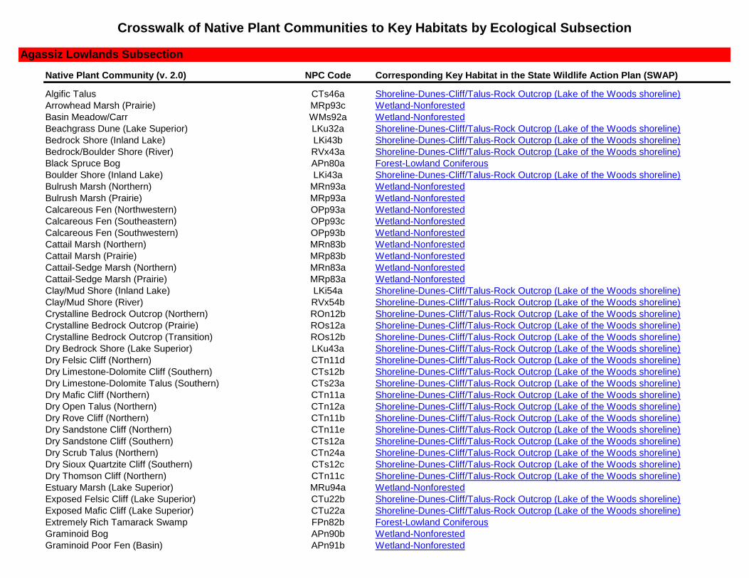
crosswalk of native plant communities to key...
TRANSCRIPT
Native Plant Community (v. 2.0) NPC Code Corresponding Key Habitat in the State Wildlife Action Plan (SWAP)
Algific Talus CTs46a Shoreline-Dunes-Cliff/Talus-Rock Outcrop (Lake of the Woods shoreline)
Arrowhead Marsh (Prairie) MRp93c Wetland-Nonforested
Basin Meadow/Carr WMs92a Wetland-Nonforested
Beachgrass Dune (Lake Superior) LKu32a Shoreline-Dunes-Cliff/Talus-Rock Outcrop (Lake of the Woods shoreline)
Bedrock Shore (Inland Lake) LKi43b Shoreline-Dunes-Cliff/Talus-Rock Outcrop (Lake of the Woods shoreline)
Bedrock/Boulder Shore (River) RVx43a Shoreline-Dunes-Cliff/Talus-Rock Outcrop (Lake of the Woods shoreline)
Black Spruce Bog APn80a Forest-Lowland Coniferous
Boulder Shore (Inland Lake) LKi43a Shoreline-Dunes-Cliff/Talus-Rock Outcrop (Lake of the Woods shoreline)
Bulrush Marsh (Northern) MRn93a Wetland-Nonforested
Bulrush Marsh (Prairie) MRp93a Wetland-Nonforested
Calcareous Fen (Northwestern) OPp93a Wetland-Nonforested
Calcareous Fen (Southeastern) OPp93c Wetland-Nonforested
Calcareous Fen (Southwestern) OPp93b Wetland-Nonforested
Cattail Marsh (Northern) MRn83b Wetland-Nonforested
Cattail Marsh (Prairie) MRp83b Wetland-Nonforested
Cattail-Sedge Marsh (Northern) MRn83a Wetland-Nonforested
Cattail-Sedge Marsh (Prairie) MRp83a Wetland-Nonforested
Clay/Mud Shore (Inland Lake) LKi54a Shoreline-Dunes-Cliff/Talus-Rock Outcrop (Lake of the Woods shoreline)
Clay/Mud Shore (River) RVx54b Shoreline-Dunes-Cliff/Talus-Rock Outcrop (Lake of the Woods shoreline)
Crystalline Bedrock Outcrop (Northern) ROn12b Shoreline-Dunes-Cliff/Talus-Rock Outcrop (Lake of the Woods shoreline)
Crystalline Bedrock Outcrop (Prairie) ROs12a Shoreline-Dunes-Cliff/Talus-Rock Outcrop (Lake of the Woods shoreline)
Crystalline Bedrock Outcrop (Transition) ROs12b Shoreline-Dunes-Cliff/Talus-Rock Outcrop (Lake of the Woods shoreline)
Dry Bedrock Shore (Lake Superior) LKu43a Shoreline-Dunes-Cliff/Talus-Rock Outcrop (Lake of the Woods shoreline)
Dry Felsic Cliff (Northern) CTn11d Shoreline-Dunes-Cliff/Talus-Rock Outcrop (Lake of the Woods shoreline)
Dry Limestone-Dolomite Cliff (Southern) CTs12b Shoreline-Dunes-Cliff/Talus-Rock Outcrop (Lake of the Woods shoreline)
Dry Limestone-Dolomite Talus (Southern) CTs23a Shoreline-Dunes-Cliff/Talus-Rock Outcrop (Lake of the Woods shoreline)
Dry Mafic Cliff (Northern) CTn11a Shoreline-Dunes-Cliff/Talus-Rock Outcrop (Lake of the Woods shoreline)
Dry Open Talus (Northern) CTn12a Shoreline-Dunes-Cliff/Talus-Rock Outcrop (Lake of the Woods shoreline)
Dry Rove Cliff (Northern) CTn11b Shoreline-Dunes-Cliff/Talus-Rock Outcrop (Lake of the Woods shoreline)
Dry Sandstone Cliff (Northern) CTn11e Shoreline-Dunes-Cliff/Talus-Rock Outcrop (Lake of the Woods shoreline)
Dry Sandstone Cliff (Southern) CTs12a Shoreline-Dunes-Cliff/Talus-Rock Outcrop (Lake of the Woods shoreline)
Dry Scrub Talus (Northern) CTn24a Shoreline-Dunes-Cliff/Talus-Rock Outcrop (Lake of the Woods shoreline)
Dry Sioux Quartzite Cliff (Southern) CTs12c Shoreline-Dunes-Cliff/Talus-Rock Outcrop (Lake of the Woods shoreline)
Dry Thomson Cliff (Northern) CTn11c Shoreline-Dunes-Cliff/Talus-Rock Outcrop (Lake of the Woods shoreline)
Estuary Marsh (Lake Superior) MRu94a Wetland-Nonforested
Exposed Felsic Cliff (Lake Superior) CTu22b Shoreline-Dunes-Cliff/Talus-Rock Outcrop (Lake of the Woods shoreline)
Exposed Mafic Cliff (Lake Superior) CTu22a Shoreline-Dunes-Cliff/Talus-Rock Outcrop (Lake of the Woods shoreline)
Extremely Rich Tamarack Swamp FPn82b Forest-Lowland Coniferous
Graminoid Bog APn90b Wetland-Nonforested
Graminoid Poor Fen (Basin) APn91b Wetland-Nonforested
Crosswalk of Native Plant Communities to Key Habitats by Ecological Subsection
Agassiz Lowlands Subsection
Native Plant Community (v. 2.0) NPC Code Corresponding Key Habitat in the State Wildlife Action Plan (SWAP)
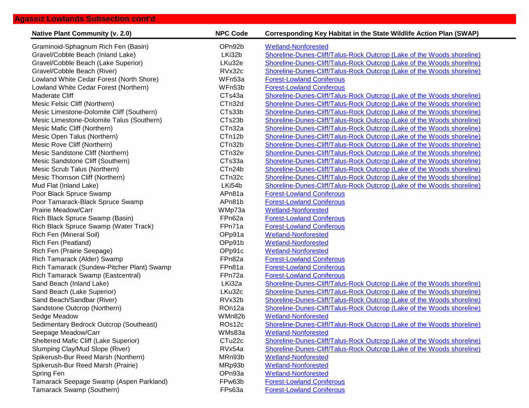
Graminoid-Sphagnum Rich Fen (Basin) OPn92b Wetland-Nonforested
Gravel/Cobble Beach (Inland Lake) LKi32b Shoreline-Dunes-Cliff/Talus-Rock Outcrop (Lake of the Woods shoreline)
Gravel/Cobble Beach (Lake Superior) LKu32e Shoreline-Dunes-Cliff/Talus-Rock Outcrop (Lake of the Woods shoreline)
Gravel/Cobble Beach (River) RVx32c Shoreline-Dunes-Cliff/Talus-Rock Outcrop (Lake of the Woods shoreline)
Lowland White Cedar Forest (North Shore) WFn53a Forest-Lowland Coniferous
Lowland White Cedar Forest (Northern) WFn53b Forest-Lowland Coniferous
Maderate Cliff CTs43a Shoreline-Dunes-Cliff/Talus-Rock Outcrop (Lake of the Woods shoreline)
Mesic Felsic Cliff (Northern) CTn32d Shoreline-Dunes-Cliff/Talus-Rock Outcrop (Lake of the Woods shoreline)
Mesic Limestone-Dolomite Cliff (Southern) CTs33b Shoreline-Dunes-Cliff/Talus-Rock Outcrop (Lake of the Woods shoreline)
Mesic Limestone-Dolomite Talus (Southern) CTs23b Shoreline-Dunes-Cliff/Talus-Rock Outcrop (Lake of the Woods shoreline)
Mesic Mafic Cliff (Northern) CTn32a Shoreline-Dunes-Cliff/Talus-Rock Outcrop (Lake of the Woods shoreline)
Mesic Open Talus (Northern) CTn12b Shoreline-Dunes-Cliff/Talus-Rock Outcrop (Lake of the Woods shoreline)
Mesic Rove Cliff (Northern) CTn32b Shoreline-Dunes-Cliff/Talus-Rock Outcrop (Lake of the Woods shoreline)
Mesic Sandstone Cliff (Northern) CTn32e Shoreline-Dunes-Cliff/Talus-Rock Outcrop (Lake of the Woods shoreline)
Mesic Sandstone Cliff (Southern) CTs33a Shoreline-Dunes-Cliff/Talus-Rock Outcrop (Lake of the Woods shoreline)
Mesic Scrub Talus (Northern) CTn24b Shoreline-Dunes-Cliff/Talus-Rock Outcrop (Lake of the Woods shoreline)
Mesic Thomson Cliff (Northern) CTn32c Shoreline-Dunes-Cliff/Talus-Rock Outcrop (Lake of the Woods shoreline)
Mud Flat (Inland Lake) LKi54b Shoreline-Dunes-Cliff/Talus-Rock Outcrop (Lake of the Woods shoreline)
Poor Black Spruce Swamp APn81a Forest-Lowland Coniferous
Poor Tamarack-Black Spruce Swamp APn81b Forest-Lowland Coniferous
Prairie Meadow/Carr WMp73a Wetland-Nonforested
Rich Black Spruce Swamp (Basin) FPn62a Forest-Lowland Coniferous
Rich Black Spruce Swamp (Water Track) FPn71a Forest-Lowland Coniferous
Rich Fen (Mineral Soil) OPp91a Wetland-Nonforested
Rich Fen (Peatland) OPp91b Wetland-Nonforested
Rich Fen (Prairie Seepage) OPp91c Wetland-Nonforested
Rich Tamarack (Alder) Swamp FPn82a Forest-Lowland Coniferous
Rich Tamarack (Sundew-Pitcher Plant) Swamp FPn81a Forest-Lowland Coniferous
Rich Tamarack Swamp (Eastcentral) FPn72a Forest-Lowland Coniferous
Sand Beach (Inland Lake) LKi32a Shoreline-Dunes-Cliff/Talus-Rock Outcrop (Lake of the Woods shoreline)
Sand Beach (Lake Superior) LKu32c Shoreline-Dunes-Cliff/Talus-Rock Outcrop (Lake of the Woods shoreline)
Sand Beach/Sandbar (River) RVx32b Shoreline-Dunes-Cliff/Talus-Rock Outcrop (Lake of the Woods shoreline)
Sandstone Outcrop (Northern) ROn12a Shoreline-Dunes-Cliff/Talus-Rock Outcrop (Lake of the Woods shoreline)
Sedge Meadow WMn82b Wetland-Nonforested
Sedimentary Bedrock Outcrop (Southeast) ROs12c Shoreline-Dunes-Cliff/Talus-Rock Outcrop (Lake of the Woods shoreline)
Seepage Meadow/Carr WMs83a Wetland-Nonforested
Sheltered Mafic Cliff (Lake Superior) CTu22c Shoreline-Dunes-Cliff/Talus-Rock Outcrop (Lake of the Woods shoreline)
Slumping Clay/Mud Slope (River) RVx54a Shoreline-Dunes-Cliff/Talus-Rock Outcrop (Lake of the Woods shoreline)
Spikerush-Bur Reed Marsh (Northern) MRn93b Wetland-Nonforested
Spikerush-Bur Reed Marsh (Prairie) MRp93b Wetland-Nonforested
Spring Fen OPn93a Wetland-Nonforested
Tamarack Seepage Swamp (Aspen Parkland) FPw63b Forest-Lowland Coniferous
Tamarack Swamp (Southern) FPs63a Forest-Lowland Coniferous
Agassiz Lowlands Subsection cont'd

Native Plant Community (v. 2.0) NPC Code Corresponding Key Habitat in the State Wildlife Action Plan (SWAP)
Tamarack-Black Spruce Swamp (Aspen Parkland) FPw63a Forest-Lowland Coniferous
Wet Felsic Cliff (Northern) CTn42c Shoreline-Dunes-Cliff/Talus-Rock Outcrop (Lake of the Woods shoreline)
Wet Limestone-Dolomite Cliff (Southern) CTs53b Shoreline-Dunes-Cliff/Talus-Rock Outcrop (Lake of the Woods shoreline)
Wet Mafic Cliff (Northern) CTn42a Shoreline-Dunes-Cliff/Talus-Rock Outcrop (Lake of the Woods shoreline)
Wet Rocky Shore (Lake Superior) LKu43b Shoreline-Dunes-Cliff/Talus-Rock Outcrop (Lake of the Woods shoreline)
Wet Rove Cliff (Northern) CTn42b Shoreline-Dunes-Cliff/Talus-Rock Outcrop (Lake of the Woods shoreline)
Wet Sandstone Cliff (Northern) CTn42d Shoreline-Dunes-Cliff/Talus-Rock Outcrop (Lake of the Woods shoreline)
Wet Sandstone Cliff (Southern) CTs53a Shoreline-Dunes-Cliff/Talus-Rock Outcrop (Lake of the Woods shoreline)
White Cedar Swamp (Northcentral) FPn63b Forest-Lowland Coniferous
White Cedar Swamp (Northeastern) FPn63a Forest-Lowland Coniferous
White Cedar Swamp (Northwestern) FPn63c Forest-Lowland Coniferous
Willow Sandbar Shrubland (River) RVx32a Shoreline-Dunes-Cliff/Talus-Rock Outcrop (Lake of the Woods shoreline)
N/A* N/A* River-Headwater to Large
Native Plant Community (v. 2.0) NPC Code Corresponding Key Habitat in the State Wildlife Action Plan (SWAP)
Algific Talus CTs46a Shoreline-Dunes-Cliff/Talus-Rock Outcrop (dune habitat)
Arrowhead Marsh (Prairie) MRp93c Wetland-Nonforested
Aspen Openings (Northern) UPn24b Shrub/Woodland-Upland (oak savanna)
Basin Meadow/Carr WMs92a Wetland-Nonforested
Beach Ridge Shrubland (Lake Superior) Lku32d Shrub/Woodland-Upland (oak savanna)
Beachgrass Dune (Lake Superior) LKu32a Shoreline-Dunes-Cliff/Talus-Rock Outcrop (dune habitat)
Bedrock Shore (Inland Lake) LKi43b Shoreline-Dunes-Cliff/Talus-Rock Outcrop (dune habitat)
Bedrock Shrubland (Inland) Ron23a Shrub/Woodland-Upland (oak savanna)
Bedrock Shrubland (Lake Superior) Ron23b Shrub/Woodland-Upland (oak savanna)
Bedrock/Boulder Shore (River) RVx43a Shoreline-Dunes-Cliff/Talus-Rock Outcrop (dune habitat)
Boulder Shore (Inland Lake) LKi43a Shoreline-Dunes-Cliff/Talus-Rock Outcrop (dune habitat)
Bulrush Marsh (Northern) MRn93a Wetland-Nonforested
Bulrush Marsh (Prairie) MRp93a Wetland-Nonforested
Calcareous Fen (Northwestern) OPp93a Wetland-Nonforested
Calcareous Fen (Southeastern) OPp93c Wetland-Nonforested
Calcareous Fen (Southwestern) OPp93b Wetland-Nonforested
Cattail Marsh (Northern) MRn83b Wetland-Nonforested
Cattail Marsh (Prairie) MRp83b Wetland-Nonforested
Cattail-Sedge Marsh (Northern) MRn83a Wetland-Nonforested
Cattail-Sedge Marsh (Prairie) MRp83a Wetland-Nonforested
Clay/Mud Shore (Inland Lake) LKi54a Shoreline-Dunes-Cliff/Talus-Rock Outcrop (dune habitat)
Clay/Mud Shore (River) RVx54b Shoreline-Dunes-Cliff/Talus-Rock Outcrop (dune habitat)
Crystalline Bedrock Outcrop (Northern) ROn12b Shoreline-Dunes-Cliff/Talus-Rock Outcrop (dune habitat)
Crystalline Bedrock Outcrop (Prairie) ROs12a Shoreline-Dunes-Cliff/Talus-Rock Outcrop (dune habitat)
Crystalline Bedrock Outcrop (Transition) ROs12b Shoreline-Dunes-Cliff/Talus-Rock Outcrop (dune habitat)
Dry Barrens Jack Pine Savanna (Northern) UPn13a Shrub/Woodland-Upland (oak savanna)
Agassiz Lowlands Subsection cont'd
Anoka Sand Plain Subsection

Native Plant Community (v. 2.0) NPC Code Corresponding Key Habitat in the State Wildlife Action Plan (SWAP)
Dry Barrens Oak Savanna (Northern) UPn13b Shrub/Woodland-Upland (oak savanna)
Dry Barrens Oak Savanna (Southern) UPs14a Shrub/Woodland-Upland (oak savanna)
Dry Barrens Prairie (Northern) UPn12a Prairie
Dry Barrens Prairie (Southern) Ups13a Prairie
Dry Bedrock Bluff Prairie (Southern) Ups13c Prairie
Dry Bedrock Shore (Lake Superior) LKu43a Shoreline-Dunes-Cliff/Talus-Rock Outcrop (dune habitat)
Dry Felsic Cliff (Northern) CTn11d Shoreline-Dunes-Cliff/Talus-Rock Outcrop (dune habitat)
Dry Hill Oak Savanna (Northern) UPn13d Shrub/Woodland-Upland (oak savanna)
Dry Hill Oak Savanna (Southern) Ups14c Shrub/Woodland-Upland (oak savanna)
Dry Hill Prairie (Northern) UPn12d Prairie
Dry Hill Prairie (Southern) Ups13d Prairie
Dry Limestone-Dolomite Cliff (Southern) CTs12b Shoreline-Dunes-Cliff/Talus-Rock Outcrop (dune habitat)
Dry Limestone-Dolomite Talus (Southern) CTs23a Shoreline-Dunes-Cliff/Talus-Rock Outcrop (dune habitat)
Dry Mafic Cliff (Northern) CTn11a Shoreline-Dunes-Cliff/Talus-Rock Outcrop (dune habitat)
Dry Open Talus (Northern) CTn12a Shoreline-Dunes-Cliff/Talus-Rock Outcrop (dune habitat)
Dry Rove Cliff (Northern) CTn11b Shoreline-Dunes-Cliff/Talus-Rock Outcrop (dune habitat)
Dry Sand-Gravel Brush-Prairie (Northern) UPn12c Prairie
Dry Sand-Gravel Oak Savanna (Northern) UPn13c Shrub/Woodland-Upland (oak savanna)
Dry Sand-Gravel Oak Savanna (Southern) UPs14b Shrub/Woodland-Upland (oak savanna)
Dry Sand-Gravel Prairie (Northern) UPn12b Prairie
Dry Sand-Gravel Prairie (Southern) Ups13b Prairie
Dry Sandstone Cliff (Northern) CTn11e Shoreline-Dunes-Cliff/Talus-Rock Outcrop (dune habitat)
Dry Sandstone Cliff (Southern) CTs12a Shoreline-Dunes-Cliff/Talus-Rock Outcrop (dune habitat)
Dry Scrub Talus (Northern) CTn24a Shoreline-Dunes-Cliff/Talus-Rock Outcrop (dune habitat)
Dry Sioux Quartzite Cliff (Southern) CTs12c Shoreline-Dunes-Cliff/Talus-Rock Outcrop (dune habitat)
Dry Thomson Cliff (Northern) CTn11c Shoreline-Dunes-Cliff/Talus-Rock Outcrop (dune habitat)
Estuary Marsh (Lake Superior) MRu94a Wetland-Nonforested
Exposed Felsic Cliff (Lake Superior) CTu22b Shoreline-Dunes-Cliff/Talus-Rock Outcrop (dune habitat)
Exposed Mafic Cliff (Lake Superior) CTu22a Shoreline-Dunes-Cliff/Talus-Rock Outcrop (dune habitat)
Graminoid Bog APn90b Wetland-Nonforested
Graminoid Poor Fen (Basin) APn91b Wetland-Nonforested
Graminoid Poor Fen (Water Track) APn91c Wetland-Nonforested
Graminoid Rich Fen (Basin) OPn92a Wetland-Nonforested
Graminoid Rich Fen (Water Track) OPn91b Wetland-Nonforested
Graminoid-Sphagnum Rich Fen (Basin) OPn92b Wetland-Nonforested
Gravel/Cobble Beach (Inland Lake) LKi32b Shoreline-Dunes-Cliff/Talus-Rock Outcrop (dune habitat)
Gravel/Cobble Beach (Lake Superior) LKu32e Shoreline-Dunes-Cliff/Talus-Rock Outcrop (dune habitat)
Gravel/Cobble Beach (River) RVx32c Shoreline-Dunes-Cliff/Talus-Rock Outcrop (dune habitat)
Juniper Dune Shrubland (Lake Superior) LKu32b Shrub/Woodland-Upland (oak savanna)
Maderate Cliff CTs43a Shoreline-Dunes-Cliff/Talus-Rock Outcrop (dune habitat)
Mesic Brush-Prairie (Northern) UPn23a Shrub/Woodland-Upland (oak savanna)
Mesic Felsic Cliff (Northern) CTn32d Shoreline-Dunes-Cliff/Talus-Rock Outcrop (dune habitat)
Mesic Limestone-Dolomite Cliff (Southern) CTs33b Shoreline-Dunes-Cliff/Talus-Rock Outcrop (dune habitat)
Anoka Sand Plain Subsection cont'd

Native Plant Community (v. 2.0) NPC Code Corresponding Key Habitat in the State Wildlife Action Plan (SWAP)
Mesic Limestone-Dolomite Talus (Southern) CTs23b Shoreline-Dunes-Cliff/Talus-Rock Outcrop (dune habitat)
Mesic Mafic Cliff (Northern) CTn32a Shoreline-Dunes-Cliff/Talus-Rock Outcrop (dune habitat)
Mesic Oak Savanna (Northern) UPn24a Shrub/Woodland-Upland (oak savanna)
Mesic Oak Savanna (Southern) UPs24a Shrub/Woodland-Upland (oak savanna)
Mesic Open Talus (Northern) CTn12b Shoreline-Dunes-Cliff/Talus-Rock Outcrop (dune habitat)
Mesic Prairie (Northern) Upn23b Prairie
Mesic Prairie (Southern) Ups23a Prairie
Mesic Rove Cliff (Northern) CTn32b Shoreline-Dunes-Cliff/Talus-Rock Outcrop (dune habitat)
Mesic Sandstone Cliff (Northern) CTn32e Shoreline-Dunes-Cliff/Talus-Rock Outcrop (dune habitat)
Mesic Sandstone Cliff (Southern) CTs33a Shoreline-Dunes-Cliff/Talus-Rock Outcrop (dune habitat)
Mesic Scrub Talus (Northern) CTn24b Shoreline-Dunes-Cliff/Talus-Rock Outcrop (dune habitat)
Mesic Thomson Cliff (Northern) CTn32c Shoreline-Dunes-Cliff/Talus-Rock Outcrop (dune habitat)
Mud Flat (Inland Lake) LKi54b Shoreline-Dunes-Cliff/Talus-Rock Outcrop (dune habitat)
Prairie Meadow/Carr WMp73a Wetland-Nonforested
Rich Fen (Mineral Soil) OPp91a Wetland-Nonforested
Rich Fen (Peatland) OPp91b Wetland-Nonforested
Rich Fen (Prairie Seepage) OPp91c Wetland-Nonforested
Sand Beach (Inland Lake) LKi32a Shoreline-Dunes-Cliff/Talus-Rock Outcrop (dune habitat)
Sand Beach (Lake Superior) LKu32c Shoreline-Dunes-Cliff/Talus-Rock Outcrop (dune habitat)
Sand Beach/Sandbar (River) RVx32b Shoreline-Dunes-Cliff/Talus-Rock Outcrop (dune habitat)
Sandstone Outcrop (Northern) ROn12a Shoreline-Dunes-Cliff/Talus-Rock Outcrop (dune habitat)
Sedge Meadow WMn82b Wetland-Nonforested
Sedimentary Bedrock Outcrop (Southeast) ROs12c Shoreline-Dunes-Cliff/Talus-Rock Outcrop (dune habitat)
Seepage Meadow/Carr WMs83a Wetland-Nonforested
Sheltered Mafic Cliff (Lake Superior) CTu22c Shoreline-Dunes-Cliff/Talus-Rock Outcrop (dune habitat)
Slumping Clay/Mud Slope (River) RVx54a Shoreline-Dunes-Cliff/Talus-Rock Outcrop (dune habitat)
Spikerush-Bur Reed Marsh (Northern) MRn93b Wetland-Nonforested
Spikerush-Bur Reed Marsh (Prairie) MRp93b Wetland-Nonforested
Spring Fen OPn93a Wetland-Nonforested
Wet Felsic Cliff (Northern) CTn42c Shoreline-Dunes-Cliff/Talus-Rock Outcrop (dune habitat)
Wet Limestone-Dolomite Cliff (Southern) CTs53b Shoreline-Dunes-Cliff/Talus-Rock Outcrop (dune habitat)
Wet Mafic Cliff (Northern) CTn42a Shoreline-Dunes-Cliff/Talus-Rock Outcrop (dune habitat)
Wet Prairie (Northern) WPn53c Prairie
Wet Prairie (Southern) WPs54b Prairie
Wet Rocky Shore (Lake Superior) LKu43b Shoreline-Dunes-Cliff/Talus-Rock Outcrop (dune habitat)
Wet Rove Cliff (Northern) CTn42b Shoreline-Dunes-Cliff/Talus-Rock Outcrop (dune habitat)
Wet Saline Prairie (Northern) WPn53d Prairie
Wet Saline Prairie (Southern) WPs54c Prairie
Wet Sandstone Cliff (Northern) CTn42d Shoreline-Dunes-Cliff/Talus-Rock Outcrop (dune habitat)
Wet Sandstone Cliff (Southern) CTs53a Shoreline-Dunes-Cliff/Talus-Rock Outcrop (dune habitat)
Wet Seepage Prairie (Northern) WPn53a Prairie
Wet Seepage Prairie (Southern) WPs54a Prairie
Willow Sandbar Shrubland (River) RVx32a Shoreline-Dunes-Cliff/Talus-Rock Outcrop (dune habitat)
Anoka Sand Plain Subsection cont'd

Native Plant Community (v. 2.0) NPC Code Corresponding Key Habitat in the State Wildlife Action Plan (SWAP)
N/A* N/A* Grassland
N/A* N/A* Lake-Shallow
N/A* N/A* River-Headwater to Large
Native Plant Community (v. 2.0) NPC Code Corresponding Key Habitat in the State Wildlife Action Plan (SWAP)
Arrowhead Marsh (Prairie) MRp93c Wetland-Nonforested (wet prairie)
Aspen Openings (Northern) UPn24b Shrub/Woodland-Upland (brush prairie)
Basin Meadow/Carr WMs92a Wetland-Nonforested (wet prairie)
Beach Ridge Shrubland (Lake Superior) Lku32d Shrub/Woodland-Upland (brush prairie)
Bedrock Shrubland (Inland) Ron23a Shrub/Woodland-Upland (brush prairie)
Bedrock Shrubland (Lake Superior) Ron23b Shrub/Woodland-Upland (brush prairie)
Bulrush Marsh (Northern) MRn93a Wetland-Nonforested (wet prairie)
Bulrush Marsh (Prairie) MRp93a Wetland-Nonforested (wet prairie)
Calcareous Fen (Northwestern) OPp93a Wetland-Nonforested (wet prairie)
Calcareous Fen (Southeastern) OPp93c Wetland-Nonforested (wet prairie)
Calcareous Fen (Southwestern) OPp93b Wetland-Nonforested (wet prairie)
Cattail Marsh (Northern) MRn83b Wetland-Nonforested (wet prairie)
Cattail Marsh (Prairie) MRp83b Wetland-Nonforested (wet prairie)
Cattail-Sedge Marsh (Northern) MRn83a Wetland-Nonforested (wet prairie)
Cattail-Sedge Marsh (Prairie) MRp83a Wetland-Nonforested (wet prairie)
Dry Barrens Jack Pine Savanna (Northern) UPn13a Shrub/Woodland-Upland (brush prairie)
Dry Barrens Oak Savanna (Northern) UPn13b Shrub/Woodland-Upland (brush prairie)
Dry Barrens Oak Savanna (Southern) UPs14a Shrub/Woodland-Upland (brush prairie)
Dry Barrens Prairie (Northern) UPn12a Prairie
Dry Barrens Prairie (Southern) Ups13a Prairie
Dry Bedrock Bluff Prairie (Southern) Ups13c Prairie
Dry Hill Oak Savanna (Northern) UPn13d Shrub/Woodland-Upland (brush prairie)
Dry Hill Oak Savanna (Southern) Ups14c Shrub/Woodland-Upland (brush prairie)
Dry Hill Prairie (Northern) UPn12d Prairie
Dry Hill Prairie (Southern) Ups13d Prairie
Dry Sand-Gravel Brush-Prairie (Northern) UPn12c Prairie
Dry Sand-Gravel Oak Savanna (Northern) UPn13c Shrub/Woodland-Upland (brush prairie)
Dry Sand-Gravel Oak Savanna (Southern) UPs14b Shrub/Woodland-Upland (brush prairie)
Dry Sand-Gravel Prairie (Northern) UPn12b Prairie
Dry Sand-Gravel Prairie (Southern) Ups13b Prairie
Estuary Marsh (Lake Superior) MRu94a Wetland-Nonforested (wet prairie)
Graminoid Bog APn90b Wetland-Nonforested (wet prairie)
Graminoid Poor Fen (Basin) APn91b Wetland-Nonforested (wet prairie)
Graminoid Poor Fen (Water Track) APn91c Wetland-Nonforested (wet prairie)
Graminoid Rich Fen (Basin) OPn92a Wetland-Nonforested (wet prairie)
Graminoid Rich Fen (Water Track) OPn91b Wetland-Nonforested (wet prairie)
Anoka Sand Plain Subsection cont'd
Aspen Parklands Subsection

Native Plant Community (v. 2.0) NPC Code Corresponding Key Habitat in the State Wildlife Action Plan (SWAP)
Graminoid-Sphagnum Rich Fen (Basin) OPn92b Wetland-Nonforested (wet prairie)
Juniper Dune Shrubland (Lake Superior) LKu32b Shrub/Woodland-Upland (brush prairie)
Mesic Brush-Prairie (Northern) UPn23a Shrub/Woodland-Upland (brush prairie)
Mesic Oak Savanna (Northern) UPn24a Shrub/Woodland-Upland (brush prairie)
Mesic Oak Savanna (Southern) UPs24a Shrub/Woodland-Upland (brush prairie)
Mesic Prairie (Northern) Upn23b Prairie
Mesic Prairie (Southern) Ups23a Prairie
Prairie Meadow/Carr WMp73a Wetland-Nonforested (wet prairie)
Rich Fen (Mineral Soil) OPp91a Wetland-Nonforested (wet prairie)
Rich Fen (Peatland) OPp91b Wetland-Nonforested (wet prairie)
Rich Fen (Prairie Seepage) OPp91c Wetland-Nonforested (wet prairie)
Sedge Meadow WMn82b Wetland-Nonforested (wet prairie)
Seepage Meadow/Carr WMs83a Wetland-Nonforested (wet prairie)
Spikerush-Bur Reed Marsh (Northern) MRn93b Wetland-Nonforested (wet prairie)
Spikerush-Bur Reed Marsh (Prairie) MRp93b Wetland-Nonforested (wet prairie)
Spring Fen OPn93a Wetland-Nonforested (wet prairie)
Wet Prairie (Northern) WPn53c Prairie
Wet Prairie (Southern) WPs54b Prairie
Wet Saline Prairie (Northern) WPn53d Prairie
Wet Saline Prairie (Southern) WPs54c Prairie
Wet Seepage Prairie (Northern) WPn53a Prairie
Wet Seepage Prairie (Southern) WPs54a Prairie
N/A* N/A* Grassland
N/A* N/A* Lake-Shallow
N/A* N/A* River-Headwater to Large
Native Plant Community (v. 2.0) NPC Code Corresponding Key Habitat in the State Wildlife Action Plan (SWAP)
Algific Talus CTs46a Shoreline-Dunes-Cliff/Talus-Rock Outcrop
Arrowhead Marsh (Prairie) MRp93c Wetland-Nonforested
Aspen Openings (Northern) UPn24b Shrub/Woodland-Upland (oak savanna)
Basin Meadow/Carr WMs92a Wetland-Nonforested
Beach Ridge Shrubland (Lake Superior) Lku32d Shrub/Woodland-Upland (oak savanna)
Beachgrass Dune (Lake Superior) LKu32a Shoreline-Dunes-Cliff/Talus-Rock Outcrop
Bedrock Shore (Inland Lake) LKi43b Shoreline-Dunes-Cliff/Talus-Rock Outcrop
Bedrock Shrubland (Inland) Ron23a Shrub/Woodland-Upland (oak savanna)
Bedrock Shrubland (Lake Superior) Ron23b Shrub/Woodland-Upland (oak savanna)
Bedrock/Boulder Shore (River) RVx43a Shoreline-Dunes-Cliff/Talus-Rock Outcrop
Black Oak-White Oak Woodland (Sand) FDs27c Forest-Upland Deciduous (Oak)
Boulder Shore (Inland Lake) LKi43a Shoreline-Dunes-Cliff/Talus-Rock Outcrop
Bulrush Marsh (Northern) MRn93a Wetland-Nonforested
Bulrush Marsh (Prairie) MRp93a Wetland-Nonforested
Aspen Parklands Subsection cont'd
Big Woods Subsection

Native Plant Community (v. 2.0) NPC Code Corresponding Key Habitat in the State Wildlife Action Plan (SWAP)
Bur Oak (Forest Herb) Woodland FDw24b Forest-Upland Deciduous (Oak)
Bur Oak (Prairie Herb) Woodland FDw24a Forest-Upland Deciduous (Oak)
Bur Oak-Aspen Forest FDs36a Forest-Upland Deciduous (Oak)
Calcareous Fen (Northwestern) OPp93a Wetland-Nonforested
Calcareous Fen (Southeastern) OPp93c Wetland-Nonforested
Calcareous Fen (Southwestern) OPp93b Wetland-Nonforested
Cattail Marsh (Northern) MRn83b Wetland-Nonforested
Cattail Marsh (Prairie) MRp83b Wetland-Nonforested
Cattail-Sedge Marsh (Northern) MRn83a Wetland-Nonforested
Cattail-Sedge Marsh (Prairie) MRp83a Wetland-Nonforested
Clay/Mud Shore (Inland Lake) LKi54a Shoreline-Dunes-Cliff/Talus-Rock Outcrop
Clay/Mud Shore (River) RVx54b Shoreline-Dunes-Cliff/Talus-Rock Outcrop
Crystalline Bedrock Outcrop (Northern) ROn12b Shoreline-Dunes-Cliff/Talus-Rock Outcrop
Crystalline Bedrock Outcrop (Prairie) ROs12a Shoreline-Dunes-Cliff/Talus-Rock Outcrop
Crystalline Bedrock Outcrop (Transition) ROs12b Shoreline-Dunes-Cliff/Talus-Rock Outcrop
Dry Barrens Jack Pine Savanna (Northern) UPn13a Shrub/Woodland-Upland (oak savanna)
Dry Barrens Oak Savanna (Northern) UPn13b Shrub/Woodland-Upland (oak savanna)
Dry Barrens Oak Savanna (Southern) UPs14a Shrub/Woodland-Upland (oak savanna)
Dry Bedrock Shore (Lake Superior) LKu43a Shoreline-Dunes-Cliff/Talus-Rock Outcrop
Dry Felsic Cliff (Northern) CTn11d Shoreline-Dunes-Cliff/Talus-Rock Outcrop
Dry Hill Oak Savanna (Northern) UPn13d Shrub/Woodland-Upland (oak savanna)
Dry Hill Oak Savanna (Southern) Ups14c Shrub/Woodland-Upland (oak savanna)
Dry Limestone-Dolomite Cliff (Southern) CTs12b Shoreline-Dunes-Cliff/Talus-Rock Outcrop
Dry Limestone-Dolomite Talus (Southern) CTs23a Shoreline-Dunes-Cliff/Talus-Rock Outcrop
Dry Mafic Cliff (Northern) CTn11a Shoreline-Dunes-Cliff/Talus-Rock Outcrop
Dry Open Talus (Northern) CTn12a Shoreline-Dunes-Cliff/Talus-Rock Outcrop
Dry Rove Cliff (Northern) CTn11b Shoreline-Dunes-Cliff/Talus-Rock Outcrop
Dry Sand-Gravel Oak Savanna (Northern) UPn13c Shrub/Woodland-Upland (oak savanna)
Dry Sand-Gravel Oak Savanna (Southern) UPs14b Shrub/Woodland-Upland (oak savanna)
Dry Sandstone Cliff (Northern) CTn11e Shoreline-Dunes-Cliff/Talus-Rock Outcrop
Dry Sandstone Cliff (Southern) CTs12a Shoreline-Dunes-Cliff/Talus-Rock Outcrop
Dry Scrub Talus (Northern) CTn24a Shoreline-Dunes-Cliff/Talus-Rock Outcrop
Dry Sioux Quartzite Cliff (Southern) CTs12c Shoreline-Dunes-Cliff/Talus-Rock Outcrop
Dry Thomson Cliff (Northern) CTn11c Shoreline-Dunes-Cliff/Talus-Rock Outcrop
Elm-Basswood-Black Ash (Blue Beech) Forest MHs49b Forest-Upland Deciduous (Hardwood)
Elm-Basswood-Black Ash (Hackberry) Forest MHs49a Forest-Upland Deciduous (Hardwood)
Estuary Marsh (Lake Superior) MRu94a Wetland-Nonforested
Exposed Felsic Cliff (Lake Superior) CTu22b Shoreline-Dunes-Cliff/Talus-Rock Outcrop
Exposed Mafic Cliff (Lake Superior) CTu22a Shoreline-Dunes-Cliff/Talus-Rock Outcrop
Graminoid Bog APn90b Wetland-Nonforested
Graminoid Poor Fen (Basin) APn91b Wetland-Nonforested
Graminoid Poor Fen (Water Track) APn91c Wetland-Nonforested
Graminoid Rich Fen (Basin) OPn92a Wetland-Nonforested
Big Woods Subsection cont'd
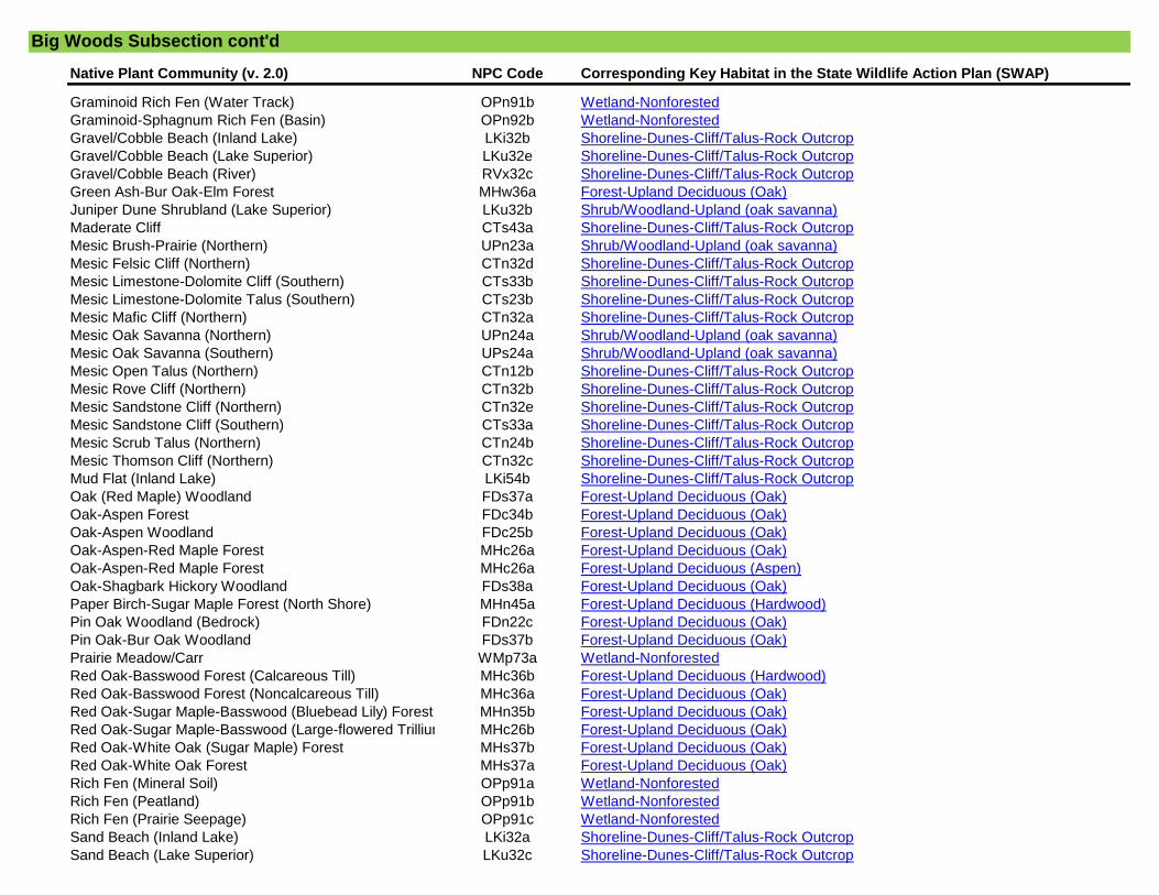
Native Plant Community (v. 2.0) NPC Code Corresponding Key Habitat in the State Wildlife Action Plan (SWAP)
Graminoid Rich Fen (Water Track) OPn91b Wetland-Nonforested
Graminoid-Sphagnum Rich Fen (Basin) OPn92b Wetland-Nonforested
Gravel/Cobble Beach (Inland Lake) LKi32b Shoreline-Dunes-Cliff/Talus-Rock Outcrop
Gravel/Cobble Beach (Lake Superior) LKu32e Shoreline-Dunes-Cliff/Talus-Rock Outcrop
Gravel/Cobble Beach (River) RVx32c Shoreline-Dunes-Cliff/Talus-Rock Outcrop
Green Ash-Bur Oak-Elm Forest MHw36a Forest-Upland Deciduous (Oak)
Juniper Dune Shrubland (Lake Superior) LKu32b Shrub/Woodland-Upland (oak savanna)
Maderate Cliff CTs43a Shoreline-Dunes-Cliff/Talus-Rock Outcrop
Mesic Brush-Prairie (Northern) UPn23a Shrub/Woodland-Upland (oak savanna)
Mesic Felsic Cliff (Northern) CTn32d Shoreline-Dunes-Cliff/Talus-Rock Outcrop
Mesic Limestone-Dolomite Cliff (Southern) CTs33b Shoreline-Dunes-Cliff/Talus-Rock Outcrop
Mesic Limestone-Dolomite Talus (Southern) CTs23b Shoreline-Dunes-Cliff/Talus-Rock Outcrop
Mesic Mafic Cliff (Northern) CTn32a Shoreline-Dunes-Cliff/Talus-Rock Outcrop
Mesic Oak Savanna (Northern) UPn24a Shrub/Woodland-Upland (oak savanna)
Mesic Oak Savanna (Southern) UPs24a Shrub/Woodland-Upland (oak savanna)
Mesic Open Talus (Northern) CTn12b Shoreline-Dunes-Cliff/Talus-Rock Outcrop
Mesic Rove Cliff (Northern) CTn32b Shoreline-Dunes-Cliff/Talus-Rock Outcrop
Mesic Sandstone Cliff (Northern) CTn32e Shoreline-Dunes-Cliff/Talus-Rock Outcrop
Mesic Sandstone Cliff (Southern) CTs33a Shoreline-Dunes-Cliff/Talus-Rock Outcrop
Mesic Scrub Talus (Northern) CTn24b Shoreline-Dunes-Cliff/Talus-Rock Outcrop
Mesic Thomson Cliff (Northern) CTn32c Shoreline-Dunes-Cliff/Talus-Rock Outcrop
Mud Flat (Inland Lake) LKi54b Shoreline-Dunes-Cliff/Talus-Rock Outcrop
Oak (Red Maple) Woodland FDs37a Forest-Upland Deciduous (Oak)
Oak-Aspen Forest FDc34b Forest-Upland Deciduous (Oak)
Oak-Aspen Woodland FDc25b Forest-Upland Deciduous (Oak)
Oak-Aspen-Red Maple Forest MHc26a Forest-Upland Deciduous (Oak)
Oak-Aspen-Red Maple Forest MHc26a Forest-Upland Deciduous (Aspen)
Oak-Shagbark Hickory Woodland FDs38a Forest-Upland Deciduous (Oak)
Paper Birch-Sugar Maple Forest (North Shore) MHn45a Forest-Upland Deciduous (Hardwood)
Pin Oak Woodland (Bedrock) FDn22c Forest-Upland Deciduous (Oak)
Pin Oak-Bur Oak Woodland FDs37b Forest-Upland Deciduous (Oak)
Prairie Meadow/Carr WMp73a Wetland-Nonforested
Red Oak-Basswood Forest (Calcareous Till) MHc36b Forest-Upland Deciduous (Hardwood)
Red Oak-Basswood Forest (Noncalcareous Till) MHc36a Forest-Upland Deciduous (Oak)
Red Oak-Sugar Maple-Basswood (Bluebead Lily) Forest MHn35b Forest-Upland Deciduous (Oak)
Red Oak-Sugar Maple-Basswood (Large-flowered Trillium) ForestMHc26b Forest-Upland Deciduous (Oak)
Red Oak-White Oak (Sugar Maple) Forest MHs37b Forest-Upland Deciduous (Oak)
Red Oak-White Oak Forest MHs37a Forest-Upland Deciduous (Oak)
Rich Fen (Mineral Soil) OPp91a Wetland-Nonforested
Rich Fen (Peatland) OPp91b Wetland-Nonforested
Rich Fen (Prairie Seepage) OPp91c Wetland-Nonforested
Sand Beach (Inland Lake) LKi32a Shoreline-Dunes-Cliff/Talus-Rock Outcrop
Sand Beach (Lake Superior) LKu32c Shoreline-Dunes-Cliff/Talus-Rock Outcrop
Big Woods Subsection cont'd
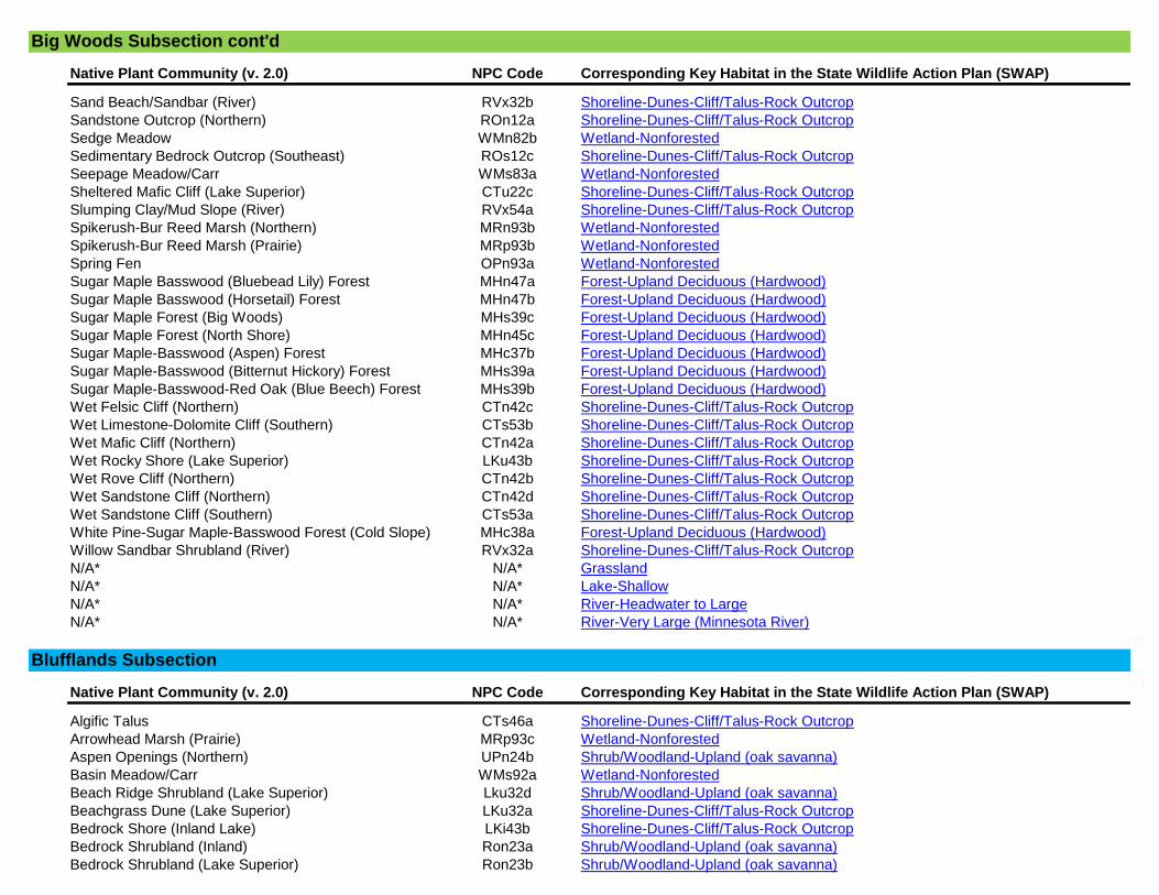
Native Plant Community (v. 2.0) NPC Code Corresponding Key Habitat in the State Wildlife Action Plan (SWAP)
Sand Beach/Sandbar (River) RVx32b Shoreline-Dunes-Cliff/Talus-Rock Outcrop
Sandstone Outcrop (Northern) ROn12a Shoreline-Dunes-Cliff/Talus-Rock Outcrop
Sedge Meadow WMn82b Wetland-Nonforested
Sedimentary Bedrock Outcrop (Southeast) ROs12c Shoreline-Dunes-Cliff/Talus-Rock Outcrop
Seepage Meadow/Carr WMs83a Wetland-Nonforested
Sheltered Mafic Cliff (Lake Superior) CTu22c Shoreline-Dunes-Cliff/Talus-Rock Outcrop
Slumping Clay/Mud Slope (River) RVx54a Shoreline-Dunes-Cliff/Talus-Rock Outcrop
Spikerush-Bur Reed Marsh (Northern) MRn93b Wetland-Nonforested
Spikerush-Bur Reed Marsh (Prairie) MRp93b Wetland-Nonforested
Spring Fen OPn93a Wetland-Nonforested
Sugar Maple Basswood (Bluebead Lily) Forest MHn47a Forest-Upland Deciduous (Hardwood)
Sugar Maple Basswood (Horsetail) Forest MHn47b Forest-Upland Deciduous (Hardwood)
Sugar Maple Forest (Big Woods) MHs39c Forest-Upland Deciduous (Hardwood)
Sugar Maple Forest (North Shore) MHn45c Forest-Upland Deciduous (Hardwood)
Sugar Maple-Basswood (Aspen) Forest MHc37b Forest-Upland Deciduous (Hardwood)
Sugar Maple-Basswood (Bitternut Hickory) Forest MHs39a Forest-Upland Deciduous (Hardwood)
Sugar Maple-Basswood-Red Oak (Blue Beech) Forest MHs39b Forest-Upland Deciduous (Hardwood)
Wet Felsic Cliff (Northern) CTn42c Shoreline-Dunes-Cliff/Talus-Rock Outcrop
Wet Limestone-Dolomite Cliff (Southern) CTs53b Shoreline-Dunes-Cliff/Talus-Rock Outcrop
Wet Mafic Cliff (Northern) CTn42a Shoreline-Dunes-Cliff/Talus-Rock Outcrop
Wet Rocky Shore (Lake Superior) LKu43b Shoreline-Dunes-Cliff/Talus-Rock Outcrop
Wet Rove Cliff (Northern) CTn42b Shoreline-Dunes-Cliff/Talus-Rock Outcrop
Wet Sandstone Cliff (Northern) CTn42d Shoreline-Dunes-Cliff/Talus-Rock Outcrop
Wet Sandstone Cliff (Southern) CTs53a Shoreline-Dunes-Cliff/Talus-Rock Outcrop
White Pine-Sugar Maple-Basswood Forest (Cold Slope) MHc38a Forest-Upland Deciduous (Hardwood)
Willow Sandbar Shrubland (River) RVx32a Shoreline-Dunes-Cliff/Talus-Rock Outcrop
N/A* N/A* Grassland
N/A* N/A* Lake-Shallow
N/A* N/A* River-Headwater to Large
N/A* N/A* River-Very Large (Minnesota River)
Native Plant Community (v. 2.0) NPC Code Corresponding Key Habitat in the State Wildlife Action Plan (SWAP)
Algific Talus CTs46a Shoreline-Dunes-Cliff/Talus-Rock Outcrop
Arrowhead Marsh (Prairie) MRp93c Wetland-Nonforested
Aspen Openings (Northern) UPn24b Shrub/Woodland-Upland (oak savanna)
Basin Meadow/Carr WMs92a Wetland-Nonforested
Beach Ridge Shrubland (Lake Superior) Lku32d Shrub/Woodland-Upland (oak savanna)
Beachgrass Dune (Lake Superior) LKu32a Shoreline-Dunes-Cliff/Talus-Rock Outcrop
Bedrock Shore (Inland Lake) LKi43b Shoreline-Dunes-Cliff/Talus-Rock Outcrop
Bedrock Shrubland (Inland) Ron23a Shrub/Woodland-Upland (oak savanna)
Bedrock Shrubland (Lake Superior) Ron23b Shrub/Woodland-Upland (oak savanna)
Blufflands Subsection
Big Woods Subsection cont'd

Native Plant Community (v. 2.0) NPC Code Corresponding Key Habitat in the State Wildlife Action Plan (SWAP)
Bedrock/Boulder Shore (River) RVx43a Shoreline-Dunes-Cliff/Talus-Rock Outcrop
Boulder Shore (Inland Lake) LKi43a Shoreline-Dunes-Cliff/Talus-Rock Outcrop
Bulrush Marsh (Northern) MRn93a Wetland-Nonforested
Bulrush Marsh (Prairie) MRp93a Wetland-Nonforested
Calcareous Fen (Northwestern) OPp93a Wetland-Nonforested
Calcareous Fen (Southeastern) OPp93c Wetland-Nonforested
Calcareous Fen (Southwestern) OPp93b Wetland-Nonforested
Cattail Marsh (Northern) MRn83b Wetland-Nonforested
Cattail Marsh (Prairie) MRp83b Wetland-Nonforested
Cattail-Sedge Marsh (Northern) MRn83a Wetland-Nonforested
Cattail-Sedge Marsh (Prairie) MRp83a Wetland-Nonforested
Clay/Mud Shore (Inland Lake) LKi54a Shoreline-Dunes-Cliff/Talus-Rock Outcrop
Clay/Mud Shore (River) RVx54b Shoreline-Dunes-Cliff/Talus-Rock Outcrop
Crystalline Bedrock Outcrop (Northern) ROn12b Shoreline-Dunes-Cliff/Talus-Rock Outcrop
Crystalline Bedrock Outcrop (Prairie) ROs12a Shoreline-Dunes-Cliff/Talus-Rock Outcrop
Crystalline Bedrock Outcrop (Transition) ROs12b Shoreline-Dunes-Cliff/Talus-Rock Outcrop
Dry Barrens Jack Pine Savanna (Northern) UPn13a Shrub/Woodland-Upland (oak savanna)
Dry Barrens Oak Savanna (Northern) UPn13b Shrub/Woodland-Upland (oak savanna)
Dry Barrens Oak Savanna (Southern) UPs14a Shrub/Woodland-Upland (oak savanna)
Dry Barrens Prairie (Northern) UPn12a Prairie
Dry Barrens Prairie (Southern) Ups13a Prairie
Dry Bedrock Bluff Prairie (Southern) Ups13c Prairie
Dry Bedrock Shore (Lake Superior) LKu43a Shoreline-Dunes-Cliff/Talus-Rock Outcrop
Dry Felsic Cliff (Northern) CTn11d Shoreline-Dunes-Cliff/Talus-Rock Outcrop
Dry Hill Oak Savanna (Northern) UPn13d Shrub/Woodland-Upland (oak savanna)
Dry Hill Oak Savanna (Southern) Ups14c Shrub/Woodland-Upland (oak savanna)
Dry Hill Prairie (Northern) UPn12d Prairie
Dry Hill Prairie (Southern) Ups13d Prairie
Dry Limestone-Dolomite Cliff (Southern) CTs12b Shoreline-Dunes-Cliff/Talus-Rock Outcrop
Dry Limestone-Dolomite Talus (Southern) CTs23a Shoreline-Dunes-Cliff/Talus-Rock Outcrop
Dry Mafic Cliff (Northern) CTn11a Shoreline-Dunes-Cliff/Talus-Rock Outcrop
Dry Open Talus (Northern) CTn12a Shoreline-Dunes-Cliff/Talus-Rock Outcrop
Dry Rove Cliff (Northern) CTn11b Shoreline-Dunes-Cliff/Talus-Rock Outcrop
Dry Sand-Gravel Brush-Prairie (Northern) UPn12c Prairie
Dry Sand-Gravel Oak Savanna (Northern) UPn13c Shrub/Woodland-Upland (oak savanna)
Dry Sand-Gravel Oak Savanna (Southern) UPs14b Shrub/Woodland-Upland (oak savanna)
Dry Sand-Gravel Prairie (Northern) UPn12b Prairie
Dry Sand-Gravel Prairie (Southern) Ups13b Prairie
Dry Sandstone Cliff (Northern) CTn11e Shoreline-Dunes-Cliff/Talus-Rock Outcrop
Dry Sandstone Cliff (Southern) CTs12a Shoreline-Dunes-Cliff/Talus-Rock Outcrop
Dry Scrub Talus (Northern) CTn24a Shoreline-Dunes-Cliff/Talus-Rock Outcrop
Dry Sioux Quartzite Cliff (Southern) CTs12c Shoreline-Dunes-Cliff/Talus-Rock Outcrop
Dry Thomson Cliff (Northern) CTn11c Shoreline-Dunes-Cliff/Talus-Rock Outcrop
Blufflands Subsection cont'd

Native Plant Community (v. 2.0) NPC Code Corresponding Key Habitat in the State Wildlife Action Plan (SWAP)
Estuary Marsh (Lake Superior) MRu94a Wetland-Nonforested
Exposed Felsic Cliff (Lake Superior) CTu22b Shoreline-Dunes-Cliff/Talus-Rock Outcrop
Exposed Mafic Cliff (Lake Superior) CTu22a Shoreline-Dunes-Cliff/Talus-Rock Outcrop
Graminoid Bog APn90b Wetland-Nonforested
Graminoid Poor Fen (Basin) APn91b Wetland-Nonforested
Graminoid Poor Fen (Water Track) APn91c Wetland-Nonforested
Graminoid Rich Fen (Basin) OPn92a Wetland-Nonforested
Graminoid Rich Fen (Water Track) OPn91b Wetland-Nonforested
Graminoid-Sphagnum Rich Fen (Basin) OPn92b Wetland-Nonforested
Gravel/Cobble Beach (Inland Lake) LKi32b Shoreline-Dunes-Cliff/Talus-Rock Outcrop
Gravel/Cobble Beach (Lake Superior) LKu32e Shoreline-Dunes-Cliff/Talus-Rock Outcrop
Gravel/Cobble Beach (River) RVx32c Shoreline-Dunes-Cliff/Talus-Rock Outcrop
Juniper Dune Shrubland (Lake Superior) LKu32b Shrub/Woodland-Upland (oak savanna)
Maderate Cliff CTs43a Shoreline-Dunes-Cliff/Talus-Rock Outcrop
Mesic Brush-Prairie (Northern) UPn23a Shrub/Woodland-Upland (oak savanna)
Mesic Felsic Cliff (Northern) CTn32d Shoreline-Dunes-Cliff/Talus-Rock Outcrop
Mesic Limestone-Dolomite Cliff (Southern) CTs33b Shoreline-Dunes-Cliff/Talus-Rock Outcrop
Mesic Limestone-Dolomite Talus (Southern) CTs23b Shoreline-Dunes-Cliff/Talus-Rock Outcrop
Mesic Mafic Cliff (Northern) CTn32a Shoreline-Dunes-Cliff/Talus-Rock Outcrop
Mesic Oak Savanna (Northern) UPn24a Shrub/Woodland-Upland (oak savanna)
Mesic Oak Savanna (Southern) UPs24a Shrub/Woodland-Upland (oak savanna)
Mesic Open Talus (Northern) CTn12b Shoreline-Dunes-Cliff/Talus-Rock Outcrop
Mesic Prairie (Northern) Upn23b Prairie
Mesic Prairie (Southern) Ups23a Prairie
Mesic Rove Cliff (Northern) CTn32b Shoreline-Dunes-Cliff/Talus-Rock Outcrop
Mesic Sandstone Cliff (Northern) CTn32e Shoreline-Dunes-Cliff/Talus-Rock Outcrop
Mesic Sandstone Cliff (Southern) CTs33a Shoreline-Dunes-Cliff/Talus-Rock Outcrop
Mesic Scrub Talus (Northern) CTn24b Shoreline-Dunes-Cliff/Talus-Rock Outcrop
Mesic Thomson Cliff (Northern) CTn32c Shoreline-Dunes-Cliff/Talus-Rock Outcrop
Mud Flat (Inland Lake) LKi54b Shoreline-Dunes-Cliff/Talus-Rock Outcrop
Prairie Meadow/Carr WMp73a Wetland-Nonforested
Rich Fen (Mineral Soil) OPp91a Wetland-Nonforested
Rich Fen (Peatland) OPp91b Wetland-Nonforested
Rich Fen (Prairie Seepage) OPp91c Wetland-Nonforested
Sand Beach (Inland Lake) LKi32a Shoreline-Dunes-Cliff/Talus-Rock Outcrop
Sand Beach (Lake Superior) LKu32c Shoreline-Dunes-Cliff/Talus-Rock Outcrop
Sand Beach/Sandbar (River) RVx32b Shoreline-Dunes-Cliff/Talus-Rock Outcrop
Sandstone Outcrop (Northern) ROn12a Shoreline-Dunes-Cliff/Talus-Rock Outcrop
Sedge Meadow WMn82b Wetland-Nonforested
Sedimentary Bedrock Outcrop (Southeast) ROs12c Shoreline-Dunes-Cliff/Talus-Rock Outcrop
Seepage Meadow/Carr WMs83a Wetland-Nonforested
Sheltered Mafic Cliff (Lake Superior) CTu22c Shoreline-Dunes-Cliff/Talus-Rock Outcrop
Slumping Clay/Mud Slope (River) RVx54a Shoreline-Dunes-Cliff/Talus-Rock Outcrop
Blufflands Subsection cont'd

Native Plant Community (v. 2.0) NPC Code Corresponding Key Habitat in the State Wildlife Action Plan (SWAP)
Spikerush-Bur Reed Marsh (Northern) MRn93b Wetland-Nonforested
Spikerush-Bur Reed Marsh (Prairie) MRp93b Wetland-Nonforested
Spring Fen OPn93a Wetland-Nonforested
Wet Felsic Cliff (Northern) CTn42c Shoreline-Dunes-Cliff/Talus-Rock Outcrop
Wet Limestone-Dolomite Cliff (Southern) CTs53b Shoreline-Dunes-Cliff/Talus-Rock Outcrop
Wet Mafic Cliff (Northern) CTn42a Shoreline-Dunes-Cliff/Talus-Rock Outcrop
Wet Prairie (Northern) WPn53c Prairie
Wet Prairie (Southern) WPs54b Prairie
Wet Rocky Shore (Lake Superior) LKu43b Shoreline-Dunes-Cliff/Talus-Rock Outcrop
Wet Rove Cliff (Northern) CTn42b Shoreline-Dunes-Cliff/Talus-Rock Outcrop
Wet Saline Prairie (Northern) WPn53d Prairie
Wet Saline Prairie (Southern) WPs54c Prairie
Wet Sandstone Cliff (Northern) CTn42d Shoreline-Dunes-Cliff/Talus-Rock Outcrop
Wet Sandstone Cliff (Southern) CTs53a Shoreline-Dunes-Cliff/Talus-Rock Outcrop
Wet Seepage Prairie (Northern) WPn53a Prairie
Wet Seepage Prairie (Southern) WPs54a Prairie
Willow Sandbar Shrubland (River) RVx32a Shoreline-Dunes-Cliff/Talus-Rock Outcrop
N/A* N/A* River-Headwater to Large
N/A* N/A* River-Very Large (Mississippi River)
Native Plant Community (v. 2.0) NPC Code Corresponding Key Habitat in the State Wildlife Action Plan (SWAP)
Aspen Openings (Northern) UPn24b Shrub/Woodland-Upland (jack pine woodland)
Beach Ridge Shrubland (Lake Superior) Lku32d Shrub/Woodland-Upland (jack pine woodland)
Bedrock Shrubland (Inland) Ron23a Shrub/Woodland-Upland (jack pine woodland)
Bedrock Shrubland (Lake Superior) Ron23b Shrub/Woodland-Upland (jack pine woodland)
Black Spruce Bog APn80a Forest-Lowland Coniferous
Black Spruce Woodland FDn33c Forest-Upland Coniferous
Black Spruce-Jack Pine Woodland FDn32c Forest-Upland Coniferous
Dry Barrens Jack Pine Savanna (Northern) UPn13a Shrub/Woodland-Upland (jack pine woodland)
Dry Barrens Oak Savanna (Northern) UPn13b Shrub/Woodland-Upland (jack pine woodland)
Dry Barrens Oak Savanna (Southern) UPs14a Shrub/Woodland-Upland (jack pine woodland)
Dry Hill Oak Savanna (Northern) UPn13d Shrub/Woodland-Upland (jack pine woodland)
Dry Hill Oak Savanna (Southern) Ups14c Shrub/Woodland-Upland (jack pine woodland)
Dry Sand-Gravel Oak Savanna (Northern) UPn13c Shrub/Woodland-Upland (jack pine woodland)
Dry Sand-Gravel Oak Savanna (Southern) UPs14b Shrub/Woodland-Upland (jack pine woodland)
Extremely Rich Tamarack Swamp FPn82b Forest-Lowland Coniferous
Jack Pine (Bearberry) Woodland FDc12a Forest-Upland Coniferous
Jack Pine (Bush Honeysuckle) Woodland FDc24a Forest-Upland Coniferous
Jack Pine (Yarrow) Woodland FDc23a Forest-Upland Coniferous
Jack Pine Woodland (Bedrock) FDn22a Forest-Upland Coniferous
Jack Pine Woodland (Sand) FDn12a Forest-Upland Coniferous
Border Lakes Subsection
Blufflands Subsection cont'd

Native Plant Community (v. 2.0) NPC Code Corresponding Key Habitat in the State Wildlife Action Plan (SWAP)
Jack Pine-Black Spruce Woodland (Sand) FDn32d Forest-Upland Coniferous
Jack Pine-Oak Woodland FDc25a Forest-Upland Coniferous
Jack Pine-Oak Woodland (Sand) FDs27a Forest-Upland Coniferous
Juniper Dune Shrubland (Lake Superior) LKu32b Shrub/Woodland-Upland (jack pine woodland)
Lowland White Cedar Forest (North Shore) WFn53a Forest-Lowland Coniferous
Lowland White Cedar Forest (Northern) WFn53b Forest-Lowland Coniferous
Mesic Brush-Prairie (Northern) UPn23a Shrub/Woodland-Upland (jack pine woodland)
Mesic Oak Savanna (Northern) UPn24a Shrub/Woodland-Upland (jack pine woodland)
Mesic Oak Savanna (Southern) UPs24a Shrub/Woodland-Upland (jack pine woodland)
Poor Black Spruce Swamp APn81a Forest-Lowland Coniferous
Poor Tamarack-Black Spruce Swamp APn81b Forest-Lowland Coniferous
Red Pine Woodland (Sand) FDn12b Forest-Upland Coniferous
Red Pine-White Pine Forest FDc34a Forest-Upland Coniferous
Red Pine-White Pine Woodland FDn33a Forest-Upland Coniferous
Red Pine-White Pine Woodland (Canadian Shield) FDn32a Forest-Upland Coniferous
Red Pine-White Pine Woodland (Eastcentral Bedrock) FDn22c Forest-Upland Coniferous
Red Pine-White Pine Woodland (Northeastern Bedrock) FDn22b Forest-Upland Coniferous
Rich Black Spruce Swamp (Basin) FPn62a Forest-Lowland Coniferous
Rich Black Spruce Swamp (Water Track) FPn71a Forest-Lowland Coniferous
Rich Tamarack (Alder) Swamp FPn82a Forest-Lowland Coniferous
Rich Tamarack (Sundew-Pitcher Plant) Swamp FPn81a Forest-Lowland Coniferous
Rich Tamarack Swamp (Eastcentral) FPn72a Forest-Lowland Coniferous
Spruce-Fir Woodland (North Shore) FDn32e Forest-Upland Coniferous
Tamarack Seepage Swamp (Aspen Parkland) FPw63b Forest-Lowland Coniferous
Tamarack Swamp (Southern) FPs63a Forest-Lowland Coniferous
Tamarack-Black Spruce Swamp (Aspen Parkland) FPw63a Forest-Lowland Coniferous
Upland White Cedar Forest FDn43c Forest-Upland Coniferous
White Cedar Swamp (Northcentral) FPn63b Forest-Lowland Coniferous
White Cedar Swamp (Northeastern) FPn63a Forest-Lowland Coniferous
White Cedar Swamp (Northwestern) FPn63c Forest-Lowland Coniferous
White Cedar-Yellow Birch Forest MHn45b Forest-Upland Coniferous
White Pine-Oak Woodland (Sand) FDs27b Forest-Upland Coniferous
White Pine-Red Pine Forest FDn43a Forest-Upland Coniferous
White Pine-White Spruce-Paper Birch Forest MHn44b Forest-Upland Coniferous
N/A* N/A* Lake-Deep
N/A* N/A* River-Headwater to Large
Native Plant Community (v. 2.0) NPC Code Corresponding Key Habitat in the State Wildlife Action Plan (SWAP)
Arrowhead Marsh (Prairie) MRp93c Wetland-Nonforested
Aspen Openings (Northern) UPn24b Shrub/Woodland-Upland (jack pine woodland)
Basin Meadow/Carr WMs92a Wetland-Nonforested
Chippewa Plains Subsection
Border Lakes Subsection cont'd
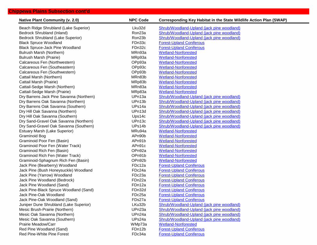
Native Plant Community (v. 2.0) NPC Code Corresponding Key Habitat in the State Wildlife Action Plan (SWAP)
Beach Ridge Shrubland (Lake Superior) Lku32d Shrub/Woodland-Upland (jack pine woodland)
Bedrock Shrubland (Inland) Ron23a Shrub/Woodland-Upland (jack pine woodland)
Bedrock Shrubland (Lake Superior) Ron23b Shrub/Woodland-Upland (jack pine woodland)
Black Spruce Woodland FDn33c Forest-Upland Coniferous
Black Spruce-Jack Pine Woodland FDn32c Forest-Upland Coniferous
Bulrush Marsh (Northern) MRn93a Wetland-Nonforested
Bulrush Marsh (Prairie) MRp93a Wetland-Nonforested
Calcareous Fen (Northwestern) OPp93a Wetland-Nonforested
Calcareous Fen (Southeastern) OPp93c Wetland-Nonforested
Calcareous Fen (Southwestern) OPp93b Wetland-Nonforested
Cattail Marsh (Northern) MRn83b Wetland-Nonforested
Cattail Marsh (Prairie) MRp83b Wetland-Nonforested
Cattail-Sedge Marsh (Northern) MRn83a Wetland-Nonforested
Cattail-Sedge Marsh (Prairie) MRp83a Wetland-Nonforested
Dry Barrens Jack Pine Savanna (Northern) UPn13a Shrub/Woodland-Upland (jack pine woodland)
Dry Barrens Oak Savanna (Northern) UPn13b Shrub/Woodland-Upland (jack pine woodland)
Dry Barrens Oak Savanna (Southern) UPs14a Shrub/Woodland-Upland (jack pine woodland)
Dry Hill Oak Savanna (Northern) UPn13d Shrub/Woodland-Upland (jack pine woodland)
Dry Hill Oak Savanna (Southern) Ups14c Shrub/Woodland-Upland (jack pine woodland)
Dry Sand-Gravel Oak Savanna (Northern) UPn13c Shrub/Woodland-Upland (jack pine woodland)
Dry Sand-Gravel Oak Savanna (Southern) UPs14b Shrub/Woodland-Upland (jack pine woodland)
Estuary Marsh (Lake Superior) MRu94a Wetland-Nonforested
Graminoid Bog APn90b Wetland-Nonforested
Graminoid Poor Fen (Basin) APn91b Wetland-Nonforested
Graminoid Poor Fen (Water Track) APn91c Wetland-Nonforested
Graminoid Rich Fen (Basin) OPn92a Wetland-Nonforested
Graminoid Rich Fen (Water Track) OPn91b Wetland-Nonforested
Graminoid-Sphagnum Rich Fen (Basin) OPn92b Wetland-Nonforested
Jack Pine (Bearberry) Woodland FDc12a Forest-Upland Coniferous
Jack Pine (Bush Honeysuckle) Woodland FDc24a Forest-Upland Coniferous
Jack Pine (Yarrow) Woodland FDc23a Forest-Upland Coniferous
Jack Pine Woodland (Bedrock) FDn22a Forest-Upland Coniferous
Jack Pine Woodland (Sand) FDn12a Forest-Upland Coniferous
Jack Pine-Black Spruce Woodland (Sand) FDn32d Forest-Upland Coniferous
Jack Pine-Oak Woodland FDc25a Forest-Upland Coniferous
Jack Pine-Oak Woodland (Sand) FDs27a Forest-Upland Coniferous
Juniper Dune Shrubland (Lake Superior) LKu32b Shrub/Woodland-Upland (jack pine woodland)
Mesic Brush-Prairie (Northern) UPn23a Shrub/Woodland-Upland (jack pine woodland)
Mesic Oak Savanna (Northern) UPn24a Shrub/Woodland-Upland (jack pine woodland)
Mesic Oak Savanna (Southern) UPs24a Shrub/Woodland-Upland (jack pine woodland)
Prairie Meadow/Carr WMp73a Wetland-Nonforested
Red Pine Woodland (Sand) FDn12b Forest-Upland Coniferous
Red Pine-White Pine Forest FDc34a Forest-Upland Coniferous
Chippewa Plains Subsection cont'd

Native Plant Community (v. 2.0) NPC Code Corresponding Key Habitat in the State Wildlife Action Plan (SWAP)
Red Pine-White Pine Woodland FDn33a Forest-Upland Coniferous
Red Pine-White Pine Woodland (Canadian Shield) FDn32a Forest-Upland Coniferous
Red Pine-White Pine Woodland (Eastcentral Bedrock) FDn22c Forest-Upland Coniferous
Red Pine-White Pine Woodland (Northeastern Bedrock) FDn22b Forest-Upland Coniferous
Rich Fen (Mineral Soil) OPp91a Wetland-Nonforested
Rich Fen (Peatland) OPp91b Wetland-Nonforested
Rich Fen (Prairie Seepage) OPp91c Wetland-Nonforested
Sedge Meadow WMn82b Wetland-Nonforested
Seepage Meadow/Carr WMs83a Wetland-Nonforested
Spikerush-Bur Reed Marsh (Northern) MRn93b Wetland-Nonforested
Spikerush-Bur Reed Marsh (Prairie) MRp93b Wetland-Nonforested
Spring Fen OPn93a Wetland-Nonforested
Spruce-Fir Woodland (North Shore) FDn32e Forest-Upland Coniferous
Upland White Cedar Forest FDn43c Forest-Upland Coniferous
White Cedar-Yellow Birch Forest MHn45b Forest-Upland Coniferous
White Pine-Oak Woodland (Sand) FDs27b Forest-Upland Coniferous
White Pine-Red Pine Forest FDn43a Forest-Upland Coniferous
White Pine-White Spruce-Paper Birch Forest MHn44b Forest-Upland Coniferous
N/A* N/A* River-Headwater to Large
Native Plant Community (v. 2.0) NPC Code Corresponding Key Habitat in the State Wildlife Action Plan (SWAP)
Arrowhead Marsh (Prairie) MRp93c Wetland-Nonforested
Basin Meadow/Carr WMs92a Wetland-Nonforested
Bulrush Marsh (Northern) MRn93a Wetland-Nonforested
Bulrush Marsh (Prairie) MRp93a Wetland-Nonforested
Calcareous Fen (Northwestern) OPp93a Wetland-Nonforested
Calcareous Fen (Southeastern) OPp93c Wetland-Nonforested
Calcareous Fen (Southwestern) OPp93b Wetland-Nonforested
Cattail Marsh (Northern) MRn83b Wetland-Nonforested
Cattail Marsh (Prairie) MRp83b Wetland-Nonforested
Cattail-Sedge Marsh (Northern) MRn83a Wetland-Nonforested
Cattail-Sedge Marsh (Prairie) MRp83a Wetland-Nonforested
Dry Barrens Prairie (Northern) UPn12a Prairie
Dry Barrens Prairie (Southern) Ups13a Prairie
Dry Bedrock Bluff Prairie (Southern) Ups13c Prairie
Dry Hill Prairie (Northern) UPn12d Prairie
Dry Hill Prairie (Southern) Ups13d Prairie
Dry Sand-Gravel Brush-Prairie (Northern) UPn12c Prairie
Dry Sand-Gravel Prairie (Northern) UPn12b Prairie
Dry Sand-Gravel Prairie (Southern) Ups13b Prairie
Coteau Moraines Subsection
Chippewa Plains Subsection cont'd

Native Plant Community (v. 2.0) NPC Code Corresponding Key Habitat in the State Wildlife Action Plan (SWAP)
Estuary Marsh (Lake Superior) MRu94a Wetland-Nonforested
Graminoid Bog APn90b Wetland-Nonforested
Graminoid Poor Fen (Basin) APn91b Wetland-Nonforested
Graminoid Poor Fen (Water Track) APn91c Wetland-Nonforested
Graminoid Rich Fen (Basin) OPn92a Wetland-Nonforested
Graminoid Rich Fen (Water Track) OPn91b Wetland-Nonforested
Graminoid-Sphagnum Rich Fen (Basin) OPn92b Wetland-Nonforested
Mesic Prairie (Northern) Upn23b Prairie
Mesic Prairie (Southern) Ups23a Prairie
Prairie Meadow/Carr WMp73a Wetland-Nonforested
Rich Fen (Mineral Soil) OPp91a Wetland-Nonforested
Rich Fen (Peatland) OPp91b Wetland-Nonforested
Rich Fen (Prairie Seepage) OPp91c Wetland-Nonforested
Sedge Meadow WMn82b Wetland-Nonforested
Seepage Meadow/Carr WMs83a Wetland-Nonforested
Spikerush-Bur Reed Marsh (Northern) MRn93b Wetland-Nonforested
Spikerush-Bur Reed Marsh (Prairie) MRp93b Wetland-Nonforested
Spring Fen OPn93a Wetland-Nonforested
Wet Prairie (Northern) WPn53c Prairie
Wet Prairie (Southern) WPs54b Prairie
Wet Saline Prairie (Northern) WPn53d Prairie
Wet Saline Prairie (Southern) WPs54c Prairie
Wet Seepage Prairie (Northern) WPn53a Prairie
Wet Seepage Prairie (Southern) WPs54a Prairie
N/A* N/A* River-Headwater to Large
Native Plant Community (v. 2.0) NPC Code Corresponding Key Habitat in SWAP
Aspen (Beaked Hazel) Woodland FDw34b Forest-Upland Deciduous (Aspen)
Aspen (Chokecherry) Woodland FDw44b Forest-Upland Deciduous (Aspen)
Aspen (Cord grass) Woodland FDw44a Forest-Upland Deciduous (Aspen)
Aspen (Prairie Herb) Woodland FDw34a Forest-Upland Deciduous (Aspen)
Aspen (Sugar Maple-Basswood) Forest MHc37a Forest-Upland Deciduous (Aspen)
Aspen-Birch Forest FDn43b Forest-Upland Deciduous (Aspen)
Aspen-Birch Woodland FDn33b Forest-Upland Deciduous (Aspen)
Aspen-Birch-Basswood Forest MHn35a Forest-Upland Deciduous (Aspen)
Aspen-Fir Forest MHn44c Forest-Upland Deciduous (Aspen)
Basswood-Black Ash Forest MHc47a Forest-Upland Deciduous (Hardwood) (mixed hardwood-pine)
Black Spruce Woodland FDn33c Forest-Upland Coniferous (pine flats)
Black Spruce-Jack Pine Woodland FDn32c Forest-Upland Coniferous (pine flats)
Elm-Basswood-Black Ash (Blue Beech) Forest MHs49b Forest-Upland Deciduous (Hardwood) (mixed hardwood-pine)
Glacial Lake Superior Plain Subsection
Coteau Moraines Subsection cont'd

Native Plant Community (v. 2.0) NPC Code Corresponding Key Habitat in SWAP
Elm-Basswood-Black Ash (Hackberry) Forest MHs49a Forest-Upland Deciduous (Hardwood) (mixed hardwood-pine)
Jack Pine (Bearberry) Woodland FDc12a Forest-Upland Coniferous (pine flats)
Jack Pine (Bush Honeysuckle) Woodland FDc24a Forest-Upland Coniferous (pine flats)
Jack Pine (Yarrow) Woodland FDc23a Forest-Upland Coniferous (pine flats)
Jack Pine Woodland (Bedrock) FDn22a Forest-Upland Coniferous (pine flats)
Jack Pine Woodland (Sand) FDn12a Forest-Upland Coniferous (pine flats)
Jack Pine-Black Spruce Woodland (Sand) FDn32d Forest-Upland Coniferous (pine flats)
Jack Pine-Oak Woodland FDc25a Forest-Upland Coniferous (pine flats)
Jack Pine-Oak Woodland (Sand) FDs27a Forest-Upland Coniferous (pine flats)
Oak-Aspen-Red Maple Forest MHc26a Forest-Upland Deciduous (Aspen)
Paper Birch-Sugar Maple Forest (North Shore) MHn45a Forest-Upland Deciduous (Hardwood) (mixed hardwood-pine)
Red Oak-Basswood Forest (Calcareous Till) MHc36b Forest-Upland Deciduous (Hardwood) (mixed hardwood-pine)
Red Pine Woodland (Sand) FDn12b Forest-Upland Coniferous (pine flats)
Red Pine-White Pine Forest FDc34a Forest-Upland Coniferous (pine flats)
Red Pine-White Pine Woodland FDn33a Forest-Upland Coniferous (pine flats)
Red Pine-White Pine Woodland (Canadian Shield) FDn32a Forest-Upland Coniferous (pine flats)
Red Pine-White Pine Woodland (Eastcentral Bedrock) FDn22c Forest-Upland Coniferous (pine flats)
Red Pine-White Pine Woodland (Northeastern Bedrock) FDn22b Forest-Upland Coniferous (pine flats)
Spruce-Fir Woodland (North Shore) FDn32e Forest-Upland Coniferous (pine flats)
Sugar Maple Basswood (Bluebead Lily) Forest MHn47a Forest-Upland Deciduous (Hardwood) (mixed hardwood-pine)
Sugar Maple Basswood (Horsetail) Forest MHn47b Forest-Upland Deciduous (Hardwood) (mixed hardwood-pine)
Sugar Maple Forest (Big Woods) MHs39c Forest-Upland Deciduous (Hardwood) (mixed hardwood-pine)
Sugar Maple Forest (North Shore) MHn45c Forest-Upland Deciduous (Hardwood) (mixed hardwood-pine)
Sugar Maple-Basswood (Aspen) Forest MHc37b Forest-Upland Deciduous (Hardwood) (mixed hardwood-pine)
Sugar Maple-Basswood (Bitternut Hickory) Forest MHs39a Forest-Upland Deciduous (Hardwood) (mixed hardwood-pine)
Sugar Maple-Basswood-Red Oak (Blue Beech) Forest MHs39b Forest-Upland Deciduous (Hardwood) (mixed hardwood-pine)
Upland White Cedar Forest FDn43c Forest-Upland Coniferous (pine flats)
White Cedar-Yellow Birch Forest MHn45b Forest-Upland Coniferous (pine flats)
White Pine-Oak Woodland (Sand) FDs27b Forest-Upland Coniferous (pine flats)
White Pine-Red Pine Forest FDn43a Forest-Upland Coniferous (pine flats)
White Pine-Sugar Maple-Basswood Forest (Cold Slope) MHc38a Forest-Upland Deciduous (Hardwood) (mixed hardwood-pine)
White Pine-White Spruce-Paper Birch Forest MHn44b Forest-Upland Coniferous (pine flats)
N/A* N/A* River-Headwater to Large
Native Plant Community (v. 2.0) NPC Code Corresponding Key Habitat in the State Wildlife Action Plan (SWAP)
Arrowhead Marsh (Prairie) MRp93c Wetland-Nonforested
Aspen (Sugar Maple-Basswood) Forest MHc37a Forest-Upland Deciduous (Aspen)
Aspen Openings (Northern) UPn24b Shrub/Woodland-Upland (oak savanna, brush prairie)
Aspen-Birch-Basswood Forest MHn35a Forest-Upland Deciduous (Aspen)
Basin Meadow/Carr WMs92a Wetland-Nonforested
Hardwood Hills Subsection
Glacial Lake Superior Plain Subsection cont'd

Native Plant Community (v. 2.0) NPC Code Corresponding Key Habitat in the State Wildlife Action Plan (SWAP)
Basswood-Black Ash Forest MHc47a Forest-Upland Deciduous (Hardwood)
Beach Ridge Shrubland (Lake Superior) Lku32d Shrub/Woodland-Upland (oak savanna, brush prairie)
Bedrock Shrubland (Inland) Ron23a Shrub/Woodland-Upland (oak savanna, brush prairie)
Bedrock Shrubland (Lake Superior) Ron23b Shrub/Woodland-Upland (oak savanna, brush prairie)
Black Oak-White Oak Woodland (Sand) FDs27c Forest-Upland Deciduous (Oak)
Bulrush Marsh (Northern) MRn93a Wetland-Nonforested
Bulrush Marsh (Prairie) MRp93a Wetland-Nonforested
Bur Oak (Forest Herb) Woodland FDw24b Forest-Upland Deciduous (Oak)
Bur Oak (Prairie Herb) Woodland FDw24a Forest-Upland Deciduous (Oak)
Bur Oak-Aspen Forest FDs36a Forest-Upland Deciduous (Oak)
Calcareous Fen (Northwestern) OPp93a Wetland-Nonforested
Calcareous Fen (Southeastern) OPp93c Wetland-Nonforested
Calcareous Fen (Southwestern) OPp93b Wetland-Nonforested
Cattail Marsh (Northern) MRn83b Wetland-Nonforested
Cattail Marsh (Prairie) MRp83b Wetland-Nonforested
Cattail-Sedge Marsh (Northern) MRn83a Wetland-Nonforested
Cattail-Sedge Marsh (Prairie) MRp83a Wetland-Nonforested
Dry Barrens Jack Pine Savanna (Northern) UPn13a Shrub/Woodland-Upland (oak savanna, brush prairie)
Dry Barrens Oak Savanna (Northern) UPn13b Shrub/Woodland-Upland (oak savanna, brush prairie)
Dry Barrens Oak Savanna (Southern) UPs14a Shrub/Woodland-Upland (oak savanna, brush prairie)
Dry Barrens Prairie (Northern) UPn12a Prairie
Dry Barrens Prairie (Southern) Ups13a Prairie
Dry Bedrock Bluff Prairie (Southern) Ups13c Prairie
Dry Hill Oak Savanna (Northern) UPn13d Shrub/Woodland-Upland (oak savanna, brush prairie)
Dry Hill Oak Savanna (Southern) Ups14c Shrub/Woodland-Upland (oak savanna, brush prairie)
Dry Hill Prairie (Northern) UPn12d Prairie
Dry Hill Prairie (Southern) Ups13d Prairie
Dry Sand-Gravel Brush-Prairie (Northern) UPn12c Prairie
Dry Sand-Gravel Oak Savanna (Northern) UPn13c Shrub/Woodland-Upland (oak savanna, brush prairie)
Dry Sand-Gravel Oak Savanna (Southern) UPs14b Shrub/Woodland-Upland (oak savanna, brush prairie)
Dry Sand-Gravel Prairie (Northern) UPn12b Prairie
Dry Sand-Gravel Prairie (Southern) Ups13b Prairie
Elm-Basswood-Black Ash (Blue Beech) Forest MHs49b Forest-Upland Deciduous (Hardwood)
Elm-Basswood-Black Ash (Hackberry) Forest MHs49a Forest-Upland Deciduous (Hardwood)
Estuary Marsh (Lake Superior) MRu94a Wetland-Nonforested
Graminoid Bog APn90b Wetland-Nonforested
Graminoid Poor Fen (Basin) APn91b Wetland-Nonforested
Graminoid Poor Fen (Water Track) APn91c Wetland-Nonforested
Graminoid Rich Fen (Basin) OPn92a Wetland-Nonforested
Graminoid Rich Fen (Water Track) OPn91b Wetland-Nonforested
Graminoid-Sphagnum Rich Fen (Basin) OPn92b Wetland-Nonforested
Green Ash-Bur Oak-Elm Forest MHw36a Forest-Upland Deciduous (Oak)
Juniper Dune Shrubland (Lake Superior) LKu32b Shrub/Woodland-Upland (oak savanna, brush prairie)
Hardwood Hills Subsection cont'd

Native Plant Community (v. 2.0) NPC Code Corresponding Key Habitat in the State Wildlife Action Plan (SWAP)
Mesic Brush-Prairie (Northern) UPn23a Shrub/Woodland-Upland (oak savanna, brush prairie)
Mesic Oak Savanna (Northern) UPn24a Shrub/Woodland-Upland (oak savanna, brush prairie)
Mesic Oak Savanna (Southern) UPs24a Shrub/Woodland-Upland (oak savanna, brush prairie)
Mesic Prairie (Northern) Upn23b Prairie
Mesic Prairie (Southern) Ups23a Prairie
Oak (Red Maple) Woodland FDs37a Forest-Upland Deciduous (Oak)
Oak-Aspen Forest FDc34b Forest-Upland Deciduous (Oak)
Oak-Aspen Woodland FDc25b Forest-Upland Deciduous (Oak)
Oak-Aspen-Red Maple Forest MHc26a Forest-Upland Deciduous (Oak)
Oak-Aspen-Red Maple Forest MHc26a Forest-Upland Deciduous (Aspen)
Oak-Shagbark Hickory Woodland FDs38a Forest-Upland Deciduous (Oak)
Paper Birch-Sugar Maple Forest (North Shore) MHn45a Forest-Upland Deciduous (Hardwood)
Pin Oak Woodland (Bedrock) FDn22c Forest-Upland Deciduous (Oak)
Pin Oak-Bur Oak Woodland FDs37b Forest-Upland Deciduous (Oak)
Prairie Meadow/Carr WMp73a Wetland-Nonforested
Red Oak-Basswood Forest (Calcareous Till) MHc36b Forest-Upland Deciduous (Hardwood)
Red Oak-Basswood Forest (Noncalcareous Till) MHc36a Forest-Upland Deciduous (Oak)
Red Oak-Sugar Maple-Basswood (Bluebead Lily) Forest MHn35b Forest-Upland Deciduous (Oak)
Red Oak-Sugar Maple-Basswood (Large-flowered Trillium) ForestMHc26b Forest-Upland Deciduous (Oak)
Red Oak-White Oak (Sugar Maple) Forest MHs37b Forest-Upland Deciduous (Oak)
Red Oak-White Oak Forest MHs37a Forest-Upland Deciduous (Oak)
Rich Fen (Mineral Soil) OPp91a Wetland-Nonforested
Rich Fen (Peatland) OPp91b Wetland-Nonforested
Rich Fen (Prairie Seepage) OPp91c Wetland-Nonforested
Sedge Meadow WMn82b Wetland-Nonforested
Seepage Meadow/Carr WMs83a Wetland-Nonforested
Spikerush-Bur Reed Marsh (Northern) MRn93b Wetland-Nonforested
Spikerush-Bur Reed Marsh (Prairie) MRp93b Wetland-Nonforested
Spring Fen OPn93a Wetland-Nonforested
Sugar Maple Basswood (Bluebead Lily) Forest MHn47a Forest-Upland Deciduous (Hardwood)
Sugar Maple Basswood (Horsetail) Forest MHn47b Forest-Upland Deciduous (Hardwood)
Sugar Maple Forest (Big Woods) MHs39c Forest-Upland Deciduous (Hardwood)
Sugar Maple Forest (North Shore) MHn45c Forest-Upland Deciduous (Hardwood)
Sugar Maple-Basswood (Aspen) Forest MHc37b Forest-Upland Deciduous (Hardwood)
Sugar Maple-Basswood (Bitternut Hickory) Forest MHs39a Forest-Upland Deciduous (Hardwood)
Sugar Maple-Basswood-Red Oak (Blue Beech) Forest MHs39b Forest-Upland Deciduous (Hardwood)
Wet Prairie (Northern) WPn53c Prairie
Wet Prairie (Southern) WPs54b Prairie
Wet Saline Prairie (Northern) WPn53d Prairie
Wet Saline Prairie (Southern) WPs54c Prairie
Wet Seepage Prairie (Northern) WPn53a Prairie
Wet Seepage Prairie (Southern) WPs54a Prairie
White Pine-Sugar Maple-Basswood Forest (Cold Slope) MHc38a Forest-Upland Deciduous (Hardwood)
Hardwood Hills Subsection cont'd

Native Plant Community (v. 2.0) NPC Code Corresponding Key Habitat in the State Wildlife Action Plan (SWAP)
N/A* N/A* Grassland
N/A* N/A* Lake-Shallow
N/A* N/A* River-Headwater to Large
Native Plant Community (v. 2.0) NPC Code Corresponding Key Habitat in the State Wildlife Action Plan (SWAP)
Arrowhead Marsh (Prairie) MRp93c Wetland-Nonforested
Basin Meadow/Carr WMs92a Wetland-Nonforested
Bulrush Marsh (Northern) MRn93a Wetland-Nonforested
Bulrush Marsh (Prairie) MRp93a Wetland-Nonforested
Calcareous Fen (Northwestern) OPp93a Wetland-Nonforested
Calcareous Fen (Southeastern) OPp93c Wetland-Nonforested
Calcareous Fen (Southwestern) OPp93b Wetland-Nonforested
Cattail Marsh (Northern) MRn83b Wetland-Nonforested
Cattail Marsh (Prairie) MRp83b Wetland-Nonforested
Cattail-Sedge Marsh (Northern) MRn83a Wetland-Nonforested
Cattail-Sedge Marsh (Prairie) MRp83a Wetland-Nonforested
Dry Barrens Prairie (Northern) UPn12a Prairie
Dry Barrens Prairie (Southern) Ups13a Prairie
Dry Bedrock Bluff Prairie (Southern) Ups13c Prairie
Dry Hill Prairie (Northern) UPn12d Prairie
Dry Hill Prairie (Southern) Ups13d Prairie
Dry Sand-Gravel Brush-Prairie (Northern) UPn12c Prairie
Dry Sand-Gravel Prairie (Northern) UPn12b Prairie
Dry Sand-Gravel Prairie (Southern) Ups13b Prairie
Estuary Marsh (Lake Superior) MRu94a Wetland-Nonforested
Graminoid Bog APn90b Wetland-Nonforested
Graminoid Poor Fen (Basin) APn91b Wetland-Nonforested
Graminoid Poor Fen (Water Track) APn91c Wetland-Nonforested
Graminoid Rich Fen (Basin) OPn92a Wetland-Nonforested
Graminoid Rich Fen (Water Track) OPn91b Wetland-Nonforested
Graminoid-Sphagnum Rich Fen (Basin) OPn92b Wetland-Nonforested
Mesic Prairie (Northern) Upn23b Prairie
Mesic Prairie (Southern) Ups23a Prairie
Prairie Meadow/Carr WMp73a Wetland-Nonforested
Rich Fen (Mineral Soil) OPp91a Wetland-Nonforested
Rich Fen (Peatland) OPp91b Wetland-Nonforested
Rich Fen (Prairie Seepage) OPp91c Wetland-Nonforested
Sedge Meadow WMn82b Wetland-Nonforested
Seepage Meadow/Carr WMs83a Wetland-Nonforested
Spikerush-Bur Reed Marsh (Northern) MRn93b Wetland-Nonforested
Spikerush-Bur Reed Marsh (Prairie) MRp93b Wetland-Nonforested
Inner Coteau Subsection
Hardwood Hills Subsection cont'd

Native Plant Community (v. 2.0) NPC Code Corresponding Key Habitat in the State Wildlife Action Plan (SWAP)
Spring Fen OPn93a Wetland-Nonforested
Wet Prairie (Northern) WPn53c Prairie
Wet Prairie (Southern) WPs54b Prairie
Wet Saline Prairie (Northern) WPn53d Prairie
Wet Saline Prairie (Southern) WPs54c Prairie
Wet Seepage Prairie (Northern) WPn53a Prairie
Wet Seepage Prairie (Southern) WPs54a Prairie
N/A* N/A* River-Headwater to Large
Native Plant Community (v. 2.0) NPC Code Corresponding Key Habitat in the State Wildlife Action Plan (SWAP)
Aspen Openings (Northern) UPn24b Shrub/Woodland-Upland (jack pine woodland)
Beach Ridge Shrubland (Lake Superior) Lku32d Shrub/Woodland-Upland (jack pine woodland)
Bedrock Shrubland (Inland) Ron23a Shrub/Woodland-Upland (jack pine woodland)
Bedrock Shrubland (Lake Superior) Ron23b Shrub/Woodland-Upland (jack pine woodland)
Black Spruce Bog APn80a Forest-Lowland Coniferous
Black Spruce Woodland FDn33c Forest-Upland Coniferous
Black Spruce-Jack Pine Woodland FDn32c Forest-Upland Coniferous
Dry Barrens Jack Pine Savanna (Northern) UPn13a Shrub/Woodland-Upland (jack pine woodland)
Dry Barrens Oak Savanna (Northern) UPn13b Shrub/Woodland-Upland (jack pine woodland)
Dry Barrens Oak Savanna (Southern) UPs14a Shrub/Woodland-Upland (jack pine woodland)
Dry Hill Oak Savanna (Northern) UPn13d Shrub/Woodland-Upland (jack pine woodland)
Dry Hill Oak Savanna (Southern) Ups14c Shrub/Woodland-Upland (jack pine woodland)
Dry Sand-Gravel Oak Savanna (Northern) UPn13c Shrub/Woodland-Upland (jack pine woodland)
Dry Sand-Gravel Oak Savanna (Southern) UPs14b Shrub/Woodland-Upland (jack pine woodland)
Extremely Rich Tamarack Swamp FPn82b Forest-Lowland Coniferous
Jack Pine (Bearberry) Woodland FDc12a Forest-Upland Coniferous
Jack Pine (Bush Honeysuckle) Woodland FDc24a Forest-Upland Coniferous
Jack Pine (Yarrow) Woodland FDc23a Forest-Upland Coniferous
Jack Pine Woodland (Bedrock) FDn22a Forest-Upland Coniferous
Jack Pine Woodland (Sand) FDn12a Forest-Upland Coniferous
Jack Pine-Black Spruce Woodland (Sand) FDn32d Forest-Upland Coniferous
Jack Pine-Oak Woodland FDc25a Forest-Upland Coniferous
Jack Pine-Oak Woodland (Sand) FDs27a Forest-Upland Coniferous
Juniper Dune Shrubland (Lake Superior) LKu32b Shrub/Woodland-Upland (jack pine woodland)
Lowland White Cedar Forest (North Shore) WFn53a Forest-Lowland Coniferous
Lowland White Cedar Forest (Northern) WFn53b Forest-Lowland Coniferous
Mesic Brush-Prairie (Northern) UPn23a Shrub/Woodland-Upland (jack pine woodland)
Mesic Oak Savanna (Northern) UPn24a Shrub/Woodland-Upland (jack pine woodland)
Mesic Oak Savanna (Southern) UPs24a Shrub/Woodland-Upland (jack pine woodland)
Poor Black Spruce Swamp APn81a Forest-Lowland Coniferous
Poor Tamarack-Black Spruce Swamp APn81b Forest-Lowland Coniferous
Laurentian Uplands Subsection
Inner Coteau Subsection cont'd

Native Plant Community (v. 2.0) NPC Code Corresponding Key Habitat in the State Wildlife Action Plan (SWAP)
Red Pine Woodland (Sand) FDn12b Forest-Upland Coniferous
Red Pine-White Pine Forest FDc34a Forest-Upland Coniferous
Red Pine-White Pine Woodland FDn33a Forest-Upland Coniferous
Red Pine-White Pine Woodland (Canadian Shield) FDn32a Forest-Upland Coniferous
Red Pine-White Pine Woodland (Eastcentral Bedrock) FDn22c Forest-Upland Coniferous
Red Pine-White Pine Woodland (Northeastern Bedrock) FDn22b Forest-Upland Coniferous
Rich Black Spruce Swamp (Basin) FPn62a Forest-Lowland Coniferous
Rich Black Spruce Swamp (Water Track) FPn71a Forest-Lowland Coniferous
Rich Tamarack (Alder) Swamp FPn82a Forest-Lowland Coniferous
Rich Tamarack (Sundew-Pitcher Plant) Swamp FPn81a Forest-Lowland Coniferous
Rich Tamarack Swamp (Eastcentral) FPn72a Forest-Lowland Coniferous
Spruce-Fir Woodland (North Shore) FDn32e Forest-Upland Coniferous
Tamarack Seepage Swamp (Aspen Parkland) FPw63b Forest-Lowland Coniferous
Tamarack Swamp (Southern) FPs63a Forest-Lowland Coniferous
Tamarack-Black Spruce Swamp (Aspen Parkland) FPw63a Forest-Lowland Coniferous
Upland White Cedar Forest FDn43c Forest-Upland Coniferous
White Cedar Swamp (Northcentral) FPn63b Forest-Lowland Coniferous
White Cedar Swamp (Northeastern) FPn63a Forest-Lowland Coniferous
White Cedar Swamp (Northwestern) FPn63c Forest-Lowland Coniferous
White Cedar-Yellow Birch Forest MHn45b Forest-Upland Coniferous
White Pine-Oak Woodland (Sand) FDs27b Forest-Upland Coniferous
White Pine-Red Pine Forest FDn43a Forest-Upland Coniferous
White Pine-White Spruce-Paper Birch Forest MHn44b Forest-Upland Coniferous
N/A* N/A* River-Headwater to Large
Native Plant Community (v. 2.0) NPC Code Corresponding Key Habitat in the State Wildlife Action Plan (SWAP)
Black Spruce Bog APn80a Forest-Lowland Coniferous
Black Spruce Woodland FDn33c Forest-Upland Coniferous
Black Spruce-Jack Pine Woodland FDn32c Forest-Upland Coniferous
Extremely Rich Tamarack Swamp FPn82b Forest-Lowland Coniferous
Jack Pine (Bearberry) Woodland FDc12a Forest-Upland Coniferous
Jack Pine (Bush Honeysuckle) Woodland FDc24a Forest-Upland Coniferous
Jack Pine (Yarrow) Woodland FDc23a Forest-Upland Coniferous
Jack Pine Woodland (Bedrock) FDn22a Forest-Upland Coniferous
Jack Pine Woodland (Sand) FDn12a Forest-Upland Coniferous
Jack Pine-Black Spruce Woodland (Sand) FDn32d Forest-Upland Coniferous
Jack Pine-Oak Woodland FDc25a Forest-Upland Coniferous
Jack Pine-Oak Woodland (Sand) FDs27a Forest-Upland Coniferous
Lowland White Cedar Forest (North Shore) WFn53a Forest-Lowland Coniferous
Lowland White Cedar Forest (Northern) WFn53b Forest-Lowland Coniferous
Poor Black Spruce Swamp APn81a Forest-Lowland Coniferous
Littlefork-Vermilion Uplands Subsection
Laurentian Uplands Subsection cont'd

Native Plant Community (v. 2.0) NPC Code Corresponding Key Habitat in the State Wildlife Action Plan (SWAP)
Poor Tamarack-Black Spruce Swamp APn81b Forest-Lowland Coniferous
Red Pine Woodland (Sand) FDn12b Forest-Upland Coniferous
Red Pine-White Pine Forest FDc34a Forest-Upland Coniferous
Red Pine-White Pine Woodland FDn33a Forest-Upland Coniferous
Red Pine-White Pine Woodland (Canadian Shield) FDn32a Forest-Upland Coniferous
Red Pine-White Pine Woodland (Eastcentral Bedrock) FDn22c Forest-Upland Coniferous
Red Pine-White Pine Woodland (Northeastern Bedrock) FDn22b Forest-Upland Coniferous
Rich Black Spruce Swamp (Basin) FPn62a Forest-Lowland Coniferous
Rich Black Spruce Swamp (Water Track) FPn71a Forest-Lowland Coniferous
Rich Tamarack (Alder) Swamp FPn82a Forest-Lowland Coniferous
Rich Tamarack (Sundew-Pitcher Plant) Swamp FPn81a Forest-Lowland Coniferous
Rich Tamarack Swamp (Eastcentral) FPn72a Forest-Lowland Coniferous
Spruce-Fir Woodland (North Shore) FDn32e Forest-Upland Coniferous
Tamarack Seepage Swamp (Aspen Parkland) FPw63b Forest-Lowland Coniferous
Tamarack Swamp (Southern) FPs63a Forest-Lowland Coniferous
Tamarack-Black Spruce Swamp (Aspen Parkland) FPw63a Forest-Lowland Coniferous
Upland White Cedar Forest FDn43c Forest-Upland Coniferous
White Cedar Swamp (Northcentral) FPn63b Forest-Lowland Coniferous
White Cedar Swamp (Northeastern) FPn63a Forest-Lowland Coniferous
White Cedar Swamp (Northwestern) FPn63c Forest-Lowland Coniferous
White Cedar-Yellow Birch Forest MHn45b Forest-Upland Coniferous
White Pine-Oak Woodland (Sand) FDs27b Forest-Upland Coniferous
White Pine-Red Pine Forest FDn43a Forest-Upland Coniferous
White Pine-White Spruce-Paper Birch Forest MHn44b Forest-Upland Coniferous
N/A* N/A* River-Headwater to Large
Native Plant Community (v. 2.0) NPC Code Corresponding Key Habitat in the State Wildlife Action Plan (SWAP)
Algific Talus CTs46a Shoreline-Dunes-Cliff/Talus-Rock Outcrop
Arrowhead Marsh (Prairie) MRp93c Wetland-Nonforested
Aspen Openings (Northern) UPn24b Shrub/Woodland-Upland (jack pine woodland)
Basin Meadow/Carr WMs92a Wetland-Nonforested
Basswood-Black Ash Forest MHc47a Forest-Upland Deciduous (Hardwood) (mixed hardwood-pine)
Beach Ridge Shrubland (Lake Superior) Lku32d Shrub/Woodland-Upland (jack pine woodland)
Beachgrass Dune (Lake Superior) LKu32a Shoreline-Dunes-Cliff/Talus-Rock Outcrop
Bedrock Shore (Inland Lake) LKi43b Shoreline-Dunes-Cliff/Talus-Rock Outcrop
Bedrock Shrubland (Inland) Ron23a Shrub/Woodland-Upland (jack pine woodland)
Bedrock Shrubland (Lake Superior) Ron23b Shrub/Woodland-Upland (jack pine woodland)
Bedrock/Boulder Shore (River) RVx43a Shoreline-Dunes-Cliff/Talus-Rock Outcrop
Black Spruce Bog APn80a Forest-Lowland Coniferous
Black Spruce Woodland FDn33c Forest-Upland Coniferous
Black Spruce-Jack Pine Woodland FDn32c Forest-Upland Coniferous
Mille Lacs Uplands Subsection
Littlefork-Vermilion Uplands Subsection cont'd

Native Plant Community (v. 2.0) NPC Code Corresponding Key Habitat in the State Wildlife Action Plan (SWAP)
Boulder Shore (Inland Lake) LKi43a Shoreline-Dunes-Cliff/Talus-Rock Outcrop
Bulrush Marsh (Northern) MRn93a Wetland-Nonforested
Bulrush Marsh (Prairie) MRp93a Wetland-Nonforested
Calcareous Fen (Northwestern) OPp93a Wetland-Nonforested
Calcareous Fen (Southeastern) OPp93c Wetland-Nonforested
Calcareous Fen (Southwestern) OPp93b Wetland-Nonforested
Cattail Marsh (Northern) MRn83b Wetland-Nonforested
Cattail Marsh (Prairie) MRp83b Wetland-Nonforested
Cattail-Sedge Marsh (Northern) MRn83a Wetland-Nonforested
Cattail-Sedge Marsh (Prairie) MRp83a Wetland-Nonforested
Clay/Mud Shore (Inland Lake) LKi54a Shoreline-Dunes-Cliff/Talus-Rock Outcrop
Clay/Mud Shore (River) RVx54b Shoreline-Dunes-Cliff/Talus-Rock Outcrop
Crystalline Bedrock Outcrop (Northern) ROn12b Shoreline-Dunes-Cliff/Talus-Rock Outcrop
Crystalline Bedrock Outcrop (Prairie) ROs12a Shoreline-Dunes-Cliff/Talus-Rock Outcrop
Crystalline Bedrock Outcrop (Transition) ROs12b Shoreline-Dunes-Cliff/Talus-Rock Outcrop
Dry Barrens Jack Pine Savanna (Northern) UPn13a Shrub/Woodland-Upland (jack pine woodland)
Dry Barrens Oak Savanna (Northern) UPn13b Shrub/Woodland-Upland (jack pine woodland)
Dry Barrens Oak Savanna (Southern) UPs14a Shrub/Woodland-Upland (jack pine woodland)
Dry Bedrock Shore (Lake Superior) LKu43a Shoreline-Dunes-Cliff/Talus-Rock Outcrop
Dry Felsic Cliff (Northern) CTn11d Shoreline-Dunes-Cliff/Talus-Rock Outcrop
Dry Hill Oak Savanna (Northern) UPn13d Shrub/Woodland-Upland (jack pine woodland)
Dry Hill Oak Savanna (Southern) Ups14c Shrub/Woodland-Upland (jack pine woodland)
Dry Limestone-Dolomite Cliff (Southern) CTs12b Shoreline-Dunes-Cliff/Talus-Rock Outcrop
Dry Limestone-Dolomite Talus (Southern) CTs23a Shoreline-Dunes-Cliff/Talus-Rock Outcrop
Dry Mafic Cliff (Northern) CTn11a Shoreline-Dunes-Cliff/Talus-Rock Outcrop
Dry Open Talus (Northern) CTn12a Shoreline-Dunes-Cliff/Talus-Rock Outcrop
Dry Rove Cliff (Northern) CTn11b Shoreline-Dunes-Cliff/Talus-Rock Outcrop
Dry Sand-Gravel Oak Savanna (Northern) UPn13c Shrub/Woodland-Upland (jack pine woodland)
Dry Sand-Gravel Oak Savanna (Southern) UPs14b Shrub/Woodland-Upland (jack pine woodland)
Dry Sandstone Cliff (Northern) CTn11e Shoreline-Dunes-Cliff/Talus-Rock Outcrop
Dry Sandstone Cliff (Southern) CTs12a Shoreline-Dunes-Cliff/Talus-Rock Outcrop
Dry Scrub Talus (Northern) CTn24a Shoreline-Dunes-Cliff/Talus-Rock Outcrop
Dry Sioux Quartzite Cliff (Southern) CTs12c Shoreline-Dunes-Cliff/Talus-Rock Outcrop
Dry Thomson Cliff (Northern) CTn11c Shoreline-Dunes-Cliff/Talus-Rock Outcrop
Elm-Basswood-Black Ash (Blue Beech) Forest MHs49b Forest-Upland Deciduous (Hardwood) (mixed hardwood-pine)
Elm-Basswood-Black Ash (Hackberry) Forest MHs49a Forest-Upland Deciduous (Hardwood) (mixed hardwood-pine)
Estuary Marsh (Lake Superior) MRu94a Wetland-Nonforested
Exposed Felsic Cliff (Lake Superior) CTu22b Shoreline-Dunes-Cliff/Talus-Rock Outcrop
Exposed Mafic Cliff (Lake Superior) CTu22a Shoreline-Dunes-Cliff/Talus-Rock Outcrop
Extremely Rich Tamarack Swamp FPn82b Forest-Lowland Coniferous
Graminoid Bog APn90b Wetland-Nonforested
Graminoid Poor Fen (Basin) APn91b Wetland-Nonforested
Graminoid Poor Fen (Water Track) APn91c Wetland-Nonforested
Mille Lacs Uplands Subsection cont'd
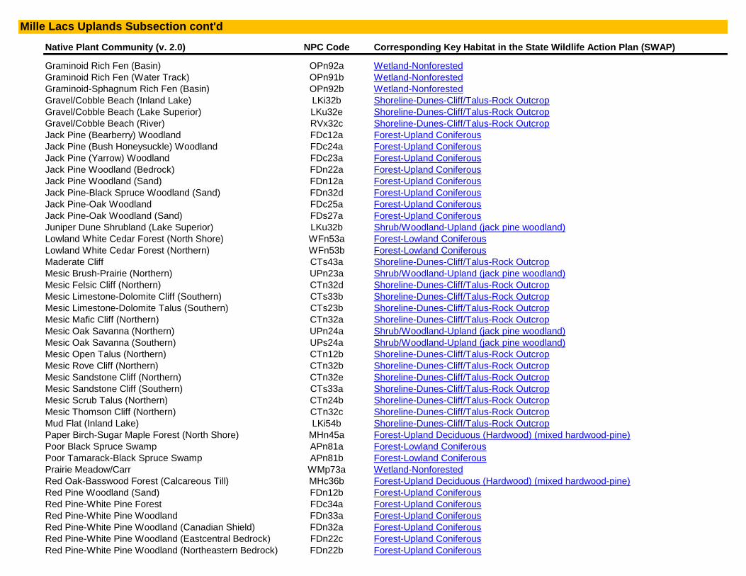
Native Plant Community (v. 2.0) NPC Code Corresponding Key Habitat in the State Wildlife Action Plan (SWAP)
Graminoid Rich Fen (Basin) OPn92a Wetland-Nonforested
Graminoid Rich Fen (Water Track) OPn91b Wetland-Nonforested
Graminoid-Sphagnum Rich Fen (Basin) OPn92b Wetland-Nonforested
Gravel/Cobble Beach (Inland Lake) LKi32b Shoreline-Dunes-Cliff/Talus-Rock Outcrop
Gravel/Cobble Beach (Lake Superior) LKu32e Shoreline-Dunes-Cliff/Talus-Rock Outcrop
Gravel/Cobble Beach (River) RVx32c Shoreline-Dunes-Cliff/Talus-Rock Outcrop
Jack Pine (Bearberry) Woodland FDc12a Forest-Upland Coniferous
Jack Pine (Bush Honeysuckle) Woodland FDc24a Forest-Upland Coniferous
Jack Pine (Yarrow) Woodland FDc23a Forest-Upland Coniferous
Jack Pine Woodland (Bedrock) FDn22a Forest-Upland Coniferous
Jack Pine Woodland (Sand) FDn12a Forest-Upland Coniferous
Jack Pine-Black Spruce Woodland (Sand) FDn32d Forest-Upland Coniferous
Jack Pine-Oak Woodland FDc25a Forest-Upland Coniferous
Jack Pine-Oak Woodland (Sand) FDs27a Forest-Upland Coniferous
Juniper Dune Shrubland (Lake Superior) LKu32b Shrub/Woodland-Upland (jack pine woodland)
Lowland White Cedar Forest (North Shore) WFn53a Forest-Lowland Coniferous
Lowland White Cedar Forest (Northern) WFn53b Forest-Lowland Coniferous
Maderate Cliff CTs43a Shoreline-Dunes-Cliff/Talus-Rock Outcrop
Mesic Brush-Prairie (Northern) UPn23a Shrub/Woodland-Upland (jack pine woodland)
Mesic Felsic Cliff (Northern) CTn32d Shoreline-Dunes-Cliff/Talus-Rock Outcrop
Mesic Limestone-Dolomite Cliff (Southern) CTs33b Shoreline-Dunes-Cliff/Talus-Rock Outcrop
Mesic Limestone-Dolomite Talus (Southern) CTs23b Shoreline-Dunes-Cliff/Talus-Rock Outcrop
Mesic Mafic Cliff (Northern) CTn32a Shoreline-Dunes-Cliff/Talus-Rock Outcrop
Mesic Oak Savanna (Northern) UPn24a Shrub/Woodland-Upland (jack pine woodland)
Mesic Oak Savanna (Southern) UPs24a Shrub/Woodland-Upland (jack pine woodland)
Mesic Open Talus (Northern) CTn12b Shoreline-Dunes-Cliff/Talus-Rock Outcrop
Mesic Rove Cliff (Northern) CTn32b Shoreline-Dunes-Cliff/Talus-Rock Outcrop
Mesic Sandstone Cliff (Northern) CTn32e Shoreline-Dunes-Cliff/Talus-Rock Outcrop
Mesic Sandstone Cliff (Southern) CTs33a Shoreline-Dunes-Cliff/Talus-Rock Outcrop
Mesic Scrub Talus (Northern) CTn24b Shoreline-Dunes-Cliff/Talus-Rock Outcrop
Mesic Thomson Cliff (Northern) CTn32c Shoreline-Dunes-Cliff/Talus-Rock Outcrop
Mud Flat (Inland Lake) LKi54b Shoreline-Dunes-Cliff/Talus-Rock Outcrop
Paper Birch-Sugar Maple Forest (North Shore) MHn45a Forest-Upland Deciduous (Hardwood) (mixed hardwood-pine)
Poor Black Spruce Swamp APn81a Forest-Lowland Coniferous
Poor Tamarack-Black Spruce Swamp APn81b Forest-Lowland Coniferous
Prairie Meadow/Carr WMp73a Wetland-Nonforested
Red Oak-Basswood Forest (Calcareous Till) MHc36b Forest-Upland Deciduous (Hardwood) (mixed hardwood-pine)
Red Pine Woodland (Sand) FDn12b Forest-Upland Coniferous
Red Pine-White Pine Forest FDc34a Forest-Upland Coniferous
Red Pine-White Pine Woodland FDn33a Forest-Upland Coniferous
Red Pine-White Pine Woodland (Canadian Shield) FDn32a Forest-Upland Coniferous
Red Pine-White Pine Woodland (Eastcentral Bedrock) FDn22c Forest-Upland Coniferous
Red Pine-White Pine Woodland (Northeastern Bedrock) FDn22b Forest-Upland Coniferous
Mille Lacs Uplands Subsection cont'd
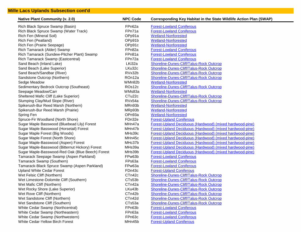
Native Plant Community (v. 2.0) NPC Code Corresponding Key Habitat in the State Wildlife Action Plan (SWAP)
Rich Black Spruce Swamp (Basin) FPn62a Forest-Lowland Coniferous
Rich Black Spruce Swamp (Water Track) FPn71a Forest-Lowland Coniferous
Rich Fen (Mineral Soil) OPp91a Wetland-Nonforested
Rich Fen (Peatland) OPp91b Wetland-Nonforested
Rich Fen (Prairie Seepage) OPp91c Wetland-Nonforested
Rich Tamarack (Alder) Swamp FPn82a Forest-Lowland Coniferous
Rich Tamarack (Sundew-Pitcher Plant) Swamp FPn81a Forest-Lowland Coniferous
Rich Tamarack Swamp (Eastcentral) FPn72a Forest-Lowland Coniferous
Sand Beach (Inland Lake) LKi32a Shoreline-Dunes-Cliff/Talus-Rock Outcrop
Sand Beach (Lake Superior) LKu32c Shoreline-Dunes-Cliff/Talus-Rock Outcrop
Sand Beach/Sandbar (River) RVx32b Shoreline-Dunes-Cliff/Talus-Rock Outcrop
Sandstone Outcrop (Northern) ROn12a Shoreline-Dunes-Cliff/Talus-Rock Outcrop
Sedge Meadow WMn82b Wetland-Nonforested
Sedimentary Bedrock Outcrop (Southeast) ROs12c Shoreline-Dunes-Cliff/Talus-Rock Outcrop
Seepage Meadow/Carr WMs83a Wetland-Nonforested
Sheltered Mafic Cliff (Lake Superior) CTu22c Shoreline-Dunes-Cliff/Talus-Rock Outcrop
Slumping Clay/Mud Slope (River) RVx54a Shoreline-Dunes-Cliff/Talus-Rock Outcrop
Spikerush-Bur Reed Marsh (Northern) MRn93b Wetland-Nonforested
Spikerush-Bur Reed Marsh (Prairie) MRp93b Wetland-Nonforested
Spring Fen OPn93a Wetland-Nonforested
Spruce-Fir Woodland (North Shore) FDn32e Forest-Upland Coniferous
Sugar Maple Basswood (Bluebead Lily) Forest MHn47a Forest-Upland Deciduous (Hardwood) (mixed hardwood-pine)
Sugar Maple Basswood (Horsetail) Forest MHn47b Forest-Upland Deciduous (Hardwood) (mixed hardwood-pine)
Sugar Maple Forest (Big Woods) MHs39c Forest-Upland Deciduous (Hardwood) (mixed hardwood-pine)
Sugar Maple Forest (North Shore) MHn45c Forest-Upland Deciduous (Hardwood) (mixed hardwood-pine)
Sugar Maple-Basswood (Aspen) Forest MHc37b Forest-Upland Deciduous (Hardwood) (mixed hardwood-pine)
Sugar Maple-Basswood (Bitternut Hickory) Forest MHs39a Forest-Upland Deciduous (Hardwood) (mixed hardwood-pine)
Sugar Maple-Basswood-Red Oak (Blue Beech) Forest MHs39b Forest-Upland Deciduous (Hardwood) (mixed hardwood-pine)
Tamarack Seepage Swamp (Aspen Parkland) FPw63b Forest-Lowland Coniferous
Tamarack Swamp (Southern) FPs63a Forest-Lowland Coniferous
Tamarack-Black Spruce Swamp (Aspen Parkland) FPw63a Forest-Lowland Coniferous
Upland White Cedar Forest FDn43c Forest-Upland Coniferous
Wet Felsic Cliff (Northern) CTn42c Shoreline-Dunes-Cliff/Talus-Rock Outcrop
Wet Limestone-Dolomite Cliff (Southern) CTs53b Shoreline-Dunes-Cliff/Talus-Rock Outcrop
Wet Mafic Cliff (Northern) CTn42a Shoreline-Dunes-Cliff/Talus-Rock Outcrop
Wet Rocky Shore (Lake Superior) LKu43b Shoreline-Dunes-Cliff/Talus-Rock Outcrop
Wet Rove Cliff (Northern) CTn42b Shoreline-Dunes-Cliff/Talus-Rock Outcrop
Wet Sandstone Cliff (Northern) CTn42d Shoreline-Dunes-Cliff/Talus-Rock Outcrop
Wet Sandstone Cliff (Southern) CTs53a Shoreline-Dunes-Cliff/Talus-Rock Outcrop
White Cedar Swamp (Northcentral) FPn63b Forest-Lowland Coniferous
White Cedar Swamp (Northeastern) FPn63a Forest-Lowland Coniferous
White Cedar Swamp (Northwestern) FPn63c Forest-Lowland Coniferous
White Cedar-Yellow Birch Forest MHn45b Forest-Upland Coniferous
Mille Lacs Uplands Subsection cont'd

Native Plant Community (v. 2.0) NPC Code Corresponding Key Habitat in the State Wildlife Action Plan (SWAP)
White Pine-Oak Woodland (Sand) FDs27b Forest-Upland Coniferous
White Pine-Red Pine Forest FDn43a Forest-Upland Coniferous
White Pine-Sugar Maple-Basswood Forest (Cold Slope) MHc38a Forest-Upland Deciduous (Hardwood) (mixed hardwood-pine)
White Pine-White Spruce-Paper Birch Forest MHn44b Forest-Upland Coniferous
Willow Sandbar Shrubland (River) RVx32a Shoreline-Dunes-Cliff/Talus-Rock Outcrop
N/A* N/A* Lake-Deep
N/A* N/A* River-Headwater to Large
N/A* N/A* River-Very Large (St. Croix River)
Native Plant Community (v. 2.0) NPC Code Corresponding Key Habitat in the State Wildlife Action Plan (SWAP)
Algific Talus CTs46a Shoreline-Dunes-Cliff/Talus-Rock Outcrop
Arrowhead Marsh (Prairie) MRp93c Wetland-Nonforested
Basin Meadow/Carr WMs92a Wetland-Nonforested
Beachgrass Dune (Lake Superior) LKu32a Shoreline-Dunes-Cliff/Talus-Rock Outcrop
Bedrock Shore (Inland Lake) LKi43b Shoreline-Dunes-Cliff/Talus-Rock Outcrop
Bedrock/Boulder Shore (River) RVx43a Shoreline-Dunes-Cliff/Talus-Rock Outcrop
Boulder Shore (Inland Lake) LKi43a Shoreline-Dunes-Cliff/Talus-Rock Outcrop
Bulrush Marsh (Northern) MRn93a Wetland-Nonforested
Bulrush Marsh (Prairie) MRp93a Wetland-Nonforested
Calcareous Fen (Northwestern) OPp93a Wetland-Nonforested
Calcareous Fen (Southeastern) OPp93c Wetland-Nonforested
Calcareous Fen (Southwestern) OPp93b Wetland-Nonforested
Cattail Marsh (Northern) MRn83b Wetland-Nonforested
Cattail Marsh (Prairie) MRp83b Wetland-Nonforested
Cattail-Sedge Marsh (Northern) MRn83a Wetland-Nonforested
Cattail-Sedge Marsh (Prairie) MRp83a Wetland-Nonforested
Clay/Mud Shore (Inland Lake) LKi54a Shoreline-Dunes-Cliff/Talus-Rock Outcrop
Clay/Mud Shore (River) RVx54b Shoreline-Dunes-Cliff/Talus-Rock Outcrop
Crystalline Bedrock Outcrop (Northern) ROn12b Shoreline-Dunes-Cliff/Talus-Rock Outcrop
Crystalline Bedrock Outcrop (Prairie) ROs12a Shoreline-Dunes-Cliff/Talus-Rock Outcrop
Crystalline Bedrock Outcrop (Transition) ROs12b Shoreline-Dunes-Cliff/Talus-Rock Outcrop
Dry Barrens Prairie (Northern) UPn12a Prairie
Dry Barrens Prairie (Southern) Ups13a Prairie
Dry Bedrock Bluff Prairie (Southern) Ups13c Prairie
Dry Bedrock Shore (Lake Superior) LKu43a Shoreline-Dunes-Cliff/Talus-Rock Outcrop
Dry Felsic Cliff (Northern) CTn11d Shoreline-Dunes-Cliff/Talus-Rock Outcrop
Dry Hill Prairie (Northern) UPn12d Prairie
Dry Hill Prairie (Southern) Ups13d Prairie
Dry Limestone-Dolomite Cliff (Southern) CTs12b Shoreline-Dunes-Cliff/Talus-Rock Outcrop
Dry Limestone-Dolomite Talus (Southern) CTs23a Shoreline-Dunes-Cliff/Talus-Rock Outcrop
Dry Mafic Cliff (Northern) CTn11a Shoreline-Dunes-Cliff/Talus-Rock Outcrop
Minnesota River Prairie Subsection
Mille Lacs Uplands Subsection cont'd

Native Plant Community (v. 2.0) NPC Code Corresponding Key Habitat in the State Wildlife Action Plan (SWAP)
Dry Open Talus (Northern) CTn12a Shoreline-Dunes-Cliff/Talus-Rock Outcrop
Dry Rove Cliff (Northern) CTn11b Shoreline-Dunes-Cliff/Talus-Rock Outcrop
Dry Sand-Gravel Brush-Prairie (Northern) UPn12c Prairie
Dry Sand-Gravel Prairie (Northern) UPn12b Prairie
Dry Sand-Gravel Prairie (Southern) Ups13b Prairie
Dry Sandstone Cliff (Northern) CTn11e Shoreline-Dunes-Cliff/Talus-Rock Outcrop
Dry Sandstone Cliff (Southern) CTs12a Shoreline-Dunes-Cliff/Talus-Rock Outcrop
Dry Scrub Talus (Northern) CTn24a Shoreline-Dunes-Cliff/Talus-Rock Outcrop
Dry Sioux Quartzite Cliff (Southern) CTs12c Shoreline-Dunes-Cliff/Talus-Rock Outcrop
Dry Thomson Cliff (Northern) CTn11c Shoreline-Dunes-Cliff/Talus-Rock Outcrop
Estuary Marsh (Lake Superior) MRu94a Wetland-Nonforested
Exposed Felsic Cliff (Lake Superior) CTu22b Shoreline-Dunes-Cliff/Talus-Rock Outcrop
Exposed Mafic Cliff (Lake Superior) CTu22a Shoreline-Dunes-Cliff/Talus-Rock Outcrop
Graminoid Bog APn90b Wetland-Nonforested
Graminoid Poor Fen (Basin) APn91b Wetland-Nonforested
Graminoid Poor Fen (Water Track) APn91c Wetland-Nonforested
Graminoid Rich Fen (Basin) OPn92a Wetland-Nonforested
Graminoid Rich Fen (Water Track) OPn91b Wetland-Nonforested
Graminoid-Sphagnum Rich Fen (Basin) OPn92b Wetland-Nonforested
Gravel/Cobble Beach (Inland Lake) LKi32b Shoreline-Dunes-Cliff/Talus-Rock Outcrop
Gravel/Cobble Beach (Lake Superior) LKu32e Shoreline-Dunes-Cliff/Talus-Rock Outcrop
Gravel/Cobble Beach (River) RVx32c Shoreline-Dunes-Cliff/Talus-Rock Outcrop
Maderate Cliff CTs43a Shoreline-Dunes-Cliff/Talus-Rock Outcrop
Mesic Felsic Cliff (Northern) CTn32d Shoreline-Dunes-Cliff/Talus-Rock Outcrop
Mesic Limestone-Dolomite Cliff (Southern) CTs33b Shoreline-Dunes-Cliff/Talus-Rock Outcrop
Mesic Limestone-Dolomite Talus (Southern) CTs23b Shoreline-Dunes-Cliff/Talus-Rock Outcrop
Mesic Mafic Cliff (Northern) CTn32a Shoreline-Dunes-Cliff/Talus-Rock Outcrop
Mesic Open Talus (Northern) CTn12b Shoreline-Dunes-Cliff/Talus-Rock Outcrop
Mesic Prairie (Northern) Upn23b Prairie
Mesic Prairie (Southern) Ups23a Prairie
Mesic Rove Cliff (Northern) CTn32b Shoreline-Dunes-Cliff/Talus-Rock Outcrop
Mesic Sandstone Cliff (Northern) CTn32e Shoreline-Dunes-Cliff/Talus-Rock Outcrop
Mesic Sandstone Cliff (Southern) CTs33a Shoreline-Dunes-Cliff/Talus-Rock Outcrop
Mesic Scrub Talus (Northern) CTn24b Shoreline-Dunes-Cliff/Talus-Rock Outcrop
Mesic Thomson Cliff (Northern) CTn32c Shoreline-Dunes-Cliff/Talus-Rock Outcrop
Mud Flat (Inland Lake) LKi54b Shoreline-Dunes-Cliff/Talus-Rock Outcrop
Prairie Meadow/Carr WMp73a Wetland-Nonforested
Rich Fen (Mineral Soil) OPp91a Wetland-Nonforested
Rich Fen (Peatland) OPp91b Wetland-Nonforested
Rich Fen (Prairie Seepage) OPp91c Wetland-Nonforested
Sand Beach (Inland Lake) LKi32a Shoreline-Dunes-Cliff/Talus-Rock Outcrop
Sand Beach (Lake Superior) LKu32c Shoreline-Dunes-Cliff/Talus-Rock Outcrop
Sand Beach/Sandbar (River) RVx32b Shoreline-Dunes-Cliff/Talus-Rock Outcrop
Minnesota River Prairie Subsection cont'd

Native Plant Community (v. 2.0) NPC Code Corresponding Key Habitat in the State Wildlife Action Plan (SWAP)
Sandstone Outcrop (Northern) ROn12a Shoreline-Dunes-Cliff/Talus-Rock Outcrop
Sedge Meadow WMn82b Wetland-Nonforested
Sedimentary Bedrock Outcrop (Southeast) ROs12c Shoreline-Dunes-Cliff/Talus-Rock Outcrop
Seepage Meadow/Carr WMs83a Wetland-Nonforested
Sheltered Mafic Cliff (Lake Superior) CTu22c Shoreline-Dunes-Cliff/Talus-Rock Outcrop
Slumping Clay/Mud Slope (River) RVx54a Shoreline-Dunes-Cliff/Talus-Rock Outcrop
Spikerush-Bur Reed Marsh (Northern) MRn93b Wetland-Nonforested
Spikerush-Bur Reed Marsh (Prairie) MRp93b Wetland-Nonforested
Spring Fen OPn93a Wetland-Nonforested
Wet Felsic Cliff (Northern) CTn42c Shoreline-Dunes-Cliff/Talus-Rock Outcrop
Wet Limestone-Dolomite Cliff (Southern) CTs53b Shoreline-Dunes-Cliff/Talus-Rock Outcrop
Wet Mafic Cliff (Northern) CTn42a Shoreline-Dunes-Cliff/Talus-Rock Outcrop
Wet Prairie (Northern) WPn53c Prairie
Wet Prairie (Southern) WPs54b Prairie
Wet Rocky Shore (Lake Superior) LKu43b Shoreline-Dunes-Cliff/Talus-Rock Outcrop
Wet Rove Cliff (Northern) CTn42b Shoreline-Dunes-Cliff/Talus-Rock Outcrop
Wet Saline Prairie (Northern) WPn53d Prairie
Wet Saline Prairie (Southern) WPs54c Prairie
Wet Sandstone Cliff (Northern) CTn42d Shoreline-Dunes-Cliff/Talus-Rock Outcrop
Wet Sandstone Cliff (Southern) CTs53a Shoreline-Dunes-Cliff/Talus-Rock Outcrop
Wet Seepage Prairie (Northern) WPn53a Prairie
Wet Seepage Prairie (Southern) WPs54a Prairie
Willow Sandbar Shrubland (River) RVx32a Shoreline-Dunes-Cliff/Talus-Rock Outcrop
N/A* N/A* Lake-Shallow
N/A* N/A* River-Headwater to Large
N/A* N/A* River-Very Large (Minnesota River)
Native Plant Community (v. 2.0) NPC Code Corresponding Key Habitat in the State Wildlife Action Plan (SWAP)
Aspen Openings (Northern) UPn24b Shrub/Woodland-Upland (jack pine woodland)
Basswood-Black Ash Forest MHc47a Forest-Upland Deciduous (Hardwood) (mixed hardwood-pine)
Beach Ridge Shrubland (Lake Superior) Lku32d Shrub/Woodland-Upland (jack pine woodland)
Bedrock Shrubland (Inland) Ron23a Shrub/Woodland-Upland (jack pine woodland)
Bedrock Shrubland (Lake Superior) Ron23b Shrub/Woodland-Upland (jack pine woodland)
Black Spruce Bog APn80a Forest-Lowland Coniferous
Black Spruce Woodland FDn33c Forest-Upland Coniferous (red-white pine)
Black Spruce-Jack Pine Woodland FDn32c Forest-Upland Coniferous (red-white pine)
Dry Barrens Jack Pine Savanna (Northern) UPn13a Shrub/Woodland-Upland (jack pine woodland)
Dry Barrens Oak Savanna (Northern) UPn13b Shrub/Woodland-Upland (jack pine woodland)
Dry Barrens Oak Savanna (Southern) UPs14a Shrub/Woodland-Upland (jack pine woodland)
Dry Hill Oak Savanna (Northern) UPn13d Shrub/Woodland-Upland (jack pine woodland)
Dry Hill Oak Savanna (Southern) Ups14c Shrub/Woodland-Upland (jack pine woodland)
Nashwauk Uplands Subsection
Minnesota River Prairie Subsection cont'd
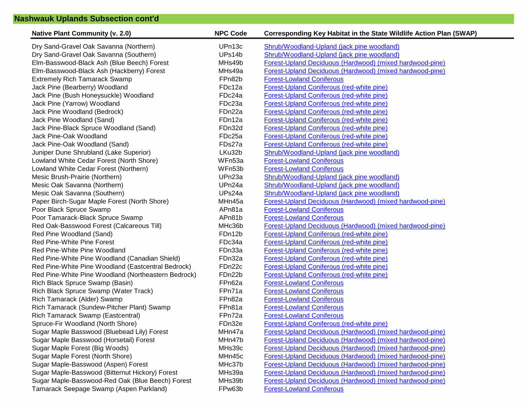
Native Plant Community (v. 2.0) NPC Code Corresponding Key Habitat in the State Wildlife Action Plan (SWAP)
Dry Sand-Gravel Oak Savanna (Northern) UPn13c Shrub/Woodland-Upland (jack pine woodland)
Dry Sand-Gravel Oak Savanna (Southern) UPs14b Shrub/Woodland-Upland (jack pine woodland)
Elm-Basswood-Black Ash (Blue Beech) Forest MHs49b Forest-Upland Deciduous (Hardwood) (mixed hardwood-pine)
Elm-Basswood-Black Ash (Hackberry) Forest MHs49a Forest-Upland Deciduous (Hardwood) (mixed hardwood-pine)
Extremely Rich Tamarack Swamp FPn82b Forest-Lowland Coniferous
Jack Pine (Bearberry) Woodland FDc12a Forest-Upland Coniferous (red-white pine)
Jack Pine (Bush Honeysuckle) Woodland FDc24a Forest-Upland Coniferous (red-white pine)
Jack Pine (Yarrow) Woodland FDc23a Forest-Upland Coniferous (red-white pine)
Jack Pine Woodland (Bedrock) FDn22a Forest-Upland Coniferous (red-white pine)
Jack Pine Woodland (Sand) FDn12a Forest-Upland Coniferous (red-white pine)
Jack Pine-Black Spruce Woodland (Sand) FDn32d Forest-Upland Coniferous (red-white pine)
Jack Pine-Oak Woodland FDc25a Forest-Upland Coniferous (red-white pine)
Jack Pine-Oak Woodland (Sand) FDs27a Forest-Upland Coniferous (red-white pine)
Juniper Dune Shrubland (Lake Superior) LKu32b Shrub/Woodland-Upland (jack pine woodland)
Lowland White Cedar Forest (North Shore) WFn53a Forest-Lowland Coniferous
Lowland White Cedar Forest (Northern) WFn53b Forest-Lowland Coniferous
Mesic Brush-Prairie (Northern) UPn23a Shrub/Woodland-Upland (jack pine woodland)
Mesic Oak Savanna (Northern) UPn24a Shrub/Woodland-Upland (jack pine woodland)
Mesic Oak Savanna (Southern) UPs24a Shrub/Woodland-Upland (jack pine woodland)
Paper Birch-Sugar Maple Forest (North Shore) MHn45a Forest-Upland Deciduous (Hardwood) (mixed hardwood-pine)
Poor Black Spruce Swamp APn81a Forest-Lowland Coniferous
Poor Tamarack-Black Spruce Swamp APn81b Forest-Lowland Coniferous
Red Oak-Basswood Forest (Calcareous Till) MHc36b Forest-Upland Deciduous (Hardwood) (mixed hardwood-pine)
Red Pine Woodland (Sand) FDn12b Forest-Upland Coniferous (red-white pine)
Red Pine-White Pine Forest FDc34a Forest-Upland Coniferous (red-white pine)
Red Pine-White Pine Woodland FDn33a Forest-Upland Coniferous (red-white pine)
Red Pine-White Pine Woodland (Canadian Shield) FDn32a Forest-Upland Coniferous (red-white pine)
Red Pine-White Pine Woodland (Eastcentral Bedrock) FDn22c Forest-Upland Coniferous (red-white pine)
Red Pine-White Pine Woodland (Northeastern Bedrock) FDn22b Forest-Upland Coniferous (red-white pine)
Rich Black Spruce Swamp (Basin) FPn62a Forest-Lowland Coniferous
Rich Black Spruce Swamp (Water Track) FPn71a Forest-Lowland Coniferous
Rich Tamarack (Alder) Swamp FPn82a Forest-Lowland Coniferous
Rich Tamarack (Sundew-Pitcher Plant) Swamp FPn81a Forest-Lowland Coniferous
Rich Tamarack Swamp (Eastcentral) FPn72a Forest-Lowland Coniferous
Spruce-Fir Woodland (North Shore) FDn32e Forest-Upland Coniferous (red-white pine)
Sugar Maple Basswood (Bluebead Lily) Forest MHn47a Forest-Upland Deciduous (Hardwood) (mixed hardwood-pine)
Sugar Maple Basswood (Horsetail) Forest MHn47b Forest-Upland Deciduous (Hardwood) (mixed hardwood-pine)
Sugar Maple Forest (Big Woods) MHs39c Forest-Upland Deciduous (Hardwood) (mixed hardwood-pine)
Sugar Maple Forest (North Shore) MHn45c Forest-Upland Deciduous (Hardwood) (mixed hardwood-pine)
Sugar Maple-Basswood (Aspen) Forest MHc37b Forest-Upland Deciduous (Hardwood) (mixed hardwood-pine)
Sugar Maple-Basswood (Bitternut Hickory) Forest MHs39a Forest-Upland Deciduous (Hardwood) (mixed hardwood-pine)
Sugar Maple-Basswood-Red Oak (Blue Beech) Forest MHs39b Forest-Upland Deciduous (Hardwood) (mixed hardwood-pine)
Tamarack Seepage Swamp (Aspen Parkland) FPw63b Forest-Lowland Coniferous
Nashwauk Uplands Subsection cont'd
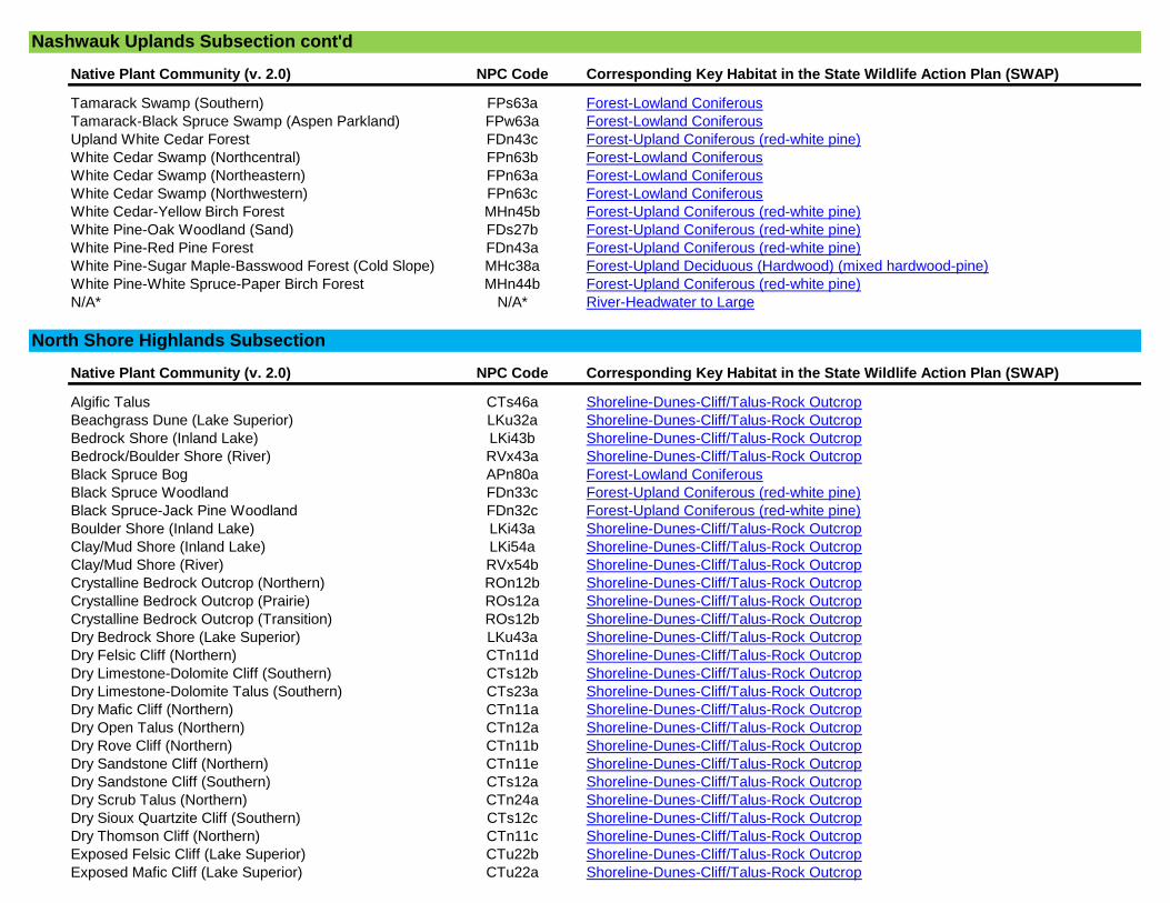
Native Plant Community (v. 2.0) NPC Code Corresponding Key Habitat in the State Wildlife Action Plan (SWAP)
Tamarack Swamp (Southern) FPs63a Forest-Lowland Coniferous
Tamarack-Black Spruce Swamp (Aspen Parkland) FPw63a Forest-Lowland Coniferous
Upland White Cedar Forest FDn43c Forest-Upland Coniferous (red-white pine)
White Cedar Swamp (Northcentral) FPn63b Forest-Lowland Coniferous
White Cedar Swamp (Northeastern) FPn63a Forest-Lowland Coniferous
White Cedar Swamp (Northwestern) FPn63c Forest-Lowland Coniferous
White Cedar-Yellow Birch Forest MHn45b Forest-Upland Coniferous (red-white pine)
White Pine-Oak Woodland (Sand) FDs27b Forest-Upland Coniferous (red-white pine)
White Pine-Red Pine Forest FDn43a Forest-Upland Coniferous (red-white pine)
White Pine-Sugar Maple-Basswood Forest (Cold Slope) MHc38a Forest-Upland Deciduous (Hardwood) (mixed hardwood-pine)
White Pine-White Spruce-Paper Birch Forest MHn44b Forest-Upland Coniferous (red-white pine)
N/A* N/A* River-Headwater to Large
Native Plant Community (v. 2.0) NPC Code Corresponding Key Habitat in the State Wildlife Action Plan (SWAP)
Algific Talus CTs46a Shoreline-Dunes-Cliff/Talus-Rock Outcrop
Beachgrass Dune (Lake Superior) LKu32a Shoreline-Dunes-Cliff/Talus-Rock Outcrop
Bedrock Shore (Inland Lake) LKi43b Shoreline-Dunes-Cliff/Talus-Rock Outcrop
Bedrock/Boulder Shore (River) RVx43a Shoreline-Dunes-Cliff/Talus-Rock Outcrop
Black Spruce Bog APn80a Forest-Lowland Coniferous
Black Spruce Woodland FDn33c Forest-Upland Coniferous (red-white pine)
Black Spruce-Jack Pine Woodland FDn32c Forest-Upland Coniferous (red-white pine)
Boulder Shore (Inland Lake) LKi43a Shoreline-Dunes-Cliff/Talus-Rock Outcrop
Clay/Mud Shore (Inland Lake) LKi54a Shoreline-Dunes-Cliff/Talus-Rock Outcrop
Clay/Mud Shore (River) RVx54b Shoreline-Dunes-Cliff/Talus-Rock Outcrop
Crystalline Bedrock Outcrop (Northern) ROn12b Shoreline-Dunes-Cliff/Talus-Rock Outcrop
Crystalline Bedrock Outcrop (Prairie) ROs12a Shoreline-Dunes-Cliff/Talus-Rock Outcrop
Crystalline Bedrock Outcrop (Transition) ROs12b Shoreline-Dunes-Cliff/Talus-Rock Outcrop
Dry Bedrock Shore (Lake Superior) LKu43a Shoreline-Dunes-Cliff/Talus-Rock Outcrop
Dry Felsic Cliff (Northern) CTn11d Shoreline-Dunes-Cliff/Talus-Rock Outcrop
Dry Limestone-Dolomite Cliff (Southern) CTs12b Shoreline-Dunes-Cliff/Talus-Rock Outcrop
Dry Limestone-Dolomite Talus (Southern) CTs23a Shoreline-Dunes-Cliff/Talus-Rock Outcrop
Dry Mafic Cliff (Northern) CTn11a Shoreline-Dunes-Cliff/Talus-Rock Outcrop
Dry Open Talus (Northern) CTn12a Shoreline-Dunes-Cliff/Talus-Rock Outcrop
Dry Rove Cliff (Northern) CTn11b Shoreline-Dunes-Cliff/Talus-Rock Outcrop
Dry Sandstone Cliff (Northern) CTn11e Shoreline-Dunes-Cliff/Talus-Rock Outcrop
Dry Sandstone Cliff (Southern) CTs12a Shoreline-Dunes-Cliff/Talus-Rock Outcrop
Dry Scrub Talus (Northern) CTn24a Shoreline-Dunes-Cliff/Talus-Rock Outcrop
Dry Sioux Quartzite Cliff (Southern) CTs12c Shoreline-Dunes-Cliff/Talus-Rock Outcrop
Dry Thomson Cliff (Northern) CTn11c Shoreline-Dunes-Cliff/Talus-Rock Outcrop
Exposed Felsic Cliff (Lake Superior) CTu22b Shoreline-Dunes-Cliff/Talus-Rock Outcrop
Exposed Mafic Cliff (Lake Superior) CTu22a Shoreline-Dunes-Cliff/Talus-Rock Outcrop
North Shore Highlands Subsection
Nashwauk Uplands Subsection cont'd

Native Plant Community (v. 2.0) NPC Code Corresponding Key Habitat in the State Wildlife Action Plan (SWAP)
Extremely Rich Tamarack Swamp FPn82b Forest-Lowland Coniferous
Gravel/Cobble Beach (Inland Lake) LKi32b Shoreline-Dunes-Cliff/Talus-Rock Outcrop
Gravel/Cobble Beach (Lake Superior) LKu32e Shoreline-Dunes-Cliff/Talus-Rock Outcrop
Gravel/Cobble Beach (River) RVx32c Shoreline-Dunes-Cliff/Talus-Rock Outcrop
Jack Pine (Bearberry) Woodland FDc12a Forest-Upland Coniferous (red-white pine)
Jack Pine (Bush Honeysuckle) Woodland FDc24a Forest-Upland Coniferous (red-white pine)
Jack Pine (Yarrow) Woodland FDc23a Forest-Upland Coniferous (red-white pine)
Jack Pine Woodland (Bedrock) FDn22a Forest-Upland Coniferous (red-white pine)
Jack Pine Woodland (Sand) FDn12a Forest-Upland Coniferous (red-white pine)
Jack Pine-Black Spruce Woodland (Sand) FDn32d Forest-Upland Coniferous (red-white pine)
Jack Pine-Oak Woodland FDc25a Forest-Upland Coniferous (red-white pine)
Jack Pine-Oak Woodland (Sand) FDs27a Forest-Upland Coniferous (red-white pine)
Lowland White Cedar Forest (North Shore) WFn53a Forest-Lowland Coniferous
Lowland White Cedar Forest (Northern) WFn53b Forest-Lowland Coniferous
Maderate Cliff CTs43a Shoreline-Dunes-Cliff/Talus-Rock Outcrop
Mesic Felsic Cliff (Northern) CTn32d Shoreline-Dunes-Cliff/Talus-Rock Outcrop
Mesic Limestone-Dolomite Cliff (Southern) CTs33b Shoreline-Dunes-Cliff/Talus-Rock Outcrop
Mesic Limestone-Dolomite Talus (Southern) CTs23b Shoreline-Dunes-Cliff/Talus-Rock Outcrop
Mesic Mafic Cliff (Northern) CTn32a Shoreline-Dunes-Cliff/Talus-Rock Outcrop
Mesic Open Talus (Northern) CTn12b Shoreline-Dunes-Cliff/Talus-Rock Outcrop
Mesic Rove Cliff (Northern) CTn32b Shoreline-Dunes-Cliff/Talus-Rock Outcrop
Mesic Sandstone Cliff (Northern) CTn32e Shoreline-Dunes-Cliff/Talus-Rock Outcrop
Mesic Sandstone Cliff (Southern) CTs33a Shoreline-Dunes-Cliff/Talus-Rock Outcrop
Mesic Scrub Talus (Northern) CTn24b Shoreline-Dunes-Cliff/Talus-Rock Outcrop
Mesic Thomson Cliff (Northern) CTn32c Shoreline-Dunes-Cliff/Talus-Rock Outcrop
Mud Flat (Inland Lake) LKi54b Shoreline-Dunes-Cliff/Talus-Rock Outcrop
Poor Black Spruce Swamp APn81a Forest-Lowland Coniferous
Poor Tamarack-Black Spruce Swamp APn81b Forest-Lowland Coniferous
Red Pine Woodland (Sand) FDn12b Forest-Upland Coniferous (red-white pine)
Red Pine-White Pine Forest FDc34a Forest-Upland Coniferous (red-white pine)
Red Pine-White Pine Woodland FDn33a Forest-Upland Coniferous (red-white pine)
Red Pine-White Pine Woodland (Canadian Shield) FDn32a Forest-Upland Coniferous (red-white pine)
Red Pine-White Pine Woodland (Eastcentral Bedrock) FDn22c Forest-Upland Coniferous (red-white pine)
Red Pine-White Pine Woodland (Northeastern Bedrock) FDn22b Forest-Upland Coniferous (red-white pine)
Rich Black Spruce Swamp (Basin) FPn62a Forest-Lowland Coniferous
Rich Black Spruce Swamp (Water Track) FPn71a Forest-Lowland Coniferous
Rich Tamarack (Alder) Swamp FPn82a Forest-Lowland Coniferous
Rich Tamarack (Sundew-Pitcher Plant) Swamp FPn81a Forest-Lowland Coniferous
Rich Tamarack Swamp (Eastcentral) FPn72a Forest-Lowland Coniferous
Sand Beach (Inland Lake) LKi32a Shoreline-Dunes-Cliff/Talus-Rock Outcrop
Sand Beach (Lake Superior) LKu32c Shoreline-Dunes-Cliff/Talus-Rock Outcrop
Sand Beach/Sandbar (River) RVx32b Shoreline-Dunes-Cliff/Talus-Rock Outcrop
Sandstone Outcrop (Northern) ROn12a Shoreline-Dunes-Cliff/Talus-Rock Outcrop
North Shore Highlands Subsection cont'd
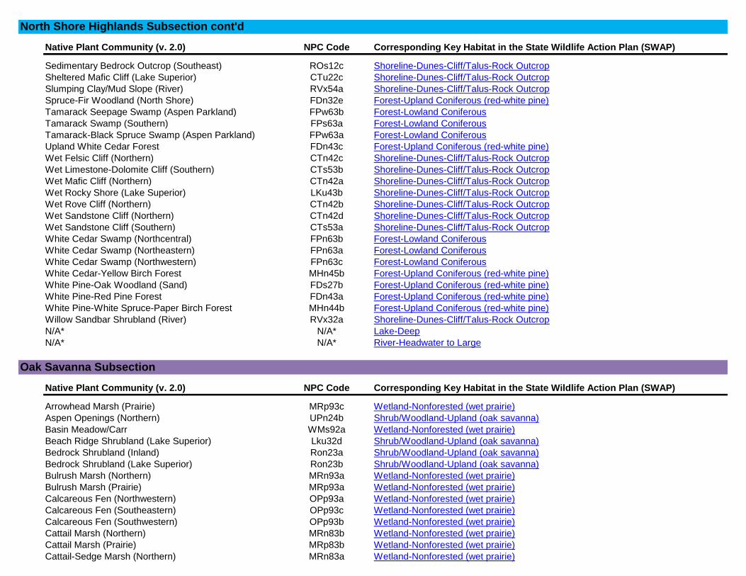
Native Plant Community (v. 2.0) NPC Code Corresponding Key Habitat in the State Wildlife Action Plan (SWAP)
Sedimentary Bedrock Outcrop (Southeast) ROs12c Shoreline-Dunes-Cliff/Talus-Rock Outcrop
Sheltered Mafic Cliff (Lake Superior) CTu22c Shoreline-Dunes-Cliff/Talus-Rock Outcrop
Slumping Clay/Mud Slope (River) RVx54a Shoreline-Dunes-Cliff/Talus-Rock Outcrop
Spruce-Fir Woodland (North Shore) FDn32e Forest-Upland Coniferous (red-white pine)
Tamarack Seepage Swamp (Aspen Parkland) FPw63b Forest-Lowland Coniferous
Tamarack Swamp (Southern) FPs63a Forest-Lowland Coniferous
Tamarack-Black Spruce Swamp (Aspen Parkland) FPw63a Forest-Lowland Coniferous
Upland White Cedar Forest FDn43c Forest-Upland Coniferous (red-white pine)
Wet Felsic Cliff (Northern) CTn42c Shoreline-Dunes-Cliff/Talus-Rock Outcrop
Wet Limestone-Dolomite Cliff (Southern) CTs53b Shoreline-Dunes-Cliff/Talus-Rock Outcrop
Wet Mafic Cliff (Northern) CTn42a Shoreline-Dunes-Cliff/Talus-Rock Outcrop
Wet Rocky Shore (Lake Superior) LKu43b Shoreline-Dunes-Cliff/Talus-Rock Outcrop
Wet Rove Cliff (Northern) CTn42b Shoreline-Dunes-Cliff/Talus-Rock Outcrop
Wet Sandstone Cliff (Northern) CTn42d Shoreline-Dunes-Cliff/Talus-Rock Outcrop
Wet Sandstone Cliff (Southern) CTs53a Shoreline-Dunes-Cliff/Talus-Rock Outcrop
White Cedar Swamp (Northcentral) FPn63b Forest-Lowland Coniferous
White Cedar Swamp (Northeastern) FPn63a Forest-Lowland Coniferous
White Cedar Swamp (Northwestern) FPn63c Forest-Lowland Coniferous
White Cedar-Yellow Birch Forest MHn45b Forest-Upland Coniferous (red-white pine)
White Pine-Oak Woodland (Sand) FDs27b Forest-Upland Coniferous (red-white pine)
White Pine-Red Pine Forest FDn43a Forest-Upland Coniferous (red-white pine)
White Pine-White Spruce-Paper Birch Forest MHn44b Forest-Upland Coniferous (red-white pine)
Willow Sandbar Shrubland (River) RVx32a Shoreline-Dunes-Cliff/Talus-Rock Outcrop
N/A* N/A* Lake-Deep
N/A* N/A* River-Headwater to Large
Native Plant Community (v. 2.0) NPC Code Corresponding Key Habitat in the State Wildlife Action Plan (SWAP)
Arrowhead Marsh (Prairie) MRp93c Wetland-Nonforested (wet prairie)
Aspen Openings (Northern) UPn24b Shrub/Woodland-Upland (oak savanna)
Basin Meadow/Carr WMs92a Wetland-Nonforested (wet prairie)
Beach Ridge Shrubland (Lake Superior) Lku32d Shrub/Woodland-Upland (oak savanna)
Bedrock Shrubland (Inland) Ron23a Shrub/Woodland-Upland (oak savanna)
Bedrock Shrubland (Lake Superior) Ron23b Shrub/Woodland-Upland (oak savanna)
Bulrush Marsh (Northern) MRn93a Wetland-Nonforested (wet prairie)
Bulrush Marsh (Prairie) MRp93a Wetland-Nonforested (wet prairie)
Calcareous Fen (Northwestern) OPp93a Wetland-Nonforested (wet prairie)
Calcareous Fen (Southeastern) OPp93c Wetland-Nonforested (wet prairie)
Calcareous Fen (Southwestern) OPp93b Wetland-Nonforested (wet prairie)
Cattail Marsh (Northern) MRn83b Wetland-Nonforested (wet prairie)
Cattail Marsh (Prairie) MRp83b Wetland-Nonforested (wet prairie)
Cattail-Sedge Marsh (Northern) MRn83a Wetland-Nonforested (wet prairie)
North Shore Highlands Subsection cont'd
Oak Savanna Subsection
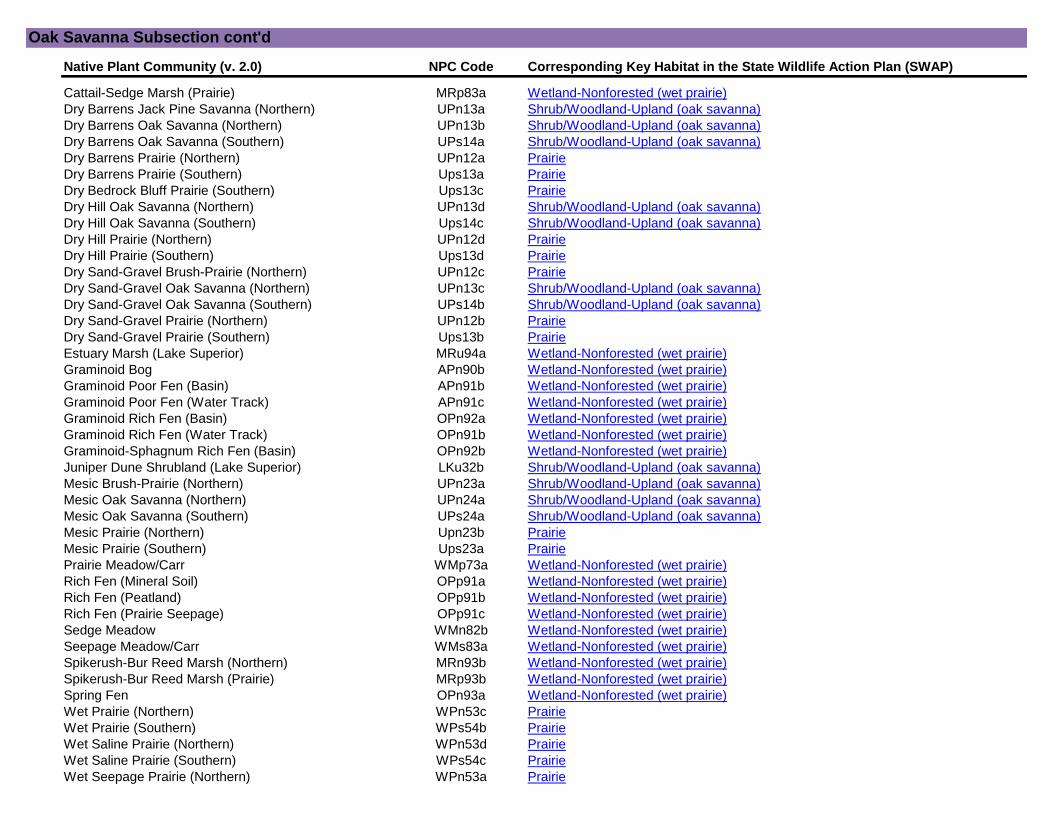
Native Plant Community (v. 2.0) NPC Code Corresponding Key Habitat in the State Wildlife Action Plan (SWAP)
Cattail-Sedge Marsh (Prairie) MRp83a Wetland-Nonforested (wet prairie)
Dry Barrens Jack Pine Savanna (Northern) UPn13a Shrub/Woodland-Upland (oak savanna)
Dry Barrens Oak Savanna (Northern) UPn13b Shrub/Woodland-Upland (oak savanna)
Dry Barrens Oak Savanna (Southern) UPs14a Shrub/Woodland-Upland (oak savanna)
Dry Barrens Prairie (Northern) UPn12a Prairie
Dry Barrens Prairie (Southern) Ups13a Prairie
Dry Bedrock Bluff Prairie (Southern) Ups13c Prairie
Dry Hill Oak Savanna (Northern) UPn13d Shrub/Woodland-Upland (oak savanna)
Dry Hill Oak Savanna (Southern) Ups14c Shrub/Woodland-Upland (oak savanna)
Dry Hill Prairie (Northern) UPn12d Prairie
Dry Hill Prairie (Southern) Ups13d Prairie
Dry Sand-Gravel Brush-Prairie (Northern) UPn12c Prairie
Dry Sand-Gravel Oak Savanna (Northern) UPn13c Shrub/Woodland-Upland (oak savanna)
Dry Sand-Gravel Oak Savanna (Southern) UPs14b Shrub/Woodland-Upland (oak savanna)
Dry Sand-Gravel Prairie (Northern) UPn12b Prairie
Dry Sand-Gravel Prairie (Southern) Ups13b Prairie
Estuary Marsh (Lake Superior) MRu94a Wetland-Nonforested (wet prairie)
Graminoid Bog APn90b Wetland-Nonforested (wet prairie)
Graminoid Poor Fen (Basin) APn91b Wetland-Nonforested (wet prairie)
Graminoid Poor Fen (Water Track) APn91c Wetland-Nonforested (wet prairie)
Graminoid Rich Fen (Basin) OPn92a Wetland-Nonforested (wet prairie)
Graminoid Rich Fen (Water Track) OPn91b Wetland-Nonforested (wet prairie)
Graminoid-Sphagnum Rich Fen (Basin) OPn92b Wetland-Nonforested (wet prairie)
Juniper Dune Shrubland (Lake Superior) LKu32b Shrub/Woodland-Upland (oak savanna)
Mesic Brush-Prairie (Northern) UPn23a Shrub/Woodland-Upland (oak savanna)
Mesic Oak Savanna (Northern) UPn24a Shrub/Woodland-Upland (oak savanna)
Mesic Oak Savanna (Southern) UPs24a Shrub/Woodland-Upland (oak savanna)
Mesic Prairie (Northern) Upn23b Prairie
Mesic Prairie (Southern) Ups23a Prairie
Prairie Meadow/Carr WMp73a Wetland-Nonforested (wet prairie)
Rich Fen (Mineral Soil) OPp91a Wetland-Nonforested (wet prairie)
Rich Fen (Peatland) OPp91b Wetland-Nonforested (wet prairie)
Rich Fen (Prairie Seepage) OPp91c Wetland-Nonforested (wet prairie)
Sedge Meadow WMn82b Wetland-Nonforested (wet prairie)
Seepage Meadow/Carr WMs83a Wetland-Nonforested (wet prairie)
Spikerush-Bur Reed Marsh (Northern) MRn93b Wetland-Nonforested (wet prairie)
Spikerush-Bur Reed Marsh (Prairie) MRp93b Wetland-Nonforested (wet prairie)
Spring Fen OPn93a Wetland-Nonforested (wet prairie)
Wet Prairie (Northern) WPn53c Prairie
Wet Prairie (Southern) WPs54b Prairie
Wet Saline Prairie (Northern) WPn53d Prairie
Wet Saline Prairie (Southern) WPs54c Prairie
Wet Seepage Prairie (Northern) WPn53a Prairie
Oak Savanna Subsection cont'd
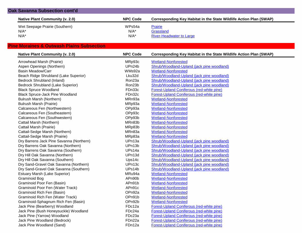
Native Plant Community (v. 2.0) NPC Code Corresponding Key Habitat in the State Wildlife Action Plan (SWAP)
Wet Seepage Prairie (Southern) WPs54a Prairie
N/A* N/A* Grassland
N/A* N/A* River-Headwater to Large
Native Plant Community (v. 2.0) NPC Code Corresponding Key Habitat in the State Wildlife Action Plan (SWAP)
Arrowhead Marsh (Prairie) MRp93c Wetland-Nonforested
Aspen Openings (Northern) UPn24b Shrub/Woodland-Upland (jack pine woodland)
Basin Meadow/Carr WMs92a Wetland-Nonforested
Beach Ridge Shrubland (Lake Superior) Lku32d Shrub/Woodland-Upland (jack pine woodland)
Bedrock Shrubland (Inland) Ron23a Shrub/Woodland-Upland (jack pine woodland)
Bedrock Shrubland (Lake Superior) Ron23b Shrub/Woodland-Upland (jack pine woodland)
Black Spruce Woodland FDn33c Forest-Upland Coniferous (red-white pine)
Black Spruce-Jack Pine Woodland FDn32c Forest-Upland Coniferous (red-white pine)
Bulrush Marsh (Northern) MRn93a Wetland-Nonforested
Bulrush Marsh (Prairie) MRp93a Wetland-Nonforested
Calcareous Fen (Northwestern) OPp93a Wetland-Nonforested
Calcareous Fen (Southeastern) OPp93c Wetland-Nonforested
Calcareous Fen (Southwestern) OPp93b Wetland-Nonforested
Cattail Marsh (Northern) MRn83b Wetland-Nonforested
Cattail Marsh (Prairie) MRp83b Wetland-Nonforested
Cattail-Sedge Marsh (Northern) MRn83a Wetland-Nonforested
Cattail-Sedge Marsh (Prairie) MRp83a Wetland-Nonforested
Dry Barrens Jack Pine Savanna (Northern) UPn13a Shrub/Woodland-Upland (jack pine woodland)
Dry Barrens Oak Savanna (Northern) UPn13b Shrub/Woodland-Upland (jack pine woodland)
Dry Barrens Oak Savanna (Southern) UPs14a Shrub/Woodland-Upland (jack pine woodland)
Dry Hill Oak Savanna (Northern) UPn13d Shrub/Woodland-Upland (jack pine woodland)
Dry Hill Oak Savanna (Southern) Ups14c Shrub/Woodland-Upland (jack pine woodland)
Dry Sand-Gravel Oak Savanna (Northern) UPn13c Shrub/Woodland-Upland (jack pine woodland)
Dry Sand-Gravel Oak Savanna (Southern) UPs14b Shrub/Woodland-Upland (jack pine woodland)
Estuary Marsh (Lake Superior) MRu94a Wetland-Nonforested
Graminoid Bog APn90b Wetland-Nonforested
Graminoid Poor Fen (Basin) APn91b Wetland-Nonforested
Graminoid Poor Fen (Water Track) APn91c Wetland-Nonforested
Graminoid Rich Fen (Basin) OPn92a Wetland-Nonforested
Graminoid Rich Fen (Water Track) OPn91b Wetland-Nonforested
Graminoid-Sphagnum Rich Fen (Basin) OPn92b Wetland-Nonforested
Jack Pine (Bearberry) Woodland FDc12a Forest-Upland Coniferous (red-white pine)
Jack Pine (Bush Honeysuckle) Woodland FDc24a Forest-Upland Coniferous (red-white pine)
Jack Pine (Yarrow) Woodland FDc23a Forest-Upland Coniferous (red-white pine)
Jack Pine Woodland (Bedrock) FDn22a Forest-Upland Coniferous (red-white pine)
Jack Pine Woodland (Sand) FDn12a Forest-Upland Coniferous (red-white pine)
Pine Moraines & Outwash Plains Subsection
Oak Savanna Subsection cont'd
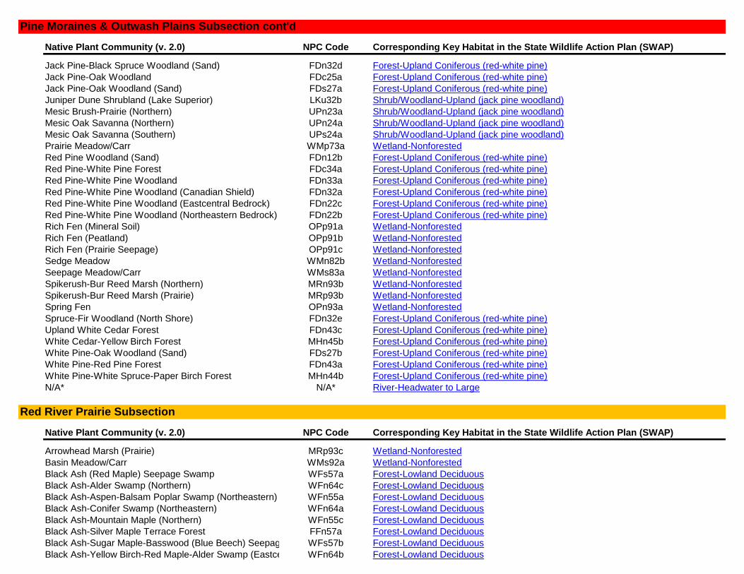
Native Plant Community (v. 2.0) NPC Code Corresponding Key Habitat in the State Wildlife Action Plan (SWAP)
Jack Pine-Black Spruce Woodland (Sand) FDn32d Forest-Upland Coniferous (red-white pine)
Jack Pine-Oak Woodland FDc25a Forest-Upland Coniferous (red-white pine)
Jack Pine-Oak Woodland (Sand) FDs27a Forest-Upland Coniferous (red-white pine)
Juniper Dune Shrubland (Lake Superior) LKu32b Shrub/Woodland-Upland (jack pine woodland)
Mesic Brush-Prairie (Northern) UPn23a Shrub/Woodland-Upland (jack pine woodland)
Mesic Oak Savanna (Northern) UPn24a Shrub/Woodland-Upland (jack pine woodland)
Mesic Oak Savanna (Southern) UPs24a Shrub/Woodland-Upland (jack pine woodland)
Prairie Meadow/Carr WMp73a Wetland-Nonforested
Red Pine Woodland (Sand) FDn12b Forest-Upland Coniferous (red-white pine)
Red Pine-White Pine Forest FDc34a Forest-Upland Coniferous (red-white pine)
Red Pine-White Pine Woodland FDn33a Forest-Upland Coniferous (red-white pine)
Red Pine-White Pine Woodland (Canadian Shield) FDn32a Forest-Upland Coniferous (red-white pine)
Red Pine-White Pine Woodland (Eastcentral Bedrock) FDn22c Forest-Upland Coniferous (red-white pine)
Red Pine-White Pine Woodland (Northeastern Bedrock) FDn22b Forest-Upland Coniferous (red-white pine)
Rich Fen (Mineral Soil) OPp91a Wetland-Nonforested
Rich Fen (Peatland) OPp91b Wetland-Nonforested
Rich Fen (Prairie Seepage) OPp91c Wetland-Nonforested
Sedge Meadow WMn82b Wetland-Nonforested
Seepage Meadow/Carr WMs83a Wetland-Nonforested
Spikerush-Bur Reed Marsh (Northern) MRn93b Wetland-Nonforested
Spikerush-Bur Reed Marsh (Prairie) MRp93b Wetland-Nonforested
Spring Fen OPn93a Wetland-Nonforested
Spruce-Fir Woodland (North Shore) FDn32e Forest-Upland Coniferous (red-white pine)
Upland White Cedar Forest FDn43c Forest-Upland Coniferous (red-white pine)
White Cedar-Yellow Birch Forest MHn45b Forest-Upland Coniferous (red-white pine)
White Pine-Oak Woodland (Sand) FDs27b Forest-Upland Coniferous (red-white pine)
White Pine-Red Pine Forest FDn43a Forest-Upland Coniferous (red-white pine)
White Pine-White Spruce-Paper Birch Forest MHn44b Forest-Upland Coniferous (red-white pine)
N/A* N/A* River-Headwater to Large
Native Plant Community (v. 2.0) NPC Code Corresponding Key Habitat in the State Wildlife Action Plan (SWAP)
Arrowhead Marsh (Prairie) MRp93c Wetland-Nonforested
Basin Meadow/Carr WMs92a Wetland-Nonforested
Black Ash (Red Maple) Seepage Swamp WFs57a Forest-Lowland Deciduous
Black Ash-Alder Swamp (Northern) WFn64c Forest-Lowland Deciduous
Black Ash-Aspen-Balsam Poplar Swamp (Northeastern) WFn55a Forest-Lowland Deciduous
Black Ash-Conifer Swamp (Northeastern) WFn64a Forest-Lowland Deciduous
Black Ash-Mountain Maple (Northern) WFn55c Forest-Lowland Deciduous
Black Ash-Silver Maple Terrace Forest FFn57a Forest-Lowland Deciduous
Black Ash-Sugar Maple-Basswood (Blue Beech) Seepage SwampWFs57b Forest-Lowland Deciduous
Black Ash-Yellow Birch-Red Maple-Alder Swamp (Eastcentral) WFn64b Forest-Lowland Deciduous
Red River Prairie Subsection
Pine Moraines & Outwash Plains Subsection cont'd
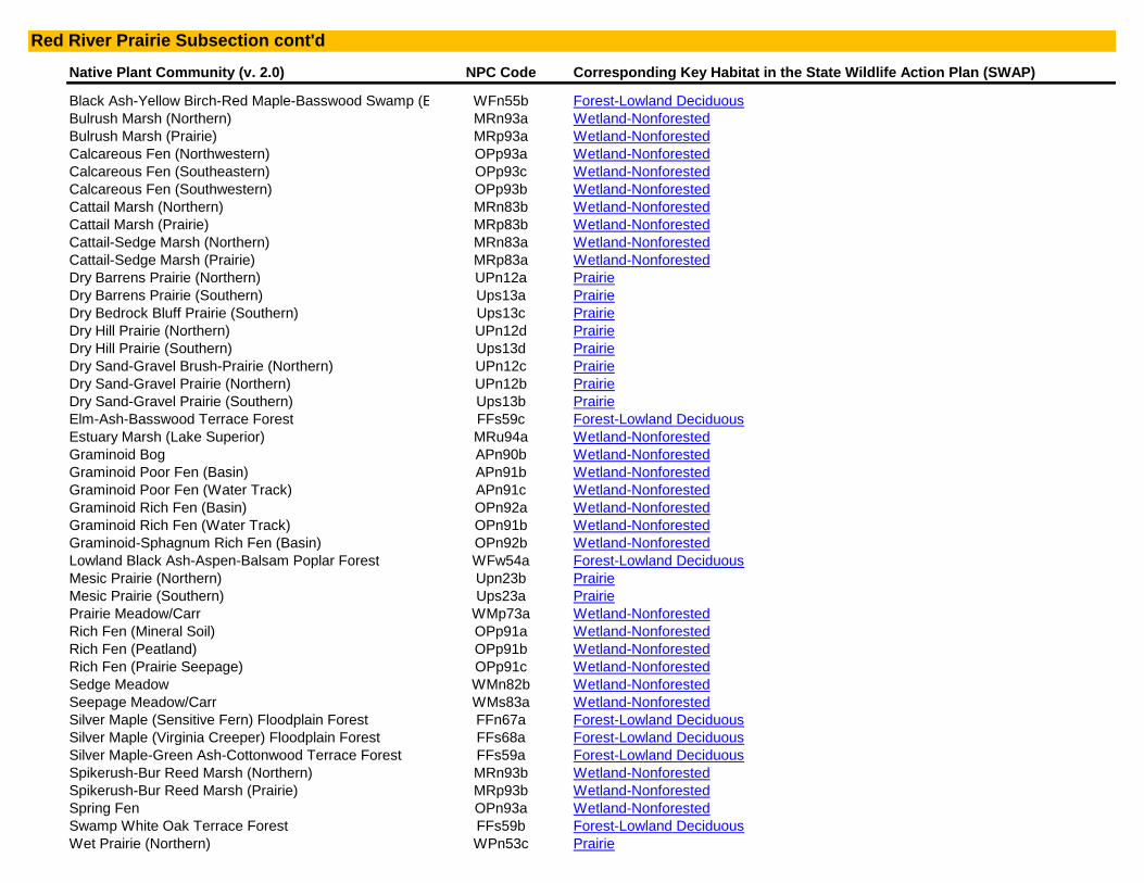
Native Plant Community (v. 2.0) NPC Code Corresponding Key Habitat in the State Wildlife Action Plan (SWAP)
Black Ash-Yellow Birch-Red Maple-Basswood Swamp (Eastcentral)WFn55b Forest-Lowland Deciduous
Bulrush Marsh (Northern) MRn93a Wetland-Nonforested
Bulrush Marsh (Prairie) MRp93a Wetland-Nonforested
Calcareous Fen (Northwestern) OPp93a Wetland-Nonforested
Calcareous Fen (Southeastern) OPp93c Wetland-Nonforested
Calcareous Fen (Southwestern) OPp93b Wetland-Nonforested
Cattail Marsh (Northern) MRn83b Wetland-Nonforested
Cattail Marsh (Prairie) MRp83b Wetland-Nonforested
Cattail-Sedge Marsh (Northern) MRn83a Wetland-Nonforested
Cattail-Sedge Marsh (Prairie) MRp83a Wetland-Nonforested
Dry Barrens Prairie (Northern) UPn12a Prairie
Dry Barrens Prairie (Southern) Ups13a Prairie
Dry Bedrock Bluff Prairie (Southern) Ups13c Prairie
Dry Hill Prairie (Northern) UPn12d Prairie
Dry Hill Prairie (Southern) Ups13d Prairie
Dry Sand-Gravel Brush-Prairie (Northern) UPn12c Prairie
Dry Sand-Gravel Prairie (Northern) UPn12b Prairie
Dry Sand-Gravel Prairie (Southern) Ups13b Prairie
Elm-Ash-Basswood Terrace Forest FFs59c Forest-Lowland Deciduous
Estuary Marsh (Lake Superior) MRu94a Wetland-Nonforested
Graminoid Bog APn90b Wetland-Nonforested
Graminoid Poor Fen (Basin) APn91b Wetland-Nonforested
Graminoid Poor Fen (Water Track) APn91c Wetland-Nonforested
Graminoid Rich Fen (Basin) OPn92a Wetland-Nonforested
Graminoid Rich Fen (Water Track) OPn91b Wetland-Nonforested
Graminoid-Sphagnum Rich Fen (Basin) OPn92b Wetland-Nonforested
Lowland Black Ash-Aspen-Balsam Poplar Forest WFw54a Forest-Lowland Deciduous
Mesic Prairie (Northern) Upn23b Prairie
Mesic Prairie (Southern) Ups23a Prairie
Prairie Meadow/Carr WMp73a Wetland-Nonforested
Rich Fen (Mineral Soil) OPp91a Wetland-Nonforested
Rich Fen (Peatland) OPp91b Wetland-Nonforested
Rich Fen (Prairie Seepage) OPp91c Wetland-Nonforested
Sedge Meadow WMn82b Wetland-Nonforested
Seepage Meadow/Carr WMs83a Wetland-Nonforested
Silver Maple (Sensitive Fern) Floodplain Forest FFn67a Forest-Lowland Deciduous
Silver Maple (Virginia Creeper) Floodplain Forest FFs68a Forest-Lowland Deciduous
Silver Maple-Green Ash-Cottonwood Terrace Forest FFs59a Forest-Lowland Deciduous
Spikerush-Bur Reed Marsh (Northern) MRn93b Wetland-Nonforested
Spikerush-Bur Reed Marsh (Prairie) MRp93b Wetland-Nonforested
Spring Fen OPn93a Wetland-Nonforested
Swamp White Oak Terrace Forest FFs59b Forest-Lowland Deciduous
Wet Prairie (Northern) WPn53c Prairie
Red River Prairie Subsection cont'd

Native Plant Community (v. 2.0) NPC Code Corresponding Key Habitat in the State Wildlife Action Plan (SWAP)
Wet Prairie (Southern) WPs54b Prairie
Wet Saline Prairie (Northern) WPn53d Prairie
Wet Saline Prairie (Southern) WPs54c Prairie
Wet Seepage Prairie (Northern) WPn53a Prairie
Wet Seepage Prairie (Southern) WPs54a Prairie
N/A* N/A* River-Headwater to Large
N/A* N/A* River-Very Large (Red River)
Native Plant Community (v. 2.0) NPC Code Corresponding Key Habitat in the State Wildlife Action Plan (SWAP)
Arrowhead Marsh (Prairie) MRp93c Wetland-Nonforested
Aspen Openings (Northern) UPn24b Shrub/Woodland-Upland (oak savanna, brush prairie)
Basin Meadow/Carr WMs92a Wetland-Nonforested
Beach Ridge Shrubland (Lake Superior) Lku32d Shrub/Woodland-Upland (oak savanna, brush prairie)
Bedrock Shrubland (Inland) Ron23a Shrub/Woodland-Upland (oak savanna, brush prairie)
Bedrock Shrubland (Lake Superior) Ron23b Shrub/Woodland-Upland (oak savanna, brush prairie)
Bulrush Marsh (Northern) MRn93a Wetland-Nonforested
Bulrush Marsh (Prairie) MRp93a Wetland-Nonforested
Calcareous Fen (Northwestern) OPp93a Wetland-Nonforested
Calcareous Fen (Southeastern) OPp93c Wetland-Nonforested
Calcareous Fen (Southwestern) OPp93b Wetland-Nonforested
Cattail Marsh (Northern) MRn83b Wetland-Nonforested
Cattail Marsh (Prairie) MRp83b Wetland-Nonforested
Cattail-Sedge Marsh (Northern) MRn83a Wetland-Nonforested
Cattail-Sedge Marsh (Prairie) MRp83a Wetland-Nonforested
Dry Barrens Jack Pine Savanna (Northern) UPn13a Shrub/Woodland-Upland (oak savanna, brush prairie)
Dry Barrens Oak Savanna (Northern) UPn13b Shrub/Woodland-Upland (oak savanna, brush prairie)
Dry Barrens Oak Savanna (Southern) UPs14a Shrub/Woodland-Upland (oak savanna, brush prairie)
Dry Barrens Prairie (Northern) UPn12a Prairie
Dry Barrens Prairie (Southern) Ups13a Prairie
Dry Bedrock Bluff Prairie (Southern) Ups13c Prairie
Dry Hill Oak Savanna (Northern) UPn13d Shrub/Woodland-Upland (oak savanna, brush prairie)
Dry Hill Oak Savanna (Southern) Ups14c Shrub/Woodland-Upland (oak savanna, brush prairie)
Dry Hill Prairie (Northern) UPn12d Prairie
Dry Hill Prairie (Southern) Ups13d Prairie
Dry Sand-Gravel Brush-Prairie (Northern) UPn12c Prairie
Dry Sand-Gravel Oak Savanna (Northern) UPn13c Shrub/Woodland-Upland (oak savanna, brush prairie)
Dry Sand-Gravel Oak Savanna (Southern) UPs14b Shrub/Woodland-Upland (oak savanna, brush prairie)
Dry Sand-Gravel Prairie (Northern) UPn12b Prairie
Dry Sand-Gravel Prairie (Southern) Ups13b Prairie
Estuary Marsh (Lake Superior) MRu94a Wetland-Nonforested
Graminoid Bog APn90b Wetland-Nonforested
Rochester Plateau Subsection
Red River Prairie Subsection cont'd

Native Plant Community (v. 2.0) NPC Code Corresponding Key Habitat in the State Wildlife Action Plan (SWAP)
Graminoid Poor Fen (Basin) APn91b Wetland-Nonforested
Graminoid Poor Fen (Water Track) APn91c Wetland-Nonforested
Graminoid Rich Fen (Basin) OPn92a Wetland-Nonforested
Graminoid Rich Fen (Water Track) OPn91b Wetland-Nonforested
Graminoid-Sphagnum Rich Fen (Basin) OPn92b Wetland-Nonforested
Juniper Dune Shrubland (Lake Superior) LKu32b Shrub/Woodland-Upland (oak savanna, brush prairie)
Mesic Brush-Prairie (Northern) UPn23a Shrub/Woodland-Upland (oak savanna, brush prairie)
Mesic Oak Savanna (Northern) UPn24a Shrub/Woodland-Upland (oak savanna, brush prairie)
Mesic Oak Savanna (Southern) UPs24a Shrub/Woodland-Upland (oak savanna, brush prairie)
Mesic Prairie (Northern) Upn23b Prairie
Mesic Prairie (Southern) Ups23a Prairie
Prairie Meadow/Carr WMp73a Wetland-Nonforested
Rich Fen (Mineral Soil) OPp91a Wetland-Nonforested
Rich Fen (Peatland) OPp91b Wetland-Nonforested
Rich Fen (Prairie Seepage) OPp91c Wetland-Nonforested
Sedge Meadow WMn82b Wetland-Nonforested
Seepage Meadow/Carr WMs83a Wetland-Nonforested
Spikerush-Bur Reed Marsh (Northern) MRn93b Wetland-Nonforested
Spikerush-Bur Reed Marsh (Prairie) MRp93b Wetland-Nonforested
Spring Fen OPn93a Wetland-Nonforested
Wet Prairie (Northern) WPn53c Prairie
Wet Prairie (Southern) WPs54b Prairie
Wet Saline Prairie (Northern) WPn53d Prairie
Wet Saline Prairie (Southern) WPs54c Prairie
Wet Seepage Prairie (Northern) WPn53a Prairie
Wet Seepage Prairie (Southern) WPs54a Prairie
N/A* N/A* Grassland
N/A* N/A* River-Headwater to Large
Native Plant Community (v. 2.0) NPC Code Corresponding Key Habitat in the State Wildlife Action Plan (SWAP)
Black Spruce Woodland FDn33c Forest-Upland Coniferous (red-white pine)
Black Spruce-Jack Pine Woodland FDn32c Forest-Upland Coniferous (red-white pine)
Jack Pine (Bearberry) Woodland FDc12a Forest-Upland Coniferous (red-white pine)
Jack Pine (Bush Honeysuckle) Woodland FDc24a Forest-Upland Coniferous (red-white pine)
Jack Pine (Yarrow) Woodland FDc23a Forest-Upland Coniferous (red-white pine)
Jack Pine Woodland (Bedrock) FDn22a Forest-Upland Coniferous (red-white pine)
Jack Pine Woodland (Sand) FDn12a Forest-Upland Coniferous (red-white pine)
Jack Pine-Black Spruce Woodland (Sand) FDn32d Forest-Upland Coniferous (red-white pine)
Jack Pine-Oak Woodland FDc25a Forest-Upland Coniferous (red-white pine)
Jack Pine-Oak Woodland (Sand) FDs27a Forest-Upland Coniferous (red-white pine)
Red Pine Woodland (Sand) FDn12b Forest-Upland Coniferous (red-white pine)
St. Louis Moraines Subsection
Rochester Plateau Subsection cont'd
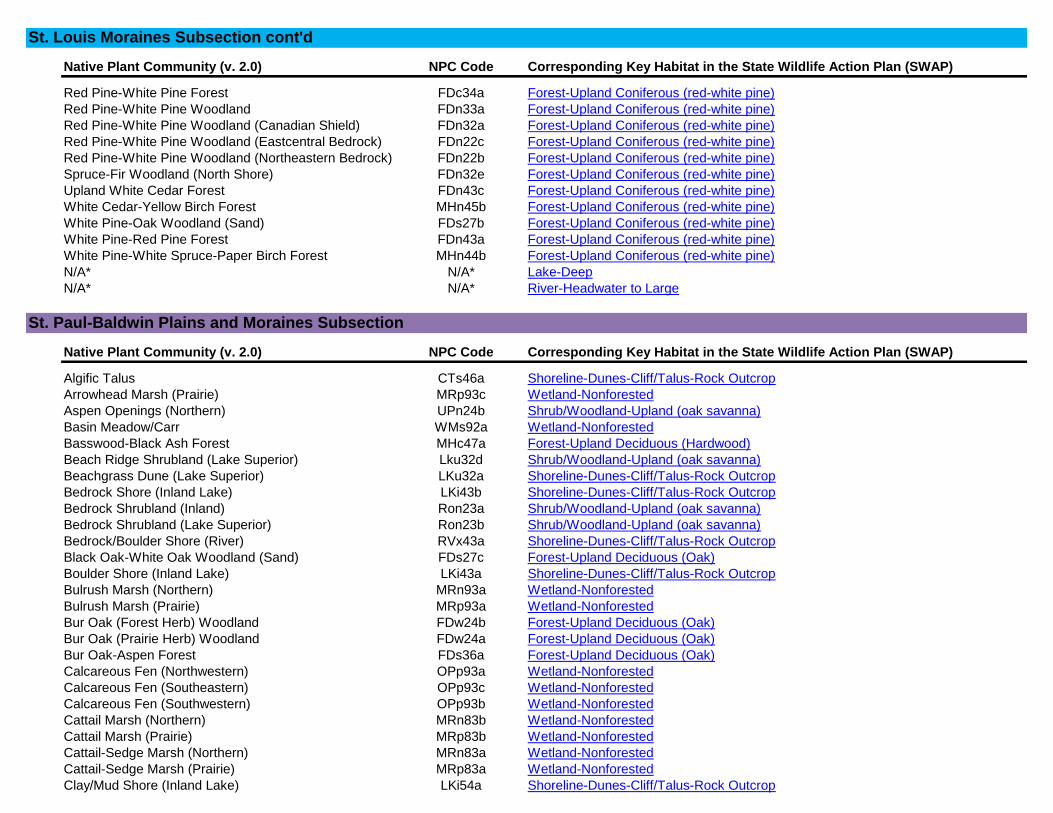
Native Plant Community (v. 2.0) NPC Code Corresponding Key Habitat in the State Wildlife Action Plan (SWAP)
Red Pine-White Pine Forest FDc34a Forest-Upland Coniferous (red-white pine)
Red Pine-White Pine Woodland FDn33a Forest-Upland Coniferous (red-white pine)
Red Pine-White Pine Woodland (Canadian Shield) FDn32a Forest-Upland Coniferous (red-white pine)
Red Pine-White Pine Woodland (Eastcentral Bedrock) FDn22c Forest-Upland Coniferous (red-white pine)
Red Pine-White Pine Woodland (Northeastern Bedrock) FDn22b Forest-Upland Coniferous (red-white pine)
Spruce-Fir Woodland (North Shore) FDn32e Forest-Upland Coniferous (red-white pine)
Upland White Cedar Forest FDn43c Forest-Upland Coniferous (red-white pine)
White Cedar-Yellow Birch Forest MHn45b Forest-Upland Coniferous (red-white pine)
White Pine-Oak Woodland (Sand) FDs27b Forest-Upland Coniferous (red-white pine)
White Pine-Red Pine Forest FDn43a Forest-Upland Coniferous (red-white pine)
White Pine-White Spruce-Paper Birch Forest MHn44b Forest-Upland Coniferous (red-white pine)
N/A* N/A* Lake-Deep
N/A* N/A* River-Headwater to Large
Native Plant Community (v. 2.0) NPC Code Corresponding Key Habitat in the State Wildlife Action Plan (SWAP)
Algific Talus CTs46a Shoreline-Dunes-Cliff/Talus-Rock Outcrop
Arrowhead Marsh (Prairie) MRp93c Wetland-Nonforested
Aspen Openings (Northern) UPn24b Shrub/Woodland-Upland (oak savanna)
Basin Meadow/Carr WMs92a Wetland-Nonforested
Basswood-Black Ash Forest MHc47a Forest-Upland Deciduous (Hardwood)
Beach Ridge Shrubland (Lake Superior) Lku32d Shrub/Woodland-Upland (oak savanna)
Beachgrass Dune (Lake Superior) LKu32a Shoreline-Dunes-Cliff/Talus-Rock Outcrop
Bedrock Shore (Inland Lake) LKi43b Shoreline-Dunes-Cliff/Talus-Rock Outcrop
Bedrock Shrubland (Inland) Ron23a Shrub/Woodland-Upland (oak savanna)
Bedrock Shrubland (Lake Superior) Ron23b Shrub/Woodland-Upland (oak savanna)
Bedrock/Boulder Shore (River) RVx43a Shoreline-Dunes-Cliff/Talus-Rock Outcrop
Black Oak-White Oak Woodland (Sand) FDs27c Forest-Upland Deciduous (Oak)
Boulder Shore (Inland Lake) LKi43a Shoreline-Dunes-Cliff/Talus-Rock Outcrop
Bulrush Marsh (Northern) MRn93a Wetland-Nonforested
Bulrush Marsh (Prairie) MRp93a Wetland-Nonforested
Bur Oak (Forest Herb) Woodland FDw24b Forest-Upland Deciduous (Oak)
Bur Oak (Prairie Herb) Woodland FDw24a Forest-Upland Deciduous (Oak)
Bur Oak-Aspen Forest FDs36a Forest-Upland Deciduous (Oak)
Calcareous Fen (Northwestern) OPp93a Wetland-Nonforested
Calcareous Fen (Southeastern) OPp93c Wetland-Nonforested
Calcareous Fen (Southwestern) OPp93b Wetland-Nonforested
Cattail Marsh (Northern) MRn83b Wetland-Nonforested
Cattail Marsh (Prairie) MRp83b Wetland-Nonforested
Cattail-Sedge Marsh (Northern) MRn83a Wetland-Nonforested
Cattail-Sedge Marsh (Prairie) MRp83a Wetland-Nonforested
Clay/Mud Shore (Inland Lake) LKi54a Shoreline-Dunes-Cliff/Talus-Rock Outcrop
St. Paul-Baldwin Plains and Moraines Subsection
St. Louis Moraines Subsection cont'd

Native Plant Community (v. 2.0) NPC Code Corresponding Key Habitat in the State Wildlife Action Plan (SWAP)
Clay/Mud Shore (River) RVx54b Shoreline-Dunes-Cliff/Talus-Rock Outcrop
Crystalline Bedrock Outcrop (Northern) ROn12b Shoreline-Dunes-Cliff/Talus-Rock Outcrop
Crystalline Bedrock Outcrop (Prairie) ROs12a Shoreline-Dunes-Cliff/Talus-Rock Outcrop
Crystalline Bedrock Outcrop (Transition) ROs12b Shoreline-Dunes-Cliff/Talus-Rock Outcrop
Dry Barrens Jack Pine Savanna (Northern) UPn13a Shrub/Woodland-Upland (oak savanna)
Dry Barrens Oak Savanna (Northern) UPn13b Shrub/Woodland-Upland (oak savanna)
Dry Barrens Oak Savanna (Southern) UPs14a Shrub/Woodland-Upland (oak savanna)
Dry Barrens Prairie (Northern) UPn12a Prairie
Dry Barrens Prairie (Southern) Ups13a Prairie
Dry Bedrock Bluff Prairie (Southern) Ups13c Prairie
Dry Bedrock Shore (Lake Superior) LKu43a Shoreline-Dunes-Cliff/Talus-Rock Outcrop
Dry Felsic Cliff (Northern) CTn11d Shoreline-Dunes-Cliff/Talus-Rock Outcrop
Dry Hill Oak Savanna (Northern) UPn13d Shrub/Woodland-Upland (oak savanna)
Dry Hill Oak Savanna (Southern) Ups14c Shrub/Woodland-Upland (oak savanna)
Dry Hill Prairie (Northern) UPn12d Prairie
Dry Hill Prairie (Southern) Ups13d Prairie
Dry Limestone-Dolomite Cliff (Southern) CTs12b Shoreline-Dunes-Cliff/Talus-Rock Outcrop
Dry Limestone-Dolomite Talus (Southern) CTs23a Shoreline-Dunes-Cliff/Talus-Rock Outcrop
Dry Mafic Cliff (Northern) CTn11a Shoreline-Dunes-Cliff/Talus-Rock Outcrop
Dry Open Talus (Northern) CTn12a Shoreline-Dunes-Cliff/Talus-Rock Outcrop
Dry Rove Cliff (Northern) CTn11b Shoreline-Dunes-Cliff/Talus-Rock Outcrop
Dry Sand-Gravel Brush-Prairie (Northern) UPn12c Prairie
Dry Sand-Gravel Oak Savanna (Northern) UPn13c Shrub/Woodland-Upland (oak savanna)
Dry Sand-Gravel Oak Savanna (Southern) UPs14b Shrub/Woodland-Upland (oak savanna)
Dry Sand-Gravel Prairie (Northern) UPn12b Prairie
Dry Sand-Gravel Prairie (Southern) Ups13b Prairie
Dry Sandstone Cliff (Northern) CTn11e Shoreline-Dunes-Cliff/Talus-Rock Outcrop
Dry Sandstone Cliff (Southern) CTs12a Shoreline-Dunes-Cliff/Talus-Rock Outcrop
Dry Scrub Talus (Northern) CTn24a Shoreline-Dunes-Cliff/Talus-Rock Outcrop
Dry Sioux Quartzite Cliff (Southern) CTs12c Shoreline-Dunes-Cliff/Talus-Rock Outcrop
Dry Thomson Cliff (Northern) CTn11c Shoreline-Dunes-Cliff/Talus-Rock Outcrop
Elm-Basswood-Black Ash (Blue Beech) Forest MHs49b Forest-Upland Deciduous (Hardwood)
Elm-Basswood-Black Ash (Hackberry) Forest MHs49a Forest-Upland Deciduous (Hardwood)
Estuary Marsh (Lake Superior) MRu94a Wetland-Nonforested
Exposed Felsic Cliff (Lake Superior) CTu22b Shoreline-Dunes-Cliff/Talus-Rock Outcrop
Exposed Mafic Cliff (Lake Superior) CTu22a Shoreline-Dunes-Cliff/Talus-Rock Outcrop
Graminoid Bog APn90b Wetland-Nonforested
Graminoid Poor Fen (Basin) APn91b Wetland-Nonforested
Graminoid Poor Fen (Water Track) APn91c Wetland-Nonforested
Graminoid Rich Fen (Basin) OPn92a Wetland-Nonforested
Graminoid Rich Fen (Water Track) OPn91b Wetland-Nonforested
Graminoid-Sphagnum Rich Fen (Basin) OPn92b Wetland-Nonforested
Gravel/Cobble Beach (Inland Lake) LKi32b Shoreline-Dunes-Cliff/Talus-Rock Outcrop
St. Paul-Baldwin Plains and Moraines Subsection cont'd
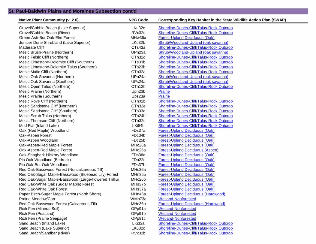
Native Plant Community (v. 2.0) NPC Code Corresponding Key Habitat in the State Wildlife Action Plan (SWAP)
Gravel/Cobble Beach (Lake Superior) LKu32e Shoreline-Dunes-Cliff/Talus-Rock Outcrop
Gravel/Cobble Beach (River) RVx32c Shoreline-Dunes-Cliff/Talus-Rock Outcrop
Green Ash-Bur Oak-Elm Forest MHw36a Forest-Upland Deciduous (Oak)
Juniper Dune Shrubland (Lake Superior) LKu32b Shrub/Woodland-Upland (oak savanna)
Maderate Cliff CTs43a Shoreline-Dunes-Cliff/Talus-Rock Outcrop
Mesic Brush-Prairie (Northern) UPn23a Shrub/Woodland-Upland (oak savanna)
Mesic Felsic Cliff (Northern) CTn32d Shoreline-Dunes-Cliff/Talus-Rock Outcrop
Mesic Limestone-Dolomite Cliff (Southern) CTs33b Shoreline-Dunes-Cliff/Talus-Rock Outcrop
Mesic Limestone-Dolomite Talus (Southern) CTs23b Shoreline-Dunes-Cliff/Talus-Rock Outcrop
Mesic Mafic Cliff (Northern) CTn32a Shoreline-Dunes-Cliff/Talus-Rock Outcrop
Mesic Oak Savanna (Northern) UPn24a Shrub/Woodland-Upland (oak savanna)
Mesic Oak Savanna (Southern) UPs24a Shrub/Woodland-Upland (oak savanna)
Mesic Open Talus (Northern) CTn12b Shoreline-Dunes-Cliff/Talus-Rock Outcrop
Mesic Prairie (Northern) Upn23b Prairie
Mesic Prairie (Southern) Ups23a Prairie
Mesic Rove Cliff (Northern) CTn32b Shoreline-Dunes-Cliff/Talus-Rock Outcrop
Mesic Sandstone Cliff (Northern) CTn32e Shoreline-Dunes-Cliff/Talus-Rock Outcrop
Mesic Sandstone Cliff (Southern) CTs33a Shoreline-Dunes-Cliff/Talus-Rock Outcrop
Mesic Scrub Talus (Northern) CTn24b Shoreline-Dunes-Cliff/Talus-Rock Outcrop
Mesic Thomson Cliff (Northern) CTn32c Shoreline-Dunes-Cliff/Talus-Rock Outcrop
Mud Flat (Inland Lake) LKi54b Shoreline-Dunes-Cliff/Talus-Rock Outcrop
Oak (Red Maple) Woodland FDs37a Forest-Upland Deciduous (Oak)
Oak-Aspen Forest FDc34b Forest-Upland Deciduous (Oak)
Oak-Aspen Woodland FDc25b Forest-Upland Deciduous (Oak)
Oak-Aspen-Red Maple Forest MHc26a Forest-Upland Deciduous (Oak)
Oak-Aspen-Red Maple Forest MHc26a Forest-Upland Deciduous (Aspen)
Oak-Shagbark Hickory Woodland FDs38a Forest-Upland Deciduous (Oak)
Pin Oak Woodland (Bedrock) FDn22c Forest-Upland Deciduous (Oak)
Pin Oak-Bur Oak Woodland FDs37b Forest-Upland Deciduous (Oak)
Red Oak-Basswood Forest (Noncalcareous Till) MHc36a Forest-Upland Deciduous (Oak)
Red Oak-Sugar Maple-Basswood (Bluebead Lily) Forest MHn35b Forest-Upland Deciduous (Oak)
Red Oak-Sugar Maple-Basswood (Large-flowered Trillium) ForestMHc26b Forest-Upland Deciduous (Oak)
Red Oak-White Oak (Sugar Maple) Forest MHs37b Forest-Upland Deciduous (Oak)
Red Oak-White Oak Forest MHs37a Forest-Upland Deciduous (Oak)
Paper Birch-Sugar Maple Forest (North Shore) MHn45a Forest-Upland Deciduous (Hardwood)
Prairie Meadow/Carr WMp73a Wetland-Nonforested
Red Oak-Basswood Forest (Calcareous Till) MHc36b Forest-Upland Deciduous (Hardwood)
Rich Fen (Mineral Soil) OPp91a Wetland-Nonforested
Rich Fen (Peatland) OPp91b Wetland-Nonforested
Rich Fen (Prairie Seepage) OPp91c Wetland-Nonforested
Sand Beach (Inland Lake) LKi32a Shoreline-Dunes-Cliff/Talus-Rock Outcrop
Sand Beach (Lake Superior) LKu32c Shoreline-Dunes-Cliff/Talus-Rock Outcrop
Sand Beach/Sandbar (River) RVx32b Shoreline-Dunes-Cliff/Talus-Rock Outcrop
St. Paul-Baldwin Plains and Moraines Subsection cont'd

Native Plant Community (v. 2.0) NPC Code Corresponding Key Habitat in the State Wildlife Action Plan (SWAP)
Sandstone Outcrop (Northern) ROn12a Shoreline-Dunes-Cliff/Talus-Rock Outcrop
Sedge Meadow WMn82b Wetland-Nonforested
Sedimentary Bedrock Outcrop (Southeast) ROs12c Shoreline-Dunes-Cliff/Talus-Rock Outcrop
Seepage Meadow/Carr WMs83a Wetland-Nonforested
Sheltered Mafic Cliff (Lake Superior) CTu22c Shoreline-Dunes-Cliff/Talus-Rock Outcrop
Slumping Clay/Mud Slope (River) RVx54a Shoreline-Dunes-Cliff/Talus-Rock Outcrop
Spikerush-Bur Reed Marsh (Northern) MRn93b Wetland-Nonforested
Spikerush-Bur Reed Marsh (Prairie) MRp93b Wetland-Nonforested
Spring Fen OPn93a Wetland-Nonforested
Sugar Maple Basswood (Bluebead Lily) Forest MHn47a Forest-Upland Deciduous (Hardwood)
Sugar Maple Basswood (Horsetail) Forest MHn47b Forest-Upland Deciduous (Hardwood)
Sugar Maple Forest (Big Woods) MHs39c Forest-Upland Deciduous (Hardwood)
Sugar Maple Forest (North Shore) MHn45c Forest-Upland Deciduous (Hardwood)
Sugar Maple-Basswood (Aspen) Forest MHc37b Forest-Upland Deciduous (Hardwood)
Sugar Maple-Basswood (Bitternut Hickory) Forest MHs39a Forest-Upland Deciduous (Hardwood)
Sugar Maple-Basswood-Red Oak (Blue Beech) Forest MHs39b Forest-Upland Deciduous (Hardwood)
Wet Felsic Cliff (Northern) CTn42c Shoreline-Dunes-Cliff/Talus-Rock Outcrop
Wet Limestone-Dolomite Cliff (Southern) CTs53b Shoreline-Dunes-Cliff/Talus-Rock Outcrop
Wet Mafic Cliff (Northern) CTn42a Shoreline-Dunes-Cliff/Talus-Rock Outcrop
Wet Prairie (Northern) WPn53c Prairie
Wet Prairie (Southern) WPs54b Prairie
Wet Rocky Shore (Lake Superior) LKu43b Shoreline-Dunes-Cliff/Talus-Rock Outcrop
Wet Rove Cliff (Northern) CTn42b Shoreline-Dunes-Cliff/Talus-Rock Outcrop
Wet Saline Prairie (Northern) WPn53d Prairie
Wet Saline Prairie (Southern) WPs54c Prairie
Wet Sandstone Cliff (Northern) CTn42d Shoreline-Dunes-Cliff/Talus-Rock Outcrop
Wet Sandstone Cliff (Southern) CTs53a Shoreline-Dunes-Cliff/Talus-Rock Outcrop
Wet Seepage Prairie (Northern) WPn53a Prairie
Wet Seepage Prairie (Southern) WPs54a Prairie
White Pine-Sugar Maple-Basswood Forest (Cold Slope) MHc38a Forest-Upland Deciduous (Hardwood)
Willow Sandbar Shrubland (River) RVx32a Shoreline-Dunes-Cliff/Talus-Rock Outcrop
N/A* N/A* Grassland
N/A* N/A* Lake-Shallow
N/A* N/A* River-Headwater to Large
N/A* N/A* River-Very Large (Mississippi River)
Native Plant Community (v. 2.0) NPC Code Corresponding Key Habitat in the State Wildlife Action Plan (SWAP)
Arrowhead Marsh (Prairie) MRp93c Wetland-Nonforested
Basin Meadow/Carr WMs92a Wetland-Nonforested
Black Spruce Bog APn80a Forest-Lowland Coniferous
Black Spruce Woodland FDn33c Forest-Upland Coniferous (red-white pine)
St. Paul-Baldwin Plains and Moraines Subsection cont'd
Tamarack Lowlands Subsection

Native Plant Community (v. 2.0) NPC Code Corresponding Key Habitat in the State Wildlife Action Plan (SWAP)
Black Spruce-Jack Pine Woodland FDn32c Forest-Upland Coniferous (red-white pine)
Bulrush Marsh (Northern) MRn93a Wetland-Nonforested
Bulrush Marsh (Prairie) MRp93a Wetland-Nonforested
Calcareous Fen (Northwestern) OPp93a Wetland-Nonforested
Calcareous Fen (Southeastern) OPp93c Wetland-Nonforested
Calcareous Fen (Southwestern) OPp93b Wetland-Nonforested
Cattail Marsh (Northern) MRn83b Wetland-Nonforested
Cattail Marsh (Prairie) MRp83b Wetland-Nonforested
Cattail-Sedge Marsh (Northern) MRn83a Wetland-Nonforested
Cattail-Sedge Marsh (Prairie) MRp83a Wetland-Nonforested
Estuary Marsh (Lake Superior) MRu94a Wetland-Nonforested
Extremely Rich Tamarack Swamp FPn82b Forest-Lowland Coniferous
Graminoid Bog APn90b Wetland-Nonforested
Graminoid Poor Fen (Basin) APn91b Wetland-Nonforested
Graminoid Poor Fen (Water Track) APn91c Wetland-Nonforested
Graminoid Rich Fen (Basin) OPn92a Wetland-Nonforested
Graminoid Rich Fen (Water Track) OPn91b Wetland-Nonforested
Graminoid-Sphagnum Rich Fen (Basin) OPn92b Wetland-Nonforested
Jack Pine (Bearberry) Woodland FDc12a Forest-Upland Coniferous (red-white pine)
Jack Pine (Bush Honeysuckle) Woodland FDc24a Forest-Upland Coniferous (red-white pine)
Jack Pine (Yarrow) Woodland FDc23a Forest-Upland Coniferous (red-white pine)
Jack Pine Woodland (Bedrock) FDn22a Forest-Upland Coniferous (red-white pine)
Jack Pine Woodland (Sand) FDn12a Forest-Upland Coniferous (red-white pine)
Jack Pine-Black Spruce Woodland (Sand) FDn32d Forest-Upland Coniferous (red-white pine)
Jack Pine-Oak Woodland FDc25a Forest-Upland Coniferous (red-white pine)
Jack Pine-Oak Woodland (Sand) FDs27a Forest-Upland Coniferous (red-white pine)
Lowland White Cedar Forest (North Shore) WFn53a Forest-Lowland Coniferous
Lowland White Cedar Forest (Northern) WFn53b Forest-Lowland Coniferous
Poor Black Spruce Swamp APn81a Forest-Lowland Coniferous
Poor Tamarack-Black Spruce Swamp APn81b Forest-Lowland Coniferous
Prairie Meadow/Carr WMp73a Wetland-Nonforested
Red Pine Woodland (Sand) FDn12b Forest-Upland Coniferous (red-white pine)
Red Pine-White Pine Forest FDc34a Forest-Upland Coniferous (red-white pine)
Red Pine-White Pine Woodland FDn33a Forest-Upland Coniferous (red-white pine)
Red Pine-White Pine Woodland (Canadian Shield) FDn32a Forest-Upland Coniferous (red-white pine)
Red Pine-White Pine Woodland (Eastcentral Bedrock) FDn22c Forest-Upland Coniferous (red-white pine)
Red Pine-White Pine Woodland (Northeastern Bedrock) FDn22b Forest-Upland Coniferous (red-white pine)
Rich Black Spruce Swamp (Basin) FPn62a Forest-Lowland Coniferous
Rich Black Spruce Swamp (Water Track) FPn71a Forest-Lowland Coniferous
Rich Fen (Mineral Soil) OPp91a Wetland-Nonforested
Rich Fen (Peatland) OPp91b Wetland-Nonforested
Rich Fen (Prairie Seepage) OPp91c Wetland-Nonforested
Rich Tamarack (Alder) Swamp FPn82a Forest-Lowland Coniferous
Tamarack Lowlands Subsection cont'd
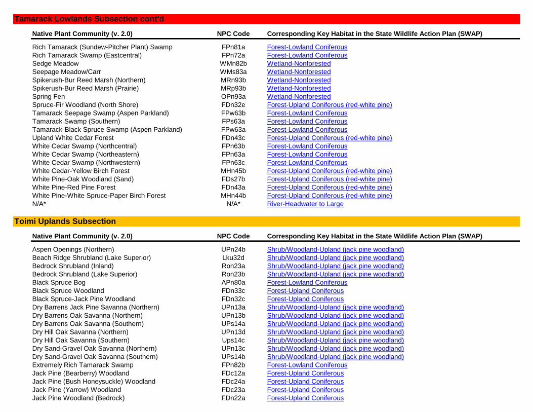
Native Plant Community (v. 2.0) NPC Code Corresponding Key Habitat in the State Wildlife Action Plan (SWAP)
Rich Tamarack (Sundew-Pitcher Plant) Swamp FPn81a Forest-Lowland Coniferous
Rich Tamarack Swamp (Eastcentral) FPn72a Forest-Lowland Coniferous
Sedge Meadow WMn82b Wetland-Nonforested
Seepage Meadow/Carr WMs83a Wetland-Nonforested
Spikerush-Bur Reed Marsh (Northern) MRn93b Wetland-Nonforested
Spikerush-Bur Reed Marsh (Prairie) MRp93b Wetland-Nonforested
Spring Fen OPn93a Wetland-Nonforested
Spruce-Fir Woodland (North Shore) FDn32e Forest-Upland Coniferous (red-white pine)
Tamarack Seepage Swamp (Aspen Parkland) FPw63b Forest-Lowland Coniferous
Tamarack Swamp (Southern) FPs63a Forest-Lowland Coniferous
Tamarack-Black Spruce Swamp (Aspen Parkland) FPw63a Forest-Lowland Coniferous
Upland White Cedar Forest FDn43c Forest-Upland Coniferous (red-white pine)
White Cedar Swamp (Northcentral) FPn63b Forest-Lowland Coniferous
White Cedar Swamp (Northeastern) FPn63a Forest-Lowland Coniferous
White Cedar Swamp (Northwestern) FPn63c Forest-Lowland Coniferous
White Cedar-Yellow Birch Forest MHn45b Forest-Upland Coniferous (red-white pine)
White Pine-Oak Woodland (Sand) FDs27b Forest-Upland Coniferous (red-white pine)
White Pine-Red Pine Forest FDn43a Forest-Upland Coniferous (red-white pine)
White Pine-White Spruce-Paper Birch Forest MHn44b Forest-Upland Coniferous (red-white pine)
N/A* N/A* River-Headwater to Large
Native Plant Community (v. 2.0) NPC Code Corresponding Key Habitat in the State Wildlife Action Plan (SWAP)
Aspen Openings (Northern) UPn24b Shrub/Woodland-Upland (jack pine woodland)
Beach Ridge Shrubland (Lake Superior) Lku32d Shrub/Woodland-Upland (jack pine woodland)
Bedrock Shrubland (Inland) Ron23a Shrub/Woodland-Upland (jack pine woodland)
Bedrock Shrubland (Lake Superior) Ron23b Shrub/Woodland-Upland (jack pine woodland)
Black Spruce Bog APn80a Forest-Lowland Coniferous
Black Spruce Woodland FDn33c Forest-Upland Coniferous
Black Spruce-Jack Pine Woodland FDn32c Forest-Upland Coniferous
Dry Barrens Jack Pine Savanna (Northern) UPn13a Shrub/Woodland-Upland (jack pine woodland)
Dry Barrens Oak Savanna (Northern) UPn13b Shrub/Woodland-Upland (jack pine woodland)
Dry Barrens Oak Savanna (Southern) UPs14a Shrub/Woodland-Upland (jack pine woodland)
Dry Hill Oak Savanna (Northern) UPn13d Shrub/Woodland-Upland (jack pine woodland)
Dry Hill Oak Savanna (Southern) Ups14c Shrub/Woodland-Upland (jack pine woodland)
Dry Sand-Gravel Oak Savanna (Northern) UPn13c Shrub/Woodland-Upland (jack pine woodland)
Dry Sand-Gravel Oak Savanna (Southern) UPs14b Shrub/Woodland-Upland (jack pine woodland)
Extremely Rich Tamarack Swamp FPn82b Forest-Lowland Coniferous
Jack Pine (Bearberry) Woodland FDc12a Forest-Upland Coniferous
Jack Pine (Bush Honeysuckle) Woodland FDc24a Forest-Upland Coniferous
Jack Pine (Yarrow) Woodland FDc23a Forest-Upland Coniferous
Jack Pine Woodland (Bedrock) FDn22a Forest-Upland Coniferous
Toimi Uplands Subsection
Tamarack Lowlands Subsection cont'd
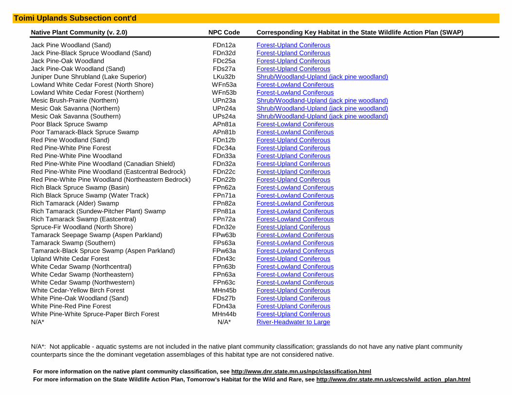
Native Plant Community (v. 2.0) NPC Code Corresponding Key Habitat in the State Wildlife Action Plan (SWAP)
Jack Pine Woodland (Sand) FDn12a Forest-Upland Coniferous
Jack Pine-Black Spruce Woodland (Sand) FDn32d Forest-Upland Coniferous
Jack Pine-Oak Woodland FDc25a Forest-Upland Coniferous
Jack Pine-Oak Woodland (Sand) FDs27a Forest-Upland Coniferous
Juniper Dune Shrubland (Lake Superior) LKu32b Shrub/Woodland-Upland (jack pine woodland)
Lowland White Cedar Forest (North Shore) WFn53a Forest-Lowland Coniferous
Lowland White Cedar Forest (Northern) WFn53b Forest-Lowland Coniferous
Mesic Brush-Prairie (Northern) UPn23a Shrub/Woodland-Upland (jack pine woodland)
Mesic Oak Savanna (Northern) UPn24a Shrub/Woodland-Upland (jack pine woodland)
Mesic Oak Savanna (Southern) UPs24a Shrub/Woodland-Upland (jack pine woodland)
Poor Black Spruce Swamp APn81a Forest-Lowland Coniferous
Poor Tamarack-Black Spruce Swamp APn81b Forest-Lowland Coniferous
Red Pine Woodland (Sand) FDn12b Forest-Upland Coniferous
Red Pine-White Pine Forest FDc34a Forest-Upland Coniferous
Red Pine-White Pine Woodland FDn33a Forest-Upland Coniferous
Red Pine-White Pine Woodland (Canadian Shield) FDn32a Forest-Upland Coniferous
Red Pine-White Pine Woodland (Eastcentral Bedrock) FDn22c Forest-Upland Coniferous
Red Pine-White Pine Woodland (Northeastern Bedrock) FDn22b Forest-Upland Coniferous
Rich Black Spruce Swamp (Basin) FPn62a Forest-Lowland Coniferous
Rich Black Spruce Swamp (Water Track) FPn71a Forest-Lowland Coniferous
Rich Tamarack (Alder) Swamp FPn82a Forest-Lowland Coniferous
Rich Tamarack (Sundew-Pitcher Plant) Swamp FPn81a Forest-Lowland Coniferous
Rich Tamarack Swamp (Eastcentral) FPn72a Forest-Lowland Coniferous
Spruce-Fir Woodland (North Shore) FDn32e Forest-Upland Coniferous
Tamarack Seepage Swamp (Aspen Parkland) FPw63b Forest-Lowland Coniferous
Tamarack Swamp (Southern) FPs63a Forest-Lowland Coniferous
Tamarack-Black Spruce Swamp (Aspen Parkland) FPw63a Forest-Lowland Coniferous
Upland White Cedar Forest FDn43c Forest-Upland Coniferous
White Cedar Swamp (Northcentral) FPn63b Forest-Lowland Coniferous
White Cedar Swamp (Northeastern) FPn63a Forest-Lowland Coniferous
White Cedar Swamp (Northwestern) FPn63c Forest-Lowland Coniferous
White Cedar-Yellow Birch Forest MHn45b Forest-Upland Coniferous
White Pine-Oak Woodland (Sand) FDs27b Forest-Upland Coniferous
White Pine-Red Pine Forest FDn43a Forest-Upland Coniferous
White Pine-White Spruce-Paper Birch Forest MHn44b Forest-Upland Coniferous
N/A* N/A* River-Headwater to Large
For more information on the State Wildlife Action Plan, Tomorrow's Habitat for the Wild and Rare, see http://www.dnr.state.mn.us/cwcs/wild_action_plan.html
N/A*: Not applicable - aquatic systems are not included in the native plant community classification; grasslands do not have any native plant community
counterparts since the the dominant vegetation assemblages of this habitat type are not considered native.
Toimi Uplands Subsection cont'd
For more information on the native plant community classification, see http://www.dnr.state.mn.us/npc/classification.html