cropwat 8.0 example
TRANSCRIPT

1
EXAMPLE OF THE USE OF CROPWAT 8.0

2
1. INTRODUCTION This document shows in a practical way the use of CROPWAT 8.0 for design and management of irrigation schemes, taking the user, with the help of an actual data set, through the different steps required to calculate evapotranspiration, crop water requirements, scheme water supply and irrigation scheduling. To learn about how the software works and the main calculation procedures, users are invited to read the context-specific Help available in the software. The example set used is taken from the Rajolibanda Diversion Scheme in Andhra Pradesh, India.
3
2. CALCULATION OF REFERENCE EVAPOTRANSPIRATION 2.1 Introduction The Reference Evapotranspiration (ETo) represents the potential evaporation of a well-watered grass crop. The water needs of other crops are directly linked to this climatic parameter. Although several methods exist to determine ETo, the Penman-Monteith Method has been recommended as the appropriate combination method1 to determine ETo from climatic data on:
• temperature • humidity • sunshine • windspeed.
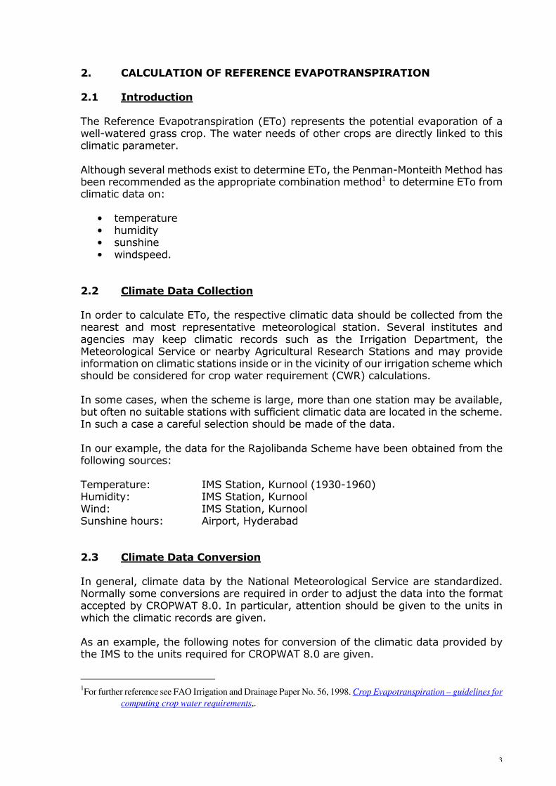
2.2 Climate Data Collection In order to calculate ETo, the respective climatic data should be collected from the nearest and most representative meteorological station. Several institutes and agencies may keep climatic records such as the Irrigation Department, the Meteorological Service or nearby Agricultural Research Stations and may provide information on climatic stations inside or in the vicinity of our irrigation scheme which should be considered for crop water requirement (CWR) calculations. In some cases, when the scheme is large, more than one station may be available, but often no suitable stations with sufficient climatic data are located in the scheme. In such a case a careful selection should be made of the data. In our example, the data for the Rajolibanda Scheme have been obtained from the following sources: Temperature: IMS Station, Kurnool (1930-1960) Humidity: IMS Station, Kurnool Wind: IMS Station, Kurnool Sunshine hours: Airport, Hyderabad 2.3 Climate Data Conversion In general, climate data by the National Meteorological Service are standardized. Normally some conversions are required in order to adjust the data into the format accepted by CROPWAT 8.0. In particular, attention should be given to the units in which the climatic records are given. As an example, the following notes for conversion of the climatic data provided by the IMS to the units required for CROPWAT 8.0 are given. 1For further reference see FAO Irrigation and Drainage Paper No. 56, 1998. Crop Evapotranspiration – guidelines for
computing crop water requirements,.

4
Temperature data IMS: Mean Daily Maximum and Minimum Temperature, [º C] CROPWAT: Maximum and Minimum Temperature, [º C] Conversion: No conversion needed Humidity data IMS: Relative Humidity [in percentage] as well as the Vapour Pressure
[kPa] both for morning and afternoon CROPWAT: Average daily Relative Humidity [in percentage] or Vapour Pressure
[kPa] Conversion: Average of morning and afternoon values of vapour pressure Comments: Vapour pressure rather than Relative Humidity values are taken, as
the latter relate to temperature values at sunrise and noon Sunshine data IMS: Cloudiness in Oktas of sky of All and Low Clouds for morning and
noon CROPWAT: Sunshine hours (heliograph) or sunshine percentage Conversion: According to the following relationship: where: SSP = sunshine rate (fraction) LC1 = low clouds at sunrise (oktas) LC2 = low clouds at noon (oktas) AC1 = high clouds at sunrise (oktas) AC2 = low clouds at noon (oktas) α = empirical parameter (≈ 0.3) Windspeed data IMS: Average Daily Windrun in km/hour CROPWAT: Average Daily Windspeed in km/day or m/sec Conversion: WS km/day = 24 x WS km/hour 2.4 Climate/ETo Data Input and Output The Climate module can be selected by clicking on the “Climate/ETo” icon in the module bar located on the left of the main CROPWAT window. The data window will open with the default data type (Monthly / Decade / Daily values); it is possible to quickly change to another data type by using the drop down menu from the “New” button on the toolbar. In alternative, use the “New” button in the “File” drop down menu. The module is primary for data input, requiring information on the meteorological station (country, name, altitude, latitude and longitude) together with climatic data. CROPWAT 8.0 can calculate reference ETo using only temperature, but humidity,
2
AC2 + AC1* +
2
LC2 + LC1 - 0.95 = SSP α
5
wind speed and sunshine should be entered if available. For the benefit of CROPWAT 8.0 users a climatic database called CLIMWAT has been developed to provide the basic climatic information needed by the programme. CLIMWAT Version 2.0 contains monthly climatic data that can be exported in the appropriate format required by CROPWAT 8.0. The Climate/ETo module includes calculations, producing Radiation and ETo data using the FAO Penman-Monteith approach. A printout of climatic data inserted and of calculated Radiation and ETo is shown in Table 1. 2.5 Climate/ETo Data Saving After checking the data for possible errors, Climate/ETo data can be saved selecting the “Save” button on the Toolbar or the “File” > “Save” menu item. It is important to give an appropriate name to the data set which can easily be recognized later. In our example, the name KURNOOL, referring to the climate station from which the data has been taken, was used.
Table 1 Printout – Climate/ETo Data Kurnool

6
3. PROCESSING OF RAINFALL DATA 3.1 Introduction The rainfall contributes to a greater or lesser extent in satisfying CWR, depending on the location. During the rainy season in tropical and some semi-tropical regions, a great part of the crop's water needs are covered by rainfall, while during the dry season, the major supply of water should come from irrigation. How much water is coming from rainfall and how much water should be covered by irrigation is, unfortunately, difficult to predict as rainfall varies greatly from season to season. In order to estimate the rainfall deficit for irrigation water requirements, a statistical analysis needs to be made from long-term rainfall records. In addition to the variability of rainfall from year to year, not all rain which falls is used by the crop. The intensity of rain may be such that part of the rainfall is lost due to surface runoff or due to deep percolation below the root zone. In order to determine that part of the rainfall which effectively contributes to cover CWR, a number of definitions are first given, while subsequently it is explained how the different rainfall values can be calculated and how they are incorporated in the CWR calculations. 3.2 Rainfall Definitions Average monthly rainfall: Mathematically determined average for a series of rainfall records, most commonly available. To be used for CWR calculation to represent average climatic conditions. Dependable rainfall: The amount of rainfall which can be depended upon in 1 out of 4 or 5 years corresponding to a 75 or 80% probability of exceedance and representing a dry year. The dependable rainfall (80%) is used for the design of the irrigation system capacity. Rainfall in wet, normal and dry years: Defined as the rainfall with a respectively 20, 50 and 80% probability of exceedance, representing a wet, normal and dry year. The three values are useful for the programming of irrigation supply and simulation of irrigation management conditions. The rainfall in normal years (50% probability) is, in general, well approached by the average rainfall. Historical or actual rainfall data: The actual recorded rainfall used for evaluation purposes. Effective rainfall: Defined as that part of the rainfall which is effectively used by the crop after rainfall losses due to surface run off and deep percolation have been accounted for. The

7
effective rainfall is the rainfall ultimately used to determine the crop irrigation requirements. 3.3 Rainfall Data Collection The precipitation data required for CROPWAT 8.0 can be daily, decade or monthly rainfall, commonly available from many climatic stations. In addition, substations may be found with single rainfall records. For larger schemes, records of several rainfall stations may be available, allowing an analysis of the spatial variability. To allow a calculation of rainfall probabilities, rainfall records from a range of years (15-30) are to be collected. Rainfall records of the Rajalibanda Scheme are taken from Uppal Camp and are presented in Table 2.
Month '74 '75 '76 '77 '78 '79 '80 '81 '82 '83 '84 '85 Average
Jan 0 0 0 0 0 0 0 0 0 0 0 0 0
Feb 0 0 0 0 13 45 0 0 0 0 0 0 5
Mar 0 0 0 0 0 0 0 13 0 0 0 13 2
Apr 0 0 8 13 38 0 20 20 0 0 15 14 11
May 69 8 33 70 87 197 0 0 18 0 0 106 49
Jun 44 89 48 140 103 118 74 56 180 0 66 29 79
Jul 15 201 121 176 144 111 76 112 72 0 128 120 106
Aug 121 110 98 160 266 13 96 101 0 257 14 73 109
Sep 69 139 119 20 272 267 66 290 8 171 42 72 128
Oct 175 384 0 101 0 104 13 43 107 64 77 117 99
Nov 15 23 20 76 29 36 0 18 76 0 8 10 26
Dec 0 0 0 0 13 0 0 0 0 0 8 6 2
Total 508 954 448 759 964 891 345 654 460 492 362 556 616
Table 2 Monthly rainfall data (1974-1985) Raingauge: Uppal Camp
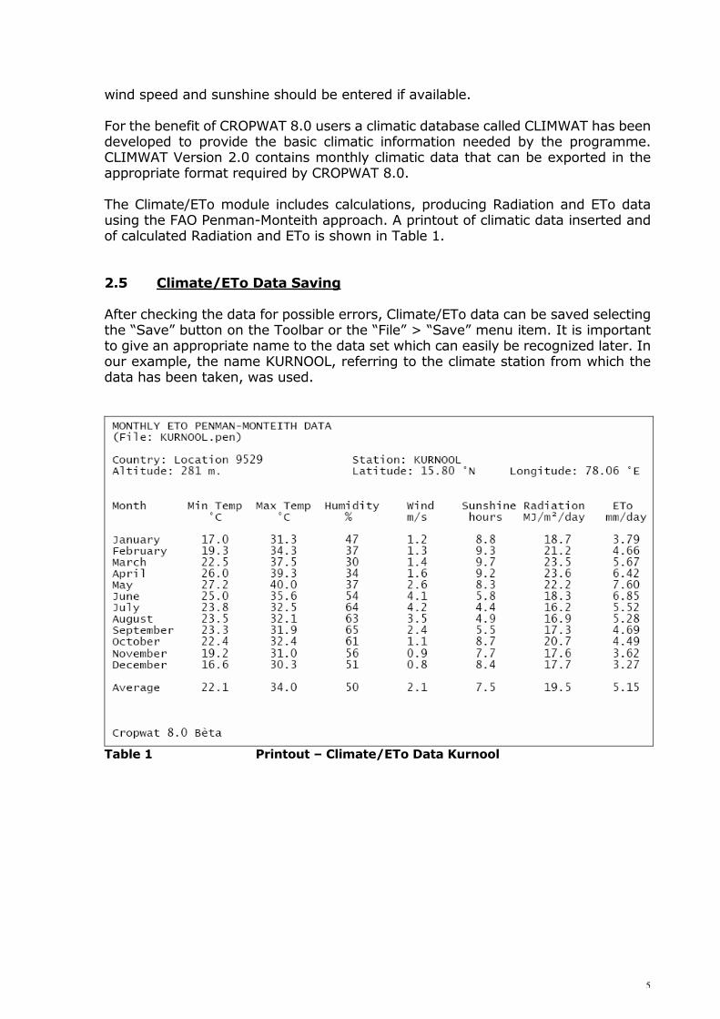
3.4 Rainfall Data Processing For programming of irrigation water supply and management, rainfall data of normal, wet and dry years are used. An estimate of the respective rainfall data can be obtained by computing and plotting probabilities from the rainfall records. The different steps involved are: i. Tabulate yearly rainfall totals for a given period. ii. Arrange data in descending order of magnitude. iii. Tabulate plotting position according to: Fa = 100 * m / (N + 1) where: N = number of records
8
m = rank number Fa = plotting position
Year '74 '75 '76 '77 '78 '79 '80 '81 '82 '83 '84 '85
Rain 508 954 448 759 964 891 345 654 460 493 363 558
Rank No 7 2 10 4 1 3 12 5 9 8 11 6
Rank No 1 2 3 4 5 6 7 8 9 10 11 12
Rain mm/year 964 954 891 759 654 558 508 493 460 448 363 345
Fa % 8 15 23 31 38 46 54 62 69 77 85 92
mm/year
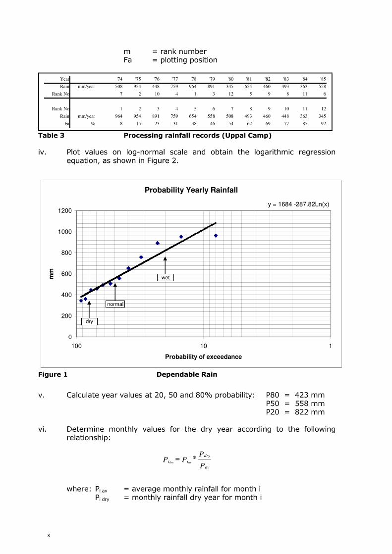
Table 3 Processing rainfall records (Uppal Camp) iv. Plot values on log-normal scale and obtain the logarithmic regression
equation, as shown in Figure 2.
v. Calculate year values at 20, 50 and 80% probability: P80 = 423 mm P50 = 558 mm P20 = 822 mm vi. Determine monthly values for the dry year according to the following
relationship: where: Pi av = average monthly rainfall for month i Pi dry = monthly rainfall dry year for month i
Probability Yearly Rainfall
y = 1684 -287.82Ln(x)
0
200
400
600
800
1000
1200
110100
Probability of exceedance
mm
dry
wet
normal
Figure 1 Dependable Rain
P
P* P = P
av
dry
ii avdry

9
Pav = average yearly rainfall Pdry = yearly rainfall at 80% probability of exceedance Similarly values for normal and wet years can be determined. Results are given in the following table.
Jan Feb Mar Apr May Jun Jul Aug Sep Oct Nov Dec Year
Average 0 5 2 11 49 79 106 109 128 99 26 2 616
Dry 0 3 1 8 34 54 73 75 88 68 18 1 423
Wet 0 7 3 15 65 105 141 145 171 132 35 3 822
Table 4 Processing rainfall records (Uppal Camp)
3.5 Effective Rainfall Method To account for the losses due to runoff or percolation, a choice can be made of one of the four methods given in CROPWAT 8.0 (Fixed percentage, Dependable rain, Empirical formula, USDA Soil Conservation Service). In general, the efficiency of rainfall will decrease with increasing rainfall. For most rainfall values below 100 mm/month, the efficiency will be approximately 80%. Unless more detailed information is available for local conditions, it is suggested to select the Option “Fixed percentage” and give 80% as requested value. In the water balance calculations included in the irrigation scheduling part of CROPWAT, a possibility exists to evaluate actual Efficiency values for different crops and soil conditions. 3.6 Rainfall Data Input and Output The Rain module can be selected by clicking on the “Rain” icon in the module bar located on the left of the main CROPWAT window. The data window will open with the default data type (Daily / Decade / Monthly values); it is possible to quickly change to another data type by using the drop down menu from the “New” button on the toolbar. In alternative, use the “New” button in the “File” drop down menu. Once the window is open with the suitable data type, type rainfall data and check the input. The Rain module also include calculations, producing Effective rainfall data using one of the approaches available, which can be selected by clicking on “Options” on the toolbar while the Rain module is the active window. Table 5 shows a printout of the average rainfall data file of KURNOOL. 3.7 Saving Rainfall Data Rainfall data should be saved after input of one set of data is completed. To do so, select the “Save” button on the Toolbar or the “File” > “Save” menu item. The naming of the file should adequately reflect the type of rainfall data. In our case,

10
the following files are saved: KURN-AV: for average ETo from Kurnool and average rainfall data KURN-NOR: for average ETo data from Kurnool and rainfall data in a normal year
(50%) KURN-WET: for average ETo data and precipitation data of a year with rainfall of
20% probability of exceedance KURN-DRY: for average ETo data and precipitation data of a year with rainfall of
80% probability of exceedance The files are included in Appendix 1. MONTHLY RAIN DATA
(File: C:\Documents and Settings\All Users\Application Data\CROPWAT\data\rain\KURN-AV.CRM)
Station: KURNOOL
Eff. rain method: Effective rain is 80 % of actual rain
January
February
March
April
May
June
July
August
September
October
November
December
Total
Rain
mm
0.0
5.0
2.0
11.0
49.0
79.0
106.0
109.0
128.0
99.0
26.0
2.0
616.0
Eff rain
mm
0.0
4.0
1.6
8.8
39.2
63.2
84.8
87.2
102.4
79.2
20.8
1.6
492.8
Cropwat 8.0
Table 5 Printout - Average rainfall data of Kurnool

11
4. CROP AND CROPPING PATTERN INFORMATION 4.1 Introduction To determine the irrigation requirements of the Rajolibanda Diversion Scheme, an assessment should be made of the different crops grown under irrigation presently and possibly in the future. Furthermore, information on the various crop characteristics such as length of the growth cycle, crop factors, rooting depth, etc., should be collected. CROPWAT 8.0 has crop data for several common crops taken from selected FAO publications. However, the most reliable crop data remain the data obtained from local agricultural research stations. 4.2 Crop and Cropping Pattern Data Collection A local survey should be carried out in the irrigation scheme to assess the crops grown rainfed as well as under irrigation. Through field observations, interviews with extension agents and farmers and additional information from other agencies, for instance a revenue department, an assessment can be made of the present cropping pattern. Essential information collected from the field should include: 1. Crop and crop variety 2. First and last planting date 3. First and last harvesting date Additional information may include: 4. Indicative yield level 5. Indicative irrigation practices:
• field irrigation methods • irrigation frequencies and interval • irrigation application depths
From the Agricultural Research Stations, more accurate information may be collected on: 6. Crop characteristics:
• length of individual growth stages • crop factors, relating crop evapotranspiration to reference
evapotranspiration • rooting depth • allowable depletion levels • yield response factors.
4.3 Crop and Cropping Pattern Data Processing The collected information on the planting and harvest dates should be systematically arranged in a cropping pattern.

12
The planting date of crops, in particular those which cover substantial areas or are high in water demands such as rice, may be spread over a period of 3-6 weeks. In such cases the crop may be subdivided into different crop units with planting date intervals of 10-15 days. Figure 3 illustrates a possible distribution of crops over the year and over the irrigated area.
Area
Cropped
8. Cotton
17. Sugarcane
Fallow
Fallo
w
10. Groundnut - Kharif
11. Groundnut - Kharif
12. Groundnut - Rabi
13. Groundnut - Rabi
14. Groundnut - Rabi
15. Sorghum
16. Sorghum
5. Paddy
6. Paddy
7. Paddy
9. Groundnut - Kharif
1. Paddy
2. Paddy
3. Paddy
4. Paddy
June July August September October November December January February March April May
10 %
20 %
30 %
40 %
50 %
60 %
70 %
80 %
90 %
100 %
Figure 3. Cropping Pattern for Rajolibanda 4.4 Crop and Cropping Pattern Data Input and Output The Crop module can be selected by clicking on the “Crop” icon in the module bar located on the left of the main CROPWAT window. The data window will open with the default data type (Non-rice / Rice crop); it is possible to quickly change to the other data type by using the drop down menu from the “New” button on the toolbar. In alternative, use the “New” button in the “File” drop down menu. The Crop module requires crop data over the different development stages, defined as follow:
• Initial stage: it starts from planting date to approximately 10% ground cover. • Development stage: it runs from 10% ground cover to effective full cover.
Effective full cover for many crops occurs at the initiation of flowering. • Mid-season stage: it runs from effective full cover to the start of maturity. The
start of maturity is often indicated by the beginning of the ageing, yellowing or senescence of leaves, leaf drop, or the browning of fruit to the degree that the crop evapotranspiration is reduced relative to the ETo.
• Late season stage: it runs from the start of maturity to harvest or full senescence.

13
Data required differ in case of a non-rice or a rice crop. In case of non-rice crop, the following information is necessary:
• Crop name • Planting date • Crop coefficient (Kc) • Stages length • Rooting depth • Critical depletion fraction (p) • Yield response factor (Ky)
If available, maximum crop height should be provided. Table 6 shows a printout of the Crop module in case of groundnut in winter time. DRY CROP DATA
(File: C:\Documents and Settings\All Users\Application Data\CROPWAT\data\crops\KURN-GRONDNUT RABI.CRO)
Crop Name: Groudnut Rabi Planting date: 06/12 Harvest: 24/03
Stage
Length (days)
Kc Values
Rooting depth (m)
Critical depletion
Yield response f.
Cropheight (m)
initial
20
0.40
0.30
0.45
0.20
develop
30
-->
-->
-->
0.80
mid
35
1.15
0.80
0.45
0.60
0.40
late
25
0.60
0.80
0.50
0.20
total
110
0.70
Cropwat 8.0
Table 6 Printout - Crop data Groundnut (Rabi)
The rice crop module requires the following additional information in comparison to non-rice crops:
• Planting date in case of direct sowing, or transplanting date in case of sowing in a nursery area
• Duration of nursery and land preparation (including puddling) stages • Dry and Wet Crop coefficients (Kc) • Puddling depth
Table 7 shows a printout containing the information of a rice.

14
RICE DATA
(File: C:\Documents and Settings\All Users\Application Data\CROPWAT\data\crops\KURN-RICE.CRO)
Crop Name: Rice Transplanting date: 0612/20/07 Harvest: 03/04/2008
Stage nursery landprep growth stage total
total puddling initial develop mid late
Length (days)
30
20
5
Kc dry
Kc wet
Rooting depth (m)
Puddling depth (m)
Nursery area (%)
Critical depletion
Yield response f.
Cropheight (m)
Cropwat 8.0
0.70
1.20
10
0.20
0.30
1.05
0.40
20
0.50
1.10
0.10
0.20
1.00
30
-->
-->
-->
-->
1.09
40
1.05
1.20
0.60
0.20
1.09
1.00
30
0.70
1.05
0.60
0.20
1.09
150
1.09
Table 7 Printout - Crop data Paddy
The files of the crops in the scheme under analysis are included in Appendix 2. The Cropping pattern module can be selected by clicking on the “Crop Pattern” icon in the module bar located on the left of the main CROPWAT window. In alternative, it is possible to use the drop down menu from the “New” button on the toolbar or the “New” button in the “File” drop down menu. The cropping pattern module is primary data input, requiring information on the crops (Up to 20) being part of the scheme. With reference to each crop, the following data should be provided:
• Crop file • Planting date • Area: extension of the area dedicated to each crop, as a percentage of the
total cropped area. Care should be taken that at any given moment the sum of the individual crops does not exceed 100 % of total scheme area.
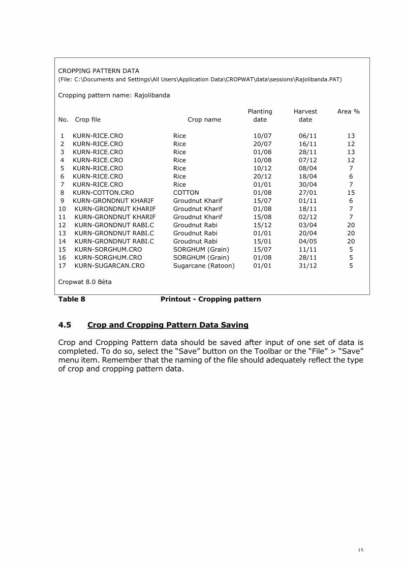
Table 8 provides a printout for Rajolibanda scheme.
15
CROPPING PATTERN DATA
(File: C:\Documents and Settings\All Users\Application Data\CROPWAT\data\sessions\Rajolibanda.PAT)
Cropping pattern name: Rajolibanda
No. Crop file
Crop name
Planting
date
Harvest
date
Area %
1 KURN-RICE.CRO
2 KURN-RICE.CRO
3 KURN-RICE.CRO
4 KURN-RICE.CRO
5 KURN-RICE.CRO
6 KURN-RICE.CRO
7 KURN-RICE.CRO
8 KURN-COTTON.CRO
9 KURN-GRONDNUT KHARIF
10 KURN-GRONDNUT KHARIF
11 KURN-GRONDNUT KHARIF
12 KURN-GRONDNUT RABI.C
13 KURN-GRONDNUT RABI.C
14 KURN-GRONDNUT RABI.C
15 KURN-SORGHUM.CRO
16 KURN-SORGHUM.CRO
17 KURN-SUGARCAN.CRO
Cropwat 8.0 Bèta
Rice
Rice
Rice
Rice
Rice
Rice
Rice
COTTON
Groudnut Kharif
Groudnut Kharif
Groudnut Kharif
Groudnut Rabi
Groudnut Rabi
Groudnut Rabi
SORGHUM (Grain)
SORGHUM (Grain)
Sugarcane (Ratoon)
10/07
20/07
01/08
10/08
10/12
20/12
01/01
01/08
15/07
01/08
15/08
15/12
01/01
15/01
15/07
01/08
01/01
06/11
16/11
28/11
07/12
08/04
18/04
30/04
27/01
01/11
18/11
02/12
03/04
20/04
04/05
11/11
28/11
31/12
13
12
13
12
7
6
7
15
6
7
7
20
20
20
5
5
5
Table 8 Printout - Cropping pattern 4.5 Crop and Cropping Pattern Data Saving Crop and Cropping Pattern data should be saved after input of one set of data is completed. To do so, select the “Save” button on the Toolbar or the “File” > “Save” menu item. Remember that the naming of the file should adequately reflect the type of crop and cropping pattern data.
16
5. CROP WATER REQUIREMENT CALCULATIONS 5.1 Introduction Calculation of the CWR can be carried out by calling up successively the appropriate climate and rainfall data sets, together with the crop files and the corresponding planting dates. In case of CWR calculation of rice, soil data are also required. 5.2 Soil Data Collection Information from the soil surveys carried out in the Rajolibanda area show two distinct soil categories:
• Red Sandy Loams, Red Loamy and Red Sandy, covering 23% of the command area, relatively shallow and free-draining, particularly suitable for upland crops;
• Black Clay Soils, covering 77%, deep but poorly drained, suitable mainly for paddy and deep rooting crops like cotton.
5.3 Soil Data Input and Output The Soil module is selected by clicking on the “Soil” icon in the module bar located on the left of the main CROPWAT window. In alternative, it can be opened by using the drop down menu from the “New” button on the toolbar or using the “New” button in the “File” drop down menu. The Soil module is essentially data input, requiring the following general soil data:
• Total Available Water (TAW) • Maximum infiltration rate • Maximum rooting depth • Initial soil moisture depletion
In case of rice calculation, the following additional soil data are required:
• Drainable porosity • Critical depletion for puddle cracking • Water availability at planting • Maximum water depth
The module also includes calculations, providing the initial available soil moisture and, in case of rice, the maximum percolation rate after puddling. The Printout of the Black Clay Soil, required for CWR rice calculation, is provided in Table 9. The files of the soils in the scheme under analysis are included in Appendix 3.

17
SOIL DATA
(File: C:\Documents and Settings\All Users\Application Data\CROPWAT\data\soils\BLACK CLAY SOIL.SOI)
Soil name: BLACK CLAY SOIL
General soil data:
Total available soil moisture (FC - WP)
Maximum rain infiltration rate
Maximum rooting depth
Initial soil moisture depletion (% TAM)
Initial available soil moisture
200.0
30
900
50
100.0
mm/meter
mm/day
centimeters
%
mm/meter
Additional soil data for rice calculations:
Drainable porosity (SAT - FC)
Critical depletion for puddle cracking
Water availability at planting
Maximum waterdepth
Cropwat 8.0
10
0.60
5
120
%
mm/day
mm WD
mm
Table 9 Printout – Black Clay Soil 5.4 Soil Data Saving Soil data should be saved after input of one set of data is completed. To do so, select the “Save” button on the Toolbar or the “File” > “Save” menu item. Remember that the naming of the file should adequately reflect the type of soil data. 5.5 CWR Data Input and Output The CWR module can be selected by clicking on the “CWR” icon in the module bar located on the left of the main CROPWAT window. Data on Climate/ETo, Rainfall (average), Crop and Soil (in case of rice) are required. If not all data are available, CROPWAT will produce a warning and close the CWR module. The CWR module includes calculations, producing the irrigation water requirement of the crop on a decadal basis and over the total growing season, as the difference between the crop evapotranspiration under standard conditions (ETc) and the Effective rainfall. Examples of CWR printouts are shown in Tables 10 and 11.
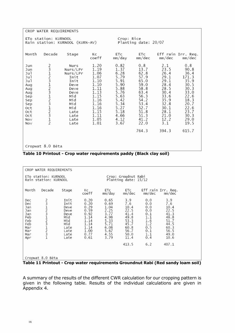
18
Table 10 Printout - Crop water requirements paddy (Black clay soil)
Table 11 Printout - Crop water requirements Groundnut Rabi (Red sandy loam soil) A summary of the results of the different CWR calculation for our cropping pattern is given in the following table. Results of the individual calculations are given in Appendix 4.

19
Plant. Harvest Area ETc Eff Rain Irr req No. CROP
date date % mm mm mm
1 PADDY 10-Jul 6-Nov 13 797.0 407.3 637.3
2 PADDY 20-Jul 16-Nov 12 764.3 394.3 615.7
3 PADDY 1-Aug 28-Nov 13 730.4 370.9 612.9
4 PADDY 10-Aug 7-Dec 12 708.9 349.0 617.1
5 PADDY 10-Dec 8-Apr 7 704.9 18.4 927.5
6 PADDY 20-Dec 18-Apr 6 737.8 14.4 955.0
7 PADDY 1-Jan 30-Apr 7 783.5 16.2 1000.5
8 COTTON 1-Aug 27-Jan 15 604.4 291.4 362.0
9 GROUNDNUT-KHARIF 15-Jul 1-Nov 6 425.7 316.6 123.6
10 GROUNDNUT-KHARIF 1-Aug 18-Nov 7 400.9 285.1 129.3
11 GROUNDNUT-KHARIF 15-Aug 2-Dec 7 378.9 250.1 155.9
12 GROUNDNUT-RABI 15-Dec 3-Apr 20 413.5 6.2 407.1
13 GROUNDNUT-RABI 1-Jan 20-Apr 20 455.9 9.0 446.8
14 GROUNDNUT-RABI 15-Jan 4-May 20 492.4 18.6 472.9
15 SORGHUM 15-Jul 11-Nov 5 382.0 328.1 85.4
16 SORGHUM 1-Aug 28-Nov 5 356.2 288.9 108.1
17 SUGARCANE 1-Jan 31-Dec 5 2024.1 492.9 1549.2 Table 12 Crop Water Requirements
20
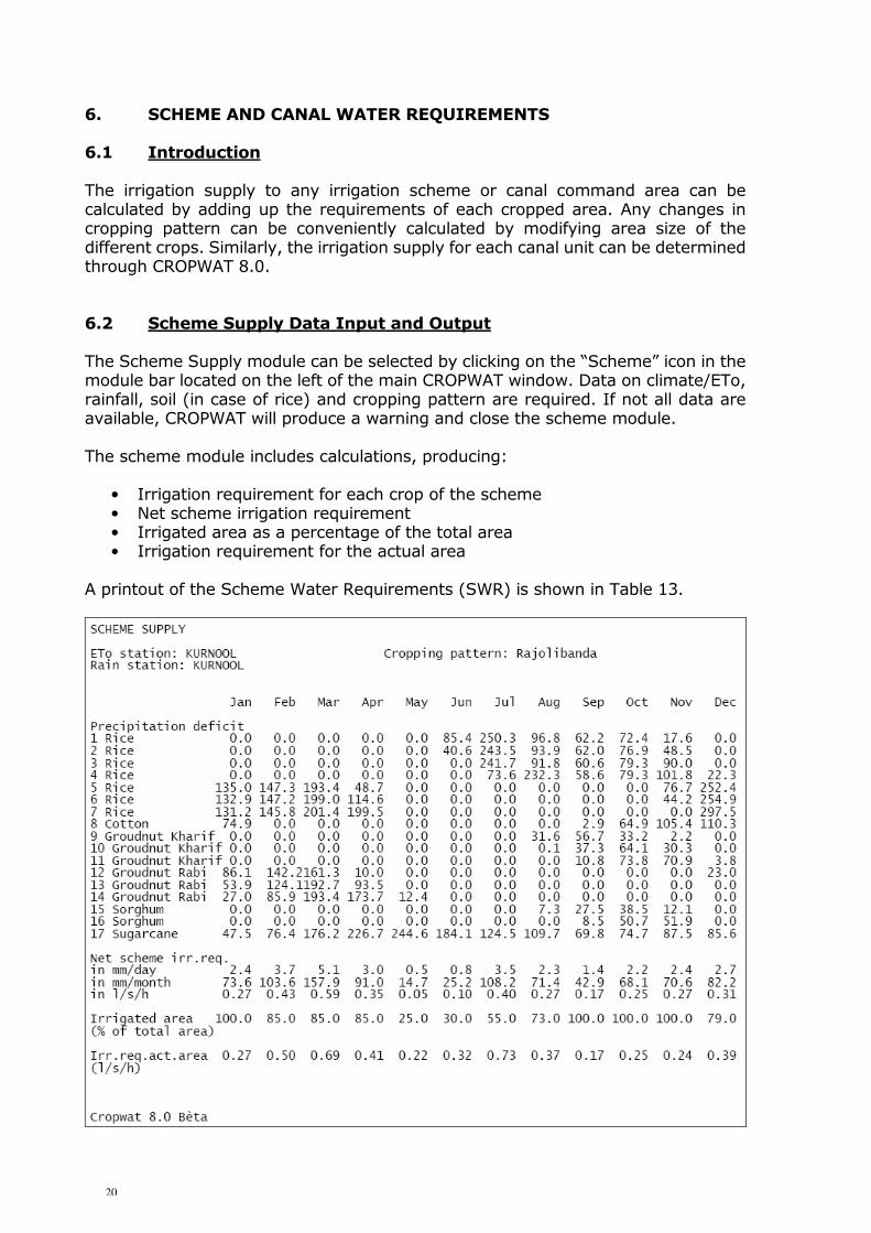
6. SCHEME AND CANAL WATER REQUIREMENTS 6.1 Introduction The irrigation supply to any irrigation scheme or canal command area can be calculated by adding up the requirements of each cropped area. Any changes in cropping pattern can be conveniently calculated by modifying area size of the different crops. Similarly, the irrigation supply for each canal unit can be determined through CROPWAT 8.0. 6.2 Scheme Supply Data Input and Output The Scheme Supply module can be selected by clicking on the “Scheme” icon in the module bar located on the left of the main CROPWAT window. Data on climate/ETo, rainfall, soil (in case of rice) and cropping pattern are required. If not all data are available, CROPWAT will produce a warning and close the scheme module. The scheme module includes calculations, producing:
• Irrigation requirement for each crop of the scheme • Net scheme irrigation requirement • Irrigated area as a percentage of the total area • Irrigation requirement for the actual area
A printout of the Scheme Water Requirements (SWR) is shown in Table 13.
21
Table 13 Printout - Scheme Water Requirements (SWR) Rajolibanda
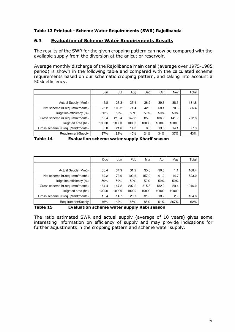
6.3 Evaluation of Scheme Water Requirements Results The results of the SWR for the given cropping pattern can now be compared with the available supply from the diversion at the anicut or reservoir. Average monthly discharge of the Rajolibanda main canal (average over 1975-1985 period) is shown in the following table and compared with the calculated scheme requirements based on our schematic cropping pattern, and taking into account a 50% efficiency.
Jun Jul Aug Sep Oct Nov Total
Actual Supply (Mm3) 5.8 26.3 35.4 36.2 39.6 38.5 181.8
Net scheme irr.req. (mm/month) 25.2 108.2 71.4 42.9 68.1 70.6 386.4
Irrigation efficiency (%) 50% 50% 50% 50% 50% 50%
Gross scheme irr.req. (mm/month) 50.4 216.4 142.8 85.8 136.2 141.2 772.8
Irrigated area (ha) 10000 10000 10000 10000 10000 10000
Gross scheme irr.req. (Mm3/month) 5.0 21.6 14.3 8.6 13.6 14.1 77.3
Requirement/Supply 87% 82% 40% 24% 34% 37% 43%
Table 14 Evaluation scheme water supply Kharif season
Dec Jan Feb Mar Apr May Total
Actual Supply (Mm3) 35.4 34.9 31.2 35.8 30.0 1.1 168.4
Net scheme irr.req. (mm/month) 82.2 73.6 103.6 157.9 91.0 14.7 523.0
Irrigation efficiency (%) 50% 50% 50% 50% 50% 50%
Gross scheme irr.req. (mm/month) 164.4 147.2 207.2 315.8 182.0 29.4 1046.0
Irrigated area (ha) 10000 10000 10000 10000 10000 10000
Gross scheme irr.req. (Mm3/month) 16.4 14.7 20.7 31.6 18.2 2.9 104.6
Requirement/Supply 46% 42% 66% 88% 61% 267% 62%
Table 15 Evaluation scheme water supply Rabi season The ratio estimated SWR and actual supply (average of 10 years) gives some interesting information on efficiency of supply and may provide indications for further adjustments in the cropping pattern and scheme water supply.

22
7. IRRIGATION SCHEDULING 7.1 Introduction An important element of CROPWAT 8.0 is the irrigation scheduling module, which has several application possibilities:
• to develop indicative irrigation schedules: o for the agricultural extension service to promote better irrigation practices o for the irrigation service to establish improved rotational delivery
schedules; • to evaluate existing irrigation practices on water use efficiency and water
stress conditions; • to evaluate crop production under rainfed conditions, to assess feasibility of
supplementary irrigation and to develop appropriate irrigation schedules; • to develop alternative water delivery schedules under restricted water supply
conditions. The calculations of the scheduling module are based on a soil water budget, where, on a daily basis, the soil moisture status is determined, accounting for incoming and outgoing water in the root zone. We will see using our example from the Rajolibanda scheme how the different applications are worked out. 7.2 Schedule Data Input and Output The Schedule module can be selected clicking on the “Schedule” icon in the module bar located on the left of the main CROPWAT window. Data on climate/ETo, rainfall, crop and soil are required. If not all data are available, CROPWAT will produce a warning and close the schedule module. The schedule module essentially includes calculations, producing a soil water balance on a daily step. The following parameters are used:
• Effective rainfall, over dry, normal and/or wet years • Water stress coefficient (Ks) • Crop evapotranspiration under non-standard conditions (ETc adj) • Root zone depletion • Net irrigation • Deficit • Irrigation losses • Gross irrigation • Flow
The calculations for scheduling of rice are somewhat different. For lowland rice, a water layer is maintained in the field for most of the growing season and therefore, extra irrigation water is required not only to cover evaporation losses but also to compensate for the percolation losses in the inundated fields. Furthermore, prior to transplanting, substantial irrigation water is required for the land preparation and the nursery. The additional following parameters are displayed in case of rice calculation:

23
• Puddling state • Deep Percolation • Depletion of soil moisture • Depletion of saturation
7.3 Irrigation Scheduling Applications To illustrate the different applications of the scheduling program, we will work out some examples. 7.3.1 Development of indicative irrigation schedule Objective: To determine the irrigation water supply for a given crop in terms of frequency and irrigation depth, assuring optimal crop growth and efficient water use. Conditions: The irrigation schedule should meet the requirements of the field irrigation method practised and the operational criteria of the irrigation system (Warabandi). Furthermore, the validity of the schedule for different soil types and for variable rainfall conditions should be assessed. Required data and information: The essential information required for the development of an indicative schedule is given below for two crops: 1. Crop: Groundnut Rabi Planting date: 15 December Climate: Kurnool Normal Years Soil: Red Sandy Loam, Red Sandy and Red Loamy Irrigation method: Furrow irrigation Net application: 40-50 mm Irrigation supply: Warabandi system with fixed rotational interval period 2. Crop: Cotton Planting date: 1 August Climate: Kurnool Normal, Wet and Dry Years Soil: Black Clay Soil, Red Sandy Loam and Red Sandy Irrigation method: Basin irrigation Net application: 70-80 mm Irrigation supply: Warabandi system with fixed rotational interval period Scheduling procedures: In order to develop the irrigation schedule which would fit our requirements, an interactive procedure is followed in which several runs are made with different timing and application options.

24
The results of each run will be evaluated providing the information for the next option. A printout of each run is given in Appendix 5.1 with summarized results given in Table 17. An example of the printout of an irrigation schedule developed for groundnut is given in Table 16. The different runs provide an indication of the criteria which are evaluated and used for the next run.
Table 16 Printout - Selected irrigation schedule for groundnut

25
For groundnut, the following sequence of runs is made: Run 1 Timing Option: Irrigation at critical depletion Application Option: Refill soil to field capacity Evaluation Criteria: - Interval variance (9 to 14 days) - Application variance (42 to 57 mm) Run 2 Timing Option: Irrigation at fixed depletion (40 mm) Application Option: Fixed application depth (40 mm) Evaluation Criteria: - Interval variance (7 to 11 days) Run 3-5 Timing Option: Irrigation at fixed intervals per stage (7 to 10 days) Application Option: Fixed application depth (40 to 45 mm) Evaluation Criteria: - Irrigation efficiency (65 to 74%) - Eventual yield reduction (0 to 5%) Run 6 Timing Option: Irrigate at user defined intervals
(40/50/60/70/80/90/100 days) Application Option: Fixed application depth (45 mm) Evaluation Criteria: - Irrigation efficiency (100%) - Yield reduction (3%) Run 7-8 The effect of the selected irrigation schedule on irrigation and rain efficiency and yield reduction is evaluated for varying soil type: Timing Option: Irrigate at user defined intervals
(40/50/60/70/80/90/100 days) Application Option: Fixed application depth (45 mm) Evaluation Criteria: - Irrigation efficiency (100%) - Yield reduction (1 to 6%)

26
Net irr. Irrig. Tot net irr. Sched. Yield Rain
(mm) Turns (mm) Effic. Reduc. Effic.
1 variable 7 365 100% - 92%
2 variable 10 400 100% - 100%
3 40 15 600 65% - 82%
4 40 10 400 74% 5% 92%
5 45 10 450 71% 2% 92%
6 45 7 315 100% 3% 100%
7 45 7 315 100% 7% 92%
8 45 7 315 100% 1% 100%
Run
Red Sandy Loam (140 mm/m)
Red Sandy (100 mm/m)
Red Loamy (180 mm/m)
Table 17 Summarized results scheduling runs for groundnut
The results of a similar procedure followed for a cotton crop are shown in Table 18. As rainfall is more substantial than for the previous crop, the effect of precipitation for wet and dry years is evaluated in separate runs, as well as the effect of medium and light texture soils.
Net irr. Irrig. Tot net irr. Sched. Yield Rain
(mm) Turns (mm) Effic. Reduc. Effic.
1 183 1 183 100% - 100%
2 80 5 400 100% - 98%
3 80 5 400 91% - 100%
4 70 5 350 100% - 100%
5 70 4 280 100% - 100%
6 70 4 280 100% - 74%
7 70 4 280 100% - 74%
8 70 4 280 100% 3% 100%
9 70 4 280 93% - 88%
10 70 1 70 100% - 88%
Black Clay Soil (200 mm/m), Wet year
Run
Black Clay Soil (200 mm/m), Average year
Red Sandy (100 mm/m), Average year
Black Clay Soil (200 mm/m), Dry year
Red Sand Loam (140 mm/m), Average year
Table 18 Summarized results scheduling runs for cotton

27
7.3.2 Evaluation of irrigation practices Objective: To assess adequacy of existing irrigation practices in terms of efficient water use and production level as a base to develop and promote better irrigation practices. Required data and information: In order to evaluate existing practices, actual data should be collected through field surveys and interviews with farmers. Although a detailed survey would provide more accurate information, a rapid survey on certain parameters would provide already useful indications, as shown in our example. The minimum data information should include, apart from general information on
climate, crops and soils:
• Crop information: Variety, planting date, harvest date; • Climate: Data on actual rainfall over the growing season, as
far as available; • Irrigation frequency: Actual dates of irrigation, or average irrigation
interval practised, or number of irrigations over the growing season;
• Irrigation application: Estimate of average irrigation depth per irrigation according to irrigation method practised;
• Soil: Estimate soil texture. Example: Sorghum During a field visit to Rajolibanda, the following information was obtained from discussions with farmers and from field observations: Crop: HYV sorghum, grown for certified seed production Planting date: 13 September Harvest date: 17 January (estimated) 1st irrigation: 23 November Interval period: 20-25 days Irrigation method: Basin irrigation, size 10 x 25 m Application depth: 70-80 mm (estimated) Soil type: Red Loamy (180 mm/m) (estimated) Rainfall data: Kurnool 1986 (see Appendix 1) ETo Climate data Kurnool CWR Calculation The CWR calculated for the sorghum crop yields: Total ETcrop = 412 mm Effective Rainfall = 142 mm Irrigation Requirement = 276 mm
28
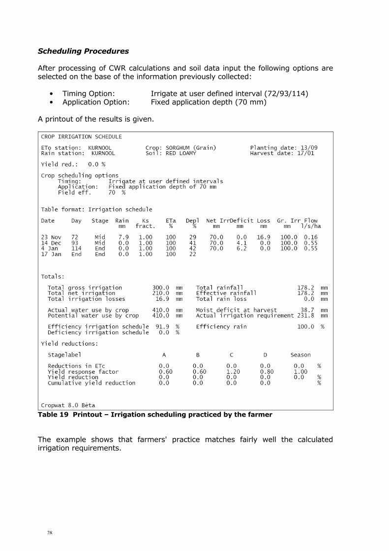
Scheduling Procedures After processing of CWR calculations and soil data input the following options are selected on the base of the information previously collected:
• Timing Option: Irrigate at user defined interval (72/93/114) • Application Option: Fixed application depth (70 mm)
A printout of the results is given.
Table 19 Printout – Irrigation scheduling practiced by the farmer The example shows that farmers' practice matches fairly well the calculated irrigation requirements.
29
7.3.3 Rainfed production and supplementary irrigation Objective:
• To assess the adequacy of rainfall for crop growth. • To determine yield reductions due to rainfall deficits. • To determine feasibility of supplementary irrigation. • To develop supplementary irrigation schedules.
Required data: Climate: The rainfall data used will concern in general statistically processed
values with assigned probability values (80, 50 or 20), but also historical rainfall data may be used. In our example, climatic data of an average year are used.
Crop: Crops and crop varieties normally grown under rainfall should be used.
An adjustment of the crop file may be necessary as rainfed crops will in general be better adapted to stress conditions than higher yielding irrigated crops; consequently length of growing stages, rooting depth, allowable depletion levels and yield response factor will need to be adjusted. In our example, cotton has been used as a crop to show the procedures.
Soil: Predominant soils for rainfed crops should be taken. In our example, the
deep Black Clay Soils have been used to assess suitability of rainfed cotton.
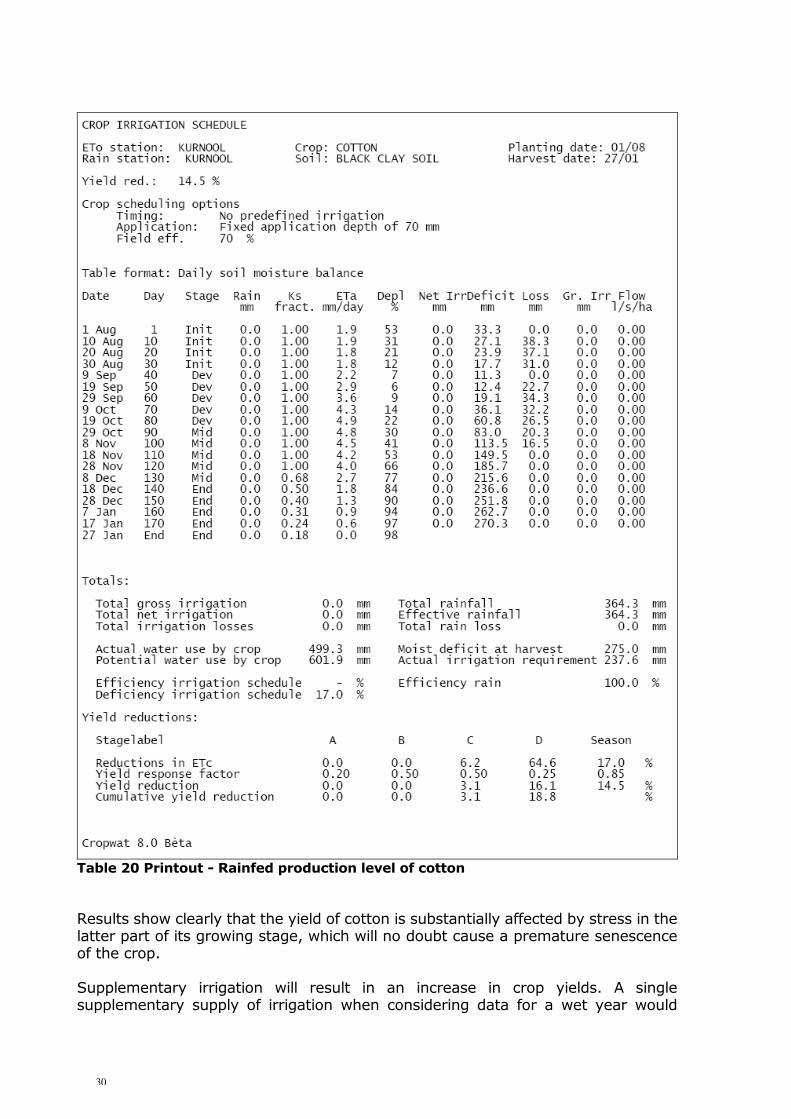
CWR Calculations The crop water requirements of cotton calculated earlier (see Appendix 4) show for cotton planted on 1 August the following summarized results: Total ET cotton = 604 mm Effective rainfall = 291 mm Irrigation Requirements = 362 mm Scheduling Procedures To assess the effect of rainfall deficits on crop growth, the following option should be selected:
• Timing Option: No irrigation (Rainfed) • Application Option: -
A printout of the results is shown in Table 20.
30
Table 20 Printout - Rainfed production level of cotton Results show clearly that the yield of cotton is substantially affected by stress in the latter part of its growing stage, which will no doubt cause a premature senescence of the crop. Supplementary irrigation will result in an increase in crop yields. A single supplementary supply of irrigation when considering data for a wet year would

31
guarantee an optimal cotton production, as determined earlier (Appendix 5.1). 7.3.4 Deficit irrigation Objective
• To assess the effect of limited water supply on crop growth for conditions of restricted water availability.
• To develop an alternative irrigation schedule optimizing crop production under limited water supply conditions.
Required Data A similar data set as used under option 7.3.1 can be used. We have taken groundnuts planted in Rabi on 15 December with an average climatic data set, grown on a Red Sandy Loam. CWR Calculations CWR of groundnuts have been calculated: Total ETc : 438 mm Effective rainfall : 6 mm Irrigation Requirements : 432 mm Scheduling Procedures Timing options available in CROPWAT 8.0 for Deficit irrigation are the following:
• Irrigate at given Yield reduction • Irrigate at given ETc reduction per stage
As our aim is to optimize crop production under restricted water supply, we will
choose the first option. An initial value of 10% may be given, in later runs possibly increased or decreased. A fixed irrigation depth of 40 mm is typically used for groundnut irrigated on furrows. Scheduling Results In Table 21 the results of the schedule are shown. The total irrigation supply is 360 mm, compared to a previous irrigation supply requirement of 400 mm (see section 7.3.1).

32
Table 21 Printout - Deficit irrigation of groundnut

33
34
APPENDIX 1 PRINTOUT CLIMATIC DATA FILES 1. Reference Evapotranspiration Kurnool 2. Average Climatic Data Kurnool 3. Dry Year Climatic Data Kurnool 4. Normal Year Climatic Data Kurnool 5. Wet Year Climatic Data Kurnool 6. 1986 Climatic Data Kurnool
35
1. Reference Evapotranspiration Kurnool
2. Average Climatic Data Kurnool
36
3. Dry Year Climatic Data Kurnool
4. Normal Year Climatic Data Kurnool

37
5. Wet Year Climatic Data Kurnool
6. 1986 Climatic Data Kurnool

38
APPENDIX 2 CROP DATA FILES 1. Paddy 2. Sorghum 3. Sugarcane 4. Cotton 5. Groundnut (Kharif) 6. Groundnut (Rabi)

39
1. Paddy
2. Sorghum
3. Sugarcane
40
4. Cotton
5. Groundnut (Kharif)
6. Groundnut (Rabi)

41
APPENDIX 3 SOIL DATA FILES 1. Black Clay Soil 2. Red Sandy Loam 3. Red Sandy 4. Red Loamy

42
1. Black Clay Soil
2. Red Sandy Loam
3. Red Sandy

43
4. Red Loamy

44
APPENDIX 4 CROP WATER REQUIREMENT CALCULATIONS No. Crop Planting Date Harvest Date 1 Paddy 10 July 06 Nov 2 Paddy 20 July 16 Nov 3 Paddy 01 Aug 28 Nov 4 Paddy 10 Aug 07 Dec 5 Paddy 10 Dec 08 Apr 6 Paddy 20 Dec 18 Apr 7 Paddy 01 Jan 30 Apr 8 Cotton 01 Aug 27 Jan 9 Groundnut 15 July 01Nov 10 Groundnut 01 Aug 18 Nov 11 Groundnut 15 Aug 02 Dec 12 Groundnut 15 Dec 03 Apr 13 Groundnut 01 Jan 20 Apr 14 Groundnut 15 Jan 04 May 15 Sorghum 15 July 11 Nov 16 Sorghum 01 Aug 28 Nov 17 Sugarcane perennial
45
1. Paddy (from 10 July to 06 Nov, Black clay soil)
2. Paddy (from 20 July to 16 Nov, Black clay soil)
46
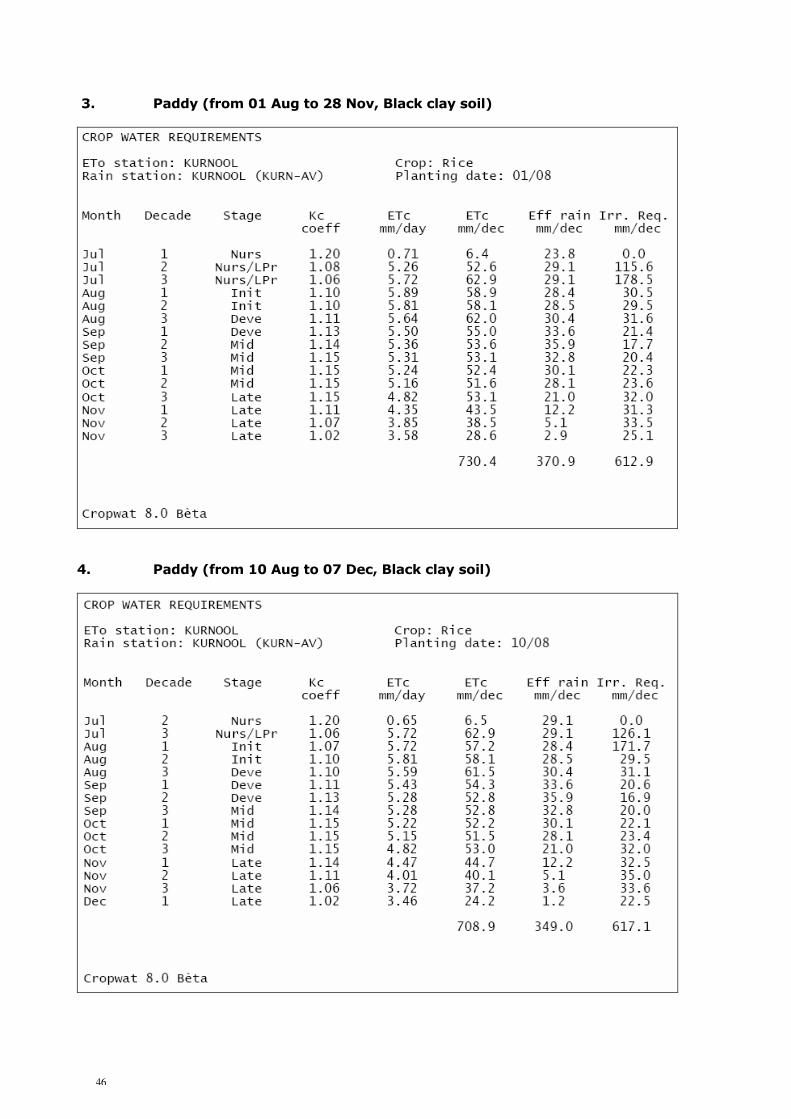
3. Paddy (from 01 Aug to 28 Nov, Black clay soil)
4. Paddy (from 10 Aug to 07 Dec, Black clay soil)

47
5. Paddy (from 10 Dec to 08 Apr, Black clay soil)
6. Paddy (from 20 Dec to 18 Apr, Black clay soil)

48
7. Paddy (from 01 Jan to 30 Apr, Black clay soil)
8. Cotton (from 01 Aug to 27 Jan, Black clay soil)

49
9. Groundnut (from 15 July to 1Nov, Red sandy loam soil)
10. Groundnut (from 01 Aug to 18 Nov, Red sandy loam soil)

50
11. Groundnut (from 15 Aug to 2 Dec, Red sandy loam soil)
12. Groundnut (from 15 Dec to 3 Apr, Red sandy loam soil)
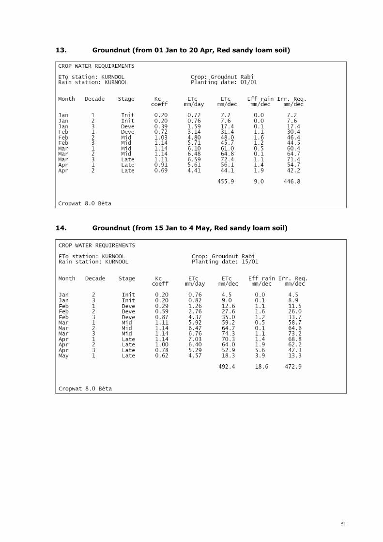
51
13. Groundnut (from 01 Jan to 20 Apr, Red sandy loam soil)
14. Groundnut (from 15 Jan to 4 May, Red sandy loam soil)

52
15. Sorghum (from 15 July to 11 Nov, Red sandy loam soil)
16. Sorghum (from 01 Aug to 28 Nov, Red sandy loam soil)
53
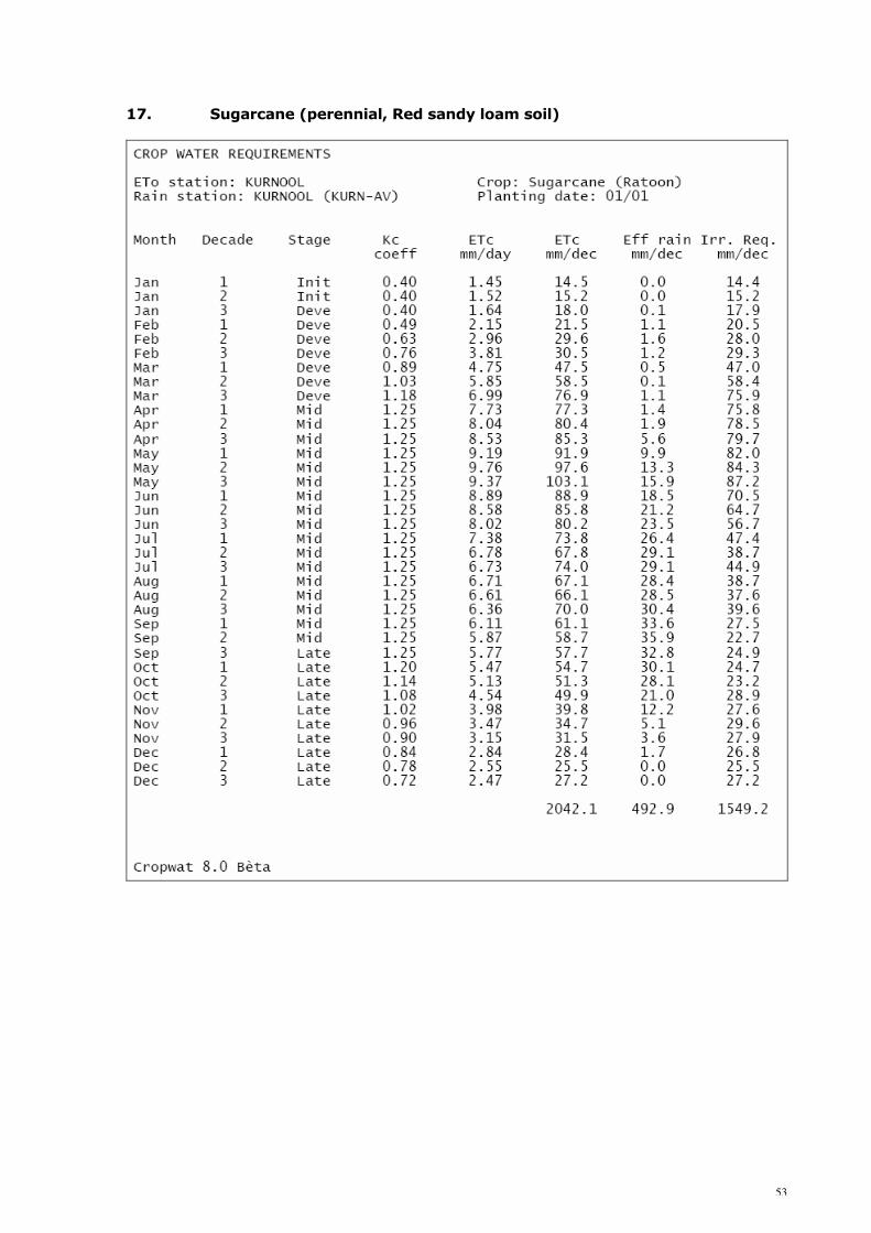
17. Sugarcane (perennial, Red sandy loam soil)

54
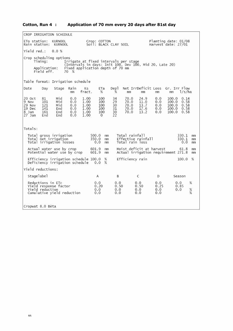
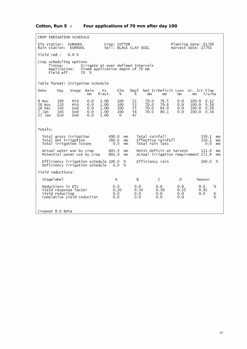
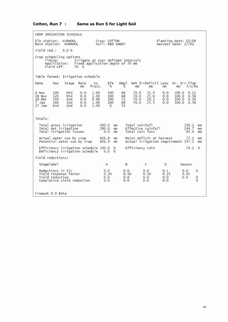
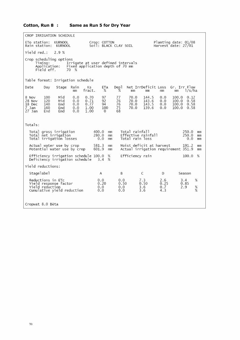
APPENDIX 5.1 IRRIGATION SCHEDULING RUNS Indicative Irrigation Schedules: Groundnut Run 1 : Full replenishment at critical depletion Run 2 : Application of 40 mm after 40 mm depletion Run 3 : Application of 40 mm every 7 days Run 4 : Application of 40 mm every 10 days Run 5 : Application of 45 mm every 10 days Run 6 : Application of 45 mm every 10 days starting 40th day Run 7 : Same as Run 6 for Light Soil Run 8 : Same as Run 6 for Heavy Soil Cotton Run 1 : Full replenishment at critical depletion Run 2 : Application of 80 mm after 80 mm depletion Run 3 : Application of 80 mm every 20 days after 81st day Run 4 : Application of 70 mm every 20 days after 81st day Run 5 : Four applications of 70 mm after day 100 Run 6 : Same as Run 5 for Medium Soil Run 7 : Same as Run 5 for Light Soil Run 8 : Same as Run 5 for Dry Year Run 9 : Same as Run 5 for Wet Year Run 10 : One application (70 mm) on day 130 for Wet Year

55
Groundnut, Run 1 : Full replenishment at critical depletion
56
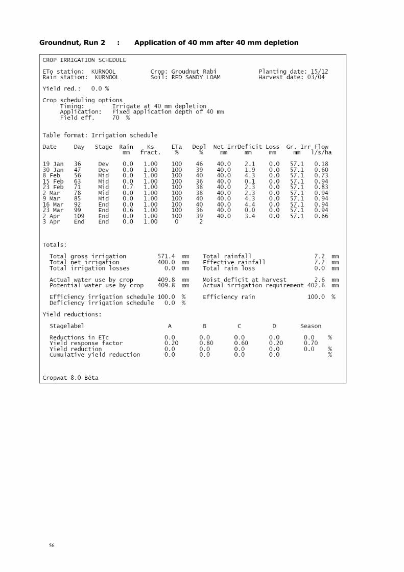
Groundnut, Run 2 : Application of 40 mm after 40 mm depletion
57
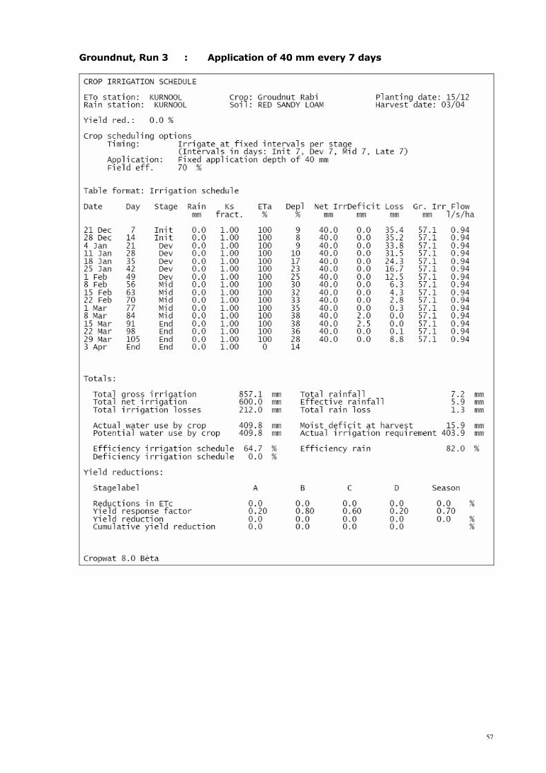
Groundnut, Run 3 : Application of 40 mm every 7 days

58
Groundnut, Run 4 : Application of 40 mm every 10 days
59
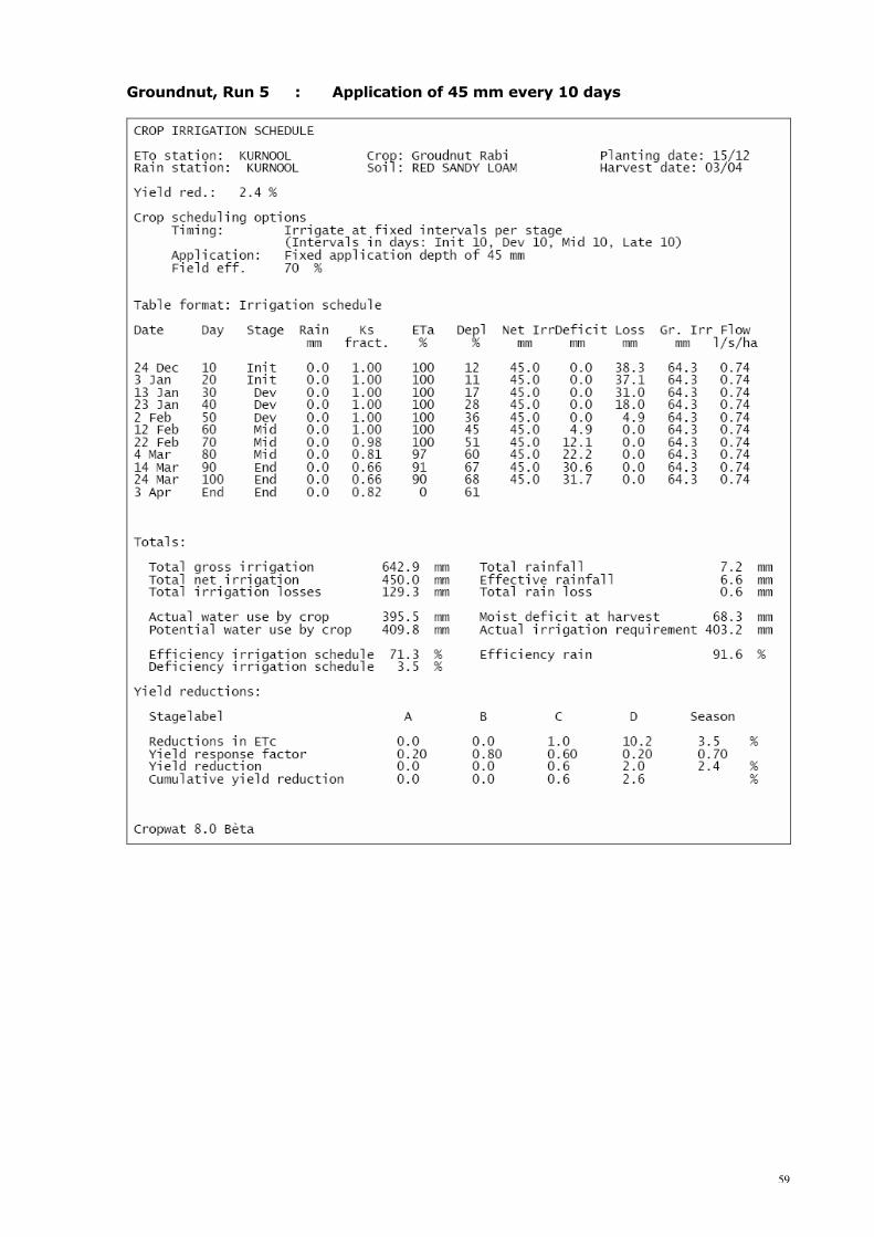
Groundnut, Run 5 : Application of 45 mm every 10 days

60
Groundnut, Run 6 : Application of 45 mm every 10 days starting 40th day
61
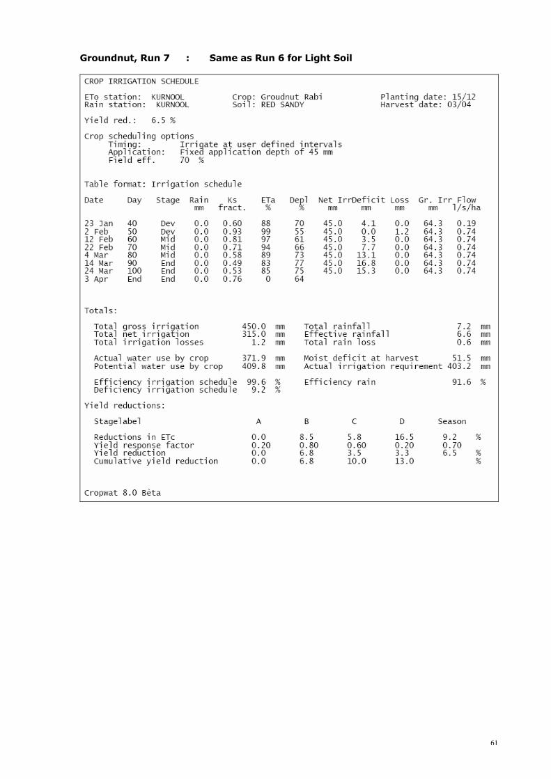
Groundnut, Run 7 : Same as Run 6 for Light Soil

62
Groundnut, Run 8 : Same as Run 6 for Heavy Soil

63
Cotton, Run 1 : Full replenishment at critical depletion
64
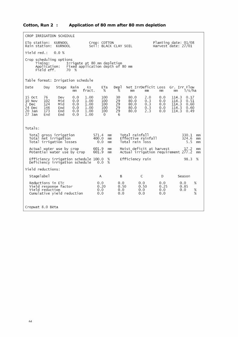
Cotton, Run 2 : Application of 80 mm after 80 mm depletion

65
Cotton, Run 3 : Application of 80 mm every 20 days after 81st day
66
Cotton, Run 4 : Application of 70 mm every 20 days after 81st day
67
Cotton, Run 5 : Four applications of 70 mm after day 100

68
Cotton, Run 6 : Same as Run 5 for Medium Soil
69
Cotton, Run 7 : Same as Run 5 for Light Soil
70
Cotton, Run 8 : Same as Run 5 for Dry Year

71
Cotton, Run 9 : Same as Run 5 for Wet Year

72
Cotton, Run 10 : One application (70 mm) on day 130 for Wet Year

73
APPENDIX 5.2 EVALUATION OF IRRIGATION PRACTICES 1. Sorghum-HYV File 2. CWR Sorghum-HYV 3. Irrigation Schedule as practised by farmer

74
1. Sorghum-HYV File
2. CWR Sorghum-HYV

75
3. Irrigation Schedule as practised by farmer