crm bulletin vol. 11, no. 4 (1988)
TRANSCRIPT

eilPIra B U L L E T I N
Volume 11: N o . 4 Cultural Resources Managemen t • National Park Service August 1988 A Technical Bulletin for Parks , Federal Agencies, States, Local Government s , and the Private Sector
The Certified Local Government Program
Makes a Difference Patricia L. Parker
Almost 450 local governments . across the country have
elected to become Certified Local Governments or CLGs. CLGs are large counties, small and medium-sized towns, suburbs in metropolitan areas, old cities and new "planned communities." A CLG is a local government that has been certified by the State Historic Preservation Officer (SHPO) as having its own historic preservation program meeting state and Federal standards. As such, CLGs formally participate in the national historic preservation program established by the National Historic Preservation Act of 1966. They are the local links in a nationwide program of financial and technical assistance to preserve historic proper t ies-buildings, structures, sites, neighborhoods, and other places important to the historical and cultural life of the Nation.
The Service administers the Certified Local Government Program through the State Historic Preservation Offices. This partnership between the states and local government is not new, local governments having sometimes been recipients of Historic Preservation Fund grants. But it was the 1980 amendments to the National Historic Preservation Act that formalized this partnership. Through the
states, the Service provides technical assistance and financial support to communities that want to protect and enhance the historic character of their cities and towns.
CLGs are eligible to apply for special subgrants from their SHPOs. At least 10 percent of the annual Historic Preservation Fund grant made to states under the
National Historic Preservation Act must be distributed among CLGs. Subgrants to CLGs range from $30,000 to $300; an average grant is about $8,000. These are matching grants with the match provided by the CLG. An estimated $7,500,000 from the Historic Preservation Fund
(Continued on page 8)
History on the Drawing Board Ben Miller
The writers, museum curators, and film makers at the Harpers Ferry Center who produce interpretive media for the parks are another large group "doing history in the NPS," in addition to those featured in the February 1988 CRM Bulletin (Vol. 11, No. 1). What distinguishes their jobs is that every piece of historical work produced at the HFC reaches the public directly. For many visitors, the park film or brochure is the primary carrier of the park story. The following article is adapted from an article that first appeared in Public History: An Introduction^ Barbara J. Howe and Emory L. Kemp, editors (Malabar, Florida; Robert E. Krieger Publishing Co., 1986).
Detail from exhibit, Mound City National Monument.
(See page 2 for article by Ben Miller)

History on the Drawing Board: The Historian as Developer of Interpretive
Media Ben Miller
Visitors come to historic sites to learn about the past, to track
down a detail of particular interest. Those who work at these sites hope all visitors will learn at least a little history before they leave. Thus, one of the more exciting applications of the historical profession is the selection, arrangement, and presentation of material to be conveyed to the public at these sites.
The historian interpreting a historic site gives meaning to a physical part of the past. While not being able to bring the past to life, the historian can give life to the past by making its ideas and experiences useful to the contemporary visitor. This can be a challenge.
Antietam National Battlefield in western Maryland presents a pleasing image to visitors. Fieldstone and wire fences enclose pastures and cornfields. In the distance the smoky blue line of the Blue Ridge Mountains marks the horizon. This rural landscape could be from the last century, with the Victorian monuments adding a touch of solemnity to the scene. Care and effort have preserved the land as it was on September 17, 1862.
The scene during the battle, however, was dramatically different. Confederate and Union soldiers experienced an event here that is difficult for us to imagine.
The most devoted student of the Civil War might stop short of claiming that knowledge and imagination can retrieve the sights and sounds of this battle from the past. The historian cannot recreate the battle. The historian also knows that the Battle of Antietam was more than blood and shrieking shells; the battle was an event of
historical consequence. At Antietam, the Union Army halted a major Confederate invasion of the North. President Abraham Lincoln, wanting to appear to act from strength rather than weakness, seized the opportunity offered by this victory and issued the Emancipation Proclamation. Great Britain decided not to side with a slave-holding power and withheld diplomatic recognition of the Confederacy.
The visitor to Antietam Battlefield deserves an explanation of the event that occurred there. The historian has the responsibility to provide that explanation. The historian must interpret the battle, the place of the battle in the history of the Civil War, and the meaning of the Civil War to American history. While doing this, the historian also must enable the visitor to find a personal meaning in the events at Antietam.
At Antietam, a 25 minute film shown in the visitor center presents the consequences of the battle and focuses on Lincoln's visit there shortly after the battle. Scenes of the battle are realistically shown. The cost in human life and suffering is emphasized by Lincoln's visit to a field hospital. The film presents the significance of the battle by showing how Lincoln used the opportunity of the Union victory to issue the Emancipation Proclamation. The museum exhibits present the physical textures of the battle and concentrate on the personal experience of war. Artifacts, photographs, drawings, and quotations are grouped to represent the stages of the battle: "Before the Battle"; "During the Battle"; and "Aftermath of Battle." The exhibits
use words, images, and objects to create an exciting experience for the visitor. Floor-level displays of artifacts fascinate children; the rich use of first person accounts of the battle intrigues adults.
Publications and panels also interpret the site. A brochure is a guide to the battlefield. It contains a synopsis of the battle, some attractive period and modern graphics, and a map of the battlefield for use on the driving tour. On this tour, wayside exhibits explain with words, maps, and graphics the events of the battle that occurred at a particular location. The wayside exhibits and the brochure are the primary means of interpreting the tactics of the battle.
How Much Interpretation?
Visitors have different levels of knowledge and interest and the historian must consider the extent
Officer's coat and trousers, Antietam National Battlefield. Photo by Paul Chiles.
August 1988 2

and depth of the interpretation. One consideration is the ability of the historic site to communicate on its own. Antietam is a well-preserved battlefield. There are, at this writing, few modern intrusions to confuse the visitor. Even with this advantage, visitors may have more difficulty envisioning what happend there than they would have at a restored colonial town like Williamsburg or a western fort like Fort Larned in Kansas. A ruin of an iron furnace or a battlefield bordered by a shopping center might require a lengthy explanation of what the site represents.
Another consideration is the technical complexity of the story to be told. Antietam is a battle that was tactically simple, and the movements of the troops covered a small area. The Battle of Gettysburg, by contrast, occurred over a three-day period with the armies gaining and losing large areas of ground. This is a more difficult battle to understand and to interpret.
The historian must also evaluate the historical significance of the event, person honored, and historic structure. The historian should be able to place the historic site in the overall sweep of history. This may be the real and lasting value of the site to historians and the public.
The historian developing a film, brochure, or exhibit begins by researching the subject. Primary and secondary sources are read and evaluated. (The Harpers Ferry Center relies on others to conduct original research, except in the historic furnishings office.) Historians who work at the site are interviewed about their knowledge of the site and the story that is presented to their visitors. The artifact collection is evaluated. Historic photographs, prints, and paintings are located and reviewed as possible resources.
Developing a theme may be the historian's most difficult, demanding, and, ultimately, rewarding task. The historian knows the subject; the visitor presumably does not. The historian must distill a theme from a mass of original and secondary source material. This theme is the underlying or unifying idea that gives meaning to the historic site or event. The historical
Detail from exhibit, Mound City National Monument.
experience thus becomes an idea—a modern idea, a contemporary idea—with power to excite and to change our knowledge of the past and awareness of the present.
Mound City National Monument in Chillicothe, Ohio, for example, preserves burial mounds originally built by prehistoric people of the Hopewellian culture. A museum displaying a collection of exquisite burial artifacts is introduced by the theme statement, "Here an ancient people buried their honored dead in their own time and way." This recognition of a common human experience is the theme carried throughout the exhibits.
The historian developing interpretive media works with professionals from other fields. The best product is often the result of a cooperative effort by designers, artists, architects, film makers, and subject-matter specialists. The historian may become the coordinator of a variety of creative efforts or serve as the specialist in the area under review.
Exhibit planners work closely with designers in producing exhibits, although there is no set formula by which this is done. Sometimes the exhibit planner will take the lead in determining the
theme, story line, and content of the exhibit. At other times the designer may create a visual and spatial solution to an interpretive problem. In this case the historian may follow rather than lead (with an eye out for historical accuracy, of course). The Museum of Western Expansion at Jefferson National Expansion Memorial in St. Louis is an example of a museum that was a design solution for an interpretive exhibit. Artifacts, photographs, and words are used as symbols of the American progression westward. The Lewis and Clark expedition is emphasized. The use of design symbolism seems appropriate there since the museum is housed at the base of Eero Saarinen's great arch beside the Mississippi—the arch itself being a dramtic symbol.
Historians and artists also need to work together, for art can interpret history effectively. For an exhibit on John Brown at Harpers Ferry National Historical Park, artist Richard Schlect produced a drawing of Harpers Ferry in 1859, the year of Brown's raid of the U.S. Armory and Arsenal. The town has changed since 1859, and visitors have difficulty understanding the
(Continued on page 4)
August 1988 3
History on the Drawing Board (Continued from page 3)
events of the raid. Even "John Brown's Fort"—the fire engine house—is in a new location. A historian, exhibit planner, and exhibit designer worked with the artist to re-create the 19th-century town in art. A large photographic enlargement of the artwork is now displayed in the John Brown Museum and is a popular part of the exhibit.
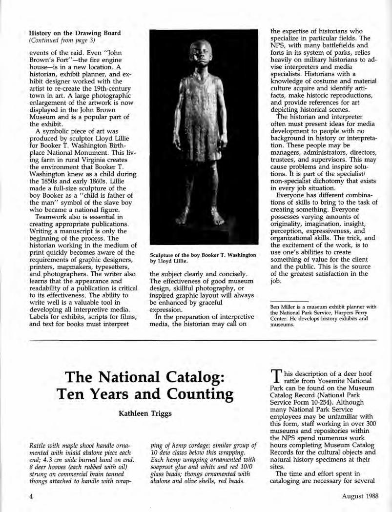
A symbolic piece of art was produced by sculptor Lloyd Lillie for Booker T. Washington Birthplace National Monument. This living farm in rural Virginia creates the environment that Booker T. Washington knew as a child during the 1850s and early 1860s. Lillie made a full-size sculpture of the boy Booker as a "child is father of the man" symbol of the slave boy who became a national figure.
Teamwork also is essential in creating appropriate publications. Writing a manuscript is only the beginning of the process. The historian working in the medium of print quickly becomes aware of the requirements of graphic designers, printers, mapmakers, typesetters, and photographers. The writer also learns that the appearance and readability of a publication is critical to its effectiveness. The ability to write well is a valuable tool in developing all interpretive media. Labels for exhibits, scripts for films, and text for books must interpret
Sculpture of the boy Booker T. Washington by Lloyd Lillie.
the subject clearly and concisely. The effectiveness of good museum design, skillful photography, or inspired graphic layout will always be enhanced by graceful expression.
In the preparation of interpretive media, the historian may call on
the expertise of historians who specialize in particular fields. The NPS, with many battlefields and forts in its system of parks, relies heavily on military historians to advise interpreters and media specialists. Historians with a knowledge of costume and material culture acquire and identify artifacts, make historic reproductions, and provide references for art depicting historical scenes.
The historian and interpreter often must present ideas for media development to people with no background in history or interpretation. These people may be managers, administrators, directors, trustees, and supervisors. This may cause problems and inspire solutions. It is part of the specialist/ non-specialist dichotomy that exists in every job situation.
Everyone has different combinations of skills to bring to the task of creating something. Everyone possesses varying amounts of originality, imagination, insight, perception, expressiveness, and organizational skills. The trick, and the excitement of the work, is to use one's abilities to create something of value for the client and the public. This is the source of the greatest satisfaction in the job.
Ben Miller is a museum exhibit planner with the National Park Service, Harpers Ferry Center. He develops history exhibits and museums.
The National Catalog: Ten Years and Counting
Kathleen Tr iggs
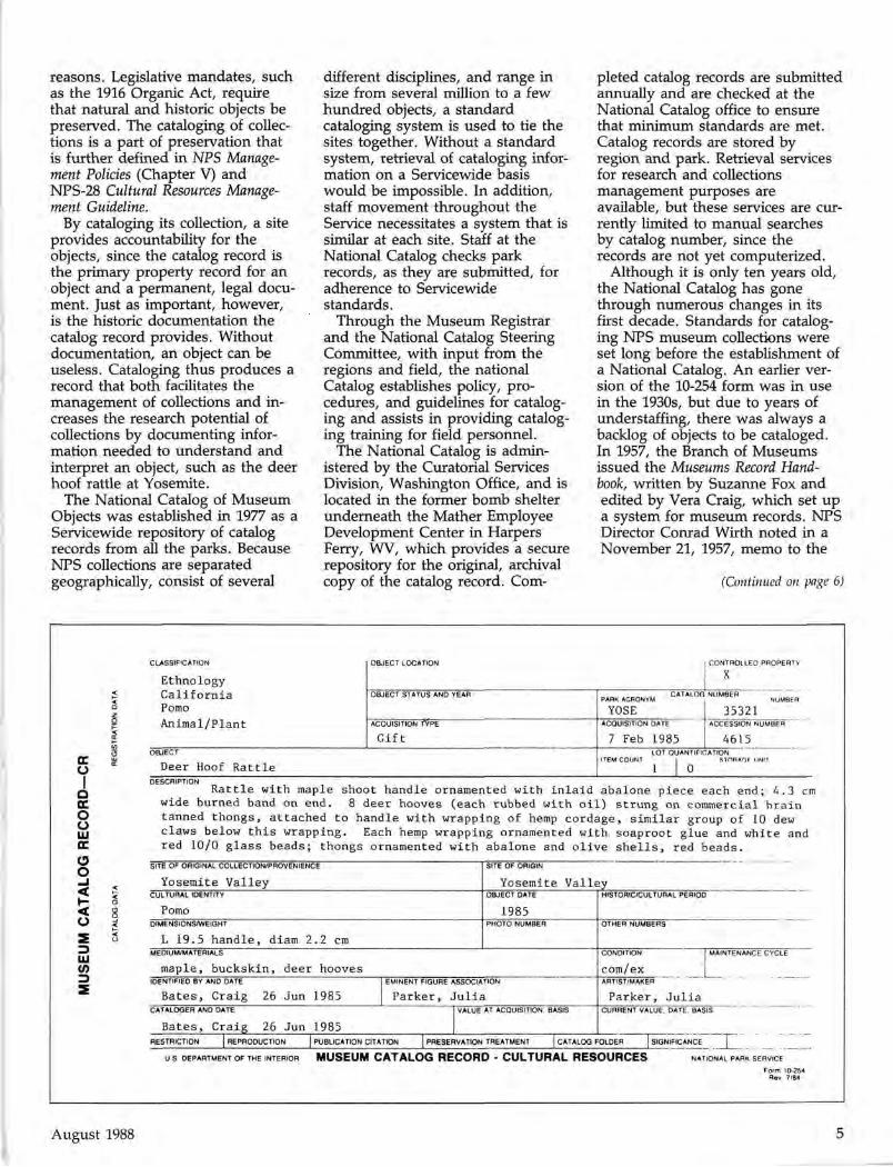
Rattle with maple shoot handle ornamented with inlaid abalone piece each end; 4.3 cm wide burned band on end. 8 deer hooves (each rubbed with oil) strung on commercial brain tanned thongs attached to handle with wrap
ping of hemp cordage; similar group of 10 dew claws below this wrapping. Each hemp wrapping ornamented with soaproot glue and white and red 10/0 glass beads; thongs ornamented with abalone and olive shells, red beads.
T his description of a deer hoof rattle from Yosemite National
Park can be found on the Museum Catalog Record (National Park Service Form 10-254). Although many National Park Service employees may be unfamiliar with this form, staff working in over 300 museums and repositories within the NPS spend numerous work hours completing Museum Catalog Records for the cultural objects and natural history specimens at their sites.
The time and effort spent in cataloging are necessary for several
August 1988 4
reasons. Legislative mandates, such as the 1916 Organic Act, require that natural and historic objects be preserved. The cataloging of collections is a part of preservation that is further defined in NPS Management Policies (Chapter V) and NPS-28 Cultural Resources Management Guideline.
By cataloging its collection, a site provides accountability for the objects, since the catalog record is the primary property record for an object and a permanent, legal document. Just as important, however, is the historic documentation the catalog record provides. Without documentation, an object can be useless. Cataloging thus produces a record that both facilitates the management of collections and increases the research potential of collections by documenting information needed to understand and interpret an object, such as the deer hoof rattle at Yosemite.
The National Catalog of Museum Objects was established in 1977 as a Servicewide repository of catalog records from all the parks. Because NPS collections are separated geographically, consist of several
different disciplines, and range in size from several million to a few hundred objects, a standard cataloging system is used to tie the sites together. Without a standard system, retrieval of cataloging information on a Servicewide basis would be impossible. In addition, staff movement throughout the Service necessitates a system that is similar at each site. Staff at the National Catalog checks park records, as they are submitted, for adherence to Servicewide standards.
Through the Museum Registrar and the National Catalog Steering Committee, with input from the regions and field, the national Catalog establishes policy, procedures, and guidelines for cataloging and assists in providing cataloging training for field personnel.
The National Catalog is administered by the Curatorial Services Division, Washington Office, and is located in the former bomb shelter underneath the Mather Employee Development Center in Harpers Ferry, WV, which provides a secure repository for the original, archival copy of the catalog record. Com
pleted catalog records are submitted annually and are checked at the National Catalog office to ensure that minimum standards are met. Catalog records are stored by region and park. Retrieval services for research and collections management purposes are available, but these services are currently limited to manual searches by catalog number, since the records are not yet computerized.
Although it is only ten years old, the National Catalog has gone through numerous changes in its first decade. Standards for cataloging NPS museum collections were set long before the establishment of a National Catalog. An earlier version of the 10-254 form was in use in the 1930s, but due to years of understaffing, there was always a backlog of objects to be cataloged. In 1957, the Branch of Museums issued the Museums Record Handbook, written by Suzanne Fox and edited by Vera Craig, which set up a system for museum records. NPS Director Conrad Wirth noted in a November 21, 1957, memo to the
(Continued on page 6)
<r o
I Q er O o cc O O _i < < O 2
UJ V) => 2
CLASSIFICATION OBJECT LOCATION j CONTROLLED PROPERTY
I X
Ethnology C a l i f o r n i a OBJECT STATUS AND YEAR " I PARK ACRONYM CATALOG NUMBER ZGJ~^"
P°m° YOSE 35321 A n i m a l / P l a n t ACQUISITION TYPE ACQUISITION DATE ACCESSION NUMBER
G i f t 7 Feb 1985 4615 O B J E C T LOT QUANTIF ICATION
ITEM COUNT STORAGE UNIT
Deer Hoof Rattle 1 | Q
Rattle with maple shoot handle ornamented with inlaid abalone piece each end; 4.3 cm wide burned band on end. 8 deer hooves (each rubbed with oil) strung on commercial brain tanned thongs, attached to handle with wrapping of hemp cordage, similar group of 10 dew claws below this wrapping. Each hemp wrapping ornamented with, soaproot glue and white and red 10/0 glass beads; thongs ornamented with abalone and olive shells, red beads.
SITE OF ORIGINAL COLLECTION/PROVENIENCE '" "~ " I SITE OF ORIGIN ~~ " " " """ '
Yosemite Valley Yosemite Valley CULTURAL IDENTITY OBJECT DATE 1 HISTORIC/CULTURAL PERIOD
Pomo 1985 DIMENSIONSAMEIGHT PHOTO NUMBER OTHER NUMBERS
L 19.5 handle, diam 2.2 cm MEDIUM/MATERIALS CONDITION I MAINTENANCE CYCLE
maple, buckskin, deer hooves com/ex IDENTIFIED BY AND DATE I EMINENT FIGURE ASSOCIATION ARTIST/MAKER ~~ " " "
Bates, Craig 26 Jun 1985 Parker, Julia Parker, Julia CATALOGER AND DATE I VALUE AT ACQUISITION, BASIS CURRENT VALUE, DATE BASIS ~
Bates, Craig 26 Jun 1985 |_ RESTRICTION | REPRODUCTION | PUBLICATION CITATION | PRESERVATION TREATMENT | CATALOG FOLDER TSIGNIFICANCE j _
U S DEPARTMENT OF THE INTERIOR MUSEUM CATALOG RECORD - CULTURAL RESOURCES NATIONAL PARK SERVICE
August 1988 5
Form 10-254 Rev 7/84
< < O Z 5 < DC
O ft
< < o
8 < •-< U

The National Catalog (Continued from page 5)
field offices that in a recent audit, the accountability for museum records was found to be inadequate. He stated, "One of the very important purposes of the revised museum record system is to provide accountability for museum specimens." Each region was given $10,000 per year for three years to get catalog records updated. Regional curators were appointed in the northeast, southeast, midwest, and southwest to help parks with the cataloging program. At this time the size of NPS museum collections was estimated at 2.5 million.
In 1967, the Museum Handbook was issued to replace the Museum Records Handbook. As parks were added to the system and collections continued to expand, creation of a centralized repository for catalog records was just a matter of time. In 1969, Dr. David Wallace, Assistant Chief, Branch of Museum Operations (formerly Branch of Museums), wrote a justification for centralizing and possibly computerizing NPS catalog records to answer research and information requests and to aid in collection management.
Early Period
However, the idea did not really get started until the mid-seventies when the Fiscal Year 1977 budget for the Division of Museum Services (formerly Branch of Museum Operations), Harpers Ferry Center, included initial funding to establish a National Catalog. This idea was probably due in part to the increased emphasis museum collections received in 1976 with the issuance of the Manual for Museums, by Ralph Lewis, and the Pound Report, a Servicewide artifact inventory. Jack Pound, Special Assistant to the Director, requested each park to conduct an inventory of its museum collection. The resulting count of nearly 10 million objects was four times the 1957 estimate of Servicewide collection totals.
On May 13, 1977, Staff Directive 77-5 concerning the establishment of a National Catalog was issued to
the field. The purposes for establishing this repository were to better categorize and manage the museum objects in the Service. The future need to computerize records was also mentioned.
From the start, the National Catalog was seen as a means for checking the quality of cataloging as well as the quantity. In 1978, Art Allen, Chief, Division of Museum Services, HFC, noted that the majority of catalog records was below professional standards, with incomplete classifications and descriptions. Instructions for making corrections and submitting new records were issued in 1978.
Improvements
A move to improve the classification system was made in 1979 when a committee of curators approved the use of Chenhall's Nomenclature for Museum Cataloging to classify material culture. At the same time, an updated classification list for natural history specimens was issued.
In 1980, the NPS appointed a Chief Curator to oversee the management of museum collections. An NPS curators conference held that same year endorsed the concept of a National Catalog Steering Committee to develop and implement a long-term program for the National Catalog that would include computerization. The curators
were concerned that 90% of NPS collections still needed to be cataloged.
The National Catalog Steering Committee was established in 1982. Its three major duties were to revise and improve cataloging, to insure input from users on policy and procedures, and to recommend action to the Associate Director, Cultural Resources, on issues related to the National Catalog. Its members came from parks, centers, regional offices, and non-NPS museums, serving two-year terms with potential reappointment.
Although automation was the ultimate goal for the National Catalog, the Committee first needed to improve and standardize the manual system of cataloging. The Museum Handbook, Park II, Museum Records, was issued to the field in 1984 as the result of its work and that of the Curatorial Services Division. Major changes in the cataloging system included the use of two different catalog records, one for Cultural Resources and one for Natural History; the expansion of the use of discipline-specific lot cataloging to expedite the process of cataloging similar objects from the same provenience; new classification systems for archeology and ethnography based on material identification rather than function; a revised natural history classification; and a minimal, mandatory registration level of cataloging to
Porno Indian baskets, CA. Part of DOI museum collection presently being cataloged.
August 1988 6

Mahogany balloon-back chair, William IV-style. From NPS Clearinghouse collection; on loan to the Old Executive Office Building
gain quicker accountability for museum property.
The need to streamline the cataloging process and increase the rate of cataloging was of primary importance due to the large backlog of uncataloged objects in the Service. As soon as the new system was issued to the field, work began on producing a computer-based cataloging program.
Computerization
From the start, computerization was seen as the best way to gain access to museum collections both for management and research purposes. Efforts to develop a computerized cataloging system began as early as 1978 with development of functional requirements documents for a centralized main frame system. However, this development was interrupted by the need to first revise the cataloging system. When the project eventually came under the review of the National Catalog Steering Committee, a microcomputer park-based system was recommended. The Automated National Catalog System (ANCS), developed by the Curatorial Services Division and the
Information and Data Systems Division, WASO, from a prototype created in the Southeast Region for historic objects at Carl Sandburg Home National Historic Site, was released in 1987. It is a park-based stand-alone microcomputer-based system with potential to link to other NPS databases. Networking and multi-tasking are anticipated in future releases. (See CRM Bulletin, Vol. 10, Nos. 1, 4, and the Special Issue for more information on the ANCS.) Because NPS collections are site-specific, access to collection information is most important at the site. However, standardization of certain data fields will allow Servicewide searches in the future when all records are cataloged.
An immediate benefit of the ANCS has been improvement in the quality of cataloging. The program validates data in discipline-specific fields and therefore prevents many errors. Other recent moves to improve cataloging quality include returning records that do not meet minimum standards back to the parks for correction and resubmission. In 1986, the Curatorial Services Division initiated a program to bring the regional curators to Harpers Ferry each year to help check the quality of submissions from their parks.
Accountability
Accountability has been the primary goal of the National Catalog. A 1986 survey of NPS collections produced an estimate of 25.6 million objects, more than twice the amount of the previous estimate. Of this total, 22.6 million objects are still uncataloged. The huge increase is due in part to an increase in sites, more accurate tallies, and Federal regulations requiring that all archeological objects and certain natural history specimens found on park lands be retained as part of the museum collection.
In 1985, an audit by the Office of Inspector General cited the large backlog of uncataloged collections and recommended that the NPS increase its efforts to gain accountability for its collections. To help remedy this problem, parks were
asked to establish target dates and cost estimates for cataloging and backlog. The majority of the backlog consists of archeology and archives. A Servicewide schedule and cost estimates for cataloging the backlog were submitted to Congress in 1987. Appropriations in FY 1988 included an add-on of $2,763 million that has been used for cataloging projects throughout the Service.
There are currently about 900,000 records at the National Catalog. However, the rate of cataloging has increased in the past two years and should greatly increase in 1988-89. The increased use of lot cataloging has also allowed parks to account for more than one object per catalog record. In 1986, for example, the Western Region cataloged 75,555 objects on 10,442 catalog records.
As the National Catalog counts off its first ten years, it continues counting the catalog records that provide the accountability and documentation for the museum collections in the National Park Service. Future automation plans include computerization of the manual records already on file and the Servicewide aggregation of all catalog records. The National Catalog will continue to serve as an archives for the paper copies of catalog records. Improving the quality of cataloging will also remain an ongoing project.
When the National Catalog was established in 1977, it helped produce the impetus to create a professional-level Servicewide museum record keeping that has continued to grow and change. The goal of a repository containing documentation for all museum objects in the Service is slowly becoming attainable. If the second decade progresses as well as the first, a complete and updated national NPS database for museum objects may truly become a reality.
Kathleen Triggs is a staff curator in the Curatorial Services Division, Washington Office.
Photos by Jeanne Lavelle
August 1988 7

The Certified Local Government Program (Continued from page 1)
has been subgranted by State Historic Preservation Offices to CLGs since October 1985.
The meaning of being a CLG in two communities is illustrated in the following case studies.
Sublette County, Wyoming
With a population of 1,000, Sublette County is one of the least populous portions of the Nation's least populated state. It has a century-long tradition of ranching combined with some recent energy development. In 1984, the county had an active county historical society, but no organized historic preservation effort. Little had been written about the county's history, particularly the period of early settlement.
Sublette County became a CLG in 1984, with the assistance of the Wyoming State Historic Preservation Office. The county board of commissioners passed a resolution declaring that the county's objective as a CLG is to combine historic preservation with historical research. A historic preservation commission was established composed of three ranchers, a veterinarian, a museum director, a teacher and a curator/historian. A coordinator for CLG activities and a professional consultant were hired.
The county then embarked on a three-year effort to research, survey, document, and register historic sites associated with its
Jensen Ranch, Sublette County, Wyoming.
settlement by Euro-Americans. The public was actively involved; more than 4,000 hours of in-kind contributions were made during the project. As a result of the project and the public interest and support generated by it,
• more than 60 historic properties were recorded;
• four National Register nominations were completed;
• two slide shows are being used by teachers and community groups;
• a brochure describes the county's goals as a CLG;
• a manuscript on the county's early history produced by the
project is soon to be published;
• new knowledge was generated about the county's history;
• the historic preservation commission is a new source of expertise on historic properties;
• county citizens have increased awareness of local history and the value of local historic properties; and
• county citizens have increased understanding of historic preservation and the roles of the county, the SHPO and Federal agencies in the national historic preservation program.
''Our town needed educating. We could not finance a public education effort without the money and help we received from the SHPO as a CLG."
August 1988 8
"We would never have been able to raise the money for nominating our mill village to the National Register without a CLG grant. The commission is now thinking about recommending that district for local designation."
The county has initiated preservation activities other than the three-year survey project, including an archeological survey, documentation of sites associated with the educational history of the county, and the survey, documentation, and protection of an 1830s trapping post.
In Sublette County, becoming a CLG was the catalyst for an active local preservation program that now includes many activities beyond those funded by CLG subgrants. The effect of becoming a CLG has, in the words of one preservation commission member, "created a historic preservation structure that functions by itself— without CLG funds, if necessary."
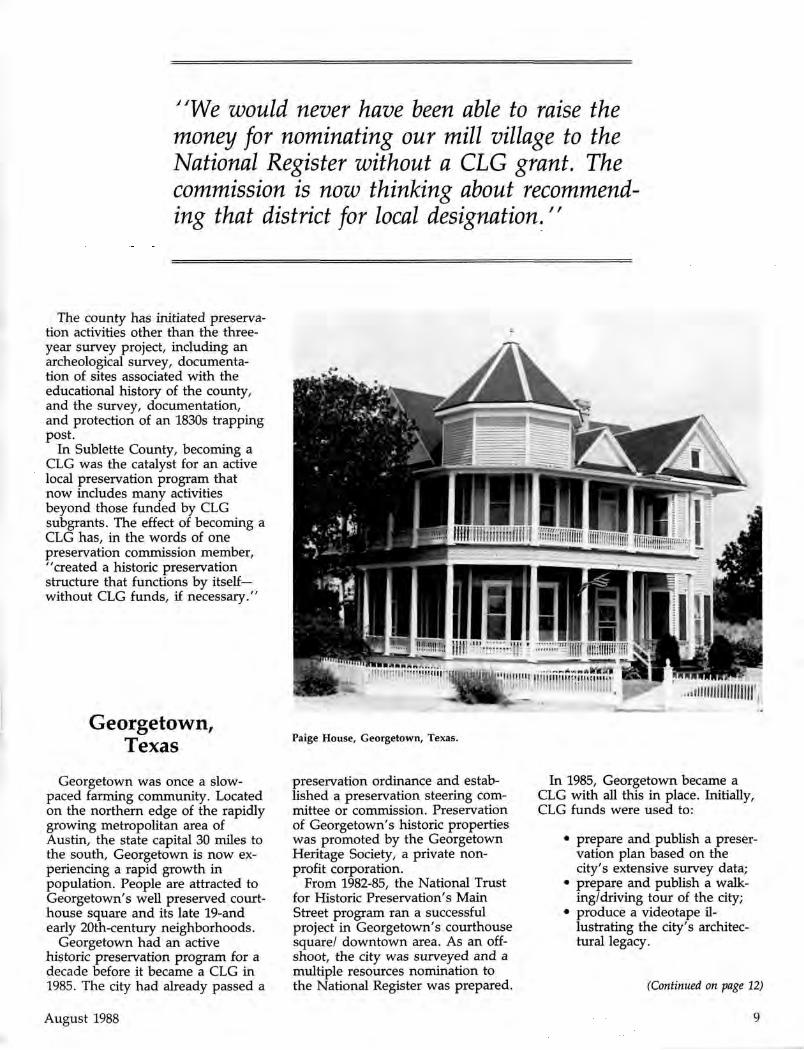
Georgetown, Texas Paige House, Georgetown, Texas.
Georgetown was once a slow-paced farming community. Located on the northern edge of the rapidly growing metropolitan area of Austin, the state capital 30 miles to the south, Georgetown is now experiencing a rapid growth in population. People are attracted to Georgetown's well preserved courthouse square and its late 19-and early 20th-century neighborhoods.
Georgetown had an active historic preservation program for a decade before it became a CLG in 1985. The city had already passed a
preservation ordinance and established a preservation steering committee or commission. Preservation of Georgetown's historic properties was promoted by the Georgetown Heritage Society, a private nonprofit corporation.
From 1982-85, the National Trust for Historic Preservation's Main Street program ran a successful project in Georgetown's courthouse square/ downtown area. As an offshoot, the city was surveyed and a multiple resources nomination to the National Register was prepared.
In 1985, Georgetown became a CLG with all this in place. Initially, CLG funds were used to:
• prepare and publish a preservation plan based on the city's extensive survey data;
• prepare and publish a walking/driving tour of the city;
• produce a videotape illustrating the city's architectural legacy.
(Continued on page 12)
August 1988 9

Certified Local Governments
10 Photos courtesy the National Register of Historic Places. Map by Jeff Shrimpton Miami-Biltmore Hotel, Miami FL
11
Dallas Hall, SMU, Dallas TX
Glen Auburn, Natchez MS
Kentucky National Bank, Jefferson County KY
The Pagoda, Reading PA
Morse Bridge, Bangor ME
St. Paul's Episcopal Church, Buffalo NY
Painter-Bernatz Mill, Winneskiek Co., IA
Dixon-Markle House, Aspen CO
Long-Waterman House, San Diego CA
Cities a n d T o w n s
Coun t i e s
(as of July 1988)

The Certified Local Government Program (Continued from page 9)
The preservation plan was adopted by the city. It included a strategy for developing a tourism program based on the community's history. This plan is being followed, as evidenced by the recent hiring of a tourism director and the rehabilitation of a historic building for a tourism center on Courthouse Square. This year's CLG subgrant is being used to implement other parts of the plan.
Many of the elected officials and citizens of Georgetown have joined in support for preservation over the years. They have learned first hand that their economy can be improved and their small town quality
"The grants have been great start-up funds for our local efforts, especially since our city council was reluctant to spend money for design guidelines for the commission."
of life can be enriched through historic preservation. The visitor to Georgetown senses an enhanced "pride of place" that is created by its past and ongoing preservation activities. As the city continues to
build on this solid base, the CLG program gives it access to important new tools and building blocks.
As these two cases illustrate, the CLG program can be effectively used both by local governments that have long engaged in preservation activities and by those to whom preservation is new. They also illustrate that the program can be used by many kinds of jurisdictions—in these cases a rural county and a small city at the edge of an urbanizing area. The CLG program is, and must be, flexible, recognizing the wide diversity of communities and preservation needs that exist across the country. Recognizing the opportunities it provides, more and more local governments are seizing their opportunity to become active participants in the national historic preservation program.
Georgetown Courthouse Square, Texas
Patricia Parker is the Certified Local Government Coordinator for the Interagency Resources Division, National Park Service.
"We conducted the commission's survey with community volunteers and CLG grant assistance. We really became excited again about what we had. Everyone's preservation spirit has been regalvanized and the commission is leading the way!"
12 August 1988

Computer Maps for Cultural Resources Planning
John J. Knoerl Sandy Weber
Our special series on Cultural Resource Management Planning continues in this issue of the CRM Bulletin. Articles on this subject have appeared in the April and June issues. Copies are still available from the Editor.
The Interagency Resources Division occupies a relatively unique
position in the national historic preservation program in that it is responsible for fostering a complementary set of preservation planning activities among local, state, and Federal programs, including the National Park Service. One of the major difficulties the Division faces in exercising this responsibility is the wide variety of terminology used in various resource management programs, and the different formats in which planning information is presented from agency to agency, and sometimes even within a single agency. This makes communication difficult and tends to fragment the overall preservation effort.
Fortunately, advances in computer mapping programs have the potential to create a common basis for communicating resource information and opening the way for
previously unimagined applications. The Interagency Resources Division is committed in its five-year work plan toward exploring the various uses of geographic resource data for planning purposes, and establishing a long-term goal to encourage the adoption of computer mapping techniques in the cultural resources community. This article discusses general advantages of Geographic Information Systems (GIS) for cultural resources planning, and identifies some current applications within the National Park Service (NPS).
Information Management
According to information recently supplied by the regional offices, there are approximately 15,300 structures and 36,700 sites currently administered as cultural resources by the NPS. There are also well over 1.2 million prehistoric and historic properties recorded on state inventories. This is an impressive number of cultural resources, but its very size has generated a significant problem for resource planning. How does a manager most effectively use the vast amount of data which describes these resources when trying to make management and planning decisions?
It is important to realize that to manage cultural resources, we must first learn how to manage information about them. Essentially, resource managers use two types of information. First, "wha t " is it? We
collect data that helps us describe sites, structures and objects. We assess their condition, type, and significance in order to determine the appropriate treatment they should be accorded. We also ask, "where" is it? We record the location of cultural resources with reference to a variety of geographical characteristics. We can note precisely where the resources are on a U.S. Geological Survey map. We can measure distances to the nearest roadway. We can note the soil type on which the site is located, or we can reconstruct the subsistence potential of an area surrounding a prehistoric site. All these categories of information can be stored in cultural resource inventories.
These inventories provide much of the data used in resource planning. In retrospect, perhaps too much emphasis has been given to managing the "wha t" component at the expense of the "where" component. One significant consequence of this emphasis has been the production of planning documents that were not easily understood or assimilated by non-cultural resource managers, or non-NPS agencies or groups. Often, the language and structure of the information has either been unintelligible or not packaged in a usable format. Clearly, some rethinking is in order to improve our ability to share planning data with the other
(Continued on page 14)
August 1988 13
CBM Planning
Computer Maps (Continued from page 13)
managers, specialists, and agencies with whom we must interact daily in making resource planning decisions.
If we focus on the "where" component of resource data we may find some potentially promising areas to explore for if there is one thing that managers and planners have in common, it is a concern for a given place. This concern might not be the same. It might even be in conflict, but each player in the decision-making process has his or her own piece of information to share regarding a particular location. The common medium for sharing this information is the map. It is the way this map information is shared and manipulated that can create the basis for solving difficult problems and resolving seemingly intractable conflicts.
Analysis
The practical difficulties of taking the above idea and turning it into reality are the limitations that traditional paper maps impose on map analysis. They often contain so much information that little sense can be made of them, and most do not contain the kind of data needed to solve complex issues such as viewshed problems or trail-siting alternatives. Paper maps are also costly to produce and revise, severely limiting available options and analysis opportunities. Fortunately, most of these map problems have been overcome by the introduction of micro computers with large storage capacities and computer mapping software programs. One important advance in the area of computer mapping is the development of Geographic Information Systems (GIS).
A GIS program is a set of computer programs that encode, store, manipulate, analyze, and output spatial information. It mimics manual map analysis such as McHarg light table overlays and planimeters for analyzing the coincidence of themes (e.g., areas on a lake plain that have marsh vegetation) or distance measures (e.g., distance from the nearest water source), but it goes far beyond these simple analyses.
Encoding and storing spatial information as thematic maps is admittedly both expensive and time-consuming, but once this information is entered into a computer, a wide variety of analyses can be performed using a combination of four map operations: 1) reclassification, 2) overlay, 3) distance measures, and 4) neighborhood characterization.
The reclassification operation involves the simple repackaging of information on an existing map for storage onto a new map. For example, to create a map isolating parcels of land requiring a cultural resources survey, one would "recolor" an original survey base map, assigning a clear color to parcels already surveyed or to parcels where survey is not needed, and shading those parcels where survey is required.
Overlay operations involve the creation of a new map based on the coincidence of values for two or more thematic maps. A map can be created, for example, which identifies parcels where cultural resources are threatened by future development. This is accomplished by overlaying a land use map with a cultural resources sensitivity map. The resulting map could then be reclassified to isolate those parcels which show a coincidence of intensive land development and high cultural resources sensitivity.
Distance operations identify the shortest route between two points, taking into account factors that inhibit or promote movement. For example, more realistic prehistoric site subsistence zones can be defined by measuring distance away from the site over a "friction" surface. The friction can be terrain rug-gedness, avoidance of water or any other appropriate barrier to travel. Thus, the shape of the zone is less likely to be a simple circle but a more irregular or warped configuration.
The fourth operation, the neighborhood characterization, is essentially one of interpolation, e.g., creating a topographic surface map or mapping viewsheds sacred to Native American groups. The impacts of proposed land use practices on the continued protection of viewsheds can also be more precisely assessed.
These four operations can be combined in an almost infinite number of ways. A "cartographic model" represents a specific combination of operations designed to answer a particular query. The process is analogous to a conventional algebraic formula wherein the solution map lies on one side of the equation, and the constants and variables are ordered on the other side. The variables in this analogy are thematic maps which are manipulated with each other using the four map operations discussed above. The logical sequence of performing these operations produces the solution map. This generic approach to map analysis is applicable to a wide variety of cartographic problems, including many typical cultural resources management issues.
14 August 1988
CRM Planning
Application
Several dozen parks, with the assistance of the NPS Geographic Information Systems Division, are already using or considering GIS applications in their resource management programs. Natural resource managers have embraced the process more extensively to date than cultural resource managers, but they too are beginning to see useful applications, often using the same information already gathered by the natural resources staff. Among the most frequent current uses of GIS techniques is the development of fire history maps such as those being produced at Yosemite National Park. These maps will assist managers in developing precise fire management plans and fuel models. These in turn can be used in conjunction with historic base maps and ar-cheological survey maps to identify the impact of fire management strategies on cultural resources.
At both Saratoga National Historical Park and Antietam National Battlefield, efforts are being made to use GIS overlay operations to compare historic landscape maps and current vegetation patterns to facilitate the restoration of historic landscapes and the production of highly detailed vegetation management plans. GIS cartographic neighborhood operations are also being applied to the protection of important viewsheds along the Potomac River palisades of the George Washington Memorial Parkway and at key locations along exit points at Antietam. Santa Monica Mountains National Recreation Area and Mount Rainier National Park are considering combined overlay and neighborhood operations as part of environmental impact analyses. Tracts scheduled for development can be overlaid
with natural and cultural thematic maps to assess the impact of these projects both within the development area and in nearby protected areas.
One of the most promising applications of GIS in the area of cultural resources management is taking place at Mammoth Cave National Park. Over the next three years, the Southeast Archeological Research Center will be completing thematic maps that will enable archeologists to predict the locations of archeological sites in the park. A good deal of information is known about rockshelter and cave sites, but only recently have archeologists turned their attention to sites located in the uplands and bottoms. Many of the bottom sites are in pristine condition because they were sealed over by sterile deposits. They therefore represent a valuable complement to the archeological record at Mammoth Cave. Archeologists suspect, however, that many bottom sites have yet to be discovered and may be endangered by development projects. To identify where these sites may be located, GIS overlay operations using both geologic and vegetation thematic maps will be superimposed on a known-site location map in an attempt to identify unique signatures for the location of additional sites. In the future, when a proposed project is being considered, attention will be drawn to the possible presence of these bottom sites on the basis of the established signature.
Cooperation
This article began by noting that resource planning has traditionally not given much attention to using the "where" aspects of resource information. As noted in the previous examples, computer maps have the
potential to successfully integrate with other kinds of resource information to yield solutions to difficult planning problems. Results are particularly effective when the GIS project has a strong interdisciplinary structure. Nearly all GIS thematic maps employ data that cross-cuts traditional staff functions. The archeologists at Mammoth Cave, for example, use geologic and vegetation data gathered by natural resource specialists for their predictive model. Interdisciplinary cooperation, both in terms of staff involvement and budgeting, is almost always necessary for a successful GIS application. By expanding the analysis options and data sources we use when addressing resource planning issues, we improve our ability to implement viable solutions to difficult management problems.
The Interagency Resources Division (202/343-9500) is interested in learning about any additional GIS projects currently underway, or possible applications for cultural resources management purposes. The early experiments and present applications are very encouraging. Working together, resource managers from parks, states, and other Federal agencies can hopefully develop programs which will facilitate interagency coordination and effectiveness in resource management.
Dr. John J. Knoerl is an archeologist in the National Register Branch of the Interagency Resources Division, National Park Service.
Sandy Weber is a historian in the Preservation Planning Branch of the Interagency Resources Division, National Park Service.
August 1988 15
CRM Planning

Skills Development Plan Enters Second Year
Emogene Bevitt
In 1986 the Skills Development Plan for Historical Architects in
the National Park Service was sent to historical architects and others who work with historic structures in the Service. This plan puts forth a continuing education program for NPS employees that can be tailored to the personal needs and interests of the participant. The plan describes skills needed by one specific profession—that of the historical architect—to conduct responsible evaluation and treatment of historic structures. The most basic skills are described in some detail and a selected bibliography is included. The purposes of the plan are twofold: (1) to create an opportunity for the employee to learn new skills; and (2) to create an opportunity for this new knowledge to be shared with others. An employee participates by identifying a job-related topic, obtaining the support of the supervisor, and developing and submitting a study plan for review and comment. The employee signs up for three years and is required to produce a written, graphic or oral project or presentation for each of the three years to share what has been learned.
Recognition
In May 1988, the American Institute of Architects awarded the National Park Service its Citation for Outstanding Education in Practice for the Skills Development Plan, as "a significant achievement in the formulation, implementation, and outcome of educational programs in architectural practice."
Marilyn Kaplan, Director, Preservation and Research, Cannon Design, Albany, New York, in her review of the Skills Development
Plan in the APT Bulletin (Vol. XX, No. 2, 1988), wrote: "The document, a detailed and comprehensive overview of the skills the historical architect should possess, once again reminded me of the breadth of knowledge one must have to work responsibly on a historic s tructure. . . Ironically, the gaps in the bibliography clearly illustrate the technical research and sharing of information so desperately needed in certain areas of our rapidly expanded field.. . Overall, the document is an admirable compendium of information whose usefulness will extend beyond the National Park Service. For educators, the description of skills the historical architect must possess provides an outline to be considered in preparing a curriculum, and perhaps can help bridge the gap between preservation education and practice. For administrators, the clear explanation of necessary expertise will be useful in describing positions and selecting employees. And for all practitioners in the field—architects, engineers, conservators, historians and tradespersons—the Skills Development Plan describes a direction for learning and growth, and a reading list that will easily take the next twenty to thirty years to absorb."
The audience at the International Council on Monuments and Sites General Assembly last October was most interested in a presentation on the Skills Development Plan made at a session on training and education. Copies of the Plan were requested for preservationists in Zambia, Sudan, Finland, Canada and Hungary.
Several preservation programs at colleges and universities throughout the.United States have identified
the Skills Development Plan as a good source for curriculum development and bibliographic material.
The Plan is Working
The best news of all is that the plan is working. New things are being learned and shared. Participants are located in Georgia, Pennsylvania, Arizona, New Mexico, Maryland, and Ohio. While several are historical architects, there are also preservation specialists, a maintenance mechanic, and a program analyst. Topics include:
The appropriate use of modern woodworking techniques and materials in the restoration process (Douglas Hicks, Williamsport Preservation Training Center)
Conducting research to locate the original archeological excavation documentation of Earl Morris for Canyon de Chelly National Monument and Aztec Ruins National Monument (John Morgart, Southwest Cultural Resources Center).
Investigating building practices, regional craftsmanship, and design and construction techniques of barns within the Cuyahoga Valley National Recreation Area (Paulette Oswick, Cuyahoga Valley Land Resources Office).
Caulkings and sealants in historic buildings—when their use is appropriate, when not (Sharon Park, Washington Office).
Wood panelling—as structural and decorative members, and its potential as a dating tool (Thomas Schiller, Hampton National Historic Site).
16 August 1988

Fire protection for historic structures, especially overnight lodging and the impact of protection requirements upon historic fabric (Thomas Solon, Delaware Water Gap National Recreation Area).
Reroofing of adobe buildings, especially parapet flashing and solving canale problems, including systems flashing (Thomas Vitanza, Williamsport Preservation Training Center).
Architectural Study Collections-define and describe what a collection is and identify those in the United States (Emogene Bevitt, Washington Office).
Repointing of historic and prehistoric structures in the Southwest (Douglas Dewitz, Pipe Spring National Monument).
Becoming familiar, hands-on, with the process of repairing and reproducing interior woodwork (Rene Cote, Jr., Southeast Cultural Resources Preservation Center).
Completed Projects
Sharon Park reviewed the manufacturers' literature and
developed a paper about the criteria for selecting caulkings and sealants, information about generic types, their life expectancy and their intended application. Sharon has also drafted a questionnaire to elicit information from National Park Service architects and others on how these products have actually performed on historic structures. Ultimately, it is intended to focus on the problems and applicability of these products to historic structures.
Thomas Solon provided a paper, complete with footnotes, a three-page selected bibliography, two case studies applying the fire safety evaluation system to two historic structures, a copy of the National Fire Protection Association's "Recommended Practice for the Protection of Historic Structures and Sites," and an extensive section of photocopied product literature on fire detection and alarm systems, chimney flue systems, door and wall systems, passive protection systems, and fire retardants. The paper is presented as a guideline. The introduction and article explain in non-technical terms what the fire safety evaluation system is and how such a system of carefully evaluated tradeoffs can be applied successfully to
August 1988
preserve and safely secure historic structures.
Thomas Schiller prepared a paper with footnotes, drawings and photographs describing what he has been able to find out about the panelling at the Overseer's House at Hampton Mansion. Having posed the question, "Can wood panelling be used as a dating tool?," he proceeded to look at the several styles of panelling in the Overseer's House and at the Mansion and tried to locate original records to see if there was a relationship between the dates of the records and the type of panelling.
What Next?
Participants enroll for three years in the Skills Development Plan. These projects, and others that were submitted, are products of the first year projects, and represent an important effort to communicate what has been learned so far. Each of the individuals will develop this project, will add to it, revise it and flesh it out as needed, and will develop a revised draft by the end of the second year. We are presently exploring ways of distributing this information so that it can be snared throughout the National Park Service.
An exciting aspect of the development of this information is that it is quite clear that new information is being developed; information that does not currently exist in a college course or in any existing textbook or reference material. This new information was developed by NPS employees and their efforts should materially assist many more throughout the Service.
The Skills Development Plan is a program of the National Park Service developed to enhance the skills of employees involved with historic structures and to develop sharable technical preservation information. If you would like more information about the program, contact Emogene Bevitt, Skills Development Plan Coordinator, National Park Service (424), P.O. Box 37127, Washington, DC 20013-7127, Phone: 202/343-9561. If you know of any information that might assist the participants with their chosen topics, contact them.
17

Announcements
Call for Papers
The New River Gorge National River (WV) and the New River State Park (NC) are co-sponsoring the eighth annual three-day New River symposium, scheduled for April 20-22, 1989.
Papers for the symposium are being requested in natural and/or cultural history, folklore, archeology,
geography, other natural, physical and social sciences, and the humanities. Proposals must be received by December 1, 1988.
For more information, contact the Chief of Interpretation, National Park Service, New River Gorge National River, P.O. Box 1189, Oak Hill, WV 25901; Phone: 304/465-0508.
INTERIORS CONFERENCE
FOR HISTORIC BUILDINGS
Philadelphia December 7-9,1988
National conference on rehabilitation and restoration of interiors in historic buildings, featuring state-of-the-art repair, rehabilitation options, craft techniques, adaptive reuse, walls and floor coverings, and building codes, with more than 70 leading experts as speakers.
SPONSORS: National Park Service • American Society of Interior Designers • General Services Administration • Rhode Island Historical Preservation Commission • Pennsylvania Historical & Museum Commission •
New York State Parks, Recreation & Historic Preservation • The Wool Bureau, Inc. • Georgia Institute of Technology
For information urite: Interiors Conference • P.O. Box 27080 • Washington, D.C. 20038 • (202) 343-9578
INTERIORS EXPOSITION
FOR HISTORIC BUILDINGS
Philadelphia December 7-9,1988
Over 60 select companies from here and abroad exhibiting products and services for the rehabilitation and restoration of interiors in historic buildings, with special demonstrations.
CRM Bulletin Gets
Associate Editor
Michael G. Schene, regional historian for the Rocky Mountain Region, National Park Service, has been designated associate editor of the CRM Bulletin. Dr. Schene has been participating in the production of the Bulletin on a regular basis for over a year.
Building on his network of contacts both within and outside the NPS, Michael will be soliciting manuscripts directed toward problems and issues germane to both NPS field areas and state and local preservation programs. He hopes also to continue the practice of having contributing editors who will regularly provide material on special interest topics.
Michael has previously worked at the Denver Service Center, Jean Lafitte National Historical Park, and the Florida Division of Archives, History, and Records Management. He has recently edited a special issue of The Public Historian that focused on the NPS and its role in historic preservation.
If you have suggestions or comments about articles or topics, please contact Michael, in Denver, at 303/969-2875, or FTS 327-2875.
18 August 1988

New on the Market Capitol Contact
Bruce Craig
The Revised Nomenclature for Museum Cataloging by James R. Blackaby, Patricia Greeno and The Nomenclature Committee; h/b; 300 pps; $62.50/55.00 to AASLH members. Long considered a classic in the work of cataloging museum objects, "Nomenclature" makes its return with a new expanded edition. Based on the original book (1978) by Robert G. Chenhall, the revision includes more object terms, clearer rules for handling unusual objects, and a fuller bibliography for use in researching artifacts.
Profile of Black Museums by the African American Museums Association; p/b; approx. 64 pps; $8.75/7.85 to members. This publication was compiled to discover an accurate profile of the American Black museum.
Moving Historic Buildings by John Obed Curtis; p/b; 50 pps; $8.75/$7.85 to members. This book deals historically wtih the problems, failures, and successes of moving historic structures.
Public Places: Exploring Their History by Gerald A. Danzer; p/b; 132 pps; $11.95/10.75 to members. "Public Places" explores a broad category of spaces and places within the community, those that are generally accessible to residents and visitors as opposed to those that are private or somehow restricted. The author tells you how to investigate historic places for public use such as buildings for commerce, culture, and government; parks or sites for recreation and respite; and streets as they reflect the lives of people who meet there or simply pass through.
To order any of the above ($10.00 minimum) or for more information, write Order/Billing Department, American Association for State and Local History, 172 Second Avenue North, Suite 102, Nashville, TN 37201; 615/255-2971.
The President recently signed bills which focus on "affiliated areas" of the National Park System and on several of the maritime units administered by the bureau.
In June, President Reagan signed Public Law 100-336 which requires the NPS to report to Congress on criteria of national significance and other factors necessary for a proposed area to be considered appropriate for inclusion as an "affiliated" area of the National Park System. Though generally not owned or managed by the NPS, such areas are eligible for technical and financial assistance from the Service. Several recent proposals have raised the question of whether "affiliated" areas should have to meet the same standards of national significance as new parks or landmarks.
PL 100-336 (HR 1100) was introduced by House minority leader Robert H. Michel (R-IL) and sought to confer affiliated site status on the Wildlife Prairie Park located just outside Peoria, IL. Conservation and preservation groups opposed the bill, arguing that the site lacked national significance. As a consequence, the bill was amended to require the NPS to assess the significance of the proposed area and also study generic issues relating to affiliated area designation and management. The report will review existing criteria for national significance, suitability and feasibility, and management alternatives for considering potential new parks as well as future additions to the affiliated category. Even before this bill passed, the Service established a task force and began working on the report. A draft is expected to be available for public review shortly.
In addition to the Wildlife Prairie Park bill, the President signed PL 100-355 which provides increased funding for an affiliated area—the Sewall-Belmont House National Historic Site. The bill increased this unit 's authorization from $500,000 to $2,000,000. But perhaps more important than the increased authorization is the provision in the Act that directs the Service to prepare a Statement for Management, A Statement for Interpretation, a Scope of Collections Statement and a Historic
Structures Report for the site. Congressional intent and precedent is now established—those affiliated areas that clearly possess national significance and are of national park quality should (as reflected in report accompanying the bill) be "operated and maintained to National Park Service standards."
Congress and the President also acted on two maritime cultural resource bills. PL 100-349 revised the boundary of the Salem Maritime National Historic Site to include the three-story St. Joseph's Roman Catholic Polish Club which the Service hopes to use as a visitor center and administrative facility. This legislation gave the NPS the flexibility of moving maintenance, operations and administrative activities from Salem Maritime's most significant historic structures to this more appropriate building.
At long last the "San Francisco Maritime National Historical Park" has been established! PL 100-348 removes from Golden Gate NRA the lands, structures, historic vessels, maritime collections, and libraries which relate to maritime history and establishes them as a separate administrative entity. Hopefully, conferring National Historical Park status will facilitate increased funding for the distinctive maritime resources preserved within the boundaries of this park.
This bill did not pass without controversy, especially in regard to selection of an appropriate name for the area. Some sought designation of the areas as the "San Francisco Seaport National Historic Park;" others wanted the inclusion of the word "Museum" in the title. The Subcommittees of Congress were not interested in further complicating the already confusing nomenclature of park system areas. As a result the name selected for the new unit reflects the nationally significant resources that the area seeks to preserve for the benefit and enjoyment of the American public.
If you are interested in obtaining more information about any of these acts, drop me a line at National Parks and Conservation Association, 1015 31st Street, NW, Washington, DC 20007, and I'll send you some additional information.
Augus t 1988 19

B U L L E T I N
August 1988
Published by the National Park Service for parks, Federal agencies, states, local governments, and the private sector to promote and maintain high standards for preserving and managing cultural resources.
Director: William Penn Mott, Jr. Associate Director: Jerry L. Rogers Managing Editor: Ronald M. Greenberg Associate Editor: Michael G. Schene Production Manager: Karlota M. Koester Feedback Editor: Hugh C. Miller
Cultural Resources, Washington, D.C.
U.S. Department of the Interior
National Park Service Cultural Resources P.O. Box 37127 Washington, DC 20013-7127
Third Class Mail Postage & Fees Paid
U.S. Department of the Interior G-83
Volume 11: N o . 4
FEEDBACK
Hugh C. Miller
Editor to Change Jobs After 30 years of Federal service and 4 years as "Feedback" editor, I am retiring from my position as Chief Historical Architect, NPS, on September 2 to spend full time promoting the principals and practice of architectural conservation with teaching and program development. Direct feedback is essential to learning and I look forward to your continued involvement in this CRM network.
Stucco as a Sacrificial Protective Layer
Since the surface of masonry is exposed to the most efficient deterioration processes of thermal shock, salt crystallizations, frost and attack by acid gases, a porous layer of stucco can be applied over the masonry for protection. Hence, most of the destructive effects of the environment are concentrated in this stucco while the
masonry core is protected. In many historic structures, stucco or plaster over masonry was the original intent. Stucco applications can be used for repair, i.e., brownstone, or protection of badly deteriorated masonry, if care is taken in the application.
Stucco must not be too hard or too strong. Use of any cement or add mixes impervious to water should be carefully analyzed before including in the stucco. An impervious stucco is likely to crack sooner or later due to thermal movement, thus interrupting the continuity of the intended water barrier. Water then will accumulate behind this impervious layer. If the wall is affected by rising damp, moisture will reach a higher level after application of the impervious stucco, because the normal evaporation does not occur. The final result might well be development of internal stresses at the interface, between the stucco and the
masonry because of frost or salt crystallization, causing failure of the stucco and more damage to the masonry.
Plaster or stucco acts as a sacrificial protection layer but must be renewed periodically when it has lost its function. When new plaster or stucco is applied, in partial or total replacement of the old, it must be remembered that it can carry out its sacrificial protective action only if its pore system is accessible to water, in liquid and vapor form. From Perous Building Materials
Giogio Terraca, Rome
Editor's Note: For more information on stucco repair and maintenance, the AIA Committee on Historic Resources will hold an intensive one-day workshop on February 11, 1989, in New Orleans. Contact Bruce Kriviskey, AIA staff, or phone 202/626-7452.