crl notice of requirement #1
DESCRIPTION
CRL Notice of Requirement #1 - this covers and includes the section with Aotea StationTRANSCRIPT

6 Henderson Valley Road, Henderson, Auckland 0612 Private Bag 92250, Auckland 1142, New Zealand
Ph 09 355 3553 Fax 09 355 3550
www.aucklandtransport.govt.nz
Notice of Requirement 1 (NoR 1)
NOTICE OF REQUIREMENT FOR A DESIGNATION UNDER SECTION 168(2) OF THE RESOURCE MANAGEMENT ACT 1991 (RMA)
TO: Auckland Council
FROM: Auckland Transport 6 Henderson Valley Road Henderson Private Bag 92250 Auckland
AUCKLAND TRANSPORT (an Auckland Council Controlled Organisation) as Requiring Authority under section 167 of the Resource Management Act 1991 gives notice of a requirement for a designation in the Auckland Council District Plan for works being the City Rail Link (CRL or the Project) to be shown as Rail Purposes for the City Rail Link (Britomart to Aotea).
1. SUMMARY
The CRL will generally comprise:
an underground passenger railway approximately 3.4km long, (including two tracks and three underground stations) running between Britomart Station and the North Auckland Line (NAL) in the vicinity of the existing Mount Eden station; and
an additional 850m of track modifications within and adjacent to the NAL.
This Notice of Requirement (NoR 1) relates to that part of the CRL project between Britomart Transport Centre (Britomart) and Albert Street / Mayoral Drive (in the vicinity of the Aotea Centre car parking entrance on Mayoral Drive) which is necessary to provide for the construction ((including connection of the CRL to Britomart under lower Queen Street), relocation of utility services, a construction area to support construction works, reinstatement and enhancement following primary construction, and other ancillary construction works), operation and maintenance of two rail tunnels, a new rail station (located under Albert Street approximately between Victoria and Wellesley Streets), housing of appropriate utility services within the operational tunnels (i.e. telecommunications), and ancillary activities associated with the construction, operation and maintenance of the CRL.
For ease of reference the station included in NoR 1 for the CRL has been temporarily named Aotea Station. The station will be formally named in the future. This section of the CRL once constructed will operate below ground.
Auckland Transport’s (AT) objective is to secure the rail corridor to enable construction, operation and maintenance. In doing this, the wider objectives of the Project will also be achieved.
2. THE SITES WHICH NOTICE OF REQUIREMENT 1 APPLIES TO ARE AS FOLLOWS:
www.aucklandtransport.govt.nz
NoR 1 relates to land within the Auckland Council District Plan being:
Part of Queen Street (Lower Queen Street adjacent Britomart);
Part of Galway Street and Tyler Street (adjacent Britomart);
Queen Elizabeth II Square;
Private land occupied by the Downtown Shopping Centre;
The road reserve of lower Albert Street and Albert Street and parts of its intersecting streets (including Customs Street West, Mills Lane, Wolfe, Swanson, Wyndham, Kingston, Durham, Victoria, and Wellesley Streets) and Mayoral Drive (to the vicinity of the Aotea Centre car parking entrance on Mayoral Drive);
Part of the road reserve of Customs Street West, Victoria Street and Wellesley Street between Queen Street and Federal Street;
Private land located on the northwest corner of Albert Street and Victoria Street;
Private land located on the northeast corner of Albert Street and Wellesley Street;
Auckland Council owned land on the southeast corner of Mayoral Drive and Wellesley Street.
The following plans are attached which indicate the extent of this NOR:
The extent of the proposed designation is shown on the Land Requirement Plans labelled NoR 1, Sheet 1, 2 and 3 attached to this NoR – land to be designated is shown in orange on these plans;
The longitudinal extent of NoR 1 is shown in the NoR Overview document contained in this Volume (Volume 1) of the CRL NoR suite of documents.
An indicative long section view of NoR 1 in the vicinity of Aotea station in this NoR Form.
The legal descriptions of the land to be designated are also attached to this NoR in an associated Schedule of properties affected by NoR 1.
3. THE NATURE OF THE PROPOSED WORK IS AS FOLLOWS:
NoR 1 seeks to designate land for Rail Purposes for the City Rail Link (Britomart to Aotea). This includes the construction ((including connection of the CRL to Britomart under lower Queen Street), relocation of utility services, a construction area to support construction works, reinstatement and enhancement following primary construction, and other ancillary construction works), operation and maintenance of two rail tunnels, a new rail station (located under Albert Street approximately between Victoria and Wellesley Streets), housing of appropriate utility services within the operational tunnels (e.g. telecommunications), and ancillary activities associated with the construction, operation and maintenance of the CRL.
The nature of the work in relation to NoR 1 is detailed in the CRL NoR AEE: Volume 2 (particularly section 4), and the 2012 Concept Design Report, Appendix 13: Volume 3 of the CRL NoR suite of documents. In summary, the work includes the following activities:

www.aucklandtransport.govt.nz
A construction area and works including the construction of two rail tunnels (either by way of cut and cover / top down or by driven tunnelling methods) and ancillary works, including but not limited to rail track, electrification, signalling and ventilation;
Construction works to protect the structural integrity of the former Central Post Office Building;
Removal (and reconstruction) of the existing Lower Queen Street underpass into Britomart;
Construction through two listed Maori Heritage Sites (at the corner of Customs and Albert Streets and at 87-89 Albert Street);
Construction of a station including entrances and ancillary activities;
Removal of the public toilets beneath Albert Street which have heritage value;
Removal or relocation of trees;
Reinstatement and enhancement of Queen Street (between Quay and Customs Street), Queen Elizabeth II Square, and the Albert Street environs following construction of the CRL;
Use of the two tunnels and station during operation;
Use of the two tunnels to house appropriate future services (i.e. telecommunications and other utilities); and
Operation and maintenance of the tunnels and stations for rail purposes and ancillary activities as required, including but not limited to electrification, signalling and ventilation.
See the plans contained in Appendix 1 and 2 and the Concept Design Report (Appendix 13: Volume 3 CRL NoR suite of documents).
4. THE NATURE OF THE PROPOSED CONDITIONS THAT WOULD APPLY ARE:
The land required will be used for the construction, operation and maintenance of the CRL and ancillary activities. Once constructed, access will be restricted and controlled to provide for safe and efficient movement of passengers within and through to each station. Upon completion of the construction of the CRL this designation may be drawn back (pursuant to section 182 of the RMA) to operational requirements.
The proposed conditions that would likely apply to NoR 1 are:
Works to be undertaken in general accordance with the information provided to support NoR 1 (the CRL NoR suite of documents and any further relevant information provided through the public process associated with confirming this NoR);
The preparation and implementation under the Environmental Management Framework of the Environmental Management Plan (EMP) and the Construction Environmental Management Plan (CEMP) (which particularly pertains to transport management, noise and vibration, built heritage and archaeology, building

www.aucklandtransport.govt.nz
condition surveys and monitoring / settlement monitoring, contamination management, air quality during construction, and trees) to manage (including the avoiding, remedying and mitigating of) adverse environmental effects during the construction of the CRL;
As part of the construction of the CRL, the implementation of the principles set out in the Urban Design Framework (under the Environmental Management Framework which supports the CRL NoR) to reinstate the public surface areas within the designation footprint;
The preparation and implementation under the Environmental Management Framework of the Communications Plan to manage and implement communications and consultation during the construction of the CRL;
The preparation and implementation under the Environmental Management Framework (EMF) of operational management plans.
Section 176 of the RMA provides that once a designation is included in a district plan, land owners may not, without AT written consent, do anything on their land that would prevent or hinder the project to which this NoR relates. That protection also applies in the interim once the NoR is served with the Council under section 178.
While this designation remains in place before construction of the CRL, property owners may not undertake any activities that would hinder or prevent the CRL being constructed, operated and maintained pursuant to the designation without AT written consent. Once the CRL is operational, this restriction will continue to apply to that land (including sub strata land) which remains designated (i.e. the area AT draws the designation back to following construction).

www.aucklandtransport.govt.nz
Below is a visual representation of a long section of NoR 1 in the vicinity of Aotea Station.
5. THE EFFECTS THAT THE PROPOSED WORK WILL HAVE ON THE ENVIRONMENT AND THE WAYS IN WHICH ANY ADVERSE EFFECTS WILL BE MITIGATED ARE:
An assessment of the actual and potential effects and a summary of the proposed measures to manage (including to avoid, remedy or mitigate) potential adverse effects are presented in Section 7 of the Assessment of Environmental Effects (AEE) which supports this NoR (Volume 2 of the CRL NoR suite of documents).
The CRL project will provide local and regional benefits, including: enhancing rail travel efficiency and trip reliability for users (particularly those travelling to and from the central city area to the west); increased network resilience by making Britomart a through station and enabling the CRL to connect both to the east and west on the NAL; and providing opportunity for residential and business intensification surrounding the stations.
In summary adverse effects on the environment likely as a result of the works authorised by NoR 1 are:
The removal of the Downtown Shopping Centre prior to the construction of the CRL;
Loss of land and buildings in relation to the construction of Aotea Station (it is noted that the sites are required for permanent use by Aotea Station and that in relation to the sites located on the northwestern side of Victoria Street and the southeastern corner of Wellesley Street building retention will occur where practicable);
Effects on the public toilets beneath Albert Street which have heritage value;

www.aucklandtransport.govt.nz
Construction impacts on above ground transport movements in and around Queen Street (between Quay and Customs Street), Albert Street and its intersecting streets and lanes (including Mills Lane, Wolfe, Customs, Swanson, Wyndham, Kingston, Durham, Victoria, and Wellesley Streets), and Mayoral Drive including diversions, extended travel times, delays and increased congestion on public bus operators and users, emergency vehicles, private vehicles, private coach operators and users, cyclists and pedestrians;
Temporary restrictions and inconvenience during construction relating to property access throughout the area covered by this NoR, including the Lower Queen Street underpass (connecting Queen Elizabeth II Square to Britomart), Albert Street and intersecting streets and lanes (including Mills Lane, Wolfe, Customs, Swanson, Wyndham, Kingston, Durham, Victoria, and Wellesley Streets), properties fronting Albert Street and Mayoral Drive, Victoria and Wellesley Streets as contained within this NoR;
Potential effects from airborne and regenerated noise and tactile vibration emissions from construction operations and potential structural damage to surrounding buildings (and heritage or character buildings in particular) from construction vibration;
During construction potential interference with and relocation of existing utility services;
During construction potential business disruption impacts on business owners, operators and on visitors;
Disturbance of the listed Maori Heritage Site at Customs/Albert Street intersection (reference 274 of the Auckland City District Plan: Central Area Section 2005);
The relocation and / or the removal of trees;
Disruption for pedestrians;
The disturbance and / or removal of potentially contaminated soil.
Through careful design, management and various mitigation measures proposed in the AEE which supports this NoR, these effects can be adequately avoided, remedied or mitigated. In particular, the following key avoidance and mitigation measures are proposed:
After construction, surface activities will be reinstated and enhanced in general accordance with the Urban Design Framework including provision for redevelopment opportunities;
Careful traffic management during the construction phase will be achieved through the CEMP proposed under the Environmental Management Plan (EMP). The EMP will be developed under the Environmental Management Framework (EMF) which has been developed to support the CRL NoR. This will minimise the potential effects of construction works on the safe and efficient operation of the existing road network. The CEMP will include:
o Measures to provide temporary access to buildings fronting Albert Street and Mayoral Drive, Victoria and Wellesley;

www.aucklandtransport.govt.nz
o Measures, including detours and diversions, to safely manage access for vehicles and pedestrians to intersecting streets and lanes (including Mills Lane, Wolfe, Customs, Swanson, Wyndham, Kingston, Durham, Victoria, and Wellesley Streets) and Mayoral Drive;
o Measures to manage the safe diversion of pedestrians and cyclists including clear signage and communication;
o Measures to manage emergency vehicle access and public transport impacts including the diversion of buses, temporary relocation of bus stops and the bus interchange, and temporary access to Britomart.
The construction programme envisions a staged construction approach to works on Albert, Customs, and Lower Queen Streets to lessen potential congestion effects;
Noise and vibration emissions during construction will be managed by developing and implementing the CEMP, to minimise and otherwise manage the potential effects of these works on owners and occupiers above or in proximity to the CRL, including;
o site specific mitigation measures to be developed and agreed in consultation with the affected party/receiver;
o pre-construction condition surveys of specific buildings (including heritage buildings), which may be potentially affected by construction vibration;
o Monitoring of buildings, identified through the condition surveys, during construction;
o Amending construction activities, or implementing measures to safeguard buildings as required during construction; and
o Rectifying residual damage to buildings after construction.
Coordination with utility operators to determine the specific location of utilities and methods to avoid, protect or relocate services along with methods to manage accidental damage to utilities;
Underpinning of the former Central Post Office building and any other identified sensitive buildings to maintain their structural integrity during the tunnelling operations;
The management of potentially contaminated soil through the development and implementation of the contamination remedial action delivery work plan under the CEMP;
The management of dust through the development and implementation of the air quality work delivery plan under the CEMP;
The management of any tree removal through the development and implementation of the Tree delivery work plan under the CEMP;
In relation to built heritage and archaeology, the CEMP will include proposed protocols for managing the works relating to the scheduled toilets, protecting the

www.aucklandtransport.govt.nz
bluestone wall, character buildings, and any discoveries of archaeological, heritage or cultural value;
Undertaking on-going consultation with Iwi (amongst others) to discuss effects of construction on the Maori Heritage sites and potential mitigation measures;
Obtaining required authorities from the NZ Historic Places Trust under the Historic Places Act for works within archaeological sites; and
Undertaking and maintaining communication with those directly affected, affected in proximity, and the wider community through implementation of the Communications Plan which is developed under the EMF.
The CRL project will be designed and implemented in a way which recognises and responds to the actual and potential adverse effects of the project on the environment. With the proposed mitigation measures and methodology these effects will be appropriately managed.
6. ALTERNATIVE SITES AND METHODS HAVE BEEN CONSIDERED TO THE FOLLOWING EXTENT:
Alternative sites, routes and methods considered are detailed in Section 3 of the AEE, the 2010 Option Evaluation Report1 and the 2012 Option Evaluation Report2.
The preferred alignment for the CRL has been the result of a careful evaluation of a number of alignment options and construction methods. From mid-2009 to December 2010 investigations (including engineering design and environmental assessments) were undertaken and design and construction alternatives considered3. In 2012 AT undertook further investigations, designs and alternatives have been considered which have refined the 2009 / 2010 work. In particular, the assessment of alternatives has focussed on engineering requirements, environmental impacts and technical feasibility, and cost.
The CRL is restricted by a number of technical parameters (including maximum gradient for the safe operation of a railway) and physical constraints (including the topography of central Auckland). The preferred CRL alignment has been selected to minimise, to the extent practicable, impacts upon private property particularly in terms of surface requirements, while achieving consistency with the Project and AT’s objectives.
The assessment of alternatives has provided AT with information which has assisted it in identifying its preferred alignment and feasible construction options for the CRL.
Specifically in relation to NoR 1 it is noted that the alignment for the two tunnels is generally fixed due to the location of the tunnels out of Britomart and the curvature onto Albert Street. Consequently, private property could not be avoided. The low ground cover precludes some options in terms of construction methodologies at the northern end of Albert Street through to Britomart (e.g. Tunnel Boring Machine). A number of station
1 Appendix 11: Volume 3 of the CRL NoR suite of documents
2 Appendix 12: Volume 3 of the CRL NoR suite of documents
3 For KiwiRail and ARTA
www.aucklandtransport.govt.nz
locations have been assessed having regard to engineering and technical feasibility, economic, social and environmental impacts (including assessment of the likely catchments and benefits of each station location), and cost. The determination of station locations was assisted through the application of key principles including:
the potential to promote connections to other public transport modes and active street frontages;
the potential to facilitate urban renewal and development (i.e. located close to areas with development potential which would generate additional patronage).
This is further discussed in Section 3 of the AEE, the 2010 Option Evaluation Report, and the 2012 Option Evaluation Report which all support this NoR.
7. THE PROPOSED WORK AND DESIGNATION ARE REASONABLY NECESSARY FOR ACHIEVING THE OBJECTIVES OF THE REQUIRING AUTHORITY:
AT’s objectives are outlined in the Statement of Intent (SOI) 2012-2015. The SOI presents AT’s overarching outcome as “Auckland’s transport system is effective and efficient and provides for the region’s social, economic, environmental and cultural wellbeing”. The CRL project is identified as a key project in the SOI under integrating transport planning and investment with land development.
AT’s objective in serving this NoR is to enable the construction, operation and maintenance of the CRL including a connection between Britomart and the NAL. In achieving that, AT will also enable the achievement of the Project Objectives, as set out in full in Section 1.6 of the AEE which supports this NoR. For ease of reference these are repeated below:
Improve transport access into and around the city centre for a rapidly growing Auckland
(a) Future proof for expected growth
Improve the efficiency and resilience of the transport network of urban Auckland
(a) Improve journey time, frequency and reliability of all transport modes (b) Maximise the benefits of existing and proposed investment in transport (c) Release the rail capacity constraint at Britomart
Significantly contribute to lifting and shaping Auckland's economic growth
(a) Support economic development opportunities (b) Provide the greatest amount of benefit for cost (c) Enable a more productive and efficient city
Provide a sustainable transport solution that minimises environmental impacts
(a) Limit visual, air quality and noise effects (b) Contribute to the country's carbon emission targets
Contribute positively to a liveable, vibrant and safe city

www.aucklandtransport.govt.nz
(a) Enhance the attractiveness of the city as a place to live, work and visit (b) Protect our cultural and historic heritage for future generations (c) Help safeguard the city and community against rising transport costs
The proposed works are reasonably necessary for achieving these objectives because they:
Provide for Britomart to be connected as a through station rather than a terminus station to the wider Auckland rail network thereby releasing constraints and improving the functionality of the network;
Provide for a direct connection of the rail network to the NAL without the need to go via Newmarket, improving transport access into and around the city centre, network resilience, journey times and reliability for people travelling on the rail network in particular to and from the west;
Provide for a direct rail connection into the centre of the main business district (around Aotea Station), enhancing the attractiveness of the city as a place to work and live while assisting to facilitate employment growth in this area;
Enable additional land use and economic development benefits for the Central City area.
The proposed designation is reasonably necessary for achieving these objectives because:
It enables AT to have the flexibility and ability to construct, operate and maintain the network and undertake the Project in accordance with the designation notwithstanding anything contrary within the relevant District Plans;
It enables the work to be undertaken in a comprehensive and integrated manner;
It achieves certainty through identifying in the District Plan the location, nature and extent of the Project and AT’s clearly intended use of that land; and
It ensures the security of the rail link is maintained in respect of separation from other network utilities and the potential actions of third parties on and within (in particular) land contained within the designation footprint.
As an approved Requiring Authority in terms of section 167 of the RMA via section 47(1) of the Local Government (Auckland Council) Act 2009, AT may designate to construct, operate and maintain a rail line and tunnels, rail stations and ancillary activities.
8. OTHER RESOURCE CONSENTS NEEDED FOR THE PROPOSED ACTIVITY WHICH HAVE NOT BEEN APPLIED FOR:
As summarised in Section 2.3 of the AEE which supports this NoR, resource consents in accordance with sections 9, 14 and 15 of the RMA will be required to construct the CRL (generally relating to earthworks, restrictions relating to taking, diverting or using water (such as groundwater), and the discharge of contaminants into the environment). The preparation of these resource consents is dependent upon further site investigations and detailed design being undertaken at a future date.
9. THE FOLLOWING CONSULTATION HAS BEEN UNDERTAKEN WITH PARTIES THAT ARE LIKELY TO BE AFFECTED:
www.aucklandtransport.govt.nz
The consultation undertaken with parties likely to have particular interest in the CRL project is detailed in Section 5 of the AEE which supports this NoR. Discussions will be continuous and on-going. In summary, AT has consulted with:
Auckland Council;
Waterfront Auckland;
New Zealand Railways Corporation (KiwiRail);
NZ Transport Agency;
Directly affected Waitemata and Albert Eden Local boards as well as another 16 of the 21 Auckland Local Boards;
Stakeholder Groups (notably EMA, New Zealand Planning Institute, Karangahape Road Business Association, Heart of the City, Electorate MPs Nikki Kaye and John Banks, Eden Terrace Business Group);
Central Government departments (notably Ministry of Transport, Central Government - Treasury);
New Zealand Historic Places Trust;
Iwi (notably Ngati Maru, Ngati Paoa, Ngai Tai ki Tamaki, Ngati Te Ata, Ngati Whatua o Orakei, Te Akitai, Te Kawerau a Maki and Ngati Tamoho);
Directly affected landowners; and
The general public through the consultation processes associated with the Auckland Plan, the City Centre Master Plan, Auckland Long Term Plan, and Regional Land Transport Programme.
10. AUCKLAND TRANSPORT ATTACHES THE FOLLOWING INFORMATION REQUIRED TO BE INCLUDED IN THIS NOTICE OF REQUIREMENT BY THE DISTRICT PLAN, REGIONAL PLAN, OR ANY REGULATIONS MADE UNDER THE RESOURCE MANAGEMENT ACT 1991:
This NoR is contained within Volume 1 of the full suite of documents that comprise the “City Rail Link Notices of Requirement and supporting information”. Also in that suite of documents are Volume 2 (AEE and AEE appendices) and Volume 3 (technical reports including the 2012 Concept Design Report and plans, two option evaluation reports, technical environmental assessments). Section 2.2.11 of the AEE supporting this NoR includes the information required by Section 15.4.1 – Designations, of the Auckland Council District Plan: Central Area Section 2005. In addition a schedule of affected properties and a plan identifying the area covered by this NoR is attached to the NoR.
11. Extended Lapse Period Sought:
Pursuant to section 184(1)(c) of the RMA, AT proposes a lapse period of 20 years for the implementation of the proposed designation as detailed in Section 2.2.7 of the AEE supporting this NoR.
This period provides sufficient time for AT to give effect to the works including undertaking land purchase negotiations, detailed design and construction of the rail link itself, and
www.aucklandtransport.govt.nz
allows for an appropriate period to address required resource consenting, tendering and construction processes.
Signed for AT by Dr Kevin Doherty, Chief Infrastructure Office pursuant to an authority by AT
Signature:
Date: 15 August 2012
Address for Service:
Auckland Transport 6 Henderson Valley Road Henderson Private Bag 92250 Auckland
Attention: Deborah Godinet
Ph: 0274308101
Email:[email protected]

Beca // 15 August 2012 // Page 1 4214293 // NZ1-6151069-13 1.1
Schedule of Affected Properties - Auckland City Rail Link - Notice of Requirement 1 NoR NO. ON LAND
REQUIREMENT PLAN
LEGAL DESCRIPTION
TITLE REFERENCE
(TITLE) OWNERS TOTAL AREA (Ha)
LAND TAKE AREA (Ha)
LAND TAKE AREA IN
STRATA (Ha)
ROAD NAME OTHER RELEVANT
NORs
1 1 Legal Road Auckland Council 0.10 0.10 Galway Street -
1 2 Legal Road Auckland Council 0.10 0.10 Tyler Street -
1 3 Legal Road Auckland Council 0.48 0.48 Queen Street -
1 4 Lot 3 DP 74695 Auckland Council 0.19 0.19 Queen Elizabeth II Square
-
1 5 Lot 4 DP 69547 NA25C/377 Downtown Shopping Centre (No2) Limited 0.30 0.30 -
1 6 Section 51 Block VIII Rangitoto SD NA32D/652 Auckland Council <0.01 <0.01 Lower Albert
Street -
1 7 Section 52 Block VIII Rangitoto SD NA32D/652 Auckland Council <0.01 <0.01 Lower Albert
Street -
1 8 Section 49 Block VIII Rangitoto SD NA32D/652 Auckland Council <0.01 <0.01 Lower Albert
Street -
1 9 Lot 2 DP 69547 NA25C/376 Downtown Shopping Centre (No2) Limited 0.35 0.35 -
1 10 Section 50 Block VIII Rangitoto SD NA32D/652 Auckland Council <0.01 <0.01 Lower Albert
Street -
1 11 Legal Road Auckland Council 0.35 0.35 Lower Albert Street
-
1 12 Legal Road Auckland Council 0.25 0.25 Customs Street West
-
1 13 Legal Road Auckland Council 1.87 1.87 Albert Street -
1 14 Part Allot 19 Sec 21
Town of Auckland and defined on DP 21656
NA620/259 City Construction Limited 0.02 0.02 -
1 15 Lot 1 DP 88284 NA45D/253 City Construction Limited 0.04 0.04 -
1 16 Lot 2 DP 20197 NA451/269 City Construction Limited 0.01 <0.01 -
1 17 Legal Road Auckland Council 0.28 0.28 Victoria Street West
-
1 19 DP 24785 NA9D/269 City Central Hotel Limited <0.01 <0.01 -
1 20 DP4671 NA86D/849 City Central Hotel Limited 0.04 0.04 -
1 21 Legal Road Auckland Council 0.28 0.28 Wellesley Street West
-
1 22 Lot 19 DP 21520 NA485/235 Auckland Council 0.05 0.05 -
1 23 Part Lot 21 DP 21520 NA1589/36 Auckland Council 0.09 0.09 -
1 24 Lot 18 DP 21520 NA1589/36 Auckland Council 0.04 0.04 -
1 25 Part Lot 21 DP 21520 NA1589/36 Auckland Council <0.01 <0.01 -
1 26 Lot 25 DP 21520 NA1589/36 Auckland Council 0.04 0.04 -
1 28 Legal Road Auckland Council 0.26 0.26 Mayoral Drive -
1 29 Lot 24 DP 21520 NA1589/36 Auckland Council 0.04 0.04 -
1 30 Lot 23 DP 21520 NA1589/36 Auckland Council 0.06 0.06 -
1 31 Lot 15 DP 21520 NA1589/36 Auckland Council 0.02 0.02 -
1 32 Allot 27 Sec 31 Auckland CITY NA1193/78 Auckland Council 0.03 0.03 -
1 33 Allot 26 Sec 31 Auckland CITY NA1193/78 Auckland Council <0.01 <0.01 -
1 34 Part Lot 2 DP 200295 NA128C/83 Auckland Council 0.30 <0.01 -
Beca // 15 August 2012 // Page 2 4214293 // NZ1-6151069-13 1.1
NoR NO. ON LAND REQUIREMENT
PLAN
LEGAL DESCRIPTION
TITLE REFERENCE
(TITLE) OWNERS TOTAL AREA (Ha)
LAND TAKE AREA (Ha)
LAND TAKE AREA IN
STRATA (Ha)
ROAD NAME OTHER RELEVANT
NORs
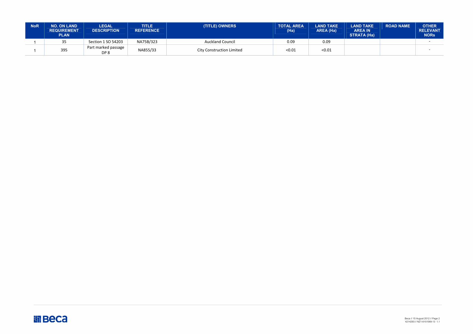
1 35 Section 1 SO 54203 NA75B/323 Auckland Council 0.09 0.09 -
1 395 Part marked passage DP 8 NA855/33 City Construction Limited <0.01 <0.01 -

City Rail Link
A3STATUS: DRAWING NO: REV:
FINALSIZE:
This drawing is confidential and shall only be used for the purposes of this project.
No. BY DATE
REVIS
IONS DESIGNED
DRAWN
APPROVED
CHECKED
DATE
CHECKED
5
Land Requirement PlanNOR 1, Sheet 1 of 3
GIS-4214293-100-1
±
3
9
5
13
11
4
12
2
1
6
7
8
10
QUAY ST
GORE
ST
QUEEN ST
TYLER ST
COMM
ERCE
ST
GALWAY ST
WOLFE ST
CUSTOMS ST WEST
FORT LN
CUSTOMS ST EAST
FANSHAWE ST
ALBE
RT S
T
MILLS LN
LOWE
R AL
BERT
ST
FEDE
RAL S
T
IMPERIAL ACDEAC
DE A
RCAD
E 32
STURDEE ST
HECHECAH4
OKOK
15-Aug-2012
Map intended for distribution as PDF document. Scale may be incorrect when printed.
0 25 5012.5 m
LegendIndicative Rail AlignmentLand to be Designated SurfaceExisting Britomart Transport Centre DesignationWorks subject to future Outline PlanParcel boundaries
Scale: 1:1,250
Notice of Requirement for a designation under section 168 (2) of the Resource Management Act 1991 to be shown as "Rail Purposes for City Rail Link (Britomart to Aotea)". All plans subject to final survey.
Map contains information sourced from LINZ (Crown Copyright Reserved).This map contains data derived in part or wholly from sources other than Beca
and therefore, no representations or warranties are made by Becaas to the accuracy or completeness of this information.
1 HEC 20/07/12 DRAFT FOR REVIEW2 JYG 30/07/12 FOR CLIENT REVIEW3 HEC 30/07/12 FOR CLIENT REVIEW
5 HEC 10/12/12 S92 CLARIFICATION OF BRITOMART DESIGNATION4 HEC 30/07/12 FINAL
City Rail Link
A3STATUS: DRAWING NO: REV:
FINALSIZE:
This drawing is confidential and shall only be used for the purposes of this project.
No. BY DATE
REVIS
IONS DESIGNED
DRAWN
APPROVED
CHECKED
DATE
CHECKED
5
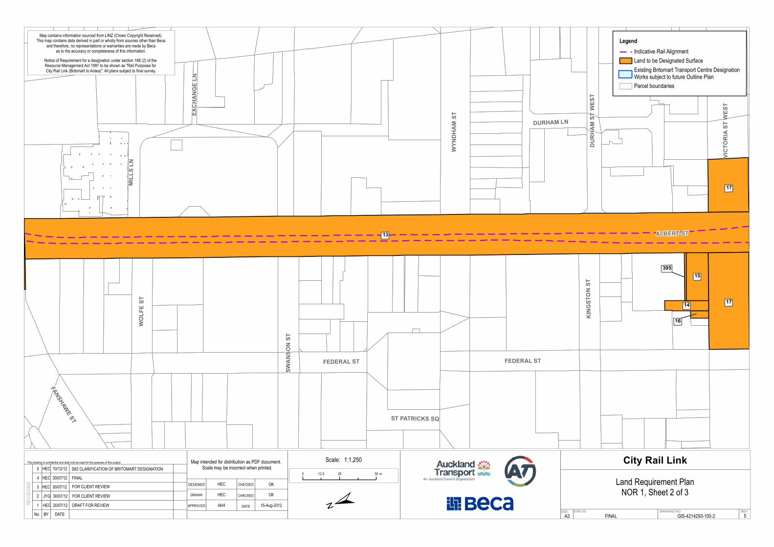
Land Requirement PlanNOR 1, Sheet 2 of 3
GIS-4214293-100-2
±
13
17
15
14
17
16
12
395
ALBERT ST
SWAN
SON
ST
WYND
HAM
ST
QUEEN ST
FEDERAL ST
VICTO
RIA
ST W
EST
WOLF
E ST
KING
STON
ST
MILL
S LN
DURH
AM ST
WES
T
DURHAM LN
FANSHAWE ST
EXCH
ANGE
LN
ST PATRICKS SQ
FEDERAL ST
HECHECAH4
OKOK
15-Aug-2012
Map intended for distribution as PDF document. Scale may be incorrect when printed.
0 25 5012.5 m
LegendIndicative Rail AlignmentLand to be Designated SurfaceExisting Britomart Transport Centre DesignationWorks subject to future Outline PlanParcel boundaries
Scale: 1:1,250
Notice of Requirement for a designation under section 168 (2) of the Resource Management Act 1991 to be shown as "Rail Purposes for City Rail Link (Britomart to Aotea)". All plans subject to final survey.
Map contains information sourced from LINZ (Crown Copyright Reserved).This map contains data derived in part or wholly from sources other than Beca
and therefore, no representations or warranties are made by Becaas to the accuracy or completeness of this information.
1 HEC 20/07/12 DRAFT FOR REVIEW2 JYG 30/07/12 FOR CLIENT REVIEW3 HEC 30/07/12 FOR CLIENT REVIEW
5 HEC 10/12/12 S92 CLARIFICATION OF BRITOMART DESIGNATION4 HEC 30/07/12 FINAL

City Rail Link
A3STATUS: DRAWING NO: REV:
FINALSIZE:
This drawing is confidential and shall only be used for the purposes of this project.
No. BY DATE
REVIS
IONS DESIGNED
DRAWN
APPROVED
CHECKED
DATE
CHECKED
5
Land Requirement PlanNOR 1, Sheet 3 of 3
GIS-4214293-100-3
±
1321
28
17
17
35
2330
15
22 24
20
26 29 32
14
31
16
19
33
3425
395
FEDERAL ST
ALBERT ST
ELLIOTT ST
VICTO
RIA
ST W
EST
WELL
ESLE
Y ST W
EST
MAYORAL DR
KING
STON
STDU
RHAM
ST W
EST
DURHAM LN
DARB
Y ST
MYERS ST
HECHECAH4
OKOK
15-Aug-2012
Map intended for distribution as PDF document. Scale may be incorrect when printed.
0 25 5012.5 m
LegendIndicative Rail AlignmentLand to be Designated SurfaceExisting Britomart Transport Centre DesignationWorks subject to future Outline PlanParcel boundaries
Scale: 1:1,250
Notice of Requirement for a designation under section 168 (2) of the Resource Management Act 1991 to be shown as "Rail Purposes for City Rail Link (Britomart to Aotea)". All plans subject to final survey.
Map contains information sourced from LINZ (Crown Copyright Reserved).This map contains data derived in part or wholly from sources other than Beca
and therefore, no representations or warranties are made by Becaas to the accuracy or completeness of this information.
1 HEC 20/07/12 DRAFT FOR REVIEW2 JYG 30/07/12 FOR CLIENT REVIEW3 HEC 30/07/12 FOR CLIENT REVIEW
5 HEC 10/12/12 S92 CLARIFICATION OF BRITOMART DESIGNATION4 HEC 30/07/12 FINAL