crest applications at local, region and global...
TRANSCRIPT

HyDrometeorology and RemOte Sensing Laboratory (hydro.ou.edu)
HyDrometeorology and RemOte Sensing Laboratory (hydro.ou.edu)
Xianwu Xue April 2nd 2012
CREST Applications at local, region and global scale

HyDrometeorology and RemOte Sensing Laboratory (hydro.ou.edu)
Table of Contents
• Global Scale
• Regional Scale
• Watershed Scale

HyDrometeorology and RemOte Sensing Laboratory (hydro.ou.edu)
OU-NASA Joint Operational Global Hydrologic Prediction Real-time Hydrology: http://eos.ou.edu
Hong et al. 2007 WRR; Wang and Hong et al. 2010 HSJ; Wu et al 2011 JHM

HyDrometeorology and RemOte Sensing Laboratory (hydro.ou.edu)
Operational Global Hydrologic Prediction System

HyDrometeorology and RemOte Sensing Laboratory (hydro.ou.edu)
Regional and Watershed scale Application
USA
SERVIR East Africa
Pakistan
SERVIR-Bhutan Yangtze River
Wangjiaba, Huai River

HyDrometeorology and RemOte Sensing Laboratory (hydro.ou.edu)
National Mosaic and Multi-Sensor QPE (NMQ-) Flooded Locations And Simulated Hydrographs (FLASH)
- A CONUS-wide flash-flood forecasting demonstration system NMQ/Q2 Rainfall Observations
-1km2/2.5 min Stormscale Rainfall Forecasts
Stormscale Distributed Hydrologic Models
Probabilistic Forecast Return Periods and Estimated Impacts
10-11 June 2010, Albert Pike Rec Area, Arkansas
10”
8” 6”
Q2
Q5
5 hr
Hydrograph of Simulated and Observed Discharge
Simulated surface water flow
20 fatalities
80% 60% 40%
Probability of life-threatening flash flood
t=2300
t=0000 t=0100

HyDrometeorology and RemOte Sensing Laboratory (hydro.ou.edu)

HyDrometeorology and RemOte Sensing Laboratory (hydro.ou.edu)
CONUS Flash Flood Demo System • Project uses forcing from high-resolution Q2 and future dual-pol radar (Q3) • Readily incorporates probabilistic rainfall forecasts (i.e., Warn on Forecast) • Addresses service needs in NWS; flash flooding is #1 weather-related killer
HyDrometeorology and RemOte Sensing Laboratory (hydro.ou.edu)
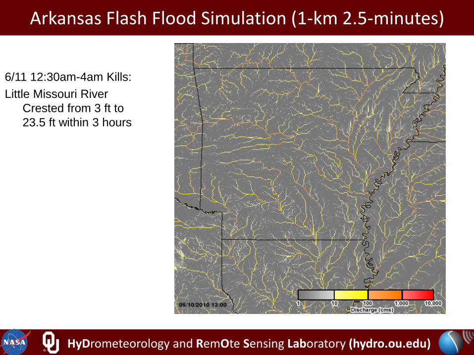
Arkansas Flash Flood Simulation (1-km 2.5-minutes)
6/11 12:30am-4am Kills: Little Missouri River
Crested from 3 ft to 23.5 ft within 3 hours

HyDrometeorology and RemOte Sensing Laboratory (hydro.ou.edu)
SERVIR East Africa: A Disaster and Water DSS
Funded by NASA Applied Science Program, USAID: to implement an operational water-hazard warning system, SERVIR-East Africa.

HyDrometeorology and RemOte Sensing Laboratory (hydro.ou.edu)
SERVIR-East Africa CREST/Flood Warning System (funded by USAID/NASA and partnered with RCMRD in Kenya)
Green: Safe
Yellow: Watch
72-hour Forecast, later verified and updated by real-time Satellite Inundation Images
Visualization and Dissemination Systems: Google Earth and Web Portal

HyDrometeorology and RemOte Sensing Laboratory (hydro.ou.edu)
SERVIR-Africa: Realtime Hydrological Simulation and Flood Monitoring

HyDrometeorology and RemOte Sensing Laboratory (hydro.ou.edu)
SERVIR-Africa: Realtime Hydrological Simulation and Flood Monitoring

HyDrometeorology and RemOte Sensing Laboratory (hydro.ou.edu)
Location and DEM of Bhutan

HyDrometeorology and RemOte Sensing Laboratory (hydro.ou.edu)
SERVIR-Bhutan

HyDrometeorology and RemOte Sensing Laboratory (hydro.ou.edu)
SERVIR-Bhutan

HyDrometeorology and RemOte Sensing Laboratory (hydro.ou.edu)
US-Pakistan Collaborative Project: 11/2010-10/2013 Capacity building in Hydrometeorological Disaster Risk Reduction
through training and research in Pakistan

HyDrometeorology and RemOte Sensing Laboratory (hydro.ou.edu)
Wangjiaba Huaihe, China

HyDrometeorology and RemOte Sensing Laboratory (hydro.ou.edu)

HyDrometeorology and RemOte Sensing Laboratory (hydro.ou.edu)
Datong Station, Yangtze River, China

HyDrometeorology and RemOte Sensing Laboratory (hydro.ou.edu)
Comparison of simulated and observed discharge during the calibration and validation periods

HyDrometeorology and RemOte Sensing Laboratory (hydro.ou.edu)
Thank you for your attention!
Any questions and/ or comments?