creating community and economic development tools for ... · a strong network of communication and...
TRANSCRIPT

Report to Economic Development Administration, Investment No.: 99-07-13873
1
Creating Community and Economic Development Tools for Preserving Working Waterfronts and Waterways
Report to Economic Development Administration, Investment No.: 99-07-13873 Working waterfronts and waterways have long been an important component of the US economy and our cultural and social heritage. Working waterfronts and waterways includes water-dependent and coastal-related businesses that support commercial and recreational activities, which are now threatened by accelerated real estate development of non-water dependent waterfront properties over recent decades. Loss of working waterfronts and waterways is negatively impacting coastal communities economically, socially, culturally, and environmentally. Some communities and states are proactively preserving and maintaining existing working waterfronts and waterways, using creative financial and organizational approaches. Nonetheless, piecemeal conversion of properties that previously supported water-dependent commercial activities, such as fishing and shipping, to non-water dependent uses, such as lodging or entertainment, has had unexpected cumulative impacts on communities. In many cases, the rate of loss and conversion outpace community action to address the issue. The Economic Development Administration recognized the need to collect and synthesize information about the economic impacts and historical trends of working waterfront conversion to non-working waterfront uses, and provide resources for communities and states about challenges and opportunities for preserving working waterfronts and waterways as key economic drivers in communities. The Economic Development Administration awarded a grant in the fall of 2011 to the Island Institute and six project partners to study working waterfront needs, challenges, and strategies for preservation. The project team is collecting, analyzing, and synthesizing information and developing a tool kit in order to enhance working waterfront preservation. The project team is identifying and determining the feasibility of specific strategies and disseminating these findings and relevant tools through an information clearinghouse. The project team is exploring a range of strategies and case studies, in order to shed light on multiple approaches for preservation, including land-use research, economic diversification, taxation policies, comprehensive planning and grants, public investment and loan-funding and public education. The results of this research project will be useful to a broad audience of stakeholders ranging from small business owners to natural resource managers. This effort will lay the groundwork for a strong network of communication and collaboration among working waterfront communities and stakeholders and will ultimately increase the capacity of coastal communities to make informed decisions, balance diverse uses and plan for the future of their working waterfronts and waterways. The team assembled for this project includes individuals with decades of experience tackling working waterfront and waterway issues around the nation. Outputs from this project will ensure new information will be publicly available about: historical and current trends in working waterfronts and waterways, economic impacts of working waterfronts, and financing tools and policy alternatives for working waterfront preservation. The project team is also preparing a
Report to Economic Development Administration, Investment No.: 99-07-13873
2
series of informative case studies from around the country to highlight best practices and successes and creating a publicly available, web-based information clearinghouse. The project team is accomplishing these tasks through efforts of six work groups, which are tasked with producing outputs related to: 1) historical trends, 2) economic impacts, 3) financial tools, 4) policy and legal tools, 5) outreach and education, 6) website development. Project advisors include individuals with backgrounds in economics, policy, finance, and natural resource management, who will work with members of each work group to review draft work products and ensure the accuracy and relevancy of information and findings developed. This progress report covers work through April 30, 2012. Overall, the project is going well and the work groups have made substantial progress towards their outputs. The Historical Trends work group is conducting an in-depth literature review and interviews with industry members and managers about national and regional trends in working waterfronts and waterways over recent decades and the drivers of these changes. Data has been collected from the 1997, 2002, and 2007 Economic Census and annual data from 1997-2010 from the Regional Economic Information System. In order to explore trends and changes not captured in these data sets, the work group will conduct a total of 15 to 20 interviews. They have carried out three preliminary interviews to inform the development of additional interview questions. Work group members have completed most of the necessary literature review and have developed a list of people to interview. The team will be producing a narrative report summarizing historical changes since 1997, current trends, and factors that are projected to affect the future of working waterfronts throughout the US. The report will be available in draft form for review by project advisors, including federal agency partners, in late August 2012. The Economic Impacts work group has compiled the necessary data to analyze the economic impact of coastal and ocean-dependent economic activity. Based on preliminary results, the work group has identified 37 coastal counties in which the ocean-dependent sectors represent at least 10 percent of Gross Domestic Product. Additional coastal-dependent business activity in the travel and tourism sectors will be determined based on a GIS analysis. Work group members will summarize their findings in a narrative report, tables and figures, which will be available for review by project advisors, including federal agency partners, in late August 2012. The Financing Tools work group is researching financing mechanisms used at both the state and federal level. The work group has researched fourteen of the thirty coastal states and has identified programs within the U.S. Department of Commerce and the U.S. Department of Agriculture as a starting point to identify Federal programs. This work group convened a call with their project advisors in mid-April and has received positive feedback and confirmation that their methods to date have been appropriate. Summaries of each state and federal program will be included in the final report, which will be available for review by project advisors, including federal agency partners, in late August 2012. The work group is also developing a spreadsheet containing information on all programs included in the report. The Policy and Legal Tools work group is in the process of updating the 1997 NOAA Ocean and Coastal Resource Management technical report, “Coastal and Water-dependent Uses: Coastal
Report to Economic Development Administration, Investment No.: 99-07-13873
3
Management Programs, Meeting the Needs of our Nation” (OCRM Program Policy Series, Technical Document 97-1). The updated report will include more recent information on available policy and legal approaches for preserving working waterfronts and waterways, and will be available for review by project advisors, including federal agency partners, in late August 2012. The work group is also developing a pro bono network which will bring together attorneys and resource managers around the country who are willing to support communities undertaking working waterfront preservation projects on a pro bono basis. The Outreach and Education work group has completed the first round of eight case studies. These case studies are representative of working waterfront and waterway preservation from around the country. The work group plans to develop another twelve case studies as part of this project. A subset of these case studies will be included in the final report and all will be available on the website. The project advisors, including federal partners, will be asked to review case studies prior to project completion. The Website work group has adapted an existing website [http://www.wateraccessus.com/] to house the reports, case studies, and other information developed by the project partners, and to make these resources broadly available to the general public. This site will also have a social networking component that will allow individuals and organizations to interact with each other to share their challenges and successes with working waterfront and waterways projects, by providing them with tools to facilitate discussion and exchange information. One of the keys to successful delivery of this project with its multiple partners and short timeline is timely and frequent communication about the activities of the various work groups. In an effort to ensure that project team members are coordinating their activities and avoiding conducting duplicative work, we have established standing monthly calls with the work group leaders. These calls have also maintained the momentum and energy around the project. The Island Institute has also followed up with individual work group leads to further discuss any issues and then communicate the necessary information to the appropriate work groups. In addition, the project partners are using an internal project website, allowing for active collaboration on documents, sharing of draft project outputs, coordination on literature reviews and digital document libraries and references. Project Finances We are currently experiencing technical difficulties logging into and accessing the financial reporting website. We will provide updated the financial information once these technical issues have been resolved. In the meantime, necessary financial reports will be provided for the project period through March 30, 2012. Looking Forward An updated project timeline, reflecting work completed to date, is included as an appendix. We are slightly behind on a few of our outlined tasks; however, our pace of work has greatly increased in the last quarter and we expect to be on track for completing the project.

Report to Economic Development Administration, Investment No.: 99-07-13873
4
One of the biggest challenges we foresee with completing the final report is the integration of data and information from different disciplines and fields. For this reason, the final project report will likely include summary information and a series of technical appendices. Another area of concern for the project team is the future of the website beyond the term of this project, specifically - ensuring the information gathered and housed in the website remains relevant and timely. In order to address this challenge and the broader challenge of sustaining this effort into the future, we have moved forward with organizing the National Working Waterfront Network. In order to lay the groundwork for continued broad collaboration amongst project partners and other interested individuals and organization on this issue, we have been convening monthly calls to provide updates on general issues surrounding working waterfronts and waterways to those interested. Discussions on these calls include: updates about federal legislation and federal agency action, updates on the 2013 working waterfront conference, progress on the current EDA-funded research project, and the development of the National Working Waterfront Network (NWWN) as well as a schedule of upcoming conferences with presentations on issues related to working waterfronts and waterways. Project partners and others who have been involved with working waterfront issues throughout their careers have drafted operating procedures for the NWWN and identified a Founding Steering Committee to guide the development and organization of the Network and will also develop a strategy to grow and maintain the Network. The first conference call with Founding Steering Committee members will be held in early May. Members of the Committee have started planning and preparing for the third Working Waterfront Symposium scheduled for March 2013 in Tacoma, WA. To strengthen the Network development effort and to ensure that results from the EDA-funded research project inform Network members’ working waterfront and waterways preservation efforts, the Island Institute is organizing a two-day, in-person meeting in late July with EDA project partners and the NWWN Founding Steering Committee members. The first day will be dedicated to finalizing the structure and substance of the final report for the Economic Development Administration. The agenda for the second day will focus on the next steps and future collaborative efforts around working waterfront and waterway preservation. This meeting will also help address the issue about the integration of different disciplines into a final report. In the future, with increasing competition between marine uses and increasing pressure from coastal development, working waterfront and waterway preservation will remain a pressing issue. It is critical that the results of the EDA-funded research project are disseminated as effectively as possible, and incorporated into planning for future working waterfront and waterway preservation efforts to support economic activity in our coastal communities. Lessons Learned So Far
• The collection of information for the project has highlighted the need for a centralized clearinghouse of working waterfront-related information.
Report to Economic Development Administration, Investment No.: 99-07-13873
5
• This project should lead to development of additional or new model policy, legal and financing tools.
• Federal agencies such as the USDA are a relatively untapped resource for working waterfront and waterway projects, but organizations working on preservation or enhancement projects will need to be able to better frame the challenges facing them in terms of community economic development, in addition to coastal access or coastal management.
• This research project should provide a recommendation for development of federal tools to encourage private investment in privately-owned working waterfronts.
• Dredging of small ports and harbors is an on-going issue. Access to working waterfronts from the water is just as important as access from the land and in the current budgetary climates, the dredging of small harbors and ports is an under-appreciated threat.
The attachments to this report include more detailed information on the following: • List of Project Advisors • Brief updates from each of the six work streams:
o Historical trends o Economic impacts o Financing tools o Policy and legal tools o Outreach and education o Website development
• An updated project timeline where tasks have been identified as completed, in progress or ongoing.
• The first round of case studies developed by the Outreach and Education work group • Draft outline for the final report
Conclusion We are making strong progress towards completing this project. We are excited about the final report to the EDA that will present project findings and recommendations. Support from the EDA is facilitating the creation of a much-needed tool kit, which will prove valuable to many communities and states working to resolve working waterfront issues. The resulting clearinghouse of information will provide detailed results of intense research into the full range of economic, legal, and technical impacts on working waterfronts and waterways. This information will be useful to a broad audience of stakeholders ranging from small business owners to resource managers and indeed, we feel that it already is useful to those of us working on the project. This effort will lay the groundwork for developing a strong network of communication and collaboration among working waterfront communities and stakeholders and will ultimately increase the capacity of coastal communities to make informed decisions, balance diverse uses and plan for the future of their working waterfronts and waterways.

Report to Economic Development Administration, Investment No.: 99-07-13873
6
Appendices
• List of Project Advisors • Historical Trends Work Group Update • Economic Impacts Work Group Update • Financing Tools Work Group Update • Policy and Legal Tools Work Group Update • Outreach and Education Work Group Update • Website Work Group Update • Updated Timeline • 1st Round of Case Studies
1. Waterfronts Florida Program 2. York River/ Glouchester County, VA: Balancing Conflicting Uses through
Stakeholder Engagement 3. Portland, Maine: Balancing Maritime Uses and Waterfront Diversification
through Municipal Zoning 4. Planning for Environmental Protection and Economic Development in
Trinidad Harbor, California 5. Preserving Historic Fishtown through a Community-Led Endeavor 6. Alabama Waterfront Access Study Committee 7. Evolution of a Working Waterfront: A Case Study of Tacoma Washington’s
Thea Foss Waterway 8. Port of Miami River Water Dependent Land Use Litigation Case Study
• Draft Outline of Final Report

Report to Economic Development Administration, Investment No.: 99-07-13873
7
List of Project Advisors Name Position/ Affiliation EDA Work Group
Lisa Gutierrez
Boating Facilities and Access Planning Division Maryland Department of Natural Resources
Historical Trends
Julie Harrington
Director, Center for Economic Forecasting and Analysis, Florida State University
Economic Impacts
Chuck Adams
Marine Economist and Professor, Food and Resource Economics Department, University of Florida
Economic Impacts
Mike Cannon Executive Director, Integra Realty Resources Financing Tools
Mike Dickerson Executive Vice President, Shorebank Enterprise Cascadia
Financing Tools
Gil Sylvia Superintendent, Coastal Oregon Marine Experiment Station, Oregon Sea Grant
Policy and Legal Tools
David Ashton Port of Portland, Oregon Policy and Legal Tools
Dennis Ducsik
Tidelands Public Trust Policy Coordinator for the Mass Coastal Zone Management Program
Policy and Legal Tools
Lewie Lawrence
Acting Executive Director, Middle Peninsula Planning District Commission, Virginia
Outreach and Education/ Website
Jody Thompson
Extension Associate-Environmental Mississippi-Alabama Sea Grant Extension Program
Outreach and Education/ Website

Report to Economic Development Administration, Investment No.: 99-07-13873
8
Historical Trends Work Group The Historical Trends work group continues to review and organize the source material we have collected from the literature, the web, and interviews conducted to date, for a narrative of the evolution of working waterfronts throughout the US. The drivers of those changes, including technological advancements and economic, legal, societal, and environmental changes, are key to the significance of this narrative for understanding present conditions and informing the appropriate policy responses for protecting and promoting working waterfronts in the future. The work group has prepared a working outline of the report to present the material so that it will be relevant and accessible for users whose perspectives differ by region, sector, or scale. The Group is building its list of industry and government professionals to interview (a few preliminary interviews have been done already) to ensure the work includes an accurate assessment of the current status and trends of working waterfronts and coastal communities. The Work Group is beginning to conduct initial interviews, but this effort will continue through for several more months. Methods
• Conducting a literature review of peer-reviewed, industry and government reports and data.
• Interviews (guided conversations) of individuals from the water-dependent industries of interest, government agencies responsible for the implementation of programs, laws and regulations affecting water-dependent uses and communities; and representatives of working waterfront communities.
Outcomes • A narrative summarizing the historical changes—and the reasons for those changes—that
have occurred in the past, current trends, and factors that are projected to affect the future of working waterfronts throughout the US.
• An annotated bibliography and data sources. Timeline
• Completed: o Overview of historical changes (Mid-Jan. – Mid- April 2012).
• In Progress: o Literature and data search o Industry and Government interviews o Drivers and stressors of change o Assess changing perspectives o Assist and support team
• Next steps: o Collaborating with CEI on identifying strategic opportunities (May – June 2012) o Final report on changes and trends (Mid July – mid August 2012)

Report to Economic Development Administration, Investment No.: 99-07-13873
9
Economic Impacts Work Group The economic impact work group is conducting an economic analysis of working waterfront communities. The group adopted the definitions of ocean and coastal-related economic activity developed by the National Ocean Economics Program (http://www.oceaneconomics.org/), based on classifications according to the North American Industry Classification System (NAICS). Information is being compiled for all coastal counties in the US (n=335), and also for counties up to 50 miles inland from the coast (n=722), as identified using GIS. Data compiled includes employment, wages and Gross Domestic Product (GDP) for overall economic activity in 11 major industry groups, and similar data for six ocean-dependent economic sectors (marine construction, living resources, offshore minerals, ship and boat building, transportation, and near-shore tourism and recreation). Information is also being compiled for individual port communities on commercial fisheries landings (weight, value), commercial shipping imports-exports (tonnage and value), and cruise ship visitor nights. All data is compiled as time series over the period 1990 through 2009/10, in order to analyze trends over time. In addition, data on employment and sales for individual businesses in the near-shore area (within 20 miles of coast) are being compiled using the ArcGIS Business Analyst software. Waterfront-dependent communities will be identified based on the percentage share of overall economic activity (GDP) in ocean-dependent sectors, and trends over time. Based on preliminary results, we have identified 37 coastal counties in which the ocean-dependent sectors represent at least 10 percent of GDP. Additional coastal-dependent business activity in the travel and tourism sectors will be determined based the GIS analysis. Analytical results will be summarized for individual counties, Metropolitan Statistical areas (MSA), BEA Economic Areas and states within ten different regions of the coastal U.S.: Northeast-Atlantic (ME, NH, MA, RI, CT, NY), Mid-Atlantic (NJ, DE, MD, VA), South-Atlantic (NC, SC, GA, FL), Eastern Gulf of Mexico (FL, MS, AL), Western Gulf of Mexico (LA, TX), Pacific-California, Pacific-Northwest (OR, WA), Pacific-Alaska, Pacific-Hawaii, and Great Lakes (MN, WI, MI, IL, IN, OH, PA, NY). Regional economic impacts of coastal and ocean-dependent economic activity will be analyzed using the Impacts for Planning (Implan) software and 2010 national state/county dataset, with regional models constructed for the ten coastal regions indicated above. Note that this is a change from the original proposal, which proposed to use the RIMSII economic multipliers obtained from the U.S. Department of Commerce, Bureau of Economic Analysis. The Implan system will offer greater flexibility and richer detail for analysis, including multipliers for output, value-added employment, labor income, other property income and indirect business taxes. The significant cost for the Implan national data set ($43,000) is being covered with funds leveraged from other sources. Methods
• Database systems, regional input-output analysis (Implan), geographic information systems (ArcGIS), time-series analysis.
Outcomes

Report to Economic Development Administration, Investment No.: 99-07-13873
10
• The team will provide findings in a work group report as well as in the final report, with narrative text, tables and graphic figures.
Timeline
• Completed: o Develop definition of waterfront-dependent economic activities o Identification and economic inventory of waterfront-dependent communities
• In Progress: o Analyze historic trends in economic activity of waterfront-dependent
communities Evaluate regional economic impacts o Forecast future economic activity in waterfront-dependent communities
• Next Steps: o Write project report (April – August 2012)

Report to Economic Development Administration, Investment No.: 99-07-13873
11
Financing Tools Work Group Financial Tools Work Group is identifying the financial programs and tools available to protect working waterfronts and maintain access for water-related uses at both the state and federal level. The work group has completed an in-depth review of programs for 14 of the 30 coastal and Great Lakes states. Additionally, the work group has focused on the Department of Commerce and the Department of Agriculture as a starting point to identify Federal programs. Other programs have been identified within the Department of Transportation and in the Department of Housing and Urban Affairs. A spreadsheet of useful information about trade associations and foundations with ties to marine activities has been started. The Federal program research is near completion at this time, but the state-by-state research is more in depth and time consuming. The conclusions and recommendations draft will be sent out to advisors and project partners at the end of June. The work group is currently seeking feedback from its advisors on their research methodology and the information being assembled. Methods
• An in-depth Internet search of relevant state and federal websites including those related to economic development has been conducted. Key terms are used in a search engine on a state-by-state search. The work group is also reviewing Working Waterfront studies, which often are good sources of information that may not come up in an internet search.
• The group is compiling a list of industry trade associations that support working waterfront related activities or efforts and identifying any programs they have to offer as well.
Outcomes
• A list of the Federal programs with summaries. • List including each state with a brief summary explaining the different programs and
organize their particular programs by type (state website, state economic development office, state incentives for businesses, financing programs, grant programs, information repositories, etc).
• A master spreadsheet (alphabetical by state that will list programs by name with a link to their website) will be created.
Timeline
• Completed: o Advisors identified
• In Progress: o Research and inventory o Summarize and prioritize track D research
• Next Steps: o Conclusions and draft recommendations (May 2012) o Track D research completed (May 2012) o Research conclusions and recommendations draft (June 2012) o Incorporate feedback from partners, advisors, and EDA (July – August 2012) –

Report to Economic Development Administration, Investment No.: 99-07-13873
12
o Final Report (September 2012)

Report to Economic Development Administration, Investment No.: 99-07-13873
13
Policy and Legal Tools Work Group To date, the Policy and Legal Tools Work Group has focused its efforts on two grant deliverables: (1) an update of a NOAA Ocean and Coastal Resource Management (OCRM) technical report produced in 1997 on the Coastal Zone Management Act and “Coastal- and Water-Dependent Uses” and (2) convening a team of attorneys and pro bono managers to begin work on a WWF Pro Bono Plan. With respect to the technical report update, the Work Group is developing a spreadsheet that defines coastal and water-dependent uses. Some best practices have been identified, but list not finalized yet. Work will continue on this during next quarter. This information will provide the foundation for the report update. The work group will begin drafting update to technical report and case studies during next quarter. The work group has also identified seven individuals to assist with planning for the Working Waterfront Pro Bono Network. This group will begin monthly conference calls in late April, which will continue until August, when a draft plan will be developed and circulated for review. Case studies have also been identified and a further analysis of these cases will continue. Methods
• Literature review of legal tools • Traditional legal research methods, including searches of relevant laws, regulations, and
policies using legal databases such as Westlaw and Lexis-Nexus. Outcomes
• A narrative summary of major findings • Case studies of major law and policy tools, such as Coastal Zone Management Act and
local zoning. • Updated NOAA Technical Report on coastal and water-dependent uses and
accompanying spreadsheet of state regulations and definitions. • WWF Pro Bono Plan
Timeline
• Completed: o Literature review
• In Progress: o Identify best practices o Plan for pro-bono network
• Next Steps: o Draft guidance documents (April – August 2012)

Report to Economic Development Administration, Investment No.: 99-07-13873
14
Outreach and Education Work Group Outreach and Education (O&E) work group members were sought to enhance regional representation with contributing individuals from the Northeast, Mid-Atlantic, the Gulf Coast, the Pacific Northwest, and the Great Lakes region. The first round of case studies highlighting a variety of working waterfront communities around the country have been drafted. The work group identified case study development as an ideal approach to compile issues, tools, and practices that can serve as practical, real-world models for WWF efforts elsewhere. To provide consistency and facilitate information gathering, the work group members first developed an easy-to-use template that can be viewed at http://www2.vims.edu/bridge/wateraccess/casestudiesform.cfm. O&E members worked collaboratively with work group leaders to develop these comprehensive lists of waterfront uses, issues, and tools that evolved into a working, online database template. These lists will serve as references for future NWWN activities and initiatives. To date, eight case studies are in the final stages of completion. These can be view at http://www2.vims.edu/bridge/wateraccess/casestudieslist.cfm. A second round of case studies is in the process of being assigned and it is anticipated that each O&E member will complete two to three case studies during the term of this project. As the O&E work group members have developed their case studies, each has identified tools (financial, policy, planning, engagement tools, etc.) that have been central to the success of this effort. These Tools are being compiled and will be shared with the other work groups. This ensures that innovative approaches can be pursued across work groups. Similarly, O&E members are compiling and coding Best Practices to identify common themes that will be used to generate a WWF preservation guidance document. Methods
• Literature review • Case study approach and coding for themes
Outcomes The case studies will ultimately be made available for viewing at the NWWN web site http://www.wateraccessus.com/. They will be formatted to display only selected criteria (not the entire template), with images, video, links, sidebars, etc. The template entries developed for the case studies will also serve to focus search criteria on the web site. Timeline
• Completed: o Cooperate with NSGLC to identify strategy for coordinating the work of the
research associate. o Identify and recruit the required number of Outreach and Education Advisory
Committee members; set a date to convene the group by conference call. o Review existing DB, identify gaps in potential members, and expand the DB with
these contacts. o Confirm IT needs for creating a functional, internal, potential member DB. o Cooperate with the web portal team to enable the project team to access the DB.
• In progress:

Report to Economic Development Administration, Investment No.: 99-07-13873
15
o Continuing to develop and research additional case studies o Coordinate with Economic Impact, Financing, and Policy work groups re:
gathering their inventoried resources and identifying gaps. o As proposed, the timeline for January to March focuses on reaching this
benchmark: The four work groups have identified their initial collection of tools and forward to Research associate for review as needed. These submitted to web portal committee in preparation for posting.

Report to Economic Development Administration, Investment No.: 99-07-13873
16
Website Work Group The project team established an online project collaboration and management site at Basecamp.com. Here we maintain a project calendar, project personnel information, post messages to the group, share files, and engage in-group discussions. Wateraccessus.com has been adapted to an information site for the National Working Waterfront Network and content from the various work groups is continually added as it becomes available. On the wateraccessus.com site, we provide information, news and events of interest to the national community including information on:
• EDA project • Launch of the National Working Waterfronts and Waterways Network • Working waterfronts and waterways related conferences • National Working Waterfront Network update
The web group is working with all project work groups to identify and collect information and resources for the website. An online case study upload/edit/review system with associated backend database has been developed and implemented with the project team. A project logo has been designed in accordance with the EDA Style Guide and with the EDA Style Guide will serve as the basis for the graphic design of the website. Various social networking software/websites were evaluated and we have selected Ning as the tool we will use. With Ning.com, we can apply our own look and feel to their already established, popular social networking framework. Creation and development of the social networking portion of the project will continue throughout the project time period. A beta version of the social networking component of the website will be tested with the project team and advisors with a public launch in September 2012. Methods
• Project communication has been facilitated through the use of Basecamp.com. • Development of the project database has begun using a Microsoft Access database. • Development of the resource website has begun with HTML and ColdFusion.
Outcomes The web portal will serve as a resource clearinghouse that will contain economic, legal, and planning resources and tools identified by the project team as critical to working waterfront issues. It will also provide a social networking center. Progress on the resource and social networking components of the website are moving forward as outlined in the project timeline. Timeline
• Completed: o Establish online project collaboration site for internal project use o Adapt wateraccessus.com to information site for coalition
• In progress o Review and select social networking software/ tool o Create web portal expert panel with project & coalition members o Work with project work groups to identify resource center sections o Design resource page layout & develop site structure o Populate resource center with tools and info from project work groups

Report to Economic Development Administration, Investment No.: 99-07-13873
17
o Launch pilot resource center with project team, then advisors, etc. o Full launch of web portal with resource center and social networking site o The Working Waterfronts and Waterways resource website will be launched
publicly late summer 2012. o Continued posting and updated of resources on web portal o Refinement of social networking features/ system

Current StatusCreating Community and Economic Development Tools for Preserving Working Waterfronts and Waterways
(completed, in progress, ongoing)
EDA Grant Timeline
Task: Project Coordination and Administration (Island Institute)
Completed 1 Project launch 1Completed 2 Completion of executed MOU's 2Completed 3 Work with work groups to identify and recruit advisors 3In progress 4 Project Team and Advisor Conference Call 4 4 4 4 4 4 4 4 4 4 4 4Ongoing 5 Quarterly Project Conference Call with EDA 5 5 5
In progress 6 Preperation and final project report 6In progress 7 EDA final report and project review 7
Task: Historical Changes and Current Trends (UHI)Ongoing 8 Literature and Data Search 8
In progress 9 Industry and government interviews 9Completed 10 Overview of historical changes 10In progress 11 Drivers and stressors of change 11In progress 12 Assess changing perspectives 12
13 Strategic opportunities 1314 Final report on changes and trends 14
Ongoing 15 Assist and support team 15Task: Economic Impact Research (University of Florida and Florida Sea Grant)
Completed 16 Develop definition of waterfront-dependent economic activities 16Completed 17 Identify waterfront-dependent communities 17Completed 18 Submit interim progress report 18
In progress 19 Analyze historic trends in economic activity of waterfront-dependent communities 19
In progress 20 Evaluate regional economic impacts 20
In progress 21Forecast future economic activity in waterfront-dependent communities 21
22 Write project report 2223 Submit final project report 23
Task: Financing Tools (CEI)Completed 24 Advisors Identified 24In progress 25 Research & inventory 25In progress 26 Summarize & prioritise Track D research 26
27 Conclusions and draft recommendations 2728 Track D Research completed 2829 Research Conclusions and Recommendations draft 2930 Incorporate feedback (from group & EDA) 3031 Final Report 31
Sept
Q1 Q2 Q3 Q4
Oct Nov Dec Jan Feb Mar Apr May June July Aug

Current StatusCreating Community and Economic Development Tools for Preserving Working Waterfronts and Waterways
(completed, in progress, ongoing)
EDA Grant Timeline
Task: Develop National Web Portal (VA Sea Grant)
Completed 32 25. Adapt wateraccessus.com to information site for coalition; 32
Completed 33 26. Establish online project collaboration site for internal project use 33
In progress 34 27. Review and select social networking software/tool 34
In progress 35 28. Create web portal expert panel with project & coalition members 35
In progress 36 29. Work with project committees to identify resource center sections 36
In progress 37 30. Design resource page layout & develop site structure 37In progress 38 31. Develop social networking center structure 38
In progress 39 32. Populate resource center with tools & info from project committees 39
40 33. Launch pilot resource center with project team, then advisors, etc. 40
41 34. Launch pilot social networking site with project team, advisors, etc. 41
42 35. Full launch of web portal with resource center and social networking site 42
43 36. Continued posting & updated of resources on web portal 4344 37. Refinement of social networking features/system 44
Task: Policy and Legal Tools (Sea Grant Law Center)Completed 45 Literature review 45In progress 46 Identify best practices 46In progress 47 Draft guidance documents 47In progress 48 Plan for the pro-bono network 48
Task: Outreach and Education (ME Sea Grant)
Completed 49Cooperate with NSGLC to identify strategy for coordinating the work of the research associate. 49
Completed 50
Identify and recruit the required number of Outreach and Education Advisory Committee members; set a date to convene the group by conference call. 50
Completed 51 Review existing DB, identify gaps in potential members, and expand the DB with these contacts. 51
Completed 52 Confirm IT needs for creating a functional, internal, potential member DB. 52
Completed 53Cooperate with the web portal team to enable the project team to access the DB. 53
Q1 Q2 Q3 Q4
Oct Nov Dec Jan Feb Mar Apr May June July Aug Sept

Current StatusCreating Community and Economic Development Tools for Preserving Working Waterfronts and Waterways
(completed, in progress, ongoing)
EDA Grant Timeline
In progress 54
Coordinate with Economic Impact, Financing, and Policy Committees re: gathering their inventoried resources and identifying gaps. 54
In progress 55 Advisory Committee forwards inventoried resources and identified gaps to O&E Comm leads. 55
In progress 56
Coordinate with Economic Impact, Financing, and Policy Committees to gather their inventoried resources and identified gaps. 56
In progress 57 Initial inventories of existing resource from all committees forwarded to research assistant for review. 57
In progress 58Draft O&E inventory forwarded to web portal committee to inform building structure of web portal. 58
In progress 59
Research associate compiles and refines inventories and identified gaps; forwards a draft tool kit of existing resources for the four committees. 59
60
O&E Committee convenes to review the draft tool kit, offers comments, and recommendations for development of resources to fill existing gaps. 60
61O&E Committee coordinates with web portal committee to refine web structure for toolkit. 61
62
The four committees have identified their initial collection of tools and forward to Research associate for review as needed. These submitted to web portal committee in preparation for posting. 62
63Continue to add to potential member DB; begin development of social networking features with web portal committee. 63
64Development of original materials to meet identified gaps in resources. 64
65Web portal committee coordinates with the four committees to populate web portal with initial tools. 65
66Launch pilot versions of resource portions of the web portal internally with project team, then advisors, etc. 66
67 Continued posting of toolkit resources to web portal. 67
68Launch pilot social networking features internally with project team, and then to advisors. 68
69 Develop and finalize evaluation strategy for O&E deliverables. 69
70Full launch of web portal with resource center and social networking. 70
71Continued posting, and update of toolkit resources to web portal, and promoting membership to DB (ongoing). 71
72
Use finalized DB to invite potential members to join the NWWC via the web portal and official launch of social network features. 72
73 Continue to promote membership to DB. 7374 Refinement of social networking features/systems. 74
Q1 Q2 Q3 Q4
Oct Nov Dec Jan Feb Mar Apr May June July Aug Sept

75 Implement evaluation strategy of initial tools for O&E deliverables 75
EDA Case StudyEDA Case Study
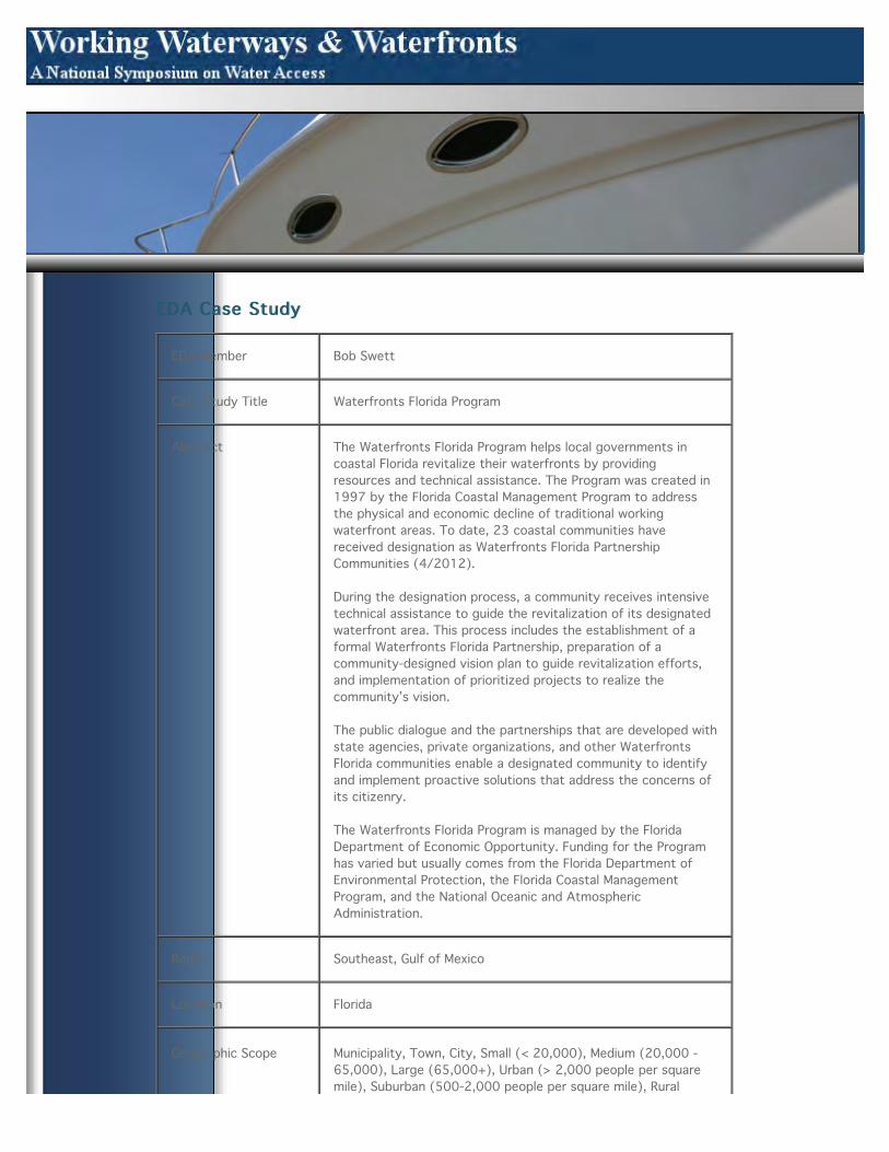
EDA Member Bob Swett
Case Study Title Waterfronts Florida Program
Abstract The Waterfronts Florida Program helps local governments incoastal Florida revitalize their waterfronts by providingresources and technical assistance. The Program was created in1997 by the Florida Coastal Management Program to addressthe physical and economic decline of traditional workingwaterfront areas. To date, 23 coastal communities havereceived designation as Waterfronts Florida PartnershipCommunities (4/2012).
During the designation process, a community receives intensivetechnical assistance to guide the revitalization of its designatedwaterfront area. This process includes the establishment of aformal Waterfronts Florida Partnership, preparation of acommunity-designed vision plan to guide revitalization efforts,and implementation of prioritized projects to realize thecommunity’s vision.
The public dialogue and the partnerships that are developed withstate agencies, private organizations, and other WaterfrontsFlorida communities enable a designated community to identifyand implement proactive solutions that address the concerns ofits citizenry.
The Waterfronts Florida Program is managed by the FloridaDepartment of Economic Opportunity. Funding for the Programhas varied but usually comes from the Florida Department ofEnvironmental Protection, the Florida Coastal ManagementProgram, and the National Oceanic and AtmosphericAdministration.
Region Southeast, Gulf of Mexico
Location Florida
Geographic Scope Municipality, Town, City, Small (< 20,000), Medium (20,000 -65,000), Large (65,000+), Urban (> 2,000 people per squaremile), Suburban (500-2,000 people per square mile), Rural

(<500 people per square mile)
Key Partnerships Florida Department of Environmental Protection; Florida CoastalManagement Program; NOAA
Time Frame 1997 - present
Waterfront Use Public access (docks/wharfs/beach/park),Waterborne passengertransportation (ferries, water taxis, cruise ship facilities,etc.),Marina/drystack,Pier/dock/wharf/lift,Boat ramp/lift,Boatrepair,Commerical fishing,Fish processing,Fish/bait shops, fishcleaning station,Recreational fishing,Charter fishing,Charter boattours (general sightseeing, whale watch, etc.),Recreationalboating, kayaking, other recreationalwatercraft,Cultural/heritage tourism,Market (local seafood,produce, etc.)
Issue Loss of commercial and/or recreational access and associateduser conflicts, Economic development, Environmental impacts:resource protection, habitat loss, water quality degradation,Loss or preservation of heritage (cultural, maritime, etc.)
Description DESCRIPTION (Note from Swett: The language below was takenfrom the Program’s website, so we want to make sure that it isproperly cited. I have edited and rearranged it to some degree(minor).)
BACKGROUND (Rationale) Many of Florida’s working waterfrontswere once thriving centers of activity but now struggle toremain economically viable. A changing economy and lack ofpublic and private investment have taken a toll. Nonetheless,working waterfronts still remain valuable assets that cancontribute significantly to a community's economic health andimage. The Florida Department of Economic Opportunity’sWaterfronts Florida Program was created to support traditionalwater-dependent uses, as well as new waterfront uses thatprotect natural and cultural resources. The Program providesplanning resources to local communities in coastal Florida thatwant to revitalize their working waterfronts.
HISTORYThe Waterfronts Florida Program evolved from researchconducted in the wake of a 1994 amendment to the FloridaConstitution that banned the use of entangling nets in Floridawaters [REFWORKS ID 72]. The controversial net ban impactednumerous commercial and recreational user groups, as well astheir communities. The Program was designed to incorporateand/or address many factors that facilitate or impederevitalization of declining waterfronts as identified by research.
The Program’s first communities had to meet severalprerequisites prior to their acceptance, including obtaining thesponsorship of their local government, development of a visionplan, formation of a steering committee, and the hiring of a
program manager. In turn, the Program provided small “seedmoney” grants to fund local planning activities, workshops onspecial topics, and, of prime importance to many communities, ahigh level of planning and policy assistance to develop andimplement a protection strategy for the local waterfront. TheWaterfronts Florida Coordinator, in addition to serving as a

morale booster, listened to problems voiced by communitymembers, talked them through their available options, andhelped them decide on the appropriate next steps forward.
The Program was solidified in 2005 when it was officiallyadopted into Florida Statutes with language stating that it wouldprovide “financial and technical assistance” to communitiesrevitalizing their waterfront areas [REFWORKS 76]. TheProgram’s current mission is to provide planning resources toaddress four priority areas: economic development, natural andcultural resource protection, public access, and hazardmitigation.
BENEFITSCoastal communities that participate in the Waterfronts FloridaProgram receive support to develop and implement acommunity-designed waterfront revitalization plan (vision plan)that promotes coastal resource conservation and economicdevelopment. The in-depth process serves to strengthen localcapacity and empower participants, while at the same timehelping to sustain the rich heritage of Florida's workingwaterfronts. During a community's designation process, thePartnership Program provides:
• Assistance in organizing the local Partnership and itsvolunteers into highly functioning committees
• Assistance in creating successful collaboration with localgovernment, citizens, businesses, and civic groups
• Technical assistance related to visioning, comprehensiveplanning and land development regulations, waterfrontrevitalization, environmental protection, and redevelopment
• Training and peer exchange opportunities for local programmanagers and committee members
• Assistance in locating funding and other resources forcontinued implementation of the community's revitalization plan
• Mentoring and networking opportunities from otherWaterfronts Florida Partnership Communities that can offerassistance with their experience and expertise
In addition to the numerous benefits of being designated aWaterfronts Florida Partnership Community, active communitiesreceive extra points and benefits with some state grantprograms.
ACTIONS/APPROACHESCommunities who seek designation as a Waterfronts FloridaCommunity must submit a formal application. The applicantmust be a municipal or county government, or a local nonprofitthat is able to demonstrate a strong working relationship withlocal government staff and officials.
Eligible communities are those that are required to prepare acoastal element as part of their local governmentcomprehensive plan (subsection 163.3177(6)(g), FloridaStatutes). The community also must recognize the waterfrontas a special place and be committed to developing policies thatencourage the preservation of recreational and commercialwaterfronts. Additionally, communities must have the resourcesto designate a local Waterfronts Florida program manager and to

support a Waterfronts Florida committee representingstakeholders' interests.
During the first phase of designation, a community establishes astrong local Waterfronts Florida partnership and then prepares acommunity-designed vision plan to guide the revitalization of itswaterfront. The visioning process begins by reviewing existingdocuments, plans, and regulations that are germane to thedesignated waterfront. The community then hosts a series ofworkshops to gather input from a wide range of stakeholders.
The final vision plan will (a) identify goals, objectives, andstrategies for addressing the four priority issue areas of theWaterfronts Florida Program, (b) provide recommendations forcomprehensive plan and land development code changesnecessary to preserve the community's waterfront, and (c)include an implementation plan with specific actions, timeframes, and responsibilities.
During the second phase, the community continues toimplement its vision plan, incorporating it into the localcomprehensive plan and undertaking priority projects thatfurther its efforts to revitalize and preserve the waterfront.
In the second year and thereafter, the local partnership willincrease community capacity to plan for and implementwaterfront revitalization by participating in quarterlyWaterfronts Florida program managers' meetings, trainings andother professional development events, as well as continuing todevelop and adopt policy language necessary to implement theirWaterfronts Florida vision plan. To remain active, GraduateCommunities are called upon to share their experiences andexpertise with other waterfront communities.
Transferrability The Program in its current form was created by the FloridaLegislature, thus limiting its transferability to other states unlessadopted by their legislatures. Nonetheless, there are aspectsand outcomes of the Program that could be consideredtransferable as noted in the section on best practices.
Tools Technical assistance, Community visioning, Issue andstakeholder identification, Increasing awareness and knowledge,education and training, Forming partnerships and coalitions,Group processes/participation (community workshop, listeningsession, focus group, public hearing, etc.), Conflict resolution,Action planning, Evaluation
Best Practices • Communities that want to apply for designation as aWaterfronts Florida Partnership Community are encouraged totake part in a two-day training event.
• Designation Ceremony - The Waterfronts Florida PartnershipCoordinator and other program staff will visit the communityfollowing designation to promote the local Waterfronts FloridaPartnership.
• Waterfronts Florida Program Managers' Meetings that rotateamong the designated communities.
• Mentoring and networking opportunities from otherWaterfronts Florida Partnership Communities that can offerassistance with their experience and expertise.

• A 67 page guidebook containing best management practicesthat were drawn from the ideas and “on-the-ground know-how”of practitioners. [REFWORK 77]
• A 98 page document that contains a set of case studies of 21communities that received Waterfronts Florida designations.[REWORKS 78]
Additional Information
References I embedded RefWorks IDs in the text. I.e., in the locations wherethey belong.
Contacts Julie A. Dennis, Waterfronts Florida Program Coordinator,[email protected]
©Copyright 2006 Virginia Sea Grant Marine Advisory ProgramAll Rights Reserved

EDA Case StudyEDA Case Study
EDA Member Kenneth Walker
Case Study Title York River/Glouchester County, VA: Balancing Conflicting UsesThrough Stakeholder Engagement
Abstract Conflicts are becoming increasingly common between waterfrontproperty owners, waterman, boaters, recreational fishermen,sportsmen, aquaculture industries and others seeking to use theCommonwealths’ water resources on the York River. Thehistorical balance between working waterfronts and residentialdevelopment is shifting to predominantly residential waterfront.Infrastructure to support working waterfronts and the economicopportunities they provide is disappearing. As the MiddlePeninsula of Virginia continues to transition from a less rural to amore suburban community, public policies that currently serveas management tools for near-shore land, public water bodies,and water use rights/privileges must adapt. The York River UseConflict Committee was established to explore the public policyquestion facing many rural coastal local governments: “to whatextent will future development of coastal communities rely onthe opportunities presented by a coastal environment and whatpublic policies will govern such opportunities”[1]
Region
Location York River/Gloucester County, VA
Geographic Scope Small (< 20,000), Rural (<500 people per square mile), Small (<20,000), Rural (<500 people per square mile)
Key Partnerships Middle Peninsula Planning District Commission, VA Sea Grant, VACoastal Zone Management Program, NOAA, Local Stakeholders
Time Frame 2008-present
Waterfront Use Public access (docks/wharfs/beach/park), Pier/dock/wharf/lift,Commerical fishing, Aquaculture, Recreational fishing
Issue Loss of commercial and/or recreational access and associated

Issue Loss of commercial and/or recreational access and associateduser conflicts, Private ownership and public accessconflicts/legal framework of public trust rights and privateproperty rights, Economic development, Overcrowding due tocoastal population growth, Regulatory factors, Loss orpreservation of heritage (cultural, maritime, etc.)
Description The active, but diminishing, commercial fishing industry facescompetition for space. Privatization of the waterfront anddramatic increases in waterfront property values have onlyexacerbated the problem. The 2006 Board of Commissioners ofthe Middle Peninsula Planning District Commission developed aconsensus on the area’s highest legislative and policy priorities,which included water use conflict. The establishment of the YorkRiver Use Conflict Committee was driven by the increase in landand water use conflicts across the Middle Peninsula. In order togain a better understanding of existing uses and conflicts alongthe York River, Gloucester County was selected for the UseConflict study. Staff to the Middle Peninsula Planning DistrictCommission (MPPDC) and the Gloucester County Board ofSupervisors appointed Committee members representing varioususe conflict perspectives. The Committee was charged with: 1)Determining the features and uses as they currently andhistorically existed; 2) Identifying what conflicts exist or couldexist in the study area; 3) Determining what is or could becausing the conflicts; 4) Discussing how conflicts could bemitigated; and 5) Recommending public policy that couldmanage the conflict. To kick off the process, the MPPDC andVirginia Sea Grant sponsored a public forum which provided anopportunity for the general public to discuss sources andlocations of use conflict important to residents. Informationcollected at the public forum was used as a foundation tosupport the work of the York River Use Conflict Committee. TheUse Conflict Committee members represented a diversity ofinterests and backgrounds. Membership includes: • Local electedofficial • Local planning staff • Residential waterfront propertyowners • Commercial waterfront property owners • Commercialfisherman, oyster harvester, clam harvester • Recreational users(duck hunting, oyster gardening, crab harvesting, fishing,boating) • Staff resource experts Developing a commonunderstanding of issues, including existing policies, regulationsand terminology, was important for the Committee as a whole. Acomprehensive compilation of existing state and local codes andagency regulations, as well as jurisdictional illustrations werecritical to this education process for the Committee. Throughfacilitated meetings, homework assignments and field trips, theCommittee gained significant understanding of these issues aswell as other stakeholders perspectives and interests. The UseConflict Committee utilized two processes for prioritizingconflicts. The first process involved analyzing the relationshipsbetween local, state and federal jurisdiction and variouscombinations of use categories: commercial and residential uses;recreational and residential uses, and commercial andrecreational uses. A second process utilized a matrix to identifythe use conflict “issue area” and then presented twoperspectives: one in favor of the use and the other in oppositionof the use. Committee members were then asked “What should
local governments do about the conflict? Each Committeemember was then asked to prioritize the importance of theconflict and the priority for addressing the conflict. The resultsserved as a foundation for understanding how local governmentsmight handle conflict and identified prioritization of conflictissues. In addition, Virginia Sea Grant funded the development of

a Geographic Information System (GIS) analysis of the studyarea in Gloucester County. Spatial data collected related to anumber of topics including water dependent uses, agencyjurisdiction, current regulations regarding use standards andzoning of waterways, existing and proposed infrastructure, andsensitive and significant habitats, such as wetlands and shellfishareas. The Use Conflict Committee worked in small groups toanalyze the Study Reach GIS plates. Each group used conflictworksheet to analyze spatial information and better understandeach part of the Study Reach. A segue to its next phase of theproject, the Committee’s education phase culminated with adiscussion of “Who should manage use conflict?” “What is theappropriate use?” and “Who should determine the appropriateuses?” Photographs of different recreational, commercial, andresidential uses were illustrated for this discussion, and useconflict regulations from other states were discussed. In theend, the Committee created a matrix of all the use conflicts ithad identified and the applicable managing entities involved inthe management of the uses. This matrix provided an overviewof the Committee’s education phase that helped inform its worktransiting to policy recommendations. The Gloucester CountyBoard of Supervisors on Feb 17th, 2009 approved allrecommendations from the York River Use Conflict Study.Implementation responsibilities have been assigned to variousGloucester County Department Heads. Many of therecommendations from the York River Use Conflict Report havebeen transferred to adjoining localities struggling with the samecoastal zone management issues.
Transferrability Public participation process, Stakeholder education andparticipation, GIS analysis and inventory, development ofcommon terminology and “Use Conflict Report” (prioritization ofimportance of conflicts) are potentially transferable to othercommunities.
Tools Local land use authority, Shoreline access planning,Issue andstakeholder identification,Increasing awareness and knowledge,education and training,Forming partnerships andcoalitions,Conflict resolution, Legislative task forces or otherstudy committee
Best Practices Engaging stakeholders and helping them understand othersperspectives and interests is key. Analysis of jurisdictionalauthority and development of common terminology is alsoimportant.
Additional Information Phase 1- VA Sea Grant GIS Analysis of study reach. Phase 2-VCZMP Funded: Learning phase for committee members; dispelmyths and notion about water use conflict Phase 3- VCZMPFunded: Use Conflict Issue Framing and Policy NeedIdentification. Phase 4- VCZMP Funded: The final project analysisand final report will be used to drive future development ofenforceable policy
References
Contacts Lewis Lawrence, Acting Executive Director, Middle PeninsulaPlanning District Commission P.O. Box 286 Saluda, VA 23149-0286 (804) 758-2311 Email: [email protected] Website:http://www.mppdc.com/ York River Use Conflict Report can be

http://www.mppdc.com/ York River Use Conflict Report can befound under Service Centers—Coastal and CommunityDevelopment—York River Use Conflicthttp://www.mppdc.com/index.php/service-centers/coastal/york-river-use-conflict
©Copyright 2006 Virginia Sea Grant Marine Advisory ProgramAll Rights Reserved

EDA Case StudyEDA Case Study
EDA Member Kenneth Walker
Case StudyTitle Portland, Maine: Balancing Maritime Uses and Waterfront Diversification through Municipal Zoning
Abstract Portland, Maine, has over thirty years experience in balancing maritime and non-marine uses along itswaterfront. Compatibality between marine and non-marine uses has been always been important to theCity's approach to waterfront zoning. Residential uses and hotels are not allowed, while other uses areconsidered compatible if performance standards related to the working waterfront are met. Since 2008,the City has worked closely with pier owners and the fishing community to update the zoning ordinanceto address concerns about the mix and compatibility marine and non marine uses. Economic downturns,coupled with long-term declines in fishing and maritime industries, continue to challenge the feasibility ofmaintaining the waterfront's aging marine-related infrastructure. Portland's innovative application ofmixed-use zoning is an important strategy to help generate the funds needed to protect and maintainthat built infrastructure, while protecting water-dependent uses.
Region Northeast
Location Portland, Maine
GeographicScope City, Large (65,000+), Urban (> 2,000 people per square mile)
KeyPartnerships City of Portland (http://www.portlandmaine.gov/planning/wcz.asp), pier owners, fishing community
Time Frame 1983-2012 (on going)
WaterfrontUse
Public access (docks/wharfs/beach/park),Pier/dock/wharf/lift,Commerical fishing,Fishprocessing,Fish/bait shops, fish cleaning station,Retail/commercial
Issue Loss of commercial and/or recreational access and associated user conflicts, Private ownership and publicaccess conflicts/legal framework of public trust rights and private property rights, Economicdevelopment
Description Portland, Maine, began its waterfront planning effort by identifying a range of land uses appropriate forits commercial harbor (water-dependent, marine-related, and compatible non-marine) and thendeveloping zoning approaches that allowed these uses to be mixed together. The community found that

developing zoning approaches that allowed these uses to be mixed together. The community found thatadopting a mixed-use zone that allows compatible non-marine uses to be located above and in certainareas along side water-dependent uses was more successful (and flexible) than the previous zoningdesignation, which restricted the waterfront area solely to water-dependent uses. This zoning changeallowed pier and wharf owners to fill vacant properties and generate income by leasing second-floorspace and other commercial space, which helped pay for the high costs of maintaining commercial marineinfrastructure. In 2008, prompted by a zoning amendment application by pier owners in the CentralWaterfront, the City initiated a new planning process for the Central Waterfront. Both the propertyowners and the City were concerned about the lack of needed investment to repair and maintain piers. Even with expanded non-marine development, the overall infrastructure investment needs were greaterthan the revenues generated through rents alone. In 2009, an inventory of buildings, uses, andvacancies provided a baseline of current conditions within the Central Waterfront. In 2010, amendmentsto the zoning code established a “non-marine use overlay zone” which runs along Commercial Street,where compatible non-marine uses are allowed (no residential or hotels). Projects within the overlayzone must meet performance standards to facilitate marine uses on the piers and must contribute to amarine investment fund which supports infrastructure improvements in the central waterfront. Outsideof the overlay zone, ground floors must maintain 55% marine use, while 45% is allowed for compatiblenon-marine uses which meet performance standards related to marine uses. Before space is occupied bynon-marine uses, pier owners must provide first option to water dependent uses at a reasonable rate formarine uses. Economic downturns, coupled with long-term declines in fishing and maritime industries,continue to challenge the feasibility of maintaining the waterfront's aging marine-related infrastructure.Portland's innovative application of mixed-use zoning is an important strategy to help generate the fundsneeded to protect and maintain that built infrastructure. City of Portlandhttp://www.portlandmaine.gov/planning/wcz.asp Maine Coastal Access Common Law & Statuteshttp://www.accessingthemainecoast.com/common_law_and_statutes/common_law_and_statutes.shtmlhttp://www.accessingthemainecoast.com/common_law_and_statutes/common_law_and_statutes.shtml
Transferrability Mixed use and water dependent use zoning, waterfront inventory, marine investment fund, andperformance standards are tools that are potenitally transferable to other communities.
Tools Local land use authority, Dedicated revenue, Subsidy, Maritime use zoning, Water-dependent use zoning,Overlay zoning, Special assessment, Group processes/participation (community workshop, listeningsession, focus group, public hearing, etc.), Working waterfront use inventory
Best Practices Compatability is important when devising a mix of uses (Portland is addressing compatibility throughperformance standards). Engaging stakeholders was also key; both the pier owners and fishingcommunity were involved with the inventory (which made it credible) and the proposed zoning changes.
AdditionalInformation
"Development in the Central Waterfront will achieve a balance where non-marine economic developmentbenefits the piers, Commercial Street, the Waterfront and the City by sustaining marine infrastructure,protecting opportunity for commercial marine activity, and promoting appropriate access by the public toviews and activities in Portland Harbor." Portland Planning Board and City Council, March 2011
References
Contacts Bill Needelman City of Portland Planning Department [email protected] 207-874-8722

©Copyright 2006 Virginia Sea Grant Marine Advisory ProgramAll Rights Reserved

EDA Case StudyEDA Case Study
EDA Member Kristen Grant
Case StudyTitle Planning for Environmental Protection and Economic Development in Trinidad Harbor, California
Abstract Trinidad is a small city of roughly 300 people on the northern coast of California, renowned for itsspectacular scenery and natural resources. Commercial and recreational fishing have evolved as thecornerstone of the local economy. Trinidad pier, built in 1946, has provided critical infrastructure fora once-thriving salmon fishery and a private boat recreational fishing. Salmon and ground fisherymanagement regulations imposed since the 1980s have discouraged (nontribal) fishing in theregion, resulting in substantial reductions in both commercial and recreational fishing activity andcontributing to social and economic impacts that have altered the fisheries landscape at Trinidad.Additionally, the bay’s kelp beds have been designated an Area of Special Biological Significance anda Critical Coastal Area. These designations mandate stringent water quality standards and as such,the pier itself was designated as a hazardous discharge, essentially mandating its reconstruction ata cost much higher than the industry standard. Planning to address both environmental andeconomic issues together, broad community support, and diverse partnerships, all facilitatedsignificant fundraising by the owner, Trinidad Rancheria, and the City of Trinidad, that will result inthe opening of a new, low to no discharge pier in spring 2012.
Region Pacific
Location California, Northern Coast, City of Trinidad
GeographicScope City, Small (< 20,000), Rural (<500 people per square mile)
KeyPartnerships
Cher-Ae Heights Indian Community of the Trinidad Rancheria http://trinidad-rancheria.org/http://trinidad-rancheria.org/departments/peir-reconstruction City of Trinidad, CAhttp://www.trinidad.ca.gov/
Time Frame 2006 - present
WaterfrontUse
Public access (docks/wharfs/beach/park),Pier/dock/wharf/lift,Commerical fishing,Fish/bait shops,fish cleaning station,Recreational fishing,Charter fishing,Recreational boating, kayaking, otherrecreational watercraft,Coastal tourism,Retail/commercial,Restaurant accessible bywater,Hotel/motel/lodging providing water access
Issue Economic development, Environmental impacts: resource protection, habitat loss, water quality

Issue Economic development, Environmental impacts: resource protection, habitat loss, water qualitydegradation, Regulatory factors
Description HISTORY Located 300 miles north of San Francisco and 25 miles north of Eureka, Trinidad is knownfor its spectacular scenery, unique cultural history, and abundant natural resources. Theincorporated city has a resident population of just over 300 and the Trinidad-Westhaven region hasa population of roughly 2,000. Once home to the Yurok village of Tsurai, Trinidad became a hub forthe gold mining, whaling and timber industries in the mid- to late-1800s, and currently the upperhalf of the watershed is owned by a private timber company. But, as those industries declined,residents turned increasingly to fishing as a source of livelihood. Following the Hallmark family’sconstruction of the Trinidad Pier in 1946 and a mooring basin soon after, Trinidad became an activefishing village, with smokehouses and a seasonal “mosquito fleet” of up to 400 salmon trollers inthe late 1970s. Charter fishing operations, first established in 1952, provided recreational fishingopportunities for visitors and residents. Over the years, the pier fell into disrepair and requiredreplacement. When the state designated the area in 1974 as an Area of Special BiologicalSignificance , the pier became subject to water quality standards. In 2000, the pier was purchasedby the Cher-Ae Heights Indian Community of the Trinidad Rancheria, a local, federally-recognizedtribe. The Rancheria purchased the pier and adjacent restaurant and is working with the City ofTrinidad, the fishing community, and other stakeholders to lead the reconstruction of the pier, acomplex permitting process due to the area’s biological significance. CHALLENGES/ISSUES POLICYIMPACTS Environmental Quality Trinidad’s location, geography, oceanography, and storm and foghazards frequently substantially limit access to fishing grounds, making it impractical to develop asa larger scale fishing port. Moreover, the State has designated the Trinidad Kelp Beds an Area ofSpecial Biological Significance and as a State Critical Coastal Area. These designations created azero-discharge zone to maintain high water quality, making the pier itself a “hazardous discharge,”essentially mandating its reconstruction. Fisheries Management Regulation Over the past 30 years,growing concerns about the status of West Coast salmon and groundfish stocks prompted thePacific Fishery Management Council and the State of California to implement increasingly stringentmanagement measures for commercial and recreational fisheries. These measures have included theestablishment of fishery management zones, restricted areas, season limits, commercial andrecreational fishery closures, and most recently the complete closure of the salmon fishery.Cumulatively, these measures have discouraged (nontribal) fishing along much of the North Coast,resulting in substantial reductions in both commercial and recreational fishing activity andcontributing to social and economic impacts that have altered the fisheries landscape at Trinidad.SIDEBAR Impacts of Regulation on the Fishing Community: Commercial – Salmon played a substantialrole in the local economy into the early 1980s. In recent years, salmon landings and ex-vessel valuehave accounted on average for less than 3% of total landings and value, with 12% of boatsparticipating in the fishery. The commercial fleet now consists almost entirely of resident fishermenwho have become highly dependent on the crab fishery. The Dungeness crab fishery, whichaccounted for an annual average of 80% of landings and 70% of ex-vessel value from 1947 through1980, maintained its dominant position from 1981 through 2007, its average annual share oflandings and value increasing to 93%. A small hook-and-line fishery for rockfish and lingcodaccounted on average for about 1% of landings and ex-vessel value with 17% of commercial fishingvessels active from 1981 through 2007. Recreational- Private boat fishing activity has declinedsubstantially, although charter activity—targeting rockfish and other groundfish species—hasincreased. Use of seasonal moorings declined from about 400 to 90 and use of the boat launchramp fell from 45–60 launches per day to 10–30 in recent years. The average numbers of charterboats, trips, and angler days at Trinidad are, respectively, 68%, 95% and 84% greater in recentyears compared to the long term. Trinidad is the most active charter port in the Redwood District(Humboldt and Del Norte counties), accounting for an average of 41%– 46% of activity on allmeasures (boats, trips, and angler days) in the long term and increasing to 75%–81%, in recentyears. Economic Challenges The fishing industry cites increasing fuel and gear costs, dockage,offloading, and ex-vessel value of crab catch fees as significant issues, in addition to the loss oflocal fishing support services such as the fuel dock, and fish cleaning station, and lack of local vesselrepair, refrigeration, gear suppliers, etc.. Variable and uncertain revenues due to natural variability incrab stocks and regulatory constraints on rockfish and salmon also pose challenges. The greatestchallenge for the Rancheria is the replacement of the aging pier itself, a critical need shared among
recreational and commercial fishery participants, support businesses, and the community. Sinceacquiring the pier and associated infrastructure in 2000, the Rancheria has taken several actions tomeet the site’s water quality standards while addressing the needs of the fishing community, whichdepends on safe, functional infrastructure. Funding pier reconstruction has been an ongoing effortinvolving partnerships to share costs and secure grant funding. To date, the Rancheria has securedfunding from several sources including the California State Coastal Conservancy, the Headwaters

Fund and the State Water Resources Control Board, EPA Brownfields Program, Federal HighwayAdministration, and the Bureau of Indian Affairs to support various aspects of the pierreconstruction project. However, securing full funding for the project, estimated to cost $10 million,poses a significant challenge, especially given variability in resource availability and regulatoryuncertainty. SIDEBAR Rebuilding the Pier – The pier was built in 1946 with creosote-treated pilingsand pressure-treated wood. By the State Water Resources Control Board standards, the pier,including its decking and deteriorating pilings, was identified as a nonpoint source of contaminatedrunoff and a hazard to the Area of Special Biological Significance (the nearby kelp beds).Additionally, most surrounding facilities and uses (fish cleaning facility, parking lot, boat cleaning)therefore became prohibited discharges. In response, a designated wastewater treatment facility toservice pier facilities (rest rooms, restaurant, rental house) was constructed and the Rancheria hasbegun the process of replacing the pier itself. In order to reconstruct in accordance with staterequirements, the project is expected to cost roughly $10 million, significantly more than theindustry standard. The Rancheria is working in hopes of eliminating all discharges. For the Rancheria,the cost of replacing the pier, together with variable and uncertain revenues from its use, are ofcentral concern. In addition to the pier’s function as a tribal investment, it directly or indirectlysupports 60 local tribal and nontribal families, and generates activity that supports 25 localbusinesses. In addition to dockage and offloading fees, the Rancheria depends on fees for mooringrentals, boat launches, and boat washing. However, these sources of revenue, too, have becomeless reliable following recent declines in recreational use, linked to regional fishery closures. The newpier is expected to open in May 2012. ACTIONS/APPROACH Plan for Environmental Protection andEconomic Development Together and Invest in Planning The environmental protection and harborredevelopment initiatives in Trinidad are directly related. These two main threads in local planningefforts have been key to progress in the community, and have been tied as a result of California’sIntegrated Coastal Watershed Management planning process through which stakeholders consideredand incorporated both water quality goals and socioeconomic goals in developing the watershedplan. The plan was completed in 2008 and has since acted as a kind of a launch pad for someprojects, and many other projects have emerged independent of that planning effort. Master andGeneral planning efforts by the Trinidad Rancheria and the City of Trinidad, respectively, alsoresulted in efforts to address natural resource protection and economic developmentsimultaneously. Build a Broad Base of Support and Consider Putting Collaboration Ahead of Self-Interest The formation of new partnerships has been key to progress made in Trinidad. For example,Trinidad Rancheria sought funding from the State Water Resources Control Board for pierimprovements that would reduce or eliminate discharges to the bay’s Area of Special BiologicalSignificance. But the Board determined that the Rancheria was ineligible for funding. To support theRancheria and the community-wide need for pier reconstruction, the City of Trinidad partnered withTrinidad Rancheria to submit the request for reconstruction funds, in addition to several otherinitiatives. This partnership resulted in significant funding allocated to pier improvements. Anotherexample of a key partnership is that of Green Diamond Resource Company and Trinidad BayWatershed Council. Green Diamond owns more than half of all the land in the watershed and haspledged support for the integrated coastal watershed management plan. Green Diamond isparticipating on the watershed council, and is funding ongoing maintenance to reduce sedimentloads on its lands. Green Diamond also contributed a cost share for the watershed management plandevelopment. Involve Stakeholders from the Beginning Local and regional stakeholders whocontributed throughout these planning processes include: the City of Trinidad, Trinidad Rancheriaand its community members, the watershed’s major property owner Green Diamond ResourceCompany, the County of Humboldt , Humboldt State University Telonicher Marine Lab, TsuraiAncestral Society, Westhaven Community Services District, Redwood Community Action Agency,Yurok Tribe, Trinidad Bay Land Trust, Trinidad and Westhaven property owners, residents,businesses, and organizations, members of the recreational/sport/commercial fisheries, and otherrecreational users such as kayakers, scuba divers, beachgoers, etc.. State and federal agencies suchas CA State and North Coast Regional Water Quality Control Boards, CA Coastal Commission, CACoastal Conservancy, CDF/CalFire, CA State Parks, CA Department of Fish & Game, CA Departmentof Transportation, U. S. Bureau of Land Management, NOAA Fisheries, and U.S. Fish and WildlifeService have also been engaged. The pier is regarded as the cornerstone of community. “Fishing isthe main reason Trinidad is an incorporated City,” explained Jonas Savage, Trinidad RancheriaEnvironmental Programs Coordinator. Mr. Savage suggests that all Trinidad stakeholders have linksto fishing (mostly crab), whether it be commercial, recreational, or fishing/waterfront relatedtourism. Therefore the community is tied to the pier, which has likely made community consensuseasier. Mr. Savage suggests that if the pier redevelopment project had been underway 50 years agowhen other resource industries (such as timber) were larger, the project would likely have generatedmore controversy. Currently, roughly one-half of the watershed area is owned by timber companyGreen Diamond Resource Company, but the industry is a small contributor to the local economy atthis time. The variety of initiatives launched to address environmental protection and waterfront

redevelopment have all engaged stakeholders in planning, design, and execution. Over the lastdecade, stakeholder-agency groups have been formed including the Critical Coastal Areas PilotProject for the Trinidad Head Area of Special Biological Significance, the Regional Water ManagementGroup, and the California Coastal National Monument Gateway Commission. The Trinidad BayWatershed Council was formed in 2008, near the end of the watershed planning process. The workof its grassroots membership is guided by the Integrated Coastal Watershed Management Plan.Since implementation of the integrated coastal watershed plan began, $15 million in grants havebeen awarded to projects that promote water quality protection in the bay, including $8 million topier redevelopment. References • California’s North Coast Fishing Communities HistoricalPerspective and Recent Trends: Trinidad Harbor Fishing Community Profile. Pomeroy, Caroline;Thomson, Cynthia J.; Stevens, Melissa M. California Sea Grant College Program, Scripps Institution ofOceanography, La Jolla CA, 2010 http://ca-sgep.ucsd.edu/system/files/files/4TRNprofile_29Nov2011.pdf • Informational Public Meeting forthe Trinidad Pier Reconstruction Project. Trinidad Rancheria , http://trinidad-rancheria.org/sites/trinidadrancheria.com/files/Pier%20Meeting%20Press%20Release_final_0_0.pdf• Reconstruction Project Description. Trinidad Rancheria, http://trinidad-rancheria.org/sites/trinidadrancheria.com/files/Brief%20Project%20Description.pdf • CarolinePomeroy, Extension Advisor, California Sea Grant. Personal communication. • Rebecca Price-Hall,Grant Administrator and Watershed Coordinator, City of Trinidad, CA. Personal communication. •Jonas Savage, Environmental Director, Trinidad Rancheria. Personal communication.
Transferrability The challenges faced in Trinidad are similar to those encountered on small community waterfrontsacross the country. Limited resources require forming mutually beneficial partnerships to findcommon objectives, seek collective funding, and cooperatively implement actions. The state policyand regulatory frameworks under consideration here, are likely more restrictive than many otherstates. Some of the funding mechanisms accessed by the City are California state grants - resourceswill vary state-to-state. Trinidad Rancheria was also able to access funding specific to its tribalstatus.
Tools Fisheries management, Natural resource protection (other than fisheries), Habitat protection,Private land trust or working waterfront trust, State-level conservation program, Economicdevelopment department, Federal grant program, State grant program, Comprehensive, masterplanning, Needs assessment, Community visioning, Issue and stakeholder identification, Increasingawareness and knowledge, education and training, Forming partnerships and coalitions, Groupprocesses/participation (community workshop, listening session, focus group, public hearing, etc.),Economic assessment, Natural resource inventory
Best Practices Build a Broad Base of SupportA key to success was The Trinidad Rancheria’s persistent Chief Executive Officer’s ability to viewpier redevelopment as linking across community issues. She had creativity to envision and pursueconnections and build partnerships and networks that were beneficial to all. The CEO’s approach waslargely responsible for the highly successful pier reconstruction funding effort.
Involve Stakeholders from the Beginning Before planning efforts began, The City and the Rancheria identified those individuals, groups, andagencies most invested in protection and redevelopment of harbor resources. These stakeholderswere engaged at the initial stages of planning to identify and address their needs and concerns. This input was then integrated as plans evolved, and facilitated community consensus.
Invest in PlanningPlanning a key tool in waterfront development. City of Trinidad is a small community with limitedresources, making it necessary to tackle issues piece by piece and then work to integrate all into awhole. The City utilizes the resources of professional consultants for key functions such as cityplanning and engineering. Working with these consultants provides the city with a wide range ofexpertise and resources, including identifying and applying for grants to finance a variety ofprojects. Additionally, the development of the Integrated Coastal Watershed Management Planprovided the foundation needed to justify fund seeking proposals, that ultimately resulted in theaward of $15 million in harbor-related grants.
Plan for Environmental Protection and Economic Development TogetherHabitat and water quality protection mandates resulted in the pier itself being designated as ahazardous discharge, essentially mandating the pier’s reconstruction. As a means of eliminating
discharges then, the City and the Rancheria were able to access to funds for harbor redevelopmentimplementation.
Consider Putting Collaboration Ahead of Self-InterestBecause Trinidad Rancheria was not an eligible applicant for State Water Resources Control Boardfunding, The City of Trinidad (which was eligible) chose to partner with the Rancheria in its ownapplication in order to enable the Rancheria to access pier reconstruction funding. The applicationwas successful in funding the identified pier work, but did not fund all other proposed activities.
AdditionalInformation
QUOTES:
“Fishing is the main reason Trinidad is an incorporated City.” - Jonas Savage, Environmental Director,Trinidad Rancheria
“It is critical to create relationships that are mutually beneficial – these relationships are a keystrategy for making progress in small communities where mutual support can provide humanresources, if not financial resources, to get a job done.” – Jonas Savage
“To succeed in development work in small communities, you need to be responsive to opportunitiesand work in partnership _ to favor collaboration at times versus protecting your own interests. It’simportant to recognize the value of community leaders and enthusiasm they generate in others.Encourage them to lead and be willing to follow their lead. Working collaboratively is infectious –those involved here have gone on the apply the approach elsewhere in the community.” – RebeccaPrice-Hall, Grant Administrator and Watershed Coordinator, City of Trinidad
“Public engagement is one of the hardest, most frustrating parts of community planning – but it’sthe most important. If you don’t bring stakeholders in at the beginning, to address their needs,interests, concerns – you will need to later when it is harder to accommodate. So in a way, you haveto go slow to go fast.” – Jonas Savage
“The planning process is a 5 – 10 year endeavor, and before it ends, it begins again. This is themost discouraging part to many involved with community development, but change takes time.” –Jonas Savage
“Since the (integrated coastal watershed management) plan was developed, $15 million in grantshave been awarded - $8 million to pier redevelopment alone.” – Rebecca Price-Hall
References California’s North Coast Fishing Communities Historical Perspective and Recent Trends: TrinidadHarbor Fishing Community Profile. Caroline Pomeroy, Cynthia J. Thomson, Melissa M. Stevens.California Sea Grant College Program, 2010. RefWork ID 51s
Contacts Jonas SavageEnvironmental Director
Trinidad Rancheria [email protected]
Rebecca Price-HallGrant Administrator and Watershed Coordinator City of [email protected]

©Copyright 2006 Virginia Sea Grant Marine Advisory ProgramAll Rights Reserved

EDA Case StudyEDA Case Study
EDA Member Liz Durfee
Case Study Title Preserving Historic Fishtown through a Community-Led Endeavor
Abstract Fishtown of Leland, Michigan is one of the few remaining historicfishing villages in the Great Lakes region. In early 2000, whenthe longtime owner of the commercial fishery and property atthe heart of Fishtown sought a successor for his land andbusiness, the future of the working waterfront was uncertain.The Fishtown Preservation Society (FPS) emerged in response tothe community’s recognition of the value of this historic workingwaterfront and the property’s vulnerability to development. FPSsucceeded in raising enough funds to purchase the property,historic structures, fishing boats and licenses necessary tomaintain the historic fishery and village. FPS has since developeda master plan, historic structure report, and long-terminterpretive plan to ensure that Fishtown remains an activefishery, historic site, and tourist attraction open to all.
Region Great Lakes
Location Leland, MI
Geographic Scope Town, Small (< 20,000), Rural (<500 people per square mile)
Key Partnerships Michigan Sea Grant, NOAA Preserve America, Michigan CoastalManagement Program, National Park Service, National Trust forHistoric Preservation, Jeffris Family Foundation
Time Frame 2001-present
Waterfront Use Public access (docks/wharfs/beach/park),Waterborne passengertransportation (ferries, water taxis, cruise ship facilities,etc.),Pier/dock/wharf/lift,Boat ramp/lift,Commerical fishing,Fishprocessing,Fish/bait shops, fish cleaning station,Recreationalfishing,Charter fishing,Charter boat tours (general sightseeing,whale watch, etc.),Recreational boating, kayaking, otherrecreational watercraft,Guided touring,Coastal tourism,Fisheries

tourism,Cultural/heritage tourism,Educational facility (museum,aquarium, interpretive center, etc.),Market (local seafood,produce, etc.),Retail/commercial,Restaurant accessible bywater,Hotel/motel/lodging providing water access
Issue Loss of commercial and/or recreational access and associateduser conflicts, What will happen if we do nothing?, Loss orpreservation of heritage (cultural, maritime, etc.), Impacts ontourism industry
Description Background/History Fishtown is one of the few remaining placesin the Great Lakes region where a traditional, cultural landscape,commercial and sports fishing, and waterborne transportationcoexist and thrive. Located in picturesque northwest Michigan,Fishtown is characterized by its historic fishing vessels, shanties,and active fishery. Since it was settled in the late 1800s,Fishtown has provided access to the recreation, leisure, andcommercial opportunities Lake Michigan offers. As early as the1930s, fishermen learned to survive in the fishing industry byworking seasonal jobs and adding value to their businessthrough tourism. Fishtown is home to one of the oldest charterfishing businesses on the Great Lakes as well as to ManitouIsland Transit, which ferries visitors to the nearby NationalLakeshore Manitou Islands. The recognition that Fishtown wasboth a vulnerable working waterfront and historical site datesback to 1975 when Alan William Moore, a writer working withSea Grant Michigan, sought ways to preserve commercial fishingheritage in Michigan. In partnership with Michigan’s State HistoricPreservation Office, Moore identified historic fisheries,preservation strategies related to the fishing industry, andprepared a report on Fishtown. Moore concluded his report bystating that commercial fishing should be maintained in Leland,and that "a concerted effort by local citizens might accomplishthis goal." Challenges/Issues Seventy percent of the small areain Leland, MI known as Fishtown was owned by the Carlsons, alocal fishing family. In 2001, the family looked to sell theirproperty to someone who would carry on their vision ofsustaining the fishery and maintaining public access to thewaterfront. If the valuable river and lakefront property was lostto private development, the loss to the community and visitorsof Fishtown would be significant. The need to preserve an activefishery and continue to draw visitor to the site within the LelandHistoric District (National Register of Historic Place 1975-11-20) was great. The high value of the property and a change incommercial fishing quotas that impacted the viability of thefishing business added to the challenge of sustaining the historicfishery. Actions/Approaches Local community leaders formed anon-profit organization called the Fishtown Preservation Societyto ensure the continuation of the authenticity of and publicaccess to the commercial fishery as well as the historicalintegrity of the unique fishing docks. A primary driver behind theestablishment of FPS was to draw attention to and provideeducation about the impact of new fishing quotas andcommercial fishing industry regulations that were detrimental tothe sustainability of the fishery. The new quota and the value ofthe half acre of real estate made the property cost-prohibitive
to a small commercial fishery. In 2005, FPS was reestablished asa fundraising organization and sought to generate funds topurchase Fishtown, two fishing vessels, fishing licenses, andequipment to prevent developers from purchasing Fishtown andits ideal river- and lakefront location. By early 2007, two yearsafter initiating a fundraising effort, FPS had raised $2.7 million in

cash and received pledges from over 3,000 donors to financethe purchase. FPS then officially received title to the landproperties, including: eight wood-framed buildings; two concreteblock smokehouses; overhanging docks on 0.26 acres along thenorth side of the Leland River; and two fishing tugs, equipmentand the associated fishing licenses. The total value of thispurchase was $3.0 million, and included provisions such as a 40-year use of fishery agreement. A small staff and Board ofDirectors manage the mortgage. The community and a team ofrenowned architects and planners planned, implemented, andevaluated the preservation of Fishtown. In 2009 FSP completeda master plan for Fishtown that provided guidance and directionfor the community. In 2010, FSP formed an interpretive planningtask group, which included representatives from FPS, MichiganState Historical Parks and Museums, Michigan Sea Grant, InlandSeas Education Association, Leelanau Historical Society,Northwest Michigan Council of Governments, Sleeping BearDunes National Lakeshore, Saxon Design, Hopkins Burns DesignStudio and the public, to work with the National Park ServiceRivers, Trails, and Conservation Assistance Program to develop along-term plan. The recently completed Fishtown Long-RangeInterpretive Plan is a comprehensive plan that provides a visionfor the future Fishtown and a strategy for reaching that vision.The Plan highlights educational opportunities, identifiesimportant themes and organizational goals, and describes thevisitor experience. Evaluation is a key and ongoing component ofimplementing the Fishtown Interpretive Plan’s projects andrecommendations. A grant from the Michigan CoastalManagement Program helped FPS to produce a historicstructures report. In 2011, Laurie Kay Sommers et al. published"The River Runs Through It, Report on Historical Structures andSite Design in the Fishtown Cultural Landscape". This publication— filled with historic photos of the people, landscape, andstructures of Fishtown — conveys the effort to preserveFishtown’s uniqueness. Today the property continues to be usedfor retail and general operations of the commercial fishery.Carlson's Fishery markets retail and wholesale fish, the shantiesremain and are systematically rehabilitated, and the same twofishing tugs still fish Lake Michigan. FSP helps to ensure that thetradition of fostering visitors continues: Fishtown remains freeand open to the public year round; schedules for staffing at theinformation center, demonstrations, and events, reflect andaccommodate daily and seasonal fluctuation in visitors;wayfinding and informational signage to help pedestrians accessand navigate the historic site; and design guidelines ensure thatthe historic character of the shanties is maintained, and awebsite and numerous publications and printed media help toincrease awareness of Fishtown. This effort to ensure visitorscontinue to enjoy Fishtown adds to the resiliency of the fishingcommunity. Fishtown succeeded, in part, by demonstrating thatpreserving heritage supports what the community values fromthe past — as well as their prospects for the future. Next StepsFPS continues to implement its master and historic plans. Nextsteps include maintaining the physical infrastructure, such ascontinuing to investing in foundations below historic structuresand renovating structures to time period, and furtheringeducational programming and outreach. As part of maintainingthe long-term sustainability of the working waterfront, FPS mustalso evaluate future challenges and identify adaptationstrategies to address issues such as lake level, climate andweather.
Transferrability The approach that enabled the successful preservation ofFishtown is replicable in other communities. Factors that

Fishtown is replicable in other communities. Factors thatcontributed to this success include: the property owner’s desireto ensure a sustainable fishery; the community’s recognition ofthe value of Fishtown; the creation of a non-profit organizationto facilitate acquisition and management of the property; andthe preparation of planning and visioning documents. While eachof these components may be readily applicable in othercommunities, it important to note that strong leadership andcommunity support were essential to this effort. Additionalfactors that likely contributed to successful preservationFishtown were the small geographic area of the site and the factthat the property was held by a single owner. The preservationstrategies applied in Fishtown are a model for how a community-led approach can foster working waterfront protection inMichigan and throughout the coast.
Tools Coastal Zone Management Program, Conveyance, Financingtools, State grant program, Comprehensive, master planning,Habor/waterfront planning, Shoreline access planning,Community visioning, Increasing awareness and knowledge,education and training, Forming partnerships and coalitions,Working waterfront use inventory, Working waterfront landsinventory, Cultural/social assessment or asset mapping
Best Practices A community driven approach was very effective. Using avariety of tools to generate attention and support forwaterfront protection helped the community bring in enoughdonations to purchase the property. Web presence andphotography were effective tools to convey information,increase awareness and build support. The management needsof a recognized historic property are significantly different froma shanty. The transition from a standard open public, family-owned dock to a non-profit-owned facility required changes inpolicies, insurance, and additional safely precautions. Tocontinue to allow open public access but avoid hiring police andgating off the docks, new policies to ensure the protection ofthe site in perpetuity were needed. The master planning processwas a helpful approach for generating additional communitysupport and for showing the community how Fishtown hadphysically changed over the years. Selling the property to a non-profit organization and establishing a historic landmark increasesthe long-term viability of the commercial fishery and ensures thecontinuity of active management of the historic docks andpublic access.
Additional Information please see word doc with additional information, links, photos,references to be included with case write up, etc.
References please additional information in word doc
Contacts Amanda HolmesExecutive Director, Fishtown Preservation [email protected] Breederland, MI Sea Grant Extension, [email protected]

©Copyright 2006 Virginia Sea Grant Marine Advisory ProgramAll Rights Reserved

EDA Case StudyEDA Case Study
EDA Member Natalie Springuel
Case Study Title Alabama Waterfront Access Study Committee
Abstract A House Joint Resolution during the 2008 Legislative Sessioncreated the Alabama Waterfront Access Study Committee toidentify the loss and potential loss of diversity along theshorelines of Alabama and how these losses impact access tothe public trust waters of the state, including
• Gathering information about local land-use management andzoning, current shoreline development trends, and local taxrates,
• Collecting research and information from Alabama and otherstates and jurisdictions regarding incentive-based techniquesand management tools used to preserve waterfront diversity,
• Assessing the applicability of such tools and techniques to thecoastal shorelines of Alabama.
In March, 2010, the Committee submitted a final report to theLegislature proposing recommendations in several categories:planning/zoning, financial incentives, socio-economic, and infrastructure issues. Partners are working to implement priorityrecommendations. In a recent development (early 2012) theCity of Gulf Shores implemented a new overlay district whichallows for the re-establishment of water-dependent businessesand provides model language regarding traditional, commercial,and recreational working waterfronts. The Alabama WorkingWaterfront Coalition has been informally working together toadvance working waterfront efforts throughout the state. Partners are considering formalizing this entity to directlyaddress and implement the recommendations make by theStudy Committee.
Region Gulf of Mexico
Location Alabama coastal region, especially Mobile County thoughexpanding inventory work to whole coast (2 counties in Al andMiss 3 counties)

Geographic Scope Statewide
Key Partnerships Alabama Water Access Study Committee Alabama WorkingWaterfronts Coalition Mississippi-Alabama Sea Grant Consortium;Auburn University Marine Extension and Research Center(AUMERC) Auburn University Northern Gulf Institute
Time Frame 2006 to present, the actual Study was conducted 2008-2011
Waterfront Use
Issue Loss of commercial and/or recreational access and associateduser conflicts, Economic development, Regulatory factors, Whatwill happen if we do nothing?
Description Background
Alabama is abundant with water. The identity, culture, andeconomy of the State are tied to this precious resource. Thewaters of the State are vital for tourism, transportation,municipal and industrial supply, fisheries production, andrecreation. It is important to balance access to Alabama’swaters with other desires for waterfront development. Yetcompetition for land use in the coastal zone has become aconcern because the population has grown and tourismdevelopment has increased the economic value of the land. Thishas resulted in a decrease in locally owned working waterfrontbusinesses. Waterfront lands are increasingly converted tocondominiums, casinos and resorts. The issue is furtherexacerbated by natural and human-caused disasters that haveopened up coastal investment in various alternative uses,thereby accelerating the rate of conversion.
In 2006, two workshops were held to launch discussions in bothAlabama and Mississippi about these working waterfrontchallenges. Shortly thereafter in 2008, MASGC funded thedevelopment of a database tool to assist with workingwaterfronts planning. The goal was to understand the dynamicsof Alabama’s working waterfronts in addition to building adatabase of water-dependent businesses in the southwesternpart of state. The database could be used to start quantifyingcurrent economic conditions and predict land use change in theGulf of Mexico. It has served as a baseline for monitoringongoing changes through time which will aid in planning anddecision making processes.
These and other actions have contributed to the Alabamalegislature’s recognition of the importance of workingwaterfronts and an interest in looking at opportunities topreserve and enhance this valuable Alabama asset, especially inlight of current rates of loss.
The Study CommitteeHouse Joint Resolution 656, passed during the 2008 LegislativeSession, created the Alabama Waterfront Access StudyCommittee. The charge was to provide to the AlabamaLegislature a report outlining the loss and potential loss of thediversity of uses along the shorelines of Alabama and how these

losses impact access to the public trust waters of the state. The Committee was assigned the following duties:
• Gather information about local land-use management andzoning, current shoreline development trends, and local taxrates, including tax assessment trends for shoreline properties.
• Collect research and information from Alabama and otherstates and jurisdictions regarding incentive-based techniquesand management tools used to preserve waterfront diversity.
• Assess the applicability of such tools and techniques to thecoastal shorelines of Alabama.
In March, 2010, the Committee submitted a final report to theLegislature proposing a series of recommendations in severalcategories and outlined in 3 priority tiers:
• Planning/Zoning Issues (including completing a ComprehensiveWorking Waterfront Plan as defined by any related federallegislation; creating a Waterfronts Alabama Partnership Programto assist local and regional planning efforts; and seeking a waiveron fees for rebuilding waterfront properties after naturaldisasters.)• Financial Incentive issues (including incentives for workingwaterfront businesses; establishing a fund for land acquisitionsand identifying priority areas; and applying boater registrationand other fees to manage and police working waterfronts.) • Socio-economic Issues (including conducting an economicinventory and an economic impact study of working waterfrontsand waterfront access; enabling further technical assistance andoutreach on these topics by Cooperative Extension and SeaGrant; and encouraging continued commercial use in workingwaterfronts.)• Infrastructure Issues (including directing all state agencies toexpand public access in planning and construction programs; andencouraging federal and local agencies to incorporate waterfrontaccess in projects in public trust waters.)
Every one of these recommendations will have considerablepolicy implications, including for example potential changes inlocal land use ordinances and zoning.During the 2010 Regular Session, House Joint Resolution 840was adopted, extending the Alabama Waterfront Access StudyCommittee to the tenth legislative day of the 2011 RegularSession. In 2011, during the Regular Session, the Committeewas again extended for one year with the adoption of SenateJoint Resolution 43.
Next StepsThough the report has been turned in, the work is only justbeginning. Mississippi/Alabama Sea Grant Consortium recentlyfunded a research project to extend the Mobile area inventorydatabase project described above to include both Alabamawaterfront counties and all three Mississippi Counties.
In a very recent development, in part as a result of therecommendations above, the City of Gulf Shores recentlyimplemented a new overlay district, the Historic DowntownOverlay District, which includes a series of zoning regulationsthat set the framework for a downtown neighborhood district.This allows for the re-establishment of water-dependentbusinesses—boatyards, marinas, seafood processors—thathistorically were part of the waterfront. Those uses are not

allowed now, and the overlay encourages them. In addition, theoverlay district provides model language for preserving,protecting and enhancing the traditional, commercial, andrecreational working waterfront culture and character of thearea.
Finally, the Alabama Working Waterfront Coalition has beeninformally working together to advance working waterfrontefforts throughout the state. Partners are consideringformalizing this entity to directly address and implement therecommendations make by the Study Committee.
Transferrability Challenges: • The WASC (legislative committee) was an unfunded mandate,making it difficult to implement the recommendations withoutthe development and support of MASGC’s partnerships.• Defining specific issues and solutions (management tools) thatwere applicable to Alabama. An example would be current usetaxation not being recommended, inasmuch as Alabama’s taxrate is already low and considered an incentive for businesseslocating here.• Incorporating working waterfront language and protectionprovisions into the State coastal management plan has not beenaccomplished.Lessons Learned:• To have a viable and representative working waterfrontcoalition, you have to educate the appropriate workingwaterfront business owners/operators and related stakeholdersabout what defines a working waterfront and how they areaffected. You also have to strongly encourage representativesfrom both counties/sides of the Bay to come to meetings(orjoin the coalition) and discover they have common issues andconcerns. Think broadly as to who might constitute astakeholder. Although we didn’t expect it in the beginning,charter fishing, chambers of commerce, and large-scale marineindustrial businesses have all been key stakeholders.• The importance and necessity for states to conduct a workingwaterfront inventory and economic impacts
Tools Legislative task forces or other study committee
Best Practices Best Practices:• MASGC partnerships have resulted in developing legislativesupport. The membership of the WASC includes non-coastalworking waterfronts such as the Tennessee River ValleyAssociation and the Alabama State Port Authority/Port ofMobile that are active with the legislature and support ofworking waterfront efforts.• The MASGC-Legal Program sponsored working waterfrontplanners workshop. It not only educated local, state and regionalplanners, it directly led to the request by the City of Gulf Shoresfor assistance in incorporating working waterfronts into theirzoning and land use plans.
Additional Information Mississippi-Alabama Sea Grant Consortium Working Waterfrontspage (which includes videos, reports, links etc): http://www.masgc.org/page.asp?id=398

http://www.masgc.org/page.asp?id=398
References
Contacts Marie Dyson, Working Waterfronts Outreach and ExtensionFacilitator, MASGC, [email protected]
Jody Thompson, Extension Specialist, MASGC,[email protected]
©Copyright 2006 Virginia Sea Grant Marine Advisory ProgramAll Rights Reserved

EDA Case StudyEDA Case Study
EDA Member Suzanna Stoike
Case StudyTitle
Evolution of a working waterfront: A case study of Tacoma, Washington's Thea Foss Waterway
Abstract The Thea Foss Waterway project is an example of one city’s successful efforts to preservehistory and traditional uses while creating new opportunities for education, recreation, andeconomic development. The City of Tacoma, the Tacoma Planning Commission, and theCommunity and Economic Development Department led the evolution of the Thea FossWaterway from a Superfund site into the Pacific Northwest's newest mixed-use waterfrontcommunity.This project was drafted into Tacoma’s Shoreline Master Program update, which is a part ofWashington State’s interpretation of the Federal Coastal Zone Management Act. This projectalso complies with Washington State Growth Management Act. Renovating the Thea FossWaterway realizes the City of Tacoma’s goals to implement a compelling adaptation of itsvenue for long-term community educational and recreational use.
Region Pacific
Location Tacoma, WA
GeographicScope City, Large (65,000+), Urban (> 2,000 people per square mile)
KeyPartnerships
Foss Waterway Development Authority, City of Tacoma Community Economic DevelopmentDepartment, Department of Ecology, Greater Tacoma Community Council, EPA, Citizens for aHealthy Bay
Time Frame 1950s - Present
WaterfrontUse
Public access (docks/wharfs/beach/park),Marine (shipping and storage) terminals,Water-dependent industrial, including powerplants,Maritime support (tugs, bargesfacilities),Marina/drystack,Pier/dock/wharf/lift,Boat building,Boat repair
Issue Loss of commercial and/or recreational access and associated user conflicts, Private ownershipand public access conflicts/legal framework of public trust rights and private property rights,Economic development, Environmental impacts: resource protection, habitat loss, water quality
degradation, What will happen if we do nothing?
Description The Thea Foss Waterway project is an example of one city’s successful efforts to preservehistory and traditional uses while creating new opportunities for education, recreation, andeconomic development. The City of Tacoma, the Tacoma Planning Commission, and theCommunity and Economic Development Department led the evolution of the Waterway from aSuperfund site into the Pacific Northwest's newest mixed-use waterfront community.The City of Tacoma was born out of the waterfront, where the deep-water port and westernterminus of the Northern Pacific Railroad brought in businesses and the employees to workthem. Over the past 100 years, the Thea Foss Waterway area held industries such as lumbermills, a cement factory, petroleum processing plants, a chemical processing plant, and ship-building operations. For several decades the port thrived. However, from the 1960s throughthe 1980s as the economy weakened, many of these industries moved or went out of business.Those vacancies were not filled and the waterway began its decline as the city’s economicdriver.Along with this legacy of a thriving port town came over 100 years of pollution. Back then,waste materials were dumped directly into the waterway along with the City’s untreatedsewage. It was thought that the tides would carry the waste away, daily taking the waste andpollution into the bay and eventually into the ocean. Instead, contaminants persisted in the soil,and years later led to over 125 acres of contaminated sediment on land and in water. In 1983, the Environmental Protection Agency designated the Thea Foss Waterway andCommencement Bay a Superfund cleanup site. A century of industrial waste, sewage, andrunoff from the City had taken its toll, and contaminated soil would have to be cleaned up. Thewaterway faced a major overhaul that would cost a small fortune to the City and some of thebusinesses. In addition to the Superfund designation, in the 1980’s the City of Tacoma became embroiledin a tribal land settlement. The Puyallup Indian nation claimed land rights to over 18,000 acresalong Commencement Bay. After more than a decade of litigation the Puyallup Tribe accepted a$162 million dollar settlement with the City for lost land. During this time, however, businessesexisting along the Thea Foss Waterway faced a very uncertain future. Should the Tribe reclaimtheir rights to the property, businesses leasing property from the City could be forced torelocate. This process halted owners’ upkeep and maintenance to the properties existing on thewaterway; with such an uncertain future, there was no cause to invest. The Thea Foss Waterway was developing a legacy of pollution and neglect; and residents, Cityofficials and business owners began to take action. The city was growing up and they wantedthis unique waterfront area, the “door to the city”, to be a highlight, not a Brownfield site. Inthe 1980’s, the City Club of Tacoma, a group of citizens and business owners from the area,crafted the “Dome to Defiance” Plan. It was their vision for the waterway, reaching from theTacoma Dome out to Point Defiance. They envisioned a waterway that offered public access,had continuity in its uses and development, attracted new business, and addressed the growingproblem of poor water quality and contamination. The plan laid out the regulatory environmentfor the area and provided a grounded vision of the future of the Thea Foss Waterway.In 1991, the City of Tacoma purchased 27 acres of land on the western shoreline of the FossWaterway. This huge investment came with a vision of a waterfront “renaissance”. This visionincluded hotels, retail, public access, parks, restaurants...a thriving waterway that residents andvisitors could enjoy, and that would offer the City a long term return on their investment. Thisincluded a continuous walkway, or esplanade, allowing visitors to enjoy a 1.5 mile stretch tostay, recreate, eat, and shop. The “Design and Development Plan for the Thea Foss Waterway”was completed in 1998 by the City and the Planning Commission.The Superfund designation offered a unique opportunity for the City, the EPA, developers,private industry, and state regulatory authorities to work together to achieve this vision. Toexpedite the clean up process, in 1994 the City of Tacoma approached the EPA and voluntarilyentered into an Administrative Order on Consent to begin remedial design on the waterway.The City also facilitated the formation of a Funding and Participation Group where responsibleparties could participate in the study and design process for a small fee. In 1997, the City ofTacoma and other parties agreed to a multi-year, non-binding allocation liability for cleaning upthis site. This reduced the litigation costs and potential delay in implementation. These actionsresulted in a comprehensive settlement proposal from the responsible parties to the EPA,ultimately resulting in a timelier cleanup of the waterway. Tacoma also created financial incentives for developers to encourage their investment in thearea. The Thea Foss waterway is a federally designated Renewal Community. As such the Cityof Tacoma was allocated $12 million in tax deductions annually, and the City also offers a 10-year property tax exemption for new residential construction of four units or more. These

incentives help spur investment in the waterway. The Foss Waterway Development Authority (FWDA) was commissioned by the City through acharter to implement the Foss development plan. The FWDA served as an entity empowered toimplement the plan. The FWDA is a Washington state public corporation, geographically limitedto the Foss waterway shoreline district. The role of the FWDA is to act on the City’s behalf tosell, lease and manage public property within and along the Thea Foss Waterway. Theresponsibility to market the property and negotiate sound business deals is one of the reasonsthe FWDA was formed. The intent was to have an organization that would stay focused onredevelopment over time and reduce the politics generally associated with private investmentof public land. The deals are negotiated by the FWDA and must be approved by the Council.FWDA markets and manages properties like the community building, provides eventsponsorship, and writes grants for continuing the public access portion of the waterway vision.After the purchase and completion of the Foss Development Plan and initial cleanup, the FWDAhas diligently sought developers and investors to “complete” the vision of the waterway.To attract private investment, the City subdivided the investment site. These properties werebrokered individually by the FWDA. Investment is a process: a development proposal is putforward to the City, which must be approved, and there is an opportunity for the public toparticipate through the Shoreline Master Program and public meetings of the FWDA. If thedeveloper meets all the requirements of the FWDA, the City, the state agencies, lenders, andthe public, the project moves forward. As part of those requirements, regulatory code requirespublic shoreline access (which is held in public ownership) and an easement across developmentsites that provides a link from the street to the public esplanade. The Thea Foss waterway project is unique in that success depends on an increase in populationdensity in Tacoma. One major issue slowing the progress of this project (along with marketforces and the economic downturn) is that there just aren’t that many people living andworking in downtown Tacoma. The downtown itself has had major problems withredevelopment, making the waterway even less likely to see a quick turnaround on investment.When there are more people living and working downtown, the public will find that it really isn’tthat difficult to get to the waterway. An increase in waterway visitors is something required bymost developers considering making substantial investments into waterway property. Eventsand activities on the waterway also help to increase active use.
The original expectation for redevelopment of the waterway was that it would take 10 years tohave complete development on the west side of the Thea Foss Waterway. Remediation work,market issues, existing uses, and absorption issues mean much slower progress. Sporadicdevelopment on the Thea Foss Waterway has led to “esplanade islands” that do not connect. In the past the policy was to complete sections of the public esplanade in conjunction with theupland development. However, properties adjacent to developed sites remain vacant, makingjust a small public access point directly in front of the new development. The City and FWDAare now focused on completing the public esplanade in advance of upland development toposition the project for the next round of redevelopment and activate the waterfront withincreased public use.From a planning standpoint, the City created the vision, the policy document, had regulations inplace, and created the FWDA. The City made decisions early on about how the developmentwould take place that, in did not function well in a restrained market. The City is now trying tofind ways to refine that vision, and looking for creative ways to achieve the goal.
Transferrability The Thea Foss Waterway Redevelopment project serves as an example of how one communityreclaimed its waterway from decades of neglect and contamination. It was partially spurred bythe EPA Superfund designation, but mostly by the community’s push to save the heritage andhistory of Tacoma, and the City’s desire to create a new, viable economy on the doorstep ofTacoma’s downtown.
Tools Coastal Zone Management Program, Public trust doctrine, Habitat protection, Local land useauthority, Government acquisition (eminent domain, purchase, etc.), Private propertyrestrictions (deed restrictions, conservation easements, etc.), Easement, Deed restriction,State grant program, Subsidy, Technical assistance, Habor/waterfront planning, Shorelineaccess planning, Growth management planning, Shore zoning, Rights-of-way, Needsassessment, Community visioning, Increasing awareness and knowledge, education and training,Forming partnerships and coalitions, Group processes/participation (community workshop,listening session, focus group, public hearing, etc.), Conflict resolution, Working waterfront useinventory, Working waterfront lands inventory, Economic assessment

inventory, Working waterfront lands inventory, Economic assessment
Best Practices "Visions’ are always being renegotiated as actors and relationships and economies change. Itisn’t static. And often what energizes one group to participate at one point in time is differentthan at some other point. I keep coming back to this idea that one person’s ‘vision’ is oftenperceived by someone else as a ‘tyranny’. The persistence of a vision is contingent on thepersistence of participation, mobilization, and resources of a set of actors in relation to others.It is a tricky power dynamic." – Steve Atkinson, Associate Planner, Community & EconomicDevelopment
“Environmental leadership makes good economic sense” – Mary Henley, Project Manager, TheaFoss Sediment Remediation Project
Su Dowie, Foss Waterway Development Authority:• Takes vision and identified leadership – can be public or private or a partnership ofpublic/private.• Leaders with patience and perseverance – partnership at the federal, state & local level• Public policies that are an incentive for development • Requires community support and desire to move from an industrial legacy to a livabilitylegacy – a vision that captures the community’s imagination• Public infrastructure that supports development and habitat restoration• An entity that can act and take responsibility – act as a facilitator for development andserves an essential public purpose (public access, habitat restoration/stewardship)• Optimistic realism • Ability to react to market conditions & be entrepreneurial • Early successes and a sustainable pace• Links to other initiatives of the city/community – e.g. Puget Sound initiative, smart growth,complete streets, trail systems • Long term maintenance plan for public spaces• Financial resources over time – sustainability Plan for downtown redevelopment and waterfront revilativtion simultaneously; Plan forenvironmental preservation and economic development together.
AdditionalInformation
http://cms.cityoftacoma.org/Planning/Comprehensive%20Plan/19%20-%20Thea%20Foss%20Waterway%20Design%20and%20Development%20Plan%2011-15-05.pdf
http://www.cityoftacoma.org/Page.aspx?hid=2241
http://www.theafoss.com/web2011/projects.html
http://www.cityoftacoma.org/Page.aspx?hid=13879
http://www.ecy.wa.gov/pubs/0509076.pdf
http://www.cityoftacoma.org/Page.aspx?hid=939#More
http://cms.cityoftacoma.org/Planning/Shoreline/CityCouncil/Amended/Ord28034Exhibit_A.pdf
https://fortress.wa.gov/ecy/gsp/Sitepage.aspx?csid=3677
http://www.historylink.org/index.cfm?DisplayPage=output.cfm&file_id=7969
References Consent Decree, Thea Foss Waterway Redevelopment Properties Parcel 3, Site 5, RefWorksID#66; SHORELINE MASTER PROGRAM An Element of the Comprehensive Plan and Title 13 ofthe Tacoma Municipal Code, RefWorks ID#68; City of Tacoma, Community and EconomicDevelopment, Comprehensive Plan, RefWorks ID#65; City of Tacoma, Thea Foss WaterwayCleanup, RefWorks ID#67; Thea Foss Waterway Design and Development PlanA ComprehensivePlan Element, RefWorks ID#61; Background on the Thea Foss Superfund Cleanup site, RefWorksID#69; Thea Foss Development Authority, RefWorks ID#71;

Contacts Stephen Atkinson, Associate PlannerCommunity & Economic Development City of Tacoma747 Market Street, Suite 1036Tacoma, Washington 98402-3793Phone: [email protected]
Su DowieFoss Waterway Development Authority535 Dock Street, Suite 204Tacoma, WA 98402(253) 597-8122Toll free 1-888-328-8122Fax (253) [email protected] Mary HenleyPublic Works / Environmental ServicesScience and EngineeringCenter for Urban Waters326 East D StreetTacoma, WA 98421-1801phone 253-502-2113cell [email protected]
Kim Van ZwalenburgShoreline PlannerWashington Department of Ecology300 Desmond Drive SELacey, WA 98503 (360) [email protected]
©Copyright 2006 Virginia Sea Grant Marine Advisory ProgramAll Rights Reserved

EDA Case StudyEDA Case Study
EDA Member Tom Ankersen
Case Study Title Port of the Miami River Water Dependent Land Use LitigationCase Study
Abstract The “Port of Miami River” is a shallow draft riverine portconsisting of independent, privately-owned small shippingcompanies, fisheries, vessel repair facilities marinas and otherrecreational and commercial working waterfront uses, locatedalong the banks of the Miami River, Florida and its tributaries andcanals. The Port of Miami River extends from the salinity dam inunincorporated Miami-Dade County to Biscayne Bay in the Cityof Miami. In 2004 and 2006, the Miami City Commissionapproved three controversial multifamily-mixed usedevelopments on the Miami River. To legitimize thedevelopments’ rezoning and special use permits, the Cityamended its Future Land Use Map (FLUM) from marine industrialto high density residential. The property in question lies withinan historically important cluster of maritime uses that had beengiven special overlay protection in the City’s comprehensive planand zoning regulation. In response to potential loss of water-dependent marine and industrial commerce, the Miami RiverMarine Group, a trade association representing marine andindustrial businesses along the Miami River, along with otherappellants, challenged the FLUM amendments. In 2010, theThird District Court of Appeals found that the amendmentsviolated state statutory limitations and prohibitions oncomprehensive plan amendments; the city’s zoning code’sdesignation of the area as a protected maritime districtdesigned to prevent residential development; the Miami RiverMaster Plan; and the Port of Miami River comprehensive plansub-element.
Region
Location Miami, Florida
Geographic Scope Municipality, City, Large (65,000+), Urban (> 2,000 people persquare mile), Municipality, City, Large (65,000+)
Key Partnerships Florida Marine Industries Assoc., Miami River Marine Group

Key Partnerships Florida Marine Industries Assoc., Miami River Marine Group
Time Frame 2004-06 (City Commission of Miami approved FLUMamendments) – 2010 & 2011 (Third District Court of Appealsissued final opinion and Florida Supreme Court DeniedJurisdiction)
Waterfront Use Water-dependent industrial, including powerplants,Marina/drystack, Pier/dock/wharf/lift, Boat building, Boat repair
Issue Loss of commercial and/or recreational access and associateduser conflicts, Economic development, Loss or preservation ofheritage (cultural, maritime, etc.)
Description BACKGROUND, HISTORY AND LOCAL CONTEXT Unlike its sisterport, The Port of Miami, The Port of Miami River does not enjoystatutory port status. Instead it depends on local land use law toprotect the historic water dependent maritime uses. The realestate bubble caused the City of Miami to prefer high valueresidential development to the traditional industrial andcommercial waterfront uses along the Riverfront. In the face ofeconomic development pressure The City of Miami moved tochange the land use categories to allow the conversion of thewaterfront to non-water dependent uses. Faced with the loss ofindustrial waterfront, litigation under Florida's unique system ofland use law became the only avenue to maintain the integrityof the Port. ACTIONS/ APPROACHES The proactive efforts ofthe Miami River Marine Group, Inc. trade association indicate aneffective partnership among the commercial and industrialinterests along the Miami River. In addition to the Miami RiverMarine Group, Inc. appellants challenging the FLUM amendmentsincluded a tugboat company owner and operator, a localresident, and a non-profit neighborhood association composedof approximately ninety homeowners and businesses in the area.Together, these appellants petitioned the Department ofAdministrative Hearings to challenge the local ordinance thatapproved the FLUM amendment. The Appellants sought reviewin the Third District Court of Appeal of the Florida Departmentof Community Affairs’ final order adopting the DOAHadministrative law judge’s recommended order, which upheld theCity’s FLUM amendments. POLIYC FRAMEWORK Pursuant toFlorida’s Growth Management Act, Chapter 163, Part II, The Cityheld a transmittal public hearing for the FLUM amendments, theFlorida Department of Community Affairs reviewed theamendments and found them in compliance with the Act and thestate, regional, and local plans, and the amendments wereenacted at an adoption public hearing by the City Commission.The Appellants expressed their opposition to the amendmentsduring the entire process and filed their DOAH petitionchallenging the amendments within 30 days after the adoptionhearing. Following more than six years of litigations, the City,State and Appellants – but not the developers – agreed to adoptpro-working waterfront goals, objectives and policies into theCity’s comprehensive plan. A year later, the Act was amended
to the “Community Planning Act” in 2011, which dramaticallyreduced state oversight of local comprehensive planning, whichmight have altered the outcome of these cases and theagreement.
Transferrability The land use law process for comprehensive planning is

Transferrability The land use law process for comprehensive planning issomewhat unique to Florida. What is transferable is the ability ofa small group of like-minded maritime interests who competecommercially to come together in the face of a common threatand use litigation to challenge a political decision to converttraditional water-dependent uses.
Tools Local land use authority, Comprehensive, master planning,Habor/waterfront planning, Maritime use zoning, Water-dependent use zoning, Overlay zoning,Forming partnerships andcoalitions,Conflict resolution
Best Practices Creation of an informal port - Port of Miami River Creation ontrade association - Miami River Marine Group Retention of anexperienced Land Use lawyer
Additional Information "We further note that these "small scale" amendments, whenviewed together as a whole, are changing the character of theMiami River waterfront without proper long range planning orinput from appropriate agencies, departments, and citizengroups. Because the Miami River is such an important asset tothe City, County, and State, such piecemeal, haphazard changesare not only ill-advised, they are contrary to the goals andobjectives of those who worked together, debated, anddetermined how the Miami River waterfront should bedeveloped. If the City's vision for the Miami River has changed,then that change should be clearly reflected in itsComprehensive Plan to provide industries and land owners alongthe Miami River with fair notice." PAYNE v. CITY OF MIAMI, 52So.3d 707 (2010)
References Payne v. City of Miami, 913 So. 2d 1260 (Fl, 2005); Payne v.City of Miami, 927 So. 2d 904 (Fla. App., 2005); Payne v. Cityof Miami, 52 So. 3d 707 (Fla. 3d DCA 2010); Payne v. City ofMiami, 53 So. 3d 258 (Fla. App., 2010); The Durham ParkNeighborhood Ass'n Inc. v. City of Miami, 53 So. 3d 245 (Fla.App., 2010); Balbino Investments & Riverside Investments v.Payne et al., SC11-75 (Aug. 4, 2011).
Contacts Andrew Dickman, Attorney for Miami River Marine [email protected] John Sprague, Florida MarineIndustries Association [email protected]
©Copyright 2006 Virginia Sea Grant Marine Advisory ProgramAll Rights Reserved

Report to Economic Development Administration, Investment No.: 99-07-13873
Final Report Draft Outline Objectives of the Final Report:
• Outline all of the findings from the research and analysis performed during the course of this project
• Introduce the functions and facilitative directions for use of the new national web portal and for the existing regional web portals
Outline
1. Introduction a. Purpose (and justification) of project
i. Develop a strong network of communication and collaboration ii. Identify national and regional research and education needs for working
waterfronts and waterways iii. Facilitate the development of information and tools needed to resolve
working waterfront issues iv. Create a clearinghouse to disseminate relevant information and tools
2. Background
a. Historical changes and current trends (UHI) i. Document historical and current trends related to the economic impact of
working waterfront 1. Trends of working waterfront industries 2. The drivers (including stressors) of those trends 3. The changing perspectives about working waterfronts over time
and region b. Economic value of working waterfronts (FL SG)
i. Economic analysis of working waterfront 1. Definition of working waterfront activities 2. Inventory of waterfront-dependent communities 3. Regional economic impacts of waterfront-dependent communities
using input-output analysis 4. Economic forecast of future economic activity in waterfront-
dependent communities a. Forecast for 10 years (2011-2020) based on extrapolation
of trends observed for the baseline period (1997-2010)
3. Challenges and Strategies a. Lessons learned and strategies for the future (UHI and CEI)
i. Challenges faced and mitigation strategies to preserve, establish, and grow working waterfronts
1. Identify strategic opportunities that allow communities to balance competing uses of working waterfronts, identifying the pitfalls that should be avoided
ii. Deliverable: Contribution to a research report that details the challenges faced and mitigation strategies successfully used by communities

Report to Economic Development Administration, Investment No.: 99-07-13873
interested in preserving, establishing, or growing their working waterfronts
1. Will include case studies
4. Resources/ Tools a. Policy and legal tools (NSGLC)
i. Developing a comprehensive database detailing whether and how state CZM programs address coastal- and water-dependent uses
1. Identifying “Law and Policy Best Practices” a. Providing case studies and implementation guidance (e.g.
model state legislation, model ordinances, or sample comprehensive plan language)
ii. Working Waterfront Pro-bono Network b. Financing mechanisms (Financing Tools Workgroup – CEI, UHI, VA SG)
i. Existing or potential federal finance tools for working waterfront programs (e.g. tax incentives, grants, loan programs, or dedicated revenue)
ii. Existing state programs iii. Organizational/ governance strategies (e.g. regional initiatives,
foundations and other private sources) iv. Recommend the more effective financing mechanisms that communities
can employ to support their specific economic development strategies
5. Conclusions/ Final Recommendations/ Next Steps