cp name cp50 and cp50a dykes of gray rd amend the current
TRANSCRIPT

Reference – Amendment 1, Core Path 50
CP name CP50 and CP50a Dykes of Gray Rd
Length to be amended
Amend the current 1999m Core Path to 3894m and add aspirational route of 340m
Description of core path
Dykes of Gray Rd path extending CP50 by 1800m and additional aspirational route crossing Swallow Hotel circle. The new path is surfaced. The additional aspirational route will bring in a link over the Trunk Road as part of the conditions of planning approval in the Western Gateway Development by 2023.
Criteria applying
Aspirational route from 2009 Core Path Plan has now been constructed.
Detailed reason for amendment
To include recently constructed path identified as aspirational in the Core Path Plan
Alternative route
N/A
Landowner DCC (City Development adopted roads list)
Biodiversity/ Geo sites
No Geodiversity, Ancient Woodland or Biodiversity Sites affected
Forum view Agreed proposed amendment 7/11/16
Photos
The constructed path alongside Dykes of Gray Rd

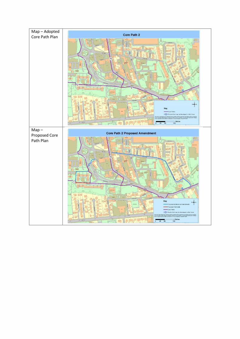
Map – Adopted Core Path Plan
Map – Proposed Core Path Plan

Reference – Amendment 2, Core Path 77
CP name CP77 Swallow Hotel Right of Way
Length to be amended
Amend the current 693m Core Path to 293m
Description of core path
Right of Way from DoubleTree Hotel across Kingsway to Explorer Rd. Double Tree Hotel and Kingsway path reducing CP77 by 400m and realigning to use the entrance road and car park of DoubleTree Hotel
Criteria applying
Part of route is dangerous crossing of Kingsway and part of route does not exist. New route is fit for multi-Buse, connects to wider path network and meets the demand.
Detailed reason for amendment
Current Core Path Route does not meet the Core Path Criteria. To avoid dangerous crossing of Kingsway and impassable section of route. All current users travel via the Hotel entrance road.
Alternative route
Road into Hotel, crossing Kingsway at dropped kerbs near roundabout, or via underpass. The A92 will eventually (by 2023) be a controlled crossing as required by Planning consent for Western Gateway housing.
Landowner Doubletree Hotel and Transport Scotland.
Biodiversity/ Geo sites
No Geodiversity or Ancient Woodland Sites affected. Swallow Roundabout Wetland SINC adjacent to the Core Path, but with restricted access from the path and no impact anticipated.
Forum view Agreed proposed amendment 7/11/16. Because of the asserted Right of Way, Scotways have also been consulted and agree with proposed amendment.
Photos
Part of Core Path is not used.
Road into hotel is open and has light traffic volume.

Map – Adopted Core Path Plan
Map – Proposed Core Path Plan
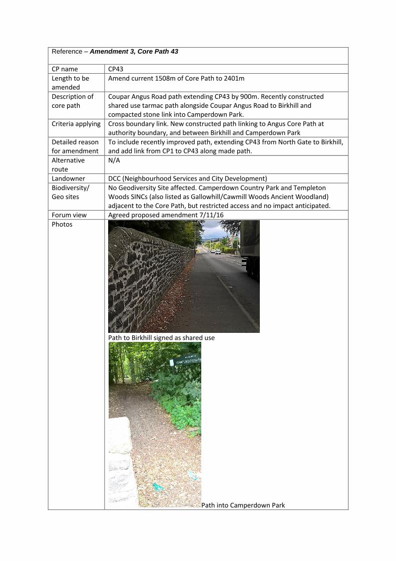
Reference – Amendment 3, Core Path 43
CP name CP43
Length to be amended
Amend current 1508m of Core Path to 2401m
Description of core path
Coupar Angus Road path extending CP43 by 900m. Recently constructed shared use tarmac path alongside Coupar Angus Road to Birkhill and compacted stone link into Camperdown Park.
Criteria applying Cross boundary link. New constructed path linking to Angus Core Path at authority boundary, and between Birkhill and Camperdown Park
Detailed reason for amendment
To include recently improved path, extending CP43 from North Gate to Birkhill, and add link from CP1 to CP43 along made path.
Alternative route
N/A
Landowner DCC (Neighbourhood Services and City Development)
Biodiversity/ Geo sites
No Geodiversity Site affected. Camperdown Country Park and Templeton Woods SINCs (also listed as Gallowhill/Cawmill Woods Ancient Woodland) adjacent to the Core Path, but restricted access and no impact anticipated.
Forum view Agreed proposed amendment 7/11/16
Photos
Path to Birkhill signed as shared use
Path into Camperdown Park
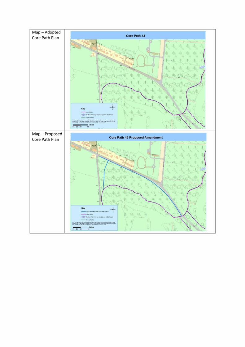
Map – Adopted Core Path Plan
Map – Proposed Core Path Plan
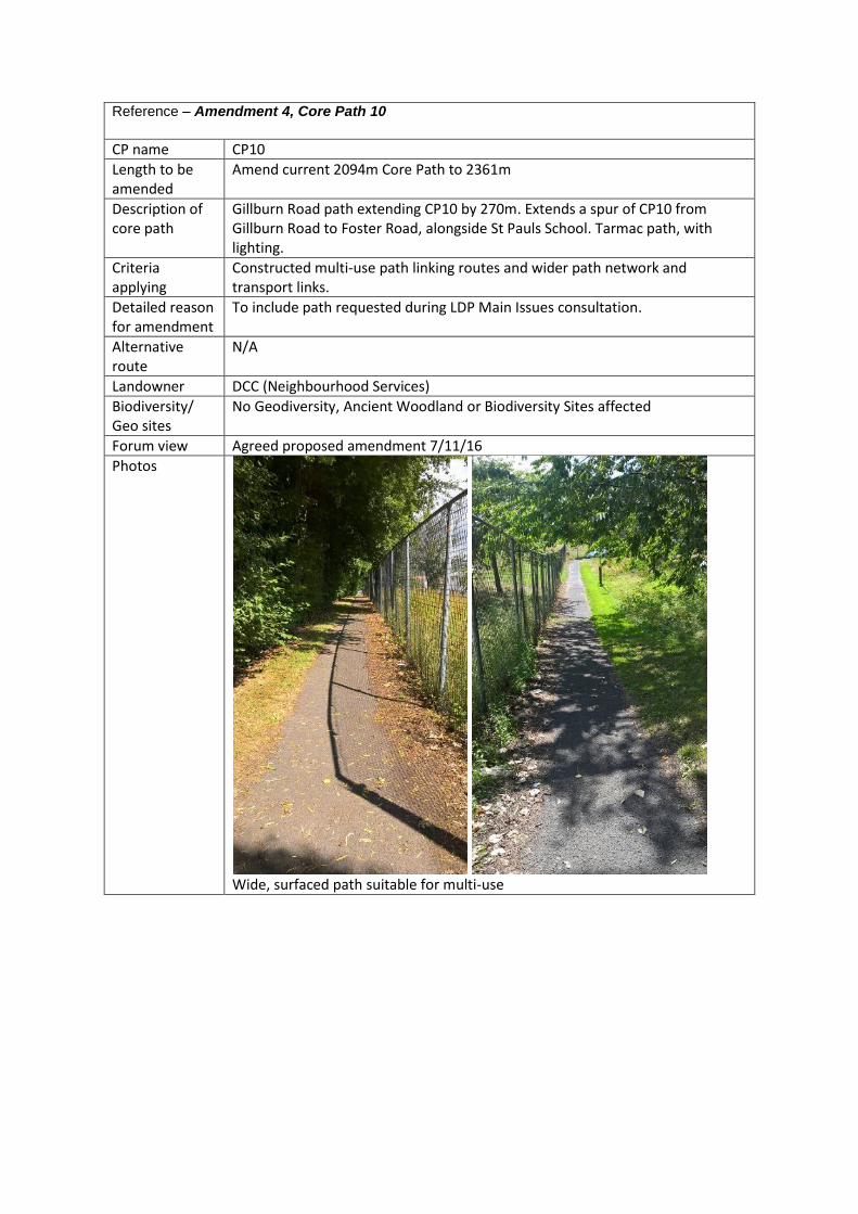
Reference – Amendment 4, Core Path 10
CP name CP10
Length to be amended
Amend current 2094m Core Path to 2361m
Description of core path
Gillburn Road path extending CP10 by 270m. Extends a spur of CP10 from Gillburn Road to Foster Road, alongside St Pauls School. Tarmac path, with lighting.
Criteria applying
Constructed multi-use path linking routes and wider path network and transport links.
Detailed reason for amendment
To include path requested during LDP Main Issues consultation.
Alternative route
N/A
Landowner DCC (Neighbourhood Services)
Biodiversity/ Geo sites
No Geodiversity, Ancient Woodland or Biodiversity Sites affected
Forum view Agreed proposed amendment 7/11/16
Photos
Wide, surfaced path suitable for multi-use

Map – Adopted Core Path Plan
Map – Proposed Core Path Plan
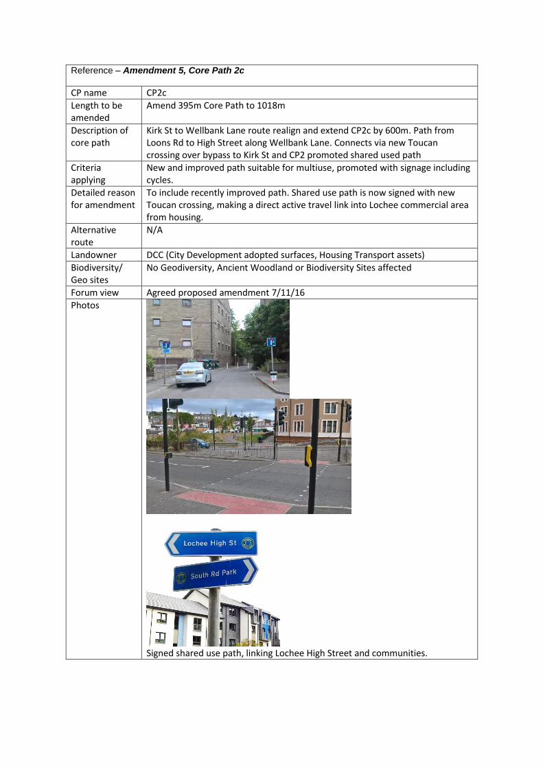
Reference – Amendment 5, Core Path 2c
CP name CP2c
Length to be amended
Amend 395m Core Path to 1018m
Description of core path
Kirk St to Wellbank Lane route realign and extend CP2c by 600m. Path from Loons Rd to High Street along Wellbank Lane. Connects via new Toucan crossing over bypass to Kirk St and CP2 promoted shared used path
Criteria applying
New and improved path suitable for multiuse, promoted with signage including cycles.
Detailed reason for amendment
To include recently improved path. Shared use path is now signed with new Toucan crossing, making a direct active travel link into Lochee commercial area from housing.
Alternative route
N/A
Landowner DCC (City Development adopted surfaces, Housing Transport assets)
Biodiversity/ Geo sites
No Geodiversity, Ancient Woodland or Biodiversity Sites affected
Forum view Agreed proposed amendment 7/11/16
Photos
Signed shared use path, linking Lochee High Street and communities.
Map – Adopted Core Path Plan
Map – Proposed Core Path Plan

Reference – Amendment 6, Core Path 41
CP name CP41
Length to be amended
Amend 2221m Core Path to 2091m
Description of core path
Ninewells to Mariner Dr path realign and reduce CP41 by 130m. Footway/ path by Carseview, new route uses recently constructed signed shared use, tarmac path directly linking to CP36
Criteria applying
Recently constructed shared use path, promoted with signage is now available
Detailed reason for amendment
To include recently constructed path. Route is now more direct and a multi-use path available.
Alternative route
Still available on the current footway
Landowner NHS
Biodiversity/ Geo sites
No Geodiversity, Ancient Woodland or Biodiversity Sites affected
Forum view Agreed proposed amendment 7/11/16
Photos
New shared use path, signed and surfaced

Map – Adopted Core Path Plan
Map – Proposed Core Path Plan
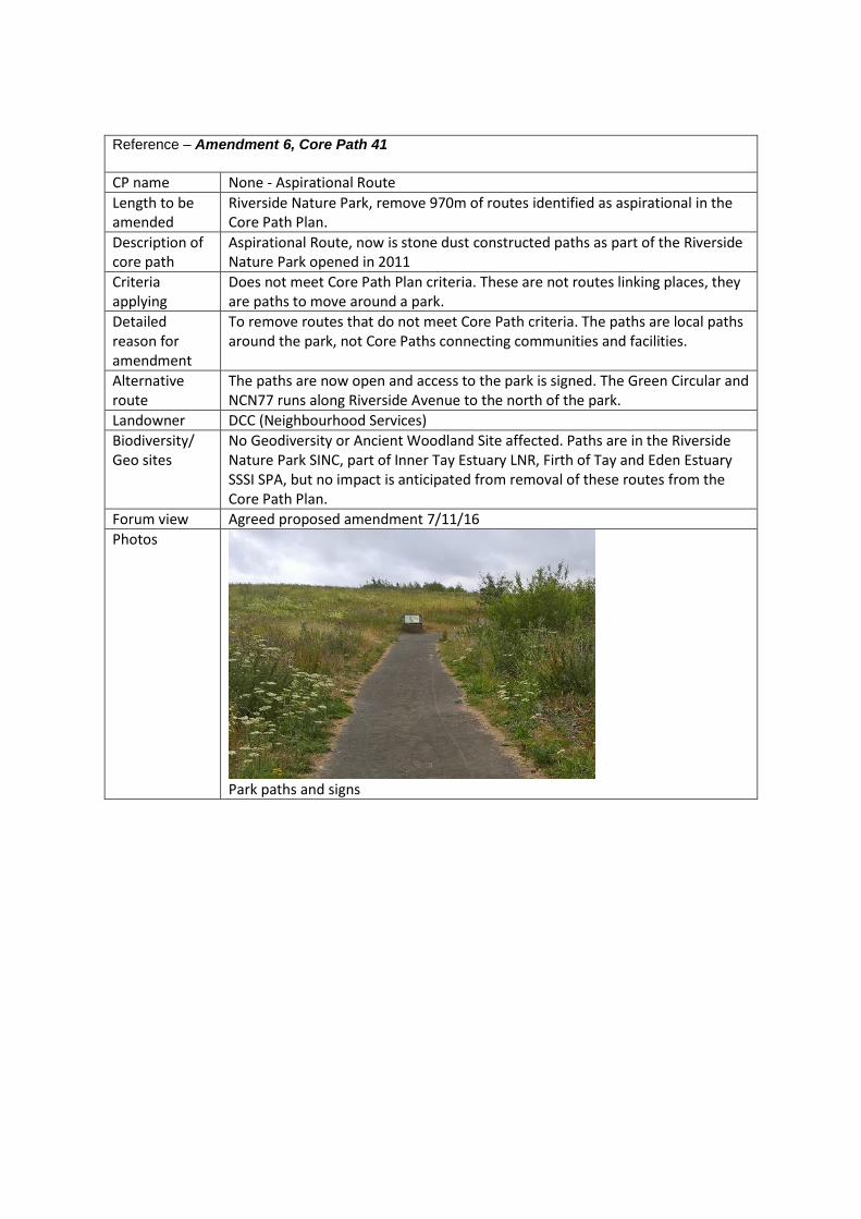
Reference – Amendment 6, Core Path 41
CP name None - Aspirational Route
Length to be amended
Riverside Nature Park, remove 970m of routes identified as aspirational in the Core Path Plan.
Description of core path
Aspirational Route, now is stone dust constructed paths as part of the Riverside Nature Park opened in 2011
Criteria applying
Does not meet Core Path Plan criteria. These are not routes linking places, they are paths to move around a park.
Detailed reason for amendment
To remove routes that do not meet Core Path criteria. The paths are local paths around the park, not Core Paths connecting communities and facilities.
Alternative route
The paths are now open and access to the park is signed. The Green Circular and NCN77 runs along Riverside Avenue to the north of the park.
Landowner DCC (Neighbourhood Services)
Biodiversity/ Geo sites
No Geodiversity or Ancient Woodland Site affected. Paths are in the Riverside Nature Park SINC, part of Inner Tay Estuary LNR, Firth of Tay and Eden Estuary SSSI SPA, but no impact is anticipated from removal of these routes from the Core Path Plan.
Forum view Agreed proposed amendment 7/11/16
Photos
Park paths and signs
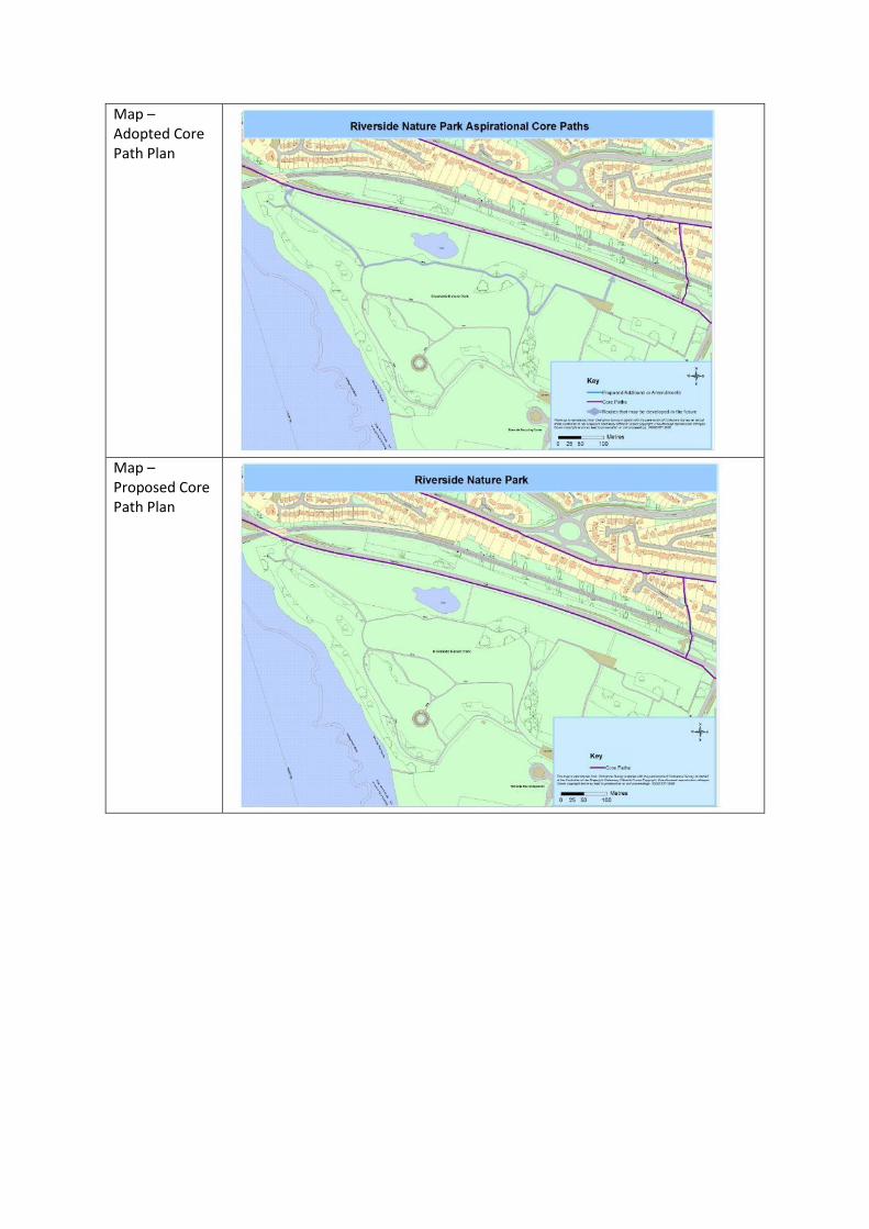
Map – Adopted Core Path Plan
Map – Proposed Core Path Plan
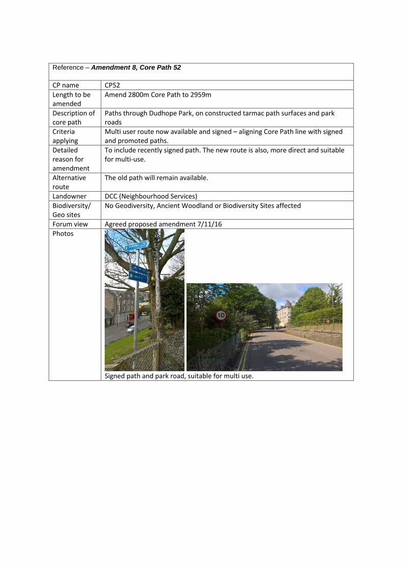
Reference – Amendment 8, Core Path 52
CP name CP52
Length to be amended
Amend 2800m Core Path to 2959m
Description of core path
Paths through Dudhope Park, on constructed tarmac path surfaces and park roads
Criteria applying
Multi user route now available and signed – aligning Core Path line with signed and promoted paths.
Detailed reason for amendment
To include recently signed path. The new route is also, more direct and suitable for multi-use.
Alternative route
The old path will remain available.
Landowner DCC (Neighbourhood Services)
Biodiversity/ Geo sites
No Geodiversity, Ancient Woodland or Biodiversity Sites affected
Forum view Agreed proposed amendment 7/11/16
Photos
Signed path and park road, suitable for multi use.

Map – Adopted Core Path Plan
Map – Proposed Core Path Plan

Reference – Amendment 9, Core Path 17
CP name CP17
Length to be amended
Amend 667m Core Path to 614m
Description of core path
Trottick Ponds realign CP17 reducing by 50m. Paths around Trottick Ponds and Balmuir field, linking Green Circular to William Fitzgerald Way. Partially unmade horse riding route, partially tarmac shared use path.
Criteria applying
Aspirational Route now constructed and open, signed and suitable for multi-use. Also removes line indicating path in Angus Council Area, Angus Council Access Officer informed.
Detailed reason for amendment
To correct mistake in Core Path (removing path in Angus council area) and include recently constructed path identified as aspirational in Core Path Plan.
Alternative route
N/A
Landowner DCC (Neighbourhood Services)
Biodiversity/ Geo sites
No Geodiversity or Ancient Woodland Sites affected. Path runs through Balmuir SINC which is mainly developing woodland plantation, with deer fencing which restricts access. No effect on the SINC is expected from the Core Path designation.
Forum view Agreed proposed amendment 7/11/16
Photos
Signed and newly surfaced path, suitable for multi-use
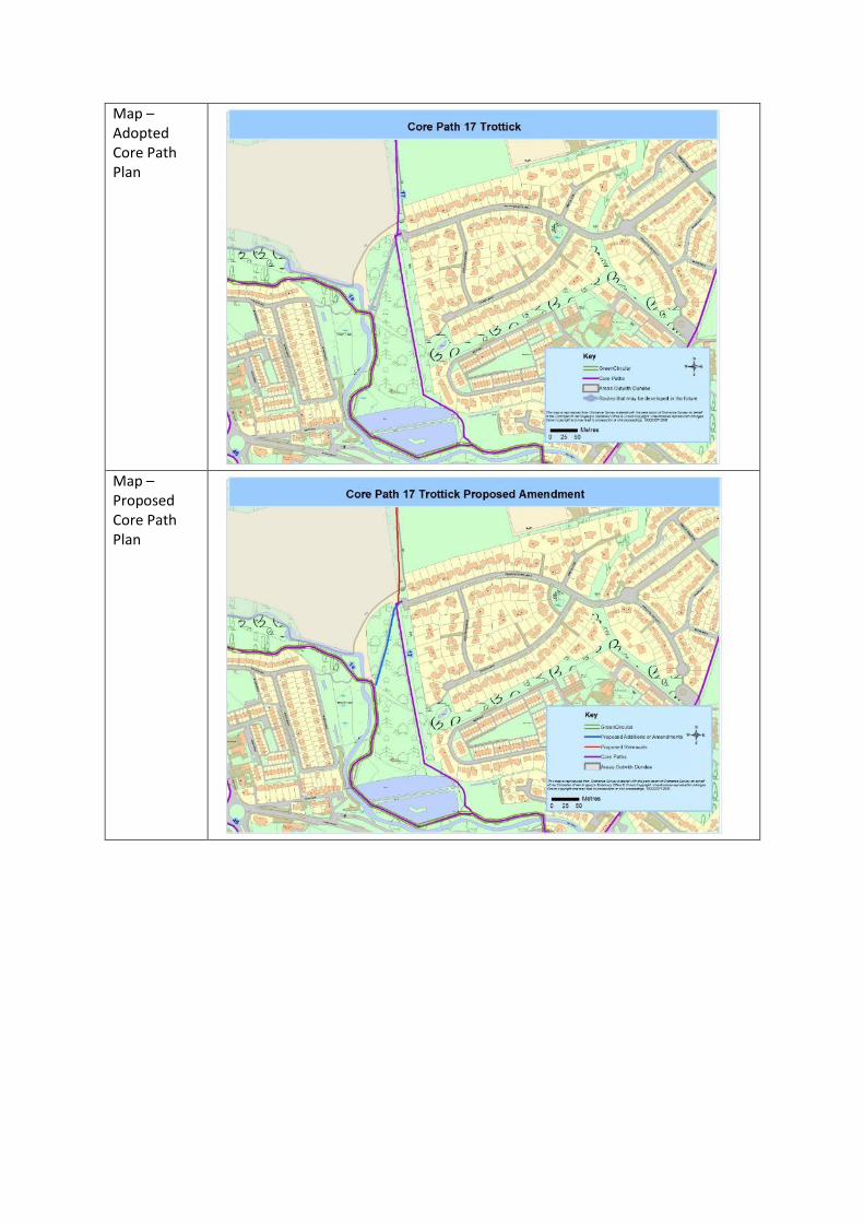
Map – Adopted Core Path Plan
Map – Proposed Core Path Plan
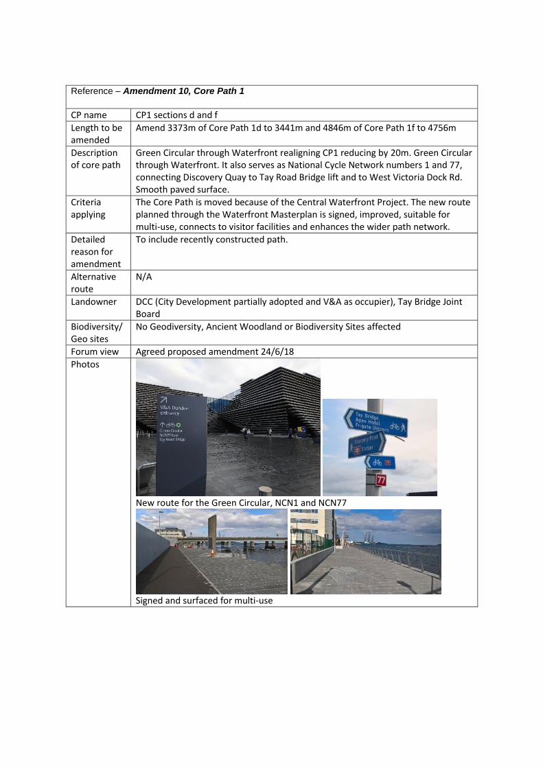
Reference – Amendment 10, Core Path 1
CP name CP1 sections d and f
Length to be amended
Amend 3373m of Core Path 1d to 3441m and 4846m of Core Path 1f to 4756m
Description of core path
Green Circular through Waterfront realigning CP1 reducing by 20m. Green Circular through Waterfront. It also serves as National Cycle Network numbers 1 and 77, connecting Discovery Quay to Tay Road Bridge lift and to West Victoria Dock Rd. Smooth paved surface.
Criteria applying
The Core Path is moved because of the Central Waterfront Project. The new route planned through the Waterfront Masterplan is signed, improved, suitable for multi-use, connects to visitor facilities and enhances the wider path network.
Detailed reason for amendment
To include recently constructed path.
Alternative route
N/A
Landowner DCC (City Development partially adopted and V&A as occupier), Tay Bridge Joint Board
Biodiversity/ Geo sites
No Geodiversity, Ancient Woodland or Biodiversity Sites affected
Forum view Agreed proposed amendment 24/6/18
Photos
New route for the Green Circular, NCN1 and NCN77
Signed and surfaced for multi-use

Map – Adopted Core Path Plan
Map – Proposed Core Path Plan

Reference – Amendment 11, New Core Path 84
CP name New CP84
Length to be amended
CP84 290m of new core path added through the Waterfront improvement works
Description of core path
Whalers Lane addition of 290m Core Path. Multi-use link from Tay Road Bridge lift to Dock Street, via smooth paved paths and Toucan and Puffin Crossings.
Criteria applying
New development creates a path as planned through the Waterfront development. The new route is improved, suitable for multi-use, connects to visitor facilities and enhances the wider path network.
Detailed reason for amendment
To include recently constructed path. New development of Central Waterfront Project creates path indicated as a future link in the adopted Core Path Plan.
Alternative route
N/A
Landowner DCC (City Development adopted roads list), Tay Bridge Joint Board
Biodiversity/ Geo sites
No Geodiversity, Ancient Woodland or Biodiversity Sites affected
Forum view Agreed proposed amendment 24/6/18
Photos
New path, surfaced and suitable for multi-use. Designed to be a promoted cycle route.

Map – Adopted Core Path Plan
Map – Proposed Core Path Plan

Reference – Amendment 12, Core Path 66
CP name CP66
Length to be amended
Railway station path Amend current 147m route to 486m new route
Description of core path
Dundee Railway Station realign and extend CP66 by 350m From Discovery Point, passed Rail Station to Greenmarket and South Union St via Toucan Crossing. Paved surface.
Criteria applying
New development creates new improved route as identified in Core Path Plan as a future link/moves core path from front of old railway station. Multiuse path, connecting facilities and adding to the wider network.
Detailed reason for amendment
To include recently constructed path. New path replaces “proposed future link” as identified in Core Path Plan.
Alternative route
N/A
Landowner DCC (City Development adopted roads list)
Biodiversity/ Geo sites
No Geodiversity, Ancient Woodland or Biodiversity Sites affected
Forum view Agreed proposed amendment 24/6/18
Photos
Newly open path route, designed for multi-use and for promotion as a cycle route

Map – Adopted Core Path Plan
Map – Proposed Core Path Plan

Reference – Amendment 13, Core Path 65
CP name CP65
Length to be amended
Extend CP65 with additional 331m of Core Path
Description of core path
Seabraes Bridge and Magdalen Green extending CP65 by 331m. Recently constructed tarmac surfaced path at Magdalen Green and bridge to waterfront.
Criteria applying
Aspirational routes from Core Path Plan 2009 have been constructed, providing multi use network links and routes to and from facilities.
Detailed reason for amendment
To include recently constructed path and bridge identified as aspirational in Core Path Plan. Improved and recently constructed routes at Magdalen Green and new railway bridge. Open, signed and suitable for multiuse.
Alternative route
N/A
Landowner DCC Neighbourhood Services, Scottish Enterprise, Network Rail, H&H Developments UK Ltd
Biodiversity/ Geo sites
No Geodiversity, Ancient Woodland or Biodiversity Sites affected
Forum view Agreed proposed amendment 7/11/16
Photos
Constructed path Magdalen Green
Constructed path Seabraes Bridge

Map – Adopted Core Path Plan
Map – Proposed Core Path Plan

Reference – Amendment 14, New Core Path 85
CP name New CP85
Length to be amended
New 1216m Core Path
Description of core path
Lothian Crescent addition of 1216m Core Path. Aspirational Route amended to Core Path along Lothian Crescent from near Fintry Terrace to Maybole Place.
Criteria applying
Recently constructed paths are suitable for multi-use, replacing aspirational route indicated in the Core Path Plan. Signed for shared use. Links facilities and residential areas.
Detailed reason for amendment
To include recently constructed path identified as aspirational in Core Path Plan.
Alternative route
N/A
Landowner DCC (City Development adopted road list, Housing Transport Assets,
Biodiversity/ Geo sites
No Geodiversity, Ancient Woodland or Biodiversity Sites affected
Forum view Agreed proposed amendment 7/11/16
Photos
Whitfield Lothian Crescent Shared use path
Map – Adopted Core Path Plan

Map – Proposed Core Path Plan
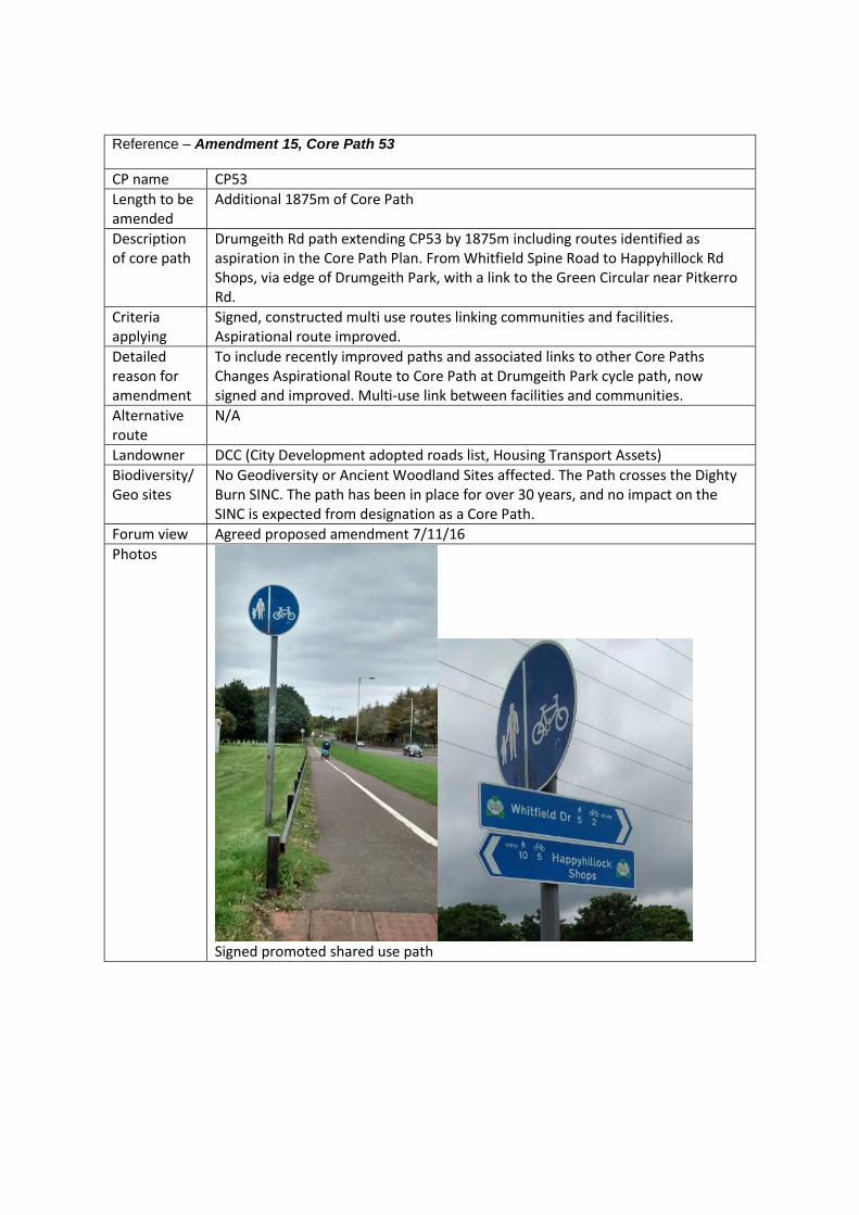
Reference – Amendment 15, Core Path 53
CP name CP53
Length to be amended
Additional 1875m of Core Path
Description of core path
Drumgeith Rd path extending CP53 by 1875m including routes identified as aspiration in the Core Path Plan. From Whitfield Spine Road to Happyhillock Rd Shops, via edge of Drumgeith Park, with a link to the Green Circular near Pitkerro Rd.
Criteria applying
Signed, constructed multi use routes linking communities and facilities. Aspirational route improved.
Detailed reason for amendment
To include recently improved paths and associated links to other Core Paths Changes Aspirational Route to Core Path at Drumgeith Park cycle path, now signed and improved. Multi-use link between facilities and communities.
Alternative route
N/A
Landowner DCC (City Development adopted roads list, Housing Transport Assets)
Biodiversity/ Geo sites
No Geodiversity or Ancient Woodland Sites affected. The Path crosses the Dighty Burn SINC. The path has been in place for over 30 years, and no impact on the SINC is expected from designation as a Core Path.
Forum view Agreed proposed amendment 7/11/16
Photos
Signed promoted shared use path

Map – Adopted Core Path Plan
Map – Proposed Core Path Plan

Reference – Amendment 16, Core Path 37
CP name CP37
Length to be amended
468m to be removed
Description of core path
Drumsturdy Rd remove 468m of Core Path. No path or footway, uses Drumsturdy Rd carriageway surface.
Criteria applying
No path, does not meeting Core Path criteria
Detailed reason for amendment
To remove dangerous route which uses busy Drumsturdy Road with no footway. Route does not meet Core Path criteria as there is no path and the road is too busy for pedestrians to share - it is unsafe for pedestrians
Alternative route
None, change to aspirational route
Landowner DCC (City Development adopted roads list)
Biodiversity/ Geo sites
No Geodiversity, Ancient Woodland or Biodiversity Sites affected.
Forum view Agreed proposed amendment 7/11/16
Photos
Nowhere for active travel users. Busy road at commuting times Not suitable for multi-use

Map – Adopted Core Path Plan
Map – Proposed Core Path Plan

Reference – Amendment 17, Core Path 23
CP name CP23
Length to be amended
Additional 650m
Description of core path
Linlathen Farm track extend Core Path by 650m of route identified as aspirational in the Core Path Plan. Track has improved drainage and surface.
Criteria applying
Aspirational Route improved, suitable for multi-use.
Detailed reason for amendment
To include recently improved path. Change Aspirational Route to Core Path.
Alternative route
N/A
Landowner DCC (Neighbourhood Services)
Biodiversity/ Geo sites
No Geodiversity, Ancient Woodland or Biodiversity Sites affected
Forum view Agreed proposed amendment 7/11/16
Photos
Signed and surface path.

Map – Adopted Core Path Plan
Map – Proposed Core Path Plan

Reference – Amendment 18, New Core Path 86
CP name New Core Path 86
Length to be amended
Additional 57m of Core Path
Description of core path
Edzell Street additional of 57m Core Path using current wide tarmac surfaced path through green space.
Criteria applying
New CP using current paths helping maintain connectivity between CP28 and CP1g sections of path in green space.
Detailed reason for amendment
To include path identified through Local Outdoor Access Forum survey of paths.
Alternative route
There are other narrower paths in the area, providing alternative routes.
Landowner DCC (City Development adopted roads list)
Biodiversity/ Geo sites
No Geodiversity, Ancient Woodland or Biodiversity Sites affected
Forum view Agreed proposed amendment 7/11/16
Photos
Proposed Core Path 86

Map – Adopted Core Path Plan
Map – Proposed Core Path Plan