counter-mapping for resistance and solidarity in the ... · litical tensions, neo-liberal policy...
TRANSCRIPT
144
Counter-Mapping for Resistance and Solidarity in the PhilippinesBetween Art, Pedagogy and Community
Arnisson Andre C. Ortega, Ma. Simeona M. Martinez, Cian Dayrit, Kristian Karlo C.Saguin
Counter-Cartography Is Education
145
Mapping is a deeply political practice. Especially when considering how it is embedded in the reproduction of power in the Philippine context. Historically, mapping can be linked to colonial exploits and imperial pursuits as it attempts to represent colonized popu-lations and places within a legible territory conducive for exploita-tion and control (see Harris & Hazen, 2006). In the Philippines maps serve as nation-building tools as they project a spatial vision of a nation that can easily be managed, planned and subjected to militarization. Maps have been largely used as tools for accumula-tion and control by the state, the industries, the church and other powerful institutions while the interests and needs of subaltern populations were ignored. Opposing these mapping practices, we argue that mapping can be reclaimed and used for social justice. In this contribution we feature collaborative counter-mapping efforts by critical Filipino geographers, artists and communities in the Philippines. With progressive goals, these counter-map-ping projects grapple with how to articulate space not just to ap-propriately represent the everyday geographies inhabited by mar-ginalized populations. They also provide mechanisms to criticize neoliberal projects, to build stronger alliances among groups and to expose the malevolent geographies of accumulation and dis-possession which are behind the contemporary developments in the Philippines. Further, these projects reflect the multiplicity of counter-cartographic initiatives that often entail engagements across various sectors, from university students to people's orga-nizations.
The Context: Development, Nation and the Need for Counter-Mapping Development is a highly contested term that is associated with multiple meanings and the visions of various groups. For the state, development is a necessary outcome it has to provide for its popu-lation. Its articulation through actual programs usually entails the identification of spaces that policy interventions and development visions are projected onto. In development, maps and mapmaking serve as an important role in making state spaces legible. In recent decades the Philippines have been subject to investment-oriented policies and programs, which in turn have encouraged the conver-sion of the use of land and the creation of special economic zones (SEZs) to attract foreign capital (see Ortega, 2016; Kelly, 2000). Across the country, vast tracts of land have been identified and planned as sites of SEZs (see Ortega, Acielo & Hermida, 2015). These projects are contained in master plans that carry the state's vision for these spaces and are rendered powerful as they tend to override other visions and claims made by residents. Those who live in these spaces do not necessarily have the same spatial vision as the ones projected by the state in master plans.
Counter-mapping brings together these multiple visions of space. As an antidote to the fixed and final partitioning of space by the state, counter-mapping sees maps as processes and encounters that recognize multiple spatialities operating simultaneously. By counter-mapping national spaces of development, we therefore expose the contested visions of development. We consider par- ticipatory methods and art as creative and effective means for counter-mapping that challenge the state's spatial vision.
Counter-Mapping, Art and PedagogyMany counter-mapping projects have been associated with creat-ing community maps to be used for indigenous claims. There are, however, multiple forms of counter-maps and counter-mapping practices that contest state power. In this chapter we focus on how art and pedagogy can be potent ways of engaging and collaborat-ing with communities by using maps.
Art provides a creative medium for communicating aspirations, dreams and the plight of marginalized populations. Through col-laborative and community-oriented art projects, spatial narratives of the oppressed may resist and outlast hegemonic stories about specific landscapes and built environments. These projects may rupture rigid cartographic narratives of city projects and regional master plans by exposing contested histories, relations and bodily experiences that have been silenced for the sake of particular no-tions of progress and development.
Counter-mapping can be an effective pedagogical tool for both students and communities. Through the processes from formu-lating problems and collecting data to creating and disseminating maps, counter-mapping exposes critical issues faced by marginal-ized communities as well as the ways in which cartographic con-cepts and tools can be applied when addressing these concerns. Furthermore, counter-mapping also activates the political possi-bilities of solidarity by connecting the struggles of marginalized communities with pedagogical objectives.
Counter-Mapping through ArtThe Filipino artist Cian Dayrit uses cartography and mapping to tackle power, control and memory. His compelling body of work incorporates imagery, context and cartography in an effort to cre-atively visualize information, particularly that involving social and political movements. In his work mapping is considered a tool for resisting hegemony, for projecting the aspirations of marginalized classes and for exposing issues of dispossession among the landless.
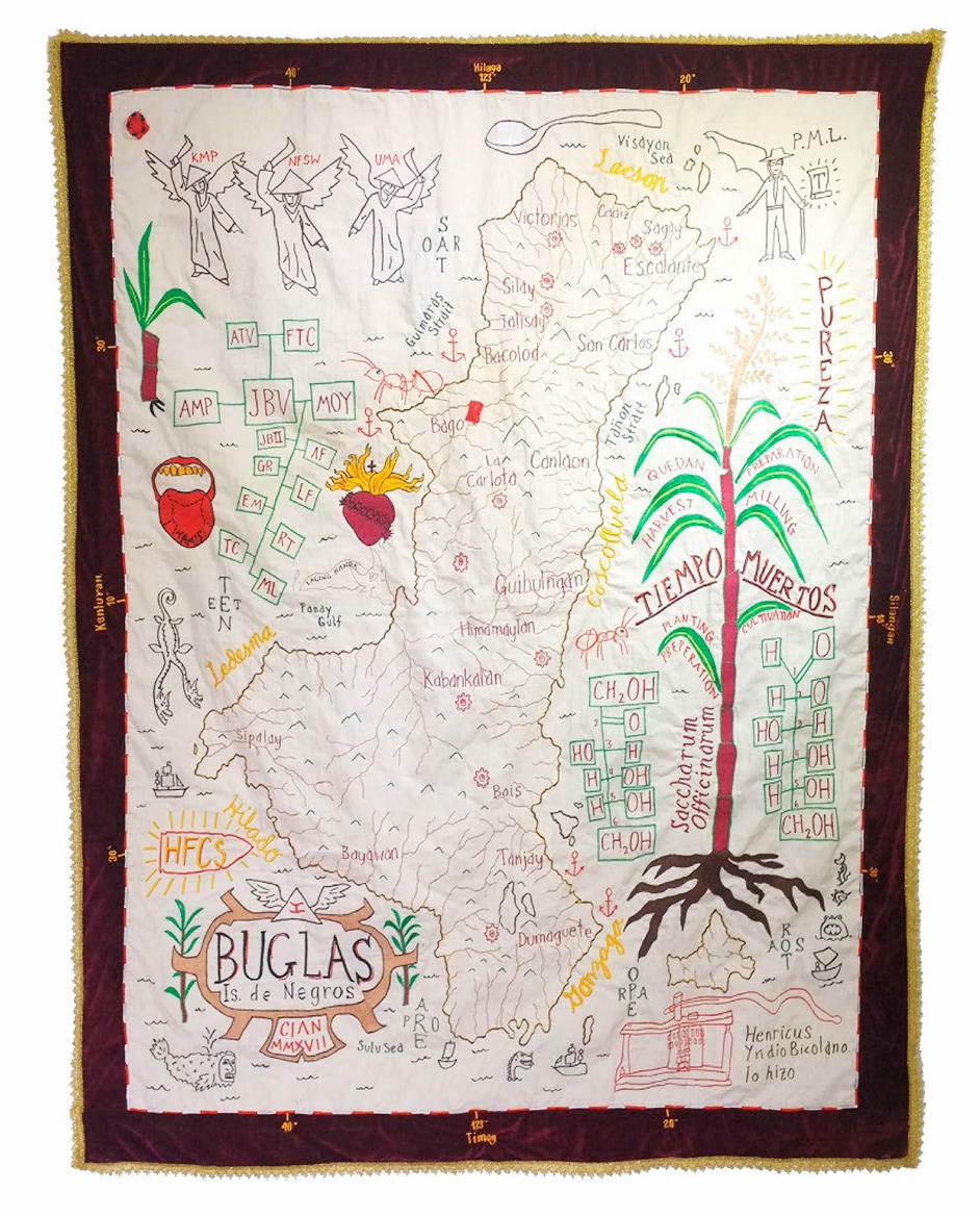
Given that maps serve as an emblem of imperial imagination, Cian uses cartographic images to expose neo-colonial visual uncon-sciousness and subvert Western cartographic practices. For exam-ple, his Atlas of the Global South exhibition investigated geo-po-litical tensions, neo-liberal policy and neo-colonialism that have shaped Global south affairs. The maps in the project challenge the traditional format of historical maps in order to plot and represent issues of inequality, hegemony and violence. In Cartography for Colonialism, Cian proposes alternative readings of colonially-de-fined borders. It attempts to defeat the function of maps as tools to uphold the traditional structures of political power while creating counter-narratives of the reconstruction of colonial property histo-ry. Questioning the validity of Western cartographic practices and its authorship, this project interrogates the notions of nationhood and imperialism and takes on the angle of history from "below". This is done by using pre-colonial place names, plotting places of power and resistance, and tracing social and revolutionary movements as well as trade routes, demarcation lines and piracy (see map at the end of the article, left). Another exhibition titled Seascapes: Tran-quility and Agitation features map pieces that question notions of nation building and sovereignty as well as territory and struggle (see map at the end of the article, right). A map of Negros Island, which is known as the sugar bowl of the Philippines, presents multiple views
Counter-Mapping for Resistance and Solidarity in the Philippines
146
multinational corporations. After drawing their maps, all partici-pants took turns in showing their maps and fortifying their work with stories of their experiences in their communities. The work-shop illustrates how cartographic representation of displacement and other abuses can be supplemented by narratives.
Counter-Mapping through Pedagogy Another series of counter-mapping activities involved university students and professors who engage in solidarity work with indig-enous peoples and farmers. At the University of the Philippines (UP), critical cartography and counter-cartographies are conduct-ed as participatory action projects. Being selectively integrated into the content of several courses, they also contribute to enrich-ing the activities of student organizations.
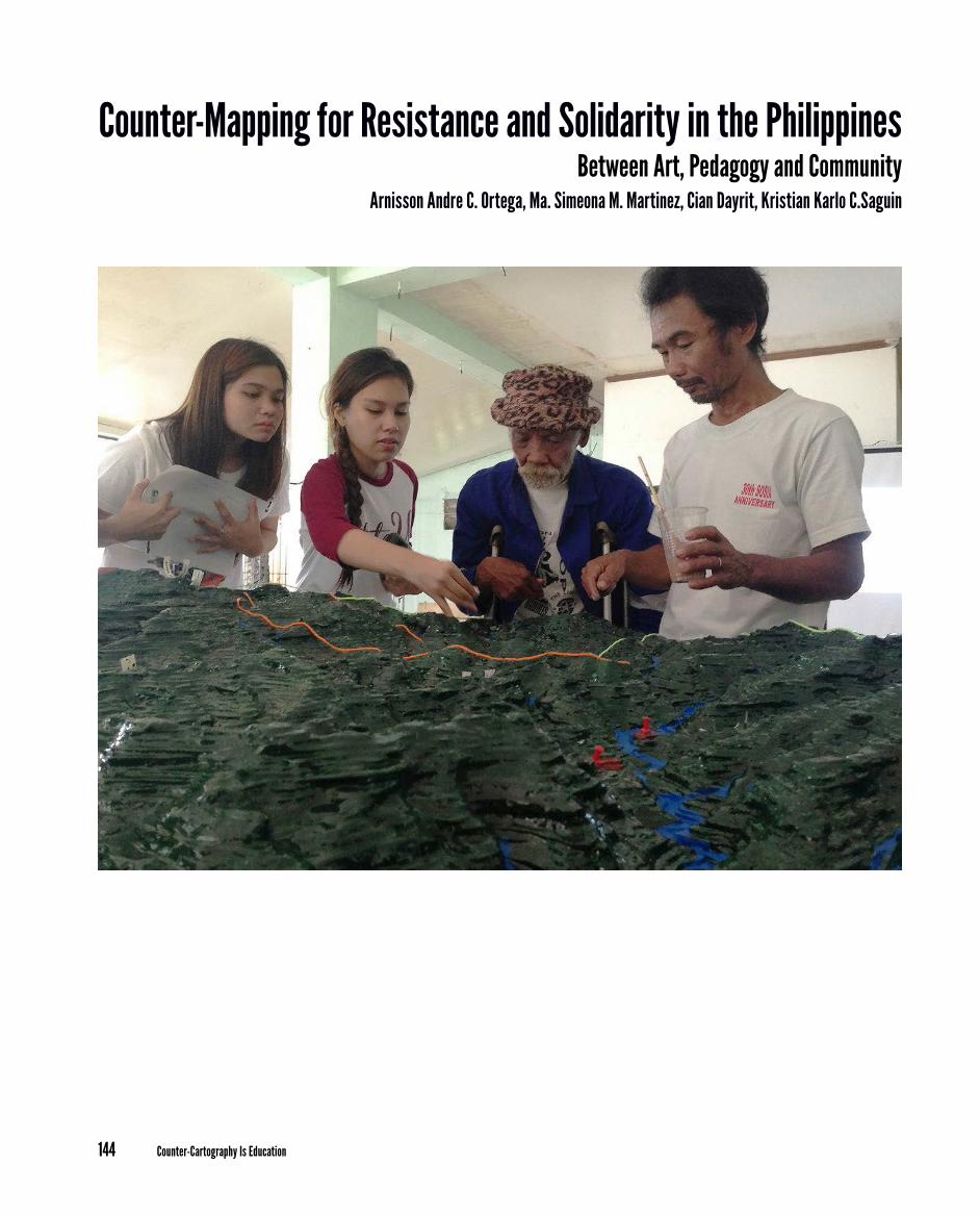
Since 2010, the Junior Philippine Geographic Society of UP Diliman has been conducting a counter-mapping project called Contour: Mapping for the People. With the aim of highlighting the plight of marginalized communities impacted by develop-ment, the project uses a participatory mixed-use mapping ap-proach that combines GIS techniques with qualitative methods. Over the years, Contour has used counter-mapping to engage with urban and rural communities, such as San Roque, an urban poor community in Quezon City. The main aims were fighting against informal settler demolition as well as the construction of new ur-ban business districts. Another community was Hacienda Luisita, a contested agricultural land in Central Luzon where farmers are fighting for their right to collectivize and plant crops.
In the UP Department of Geography, undergraduate students of the second semester of 2012-2013 launched a blog titled Cartogra-phy Mission: Mapping with a Cause, a mapping project that caters to the needs of communities for organizing and visualizing spatial data in support of human rights advocacies. Along with a geogra-phy graduate class, students took part in a participatory 3-dimen-sional mapping (P3DM) of the ancestral domain of the Agta-Dum-agat-Remontado1, an indigenous group from the Quezon Province at the southern foothills of the Sierra Madre mountain range. The activity was organized by NGOs that assist indigenous peoples in the process of ancestral domain claim-making2, the Non-Timber Forest Product Exchange Programme for South and Southeast Asia (NTFP) and Anthropology Watch (AnthroWatch). The students provided assistance to the Agta-Dumagat-Remontados primarily by preparing the materials that formed the base model for the 3-di-mensional map (see photograph on previous spread). Aside from observing and documenting the P3DM process, students helped the elders and also conducted interviews with them and other par-ticipants like women and children. The goal was to obtain a better understanding of their situation as a marginalized group, and to elicit opinions on how the mapping activity could contribute to ad-dressing their concerns and what they thought about the mapping activity in general. While they were conducting these interviews, the graduate students, who also participated in the field activity, travelled to the Sentrong Paaralan ng mga Agta (SPA), an elemen-tary school the Agta has established in the municipality of General Nakar. Equipped with GPS receivers, they carried out an adhoc task of helping teachers and elders to locate the boundary monuments that delimit the perimeter of the school. The geolocated photos of the spots where the property markers were located were then over-
on the history of the island and the sugar industry. On the one hand, it shows the family tree of Jorge Vargas (executive secretary to Pres-ident Manuel L. Quezon in Commonwealth Philippines, donor of Vargas Museum, among many other things). It shows a marker for his birth place as well as the names of the prominent families who migrated to the island in the 1880s to invest in sugar production. On the other hand, the map focuses on feudalism and struggle in the sugar industry. In the main cartouche, the pre-colonial place name for the island was used to symbolize the resistance against colonial oppression and the feudal state.
Cian's art also involves collaborations with collectives, unions, academics and other individuals. This practice is largely borne out of the need to articulate issues concerning social justice and in-equality, particularly with peasant and indigenous communities. These collaborations underscore the need to explore alternative modes of resistance to the neo-colonial, semi-feudal state system which rampantly exploits the marginalized sectors of Philippine society. He has forged alliances with various groups in conduct-ing community-based indigenous mapping and counter-cartog-raphies, melding ethnography, mapping and art. An example of these collaborations is a series of workshops with indigenous peoples and farmers held in protest spaces and encampments in Metro Manila. These workshops involved asking participants to draw maps of their everyday lives in their home communities. The aim was to develop a counter-mapping module that can be used in community organizing and in making maps for show-ing spaces of displacement and dispossession. Through memory work, participants made mental maps (see illustration below) that identified the sites where they lived, worked, worshipped and or-ganized. The maps also situated places of fear and confrontations, especially sites in which harassments by (para)military forces oc-curred. Participants used various ways of representing their tu-multuous community geographies, such as labels, icons, lines as well as elaborate narratives explaining certain sites and relation-ships. Identified spaces included sites of horrific events, such as massacres, areal bombings by the military, ambush sites, polluted rivers caused by refineries, old trails that had been fenced off by developers, mining and logging sites and monocrop plantations of
Counter-Cartography Is Education
147
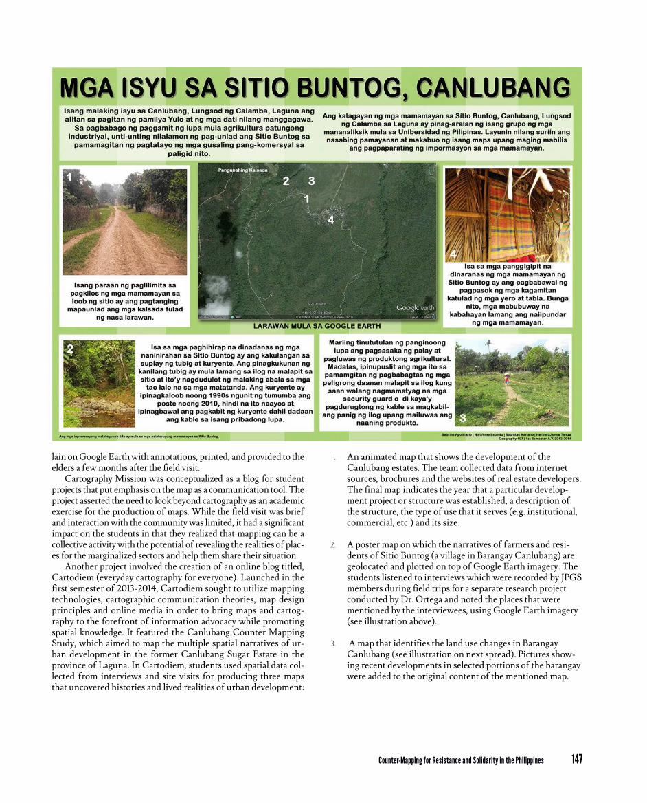
1. An animated map that shows the development of the Canlubang estates. The team collected data from internet sources, brochures and the websites of real estate developers. The final map indicates the year that a particular develop-ment project or structure was established, a description of the structure, the type of use that it serves (e.g. institutional, commercial, etc.) and its size.
2. A poster map on which the narratives of farmers and resi-dents of Sitio Buntog (a village in Barangay Canlubang) are geolocated and plotted on top of Google Earth imagery. The students listened to interviews which were recorded by JPGS members during field trips for a separate research project conducted by Dr. Ortega and noted the places that were mentioned by the interviewees, using Google Earth imagery (see illustration above).
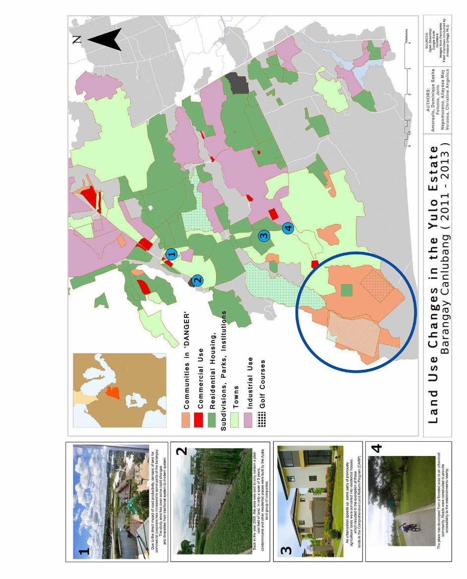
3. A map that identifies the land use changes in Barangay Canlubang (see illustration on next spread). Pictures show-ing recent developments in selected portions of the barangay were added to the original content of the mentioned map.
lain on Google Earth with annotations, printed, and provided to the elders a few months after the field visit.
Cartography Mission was conceptualized as a blog for student projects that put emphasis on the map as a communication tool. The project asserted the need to look beyond cartography as an academic exercise for the production of maps. While the field visit was brief and interaction with the community was limited, it had a significant impact on the students in that they realized that mapping can be a collective activity with the potential of revealing the realities of plac-es for the marginalized sectors and help them share their situation.
Another project involved the creation of an online blog titled, Cartodiem (everyday cartography for everyone). Launched in the first semester of 2013-2014, Cartodiem sought to utilize mapping technologies, cartographic communication theories, map design principles and online media in order to bring maps and cartog-raphy to the forefront of information advocacy while promoting spatial knowledge. It featured the Canlubang Counter Mapping Study, which aimed to map the multiple spatial narratives of ur-ban development in the former Canlubang Sugar Estate in the province of Laguna. In Cartodiem, students used spatial data col-lected from interviews and site visits for producing three maps that uncovered histories and lived realities of urban development:
Counter-Mapping for Resistance and Solidarity in the Philippines
148
Endnotes1. The indigenous group is represented by the Samahan ng Katutubong
Agta- Remontado Dumagat na Ipinaglalaban ang Lupang Ninuno (SA-GUIBIN-LN), a local Peoples’ Organization (PO) from General Nakar, Quezon Province.
2. In the Philippines, indigenous peoples need to undergo the process of ancestral domain titling through self-delineation, as stipulated in the rules and regulations implementing the Indigenous Peoples Rights Act (IPRA) of 1997, to attain entitlement to their ancestral lands and waters. Part of this process is the submission of proof that includes historical accounts of agreements on boundaries and descriptions of traditional landmarks as well as surveys and sketch maps of the ancestral lands (The Indige-nous Peoples’ Rights Act, 1997). Several non-government and peoples’ organizations engage with the government and indigenous groups to facilitate the consolidation of relevant documents with respect to the requirements provided by the law mentioned above.
ReferencesCooke, F.M. 2003. Maps and Counter-Maps: Globalised Imaginings and Local
Realities of Sarawak’s Plantation Agriculture. Journal of Southeast Asian Studies, 34(2): 265-284.
Harris, L.M. & Hazen, H.D. 2005. Power of Maps: (Counter) Mapping for Conservation. ACME: An International Journal for Critical Geographies, 4(1): 99-130.
Hodgson, D.L. & Schroeder, R.A. 2002. Dilemmas of Counter-Mapping Com-munity Resources in Tanzania. Development and Change, 33(1): 79-100.
Kelly, P.F. 2000. Landscapes of Globalization: Human Geographies of Economic Change in the Philippines. First edition. London ; New York: Routledge.
Ortega, A.A. 2016. Neoliberalizing Spaces in the Philippines: Suburbanization, Transnational Migration, and Dispossession. Lanham, MD: Lexington Books.
Ortega, A.A., Acielo, J.M.A.E. & Hermida, M.C.H. 2015. Mega-regions in the Philippines: Accounting for Special Economic Zones and Global-Local Dynamics. Cities, 48: 130-139.
Parker, B. 2006. Constructing Community Through Maps? Power and Praxis in Community Mapping. The Professional Geographer, 58(4): 470-484.
Republic of the Philippines. 1997. Republic Act No. 8371. The Indigenous Peoples’ Rights Act of 1997. Manila, October 29. officialgazette.gov.ph/1997/10/29/republic-act-no-8371, 19 April 2018.
IllustrationsMap on following spread left by Cian Dayrit: Objects of Colonial Desire 2017, oil and collage on canvas (Seascapes: Tranquility and Agitation, Metropolitan Museum)Map on following spread right by Cian Dayrit: Mapa de la Isla de Buglas 2017, tapestry (Almost There, Vargas Museum)Photo at the beginning of the article by A. Vitug.
In an article featured in the blog, two members of the class, Mr. Socrates Mariano and Ms. Niel Anne Espiritu, wrote about their experiences:
"The class of Geography 197 feels honored to take part in this movement spearheaded by the people of Canlubang in their quest for recapturing their lost rights. We are greatly pleased to contribute our cartographic skills to the portrayal of the issues and other problems they face through creative, effective and constructive maps that aim to capture a clearer picture of their struggles. As maps traditionally serve as a powerful ingredient in the attainment of social change, we feel delighted that in some way we have realized one of our roles of being a geographer, ‘mapping for a cause’."
ConclusionThe projects we featured in this chapter show how counter-map-ping can be used in art and pedagogy. As exemplified by Cian Day-rit's work, art provides a medium to culturally resist hegemonic representations of space and thus criticize neo-colonial develop-ment. At the same time, counter-mapping through art has the abil-ity to gather and re-articulate narratives of marginalized commu-nities who struggle against violence and dispossession.
Counter-mapping initiatives such as the workshops held in protest spaces and the Canlubang counter-mapping project demonstrate how narratives of marginalized populations may be represented in multiple ways: from mental maps that were drawn from memory and depict the tumultuous everyday life of indige-nous communities to poster maps that used geospatial technolo-gies in combining administrative data sources with field accounts. Also, the projects not only show how counter-mapping provides the mechanisms to resist and criticize development or neo-colo-nial discourses but also how it can facilitate land claims of indige-nous peoples. In particular, geography students collaborated with the Agta-Dumagat-Remontado group of the Quezon Province so as to save their ancestral land by assisting in the creation of a 3-di-mensional model of their community.
These experiences show how cartography is more than a set of visual techniques for representing places. Moreover, the projects reveal that it is equally important to emphasize the role of social relations in the production of maps. In counter-mapping, soli-darity and attainment of progressive goals serve as the main driv-ing forces that interconnect students, teachers, activists and the community. However, a critical concern for these projects is their sustainability and scalability. Since these were mostly time-bound initiatives and constrained by the lack of resources, sustaining col-laboration with communities has been challenging. Also, as issues confronting these communities evolve, updated maps need to be generated and communicated. Given these challenges, we argue for the need of sustainable counter-mapping projects that involve multiple sectors and institutions.
Counter-Cartography Is Education
149