council member applicant and proposal information … bay...council member applicant and proposal...
TRANSCRIPT

Council Member Applicant and Proposal Information Summary Sheet
Council Member: State of Florida
Point of Contact: Phil Coram Phone: 850-245-2167 Email: [email protected]
Project Identification Project Title: Apalachicola Bay Watershed Restoration Project
State(s): Florida County/City/Region: Franklin and Gulf Counties
General Location: Projects must be located within the Gulf Coast Region as defined in RESTORE Act. (attach map or photos, if applicable)
Apalachicola Watershed within Florida
Project Description
RESTORE Goals: Identify all RESTORE Act goals this project supports. Place a P for Primary Goal, and S for secondary goals.
P Restore and Conserve Habitat S Replenish and Protect Living Coastal and Marine Resources S Restore Water Quality S Enhance Community Resilience S Restore and Revitalize the Gulf Economy
RESTORE Objectives: Identify all RESTORE Act objectives this project supports. Place a P for Primary Objective, and S for secondary objectives.
P Restore, Enhance, and Protect Habitats S Promote Community Resilience S Restore, Improve, and Protect Water Resources S Promote Natural Resource Stewardship and
S Protect and Restore Living Coastal and Marine Resources S Environmental Education S Restore and Enhance Natural Processes and Shorelines S Improve Science-Based Decision-Making Processes
RESTORE Priorities: Identify all RESTORE Act priorities that this project supports. X Priority 1: Projects that are projected to make the greatest contribution X Priority 2: Large-scale projects and programs that are projected to substantially contribute to restoring X Priority 3: Projects contained in existing Gulf Coast State comprehensive plans for the restoration …. X Priority 4: Projects that restore long-term resiliency of the natural resources, ecosystems, fisheries …
RESTORE Commitments: Identify all RESTORE Comprehensive Plan commitments that this project supports. X Commitment to Science-based Decision Making X Commitment to Regional Ecosystem-based Approach to Restoration X Commitment to Engagement, Inclusion, and Transparency X Commitment to Leverage Resources and Partnerships X Commitment to Delivering Results and Measuring Impacts
RESTORE Proposal Type and Phases: Please identify which type and phase best suits this proposal.
X Project X Planning X Technical Assistance X Implementation Program
Project Cost and Duration
Project Cost Estimate:
Total : $26,141, 107
Project Timing Estimate: Date Anticipated to Start: October 1, 2015 Time to Completion: 5 years (including monitoring) Anticipated Project Lifespan: >25 years
Apalachicola Bay Watershed Restoration Information Summary, Page 1

Apalachicola Bay Watershed Restoration
Executive Summary
Apalachicola Bay, located in the panhandle of Florida, lies at the terminus of the Apalachicola-Chattahoochee-Flint River system and is one of the most undeveloped and productive estuaries in the United States. The bay serves as a major nursery for ecologically and commercially important species, producing about 90% of the oysters harvested in the state of Florida (10% of the national total) as well as large catches of shrimp and blue crabs. Because of their importance, ecologically and economically, the river and bay have been designated in recognition of their status as environmentally sensitive resources, including: a National Estuarine Research Reserve, an Outstanding Florida Water, a Florida Aquatic Preserve, a Class II Shellfish Approved Waters, and an International Man and the Biosphere Program waterbody.
Since approximately 2000, low flow periods in the Apalachicola River have become more frequent, more intense, and have lasted longer than previously experienced. Much of this is attributable to upstream consumption beyond Florida’s immediate control. These flow reductions have adversely impacted the Bay and the resources on which the surrounding communities rely. The proposal is intended, in part, to mitigate adverse impacts resulting from freshwater flow reductions and to remediate local, historical alterations that, heretofore, the River and Bay ecosystem has been able to tolerate.
The cities of Apalachicola and Eastpoint are defined by their oysterman families, who built the industry in the early twentieth century and are struggling to continue this heritage. Shellfish harvesting connects these communities to the Gulf, and oystermen continue to pass their skills on to the next generation. This proposal involves six projects:
1. Lower Apalachicola River Basin Restoration – Tate’s Hell State Forest ($8,084,700) 2. Hydrological Restoration of the Apalachicola River and Box-R Wildlife Management
Areas ($7,642,383) 3. Money Bayou Wetlands Restoration ($1,174,169) 4. Marsh and Oyster Reef Restoration at the Apalachicola National Estuarine Research
Reserve ($2,340,000) 5. Apalachicola Watershed Agriculture Water Quality Improvement ($2,219,856) 6. Apalachicola Bay Oyster Restoration ($4,680,000)
Three of the projects would improve the quality, quantity and timing of fresh water flows to the hydrologically impacted Apalachicola Bay watershed. Specific restoration areas include Tate’s Hell State Forest, the Apalachicola River Watershed-Apalachicola River Wildlife and Environmental Area (WEA) and the Box-R Wildlife Management Area (WMA), and the St. Joseph Bay State Buffer Preserve. During the 1960s and 1970s, the hydrology of these areas was altered for cattle, silviculture, and other development activities. Alterations included construction of access roads, ditches and culverts, followed by planting dense stands of slash pine. This system of roads and ditches fragmented wetland communities and disrupted natural sheet flow.
Apalachicola Bay Watershed Restoration Executive Summary, Page 1

A fourth project would construct over one mile of living shorelines within the Apalachicola National Estuarine Research Reserve, using trained volunteers to assist in the activities associated with this restoration. A fifth would provide cost share funds to landowners to implement Florida Department of Agriculture and Consumer Services and United States Department of Agriculture Natural Resources Conservation Service water-quality-focused best management practices to improve the quality of discharge from agricultural operations to tributary streams and groundwater that drain to the Apalachicola River.
The sixth proposal includes an expansion of a Natural Resource Damage (NRDA) early restoration oyster population rebuilding project that will restore an another 219 acres of natural oyster reefs through the addition of 43,858 cubic yards of suitable substrate to support successful oyster spat settlement, and ultimately to provide adult oysters. These projects all leverage or build upon more than $12 million in projects for the Bay that will be implemented with other Deepwater Horizon funding and Federal Disaster Assistance funds.
The primary Gulf Coast Ecosystem Restoration Council Comprehensive Plan goal addressed by this proposal is restore and conserve habitats, with the complementary goal to restore water quality. The primary corresponding objective is to restore, enhance, and protect habitats, but the proposal will also restore, improve, and protect water resources. The six projects collectively will replenish and protect coastal and marine resources by restoring key coastal habitats and restore water resources by reducing excessive nutrients. These actions in turn will revitalize the local economy, which depends on oystering and other marine-based products as well as tourism, and promote resilience and sustainability of local communities throughout the watershed.
Risks and uncertainties are project specific. The success of individual site restoration can be affected by variable and intense weather conditions, as well as coastal erosion and sea level rise, but these risks can be mitigated through appropriate planning and design that enhance coastal resiliency and natural responsiveness to these processes and discrete events. Coastal areas may be subject to intensive public uses with the potential to affect the stability and survivability of restoration sites, but that can be mitigated through local site management and maintenance.
Hydrologic restoration measures of success will primarily relate to the effective implementation of hydrologic improvements in the three identified restoration areas. For the living shoreline project, success would be measured by the number of linear feet of shoreline constructed and the acreage of marsh restored. For agriculture BMPs, project success is reflected by the number of participating farmers, acres enrolled, BMP tools adopted, irrigation systems retrofitted, and the amount of nutrient load reductions and water saved. For oyster restoration, the metrics of success will include densities of spat and sub-legal- and legal-sized oysters.
Funding is requested over a five year period to conduct the required planning, design and permitting, construction, and monitoring activities. The proposal seeks $26,141,107 for implementation of the six projects described above and more fully detailed in the Proposal Narrative.
Apalachicola Bay Watershed Restoration Executive Summary, Page 2

Proposal Narrative
The Apalachicola River and Bay system is one of the most undeveloped and unique aquatic systems remaining in the United States (Tonsmeire et al. 1996). The bay lies at the terminus of the Apalachicola-Chattahoochee-Flint River (ACF) system, a wide shallow estuary covering ~210 square miles behind a chain of barrier islands. Its primary source of fresh water is the Apalachicola River, with small watersheds also contributing freshwater to the system when main river flows are seasonally low. The overall high water quality of the Apalachicola estuary, along with the combined effects of seasonal flooding, nutrient and detrital transport, and the variable salinity regime, provide ideal living conditions for estuarine organisms and result in one of the most productive estuaries in the country. Apalachicola Bay supports a sizable recreational and commercial fishery, producing ~90% of the oysters harvested in Florida (10% of the national total) as well as large catches of shrimp and blue crabs.
Because of their importance, ecologically and economically, the river and bay have been designated in recognition of their status as environmentally sensitive resources, including: a National Estuarine Research Reserve, an Outstanding Florida Water, a Florida Aquatic Preserve, a Class II Shellfish Approved Waters, and an International Man and the Biosphere Program waterbody. The Northwest Florida Water Management District (NWFWMD or “District”) deemed the Apalachicola River and Bay one of its highest priority waterbodies in its Surface Water Improvement and Management Program and has devoted significant effort and money toward conservation and restoration. Management plans have been developed for the area by ANERR, the Apalachicola Bay Aquatic Preserve and the NWFWMD.
The Apalachicola Bay Watershed Restoration proposal will directly enhance water quality, aquatic ecosystems, and associated wetland and riparian habitats within the watershed—and the communities that depend on those natural resources and that economy—and set them on a more sustainable, resilient footing for the future. This proposal includes six projects, represented in Figure 1, below:
1. Lower Apalachicola River Basin Restoration – Tate’s Hell State Forest ($8,084,700) 2. Hydrological Restoration of the Apalachicola River and Box-R Wildlife Management
Areas ($7,642,383) 3. Money Bayou Wetlands Restoration ($1,174,169) 4. Marsh and Oyster Reef Restoration at the Apalachicola National Estuarine Research
Reserve ($2,340,000) 5. Apalachicola Watershed Agriculture Water Quality Improvement ($2,219,856) 6. Apalachicola Bay Oyster Restoration ($4,680,000)
The primary Gulf Coast Ecosystem Restoration Council Comprehensive Plan goal the proposal addresses is restore and conserve habitats, with the complementary goal to restore water quality. The primary corresponding objective is to restore, enhance, and protect habitats, but the proposal will also restore, improve, and protect water resources. The six projects collectively will replenish coastal and marine resources by restoring key coastal habitats and restore water resources by reducing excessive nutrients. These actions in turn will revitalize the local economy, which depends on oystering and other marine-based products as well as tourism, and promote resilience and sustainability of local communities throughout the watershed.
Apalachicola Bay Watershed Restoration Proposal Narrative, Page 1

Figure 1. Apalachicola Bay Watershed Restoration Proposal Projects
The six components are interrelated. Oysters need healthy habitats and the right amount of high-quality freshwater to thrive. Restoring contiguous natural landscapes and reducing nutrient loss to surface waters improve and sustain good water quality, enabling the long term viability of the bay and offshore resources, including oyster reefs, which in turn play a critical role in keeping estuaries healthy for other aquatic wildlife.
The Apalachicola Bay Watershed Restoration proposal represents a large-scale, regional approach to solving critical water resource and habitat threats to the Florida Gulf Coast. As the individual project summaries demonstrate, each one is founded on good scientific principles or other proven actions and methods that have achieved successful, measurable results. They leverage other resources and build on past investments to extend their impact. Each project is summarized below. Project 1. Lower Apalachicola River Basin Restoration – Tate’s Hell State Forest ($8,084,700)
Background - Tate’s Hell State Forest covers ~202,000 acres in Franklin and Liberty counties in the Florida panhandle (Figure 2 in Location Information), with the western portion providing significant drainage into Apalachicola Bay (Livingston 1983, 1984). Historically, this wetland area acted as storage and filter for freshwater entering the estuary, especially during critical low-water
Apalachicola Bay Watershed Restoration Proposal Narrative, Page 2
periods. The swamp was originally dominated by wet savannas, cypress strands, and hardwood swamps. During the 1960s and 1970s, the hydrology of Tate’s Hell was altered by access roads and ditches constructed for pine plantations.
The NWFWMD and the Florida Forest Service (FFS) initiated restoration projects within the drainage system to reconnect severed flow ways and rehydrate the wetlands. The goal was to restore the hydrologic connectivity of tributaries draining to the bay and improve water quality and habitat. To date, eight hydrologic restoration projects have been completed encompassing ~55,000 acres, setting the foundational stage for more comprehensive restoration of the other watersheds draining to Apalachicola Bay. The proposed project will include priority basins in the Tate’s Hell State Forest Hydrologic Restoration Plan (http://NWFWMDwetlands.com; see Figure 3 in Other) where restoration has not been completed. Basin priority was based on projected water quality benefits, species of conservation concern and restoration feasibility.
Implementation Methodology - The primary ecological goals of this project are: 1) reconnection of natural drainage pathways within the watershed to restore historical wetland structure and function, 2) re-establishment of historical sheet flow to Apalachicola Bay, and 3) restoration of a mix of historical ecological communities. Long-term ecological goals include population enhancement for a variety of wetland flora and fauna, including four federally endangered and threatened species, utilizing the upstream wetlands and marshes.
The project incorporates a combination of hydrologic modifications to restore wetland systems and hydrologic connectivity. Maps of each component are in the Tate’s Hell State Forest Hydrologic Restoration Plan (http://NWFWMDwetlands.com). Plans are available for portions of the 16 basins included in this project (Figure 4 in Other), with representative plans included in Figures 5 and 6 in Other. The project encompasses 152 low-water crossings, 193 culvert modifications, 479 ditch blocks and six bridges. Revision may occur after detailed site surveys and inspections. Low-water crossings (see Other, Figure 7) are short sections of road that have the roadbed lowered to match natural grade, allowing a generally uninterrupted flow of surface water. They are placed where the road disconnects an historical drainage pathway. Ditch blocks (see Other, Figure 8) are placed in the ditches to redirect or hold back water. Retaining water rehydrates the adjacent wetlands, increases water storage and helps restore the historical hydroperiod. General landscaping will include re-vegetation of selected portions of the forest (see Other, Figure 9) with historically important species such as longleaf and slash pine and pond cypress. Well-traveled primary roads will be stabilized to assist in erosion control.
The proposed project is part of a comprehensive hydrologic restoration plan for Tate’s Hell. Over the last 14 years, the District and FFS have collaborated on restoration in Tate’s Hell State Forest and will do so on this project. FFS has in place a regularly-updated ten-year management plan that addresses long-term maintenance of the resource (DOF 2008) and relies on the District to develop and implement hydrologic restoration.
Monitoring and adaptive management – Hydrologic restoration monitoring will be performed at representative sites to quantify success, including measurements of water levels and hydroperiod, and pre- and post-construction vegetation surveys. Post-planting monitoring will include survival check sampling after the first growing season, annual follow-up, and long-term plot re-sampling at 10-year intervals. If improved conditions are not observed within 1-2 years post-construction,
Apalachicola Bay Watershed Restoration Proposal Narrative, Page 3

each structural component will be assessed to determine if additional modifications are necessary to re-establish historical hydrology. Continued monitoring will be iterative, to evaluate modifications and make changes as required.
Measures of Success - Success criteria will include: improved water levels and hydroperiods, re-establishment of historical surface water drainage patterns, and enhanced estuarine water quality. Vegetation success criteria will include commonly accepted parameters designed to gauge increases in desirable vegetation or target species and decreases in undesirable vegetation. Risks and Uncertainties - Some of the proposed hydrologic restoration activities are more easily implemented during drier weather periods. Extended wet periods may postpone activities and delay project completion. Similarly, weather is the predominant uncertainty when planning tree cover restoration. Extremely wet or dry weather can affect the survival of the seedlings. Use of long range weather outlooks for planning may mitigate this risk. Supplemental plantings are sometimes necessary to achieve the desired tree density and distribution across the landscape.
Outreach and Education Opportunities - The District and FFS have placed educational signs at previous restoration areas in Tate’s Hell and will continue to do so. Restoration projects have been used as demonstration examples (e.g., Doyle Creek Savanna Restoration Project) for a Gulf of Mexico Coastal Training Workshop on Ecological Restoration Principles and Application. Use of the proposed restoration areas as demonstration examples will be promoted in future workshops
Leveraging Resources and Partnerships - This project will leverage the significant investment made by the NWFWMD and FFS to improve the hydrology on portions of Tate’s Hell State Forest. To date more than $1.57 million in hydrologic improvements have been made, including installing 49 low water crossings, modifying 51 culverts, removing 13.4 miles of roads, blocking 106 ditches and installing 3 bridges. This investment excludes FFS and NWFWMD personnel and equipment. While the District and FFS developed the hydrologic restoration plan for Tate’s Hell, it has been discussed with the Tate’s Hell State Forest Liaison Committee, made up of local and state government agencies and local business and environmental groups. The committee disseminates information about forest activities. The Apalachicola RiverKeeper has endorsed and promoted Tate’s Hell restoration, and the District will continue to coordinate with RiverKeeper on restoration and encourage the use of projects like this one in their educational outreach.
Project Benefits - Hydrologic improvements will reconnect flow pathways severed by past forestry, rehydrate significant acreage of altered wetlands, restore a mix of native ecological communities, and improve water quality and estuarine habitat conditions. These communities include state and federally listed species, including the threatened Florida skullcap (Scutellaria floridana), Godfrey’s butterwort (Pinguicula ionantha), white birds-in-a-nest (Macbridea alba), and the endangered Red-cockaded Woodpecker (Picoides borealis). All species will benefit from improved wetland habitat quality. Re-establishment of a more natural sheet flow to the upper bay may provide some protection from sea level rise, which will in turn provide coastal resiliency and enhance nursery function in this important habitat.
The local economy depends on the seafood industry and will benefit from increased abundance and sustainability of dominant bay species. Wetland and estuarine restoration has the potential to enhance recreation and eco-tourism, which is on the rise locally with several new businesses
Apalachicola Bay Watershed Restoration Proposal Narrative, Page 4

providing these services. The project areas will be maintained in public ownership with ready access for recreational opportunities including hunting, fishing, camping, bird-watching, kayaking and canoeing. Long-term sustainable timber harvests are vital to the area economy. Since the Florida Forest Service returns a percentage of monies generated on the forest directly to the school boards of Franklin and Liberty counties, these local economies gain substantially.
Project 2. Hydrological Restoration of the Apalachicola River and Box-R Wildlife Management Areas ($7,642,383) Background – The Apalachicola River Wildlife and Environmental Area (ARWEA) and Box-R Wildlife Management Area (BRWMA), in the southern Apalachicola River watershed, are adjacent to the coastline and help protect 74,473 acres of wildlife habitat (see Figure 10 in Location Information). They are managed by the Florida Fish and Wildlife Conservation Commission (FWC). These properties were in timber production in the 1950s-1990s and the hydrology of the landscape was significantly altered to support the growth of slash pine (Pinus elliottii) in particular. Roads, ditches, and dikes were constructed for logging access and to expedite drainage. Water flowing through ARWEA and BRWMA provides freshwater to Lake Wimico, East Bay and Apalachicola Bay and supports wetland habitat and populations of recreationally and commercially important fish and shellfish. The project will help restore the historical flow regime to Apalachicola Bay and thereby improve conditions in stream and wetland habitats. Implementation methodology – Hydrologic restoration has been implemented on these areas by FWC in cooperation with the District. However, no evaluation of the sites post-restoration has been completed. A comprehensive assessment is needed to determine the success of prior restoration and inform this project. Some questions to be answered are: Have prior restoration activities restored the sites to historic conditions? What new activities and structures are needed, such as ditch plugs, dike breaches, and culvert and low water crossing installations? Do current structures need to be modified to increase efficiency or capacity during high flow events? Will new structures or modifications to existing infrastructure improve water quantity and quality on and through the site, thus improving water quality in nearby creeks, streams, rivers and bays? Assessment and planning will include water level, water quality and vegetation monitoring and analysis, determination of the completeness and effectiveness of restoration and comparison of current and historic hydrologic and vegetative conditions. Vegetative conditions will be compared to conditions of nearby, similar and undisturbed sites. Previous restoration will be inspected for functionality and completeness to determine if structures are still in place and operating at proper elevations. Assessments will inform the plan to identify all required restoration activities including the location and type of structures needed and identification of monitoring and evaluation techniques and parameters. Subsequently, FWC will contract the surveying, engineering and installation of the recommended structures and hydrologic modifications. Monitoring and adaptive management – During project planning, adaptive management will be used to refine objectives and make changes as necessary. During construction, it will be used to evaluate the need for changes to original plans, e.g., number and types of plants, configuration of channels or grading, or amount of soil brought to the site. Using this approach, information gained
Apalachicola Bay Watershed Restoration Proposal Narrative, Page 5

through project monitoring will guide adaptive management. Monitoring and evaluation of the resulting hydrologic regime will be conducted to ensure structures are performing correctly and the desired hydrologic functions of the areas have been restored. Measures of Success – Success criteria for hydrologic components will include: improved water levels and hydroperiods; re-establishment of historical surface water drainage patterns; and enhanced estuarine water quality. Vegetation success criteria will include commonly accepted parameters to gauge the increase in desirable vegetation or target species and decreases in undesirable vegetation. Vegetation changes will be monitored through FWC’s Objective Based Vegetation Management program, which uses historical vegetation community data to develop desired future conditions for specific vegetative parameters. Parameters are then monitored to determine if they are within the desired future conditions. Risks and uncertainties –The same project 1 risks and uncertainties apply to this project, and this one has a high likelihood of success because of FWC and District staff experience. Outreach and Education Opportunities – An informational display will be developed for ARWEA and BRWMA designed to inform area visitors of the significant hydrological restoration and the benefits for humans and wildlife. Similar information will be posted on the areas’ web pages. Leveraging of Resources and Partnerships – BRWMA and ARWEA are adjacent to or near other lands within the Apalachicola River watershed managed by the FDEP, District, Florida Forest Service, and U.S. Forest Service. FWC has longstanding working partnerships with all of these entities and others through the Apalachicola Regional Stewardship Alliance (ARSA). Partners share resources to accomplish land management, including prescribed burning and invasive plant control. FWC will leverage these partnerships to accomplish the project and to ensure that lessons learned are applied to increase the likelihood of success of other hydrologic restoration. Project Benefits- The same project 1 benefits described above apply to this project.
Project 3. Money Bayou Wetlands Restoration ($1,174,169)
Background - The St. Joseph Bay State Buffer Preserve (Preserve) is a premier example of coastal Florida native landscapes. The relict dune/ridge swale topography of the Preserve provides for a great diversity of natural communities and one of the most concentrated occurrences of rare and endemic species in the southeast. Intact natural landscapes of relict dune/ridge swales and coastal creeks are rare because of the intensity of development along Florida’s coast and the prevalence of planted pines on undeveloped land. The Preserve protects a rare example of a coastal landscape including an entire coastal creek (Money Bayou) and its watershed (see Figure 11 in Location Information).
The Preserve protects 5,019 acres in Gulf County, approximately five miles south of Port St. Joe. The St. Andrews Bay Watershed, Apalachicola River Basin, and Money Bayou Watershed converge on Preserve lands. Drainages in the Preserve’s westernmost portions flow directly into St. Joseph Bay, part of the St. Andrews Bay Watershed. The northernmost portion drains into Depot Creek, which begins near Port St. Joe, flows south onto the Preserve, then turns sharply
Apalachicola Bay Watershed Restoration Proposal Narrative, Page 6

northeast flowing through Lake Wimico before emptying into the Apalachicola River and eventually into the Gulf of Mexico near Apalachicola. The Money Bayou basin occupies over 1,800 acres, including hundreds of acres of emergent estuarine and freshwater marsh that grade into wet prairie interspersed with cypress strands and island of pine flatwoods in a complex mosaic of habitats. Preserve lands are of special biological significance and were acquired to preserve a full range of threatened coastal habitats and species. Three globally imperiled plant species and 18 other confirmed rare, endangered, or threatened plants species occur within the Preserve.
Extensive hydrological disruption has occurred on the Preserve since the early 1900s. From that time through the 1940s, areas were ditched to connect wetlands to hasten the flow of water off the land, making it suitable for cattle and naval stores operations, and (1950s-70s) through the salt marshes to St. Joseph Bay for mosquito control. Beginning in the 1960s, ditching through the northern area of the current Preserve boundary drained adjacent land for a golf course, air strip and residential development. A major ditch linked Money Bayou with Indian Lagoon to bring more freshwater into the lagoon, and raised road beds with miles of ditches were constructed across Money Bayou in anticipation of a residential development. Wildfire plow lines also affect the surface water hydrology, alter the local vegetation composition, act as vectors for edge and exotic species, and are physical barriers to small animal movement and prescribed fire.
Removing prior disturbances that have altered wetland community structure will promote natural water flow and restore historic wetland function by reconnecting natural drainage pathways within the watershed. This will improve the water quality of surface water flows and runoff discharge to surrounding waters. Restoring historic drainage patterns and hydrologic connectivity, along with restoring ground cover, will conserve soil and decrease turbidity into these water bodies during significant rainfall. Enhancing wetland hydrology and function will restore a mix of natural ecological communities that have been impacted across the Preserve including wet prairie, seepage slope, floodplain marsh, strand swamp, basin swamp, and dome swamp.
Implementation methodology – The restoration design will identify specific locations for proposed activities and to achieve the greatest benefits across the Preserve’s extensive wetlands. Hydrologic restoration will include activities to restore the natural sheet-flow and connectivity of wetlands by filling 2.5 miles of ditches; filling, grading, and restoring ground cover on over 4 miles of elevated, unpaved roads; restoring ground cover to over 1.2 miles of former fire plow scar lines; installing or repairing 18 to 20 low-water crossings; and installing or replacing 5 culverts. Heavy equipment will be used to excavate segments of elevated road to restore natural grade. The excavated material will be used to fill in adjacent ditches when possible. Following the removal and ditch fill, roads will be graded, restored with native vegetation and then re-evaluated. In addition, over 700 acres of habitat will be mechanically treated to restore wetland hydroperiod and habitat functions by removing invasive plants, prescribed burning, and planting native species. This will aid in restoring the natural hydrological cycles inside the wetland strands by reducing the amount of titi (Cyrilla racemiflora) inside the cypress swamps. Ground cover restoration in the form of planting Florida native wiregrass, Aristida stricta, will be completed by contractors and volunteers after road removal and ditch filling. Approximately 6.26 miles of filled areas will require ground cover. Photopoints will be installed at restoration locations by Preserve staff and surface water level monitoring will be expanded to include additional sites, including Money Bayou.
Apalachicola Bay Watershed Restoration Proposal Narrative, Page 7

Monitoring and adaptive management - During project planning, adaptive management will be used to refine objectives and make changes as necessary. During construction, adaptive management will evaluate the need for changes to original plans, e.g., number and types of plants, configuration of channels or grading, or amount of soil brought to the site. Information gained through project monitoring will guide adaptive management. The project monitoring plan will include pre-construction monitoring to provide baseline information, during construction monitoring to ensure the project is being implemented as designed, and post-construction monitoring to evaluate whether the project meets success criteria. Post-monitoring will be completed over 36-months following completion of restoration, including monitoring for graded roads, invasive species, groundcover restoration success, and rare plants. These activities will be accomplished through contracted work and staff surveys.
Measures of Success - Success will be measured through post-restoration analysis to include a determination of completeness and effectiveness of restoration and a comparison of current and historic hydrologic and vegetative conditions. Aerial imagery will aid in determining the success of hydrological flow over the Preserve and into the wetland areas. These areas will be mapped and monitored to ensure that natural hydrologic functioning has been accomplished. Preserve staff will continue existing surface water level monitoring to gather a record of water levels and the range of variation in water levels that could be used to assess future changes in hydrology. The final report will indicate the results and provide recommendations for future restoration.
Risks and uncertainties - There are inherent risks to any project located along the Gulf Coast including sea level rise and hurricanes. However, this project has a high likelihood of success because of the use of proven restoration techniques including invasive species removal, prescribed burning/mechanical treatment, and ground cover restoration following removal of ditches and former fire plow scar lines. Preserve staff will conduct long-term maintenance and monitoring.
Outreach and Education Opportunities - Preserve staff will coordinate with the Friends of the St. Joseph Bay Preserves and volunteers to inform the public of the importance of coastal wetlands and opportunities for hydrological restoration. An informational display will be designed to increase environmental awareness of the ecological processes and needs of rare species. The Preserve will also host a workshop and restoration site tour to share project results.
Leveraging of Resources and Partnerships –The Preserve can provide basic equipment needs and ATV/UTV vehicles during restoration and experienced staff assistance. The Preserve has a strong partnership through the Apalachicola Regional Stewardship Alliance (ARSA) and will partner with The Nature Conservancy (TNC), FDEP State Parks, Florida Forest Service (FFS), and Tyndall Air Force Base to accomplish prescribed burning and ground cover restoration. The Preserve is able to involve stakeholders in many ways including providing volunteers to assist with post-restoration monitoring.
Project Benefits- Similar to projects 1 and 2 this project will protect high quality onsite coastal wetlands, all of which are nationally declining types; assure natural hydrological functioning of the Money Bayou outlet, essential to protecting ecological function of the extensive upstream estuarine wetlands; protect habitat for threatened and endangered species; protect habitat for shorebirds, migratory birds, waterfowl and many other types of wildlife; restore 1,000 acres of wet prairie, basin swamp, cypress dome swamp and other wetland types to restore hydrological
Apalachicola Bay Watershed Restoration Proposal Narrative, Page 8

functions within the Preserve and Gulf of Mexico; enhance water resources and the health of coastal wetland and aquatic communities; improve habitat sustainability; control invasive species; and manage stormwater.
Preserve staff are in place to continue the monitoring and outreach of these restoration activities and have the following on-going programs underway: prescribed burning, invasive species monitoring/mapping, ground water monitoring, photo point monitoring, and rare plant monitoring. This project directly relates to the goals of the Preserve’s issue-based, adaptive management in the SJBSBP Management Plan (2012). The project also will improve visitor experience at the Preserve by enhancing recreation and eco-tourism activities. Money Bayou is also part of the Critical Habitat designation for Gulf sturgeon, an anadromous, federally-listed threatened fish.
Project 4. Marsh and Oyster Reef Restoration at the Apalachicola National Estuarine Research Reserve ($2,340,000)
Background - The Apalachicola National Estuarine Research Reserve (ANERR or Reserve), designated in 1979, is a partnership of the National Oceanic and Atmospheric Administration (NOAA) and the Florida Department of Environmental Protection (FDEP) (see Figure 12 in Location Information). Because of myriad habitats, temperate climate and relatively pristine condition, it is among the most biologically diverse areas in North America and is home to several endangered and imperiled species (Edmiston et al. 2008). Apalachicola Bay, like most areas along the Gulf Coast, is susceptible to erosion from storm impacts and rising sea levels. Many areas along the northern and southern shores display characteristic elements of a critically eroding shoreline. Erosion is a priority issue in the ANERR management plan (ANERR 2014), which has specific goals to address the issue, including: improve species/habitat resilience to storms and sea level rise (Goal 5.2) and promote strategies to improve community resilience while maintaining environmental sensitivity (Goal 5.4).
Living shorelines, specifically those that utilize constructed oyster reefs for wave abatement, have been shown to be successful both in Apalachicola Bay and other areas throughout the Gulf of Mexico (Pace and Boyd 2012). This is a three year project to 1) identify priority areas for shoreline stabilization, 2) construct up to one mile of living shoreline using oyster shell as breakwater material, and 3) develop capacity at the community level to support future restoration activities.
Implementation Methodology – This project has two main components. The goals of the first are to 1) identify priority shoreline locations for restoration; 2) design, engineer and construct ~1 mile of living shoreline(s) and 3) implement a monitoring scheme to determine success/productivity of the constructed living shoreline(s). The goal of the second component is to build the capacity of Franklin County residents (primarily students and volunteers) to participate in restoration, specifically designing, constructing and monitoring living shorelines.
The first component is to identify priority locations for shoreline stabilization and create approximately 1 mile of living shoreline(s) through contractual services. A needs assessment will identify critically-eroding shorelines that would benefit most from the construction of a living shoreline. These locations will need to correspond to areas where oysters grow well (taking into
Apalachicola Bay Watershed Restoration Proposal Narrative, Page 9
account salinity regime), substrate is appropriate (bags will not sink), accessibility is good (construction is feasible), and infrastructure would be protected. The needs assessment will inform this project and future restoration projects within Apalachicola Bay. Once priority locations are identified, the project team will select sites for restoration. Based on the cost per linear foot, it is estimated that $1.4 million will allow creation of ~1 mile of living shoreline(s). A Request for Proposals will be issued and the Reserve will select projects.
The second component will build capacity within Franklin County to support restoration through education, training, skills development, equipment and infrastructure. Through the development of a volunteer program, ANERR would support ongoing restoration activities within Apalachicola Bay. ANERR proposes to support “Grasses in Classes” (e.g., Mosley High School in Bay County), which would educate students throughout the county on how to grow emergent vegetation and then utilize it for living shoreline projects. To support this effort, harvesting local plants would be separated and propagated on site at the Franklin County School. Plants will be housed in a greenhouse until they are ready to be used in living shoreline projects. One full time ANERR staff member would oversee plant collection and propagation and provide educational programs for teachers, staff and students. Teachers would encourage student involvement and supervise activities on site. Student participation would include maintaining the plants, participating in living shoreline construction and monitoring (supervised by Reserve staff).
The Reserve will provide regular training opportunities for professionals and volunteers on living shoreline installation. Through the Reserve’s Coastal Training Program classes could be offered to support the project including site selection, permits needed, project design, project implementation, monitoring protocols and species identification. A network of practitioners would be created with the ability and skills to apply for funding and manage a living shoreline project.
The project includes construction of a greenhouse, either on Reserve property or Franklin County School property, where plants would be propagated for use in restoration activities. The full time Training/Volunteer Coordinator would oversee the contract to build the greenhouse. In addition, an oyster shell reclamation program would be developed to collect and prepare shell for restoration projects (Northwest Florida Aquatic Preserves, formerly FDEP Ecosystem Restoration; Beth Fugate personal communication). A truck and trailer would be needed to collect shell and place on-site at the Franklin County School for weathering. In addition, a boat would be needed to support installation of the living shoreline.
Monitoring and adaptive management - The ultimate goal of the project is to stop shorelines from eroding further, so benchmarks will be established at each site to measure horizontal erosion and accretion rates following installation. Vertical accretion will also be measured using a laser level. Oyster recruitment and growth will be measured at pre-determined locations along the reef using standardized methods (Baggett et al. 2014). Because size of reef, shape, slope and height all may contribute to recruitment and solidification of the reef, these metrics will be compared between living shoreline installations to see if future construction should be augmented or adjusted. Marsh grass productivity (number of stems and biomass) will be measured regularly to determine planting success. If breakwaters are not performing as anticipated, adaptive management procedures would be used to correct the structures. Adaptive management activities may include adding material to the surface of a breakwater, adding hardened structure (e.g., riprap), adding natural materials (e.g., fossilized oyster shell), or replacing warning signs. All monitoring and adaptive management
Apalachicola Bay Watershed Restoration Proposal Narrative, Page 10
procedures would follow disturbance minimization measures, especially as they relate to vessel use around the project area. The site will be sampled pre- and post-reef installation to determine the utilization of fish and invertebrate species. These monitoring activities will be achieved by Reserve staff with the assistance of students and volunteers.
Measures of Success - The metrics for Component I are 1) Linear feet of living shoreline constructed within Apalachicola Bay, and 2) Marsh acreage restored with living shoreline. The metrics for Component II are 1) Number of students (K-12) trained in restoration science, plant growing, and living shoreline creation, 2) Number of volunteers/public trained through workshops at the Apalachicola NERR, 3) Number of greenhouse plants propagated, and 4) Number of bags of oyster shells reclaimed.
Risks and Uncertainties – For Component I, the risk is relatively low for living shoreline construction. The contractor will be responsible for monitoring the site post-installation. Specific metrics will be identified in the RFP process including: 1) reef stability and integrity following installation, 2) accretion rates, and 3) plant survivability, to which the contractor will have to adhere through the duration of the three year project. Component II has a higher risk level due to the reliance on students and volunteers to complete many tasks, but can be reduced by having two full time staff located at the school. Significant time will be spent educating and training students, volunteers and staff. In return, the expectation is that help will be provided as needed to maintain plants, collect oyster shell, bag shell, living shoreline construction and monitoring.
Outreach and Education Opportunities – The project has the potential to educate and train many residents (students and volunteers) over the course of several years. It will also build the capacity to have a county-led restoration program that will eventually be self-sufficient.
Leveraging of Resources and Partnerships - This work will build on a project to be funded as part of the Natural Resource Damage Assessment Early Restoration (Phase III), to build a living shoreline for Cat Point (Eastpoint, FL). Approximately $750,000 has been allocated to stabilize the shoreline and build marsh along the northern shore of Apalachicola Bay. This project would leverage personnel from the Reserve, volunteers, teachers and students. The Reserve has a strong relationship already in place with the Franklin County School System and the project takes advantage of the involvement and commitment of both the teachers and the students.
Project Benefits - Component I benefits include shoreline protection and natural community resilience, providing areas that would serve as refuges for spawning stocks of oysters, and increased habitat for juvenile fish, invertebrates, and wading shorebirds. Component II benefits include community education, job training, sustainability, and the investment in future restoration.
Project 5. Apalachicola Watershed Agriculture Water Quality Improvement ($2,219,856)
Background - The Florida Department of Agriculture and Consumer Services (FDACS) will oversee cost-share to landowners to implement FDACS and USDA Natural Resources Conservation Service (NRCS) water quality Best Management Practices (BMPs). The objective of this project is to reduce the discharge of sediments and pollutants from agricultural operations within the tributary streams and groundwater that drain to the Apalachicola River (see Figure 13
Apalachicola Bay Watershed Restoration Proposal Narrative, Page 11
in Location Information). This initiative will help agricultural landowners reduce nutrient loadings and reduce withdrawals from sources of water that contribute flow to the Apalachicola River and support other agencies working on water quality and quantity problems.
The initiative will reduce the discharge of sediments and pollutants from agricultural operations within the focus area to tributary streams of the Apalachicola River, and improve agricultural irrigation efficiency in the basin to reduce the volume of discharge and increase water conservation. Efforts will target land currently managed for production of commodity agronomic crops and cattle. The cost-share program will include appropriate USDA NRCS sediment, nutrient, and water conservation practices and FDACS commodity-specific BMPs.
Implementation methodology - Funding will supplement existing state and federal programs operating on limited resources. FDACS will sub-contract with local soil and water conservation districts to administer cost-share funding to assist participating farmers implement these state-adopted BMPs. FDACS field staff and others work with landowners to select the applicable BMPs, and to provide other technical assistance. Farmers interested in employing the latest technology in nutrient and irrigation management would receive priority for funding. Several categories of tools and technology will be available through the cost share-program, including: • Global Positioning System (GPS) technology will eliminate chemical and fertilizer
application overlap in the field, with elaborate systems being capable of automatic steering and equipment guidance.
• Precision soil sampling involves the use of GPS, Geographic Information Systems (GIS), and traditional techniques to identify field variability and manage inputs such as nutrients and liming materials through grid or management-zone-sampling techniques.
• Remote and in-situ sensing; portable soil water content probes; chlorophyll content meters; and plant sap nitrate and potassium meters provide useful information to guide nutrient and irrigation decisions.
• Variable-rate and section-control technology work in tandem and require other technology components, like GPS guidance, to allow producers to adjust application rate of inputs based on factors such as terrain, defined boundaries, and in-field variability. Variable rate and section controls for both spreaders and sprayers would be eligible for cost share.
• Irrigation system retrofits can be considered following an irrigation audit by a Mobile Irrigation Lab or other irrigation professional that shows system performance is less than the system design specifications or NRCS standards.
Monitoring and adaptive management - Farmers using nutrient and irrigation management tools will be able to operate more efficiently, with benefits to their farms and water resources. For example, crop farmers that use soil moisture-sensing probes to determine when crops need watering may be able to reduce the number of irrigation events, saving millions of gallons of water.
Measures of success - Metrics will include number of participating farmers, acres enrolled, BMP tools adopted, irrigation systems retrofitted, nutrient load reductions, and water saved.
Risks and uncertainties - There are minimal risks, and few uncertainties, since current demand and interest by farmers in this region to adopt new technologies exceeds state funding levels. The BMPs to be employed are tried and true technologies developed by FDACS and the University of Florida Institute of Food and Agricultural Sciences (IFAS) and meeting NRCS standards.
Apalachicola Bay Watershed Restoration Proposal Narrative, Page 12

Outreach and education – FDACS works with IFAS Extension Service to provide water resource-related outreach and education to farmers through workshops, written materials, field-based BMP demonstrations, and other outreach. This project will be integrated into that successful program. Extensive BMP information also is made available on the FDACS website, www.freshfromflorida.com/Divisions-Offices/Agricultural-Water-Policy/BMP-Implementation
Leveraging of resources and partnerships – Partners that will contribute either cost share or technical assistance include USDA-NRCS, local soil and water conservation districts, the Northwest Florida Water Management District, and the Florida Department of Environmental Protection. This project will build on existing programs and resources in assisting agricultural producers to implement water quality and conservation practices.
Project benefits – The project will result in more efficient agricultural operations, reduced nutrient loadings to the Apalachicola watershed, and increased water conservation. It will strengthen the economic viability and environmental compatibility of agriculture within the focus area. Documentation shows that improving irrigation system efficiency can conserve more than 56,000 gallons of water per pivot on a daily basis and result in more than 8,000 pounds less fertilizer being applied annually. Significant energy savings also result.
Project 6. Apalachicola Bay Oyster Restoration ($4,680,000)
Background - This project proposes to restore 219 acres of natural oyster reefs through addition of 43,858 cubic yards of suitable substrate to support successful oyster spat settlement and, ultimately, adult oysters. These enhancements will occur on natural reef complexes within Apalachicola Bay and may include Cat Point, East Hole, Lighthouse Bar, Norman’s Bar, Dry Bar, or selected bars in the western portion of the Bay, known as the Miles (Figure 14). Follow-up surveys will determine the success of the restoration, and to inform oyster fisheries managers. The habitat enhancement and follow-up monitoring will occur over three years. Knowledge gained from previous restoration (VanderKooy 2012), and especially following Hurricane Elena (Berrigan 1988), will inform the work.
Apalachicola Bay is Florida’s most important oyster reef resource, historically providing 90% of its commercially harvested oysters (Livingston et al. 1999). Recent Florida Department of Agriculture and Consumer Services (FDACS) surveys document the decline of adult oysters (unpublished data), and the observation that important substrate for oyster growth is sparse in most areas of the Bay. The data collected by FDACS indicate the 2013 Apalachicola Bay oyster population had declined by more than 80% since 1990. A recent University of Florida report (Havens et al. 2013) predicted future declines in the number of Apalachicola Bay oysters because of a dramatic decline in oyster recruitment. The pounds of oyster meat harvested by commercial harvesters in 2013 was not even half the average annual harvest from 1995 to 2012. By all signs, it appears that densities of oysters and commercial harvest will be less in 2014 than they were in 2013. These reductions were the result of consistent low flows seen over the past several years. The lack of recruitment of oyster shell has resulted in limited substrate for oyster attachment.
Apalachicola Bay Watershed Restoration Proposal Narrative, Page 13

Larval oysters must find a hard surface to attach to and grow, typically in the form of shells from live and dead oysters. Placing substrate or "cultch" in bays where natural reproduction occurs is among the most effective technique to 1) create reef infrastructure, 2) stimulate spat setting, 3) sustain oyster fisheries, 4) enhance community functions, 5) increase natural productivity, and 6) accelerate the recovery process. Improved habitat will form the foundation for oysters, as an engineering species, to contribute to wide reaching fishery and ecological benefits throughout Apalachicola Bay.
Implementation Methodology – This project will improve habitat on 219 acres of natural oyster reefs through addition of 43,858 cubic yards of suitable substrate. Enhancements will occur on natural reef complexes within Apalachicola Bay through the use of barges and high pressure water. Areas to be cultched will be marked with buoys or clearly marked stakes. FDACS will be responsible for the administration, planning and implementation of the project, and has been involved in rehabilitating oyster reefs for more than sixty years using a multi-dimensional approach built on decades of experience. FDACS has a history of completing restoration following devastating natural disasters, such as hurricanes, floods and droughts (Berrigan 1988, 1990).
Monitoring and adaptive management – Monitoring will be conducted following completion of planting. The Florida Fish and Wildlife Conservation Commission’s (FWC) Fish and Wildlife Research Institute (FWRI) will be responsible for monitoring. Oyster density (spat, sub-legal- and legal-sized) sampling will be conducted 6 months, 1 year and 2 years after cultching at each site. Five locations will be sampled at each site and 10 replicate ¼ m2 quadrats will be randomly sampled at each location. All oysters and cultch within each quadrat will be collected for analysis, which will include determining the total number of live and dead oysters with articulated shells. The shell height measurements for a maximum of 50 live oysters and cultch volume will be measured and a sub-sample of cultch and live oyster shells will be used to determine spat densities.
One of the utilities of monitoring the success of the shelling on different oyster reefs is to see if there are areas of the Bay where addition of substrate is more effective than others. There has been speculation that the recent low flows may be more normal in the future than they had been in the past. If this is the case, higher salinities in certain parts of Apalachicola Bay may not be conducive to oyster growth. The monitoring of this project may help managers adaptively manage cultching operations by pointing to areas where the probability of success is lower.
Measures of Success – The metrics of success will include densities of spat (<25 mm), sub-legal-sized (25 mm-75 mm) and legal-sized (75 mm) oysters.
Risk and Uncertainties – The largest risks include hurricanes and continued low flow. A hurricane could bury or move substrate planted prior to successful spat settlement or growth of oysters to a larger size. Continued low Apalachicola River flows into the Bay could jeopardize survival of spat and larger oysters by creating conditions for the survival and movement of oyster predators. Leveraging of resources and partnerships - This project leverages over $12 million in oyster related projects that will be implemented with Federal Disaster Assistance funds and other Deepwater Horizon funding sources.
Apalachicola Bay Watershed Restoration Proposal Narrative, Page 14

Project benefits – This project will restore and conserve habitat by replacing substrate and re-establishing oyster reef infrastructure to rehabilitate subtidal oyster reef habitat in Apalachicola Bay. It is important to Apalachicola Bay’s future and oyster reefs in general. Beck et al. (2011) estimated that 85% of oyster reefs have been lost globally, with Apalachicola Bay being one area with significant remaining reefs (Beck et al. 2011). Therefore, it is vital to conserve this important resource.
The project also will protect water quality and healthy, diverse, sustainable living coastal marine resources. Grabowski et al. (2012) determined the economic value of oyster reef services, excluding oyster harvesting, to be $5,500-$99,000 per hectare per year and that cost recovery can be 2-14 years. When oysters, oyster reef habitat, and oyster population dynamics are harmed, the result can be widespread throughout broader ecosystems and extend beyond local geographical boundaries. Oysters play a significant role in filtering water quality in Apalachicola Bay (zu Ermgassen et al. 2012). Thus, the loss of oysters could jeopardize future water quality.
The project will realize economic benefits through harvesting, processing, and marketing fishery products and felt by all who enjoy high-quality, wholesome Florida seafood. Well-functioning oyster reefs are recognized as critical structural and community components which stabilize and sustain a broad array of ecological relationships (Peterson et al. 2003). Ecological benefits are realized through an array of ecological services in the form of increased fishery and wildlife habitat; increased biodiversity and trophic dynamics; increased filtering capacity to improve water quality and recycle nutrients; and increased structural stability to reduce coastal erosion and to protect near shore resources.
Compliance and the NEPA Process
All restoration activities implemented by the Apalachicola Bay Watershed Restoration proposal will fully comply with Federal statutory and regulatory procedures and state and local permits prior to construction. The planning efforts, and design and permitting elements of this proposal will not trigger National Environmental Policy Act (NEPA) requirements for preparation of an Environmental Impact Statement (EIS) or Environmental Assessment (EA), and instead will be covered by a categorical exclusion. Any planning and design activities will support the development of an EIS or EA needed for any project.
Gulf Coast Ecosystem Restoration Council’s Comprehensive Plan Goals and Objectives
Implementation of the Apalachicola Bay Watershed Restoration proposal will contribute to accomplishment of each of the Gulf Coast Ecosystem Restoration Council’s Comprehensive Plan Goals and Objectives. The table included in the Other section summarizes the situation.
Apalachicola Bay Watershed Restoration Proposal Narrative, Page 15

Location Information Project 1. Lower Apalachicola River Basin Restoration – Tate’s Hell State Forest Tate’s Hell State Forest extends over approximately 202,000 acres in Franklin and Liberty counties in the Florida panhandle with the western portion.
Figure 2. General location for the project area with the watershed highlighted where restoration work will occur
(See the Other section for Figures 3-9)
Apalachicola Bay Watershed Restoration Location Information, Page 1

Project 2. Hydrological Restoration of the Apalachicola River and Box-R Wildlife Management Areas The ARWEA is comprised of 63,257 acres in the lower Apalachicola River basin and includes associated upland habitats, in Gulf and Franklin Counties, Florida. The BRWMA contains 11,216 acres in Franklin County, Florida. Figure 10 shows the location of ARWEA and the BRWMA within the Apalachicola River watershed.
Figure 10. Location of Apalachicola River Wildlife and Environmental Area and Box-R Wildlife Management
Area within the Apalachicola River watershed
Apalachicola Bay Watershed Restoration Location Information, Page 2

Project 3. Money Bayou Wetlands Restoration Money bayou is located in the St. Joseph Bay State Buffer Preserve (Preserve) The Preserve is located in Gulf County, about five miles southeast of the town of Port St. Joe, which is approximately 35 miles southeast of Panama City. It is located south of U.S. Highway 98 along State Road 30-A.
Figure 11. St. Joseph Bay State Buffer Preserve boundary and the location of the proposed restoration areas.
Apalachicola Bay Watershed Restoration Location Information, Page 3

Project 4. Marsh and Oyster Reef Restoration at the Apalachicola National Estuarine Research Reserve The Apalachicola National Estuarine Research Reserve is the second largest Reserve in the country at 246,000 acres. The Reserve headquarters is located in Eastpoint, Florida. Much of the acreage (135,680) is state-owned submerged lands, including significant acreage of brackish submerged vegetation, seagrasses, oyster reef, tidal flats and unconsolidated bottom.
Figure 12. Boundary of the Apalachicola National Estuarine Research Reserve. Forty-six miles of shoreline
have been identified as needing stabilization and erosion control.
Apalachicola Bay Watershed Restoration Location Information, Page 4

Project 5. Apalachicola Watershed Agriculture Water Quality Improvement This project will implement FDACS and USDA Natural Resources Conservation Service (NRCS) water-quality-focused Best Management Practices (BMPs) primarily in Jackson and Walton Counties. The upper reaches of the Florida portion of Apalachicola River watershed contain within its bounds the majority of Jackson and Calhoun counties, which are rural counties dominated by agricultural land uses. Combined these counties have approximately 350,000 acres of land in farms. Figure 13 shows the location of these counties in relation to the Apalachicola watershed.
Figure 13. Location of agricultural land uses in the Apalachicola basin, primarily centered in Jackson and
Calhoun Counties.
Apalachicola Bay Watershed Restoration Location Information, Page 5

Project 6. Apalachicola Bay Oyster Habitat Restoration This project proposes to restore 219 acres of natural oyster reefs. These enhancements will occur on natural reef complexes within Apalachicola Bay and may include Cat Point, East Hole, Lighthouse Bar, Norman’s Bar, Dry Bar, or selected bars in the western portion of the Bay, known as the Miles (Figure 14 below).
Figure 14. Location of project and potential areas for oyster reef restoration in Apalachicola Bay. Green
polygons represent hard-bottom areas of the Bay.
Apalachicola Bay Watershed Restoration Location Information, Page 6

High Level Budget Narrative
Project Project Implementation
Project Contingency
Project Oversight
Project Administration
Total Funding Requested
1. Lower Apalachicola River Basin Restoration - Tates Hell State Forest $6,910,000 $691,000 $276,400 $207,300 $8,084,700 2. Hydrological Restoration of the Apalachicola River and Box-R Wildlife Management Areas $6,531,951 $653,195 $261,278 $195,959 $7,642,383 3. Money Bayou Wetlands Restoration $1,003,563 $100,356 $40,143 $30,107 $1,174,169 4. Marsh and seagrass restoration at the Apalachicola National Estuarine Research Reserve $2,000,000 $200,000 $80,000 $60,000 $2,340,000 5. Apalachicola Watershed Agriculture Water Quality Improvement $2,155,200 $0 $0 $64,656 $2,219,856 6. Apalachicola Bay Oyster Restoration $4,000,000 $400,000 $160,000 $120,000 $4,680,000
Proposal Proposal Implementation
Proposal Contingency
Proposal Oversight
Proposal Administration
Total Funding Requested
Apalachicola Bay Watershed Restoration $18,600,714 $1,644,551 $657,821 $558,021 $26,141,107
Notes: Project 1: implementation include costs associated with design, permitting, and environmental compliance, construction, implementation, operations and maintenance, monitoring and adaptive management, and data management. Any overhead/indirect costs are at the standard federal rate.
Apalachicola Bay Watershed Restoration High-Level Budget Narrative, Page 1

A 10% contingency has been included for project implementation, a 4% is included to fund State of Florida oversight activities, and a 3% is included to fund State of Florida administration activities including contract management. The State of Florida will enter into a sub-contract with the Northwest Florida Water Management District (NWFWMD). This project will leverage the significant investment made by the NWFWMD and Florida Forest Service to improve the hydrology on portions of Tate’s Hell State Forest. To date more than $1.57 million in hydrologic improvements have been made. Project 2: implementation include costs associated with design, permitting, and environmental compliance, construction, implementation, operations and maintenance, monitoring and adaptive management, and data management. Any overhead/indirect costs are at the standard federal rate. A 10% contingency has been included for project implementation, a 4% is included to fund State of Florida oversight activities, and a 3% is included to fund State of Florida administration activities including contract management. The State of Florida will enter into a sub-contract with the Florida Fish and Wildlife Conservation Commission (FWC). BRWMA and ARWEA are adjacent to or near other lands within the Apalachicola River watershed managed by the Florida Department of Environmental Protection, Northwest Florida Water Management District, Florida Forest Service and the U.S. Forest Service. FWC has longstanding working partnerships with all of these entities and others through the Apalachicola Regional Stewardship Alliance (ARSA). Partners share resources to accomplish land management activities including prescribed burning and invasive plant control. Project 3: implementation include costs associated with design, permitting, and environmental compliance, construction, implementation, operations and maintenance, monitoring and adaptive management, and data management. Any overhead/indirect costs are at the standard federal rate. A 10% contingency has been included for project implementation, a 4% is included to fund State of Florida oversight activities, and a 3% is included to fund State of Florida administration activities including contract management. The Preserve can provide basic equipment needs and ATV/UTV vehicles during restoration and experienced staff assistance. The Preserve has a strong partnership through the Apalachicola Regional Stewardship Alliance (ARSA) and will partner with The Nature Conservancy (TNC), FDEP State Parks, Florida Forest Service (FFS), and Tyndall Air Force Base to accomplish prescribed burning and ground cover restoration. Project 4: implementation include costs associated with design, permitting, and environmental compliance, construction, implementation, operations and maintenance, monitoring and adaptive management, and data management. Any overhead/indirect costs are at the standard federal rate. A 10% contingency has been included for project implementation, a 4% is included to fund State of Florida oversight activities, and a 3% is included to fund State of Florida administration activities including contract management. This project would leverage personnel from the Reserve, volunteers, teachers and students. Project 5: The project requests $2,155,200 to supplement existing state and federal agricultural best management practices cost-share programs. The Florida Department of Agriculture and Consumer Services (FDACS) will enter into contracts with local soil and water conservation district boards (Conservation Districts) to administer the cost-share funding program, and both will provide project monitoring services. No project contingency or project oversight funds are
Apalachicola Bay Watershed Restoration High-Level Budget Narrative, Page 2
requested. A 3% project administration amount to fund State of Florida administration activities is included because the FDEP will sub-contract with FDACS to implement this project. Partners that will contribute either cost share or technical assistance include USDA-NRCS, local soil and water conservation districts, the Northwest Florida Water Management District, and the Florida Department of Environmental Protection. Project 6: implementation include costs associated with design, permitting, and environmental compliance, construction, implementation, operations and maintenance, monitoring and adaptive management, and data management. Any overhead/indirect costs are at the standard federal rate. A 10% contingency has been included for project implementation, a 4% is included to fund State of Florida oversight activities, and a 3% is included to fund State of Florida administration activities including contract management. The State of Florida will enter into a sub-contract with the Florida Fish and Wildlife Conservation Commission (FWC). This project leverages over $12 million in oyster related projects that will be implemented with Federal Disaster Assistance funds and other Deepwater Horizon funding sources.
Apalachicola Bay Watershed Restoration High-Level Budget Narrative, Page 3

Environmental Compliance Checklist This Environmental Compliance Checklist (Checklist) is being completed at the overall proposal level. Since the various proposed projects in this proposal are at various stages of environmental compliance review, we have checked No for all environmental compliance types listed on this Checklist. Individual Checklists will be submitted for each proposed project at a later date.
Environmental Compliance Type Yes No Applied
For N/A
Federal National Marine Sanctuaries Act (NMSA) X Coastal Zone Management Act (CZMA) X Fish and Wildlife Coordination Act X Farmland Protection Policy Act (FPPA) X NEPA – Categorical Exclusion X NEPA – Environmental Assessment X NEPA – Environmental Impact Statement X Clean Water Act – 404 – Individual Permit (USACOE) X Clean Water Act – 404 – General Permit(USACOE) X Clean Water Act – 404 – Letters of Permission(USACOE) X Clean Water Act – 401 – WQ certification X Clean Water Act – 402 – NPDES X Rivers and Harbors Act – Section 10 (USACOE) X Endangered Species Act – Section 7 – Informal and Formal Consultation (NMFS, USFWS) X
Endangered Species Act – Section 7 - Biological Assessment (BOEM,USACOE) X
Endangered Species Act – Section 7 – Biological Opinion (NMFS, USFWS) X
Endangered Species Act – Section 7 – Permit for Take (NMFS, USFWS) X Magnuson-Stevens Fishery Conservation and Management Act Essential Fish Habitat (EFH) – Consultation (NMFS) X
Marine Mammal Protection Act – Incidental Take Permit (106) (NMFS, USFWS) X
Migratory Bird Treaty Act (USFWS) X Bald and Golden Eagle Protection Act – Consultation and Planning (USFWS) X
Marine Protection, Research and Sanctuaries Act – Section 103 permit (NMFS) X
BOEM Outer Continental Shelf Lands Act – Section 8 OCS Lands Sand permit X
NHPA Section 106 – Consultation and Planning ACHP, SHPO(s), and/or THPO(s) X
NHPA Section 106 – Memorandum of Agreement/Programmatic Agreement X
Tribal Consultation (Government to Government) X Coastal Barriers Resource Act – CBRS (Consultation) X State As Applicable per State X
Apalachicola Bay Watershed Restoration Environmental Compliance Checklist, Page 1

Data / Information Sharing Plan
The Florida Department of Environmental Protection will provide a central location to access data and other information related to all of the projects in the proposal. It is not possible to have a single, uniform data sharing plan because the projects involve different approaches to the primary goal of restoring and conserving habitat and in how they will achieve the associated goals and objectives related to restoring water quality, replenishing and protecting living coastal and marine resources, and enhancing the Gulf economy and community resilience. The nature of the data they generate will vary, whether scientific, demographic or financial. Additional information on data sharing is summarized below.
In addition, all data and information developed and compiled through the Northwest Florida Water Management District’s SWIM program is publicly available. Completion reports and monitoring data will be made available to the Gulf Coast Ecosystem Restoration Council, the Florida Department of Environmental Protection, regional partners and stakeholders, and any person or entity upon request. Overall program implementation will also be reported annually as part of the District’s March 1 Consolidated Annual Report (http://nwfwater.com/data-publications/reports-plans/consolidated-annual-reports/). The comprehensive Tate’s Hell State Forest Hydrologic Restoration Plan is currently available to the public through the District’s website (http://NWFWMDwetlands.com). As new data are collected and assessed, this information will be added to the site. Project progress will be presented and discussed at the regularly scheduled Tate’s Hell State Forest Liaison Committee meetings. All data, analysis and assessment reports will be freely shared with the public
Water quality data will be collected pursuant to approved quality assurance plans and made available through the Florida Department of Environmental Protection’s Storage and Retrieval Data Warehouse (STORET), http://storet.dep.state.fl.us/DearSpa/.
The FWC will make all data, information and reports available by request. Hydrologic monitoring data will be shared with the Northwest Florida Water Management District, Florida Forest Service, and the U.S. Forest Service to assist with their hydrological restoration activities.
All collected data by the St. Joseph Bay State Buffer Preserve is available to the public on demand. Semi-annual and annual reports will also be made available. Information will be shared through the Friends of the St. Joseph Preserve’s website (see: http://www.stjosephbaypreserves.org/) and through newsletter publications. The Preserve will also host a wetlands restoration workshop following the completion of the project.
Oyster habitat restoration data and reports will be made public and available on demand from the Apalachicola National Estuarine Research Reserve. See http://www.dep.state.fl.us/coastal/sites/apalachicola/.
The data associated with agricultural best management practices will include funds tracking, the number of farmers participating, the acres enrolled, the number of irrigation systems retrofitted, and the amount of nutrient load reductions and water saved. The information will be made available by the Department of Agriculture and Consumer Services. See www.freshfromflorida.com/Divisions-Offices/Agricultural-Water-Policy/BMP-Implementation.
Apalachicola Bay Watershed Restoration Data & Information Sharing, Page 1

Reference List of Literature Cited
Gulf Coast Ecosystem Restoration Council. 2013. Restoring the Gulf Coast’s Ecosystem and Economy. 32 pp. http://www.restorethegulf.gov/
ANERR. 2014 (draft). Apalachicola National Estuarine Research Reserve. Eastpoint, FL. 430pp. http://publicfiles.dep.state.fl.us/cama/plans/aquatic/ANERR_Management_Plan_2013.pdf
Baggett, L.P., S.P. Powers, R. Brumbraugh, L.D. Coen, B. DeAngelis, J. Greene, B. Hancock, and S. Morlock, 2014. Oyster Habitat Restoration Monitoring and Assessment Handbook. The Nature Conservancy, Arlington, VA, USA. 96pp.
Beck, M. W., R. D. Brumbaugh, L. Airoldi, A. Carranza, L. D. Coen, C. Crawford, O. Defeo, G. J. Edgar, B. Hancock, M. C. Kay, H. S. Lenihan, M. W. Luckenbach, C. L. Toropova, G. F. Zhang, and X. M. Guo, 2011. Oyster reefs at risk and recommendations for conservation, restoration, and management. BioScience 61: 107–116.
Berrigan, M. E., 1988. Management of oyster resources in Apalachicola Bay following Hurricane Elena. Journal of Shellfish Research 7: 281-288.
Berrigan, M. E., 1990. Biological and economical assessment of an oyster resource development project in Apalachicola Bay, Florida. Journal of Shellfish Research, 9(1), 149-158.
DOF. 2008. Ten-year resource management plan for the Tate’s Hell State Forest. Prepared by Division of Forestry, Florida Department of Agriculture and Consumer Services, Tallahassee, FL.
Edmiston, H. L. 2008. A River Meets the Bay: A Characterization of the Apalachicola River and Bay System. Apalachicola National Estuarine Research Reserve. 188 pp.
Florida Department of Environmental Protection. 2012. St. Joseph Bay State Buffer Preserve Management Plan Draft. Tallahassee, FL.
Grabowski, J. H., R. D. Brumbaugh, R. F. Conrad, A. G. Keeler, J. J. Opaluch, C. H. Peterson, ... and A. R. Smyth, 2012. Economic valuation of ecosystem services provided by oyster reefs. BioScience, 62: 900-909.
Livingston, R.J. 1983. Resource Atlas of the Apalachicola Estuary. Florida Sea Grant College, Report No. 55, 64 pp.
Livingston, R.J. 1984. The ecology of the Apalachicola Bay system: an estuarine profile. U.S. Fish and Wildlife Service FWS/OBS 82/05, 148 pp.
Livingston, R. J., I. V. Howell, X. Niu, F. G. Lewis III, and G. C. Woodsum, 1999. Recovery of oyster reefs (Crassostrea virginica) in a Gulf estuary following disturbance by two hurricanes. Bulletin of Marine Science, 64: 465-483.
Apalachicola Bay Watershed Restoration Reference List of Literature Cited, Page 1

Mosley High School Grasses in Classes Program. http://bay.ifas.ufl.edu/seagrant/tag/grasses-in-classes/
Newell, R. I. 1988. Ecological changes in Chesapeake Bay: Are they the result of overharvesting the American oyster, Crassostrea virginica. Understanding the Estuary: Advances in Chesapeake Bay Research. 129: 536-546.
Pace, N. L. and C. A. Boyd, 2012. Shellfish Restoration and Alternative Shoreline Protection Policies of the Southeastern United States: Florida, Georgia, North Carolina and South Carolina. 71 pp.
Peterson, C. H., J. H. Grabowski, and S. P. Powers, 2003. Estimated enhancement of fish production resulting from restoring oyster reef habitat: quantitative valuation. Marine Ecology Progress Series, 264: 249-264.
Tonsmeire, D., D. J. Cairns, E. Hemmert, P. Ryan. (1996). Apalachicola River and Bay Management Plan. Program Development Series 96-1. Havana, FL: Northwest Florida Water Management District. www.nwfwater.com/water-resources/swim/apalachicola/
VanderKooy, S. (editor). 2012. The oyster fishery of the Gulf of Mexico, United States: a regional management plan-2012 revision. Publication No. 202. Ocean Springs, MS, States Marine Fisheries Commission. 376 pp.
zu Ermgassen, P. S., M. D. Spalding, R. E. Grizzle, and R. D. Brumbaugh, 2013. Quantifying the loss of a marine ecosystem service: filtration by the eastern oyster in US estuaries. Estuaries and Coasts, 36: 36-43.
Apalachicola Bay Watershed Restoration Reference List of Literature Cited, Page 2

Other As referenced in the narrative, the table below summarizes the Comprehensive Plan goals and objectives fulfilled by the projects in the Apalachicola Bay Watershed Restoration proposal.
Comprehensive Plan Goal Proposal Contributions Comprehensive
Plan Objective Project Contributions
1. Restore and Conserve Habitat – Restore and conserve the health, diversity and resilience of key coastal, estuarine and marine habitats.
Five of the six projects in this proposal are primarily restoration projects that will contribute to the restoration and conservation of coastal ecosystem health, diversity, and resilience.
1. Restore, Enhance, and Protect Habitats.
Completion of water quality improvement and habitat restoration projects will directly restore and conserve aquatic, wetland, and riparian habitats, contributing to the restoration and conservation of coastal ecosystem health, diversity, and resilience.
2. Restore Water Quality – Restore and protect water quality of the Gulf Coast region’s fresh, estuarine and marine waters.
Project 5 focuses on improving water quality from agricultural discharges in the watershed. The other projects that improve hydrology and habitats also contribute to improved water quality.
2. Restore, Improve, and Protect Water Resources.
Completed projects will directly improve and protect water resources. Public engagement will further promote long-term stewardship and success.
3. Replenish and Protect Living Coastal and Marine Resources – Restore and protect healthy, diverse and sustainable living coastal and marine resources.
Restoration and protection of water quality and wetland and aquatic habitats will directly restore and protect living coastal and marine resources.
3. Protect and Restore Living Coastal and Marine Resources.
Protection and restoration of water quality and coastal and wetland habitats will directly protect and restore living coastal resources.
4. Enhance Community Resilience – Build upon and sustain communities with capacity to adapt to short- and long-term changes.
Restored riparian, wetland, and floodplain functions will contribute to the resilience of coastal ecosystems and coastal human communities.
4. Restore and Enhance Natural Processes and Shorelines.
Protection and restoration of riparian and wetland habitats will directly enhance natural process and shorelines.
5. Restore and Revitalize the Gulf Economy – Enhance the sustainability and resiliency of the Gulf economy.
The Bay’s economy and quality of life are closely associated with the health and quality of the watershed and estuary. Completion of water quality and habitat restoration projects will benefit the oysterman and enhance the resilience and quality of the area’s economy.
5. Promote Community Resilience.
Restored riparian and wetland habitats and floodplains will contribute to the resilience of coastal ecosystems and coastal human communities.
6. Promote Natural Resource Stewardship and Environmental Education.
Public engagement and outreach and public distribution of watershed data and information will contribute to long-term resource stewardship and environmental education.
7. Improve Science-Based Decision-Making Processes.
Projects will use professionally-accepted scientific methodology, to include water and habitat quality data and empirically-based evaluations of BMPs and treatment and restoration methods.
Apalachicola Bay Watershed Restoration Other, Page 1

Additional maps and photographs:
Figure 3. Priority ranked areas for hydrologic restoration in Tate’s Hell State Forest (from
NWFWMD 2010)
Figure 4. Restoration tracts defined by water basin boundaries, existing roads, and forest management units
Apalachicola Bay Watershed Restoration Other, Page 2

Figure 5. Representative hydrologic restoration plans are shown for portions of the Deep Creek, Graham Creek and South Prong basins. Restoration activities include the placement of low-water crossings, ditch
blocks and culvert improvements, all of which will reestablish severed flow ways, enhance hydrologic connectivity and improve downstream water quality
Apalachicola Bay Watershed Restoration Other, Page 3

Figure 6. Representative hydrologic restoration plans are shown for the East Bayou basin. Restoration
activities include the placement of low-water crossings, ditch blocks and culvert improvements, all of which will reestablish severed flow ways, enhance hydrologic connectivity and improve downstream water quality
Apalachicola Bay Watershed Restoration Other, Page 4

Figure 7. Typical views of hardened low-water crossing (upper panel) used to reconnect the historical flow
way and ditch block (lower panel) used to redirect and retard flows
Apalachicola Bay Watershed Restoration Other, Page 5
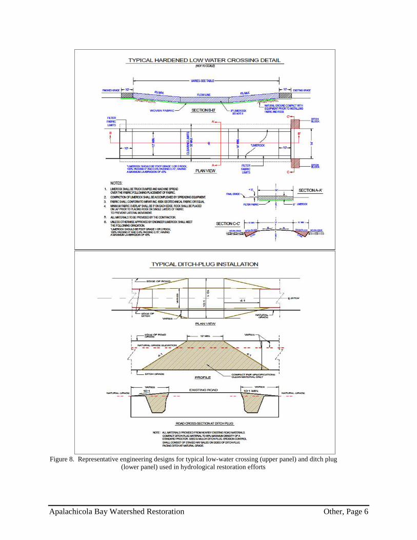
Figure 8. Representative engineering designs for typical low-water crossing (upper panel) and ditch plug
(lower panel) used in hydrological restoration efforts
Apalachicola Bay Watershed Restoration Other, Page 6

Figure 9. High priority areas for habitat restoration in Tate’s Hell State Forest
Apalachicola Bay Watershed Restoration Other, Page 7

PROPOSAL TITLE PROPOSAL NUMBER
LOCATION
SPONSOR(S)
TYPE OF FUNDING REQUESTED (Planning, Technical Assistance, Implementation)
REVIEWED BY: DATE:
Apalachicola Bay Watershed Restoration FL-2
Apalachicola Watershed within Florida
Florida
Planning/Technical Assistance/Implementation
Bethany Carl Kraft/ Ben Scaggs 11-18-14

1. Does the project aim to restore and/or protect natural resources, ecosystems, fisheries, marine and wildlife habitat, beaches, coastal wetlands and economy of the Gulf Coast Region?
YES NO
Notes:
2. Is the proposal a project?
YES NO
If yes, is the proposed activity a discrete project or group of projects where the full scope of the restoration or protection activity has been defined?
YES NO
Notes:
Proposal seeks funding for projects that will enhance water quality, aquatic ecosystems and association wetland and riparianhabitats within the watershed.

3. Is the proposal a program?
YES NO
If yes, does the proposed activity establish a program where the program manager will solicit, evaluate, select, and carry out discrete projects that best meet the program's restoration objectives and evaluation criteria?
YES NO
Notes:
4. Is the project within the Gulf Coast Region of the respective Gulf States?
YES NO
If no, do project benefits accrue in the Gulf Coast Region?
YES NO
Notes:

Eligibility Determination
Additional Information
Proposal Submission Requirements
1. Is the project submission overall layout complete? Check if included and formatted correctly.
A. Summary sheet F. Environmental compliance checklist
B. Executive summary G. Data/Information sharing plan
C. Proposal narrative H. Reference list
D. Location information I. Other
E. High level budget narrative
If any items are NOT included - please list and provide details
ELIGIBLE
✔ ✔
✔ ✔
✔ ✔
✔ ✔
✔

2. Are all proposal components presented within the specified page limits (if applicable)?
YES NO
Notes: