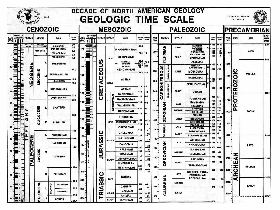
correlation and time’s arrow building a global history
TRANSCRIPT

Correlation and Time’s Arrow
Building a global history

Johann Gottlob Lehmann
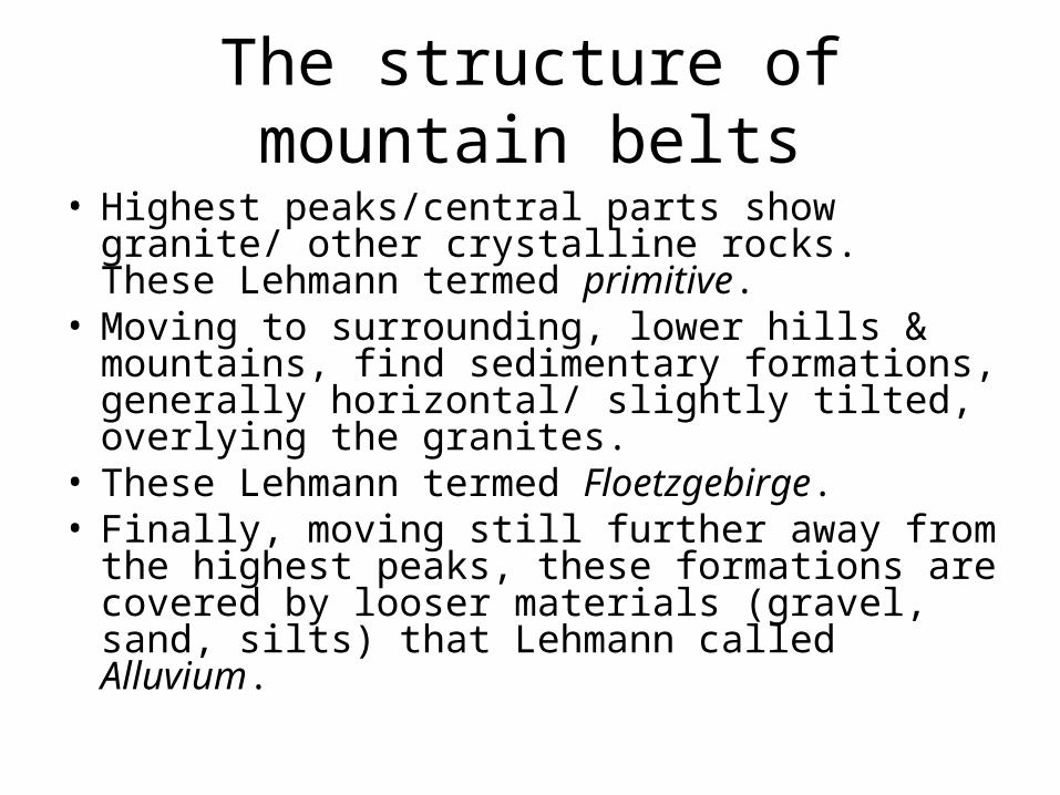
The structure of mountain belts
• Highest peaks/central parts show granite/ other crystalline rocks. These Lehmann termed primitive.
• Moving to surrounding, lower hills & mountains, find sedimentary formations, generally horizontal/ slightly tilted, overlying the granites.
• These Lehmann termed Floetzgebirge.• Finally, moving still further away from the highest
peaks, these formations are covered by looser materials (gravel, sand, silts) that Lehmann called Alluvium.
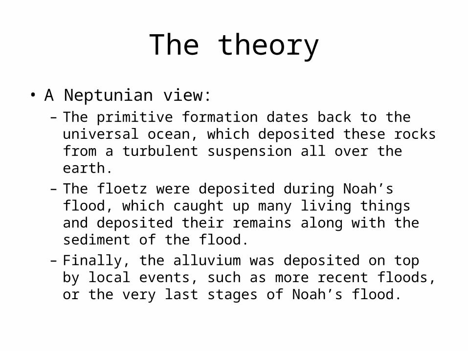
The theory
• A Neptunian view:– The primitive formation dates back to the universal
ocean, which deposited these rocks from a turbulent suspension all over the earth.
– The floetz were deposited during Noah’s flood, which caught up many living things and deposited their remains along with the sediment of the flood.
– Finally, the alluvium was deposited on top by local events, such as more recent floods, or the very last stages of Noah’s flood.
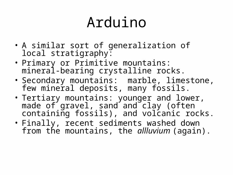
Arduino
• A similar sort of generalization of local stratigraphy:
• Primary or Primitive mountains: mineral-bearing crystalline rocks.
• Secondary mountains: marble, limestone, few mineral deposits, many fossils.
• Tertiary mountains: younger and lower, made of gravel, sand and clay (often containing fossils), and volcanic rocks.
• Finally, recent sediments washed down from the mountains, the allluvium (again).
General observations
• Rock units described in terms of the types of rock (crystalline vs. sedimentary of various types vs. volcanic)
• Presence or absence of fossils noted.• Superposition used to determine relative age.• Note Burnet’s theory fails here: If mountains
come in different ages, then a single disastrous flood event can’t explain them all.

Gotlob Werner
A directional history
• Hutton’s view of geology doesn’t include systematic change over time.
• For Hutton, as far as geology is concerned things have not changed. The cycles of erosion and sedimentation followed by uplift & collapse continue back into the past, and seem destined to continue indefinitely into the future.
• Werner takes a different view: for him, there is a ‘temporal arrow’ in the earth’s history, viz. (as with de Maillet) the withdrawal of the sea and the resulting changes in geological conditions & processes.
Background
• A serious interest in mineralogy; published a book on mineral identification (using colour, crystalline structure, hardness & other features) at 25, in 1774.
• Took a job at a mining school that year and stayed on until he died in 1817.
• A very successful teacher, attracted students from all across Europe.
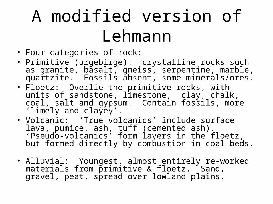
A modified version of Lehmann
• Four categories of rock:• Primitive (urgebirge): crystalline rocks such as granite,
basalt, gneiss, serpentine, marble, quartzite. Fossils absent, some minerals/ores.
• Floetz: Overlie the primitive rocks, with units of sandstone, limestone, clay, chalk, coal, salt and gypsum. Contain fossils, more ‘limely and clayey’.
• Volcanic: ‘True volcanics’ include surface lava, pumice, ash, tuff (cemented ash). ‘Pseudo-volcanics’ form layers in the floetz, but formed directly by combustion in coal beds.
• Alluvial: Youngest, almost entirely re-worked materials from primitive & floetz. Sand, gravel, peat, spread over lowland plains.
A later addition
• Transitional rocks are inserted between primitive and floetz.
• Largely crystalline, but includes some fossiliferous sedimentary rocks.
The Narrative
• When the history of the earth is told, in effect, by a sequence of rock-types characteristic of different periods, what we need to know is (of course) just what processes were going on, that produced these different rocks at different times.
• Werner begins with a universal ocean, covering a mysterious and hidden, irregular core.
• The ocean contained the materials of the primitive rocks in solution and suspension. As the ocean calmed, crystals precipitated and were deposited on the ocean floor. The level simply followed the irregularities of the core. Granite came first, with other rocks laid down later. (But some intermingled with the granite.)
Sea level falls (again)• Water was somehow decomposed, may have escaped into space.
• Solid particles begin to settle to the bottom to form rock too– here we finally get to the transitional rocks, mixing crystalline and sedimentary types.
• Islands emerge somewhere along here, but leave little trace.
• So both primitive and transitional rocks are considered universal.
• Continued lowering of water levels leads to floetz deposits: many fossils, some of these deposits are local only, as land masses grew in extent. Finally, alluvium was deposited as erosion on the surface produced and moved gravels, sands etc. to lower elevations.
Qualifications
• In the field this doesn’t all work out perfectly– the lines apply only in general, and there are exceptions/ intermediate cases.
• There were fluctuations in the water level from time to time, laying younger layers on top of some primitive layers that had been exposed and eroded.
• Steep folds and dips not due to tectonic movements, but instead reflect the curve/tilt of the underlying ‘core’.
• Deformation of sedimentary rock (which should have been horizontal when deposited) happened while the rock was still soft. (Again, playing down tectonic forces/ earth movements, so important to Hutton.)
Response
• This general division due to Lehmann and Werner was widely accepted in Europe up to the early 19th century.
• Applied to the U.S. by McClure.
• Finer divisions developed in Europe, distinguishing particular formations (systems) by their superposition relations and rock types.
Some details
• Von Humboldt used Jurassic to name a limestone formation exposed in the Jura Mountains.
• This dips under sequences of chalky limestones to the west, named Cretaceous (= Chalk).
• The Cretaceous formations are overlain in and around Paris by sands, clays, marls, limestones and gypsums. Arduino’s term, Tertiary, was applied to these.
• Alluvium over these formations came to be called Quaternary. Triassic (limestone between clay and sandstone) underlies the Jurassic formations along the Rhine valley. See p. 123 f for more…
Wales and the older rocks of Britain
• Older ‘transition’ beds in Wales & along its border were not sorted out by Smith.
• Too much folding & faulting– and fossils either rare or at least hard to extract. A major project in field geology.
• Early 1830’s, Sedgwick and Murchison set to work on it. • Murchison, in the south of Wales, identifies a system of
units underneath the Carboniferous (due to Conybeare and Phillips); each associated with distinctive fossils. Names it the Silurian, after a Welsh tribe.
• Sedgwick finds a three-part sequence of units in the north of Wales, and names it the Cambrian, Latin for Wales.
The conflict• At first, both thought their two systems fit together, with the Silurian
lying directly on top of the Cambrian.• Further study showed that the two actually overlapped.• Neither would yield part of his system to the other’s.• Long afterwards (around 1871) Lapworth showed that there were
distinctive fossils in the overlap, quite different from those in the remains of the Cambrian below and the Silurian above.
• Lapworth therefore interposed the Ordovician (named for another tribe in Wales) between the two.
• The Devonian was named by Murchison and Sedgwick before their conflict– it overlies the Silurian, and underlies the Carboniferous (and included the old red sandstone, previously attached to the Carboniferous).
• In 1840/41 Murchison traveled to Russia where he named the Permian, overlying the Carboniferous there, again distinct in its fossils.
Geological names
• From place names (Jurassic).• From rock types (Cretaceous).• From order (Tertiary, Quaternary still in use even though
primary & secondary are gone…)• From local names (tribes, towns, etc.).• Distinguished by rock types and also by their
characteristic fossils (which were key to sorting out disagreements and finding reasonable boundaries to draw).
• Particular rock-systems are not universal, and are highly variable in the sorts of rocks they include and their thickness.
Some basic rules
• What the names refer to: both the rock units and the times at which those units were laid down.
• The rocks are called systems (collections of systems are called terrains).
• The times are called periods (collections of periods are called eras).
• Type or reference sections: The standard examples of a particular rock system (sometimes differing from where they were first found).
Changes
• Interposing some (the Ordovician).
• Filling gaps (extending systems/periods so that the top lies conformably with the bottom of the next & vice versa.)
• Adjustments/ new information (an ambiguous bed with no tell-tale fossils may get re-assigned as new evidence comes along).