corporate no: c015 report council date: sept. 12/05 · - 3 - discussion the land use plan the...
TRANSCRIPT

Corporate NO: C015
Report COUNCIL DATE: Sept. 12/05
COUNCIL-IN-COMMITTEE
TO: Mayor & Council DATE: September 6, 2005
FROM: General Manager, Planning and Development FILE: 6520-20 (Grandview Heights – Area #1)
SUBJECT: Grandview Heights Area #1 (Morgan Heights) Neighbourhood Concept Plan - Stage II Report
RECOMMENDATION
It is recommended that Council:
1. Receive this report for information; 2. Approve the final and complete Grandview Heights Area #1 (Morgan Heights)
Neighbourhood Concept Plan (the "NCP"), as contained in Appendix "A" of this report, as a means to manage development of the Morgan Heights neighbourhood of Grandview Heights and to provide services, amenities and facilities in support of the development of this neighbourhood, based on Council’s approval of the Engineering Servicing Strategy for this NCP;
3. Instruct the City Clerk to introduce a by-law to amend Surrey Official Community Plan By-law 1996, No. 12900 (the "OCP By-law"), as documented in Appendix "B" of this report, to add the Grandview Heights Area #1 (Morgan Heights) NCP to Figure 27 entitled "Map Showing Recently Approved Secondary Plans" and to reflect the updated boundary between the Morgan Heights NCP and the Highway 99 Corridor Local Area Plan, as described in this report;
4. Instruct the City Clerk to introduce a by-law to amend Surrey Zoning By-law, 1993, No. 12000 (the "Zoning By-law), as documented in Appendix "C" of this report, to require amenity contributions on new development in the Grandview Heights Area #1 (Morgan Heights) NCP, based upon the density bonus concept, and to reflect the updated boundary between this NCP and the Highway 99 Corridor Local Area Plan; and
- 2 -
5. Instruct staff to bring forward any necessary OCP land use designation amendments for land in the Grandview Heights Area #1 (Morgan Heights) NCP, concurrently with the related site-specific rezoning applications.
INTENT
The purpose of this report is to: • Obtain Council approval for the final and complete Grandview Heights Area #1
(Morgan Heights) NCP; and • Obtain Council authorization to bring forward by-laws for the required readings to
formalize the amenity contribution requirements for this NCP and to recognize the Grandview Heights Area #1 (Morgan Heights) NCP within the OCP.
BACKGROUND
The Grandview Heights Area #1 (Morgan Heights) neighbourhood is situated in the northwest corner of the larger Grandview Heights community. The NCP area comprises approximately 80 hectares (196 acres) of land. It is bounded by the Highway 99 Corridor Local Area Plan to the west, 28 Avenue to the north, 24 Avenue to the south and 164 Street to the east. There are about 79 individual properties in the NCP area. The entire NCP area is currently designated for Suburban uses in the OCP. The NCP process for Morgan Heights was initiated by several development proponents who engaged the services of planning, engineering, transportation and environmental consultants to assist in preparing the NCP. In January 2005, Council approved a Terms of Reference for the preparation of an NCP for Area #1 (Morgan Heights) in Grandview Heights. On May 2, 2005, Council considered Corporate Report No. C006 (copy attached as Appendix "D"), regarding Stage I (i.e., the Land Use Concept Plan) for the Morgan Heights NCP and approved the recommendations of that report, which included authorizing staff to complete the Stage II component of the NCP. This included resolving several outstanding land use matters, preparing design guidelines, calculating the amenity contribution requirements and finalizing the servicing, phasing and financing strategies needed to implement the Land Use Plan. On June 20, 2005, Council approved the General Land Use Plan for the Grandview Heights community. That Plan provides general policies and guidelines for the preparation of the more detailed NCPs, including Morgan Heights. The Morgan Heights NCP is consistent with the policies and guidelines contained within the Grandview Heights General Land Use Plan. On June 21, 2005, the final public open house was held to present information to the public, regarding the Stage II component of the Morgan Heights NCP and to allow the public an opportunity to comment on the information.

- 3 - DISCUSSION
The Land Use Plan The proposed Final Land Use Plan for the Grandview Heights Area #1 (Morgan Heights) NCP is illustrated in Figure 4 of Appendix "A". It features a range of residential uses and densities. This mix is consistent with the OCP policies on complete communities, variety of housing types and balancing suburban lifestyles and future development. The uses and distribution of densities is also consistent with the policies and designations contained in the approved Grandview Heights General Land Use Plan. The residential densities in the NCP range from 6 to 45 units per acre (15 to 112 units per hectare). Single-family and duplex dwelling units will be permitted in areas designated as Low Density Residential (6-10 units per acre/15-25 units per hectare). In areas designated for Medium Density Residential uses (10-15 units per acre/25-37 units per hectare), small lots, townhouses and row houses will be permitted. The higher density residential areas are generally located on the plan area’s western boundary, adjacent to the Highway 99 Corridor Plan. In areas designated Medium-High Density Residential areas, residential developments with densities ranging from 20 to 30 units per acre (50-75 units per hectare) will be permitted. This may include a variety of townhouse forms, as well as row houses. In the High Density Residential designation (30-45 units per acre/75-112 units per hectare), apartments and higher density forms of townhouses will be permitted. Given the NCP's proximity to the commercial uses proposed in the Highway 99 Corridor Plan area, no commercial nodes are proposed within the Morgan Heights NCP. Appropriate transitions between residential land uses of lower and higher densities are included in several locations within the plan area and are detailed in Section 2.5 of the NCP document. This pertains particularly to 28 Avenue (and the interface with the North Grandview Heights NCP Area) and along the west side of 164 Street, which interfaces with the future Grandview Heights Area #5 NCP. The developers of the commercial sites on the north side of 24 Avenue, abutting the Morgan Heights NCP, will be required to construct appropriate buffers along the boundaries of these commercial areas to mitigate any impacts that commercial activities may have on the adjacent Morgan Heights residential sites. The Land Use Plan, when fully implemented, is expected to generate approximately 2,350 residential units, resulting in a population of approximately 5,400 people. Three new neighbourhood parks are proposed in the NCP area. A park proposed near the southwest corner of 28 Avenue and 160 Street will incorporate the Wills Brook ravine, and is also proposed to include active recreation amenities on the 27 Avenue frontage. A pathway through this park will connect it to a proposed traffic signal at 160 Street and 28 Avenue. This will facilitate pedestrian access to the future elementary school and linear park within the North Grandview Heights NCP area, west of 160 Street. East of 160 Street in Morgan Heights, two new parks are proposed. The linear park east of Southridge School will have treed areas, a pathway and benches. It may also incorporate storm water detention features. The easternmost park, at approximately 27 Avenue, east of 162 Street, will be a natural park set aside to protect an important stand of trees.
- 4 -
The pedestrian network in Morgan Heights is comprised of sidewalks, multi-use pathways, park trails and walkways. This system will allow residents to move easily between destinations within the NCP area. It will also provide links to the school and park sites within the North Grandview Heights NCP Area and to the commercial lands within the Highway 99 Corridor Plan. Together with the proposed land use mix and related design guidelines, this pedestrian network helps achieve OCP policies related to creating a safe, attractive and pedestrian friendly environment. The final Land Use Plan is generally consistent with the Stage I Land Use Plan approved by Council in May 2005. However, three amendments are proposed, as described below: 1. The final Land Use Plan shows an Optional Land Use for the area located on the
west side of 160 Street, north of 27 Avenue, adjacent to the neighbourhood active park. The Stage I Plan illustrated this site as "up to 15 upa". Since the time of the Stage I approval, interest has been shown in developing this site as a care and assisted living facility. This proposal will be further discussed later in this report. The final Land Use Plan continues to provide for the Medium Density Residential Use, but also allows for the care and assisted living facility, subject to its integration into this residential area;
2. The residential area immediately east of Southridge School and the future linear
park, was designated for "up to 8 upa" in the Stage I report. Since that time, more detailed site planning has taken place by a proponent who anticipates achieving up to 10 units per acre in a strata duplex form of development in this area. This slight increase in density is consistent with the provisions of the General Land Use Plan for Grandview Heights and will also be discussed later in this report; and
3. To ensure development that is consistent with the vision for the Morgan Heights
NCP and to provide a threshold of development that is necessary to fund the required infrastructure, a minimum and a maximum density has been included in each of the land use designations.
Heritage Conservation Based on the Heritage Study undertaken for the overall Grandview Heights Area, the heritage value and corresponding character-defining elements in this NCP are mainly in the natural landscape and how it was transformed through logging, settlement, farming and residential estate development over the years. The heritage value and heritage character of this area will be integrated into the fabric of new development in the Morgan Heights neighbourhood through the development approval process. The natural, built and historical attributes of Morgan Heights include significant viewpoints, view corridors and prominent geographic points. The heritage of the area will also be celebrated in place names of subdivisions, parks, trails, etc. Sustainable Features The Morgan Heights NCP incorporates policies, best management practices and servicing strategies that encourage sustainable development, consistent with the environmental

- 5 -
policies identified in the Grandview Heights General Land Use Plan. The following are included in the NCP: • Specific planning objectives to minimize any environmental impacts on the
hydrologic regime associated with redevelopment and to integrate key woodlands and Wills Brook into the neighbourhood;
• Urban densities that are more supportive of transit use and the integration of trail systems to provide for convenient pedestrian access throughout the neighbourhood;
• Detention ponds, infiltration systems and diversion structures that will reduce erosion in Wills Brook and other watercourses;
• Direction of street storm water run-off to catch basins connected to drain rock trenches. Infiltration capacity may be supplemented with the installation of perforated lawn drains to ensure safe conveyance of excess runoff to storm sewers;
• Building sites that allow for infiltration and reduced runoff by reducing the total
impermeable surfaces and by routing the drainage from impervious areas through grass areas to pervious areas;
• Biofiltration landscaping and the planting of suitable shade trees to promote
evapotranspiration; and
• Other at-source controls, which may include on-lot infiltration gardens or pits, rainwater detention in cisterns, community detention ponds, reduced driveway/pavement widths, reduced-slope lot grading and swales and permeable paving.
Land Use Issues The Corporate Report forwarded to Council at the time of Stage I approval (Appendix "D") identified eight land use issues that were to be addressed as part of the Stage II component of the NCP development. The following discussion contains a description of each issue and a description of how the issue is addressed in the final NCP document: 1. Environmental Advisory Committee Plan Consideration
Surrey’s Environmental Advisory Committee (EAC) requested an opportunity to consider the proposed land use plan and environmental recommendations so that any concerns and comments could be addressed in the NCP. The NCP was reviewed by the EAC at its meeting on June 15, 2005. The EAC expressed a concern related to topography and runoff issues, due to slopes in the area. Council reviewed the EAC’s recommendation to Council and concluded that staff would address, at the development application review stage, the width of riparian areas along watercourses. A specific policy regarding this has been added to the Environmental Management section of the NCP.

- 6 -
Several Class B watercourses are present within the Morgan Heights NCP area, as illustrated in Figure 7 of Appendix "A". The upper end of Wills Brook, located in a ravine at the southwest corner of 160 Street and 28 Avenue, will be protected within a future park site. The other existing watercourses are primarily roadside and farm field ditches that will be replaced, in most instances, with storm sewers. A habitat compensation plan has been prepared, which anticipates achieving a gain in fish habitat.
2. Pedestrian/Bicycle Plan
The Stage I Report noted that the pedestrian/bicycle plan needed to be refined to show the locations and widths of paths along roads (whether they would be on street or adjacent pathways) and the connection to the Millennium Trail (Pioneer Greenway) in the Grandview Corridor. The plan also needed to address linkages and interconnectivity between the cul-de-sacs and other internal roads to the main pedestrian/cycling routes (160 Street). The Pedestrian Circulation Plan (Figure 5 of Appendix "A") consists of a network of multi-use pathways, trails through parks, walkways and sidewalks. This network has been refined to allow access to areas both within and surrounding the Morgan Heights neighbourhood. The fine-grained pedestrian circulation system will give residents convenient, safe and alternative routes by which to move about the neighbourhood. A multi-use pathway on 24 Avenue will consist of a three metre paved path within an eight metre right-of-way on the north side of the street. It will provide a link between the Grandview Heights community and the proposed commercial activities at 24 Avenue and 160 Street. All three of the proposed parks in the Morgan Heights NCP will have internal trails and pathway connections to the sidewalks on adjacent streets. Except for a few short segments on limited local roads, sidewalks will be provided on both sides of all streets. Walkways are shown conceptually on the Pedestrian Circulation Plan and are described within the "Circulation" section of the NCP document. The exact location of each walkway may be adjusted at the time of subdivision and rezoning of the parcels within which they are located. Sidewalks on both sides of 160 Street and a signalized intersection at 160 Street and 28 Avenue will facilitate pedestrian access to the North Grandview Heights area and the future park located on the west side of 160 Street. A connection will be provided to the multi-use trail that is to be built within the North Grandview Gravity Sewer Interceptor right-of-way in the North Grandview Heights NCP area. Pedestrian connections will also be provided to the Pioneer Greenway, located within the BC Hydro right-of-way in the Highway 99 Corridor Plan area, at 158 Street and 26 Avenue and through future multiple residential development sites on rights-of-way.

- 7 -
3. Local Road Configuration The Stage I report identified the need to finalize the local road network to ensure satisfactory fire and emergency access and pedestrian walkways. Convenient pedestrian access from the P-loops and cul-de-sacs to major pathways and destinations in the neighbourhood was to be planned. The local road network, illustrated on the Land Use Plan, has been refined to eliminate P-loop roadways and to improve circulation. The Engineering Department has reviewed the revised road layout and is satisfied that emergency access is adequate. Pedestrian access within Morgan Heights, as discussed above, is reflected in the Land Use Plan and Pedestrian Circulation Plan in the NCP document.
4. Lot Layout Revisions
The lot layout pattern in the easterly part of the NCP was to be revised to avoid the creation of double fronting lots. Crime Prevention Through Environmental Design (CPTED) practices needed to be applied to those lots immediately adjacent to parks, open spaces and walkways.
Revised lot layouts have been developed to demonstrate that the NCP can be developed without the inclusion of double fronting lots. Many future single-family lots and multiple residential development sites will back onto or abut proposed parks and walkways. The NCP document contains policies/design guidelines that act to ensure that houses on these lots are designed to provide surveillance into these spaces, through the use of windows, decks and low fences, and other features. More specific design details will be determined at the development application review stage for such lots and will be incorporated into the Building Scheme that will be registered on the title of each such lot. Gate access will only be allowed from individual lots to active park areas.
The Design Guidelines in the NCP also document the various means by which future multiple residential development sites will contribute to park safety. Residential buildings will be encouraged to have low fencing along the private property lines that abut the parks. The use of windows, patios and decks will encourage surveillance of the parks. Gates that provide access to the active portions of the parks will be encouraged. Landscaping along any common property line between each multiple residential site and any park will be of a "low height" variety so as to maintain sightlines.
5. Stormwater Detention Ponds
The use and design of storm detention ponds or water retention facilities in the linear park near Southridge School was to be resolved.
Storm water management in the Morgan Heights NCP may require the construction of detention ponds in some of the future park areas. A number of potential detention pond locations have been identified. However, more detailed
- 8 -
engineering work is required to establish which, if not all, of these locations are necessary. The storm water management plan for the Morgan Heights NCP is focused on maintaining base flows in Wills Brook, reducing volumes through source separation, reducing peak flows through the use of detention and maintaining high runoff water quality though biofiltration systems.
6. Environmental Compensation
Details of the proposed environmental compensation in the park west of 160 Street were to be finalized. Compensation will be required to offset losses related to the closure of several watercourses within the NCP area. The park, west of 160 Street, is considered a good location for compensation related to the closure of a Class B watercourse along 28 Avenue. The park will contain and preserve the Wills Brook ravine. The conceptual habitat compensation plan for Morgan Heights was presented to the Department of Fisheries and Oceans, through the Environmental Review Committee. Conceptually, the habitat compensation plan for the NCP area, as a whole, is acceptable. However, the Department of Fisheries and Oceans will review the final design of the compensation arrangements at the development application review stage in relation to those applications that propose the closure of existing watercourses.
7. Tree Retention in the Northeast Park (Nature Park)
The location of trees in the proposed nature park (in the northeast area of the NCP) and measures to protect them were to be resolved. This park contains a significant cluster of large Douglas Firs that are considered to be the best quality trees in the NCP area. A complete tree survey of the proposed park and its vicinity was completed in June 2005. The fir trees in question are tall, with generally good trunk taper and overall excellent health. The Parks, Recreation and Culture Department is satisfied that the majority of these significant trees can be retained, based on the parkland area proposed for acquisition. Prior to any land clearing for development near the park, fences will be erected to protect this significant stand of trees.
8. Southridge School
The proponents of the Morgan Heights NCP were directed to continue working with the City and Southridge School to resolve issues regarding potential tennis courts, road design and traffic operations on 160 Street, and buffering and design guidelines in the area.
A representative for Southridge School had expressed an interest in constructing a tennis court, as a shared community amenity, in the vicinity of the linear park. Although a suitable location has not been identified, the proponents and the School continue to work together on this issue.
- 9 -
A traffic consultant was retained to prepare a detailed cross section of 160 Street, between 24 Avenue and 28 Avenue, that includes the frontage of the Southridge School site. Turning lanes will be provided at the entrances to the School site. Both Southridge School and the Engineering Department are satisfied that congestion and safety issues will be adequately addressed as the area redevelops. The NCP specifically addresses the buffers and transitions between the school and adjacent development sites. The proposed multi-family dwellings, adjacent to the school’s southern boundary, will be a maximum of two-storeys in height. A fence and landscaped strip will be planted along the property line on the multi-family site. Architectural compatibility will be ensured through the Development Permit process. Along the north and east sides of the school, single-family homes are proposed. The form and character of these new single-family homes is to be compatible with the high design standard established by Southridge School. This will be reviewed as part of the Building Scheme approval process for the subject single-family residential lots. Representatives from Southridge School have reviewed all of the proposed transition areas and are satisfied.
Two additional land use issues emerged during the process of completing Stage II of the NCP planning process and are discussed below.
9. Optional Care and Assisted Living Facility (Northwest Corner of 27 Avenue
and 160 Street)
During the Stage II process, parties interested in developing a care and assisted living facility, expressed an interest in placing such a facility on properties on the west side of 160 Street between 27 Avenue and the proposed park. While the rear parts of the lots in question are designated for park use, the front portions were designated in the Stage I Land Use Plan as residential uses at a density of up to 15 units per acre.
Staff has been advised that the South Fraser Health Authority has approved funding for a care and assisted living facility on this a three acre site. The facility would be approximately 100,000 square feet in floor area and contain about 110 complex care beds and about 45 assisted living units. The proponents have advised that the facility would offer a high quality seniors’ care environment that would respond to site conditions and be well integrated with the adjacent park. The preliminary design shows a complex that is residential in character and that should relate well with the existing and future housing in the area. The proposed facility would have a floor space ratio of 0.9 and maximum site coverage of approximately 35%, so as to permit ample landscaping and open space on the site. The height of the care facility portion is not expected to exceed two storeys. The assisted living component may be up to four storeys in height.
Allowing such a use as an optional use for the site would contribute to housing diversity within the NCP area and would not affect the objectives for the NCP. The location would offer residents, staff and visitors proximity to a park and to future commercial uses at 160 Street and 24 Avenue.
- 10 -
The Final Land Use Plan illustrates "community care and assisted living facility" as an optional use for the subject site. Amenity contributions for fire and police only would be collected for the care facility units and the full normal range amenity contributions would be collected for the assisted living units. This optional land use proposal was presented to the public at the open house held on June 21, 2005. The proposal has also been discussed with representatives of the neighbouring Southridge School. No negative comments have been received.
10. Residential Site east of the Proposed Linear Park
During the process of completing the Stage II component of the NCP, the density of the proposed residential area, immediately east of Southridge School and the future linear park, was reviewed. This area was designated for "up to 8 upa" in the Stage I report. Detailed site planning, undertaken by a prospective developer of this site, has indicated the potential to build approximately 100 residential units in a duplex form, at a density of 10 units per acre.
This slightly higher density is well within the maximum range of up to 15 units per acre identified for this area in the Grandview Heights General Land Use Plan. The preliminary site plan shows dwelling units arranged around substantial internal open space and a pathway connection to the linear park. The proposed increase in density is relatively minor, yet will contribute to increasing the variety of housing types in the Morgan Heights area. The revised site plan also provides an opportunity to enhance the northern entrance to the linear park.
Public Consultation A number of opportunities were provided for public input and comment during the preparation of the NCP, as follows: 1. A Citizens Advisory Committee ("CAC") was formed in February 2005 and CAC
meetings were held at milestones during the planning process; 2. Three meetings were held with area property owners in February 2005. Input was
received on a number of topics, including park locations, servicing, land use and environmental issues;
3. A technical review meeting was held on March 14, 2005 to discuss servicing and
environmental information; 4. A presentation on the progress of the NCP was made to the Grandview Heights
CAC on March 17, 2005; 5. A Public Open House was held on March 31, 2005 at which information about
Stage I of the NCP was presented, including the preliminary land use, engineering servicing, environment and design options;
6. A Public Open House was held on June 21, 2005 at which information about the
Stage II component of the NCP was presented, including information about

- 11 -
outstanding land use issues and proposed revisions to the land use plan, engineering servicing, financing and phasing strategy and amenity contributions; and
7. Input to the development of the plan was also received by way of written
submissions from individual property owners and others and through meetings with owners and others on site-specific issues.
Questionnaires were available at each open house for those who wished to submit written comments. Prior to the second open house, a meeting was held with the CAC and stakeholders to discuss the results of the previous public open house and to advise as to how public comments/concerns had been addressed. The Land Use Plan was supported by a majority of the people who attended the open house in March 2005, prior to Council's approval of the Stage I Land Use Plan in May 2005. Approximately 100 people attended the open house for the Stage II component of the Plan, held on June 21, 2005. After the second open house, a total of 19 questionnaires were submitted to the City. Thirteen of these responses expressed support, in general, for the Stage II component of the NCP. Three respondents said they did not support it, while three others did not reply to that question. The specific comments received through this process, along with staff’s response to each comment, are documented in the following paragraphs. • Sanitary Sewer
Five respondents commented on the proposed sanitary sewer that will service the NCP area. Three people were concerned about the timing and location of the proposed North Grandview Gravity Interceptor. The basis of the sanitary servicing strategy is that all development within the NCP catchment area will ultimately connect to the Grandview North Gravity Interceptor at 160 Street, north of 28 Avenue. This interceptor roughly follows the 55-metre contour line through the area. Detailed design and construction of Phase 1 of the Interceptor is scheduled for completion by 2005/2006, subject to right-of-way acquisition and completion of environmental and geotechnical work and is discussed in more detail in the Engineering Report on the Stage II Plan that will be forwarded to Council on the same agenda as this report.
• Detention Ponds
Four respondents mentioned detention ponds, both as positive and negative features of the Plan. The NCP includes an environmental management plan that is intended to mitigate and offset the environmental impacts associated with planned development within the area. It is possible that wetlands and ponds may be provided in the proposed parks as compensatory works. Such features can provide important, compensatory aquatic habitat, as well as be visually pleasing spaces. However, it is also recognized that parkland used for storm water facilities does compromise, to some extent, the utility of the space for park use. The location and number of such ponds and wetland features, including design details, are described in the Engineering Report on the same agenda as this report and will be finalized at the time of development application review, involving the developer, the developer’s consultants
- 12 -
and the Engineering and Parks, Recreation and Culture Departments. If such ponds are required, regular maintenance will be carried out to ensure they are kept in a clean operating condition.
• Transportation
Two respondents expressed concern about transportation related issues, including the local road network and requested traffic calming. The traffic calming plan in the NCP includes traffic circles, textured crosswalks and curb extensions at several locations. Traffic flows, based on build out volumes, will be accommodated in a safe and convenient manner. Minor adjustments to road locations may be made at the time of development application review.
• Trees and Green Space
Four people commented about trees and green space. One said that the area looks like it will be well planned, with consideration for nature. Another said the plan looks "good" because it keeps a lot of trees. Other comments related to values of green areas, emphasis on maintaining the local rural character and respect for environmentally sensitive areas. Preliminary tree surveys have been undertaken. Based on these surveys, a stand of significant trees is being kept in each of the nature park and in the 164 Street right-of-way. More detailed tree surveys will be required at the time of development application for each individual site in the NCP. Significant trees that cannot be retained will be replaced in accordance with the City’s Tree Preservation By-law.
Amenity Requirements In accordance with Council policy, to address the impact of new growth, all new residential development in the Morgan Heights NCP will be required to make a monetary contribution toward the provision of police, fire protection, library services and park amenities. The site that is designated with an optional land use to allow for a "care and assisted living facility", if developed as a care and assisted living facility, will provide amenity contributions for fire and police services only for the care facility units and for a full range of amenity contributions for the assisted living units. The amenity contribution for the care facility component of the facility will be based on a density equivalent of 4 units per acre, in keeping with standard practice. The amenity contribution for the assisted living component will be based on the actual number of residential units. The amenity contributions toward police, fire and library materials will offset the capital costs of providing these services for the new development in the area. The contributions for such services are collected on a uniform basis in all of Surrey's NCP areas. Monetary contributions toward park development are based on an estimate of the capital costs of the development of NCP-specific park amenities. In the Morgan Heights NCP, the following park improvements and amenities are to be funded by the amenity contributions:

- 13 -
• improvements in three neighbourhood parks; • tree management, trails and active recreation amenities, where appropriate; and • amenities in future community parks and greenways within greater Grandview
Heights.
The following table summarizes the applicable amenity contributions (per dwelling unit or acre) by land use and also provides an estimate of the total revenue the City can expect from the amenity contributions at build out of the NCP:
Grandview Heights Neighbourhood Concept Plan Area #1 (Morgan Heights)
Amenity Contributions
Residential Contribution Per Unit/Lot
(Based on 2,343 New Dwelling Units)
Non-residential Contribution
Per Acre
Anticipated Revenue at Build-out
Park Development $1,075.00 n/a $2,518,725.00
Library Materials 127.97 n/a 299,833.71
Police Protection 56.89 $227.56 133,293.27
Fire Protection 245.71 $982.84
575,698.53
Total:
$1,505.57 per new unit/lot
$1,210.40 per acre
$3,527,550.51
Implementation of the NCP
1. Amendments to the OCP and NCP
Include Morgan Heights NCP as a Secondary Plan Subject to Council approval of the Grandview Heights Area #1 (Morgan Heights) NCP, the OCP will need to be amended to include this new NCP as a recognized secondary plan. NCP Boundary Adjustment During preparation of this NCP, a land exchange occurred between the proponents of the Morgan Heights NCP and the developers of the Grandview Corners commercial project. The exchange pertained to a small triangular portion of a lot on the east side of side of 160 Street, north of 24 Avenue, that is currently included within the Highway 99 Corridor Local Area Plan. The subject piece of land is illustrated on Appendix "E". As a result of this land exchange, this small piece of land has been included in the Morgan Heights NCP. Its designation for residential uses was approved by Council as part of the Stage I Land Use Plan for

- 14 -
Morgan Heights. This boundary adjustment will have the effect of slightly increasing the size of the residential NCP and slightly reducing the size of the commercial area. The necessary amendments to the OCP are documented in Appendix "B". OCP Land Use Designation Amendments In keeping with the practice followed in relation to other NCPs, OCP land use designation amendments required to implement the NCP Land Use Plan (e.g. from Suburban to Multiple Residential, Commercial or Urban) will be processed concurrently with site-specific rezoning applications. Any NCP amendments that are proposed after Council approves the NCP will be addressed in accordance with the OCP policy related to amendments to secondary plans.
2. Zoning By-law Amendment for Amenity Contributions
The Zoning By-law must be amended to add the Grandview Heights Area #1 (Morgan Heights) NCP to the list of NCPs within which amenity contributions are required. An amendment is also required to correct the boundaries of the Highway 99 Corridor Local Area Plan, as discussed above. The proposed amendments to Schedules F and G of the Zoning By-law, to incorporate the amenity contributions for Grandview Heights Area #1 (Morgan Heights) NCP and to replace the map for the Highway 99 Corridor Local Area Plan, are documented in Appendix "C".
3. Form and Character of New Development
The Morgan Heights NCP will be the first neighbourhood to develop within the context of the recently approved Grandview Heights General Land Use Plan. To ensure compatibility between the new single-family residential developments and the existing residential developments in the surrounding areas, character guidelines are to be developed in conjunction with each development application and administered through the building scheme process, as is the case with all new single-family residential developments in the City. The design of multiple residential developments will also be required to be sensitive to the character of the surrounding uses. For multiple residential developments, this will be ensured through the Development Permit process. The design guidelines, as set out in Section 2.6 of the NCP, and as contained in the OCP, will apply to all development in the Plan area.
- 15 -
4. Servicing, Financing and Phasing
Servicing, including details of roads, sanitary sewers, storm water management and the provision of municipal water services, financing of development and phasing plans have been prepared to support and allow reasonable implementation of the NCP and are described in a separate Corporate Report from the Engineering Department that will be forwarded to Council for consideration at the same meeting as this report. Council approval of the Stage II Plan should be contingent upon Council’s concurrent approval of the servicing and financial strategy as contained in the Engineering Department report.
CONCLUSION
As the first NCP area to develop within Grandview Heights, the Area #1 (Morgan Heights) NCP responds to the planning policies and objectives of the OCP and is consistent with the policies and principles of the Grandview Heights General Land Use Plan. The NCP has been developed in consultation with the property owners and area stakeholders and is supported by a majority of the owners and residents of the area. Amenity contributions have been identified to fund the various amenity needs of the area. Based on the above discussion it is recommended that Council:
• Approve the final and complete Grandview Heights Area #1 (Morgan Heights) NCP,
as contained in Appendix "A" of this report, as a means to manage development of the Morgan Heights Neighbourhood of Grandview Heights and to provide services, amenities and facilities in support of the development of this neighbourhood based on Council’s approval of the Engineering Servicing Strategy for this NCP;
• Instruct the City Clerk to introduce a by-law to amend the OCP By-law, as
documented in Appendix "B" of this report, to add the Grandview Heights Area #1 (Morgan Heights) NCP to Figure 27 entitled "Map Showing Recently Approved Secondary Plans" and to reflect the updated boundary between the Morgan Heights NCP and the Highway 99 Corridor Local Area Plan, as described in this report;
• Instruct the City Clerk to introduce a by-law to amend the Zoning By-law, as
documented in Appendix "C" of this report, to require amenity contributions on new development in the Grandview Heights Area #1 (Morgan Heights) NCP, based upon the density bonus concept, and to reflect the updated boundary between this NCP and the Highway 99 Corridor Local Area Plan; and

- 16 -
• Instruct staff to bring forward any necessary OCP land use designation amendments for land in the Grandview Heights Area #1 (Morgan Heights) NCP concurrently with the related site-specific rezoning applications.
Original signed by
Murray Dinwoodie General Manager Planning and Development
TA/kms/saw Attachments: Appendix "A" - Final NCP Appendix "B" - OCP Amendment to Figure 27 Map Appendix "C" - Surrey Zoning By-law Amendments to Schedules F and G Appendix "D" - Corporate Report No. C006 Appendix "E" – Map showing boundary adjustment between Highway 99 Corridor LAP and
Morgan Heights NCP v:\wp-docs\admin & policy\05data\july-sept\08301117.ta.doc KMS 9/15/05 12:32 PM
Appendix "A" Appendix "A"
Grandview Heights Area
Neighbourhood Concept Plan #1
Morgan Heights
Stantec Consulting Aplin & Martin Consultants Jorden Cook Associates Phoenix Environmental Services Ward Consulting Group Senga Landscape Architecture Michael J. Mills Consulting James Fensom Architect
September 7, 2005
Acknowledgements
The City of Surrey acknowledges the contributions and participation of the following people and organizations in the Grandview Heights Area #1 Neighbourhood Concept Plan preparation process:
City
of Surr
ey
City of Surrey Murray Dinwoodie, General Manager, Planning and Development Department Judy McLeod, Manager, Long Range Planning & Policy Development Greg Mitchell, Planning & Development Department Hernan Bello, Planning & Development Department Ingrid Matthews, Planning & Development Department Jean Lamontagne, Planning & Development Department Raul Alleuva, Planning and Development Department Tiina Mack, Planning & Development Department Tina Atva, Planning & Development Department Wendy Whelen, Planning & Development Department Jaime Boan, Engineering Department John Wilson, Engineering Department Brad Fisher, Engineering Department Remi Dube, Engineering Department Mirjana (Mira) Petrovic, Engineering Department
NCP Advisory Committee Participants Gord Cameron (East Sector) Rita Krause (East Sector) David McCue (West Sector) Albert Svab (West Sector)
Other NCP Advisory Committee Participants Norm Fleenor (Area C) Rick Clough (Area J) Roy Langton (Area K) Joyce Gordon (Area L) Dale Quelch (North Grandview) Gary Scott (West Grandview Heights Residents Association)
Neighbourhood Plan Consulting Team Stantec Consulting Aplin & Martin Consultants Jorden Cook Associates Phoenix Environmental Services Ward Consulting Group Michael J. Mills Consulting James Fensom Architect Senga Landscape Architecture

Table of Contents Table of Contents Table of Contents Table of Contents
Part 1 Background
1.1 Introduction 1 1.2 Plan Area 1 1.3 Planning Context 1 1.4 Planning Process & Consultation 2 1.5 Opportunities & Constraints 4
Part 2 Planning Vision, Objectives & Policies
City
of Surr
ey
2.1 Planning Vision 6 2.2 Specific Objectives 6 2.3 Overall Concept 7 2.4 Land Use Components 8 2.5 Land Use Transitions 11 2.6 Design Guidelines 19 2.7 Environmental Management 27 2.8 Land Use & Population Statistics 31 2.9 Transportation 32
Part 3 Implementation 3.1 Official Community Plan Amendments 34 3.2 Neighbourhood Concept Plan Amendments 34 3.3 Rezoning 34 3.4 Subdivision 34 3.5 Development Permit Area Guidelines 34 3.6 Amenity Contributions 34 3.7 Servicing, Phasing, and Financial 35
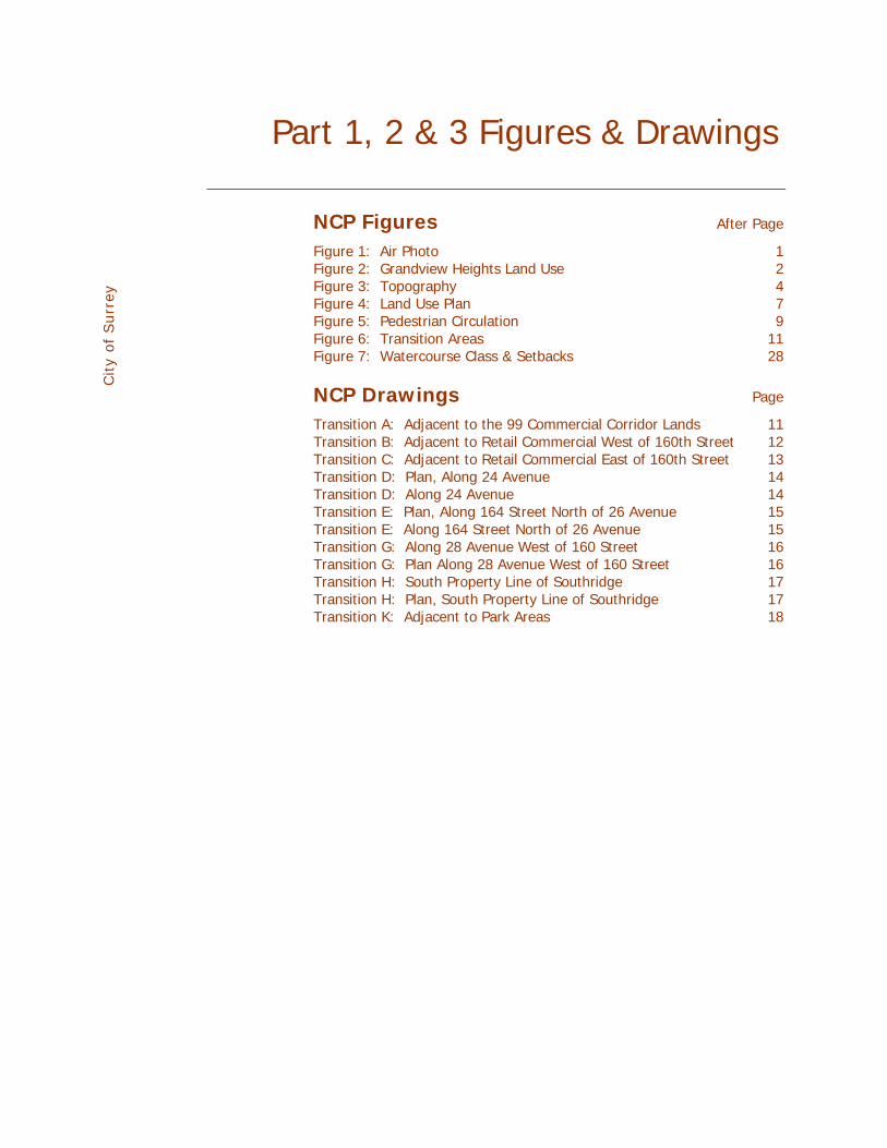
Figures & Graphics Part 1, 2 & 3 Figures & Drawings
NCP Figures After Page Figure 1: Air Photo 1 Figure 2: Grandview Heights Land Use 2 Figure 3: Topography 4
City
of Surr
ey
Figure 4: Land Use Plan 7 Figure 5: Pedestrian Circulation 9 Figure 6: Transition Areas 11 Figure 7: Watercourse Class & Setbacks 28
NCP Drawings Page Transition A: Adjacent to the 99 Commercial Corridor Lands 11 Transition B: Adjacent to Retail Commercial West of 160th Street 12 Transition C: Adjacent to Retail Commercial East of 160th Street 13 Transition D: Plan, Along 24 Avenue 14 Transition D: Along 24 Avenue 14 Transition E: Plan, Along 164 Street North of 26 Avenue 15 Transition E: Along 164 Street North of 26 Avenue 15 Transition G: Along 28 Avenue West of 160 Street 16 Transition G: Plan Along 28 Avenue West of 160 Street 16 Transition H: South Property Line of Southridge 17 Transition H: Plan, South Property Line of Southridge 17 Transition K: Adjacent to Park Areas 18

City
of Surr
ey
Part 4 Engineering Servicing Plan
Note: Part 4 under separate cover 4.1 Introduction
4.2 Transportation and Roads 4.2.1 Internal Network Street Cross-Section Elements 4.2.2 Transit 4.2.3 Pedestrians and Cyclists 4.2.4 Sidewalks 4.2.5 On-Street Parking 4.2.6 Traffic Calming Measures 4.2.7 Geometric Design 4.2.8 Street Lighting 4.2.9 Summary
4.3 Drainage and Stormwater Management 4.3.1 Overview 4.3.2 Best Management Practices 4.3.3 Green Infrastructure Performance Standards and Guidelines 4.3.4 Minor and Major Servicing 4.3.5 Watercourse Diversions 4.3.6 Stormwater Detention 4.3.7 Lowland Drainage 4.3.8 Areas South of 25 Avenue 4.3.9 DCC Funding and Expenditures 4.3.10 Summary
4.4 Sanitary 4.4.1 Sanitary Catchment 4.4.2 Grandview North Gravity Interceptor 4.4.3 Interim Sanitary Sewer 4.4.4 Sanitary Sewer Design 4.4.5 Local Sewers 4.4.6 DCC Funding and Expenditures 4.4.7 Summary
4.5 Water 4.5.1 Background 4.5.2 Grandview Reservoir 4.5.3 Proposed Upgrades 4.5.4 Proposed Interim Servicing 4.5.5 Ultimate Servicing 4.5.6 DCC Funding and Expenditures 4.5.7 Summary

City
of Surr
ey
4.6 Utilities (BC Hydro, Telus, Terasen Gas, Cable) 4.6.1 Power 4.6.2 Telus and Cable TV 4.6.3 Terasen Gas
4.7 Development Phasing
4.8 Infrastructure Financing and Funding 4.8.1 DCC Elements 4.8.2 Financing Options 4.8.3 DCC Revenues and Expenditures / Cash Flow Analysis

Part 4 Figures
4.2.1 Road Network 4.2.2 Limited Local 4.2.3 Through Local - Low Density
City
of Surr
ey
4.2.4 Through Local - High Density 4.2.5 Through Local - Commercial 4.2.6 Drain Rock Trench - Plan View 4.2.7 Drain Rock Trench - Section View 4.2.8 Drain Rock Trench - Section at Catch Basin 4.2.9 Drain Rock Trench - Section at Lawn Basin 4.2.10 164 Street - Major Collector 4.2.11 28 Avenue - Major Collector 4.2.12 160 Street - Arterial 4.2.13 Bicycle and Pedestrian Circulation Plan 4.2.14 Traffic Calming and Parking Management Plan 4.2.15 4.2.15a Traffic Circle 4.2.16 4.2.15b Traffic Circle - Detail 4.2.17 Local Road Curb Extensions 4.2.18 Curb Extensions at Collector or Arterial
4.3.1 Stormwater Drainage Study Area 4.3.2 Proposed Storm System 4.3.3 Wills Brook Hydrograph 4.3.4 Storm Levy Area
4.4.1 Grandview Heights Overall Sanitary Catchment Plan 4.4.2 Proposed Interim Sanitary System 4.4.3 Proposed Sanitary System 4.4.4 28 Avenue Sanitary Plan & Profile 4.4.5 Cul-de-Sac Sanitary Plan & Profile 4.4.6 Sanitary Levy Area
4.5.1 Existing Infrastructure & Pressure Zones 4.5.2 Interim Water Servicing Infrastructure 4.5.3 Ultimate Water Servicing Infrastructure
4.7.1 Phasing 4.7.2 Phase 1 DCC Projects: 1 – 3 years 4.7.3 Phase 2 DCC Projects: 4 – 8 years 4.7.4 Phase 3 DCC Projects: 9+ years

Part 4 Tables
4.2.1 Classification of Roads 16 4.3.1 Method of Pro-rating of Drainage Cost 38
City
of Surr
ey
4.3.2 Cost Sharing of Drainage System Plus Upsizing Costs 38 4.3.3 Grandview Heights #1 NCP Sanitary DCC Revenue and Expenditures Only 38 4.4.1 Design Population by Land Use Designation 44 4.4.2 Equivalent Population and Sanitary Flows by Catchment Area 47 4.4.3 Equivalent Population and Sanitary Flows from
Grandview Heights #1 NCP Area Only 48 4.4.4 Proposed Sanitary Sewer 49 4.4.5 Sanitary Trunk Sewer 50 4.4.6 Method for Pro-rating the Grandview Interceptor Costs 53 4.4.7 Cost Sharing of the Grandview Heights Interceptor Sewer
Plus Upsizing Expenditures 53 4.4.8 Sanitary DCC Revenue and Expenditures 54 4.5.1 Method of Pro-rating of Water System Costs 63 4.5.2 Cost Sharing of Water System Plus Upgrading Costs 63 4.5.3 Grandview Heights #1 NCP Water DCC Revenue and Expenditures Only 63 4.5.4 Grandview Heights #2 NCP Water DCC Revenue and Expenditures with
Addition of Morgan Creek Infrastructure 64 4.5.5 Upsizing Costs Occurring from Adding Morgan Creek to the System 64 4.8.1 Infrastructure Financing and Funding 74 - 79 4.8.2 DCC Revenues Based on Various Land Uses 81 - 83 4.8.3 Cost Estimate of DCC Infrastructure 84 - 85 4.8.4 Projected DCC Revenues and Expenditures 87 - 88 4.8.5 Projected DCC Revenues and Expenditures at Buildout 89

Appendices Appendices
Note: Appendices under separate cover
Part A Consultant Reports A.1 Stormwater Report A.2 Water Network Report A.3 Definitions of Current Funding Methods A.4 Environmental Report A.5 Arborist Report
City
of Surr
ey
A.6 Traffic Report
Part B Corporate Reports B.1 Council Resolution & Stage 1 Corporate Report B.2 Council Resolution & Final Corporate Report

1.1 Introduction The overall objective of this NCP is to provide policies and a strategy to implement the first neighbourhood of the Grandview Heights General Land Use Plan. The Morgan Heights neighbourhood will provide additional new housing opportunities in south Surrey in the context of a complete Grandview Heights community with increased commercial and employment growth in south Surrey as well as the provision of new services, including infrastructure, parks and schools in the general area. The intent is to create a livable, sustainable urban neighbourhood based on efficient, compact development that provides a variety of housing opportunities from low-density single family to higher density multiple housing along the Highway 99 corridor. The NCP will do this by identifying land uses; designating the transportation system; and by providing for neighbourhood servicing in an environmentally friendly manner.
1.2 Plan Area This NCP covers the northwestern area of Grandview Heights – the area commonly referred to as Morgan Heights. The Highway 99 corridor, approximately along the BC Hydro corridor but including some future commercial lands to the east of the power corridor near 24 Avenue, forms the western boundary of this NCP. The northern NCP boundary coincides with the southern boundary of the North Grandview Heights NCP area along 28 Avenue. The eastern boundary is along 164 Street. The southern boundary is 24 Avenue. The NCP area, based on logical planning boundaries, is shown on Figure 1: Air Photo.
1.3 Planning Context Official Community Plan The Official Community Plan is a ‘big picture’ plan that outlines community-wide principles and policies for growth, development, and future generalized land use. It determines broad community patterns. The OCP notes that Grandview Heights is a suburban area with potential for long-term development, subject to land use planning with local residents.
t
These policies provide for managing growth for compact communities, building a sustainable local economy, building complete communities, enhancing city image and character, increasing transportation choice, protecting agriculture and agricultural areas, providing parks and recreation facilities, improving the quality of community, and enhancing citizen safety and well being through crime prevention. Grandview Heights General Land Use Plan The objectives of the Grandview Heights planning process were to address continuing demand for residential land in south Surrey, create certainty and a community vision before development commences, and ensure community participation in its planning. The Grandview Heights plan, now adopted, illustrates, in broad terms, the general land use pattern including residential, commercial, work place, institutional, etc., at densities appropriate to meet the overall objectives of the city while taking into account community input. It also illustrates the main transportation routes, highway access, the general location of parks, schools, and major paths, community structure (i.e., neighbourhood planning units) and a general approach to providing engineering services for the area. Council has adopted Figure 2: Grandview Heights Land Use Plan and this NCP is in conformance with the policies and land use pattern of the Grandview Heights plan. Other Existing Plans The area to the north, across 28 Avenue, has an approved plan – the North Grandview Heigh s Neighbourhood Concept Plan that is now being considered for an increase in density in some areas. The Grandview Heights NCP #1 takes the amendment to the North Grandview NCP into account by providing
continuity of the roadway and path systems and ‘fit’ in terms of having the appropriate land use transitions where the two plans meet. Transitions are outlined later in this NCP. The Highway 99 Corridor Land Use Concept Plan (which is along the western boundary of this NCP) has a commercial core centred on 160 Street and 24 Avenue. The Highway 99 Corridor areas to the north and south of this commercial core includes business park and business park/light industrial adjacent to this NCP. The plan requires that these business and commercial areas provide buffers to adjacent NCP lands to the east.
1.4 Planning Process & Consultation
City
of Surr
ey
Grandview Heights Process In October 2003, Surrey City Council approved Terms of Reference for a general land use planning process for Grandview Heights in order to create certainty for the future of Grandview Heights. A Citizen’s Advisory Committee (CAC), with representation from throughout Grandview Heights, met on a continuing basis starting in February 2004. The Grandview Heights area was subdivided into many sub-areas to ensure representation from all areas within the study area. This NCP area comprised Area A (the area west of 160 Street to the Highway 99 Corridor) and Area B (the area between 160 and 164 Streets).
As planning proceeded to the point of gaining consensus about the general land use pattern for Grandview Heights, NCP planning was initiated for Morgan Heights. Morgan Heights Stage 1 Process Citizens Advisory Committee: The planning process for this NCP area naturally evolved from the process used for the larger Grandview Heights area. Landowners indicated strong support for plan preparation. Following the Grandview Heights model, an NCP Citizens Advisory Committee was established for this specific NCP area. It met initially on February 17, 2005 to discuss the process, involvement of others, and confirm the proposed general land use for the NCP area. Meeting with Acreage Owners: Area A and B representatives met with one-acre landowners in the central part of Area A to discuss a proposed park area in Area A on February 22, 2005. This input was addressed in the revised plan. A meeting was held with the one-acre property owners in Area B on February 23, 2005 to discuss the NCP. These owners indicated support for the land use concept. Area A Owners Meeting: A meeting was held February 24, 2005 amongst Area A owners to discuss the proposed plan relative to specific Area A issues. This was a presentation of servicing, land use, and environmental issues. It was well attended by a majority of Area A property owners. Open House #1: There was a formal presentation to the NCP Citizens Advisory Committee on March 3, 2005 to critique the presentation material for the first open house and area A and B neighbourhood meeting. Area A and B neighbourhood meeting was held March 10, 2005. NCP area residents and landowners attended. This was an open house session attended by the plan proponents and City of Surrey staff. Comment sheets distributed at the meeting were positive about the plan. Technical Review Meeting: There was a technical review meeting with environmental interests on March 14th. The intent of this meeting was to provide all available environmental and servicing information for the area. Consultants presented the material and responded to all questions. Grandview CAC Presentation: A presentation was made to the Grandview Heights Citizens Advisory Committee on March 17, 2005. This was an information meeting and the NCP proponents and staff answered questions. Open House #2: The City of Surrey sponsored a well-attended (estimated 150 in attendance) open house on March 31, 2005. The initial review by City of Surrey staff of the comment sheets submitted at the open house indicated 95% support. Some questions were raised about ‘interface issues’ and these have been addressed at more depth in this NCP report. Material from the open house was subsequently posted on the City’s website.
Other Consultation: Throughout the process, the landowners and their consultants regularly met with the City of Surrey staff to discuss and resolve issues as they arose.
Stantec Consulting: Morgan Heights NCP April 2005 2

There were also discussions with other groups such as Southridge School and landowners within and around the NCP. Council Approval of Stage 1 Council’s approved the Stage 1 land use plan for the Morgan Heights NCP on April 25, 2005 (See Appendix B.1: Corporate Report). Morgan Heights Stage 2 Process Ongoing Consultation: After Council’s approval of the Stage 1 plan, the Stage 2 public consultation process continued. Area representatives, landowners and their consultant team met regularly with the City of Surrey to deal with all aspects of the Stage 2 NCP.
City
of Surr
ey
Open House #3: A stakeholder meeting was held June 21, 2005 followed by a public open house. The area representatives, their consultant team, and Surrey staff provided a comprehensive overview of land use, servicing and financial issues with just over 100 attending (82 people signed the attendance sheet), 19 comment sheets were received of which 13 said ‘yes’ to “do you generally support the plan”, 3 were ‘no’, and 3 were a ‘no response’. Further Revisions: The NCP was refined in further discussions between City staff, landowners, and consultants.
Stantec Consulting: Morgan Heights NCP April 2005 3

1.5 Opportunities & Constraints Subdivision Pattern The NCP is bounded on the north, east, and south by the half-mile rural grid road system (28 Avenue, 164 Street, and 24 Avenue). Another rural grid road, 160 Street, bisects the area. The current subdivision format is based primarily on access to these roads. There are, therefore, a variety of lot sizes and configurations, from long thin parcels to smaller one-acre parcels fronting on the roads. There is one u-shaped subdivision road (26 Avenue, 163 Street, and 27 Avenue) west off 160 Street with acreage lots. Also, there is a short dead-end section of 163 Street with acreage lots.
City
of Surr
ey
There is a major land consolidation in the eastern sector between of 160 Street to 164 Street between 28 and 24 Avenues – mostly around the Southridge High School area. Generally, a dispersed pattern of ownership, as evident in the remainder of the area, requires an extra level of coordination to plan, service, and develop. In general, there are not many areas in the NCP that will maintain the existing subdivision format. The existing subdivision pattern illustrated as background on Figure 1: Air Photo. Topography The Grandview Heights area is a large hill, centred about 166 Street and 24 Avenue – to the southeast of the NCP area. As shown on Figure 3: Topography, the land slopes in all directions to the flat delta plain of the Nikomekl River. The NCP area, on the west edge of the hill, slopes generally towards the north and northwest. The slopes provides opportunities for significant views across the lower flat lands. The slopes generally range between 2% and 8% and present no difficulty for servicing and development other than the need to carefully design to minimize steeper roads, protect intersection sight lines, and manage drainage effectively. Existing Zoning The majority of the area is currently zoned RA- One acre Residential Zone. This provides for large lot residential development and a limited range of other uses, such as agriculture and horticulture on larger parcels. The PA-2 Assembly Hall 2 Zone is applied to the site of the private Southridge School. There are areas, generally east and north of Southridge School, that are zoned A-1 General Agriculture Zone (general agriculture and horticulture, intensive agriculture only in the Agricultural Land Reserve, which is not the case here). There is an area of A-2 Intensive Agriculture Zone (confinement of poultry and livestock, mushroom growing, etc.) along the west boundary of the NCP area near the BC Hydro corridor at 28 Avenue. Existing Uses As noted in the discussion on ownership, the area is structured into a series of subdivisions of different lot sizes, primarily on a rural road grid supplemented by a few local roads. Some lots are vacant and/or used for a variety of agriculture. Most lots have a single detached residence – most located close to roads. Most of the housing was constructed in the period from 1985 to 1994. The most significant development is the modern Southridge School. The pattern of development is illustrated on Figure 1: Air Photo.
Stantec Consulting: Morgan Heights NCP April 2005 4
Surrounding Uses The NCP must be cognizant of what exists and/or what is proposed for the adjacent areas. The approved plan for the Highway 99 corridor along the west boundary of the NCP includes commercial and business uses. That plan shows an extensive buffering requirement between those proposed uses and the future NCP residential areas which will need to be addressed by this NCP. In addition to the buffering, the multiple dwelling sites in this plan will be designed to ensure a good fit with the uses in the Highway 99 corridor (see Transitions A, B, and C)). To the north, there is some existing new development and vacant areas that will be developed according to the North Grandview Heights NCP or the amendment to that NCP. An appropriate land use transition (see Transition G) will be required between the two areas.
City
of Surr
ey
The eastern boundary of the NCP, 164 Street, will interface with the remainder of the Grandview Heights plan area and there will have to be an appropriate transition at this boundary road (see Transition E). Community Heritage A study commissioned by the City of Surrey as part of the overall Grandview Heights planning process revealed no community heritage resources in the Morgan Heights area. Based on the Heritage Study undertaken for the overall Grandview Heights Area, the heritage value and corresponding character-defining elements rest mainly in the natural landscape. Section 2.4 Guidelines address how this aspect of heritage value and character can be integrated into the fabric of the neighbourhood by retaining significant viewpoints, view corridors and prominent geographic points; reflecting logging heritage in names, remaining stumps, and the location of linear parks and trails; and retaining heritage plantings that contributed to the formation of the cultural landscape. Environment Environmental and tree preservation issues are discussed in Section 2.7 and in full in Appendix A.4: Environmental Report and Appendix A.5: Arborist Report. Transportation Transportation and traffic issues are discussed in Section 2.9 and in full in Appendix A.6: Traffic Report Servicing Servicing issues are discussed in full in Part 4: Servicing Plan.
Stantec Consulting: Morgan Heights NCP April 2005 5
Part 2: Vision, Objectives & Policies
2.1 Planning Vision The neighbourhood will consist of a series of distinct areas. These spaces will consist of residential areas and landscaped open spaces containing a variety of vegetation and street furniture. Residential pockets will be united by commonly shared open space and pathways. A range of single detached housing sizes will be offered, varying in character. Multiple dwellings will exhibit a single family scale that creates a pleasing relationship with the street and single family forms. Streets will be designed to encourage walking and pleasant views. Tree lined roads will help create human scale. When combined, these components will provide a sense of cohesion, quality, and an overall feeling of community in Morgan Heights. The urbanism of Morgan Heights will be about diversity of built form, appropriate scale, and a high quality welcoming public realm.
City
of Surr
ey
2.2 Specific Objectives A series of specific objectives, listed below, were developed from discussions with the Citizens Advisory Committee and numerous stakeholders and from input received at the open houses. Community The focus is on a well-planned, pedestrian friendly, identifiable community that responds to the site and surroundings. The plan will provide a framework for delivering a high quality, comprehensively planned community. Housing There will be a wide range of housing (a variety of lot sizes for single detached housing, town housing, to apartments) to fit each specific situation and to respond to markets as they evolve. This will cater to a wide variety of consumer choice including singles, young families, empty nesters, and seniors. Density will be highest adjacent to the Highway 99 corridor, with densities diminishing to the east. Safety The detailed design of the community will incorporate principles of Crime Prevention Through Environmental Design (CPTED). Parks The community will be served by a variety of local neighbourhood parks, in key locations, that provide for a mix of active and passive uses, including habitat preservation. The parks will be linked to the overall trail system. Urban Design Urban design principles will contribute to make the community attractive and livable through design, provision of buffers and parks, landscaping, maintenance of views, and design guidelines for residential development. Movement The plan will provide an inter-connected circulation system that supports the land use patterns and urban design concept by providing safe optional routes for vehicles, bicycles, pedestrians and transit.
Stantec Consulting: Morgan Heights NCP April 2005 6

Services The plan will foster an economical servicing system as a logical staged extension of existing systems to support the land use concept and minimize the environmental impact on receiving streams and the lowlands. Transitions There will be appropriate land use transitions and treatments between adjacent uses, both within the land uses in the NCP and between the NCP land uses and surrounding uses such as commercial and lower density suburban areas. Environment
City
of Surr
ey
Best practices, mitigation measures, and design will be used to minimize any environmental impacts on the hydrologic regime associated with redevelopment and provide for the integration of key woodlands and Wills Brook into the neighbourhood. Implementation The neighbourhood will be implemented through a series of phased rezonings and subdivisions that match development and market demand. Plan changes and approvals will provide for community input and the interplay of market forces. Financing The NCP will be primarily self-funded by the landowner/ developers through DCCs, special neighbourhood levies, and amenity contributions. Front-enders of trunk services will recover costs.
2.3 Overall Concept Within the framework of the overall Grandview Heights planning process, the intent of the NCP is to focus primarily on new residential development. The proposed land use concept is shown on Figure 4: Proposed Land Use Plan. A central feature of the neighbourhood is the existing Southridge School. Single detached and town houses will surround the school. On the west side of the plan area, there will be higher density housing along the Highway 99 corridor which is designated for business and commercial uses. The larger (eastern) portion of the plan contains a mix of housing densities and forms, generally decreasing in density away from the commercial lands at the corner of 24 Avenue and 160 Street. Parks are located in each sector – west and east of 160 Street. At the northwest corner of 27 Avenue and 160 Street, the plan provides for a care and assisted living facility as an optional designation to the proposed 10 – 15 UPA residential use. The structure in the western sector builds upon the existing road layout. In the eastern sector, a new local collector system is introduced to link this area to 28 Avenue, 24 Avenue, and 164 Street. In both areas, the land use concept illustrates a network of potential local roads. A system of walkway/trail connections link the residential areas with parks, surrounding areas, and the commercial lands in the Highway 99 corridor plan area.
Stantec Consulting: Morgan Heights NCP April 2005 7

2.4 Land Use Components Following is a brief description of each of the land use components of the NCP. General Residential Policies 2.4.1 The plan provides for a variety of housing forms and a range of lot sizes in the NCP 2.4.2 Residential uses are located in a manner that ensures appropriate transitions between uses, both
internally in the neighbourhood and externally to adjacent uses. 6-10 UPA Lands 2.4.3 Uses permitted in this classification include single detached and duplexes and home-based
businesses according to the Zoning Bylaw.
City
of Surr
ey
2.4.4 This area allows a range from small lot urban housing to more conventional lots. These uses are appropriate to interface, across roadways, with surrounding development, either existing or proposed.
Form and character of development in this land use is defined in considerable detail in two subsequent sections: Section 2.5: Land Use Transitions and Section 2.6: Design Guidelines. 10-15 UPA Lands 2.4.5 Uses permitted in this classification include single detached (large and small lots, with or without
coach homes), duplexes, townhouses, and rowhouses and home-based businesses according to the Zoning Bylaw. The higher densities will be located towards 24 Avenue (with smaller lots to the north as a transition to single detached housing) and along 160 Street.
2.4.6 Along 28 Avenue west of 160 Street, single detached homes will front on to 28 Avenue as a transition to lower density lands in North Grandview NCP as shown on Transition G.
Form and character of development in this land use is defined in considerable detail in two subsequent sections: Section 2.5: Land Use Transitions and Section 2.6: Design Guidelines. 20-30 UPA Lands 2.4.7 Uses permitted in this classification include higher density townhouses, rowhouses, and home-
based businesses according to the Zoning Bylaw. Form and character of development in this land use is defined in considerable detail in two subsequent sections: Section 2.5: Land Use Transitions and Section 2.6: Design Guidelines. 30-45 UPA Lands 2.4.8 This category is to provide a variety of higher density housing, including both townhouses and
apartments. These higher density uses are generally located along the Highway 99 business corridor and surrounding the commercial core at 24 Avenue and 160 Street. The highest density uses, the apartments, are located on the south side of the west sector adjacent to the major commercial site bordering the NCP. 2.4.9 The form and character of multiple housing should be established on the basis of the contextual
relationship of the site with the surrounding area, the development permit guidelines in the OCP, and the design guidelines in this NCP.
Form and character of the multiple housing lands is defined in considerable detail in two subsequent sections: Section 2.5: Land Use Transitions and Section 2.6: Design Guidelines. Optional Site for a Care and Assisted Living Facility The Fraser Health Authority has approved funding for a care and assisted living facility on a 3-acre site on the northwest corner of 27 Avenue and 160 Street. This facility will be about 100,000 ft2 and will contain about 100 complex care beds along with about 45 assisted living units. Accordingly, the plan accommodates this use at this location as an option to the 10-15 UPA. This optional institutional designation will complement the existing Southridge School to the southeast. 2.4.10 The care component of the facility will be two-storeys and the assisted living component may be
up to four storeys but the entire facility will be appropriately integrated with the adjacent neighbourhood active and natural park and the surrounding residential developments.
Stantec Consulting: Morgan Heights NCP April 2005 8

2.4.11 The density of the facility will not exceed a floor area ratio of 0.9, and site coverage should not
exceed 35% to permit landscaping and open space on the site. Some general design guidelines for this site are contained in Section 2.6 Design Guidelines. School This designation would apply only to the existing Southridge School, already zoned PA-2. This NCP area will be served by schools located in surrounding areas, including a proposed elementary school just north of 28 Avenue near Wills Brook in the North Grandview NCP. Parks Three proposed parks are shown on the Figure 4: Proposed Land Use Plan. In the west sector, one park area is proposed in the northeast corner where it is proposed in conjunction with the Wills Brook area – as part of a continuous open space network that extends into the North Grandview Heights area. It incorporates both an active area and a natural area for environmental preservation. In the east sector, park space is divided into two areas linked by the trail system. A linear park is located at the major entrance from 160 Street on the east side of the neighbourhood commercial area. A nature park is designed to protect a major area of significant trees and incorporates an existing meadow. C
ity
of Surr
ey
Pedestrian Circulation The proposed circulation system is shown on Figure 5: Pedestrian Circulation Plan. It is a fine-grained combination of sidewalk and walkway connections through the neighbourhood, connecting to adjacent multi-use paths along 24 Avenue and the Pioneer Greenway to the west of the plan area (both permitting bicycles), as well as direct access to the village commercial area. In addition, there are paths through the local parks as part of the local circulation system.
The pedestrian connection linking the nature park with 164 Street is proposed to be 6.0 m wide. The exact location of the link will be determined based on the final lotting pattern on the properties north of 26 Avenue on the west side of 164 Street. Bicycles will be accommodated within the neighbourhood primarily on local traffic calmed roadways and through connections to the overall Surrey bicycle system. 2.4.12 Pavement treatments will be provided where the pedestrian circulation network crosses streets. 2.4.13 Walkway locations are conceptual and the Planning & Development, Engineering, and Parks,
Recreation & Culture Departments will determine final design jointly. 2.4.14 Multiple residential sites will provide connections to streets, parks, and other destination points in
the area. 2.4.15 Driveways will be paired to limit potential conflict with pedestrians on sidewalks. Circulation is further addressed in Section 2.5: Land Use Transitions, Section 2.6: Design Guidelines, Part 4: Servicing Plan, and Appendix A.6: Traffic Report Heritage conservation Based on the Heritage Study undertaken for the overall Grandview Heights Area, the heritage value and corresponding character-defining elements rest mainly in the natural landscape and how it was transformed through logging, settlement, farming and residential estate development over the years. 2.4.16 This aspect of heritage value and character can be integrated into the fabric of the
neighbourhood by retaining significant viewpoints, view corridors and prominent geographic points; reflecting logging heritage in names, remaining stumps, and the location of linear parks and trails; and retaining heritage plantings that contributed to the formation of the cultural landscape.
Buildings, features, plantings and landscaped that are identified can be considered for inclusion on the Surrey Heritage Register, for protection and for the placement of markers and storyboards in the area.
Stantec Consulting: Morgan Heights NCP April 2005 9

2.5 Land Use Transitions There will be appropriate land use transitions and treatments between adjacent uses, both within the NCP and with the outside surrounding uses such as commercial and lower density suburban areas. Transitions and locations of specific cross-sections are noted on Figure 6: Transition Areas are described below. Transition A: Adjacent to the Highway 99 Corridor Lands The Highway 99 Plan recognizes that the proposed corridor lands need to buffer the residential in this NCP to minimize conflicts between residential development and non-residential uses in the corridor. Examples of obligations include high quality design, landscaping, no outdoor storage, limits to light spillover etc. Section 8 of the Appendices in the Highway 99 Corridor Plan deals with the interface conditions: berms, planting, fences, building form etc. This NCP will ensure that the outcomes anticipated by these guidelines are realized and enhanced by the type and architectural design of the housing adjacent to the commercial corridor landscaped berm buffer.
City
of Surr
ey
The buffer contained in the Highway Corridor should be supplemented by a berm within the NCP lands (refer to the detail below). The berm should meander along the length of the Hydro R/W and be of varying heights. Development permits for the area will ensure that there are adequate usable yards along the corridor. Planting of the berm should be consistent with the landscape standards established of the area.
Stantec Consulting: Morgan Heights NCP April 2005 10
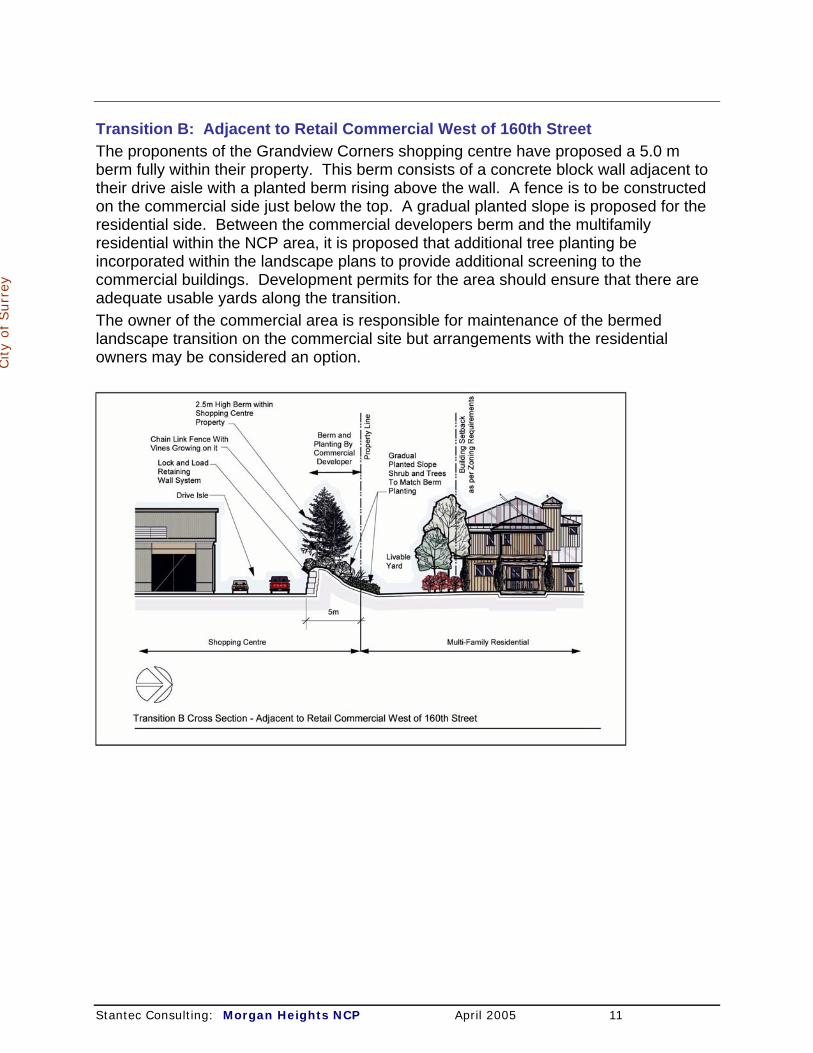
Transition B: Adjacent to Retail Commercial West of 160th Street The proponents of the Grandview Corners shopping centre have proposed a 5.0 m berm fully within their property. This berm consists of a concrete block wall adjacent to their drive aisle with a planted berm rising above the wall. A fence is to be constructed on the commercial side just below the top. A gradual planted slope is proposed for the residential side. Between the commercial developers berm and the multifamily residential within the NCP area, it is proposed that additional tree planting be incorporated within the landscape plans to provide additional screening to the commercial buildings. Development permits for the area should ensure that there are adequate usable yards along the transition.
City
of Surr
ey
The owner of the commercial area is responsible for maintenance of the bermed landscape transition on the commercial site but arrangements with the residential owners may be considered an option.
Stantec Consulting: Morgan Heights NCP April 2005 11
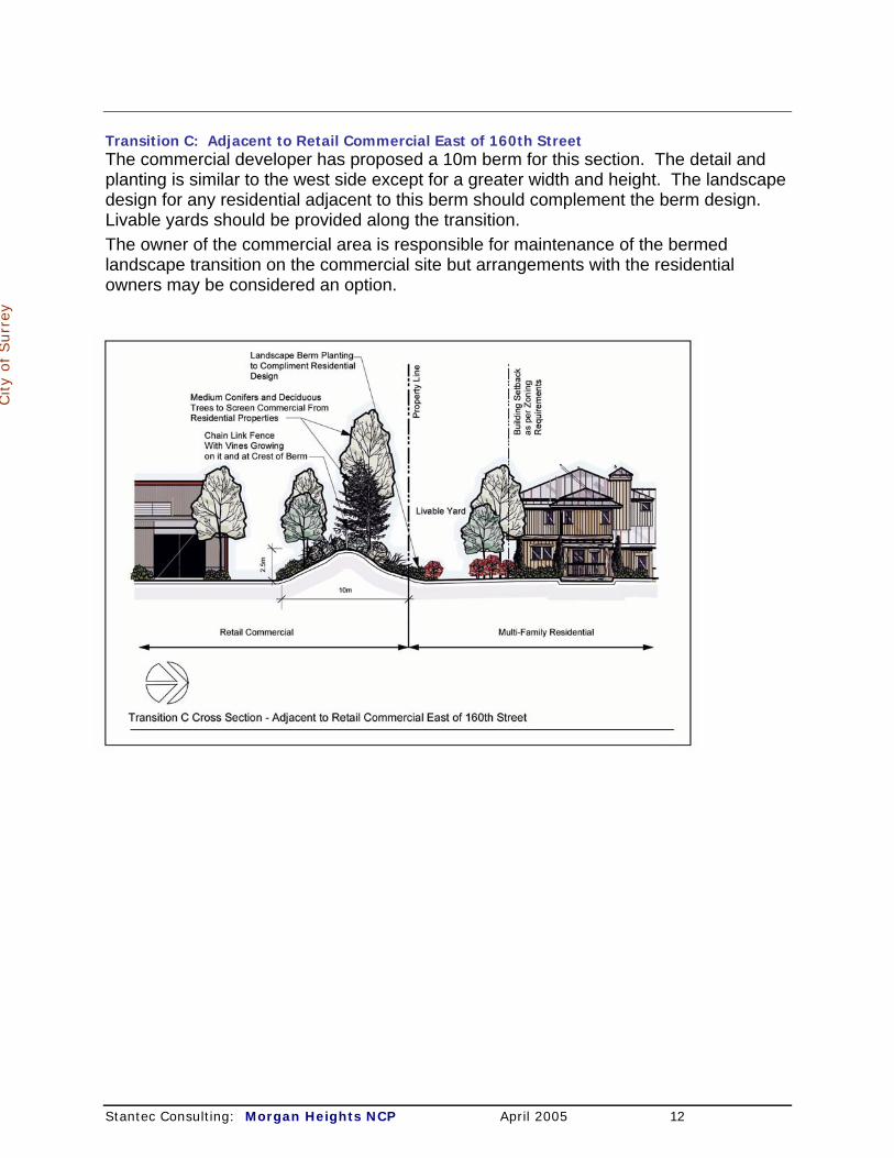
Transition C: Adjacent to Retail Commercial East of 160th Street The commercial developer has proposed a 10m berm for this section. The detail and planting is similar to the west side except for a greater width and height. The landscape design for any residential adjacent to this berm should complement the berm design. Livable yards should be provided along the transition. The owner of the commercial area is responsible for maintenance of the bermed landscape transition on the commercial site but arrangements with the residential owners may be considered an option.
City
of Surr
ey
Stantec Consulting: Morgan Heights NCP April 2005 12

Transition D: Along 24 Avenue A multi use pathway will be established along the north side of 24 Avenue from 162 Street to 164 Street as shown in the detail below and on the south side in the future NCP south of 24 Avenue. The south side of 24 Avenue, after redevelopment, is expected to have a housing density similar to the densities along 24 Avenue in this NCP.
City
of Surr
ey
Stantec Consulting: Morgan Heights NCP April 2005 13

Transition E: Along 164 Street North of 26 Avenue Single detached housing fronting on 164 Street will provide an appropriate transition to the larger lots to the east. Front yard setbacks will be determined by the Zoning Bylaw to ensure that some of the existing mature trees and growth, near the street property boundary, can be retained with adequate space. Wherever possible, driveways will be paired to limit the number of driveways to 164 Street and aid in the retention of trees. The existing ditches will be replaced by a grass swale in an interim rural cross section (as discussed in Part 4.0 Servicing Plan) as a means of maintaining the rural character of this section of 164 Street. Retaining the softer, undeveloped road edges would better fit with the lands to the east and perhaps provide additional runoff ‘habitat’ gain.
City
of Surr
ey
Stantec Consulting: Morgan Heights NCP April 2005 14

Transition F: Along 28 Avenue East of 160 Street Single detached housing fronting on 28 Avenue will also be developed as a transition to the residential development to the north. The Registered Building Scheme for these lots will require additional front yard landscaping to soften the transition. Transition G: Along 28 Avenue West of 160 Street The housing along 28 Avenue will be designed to transition to the lower density housing north of 28 Avenue. This interface will be in the form of a single row of single detached housing on wider, shallow lots to develop the appearance of lower density housing
when viewed
City
of Surr
ey
from the street.
Stantec Consulting: Morgan Heights NCP April 2005 15
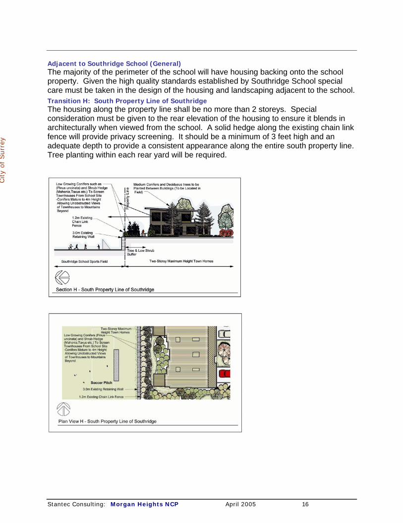
Adjacent to Southridge School (General) The majority of the perimeter of the school will have housing backing onto the school property. Given the high quality standards established by Southridge School special care must be taken in the design of the housing and landscaping adjacent to the school. Transition H: South Property Line of Southridge The housing along the property line shall be no more than 2 storeys. Special consideration must be given to the rear elevation of the housing to ensure it blends in architecturally when viewed from the school. A solid hedge along the existing chain link fence will provide privacy screening. It should be a minimum of 3 feet high and an adequate depth to provide a consistent appearance along the entire south property line. Tree planting within each rear yard will be required.
City
of Surr
ey
Stantec Consulting: Morgan Heights NCP April 2005 16

Transition I: Easterly Property Line of Southridge Single-detached lots will back onto this property line. A solid hedge along the existing chain link fence will provide privacy screening. It should be a minimum of 3 feet high and an adequate depth to provide a consistent appearance along the entire south property line. Tree planting within each rear yard will be required. Transition J: Northern Property Line of Southridge Single-detached lots will back onto this property line. A solid hedge along the existing chain link fence will provide privacy screening. It should be a minimum of 3 feet high and an adequate depth to provide a consistent appearance along the entire south property line. Tree planting within each rear yard will be required.
City
of Surr
ey
Transition K: Adjacent to Park Areas The transition between park areas and residential (including the optional site for a care and assisted living facility) will encourage an open, integrated interface while respecting the transition between public and private realms. Low, open fencing and landscaping, will be consistent with the City’s CPTED principles. Access to natural areas should be carefully managed to avoid impacts to sensitive habitat. Specific architectural guidelines for the single family lots will be developed during the rezoning process, that will specify low, open but continuous fencing, articulated rear building faces, and an encouragement for balconies overlooking parks. Finished floor elevations will be established 0.6 to 0.8 m above the park elevation where possible. The architectural guidelines will be implemented in the form of a building scheme enforced by covenant registered on title.
Stantec Consulting: Morgan Heights NCP April 2005 17

2.6 Design Guidelines • These design guidelines apply to the residential development within Morgan Heights, and are intended
to complement the development permit guidelines contained in Surrey’s OCP.
2.6.1 Overall Design Objectives 2.6.1.1 To create an identifiable and sustainable community of high visual quality, lasting value, and
character through architectural coordination, details and material selection. 2.6.1.2 To develop a distinctive public realm that is not just conventional park or green space, but a
carefully designed walking network of themed boulevards to create an interactive, pedestrian friendly and safe community environment.
City
of Surr
ey
2.6.1.3 To develop a distinctive private realm of defined yards, terraces, porches and residential buildings of various types that will complete the street enclosures and vistas to create a strong street edge.
2.6.1.4 To have a diversity of physical environment: private and public spaces, integration of natural topography, trees and habitats, a linear park system and a differentiated arrangement of street and character areas.
2.6.1.5 To encourage a mix of compatible housing and character areas that accommodate people of different income and stages in their life by including a diversity of lot sizes and housing types.
2.6.1.6 To use residential building design that provides an enjoyable pedestrian scale and character. 2.6.1.7 To encourage a pedestrian friendly environment with convenient access to park areas,
neighbouring retail, and other destinations. 2.6.1.8 To incorporate natural drainage techniques. 2.6.1.9 To preserve existing significant tree habitat, where practical. 2.6.1.10 To provide traffic calming through the use of minimum road widths at all intersections and
circular landscaped islands on through roads. 2.6.1.11 To develop a series of distinct residential neighbourhood-like areas that are comprehensively
designed for an aesthetically pleasing place to live, work and play. 2.6.1.12 To ensure that the development of multiple housing sites will exhibit a single-family scale
that creates a pleasing relationship with the street and single-family forms. 2.6.1.13 To ensure access to both private outdoor living spaces and public open spaces. 2.6.1.14 To integrate with the proposed retail development in the southwest corner. 2.6.1.15 To develop streets and boulevards that will encourage walking and pleasant views with trees
and street furniture for rest and comfort (this will be coordinated with the Engineering Department at the detailed design stage).
2.6.1.16 To develop the general residential character by means of a variety of building setbacks, private outdoor space created by low front property line boundary landscape walls, and theme boulevard design associated with each internal road.
2.6.1.17 To develop street specific built character to coordinate such elements as siting, massing for site specific lots, exterior finishing materials and colors for both single family and multi-family housing.
2.6.1.18 To provide an architectural control and review process to ensure diversity of built form and material composition detailing as set out in the building scheme.
2.6.2 Design Guidelines for Streets Street Design Policies
2.6.2.1 Architectural compatibility in terms of scale, siting, massing and material finishing will be considered when multi-family development abuts single family, school, and commercial properties.
2.6.2.2 Roads should be throated down (with curb extensions) at intersections where possible to calm
Stantec Consulting: Morgan Heights NCP April 2005 18
traffic.
2.6.2.3 Roundabouts and/or traffic circles in the through local roadway will define key character intersections and contribute to one’s sense of orientation and progression within the neighbourhood.
2.6.2.4 The size and configuration of the roundabout, traffic circles, traffic calming throats, sidewalks and location of parking will be determined at the detailed design stage when the layouts of lots and driveways are finalized.
2.6.2.5 Street lighting will be installed similar in architectural character to the residential development and will be to Engineering Department standards.
City
of Surr
ey
2.6.2.6 If needed, future additional on-street parking could be explored on the east side of 162 Street north of 24 Avenue (adjacent to multiple dwellings across from the neighbourhood commercial site) and on the west side of 164 Street north of 24 Avenue (but not north of 26 Avenue. Such on street parking might be secured through narrowing of traffic lanes, additional rights-of-way, or other appropriate mechanisms.
2.6.2.7 On street parking will be in parking bays where possible.
2.6.3 Gateway Design Strategies & Entry Signage 2.6.3.1 Gateway features will be provided at the following Morgan Heights locations:
24th Avenue entrance: commercial and multi-family, 26th Avenue and 164th Street: residential, 28th Avenue at through local road exit: residential.
2.6.3.2 The 24 Avenue multiple housing and commercial gateway will be coordinated with adjacent development. Larger scale landscape elements are anticipated in the form of stone marker or arbor features complete with high quality soft landscape materials. Distinctive hard paving materials should be included to differentiate this gateway location from abutting standard sidewalk.
2.6.3.3 The residential gateways on 26 and 28 Avenues will incorporate lower scale stone features and high quality specialized soft landscaping. Distinctive hard paving materials will be used in limited quantity to assist in differentiating the gateway portion from standard sidewalk surfacing abutting.
2.6.3.4 Entry signage will be incorporated in each of the three gateway locations. Such signs will be of a high quality durable material requiring low maintenance. The signage character will be ground oriented and composed of natural materials and will not be illuminated.
2.6.4 Design Guidelines for Street Trees Objective
2.6.4.1 Trees are a major architectural element that makes the development special, unified and softens the built form.
Street Tree Design Strategies 2.6.4.2 There will be a specific order as to type and ultimate height and scale of trees to correspond to
specific street boulevard functions and abutting residential housing scale.
2.6.4.3 Boulevard tree planting will be developed through consultation with the Parks and Recreation Department in terms of species selection and ultimate height, caliper installation sizing, color and flowering, planting patterns and spacing, installation detailing and maintenance requirements, all to meet boulevard tree planting standards.
2.6.4.4 Special consideration will be given to boulevard tree selections contained within themed boulevards.
2.6.4.5 Special consideration will be required for signature type entrance and intersection trees for symbolic character and identification purposes.
Stantec Consulting: Morgan Heights NCP April 2005 19
2.6.4.6 Trees will not be planted within 0.6 m of curbs.
2.6.4.7 Tree planting on front yards will be coordinated with boulevard tree locations to avoid conflicts and to provide suitable front door viewing.
2.6.4.8 One front lawn tree will be planted on single-family lots with a frontage less than 20.0 m and will be included within the tree replacement plan required for Morgan Heights.
2.6.4.9 Two front lawn trees will be planted on single family lots with a frontage of 20.0 m or greater, and will be included within the tree replacement plan required for Morgan Heights.
2.6.4.10 Front lawn trees for multi-family sites will be planted to replicate the standards set out above.
City
of Surr
ey
2.6.5 Design Guidelines for Single Detached Housing Objectives
2.6.5.1 While the public realm of streets and boulevards will begin to establish Morgan Height’s urban character, it is the private realm of defined yards, terraces, porches and residential buildings of various types that will complete the street enclosures and vistas and create a strong street edge. Housing will be street oriented and porches will be encouraged.
2.6.5.2 The diversity of lot size should encourage a mix of compatible housing and character areas.
Site Planning Design Strategies 2.6.5.3 The separation and identity of private outdoor living space will be created by means of low
boundary landscape walls in the east lower density areas where they can be integrated effectively with lot grading to create a unifying element to the street, an identity of place, and pleasing boundaries between private yards and streets. .
2.6.5.4 The setback from the street, the private outdoor living space created by low boundary landscape walls, combined with boulevard design associated with each internal road will set the general character boundaries. These features will also create an interactive, pedestrian friendly and safe community environment.
Design Strategies for Single Detached Housing 2.6.5.5 While the developer will establish design guidelines for the various housing types and locations,
the theme will be a variety of architecturally coordinated yet differentiated buildings. 2.6.5.6 Special consideration will be given to homes adjoining intersections, roundabout and traffic
circles, central park areas and transitions from single-family homes to multi-family sites, and the commercial site at the southwest corner.
2.6.5.7 Major intersections (those with traffic calming) will have building massing to define the experience of leaving and or entering different character areas in association with the sequential arrangement of views and vistas.
2.6.5.8 Architectural detailing referring to material selection, application of accenting elements, wall face applied versus set in windows, etc., will be considered as part of the builders guidelines for the purpose of establishing massing, shadows, depths and most importantly building value.
2.6.5.9 Considering the material development of the boulevards, the low bordering landscape walls and contributing landscaping, the foremost element of the single family home will be the front door element for scale and expression of style.
2.6.5.10 The second element in the evolution of the Morgan Height’s home will be the lowering of the second floor roof to integrate with entry porches and arbors for a more human scale versus a conventional two-storey wall with build-outs.
2.6.5.11 The residential built character will demonstrate a ‘hand crafted’ approach featuring such elements as entrance doors, windows, and corners and employing smaller scale elements as bricks and shingles.
2.6.5.12 The design, composition and materials for the front entry are to be consistent with the overall style of the home. Limited use of cultured stone as an accent material may be permitted.
Stantec Consulting: Morgan Heights NCP April 2005 20
2.6.5.13 Garages with doors in a compatible color and style to the house are required. Garages
must be set back from the front face of the dwelling and may be lowered or otherwise subordinated to the front entry.
2.6.5.14 In order to mitigate the impact of the garage door to the street, the garage should not exceed 50% of the width of the house front elevation. On corner lots, the garage driveway should be provided from the secondary road where practical.
2.6.5.15 Walls may be clad in a variety of materials including vinyl subject to individual dwelling approval, location, color choice and detailing. Specific provisions to prevent unbroken two-storey sheer walls, overuse of vinyl and inappropriate color choices will be provided.
City
of Surr
ey
2.6.5.16 Colors of wall materials and trim must be selected from a color and repetition palette supplied by the developer or his agent. Basic white will not be permitted and off-white as a body color will be permitted on a limited basis.
2.6.5.17 Rooflines, materials and colors, soffit details, gutters and fascia trim will be controlled by the building scheme to ensure continuity.
2.6.5.18 Front yards will be fully landscaped at the time of building completion and prior to occupancy to ensure an appropriately finished street appearance and for street cleaning purposes.
2.6.5.19 Driveways will be paired wherever possible with landscape finishing between driveways and continuity of sidewalks will be maintained.
Fences 2.6.5.20 Solid wood materials are required in a style and stain finish for overall style consistency. 2.6.5.21 Low, landscape style open or transparent fencing only is permitted within the projected
side yard of front yard areas as an alternative to hedging or other soft landscaping material to a maximum height of 0.60 m.
2.6.5.22 Traditional solid fencing (to Zoning Bylaw standards) will be required on the flanking side of corner lots for rear yard privacy and streetscape control. In any event, such fencing may only extend to cover the rear portion of the flanking street wall elevation and must be augmented with landscaping along the boulevard and fence. It should be coordinated with low landscape wall borders. Flanking fences should be setback a minimum of 0.6 m to allow for additional landscaping.
Zoning Bylaw Variations 2.6.5.23 The implementation of the Morgan Heights design strategy for single detached housing
may benefit greatly from minor variations of some existing Zoning Bylaw regulations (probably through the use of comprehensive development zones), including: the second storey maximum floor area calculation, front and rear yard setback dimensions, height limitations and calculations, and policies related to attic space development.
Stantec Consulting: Morgan Heights NCP April 2005 21

2.6.6 Design Guidelines for Multi-Family Housing
Objectives 2.6.6.1 Each multi-residential site within the NCP area will be encouraged to have its own unique
architectural flavour with a variety of different housing types and forms. 2.6.6.2 Architectural compatibility with the surrounding single detached housing, the school site, park
areas and the commercial site will be required in terms of compatibility of scale, siting, massing an material finishing to preserve the pedestrian quality of Morgan Heights.
Site Planning Design Strategies 2.6.6.3 Sites must respect their adjoining occupancies as well as demonstrate a compatibility with the
neighbouring single detached homes.
City
of Surr
ey
2.6.6.4 Site layout and designs should be based on principles of defensible space (CPTED) and provide ample opportunities for casual surveillance of public and common spaces. These principles attempt to strengthen two kinds of basic social behavior - territoriality and natural surveillance (eyes on the street).
2.6.6.5 Multiple residential dwelling units along streets should be designed to be pedestrian accessible from the public sidewalks and such development will not to be gated.
2.6.6.6 A higher density townhouse project is proposed for the northeast corner of 24 Avenue/162 Street (east of the village commercial). A low landscape border wall will be required on its north frontage for continuity with the park and the single detached homes. The southerly site boundary facing onto 24 Avenue will require a multi-use trail and parkway treatment.
2.6.6.7 The materials and massing for the site immediately north of the village commercial will create a pleasing relationship with the northerly school site, the southerly commercial site, the linear park and entry boulevard.
2.6.6.8 The multiple housing sites west of 160th Street will use the sloping topography as a natural resource, but as well to develop site specific mixes of scale and use in order that the environment between these parcels will encourage the pedestrian activity to and within the active and natural park areas.
Design Strategies for Multiple Dwelling Sites 2.6.6.9 Small scale two and three storey groupings of town home like forms are anticipated to be the
predominant massing style of buildings facing onto internal roadways, park and schools sites and as such must provide a pleasing pedestrian style streetscape by means of a variety of forms and facade details.
2.6.6.10 Where multiple dwelling buildings adjoin or face single detached housing, the quality of materials and finishes and the overall design of these units shall be compatible with and comparable to the scale and texture of the predominant neighbouring single detached home environment.
2.6.6.11 End elevations are to be articulated to provide appropriate transition to single detached housing.
2.6.6.12 To achieve visual diversity within the project, variations in building height, spacing, setbacks and rooflines are to be considered between, and within, clusters and units and where they adjoin lower density uses.
2.6.6.13 The design of buildings along the street should not be repetitive and should avoid a mirror image effect.
2.6.6.14 All housing units with exposed site views (e.g., on corner lots) shall provide similar architectural detailing to both the front and exposed sidewall faces. Exposed blank walls and two or three storey sheer walls will not be permitted.
2.6.6.15 In order to provide privacy on porches, verandas, patios and decks of units facing a public street or park area while still providing surveillance of parks, the finished grade of the dwelling unit should be between 0.6 m and 0.8 m above the level of the adjacent sidewalk or park.
Stantec Consulting: Morgan Heights NCP April 2005 22
2.6.6.16 Proper screening including coordinated fencing and landscaping where appropriate will
be required for all mechanical and electrical equipment, garbage collection areas and visitor parking areas.
2.6.6.17 Low landscape wall borders may be required for overall coordination with the internal street and boulevard conditions.
2.6.6.18 The building guidelines will follow the existing multiple residential guidelines in the OCP. 2.6.6.19 These guidelines will be enhanced by specific multiple dwelling design provisions within
Morgan Heights to ensure that the specific multiple dwelling environments are part of the community neighbourhood identity that is being created in the public realm and that the architectural detailing is complementary to the single family housing guideline requirements.
City
of Surr
ey
2.6.7 Design Guidelines for Development Abutting Parks Objectives
2.6.7.1 The objective is to encourage an open, integrated interface while respecting the transition between public and private realms.
Design Strategies 2.6.7.2 Specific architectural guidelines for the single family lots will be developed during the rezoning
process, that will specify low, open but continuous fencing, articulated rear building faces, and encouraging balconies overlooking parks. Finished floor elevations will be established 0.6 to 0.8 m above the park elevation where possible.
2.6.8 Design Guidelines for the Care and Assisted Living Facility Objectives
2.6.8.1 The objective is to establish a high quality seniors’ care community environment that will respond to site conditions, take advantage of and be integrated with the adjacent neighbourhood park and the surrounding residential development.
Site Planning Design Strategies 2.6.8.2 The site must respect its adjoining occupancies as well as demonstrate compatibility with existing
and future housing in the area, which may include townhouses and single-detached homes. 2.6.8.3 The residents of the care facility will have the opportunity to view and enjoy the adjacent park
and activities to the west and north yards of the building. Interconnectivity between the care facility site and park should be accommodated through wheelchair accessible pathways and linkages. Special care should be taken to ensure that the facility is appropriately integrated with the adjacent neighbourhood park including the need to address required riparian setbacks from Wills Brook.
2.6.8.4 The opportunity for shared parking between the care facility and the users of the park should be explored during the detailed site design process.
2.6.8.5 Main access to the site will be from 27 Avenue and, subject to the City’s approval, secondary access may be provided from 160 Street.
2.6.8.6 The landscaping, definition of yard edges, and design of open areas along 27 Avenue and 160 Street should achieve continuity and be complementary to the existing and future housing in the area.
2.6.8.7 The facility should be integrated into the residential neighbourhood. 2.6.8.8 High fences should be minimized. Fences higher than 1.2 m visible from the street should be
decorative, transparent and used in combination with landscaping. 2.6.8.9 Loading areas, garbage container enclosures, satellite dishes and other service elements should
not be visible from the street.
Design Strategies for the Buildings 2.6.8.10 The site layout and design of the building and open space should be based upon the
principles of defensible space and provide ample opportunities for casual surveillance of public spaces (CPTED).
2.6.8.11 Site planning and building design should be responsive to the contours and natural features Stantec Consulting: Morgan Heights NCP April 2005 23

of the site, and the specific conditions of the site (i.e., views, noise, slopes, etc.).
2.6.8.12 The building materials and colours will be determined through the development permit process. However, they should be similar to the materials used for adjacent residential development.
2.6.8.13 The entrance to the building should consider the use of architectural or landscaping elements that identify the threshold between public and private property. Any minor structure used for this purpose should be located at the dominant front yard setback line.
2.6.8.14 Consideration should be given to the siting and massing of the buildings in such a way that they ‘anchor’ the intersection, site, corners, edges and act as a gateway into the new community.
City
of Surr
ey
2.6.8.15 The articulation of the roofs should reflect and be similar to the adjacent residential buildings.
2.6.8.16 In order to be compatible with the character of the area, the design of the care facility should consider the following: gable roof components; gabled dormers; pitched roofs; bay windows; windows with muntins and mullions; French doors; stucco should only be used in combination with other natural finishing material; no vinyl siding should be used as an exterior cladding material.
2.6.9 Design Guidelines for Park Areas Park Design Policy
2.6.9.1 The City of Surrey Parks, Recreation and Culture Department will be responsible for all design and development within designated parks. Details will be finalized at the time of development.
Park Design Strategies 2.6.9.2 The nature park area east of 162 Street will be maintained as a natural woodland habitat. 2.6.9.3 Engineered storm water retention or bio-filtration areas will not be allowed in the treed area of
parks. 2.6.9.4 Pedestrian pathways through the area will meander and be created to minimize impact on the
existing natural environment and on the adjacent residential lots. 2.6.9.5 Permanent hard fencing will be erected at the private property lines along parks by the developer
as soon as possible in the development process. 2.6.9.6 Existing tree stands in all park areas will be retained where appropriate. 2.6.9.7 Special park amenities and/or structures will be determined by Surrey in consultation with the
community.
2.7 Environmental Management The environmental site analysis and resulting recommendations are fully documentetd in Appendix A.4: Environmental Report. The thrust of the environmental management plan is reflected in the dedication of the forested area near 164 Street (the nature park); the dedication of the Wills Brook area near the intersection of 160 Street/28 Avenue. Measures are proposed to maintain the quality of these spaces. An Environmental Impact Assessment (EIA) has been an integral component of the NCP developed for Morgan Heights. The EIA has addressed existing drainage watercourses and fish habitat, wildlife habitat and utilization, and has incorporated recommendations to mitigate and offset environmental impacts anticipated with the planned development within the NCP area. Watercourses
Stantec Consulting: Morgan Heights NCP April 2005 24

The primary fish habitat within the NCP is the upper end of the Wills Brook and its ravine situated near the northwest corner of 160th Street and 28th Avenue. Wills Brook and adjacent riparian habitat will be protected by a dedicated no disturbance buffer under the proposed development concept. Elsewhere in the NCP area, linear drainage watercourses (i.e. ditches, swales) extend along existing roadsides and within many of the open field areas. All of the linear drainage watercourses have been classified as Class C watercourses under the City of Surrey’s Fisheries Watercourse Mapping program. Class C watercourses: These are defined as offering insignificant food and nutrients with no documented fish presence and no reasonable potential for fish presence. Class C watercourses usually go dry quickly after rainfall events. Protection or replacement of Class C watercourses is not required under current fish habitat management policies.
City
of Surr
ey
Class B watercourses: Class B watercourses are to be protected as fish habitat, and in some cases, may be relocated and replaced in conjunction with re-development of an area; provided there is no-net-loss of fish habitat area and function. Wills Brook is classified as a Class B watercourse, providing significant flow and nutrients to downstream fish populations that cannot access the upper reaches of Wills Brook due to various obstacles or barriers to upstream fish movements. The EIA identified several of the Class C watercourses as sustaining more prolonged flows than would be attributable to a Class C watercourse, and has indicated that those watercourses should be re-classified as Class B fish habitat. The re-classification is subject to further detailed review by the City of Surrey and the Department of Fisheries and Oceans (DFO). Under current fish habitat policies, the Class B watercourses should be protected with buffer strips or setbacks that are a minimum of 15.0 m wide along each bank of the Class B watercourse. It should be noted that the provincial Riparian Areas Regulation will come into effect in 2006, and the width of setbacks may be adjusted depending on the specific watercourse. The proposed watercourse classifications and corresponding setbacks are presented on Figure 7: Watercourse Class and Setbacks. 2.7.1 Riparian area setbacks will be considered at the time of subdivision and
development on a case-by-case basis to ensure that issues of topography and flooding are appropriately addressed.
Fish Habitat Compensation As all of the re-classified Class B watercourses in this NCP are man-made, relocation and reconstruction of the fish habitat function of each is acceptable; provided that the replacement habitat is appropriate with respect to quantity and quality. The EIA includes a fish habitat compensation plan that addresses the balance between habitats to be lost and habitats to be constructed to replace those losses; generally referred to as a habitat balance. A conceptual habitat compensation plan is presented in the EIA report in some detail. It should be noted that the habitat compensation plan for the NCP has been reviewed and accepted in preliminary concept by the City and DFO. However, the detailed design for the habitat compensation plan envisioned in the EIA and formal acceptance of the habitat compensation plan will need to be addressed during the subsequent site-specific subdivision planning and approval process that will follow adoption of this NCP.
Stantec Consulting: Morgan Heights NCP April 2005 25
A series of constructed aquatic habitats with surrounding riparian habitats are proposed to replace the loss of the Class B watercourses within the NCP (see Figure 6 in the EIA report). In the central part of the NCP area, a permanent pond will flow into an ephemeral infiltration pond, which in turn will drain to constructed wetland. It is also proposed that a shallow watercourse fed by roof runoff from adjacent houses be constructed by hand and carefully located within a park containing an existing mature forest, so as not to damage the existing trees. The placement of the proposed watercourse in the forest, which will be dedicated as a nature park to the City, will require City approval and will be subject to fees that the City would collect for use of the park space for such purposes. In the west portion of the NCP, near the top of the Wills Brook ravine, another pond and watercourse with planted riparian trees and shrubs is proposed. The habitat compensation plan is expected to achieve a net gain of fish habitat.
City
of Surr
ey
2.7.2 It is a policy of this plan to achieve no net loss of primary fish habitat. Wildlife Habitat The EIA has also addressed wildlife habitat and wildlife use of the NCP area. While there are several stands of deciduous forest and mixed coniferous and deciduous forest within the NCP area, most are relatively small in area and have become surrounded by cleared or cultivated fields and houses over the years. Fragmentation of forested habitats and lack of connectivity for wildlife movements have diminished the capability of treed habitats to support the abundance and diversity of wildlife that once was possible before development of the current land uses in the NCP area. None of the forested habitats remaining in the NCP are particularly unique and, within the overall Grandview Heights area and the City, are not especially significant. The forests and older fields are still valuable for many wildlife species that are tolerant of human activities in a rural residential setting. It is possible that some rare and endangered wildlife species (e.g. Band-tailed Pigeon) might utilize habitats within the NCP, but none were observed during the EIA. A survey for rare and endangered plants and animals is usually not conducted unless the presence of a species is probable or has been observed and, if warranted, would occur at the site-specific subdivision planning and approval stage. Most of the existing treed habitats, open fields and pastures currently within the site will be lost, reducing available wildlife breeding habitat and displacing many species within the NCP area (e.g. Black-tailed Deer). Opportunities for movement and dispersal of wildlife species such as small mammals will also be substantially reduced. The majority of wildlife trees, including large cottonwood and snags, will be removed, reducing opportunities for cavity-nesting bird species. The loss of the two existing Red-tailed Hawk nests cannot be avoided under the current development scenario, and it is unlikely that this species will re-nest in the treed park areas within the site, since much of the old-field foraging habitat will have been converted to residential uses. Relocation of these nests has been proposed by the Surrey Parks Department, and is recommended as the NCP area is developed. However, the effectiveness of this measure would depend on sufficient foraging habitat being available in the area to which the nests are to be relocated. Tree Preservation Tree preservation and resulting recommendations are fully documentetd in Appendix A.5: Arborist Report. A significant effort will be made at the site planning and design
Stantec Consulting: Morgan Heights NCP April 2005 26
stage to survey and retain existing mature trees throughout the neighbourhood where possible to maintain community identity and green ambience character as envisaged by Sections 1.3 and 1.4 of the Grandview Heights General Land Use Plan. 2.7.3 Tree preservation should be based on the premise that individual trees that have
developed in open grown situations for the majority of their life can be considered candidates for individual preservation where adequate spatial zones can be assured. Trees that have developed in forest grown conditions should only be considered for retention where significant groups of existing trees can be retained practically. Selective removal of trees with obvious hazard potential can be anticipated.
City
of Surr
ey
2.7.4 Trees along 164 Avenue will be incorporated into the design of the transition to adjacent properties in a manner that retains the rural character (utilizing an interim rural cross section as shown by Transition E and discussed in Part 4.0 Servicing Plan).
2.7.5 Carefully managing edge treatments and grading on adjacent properties should protect trees in the northeastern nature park.
2.7.6 As outlined in Appendix A.5 Arborist Report, the development and careful execution of an effective tree protection program is necessary to address the needs of the trees during all phases of development, before, during, and after construction.
Site planning for tree preservation policy will be supplemented by careful tree management and maintenance as well as enhancement by the planting of additional trees as described in Section 2.5: Land Use Transitions and Section 2.6: Design Guidelines. This will include the addition of ornamental trees, but native or native appearing trees will ultimately be the most successful and attractive species for the reforestation of the neighbourhood. This will be a key component in the ultimate livability of the neighbourhood.
A key mitigation measure for wildlife habitat is the protection of remaining large intact areas to partially offset the decreasing extent of mature woodland habitats in the NCP area. The EIA identified a relatively large forest containing diverse tree and shrub species west of 164 Street and south of 28 Avenue as having high value to locally breeding wildlife populations (e.g. songbirds). A small portion of the core area of this woodlot will be protected within a proposed park. Although this park will have reduced ecosystem function, it will be an important green space once development occurs in the NCP area. Hydraulic Regime The EIA concluded that the main environmental impacts associated with the re-development concept for the Grandview Heights Area #1 NCP are associated with alteration of the existing hydrologic regime and the loss of treed and other open vegetated areas. The degree of adverse impact can be reduced with proposed mitigation measures. The altered hydrologic regime as construction of the new residential areas proceeds has the potential to adversely affect base flows in Wills Brook, and to a lesser extent, those in Old Logging Ditch beyond the site. However, these impacts can be mitigated through application of stormwater “best management practices”. The stormwater management design for the NCP has integrated the following environmental objectives: maintenance of base flows to Wills Brook and Old Logging Ditch; volume reduction through source separation; flow reduction through detention; Stantec Consulting: Morgan Heights NCP April 2005 27

and water quality treatment through biofiltration systems. Infiltration swales and infiltration boulevards are proposed for local roads within the NCP. Detention ponds are proposed to be included; the specific location, size and capacity of which will be confirmed at the subdivision planning stage. Planting native plants within detention ponds will be considered. Biofiltration of stormwater will be facilitated by use of a constructed wetland in the central park, roadside infiltration swales and planted detention ponds. Further details on stormwater management measures planned for the NCP are presented in Part 4: Engineering Servicing Plan, as well as in the EIA report (Appendix A.4)
City
of Surr
ey
2.7.7 The stormwater management scheme (detailed in the engineering servicing section) will mitigate the alteration of the hydraulic regime through best management practices designed to facilitiate volume reduction (i.e., source separtion and infiltration), flow reduction (infiltration, detention), and water quality treatment (biofiltration).
2.8 Land Use & Population Statistics A statistical summary of each of the land use components of the NCP – net area, dwelling units, and population anticipated is shown below.
Statistical Summary: Morgan Heights (Grandview Heights NCP #1)
West Sector Note: Some figures rounded
Land UseMaximum
Density (UPA)*Effective Built Density (UPA) Acres Units People/Unit Population
Townhousing 10-15 UPA 15 13 18.0 234 2.2 515Townhousing 15-30 UPA 30 20 30.1 602 2.2 1324Apartments 30-45 UPA 45 36 7.9 285 1.6 456Natural Park 2.5Active Park 2.0
West Subtotal 60.5 1121 2295
East Sector
Land UseMaximum
Density (UPA)*Effective Built Density (UPA) Acres Units People/Unit Population
Single Detached 6-10 UPA 10 7.6 71.9 546 2.8 1530Townhousing 10-15 UPA 15 13 8.9 116 2.2 255Townhousing 15-30 UPA 30 20 28.0 560 2.2 1232Woodland Park 2.5Neighbourhood Park 3.2Southridge School 16.4
East Subtotal 130.9 1222 3017
Total Area 191.5 2343 5311
*Units Per Acre
Stantec Consulting: Morgan Heights NCP April 2005 28

2.9 Transportation Ward Consulting undertook a traffic impact study to assess the traffic implications of the NCP and the work is documented in a full report (see Appendix A.6: Traffic Report). Existing Conditions The study covered the standard steps of a traffic impact study beginning by examining existing conditions. This covered identifying the key roads within and on the perimeter of the study area, including the intersection channelization and traffic controls, establishing traffic volumes at the nine study area intersections considered to be potentially impacted by the proposed development and on the various road links, and analyzing these intersections under 2005 background conditions.
City
of Surr
ey
This analysis found that the two signalized intersections (32 Avenue at 152 Street and 160 Street) both operate at an acceptable level of service in both the a.m. and p.m. peak hours. Of the eight unsignalized intersections, the 32 Avenue/168 Street intersection is most in need of improvement as the volume/capacity ratio exceeds the normally accepted maximum in both peak periods. Traffic signals coupled with left turn lanes on all four legs are the only real solution at this intersection. The other four-way stop controlled intersection of 24 Avenue/168 Street also fails in the p.m. peak hour although not nearly as severely. Again, traffic signals would solve this problem. Traffic exiting from 164 Street to 32 Avenue at this unsignalized intersection faces lengthy delays because of the high volume of traffic on 32 Avenue. However, at the present time the existing volumes are not high enough to meet the standard warrants for signals. Two other unsignalized intersections on 160 Street and 164 Street at 28 Avenue are both operating with very acceptable levels of service. Transit Transit was also considered. Currently there are no transit services within the Grandview Heights area. The closest regional service is Route 354 which travels north on 152 Street from the south and then turns west on 132 Avenue destined for the South Surrey Park ‘N’ Ride lot on the west side of Highway 99. Sidewalks Currently the only roads in the Grandview Heights area that have sidewalks are the four and five lane segments of 32 Avenue west of 154 Street, 152 Street from 32 Avenue to 34 Avenue, and from 28 Avenue south to 16 Avenue, and 24 Avenue west of King George Highway. Future Traffic Future traffic volumes on the road network were established using the City’s EMME/2 model. These projections took into account the projected growth in the Grandview Heights area but also North Grandview, Campbell Heights, and the Grandview Corners Shopping Centre. Proposed road network changes in the area were also taken into consideration. These included the additional ramps proposed at the 32 Avenue/152 Street interchange with Highway 99 to allow northbound traffic on 152 Street to enter Highway 99 northwest bound directly and southeast bound traffic on Highway 99 to exit to 152 Street northbound. The City has indicated that it is investigating the possibility of providing a new interchange on Highway 99 at 24 Avenue. For the purpose of this NCP, this new interchange was assumed to be in place. The City is also currently planning to extend the five laning on 32 Avenue east from Croydon Avenue to 160 Street and upgrade the section from this point to 168 Street to a three-lane facility by 2010. Furthermore, 24 Avenue is to be upgraded to a five-lane cross-section between 152 and 162 Streets, partly in conjunction with the development of the Grandview Corners commercial development, and key segments of King George Highway are also to be upgraded. In conjunction with the proposed Grandview Corners Shopping Centre, new signals will be installed on 24 Avenue at 168 Street, 160 Street, and 156 Street. Future traffic volumes on the road network were established based on these assumptions. Network Improvements The nine intersections analyzed under background conditions were then reanalyzed, this time under 2021 conditions. In this analysis it was assumed that signals and accompanying left turn lanes would be in place at the 32 Avenue/168 Street and 24 Avenue/168 Street intersections. The analysis concluded that signals and left turn lanes will also be needed at the 32 Avenue/164 Street intersection and possibly ultimately at the 28 Avenue/160 Street intersection as well. Left turn storage lanes should be provided on all approaches at the intersection of 24 Avenue/164 Street. Stantec Consulting: Morgan Heights NCP April 2005 29

In reviewing the proposed road network plan, it was recommended that 28 Avenue be developed as a continuous collector road from Croydon Avenue through to 168 Street. This is not intended to be a through road but simply a collector road that gathers up traffic from the local roads and carries it to the north-south arterial and collector roads, these being 160 Street and 164 Street. These north-south roads will continue to have through priority at the intersections with 28 Avenue until such time as they are signalized. Without such a link traffic traveling between the different components of this neighbourhood, i.e., from a point west of 160 Street through to east of 164 Street or even more importantly traffic traveling from this neighbourhood to the proposed school to the east of 160 Street would be forced to use 32 Avenue or 24 Avenue and this condition is undesirable given the high traffic volumes that these two arterials will ultimately be carrying. Whilst traffic calming is not normally applied to collector roads, 28 Avenue could be a candidate for such features should the need arise. This could include curb extensions at intersections with or without raised intersections, centre medians, etc. in order to slow down any faster moving vehicles. Given the road layout within the current plan, cut-through traffic is not seen as being a potential problem. However, if these problems do arise then the relevant traffic calming measures could be considered.
City
of Surr
ey
In conjunction with the development of the study area lands, 160 Street and 164 Street should be upgraded to three lane roads in order to provide adequate capacity for left turn movements at the various intersections and key access points along their lengths. The 27 Avenue intersection with 160 Street needs to be restricted to right-in/right-out movements only because of the problems associated with traffic queuing to enter and exit the Southridge School on 160 Street.
Stantec Consulting: Morgan Heights NCP April 2005 30
Part 3: Implementation
3.1 Official Community Plan Amendments Amendments to the Official Community Plan will be required, in phases as owners wish to proceed, to redesignate lands for the appropriate uses: Urban and Multiple Residential.
3.2 Neighbourhood Concept Plan Amendments All proposed amendments to the NCP shall be undertaken only in accordance with the policy to amend secondary plans contained in Part 5, Division A of the OCP.
City
of Surr
ey
3.3 Rezoning The residential lands will need to be rezoned before development can proceed and to implement the amenity contribution component of this NCP. Rezonings will be completed in a logical staged manner. First, areas suitable for development will be rezoned when owners make application consistent with this plan. Second, some areas may remain with the lower density zoning until owners apply for detailed zoning.
3.4 Subdivision Future subdivision will be consistent with both the NCP and the ultimate zoning. As noted in the section on phasing, subdivision will be dependent upon market conditions and at a pace determined by the landowners. Detailed lotting patterns will be determined at the stage of subdivision application.
3.5 Development Permit Area Guidelines All multiple residential developments (and the optional care and assisted living facility) will be reviewed in accordance with the Development Permit Guidelines of the Official Community Plan and the requirements of this NCP.
3.6 Amenity Contributions Surrey’s policy is that NCPs address funding arrangements for the provision of community facilities, amenities, and services (such as park development, police, fire, and library materials) that are translated into specific contribution requirements and adopted by Council in the Zoning Bylaw. The amenity contribution is payable upon subdivision for single-family subdivisions or upon issuance of building permits for multiple development and other uses. The bylaw provides that the base rates for amenity contributions are adjusted annually on March 1st based on Vancouver’s annual average consumer price index (CPI) for the preceding year. The following table includes the amenity contributions to be required for the NCP. They
are
based on the March 2005 rates for similar NCP areasStantec Consulting: Morgan Heights NCP April 2005 31
Amenity Item Cost/UnitWest Sector East Sector
Units 1121 1222 Sub-totalPolice $56.89 $63,773.69 $69,519.58 $133,293.27Fire $245.71 $275,440.91 $300,257.62 $575,698.53Library $127.97 $143,454.37 $156,379.34 $299,833.71Park $1,075.00 $1,205,075.00 $1,313,650.00 $2,518,725.00
Total $1,505.57 $1,687,743.97 $1,839,806.54 $3,527,550.51
Projected Revenue

already approved for police protection, fire protection, and library materials. The table above is not adjusted for the optional care and assisted living facility. If developed the parkland, library, fire, and police contributions will be charge for the assisted living building only, based on the number of residential units only. Fire and police contributions only, consistent with past City practice, will be charged for the care facility component. Park Amenity Contributions: The park contributions are based on preliminary estimates of capital funding projections for the facilities to be developed in this neighbourhood as well as in the overall Grandview Heights area and distributed over the whole area. Within Morgan Heights the park amenity contributions will be used to develop three neighborhood parks. A portion of the park amenity fees collected will be set aside for the future development of community parks and greenways shared by all neighbourhoods in greater Grandview Heights. The proposed neighbourhood park west of 160 Street preserves a creek corridor and may include a stormwater management pond and environmental enhancement area. The southern part of this park site facing 27 Avenue will be developed as a neighbourhood destination with potential for active recreation amenities. The program for the park will be determined in consultation with the community prior to development. It may accommodate amenities such as pathways, a playground and sport courts.
City
of Surr
ey
3.7 Servicing, Phasing & Financial Aplin & Martin Consultants has prepared a report on servicing that includes phasing, servicing, and the financing of infrastructure. It is included as Part 4: Engineering Servicing Plan.
Stantec Consulting: Morgan Heights NCP April 2005 32

Under Separate Cover
Part 4: Engineering Servicing Plan
City
of Surr
ey
Stantec Consulting: Morgan Heights NCP April 2005 33

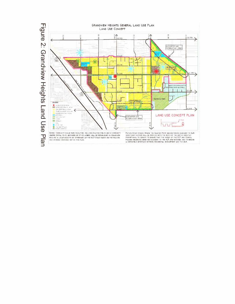
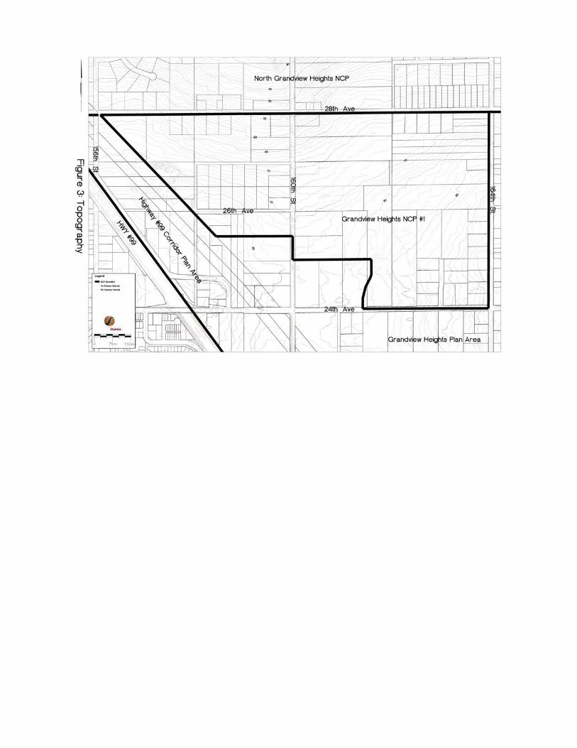
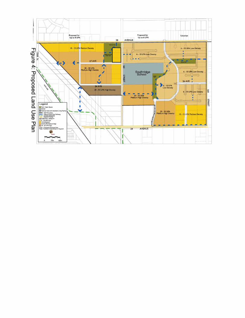


Appendix "B"
Proposed Amendment to Surrey Official Community Plan By-law, 1996, No. 12900
The following amendment is proposed to Surrey Official Community Plan By-law, 1996, No. 12900: 1. Delete Figure 27 - Map Showing Recently Approved Secondary Plans, in Division A,
Part 5 of the Official Community Plan and insert the following Figure 27:
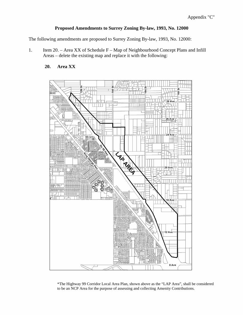
Appendix "C"
Proposed Amendments to Surrey Zoning By-law, 1993, No. 12000
The following amendments are proposed to Surrey Zoning By-law, 1993, No. 12000: 1. Item 20. – Area XX of Schedule F – Map of Neighbourhood Concept Plans and Infill
Areas – delete the existing map and replace it with the following:
20. Area XX
*The Highway 99 Corridor Local Area Plan, shown above as the “LAP Area”, shall be considered to be an NCP Area for the purpose of assessing and collecting Amenity Contributions.

2. Schedule F - Map of Neighbourhood Concept Plans and Infill Areas - insert the following as Item 23, following Item 22:
23. Area XXIII
City
of Surr
ey
3. Schedule G - Amenity Requirements in Neighbourhood Concept Plan and Infill Areas – insert the following table as Item 23, following Item 22:
NCP and Infill
Areas Contributions
Per Dwelling Unit 1
Contribution For All Other Land Uses Per Acre2
Parks Development $1,075.00 N/ALibrary Materials $127.97 N/AFire Protection $245.71 $982.84
(calculated at 4 units per acre) Police Protection $56.89 $227.56
(calculated at 4 units per acre)
23. Area XXIII on Schedule F of this By-law
Total Amenity Contributions (2004 dollars) – Area XXIII
$1,505.57
$1,210.40 per acre

Appendix "D"
Corporate NO: C006
Report COUNCIL DATE: May 2/05
COUNCIL-IN-COMMITTEE
TO: Mayor & Council DATE: April 25, 2005
FROM: General Manager, Planning and Development FILE: 6520-20 (Morgan Heights – NCP #1)
SUBJECT: Stage 1 Approval for the Area #1 Neighbourhood Concept Plan (Morgan Heights) in Grandview Heights
RECOMMENDATION
It is recommended that Council:
1. Receive this report as information; 2. Approve the Stage 1 component for the Area #1 (Morgan Heights)
Neighbourhood Concept Plan ("NCP") in Grandview Heights, as described in this report and as illustrated in Appendix 1;
3. Instruct staff and the NCP proponents to complete the Stage 2 component of the
NCP for the Area #1 (Morgan Heights) NCP on the basis of the Stage 1 Land Use Plan, including resolution of outstanding land use matters identified in this report, design guidelines, an engineering servicing strategy and a comprehensive financial plan that will provide adequate funding provisions for engineering servicing infrastructure, logical phasing, and community amenities; and
4. Authorize staff to proceed with processing of development applications in the
Area #1 (Morgan Heights) NCP, on the basis that the applications conform with the proposed Stage 1 Land Use Plan and that final approval of such applications will be held pending completion of the Stage 2 component of the NCP.
INTENT
The purpose of this report is to: 1. Provide an overview of the Stage 1 component of the Area #1 (Morgan Heights)
NCP, including the process followed in preparing the plan, public consultation
- 45 -
that has been undertaken as part of the planning process and a description of the proposed Land Use Plan;
2. Seek Council approval of the Stage 1 component of the NCP, including the
proposed Land Use Plan, as the basis for more detailed planning necessary to complete the Stage 2 component of the NCP; and
3. Provide Council with a summary of outstanding issues that will be addressed as
part of the Stage 2 component. BACKGROUND
On January 10, 2005, Council considered Corporate Report No. L001 (attached as Appendix 2) and adopted the recommendations of that report, which authorized staff to proceed with the preparation of an NCP for Area #1 (Morgan Heights) in Grandview Heights, based on the Terms of Reference attached to the report. Since that time, staff has been working with the proponents and other stakeholders toward preparing a Stage 1 NCP. This is the first NCP to be undertaken in the Grandview Heights area. The draft General Land Use Plan for Grandview Heights makes provision for five NCP areas. The General Land Use Plan is nearing completion. A final public open house was held on April 26, 2005 and the preferred plan is expected to be forwarded to Council, for consideration of approval by Council, in late May or early June 2005. The Area #1 (Morgan Heights) Stage 2 Plan will be brought forward for Council's consideration, following the approval of the General Land Use Plan for Grandview Heights.
DISCUSSION
Planning Process Plan Area The Grandview Heights Area #1 (Morgan Heights) includes an area of approximately 80 hectares (196 acres). It is bounded by the Grandview/Highway 99 Corridor Plan area to the west, 28 Avenue to the north, 24 Avenue to the south and 164 Street to the east. There are about 79 individual properties in the NCP area. The entire NCP area is currently designated Suburban in Surrey's OCP and is, for the most part, zoned One-Acre Residential (RA).

- 46 -
Planning Approach The plan preparation process was initiated by several development proponents who engaged the services of planning, engineering, transportation and environmental consultants to assist with preparing the NCP. Planning and Development staff coordinated the process, with input from Parks, Recreation and Culture and Engineering staff, the School District and others. City staff met with the proponents on a bi-weekly basis throughout the planning process and, as noted below, community and public meetings and consultations were undertaken at key milestones. Preliminary comments were also sought from Surrey's Environmental Review Committee.
Public Consultation Public consultation was a key component of the planning process. A citizen group was formed, including representatives from within the NCP area, as well as from adjacent areas in Grandview Heights and from the North Grandview Heights area. This group met on several occasions to discuss and resolve issues that were identified throughout the process. There was also a community meeting for the owners within the NCP area and a general public open house hosted by City staff. A complete chronology of the public consultation activities is contained in Appendix 3. City staff and outside agencies met throughout the process to address technical issues. Public consultation will continue throughout Stage 2.
Approximately 150 people attended the most recent public open house, held on March 31, 2005 and 55 comments sheets were submitted during and following the open house. There appears to be overwhelming support (89%) for the land use plan as presented (about six responded negatively). Several issues were raised at the open house and on the comment sheets. These comments were related to transitions or the interface between neighbouring areas, the commercial areas, and higher density areas; and traffic impacts and drainage/sewer routes through North Grandview Heights. The detailed transportation issues will be addressed as part of the Stage 2 work in consultation with the local citizen group and the transportation consultant. The detailed analysis of the comment sheets, together with a map illustrating the geographical locations of the respondents, are available from the Planning and Development Department.
Planning Objectives The proponents submitted a Stage 1 NCP document, prepared by Stantec Consulting, which is available (in draft form) from the Planning and Development Department. This document explains, among other things, the planning objectives and the land use plan in general. The following is a summary of the objectives and the major components of the land use plan, as indicated in the Stage 1 NCP submission. The overall objective of the NCP is to provide "a physical plan, defining land uses, as a basis for developing a servicing and financing strategy in Phase 2". The NCP submission indicates that "the neighbourhood will provide additional new housing opportunities in south Surrey, in the context of a complete community, with

- 47 -
increased commercial and employment growth in south Surrey as well as the provision of new services, including infrastructure, parks and schools. The intent is to create a liveable urban neighbourhood based on efficient, compact development that provides a variety of housing opportunities from low-density single family to higher density multiple housing along the Highway 99 Corridor". The specific objectives of the NCP are identified as follows: Community: The focus is on a well-planned identifiable community that responds to the site and surroundings. The plan will provide a framework for delivering a high quality, comprehensively planned community. Housing: There will be an integrated broad range of housing types (a variety of lot sizes for single detached housing, town housing and apartments) to provide for a variety of household types and to respond to markets as they evolve. This will cater to a wide consumer choice, including singles, young families, empty nesters and seniors. Safety: The detailed design of the community will incorporate principles of Crime Prevention Through Environmental Design. Parks: The community will be served by a variety of local parks, in key locations, that provide for a mix of active and passive uses, including habitat preservation. The parks will be linked by the overall trail system. Urban design: Urban design principles will be applied to make the community attractive and liveable through design, provision of buffers and parks, landscaping, maintenance of views, and guidelines for residential development. Movement: The plan will provide an inter-connected circulation system that supports the land use patterns and urban design concept by providing safe optional routes for vehicles, bicycles, pedestrians and transit. Services: The plan will foster an economical servicing system as a logical staged extension of existing systems to support the land use concept and minimize the environmental impact on receiving streams and the lowlands. Transitions: There will be appropriate land use transitions and treatments between adjacent uses, both within the NCP and between the NCP land uses and surrounding uses, such as commercial and lower density suburban areas. (The buffer between the NCP and Highway 99 Corridor area is the responsibility of the commercial developers.) Environment: Best practices, mitigation measures and design will be used to minimize any environmental impacts on the hydrologic regime associated with redevelopment and provide for the integration of key woodlands and Wills Brook into the neighbourhood. Implementation: The neighbourhood will be implemented through a series of phased rezonings and subdivisions that match development and market demand. Plan changes and approvals will provide for community input and the interplay of market forces. There will be an orderly transition that respects existing uses until development occurs.

- 48 -
Overview of the Proposed Land Use Plan The Proposed Land Use Plan is illustrated in Appendix 1. The NCP land use plan features higher density residential development in the west, which is adjacent to the eastern boundary of the Highway 99 Corridor Plan. Densities generally decrease away from the commercial lands at the corner of 24 Avenue and 160 Street, eastward toward the existing suburban area. The multiple residential designations in the proposed land use plan provide for a variety of residential forms, from townhousing through to apartments, including care facilities. It is expected that apartments will be developed adjacent to the proposed large format commercial site at the northeast corner of 24 Avenue and 160 Street, with an appropriate buffer and/or berm interface to be detailed during the Stage 2 NCP process. Other residential forms include ground oriented housing (such as single family, duplex and buildings with three or four dwellings) and townhouses. The lower density single-family areas will be designed to provide appropriate interfaces with adjacent development, particularly the suburban lots to the north and east of the NCP area. Land uses are located in a manner that ensures appropriate transitions between uses, both within the neighbourhood and externally to adjacent uses. Further details of these transition areas, especially along 28 Avenue and 164 Street, including architectural guidelines, will be finalized during the Stage 2 NCP process. A central feature of the existing neighbourhood is Southridge School. Single family lots of varying sizes, as well as some low density townhouse developments, are proposed adjacent to the school. Design guidelines will be included in the plan to limit the height of units adjacent to the school to two storeys and to provide appropriate setbacks, buffering and design guidelines. As the neighbourhood will rely on neighbourhood commercial facilities provided in the Grandview Corridor Plan at the northeast quadrant of 24 Avenue and 160 Street, no new commercial facilities are anticipated within this NCP. New development in the westerly portion of the NCP area will build upon the existing road layout, including 26 Avenue and 27 Avenue. East of 160 Street, a new local collector system is introduced to link with 28 Avenue, 24 Avenue and 164 Street. A system of walkway/trail connections link the residential areas with parks, surrounding areas and the commercial lands in the Highway 99 Corridor plan area. Appendix 4 illustrates the proposed pedestrian/bicycle path system and the proposed areas of residential transition. This area will ultimately be served by a new elementary school, proposed to be located outside this NCP area, north of 28 Avenue at about 160 Street. In the interim, it is anticipated that elementary school children will attend Sunnyside Elementary or the new elementary school on 26 Avenue at 174 Street in the Grandview Heights Community, pending a review of catchment areas.
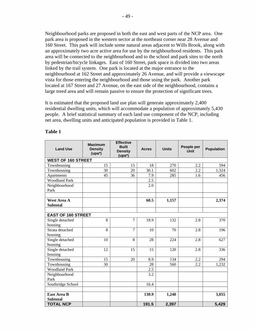
- 49 -
Neighbourhood parks are proposed in both the east and west parts of the NCP area. One park area is proposed in the western sector at the northeast corner near 28 Avenue and 160 Street. This park will include some natural areas adjacent to Wills Brook, along with an approximately two acre active area for use by the neighbourhood residents. This park area will be connected to the neighbourhood and to the school and park sites to the north by pedestrian/bicycle linkages. East of 160 Street, park space is divided into two areas linked by the trail system. One park is located at the major entrance to the neighbourhood at 162 Street and approximately 26 Avenue, and will provide a viewscape vista for those entering the neighbourhood and those using the park. Another park located at 167 Street and 27 Avenue, on the east side of the neighbourhood, contains a large treed area and will remain passive to ensure the protection of significant trees. It is estimated that the proposed land use plan will generate approximately 2,400 residential dwelling units, which will accommodate a population of approximately 5,430 people. A brief statistical summary of each land use component of the NCP, including net area, dwelling units and anticipated population is provided in Table 1. Table 1
Land Use Maximum Density (upa*)
Effective Built
Density (upa*)
Acres Units People per Unit Population
WEST OF 160 STREET Townhousing 15 15 18 270 2.2 594 Townhousing 30 20 30.1 602 2.2 1,324 Apartments 45 36 7.9 285 1.6 456 Woodland Park 2.5 Neighbourhood Park
2.0
West Area A Subtotal
60.5 1,157 2,374
EAST OF 160 STREET Single detached housing
8 7 18.9 132 2.8 370
Strata detached housing
8 7 10 70 2.8 196
Single detached housing
10 8 28 224 2.8 627
Single detached housing
12 15 15 120 2.8 336
Townhousing 15 20 8.9 134 2.2 294 Townhousing 30 28 560 2.2 1,232 Woodland Park 2.5 Neighbourhood Park
3.2
Southridge School 16.4 East Area B Subtotal
130.9 1,240 3,055
TOTAL NCP 191.5 2,397 5,429

- 50 -
Environmental Assessment A detailed environmental impact assessment of the NCP area was undertaken by Phoenix Environmental Services. This assessment identified a number of watercourses, forested areas in the northwest portion of the NCP and potential wildlife species in the area. The assessment highlights the role of the area in the Nicomekl River watershed and the need to mitigate changes through application of stormwater "best management practices" through techniques such as constructed infiltration facilities and the use of bio-filtration. It was determined that it should be possible to produce a modest net gain in fish habitat within the NCP area through permanent and ephemeral ponds, wetlands and watercourses and the protection of some existing treed habitats. There is also a low risk or probability for environmental contamination. Planning Analysis The proposed Land Use component of the Area #1 (Morgan Heights) NCP is generally consistent with the goals, objectives and land use designations identified, to date, in the Grandview Heights General Land Use Plan. The proposed Stage 1 NCP also has support from a majority of the property owners in the area.
Surrey's Official Community Plan ("OCP") identifies several policies relating to how new neighbourhoods or NCPs should contribute to the overall community framework. The NCP discussed in this report substantially meets these policy directions, as identified below:
• Encourages growth and development that effectively utilizes land and City resources,
creating new opportunities to grow in ways that can enhance our neighbourhoods; • Creates orderly and cost-effective development by promoting a complete urban
community, ensuring strategic capital investments to support the community and ensures stakeholder participation and support in local land use planning;
• Supports a compact urban development pattern and creates an identifiable
neighbourhood by ensuring proper planning for schools, parks and stores; • Provides a balanced range of choices in the type, tenure and cost of housing; • Creates a safe, attractive and people-friendly environment through the promotion of
CPTED principles, thus enhancing the City's image; and • Locates services and facilities close to residential neighbourhoods to create
multi-purpose centres and minimize travel to larger commercial areas.
The proposed NCP will effectively integrate with the surrounding land use context and the adjacent areas (North Grandview Heights and the Highway 99 Corridor). The new residential developments will be reasonably served by commercial development, schools, parks and other amenities. Substantial public consultation has been undertaken throughout the planning process for the General Land Use Plan (in process) and extensive local consultation has been undertaken in connection with the development of this NCP.

- 51 -
The proposed Stage 1 Land Use Plan appears to respond to the aspirations of the majority of residents and property owners, in terms of land use, density and area character.
General Servicing Issues The Stage 1 servicing plan report has been completed for the area. Maps for the transportation, sewer, water and storm services are contained in Appendix 5. The Engineering Department staff is satisfied that the servicing concepts, as proposed for transportation, water, sanitary sewer and storm drainage will support the proposed land use plan. The detailed work required to finalize the servicing strategies will be undertaken as part of the Stage 2 component of the NCP. Upon completion of this engineering analysis, a financial plan will be developed to identify how the engineering services will be funded. The following paragraphs summarize specific servicing issues that may impact the development schedule and final layouts:
Water The City’s existing pump station has insufficient capacity to provide water pressure for the new development proposed in this plan. This will be addressed by 2007 with system upgrades being designed for the Grandview Heights reservoir. Any interim water system upgrades that may be approved to facilitate phased development, must be implemented at the proponents' expense. Sanitary Sewer The design and acquisition of key rights of way for the new Grandview Heights North gravity interceptor, west of 160 Street, is currently being addressed by the City. It is not expected that the interceptor will be completed by the City within the required development schedule. If the proponent has a need to advance the City’s construction program to meet development schedules, the proponent will be required to finance the construction of the interceptor up to 160 Street by way of a front-ender agreement with the City. Storm Drainage Stormwater Management strategies are currently being reviewed and opportunities related to detention ponds, trunk sewers, low impact development and pump station upgrades are being evaluated. The current land use plan concept provides sufficient flexibility to accommodate the infrastructure, likely to be proposed through the Stage 2 process. Transportation The Traffic Analysis for the Morgan Heights NCP is based upon a partial interchange located at Highway 99 and 24 Avenue, as well as a full interchange at 152 Street. The results of this analysis indicate that the existing major grid road network (the R-91) will be sufficient to address traffic generation from the Morgan Heights NCP, with two road network changes required. 160 Street must

- 52 -
be upgraded, north of 24 Avenue, to a Divided Arterial Road and 26 Avenue, from 164 Street to 168 Street, must be upgraded to a Major Collector Road. An integrated traffic calming plan will be developed during Stage 2 analysis. A financial plan and phasing strategy will be completed as part of the Stage 2 component. The financial plan will identify the costs for each component of infrastructure and the anticipated DCC revenues for that component, to demonstrate a balance. Refinements and proposed additions to the City's 10 Year Servicing Plan will be recommended. The details associated with the engineering servicing strategies, the costs related to the design and construction of these works and the best method for the NCP to finance the infrastructure, will be addressed as part of the Stage 2 component of the NCP. Land Use Matters Remaining to be Resolved A number of land use issues will need to be resolved during Stage 2 of the NCP process. The following is a summary of these outstanding matters. A detailed assessment of these matters will be conducted as part of Stage 2 and any resulting changes to the Land Use Plan and/or the Circulation Plan will be presented to Council in conjunction with the Stage 2 component of the NCP:
1. The proposed land use plan and environmental recommendations will be
considered by Surrey's Environmental Advisory Committee and any concerns and comments addressed in the NCP;
2. The pedestrian/bicycle plan will be refined to show the location of the paths along
roads (i.e., on street or pathway adjacent), the width of the paths and connections through to the Millennium Trail in the Grandview Corridor. Similarly, the circulation plan will address linkages and interconnectivity between the cul-de-sacs and other internal roads to the main pedestrian/cycling routes (i.e., 160 Street);
3. The local road configuration must be finalized in conjunction with Planning and
Development and the Fire Department staff. Enclosed "P-loops" must make accommodation for emergency access and pedestrian walkways will be incorporated to ensure easy and convenient pedestrian access from the P-loops and cul-de-sacs to all major pathways and destination areas in the neighbourhood;
4. The general lot configurations in the easterly part of the NCP will be refined to
address the City's policies respecting double-fronting lots. CPTED practices must be employed for lots adjacent to parks, open spaces and walkways (i.e., lots should not back onto parks);
5. The storm detention ponds or water retention facilities in the linear park (near
Southridge School) must be addressed as to their acceptability and design; 6. Details of the proposed environmental compensation area in the park west of
160 Street must be confirmed and approved by the City and the Department of Fisheries and Oceans;

- 53 -
7. The location and measures to protect trees in the proposed nature park in the northeast area of the NCP will be confirmed; and
8. The proponents must work with the City and Southridge School to resolve issues,
regarding potential tennis courts, road design and traffic operations on 160 Street and buffering and design guidelines in the vicinity of Southridge School.
Next Steps It is recommended that Council authorize staff to proceed to preparing the Stage 2 component of the NCP, involving more detailed planning and analysis, as identified in this report and appendices and as summarized below:
1. Resolution of the outstanding land use matters, as documented in this report; 2. Identification of detailed engineering servicing requirements, including water,
sanitary sewer, storm sewer, drainage facilities, other major utility infrastructure and the road network;
3. Preparation of a comprehensive servicing plan which will provide solutions to
servicing, transportation and other servicing matters; 4. Determination of a financial strategy to fund the infrastructure needed to support
development in the area in accordance with City policy; 5. Development of a phasing plan for the logical development of the area; and 6. Completion of a review of required amenities to serve this area, including park
acquisition analysis, park development costs, fire and police protection and library materials and the calculation of appropriate amenity contributions for the NCP area to be collected at the time of development of individual sites.
Various City Departments and external agencies will continue to be consulted during the preparation of the Stage 2 component of the NCP. The complete servicing, phasing and financial plan will be presented to the public for review and comment before it is submitted to Council for consideration of approval. It is anticipated that the Stage 2 component of the NCP will be completed by summer 2005. If Council adopts the Stage 1 component of the NCP, in keeping with past practice, it is further recommended that staff be authorized to receive and process development applications for sites within the NCP, provided that final approval of such applications will be held pending completion of the Final Stage 2 component of the NCP, as described in this report.
CONCLUSION
In view of the above analysis and rationale, it is recommended that Council: 1. Approve the Stage 1 component for the Area #1 (Morgan Heights) NCP in
Grandview Heights, as described in this report and as illustrated in Appendix 1;

- 54 -
2. Instruct staff and the NCP proponents to complete the Stage 2 component of the NCP for the Area #1 (Morgan Heights) NCP on the basis of the Stage 1 Land Use Plan, including resolution of outstanding land use matters identified in this report, design guidelines, an engineering servicing strategy and a comprehensive financial plan that will provide adequate funding provisions for engineering servicing infrastructure, logical phasing and community amenities; and
3. Authorize staff to proceed with the processing of development applications in the
Area #1 (Morgan Heights) NCP on the basis that the applications conform with the proposed Stage 1 Land Use Plan and that final approval of such applications will be held pending completion of the Stage 2 component of the NCP.
Original signed by
Murray Dinwoodie General Manager, Planning and Development
JM/kms/saw Attachments: Appendix 1 Stage 1 Land Use Plan Appendix 2 Corporate Report No. L001 and Terms of Reference Appendix 3 Chronology of Public Consultation Appendix 4 Pedestrian Circulation Plan (and Interface areas) Appendix 5 Preliminary Engineering Servicing Drawings (Stage 1) v:\wp-docs\admin & policy\05data\april-june\04251546.jm.doc SAW 9/15/05 12:32 PM

Appendix 1 Stage 1 Land Use Plan

Appendix 2
Corporate NO: LOO1
Report COUNCIL DATE: JAN 10/05
REGULAR COUNCIL - LAND USE
TO: Mayor & Council DATE: January 6, 2005
FROM: General Manager, Planning and Development FILE: 6520-20 (Grandview Heights – Area #1 - Morgan Heights)
SUBJECT: Terms of Reference for the Preparation of a Neighbourhood Concept Plan for NCP Area #1 (Morgan Heights) in Grandview Heights
RECOMMENDATION It is recommended that Council: 1. Receive this report as information; and 2. Authorize staff to proceed with the preparation of a Neighbourhood Concept Plan
for Area #1 (Morgan Heights) in Grandview Heights, based on the Terms of Reference attached to this report as Appendix I.
INTENT
The purpose of this report is to obtain Council authorization to proceed with the preparation of a Neighbourhood Concept Plan for Area #1 (also known as Morgan Heights) in the Grandview Heights community.
BACKGROUND
On October 27, 2003, City Council considered a report and approved a Terms of Reference for the preparation of a General Land Use Plan for the Grandview Heights community. As part of this approval, Council directed that, as early as practical in the General Land Use planning process, boundaries were to be established to delineate neighbourhoods in Grandview Heights for the purpose of commencing the preparation of a Neighbourhood Concept Plan(s) ("NCP") in the area. The General Land Use Plan for Grandview Heights has progressed to a point where, in consultation with the community, boundaries for NCPs have been generally delineated.
- 57 -
On December 13, 2004, City Council considered a status report on the General Land Use Plan for Grandview Heights and directed staff to bring forward, for Council’s consideration during January 2005, a Terms of Reference to guide the preparation of an NCP for NCP Area #1. This would be the first of potentially five NCPs in Grandview Heights. The neighbourhood boundaries are illustrated on the map attached as Appendix II to this report.
DISCUSSION The General Land Use Plan for Grandview Heights, which is nearing completion, will provide a broad land use and servicing concept for the overall Grandview Heights area, along with a preliminary phasing and financing strategy. The Plan also forms the foundation for the preparation of NCPs for future neighbourhoods in the Grandview Heights area. It is anticipated that, following a final open house in early 2005, the completed General Land Use Plan will be forwarded to Council for consideration in the Spring of 2005. The planning process for Grandview Heights consists of two general components: 1. A General Land Use Plan including a preliminary servicing and phasing
strategy, which, among other things, will act to establish NCP boundaries; and
2. The preparation of an NCP for each of the neighbourhood areas within
Grandview Heights, as defined by the General Land Use Plan. The Terms of Reference, attached as Appendix I to this report, is intended to guide the preparation of an NCP for Area #1 in Grandview Heights. Area #1 is also known as Morgan Heights. The NCP process is designed to ensure orderly and sustainable development. Most of the engineering and planning work identified in Appendix "C" of the Terms of Reference will be undertaken by the owners of properties within Area #1 and/or development proponents. It is noted that there is a very active community association in this area (West Grandview Heights Residents’ Association) which, in conjunction with a development group, have been working on land use options and servicing plans and have engaged the services of several consultants to assist them. Upon approval of the attached Terms of Reference, the formal public consultation process (i.e., open houses, etc.) will commence and City staff will become involved to ensure that the plans are consistent with the General Land Use Plan, City policies and technical requirements. This NCP planning exercise will establish, among other things, the alignment of roads and lanes, location of various land uses, development densities, subdivision patterns and location of schools, parks, walkways and open spaces. It will also address the interface between the proposed commercial node at 24 Avenue and 160 Street and this new neighbourhood. A detailed engineering servicing and financing strategy, along with the calculation of amenity charges, will also be included in the NCP planning process.
- 58 -
CONCLUSION
Based on the above, it is recommended that Council authorize staff to proceed with the preparation of an NCP for Area #1 (Morgan Heights) in Grandview Heights, based on the Terms of Reference attached to this report as Appendix I.
Original signed by
Murray Dinwoodie General Manager Planning and Development
WW/kms/saw Attachments: Appendix I Terms of Reference for Neighbourhood Concept Plan Area #1 (Morgan Heights) Appendix II Map Showing Neighbourhood Concept Plan Area Boundaries v:\wp-docs\admin & policy\04data\12231132.ww.doc SAW 9/15/05 12:32 PM

Appendix I
TERMS OF REFERENCE Planning and Public Consultation Process
Grandview Heights Neighbourhood Concept Plan - Area #1 (Morgan Heights)
Introduction The Official Community Plan (the "OCP") sets out broad objectives and policies to guide growth and development within the City. The General Land Use Plan for Grandview Heights will illustrate, in broad terms, the general land use pattern, including residential, commercial, work place, institutional and other land uses at densities appropriate to meet the overall objectives of the City, while taking into account community input. It will also illustrate the main transportation routes, highway access points, the general location of parks, schools and major greenways, the community structure and a general approach to providing engineering services in the area with associated cost estimates and a general financing strategy. The General Land Use Plan forms the foundation for the preparation of Neighbourhood Concept Plans ("NCPs") for future neighbourhoods in the Grandview Heights area. NCPs detail more precisely, on a lot by lot basis, land uses and densities, the transportation network, as well as requirements for engineering servicing, amenities and a financing strategy, based on the principle of "development pays". The NCP acts as the basis for reviewing and approving rezoning and development applications in the area. Purpose These Terms of Reference set out the parameters for undertaking a planning and public consultation process for the preparation of the first NCP in the Grandview Heights area of Surrey. They set the context, provide guidelines for preparing the NCP, define the study area, outline the content of the NCP and set the timeframe for preparing the plan. The NCP Area The plan area, known as Area #1 or "Morgan Heights", includes approximately 80 hectares (196 acres), as illustrated on the map attached as Appendix "A". The NCP area is generally bounded by the Grandview/Highway 99 Corridor to the west, 28 Avenue to the north, 24 Avenue to the south and 164 Street to the east. There are about 79 individual properties in the NCP area. The OCP The entire NCP area is designated Suburban in Surrey’s OCP and is, for the most part, zoned RA One-Acre Residential. NCP Preparation and Consultation Process The planning process will commence with the establishment of a Citizens Advisory Committee from the NCP area. This will be accomplished through consultation with the West Grandview Heights Residents' Association. Based on the work already completed by the development proponents in this area and due to resource limitations, consultants will undertake most of the work associated with the preparation of the NCP.

- 2 -
Appendix "B" lists the steps and the timeframe associated with each step in the proposed NCP planning process for Area #1. Infrastructure and engineering servicing planning, as detailed in Appendix "C", will be an integral part of the process, as will extensive public consultation through committees, workshops, meetings, open houses and focus groups. At milestones in the planning process, public meetings will be held and update reports will be provided to City Council. As outlined in the OCP, residential interests and the business community, along with the general public will be consulted in preparing the NCP. In addition, there will be consultation with the Grandview Heights Citizen Advisory Committee and residents/community associations from the neighbouring areas. The proponents have engaged a planning consultant to prepare land use concepts and related subdivision plans for the NCP area. At least two options will be developed in consultation with City staff. These options will be reviewed with the property owners in the area, as well as with other stakeholders. The proponents, in conjunction with City staff, will hold a public information meeting(s) to discuss the proposed NCP with and to receive input from the public. NCP Content The NCP will contain the elements specified in Part 5: Secondary Plans of the OCP. The NCP will include a physical plan for land uses, known as the Land Use Concept Plan and a facilities, amenities, engineering servicing and financing strategy for the provision of services to and for the neighbourhood. The physical plan will contain the following components: 1. Maps and statistics describing the plan area and sub-areas; 2. A statement outlining the overall development concept; 3. Policies for the development and provision of services, amenities and facilities; 4. Policies and strategies reflecting requirements of the OCP policy directions; 5. A land use concept plan showing:
− Proposed Land uses on each lot; − Park, open space and recreational uses, including greenway connections with adjacent
areas; − The potential location of a neighbourhood school/park site; − Buffers, landscaped areas and edge conditions, specifically in relation to adjacent
future commercial development; and − Other land uses supporting business activity, including day care, employee amenities,
utility and communication facilities, etc.; 6. A Transportation and Circulation Concept Plan that provides for balanced transportation
modes, including walking, bicycling, transit and automobiles; 7. Guidelines relating to character and urban design, CPTED, nuisance control, edge
conditions, screening and buffering, environmental protection and tree protection;
- 3 -
8. An environmental impact analysis with recommendations for protection of treed areas, watercourses and areas of fisheries and wildlife habitat;
9. Buffering and landscaping standards to achieve appropriate interfaces and adequate
separation, where applicable; 10. Plans and strategies for access to/from arterial roads and regional highways; and 11. A servicing and financing strategy, as set out in Appendix "C" to these Terms of
Reference – Engineering Terms of Reference Summary, based on the principle of "development pays" that will contain the following:
− A comprehensive servicing plan that includes the location, staging and standards of
services, including sanitary sewer, water, drainage, roads and other utilities and methods of implementation through rezoning, subdivision and other mechanisms; and
− A financial analysis that will demonstrate how the servicing plan will be implemented.
• NCP Timeline
It is anticipated that the NCP will be substantially completed within seven months, as generally outlined in Appendix "B" Appendices: Appendix "A" - Map of the NCP Area Appendix "B" - Proposed Work Schedule Appendix "C" - Engineering Terms of Reference Summary – Grandview Heights NCP – Area #1 v:\wp-docs\admin & policy\04data\12231132.ww.doc SAW 9/15/05 12:32 PM

Appendix "A" Map of the NCP - Area #1 (Morgan Heights)

Appendix "B" Proposed Work Schedule
NCP - Area #1 Grandview Heights
Activity/Task Estimated Time
1) Initiate formal planning process − Confirm property-owner committee − Collect Background materials and information
January 2005
2) Prepare land use concept options (at least 2 options will be reviewed) and related servicing
February 2005
3) Review options with stakeholders and public − Technical review − Meet with stakeholder meetings and hold a public information meeting
March 2005
4) Develop preferred land use concept − Review with stakeholders − Hold a public information meeting
April 2005
5) Refine the preferred land use concept, based on stakeholder and public input
April 2005
6) Seek Council approval for the final land use and development concept May 2005
7) Prepare and finalize servicing/infrastructure, phasing and funding strategies June 2005
8) Hold a final public information meeting July 2005
9) Forward the final NCP to Council for approval
July 2005

Appendix "C"
Engineering Terms of Reference Summary Grandview Heights Neighbourhood Concept Plan #1 (Morgan Heights)
A. INTRODUCTION
The Grandview Heights area will be divided into several NCP areas. The purpose of the engineering Terms of Reference is to set out a process to prepare servicing plans for the Grandview Heights NCP Area #1, generally referred to as Morgan Heights. The following is a summary of the Engineering Terms of Reference for the Area.
B. ENGINEERING
General Requirements
The proponent(s) must demonstrate how the NCP will conform to the policies and guidelines of the overall Grandview Heights General Land Use Plan and provide details related to a general approach to providing engineering services for the area, with estimated costs, sequencing and funding strategy. Transportation Requirements
The plan must demonstrate the adequacy of the existing routes or off-site improvements necessary to provide acceptable vehicular and pedestrian accessibility. Based on existing traffic volumes, along with projection of traffic from the Grandview Heights General Land Use Plan area, this will include intersection analysis of all intersections on Arterial and Collector routes. Analysis is to be AM and PM peak for initial conditions, the 10 year horizon and ultimate build out conditions The planned ultimate permissible movements for the road network proposed, would need to be identified, as well as intersections that require possible signalization. Specific road issues include, but may not be limited to:
− The road layout must meet the character/objectives of the road pattern established
in the Grandview Heights General Land Use Plan; − Identify impact of traffic generated by commercial core centred on 160 Street and
24 Avenue and integrate the traffic management plans of the two areas; − Identify areas that may require the implementation of traffic calming measures;
and − Address access to the existing private Southridge School, off 160 Street.
Drainage
The Grandview Heights NCP Area #1 (Morgan Heights) area drains to the north, following the natural topography through the North Grandview Heights area, via Morgan Creek and Wills Brook, to the Nicomekl River in the lowlands. There have been no natural watercourses identified within the Grandview Heights NCP Area #1 area, but the area is generally serviced by open ditches that form the headwaters of the natural watercourses named above. Although the servicing plans for the North Grandview Heights NCP were prepared assuming development within the Morgan Heights area, the
- 2 -
density assumptions will need to be verified. Infrastructure recommendations regarding NCP Area #1 must be coordinated with any amendments to the North Grandview Heights NCP. Servicing plans for NCP Area # 1 will include the following:
− Specific drainage issues will include, but may not be limited to confirmation of existing drainage boundaries and highlighting of the proposed future drainage boundaries;
− Highlight downstream constraints associated with proposed drainage plan; − Provide mitigation measures required to deal with constraints and show how these
vary from those presented in the North Grandview Heights NCP and Master Drainage Plan. This includes conveyance upgrades for minor and major flows as well as detention requirements;
− Show the extent of the area that will allow construction of homes with basements; − Identify and integrate opportunities for best management practices that will
protect the hydrologic regime of the watercourses and minimize the risk of water quality degradation; and
− Ensure that lowland drainage strategies currently proposed will accommodate the development schemes proposed in the NCP, with no negative impact to low lying floodplain areas.
Water
The proponent(s) must confirm that the planned Grandview Pump Station, to be constructed adjacent to the GVRD Grandview Reservoir, will have sufficient capacity to service this area and will meet City design criteria. This pump station will replace the existing pump station at 160 Street and 24 Avenue. Key water servicing issues to be considered include, but may not be limited to:
− The Maximum Day Demand and Peak Hour Demand of the plan area; − The schedule and phasing of development; − Adequately sized water mains to provide sufficient domestic demand and fire
flow (supported with calculations) to the subdivisions in accordance to the City's Design Criteria; and
− Integration of the proposed water system with surrounding existing and future NCPs.
Sewer
The proponent(s) must confirm that the planned Grandview North Gravity Interceptor will have enough capacity to service this area and will meet City design criteria. The depth of the sewer serving development within the expanded NCP area must be confirmed. A preliminary profile of the sewer must be provided that will show the depth and length of the sewer. Specific sanitary sewer servicing issues include, but may not be limited to:
− Confirming whether the entire catchment can drain to the Grandview Interceptor; − Sewer routes should be chosen such that rear and side yard servicing will not
occur and that all properties are to be serviced by gravity; − Scheduling and phasing of development;
- 3 -
− Evaluation of whether interim measures will be required to service the area prior to construction of the Grandview North Gravity Interceptor; and
− Preparation of a detailed implementation plan for such interim measures. The costs must be computed for these interim measures.
C. FINANCING AND STAGING
A funding strategy is required to link the servicing costs with the proposed implementation plan. Preliminary cost estimates will be developed for all Development Cost Charge ("DCC") eligible infrastructure and an assessment of the financial balance sheet for the NCP will be provided. As is the case for most NCPs within the City of Surrey, the following principles for engineering infrastructure financing will apply:
− The City will not finance costs for new infrastructure to serve development; − The DCCs collected in the NCP must balance with or exceed required
expenditures for the total build out of the NCP; and − The City will not fund through DCCs, any interim infrastructure or measures.
The financial evaluation must take into consideration the staging of the NCP to ensure the required infrastructure can be implemented using logical phasing that will be financially viable with the DCC funding and administrative procedures (i.e., DCC credits, front enders etc.).

Appendix II Neighbourhood Concept Plan Boundaries
v:\wp-docs\admin & pol y\04data\12231132.ww.doc icSAW 9/15/05 12:32 PM

Appendix 3
Chronology of Public Consultation NCP # 1 (Morgan Heights) Timeline
Date
October 2003 • Surrey City Council approved the Terms of Reference for a General Land Use Planning process for Grandview Heights including the establishment of a Grandview Heights Community Advisory Committee.
January 2004 • NCP boundaries within the Grandview Heights area were established to allow for the start of an NCP Planning Process complimentary to the General Land Use Plan.
February 17, 2005 • The first meeting of the Citizen's Advisory Committee for the Area #1 (Morgan Heights) NCP. This CAC included representatives from within the Morgan Heights area and representatives from the surrounding areas of Grandview Heights.
February 22 – 23, 2005 • Area A and B representatives met with the 1-acre landowners in areas A and B to discuss the NCP. Concerns raised during the meetings were subsequently addressed in a revised plan.
March 10, 2005 • A formal presentation of the Area #1 Morgan Heights NCP was made to the Citizen's Advisory Committee. This was an open house session attended by plan proponents and City of Surrey staff.
March 14, 2005 • Technical review meeting held to provide all available environmental and servicing information for the area; the consultants presented the material and were available to respond to questions.
March 17, 2005 • Information meeting held with the Citizens Advisory Committee.
March 31, 2005 • Public Open House held with respect to Area #1 (Morgan Heights) NCP; approximately 150 attended with 53 comment sheets returned to date (6 did not support, 1 supported with conditions, 44 supported).
Current • On-going consultation with City of Surrey staff and local stakeholders (i.e. Southridge School) and fine-tuning of NCP plan.
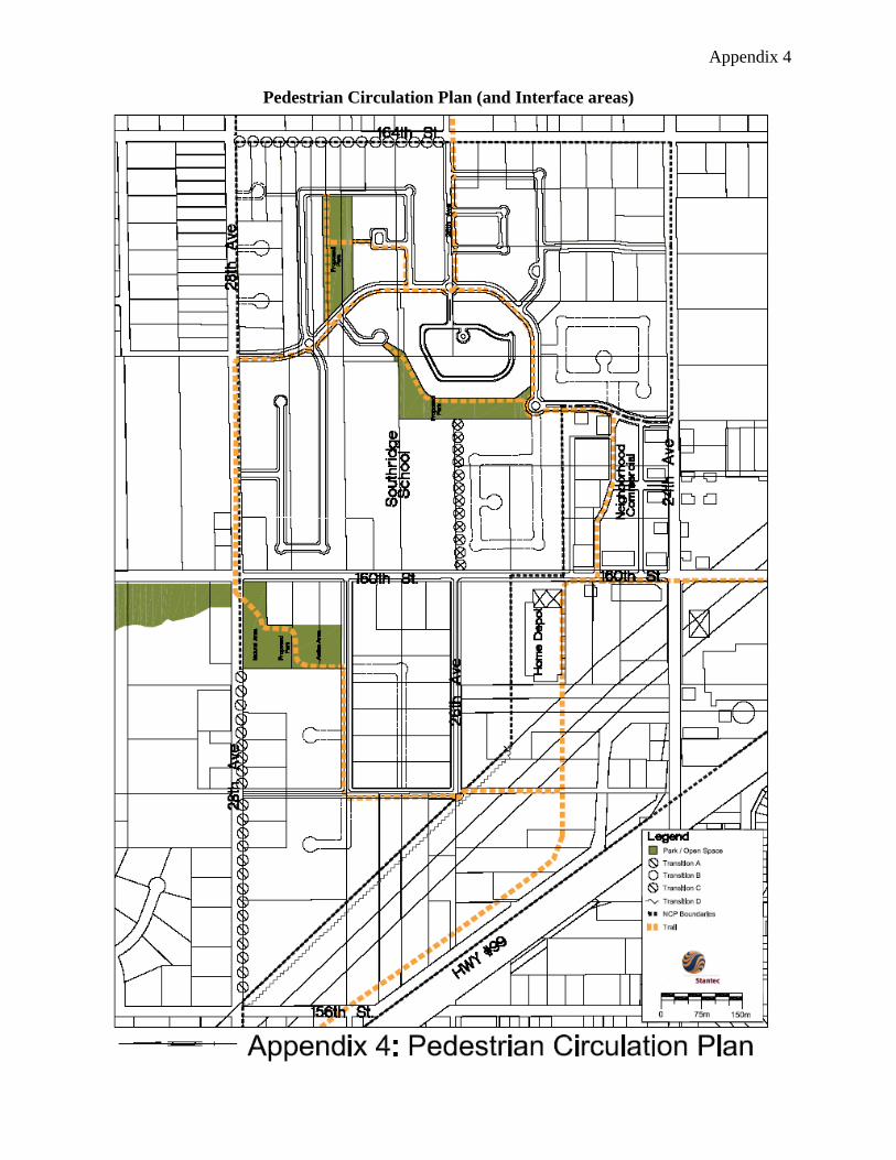
Appendix 4
Pedestrian Circulation Plan (and Interface areas)

Appendix 5
Preliminary Engineering Servicing Drawings (Stage 1)
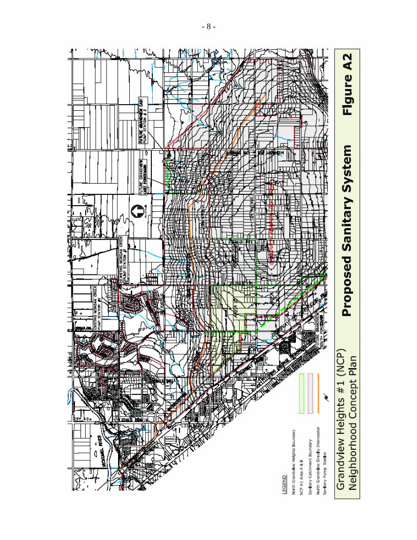
- 8 -
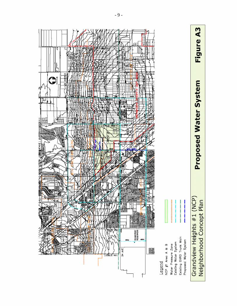
- 9 -

Appendix "E"
Boundary Adjustment between Highway 99 Corridor Local Area Plan and Morgan Heights NCP
v:\wp-docs\admin & policy\05data\july-sept\08301117.ta.doc SAW 9/15/05 12:32 PM