core strategy - city of...
TRANSCRIPT
Core Strategy
Adopted January 2011
Local Development Framework

PART I: Introduction
Maps reproduced from Ordinance Survey mapping with the sanction of Her Majesty’s Stationery Office, Crown Copyright. Unauthorised
reproduction may lead to prosecution or civil proceedings. City of Westminster 2009 LA 100019597.
Land Use Pie Charts for areas in Part III are based on 2008 pipeline data from Westminster City Council’s land use monitoring.
Photographic references:
Page 10: Westminster’s 2012 Ambassadors, from left: Giles Long MBE (Paralympic Gold medallist, swimming), Benjamin Challenger
(Commonwealth Bronze medallist, high jump), Jonathan Edwards CBE (Olympic Gold medallist and World Record holder, triple jump).
Page 13: Image of Westminster by Wenzel Hollar dated 1647 reproduced with permission of Westminster City Archives.
Page 23: 16 New Burlington Place, Regent Street, W1. Client: The Crown Estate. Architect: Trehearne Architects.
Page 24: Beethoven Centre Food Co-op courtesy of Queen’s Park Neighbourhood Management.
Page 30: Photograph courtesy of Savile Row Bespoke.
Page 46: Legible London photograph from Transport for London.
Page 67: Aerial photograph from www.maps.live.com.
Page 81: Carmine, Merchant Square, Paddington, W2. Client: European Land & Property Ltd. Architect: Mossessian & Partners.
Page 96: Gap House, Bayswater, W2. Client: Luke Tozer. Architect: Pitman Tozer.
Page 110: Westminster Academy, Harrow Road, W2. Client: Westminster Academy, Westminster City Council, DCSF and Exilarch
Foundation. Architect: Tim Soar/Alford Hall Monaghan.
Page 112: Photograph courtesy of Westminster PCT.
Page 115: Aerial photograph from www.maps.live.com.
Page 121: Aerial photograph from CityWest Homes.
Page 140: Public meeting of the Queen’s Park Forum (LARP) courtesy of Queen’s Park Neighbourhood Management.

Page i
FOREWORD Welcome to Westminster City Council’s Core Strategy
Westminster is unique. It is not only home to parliament, the Monarchy and Royal Parks, but also world class
tourist attractions, London’s two International shopping centres, the highest number of historic buildings in
the country, over 230,000 residents, and more businesses than the City and Canary Wharf combined.
Westminster accommodates the lively West End, and areas dominated by offices and commercial uses; by
nationally important tourism and cultural uses, and world famous specialist uses; all sitting cheek by jowl with
residential areas and essential local community facilities.
Westminster City Council is committed to providing an excellent service to this wide and varied community. In
the Core Strategy we will build on the things we value: we will improve our neighbourhoods; and provide
enhanced opportunities for our local communities. We will make Westminster the foremost world class city,
with exemplary sustainable design.
We are moving into a new era, where everyone can and should expect the best. The Core Strategy will rise to
the challenge of managing this unique and complex environment for the next 20 years. It sets out a vision for
the future of our unique city: a future of opportunity, improvement, and carefully managed growth and
change.
The Core Strategy has been produced in conjunction with key stakeholders, partners and the local community,
and is the ‘spatial expression’ of the Westminster City Plan. It has been written to see us through the next 20
years, whatever they may hold: environmental challenges: complex and changing economic circumstances:
and outstanding events such as management of the Olympic legacy, to further enhance Westminster’s and
London’s world class city status: to recognise its global importance: and increase its international
competitiveness.
I would like to thank all those involved in the production of this document and in the development of
Westminster. We will continue to work with our partners, stakeholders, businesses and residents to deliver
our vision, and achieve a city that we can all be proud of.
Councillor Robert Davis DL
Deputy Leader of Westminster City Council
Cabinet Member for the Built Environment

WESTMINSTER’S CORE STRATEGY
Page ii
CONTENTS
PART I: INTRODUCTION ................................................................................................................ 1 Westminster’s Local Development Framework ......................................................................... 1 Westminster’s Core Strategy ..................................................................................................... 3 How to use this document ......................................................................................................... 4
PART II: A UNIQUE CITY ................................................................................................................ 5 The Local Context............................................................................................................. 5
Westminster at the heart of a global city .................................................................... 5 Employment and the local economy ............................................................................ 6 Westminster’s Residents .............................................................................................. 7 Health and well-being .................................................................................................. 8 A Unique City ............................................................................................................. 10
The Regional Context ..................................................................................................... 11 Westminster’s Issues and Challenges .............................................................................. 12
Accommodating strategic land uses within a unique Central London mix ................ 12 Strength of Westminster’s heritage assets ................................................................ 13 Lack of available land, housing, and competing land uses ........................................ 14 People pressure .......................................................................................................... 14 Inequalities including health inequalities................................................................... 15 Adaptation to and mitigating climate change ........................................................... 16
Westminster’s Spatial Strategy ....................................................................................... 17 Westminster’s Spatial Vision .................................................................................................... 17 Westminster’s Strategic Objectives ......................................................................................... 17 Westminster’s Spatial Strategy ................................................................................................ 19
Employment and the economy .................................................................................. 19 Housing ...................................................................................................................... 20 Infrastructure ............................................................................................................. 21 Urban Characteristics ................................................................................................ 23 Tackling inequalities .................................................................................................. 24
Westminster’s Key Diagram .................................................................................................... 25
PART III: LOCAL SPATIAL POLICIES ............................................................................................... 26 The Central Activities Zone ............................................................................................. 26
Mixed Uses in the Central Activities Zone .................................................................. 28 Special Policy Areas .................................................................................................... 29
Paddington Opportunity Area .................................................................................................. 31 Victoria Opportunity Area ........................................................................................................ 34 Tottenham Court Road Opportunity Area ............................................................................... 37 Core Central Activities Zone ..................................................................................................... 40
West End Special Retail Policy Area ........................................................................... 43 Marylebone and Fitzrovia ........................................................................................................ 47 Knightsbridge ........................................................................................................................... 49 Pimlico ...................................................................................................................................... 51 Royal Parks ............................................................................................................................... 53
North Westminster Economic Development Area ........................................................... 55 Outside the CAZ and NWEDA.......................................................................................... 60
PART IV: CITY-WIDE SPATIAL POLICIES ........................................................................................ 65 Housing Provision .......................................................................................................... 65
Optimising Housing Delivery .................................................................................................... 67 Meeting Housing Needs ........................................................................................................... 70
Affordable Housing .................................................................................................... 72 Gypsies and Travellers ............................................................................................... 77
Business and Employment .............................................................................................. 80
Page iii
Offices and Business Floorspace .............................................................................................. 81 Retail ........................................................................................................................................ 83 Tourism, Arts and Culture ........................................................................................................ 85
Arts and Culture ......................................................................................................... 86 Hotels and Conference Facilities ................................................................................ 87
Entertainment Uses ................................................................................................................. 88
PART V: CREATING PLACES ......................................................................................................... 91 Heritage ........................................................................................................................ 91
Views ........................................................................................................................................ 92 Uses of National and International Importance ............................................................... 95 Sustainable and Inclusive Design .................................................................................... 96 Health, Safety and Well-Being ........................................................................................ 99
Flood Risk ............................................................................................................................... 101 Air Quality .............................................................................................................................. 104 Noise Pollution ....................................................................................................................... 106
Infrastructure and Development Impacts ..................................................................... 108 Social and Community Infrastructure .................................................................................... 110 Open Space and Green Infrastructure ................................................................................... 113
Open Space Network ............................................................................................... 113 Sites of Importance for Nature Conservation .......................................................... 116 Blue Ribbon Network ............................................................................................... 117 Other Green Infrastructure ...................................................................................... 118
Energy Infrastructure ............................................................................................................. 121 Heat and Power Networks ....................................................................................... 121 Renewable Energy Generation ................................................................................ 123
Transport and Public Realm Infrastructure ............................................................................ 124 Sustainable Transport .............................................................................................. 124 Servicing and deliveries ............................................................................................ 126 The transport network ............................................................................................. 127
Waste Infrastructure .............................................................................................................. 131 Flood and Water-Related Infrastructure ................................................................................ 134 Thames Tunnel……………………………………………………………………………………………………………………135
PART VI: IMPLEMENTATION ..................................................................................................... 135 Partnerships ................................................................................................................ 137
Westminster’s Local Strategic Partnership ............................................................................ 137 Partnership Working .............................................................................................................. 138 Community Governance ........................................................................................................ 139
Risk and Review ........................................................................................................... 141 Monitoring Framework ............................................................................................ 143
SUPPORTING INFORMATION .................................................................................................... 146 Appendix 1: Proposals Sites .......................................................................................... 146 Appendix 2: Retail Hierarchy ........................................................................................ 151
International Shopping Centres ............................................................................................. 151 West End Special Retail Policy Area ....................................................................................... 151 CAZ Frontages ........................................................................................................................ 151 Other Shopping Centres within the Central Activities Zone .................................................. 151 Major Shopping Centres ........................................................................................................ 153 District Shopping Centres ....................................................................................................... 153 Local Shopping Centres .......................................................................................................... 154
Appendix 3: Key Partnerships ....................................................................................... 157 Appendix 4: Housing Delivery ....................................................................................... 161 Appendix 5: Unitary Development Plan Policies Replaced by Core Strategy ................... 166 Glossary....................................................................................................................... 168 References ................................................................................................................... 187

WESTMINSTER’S CORE STRATEGY
Page iv
TABLE OF POLICIES: POLICY CS1 MIXED USE IN THE CENTRAL ACTIVITIES ZONE ...................................................................... 28
POLICY CS2 SPECIAL POLICY AREAS ............................................................................................................ 30
POLICY CS3 PADDINGTON OPPORTUNITY AREA .......................................................................................... 32
POLICY CS4 VICTORIA OPPORTUNITY AREA ................................................................................................. 35
POLICY CS5 TOTTENHAM COURT ROAD OPPORTUNITY AREA .................................................................. 38
POLICY CS6 CORE CENTRAL ACTIVITIES ZONE ............................................................................................ 41
POLICY CS7 WEST END SPECIAL RETAIL POLICY AREA ............................................................................. 44
POLICY CS8 MARYLEBONE AND FITZROVIA .................................................................................................. 48
POLICY CS9 KNIGHTSBRIDGE .......................................................................................................................... 50
POLICY CS10 PIMLICO ....................................................................................................................................... 52
POLICY CS11 ROYAL PARKS ............................................................................................................................ 54
POLICY CS12 NORTH WESTMINSTER ECONOMIC DEVELOPMENT AREA .................................................. 57
POLICY CS13 OUTSIDE THE CAZ AND NWEDA .............................................................................................. 64
POLICY CS14 OPTIMISING HOUSING DELIVERY ............................................................................................ 68
POLICY CS15 MEETING HOUSING NEEDS ...................................................................................................... 71
POLICY CS16 AFFORDABLE HOUSING ........................................................................................................... 73
POLICY CS17 GYPSIES AND TRAVELLERS..................................................................................................... 78
POLICY CS18 COMMERCIAL DEVELOPMENT ................................................................................................. 80
POLICY CS19 OFFICES AND OTHER B1 FLOORSPACE ................................................................................. 82
POLICY CS20 RETAIL ......................................................................................................................................... 84
POLICY CS21 TOURISM, ARTS AND CULTURE ............................................................................................... 87
POLICY CS22 HOTELS AND CONFERENCE FACILITIES ................................................................................ 87
POLICY CS23 ENTERTAINMENT USES ............................................................................................................ 90
POLICY CS24 HERITAGE ................................................................................................................................... 92
POLICY CS25 VIEWS .......................................................................................................................................... 94
POLICY CS26 BUILDINGS AND USES OF INTERNATIONAL AND NATIONAL IMPORTANCE ..................... 95
POLICY CS27 DESIGN ........................................................................................................................................ 98
POLICY CS28 HEALTH, SAFETY AND WELL-BEING ..................................................................................... 100
POLICY CS29 FLOOD RISK .............................................................................................................................. 103
POLICY CS30 AIR QUALITY ............................................................................................................................. 105
POLICY CS31 NOISE ......................................................................................................................................... 107
POLICY CS32 PLANNING OBLIGATIONS AND DELIVERING INFRASTRUCTURE ...................................... 109
POLICY CS33 SOCIAL AND COMMUNITY INFRASTRUCTURE ..................................................................... 111
POLICY CS34 OPEN SPACE ............................................................................................................................ 115
POLICY CS35 SITES OF IMPORTANCE FOR NATURE CONSERVATION .................................................... 116
POLICY CS36 WESTMINSTER’S BLUE RIBBON NETWORK ......................................................................... 118
POLICY CS37 BIODIVERSITY AND GREEN INFRASTRUCTURE .................................................................. 120
POLICY CS38 DECENTRALISED ENERGY NETWORKS ............................................................................... 122
POLICY CS39 RENEWABLE ENERGY ............................................................................................................. 123
POLICY CS40 PEDESTRIAN MOVEMENT AND SUSTAINABLE TRANSPORT ............................................. 125
POLICY CS41 SERVICING AND DELIVERIES ................................................................................................. 127
POLICY CS42 MAJOR TRANSPORT INFRASTRUCTURE .............................................................................. 129
POLICY CS43 SUSTAINABLE WASTE MANAGEMENT ................................................................................. 132
POLICY CS44 FLOOD-RELATED INFRASTRUCTURE ................................................................................... 134
POLICY CS45 THAMES TUNNEL ..................................................................................................................... 135

Page v
TABLE OF FIGURES:
FIGURE 1 WESTMINSTER’S POLICY FRAMEWORK ......................................................................................... 1
FIGURE 2 SPATIAL, TEMPORAL AND SENSORY DIAGRAM ............................................................................ 2
FIGURE 3 WESTMINSTER IN THE HEART OF GREATER LONDON ................................................................. 5
FIGURE 4 PROPORTION OF LONDON’S JOBS WITHIN EACH BOROUGH (2007) .......................................... 6
FIGURE 5 COMPARISON OF ECONOMIC SECTORS FOR WESTMINSTER AND CITY OF LONDON, 2007 ... 6
FIGURE 6 PERCENTAGE OF WESTMINSTER’S HOUSEHOLDS IN DIFFERENT ETHNIC GROUPS, 2006 .... 7
FIGURE 7 DEPRIVATION AND LIFE EXPECTANCY FOR WESTMINSTER’S WARDS, 2007 ........................... 7
FIGURE 8 HOUSEHOLD TENURE AND INCOME, 2006 ...................................................................................... 8
FIGURE 9 MAIN CAUSES OF DEATH FOR WESTMINSTER’S RESIDENTS, 2006 ............................................ 9
FIGURE 10 LONDON PLAN KEY DIAGRAM 2008 ............................................................................................. 11
FIGURE 11 SHOPPING CENTRE GROWTH PROJECTION AND CAPACITY .................................................. 20
FIGURE 12 CROSSRAIL LINE 1 ROUTE THROUGH LONDON ........................................................................ 21
FIGURE 13 THE CENTRAL ACTIVITIES ZONE .................................................................................................. 26
FIGURE 14 PUBLIC BUILDINGS (SQM) ACROSS THE CENTRAL ACTIVITIES ZONE 2003 .......................... 27
FIGURE 15 SPECIAL POLICY AREAS ............................................................................................................... 29
FIGURE 16 PADDINGTON OPPORTUNITY AREA ............................................................................................. 31
FIGURE 17 VICTORIA OPPORTUNITY AREA .................................................................................................... 34
FIGURE 18 TOTTENHAM COURT ROAD OPPORTUNITY AREA ..................................................................... 37
FIGURE 19 CORE CENTRAL ACTIVITIES ZONE ............................................................................................... 40
FIGURE 20 CORE CAZ LAND USE BREAKDOWN ............................................................................................ 41
FIGURE 21 WEST END SPECIAL RETAIL POLICY AREA ................................................................................ 43
FIGURE 22 MARYLEBONE AND FITZROVIA..................................................................................................... 47
FIGURE 23 MARYLEBONE AND FITZROVIA LAND USE BREAKDOWN ........................................................ 48
FIGURE 24 KNIGHTSBRIDGE............................................................................................................................. 49
FIGURE 25 KNIGHTSBRIDGE LAND USE BREAKDOWN ................................................................................ 50
FIGURE 27 PIMLICO ............................................................................................................................................ 51
FIGURE 27 PIMLICO LAND USE BREAKDOWN ............................................................................................... 52
FIGURE 28 ROYAL PARKS IN WESTMINSTER ................................................................................................. 53
FIGURE 29 NORTH WESTMINSTER ECONOMIC DEVELOPMENT AREA ...................................................... 55
FIGURE 30 NORTH WESTMINSTER EDA LAND USE BREAKDOWN .............................................................. 56
FIGURE 31 OUTSIDE THE CAZ AND NWEDA ................................................................................................... 60
FIGURE 32 OUTSIDE DESIGNATED AREAS LAND USE BREAKDOWN ........................................................ 60
FIGURE 33 ST. JOHN’S WOOD AND MAIDA VALE .......................................................................................... 61
FIGURE 34 QUEENSWAY AND WESTBOURNE GROVE .................................................................................. 62
FIGURE 35 BELGRAVIA ..................................................................................................................................... 63
FIGURE 36 5-15 YEAR HOUSING LAND SUPPLY 2009/10 – 2013/14 .............................................................. 66
FIGURE 37 WESTMINSTER’S HOUSING TRAJECTORY .................................................................................. 69
FIGURE 38 WESTMINSTER’S SHOPPING CENTRES ....................................................................................... 83
FIGURE 39 TOURISM-RELATED EMPLOYMENT AS A PROPORTION OF ALL JOBS 2007 .......................... 86
FIGURE 40 DENSITY OF INCIDENTS OF VIOLENCE AGAINST THE PERSON 2007/08 ................................ 89
FIGURE 41 ENERGY CONSUMPTION 2007 ....................................................................................................... 97
FIGURE 42 WIDER DETERMINANTS OF HEALTH ............................................................................................ 99
FIGURE 43 FLOOD ZONE 3 AND AREAS MOST AT RISK OF RAPID INUNDATION .................................... 102

WESTMINSTER’S CORE STRATEGY
Page vi
FIGURE 44 2010 MODELLED ANNUAL AVERAGE POLLUTION EXCEEDANCES FOR NITROGEN DIOXIDE AND PARTICULATES ....................................................................................................................................... 104
FIGURE 45 OPEN SPACE NETWORK .............................................................................................................. 113
FIGURE 46 AREAS OF DEFICIENCY IN PUBLIC OPEN SPACE/ACCESSIBLE ACTIVE PLAY SPACE ...... 114
FIGURE 47 BLUE RIBBON NETWORK INCLUDING THAMES POLICY AREA .............................................. 117
FIGURE 48 AREAS OF WILDLIFE DEFICIENCY .............................................................................................. 119
FIGURE 49 EXTENT OF PIMLICO DISTRICT HEAT UNDERTAKING 2008 .................................................... 121
FIGURE 50 WESTMINSTER’S CONNECTIONS ............................................................................................... 128
FIGURE 51 PUBLIC TRANSPORT ACCESSIBILITY LEVELS 2008 ................................................................ 130
FIGURE 52 BOROUGH LEVEL APPORTIONMENT ......................................................................................... 131
FIGURE 53 WASTE MANAGEMENT FACILITIES ............................................................................................ 132
FIGURE 54 LOCAL AREA RENEWAL PARTNERSHIPS / BUSINESS IMPROVEMENT DISTRICTS ............ 139
FIGURE 55 RISK ASSESSMENT ...................................................................................................................... 141
FIGURE 56 MONITORING FRAMEWORK ........................................................................................................ 144
FIGURE 57 PROJECTED HOUSING SUPPLY FROM ALL SOURCES 2010/11 – 2024/25 ............................. 162
FIGURE 58 RESIDENTIAL SCHEMES WITH 1 TO 9 ADDITIONAL RESIDENTIAL UNITS ............................ 163
FIGURE 59 HOUSING DELIVERY AGAINST LONDON PLAN TARGETS 1999-2024/25 ................................ 165

PART I: Introduction
Page 1
PART I: INTRODUCTION WESTMINSTER’S LOCAL DEVELOPMENT FRAMEWORK
1.1 Westminster’s Local Development Framework is a ‘portfolio’ of documents which
together provide a comprehensive local policy framework for the city.
FIGURE 1 WESTMINSTER’S POLICY FRAMEWORK
This Core Strategy is the key document in that portfolio: all other documents will flow from
it.
1.2 The Core Strategy is one of two Development Plan Documents that Westminster is
preparing. The other will be the City Management Plan, containing the more detailed
policies for determining planning applications.
1.3 The portfolio will also include a number of Supplementary Planning Documents.
These documents give further guidance on how the council expects the policies in the Core
Strategy and City Management Plan to be implemented. They include Planning Briefs,
Conservation Area Audits, design guidance and other topic-based guidance.
WESTMINSTER’S CORE STRATEGY
Page 2
1.4 All of these documents will be prepared in accordance with the timetable set out in
the Local Development Scheme, and undertaking consultation in accordance with the
Statement of Community Involvement. These two documents also form part of the
portfolio of documents: the Local Development Framework.
1.5 The council also monitors the outcomes of its policies annually, and publishes this
information in the Annual Monitoring Report. This report also monitors how the council is
progressing in preparing its policy documents. The Annual Monitoring Report forms part of
the Local Development Framework and is a crucial part of implementing and reviewing the
Core Strategy over the next 15-20 years.
1.6 Finally, Westminster’s Local Development Framework is also likely to include a
charging schedule in the future, setting out required contributions from development in
order to deliver the infrastructure needed to support that development.
1.7 The LDF takes into account the city council’s own strategies and also other agencies’
plans and proposals, giving them spatial expression, and help to deliver them. As well as
embracing this ‘spatial’ planning approach, the LDF recognises the temporal and sensory
aspects of the way the city functions as well as the way the city is experienced by
individuals. Westminster is a complex environment; it is a city with multiple dimensions.
This is fundamental to understanding the way Westminster is now and how it should
develop into the future.
FIGURE 2 SPATIAL, TEMPORAL AND SENSORY DIAGRAM
PART I: Introduction
Page 3
WESTMINSTER’S CORE STRATEGY
1.8 The Core Strategy sets out the vision for the City of Westminster up to and beyond
2025, and puts in place a policy framework to deliver that vision.
1.9 It has been developed by Westminster City Council, working with key stakeholders
and the wide and varied communities across the borough. It has been agreed by the
Westminster City Partnership, and is the ‘spatial expression’ of their document – the
Westminster City Plan. The Core Strategy will be used by Westminster’s key stakeholders in
delivering their services across the city.
1.10 Westminster’s Core Strategy is a Development Plan Document. Together with the
London Plan and Westminster’s City Management Plan, these three documents make up the
statutory ‘development plan’ for the city:
Planning applications must be determined in accordance with the development plan
unless material considerations indicate otherwise1
.
Cross-reference to Part II The Regional Context, Part VI Partnerships including Westminster’s
Local Strategic Partnership.
1 Planning and Compulsory Purchase Act 2004, Section 38(6)

WESTMINSTER’S CORE STRATEGY
Page 4
HOW TO USE THIS DOCUMENT
1.11 This document is made up of six inter-related parts:
1.12 All Core Strategy policies are interrelated and should not be viewed in isolation. To
enable greater ease of use, there are cross-references to other directly related policies.
However, these boxes should not be used as the sole means for comprehensively assessing
which policies apply to a development proposal. Development proposals will be assessed
on how well they meet all relevant policies within the Core Strategy together with other
relevant policies in the development plan for Westminster.
1.13 Core Strategy policies do not repeat national or London Plan policies, but do refer to
specific national and regional targets: The Core Strategy should be read alongside the
London Plan.
1.14 Many of the policies within the Core Strategy refer to where the council considers or
is satisfied that something is the case. However, in circumstances where the council is not
the final decision-maker, this reference to the council is intended to apply to any decision-
maker e.g. a Planning Inspector or the Secretary of State. This applies to Policies CS1, CS2,
CS4, CS5, CS6, CS7, CS8, CS12, CS13, CS14, CS16, CS20, CS33, CS38, CS39, CS41 and CS43.
PART II: A Unique City
PART III: Local Spatial Policies
PART IV: City-Wide Spatial Policies
PART V: Creating Places
PART VI: Implementation
Westminster’ profile and its issues and challenges. A vision, objectives and a spatial strategy to address these challenges over the next 15-20 years.
Building on the spatial strategy, these policies set out the approach and priorities for Westminster’s varied local areas.
Land-use policies to direct activities to appropriate locations, and advise how these should be delivered to meet Westminster’s needs.
Westminster-wide policies to deliver sustainable development, including the infrastructure needed to support development.
Mechanisms for achieving the spatial strategy and minimising risk to its achievement.
PART I: Introduction
What the Core Strategy is and how to use it.
PART II: A Unique City
Page 5
PART II: A UNIQUE CITY THE LOCAL CONTEXT WESTMINSTER AT THE HEART OF A GLOBAL CITY
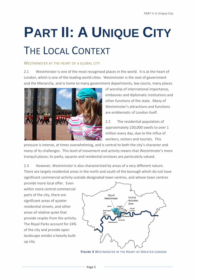
2.1 Westminster is one of the most recognised places in the world. It is at the heart of
London, which is one of the leading world cities. Westminster is the seat of government
and the Monarchy, and is home to many government departments, law courts, many places
of worship of international importance,
embassies and diplomatic institutions and
other functions of the state. Many of
Westminster’s attractions and functions
are emblematic of London itself.
2.2 The residential population of
approximately 230,000 swells to over 1
million every day, due to the influx of
workers, visitors and tourists. This
pressure is intense, at times overwhelming, and is central to both the city’s character and
many of its challenges. This level of movement and activity means that Westminster’s more
tranquil places; its parks, squares and residential enclaves are particularly valued.
2.3 However, Westminster is also characterised by areas of a very different nature.
There are largely residential areas in the north and south of the borough which do not have
significant commercial activity outside designated town centres, and whose town centres
provide more local offer. Even
within more central commercial
parts of the city, there are
significant areas of quieter
residential streets, and other
areas of relative quiet that
provide respite from the activity.
The Royal Parks account for 24%
of the city and provide open
landscape amidst a heavily built-
up city.
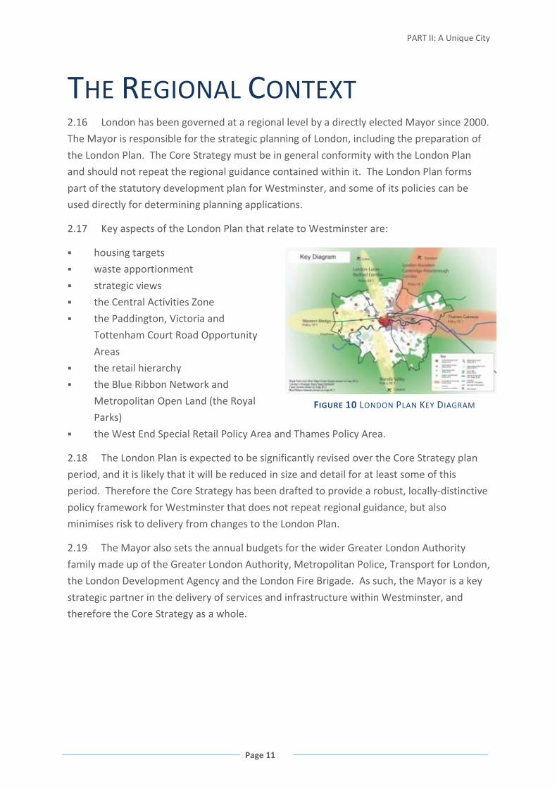
FIGURE 3 WESTMINSTER IN THE HEART OF GREATER LONDON

WESTMINSTER’S CORE STRATEGY
Page 6
EMPLOYMENT AND THE LOCAL ECONOMY
2.4 Westminster functions as a national and international centre for business, shopping,
arts and culture, and entertainment. It accommodates 577,000 jobs, 14% of all of London’s
jobs, and more than the City and Canary Wharf combinedi
. Westminster’s economy
generates 2.2% of the Gross Domestic Product for the UK, about £16 billionii.
FIGURE 4 PROPORTION OF LONDON’S JOBS WITHIN EACH BOROUGH
(BOROUGHS WITH OVER 100,000 JOBS SHOWN) 2007iii
2.5 Westminster’s 47,000 businesses have a diverse and balanced employment offer,
particularly when compared to other areas of the capital such as the City of Londoniv. This
reflects its mixed character and contributes to its economic resilience. Seventy percent of
these businesses are small businesses employing less than five people, and about 85%
employ less than ten peoplev. This is similar to averages for London and England as a whole.
FIGURE 5 COMPARISON OF ECONOMIC SECTORS FOR WESTMINSTER AND CITY OF LONDON, 2007vi

PART II: A Unique City
Page 7
WESTMINSTER’S RESIDENTS
2.6 Compared to other local authorities in the country, Westminster has the highest
proportion of residents born outside the UK (52% for 2004-2006, compared to 9% for
England as a whole). Approximately 29% of Westminster’s residents are from a Black, Asian,
Arabic or other minority ethnic groups. The overall proportion is not expected to change in
the future, although increases are expected from Chinese, Indian, Other Asian and ‘other’
groups, and decreases in Black African, Bangladeshi and Black Caribbean groups.
FIGURE 6 PERCENTAGE OF WESTMINSTER’S HOUSEHOLDS IN DIFFERENT ETHNIC GROUPS, 2006vii
2.7 During the period
2001-2006, Westminster also
had the highest level of
international migration per
1,000 population for England
and Wales. In particular,
Victoria Coach Station is one
of the main points of arrival
into the UK from Europe, and
at its peak had an estimated
2,000 migrants arriving from
the continent every weekviii.
2.8 Westminster is a place
of contrast, with the poorest
residents often living cheek by
jowl with its richest. There
are significant differences in
life expectancy and mortality
between and within electoral FIGURE 7 DEPRIVATION AND LIFE EXPECTANCY FOR WESTMINSTER’S
WARDS, 2007

WESTMINSTER’S CORE STRATEGY
Page 8
wards in Westminster. Deprivation is much more concentrated in the north-west and south
of the cityix. However, significant progress has been made, particularly through local area
renewal partnerships: Since 2004, Index of Deprivation affected wards have improved their
national rankingx.
2.9 Westminster’s housing sector also differs markedly from other areas. Average house
prices in Westminster are the second highest in the country. The city has a significant
private rented sector, comprising over one-third of households, compared to 20% for
London and only 13% for England as a whole. It has a lower owner-occupier sector at only
44%, compared to London (57%) and England (70%)xi. The housing sector reflects
Westminster’s role at the centre of a world city.
FIGURE 8 HOUSEHOLD TENURE AND INCOME, 2006xii
HEALTH AND WELL-BEING
2.10 Westminster generally performs well on health indicators. However, patterns of
health inequality mirror the patterns of social and economic deprivation and there are a
number of key areas where the city performs less well or where there are specific issues
that arise because of the characteristics of the city.
2.11 The Indices of Deprivation includes a measure for the outdoor living environment,
and measures air quality and road traffic accidents. All of Westminster falls within the worst
20% of areas across the UK for this measure.

PART II: A Unique City
Page 9
FIGURE 9 MAIN CAUSES OF DEATH FOR WESTMINSTER’S RESIDENTS, 2006xiii
2.12 Road safety is a significant issue within Westminster. Approximately 300 people die
or are seriously injured on the roads of Westminster each year: approximately three times
the London averagexiv. This adversely affects residents, accounting for a significant
proportion of accidental deaths and of premature deaths from all causesxv. Road safety also
affects workers and visitors within Westminster, and a significant number of fatalities are
pedestriansxvi.
2.13 Crime and the fear of crime can have considerable negative impacts on health,
including increased levels of stress and anxiety, including a fear of going out alone,
therefore impacting on levels of physical activity, and loss of confidence. Creating a city
where people feel safe and stay safe is a priority for Westminsterxvii. Crime in Westminster
steadily dropped between 2000 and 2005, dropping by about 18% overallxviii. Crime levels
are strongly affected by the one million people entering the city every day, and by the
unique circumstances of the West End, Oxford Street and the Governmental and related
functions in and around Whitehall, giving rise to additional security concerns and challenges
including those relating to terrorismxix. The thousands of people attracted to the West End
from all over London for its pubs, clubs and bars leads to anti-social behaviour, including
vandalism, graffiti and drunk, rowdy and intimidating behaviour, as well as acting as a
magnet for crimexx. Over half of recorded crime within Westminster is committed within the
West End and St James’s wards and even this is concentrated within specific parts of those
wardsxxi.
2.14 In many ways, fear of crime can have as profound an effect as direct experience of
crime, with similar effects on people’s mental and physical health. There is a much stronger
correlation between deprivation and the fear of crime as opposed to actual crime statistics,
with residents in Westbourne, Queen’s Park and Harrow Road feeling the least safexxii.

WESTMINSTER’S CORE STRATEGY
Page 10
A UNIQUE CITY
2.15 The City of Westminster is therefore unique and requires a bespoke planning
framework to respond to the opportunities and challenges over the next 20 years. Looking
towards 2025, Westminster will play a key role at the heart of London: the city will host
three events of the 2012 Olympic and Paralympic Games, ensuring that the work we do
provides a lasting legacy for Westminster; contributing to tackling climate change, new
economic circumstances, changing markets
and employment sectors; and changes in the
composition of households and families, and
the way people carry out their daily lives.
This planning framework must retain those
unique characteristics that make
Westminster what it is today: its heritage,
vibrancy, and mix of activities and places.
The following chapters set out this planning
framework to deliver Westminster’s spatial
vision for the future.
i Annual Business Inquiry, 2007 ii Business Directory 2008-10 iii Office for National Statistics, 2009 iv Annual Business Inquiry, 2007 v Annual Business Inquiry, 2007 vi Office for National Statistics, 2009 vii Housing Needs Assessment, 2006 viii Estimate based on Office of National Statistics 2006 data, in liaison with Victoria bus station management
and core coach station companies ix Index of Deprivation 2007 Briefing Note Westminster City Council (accessible through Westminster City
Council’s COWSTAT system) x Westminster City Plan 2006-2016 xi Housing Needs Assessment, 2006 xii Housing Needs Assessment, 2006 xiii ONS Vital Statistics 2006 cited in Public Health Annual Report 2006/2007 xiv London Accident Analysis Unit, London Road Safety Unit, Transport for London Street Management, 2008 xv Public Health Annual Report 2006/2007 Figure 2.4 and Figure 2.8. It is noted that mortality statistics relating
to road safety shown in these figures do not necessarily mean that this was a result of an accident within Westminster. However, the other statistics relate to injuries on Westminster’s roads.
xvi Towards the year 2010: monitoring casualties in Greater London; Issue 8, August 2008 xvii Westminster City Plan 2006-2016 xviii Crime Statistics provided to Westminster City Council by Metropolitan Police, 2008 xix Crime and Disorder Reduction Strategy 2005 – 08 – Priorities reflect this, including those relating to street
crime, drug and substance misuse, alcohol related violence and begging. xx Westminster City Plan 2006-2016, page 28 xxi Westminster City Council Ward Level Crime Statistics, all recorded crimes and Westminster City Council
Crime Mapping (2007-08) Violence against the person xxii Public Health Annual Report 2006/2007
PART II: A Unique City
Page 11
THE REGIONAL CONTEXT 2.16 London has been governed at a regional level by a directly elected Mayor since 2000.
The Mayor is responsible for the strategic planning of London, including the preparation of
the London Plan. The Core Strategy must be in general conformity with the London Plan
and should not repeat the regional guidance contained within it. The London Plan forms
part of the statutory development plan for Westminster, and some of its policies can be
used directly for determining planning applications.
2.17 Key aspects of the London Plan that relate to Westminster are:
housing targets
waste apportionment
strategic views
the Central Activities Zone
the Paddington, Victoria and
Tottenham Court Road Opportunity
Areas
the retail hierarchy
the Blue Ribbon Network and
Metropolitan Open Land (the Royal
Parks)
the West End Special Retail Policy Area and Thames Policy Area.
2.18 The London Plan is expected to be significantly revised over the Core Strategy plan
period, and it is likely that it will be reduced in size and detail for at least some of this
period. Therefore the Core Strategy has been drafted to provide a robust, locally-distinctive
policy framework for Westminster that does not repeat regional guidance, but also
minimises risk to delivery from changes to the London Plan.
2.19 The Mayor also sets the annual budgets for the wider Greater London Authority
family made up of the Greater London Authority, Metropolitan Police, Transport for London,
the London Development Agency and the London Fire Brigade. As such, the Mayor is a key
strategic partner in the delivery of services and infrastructure within Westminster, and
therefore the Core Strategy as a whole.
FIGURE 10 LONDON PLAN KEY DIAGRAM

WESTMINSTER’S CORE STRATEGY
Page 12
WESTMINSTER’S ISSUES AND
CHALLENGES ACCOMMODATING STRATEGIC LAND USES WITHIN A UNIQUE CENTRAL LONDON MIX
2.20 Westminster’s central area, designated the Central Activities Zone (CAZ) within the
Core Strategy, contains a mix of uses and activities that is unique both in London and the
world. The complex mosaic of land uses gives Westminster its vitality, character and role
within London as a world city. The apparent randomness of the mix is the product of the
area’s long history of changing patterns of land use and, since the 1970s, of careful control
through planning policies and negotiations. This approach has proved a success: Soho,
Mayfair and other central areas have retained their prestige as a desirable location for
businesses and vitality and attraction, and the policy approach ensures that no one use
dominates. Monitoring of this approach indicates that while there have been overall
increases in office floorspace, the relative
proportion of office floorspace within the most
central part of this area (designated the Core CAZ)
has changed very little over the past 25 years
(50% in 1983, 51% in 1990 and 48% in 2008). This
mix not only makes Westminster’s Central
Activities Zone unique, but also helps gives it a
human scale, significantly enhancing to
experience of the city from street level.
2.21 Westminster is a nationally and internationally important location for offices, retail,
media and creative industries, arts and culture, higher education institutions, entertainment
and tourism, which it accommodates together with the functions of government and the
state. The locations of these strategic land-uses overlap and all converge in the West End.
2.22 Provision of housing within these areas is also intrinsic to its uniqueness and success.
From flats in Soho to large residential neighbourhoods such as Pimlico, this residential
element plays a major role in defining the character of different parts of the CAZ. The mix of
uses must be carefully managed to ensure that a healthy and safe residential environment is
maintained.
2.23 Maintaining such a complex environment will require a similarly rigorous approach
over the lifetime of the plan, so as to ensure that incremental changes through site-by-site
redevelopment do not erode the mix either at a very local level or across the wider area.
PART II: A Unique City
Page 13
Policies to address this issue are set out at: CS1 Mixed Use in the Central Activities Zone; CS2
Special Policy Areas; CS3 Paddington Opportunity Area; CS4 Victoria Opportunity Area; CS5
Tottenham Court Road Opportunity Area; CS6 Core Central Activities Zone; CS7 West End
Special Retail Policy Area; CS8 Marylebone and Fitzrovia; CS9 Knightsbridge; CS12 North
Westminster Economic Development Area; CS18 Commercial Development; CS19 Offices
and Other B1 Floorspace; CS20 Retail; CS21 Tourism, Arts and Culture; CS22 Hotels and
Conference Facilities; CS23 Entertainment Uses; CS26 Buildings and Uses of International
and National Importance; CS28 Health, Safety and Well-Being; CS30 Air Quality; CS31 Noise;
CS32 Planning Obligations and Delivering Infrastructure; CS41 Servicing and Deliveries; CS42
Major Transport Infrastructure.
STRENGTH OF WESTMINSTER’S HERITAGE ASSETS
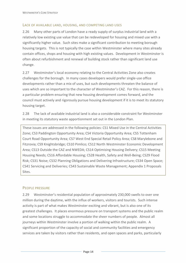
2.24 Westminster has in excess of 11,000 listed buildings (more than any other local
authority in the country), and 75% of its
land area is covered by a Conservation
Area designation. Sixteen of the 26 views
identified in the London Plan are either to
or from Westminster, and the city is
crossed by five designated viewing
corridors, including ones to Westminster’s
World Heritage Site: the Palace of
Westminster and Westminster Abbey,
including St Margaret’s Church.
2.25 This historic environment is a national and international treasure, and intrinsic to
Westminster and London as a whole. It must be the starting point for consideration of all
proposals for change, so as to ensure that it is continually enhanced over the course of this
plan and for generations to come. Sensitive and innovative development can provide
sustainable retrofitting solutions to make this historic fabric fit for the future, including the
challenges of climate change, whilst preserving the integrity of heritage assets. Similarly,
those elements of the built fabric that do not contribute to the quality of the historic
environment can be replaced with development of exemplary, high quality design and
architecture that does contribute and enhance.
These challenges are addressed in the following policies: CS4 Victoria Opportunity Area; CS8
Marylebone and Fitzrovia; CS11 Royal Parks; CS24 Heritage; CS26 Buildings and Uses of
International and National Importance; CS27 Design; CS34 Open Space; CS35 Views; CS36
Blue Ribbon Network; CS41 Servicing and Deliveries; CS42 Major Transport Infrastructure.
WESTMINSTER’S CORE STRATEGY
Page 14
LACK OF AVAILABLE LAND, HOUSING, AND COMPETING LAND USES
2.26 Many other parts of London have a ready supply of surplus industrial land with a
relatively low existing use value that can be redeveloped for housing and mixed use with a
significantly higher value. Such sites make a significant contribution to meeting borough
housing targets. This is not typically the case within Westminster where many sites already
contain offices, shops and housing with high existing values. Development in Westminster is
often about refurbishment and renewal of building stock rather than significant land use
change.
2.27 Westminster’s local economy relating to the Central Activities Zone also creates
challenges for the borough. In many cases developers would prefer single-use office
developments rather than a mix of uses, but such developments threaten the balance of
uses which are so important to the character of Westminster’s CAZ. For this reason, there is
a particular problem ensuring that new housing development comes forward, and the
council must actively and rigorously pursue housing development if it is to meet its statutory
housing target.
2.28 The lack of available industrial land is also a considerable constraint for Westminster
in meeting its statutory waste apportionment set out in the London Plan.
These issues are addressed in the following policies: CS1 Mixed Use in the Central Activities
Zone; CS3 Paddington Opportunity Area; CS4 Victoria Opportunity Area; CS5 Tottenham
Court Road Opportunity Area; CS7 West End Special Retail Policy Area; CS8 Marylebone and
Fitzrovia; CS9 Knightsbridge; CS10 Pimlico; CS12 North Westminster Economic Development
Area; CS13 Outside the CAZ and NWEDA; CS14 Optimising Housing Delivery; CS15 Meeting
Housing Needs; CS16 Affordable Housing; CS28 Health, Safety and Well-Being; CS29 Flood
Risk; CS31 Noise; CS32 Planning Obligations and Delivering Infrastructure; CS34 Open Space;
CS41 Servicing and Deliveries; CS43 Sustainable Waste Management; Appendix 1 Proposals
Sites.
PEOPLE PRESSURE
2.29 Westminster’s residential population of approximately 230,000 swells to over one
million during the daytime, with the influx of workers, visitors and tourists. Such intense
activity is part of what makes Westminster exciting and vibrant, but is also one of its
greatest challenges. It places enormous pressure on transport systems and the public realm
and some locations struggle to accommodate the sheer numbers of people. Almost all
journeys within Westminster involve a portion of walking within the public realm. A
significant proportion of the capacity of social and community facilities and emergency
services are taken by visitors rather than residents, and open spaces and parks, particularly
PART II: A Unique City
Page 15
the five Royal Parks, experience extraordinarily high visitor numbers from non-residents.
The influx of visitors also extends into the evening and night-time, as people are drawn in
for the entertainment offer, particularly concentrated around the West End. The high level
of activity and 24 hour nature of some parts of the city strongly affects noise, air quality,
crime and security, waste and the provision of local services. The functions of state and
government, together with large events befitting Westminster’s Central London role, and
high numbers of people make the threat of terrorism a particular issue within the borough,
and one which is best managed at design stage.
2.30 Regional growth also puts greater pressure on Central London locations such as
Westminster, as people move through the city, and access centrally-located services and
facilities as well as jobs. This movement to, through and across the city contributes to
Westminster having amongst the worst air pollution in the country.
Westminster’s activity makes it different from any other local authority in the country.
The policy approach to address these issues is set out in the following policies: CS4 Victoria
Opportunity Area; CS5 Tottenham Court Road Opportunity Area; CS6 Core Central Activities
Zone; CS7 West End Special Retail Policy Area; CS8 Marylebone and Fitzrovia; CS11 Royal
Parks; CS13 Outside the CAZ and NWEDA; CS23 Entertainment Uses; CS28 Heath, Safety and
Well-Being; CS30 Air Quality; CS31 Noise; CS32 Planning Obligations and Delivering
Infrastructure; CS33 Social and Community Infrastructure; CS34 Open Space; CS36 Blue
Ribbon Network; CS40 Pedestrian Movement and Sustainable Transport; CS41 Servicing and
Deliveries; CS42 Major Transport Infrastructure.
INEQUALITIES INCLUDING HEALTH INEQUALITIES
2.31 Whilst Westminster is generally viewed as a place of affluence, there are pockets of
significant deprivation. Queens Park and Church Street are amongst the top 10% of
deprived wards in the country, Harrow Road and Westbourne amongst the 10 – 20% most
deprived, and Churchill ward amongst the 20 – 30% most deprived. At a sub-ward level,
there are also smaller groupings of deprived residents, such as some communities in the
West End. Health inequalities, including life expectancy, are closely linked to patterns of
deprivation.
2.32 Considerable progress has been made in recent years in addressing deprivation and
health inequalities. Further progress is anticipated throughout the life-time of this plan.
Policies to contribute towards achieving this are set out as follows: CS3 Paddington
Opportunity Area; CS4 Victoria Opportunity Area; CS7 West End Special Retail Policy Area;
CS10 Pimlico; CS12 North Westminster Economic Development Area; CS13 Outside the CAZ
and NWEDA; CS14 Optimising Housing Delivery; CS15 Meeting Housing Needs; CS16
WESTMINSTER’S CORE STRATEGY
Page 16
Affordable Housing; CS17 Gypsies and Travellers; CS19 Offices and Other B1 Floorspace;
CS20 Retail; CS21 Tourism, Arts and Culture; CS27 Design; CS28 Heath, Safety and Well-
Being; CS32 Planning Obligations and Delivering Infrastructure; CS33 Social and Community
Infrastructure; CS34 Open Space; CS40 Pedestrian Movement and Sustainable Transport;
CS42 Major Transport Infrastructure.
ADAPTATION TO AND MITIGATING CLIMATE CHANGE
2.33 This is clearly not an issue unique to Westminster; however, there are a range of
particular challenges and opportunities which arise out of the unique characteristics of the
borough.
2.34 The density, accessibility, heritage and
complex mix of uses in Westminster, particularly
in central areas, provide significant opportunities
for sustainable development: reducing reliance on
journeys by private vehicles; the efficient use of
land; extending the lifetimes of existing buildings
(by hundreds of years in some cases); and
opportunities for local and neighbourhood
solutions such as Combined (Cooling), Heat and Power networks, local in-vessel composting
and other waste solutions, cycle hire, and freight consolidation schemes. Westminster is
also fortunate in having excellent flood defences that will be in place for at least the
duration of the Core Strategy. The need to protect existing buildings along the Thames,
such as the Houses of Parliament, will ensure that the borough has a relatively low risk of
riverine flooding compared to other parts of the country.
2.35 However, because of its central location Westminster suffers disproportionately
from the effects of London’s urban heat island and, in central areas, this is exacerbated by
the 24 hour nature of this part of the city. Noise and poor air quality are also relevant to
this issue as they increase reliance on air conditioning, which further contributes to localised
heating effects, noise and energy consumption.
Matters relating to climate change mitigation and adaptation are set out in the following
policies: CS3 Paddington Opportunity Area; CS4 Victoria Opportunity Area; CS11 Royal
Parks; CS12 North Westminster Economic Development Area; CS36 Blue Ribbon Network;
CS29 Flood Risk; CS24 Heritage; CS27 Design; CS28 Heath, Safety and Well-Being; CS31
Noise; CS32 Planning Obligations and Delivering Infrastructure; CS34 Open Space; CS37
Biodiversity; CS38 Decentralised Energy Networks; CS39 Renewable Energy; CS40 Pedestrian
Movement and Sustainable Transport; CS41 Servicing and Deliveries; CS42 Major Transport
Infrastructure; CS43 Sustainable Waste Management; CS44 Flood-Related Infrastructure.

PART II: A Unique City
Page 17
WESTMINSTER’S SPATIAL STRATEGY WESTMINSTER’S SPATIAL VISION
To make Westminster the foremost world class sustainable city: A city which values
its unique heritage and accommodates growth and change to ensure the city’s
continued economic success while providing opportunities and a high quality of life
for all its communities and a high quality environment for residents, workers and
visitors alike.
WESTMINSTER’S STRATEGIC OBJECTIVES
The objectives for Westminster are not specifically locally distinctive or unique:
Westminster shares many of the aspirations and aims of other local authorities across the
country. However, Westminster also faces particular issues challenges as set out in the
previous section, and these are also reflected in the objectives.
1. To accommodate sustainable growth and change that will contribute to enhancing
London’s role as a sustainable world class city, including its international business, retail,
cultural and entertainment functions within the Central Activities Zone; whilst
maintaining its unique and historic character, mix, functions, and townscapes.
2. To sensitively upgrade Westminster’s building stock to secure sustainable and
inclusive exemplary design which minimises energy and resource consumption and the
production of waste, reduces the impacts of local environmental pollution and meets both
today’s needs and those of the future, including the effects of a changing climate; creating
attractive places that function well whilst ensuring that the historic character and integrity
of Westminster’s built fabric and places is protected and enhanced.
3. To maintain and enhance the quality of life, health and well-being of
Westminster’s residential communities; ensuring that Westminster’s residents can benefit
from growth and change, providing more employment and housing opportunities, safety
and security, and better public transport and local services; to work with our partners to
foster economic vitality and diversity, improved learning and skills, and improved life
chances in areas of deprivation.
4. To increase the supply of good quality housing across all parts of the city to meet
Westminster’s housing target, and to meet housing needs, including the provision of
affordable housing and homes for those with special needs.

WESTMINSTER’S CORE STRATEGY
Page 18
5. To manage the pressures on the city from its national and international roles and
functions, business communities and tourism, including the 2012 Olympic and Paralympic
Games and their legacy, and to ensure a safe and enjoyable visitor experience.
6. To accommodate the safe and efficient movement of growing numbers of people
entering and moving around Westminster by facilitating major improvements to the
public transport system, improving the public realm and pedestrian environment,
managing vehicular traffic, and making walking and cycling safer and more enjoyable.
7. To protect and enhance Westminster’s open spaces, civic spaces and Blue Ribbon
Network, and Westminster’s biodiversity; including protecting the unique character and
openness of the Royal Parks and other open spaces; and to manage these spaces to
ensure areas of relative tranquillity in a city with a daytime population increased every
day by over one million workers and visitors.
PART II: A Unique City
Page 19
WESTMINSTER’S SPATIAL STRATEGY
EMPLOYMENT AND THE ECONOMY
2.36 Westminster is projected to accommodate growth in employment of about 49,000
people between 2010 and 2024i. This provision will include 5,000 new jobs in Paddington
Opportunity Area, 4,000 in Victoria Opportunity Area, and about 5,000 in the Tottenham
Court Road Opportunity Area, including those areas within the London Borough of Camdenii.
2.37 Over the life-time of the
Core Strategy, Westminster will
continue to be one of London’s
most important office locations.
New offices and other B1 business
floorspace will be directed to
appropriate locations within the
Central Activities Zone, primarily
the three Opportunity Areas at
Paddington, Victoria and
Tottenham Court Road, the Core
Central Activities Zone, and to specified locations within Marylebone and Fitzrovia. This will
be delivered in such a way that maintains Westminster’s unique mixed use character within
Central London, with approximately 50% of the floorspace across the whole of Core CAZ
being office floorspace. Overspill office and other B1 accommodation will be directed to
appropriate locations within the North Westminster Economic Development Area,
extending the existing office stock being delivered within the Paddington Opportunity Area.
2.38 Regional assessments of growth in retail have been based on demand assessment
rather than capacity and also assume a 1.5% productivity growth, which appears unlikely
over the short or long-termiii. However, the Core Strategy looks at where increases in retail
floorspace might be accommodated. The main increases, particularly comparison goods
retail floorspace, will be within the West End Special Retail Policy Area with potentially over
125,000 sqm growth between 2001 and 2016iv. Growth can also be expected to a lesser
extent in other areas of the Core CAZ and Knightsbridgev. Projections and capacity for other
significant shopping centres are set out below:
Shopping Centre Type Growth Projection
Capacity Designation
Queensway/ Westbourne Grove
Major 5,000 sqm Occupation of floorspace within existing boundaries
No obvious opportunities to extend the designation
Church Street/ Edgware Road
District 5,000 sqm Addition of supermarket Site 22 in Appendix 1
Harrow Road District 1,200 sqm Occupation of vacant units and possibly Prince of Wales
Site 21 in Appendix 1
WESTMINSTER’S CORE STRATEGY
Page 20
Junction/Maida Hill redevelopments
Praed Street District 900 sqm Occupation of units within the Paddington Opportunity Area
St John’s Wood District 1,500 sqm No indication of demand that cannot be met within the existing boundaries
No significant opportunities for expansion on the edges
FIGURE 11 SHOPPING CENTRE GROWTH PROJECTION AND CAPACITY
2.39 Westminster will continue to play a definitive role in London’s tourism, arts,
educational, service and entertainment sectors. Perceptions of Westminster (and often by
extension, of London) will be enhanced by a continued focus on the enhancement of
heritage assets and views, improved public realm, open spaces and the pedestrian
environment, and the provision of a high quality and safe visitor experience.
HOUSING
2.40 As a general principle, housing is acceptable on all sites within Westminster and is
the priority land use for delivery. As a minimum, an average of 680 new homes will be
delivered annually within Westminster up to 2011 when the new borough target is expected
to be published in the London Plan. Housing delivery will slow in the later plan period as
larger available sites are developed.
2.41 These new homes will be designed and constructed to ensure a high quality
residential environment, with particular attention given to the challenges of poorer air
quality, noise pollution and neighbouring non-residential uses in a built-up residential
environment. Housing will also be designed and positioned within sites to minimise flood
risk.
2.42 The quality of the residential environment and local characteristics of Westminster’s
neighbourhoods will continue to be a defining consideration for development proposals.
This is expressed in the area-based policies throughout the Core Strategy.
2.43 It is not possible to meet the need for affordable housing within the borough as it
exceeds the total housing provision for the plan periodvi. However, the council will seek to
maximise the delivery of affordable housing. Westminster has agreed a target of 925 new
affordable homes for the period 2009/10 – 20011/12, and to exceed 30% of new housing
being affordable over the plan period. This will include the council’s Community Build
programme on its own estates, as well as affordable housing delivered by the private sector.
It will also ensure that new affordable housing improves the mix and balance of
communities by increasing intermediate housing in areas of deprivation.

PART II: A Unique City
Page 21
INFRASTRUCTURE
2.44 Westminster’s success as a world city and its triple roles as a place to live,
commercial centre and tourist attraction places heavy demands on the infrastructure
required. Residents and businesses alike need good utilities provision, transport networks,
open spaces and social and
community facilities. The influx
of workers and visitors also place
considerable demands on public
spaces, and rely on the transport
infrastructure to take advantage
of the 24 hour nature of the
tourism offer.
2.45 Planned growth and change will increase pressure on existing infrastructure and will
generate need for improvements and in some cases, new infrastructure. This is likely to be
more pronounced in the Central Activities Zone but will also affect the rest of the city.
These infrastructure needs will be met through rationalisation of existing sites or
introducing relatively small new facilities within development sites, with the exception of
major transport infrastructure, which has been provided for within the Core Strategy.
2.46 Increases in the capacity of transport infrastructure will have a significant impact on
the city of the next 15 – 20 years. This includes the delivery of Crossrail by 2017 which will
have stations at Paddington, Bond Street and Tottenham Court Road. There will also be an
increase in passenger capacity on the overground trains into Victoria Station, together with
capacity increases on eight London Underground lines. In addition, Underground station
congestion-relief schemes are planned for Victoria, Paddington, Tottenham Court Road and
Bond Street Underground stations to support the capacity increases to those stations.
These will increase the development potential of the three Opportunity Areas: Paddington,
Victoria and Tottenham Court Road. Collectively they should cater for the increase in
demand that will result from projected employment and housing growth, although works to
some stations other than those set out above may also facilitate capacity increases.
Crossrail 2 and the Cross River Transit may be longer term projects for a time horizon to
2026 and beyond.
2.47 Measures will also facilitate the infrastructure necessary to increase walking and
cycling over the life-time of the plan.
FIGURE 12 CROSSRAIL LINE 1 ROUTE THROUGH LONDON

WESTMINSTER’S CORE STRATEGY
Page 22
2.48 Improvements to the public realm will also play a major role in the future to enable
Westminster to support the pressure it experiences. Significant areas of work identified
include Oxford Street, Marble Arch and Leicester Square, and other West End public realm
projects, work around the Victoria interchange and Westminster Cathedral Piazza, and
works in the North Westminster Economic Development Area including town centre
improvements and improving connectivity with the surrounding area. These projects are
delivered by a range of stakeholders, usually involving partnership arrangements. Key
delivery partners are Transport for London, Network Rail, Business Improvement Districts,
developers and land owners and
neighbouring boroughs.
2.49 There is no opportunity within
Westminster for large-scale provision of new
parks and therefore provision of open and
civic spaces within individual developments
will be maximised to help contribute to the
necessary infrastructure. In addition,
improvements to the quality of spaces will be
sought to mitigate the increased pressure on
these spaces.
2.50 Similarly, there is a lack of suitable sites available for dealing with waste within the
city boundary and meeting the waste apportionment set out in the London Plan.
Westminster’s approach will focus on protection of micro-sites and securing on-site
opportunities, rather than a large-scale waste site, although opportunities to identify a
suitable site may arise during the lifetime of the plan.
2.51 The need for additional social and community facilities has been identified and
provided for in the Core Strategy. In many cases, throughout the city, this will be provided
by refurbishment, rationalisation and/or redevelopment of existing sites such as indoor
sports facilities, libraries, schools and hospitals. This may also need to reflect changing
models of delivering public services, and bringing a number of local service providers
together in one location e.g. NHS, housing services, and/or voluntary sector all operating
out of a single local service facility.
2.52 Emergency services have been engaged with the Core Strategy development process
and this will enable them to continue to plan for and meet future needs.
2.53 Utility companies have also engaged with the council, including discussions to enable
them to continue to deliver services in the light of projected growth and development. This
will enable them to properly programme infrastructure delivery within the timescales of
their investment programmes. Energy infrastructure will need to be supplemented by local
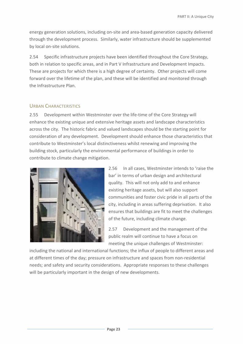
PART II: A Unique City
Page 23
energy generation solutions, including on-site and area-based generation capacity delivered
through the development process. Similarly, water infrastructure should be supplemented
by local on-site solutions.
2.54 Specific infrastructure projects have been identified throughout the Core Strategy,
both in relation to specific areas, and in Part V Infrastructure and Development Impacts.
These are projects for which there is a high degree of certainty. Other projects will come
forward over the lifetime of the plan, and these will be identified and monitored through
the Infrastructure Plan.
URBAN CHARACTERISTICS
2.55 Development within Westminster over the life-time of the Core Strategy will
enhance the existing unique and extensive heritage assets and landscape characteristics
across the city. The historic fabric and valued landscapes should be the starting point for
consideration of any development. Development should enhance those characteristics that
contribute to Westminster’s local distinctiveness whilst renewing and improving the
building stock, particularly the environmental performance of buildings in order to
contribute to climate change mitigation.
2.56 In all cases, Westminster intends to ‘raise the
bar’ in terms of urban design and architectural
quality. This will not only add to and enhance
existing heritage assets, but will also support
communities and foster civic pride in all parts of the
city, including in areas suffering deprivation. It also
ensures that buildings are fit to meet the challenges
of the future, including climate change.
2.57 Development and the management of the
public realm will continue to have a focus on
meeting the unique challenges of Westminster:
including the national and international functions; the influx of people to different areas and
at different times of the day; pressure on infrastructure and spaces from non-residential
needs; and safety and security considerations. Appropriate responses to these challenges
will be particularly important in the design of new developments.
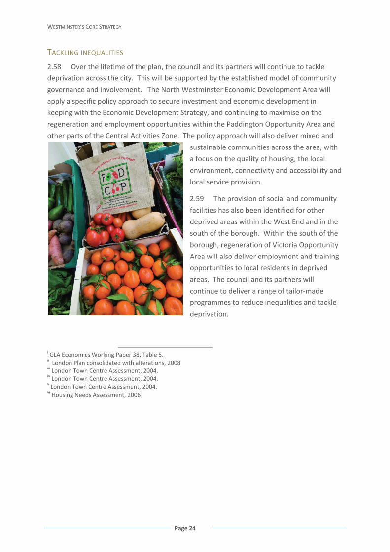
WESTMINSTER’S CORE STRATEGY
Page 24
TACKLING INEQUALITIES
2.58 Over the lifetime of the plan, the council and its partners will continue to tackle
deprivation across the city. This will be supported by the established model of community
governance and involvement. The North Westminster Economic Development Area will
apply a specific policy approach to secure investment and economic development in
keeping with the Economic Development Strategy, and continuing to maximise on the
regeneration and employment opportunities within the Paddington Opportunity Area and
other parts of the Central Activities Zone. The policy approach will also deliver mixed and
sustainable communities across the area, with
a focus on the quality of housing, the local
environment, connectivity and accessibility and
local service provision.
2.59 The provision of social and community
facilities has also been identified for other
deprived areas within the West End and in the
south of the borough. Within the south of the
borough, regeneration of Victoria Opportunity
Area will also deliver employment and training
opportunities to local residents in deprived
areas. The council and its partners will
continue to deliver a range of tailor-made
programmes to reduce inequalities and tackle
deprivation.
i GLA Economics Working Paper 38, Table 5. ii London Plan consolidated with alterations, 2008 iii London Town Centre Assessment, 2004. iv London Town Centre Assessment, 2004. v London Town Centre Assessment, 2004. vi Housing Needs Assessment, 2006
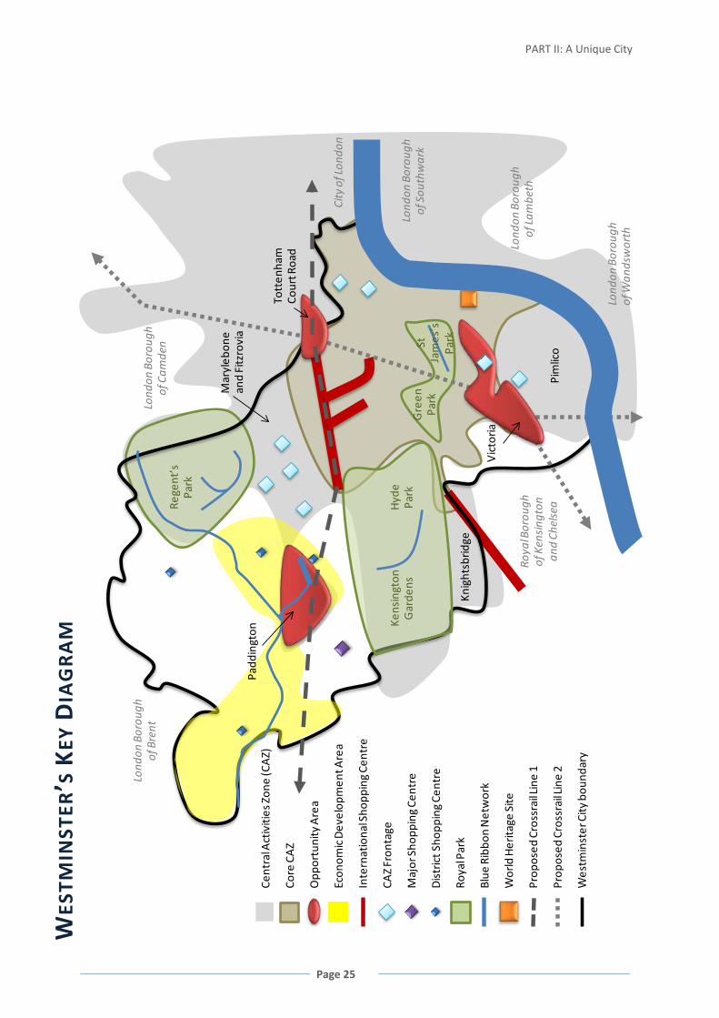
PART II: A Unique City
Page 25
WES
TMIN
STER
’S K
EY D
IAG
RA
M
Rege
nt’s
Park
Hyd
ePa
rkG
reen
ParkLond
on B
orou
ghof
Cam
den
Lond
on B
orou
ghof
Lam
beth
City
of L
ondo
n
Lond
on B
orou
ghof
Sou
thw
ark
Lond
on B
orou
ghof
Wan
dsw
orth
Lond
on B
orou
ghof
Bre
nt
Roya
l Bor
ough
of
Ken
sing
ton
and
Chel
sea
Kens
ingt
on
Gar
dens
Padd
ingt
on
Tott
enha
m
Cour
t Roa
d
Vic
toria
StJa
mes
’sPa
rk
Mar
yleb
one
and
Fitz
rovi
a
Knig
htsb
ridge
Pim
lico
Prop
osed
Cro
ssra
il Lin
e 2
Roya
l Par
k
Econ
omic
Dev
elop
men
t Are
a
Wes
tmin
ster
City
bou
ndar
y
Prop
osed
Cro
ssra
il Lin
e 1
Blue
Rib
bon
Net
wor
k
Core
CA
Z
Cent
ral A
ctiv
ities
Zon
e (C
AZ)
CAZ
Fron
tage
Inte
rnat
iona
l Sho
ppin
g Ce
ntre
Opp
ortu
nity
Are
a
Dis
tric
t Sho
ppin
g Ce
ntre
Maj
or S
hopp
ing
Cent
re
Wor
ld H
erita
ge S
ite

WESTMINSTER’S CORE STRATEGY
Page 26
PART III: LOCAL SPATIAL POLICIES THE CENTRAL ACTIVITIES ZONE
FIGURE 13 THE CENTRAL ACTIVITIES ZONE
3.1 As Westminster has evolved, it has become one of the most
mixed and exciting places in the world. This activity is centred around
the West End, and includes the area which since the 1970s has been
termed the Central Activities Zone (CAZ). Here, together with the
functions of state and the Monarchy, are over 40,000 businesses,
more office floorspace than the City of London and Canary Wharf combined, the nation’s
largest entertainment centre, London’s Theatre district and the West End cinemas, one of
the most important hubs of creative industries in the world, and internationally important
shopping offer including the West End and part of Knightsbridge. This area contains about
17% of London’s hotel bedspaces and some of London’s most recognised tourist attractions
and most iconic public spaces such as Piccadilly Circus, Leicester, Trafalgar and Parliament

Part III: Local Spatial Policies
Page 27
squares, the Royal Parks and Speakers Corner. All this takes place in an area that over
35,000 people call homei. These residents create the unique character of Westminster’s
CAZ that makes it so different from any other part of London.
3.2 The term Central Activities Zone (CAZ) was adopted by the London Plan in 2004 and
is now used to define an area extending across 10 London boroughs, and a wider area of
Westminster including Marylebone and Fitzrovia, Knightsbridge, the Royal Parks and parts
of Pimlico.
3.3 The central part of Westminster’s CAZ is characterised by an intense level and range
of activities. The council has designated this part of the CAZ as the Core Central Activities
Zone (Core CAZ). The intensity of use and range of activities in the Core CAZ is not always
appropriate in the other parts of the CAZ, which have their own unique character and role
within the city. Approximately 120,000 people live across the wider CAZ area and there are
many areas that are predominantly residential.
FIGURE 14 PUBLIC BUILDINGS (SQM) ACROSS THE CENTRAL ACTIVITIES ZONE 2003
3.4 Based on their existing character and function, scale and intensity of land uses, and
type and mix of land use, locally distinctive areas within the CAZ have been identified and
are subject to their own policy framework. These areas are as follows:
• Paddington Opportunity Area
• Victoria Opportunity Area
• Tottenham Court Road Opportunity Area
• Core Central Activities Zone (including the West End Special Retail Policy Area)
• Marylebone and Fitzrovia
• Knightsbridge
• Pimlico
• Royal Parks
A Cinemas, concert halls, theatres B Clubs (excluding sports and private members’ clubs, casinos and live entertainment) C Embassies and consulates D Armed forces E Museums, art galleries, broadcasting non-active entertainment F Courts, emergency services, palaces G Places of worship H Places of active public entertainment, sports centres and gyms

WESTMINSTER’S CORE STRATEGY
Page 28
MIXED USES IN THE CENTRAL ACTIVITIES ZONE
3.5 There is strong competition for floorspace within the CAZ from internationally
important activities and functions, but it is vital that consideration is also given to the place
of residential communities and housing in the Central Activities Zone.
3.6 Managing Westminster’s CAZ is all about balance. The mixed character of the CAZ is
central to its economic vibrancy and is also crucial in attracting visitors and businesses. It
also makes a significant contribution to the unique character of Westminster. It is
acknowledged that in seeking mixed use, potential conflicts may be created which need to
be managed. However, the benefits of genuine mixed use outweigh the difficulties of
securing mixed use development or the additional management needs that may be
generated by such a complex environment.
POLICY CS1 MIXED USE IN THE CENTRAL ACTIVITIES ZONE
The council will encourage development which promotes Westminster’s World City
functions, manages its heritage and environment and supports its living, working and
visiting populations. Within the CAZ, a mix of uses consistent with supporting its
vitality, function and character will be promoted.
Where proposals increase the amount of commercial floorspace by 200 sqm or more,
or in the case of A1 retail or private educational, health and leisure facilities (D1 or
D2), by 400 sqm or more, the provision of an equivalent amount of residential
floorspace will be required on-site, where the council considers this to be appropriate
and practical. This will not apply to changes of use between commercial uses, except
where the change of use is to B1 office use.
Reasoned Justification
The council wishes to accommodate the various economic functions that contribute to
London’s world-class city status and at the same time, build sustainable residential
communities. The primary aim of this policy is to maintain and enhance the character
and function of the CAZ in Westminster by increasing residential uses alongside
increases in commercial uses. It is the residential communities living in CAZ, alongside
the commercial uses, which make it a living, human city centre, which is so attractive to
businesses and visitors alike. Bringing new residents into CAZ will contribute to the
balance, variety and vibrancy of areas in CAZ. The consequent increase in the number of
new homes in Westminster’s CAZ will be an important contributor to meeting the

Part III: Local Spatial Policies
Page 29
borough’s housing targets, but is considered a secondary reason for requiring mixed use
in commercial schemes.
Mixed use means offices, shopping, entertainment, cultural, social and community and
residential uses sharing buildings, streets and localities. The unique and varied mixed
use character across CAZ is fundamental in ensuring the vitality, attraction and
continued economic success of Central London. The mix sought must reflect the needs,
character, function and priorities of these varied areas.
The council encourages and protects A1 uses so a higher threshold of A1 retail
development will ensure there is no discouragement for small scale retail development.
The council also acknowledges the role of private educational, health and leisure
facilities and therefore applies this higher threshold to those uses. The threshold and
proportions are measured by gross floorspace.
Where on-site provision of residential floorspace is not considered appropriate or
practical, a cascade of other options, including the use of land use swaps or residential
credits, will be considered as detailed in the City Management Plan.
Policies relating to the Opportunity Areas (Policies CS3, CS4 and CS5), Core CAZ (Policy
CS6) and West End Special Retail Policy Area (Policy CS7) include specific exceptions to
the application of this policy.
SPECIAL POLICY AREAS
FIGURE 15 SPECIAL POLICY AREAS

WESTMINSTER’S CORE STRATEGY
Page 30
3.7 The council has long protected and encouraged specialist uses in defined Special
Policy Areas (SPAs). These areas are recognised for their special local distinctiveness,
particularly relating to their land uses. Defining SPAs can help ensure that unique clusters of
activity are not lost to other commercial uses. Protection of such unique uses support
specific industries’ long-term success and in many cases enhance London’s global
reputation.
3.8 Future Special Policy Areas may be designated in order to address specific, local land
use issues. These will be used in order to ensure sufficient flexibility within the Core
Strategy to address specific development pressures, economic circumstances and market
conditions.
POLICY CS2 SPECIAL POLICY AREAS
Special Policy Areas are designated to protect and promote specialist uses and functions
as follows:
Harley Street: Medical facilities
Portland Place: Institutional uses
East Marylebone: Wholesale showrooms
Savile Row: Tailoring
St James’s: Private members’ clubs, art galleries, niche retail
Reasoned Justification
It is necessary to provide specific protection for
the unique clusters of specialist uses which are
central to London’s character and ensure these
clusters are not eroded by pressure from other
commercial uses. The detailed policies to protect
and encourage these uses are in the City
Management Plan.
Cross-reference to Policies CS1 Mixed Use in the Central Activities Zone; CS8 Marylebone
and Fitzrovia (for Edgware Road Stress Area, which extends slightly into Core CAZ
boundary).

Part III: Local Spatial Policies
Page 31
PADDINGTON OPPORTUNITY AREA
FIGURE 16 PADDINGTON OPPORTUNITY AREA
3.9 The Paddington Opportunity Area is Westminster’s most
significant opportunity for large-scale regeneration. This area,
designated in 1988 and focused around Paddington Station and the
canal, has seen considerable development which has redefined the
area. Since 2001, the capacity for over 27,000 jobs has been built, over £2 billion has been
invested in the area, 35 new companies have located into the area, and more than 900
homes completed. As a major brownfield redevelopment area, the mix of uses has been
secured subject to a planning framework, with a focus on its emerging importance within
London as an office location.
3.10 Development of this area has been characterised by partnership working to minimise
negative impacts and maximise local benefits within the Opportunity Area and surrounding
areas suffering deprivation. The Opportunity Area lies within the Central Activities Zone and
the North Westminster Economic Development Area, reflecting this dual role.
3.11 Much of the additional capacity in Westminster’s office floorspace has been
provided within Paddington and it remains the most appropriate location for large-
floorplate office space. As an area, it should continue to support businesses whilst building
WESTMINSTER’S CORE STRATEGY
Page 32
a thriving mixed-use sustainable neighbourhood and destination. Future development over
the course of the Core Strategy will therefore focus on delivery of housing to re-balance the
mix of uses in accordance with the phased regeneration of the area established in earlier
policy documents.
3.12 Linked to this growth are significant infrastructure projects and public realm
improvements. These include improvements to the rail and Underground stations, the bus
network and a new Crossrail station. These, together with other improvements for
pedestrians and cyclists, will improve connections between Central London and improve
connectivity to the south and the Economic Development Area as well as the wider regional
area. The Opportunity Area will continue to support the Imperial College Healthcare Trust
in its aims to deliver 21st Century healthcare through St. Mary’s Hospital.
3.13 The Grand Union Canal (Paddington Arm) and Paddington Basin, part of the Blue
Ribbon Network, are also key landmarks within Paddington. There is potential for
developments to improve access to and enjoyment of the canal, further developing the
basin as a waterside destination.
3.14 Evidence indicates that there is very limited potential for the location of tall buildings
within the Opportunity Areaii. The Opportunity Area has scope for the development of
medium height large floorplate buildings in keeping with the larger buildings in the
surrounding townscape. Permission has been granted for one significantly higher tall
building of exceptional quality on Harrow Road between North Wharf Road and Harbet
Road to act as a landmark for the Opportunity Area.
POLICY CS3 PADDINGTON OPPORTUNITY AREA
At least 1,000 new homes and development capacity for 5,000 new jobs will be provided
within the Paddington Opportunity Area between 2010/11 and 2024/25 by provision of a
range and mix of uses across the Opportunity Area including:
A range of offices, flexible workspaces and light industrial units including large
floorplate office stock and affordable business floorspace suitable for small business
and Creative Industries;
A significant proportion of housing;
The retention and improvement of the St Mary’s Hospital facilities to provide
healthcare at all levels and provision, if required, of health care facilities elsewhere
within the Paddington Opportunity Area;
Other uses to support the economic and social regeneration of the area, including
retail, social and community facilities, entertainment and arts/cultural uses. Where
appropriate, other town centre uses should provide active frontages at ground floor
level;

Part III: Local Spatial Policies
Page 33
Public transport and interchange improvements including delivery of Crossrail,
improvements to Underground stations and improvements to the bus network;
together with the following:
Development of a heat and power network including on-site energy generation
capacity;
Public realm improvements to improve legibility and connectivity for pedestrians
within and to/from the area, and enhanced integration between all modes of public
transport;
Improvements to the cycle network and facilities including the provision of a
north/south route to improve accessibility within and to/from the Opportunity
Area; and
New public open space, including green space and play areas across the Opportunity
Area.
The requirement for residential floorspace as part of new commercial development may
be applied more flexibly where the council considers this to be necessary in order to
deliver substantial planned transport and/or public realm improvements which are set
out above, and are also of benefit to the local community.
One site has been identified for a single landmark, high quality building. In other locations
within the Opportunity Area, the council considers that high buildings could not be
accommodated without detriment to the surrounding townscape.
Reasoned Justification
This area has already seen significant growth, however it remains Westminster’s most
important site for development with significant opportunities for place-making and
improving connectivity. The policy reflects the success of existing partnership work within
the area and ensures that continuing development benefits the wider community.
The redevelopment of sites in the Paddington Opportunity Area has established a general
height and scale for new buildings reflecting that of the higher buildings in the surrounding
area. The location identified for the tall building set out in the policy allows for the creation
of a landmark building but without harm to the character of the surrounding townscape.
Detailed policy criteria for tall buildings will be included in the City Management Plan.
Cross-reference to Policies CS1 Mixed Use in the Central Activities Zone; CS12 North
Westminster Economic Development Area; Policy CS36 Blue Ribbon Network; Appendix 1
Proposals Sites: Strategic Sites for the Paddington Opportunity Area.
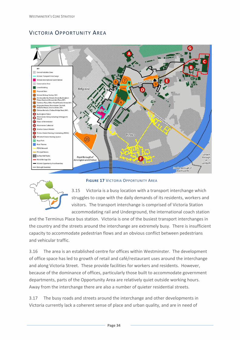
WESTMINSTER’S CORE STRATEGY
Page 34
VICTORIA OPPORTUNITY AREA
FIGURE 17 VICTORIA OPPORTUNITY AREA
3.15 Victoria is a busy location with a transport interchange which
struggles to cope with the daily demands of its residents, workers and
visitors. The transport interchange is comprised of Victoria Station
accommodating rail and Underground, the international coach station
and the Terminus Place bus station. Victoria is one of the busiest transport interchanges in
the country and the streets around the interchange are extremely busy. There is insufficient
capacity to accommodate pedestrian flows and an obvious conflict between pedestrians
and vehicular traffic.
3.16 The area is an established centre for offices within Westminster. The development
of office space has led to growth of retail and café/restaurant uses around the interchange
and along Victoria Street. These provide facilities for workers and residents. However,
because of the dominance of offices, particularly those built to accommodate government
departments, parts of the Opportunity Area are relatively quiet outside working hours.
Away from the interchange there are also a number of quieter residential streets.
3.17 The busy roads and streets around the interchange and other developments in
Victoria currently lack a coherent sense of place and urban quality, and are in need of
Part III: Local Spatial Policies
Page 35
regeneration. There is an opportunity to knit the area together in terms of the built form,
connections to the wider area, and the functioning of the transport interchange. The vision
for the Victoria area is simple: Victoria needs to become a place, not simply a space to pass
through.
3.18 Development at Victoria will also be characterised by a partnership approach
including the local employment partnership, SW1st, Victoria Business Improvement District,
and social and community fund.
3.19 There are a number of key sites that form the most significant opportunities for
development to 2025. Sites should be redeveloped sensitively, respecting adjacent heritage
assets. The proximity of conservation areas, listed buildings, Buckingham Palace, Royal
Parks and the World Heritage site limit the opportunities for tall buildingsiii.
POLICY CS4 VICTORIA OPPORTUNITY AREA
At least 1,000 new homes and development capacity for 4,000 new jobs will be provided
within the Victoria Opportunity Area between 2010/11 and 2024/25, together with the
following:
Improvements within and around the Victoria Transport Interchange (comprising
Victoria Main Line Station, London Underground stations, the international coach
terminal, local London bus network and Terminus Place) as opportunities arise.
Improvements include increased transport and pedestrian movement capacity;
improved integration between different transport modes; improved connectivity
within the transport interchange and to surrounding areas including Victoria Street,
Buckingham Palace and Vauxhall Bridge Road; improved cycle parking;
Safe-guarding and Integration of Crossrail Line 2;
Public realm and environmental improvements to improve legibility and accessibility
for pedestrians and cyclists, particularly to and around the Victoria Transport
Interchange, retail areas, other attractions and features in the vicinity;
A mix of uses on all development sites including active frontages at ground floor
level except where this would compromise movement in and around the Victoria
Transport Interchange;
Provision of publicly accessible open spaces, including tranquil spaces in the vicinity
of the transport interchange, and play spaces for children;
Provision of new purpose-built library; facilities for young people / teenagers; and
improved sports and leisure facilities;

WESTMINSTER’S CORE STRATEGY
Page 36
Protection and enhancement of Strutton Ground street market;
A Combined Heat and Power facility, connected to the Pimlico District Heating
Undertaking (and potentially to the Whitehall system if supported by Government),
with sufficient capacity to serve all sites within the Opportunity Area.
The requirement for residential floorspace as part of new commercial development may
be applied more flexibly where the council considers this to be necessary in order to
deliver substantial planned transport infrastructure improvements and/or public realm
improvements which are set out above and are also of benefit to the local community.
There are limited opportunities for tall buildings because of the potential harm to the
wider area, including the World Heritage Site adjacent listed buildings, Buckingham
Palace, conservation areas and the Royal Parks. Tall buildings may be acceptable in a
limited number of suitable locations where the council considers that they will not
seriously harm the surrounding area and its heritage assets, and will also deliver wider
benefits to the Opportunity Area.
Reasoned Justification
The development of this area needs to
improve the sense of place within and
around Victoria. To deliver this, it is
necessary to address the high volumes of
pedestrian traffic associated with the transport interchange, and provide a high quality
environment that functions well in terms of its connections, streetscape and economic and
environmental performance. This includes maximising the opportunities that exist for
redevelopment, retail, employment provision, creating a more vibrant mix of uses, and a
greatly improved public realm. This approach will enhance the significant heritage assets in
the area by sensitive improvements to historic buildings and structures together with
sensitive redevelopment on neighbouring infill sites. The policy will be implemented with a
range of stakeholders, and through local partnerships, and deliver benefits for the wider
area particularly helping to address local deprivation using a similar model to Paddington.
Detailed policy criteria for tall buildings will be included in the City Management Plan.
Cross-reference to Policies CS1 Mixed Use in the Central Activities Zone; CS25 Views; CS33
Social and Community Infrastructure (for policy on a new local services provision facility);
CS38 Decentralised Energy Networks; Appendix 1 Proposals Sites: Strategic Sites for the
Victoria Opportunity Area.

Part III: Local Spatial Policies
Page 37
TOTTENHAM COURT ROAD OPPORTUNITY AREA
FIGURE 18 TOTTENHAM COURT ROAD OPPORTUNITY AREA
3.20 The Tottenham Court Road Opportunity Area has been
established to encourage regeneration and growth. It lies across the
boundary between the City of Westminster and the London Borough of
Camden, with the smaller area within Westminster. It sits within a
wider area dominated by the retail sector, including the eastern end of
Oxford Street with its mixed retail uses, Charing Cross Road with its specialist book retailers,
and Tottenham Court Road characterised by its specialist electronics retailers.
Westminster’s part of the Opportunity Area has a number of key development sites
including sites required for the delivery of Crossrail, a large postal sorting office site and a
large retail site at the junction of Oxford Street and Tottenham Court Road.
3.21 This area already has good access to public transport, with key bus and Underground
routes. Tottenham Court Road Underground Station has 37 million passenger movements
per year and will undergo substantial change up to 2025, particularly with the construction
and opening of Crossrail. Substantial public transport improvements are required to
facilitate major development and help realise the full potential of this area.

WESTMINSTER’S CORE STRATEGY
Page 38
3.22 There is also potential to facilitate and encourage pedestrian movement within and
around the Opportunity Area as part of a comprehensive strategy for the whole of the West
End.
3.23 As Tottenham Court Road is surrounded by historic buildings and areas, it is not
appropriate for tall buildingsiv however there are significant opportunities for the sensitive
redevelopment of some sites to provide additional residential and commercial capacity.
POLICY CS5 TOTTENHAM COURT ROAD OPPORTUNITY AREA
At least 600 new homes and development capacity for 5,000 new jobs will be provided
within the Tottenham Court Road Opportunity Area (including within the London Borough
of Camden) between 2010/11 and 2024/25, together with the following priorities:
Crossrail, including new Crossrail/London Underground stations;
Public realm improvements to improve pedestrian circulation and movement,
enhance the appearance of the street environment, and improve connectivity and
way-finding to the surrounding areas, particularly retail and tourist destinations
such as Covent Garden and the British Museum;
A1 retail use at basement to first floor level for all frontages onto Oxford Street, and
at ground floor level for all frontages onto Tottenham Court Road and Charing Cross
Road, including large scale retail development on appropriate sites.
The requirement for residential floorspace as part of new commercial development may
be applied more flexibly where the council considers this to be necessary in order to
deliver substantial planned transport and/or public realm improvements which are set
out above and are also of benefit to the local community.
Reasoned Justification
Tottenham Court Road Opportunity Area provides the potential for development that
respects the conservation areas, listed buildings and important views. Some sites in the
Opportunity Area are currently under-developed, and in need of regeneration.
Development here, including improvements to public transport provision, will act as a
catalyst for further private sector investment and improve the built fabric, commercial
performance, and overall contribution that the Opportunity Area makes to the city. The
delivery of Crossrail, with new stations and associated development above increases the
potential of this area for such development.
Public realm improvements will be required to ensure that pedestrians entering the West
End are able to move around freely. Pavements and other public areas will need to be

Part III: Local Spatial Policies
Page 39
designed and managed to facilitate high pedestrian flows, particularly with the significant
increase in passenger numbers associated with Crossrail.
Westminster City Council will work with the London Borough of Camden, local land owners
and developers where appropriate, the Crossrail delivery partners, to ensure that the
necessary improvements are provided. This will include partnership working with the
London Borough of Camden to ensure that the footways and the public realm at St. Giles
Circus at the borough boundary are coordinated.
Covent Garden market and shopping area lies directly
to the southeast of the Opportunity Area, and the
British Museum is only a few streets away to the
north. Improving access to and from such
destinations will help the functioning of the West End
and surrounding area, encourage pedestrian
movement, and help foster a sense of place and
connectivity. The success of established way-finding
strategies such as Legible London will be built on to
achieve this.
As the Opportunity Area is the eastern gateway to the
Oxford Street Primary Frontage, a strong retail offer
and presence is required to support the West End
Special Retail Policy Area, especially at street level.
Cross-reference to Policies CS1 Mixed Use in the Central Activities Zone; CS7 West End
Special Retail Policy Area; Appendix 1 Proposals Sites: Strategic Sites for the Tottenham
Court Road Opportunity Area.

WESTMINSTER’S CORE STRATEGY
Page 40
CORE CENTRAL ACTIVITIES ZONE
FIGURE 19 CORE CENTRAL ACTIVITIES ZONE
3.24 The majority of commercial activity in Westminster is located
within Westminster’s original CAZ designation, in place since the early
1980s. This area (with minor updates to the boundary) is designated as
the Core Central Activities Zone (Core CAZ). It is an economic
powerhouse and international destination, home to global companies, world-class hotels,
theatres, cinemas, museums, galleries, restaurants, public houses and shops, all showcasing
the best London has to offer in terms of retail, leisure and entertainment. It is also home to
a number of long-standing residential communities, including some areas suffering
deprivation within the West End.
3.25 The Core CAZ is an appropriate location for commercial developments, institutes and
activities and functions of national and international status and importance.
3.26 Core CAZ’s international retail offer, centred around Oxford Street, Regent Street
and Bond Street, is the UK’s largest outdoor retail area and a world-renowned retail
destination. London’s other International Shopping Centre, Knightsbridge, is shared with
the Royal Borough of Kensington and Chelsea, with a section extending into the eastern part
of Core CAZ at Brompton Road.

Part III: Local Spatial Policies
Page 41
3.27 The typical ‘town centre’ model of shopping centres and parades is irrelevant within
the Core CAZ and its long-standing characteristic of genuine mixed use. Within this area
retail is encouraged in any location and this is an important element in the unique character
and mix of this part of London. Places such as Covent Garden, South Molton Street and
Carnaby Street are all retail destinations in their own right.
3.28 The central part of Westminster has one of the largest clusters of cultural and
entertainment uses in the country centred around the West End, including Theatreland,
Trafalgar Square and Somerset House. This has been designated a Strategic Cultural Area.
Millbank, along the Thames Riverside, is also a Strategic Cultural Area, including Tate Britain
and the Chelsea College of Art and Design. Creative Industries are an important element to
the Westminster economy and interdependent with a vibrant cultural sector. The West
End, particularly Soho, has the highest concentration of creative businesses in the UK.
3.29 The council has
designated the West End as a
Stress Area because there is a
saturation of entertainment uses
within the area and harm is being
caused to residential amenity,
health and safety, local
environmental quality and the
character and function of the
area.
FIGURE 20 CORE CAZ LAND USE BREAKDOWN
3.30 Despite being one of the most vibrant areas of London, supported by a range of
commercial uses, parts of the Core CAZ suffer from deprivation, and a lack of local services
and community facilities.
POLICY CS6 CORE CENTRAL ACTIVITIES ZONE
The Core Central Activities Zone (Core CAZ) is an appropriate location for residential
use and a range of commercial and cultural uses, subject to the following priorities;
Retail floorspace is encouraged throughout the area. Large scale retail
development will be directed to the West End International Shopping
Centre’s Primary Shopping Frontages, the CAZ Frontages and the Opportunity
Areas, with smaller-scale retail development also to its other shopping
centres. Development within the Knightsbridge Primary Shopping Frontage

WESTMINSTER’S CORE STRATEGY
Page 42
will support the character, function and vitality of the wider International
Shopping Centre within the Royal Borough of Kensington and Chelsea.
Within the West End Stress Area, new entertainment uses will only be
allowed where the council considers that they are small-scale, low-impact
and they will not result in an increased concentration of late-night uses.
Development sites within the Millbank Strategic Cultural Area between
Lambeth and Vauxhall bridges will deliver a mix of uses including those that
support culture and the creative industries - including arts and cultural uses,
affordable business floorspace, workshops and studios; and
Berwick Street market will be protected and the use of Rupert Street for
specialist seasonal market trading will be supported.
Where retail developments fronting the Primary Shopping Frontages result in the
requirement to provide residential floorspace, the residential floorspace may be
provided off-site in the vicinity rather than on-site, where the council is satisfied that
off-site provision would better contribute to the vitality of the West End Special Retail
Policy Area or Knightsbridge International Shopping Centre.
Reasoned Justification
This policy approach allows and encourages the growth of commercial uses within the
Core CAZ and recognises the significant contribution Westminster makes to London’s
world city status. The Core CAZ is the centre of commercial life and heart of business in
London.
Retail is an essential element of the mix
of uses in Core CAZ contributing to its
vibrancy and activity and its function as a
world-class shopping destination,
including its most famous retail
destinations.
There is some potential for
redevelopment between Lambeth and
Vauxhall bridges to enhance the Millbank Strategic Cultural Area.
It is essential that the strategically important clusters of entertainment uses within the
West End remain attractive and safe places in which to live, visit and work. There are

Part III: Local Spatial Policies
Page 43
identified ‘crime hotspots’ within the West End Stress Area and introduction of any
additional entertainment uses would be unacceptable in many instances. In particular,
larger scale and high impact entertainment uses have a disproportionate impact, and
are detrimental to the safety and functioning of the area, people’s enjoyment and
perceptions of the West End as a place to visit, and the character of the streetscape.
Off-site provision of the residential floorspace may be appropriate in the Primary
Shopping Frontages to ensure that retail growth and improved retail space remains the
priority. This will maintain a retail experience befitting the international status and help
maintain the unique vitality and attractiveness for businesses, shoppers and visitors alike.
Cross-reference to Policy CS1 Mixed Use in the Central Activities Zone.
WEST END SPECIAL RETAIL POLICY AREA
FIGURE 21 WEST END SPECIAL RETAIL POLICY AREA
3.31 The West End, at the heart of London, attracts visitors from around the world to its
celebrated shopping streets: including Oxford, Regent and Bond streets, Piccadilly, Covent
Garden and streets within Soho such as Carnaby Street.
WESTMINSTER’S CORE STRATEGY
Page 44
3.32 The West End Special Retail Policy Area (WESRPA) has been established to sustain
and enhance this unique part of the city. It includes an International Shopping Centre,
which together with Knightsbridge, sits at the top of London’s shopping hierarchy.
WESRPA’s most important shopping frontages of Oxford, Regent and Bond streets are
designated Primary Shopping Frontages as they contain the most significant concentration
of shop uses in the country.
3.33 The retail frontages within WESPRA vary in their quality and attraction. Much of the
area is architecturally attractive and performs well. However, the eastern end of Oxford
Street from Oxford Circus to Tottenham Court Road, and Marble Arch at the western end of
Oxford Street offer particular scope for improvement.
3.34 The five main Underground stations within the WESRPA2
3.35 Because of the intense activity on the main shopping streets, ‘Oasis Areas’ are being
created in side streets close to the main shopping frontages but away from their hustle and
bustle. They provide areas of rest and make the WESRPA more attractive to a wider range
of people, including older people or those with younger children.
have, on average, over
600,000 passenger movements every day, added to by the 170,000 daily passengers
movements from the bus network along Oxford Street alone. Oxford Circus station is the
third busiest Underground station in London, but unlike Victoria and Waterloo (the two
busiest stations in London), passengers do not transfer to the rail network but instead spill
out onto busy streets. Crossrail will further increase the capacity of public transport in this
part of Westminster. Pedestrian congestion is therefore a significant challenge for the
Primary Shopping Frontages.
3.36 Evidence suggests that 41% of West End shoppers never venture off the main streets
and 38% of all shoppers have difficulty finding their way aroundv. Legibility and way-finding
are crucial to improving the functioning and visitor experience in WESRPA.
3.37 Development within the WESRPA must be of exceptional design and townscape
quality in order to support its function as a world-class shopping destination.
POLICY CS7 WEST END SPECIAL RETAIL POLICY AREA
The unique status and offer of the West End Special Retail Policy Area will be
maintained and enhanced, together with the following priorities:
Improved retail space;
2 Oxford Circus, Tottenham Court Road, Bond Street, Piccadilly Circus and Leicester Square
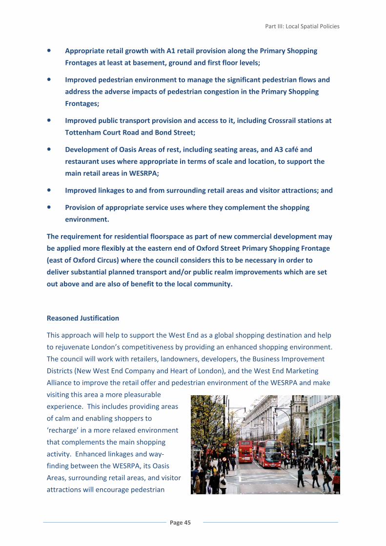
Part III: Local Spatial Policies
Page 45
Appropriate retail growth with A1 retail provision along the Primary Shopping
Frontages at least at basement, ground and first floor levels;
Improved pedestrian environment to manage the significant pedestrian flows and
address the adverse impacts of pedestrian congestion in the Primary Shopping
Frontages;
Improved public transport provision and access to it, including Crossrail stations at
Tottenham Court Road and Bond Street;
Development of Oasis Areas of rest, including seating areas, and A3 café and
restaurant uses where appropriate in terms of scale and location, to support the
main retail areas in WESRPA;
Improved linkages to and from surrounding retail areas and visitor attractions; and
Provision of appropriate service uses where they complement the shopping
environment.
The requirement for residential floorspace as part of new commercial development may
be applied more flexibly at the eastern end of Oxford Street Primary Shopping Frontage
(east of Oxford Circus) where the council considers this to be necessary in order to
deliver substantial planned transport and/or public realm improvements which are set
out above and are also of benefit to the local community.
Reasoned Justification
This approach will help to support the West End as a global shopping destination and help
to rejuvenate London’s competitiveness by providing an enhanced shopping environment.
The council will work with retailers, landowners, developers, the Business Improvement
Districts (New West End Company and Heart of London), and the West End Marketing
Alliance to improve the retail offer and pedestrian environment of the WESRPA and make
visiting this area a more pleasurable
experience. This includes providing areas
of calm and enabling shoppers to
‘recharge’ in a more relaxed environment
that complements the main shopping
activity. Enhanced linkages and way-
finding between the WESRPA, its Oasis
Areas, surrounding retail areas, and visitor
attractions will encourage pedestrian

WESTMINSTER’S CORE STRATEGY
Page 46
movement, both reducing pressure on the public transport network and promoting what
the wider area has to offer.
Appropriate management of the public realm is needed to reduce pedestrian congestion.
Public realm improvements are essential for the success of WESRPA and for the
introduction of Crossrail into the West End, with
the streetscape designed and managed to cope
with the increased pedestrian flows.
The council, New West End Company and
Transport for London have prepared an action
plan to address these issues. The Oxford, Regent,
Bond Street ‘ORB’ Action Plan covers the main
shopping streets in the West End, and this Core
Strategy supports this and other West End
partnership action plans.
The location, accessibility and scale of the
Primary Shopping Frontages make them
especially suitable for retail growth. A1 Retail
should be provided at basement to first floor
levels to maintain their character and to reflect
their importance at the top of London’s retail
hierarchy. Regeneration within the wider WESRPA will encourage further investment with
potential to further improve the environment for shoppers and retailers. This retail
experience can be enhanced by the provision of appropriate, complementary uses such as
banks and cafés.
Cross-reference to Policies CS1 Mixed Use in the Central Activities Zone; CS6 Core Central
Activities Zone; Appendix 1 Proposals Sites: Strategic Sites for the West End Special Retail
Policy Area.

Part III: Local Spatial Policies
Page 47
MARYLEBONE AND FITZROVIA
FIGURE 22 MARYLEBONE AND FITZROVIA
3.38 Residential use is much more evident in the northern part of
the Central Activities Zone covered by Marylebone and Fitzrovia than it
is in the Core Central Activities Zone, and large areas have a
predominantly residential character.
3.39 The area contains a number of commercial developments that
are clustered either within Special Policy Areas or along the main streets, which have
historically been treated as part of the Central Activities Zone. There is a significant
concentration of media-based offices which spill over from the main concentration of Soho,
most of which occupy older pre-war buildingsvi.
3.40 Retail within the area is also focused in specific shopping streets - Marylebone High
Street which has long been a designated District Shopping Centre and is now a CAZ
Frontage, and a number of local shopping parades. Whilst there are a few embassies
(mostly within the Portland Place Special Policy Area and Montagu Street) and hotels, the
area does not have the tourist-focused activities of the Core CAZ.

WESTMINSTER’S CORE STRATEGY
Page 48
However, the area contains Edgware Road which provides a unique cosmopolitan retail and
entertainment offer.
3.41 The council has
designated part of the Edgware
Road as a Stress Area due to the
existing concentration of
entertainment uses to ensure
that the impact on the
surrounding area is carefully
managed.
FIGURE 23 MARYLEBONE AND FITZROVIA LAND USE BREAKDOWN
POLICY CS8 MARYLEBONE AND FITZROVIA
Edgware Road, Baker Street, Marylebone Road, Portland Place, Park Crescent and Great
Portland Street are appropriate locations for residential use and a range of commercial
uses. Retail and other appropriate town centre uses will also be directed to Marylebone
High Street and the Local Shopping Centres.
Within the Edgware Road Stress Area, new entertainment uses will only be allowed where
the council considers that they are low-impact and would not result in an increased
concentration of late-night uses.
Outside these locations, new commercial uses will not generally be appropriate unless
they provide services to support the local residential community in that part of the Central
Activities Zone.
Reasoned Justification
This policy recognises the role of this area in terms of contributing to Westminster’s wider
role within London’s economy and world-city status, whilst ensuring that the local
distinctiveness of areas, particularly the residential character and function within
Marylebone and Fitzrovia, are not lost.
The provision of cafés, restaurants and appropriate entertainment uses can help to support
the retail function of the Edgware Road CAZ Frontage. However, growth in the night-time
economy outside this area, or creating a concentration of such uses within the area would
unacceptably impact on residential amenity and the functioning of the area.
Cross-reference to Policy CS2 Special Policy Areas.

Part III: Local Spatial Policies
Page 49
KNIGHTSBRIDGE
FIGURE 24 KNIGHTSBRIDGE
3.42 Lying west of the International Shopping Centre of
Knightsbridge, residential use dominates this area, with a mix of private
apartment blocks, and single family dwellings in terraced or mews
properties.
3.43 The western side of Knightsbridge, around Exhibition Road and
Kensington Gore, contains a concentration of specialist and world-renowned arts and
cultural facilities and is designated a Strategic Cultural Area. This area includes the Royal
Albert Hall and Albert Memorial, the Serpentine Gallery, the Royal College of Art and the
Royal College of Music, and forms a centre for higher education and research dominated by
Imperial College London. There are also a few small hotels
within this area.
3.44 This area is adjacent to the major cluster of
museums in the Royal Borough of Kensington and Chelsea,
and together form a concentration of specialist and world-
renowned arts and cultural facilities. The council will
continue to work in partnership with the Royal Borough of
Kensington and Chelsea to achieve a shared vision for the area.

WESTMINSTER’S CORE STRATEGY
Page 50
3.45 Knightsbridge has seen a significant reduction in office floorspace and the few
remaining offices tend to be small and scattered throughout the area.
FIGURE 25 KNIGHTSBRIDGE LAND USE BREAKDOWN
POLICY CS9 KNIGHTSBRIDGE
New tourism, arts, cultural and educational uses and appropriate town centre uses should
be directed to the Strategic Cultural Area.
Outside the Strategic Cultural Area, new commercial uses will not generally be
appropriate unless they provide services to support the local residential community in
that part of the Central Activities Zone.
Reasoned Justification
This policy recognises the two very different aspects and roles of this area: one of
international importance to arts, culture and education, and the other of very residential
character. This approach ensures that the character and function of the long-standing
residential communities are not lost by encroachment of other uses.

Part III: Local Spatial Policies
Page 51
PIMLICO
FIGURE 26 PIMLICO
3.46 This is an area of predominantly local uses. The majority of this
area is residential, with long-standing communities and large family
homes. Within this part of the CAZ there are also areas suffering
deprivation.
3.47 Retail uses are concentrated in the Warwick Way/Tachbrook Street CAZ Frontages,
including the vibrant street market on Tachbrook Street. Groups of small businesses and
shops form important foci of activity throughout the area and there are substantial
stretches of retail use in Lupus Street, with shorter stretches in some of the adjoining streets
and nearby Local Shopping Centres. This area is also
served by the retail provision in the Core CAZ and
Victoria Opportunity Area. There are a large number of
small hotels to the south of the Victoria Transport
Interchange, particularly on Belgrave Road, Warwick
Way and Hugh Street. The area comprises only 10%
offices and very few public buildings.

WESTMINSTER’S CORE STRATEGY
Page 52
FIGURE 27 PIMLICO LAND USE BREAKDOWN
POLICY CS10 PIMLICO
This area will be primarily for residential use with supporting retail, social and community
and local arts and cultural provision. Retail and other appropriate town centre uses will
be directed to the Warwick Way/Tachbrook Street CAZ Frontages and the Local Shopping
Centres.
The street market at Tachbrook Street will be protected and modest expansion allowed if
required to meet the needs of local residents.
Outside these locations, new commercial uses will not generally be appropriate unless
they provide services to support the local residential community in that part of the Central
Activities Zone.
The council will encourage and support a partnership approach to tackling deprivation,
and will work closely with its partners locally including the Victoria Business Improvement
District, SW1st, area renewal partnerships, local communities and the private sector.
Reasoned Justification
The policy recognises the predominantly residential nature of this area, and ‘village’
character with associated local uses and the sense of small-scale shops and services.
A partnership approach will help tackle deprivation and inequalities, particularly in relation
to the development within the Victoria Opportunity Area.
Cross-reference to Policies CS33 Social and Community Infrastructure; CS36 Blue Ribbon
Network (for Thames Special Policy Area); CS38 Decentralised Energy Networks.

Part III: Local Spatial Policies
Page 53
ROYAL PARKS
FIGURE 28 ROYAL PARKS IN WESTMINSTER
3.48 Metropolitan Open Land identified in the London Plan is
comprised of the five Royal Parks, managed by the Royal Parks Agency.
The Royal Parks are public open spaces of immense historical
importance and national and international significance. They are a
major contributor to the unique character of Westminster’s open
space network, comprising 89% of Westminster’s public open space.
3.49 As an important component of the nation’s heritage, these parks are key attractions
of Central London, used by visitors, workers and residents, with an estimated 25 million
visits per year. All five are located within the Central Activities Zone. They provide the only
metropolitan-sized public spaces in Westminster and are therefore important in providing
open landscapes and tranquillity amidst a busy, heavily built-up city. Their significant
heritage, ecological and natural conservation value is reflected in their designation as:
• Metropolitan Open Land
• Metropolitan Sites of Importance for Nature Conservation
• Listed Parks and Gardens of Special Historic Interest (all Grade I except Green Park
which is Grade II)

WESTMINSTER’S CORE STRATEGY
Page 54
POLICY CS11 ROYAL PARKS
The Royal Parks, their settings, views and tranquillity will be protected from inappropriate
development and activity. Developments will only be allowed where they are essential
and ancillary to maintaining or enhancing the value of the park as open space, and that do
not harm the park’s:
Open landscape character;
Heritage value;
Nature conservation value;
Tranquillity; or
Value as a public open space.
Reasoned Justification
Because of their location and role as Central
London attractions, the five Royal Parks are
all included within the Central Activities
Zone. However, there is substantial
pressure on these open spaces, and their
importance in providing a more tranquil
environment and respite from the activity of
other parts of the city, needs to be carefully
protected.
i Estimated population of the Core Central Activities Zone, 2008 ii High Buildings Study, 2000 iii High Buildings Study, 2000 iv High Buildings Study, 2000 v ORB Action Plan, 2008 vi A Study of Small Offices in Westminster, 2009

Part III: Local Spatial Policies
Page 55
NORTH WESTMINSTER ECONOMIC
DEVELOPMENT AREA
FIGURE 29 NORTH WESTMINSTER ECONOMIC DEVELOPMENT AREA
3.50 An Economic Development Area has been designated to
address the needs of the principal area of economic renewal in the
north-west of Westminster. This area covers 4 of the 5 wards suffering
the greatest deprivation within Westminster, namely Church Street,
Westbourne, Harrow Road and Queen’s Park: which are amongst the
most deprived places in the countryi. The North Westminster Economic Development Area
not only encompasses all of these communities, but also includes the Paddington
Opportunity Area (which lies within the Central Activities Zone) and wider Paddington
Business Improvement District. This is to ensure that regeneration both benefits and is
integrated with these deprived communities, including securing a range of economic and
physical benefits. Paddington plays an important role in linking the deprived areas to the
Central Activities Zone.
3.51 The neighbourhoods in the area share similar priorities – improving the physical
environment, promoting economic development, education, training and skills, providing
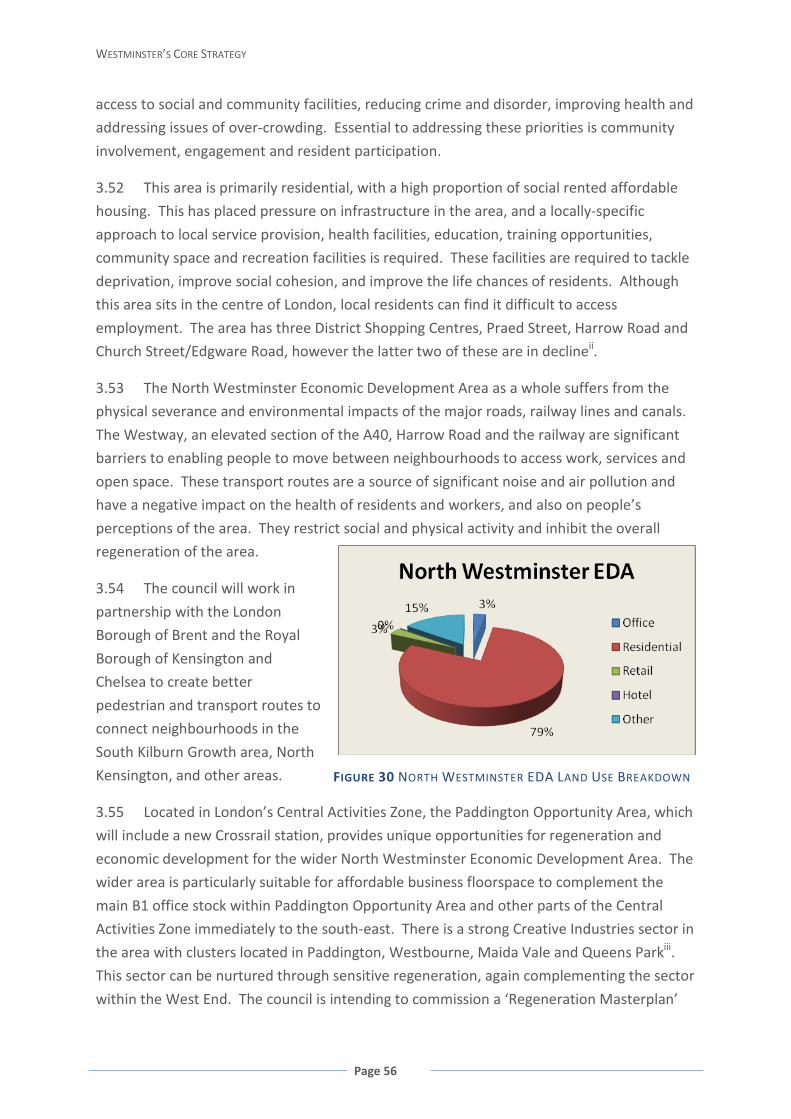
WESTMINSTER’S CORE STRATEGY
Page 56
access to social and community facilities, reducing crime and disorder, improving health and
addressing issues of over-crowding. Essential to addressing these priorities is community
involvement, engagement and resident participation.
3.52 This area is primarily residential, with a high proportion of social rented affordable
housing. This has placed pressure on infrastructure in the area, and a locally-specific
approach to local service provision, health facilities, education, training opportunities,
community space and recreation facilities is required. These facilities are required to tackle
deprivation, improve social cohesion, and improve the life chances of residents. Although
this area sits in the centre of London, local residents can find it difficult to access
employment. The area has three District Shopping Centres, Praed Street, Harrow Road and
Church Street/Edgware Road, however the latter two of these are in declineii.
3.53 The North Westminster Economic Development Area as a whole suffers from the
physical severance and environmental impacts of the major roads, railway lines and canals.
The Westway, an elevated section of the A40, Harrow Road and the railway are significant
barriers to enabling people to move between neighbourhoods to access work, services and
open space. These transport routes are a source of significant noise and air pollution and
have a negative impact on the health of residents and workers, and also on people’s
perceptions of the area. They restrict social and physical activity and inhibit the overall
regeneration of the area.
3.54 The council will work in
partnership with the London
Borough of Brent and the Royal
Borough of Kensington and
Chelsea to create better
pedestrian and transport routes to
connect neighbourhoods in the
South Kilburn Growth area, North
Kensington, and other areas.
3.55 Located in London’s Central Activities Zone, the Paddington Opportunity Area, which
will include a new Crossrail station, provides unique opportunities for regeneration and
economic development for the wider North Westminster Economic Development Area. The
wider area is particularly suitable for affordable business floorspace to complement the
main B1 office stock within Paddington Opportunity Area and other parts of the Central
Activities Zone immediately to the south-east. There is a strong Creative Industries sector in
the area with clusters located in Paddington, Westbourne, Maida Vale and Queens Parkiii.
This sector can be nurtured through sensitive regeneration, again complementing the sector
within the West End. The council is intending to commission a ‘Regeneration Masterplan’
FIGURE 30 NORTH WESTMINSTER EDA LAND USE BREAKDOWN

Part III: Local Spatial Policies
Page 57
for the Church Street area, identifying potential development opportunities. The outcomes
of this study will inform the policy approach detailed in the City Management Plan, and
future supplementary planning documents if appropriate. The Prince of Wales
Junction/Maida Hill in Harrow Road, comprised of a paved area at the junction of busy roads
and buildings on all sides, represents an opportunity for development to meet local service
needs and provide new employment space.
POLICY CS12 NORTH WESTMINSTER ECONOMIC DEVELOPMENT AREA
The council will continue to encourage and support a partnership approach to tackling
deprivation and promoting economic activity. The council will work closely with its
partners locally including Paddington Development Trust, Paddington Waterside
Partnerships, area renewal partnerships, Business Improvement Districts, local
communities and the private sector.
Development should contribute to increasing economic activity within the area, or
providing local services, or improving the quality and tenure mix of housing, and also
contribute towards the following priorities:
Improving physical connections within the Economic Development Area including
Paddington Opportunity Area and its shopping centres; and to the Central Activities
Zone and other surrounding areas including the South Kilburn Growth Area in the
London Borough of Brent and North Kensington within the Royal Borough of
Kensington and Chelsea;
Addressing severance and in some cases the poor local environment resulting from
the Westway (A40), Harrow Road (A404), rail network, and canal;
Improving the public realm and local environment, particularly within Shopping
Centres and housing estates;
Redevelopment of, and infill developments in, some existing housing estates,
including provision of a range of housing tenures (including intermediate and market
housing) wherever possible, consistent with protection of areas of open space;
Delivering improved and appropriate local services including: A local services
provision facilities in Church Street area and Queens Park; A new sports facility at
Moberley Sports and Education Centre; a new children’s sports centre at Compton
Street; and support opportunities to provide facilities for local community groups
including faith groups;
Providing training, skills and employment opportunities for local people;
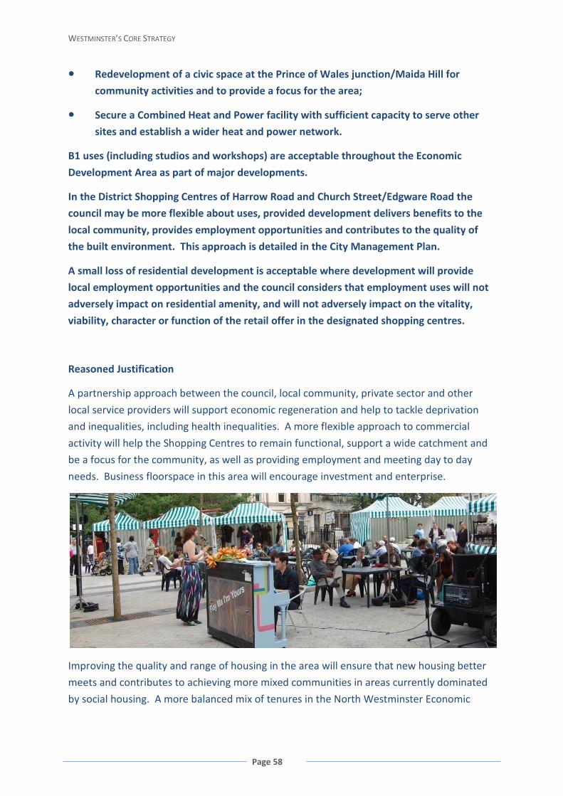
WESTMINSTER’S CORE STRATEGY
Page 58
Redevelopment of a civic space at the Prince of Wales junction/Maida Hill for
community activities and to provide a focus for the area;
Secure a Combined Heat and Power facility with sufficient capacity to serve other
sites and establish a wider heat and power network.
B1 uses (including studios and workshops) are acceptable throughout the Economic
Development Area as part of major developments.
In the District Shopping Centres of Harrow Road and Church Street/Edgware Road the
council may be more flexible about uses, provided development delivers benefits to the
local community, provides employment opportunities and contributes to the quality of
the built environment. This approach is detailed in the City Management Plan.
A small loss of residential development is acceptable where development will provide
local employment opportunities and the council considers that employment uses will not
adversely impact on residential amenity, and will not adversely impact on the vitality,
viability, character or function of the retail offer in the designated shopping centres.
Reasoned Justification
A partnership approach between the council, local community, private sector and other
local service providers will support economic regeneration and help to tackle deprivation
and inequalities, including health inequalities. A more flexible approach to commercial
activity will help the Shopping Centres to remain functional, support a wide catchment and
be a focus for the community, as well as providing employment and meeting day to day
needs. Business floorspace in this area will encourage investment and enterprise.
Improving the quality and range of housing in the area will ensure that new housing better
meets and contributes to achieving more mixed communities in areas currently dominated
by social housing. A more balanced mix of tenures in the North Westminster Economic
Part III: Local Spatial Policies
Page 59
Development Area will improve the perception of the area, help support local businesses,
and provide widened aspirations.
The provision of cafés, restaurants and appropriate entertainment uses can help to support
the retail function of the Church Street/Edgware Road District Shopping Centre. However,
growth in the night-time economy outside this area, or creating a concentration of such
uses within the area would unacceptably impact on residential amenity and the function of
the area.
Constraints in the physical environment also need to be tackled to encourage investment,
support local shops and businesses, improve social cohesion, and maximise the locational
opportunities of this area on the fringe of Central London to benefit local residents. This is
key to changing people’s perceptions of the area.
Local service provision and social and community uses need to be restructured or new sites
found to ensure they meet the specific needs of local communities and address gaps in
provision.
Cross-reference to Policies CS3 Paddington Opportunity Area; CS8 Marylebone and Fitzrovia
(for Edgware Road Stress Area which slightly lies within the North Westminster Economic
Development Area); CS33 Social and Community Infrastructure; CS38 Decentralised Energy
Networks; Appendix 1 Proposals Sites: Strategic Sites for the North Westminster Economic
Development Area.
i Index of Multiple Deprivation, 2007 ii Shopping Area Health Check Surveys for District Centre 1: Church Street/Edgware Road and District Centre 2: Harrow Road 2007. iii Creative Industries Report, 2007
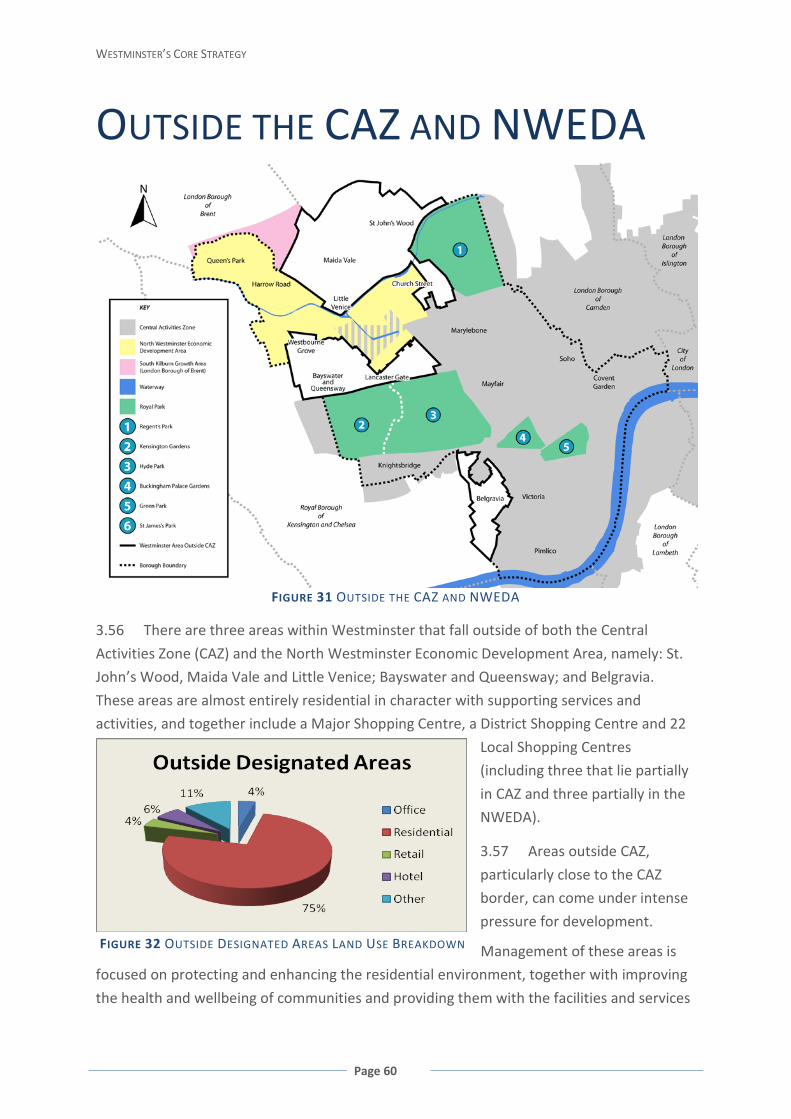
WESTMINSTER’S CORE STRATEGY
Page 60
OUTSIDE THE CAZ AND NWEDA
FIGURE 31 OUTSIDE THE CAZ AND NWEDA
3.56 There are three areas within Westminster that fall outside of both the Central
Activities Zone (CAZ) and the North Westminster Economic Development Area, namely: St.
John’s Wood, Maida Vale and Little Venice; Bayswater and Queensway; and Belgravia.
These areas are almost entirely residential in character with supporting services and
activities, and together include a Major Shopping Centre, a District Shopping Centre and 22
Local Shopping Centres
(including three that lie partially
in CAZ and three partially in the
NWEDA).
3.57 Areas outside CAZ,
particularly close to the CAZ
border, can come under intense
pressure for development.
Management of these areas is
focused on protecting and enhancing the residential environment, together with improving
the health and wellbeing of communities and providing them with the facilities and services
FIGURE 32 OUTSIDE DESIGNATED AREAS LAND USE BREAKDOWN

Part III: Local Spatial Policies
Page 61
they need. As such, commercial development will not generally be considered appropriate
in these areas, other than appropriate development within the designated town centres.
FIGURE 33 ST. JOHN’S WOOD AND MAIDA VALE
3.58 St John’s Wood was built up in the 1820’s and 1830’s and
represents the first example of suburban residential development in
Inner London. Uniquely for Westminster, it is characterised by
detached and semi-detached villas and terraced houses. The area
includes a number of private hospitals, Abbey Road Studios and Lord’s cricket ground, with
the latter being the single largest non-residential use in the area.
3.59 The Grand Union Canal and Regent’s Canal create the initial key townscape elements
of Maida Vale and Little Venice. Like St John’s Wood, the principal land use of these areas is
residential.
3.60 St John’s Wood District Shopping Centre has an important neighbourhood retail role,
serving residents in St John’s Wood, Primrose Hill, Lisson
Grove, as well as other parts of north and west London and
beyond. The District Shopping Centre has a wide range of
specialist and independent retailers. The main concentration
of A1 retail use is on St John’s Wood High Street, with smaller
concentrations in the area’s Local Shopping Centres.

WESTMINSTER’S CORE STRATEGY
Page 62
3.61 Although a growth in A1 retail floorspace has been projected (1,487 sqm gross for
2006 – 2016) there are limited opportunities within or adjacent to the town centre in which
to provide this. However, complementary community and leisure uses could add to its
vibrancy and serve a wider range of local needs.
FIGURE 34 QUEENSWAY AND WESTBOURNE GROVE
3.62 Queensway and Westbourne Grove have a lively townscape,
dominated by the Major Shopping Centre with retail on the ground
floor and predominantly residential above. Bayswater is
predominantly residential with numerous mansion blocks, including
the Hallfield Estate. This area also has one of London’s highest
concentrations of hotels, particularly Inverness Terrace, Princes Square and Leinster Square,
with many serving Paddington Station. The area also has a concentration of small hotels
clustered around Lancaster Gate and Queensway stations. Many of these hotels are not
purpose-built and occupy former residential houses in residential streets, and are therefore
more likely to give rise to adverse effects on local residential amenity and environmental
quality.
3.63 The Queensway/Westbourne Grove Major Shopping Centre has a good selection of
shops, including an indoor shopping centre on Queensway, and has a dual role serving local
residents and commuters, as well as a wider catchment from across London and beyond.
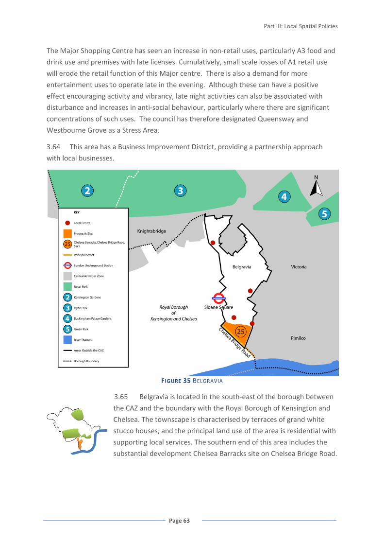
Part III: Local Spatial Policies
Page 63
The Major Shopping Centre has seen an increase in non-retail uses, particularly A3 food and
drink use and premises with late licenses. Cumulatively, small scale losses of A1 retail use
will erode the retail function of this Major centre. There is also a demand for more
entertainment uses to operate late in the evening. Although these can have a positive
effect encouraging activity and vibrancy, late night activities can also be associated with
disturbance and increases in anti-social behaviour, particularly where there are significant
concentrations of such uses. The council has therefore designated Queensway and
Westbourne Grove as a Stress Area.
3.64 This area has a Business Improvement District, providing a partnership approach
with local businesses.
FIGURE 35 BELGRAVIA
3.65 Belgravia is located in the south-east of the borough between
the CAZ and the boundary with the Royal Borough of Kensington and
Chelsea. The townscape is characterised by terraces of grand white
stucco houses, and the principal land use of the area is residential with
supporting local services. The southern end of this area includes the
substantial development Chelsea Barracks site on Chelsea Bridge Road.

WESTMINSTER’S CORE STRATEGY
Page 64
POLICY CS13 OUTSIDE THE CAZ AND NWEDA
Areas outside both the Central Activities Zone and North Westminster Economic
Development Area will be primarily for residential use with supporting social and
community provision.
Retail and other appropriate town centre uses will be directed towards the Major, District
and Local Shopping Centres.
The Queensway/Westbourne Grove Major Shopping Centre will be maintained and
enhanced by securing retail growth and improved retail space, and ensuring that A1 retail
provision is the priority within Core Shopping Frontages.
Within the Queensway/Westbourne Grove Stress Area, new entertainment uses will only
be allowed where the council considers that they are low-impact, would not result in an
increased concentration of late-night uses and do not compromise the retail character and
functioning of the Shopping Centre either individually or cumulatively.
Within the St John’s Wood District Shopping Centre, new community and leisure
floorspace may be allowed in the Secondary Shopping Frontages where this complements
the retail function within the rest of the Shopping Centre.
Reasoned Justification:
Maintaining and increasing housing and supporting facilities will protect the residential
character of these areas. The provision of social infrastructure is vital to support the
residential community in these parts of Westminster.
Enhancing the retail function of the Major and District Shopping Centres will help protect
the shops and services for these areas and help secure these centres’ long-term viability and
vitality. Encouraging community and leisure uses within the St. John’s Wood District
Shopping Centre will make provision for addressing an identified shortfall.
Provision of cafés, restaurants and appropriate entertainment uses can help support the
primary retail function of shopping areas. However, further growth in night-time
entertainment use within the designated Queensway/Westbourne Grove Stress Area would
add to a concentration of activity which would unacceptably impact on residential amenity.
Cross-reference to Policies CS8 Marylebone and Fitzrovia (for Edgware Road Stress Area
which lies partially outside CAZ); CS20 Retail; CS33 Social and Community Infrastructure;
CS36 Blue Ribbon Network

Part IV: City-Wide Spatial Policies
Page 65
PART IV: CITY-WIDE SPATIAL POLICIES HOUSING PROVISION 4.1 One of the most important aspects of Westminster is its large residential population.
Over 230,000 people call Westminster home. These range from the communities in the
heart of the city, to those in less built-up areas in the north and south. Westminster’s
residential populations are key to its character, mix, and success.
4.2 Westminster’s residential population is
projected to grow from 234,131 residents in 2007i, to
between 242,000ii and about 320,000iii residents by
2025, a growth of between 8,000 and 86,000.
However, the lower end of this range is most likely. It
is considered to be more accurate as it takes the
availability of housing into account which is likely to
continue to act as a constraint on population growth.
4.3 Due to its historic fabric, densely built up
areas, and lack of surplus industrial land that can be
‘released’ for housing, change within Westminster is typically small-scale and achieved
through the sensitive redevelopment of smaller sites and refurbishment of existing
buildings. This gives the urban environment its richness and strong local identity. The lack
of available land is a considerable constraint for Westminster in meeting its housing needs.
In many other parts of London, surplus industrial land makes a significant contribution to
meeting the borough’s housing targets. This is not typically the case in Westminster where
many sites already contain offices, shops and housing with existing high values, and new
housing is delivered by change of use and building to higher densities.
4.4 Westminster has very few large sites, and some of the larger sites that are expected
to deliver housing will also be providing a mix of commercial or other uses. For example,
the three Opportunity Areas have been designated for major growth for housing and
employment uses. Paddington Opportunity Area is expected to deliver at least 1,000 new
homes over the plan period 2010/11 – 2024/25, Victoria Opportunity Area at least 1,000
new homes. The Tottenham Court Road Opportunity Area is expected to deliver at least

WESTMINSTER’S CORE STRATEGY
Page 66
600 new homes, but the majority of this area lies within the London Borough Camden and
the parts within Westminster’s boundary are Crossrail sites in the West End International
Shopping Centre so are only expected to contribute about fifty residential units. The
majority of the housing target will therefore be provided in the London Borough of Camden.
In the Central Activities Zone (particularly Core CAZ), housing development competes with
office development, and whether housing proposals come forward depends on the vagaries
of the market for these competing land uses. The London Plan sets statutory targets for
housing delivery and the policies set out below aim to achieve these targets. The council
will need to actively and rigorously pursue housing development if it is to meet its statutory
housing target.
FIGURE 36 5-15 YEAR HOUSING LAND SUPPLY 2009/10 – 2013/14
4.5 Optimising the number of new homes delivered is even more important in
Westminster than in many other London boroughs because significant amounts of
market housing within Westminster are unavailable to residents as its global city role
means some housing is used as second homes, left empty as an investment, or is used
as temporary sleeping accommodation/ short-term lets (the council pursues
enforcement action against this).
4.6 The council is also concerned that new housing should meet needs and demands in
terms of affordability, size and type of homes, and ensuring those with special housing
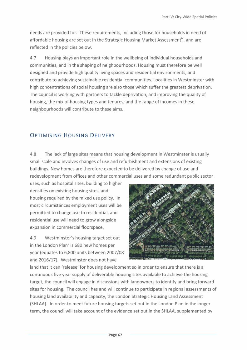
Part IV: City-Wide Spatial Policies
Page 67
needs are provided for. These requirements, including those for households in need of
affordable housing are set out in the Strategic Housing Market Assessmentiv, and are
reflected in the policies below.
4.7 Housing plays an important role in the wellbeing of individual households and
communities, and in the shaping of neighbourhoods. Housing must therefore be well
designed and provide high quality living spaces and residential environments, and
contribute to achieving sustainable residential communities. Localities in Westminster with
high concentrations of social housing are also those which suffer the greatest deprivation.
The council is working with partners to tackle deprivation, and improving the quality of
housing, the mix of housing types and tenures, and the range of incomes in these
neighbourhoods will contribute to these aims.
OPTIMISING HOUSING DELIVERY
4.8 The lack of large sites means that housing development in Westminster is usually
small scale and involves changes of use and refurbishment and extensions of existing
buildings. New homes are therefore expected to be delivered by change of use and
redevelopment from offices and other commercial uses and some redundant public sector
uses, such as hospital sites; building to higher
densities on existing housing sites, and
housing required by the mixed use policy. In
most circumstances employment uses will be
permitted to change use to residential, and
residential use will need to grow alongside
expansion in commercial floorspace.
4.9 Westminster’s housing target set out
in the London Planv is 680 new homes per
year (equates to 6,800 units between 2007/08
and 2016/17). Westminster does not have
land that it can ‘release’ for housing development so in order to ensure that there is a
continuous five year supply of deliverable housing sites available to achieve the housing
target, the council will engage in discussions with landowners to identify and bring forward
sites for housing. The council has and will continue to participate in regional assessments of
housing land availability and capacity, the London Strategic Housing Land Assessment
(SHLAA). In order to meet future housing targets set out in the London Plan in the longer
term, the council will take account of the evidence set out in the SHLAA, supplemented by

WESTMINSTER’S CORE STRATEGY
Page 68
local viability testing, and discussions with landowners to prepare the 6-10 and 11-15 year
lists of developable housing sites. The housing land supply schedules will also help facilitate
housing development by providing guidance to potential developers about what will be
expected from development sites, and instigating discussions with landowners of stalled
sites. The housing land assessments and schedules of developable sites will be updated
through the Annual Monitoring Report.
4.10 The London SHLAA published in November 2009 will inform a new target for
Westminster in revisions to the London Plan. A revised borough target will apply from 2011.
In the interim, the 680 p.a. target has been rolled forward as an indicative figure to ensure
that there is sufficient development land in the 15 year housing land supply to meet housing
targets.
POLICY CS14 OPTIMISING HOUSING DELIVERY
The council will work to achieve and exceed its borough housing target set out in the
London Plan.
Residential use is the priority across Westminster except where specifically stated.
All residential uses, floorspace and land will be protected. Proposals that would result in a
reduction in the number of residential units will not be acceptable, except where the
council considers that reconfiguration or redevelopment of affordable housing would
better meet affordable housing need or where a converted house is being returned to a
family-sized dwelling or dwellings. Proposals for conversion or redevelopment of single
family houses to flats will be assessed taking into account the character of the street and
area; impact on residential amenity including parking pressure; and the mix of units
proposed.
The number of residential units on development sites will be optimised.
The council will maintain a publicly available list of deliverable sites for housing
development to ensure a continuous five year supply of sites, and 6-15 year lists of future
developable sites.
Reasoned Justification
To achieve and exceed Westminster’s housing targets it is necessary to protect existing
housing and have housing as the priority use across the city. This means that schemes which
retain or increase the overall housing floorspace should not reduce the number of
residential units as this would reduce the number of homes in the city. Affordable housing
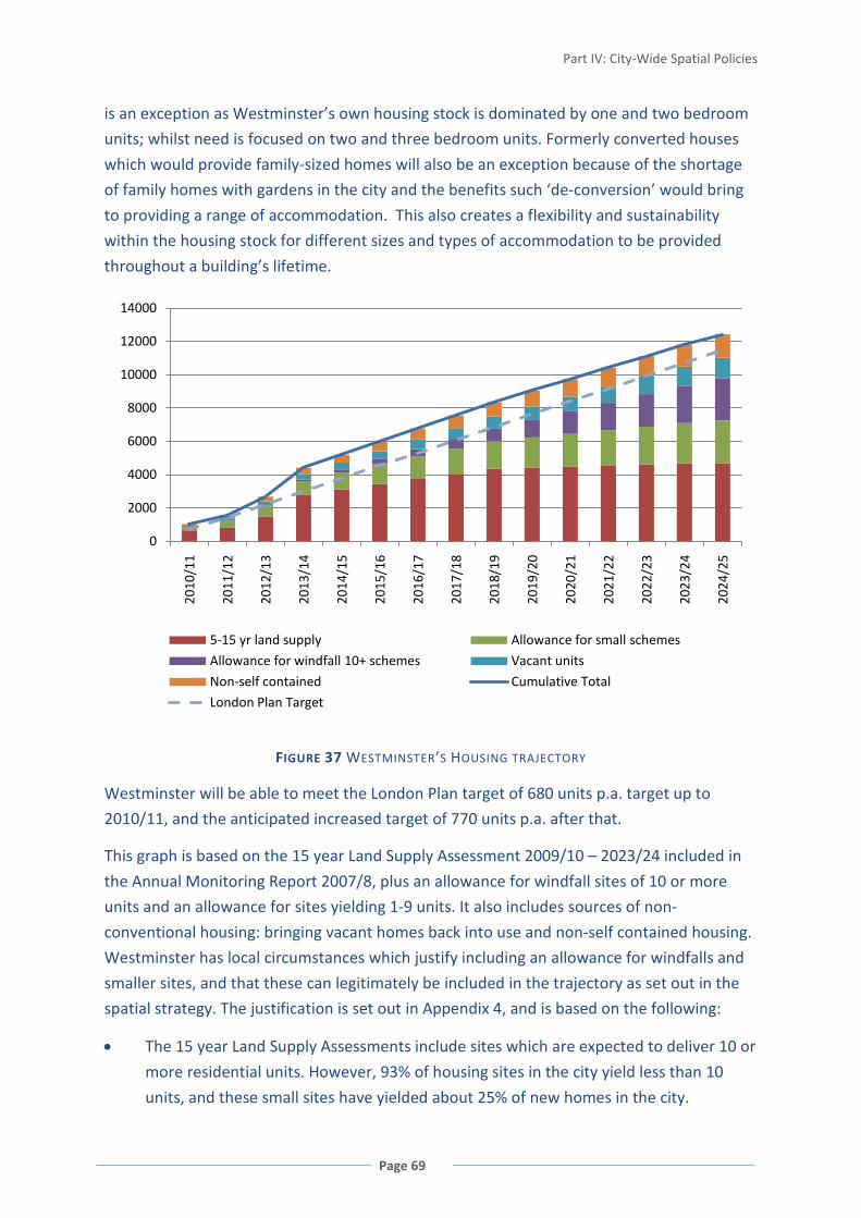
Part IV: City-Wide Spatial Policies
Page 69
is an exception as Westminster’s own housing stock is dominated by one and two bedroom
units; whilst need is focused on two and three bedroom units. Formerly converted houses
which would provide family-sized homes will also be an exception because of the shortage
of family homes with gardens in the city and the benefits such ‘de-conversion’ would bring
to providing a range of accommodation. This also creates a flexibility and sustainability
within the housing stock for different sizes and types of accommodation to be provided
throughout a building’s lifetime.
FIGURE 37 WESTMINSTER’S HOUSING TRAJECTORY
Westminster will be able to meet the London Plan target of 680 units p.a. target up to
2010/11, and the anticipated increased target of 770 units p.a. after that.
This graph is based on the 15 year Land Supply Assessment 2009/10 – 2023/24 included in
the Annual Monitoring Report 2007/8, plus an allowance for windfall sites of 10 or more
units and an allowance for sites yielding 1-9 units. It also includes sources of non-
conventional housing: bringing vacant homes back into use and non-self contained housing.
Westminster has local circumstances which justify including an allowance for windfalls and
smaller sites, and that these can legitimately be included in the trajectory as set out in the
spatial strategy. The justification is set out in Appendix 4, and is based on the following:
• The 15 year Land Supply Assessments include sites which are expected to deliver 10 or
more residential units. However, 93% of housing sites in the city yield less than 10
units, and these small sites have yielded about 25% of new homes in the city.
0
2000
4000
6000
8000
10000
12000
14000
2010
/11
2011
/12
2012
/13
2013
/14
2014
/15
2015
/16
2016
/17
2017
/18
2018
/19
2019
/20
2020
/21
2021
/22
2022
/23
2023
/24
2024
/25
5-15 yr land supply Allowance for small schemes
Allowance for windfall 10+ schemes Vacant units
Non-self contained Cumulative Total
London Plan Target

WESTMINSTER’S CORE STRATEGY
Page 70
• This plan does not give general protection to office use; offices may therefore change
to housing. Many applications for change of use from B1 use to housing are ‘windfalls’,
which depend on the vagaries of the market and cannot be anticipated.
• Historically, windfalls have accounted for 80% of housing delivered in the city.
However, the 15 year Land Supply Assessments will now capture many of these sites
so a far lower figure needs to be projected into the future.
The inclusion of these windfall and small sites allowances reflects the advice in Planning
Policy Statement 3vi and the approach set out in the Government Office for London and
Greater London Authority joint statementvii. This states in paragraph 5 that, ‘In addressing
the unique circumstances of London it could also incorporate assumptions on small sites and
windfalls as set out in PPS3’.
The council has lost single family houses to conversion and redevelopment to flats, and now
houses with gardens form only 10% of Westminster’s housing stock. These houses can
meet the needs of families wishing to live in Westminster and often make an important
contribution to the character and function of conservation areas. Whilst conversions and
redevelopments of single family homes to flatted accommodation increases the number of
residential units, they can also have a detrimental effect on character and function of
streets and areas, lead to problems with residential amenity and may not provide an
appropriate mix and size of units.
Land and buildings should be used efficiently, and larger development sites should optimise
the number of units in schemes, taking into account other policies and objectives. Housing
densities should reflect the densities set out in the London Plan. The City Management Plan
will address housing densities to be applied to development sites in different parts of the
city.
Policies relating to Special Policy Areas (Policy CS2), the Opportunity Areas (Policies CS3, CS4
and CS5), Core CAZ and the West End Special Retail Policy Area (Policies CS6 and CS7), and
North Westminster Economic Development Area (Policy CS12) have other priorities in
addition to housing.
Cross-reference to Policy CS1 Mixed Use in the Central Activities Zone; Appendix 1 Proposals
Sites: Strategic Sites for Housing.
MEETING HOUSING NEEDS
4.11 Westminster’s housing needs and demands are assessed in a regional and sub-
regional contextviii as this is how the housing market works in practice. These assessments
inform the council’s policy approach.

Part IV: City-Wide Spatial Policies
Page 71
4.12 Westminster has a lower proportion of residents aged under 20 and over 60 years
than London or England as a whole. This is expected to shift over the period to 2028, with a
growth in the numbers of children and young people, particularly children under fiveix.
Almost half of Westminster’s population live in one-person households, and about 12% of
the population are in over-crowded homes. About 12% of households contain members
with support needs i.e. have a physical disability, are frail elderly, or have a mental health
problemx.
4.13 Westminster has the second highest house prices in the country, and the need for
new affordable housing is significantly above the Inner London averagexi. In terms of unit
sizes, there are shortfalls for all sizes, but new two and three bedroom homes are
particularly needed in both the affordable and owner/occupier sectorsxii.
POLICY CS15 MEETING HOUSING NEEDS
Residential developments will provide an appropriate mix of units in terms of size, type,
and affordable housing provision to contribute towards meeting Westminster’s housing
needs, and creating mixed communities.
Hostels, Houses in Multiple Occupation, and specialist housing floorspace will be
protected. Provision of specialist housing will be allowed where this would contribute
towards meeting local housing needs.
All specialist housing floorspace and units will be protected to meet those specific needs
except where the accommodation is needed to meet different residential needs as part of
a published strategy by a local service provider. Where this exception applies, changes of
use will only be to residential care or nursing homes, hostel, Houses in Multiple
Occupation or dwelling houses use.
Reasoned Justification
Housing developments need to provide an appropriate mix of units, in terms of unit size,
type and tenure, including social and intermediate housing provision, to address
Westminster’s housing requirements as set out in regional and sub-regional assessmentsxiii.
These assessments include needs for specialist housing such as extra-care units for the
elderly and housing for people using wheelchairs, or with other mobility impairments. This
approach also recognises the need for hostel accommodation for vulnerable people, and the
role that Houses in Multiple Occupation (HMOs) play in providing affordable
accommodation in the city. Housing mix and specialist housing, including hostels and
HMOs, will be considered in detail in the City Management Plan.
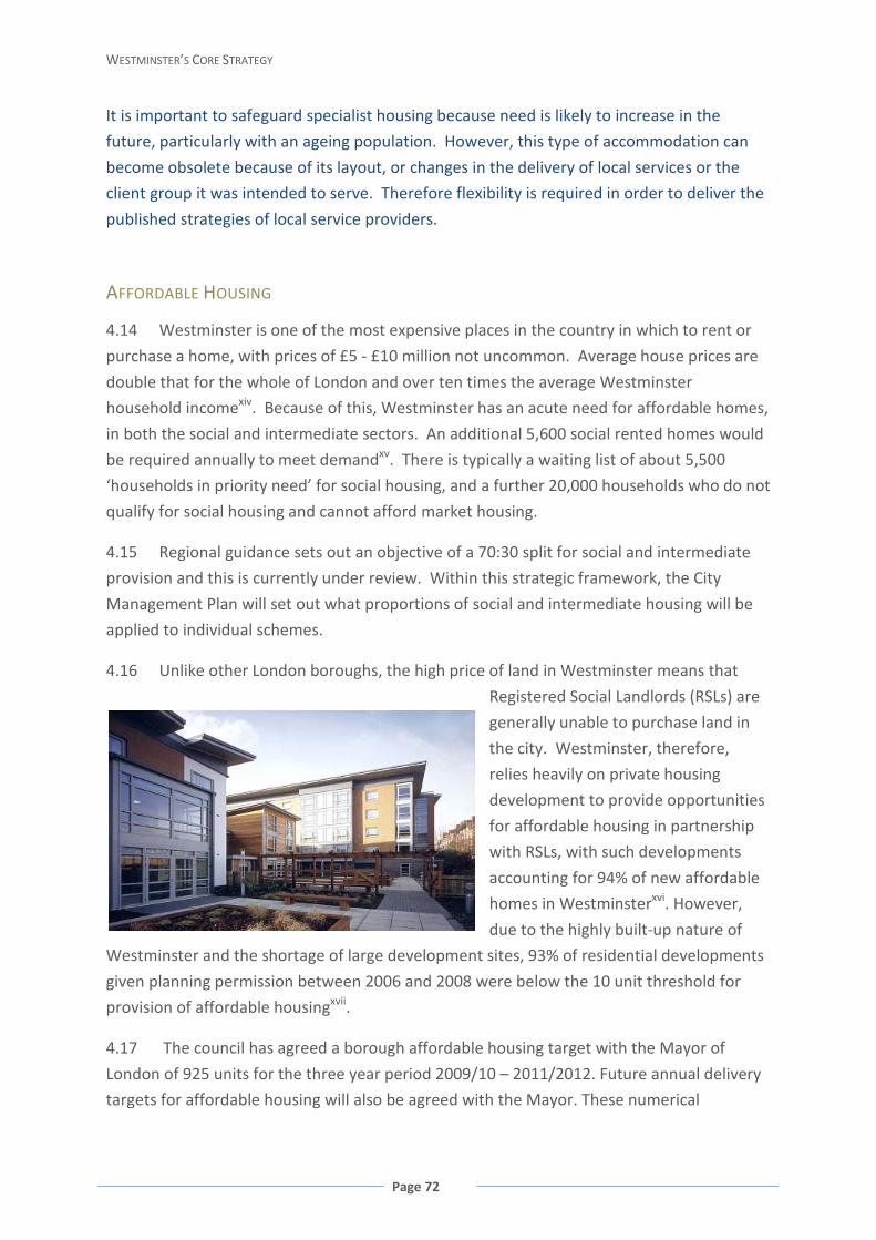
WESTMINSTER’S CORE STRATEGY
Page 72
It is important to safeguard specialist housing because need is likely to increase in the
future, particularly with an ageing population. However, this type of accommodation can
become obsolete because of its layout, or changes in the delivery of local services or the
client group it was intended to serve. Therefore flexibility is required in order to deliver the
published strategies of local service providers.
AFFORDABLE HOUSING
4.14 Westminster is one of the most expensive places in the country in which to rent or
purchase a home, with prices of £5 - £10 million not uncommon. Average house prices are
double that for the whole of London and over ten times the average Westminster
household incomexiv. Because of this, Westminster has an acute need for affordable homes,
in both the social and intermediate sectors. An additional 5,600 social rented homes would
be required annually to meet demandxv. There is typically a waiting list of about 5,500
‘households in priority need’ for social housing, and a further 20,000 households who do not
qualify for social housing and cannot afford market housing.
4.15 Regional guidance sets out an objective of a 70:30 split for social and intermediate
provision and this is currently under review. Within this strategic framework, the City
Management Plan will set out what proportions of social and intermediate housing will be
applied to individual schemes.
4.16 Unlike other London boroughs, the high price of land in Westminster means that
Registered Social Landlords (RSLs) are
generally unable to purchase land in
the city. Westminster, therefore,
relies heavily on private housing
development to provide opportunities
for affordable housing in partnership
with RSLs, with such developments
accounting for 94% of new affordable
homes in Westminsterxvi. However,
due to the highly built-up nature of
Westminster and the shortage of large development sites, 93% of residential developments
given planning permission between 2006 and 2008 were below the 10 unit threshold for
provision of affordable housingxvii.
4.17 The council has agreed a borough affordable housing target with the Mayor of
London of 925 units for the three year period 2009/10 – 2011/2012. Future annual delivery
targets for affordable housing will also be agreed with the Mayor. These numerical
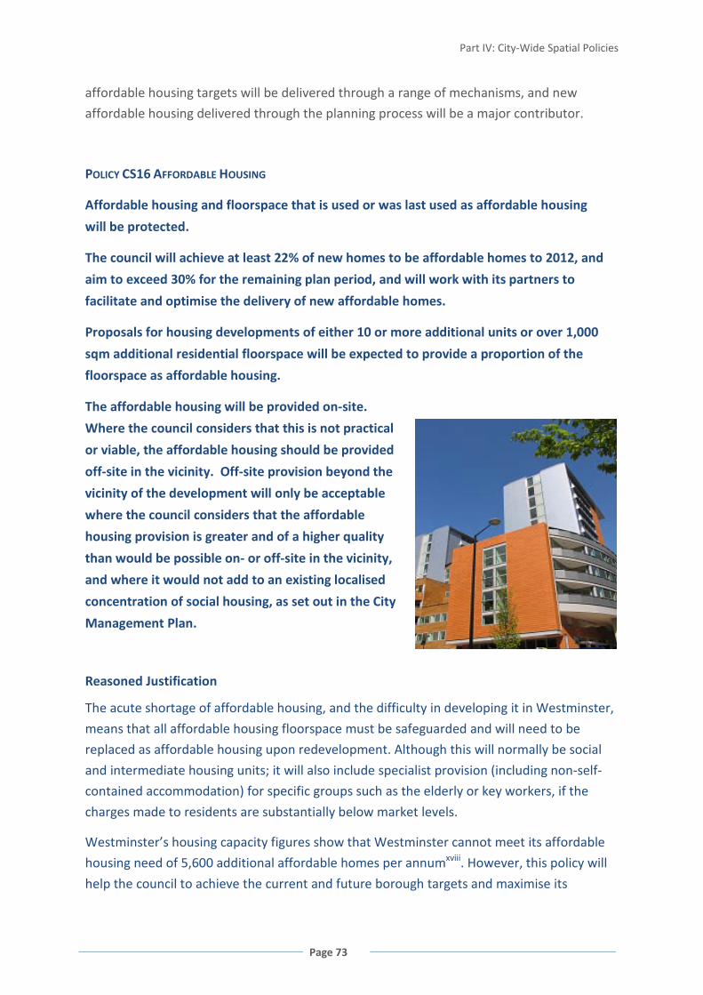
Part IV: City-Wide Spatial Policies
Page 73
affordable housing targets will be delivered through a range of mechanisms, and new
affordable housing delivered through the planning process will be a major contributor.
POLICY CS16 AFFORDABLE HOUSING
Affordable housing and floorspace that is used or was last used as affordable housing
will be protected.
The council will achieve at least 22% of new homes to be affordable homes to 2012, and
aim to exceed 30% for the remaining plan period, and will work with its partners to
facilitate and optimise the delivery of new affordable homes.
Proposals for housing developments of either 10 or more additional units or over 1,000
sqm additional residential floorspace will be expected to provide a proportion of the
floorspace as affordable housing.
The affordable housing will be provided on-site.
Where the council considers that this is not practical
or viable, the affordable housing should be provided
off-site in the vicinity. Off-site provision beyond the
vicinity of the development will only be acceptable
where the council considers that the affordable
housing provision is greater and of a higher quality
than would be possible on- or off-site in the vicinity,
and where it would not add to an existing localised
concentration of social housing, as set out in the City
Management Plan.
Reasoned Justification
The acute shortage of affordable housing, and the difficulty in developing it in Westminster,
means that all affordable housing floorspace must be safeguarded and will need to be
replaced as affordable housing upon redevelopment. Although this will normally be social
and intermediate housing units; it will also include specialist provision (including non-self-
contained accommodation) for specific groups such as the elderly or key workers, if the
charges made to residents are substantially below market levels.
Westminster’s housing capacity figures show that Westminster cannot meet its affordable
housing need of 5,600 additional affordable homes per annumxviii. However, this policy will
help the council to achieve the current and future borough targets and maximise its

WESTMINSTER’S CORE STRATEGY
Page 74
contribution towards the Mayor’s target of providing 50,000 affordable homes in London
between 2008 and 2011. In these 3 years, 598 new affordable homes are expected to be
delivered (based on the Local Area Agreement target), equating to nearly 200 new
affordable homes per annum3
The council wishes to increase the amount of affordable homes delivered in the city and
make an appropriate contribution to meeting wider regional housing needs and has
therefore monitored and analysed the impact of the previous UDP affordable housing policy
in order to inform the development of this policy and overcome any constraints to
provision. These constraint factors and the need to facilitate rather than constrain housing
delivery through overly onerous policy requirements have been taken into account in
determining the threshold and calculation method for the affordable housing policy.
.
Between 2001 and 2007/8, 22% of new homes completed in Westminster were affordable.
This is substantially below the London-wide strategic target of 50% set out in the London
Plan and reflects the lack of RSL led schemes and the predominance of small schemes below
the affordable housing threshold in Westminster. Taking into account all the criteria in
London Plan Policy 3A.9 it would not be realistic for Westminster to have a 50% target. The
five year list of deliverable sites over 10 units4
In addition to meeting borough affordable housing targets, after this period, the council will
seek to increase the proportion of affordable homes delivered between 2012/13 and
2024/25 to exceed 30%. This is a strategic target for the proportion of all housing to be
provided as affordable housing. It is not a specific target to be applied to individual
development sites, and represents affordable housing from all sources including the
council’s own developments. The increased target (from the currently achieved 22% of all
housing up to 30%) is based on:
indicates that 30% of new homes on the list
will be affordable. However, if an allowance for sites of less than 10 units is included
(historically about 93% of sites are less than 10 units, yielding about 25% of total units) this
reduces the affordable housing proportion to about 22.5% over the next five years.
• evidence that the 22% was achievable within the context of the Unitary Development
Plan policy framework and that housing in central London has a strong demand as an
investment and residential land values compare favourably with the commercial
market;
3 This is smaller than the 925 Borough Affordable Housing Target referred to in the background as it is the proportion from new affordable homes to be delivered in Westminster. The 925 target also includes a range of other affordable housing measures such as ‘Temporary to Settled Homes’. 4 As set out in the Annual Monitoring Report 2007/08

Part IV: City-Wide Spatial Policies
Page 75
• evidence from the 5-15 year housing delivery schedules and discussions with
developers and other stakeholders indicate a pipeline of development sites which will
achieve affordable housing;
• the introduction of a 1,000 sqm threshold which in the Westminster context is
effectively a lowering of the 10 unit threshold and will bring more schemes into the
requirement range;
• having a floorspace proportion rather than a unit proportion, which is expected to
increase the number of units provided in individual schemes; and
• working with partners on the Community Build Programme and other schemes to
build new affordable homes on underused housing estate land.
Beyond 2012, the council is confident that these policies, together with the council’s
Community Build Programme, will yield an increase in affordable provision to 30% of overall
housing delivery. The council will review the impact of these policies in order to sustain and
increase this proportion when the Community Build Programme ends.
Residential planning applications in Westminster are characterised by a predominance of
large market units. The average size of a residential unit given permission between 2005/6
and 2007/8 was about 129 sqm, with market units averaging approximately 140 sqm,
compared to an average of 70 sqm for affordable housingxix. This means that it is not
generally appropriate to use a unit calculation for either the threshold at which affordable
housing will be required, or the calculation of the proportion of affordable housing to be
provided. Instead, a floorspace calculation for both the threshold and the proportion
required will be a fairer method and should increase the proportion and number of
affordable homes delivered in the city.
The introduction of a floorspace threshold in addition to the unit threshold is one such
mechanism. It will bring more schemes into the requirement range by effectively lowering
the previous 10 unit threshold applicable in Westminster, to a threshold reflecting sites’
capacity to provide 10 units, whilst leaving the choice open to developers to provide larger
units if they so wish. A 1,000 sqm threshold has been tested in the Westminster Affordable
Housing Viability Study and is considered to be viable. The Study also assessed the viability
of the floorspace approach to calculating the proportion of affordable housing required on
different types of residential schemes. These proportions will be set out in the City
Management Plan.
It is considered that a housing development of 1,000 sqm gross external floorspace
represents a site which has ‘a capacity to provide 10 or more homesxx’. The average unit size
measured in gross external floorspace in Westminster is 129 sqm. Regional guidance uses a
benchmark figure of 66 sqm netxxi which equates to about 80 sqm gross external floorspace.
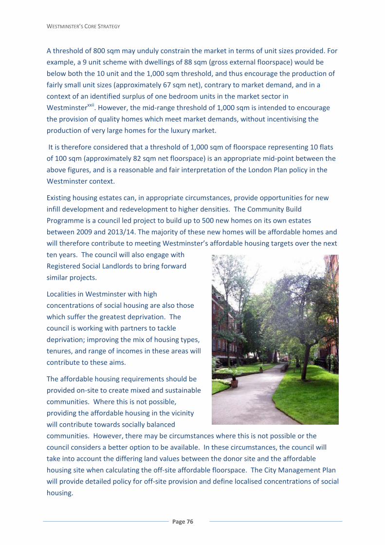
WESTMINSTER’S CORE STRATEGY
Page 76
A threshold of 800 sqm may unduly constrain the market in terms of unit sizes provided. For
example, a 9 unit scheme with dwellings of 88 sqm (gross external floorspace) would be
below both the 10 unit and the 1,000 sqm threshold, and thus encourage the production of
fairly small unit sizes (approximately 67 sqm net), contrary to market demand, and in a
context of an identified surplus of one bedroom units in the market sector in
Westminsterxxii. However, the mid-range threshold of 1,000 sqm is intended to encourage
the provision of quality homes which meet market demands, without incentivising the
production of very large homes for the luxury market.
It is therefore considered that a threshold of 1,000 sqm of floorspace representing 10 flats
of 100 sqm (approximately 82 sqm net floorspace) is an appropriate mid-point between the
above figures, and is a reasonable and fair interpretation of the London Plan policy in the
Westminster context.
Existing housing estates can, in appropriate circumstances, provide opportunities for new
infill development and redevelopment to higher densities. The Community Build
Programme is a council led project to build up to 500 new homes on its own estates
between 2009 and 2013/14. The majority of these new homes will be affordable homes and
will therefore contribute to meeting Westminster’s affordable housing targets over the next
ten years. The council will also engage with
Registered Social Landlords to bring forward
similar projects.
Localities in Westminster with high
concentrations of social housing are also those
which suffer the greatest deprivation. The
council is working with partners to tackle
deprivation; improving the mix of housing types,
tenures, and range of incomes in these areas will
contribute to these aims.
The affordable housing requirements should be
provided on-site to create mixed and sustainable
communities. Where this is not possible,
providing the affordable housing in the vicinity
will contribute towards socially balanced
communities. However, there may be circumstances where this is not possible or the
council considers a better option to be available. In these circumstances, the council will
take into account the differing land values between the donor site and the affordable
housing site when calculating the off-site affordable floorspace. The City Management Plan
will provide detailed policy for off-site provision and define localised concentrations of social
housing.
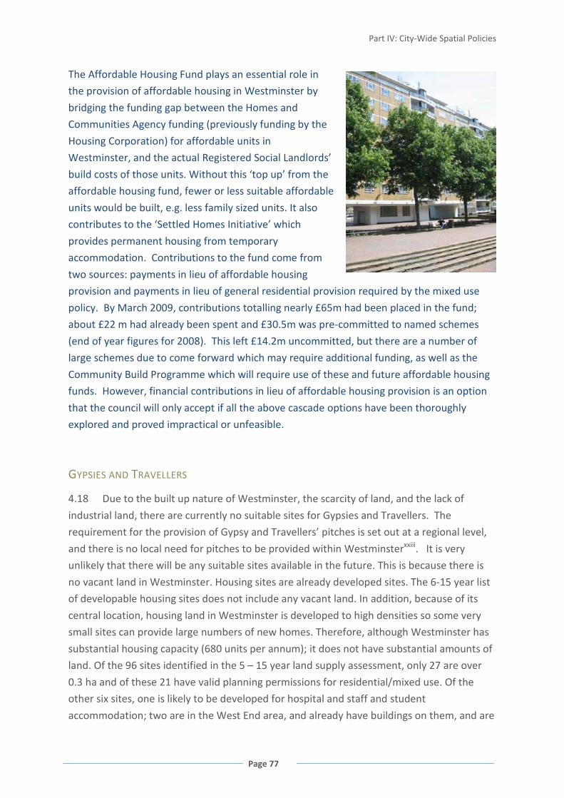
Part IV: City-Wide Spatial Policies
Page 77
The Affordable Housing Fund plays an essential role in
the provision of affordable housing in Westminster by
bridging the funding gap between the Homes and
Communities Agency funding (previously funding by the
Housing Corporation) for affordable units in
Westminster, and the actual Registered Social Landlords’
build costs of those units. Without this ‘top up’ from the
affordable housing fund, fewer or less suitable affordable
units would be built, e.g. less family sized units. It also
contributes to the ‘Settled Homes Initiative’ which
provides permanent housing from temporary
accommodation. Contributions to the fund come from
two sources: payments in lieu of affordable housing
provision and payments in lieu of general residential provision required by the mixed use
policy. By March 2009, contributions totalling nearly £65m had been placed in the fund;
about £22 m had already been spent and £30.5m was pre-committed to named schemes
(end of year figures for 2008). This left £14.2m uncommitted, but there are a number of
large schemes due to come forward which may require additional funding, as well as the
Community Build Programme which will require use of these and future affordable housing
funds. However, financial contributions in lieu of affordable housing provision is an option
that the council will only accept if all the above cascade options have been thoroughly
explored and proved impractical or unfeasible.
GYPSIES AND TRAVELLERS
4.18 Due to the built up nature of Westminster, the scarcity of land, and the lack of
industrial land, there are currently no suitable sites for Gypsies and Travellers. The
requirement for the provision of Gypsy and Travellers’ pitches is set out at a regional level,
and there is no local need for pitches to be provided within Westminsterxxiii. It is very
unlikely that there will be any suitable sites available in the future. This is because there is
no vacant land in Westminster. Housing sites are already developed sites. The 6-15 year list
of developable housing sites does not include any vacant land. In addition, because of its
central location, housing land in Westminster is developed to high densities so some very
small sites can provide large numbers of new homes. Therefore, although Westminster has
substantial housing capacity (680 units per annum); it does not have substantial amounts of
land. Of the 96 sites identified in the 5 – 15 year land supply assessment, only 27 are over
0.3 ha and of these 21 have valid planning permissions for residential/mixed use. Of the
other six sites, one is likely to be developed for hospital and staff and student
accommodation; two are in the West End area, and already have buildings on them, and are
WESTMINSTER’S CORE STRATEGY
Page 78
not appropriate sites; one is a council housing site to be redeveloped to a higher density;
and the remaining two sites are currently in social and community use.
POLICY CS17 GYPSIES AND TRAVELLERS
Permission for Gypsy and Traveller sites may be granted subject to the impact on
residential amenity, townscape, traffic and parking.
Reasoned Justification
No sites have been allocated for Gypsy and Traveller pitches, reflecting the densely built-
up nature of the city and scarcity of vacant land. Temporary sites may become available
as part of the redevelopment process. The policy provides the criteria for assessing any
proposals for pitches. The protection of residential amenity and townscape is vitally
important in Westminster due to its dense historic urban fabric with its extensive heritage
designations. Criteria are required to ensure that these are not compromised.
Cross-reference to Policies CS28 Health, Safety and Well-being; CS24 Heritage; CS41
Servicing and Deliveries.
i Census Mid-Year Estimate 2007 ii GLA Projections (High) iii The GLA Low Projections suggest that the population of Westminster will be 233,800 in 2028; the GLA High
Projections suggest that it will be 243,000 (about 420 per year); the Office of National Statistics suggest that it will be 333,400 by 2028 (about 4,760 per year) however this is based on unconstrained growth of the population. In reality, the growth of Westminster’s population will be constrained by development capacity i.e. the availability of new homes. It is considered that the most likely population growth for Westminster is between the GLA High Projection and the ONS Projection but closer to the lower figure, based on delivery of 680 new homes per year on average.
iv North London Sub-Region Strategic Housing Market Assessment, 2009 v London Plan consolidated with alterations, 2008 vi Planning Policy Statement 3, paragraph 59 vii ‘Addressing PPS3 requirements for a 15 year housing land supply’, 2008 setting out an interim approach viiiNorth London Sub-Region Strategic Housing Market Assessment, 2009 ix Public Health Annual Report 2006/2007 x Housing Needs Assessment, 2006 xi Housing Needs Assessment, 2006 xii Housing Needs Assessment, 2006 xiii North London Sub-Region Strategic Housing Market Assessment, 2009 and London Strategic Housing Market
Assessment xiv Housing Needs Assessment, 2006 xv Housing Needs Assessment, 2006 xvi Annual Monitoring Report 2007/08, Table 3.3 xvii Annual Monitoring Report 2007/08, Figure 3.2 xviii Housing Needs Assessment, 2006 xix Westminster City Council Respipe 2005/06-07/08

Part IV: City-Wide Spatial Policies
Page 79
xx London Plan Policy 3A.11 Affordable housing thresholds xxi GLA Affordable Housing Toolkit xxii Housing Needs Assessment, 2006 xxiii London Boroughs’ Gypsy and Traveller Accommodation Needs Assessment, 2008

WESTMINSTER’S CORE STRATEGY
Page 80
BUSINESS AND EMPLOYMENT 4.19 The City of Westminster, in the heart of London, plays a definitive role in London’s
economy, accommodating more jobs than any other local authority, and providing
opportunities for investment, enterprise and creativity. Employing over half a million
people across a wide range of sectors, the local economy is both significant and diverse.
Westminster needs to remain competitive as a business location within a context of
increasing globalisation and competition from other European and international cities, and
fluctuations in economic circumstances and cycles.
4.20 The working population of Westminster is projected to grow by about 49,000 people
between 2010 and 2024, to about 666,000. There is significant development for new jobs
to be created within the Opportunity Areas. There will be capacity for a further 5,000 new
jobs within Paddington (capacity for over 27,000 jobs has already been created), 4,000 new
jobs in Victoria, and 5,000 new jobs within Tottenham Court Road (shared with the London
Borough of Camden). Increases in jobs are also sought within the Core Central Activities
Zone and North Westminster Economic Development Area, particularly Church Street,
Edgware Road and Harrow Road.
4.21 Jobs may also be created through the increase in comparison goods retail floorspace.
Most of this retail floorspace will be directed to the West End Special Retail Policy Area and,
to a lesser extent, other parts of the Core Central Activities Zone including the Knightsbridge
International Shopping Centre.
4.22 However, there are limits to the level of growth that can realistically be achieved due
to the already densely developed built form, transport capacity, the need to retain all areas
of open space and the need for new development to be appropriate to its context,
particularly in relation to the mix of uses and historic fabric of much of the city. Therefore,
growth needs to be directed to the most appropriate locations in Westminster.
POLICY CS18 COMMERCIAL DEVELOPMENT
Proposals for new commercial uses must be appropriate in terms of scale and intensity of
land uses, and character and function of the area.
Reasoned Justification
This policy approach encourages the growth of commercial uses in the context of the
already densely built form of predominantly human scale, mixed use character including
residential, and the historic fabric of much of Westminster.
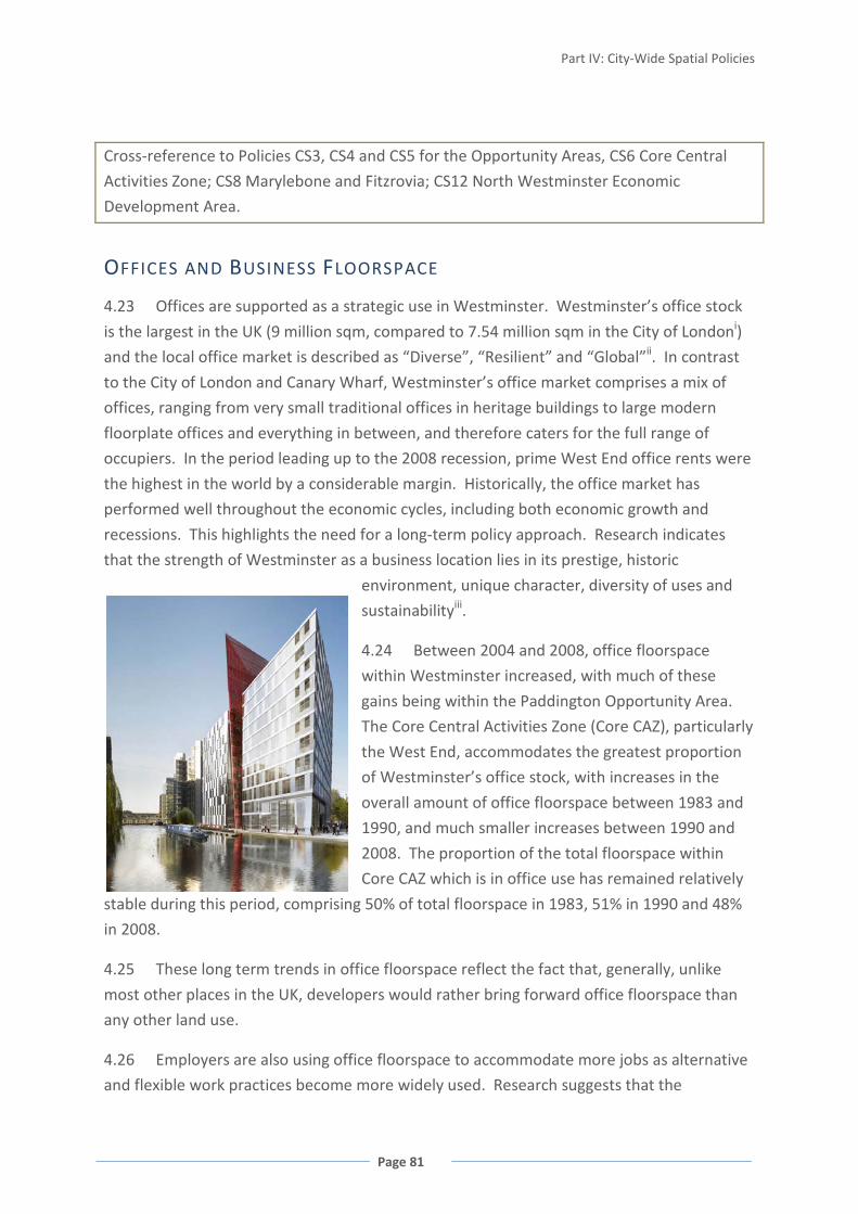
Part IV: City-Wide Spatial Policies
Page 81
Cross-reference to Policies CS3, CS4 and CS5 for the Opportunity Areas, CS6 Core Central
Activities Zone; CS8 Marylebone and Fitzrovia; CS12 North Westminster Economic
Development Area.
OFFICES AND BUSINESS FLOORSPACE
4.23 Offices are supported as a strategic use in Westminster. Westminster’s office stock
is the largest in the UK (9 million sqm, compared to 7.54 million sqm in the City of Londoni)
and the local office market is described as “Diverse”, “Resilient” and “Global”ii. In contrast
to the City of London and Canary Wharf, Westminster’s office market comprises a mix of
offices, ranging from very small traditional offices in heritage buildings to large modern
floorplate offices and everything in between, and therefore caters for the full range of
occupiers. In the period leading up to the 2008 recession, prime West End office rents were
the highest in the world by a considerable margin. Historically, the office market has
performed well throughout the economic cycles, including both economic growth and
recessions. This highlights the need for a long-term policy approach. Research indicates
that the strength of Westminster as a business location lies in its prestige, historic
environment, unique character, diversity of uses and
sustainabilityiii.
4.24 Between 2004 and 2008, office floorspace
within Westminster increased, with much of these
gains being within the Paddington Opportunity Area.
The Core Central Activities Zone (Core CAZ), particularly
the West End, accommodates the greatest proportion
of Westminster’s office stock, with increases in the
overall amount of office floorspace between 1983 and
1990, and much smaller increases between 1990 and
2008. The proportion of the total floorspace within
Core CAZ which is in office use has remained relatively
stable during this period, comprising 50% of total floorspace in 1983, 51% in 1990 and 48%
in 2008.
4.25 These long term trends in office floorspace reflect the fact that, generally, unlike
most other places in the UK, developers would rather bring forward office floorspace than
any other land use.
4.26 Employers are also using office floorspace to accommodate more jobs as alternative
and flexible work practices become more widely used. Research suggests that the
WESTMINSTER’S CORE STRATEGY
Page 82
occupation density of office floorspace in London has fallen from 18.3 sqm per worker in
2000 to 13.9 sqm per worker in 2007iv.
4.27 Offices are supported as an important use within Westminster. However, because of
the unique market pressures for office floorspace and long-term stability in provision, it is
not considered necessary to provide a specific policy to protect offices.
4.28 The Creative Industries are a major element in Westminster’s economy and
Westminster is one of the most creative hubs in the world. Seven percent of the UK’s
Creative Industries’ employees work in Westminster, and Westminster’s central area has
the highest concentration of creative businesses in the UK, and probably the world.
Westminster’s attraction to Creative Industries is its centrality, connectivity, density of
business and consumers and availability of talentv. Protecting and enhancing the Creative
Industries is a priorityvi; however, they do not fall within a specific use class and therefore
require a customised approach. In 2007, about 63% of Creative Industries operated from B1
Use Class units and a further 17% occupied A1 Use Class retail unitsvii. However, the
availability of other types of business floorspace remains important to the diversity and
functioning of this sector.
POLICY CS19 OFFICES AND OTHER B1 FLOORSPACE
New office development will be directed to Paddington, Victoria and Tottenham Court
Road Opportunity Areas, the Core Central Activities Zone, specified locations within
Marylebone and Fitzrovia, and the North Westminster Economic Development Area.
Where appropriate, the council will request a range of business floorspace including
workshops and studios.
Reasoned Justification
New offices are encouraged within these locations to retain Westminster’s strategic role in
London’s office sector, and support London’s global competitiveness. The policy also
identifies Westminster’s capacity for growth, predominantly in the three Opportunity Areas
and North Westminster Economic Development Area.
In addition to offices, a range of other B1 floorspace is required in Westminster to ensure
diversity across employment sectors. This supports a range of business activities, including
Creative Industries, and employment opportunities. It will be sought where non-office type
floorspace such as workshops and studios are appropriate as part of the overall mix of uses
because of their location or existing use.

Part IV: City-Wide Spatial Policies
Page 83
Cross-reference to Policies CS1 Mixed Use in the Central Activities Zone; CS3 Paddington
Opportunity Area; CS6 Core Central Activities Zone; CS12 North Westminster Economic
Development Area; CS18 Commercial Development.
RETAIL
4.29 Retail plays a vital role in Westminster’s economy, including the visitor economy,
currently employing over 75,000 people – nearly 20% of all shop workers in London.
Westminster has a wide range of shopping centres, each with their own character and
serving a specific role, function and catchment, with its larger centres attracting visitors
from around the world.
FIGURE 38 WESTMINSTER’S SHOPPING CENTRES
4.30 Westminster’s designated hierarchy of shopping centres ranges from the
International Centres of the West End and part of Knightsbridge, through the CAZ Frontages
and other Shopping Centres within the CAZ, to the Major, District and Local Shopping

WESTMINSTER’S CORE STRATEGY
Page 84
Centres spread throughout the city. The high number of specialist shops and retail clusters
within Westminster contribute to the local character and identity of particular areas. A full
list of Westminster’s Shopping Centres is set out in Appendix 2.
4.31 These centres provide access to the shops and services necessary to meet the
everyday needs of local residents and visitors. In many parts of the borough, accessible and
economically healthy shopping centres act as a focal point for community activity. It is
important that these are maintained.
4.32 Although shopping will remain the main focus of these centres, complementary uses
such as restaurants, banks, libraries and other services and facilities also contribute towards
meeting community needs and can help maintain activity, reduce the need to travel, and
enhance the usefulness of the visit to the centre. They are also supported by a number of
street markets.
4.33 As well as providing for the day-to-day needs of people in the area, local shops
encourage people to walk and provide opportunities for social interaction. People who are
less mobile are particularly dependant on local shops and services.
POLICY CS20 RETAIL
New retail floorspace will be directed to the designated Shopping Centres.
Existing A1 retail will be protected throughout Westminster except where the council
considers that the unit is not viable, as demonstrated by long-term vacancy despite
reasonable attempts to let.
Existing non-A1 retail uses, and uses occupying shop-type premises within designated
shopping centres will be protected from changing to uses that do not serve visiting
members of the public and that do not have active shop fronts.
Reasoned Justification
This approach will ensure that the needs of customers and retailers across the city are
met through retention of the number of shops and overall amount of retail floorspace.
The concentration of shop uses within designated Shopping Centres should be maintained
to protect their attractiveness to shoppers. Concentrations of non-A1 retail floorspace
such as cafés and fast-food takeaways can harm the appearance, character and retail
function of a shopping centre by breaking up its frontage.

Part IV: City-Wide Spatial Policies
Page 85
Larger retail developments should be directed towards the larger Shopping Centres that
have the capacity to support them. Westminster’s Primary Shopping Frontages of the
International Shopping Centres are especially suitable for large-scale retail growth. These
larger developments may also be appropriate within other parts of the Opportunity Areas,
Core CAZ, named streets in Marylebone and Fitzrovia and the Major and District Shopping
Centres where they can be introduced sensitively. This will both allow retail growth, and
ensure that the local character and function of Westminster’s Shopping Centres is not
undermined.
Policy CS12 North Westminster Economic Development Area includes a specific exception
to this policy.
Cross-reference to Policies CS1 Mixed Use in the Central Activities Zone; CS12 North
Westminster Economic Development Area; CS18 Commercial Development; Appendix 2
Retail Hierarchy.
TOURISM, ARTS AND CULTURE
4.34 Westminster is at the heart of London’s visitor economy with an unrivalled range
and combination of visitor attractions and hotel accommodation. Ninety-five percent of the
30 million annual visitors to London spend time in Westminsterviii, attracted by iconic
heritage sites such as the Houses of Parliament, Westminster Abbey and Buckingham Palace
and their many ceremonial events and entertainment and retail offer. Home to London’s
theatre district, Westminster has 38 theatres, 60 cinema screens and four concert halls with
combined seating capacity for over 50,000 peopleix; visitors to Westminster spend over £5
billion a year and support nearly 65,000 jobsx. Westminster, and in particular the West End,
is a key economic driver for the whole of London. The visitor economy, including business
tourism, supports employment in the retail, hospitality and entertainment sectors.

WESTMINSTER’S CORE STRATEGY
Page 86
FIGURE 39 TOURISM-RELATED EMPLOYMENT AS A PROPORTION OF ALL JOBS 2007
ARTS AND CULTURE
4.35 Westminster is very fortunate in the richness of its cultural offer – from national and
international institutions to the many local and community groups promoting cultural
expression – which provides a uniquely diverse range of experiences. Culture, in its widest
sense, makes a huge contribution to people’s mental and physical well-being, sense of place
and community, and learning and education.
4.36 Westminster’s arts and cultural facilities
include museums, art galleries, cinemas, live music
venues, concert halls and theatres – many of which
are of national and international importance.
Westminster has the largest concentration of
visitor attractions in London, including three of
London’s top ten free visitor attractions and four
of the top ten paid attractionsxi. As the seat of the
Government and the Monarchy, Westminster
accommodates celebrations and events of world-
wide interest. A number of internationally
recognised higher education institutions, including
those specialising in the arts, are based in the city.
These venues, institutions and events are linked to
cultural organisations and the Creative Industries,
which are also concentrated in central
14%
4%
5% 6%
7% 12%

Part IV: City-Wide Spatial Policies
Page 87
Westminster. Three Strategic Cultural Areas have been identified around Knightsbridge,
Millbank and the West End, as they contain internationally important cultural institutions,
which are also major tourist attractions. The council works with neighbouring boroughs
with respect to the Strategic Cultural Areas, including partnerships with adjoining boroughs
with major attractions within close proximity to Westminster and other riverside boroughs.
POLICY CS21 TOURISM, ARTS AND CULTURE
Existing tourist attractions and arts and cultural uses will be protected.
New arts and cultural uses and tourist attractions will be acceptable within the Core
Central Activities Zone, the North Westminster Economic Development Area and the
Strategic Cultural Areas. Outside these areas, arts and cultural uses will be acceptable
where they are of a local scale and benefit the local community, are appropriate to the
local context and can be managed without adversely impacting on residential amenity.
Reasoned Justification
This approach will maintain and strengthen Westminster’s strategic role within the
London tourist industry and help contribute to local opportunities to experience arts and
culture, without detriment to residential amenity.
Cross-reference to Policies CS6 Core Central Activities Zone; CS9 Knightsbridge for Strategic
Cultural Areas.
HOTELS AND CONFERENCE FACILITIES
4.37 There are over 430 hotels within Westminster, comprising 39% of London’s bed-
spacesxii. Westminster will continue to be one of the world’s premiere visitor destinations
during the lifetime of this plan, especially as the city is one of the boroughs hosting the 2012
Olympic and Paralympic Games. Westminster is also an important location for business
visitors, providing both overnight accommodation and conference facilities.
POLICY CS22 HOTELS AND CONFERENCE FACILITIES
New hotels will be directed to the Paddington, Victoria and Tottenham Court Road
Opportunity Areas, the Core Central Activities Zone, specified locations within
Marylebone and Fitzrovia, the Knightsbridge Strategic Cultural Area and the North
WESTMINSTER’S CORE STRATEGY
Page 88
Westminster Economic Development Area. Hotels are directed to those streets which do
not have a predominantly residential character.
New conference facilities will be directed to the Paddington, Victoria and Tottenham
Court Road Opportunity Areas, and the Core Central Activities Zone.
Existing hotels will be protected where they do not have significant adverse effects on
residential amenity. Within Pimlico, Bayswater and Queensway the change of use of
hotels to residential will be encouraged where the existing hotel is not purpose built and
causing adverse effects on residential amenity. Proposals to improve the quality and
range of hotels and will be encouraged.
Reasoned Justification
This approach will ensure that Westminster continues to make a significant contribution
to London’s visitor accommodation, particularly towards meeting the demands of the
2012 Olympic and Paralympic Games, and in supporting Westminster’s role in global
business, both before and after the 2012 Games. However, it balances these needs
against the need to manage Westminster’s neighbourhoods so that they function well and
provide a high quality of life for residents.
Hotels are often not compatible with residential neighbourhoods because the amount of
activity they generate can cause amenity problems. This approach also seeks to address the
existing over-concentration of hotels in Pimlico, Bayswater and Queensway.
Conference facilities are only appropriate in those areas that are very commercial in
character as they generate significant activity.
ENTERTAINMENT USES
4.38 Westminster, and in particular the West End, is the entertainment heart of London
and is internationally renowned. Westminster has over 2,800 entertainment uses and more
licensed premises than any other local authorityxiii. There are nearly 500 pubs, bars and
wine bars, over 1,000 restaurants licensed to serve alcohol and 136 licensed night clubs and
dance venues, 18 casinos, and nearly 60 traditional private member clubs. The vibrant
entertainment sector plays a vital role, not only through supporting other uses, but also as a
visitor attraction in its own right which contributes to Westminster’s local distinctiveness
and London’s world-city status.
4.39 Within the wide range of entertainment premises 36% of all licensed premises lie
within less than 6% of Westminster – mainly in the West End Strategic Cultural Area, but

Part IV: City-Wide Spatial Policies
Page 89
also clustered in Edgware Road and Queensway/Westbourne Grove. This includes two-
thirds of the night clubs, about a third of the pubs and half the restaurants.
4.40 These concentrations of entertainment uses
bring positive benefits to Westminster, but they also
bring associated pressures in terms of public
nuisance, noise, crime and safety. Many streets in
Soho have night-time pedestrian flows of over 40,000
people, with some streets busier at 3am than 3pm.
The concentrations of ‘crime hotspots’ in
Westminster are located in those areas with the
highest volume of late-night entertainment uses. As a
result, three Stress Areas have been designated in the
West End, Edgware Road and Queensway
/Westbourne Grove, where the number of
entertainment uses has reached a level of saturation
and harm is being caused.
4.41 Managing this night-time activity requires a specific multi-
agency approach with close partnership working between the police,
trade operators, city guardian street wardens and the council’s
licensing and environmental health teams in order to ensure that
people enjoy the night-time experience, whilst minimising disruption
to residents, visitors and businesses who share these areas.
FIGURE 40 DENSITY OF INCIDENTS OF VIOLENCE AGAINST THE PERSON 2007/08
WESTMINSTER’S CORE STRATEGY
Page 90
POLICY CS23 ENTERTAINMENT USES
New entertainment uses will need to demonstrate that they are appropriate in terms of
the type and size of use, scale of activity, relationship to any existing concentrations of
entertainment uses and any cumulative impacts and that they do not adversely impact
on residential amenity, health and safety, local environmental quality and the character
and function of the area.
New large-scale late-night entertainment uses of over 500 sqm floorspace will not
generally be appropriate within Westminster.
Reasoned Justification
Westminster has a wide range of existing entertainment uses, which provide a vibrant
night-time economy. However, in order to ensure these entertainment uses do not have
a detrimental impact on the city it is vital that their effects are closely monitored and
controlled. New entertainment uses which operate late at night and generate the largest
attendances have the potential to create a disproportionate impact on the surrounding
areas.
Cross-reference to Policies CS6 Core Central Activities Zone; CS8 Marylebone and Fitzrovia;
CS13 Outside the CAZ and NWEDA (for the West End, Edgware Road and
Queensway/Westbourne Grove Stress Areas respectively).
i Westminster City Council LUS 1999 plus 2007 pipeline update to 06/07 and City of London March 2008 ii Market View Report for Central London Offices Third Quarter 2008 iii The Importance of the Historic Environment in Westminster, 2007 iv Demand and Supply of Business Space in London, 2002 and London Office Policy Review, 2007 v Creative Industries Report, 2007 vi Westminster Economic Development Strategy, 2007 vii Creative Industries Report, 2007 viii Westminster Business Directory 2008 - 2010 ix Numbers of premises – Land Use survey data (updated 2009). Capacities – West End Entertainment Impact Study, 2001 x Westminster Business Directory 2008 - 2010 xi Visit London – London Visitor Statistics 2007/08, tables 6-23 and 6-24 xii GLA Hotel Demand Study, 2006 xiii Statement of Licensing Policy, 2008

Part V: Creating Places
Page 91
PART V: CREATING PLACES HERITAGE 5.1 As the principal cultural and administrative centre of England for many centuries,
Westminster’s built heritage and archaeology reflects its rich history and is of national and
international importance. This heritage includes the Palace of Westminster and
Westminster Abbey World Heritage Site and over 11,000 other listed buildings and
structures, more than any other local authority in the UK. About 75% of Westminster lies
within its 56 Conservation Areas. There are also 21 registered historic parks and gardens,
which includes the Royal Parks and there are two Scheduled Ancient Monuments and five
Areas of Archaeological Priority.
5.2 Westminster’s historic
fabric is a defining characteristic of
the city and should be the starting
point for consideration of any new
development. The quality of the
built environment has a direct
impact on quality of life, and
historic buildings and areas have an
intrinsic value as a record of human
achievement in the arts and
construction. They are cherished
for their aesthetic qualities as well as the links they provide to the past and sense of place
they create. Westminster’s historic environment makes an essential contribution to the
local, regional and national economy and is fundamental to its success in a global economy.
The historic environment is identified as a key reason why businesses and institutions
choose to locate within Westminsteri, and it is also vital to the millions of tourists who come
every year to enjoy the city’s exceptional heritage. As Westminster, and indeed London,
changes, its heritage assets must be carefully protected, with new development introduced
sensitively.
5.3 Conservation of the existing built environment is inherently sustainable because it
retains the energy and materials embedded in buildings and spaces. Demolition and

WESTMINSTER’S CORE STRATEGY
Page 92
redevelopment necessarily requires a significant input of energy and materials. Existing
buildings, including listed buildings, can be adapted and upgraded to improve their
environmental performance and reduce their carbon footprint.
POLICY CS24 HERITAGE
Recognising Westminster’s wider historic environment, its extensive heritage assets will
be conserved, including its listed buildings, conservation areas, Westminster’s World
Heritage Site, its historic parks including five Royal Parks, squares, gardens and other open
spaces, their settings, and its archaeological heritage. Historic and other important
buildings should be upgraded sensitively, to improve their environmental performance
and make them easily accessible.
Reasoned Justification
The intrinsic value of Westminster’s high quality and significant historic environment is one
of its greatest assets. To compete effectively with other major, world-class cities the built
environment must be respected and refurbished sensitively as appropriate. Any change
should not detract from the existing qualities of the environment, which makes the city such
an attractive and valued location for residents, businesses and visitors.
Detailed policies for each type of heritage asset will be set out in the City Management Plan.
Area-based characteristics and detailed measures required to protect and enhance heritage
assets have been set out in Conservation Area Audit Supplementary Planning Documents
and the Westminster World Heritage Site Management Plan.
Cross-reference to Policies CS11 Royal Parks; CS25 Views; CS26 Buildings and Uses of
International and National Importance; CS27 Design; CS28 Health, Safety and Well-being;
CS34 Open Space; CS35 Sites of Importance for Nature Conservation; CS36 Westminster’s
Blue Ribbon Network; CS41 Servicing and Deliveries; CS42 Major Transport Infrastructure;
CS44 Flood-Related Infrastructure.
VIEWS
5.4 Views within and across Westminster are an essential part of the city’s heritage and
contribute to the outstanding quality of Westminster’s environment. They enhance the
enjoyment of the city and help to create a sense of local identity and distinctiveness. They
include views of natural features, landmark buildings, open spaces, streets and squares.
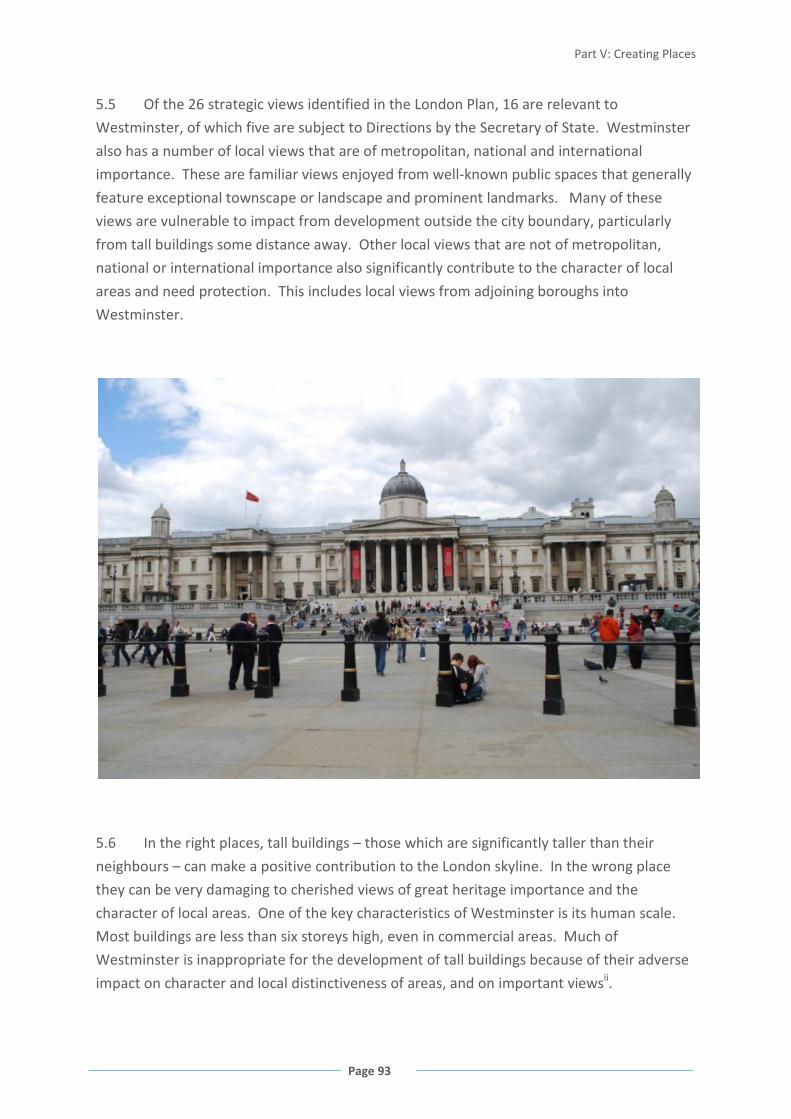
Part V: Creating Places
Page 93
5.5 Of the 26 strategic views identified in the London Plan, 16 are relevant to
Westminster, of which five are subject to Directions by the Secretary of State. Westminster
also has a number of local views that are of metropolitan, national and international
importance. These are familiar views enjoyed from well-known public spaces that generally
feature exceptional townscape or landscape and prominent landmarks. Many of these
views are vulnerable to impact from development outside the city boundary, particularly
from tall buildings some distance away. Other local views that are not of metropolitan,
national or international importance also significantly contribute to the character of local
areas and need protection. This includes local views from adjoining boroughs into
Westminster.
5.6 In the right places, tall buildings – those which are significantly taller than their
neighbours – can make a positive contribution to the London skyline. In the wrong place
they can be very damaging to cherished views of great heritage importance and the
character of local areas. One of the key characteristics of Westminster is its human scale.
Most buildings are less than six storeys high, even in commercial areas. Much of
Westminster is inappropriate for the development of tall buildings because of their adverse
impact on character and local distinctiveness of areas, and on important viewsii.
Change for another view if this is used
elsewhere
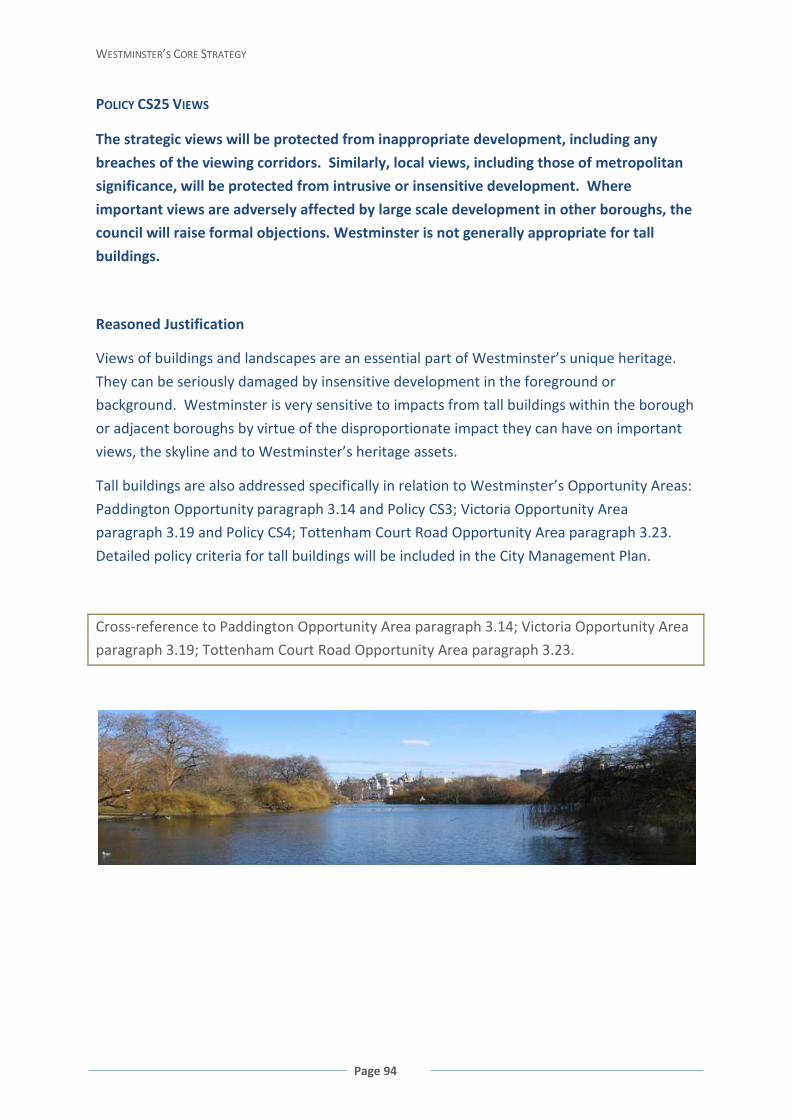
WESTMINSTER’S CORE STRATEGY
Page 94
POLICY CS25 VIEWS
The strategic views will be protected from inappropriate development, including any
breaches of the viewing corridors. Similarly, local views, including those of metropolitan
significance, will be protected from intrusive or insensitive development. Where
important views are adversely affected by large scale development in other boroughs, the
council will raise formal objections. Westminster is not generally appropriate for tall
buildings.
Reasoned Justification
Views of buildings and landscapes are an essential part of Westminster’s unique heritage.
They can be seriously damaged by insensitive development in the foreground or
background. Westminster is very sensitive to impacts from tall buildings within the borough
or adjacent boroughs by virtue of the disproportionate impact they can have on important
views, the skyline and to Westminster’s heritage assets.
Tall buildings are also addressed specifically in relation to Westminster’s Opportunity Areas:
Paddington Opportunity paragraph 3.14 and Policy CS3; Victoria Opportunity Area
paragraph 3.19 and Policy CS4; Tottenham Court Road Opportunity Area paragraph 3.23.
Detailed policy criteria for tall buildings will be included in the City Management Plan.
Cross-reference to Paddington Opportunity Area paragraph 3.14; Victoria Opportunity Area
paragraph 3.19; Tottenham Court Road Opportunity Area paragraph 3.23.
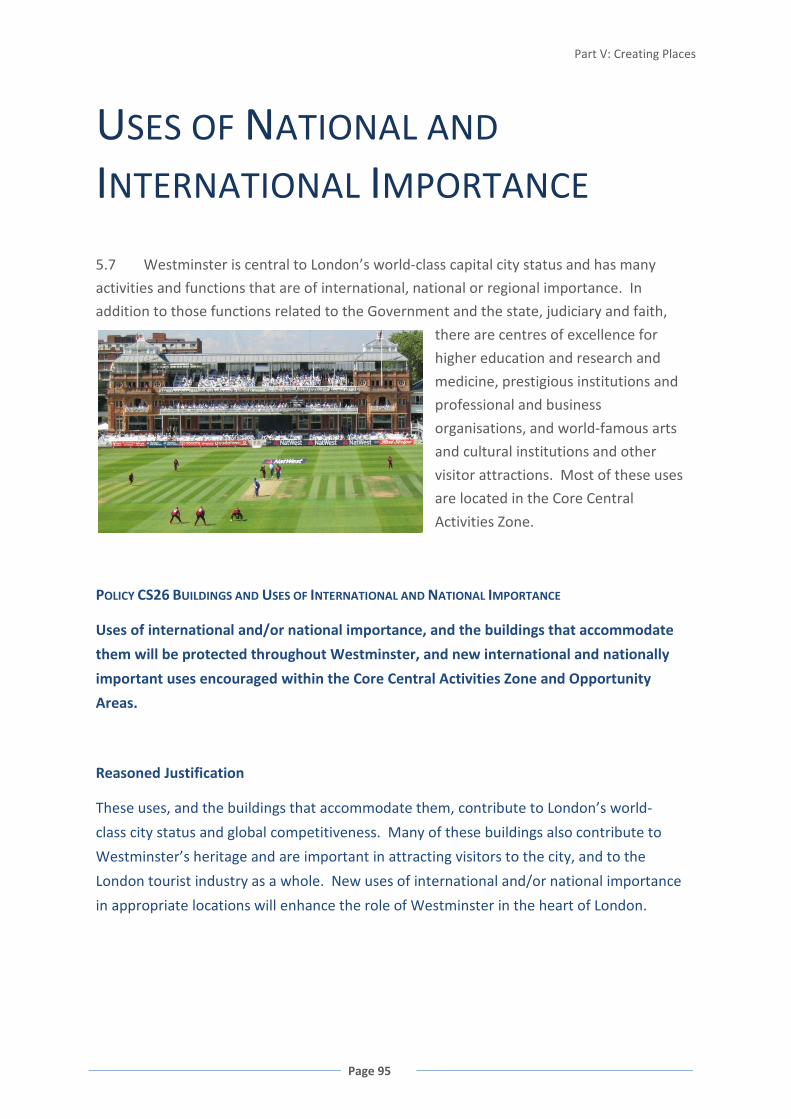
Part V: Creating Places
Page 95
USES OF NATIONAL AND
INTERNATIONAL IMPORTANCE
5.7 Westminster is central to London’s world-class capital city status and has many
activities and functions that are of international, national or regional importance. In
addition to those functions related to the Government and the state, judiciary and faith,
there are centres of excellence for
higher education and research and
medicine, prestigious institutions and
professional and business
organisations, and world-famous arts
and cultural institutions and other
visitor attractions. Most of these uses
are located in the Core Central
Activities Zone.
POLICY CS26 BUILDINGS AND USES OF INTERNATIONAL AND NATIONAL IMPORTANCE
Uses of international and/or national importance, and the buildings that accommodate
them will be protected throughout Westminster, and new international and nationally
important uses encouraged within the Core Central Activities Zone and Opportunity
Areas.
Reasoned Justification
These uses, and the buildings that accommodate them, contribute to London’s world-
class city status and global competitiveness. Many of these buildings also contribute to
Westminster’s heritage and are important in attracting visitors to the city, and to the
London tourist industry as a whole. New uses of international and/or national importance
in appropriate locations will enhance the role of Westminster in the heart of London.
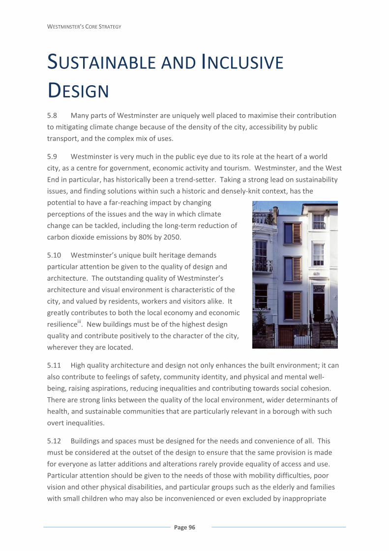
WESTMINSTER’S CORE STRATEGY
Page 96
SUSTAINABLE AND INCLUSIVE
DESIGN 5.8 Many parts of Westminster are uniquely well placed to maximise their contribution
to mitigating climate change because of the density of the city, accessibility by public
transport, and the complex mix of uses.
5.9 Westminster is very much in the public eye due to its role at the heart of a world
city, as a centre for government, economic activity and tourism. Westminster, and the West
End in particular, has historically been a trend-setter. Taking a strong lead on sustainability
issues, and finding solutions within such a historic and densely-knit context, has the
potential to have a far-reaching impact by changing
perceptions of the issues and the way in which climate
change can be tackled, including the long-term reduction of
carbon dioxide emissions by 80% by 2050.
5.10 Westminster’s unique built heritage demands
particular attention be given to the quality of design and
architecture. The outstanding quality of Westminster’s
architecture and visual environment is characteristic of the
city, and valued by residents, workers and visitors alike. It
greatly contributes to both the local economy and economic
resilienceiii. New buildings must be of the highest design
quality and contribute positively to the character of the city,
wherever they are located.
5.11 High quality architecture and design not only enhances the built environment; it can
also contribute to feelings of safety, community identity, and physical and mental well-
being, raising aspirations, reducing inequalities and contributing towards social cohesion.
There are strong links between the quality of the local environment, wider determinants of
health, and sustainable communities that are particularly relevant in a borough with such
overt inequalities.
5.12 Buildings and spaces must be designed for the needs and convenience of all. This
must be considered at the outset of the design to ensure that the same provision is made
for everyone as latter additions and alterations rarely provide equality of access and use.
Particular attention should be given to the needs of those with mobility difficulties, poor
vision and other physical disabilities, and particular groups such as the elderly and families
with small children who may also be inconvenienced or even excluded by inappropriate

Part V: Creating Places
Page 97
development. Putting people at the heart of the design process can encourage occupiers to
make more sustainable lifestyle choices, for example through incorporating cycle storage or
designing access points that do not lead directly to car parking.
5.13 Designing for flexible use of the building means that buildings can easily be
converted, negating the need for redevelopment or extensive refurbishment.
5.14 Sustainable design should be at the heart of high quality design and architecture in
Westminster. Buildings, both new and old, must be designed and refurbished to ensure they
meet high standards of environmental performance helping to mitigate for, and adapt to,
the impacts of climate change. Setting clear standards of environmental performance in
order to influence the future sustainability of buildings in Westminster is integral to the
development process.
5.15 Steps to minimise and recycle natural resource use within a development can be
made by first embedding passive, sustainable design at the centre of the design process.
This will help to reduce the energy requirement of a building. Subsequent to these are
measures to supply energy efficiently and through low carbon and renewable sources.
Further techniques to conserve and recycle water, manage surface water run-off, enhance
biodiversity, reduce waste and facilitate recycling, reduce air and noise pollution all
contribute to a more sustainable development.
FIGURE 41 ENERGY CONSUMPTION 2007iv
5.16 Sustainable design in Westminster needs careful consideration and tailored
solutions. There are fewer opportunities for large-scale redevelopment in Westminster than
there are in other parts of London because of its significant heritage assets, including listed
buildings and Conservation Areas. In this respect, retrofitting existing building is of crucial

WESTMINSTER’S CORE STRATEGY
Page 98
importance, as the existing building stock will always represent a far bigger proportion of
the buildings in Westminster than new buildings.
POLICY CS27 DESIGN
Development must incorporate exemplary standards of sustainable and inclusive urban
design and architecture. In the correct context, imaginative modern architecture is
encouraged provided that it respects Westminster’s heritage and local distinctiveness and
enriches its world-class city environment.
Development should:
• reduce energy use and emissions that contribute to climate change during the life-
cycle of the development, in line with national and regional standards as a
minimum; and
• ensure the reduction, reuse or recycling of resources and materials, including
water, waste and aggregates.
This will include providing for an extended life-time of the building itself through
excellence in design quality, high quality durable materials, efficient operation, and the
provision of high quality floorspace that can adapt to changing circumstances over time.
Reasoned Justification
Westminster requires a special approach to architecture and urban design in order to
deliver the council’s spatial vision of creating a world-class, distinctive and sustainable city.
Only the best, exemplary design, which respects and enhances the existing qualities and
character of the city will be acceptable.
Sustainable design, refurbishment and construction measures provide one of the most
effective and efficient ways in which to reduce resource use, greenhouse gas emissions and
local pollution, in terms of the materials used and construction techniques employed, as
well as throughout the lifetime operation of the development. Furthermore, excellence in
design quality and floorspace adaptability will increase the lifetime of the building and
enable its reuse by reducing the need for redevelopment. Detailed design criteria will be set
out in the City Management Plan.
Cross-reference to Policies CS24 Heritage; CS25 Views; CS28 Health, Safety and Well-Being;
CS30 Air Quality; CS31 Noise; CS37 Biodiversity and Green Infrastructure; CS38
Decentralised Energy Networks; CS39 Renewable Energy; CS40 Pedestrian Movement and
Sustainable Transport; CS41 Servicing and Deliveries; CS43 Sustainable Waste Management.
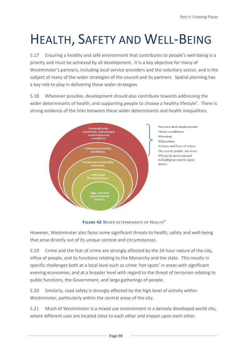
Part V: Creating Places
Page 99
HEALTH, SAFETY AND WELL-BEING 5.17 Ensuring a healthy and safe environment that contributes to people’s well-being is a
priority and must be achieved by all development. It is a key objective for many of
Westminster’s partners, including local service providers and the voluntary sector, and is the
subject of many of the wider strategies of the council and its partners. Spatial planning has
a key role to play in delivering these wider strategies.
5.18 Wherever possible, development should also contribute towards addressing the
wider determinants of health, and supporting people to choose a healthy lifestylev. There is
strong evidence of the links between these wider determinants and health inequalities.
FIGURE 42 WIDER DETERMINANTS OF HEALTHvi
However, Westminster also faces some significant threats to health, safety and well-being
that arise directly out of its unique context and circumstances.
5.19 Crime and the fear of crime are strongly affected by the 24 hour nature of the city,
influx of people, and its functions relating to the Monarchy and the state. This results in
specific challenges both at a local level such as crime ‘hot-spots’ in areas with significant
evening economies, and at a broader level with regard to the threat of terrorism relating to
public functions, the Government, and large gatherings of people.
5.20 Similarly, road safety is strongly affected by the high level of activity within
Westminster, particularly within the central areas of the city.
5.21 Much of Westminster is a mixed use environment in a densely developed world city,
where different uses are located close to each other and impact upon each other.
WESTMINSTER’S CORE STRATEGY
Page 100
Residential and commercial growth in Westminster will entail building to higher densities,
including extensions to existing buildings and infill developments. In the many areas within
the Central Activities Zone and North Westminster Economic Development Area, new
commercial uses are encouraged alongside new and existing homes and it is important that
there are good levels of residential amenity for both new and existing residents.
5.22 It is recognised that new development in Westminster is likely to have some impact
on residential amenity, but new development should take measures to minimise noise, light,
and air pollution, to acceptable levels and maintain or improve the amenity for
neighbouring residents by addressing issues of privacy, overlooking, natural light, enclosure,
and disturbance. These detailed matters will be dealt with in detail in the City Management
Plan.
5.23 In meeting the housing targets, care must be taken to create long -lasting homes that
meet the different needs of occupiers, including those with mobility difficulties and the
elderly. Particular care and innovative design solutions are required in the Westminster
context of dense, mixed use environments, high-density housing, and areas with a poor
external environment, including areas which suffer poor air quality or significant noise
pollution.
POLICY CS28 HEALTH, SAFETY AND WELL-BEING
Development should ensure that the need to secure a healthy and safe environment is
addressed, including minimising opportunities for crime, including the risk of terrorism,
and addressing any specific risks to health or safety from the local environment or
conditions. Developments should also maximise opportunities to contribute to health and
well-being, including supporting opportunities for improved life chances and healthier
lifestyle choices.
The council will resist proposals that result in an unacceptable material loss of
residential amenity and developments should aim to improve the residential
environment.
All new housing, and where possible refurbishment of existing housing, will provide a
well-designed, high quality living environment, both internally and externally in relation
to the site layout and neighbourhood.
Reasoned Justification
Westminster’s unique circumstances give rise to a number of challenges to health, safety
and well-being which should be addressed by development wherever possible. Well-

Part V: Creating Places
Page 101
designed places and spaces can make a considerable contribution to addressing these
challenges. Specific issues include: the threat of terrorism, and increased crime rates
related to the unique functions and role of Westminster’s Central Activities Zone; fear of
crime experienced in Westminster’s more deprived areas; road safety issues, particularly
those related to the significant volumes of traffic experienced in Central London, and
particular issues related to visitors to the city; and the particular challenges to providing a
healthy living environment within a dense, mixed use area, often with significant local air
and noise pollution and urban heat island effects.
Local solutions also need to be sought to address the wider determinants of health, such as
ensuring access to employment, good quality housing, a range of local services and facilities,
and open spaces; and the ability to make healthy lifestyle choices such as being active.
Growth in the Westminster context means mixed use areas and sites, infill development
and high density living. It is therefore vital that exceptional attention is paid to protecting
existing residential amenity and providing good quality residential accommodation for
future residents. Poor quality residential amenity can make homes less attractive to
permanent residents and threaten the sustainability of residential neighbourhoods. High
standards of residential amenity will benefit Westminster’s residents in terms of quality of
life, health and well-being.
Securing high quality housing enables occupiers to meet their everyday needs for a safe,
healthy and functional living environment, and tackles deprivation issues such as fuel
poverty and over-crowding. High quality homes also reduce the lifetime costs for occupiers
in terms of energy and resource use, medical costs, educational disruption and other social
and economic costs. Well-designed, high quality residential developments will also improve
the quality of neighbourhoods and make Westminster a more pleasant location for workers
and visitors, benefiting the local economy.
FLOOD RISK
5.24 As a riverside borough, some parts of Westminster identified by the Environment
Agency have been designated Flood Zone 2 and Flood Zone 3. Flood Zone 3, without
defences, has a high probability of flooding (1 in 100 or greater annual probability of river
flooding or a 1 in 200 or greater annual probability of flooding from the sea). Flood Zone 2,
without defences, has a medium probability of flooding, and covers very small areas in
Westminster. Planning Policy Statement 25 (PPS25) requires local authorities to carry out a
Strategic Flood Risk Assessment (SFRA) to assess all forms of flooding within their area.
Westminster’s SFRA identifies areas in Flood Zones 2 and 3, areas most at risk of flooding
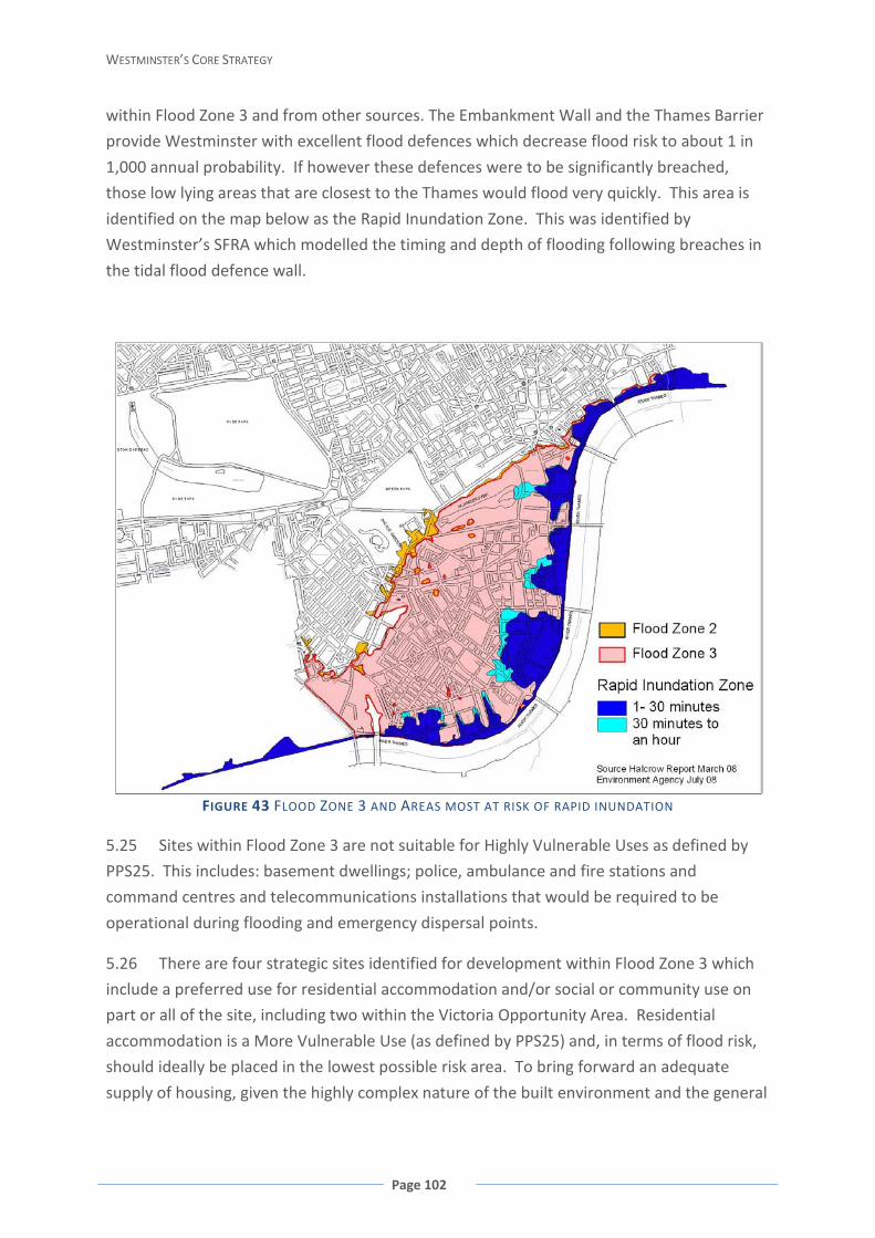
WESTMINSTER’S CORE STRATEGY
Page 102
within Flood Zone 3 and from other sources. The Embankment Wall and the Thames Barrier
provide Westminster with excellent flood defences which decrease flood risk to about 1 in
1,000 annual probability. If however these defences were to be significantly breached,
those low lying areas that are closest to the Thames would flood very quickly. This area is
identified on the map below as the Rapid Inundation Zone. This was identified by
Westminster’s SFRA which modelled the timing and depth of flooding following breaches in
the tidal flood defence wall.
FIGURE 43 FLOOD ZONE 3 AND AREAS MOST AT RISK OF RAPID INUNDATION
5.25 Sites within Flood Zone 3 are not suitable for Highly Vulnerable Uses as defined by
PPS25. This includes: basement dwellings; police, ambulance and fire stations and
command centres and telecommunications installations that would be required to be
operational during flooding and emergency dispersal points.
5.26 There are four strategic sites identified for development within Flood Zone 3 which
include a preferred use for residential accommodation and/or social or community use on
part or all of the site, including two within the Victoria Opportunity Area. Residential
accommodation is a More Vulnerable Use (as defined by PPS25) and, in terms of flood risk,
should ideally be placed in the lowest possible risk area. To bring forward an adequate
supply of housing, given the highly complex nature of the built environment and the general
Part V: Creating Places
Page 103
lack of available land in Westminster, the provision of residential accommodation is
required in almost all schemes in Westminster.
5.27 To support residents and achieve sustainable communities, social and community
uses also need to be located in areas where they serve the local population. Therefore, the
identified sites within Flood Zone 3 and other sites that may come forward from windfall
development are considered to have passed the Sequential Test set out in PPS25. Proposals
must then be considered against the Exception Test as set out in PPS25 for More Vulnerable
Uses and for Essential Infrastructure. However, to build in resilience, ground and basement
floor uses will be carefully considered.
5.28 In addition to flooding from the River Thames, there are other potential sources of
flooding; from surface water, sewers, groundwater, canals, water features and water mains.
Given the densely built-up nature of Westminster, a likely source is from surface water
flooding where rainwater is unable to soak into the ground or drain away. This may become
a more common occurrence in the future as climate change results in an increase in the
incidence and severity of heavy rainfall.
POLICY CS29 FLOOD RISK
Highly Vulnerable Uses will not be allowed within Flood Zone 3, and in Flood Zone 2 will
be required to pass the Exception Test.
Proposals for Essential Infrastructure and More Vulnerable Uses within Flood Zone 3 will
be required to pass the Exception Test. Within the Rapid Inundation Zone, new
residential units below the tidal breach flood level and extensions to residential at
basement level will not be acceptable.
All development proposals should take flood risk into account and new development
should reduce the risk of flooding.
Reasoned Justification
This ensures that development is located in the most appropriate location in terms of risk of
flooding from the River Thames and vulnerability classification, taking into account the
constraints on development potential across the whole of Westminster and the lack of
opportunities to develop in other parts of the borough.
Whilst there is a need to adapt to the effects of climate change, this approach also
acknowledges the excellent flood defences in place, which will continue to be necessary in
the future to protect the existing built infrastructure along the riverside.

WESTMINSTER’S CORE STRATEGY
Page 104
The policy ensures that all sources of flooding are taken into account and that potential
flood risk in Westminster is reduced through mitigation measures.
Proposals should provide Flood Risk Assessments as required by PPS25.
Cross-reference to Policy CS44 Flood-related Infrastructure; Appendix 1 Proposals Sites 7, 9,
25 and 26.
AIR QUALITY
5.29 Westminster has some of the poorest air quality in the country. For this reason, the
whole borough was declared an Air Quality Management Area (AQMA) in 1999 for nitrogen
dioxide (NO2) and particulates (PM10). In Westminster, concentrations of NO2 and
particulates regularly exceed the Air Quality Objectives as set out in the national Air Quality
Strategy and in European legislation.
FIGURE 44 2010 MODELLED ANNUAL AVERAGE POLLUTION EXCEEDANCES FOR NITROGEN DIOXIDE (LEFT)
AND PARTICULATES (RIGHT)
5.30 Air pollution damages human health causing an increased risk of cardiovascular and
respiratory diseases, an increased risk of cancer, and exacerbating asthma. In London, over
1,000 people die prematurely every year as a result of air pollution, and there are a similar
number of hospitalisationsvii. Air pollution also directly affects ecosystems and the local
environment, causing soiling and damage to buildings, unpleasant odours and reducing
visibility. There are also strong links between local air pollution, maintaining a healthy and
comfortable internal environment, and energy use. Poor air quality constrains the options
available for ventilating and cooling commercial premises, increasing the use of mechanical
ventilation and air-conditioning.

Part V: Creating Places
Page 105
5.31 Poor air quality in Westminster is the result of the high numbers of vehicles,
emissions from plant and machinery such as boilers, and the density of roads and buildings
which prevents dispersal of the pollutants. In addition to the pollution emitted within the
city, a significant amount is generated elsewhere and contributes to the concentrations that
are measured in Westminster. This is especially the case with particulates. Sources are
both man-made and natural, and are very closely linked to weather systems.
5.32 The focus of action to improve air quality has largely been on road transport. As
progress has been made in this area, the relative importance of emissions from non-road
transport sources increases, with emissions from buildings becoming proportionately more
important. In Westminster it is estimated that by 2010 around 60% of nitrogen oxides (NOx)
(which react in sunlight with other chemicals in the atmosphere to form NO2) will come
from gas combustion sources (including domestic and commercial boilers). Gas combustion
is already overtaking road traffic as the principle source of NOx emissions across London.
POLICY CS30 AIR QUALITY
The council will require a reduction of air pollution, with the aim of meeting the objectives
for pollutants set out in the national strategy.
Developments will minimise emissions of air pollution from both static and traffic-
generated sources.
Developments that include uses that are more vulnerable to air pollution (Air Quality
Sensitive Receptors) will minimise the impact of poor air quality on occupants through the
design of the building and appropriate technology.
Reasoned Justification
Improving air quality is a national and regional objective, and is of particular importance to
Westminster. If Westminster is to achieve a reduction in air pollution then it must require a
reduction in emissions from all sources.
Requiring consideration of air pollution in the building design stage and use of appropriate
technology is the most effective way of achieving a reduction in non-road transport
emissions. This complements policies to reduce emissions from road transport.
Cross-reference to Policies CS27 Design; CS40 Pedestrian Movement and Sustainable
Transport; CS41 Servicing and Deliveries; CS42 Major Transport Infrastructure.

WESTMINSTER’S CORE STRATEGY
Page 106
NOISE POLLUTION
5.33 Westminster is significantly noisier than many other parts of London. Like most
urban areas, noise levels in the city exceed the guideline levels set by the World Health
Organisation. Noise can lead to annoyance and have a negative impact on sleep, learning
and communication, and health and well-being more generally.
5.34 Westminster’s diverse built form, mix and pattern of commercial and entertainment
activities, concentration of transport infrastructure and volumes of movement combine and,
in some locations, lead to high levels of noise. This is exacerbated by the 24-hour nature of
activities in some parts of the city. Because of this, reducing average noise levels in the city
continues to be an important objective.
5.35 However, it is not necessarily the loudest or
continuous noise that causes the most annoyance;
some individual noise incidences are a problem
because they are intermittent and unpredictable;
other noises have tonal characteristics that most
people find unpleasant, such as screeching or deep,
vibrating tones. Noise is also more obtrusive when it
is in an area that people expect to be quieter.
Individual responses to noise vary and are dependent
on time and place. Average noise level emission
standards or noise exposure categories can only ever
be a partial response.
5.36 Despite the serious problems of noise pollution
affecting the city, there are relatively quiet areas and
positive aspects of Westminster’s soundscape (the
quality of the acoustic environment). For example,
many of the city’s open spaces are relatively tranquil
and provide respite from noise pollution and lower
noise levels can be experienced at the rear facades of
many buildings. Like the city itself, the noise
environment in Westminster is complex and unique. A
holistic approach managing noise across the city is
necessary; noise reduction measures are essential, but
mitigating impacts of different noise sources and
improving the overall quality of the sound
environment is also important.
Part V: Creating Places
Page 107
POLICY CS31 NOISE
The council will work to reduce noise pollution and its impacts and protect Noise Sensitive
Receptors from noise by:
Requiring development to minimise and contain noise and vibration;
Ensuring development provides an acceptable noise and vibration climate for
occupants and is designed to minimise exposure to vibration and external noise
sources; and
Securing improvements to Westminster’s sound environment, including protecting
open spaces of particular value for their relative tranquillity.
Reasoned Justification
This will contribute to the broader aim of reducing the impact of noise on health and well-
being. This also links to fundamental objectives to provide comfortable and healthy
environments designed to minimise adverse environmental pollution.
Noise pollution is a particular problem in Westminster but there are positive features of
Westminster’s sound environment, not least the relative tranquillity of some of the city’s
open spaces. Recognising existing, and identifying potential positive sound features of the
city, will also contribute to more effective management of Westminster’s sound
environment.
Cross-reference to Policies CS11 Royal Parks; CS34 Open Space.

WESTMINSTER’S CORE STRATEGY
Page 108
INFRASTRUCTURE AND
DEVELOPMENT IMPACTS 5.37 Managing the impact of development on the socio-economic, natural and built
environment is essential to ensure Westminster’s development is sustainable. An important
aspect of this is protecting existing, and securing new supporting infrastructure.
5.38 Unlike many other parts of the country, growth does not tend to be constrained by
infrastructure needs as developments are ‘inserted’ into an existing city where there are
existing infrastructure facilities and networks. However, the infrastructure is of varied age,
quality and fitness for purpose and often under considerable pressure from existing
residents and the workers and visitors that expand the population to over one million during
the day.
5.39 Westminster is a complex and
dynamic environment and as such requires
an equally dynamic and flexible approach
to infrastructure planning. The key
infrastructure necessary to deliver the Core
Strategy vision are highlighted in the
Spatial Strategy and in relation to policies
throughout the document, and also
considered in the section on Risk and
Review.
5.40 The council, its partners in the Westminster City Partnership, and other
infrastructure providers, have a critical role to play in delivering high quality services and
ensuring the city’s infrastructure is maintained, improved and where necessary, expanded.
The infrastructure strategies of these partner organisations have helped inform this Core
Strategy and are also considered in the infrastructure assessment published alongside the
Core Strategy. Infrastructure planning is necessarily an on-going process and the council will
continue to work closely with these partners and the development industry to assess and
meet existing and emerging infrastructure needs.
5.41 Funding for many infrastructure projects will be from mainstream sources, but for
some infrastructure types, an element of this funding may include contributions from
developers. This contribution would be secured through planning obligations, or if it is
introduced, a Community Infrastructure Levy (CIL). Planning obligations are legal
agreements with developers requiring provision of “in kind” benefits, financial contributions
Part V: Creating Places
Page 109
or other controls or restrictions on the way land is developed. They are used to prescribe
the nature the development should take, compensate for a loss caused by the development
or mitigate the impacts of development including impacts on infrastructure and other social,
economic or environmental impacts. The CIL has a narrower scope: it is a charge on
developments to fund the infrastructure necessary to support it. If the CIL is implemented it
would be used in place of planning obligations to secure infrastructure contributions from
development.
POLICY CS32 PLANNING OBLIGATIONS AND DELIVERING INFRASTRUCTURE
When negotiating planning obligations, the council will require mitigation of the directly
related impacts of development; ensure the development complies with policy
requirements within the development plan; and, if appropriate, seek contributions for
supporting infrastructure.
Development will be supported by upgrades to existing infrastructure and the provision of
new infrastructure to enable it to be sustainable. Working with its partners, the council
will identify this infrastructure, its costs and any shortfalls in funding and will ensure this
infrastructure is:
Phased and delivered in a timely manner to support growth; and
Funded through planning obligations or the Community Infrastructure Levy, where
this complies with relevant legislation.
Planning obligations and any Community Infrastructure Levy contributions will be sought
at a level that ensures the overall delivery of appropriate development is not
compromised.
Reasoned Justification
Planning obligations, used in line with relevant legislation and government guidance, can
play an important role in managing direct site specific and local impacts of a development
and ensuring that the Core Strategy and other development plan policies are achieved.
Planning obligations, or if introduced CIL, also have a role in contributing to the provision of
supporting infrastructure.
Cumulatively almost all development puts additional pressure on infrastructure and should
contribute to addressing that impact. While some infrastructure can be directly provided
by, and directly serve a specific development, in many cases it will be necessary to pool
funding from several developments.

WESTMINSTER’S CORE STRATEGY
Page 110
This policy provides framework for the development of transparent and equitable
mechanisms that improve the link between growth and the infrastructure and enable
development to fund infrastructure needed to make it acceptable. Detailed policies will be
set out in the City Management Plan and where appropriate Supplementary Planning
Documents. If CIL is implemented, charges will be set out in a Charging Schedule. These will
all be subject to consultation and, where required, an independent public examination.
Cross-reference to Part VI Partnerships; Part VI Risk and Review; Appendix 3 Key
Partnerships.
SOCIAL AND COMMUNITY INFRASTRUCTURE
5.42 As Westminster grows and changes, social and community facilities must be
provided to meet the changing needs of the city’s diverse communities. New development
will place pressure on existing social and community facilities. Therefore, new facilities
and/or investment into existing facilities will be required.
5.43 Westminster is unusual in that considerable demands are placed on its social and
community facilities by workers and visitors,
particularly for health, childcare and leisure facilities.
Certain facilities within Westminster, such as places of
worship, educational or medical institutions, also serve
a much wider catchment than Westminster, with a sub-
regional, national or even international role.
5.44 Public service providers such as the National
Health Service, Metropolitan Police and the council all
produce their own asset management plans which,
over time, will be better co-ordinated and will set out
how their respective estates will be managed and potentially more closely aligned. The
council supports the delivery of proposals in these plans. This includes proposals identified
in Westminster’s Asset Management Plan and Property Strategy to develop local service
provision facilities planned for Pimlico/Victoria Opportunity Area, Bayswater, Church Street
and Queens Park; proposals to work with Westminster’s Primary Care Trust to deliver a new
GP-led health centre in Queens Park, and develop three or four health and well-being
facilities “polysystems” aligned with GP practice- based commissioning clusters; a

Part V: Creating Places
Page 111
nd the Westminster’s Building Schools for the Future (BSF) Programme, including
redevelopment of facilities at Grey Coat Hospital School (likely completion 2011), St
George’s RC School (likely completion 2011), and St Augustine’s CE High School (likely
completion 2011). Forthcoming proposals are programmed for Queen Elizabeth II Jubilee
School, College Park School and Quintin Kynaston School.
5.45 The private sector also plays an important and valued role in providing services within
the city. For example, they provide a wide range of leisure, health, childcare and
educational services, ranging from international centres of excellence for medicine and
education, through to local childcare and gym facilities. Whilst these facilities provide
services for local communities, they are essentially businesses and their services are
available to the public on a commercial basis rather than meeting the needs of all sectors of
the local community. Finally, it is likely that the third sector will have more of a role to play
in delivering local services in the future. However, this sector has its own particular property
needs which are often difficult to meet due to the high property values within the city.
5.46 In all cases, social and community facilities need to be in appropriate buildings that
meet the needs of the service and those who use them, and which facilitate modern models
of service provision. This may include co-location of a number of different social and
community facilities to a single location and/or use of flexible community floorspace
available to a range of organisations. The council will work closely with Local Service
Providers to establish these infrastructure requirements as part of its infrastructure
planning process.
POLICY CS33 SOCIAL AND COMMUNITY INFRASTRUCTURE
All social and community floorspace will be protected except where existing provision is
being reconfigured, upgraded or is being re-located in order to improve services and meet
identified needs as part of a published strategy by a local service provider. In all such cases
the council will need to be satisfied that the overall level of social and community
provision is improved and there is no demand for an alternative social and community use
for that floorspace. In those cases where the council accepts a loss or reduction of social
and community floorspace the priority replacement use will be residential.
New social and community facilities will be encouraged throughout Westminster and will
be provided on large scale development sites.
WESTMINSTER’S CORE STRATEGY
Page 112
Reasoned Justification
The provision of social and community facilities is integral to supporting sustainable
communities. Because of Westminster’s high land values and because these uses typically
generate high levels of footfall from visiting members of the public, it can often be difficult
to establish new facilities in appropriate locations. It is therefore important to protect
existing floorspace (including external spaces). In some cases, however, local service
provision can be significantly improved by rationalising
accommodation, co-locating a range of local service
providers onto a single site(s) or providing purpose-built
flexible community floorspace. This may result in an
overall loss of floorspace, which may be acceptable if it is
part of a published strategy and brings overall benefits to
the local community. The policy approach will ensure
facilities are fit for purpose and provide sufficient
flexibility to meet the needs of both the providers and
local communities. If for any reason a new social and
community use cannot be found for an existing site,
these sites will be expected to provide housing. Large-
scale new development will be expected to contribute to
the provision of new social and community facilities so as
to mitigate their impact on existing services.
Cross-reference to Policy CS3 Paddington Opportunity Area; CS4 Victoria Opportunity Area;
CS5 Tottenham Court Road Opportunity Area; CS7 West End Special Retail Policy Area; CS12
North Westminster Economic Development Area; CS20 Retail; CS34 Open Space.
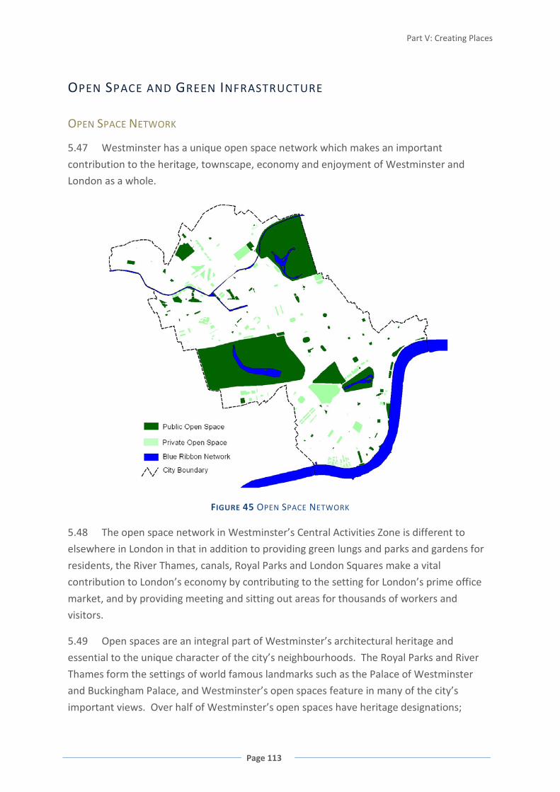
Part V: Creating Places
Page 113
OPEN SPACE AND GREEN INFRASTRUCTURE
OPEN SPACE NETWORK
5.47 Westminster has a unique open space network which makes an important
contribution to the heritage, townscape, economy and enjoyment of Westminster and
London as a whole.
FIGURE 45 OPEN SPACE NETWORK
5.48 The open space network in Westminster’s Central Activities Zone is different to
elsewhere in London in that in addition to providing green lungs and parks and gardens for
residents, the River Thames, canals, Royal Parks and London Squares make a vital
contribution to London’s economy by contributing to the setting for London’s prime office
market, and by providing meeting and sitting out areas for thousands of workers and
visitors.
5.49 Open spaces are an integral part of Westminster’s architectural heritage and
essential to the unique character of the city’s neighbourhoods. The Royal Parks and River
Thames form the settings of world famous landmarks such as the Palace of Westminster
and Buckingham Palace, and Westminster’s open spaces feature in many of the city’s
important views. Over half of Westminster’s open spaces have heritage designations;
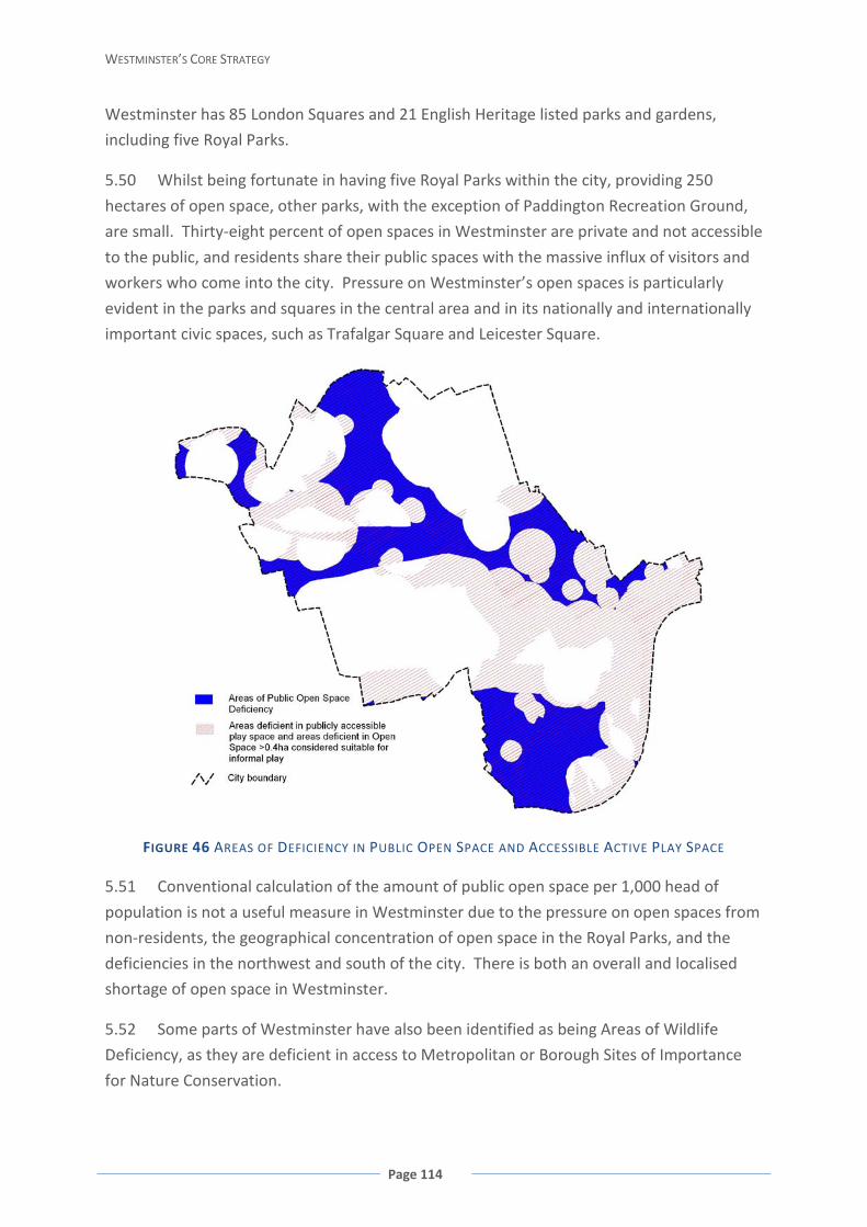
WESTMINSTER’S CORE STRATEGY
Page 114
Westminster has 85 London Squares and 21 English Heritage listed parks and gardens,
including five Royal Parks.
5.50 Whilst being fortunate in having five Royal Parks within the city, providing 250
hectares of open space, other parks, with the exception of Paddington Recreation Ground,
are small. Thirty-eight percent of open spaces in Westminster are private and not accessible
to the public, and residents share their public spaces with the massive influx of visitors and
workers who come into the city. Pressure on Westminster’s open spaces is particularly
evident in the parks and squares in the central area and in its nationally and internationally
important civic spaces, such as Trafalgar Square and Leicester Square.
FIGURE 46 AREAS OF DEFICIENCY IN PUBLIC OPEN SPACE AND ACCESSIBLE ACTIVE PLAY SPACE
5.51 Conventional calculation of the amount of public open space per 1,000 head of
population is not a useful measure in Westminster due to the pressure on open spaces from
non-residents, the geographical concentration of open space in the Royal Parks, and the
deficiencies in the northwest and south of the city. There is both an overall and localised
shortage of open space in Westminster.
5.52 Some parts of Westminster have also been identified as being Areas of Wildlife
Deficiency, as they are deficient in access to Metropolitan or Borough Sites of Importance
for Nature Conservation.
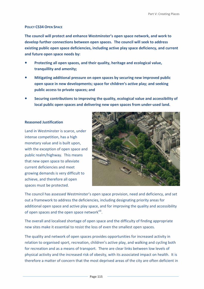
Part V: Creating Places
Page 115
POLICY CS34 OPEN SPACE
The council will protect and enhance Westminster’s open space network, and work to
develop further connections between open spaces. The council will seek to address
existing public open space deficiencies, including active play space deficiency, and current
and future open space needs by:
Protecting all open spaces, and their quality, heritage and ecological value,
tranquillity and amenity;
Mitigating additional pressure on open spaces by securing new improved public
open space in new developments; space for children’s active play; and seeking
public access to private spaces; and
Securing contributions to improving the quality, ecological value and accessibility of
local public open spaces and delivering new open spaces from under-used land.
Reasoned Justification
Land in Westminster is scarce, under
intense competition, has a high
monetary value and is built upon,
with the exception of open space and
public realm/highway. This means
that new open space to alleviate
current deficiencies and meet
growing demands is very difficult to
achieve, and therefore all open
spaces must be protected.
The council has assessed Westminster’s open space provision, need and deficiency, and set
out a framework to address the deficiencies, including designating priority areas for
additional open space and active play space, and for improving the quality and accessibility
of open spaces and the open space networkviii.
The overall and localised shortage of open space and the difficulty of finding appropriate
new sites make it essential to resist the loss of even the smallest open spaces.
The quality and network of open spaces provides opportunities for increased activity in
relation to organised sport, recreation, children’s active play, and walking and cycling both
for recreation and as a means of transport. There are clear links between low levels of
physical activity and the increased risk of obesity, with its associated impact on health. It is
therefore a matter of concern that the most deprived areas of the city are often deficient in

WESTMINSTER’S CORE STRATEGY
Page 116
open space provision. Ninety percent of residents live in flats, further increasing the
importance of open spaces as a particularly valuable resource to the social well-being and
healthy lives of Westminster’s residents.
There is little scope, in terms of suitable sites, to address the identified deficiencies in
District Parks and Local Parks. The council will therefore focus on increasing the supply of
Small Open Spaces, Pocket Parks and Civic Amenity Spaces, including facilities for sitting out,
play and nature conservation, to reduce identified open space deficiencies, and to prevent
additional deficiencies occurring citywide. Similarly, where there are under-used areas of
land, they may be able to make a contribution to open space provision.
SITES OF IMPORTANCE FOR NATURE CONSERVATION
5.53 Westminster has five Metropolitan Sites of Importance for Nature Conservation
(SMINCs) comprising the five Royal Parks and Buckingham Palace Gardens, and the Blue
Ribbon Network. The city also has five Grade I Borough SINCs (one of which is also
designated as a Local Nature Reserve), nine Grade II Borough SINCs and 17 Local SINCs.
These sites are recognised for their particular value for nature conservation. As well as the
intrinsic value of nature conservation, interaction with nature contributes to mental and
physical well-being. SINCs provide opportunities for people to interact with nature and
educate and bring people together. The Royal Parks are also designated Metropolitan Open
Land and have significant heritage value.
POLICY CS35 SITES OF IMPORTANCE FOR NATURE CONSERVATION
Sites of Importance for Nature Conservation (SINCs) will be protected and enhanced.
Proposals, both temporary and permanent, will need to demonstrate that they do not
have a detrimental impact on the habitats or populations supported in these sites.
SINCs will be protected and managed for their ecological value as the priority.
Reasoned Justification
Protection of SINCs serves to protect the significant areas of recognised habitat and species
within Westminster.
Cross-reference to Policies CS11 Royal Parks; CS37 Biodiversity and Green Infrastructure.

Part V: Creating Places
Page 117
BLUE RIBBON NETWORK
FIGURE 47 BLUE RIBBON NETWORK INCLUDING THAMES POLICY AREA
5.54 The Blue Ribbon Network within Westminster is of strategic importance to London.
The River Thames forms the southern boundary of the borough and the setting for the
Palace of Westminster and other historic buildings and areas including the bridges
themselves. In recognition of the strategic importance of the River Thames, a Thames Policy
Area has been designated. Westminster’s Blue Ribbon Network also comprises the Grand
Union and Regent’s canals towards the north, and the Serpentine and Long Water in Hyde
Park and Kensington Gardens, and lakes in the other Royal Parks. Many of Westminster’s,
and indeed London’s, most iconic views include the Thames and the lakes in the Royal Parks.
They are also important for providing habitat and wildlife corridors, and fulfil other
environmental functions such as drainage. The Thames and canals are designated Green
Corridors.
5.55 The Blue Ribbon Network also plays important roles in transport, recreation and
education. It can provide a much needed respite from the built-up nature of the city, and
also provides important linear walking and cycling routes.
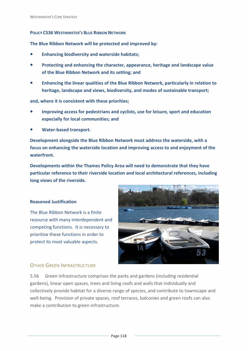
WESTMINSTER’S CORE STRATEGY
Page 118
POLICY CS36 WESTMINSTER’S BLUE RIBBON NETWORK
The Blue Ribbon Network will be protected and improved by:
Enhancing biodiversity and waterside habitats;
Protecting and enhancing the character, appearance, heritage and landscape value
of the Blue Ribbon Network and its setting; and
Enhancing the linear qualities of the Blue Ribbon Network, particularly in relation to
heritage, landscape and views, biodiversity, and modes of sustainable transport;
and, where it is consistent with these priorities;
Improving access for pedestrians and cyclists, use for leisure, sport and education
especially for local communities; and
Water-based transport.
Development alongside the Blue Ribbon Network must address the waterside, with a
focus on enhancing the waterside location and improving access to and enjoyment of the
waterfront.
Developments within the Thames Policy Area will need to demonstrate that they have
particular reference to their riverside location and local architectural references, including
long views of the riverside.
Reasoned Justification
The Blue Ribbon Network is a finite
resource with many interdependent and
competing functions. It is necessary to
prioritise these functions in order to
protect its most valuable aspects.
OTHER GREEN INFRASTRUCTURE
5.56 Green infrastructure comprises the parks and gardens (including residential
gardens), linear open spaces, trees and living roofs and walls that individually and
collectively provide habitat for a diverse range of species, and contribute to townscape and
well-being. Provision of private spaces, roof terraces, balconies and green roofs can also
make a contribution to green infrastructure.
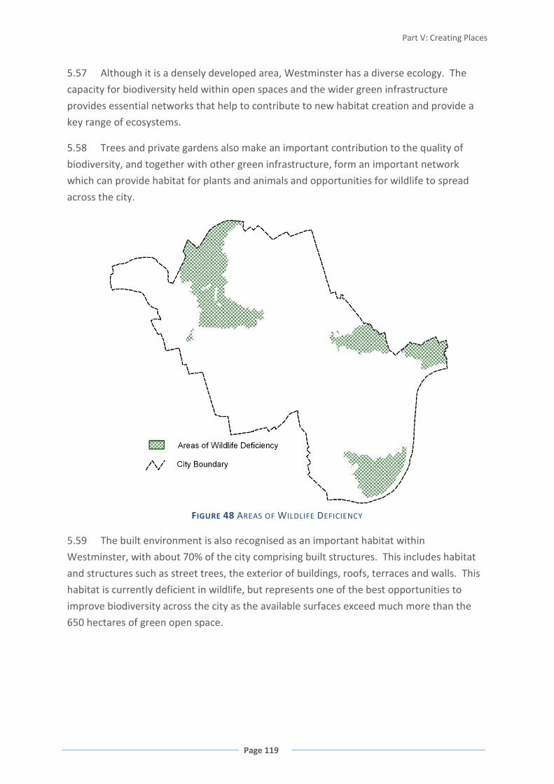
Part V: Creating Places
Page 119
5.57 Although it is a densely developed area, Westminster has a diverse ecology. The
capacity for biodiversity held within open spaces and the wider green infrastructure
provides essential networks that help to contribute to new habitat creation and provide a
key range of ecosystems.
5.58 Trees and private gardens also make an important contribution to the quality of
biodiversity, and together with other green infrastructure, form an important network
which can provide habitat for plants and animals and opportunities for wildlife to spread
across the city.
FIGURE 48 AREAS OF WILDLIFE DEFICIENCY
5.59 The built environment is also recognised as an important habitat within
Westminster, with about 70% of the city comprising built structures. This includes habitat
and structures such as street trees, the exterior of buildings, roofs, terraces and walls. This
habitat is currently deficient in wildlife, but represents one of the best opportunities to
improve biodiversity across the city as the available surfaces exceed much more than the
650 hectares of green open space.
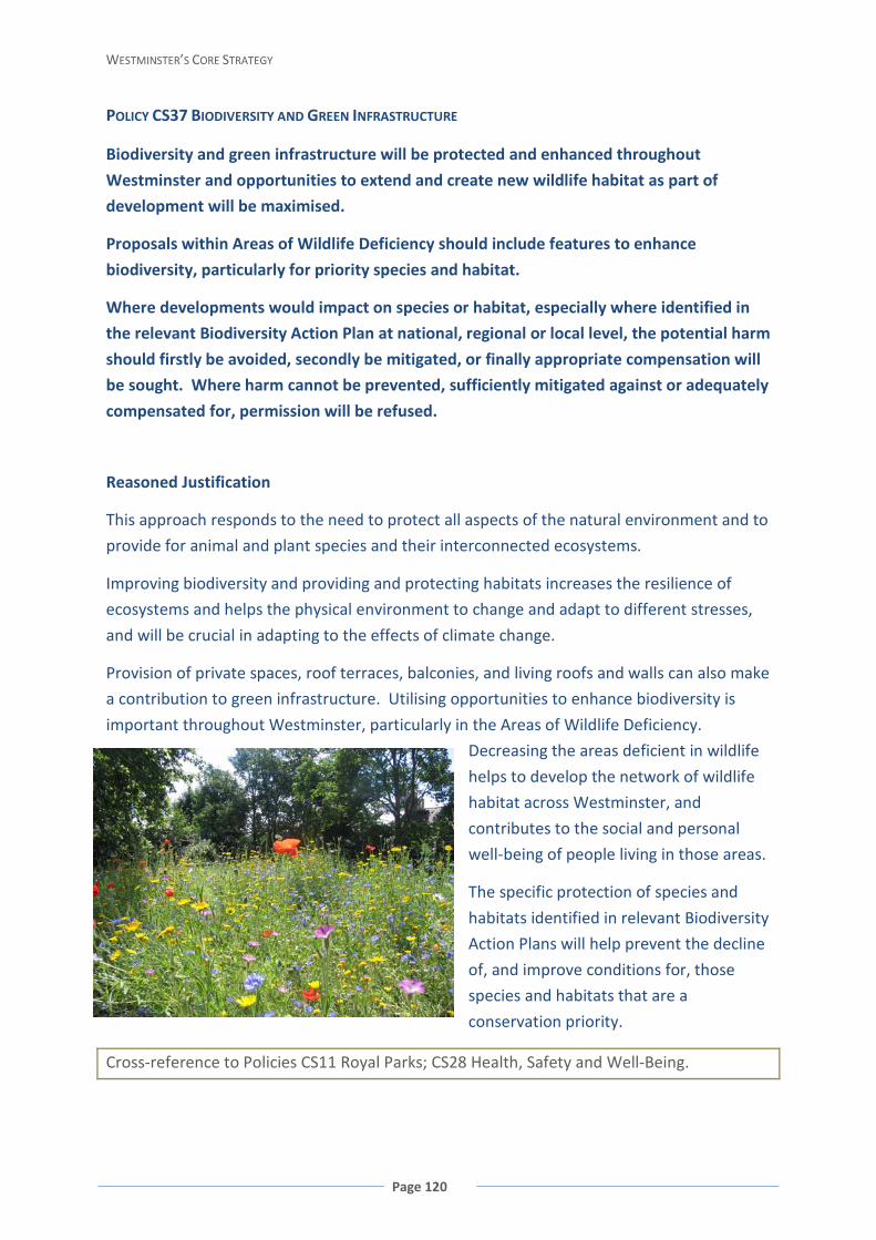
WESTMINSTER’S CORE STRATEGY
Page 120
POLICY CS37 BIODIVERSITY AND GREEN INFRASTRUCTURE
Biodiversity and green infrastructure will be protected and enhanced throughout
Westminster and opportunities to extend and create new wildlife habitat as part of
development will be maximised.
Proposals within Areas of Wildlife Deficiency should include features to enhance
biodiversity, particularly for priority species and habitat.
Where developments would impact on species or habitat, especially where identified in
the relevant Biodiversity Action Plan at national, regional or local level, the potential harm
should firstly be avoided, secondly be mitigated, or finally appropriate compensation will
be sought. Where harm cannot be prevented, sufficiently mitigated against or adequately
compensated for, permission will be refused.
Reasoned Justification
This approach responds to the need to protect all aspects of the natural environment and to
provide for animal and plant species and their interconnected ecosystems.
Improving biodiversity and providing and protecting habitats increases the resilience of
ecosystems and helps the physical environment to change and adapt to different stresses,
and will be crucial in adapting to the effects of climate change.
Provision of private spaces, roof terraces, balconies, and living roofs and walls can also make
a contribution to green infrastructure. Utilising opportunities to enhance biodiversity is
important throughout Westminster, particularly in the Areas of Wildlife Deficiency.
Decreasing the areas deficient in wildlife
helps to develop the network of wildlife
habitat across Westminster, and
contributes to the social and personal
well-being of people living in those areas.
The specific protection of species and
habitats identified in relevant Biodiversity
Action Plans will help prevent the decline
of, and improve conditions for, those
species and habitats that are a
conservation priority.
Cross-reference to Policies CS11 Royal Parks; CS28 Health, Safety and Well-Being.

Part V: Creating Places
Page 121
ENERGY INFRASTRUCTURE
HEAT AND POWER NETWORKS
5.60 Because of the dense character and mix of uses across much of Westminster, it is
particularly well suited to decentralised heat and power networks. These networks are
usually powered by a large and efficient Combined Heat and Power (CHP) plant, generating
both electricity and heat for space heating and hot water or in some instances providing
cooling. The electricity is used either locally, or sold to the national grid. These systems
achieve significantly higher efficiencies than centralised power supplies from the national
grid because they do not waste the heat from generating energy or electricity losses by
transmission. In order to operate most efficiently, a mix of uses is required so that heat and
energy are taken from the system throughout the day, not just in the morning and evening.
For all such systems, a range of residential, commercial and community properties will
maximise efficiency.
FIGURE 49 EXTENT OF PIMLICO DISTRICT HEAT UNDERTAKING 2008
5.61 The Pimlico District Heating Undertaking (PDHU), located in the south of
Westminster, is the oldest district heating system in the UK, and provides heat and power to
a large number of homes together with commercial and other premises in the south of the
borough. Power generated at the PDHU is also sold to the national grid. This system is
significantly more efficient compared to the national grid and also achieves considerable
carbon savings. Westminster currently has a second system at Whitehall operated by the

WESTMINSTER’S CORE STRATEGY
Page 122
Office of Government Commerce which can provide heat and electricity for Whitehall
including 18 government departments. However, this system may well have the potential
to be networked more widely. A third system within the Victoria Opportunity Area would
allow the entire southern area of the borough to have an available network, and the council
will work with landowners, energy providers, City West Homes and the London
Development Agency to achieve this.
5.62 The larger the network, the greater the synergies and savings that can be achieved,
and the more efficient the system can become. Therefore, all opportunities for new and
upgraded existing heat systems in large residential or commercial buildings should be taken
to provide a series of nodes for a future, district-wide energy networkix. Areas such as the
Paddington Opportunity Area/North Westminster Economic Development Area, where
significant opportunities for new development exist, also offer particular potential for
networked energy systems. Decentralised CHP or CCHP (includes cooling), particularly
networked systems which allow for greater efficiencies, should also be delivered in other
parts of the borough where there is mixed use. Areas such as Soho are well suited to
networking smaller CHP/CCHP systems installed on individual sites, and this may represent
the most effective way of addressing energy efficiency within the historic built environment.
5.63 Westminster’s Core CAZ is particularly vulnerable to the urban heat island effect.
Because of its concentration of commercial buildings, this area has a higher cooling load
than surrounding areas. Within Westminster, this is compounded by the concentration of
evening and late night-time activity that use energy, and have heating and cooling loads and
emissions over a much longer period than normal commercial hours. The area is effectively
a ‘heat island’ on top of a ‘heat island’. The ability for premises to utilise passive ventilation
(opening windows or vents) can also be constrained by the local environment, particularly
noise and air quality. For this reason, greater consideration needs to be given to cooling,
both in terms of maintaining a comfortable internal environment essential to Westminster
as an attractive location for businesses, and adapting to climate change.x
POLICY CS38 DECENTRALISED ENERGY NETWORKS
Infrastructure that is or has previously been in use as part of a heating network will be
protected.
Major development should be designed to link to and extend existing heat and energy
networks in the vicinity, except where the council considers that it is not practical or
viable to do so.
Where it is not possible to link to an existing heat and energy network, major
development will be required to provide site-wide decentralised energy generation that
Part V: Creating Places
Page 123
minimises greenhouse gas emissions and has the potential to be extended to serve other
development sites in the vicinity, except where the council considers that it is not
practical or viable to do so, including where all available technologies would have an
unacceptable impact on local air quality.
Smaller developments will be encouraged to be enabled to connect into heat and energy
networks.
Reasoned Justification
Following the use of less energy in the first instance, the supply of efficient energy
represents one of the most effective ways to contribute to the mitigation of climate change
in Westminster. Decentralised energy networks make a more efficient use of energy than
large-scale generation via the national grid. The policy approach will not only enable the
protection and expansion of the PDHU and Whitehall networks, but also ensure the
development of new networks within Westminster. The high density and mix of uses in
Westminster allow further efficiency gains to be realised, and enable optimum loads to be
reached.
The use of renewable fuel sources is important to further ensure the efficiency of
decentralised energy networks, as long as these fuel sources do not compromise other
climate change priorities or the local environment such as local air quality.
RENEWABLE ENERGY GENERATION
5.64 Wherever possible, decentralised energy generation through CHP/CCHP systems
should be supplemented by on-site renewable energy generation. In some parts of
Westminster there are reduced options for renewable energy generation due to the historic
urban fabric and lack of energy source (for example, a lack of wind in built up areas or roof
areas shaded for much of the day)xi. However, a historic urban fabric in itself does not
discount the installation of renewable technologies.
POLICY CS39 RENEWABLE ENERGY
All major development throughout Westminster should maximise on-site renewable
energy generation to achieve at least 20% reduction of carbon dioxide emissions, and
where feasible, towards zero carbon emissions, except where the council considers that it
is not appropriate or practicable due to the local historic environment, air quality and/or
site constraints.
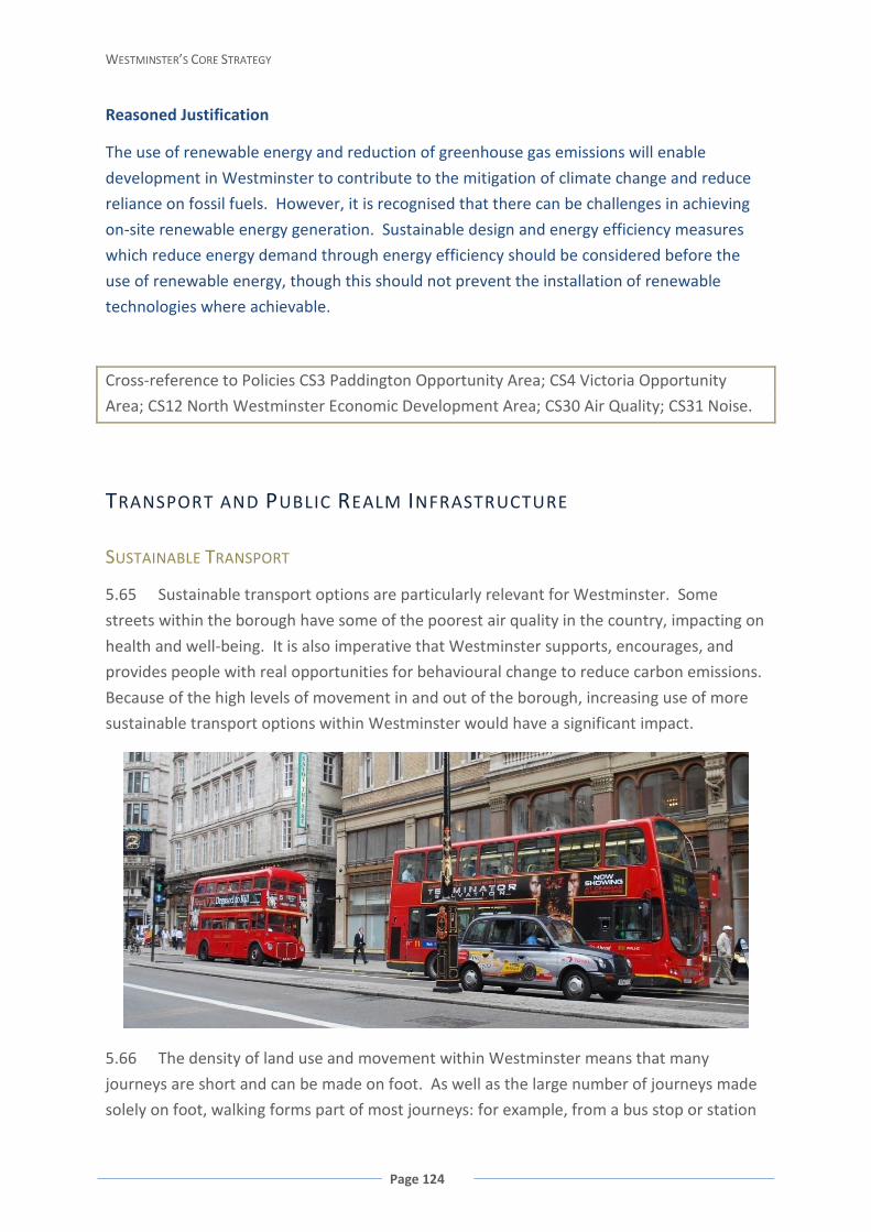
WESTMINSTER’S CORE STRATEGY
Page 124
Reasoned Justification
The use of renewable energy and reduction of greenhouse gas emissions will enable
development in Westminster to contribute to the mitigation of climate change and reduce
reliance on fossil fuels. However, it is recognised that there can be challenges in achieving
on-site renewable energy generation. Sustainable design and energy efficiency measures
which reduce energy demand through energy efficiency should be considered before the
use of renewable energy, though this should not prevent the installation of renewable
technologies where achievable.
Cross-reference to Policies CS3 Paddington Opportunity Area; CS4 Victoria Opportunity
Area; CS12 North Westminster Economic Development Area; CS30 Air Quality; CS31 Noise.
TRANSPORT AND PUBLIC REALM INFRASTRUCTURE
SUSTAINABLE TRANSPORT
5.65 Sustainable transport options are particularly relevant for Westminster. Some
streets within the borough have some of the poorest air quality in the country, impacting on
health and well-being. It is also imperative that Westminster supports, encourages, and
provides people with real opportunities for behavioural change to reduce carbon emissions.
Because of the high levels of movement in and out of the borough, increasing use of more
sustainable transport options within Westminster would have a significant impact.
5.66 The density of land use and movement within Westminster means that many
journeys are short and can be made on foot. As well as the large number of journeys made
solely on foot, walking forms part of most journeys: for example, from a bus stop or station
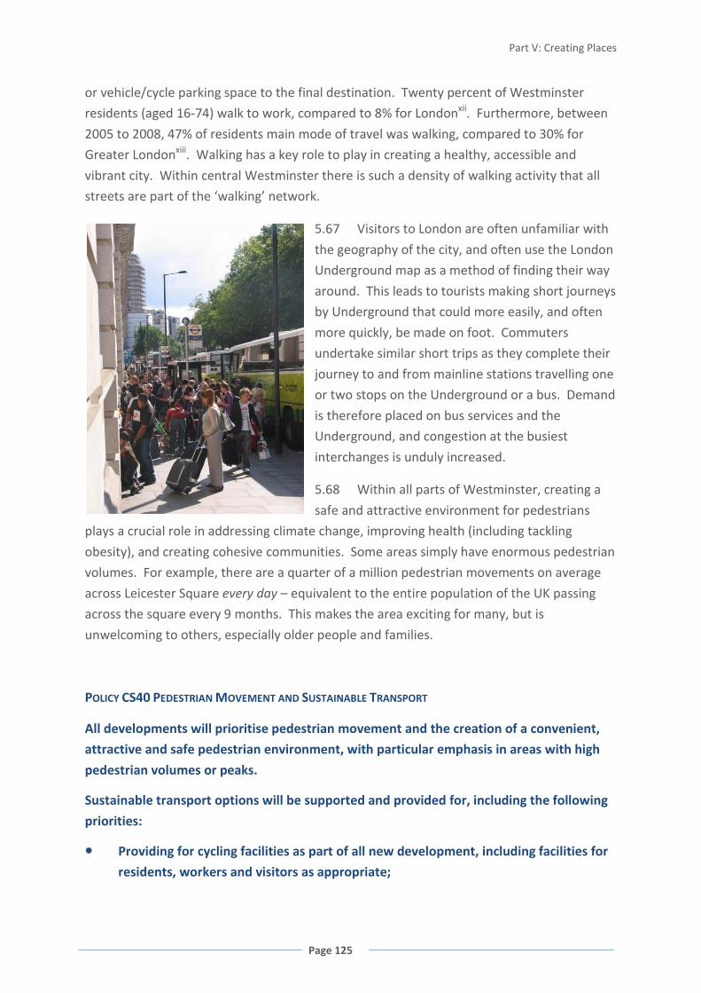
Part V: Creating Places
Page 125
or vehicle/cycle parking space to the final destination. Twenty percent of Westminster
residents (aged 16-74) walk to work, compared to 8% for Londonxii. Furthermore, between
2005 to 2008, 47% of residents main mode of travel was walking, compared to 30% for
Greater Londonxiii. Walking has a key role to play in creating a healthy, accessible and
vibrant city. Within central Westminster there is such a density of walking activity that all
streets are part of the ‘walking’ network.
5.67 Visitors to London are often unfamiliar with
the geography of the city, and often use the London
Underground map as a method of finding their way
around. This leads to tourists making short journeys
by Underground that could more easily, and often
more quickly, be made on foot. Commuters
undertake similar short trips as they complete their
journey to and from mainline stations travelling one
or two stops on the Underground or a bus. Demand
is therefore placed on bus services and the
Underground, and congestion at the busiest
interchanges is unduly increased.
5.68 Within all parts of Westminster, creating a
safe and attractive environment for pedestrians
plays a crucial role in addressing climate change, improving health (including tackling
obesity), and creating cohesive communities. Some areas simply have enormous pedestrian
volumes. For example, there are a quarter of a million pedestrian movements on average
across Leicester Square every day – equivalent to the entire population of the UK passing
across the square every 9 months. This makes the area exciting for many, but is
unwelcoming to others, especially older people and families.
POLICY CS40 PEDESTRIAN MOVEMENT AND SUSTAINABLE TRANSPORT
All developments will prioritise pedestrian movement and the creation of a convenient,
attractive and safe pedestrian environment, with particular emphasis in areas with high
pedestrian volumes or peaks.
Sustainable transport options will be supported and provided for, including the following
priorities:
Providing for cycling facilities as part of all new development, including facilities for
residents, workers and visitors as appropriate;
WESTMINSTER’S CORE STRATEGY
Page 126
Reducing reliance on private motor vehicles and single person motor vehicle trips;
Prioritising parking provision for disabled, car sharing and alternative fuel vehicles;
Encouraging use of alternative sustainable fuels and technology;
Developing water-based river transport where land provision and biodiversity
considerations allow.
Reasoned Justification
In Westminster, walking is the most efficient means of movement for short journeys,
including those from other transport modes to final destinations. Walking should therefore
be prioritised above all others, particularly due to the congestion and high volumes of
pedestrian traffic that are experienced in parts of the city, and should also be prioritised in
the design and layout of new development. This is also the best way to tackle other
priorities such as improving health and road safety, and helping to reduce air and noise
pollution.
Support for walking and other sustainable transport modes encourages behavioural change.
This will allow Westminster to accommodate the projected growth over the plan period,
reduce existing demands on the highway network and make the best use of the limited
space available for movement and transport. It will also contribute towards broader
environmental and health objectives, including reducing greenhouse gas emissions, local air
and noise pollution and encouraging physical activity.
Cross-reference to Policies CS27 Design; CS28 Health, Safety and Well-Being; CS30 Air
Quality; CS31 Noise; CS36 Blue Ribbon Network.
SERVICING AND DELIVERIES
5.69 The high concentration of commercial activity interspersed with residential
development, and particular characteristics of Westminster’s dense, historic urban fabric
create particular challenges in relation to servicing and deliveries. Westminster’s
substantial economy requires goods to be efficiently delivered and services to be provided
without undue delay or cost. Solutions to servicing and deliveries must ensure that day-to-
day operations do not compromise the safety of other users of the public highway or public
realm, particularly vulnerable road users such as pedestrians. These solutions must also
ensure that other road users are not unduly inconvenienced or obstructed.

Part V: Creating Places
Page 127
POLICY CS41 SERVICING AND DELIVERIES
Developments must demonstrate that the freight, servicing and deliveries required will be
managed in such a way that minimises adverse impacts. This may include the provision of
off-site consolidation centres, shared delivery arrangements, and/or restrictions on the
types of vehicles or timing of deliveries, especially where the quality of the public realm,
local pollution, and/or function and reliability of the transport network would be
otherwise compromised.
Servicing and delivery needs will be fully met within each development site, except where
the council considers that this is not possible, in which case the servicing and delivery
needs will be met in such a way that minimises the adverse effects on other highway and
public realm users, and other residential or commercial activity. Where some or all of the
servicing and delivery needs are met through use of the public highway, the development
will meet the initial and on-going costs associated with that use of the public highway.
Reasoned Justification
This approach recognises the importance of and constraints associated with accommodating
the servicing needs of a world-class city, within a dense, mixed and historic urban fabric.
Cross-reference to Policies CS24 Heritage, CS30 Air Quality; CS31 Noise.
THE TRANSPORT NETWORK
5.70 The City of Westminster is the most comprehensively served location by public
transport in the country.
There are four main rail termini; 32 Underground stations with 10 of the 12 tube lines
running through the city; four piers with commuter services; and some 79 bus routes also
pass through Westminster. The Central London location and its excellent accessibility
featured in the top four reasons businesses chose a Westminster location. However, over-
crowding on public transport and congestion on pavements were the top two negative
aspectsxiv. Further, relative accessibility within Westminster varies significantly and
improvement to the transport network is needed across the borough.
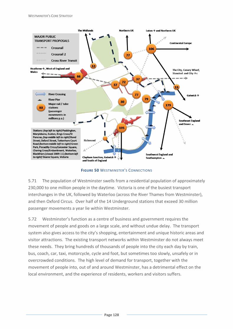
WESTMINSTER’S CORE STRATEGY
Page 128
FIGURE 50 WESTMINSTER’S CONNECTIONS
5.71 The population of Westminster swells from a residential population of approximately
230,000 to one million people in the daytime. Victoria is one of the busiest transport
interchanges in the UK, followed by Waterloo (across the River Thames from Westminster),
and then Oxford Circus. Over half of the 14 Underground stations that exceed 30 million
passenger movements a year lie within Westminster.
5.72 Westminster’s function as a centre of business and government requires the
movement of people and goods on a large scale, and without undue delay. The transport
system also gives access to the city’s shopping, entertainment and unique historic areas and
visitor attractions. The existing transport networks within Westminster do not always meet
these needs. They bring hundreds of thousands of people into the city each day by train,
bus, coach, car, taxi, motorcycle, cycle and foot, but sometimes too slowly, unsafely or in
overcrowded conditions. The high level of demand for transport, together with the
movement of people into, out of and around Westminster, has a detrimental effect on the
local environment, and the experience of residents, workers and visitors suffers.
Part V: Creating Places
Page 129
5.73 Work is required during the lifetime of this Core Strategy to improve the
effectiveness and efficiency of the transport infrastructure serving Westminster, and the
management of street works, particularly in areas where there is growth in the number of
residents, workers or visitors and whose capacity is heavily pressurised.
5.74 Crossrail 2 and the Cross River Transit may be longer term projects for a time horizon
to 2026 and beyond.
POLICY CS42 MAJOR TRANSPORT INFRASTRUCTURE
The council will support and promote improvements to transport infrastructure,
including the public realm and servicing improvements necessary to mitigate the
impacts of increased passenger numbers and integrate the infrastructure into the local
area, including the following major projects over the lifetime of the plan:
Crossrail, including new stations at Paddington, Tottenham Court Road and Bond
Street;
Improvements to stations, prioritising access for all, reducing pedestrian
congestion within and around the station, and providing a safe, convenient and
attractive environment, including Victoria, Paddington, Tottenham Court Road
and Bond Street;
Improvements to the public realm, focusing on meeting the needs of people with
disabilities and more vulnerable people, and enabling people and businesses to
make more sustainable choices;
Increasing cycle parking and improving safety for cyclists where this would not
compromise pedestrian movement including public cycle hire schemes throughout
Westminster, and indoor cycle storage and supporting facilities at major transport
interchanges;
Improving way-finding and legibility around Westminster to facilitate pedestrian
movement;
Improving the convenience, connectivity, attractiveness and safety of
Westminster’s linear walking routes, including the Blue Ribbon Network and
connections within and between Westminster’s open spaces;
Improvements to local bus and taxi infrastructure; and

WESTMINSTER’S CORE STRATEGY
Page 130
Improvements to river services and piers, subject to Policy CS36 Blue Ribbon
Network and the ability to secure adequate space to accommodate the peak flows
to/from boats.
Longer term projects which are likely to extend beyond the life-time of the plan are:
Crossrail 2; and
Cross River transport link.
Reasoned Justification
Good public transport infrastructure is
essential for meeting the economic,
social and environmental needs of the
city’s residents, businesses, workers
and visitors. Improvements to the
existing bus and train services and the
provision of new rail and light rail
links are urgently needed. They will
help improve efficiency and reliability and increase capacity, thereby reducing congestion
on both road and rail networks and ensuring the city remains competitive in a global
economy. It is also necessary to improve the accessibility of public transport and
reliability of the transport network.
Key infrastructure and public realm improvements, together with good legibility and way-
finding information are also needed to support sustainable transport modes, encourage
greater use and to ensure the increase in the number of people dispersing around
transport nodes does not have an adverse impact.
The failure to deliver key transport infrastructure such as Crossrail may affect
development capacity. It is possible that, if Crossrail was not delivered, congestion on
existing transport infrastructure would preclude the largest scale developments at
Paddington and Tottenham Court Road.
Cross-reference to Policies CS1 Mixed Use in the Central Activities Zone; CS3 Paddington
Opportunity Area; CS4 Victoria Opportunity Area; CS5 Tottenham Court Road Opportunity
Area; CS7 West End Special Retail Policy Area; CS11 Royal Parks; CS27 Design; CS32 Planning
Obligations and Delivering Infrastructure; CS34 Open Space; CS36 Blue Ribbon Network.
FIGURE 51 PUBLIC TRANSPORT ACCESSIBILITY LEVELS 2008
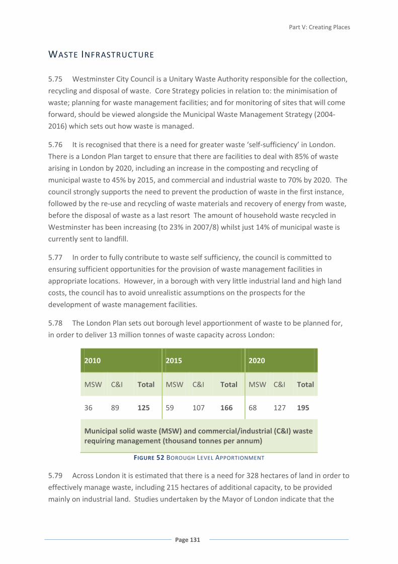
Part V: Creating Places
Page 131
WASTE INFRASTRUCTURE
5.75 Westminster City Council is a Unitary Waste Authority responsible for the collection,
recycling and disposal of waste. Core Strategy policies in relation to: the minimisation of
waste; planning for waste management facilities; and for monitoring of sites that will come
forward, should be viewed alongside the Municipal Waste Management Strategy (2004-
2016) which sets out how waste is managed.
5.76 It is recognised that there is a need for greater waste ‘self-sufficiency’ in London.
There is a London Plan target to ensure that there are facilities to deal with 85% of waste
arising in London by 2020, including an increase in the composting and recycling of
municipal waste to 45% by 2015, and commercial and industrial waste to 70% by 2020. The
council strongly supports the need to prevent the production of waste in the first instance,
followed by the re-use and recycling of waste materials and recovery of energy from waste,
before the disposal of waste as a last resort The amount of household waste recycled in
Westminster has been increasing (to 23% in 2007/8) whilst just 14% of municipal waste is
currently sent to landfill.
5.77 In order to fully contribute to waste self sufficiency, the council is committed to
ensuring sufficient opportunities for the provision of waste management facilities in
appropriate locations. However, in a borough with very little industrial land and high land
costs, the council has to avoid unrealistic assumptions on the prospects for the
development of waste management facilities.
5.78 The London Plan sets out borough level apportionment of waste to be planned for,
in order to deliver 13 million tonnes of waste capacity across London:
2010 2015 2020
MSW C&I Total MSW C&I Total MSW C&I Total
36 89 125 59 107 166 68 127 195
Municipal solid waste (MSW) and commercial/industrial (C&I) waste requiring management (thousand tonnes per annum)
FIGURE 52 BOROUGH LEVEL APPORTIONMENT
5.79 Across London it is estimated that there is a need for 328 hectares of land in order to
effectively manage waste, including 215 hectares of additional capacity, to be provided
mainly on industrial land. Studies undertaken by the Mayor of London indicate that the
WESTMINSTER’S CORE STRATEGY
Page 132
land-take of waste facilities required in Westminster to meet its apportionment is 3
hectaresxv.
5.80 However, the actual land requirement will depend upon the number, type, scale and
location of waste management facilities. The council is not in a position to dictate the exact
range of potential waste management facilities, although based on typical tonnage ‘through
put’ and land take of different types of facilities, smaller facilities such as composters are
more likely to be appropriate than large gasification/pyrolysis facilities.
5.81 Although Westminster contains no Strategic Industrial Locations, detailed analysis of
potential waste locations has been undertaken, using criteria set out in national and
regional guidancexvi. This illustrates that any potential sites are currently unsuitable due to a
combination of proximity to residential uses, no access to rail and water sustainable modes
of transport, sites that have been allocated to deliver housing, or significantly, are within the
area safeguarded for the delivery of Crossrail. Despite this, the council is committed to
tackling its waste apportionment through:
• Designating and protecting existing waste sites, including waste cleansing depots and
micro-recycling centres;
• Rolling out a programme of in-vessel composters which is projected to meet the
municipal waste apportionment target;
• Identifying new sites in line with locational criteria during the lifetime of the plan
period; and
• Requiring new development to provide new waste management facilities; and
• Joint working with other London boroughs to ‘pool’ waste apportionment.
FIGURE 53 WASTE MANAGEMENT FACILITIES

Part V: Creating Places
Page 133
POLICY CS43 SUSTAINABLE WASTE MANAGEMENT
The council will require the minimisation of waste, the increase in the re-use, recycling
and composting of waste, and the reduction in the amount of waste disposed at landfill in
order to meet the waste reduction targets set out in the London Plan.
In order to ensure sufficient opportunities for the provision of waste management
facilities in appropriate locations, in accordance with the London Plan waste
apportionment, the council will:
Protect existing waste and recycling management sites, protect any new street
cleansing depots, micro-recycling centres and in-vessel composters which are
secured during the lifetime of the plan, and require the equivalent or increased
capacity as part of any development that would result in the loss of any or all of a
designated waste site.
Require major new development to provide on-site recycling and composting waste
management facilities, except where the council considers that it is inappropriate or
unfeasible to do so. In such cases, new facilities will be provided off-site and may
include shared provision with another development or an existing waste facility in
the vicinity that has capacity, except where the council considers that it is
inappropriate or unfeasible to do so. Where it is not possible to provide either on-
site, off-site or shared waste facilities, a payment in lieu will be required to a Waste
Management Fund to allow the council to provide suitable facilities in the vicinity.
Identify potential new locations suitable for waste management facilities during the
lifetime of the Core Strategy using the following criteria:
Proximity to source of the waste;
The nature and scale of the facility;
Any potential impact on the surrounding area including noise, emissions,
odour and visual impact;
The full transport impact of all collection, transfer and disposal movements,
including maximising opportunities for transport by rail or water; and
The need to use sites that are currently in industrial use or are existing waste
management sites.
Secure any new waste sites identified during the lifetime of the plan, other than
street cleansing depots, micro-recycling centres and in-vessel composters, within a
Waste Development Plan Document.
Work in partnership with the objective of securing joint working arrangements with
other London Boroughs in order to pool waste apportionment, and set out these
arrangements within a Waste Development Plan Document.
WESTMINSTER’S CORE STRATEGY
Page 134
Reasoned Justification
This policy approach aims to support the objective of self-sufficiency as far as practically
possible, through the reduction of waste, and the protection and increase of recycling
facilities. It represents a pragmatic and realistic approach to ensuring sufficient
opportunities for the provision of future waste management facilities in appropriate
locations, recognising the built-up character of, and lack of industrial land within
Westminster. It also provides for an appropriate policy framework to be put in place in the
event that innovative solutions to addressing waste are found on sites which do not meet
national or regional waste site criteria and which are not otherwise afforded protection
through the Core Strategy.
FLOOD RELATED INFRASTRUCTURE
5.82 As a riverside borough, Westminster is potentially susceptible to tidal and fluvial
flooding from the River Thames. However, Westminster has excellent flood defences from
the Embankment Wall and Thames Barrier which
greatly reduce the risk of flooding. The
Environment Agency is reviewing how flood risk
will be managed over the next 100 years,
including how flood defence infrastructure will
need to be upgraded when existing infrastructure
comes to the end of its useful life during the
period 2030-2060. This will need to take
potential impacts of sea-level rise as a result of
climate change into account. The council will
work with the Environment Agency to ensure
flood defence infrastructure is in place to protect
the city.
POLICY CS44 FLOOD-RELATED INFRASTRUCTURE
Development will ensure that flood-related infrastructure are protected and access for
maintenance is retained.
The council will work with its partners at a regional and, where necessary, multi-regional
level to ensure flood-related infrastructure remains fit for purpose.
Part V: Creating Places
Page 135
Reasoned Justification
This approach acknowledges the excellent flood defences in place, whilst acknowledging
that there is a need to adapt to the effects of climate change in the long-term, which will
continue to be necessary in the future to protect the existing built infrastructure along the
riverside.
THAMES TUNNEL
5.83 Most of Westminster, like most of London, is served by combined sewers designed in
the 1860s, which receive foul water, and water from roofs, hard standing and sometimes
the highways. During rainy periods the sewers fill up and overflow through a series of
overflow outlets from the combined sewers into the River Thames and its tidal tributaries.
This overflow results in the release of raw sewage into the river, affecting water quality and
biodiversity. Specialist barges are currently used to oxygenate the river to mitigate for the
impacts of combined sewer overflows on wildlife, however this still results in a breach of the
requirements of the EU Urban Waste Water Treatment Directive (1991).
5.84 In London, given the growth in development and population, the strain on the
existing system can trigger an overflow in the combined sewers even from relatively modest
rainfall. During wet spells, the sewers fill up with rainwater very quickly. The impact of
climate change, in terms of intensified rainfall events, is likely to increase the number of
combined sewer discharges in the River Thames.
5.85 Thames Water is developing plans for a Thames Tunnel, a scheme to reduce and
limit pollution from the sewerage system for the whole of London, in order to comply with
EU Urban Waste Water Treatment Directive (1991). The Thames Tunnel project, if
approved, is due to commence in 2012 and be completed by 2020. The council supports
necessary infrastructure of this nature, subject to their detail and assessment of impacts.
POLICY CS45 THAMES TUNNEL
The council will work with Thames Water to support the timely implementation of the
Thames Tunnel project, including the connection of the combined sewer overflows in the
city.
Reasoned Justification
The Thames Tunnel project will help to reduce and limit pollution necessary to comply with
the EU Urban Waste Water Treatment Objective (1991).

WESTMINSTER’S CORE STRATEGY
Page 136
i The Importance of the Historic Environment in Westminster, 2007 ii High Buildings Study, 2000 iii The Importance of the Historic Environment in Westminster, 2007 iv BERR Energy Trends v Public Health Annual Report 2006/2007 pg 87 recommendations for health inequalities in Westminster vi Adapted from Public Health Annual Report 2006/2007 including diagram from Dahlgren and Whitehead 1991 vii Mayor’s Air Quality Strategy, 2002 viii Open Space Strategy Supplementary Planning Document ix Retrofitting Soho, 2008, paragraphs 5.63 to 5.90 x Retrofitting Soho, 2008, paragraphs 3.53 to 3.61 and 5.68 to 5.71, as well as other sections xi Retrofitting Soho, 2008, paragraphs 5.107 to 5.117 xii Census 2001 xiii TfL London Travel Demand Survey xiv The Importance of the Historic Environment in Westminster, 2007 xv Mayor’s Industrial Capacity SPG, 2008 xvi Planning Policy Statement 10 and London Plan Policies 4A.23 and 4A.27
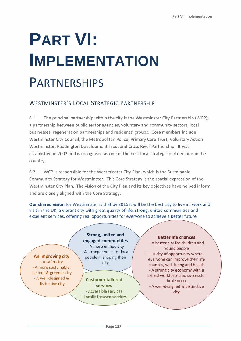
Part VI: Implementation
Page 137
Strong, united and engaged communities
- A more unified city - A stronger voice for local
people in shaping their city
PART VI: IMPLEMENTATION PARTNERSHIPS WESTMINSTER’S LOCAL STRATEGIC PARTNERSHIP
6.1 The principal partnership within the city is the Westminster City Partnership (WCP);
a partnership between public sector agencies, voluntary and community sectors, local
businesses, regeneration partnerships and residents’ groups. Core members include
Westminster City Council, the Metropolitan Police, Primary Care Trust, Voluntary Action
Westminster, Paddington Development Trust and Cross River Partnership. It was
established in 2002 and is recognised as one of the best local strategic partnerships in the
country.
6.2 WCP is responsible for the Westminster City Plan, which is the Sustainable
Community Strategy for Westminster. This Core Strategy is the spatial expression of the
Westminster City Plan. The vision of the City Plan and its key objectives have helped inform
and are closely aligned with the Core Strategy:
Our shared vision for Westminster is that by 2016 it will be the best city to live in, work and visit in the UK, a vibrant city with great quality of life, strong, united communities and excellent services, offering real opportunities for everyone to achieve a better future.
Better life chances - A better city for children and
young people • - A city of opportunity where
everyone can improve their life chances, well-being and health
- A strong city economy with a skilled workforce and successful
businesses - A well-designed & distinctive
city
Customer tailored services
- Accessible services - Locally focused services
An improving city - A safer city
- A more sustainable, cleaner & greener city
- A well-designed & distinctive city
WESTMINSTER’S CORE STRATEGY
Page 138
6.3 The WCP is also responsible for Westminster's Local Area Agreement (LAA), agreed
by the WCP and central government. The primary objective of the LAA is to deliver better
outcomes for local people through encouraging stronger local partnership working and
improving relations between local and central government. The LAA includes priorities for
improvement, which are measured by various indicators; targets have been set for each
indicator. The Core Strategy will contribute towards meeting these LAA targets where
relevant. The links between the City Plan, Local Area Assessment and Core Strategy will be
examined by the Comprehensive Area Assessment, an area-based model put in place to
monitor the performance of local public service providers such as the council and the
Primary Care Trust.
6.4 This Core Strategy has been endorsed by the Westminster City Partnership, and it
reflects the spatial aspect of the partnership’s priorities as set out in the Westminster City
Plan.
PARTNERSHIP WORKING
6.5 The council is one of a number of organisations working to manage and deliver
change across Westminster, and many of Westminster’s issues require partnership working
with a range of organisations and across local authority boundaries. The council has a
strong record of effective partnership working and works closely, both formally and
informally, with other local authorities and stakeholders as set out throughout the Core
Strategy and summarised in Appendix 3.
6.6 Issues such as housing, affordable housing and waste can only be addressed in a
regional context. Similarly, environmental action and infrastructure delivery requires an
approach that extends beyond the immediate city boundary.
6.7 Neighbourhoods do not conform to local authority boundaries, and a joint approach
to cross-boundary issues, design, streetscape and public realm improvements, and local
service delivery will continue to be important.
6.8 Where appropriate, delivery of the objectives in this Core Strategy will be managed
through established or new partnerships, particularly within major development areas or
areas with cross-boundary implications.
6.9 Partnership working will be necessary to deliver the spatial vision of this Core
Strategy, and many of its policies. The council embraces this approach and the role of the
planning process in establishing and working within a genuine partnership framework.

Part VI: Implementation
Page 139
COMMUNITY GOVERNANCE
6.10 Local partnerships are established within the borough to tackle issues at a local level,
as set out in Appendix 3. Local involvement can play a significant role in shaping the future
of Westminster and achieving the spatial vision of this Core Strategy. It is key to securing
locally appropriate responses and interventions and creating strong and sustainable
communities. This can provide more flexibility and respond more effectively to local needs
and communities.
FIGURE 54 LOCAL AREA RENEWAL PARTNERSHIPS / BUSINESS IMPROVEMENT DISTRICTS
6.11 Westminster City Partnerships established 6 local partnerships in 2002 to tackle the
complex patterns of deprivation in the poorest neighbourhoods5
5 Local Area Renewal Partnerships 2009: Church Street, Queen’s Park, Harrow Road, Westbourne, South Westminster and West End
. The local partnerships,
made up of stakeholders and the community, prepare delivery plans to achieve sustainable
change in their neighbourhoods, tackle some of the underlying causes of deprivation and
ensure a unified approach to good local service delivery.

WESTMINSTER’S CORE STRATEGY
Page 140
6.12 The council also works with Business Improvement Districts within the city6
6.13 A range of other neighbourhood initiatives operate within Westminster, facilitating
local democracy, local environmental improvements, supporting healthier living and tackling
local crime and safety issuesi.
. These
are locally controlled groups of businesses who improve the environment and economic
performance of an area funded by a levy on these businesses. They provide a welcome
partnership mechanism to both improve the city and engage with businesses on operational
and policy matters.
6.14 The council will continue to encourage and support a neighbourhood approach to
local decision-making, neighbourhood renewal and tackling inequalities, environmental
improvement and service provision.
6 Business Improvement Districts 2009: Heart of London, New West End Company, Paddington, Bayswater and Victoria
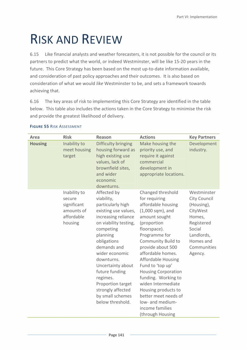
Part VI: Implementation
Page 141
RISK AND REVIEW 6.15 Like financial analysts and weather forecasters, it is not possible for the council or its
partners to predict what the world, or indeed Westminster, will be like 15-20 years in the
future. This Core Strategy has been based on the most up-to-date information available,
and consideration of past policy approaches and their outcomes. It is also based on
consideration of what we would like Westminster to be, and sets a framework towards
achieving that.
6.16 The key areas of risk to implementing this Core Strategy are identified in the table
below. This table also includes the actions taken in the Core Strategy to minimise the risk
and provide the greatest likelihood of delivery.
FIGURE 55 RISK ASSESSMENT
Area Risk Reason Actions Key Partners Housing Inability to
meet housing target
Difficulty bringing housing forward as high existing use values, lack of brownfield sites, and wider economic downturns.
Make housing the priority use, and require it against commercial development in appropriate locations.
Development industry.
Inability to secure significant amounts of affordable housing
Affected by viability, particularly high existing use values, increasing reliance on viability testing, competing planning obligations demands and wider economic downturns. Uncertainty about future funding regimes. Proportion target strongly affected by small schemes below threshold.
Changed threshold for requiring affordable housing (1,000 sqm), and amount sought (proportion floorspace). Programme for Community Build to provide about 500 affordable homes. Affordable Housing Fund to ‘top up’ Housing Corporation funding. Working to widen Intermediate Housing products to better meet needs of low- and medium- income families (through Housing
Westminster City Council (Housing), CityWest Homes, Registered Social Landlords, Homes and Communities Agency.
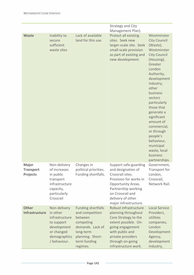
WESTMINSTER’S CORE STRATEGY
Page 142
Strategy and City Management Plan).
Waste Inability to secure sufficient waste sites
Lack of available land for this use.
Protect all existing sites. Seek new larger-scale site. Seek small-scale provision as part of existing and new development.
Westminster City Council (Waste), Westminster City Council (Housing), Greater London Authority, development industry, other business sectors particularly those that generate a significant amount of commercial, or through people’s behaviour, municipal waste, local business partnerships.
Major Transport Projects
Non-delivery of increases in public transport infrastructure capacity, particularly Crossrail
Changes in political priorities. Funding shortfalls.
Support safe-guarding and designation of Crossrail sites. Provision for works in Opportunity Areas. Partnership working on Crossrail and delivery of other major infrastructure.
Government, Transport for London, Crossrail, Network Rail.
Other Infrastructure
Non-delivery in other infrastructure to support development or changed demographics / behaviour.
Funding shortfalls and competition between competing demands. Lack of long-term planning. Short-term funding regimes.
Robust infrastructure planning throughout Core Strategy to the extent possible. On-going engagement with public and private providers through on-going infrastructure work.
Local Service Providers, utilities companies, London Development Agency, development industry,

Part VI: Implementation
Page 143
national and regional government including national regulatory bodies, other infrastructure providers.
Inequalities Increased deprivation and widening inequalities
Economic downturns. Changes in political priorities.
North Westminster Economic Development Area. Identification of infrastructure need. Specific policy for health and well-being.
Government, Westminster City Council, NHS, Job CentrePlus, voluntary sector.
Climate Change
Inability to cope with changed climate
Abrupt changes in local conditions such as weather or sea-level (tipping point passed). Extreme local weather events.
Policies to maximise contribution to adapting to and mitigating climate change (with further detail in City Management Plan).
Government, emergency services, NHS, Westminster City Council, energy and water infrastructure sectors.
6.17 The policies within this document will be reviewed annually through the Annual
Monitoring Report to enable changes where necessary to ensure the Core Strategy
continues to bring us closer to our vision and delivers our spatial strategy for the future. It
will also enable us to adjust that vision if significant events make this necessary.
There will also be on-going monitoring of infrastructure delivery, which will either be within
the Annual Monitoring Report, or in separate documentation, possibly linked to the
Community Infrastructure Levy.
MONITORING FRAMEWORK
6.18 An outline of the Core Strategy monitoring framework is set out below. The
‘headline’ objectives against which the performance of the Core Strategy policies will be
assessed are those set out in Section 1 of this Core Strategy (and listed in summary form
below). Against these objectives a series of indicators will be selected to assess the degree
to which the Core Strategy objectives are being achieved. These indicators, along with
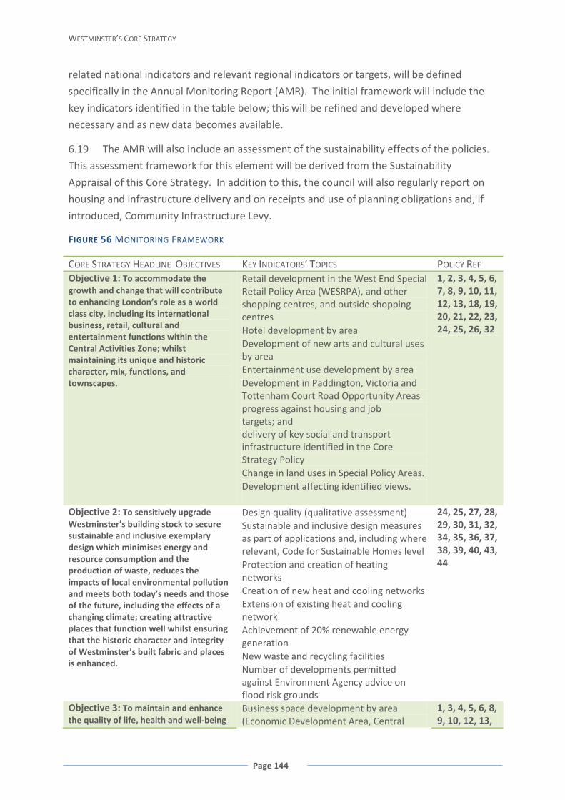
WESTMINSTER’S CORE STRATEGY
Page 144
related national indicators and relevant regional indicators or targets, will be defined
specifically in the Annual Monitoring Report (AMR). The initial framework will include the
key indicators identified in the table below; this will be refined and developed where
necessary and as new data becomes available.
6.19 The AMR will also include an assessment of the sustainability effects of the policies.
This assessment framework for this element will be derived from the Sustainability
Appraisal of this Core Strategy. In addition to this, the council will also regularly report on
housing and infrastructure delivery and on receipts and use of planning obligations and, if
introduced, Community Infrastructure Levy.
FIGURE 56 MONITORING FRAMEWORK
CORE STRATEGY HEADLINE OBJECTIVES KEY INDICATORS’ TOPICS POLICY REF Objective 1: To accommodate the growth and change that will contribute to enhancing London’s role as a world class city, including its international business, retail, cultural and entertainment functions within the Central Activities Zone; whilst maintaining its unique and historic character, mix, functions, and townscapes.
Retail development in the West End Special Retail Policy Area (WESRPA), and other shopping centres, and outside shopping centres
Hotel development by area Development of new arts and cultural uses
by area Entertainment use development by area Development in Paddington, Victoria and
Tottenham Court Road Opportunity Areas progress against housing and job
targets; and delivery of key social and transport
infrastructure identified in the Core Strategy Policy
Change in land uses in Special Policy Areas. Development affecting identified views.
1, 2, 3, 4, 5, 6, 7, 8, 9, 10, 11, 12, 13, 18, 19, 20, 21, 22, 23, 24, 25, 26, 32
Objective 2: To sensitively upgrade Westminster’s building stock to secure sustainable and inclusive exemplary design which minimises energy and resource consumption and the production of waste, reduces the impacts of local environmental pollution and meets both today’s needs and those of the future, including the effects of a changing climate; creating attractive places that function well whilst ensuring that the historic character and integrity of Westminster’s built fabric and places is enhanced.
Design quality (qualitative assessment) Sustainable and inclusive design measures
as part of applications and, including where relevant, Code for Sustainable Homes level
Protection and creation of heating networks
Creation of new heat and cooling networks Extension of existing heat and cooling
network Achievement of 20% renewable energy
generation New waste and recycling facilities Number of developments permitted
against Environment Agency advice on flood risk grounds
24, 25, 27, 28, 29, 30, 31, 32, 34, 35, 36, 37, 38, 39, 40, 43, 44
Objective 3: To maintain and enhance the quality of life, health and well-being
Business space development by area (Economic Development Area, Central
1, 3, 4, 5, 6, 8, 9, 10, 12, 13,
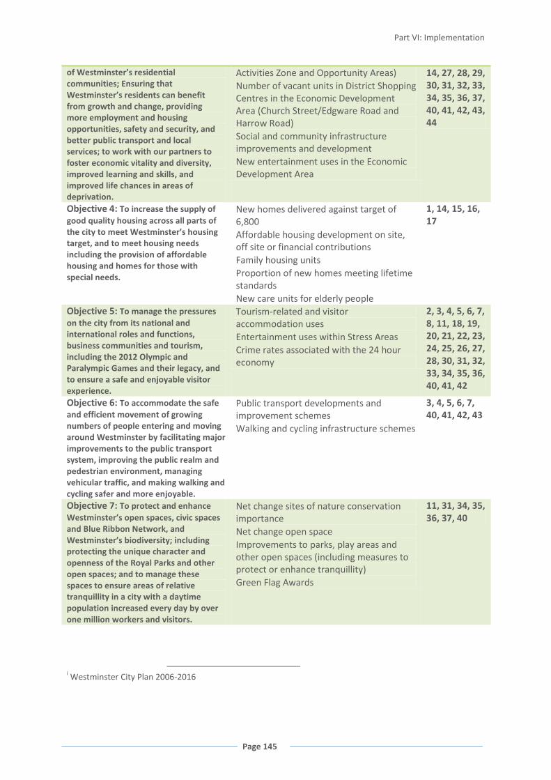
Part VI: Implementation
Page 145
of Westminster’s residential communities; Ensuring that Westminster’s residents can benefit from growth and change, providing more employment and housing opportunities, safety and security, and better public transport and local services; to work with our partners to foster economic vitality and diversity, improved learning and skills, and improved life chances in areas of deprivation.
Activities Zone and Opportunity Areas) Number of vacant units in District Shopping
Centres in the Economic Development Area (Church Street/Edgware Road and Harrow Road)
Social and community infrastructure improvements and development
New entertainment uses in the Economic Development Area
14, 27, 28, 29, 30, 31, 32, 33, 34, 35, 36, 37, 40, 41, 42, 43, 44
Objective 4: To increase the supply of good quality housing across all parts of the city to meet Westminster’s housing target, and to meet housing needs including the provision of affordable housing and homes for those with special needs.
New homes delivered against target of 6,800
Affordable housing development on site, off site or financial contributions
Family housing units Proportion of new homes meeting lifetime
standards New care units for elderly people
1, 14, 15, 16, 17
Objective 5: To manage the pressures on the city from its national and international roles and functions, business communities and tourism, including the 2012 Olympic and Paralympic Games and their legacy, and to ensure a safe and enjoyable visitor experience.
Tourism-related and visitor accommodation uses
Entertainment uses within Stress Areas Crime rates associated with the 24 hour
economy
2, 3, 4, 5, 6, 7, 8, 11, 18, 19, 20, 21, 22, 23, 24, 25, 26, 27, 28, 30, 31, 32, 33, 34, 35, 36, 40, 41, 42
Objective 6: To accommodate the safe and efficient movement of growing numbers of people entering and moving around Westminster by facilitating major improvements to the public transport system, improving the public realm and pedestrian environment, managing vehicular traffic, and making walking and cycling safer and more enjoyable.
Public transport developments and improvement schemes
Walking and cycling infrastructure schemes
3, 4, 5, 6, 7, 40, 41, 42, 43
Objective 7: To protect and enhance Westminster’s open spaces, civic spaces and Blue Ribbon Network, and Westminster’s biodiversity; including protecting the unique character and openness of the Royal Parks and other open spaces; and to manage these spaces to ensure areas of relative tranquillity in a city with a daytime population increased every day by over one million workers and visitors.
Net change sites of nature conservation importance
Net change open space Improvements to parks, play areas and
other open spaces (including measures to protect or enhance tranquillity)
Green Flag Awards
11, 31, 34, 35, 36, 37, 40
i Westminster City Plan 2006-2016
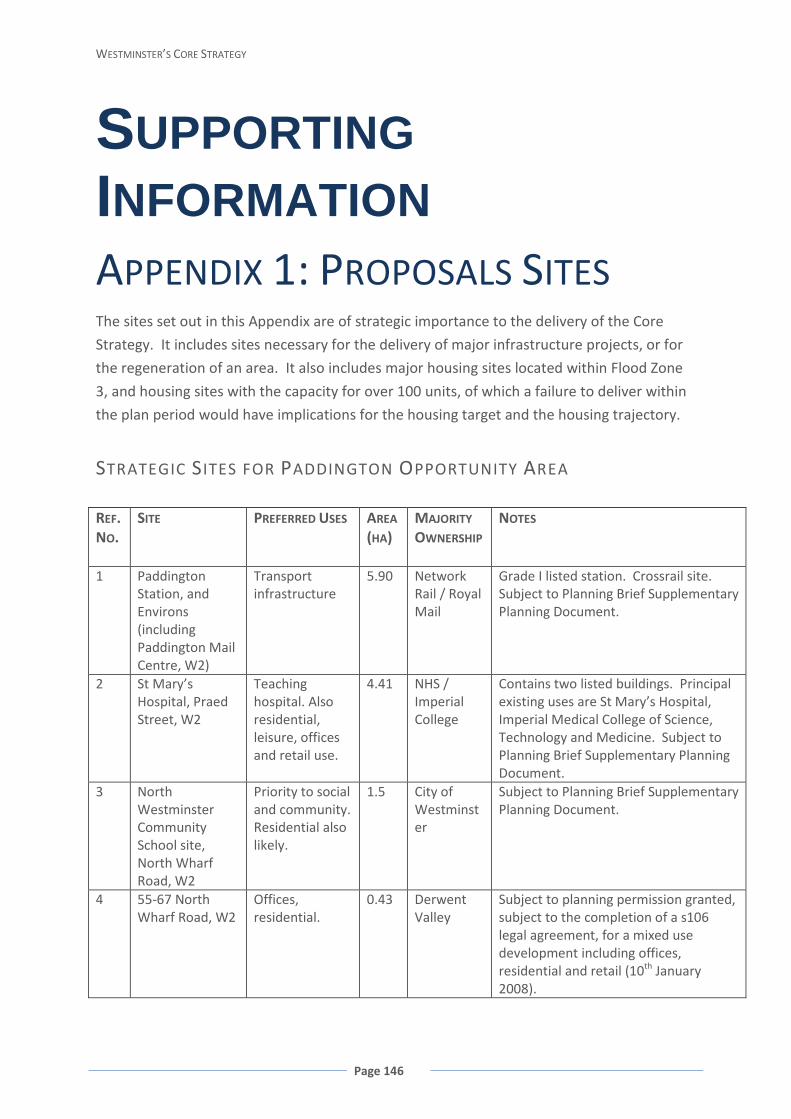
WESTMINSTER’S CORE STRATEGY
Page 146
SUPPORTING INFORMATION APPENDIX 1: PROPOSALS SITES The sites set out in this Appendix are of strategic importance to the delivery of the Core
Strategy. It includes sites necessary for the delivery of major infrastructure projects, or for
the regeneration of an area. It also includes major housing sites located within Flood Zone
3, and housing sites with the capacity for over 100 units, of which a failure to deliver within
the plan period would have implications for the housing target and the housing trajectory.
STRATEGIC SITES FOR PADDINGTON OPPORTUNITY AREA
REF. NO.
SITE PREFERRED USES AREA (HA)
MAJORITY
OWNERSHIP
NOTES
1 Paddington Station, and Environs (including Paddington Mail Centre, W2)
Transport infrastructure
5.90 Network Rail / Royal Mail
Grade I listed station. Crossrail site. Subject to Planning Brief Supplementary Planning Document.
2 St Mary’s Hospital, Praed Street, W2
Teaching hospital. Also residential, leisure, offices and retail use.
4.41 NHS / Imperial College
Contains two listed buildings. Principal existing uses are St Mary’s Hospital, Imperial Medical College of Science, Technology and Medicine. Subject to Planning Brief Supplementary Planning Document.
3 North Westminster Community School site, North Wharf Road, W2
Priority to social and community. Residential also likely.
1.5 City of Westminster
Subject to Planning Brief Supplementary Planning Document.
4 55-67 North Wharf Road, W2
Offices, residential.
0.43 Derwent Valley
Subject to planning permission granted, subject to the completion of a s106 legal agreement, for a mixed use development including offices, residential and retail (10th January 2008).
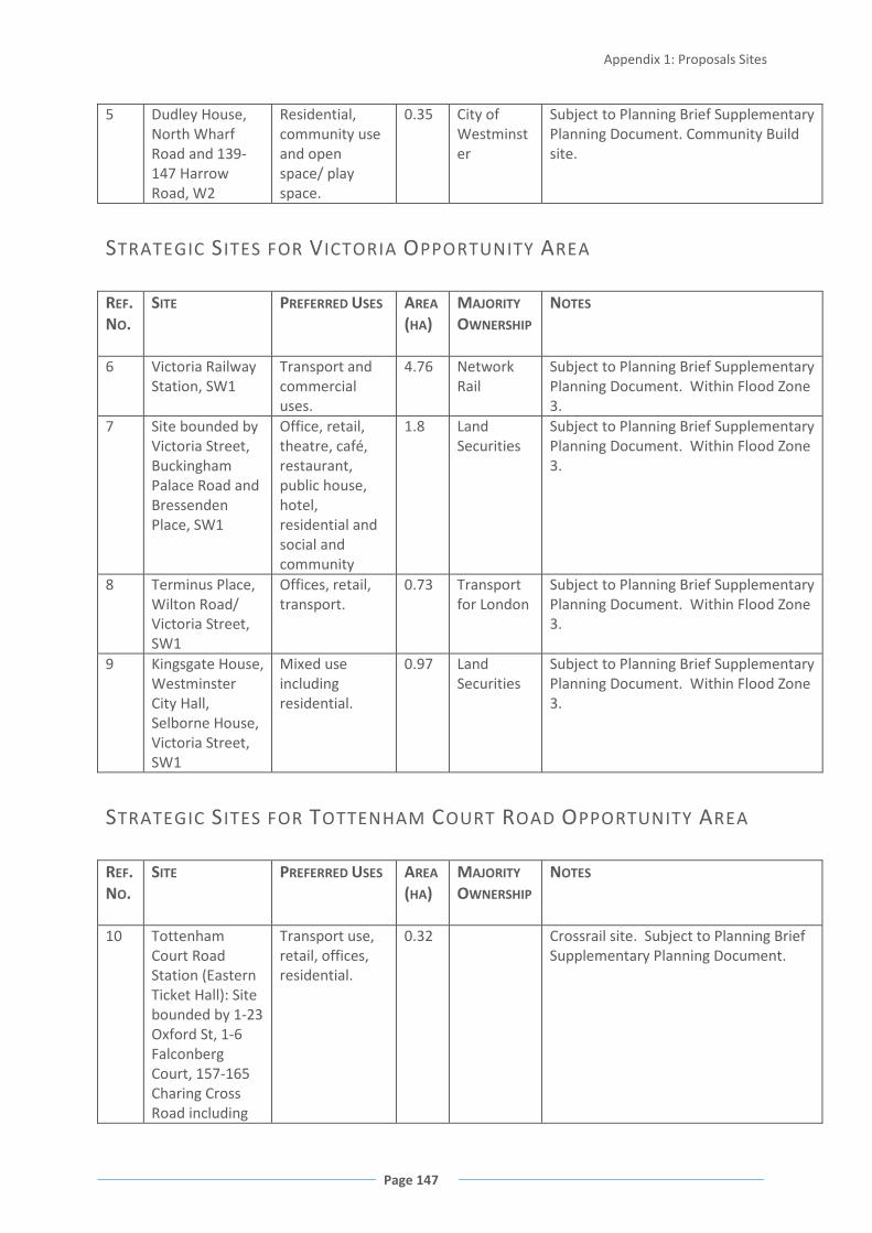
Appendix 1: Proposals Sites
Page 147
5 Dudley House, North Wharf Road and 139-147 Harrow Road, W2
Residential, community use and open space/ play space.
0.35 City of Westminster
Subject to Planning Brief Supplementary Planning Document. Community Build site.
STRATEGIC SITES FOR VICTORIA OPPORTUNITY AREA
REF. NO.
SITE PREFERRED USES AREA (HA)
MAJORITY
OWNERSHIP
NOTES
6 Victoria Railway Station, SW1
Transport and commercial uses.
4.76
Network Rail
Subject to Planning Brief Supplementary Planning Document. Within Flood Zone 3.
7 Site bounded by Victoria Street, Buckingham Palace Road and Bressenden Place, SW1
Office, retail, theatre, café, restaurant, public house, hotel, residential and social and community
1.8 Land Securities
Subject to Planning Brief Supplementary Planning Document. Within Flood Zone 3.
8 Terminus Place, Wilton Road/ Victoria Street, SW1
Offices, retail, transport.
0.73 Transport for London
Subject to Planning Brief Supplementary Planning Document. Within Flood Zone 3.
9 Kingsgate House, Westminster City Hall, Selborne House, Victoria Street, SW1
Mixed use including residential.
0.97
Land Securities
Subject to Planning Brief Supplementary Planning Document. Within Flood Zone 3.
STRATEGIC SITES FOR TOTTENHAM COURT ROAD OPPORTUNITY AREA
REF. NO.
SITE PREFERRED USES AREA (HA)
MAJORITY
OWNERSHIP
NOTES
10 Tottenham Court Road Station (Eastern Ticket Hall): Site bounded by 1-23 Oxford St, 1-6 Falconberg Court, 157-165 Charing Cross Road including
Transport use, retail, offices, residential.
0.32
Crossrail site. Subject to Planning Brief Supplementary Planning Document.
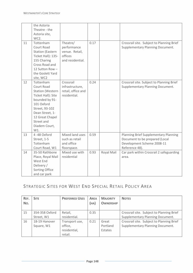
WESTMINSTER’S CORE STRATEGY
Page 148
the Astoria Theatre - the Astoria site, WC2.
11 Tottenham Court Road Station (Eastern Ticket Hall): 135-155 Charing Cross Road and 12 Sutton Row – the Goslett Yard site, WC2
Theatre/ performance venue. Retail, offices and residential.
0.17
Crossrail site. Subject to Planning Brief Supplementary Planning Document.
12 Tottenham Court Road Station (Western Ticket Hall): Site bounded by 91-101 Oxford Street, 93-102 Dean Street, 1-12 Great Chapel Street and Diadem Court, W1.
Crossrail infrastructure, retail, office and residential.
0.24
Crossrail site. Subject to Planning Brief Supplementary Planning Document.
13 4 -48 Oxford Street, 1-5 Tottenham Court Road, W1
Mixed land uses such as retail and office floorspace.
0.59
Planning Brief Supplementary Planning Document to be prepared (Local Development Scheme 2008-11 Reference 48).
14 35-50 Rathbone Place, Royal Mail West End Delivery / Sorting Office and car park
Mixed use with residential
0.93 Royal Mail Car park within Crossrail 2 safeguarding area.
STRATEGIC SITES FOR WEST END SPECIAL RETAIL POLICY AREA
REF. NO.
SITE PREFERRED USES AREA (HA)
MAJORITY
OWNERSHIP
NOTES
15 354-358 Oxford Street, W1
Retail, residential.
0.35
Crossrail site. Subject to Planning Brief Supplementary Planning Document.
16 18-19 Hanover Square, W1
Transport use, office, residential, retail.
0.21
Great Portland Estates
Crossrail site. Subject to Planning Brief Supplementary Planning Document.

Appendix 1: Proposals Sites
Page 149
17 65 Davies Street, W1
Transport use, office, residential.
0.17
Grosvenor Estate
Crossrail site. Subject to Planning Brief Supplementary Planning Document.
STRATEGIC SITES FOR NORTH WESTMINSTER ECONOMIC
DEVELOPMENT AREA
REF. NO.
SITE PREFERRED USES AREA (HA)
MAJORITY
OWNERSHIP
NOTES
18 Paddington New Yard, W9
Transport Infrastructure
6.98 National Rail
Crossrail site. Subject to Planning Brief Supplementary Planning Document.
19 The Travis Perkins Building, 149-157 Harrow Road.
Residential, commercial and community uses, open space.
2.73 Subject to Planning Brief Supplementary Planning Document.
20 Edgware Road Station, Chapel Street, NW1
Transport, infrastructure, and station improvements, housing, retail
0.86 Transport for London
Subject to Planning Brief. Principal existing use: London Underground station. Planning Brief Supplementary Planning Document to be prepared (to be included in Local Development Scheme).
21 Prince of Wales Junction/Maida Hill, W9
Mixed use social and community with retail, small business premises and residential.
0.57
Fernhead Road Properties owned by the council.
Planning Brief Supplementary Planning Document to be prepared (Local Development Scheme 2008-11 Reference 49).
22 Land bounded by 129-147 Church Street, 283-317 Edgware Road, 11-13 Paddington Green and Newcastle Place, (West End Green) W2
Retail, residential.
0.56
West End Green Properties
Subject to planning permission for supermarket, over 200 residential units, over 150 holiday let units (21/04/2004). Planning Brief Supplementary Planning Document to be prepared (Local Development Scheme 2008-11 Reference 54).
23 Site bounded by Shroton Street, Cosway Street, Bell Street, and Stalbridge Street.
School or mix of residential and commercial uses if the school can be provided elsewhere
0.21
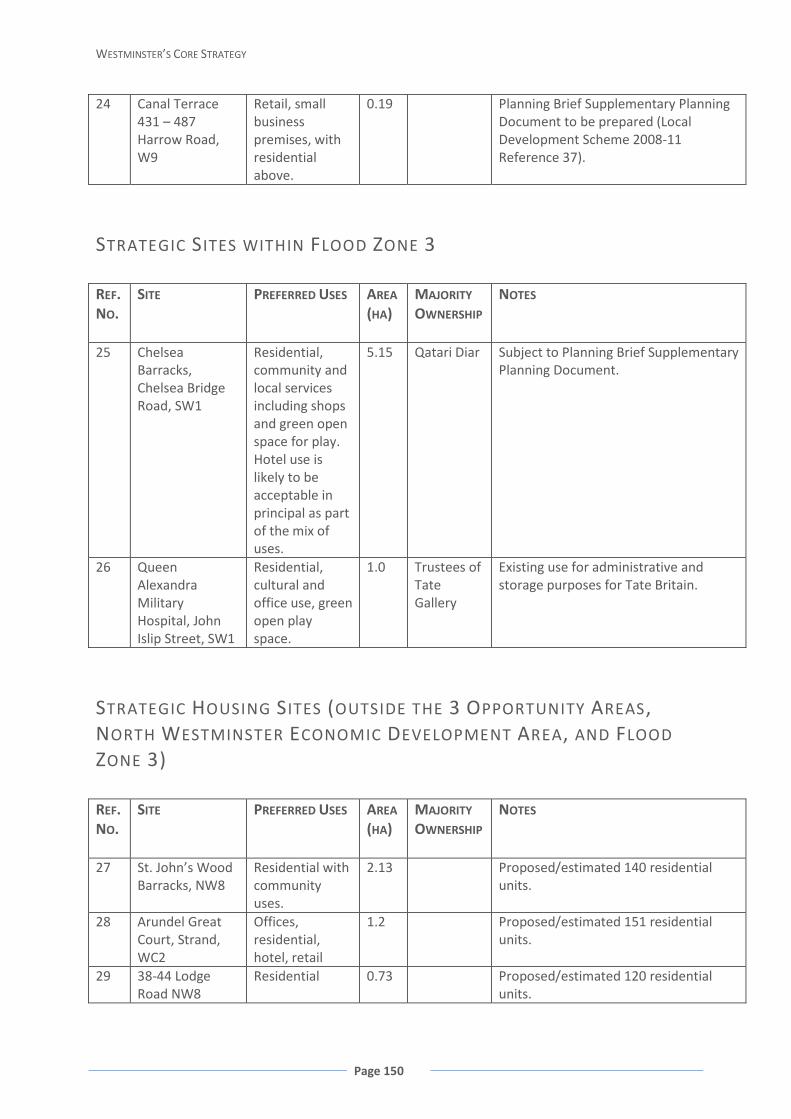
WESTMINSTER’S CORE STRATEGY
Page 150
24 Canal Terrace 431 – 487 Harrow Road, W9
Retail, small business premises, with residential above.
0.19
Planning Brief Supplementary Planning Document to be prepared (Local Development Scheme 2008-11 Reference 37).
STRATEGIC SITES WITHIN FLOOD ZONE 3
REF. NO.
SITE PREFERRED USES AREA (HA)
MAJORITY
OWNERSHIP
NOTES
25 Chelsea Barracks, Chelsea Bridge Road, SW1
Residential, community and local services including shops and green open space for play. Hotel use is likely to be acceptable in principal as part of the mix of uses.
5.15 Qatari Diar
Subject to Planning Brief Supplementary Planning Document.
26 Queen Alexandra Military Hospital, John Islip Street, SW1
Residential, cultural and office use, green open play space.
1.0 Trustees of Tate Gallery
Existing use for administrative and storage purposes for Tate Britain.
STRATEGIC HOUSING SITES (OUTSIDE THE 3 OPPORTUNITY AREAS,
NORTH WESTMINSTER ECONOMIC DEVELOPMENT AREA, AND FLOOD
ZONE 3)
REF. NO.
SITE PREFERRED USES AREA (HA)
MAJORITY
OWNERSHIP
NOTES
27 St. John’s Wood Barracks, NW8
Residential with community uses.
2.13 Proposed/estimated 140 residential units.
28 Arundel Great Court, Strand, WC2
Offices, residential, hotel, retail
1.2 Proposed/estimated 151 residential units.
29 38-44 Lodge Road NW8
Residential 0.73 Proposed/estimated 120 residential units.

Appendix 2: Retail Hierarchy
Page 151
APPENDIX 2: RETAIL HIERARCHY INTERNATIONAL SHOPPING CENTRES
Primary Shopping Frontages West End
3 - 535 and 4 - 556 Oxford Street 49 - 259 and 50 - 270 Regent Street 1 - 81 and 87 - 180 New Bond Street 1A - 50 (consec.) Old Bond Street
Knightsbridge 2 - 26 and 44 - 130 Brompton Road 127 - 129 Knightsbridge Knightsbridge Green (including arcade)
WEST END SPECIAL RETAIL POLICY AREA
West End Special Retail Policy Area (WESRPA)
WESRPA covers the West End International Shopping Centre and wider West End area including Soho and Covent Garden, as shown on the Policy CS7 map (page 42) and the detailed boundary on the Proposals Map.
CAZ FRONTAGES
Covent Garden / Strand, WC2 These centres are considered appropriate for the provision of strategically important town centre facilities as designated in the London Plan
Victoria Street, SW1 Baker Street (south), W1 Edgware Road (south), W1, W2 Marylebone Road, NW1, W1 Marylebone High Street, W1 Warwick Way / Tachbrook Street, SW1
OTHER SHOPPING CENTRES WITHIN THE CENTRAL ACTIVITIES ZONE
Piccadilly, W1 These centres fall within the Core Central Activities Zone, a locality which contains a range of distinct shopping areas, and where retail floorspace is encouraged. They are not designated as CAZ Shopping Frontages, but do contribute to Westminster’s unique
Charlotte Street / Fitzrovia, W1 Wigmore Street, W1 Shepherd Market, W1 South Audley Street / Mount Street, W1

WESTMINSTER’S CORE STRATEGY
Page 152
Jermyn Street, W1 and varied world class retail offer and, along with Westminster’s designated shopping centres are the subject of ‘Health Check’ Surveys by the Council every 5 years.
MARYLEBONE AND FITZROVIA Core Shopping Frontages Secondary Shopping Frontages Chiltern Street / George Street / Blandford Street, W1
3 - 39 and 2 - 60 Chiltern Street 48 - 51 Dorset Street 35 - 53 Blandford Street
43 -67 Chiltern Street 55 - 63 and 48 - 64 Blandford Street 17 - 31, 37 - 39, 36 - 48, and 52 - 64 George Street 5 -10, 46, 47, 52 - 55 Dorset Street 24 - 34, 35 - 41 (consec.) Paddington Street
Cleveland Street, W1 87 - 125 and 139 - 151 Cleveland Street public house on corner of Cleveland and Clipstone Street 30 Clipstone Street
Crawford Street / Seymour Place / York Street, W1
50 - 53 Crawford Street 145 - 161 Seymour Place 85 York Street
15 - 49, 54 - 61 and 81 - 117 (consec.) Crawford Street 94a - 116 and 161a - 163a Seymour Place 74 - 108, 65 - 83 and 87 York Street 7,7a, 9 Wyndham Place
Great Titchfield Street, W1 53 - 69a and 70 - 86 Great Titchfield Street 24 - 25 Langham Street
New Cavendish Street, W1 132 - 146 and 150 - 168 New Cavendish Street 45 - 63 Cleveland Street 1 Foley Street 28 and 29 Hanson Street
New Quebec Street, W1 1 -13 and 14 -25 (consec.) New Quebec Street 69 Upper Berkeley Street
Seymour Place, W1 3 - 23 and 2 - 30 Seymour Place 27 and 51a Upper Berkeley Street 60 - 64 Seymour Street
PIMLICO Core Shopping Frontages Secondary Shopping Frontages Lupus Street, SW1 105 - 129 Lupus Street 50 - 84, 79 - 103 and 131 - 133
Lupus Street 85 - 95 Charlwood Street 134 Alderney Street
Moreton Street, SW1 32 - 54 and 37 - 59 Moreton

Appendix 2: Retail Hierarchy
Page 153
Street 32 and 34 Lupus Street
Pimlico, SW1 91 -103 Tachbrook Street 87 - 89 Tachbrook Street plus adjacent public house, and Pimlico library and underground station 1 - 7 and 2 - 8 Lupus Street
Strutton Ground / Artillery Row, SW1
2 - 40 and 7 - 51 Strutton Ground
1 - 23 Artillery Row 10, 12, 14 and 15 Greycoat Place 50 - 56 Great Peter Street 3 Strutton Ground, 4 - 16 Artillery Row, 2 Greencoat Place
MAJOR SHOPPING CENTRES
Core Shopping Frontages Secondary Shopping Frontages Queensway / Westbourne Grove, W2
2 - 186, and 1 - 171 Queensway (including Whiteleys Centre) 1 - 131 and 2 - 112 Westbourne Grove 71 - 83 Bishop’s Bridge Road
120 - 134 Bayswater Road 118 - 120 Westbourne Grove 1 - 3 and 2 - 18 Chepstow Road 112a and 112b, and 175 - 181 Queensway 24 - 26 and 39 - 41 and 43 - 47 Hereford Road 88 - 98 Bishops Bridge Road
DISTRICT SHOPPING CENTRES
Core Shopping Frontages Secondary Shopping Frontages Church Street / Edgware Road, W2
1 - 127 and 2 -140 Church Street 354 - 452 and 283 - 289 plus adjacent major site on corner of Edgware Road and Church Street
304 - 352, 454 - 466, and 349 - 405 Edgware Road 3 - 25 Bell Street 123 - 127 Boscobel Street 93 - 105 and 102 - 110 Frampton Street
Harrow Road, W9, W10 480 - 606 and 355 - 411 Harrow Road
341a - 351, 353a, 353, 413 - 419 Harrow Road 470 - 478, and 608 - 618 Harrow Road 2 - 8 Fernhead Road 2 Elgin Avenue 4 - 16 Great Western Road 2 - 6 Woodfield Place
Praed Street / Paddington, W2 5 - 199, 12 - 74, and 120 - 164
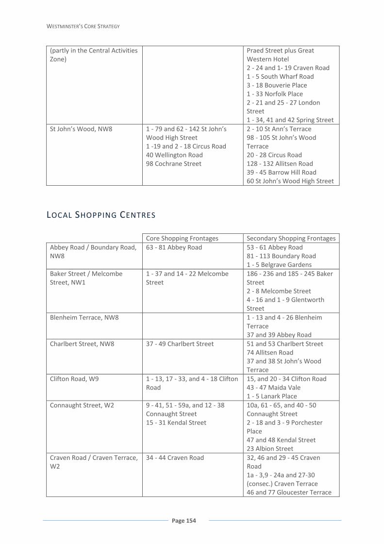
WESTMINSTER’S CORE STRATEGY
Page 154
(partly in the Central Activities Zone)
Praed Street plus Great Western Hotel 2 - 24 and 1- 19 Craven Road 1 - 5 South Wharf Road 3 - 18 Bouverie Place 1 - 33 Norfolk Place 2 - 21 and 25 - 27 London Street 1 - 34, 41 and 42 Spring Street
St John’s Wood, NW8 1 - 79 and 62 - 142 St John’s Wood High Street 1 -19 and 2 - 18 Circus Road 40 Wellington Road 98 Cochrane Street
2 - 10 St Ann’s Terrace 98 - 105 St John’s Wood Terrace 20 - 28 Circus Road 128 - 132 Allitsen Road 39 - 45 Barrow Hill Road 60 St John’s Wood High Street
LOCAL SHOPPING CENTRES
Core Shopping Frontages Secondary Shopping Frontages Abbey Road / Boundary Road, NW8
63 - 81 Abbey Road 53 - 61 Abbey Road 81 - 113 Boundary Road 1 - 5 Belgrave Gardens
Baker Street / Melcombe Street, NW1
1 - 37 and 14 - 22 Melcombe Street
186 - 236 and 185 - 245 Baker Street 2 - 8 Melcombe Street 4 - 16 and 1 - 9 Glentworth Street
Blenheim Terrace, NW8 1 - 13 and 4 - 26 Blenheim Terrace 37 and 39 Abbey Road
Charlbert Street, NW8 37 - 49 Charlbert Street 51 and 53 Charlbert Street 74 Allitsen Road 37 and 38 St John’s Wood Terrace
Clifton Road, W9 1 - 13, 17 - 33, and 4 - 18 Clifton Road
15, and 20 - 34 Clifton Road 43 - 47 Maida Vale 1 - 5 Lanark Place
Connaught Street, W2 9 - 41, 51 - 59a, and 12 - 38 Connaught Street 15 - 31 Kendal Street
10a, 61 - 65, and 40 - 50 Connaught Street 2 - 18 and 3 - 9 Porchester Place 47 and 48 Kendal Street 23 Albion Street
Craven Road / Craven Terrace, W2
34 - 44 Craven Road 32, 46 and 29 - 45 Craven Road 1a - 3,9 - 24a and 27-30 (consec.) Craven Terrace 46 and 77 Gloucester Terrace

Appendix 2: Retail Hierarchy
Page 155
Ebury Bridge Road, SW1 3 - 37 Ebury Bridge Road Public House at 46 Ebury Road and petrol filling station on corner of Ebury bridge Road and Barnabus Street
Elizabeth Street, SW1 34a - 58 and 65 - 79 Elizabeth Street 114 Ebury Street
4 - 24 - 32, 35 - 63 and 81 Elizabeth Street 139 - 147 and 116 Ebury Street 15a - 27 Elizabeth Street
Fernhead Road, W9 61 - 81 Fernhead Road Formosa Street, W9 2 - 18 Formosa Street 1 - 7 Formosa Street Harrow Road (East), W9 336 - 372 Harrow Road
1 - 11 and 2 - 6d Maryland Road 2 - 12 and 5 and 7 Sutherland Avenue public house on corner of Amberley Road and Foscote Mews
Harrow Road / Bourne Terrace, W2
264 - 292 Harrow Road 100 - 108 Bourne Terrace
Kilburn Lane, W9 336 - 354 Kilburn Lane 312 - 334 Kilburn Lane Kilburn Park Road, NW6 227 - 239 Kilburn Park Road 241 - 243 Kilburn Park Road Lauderdale Road/Castellain Road, W9
1a - 12a Lauderdale Parade 73 - 81 Castellain Road
Ledbury Road, W11 48 - 68 Ledbury Road 170 -176 Westbourne Grove Church at corner of Ledbury Road and Westbourne Grove
Leinster Terrace, W2 28 - 33 Leinster Terrace 18 - 35 and public house at 17, Leinster Terrace
Lisson Grove, NW8 31 - 51, 57 - 59, and 18 - 46 Lisson Grove 111 Bell Street
Maida Vale, W9 237 - 255 and 290 - 304 Elgin Avenue 168 - 170 Randolph Avenue
288 and 306 - 318 Elgin Avenue 166 and 166a Randolph Avenue
Moscow Road, W2 8 - 16 and 21 - 29 Moscow Road 33 - 51 Moscow Road Motcomb Street, SW1 1 - 8, 11 - 23, 24 - 28 (consec.)
Motcomb Street 2 - 6 and 7 - 12 Halkin Arcade
9 and 10 Motcomb Street 1 - 9 Kinnerton Street 14 - 17 Halkin Arcade 4, 8 and 9 - 11 West Halkin Street 12a, 14 and 15 - 18 Lowndes Street
Nugent Terrace, W9 1a - 11 and 2 - 10 Nugent Terrace
Pimlico Road, SW1 20 - 30a, 40 - 74 and 37 - 107 Pimlico Road 190 - 204 and 225 - 231 Ebury
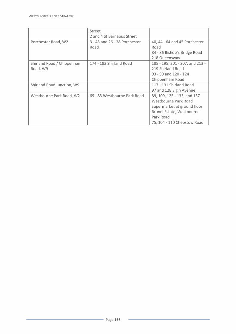
WESTMINSTER’S CORE STRATEGY
Page 156
Street 2 and 4 St Barnabus Street
Porchester Road, W2 3 - 43 and 26 - 38 Porchester Road
40, 44 - 64 and 45 Porchester Road 84 - 86 Bishop’s Bridge Road 218 Queensway
Shirland Road / Chippenham Road, W9
174 - 182 Shirland Road 185 - 195, 201 - 207, and 213 - 219 Shirland Road 93 - 99 and 120 - 124 Chippenham Road
Shirland Road Junction, W9 117 - 131 Shirland Road 97 and 128 Elgin Avenue
Westbourne Park Road, W2 69 - 83 Westbourne Park Road 89, 109, 125 - 133, and 137 Westbourne Park Road Supermarket at ground floor Brunel Estate, Westbourne Park Road 75, 104 - 110 Chepstow Road

Appendix 3: Key Partnerships
Page 157
APPENDIX 3: KEY PARTNERSHIPS PARTNERSHIP LEVEL EXAMPLES OF PROJECTS / ACHIEVEMENTS STAKEHOLDERS
INVOLVED The Westminster City Partnership (also referred to as the Local Strategic Partnership) (Established 2002)
City wide Brings together the public, private, voluntary and community sectors in Westminster, with the aim to deliver the Westminster City Plan – Sustainable Community Strategy for Westminster. This group includes a number of thematic networks.
A mix of organisations and partners including Westminster City Council, Metropolitan Police, Fire Brigade, London Ambulance, Westminster Primary Care Trust, Central London Partnership , Cross River Partnership, Voluntary Action Westminster, voluntary, community groups and many more
Greater London Authority and central Government
Regional and national respectively
Statutory bodies who are key delivery partners for the Core Strategy.
Greater London Authority, and the wider GLA family including Transport for London and the London Development Agency. Various departments at national government level who often have funding and monitoring functions.
Central London Forward (Established 2008)
Sub Regional Central London Forward is an organisation created and funded by six of the central London boroughs to ensure that they, and other agencies can consider matters on a sub regional basis. It provides a forum for boroughs to come together to ensure their plans fit within the Central London context, as well as ensuring cross boundary issues are resolved. A current project is the review of infrastructure across London.
Westminster City Council, City of London, Royal Borough of Kensington & Chelsea, London Borough of Islington, London Borough of Southwark
Cross River Partnership (Established 1995)
Sub Regional The partnership strives to create regeneration solutions providing a balance of physical, social and economic opportunities north and south of Thames. Seek to restore the Thames as a unifying feature for Central London improve transport links across the river and to create job opportunities for local people in leisure
Westminster City Council, London Borough of Lambeth, London Borough of Southwark, City of London
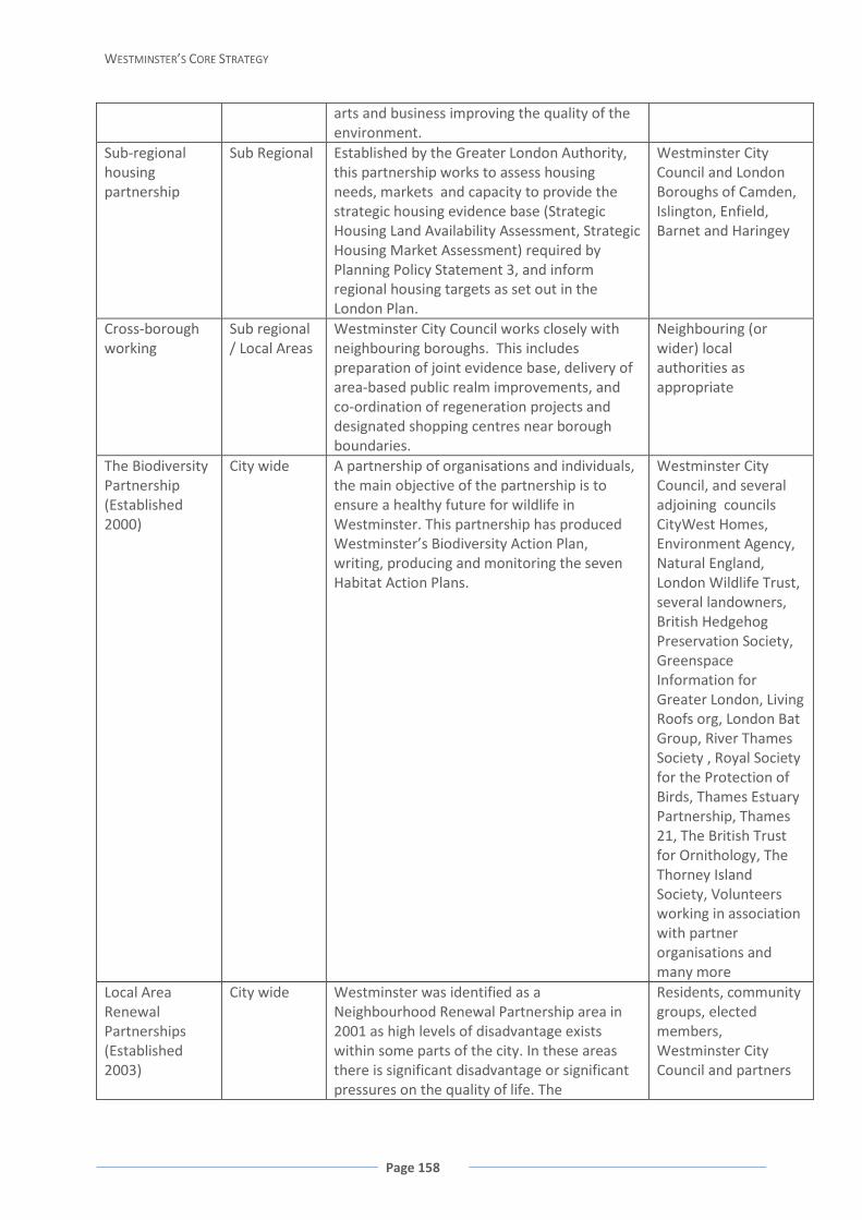
WESTMINSTER’S CORE STRATEGY
Page 158
arts and business improving the quality of the environment.
Sub-regional housing partnership
Sub Regional Established by the Greater London Authority, this partnership works to assess housing needs, markets and capacity to provide the strategic housing evidence base (Strategic Housing Land Availability Assessment, Strategic Housing Market Assessment) required by Planning Policy Statement 3, and inform regional housing targets as set out in the London Plan.
Westminster City Council and London Boroughs of Camden, Islington, Enfield, Barnet and Haringey
Cross-borough working
Sub regional / Local Areas
Westminster City Council works closely with neighbouring boroughs. This includes preparation of joint evidence base, delivery of area-based public realm improvements, and co-ordination of regeneration projects and designated shopping centres near borough boundaries.
Neighbouring (or wider) local authorities as appropriate
The Biodiversity Partnership (Established 2000)
City wide A partnership of organisations and individuals, the main objective of the partnership is to ensure a healthy future for wildlife in Westminster. This partnership has produced Westminster’s Biodiversity Action Plan, writing, producing and monitoring the seven Habitat Action Plans.
Westminster City Council, and several adjoining councils CityWest Homes, Environment Agency, Natural England, London Wildlife Trust, several landowners, British Hedgehog Preservation Society, Greenspace Information for Greater London, Living Roofs org, London Bat Group, River Thames Society , Royal Society for the Protection of Birds, Thames Estuary Partnership, Thames 21, The British Trust for Ornithology, The Thorney Island Society, Volunteers working in association with partner organisations and many more
Local Area Renewal Partnerships (Established 2003)
City wide Westminster was identified as a Neighbourhood Renewal Partnership area in 2001 as high levels of disadvantage exists within some parts of the city. In these areas there is significant disadvantage or significant pressures on the quality of life. The
Residents, community groups, elected members, Westminster City Council and partners

Appendix 3: Key Partnerships
Page 159
Westminster Partnership has designated Local Area Renewal Partnerships these are Church Street, Queens Park, Harrow Road, South Westminster and West End.
The Carbon Alliance (Established 2007)
City wide Based on local areas and sectors it involves a range businesses and organisations. The groups in the alliance share the same objective to measure their energy use in line with the long term government target 80% reduction CO2 levels by 2050.
Local community, voluntary and community organisations, Business Improvement Districts (see below), Health services, Housing residents, Central Government and other businesses
Area based steering groups
Local Area Westminster City Council works with a range of stakeholders to deliver a range of area based initiatives and/or projects to improve the quality of areas within Westminster. Some of these steering groups have action plans these include Oxford, Regent and Bond Street (ORB), Chinatown, Edgware Road, Covent Garden, Theatre Land and Leicester Square. While other groups have been developed to manage areas, for example the Savile Row Strategic Group. This group oversees land use issues and public realm projects, and develops training and skills opportunities locally.
Westminster City Council works with a range of stakeholders, these include landowners, Greater London Authority, Transport for London, Business Improvement Districts, Local Development Agency and others
Business Improvement Districts (from 2001)
Local Area These locally controlled partnerships are made up of groups of businesses. These include Paddington, New West End Company (around Oxford Regent and Bond Street), Heart of London (around Leicester Square and Piccadilly Circus), Bayswater and Victoria. Within these areas business occupiers pay an additional levy to fund improvements to their local areas, often in conjunction with voluntary contributions with landowners
Westminster City Council and groups of local businesses
Paddington First (Established 2001) & SW1st (Established 2008)
Local Area The council and its partners set up these schemes to place local people into jobs with existing employers and those jobs created by the construction and subsequent occupation of new developments. To ensure these schemes deliver employment and training opportunities it works closely with the Local Development Agency.
Westminster City Council and partners
Paddington Waterside Partnership (Established 1998)
Local Area This is a community based regeneration agency. It works in the north of the city and is a member of the City Partnership. It also plays a key role in managing all of the Local Area Renewal Partnerships.
Local landowners, developers and occupiers
Paddington Local Area These community funds were established with Westminster City

WESTMINSTER’S CORE STRATEGY
Page 160
(Established 1998) & Victoria (Established 2006) – Social and Community Fund Accounts
the aim to enhance the benefits of new developments in the areas and to integrate developments into the local community. The owners and developers of major sites in these Opportunity Areas and adjacent areas make financial contributions towards this account. The level of contribution is set out in legal agreements. Local communities and voluntary organisations are involved in the bidding for grants from the Social and Community Fund. In Paddington this scheme has successfully secured nearly £3 million for local projects.
Council, land owners developers and occupiers
MyWestminster Forums / Westminster Area Forums (Established 2001)
City wide Mechanism to involve local residents and businesses in local policy decisions, a method to find out ways to access services, identify people’s views on these services and to find out what people think of the council.
Westminster City Council
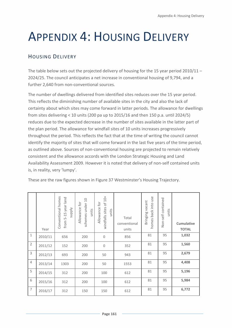
Appendix 4: Housing Delivery
Page 161
APPENDIX 4: HOUSING DELIVERY HOUSING DELIVERY
The table below sets out the projected delivery of housing for the 15 year period 2010/11 –
2024/25. The council anticipates a net increase in conventional housing of 9,794, and a
further 2,640 from non-conventional sources.
The number of dwellings delivered from identified sites reduces over the 15 year period.
This reflects the diminishing number of available sites in the city and also the lack of
certainty about which sites may come forward in latter periods. The allowance for dwellings
from sites delivering < 10 units (200 pa up to 2015/16 and then 150 p.a. until 2024/5)
reduces due to the expected decrease in the number of sites available in the latter part of
the plan period. The allowance for windfall sites of 10 units increases progressively
throughout the period. This reflects the fact that at the time of writing the council cannot
identify the majority of sites that will come forward in the last five years of the time period,
as outlined above. Sources of non-conventional housing are projected to remain relatively
consistent and the allowance accords with the London Strategic Housing and Land
Availability Assessment 2009. However it is noted that delivery of non-self contained units
is, in reality, very ‘lumpy’.
These are the raw figures shown in Figure 37 Westminster’s Housing Trajectory.
Year Conv
entio
nal h
omes
from
5-1
5 ye
ar la
nd
supp
ly
Allo
wan
ce fo
r
sche
mes
und
er 1
0
units
Allo
wan
ce fo
r
win
dfal
ls s
ites
of 1
0+
units
Total
conventional
units
Brin
ging
vac
ant
hom
es b
ack
into
use
Non
-sel
f con
tain
ed
units
Cumulative
TOTAL
1 2010/11 656 200 0 856 81 95 1,032
2 2011/12 152 200 0 352 81 95 1,560
3 2012/13 693 200 50 943 81 95 2,679
4 2013/14 1303 200 50 1553 81 95 4,408
5 2014/15 312 200 100 612 81 95 5,196
6 2015/16 312 200 100 612 81 95 5,984
7 2016/17 312 150 150 612 81 95 6,772

WESTMINSTER’S CORE STRATEGY
Page 162
8 2017/18 312 150 150 612 81 95 7,560
9 2018/19 312 150 150 612 81 95 8,348
10 2019/20 66 150 300 516 81 95 9,040
11 2020/21 66 150 300 516 81 95 9,732
12 2021/22 66 150 300 516 81 95 10,424
13 2022/23 66 150 300 516 81 95 11,116
14 2023/24 66 150 300 516 81 95 11,808
15 2024/25 0 150 300 450 81 95 12,434
TOTAL 4,694 2,550 2,550 9,794 1,215 1,425
FIGURE 57 PROJECTED HOUSING SUPPLY FROM ALL SOURCES 2010/11 – 2024/25
WINDFALL DEVELOPMENTS
There are a number of unique local circumstances in Westminster which justify the inclusion
of windfalls and smaller schemes (which are nearly always windfalls) when demonstrating
deliverability in terms of housing land supply, and producing the housing trajectory for the
Core Strategy.
1. Westminster, being at the heart of Central London, is already densely built up, and
has only has brownfield sites, and very few large sites. Any large sites coming forward will
be expected to provide either solely housing (with supporting community facilities), e.g.
Chelsea Barracks; or mixed uses to include housing, e.g. the three Opportunity Areas
designated for mixed use to provide significant employment uses and housing.
2. Because Westminster is intensively built up, over 90% of housing schemes
completed in the city have less than 10 additional residential units. Small schemes of less
than 10 units produced 1,143 units in the five years 2002 to 2006/7, and make up about
25% of additional residential units completed. This equated to an average figure of 228
units per annum from these small sites. There were 372 units under construction on small
site schemes in July 2008, and these are likely to have been completed between 2009 and
2010. An allowance of 200 units per year for small schemes is therefore considered to
represent a realistic estimate of likely units arising.
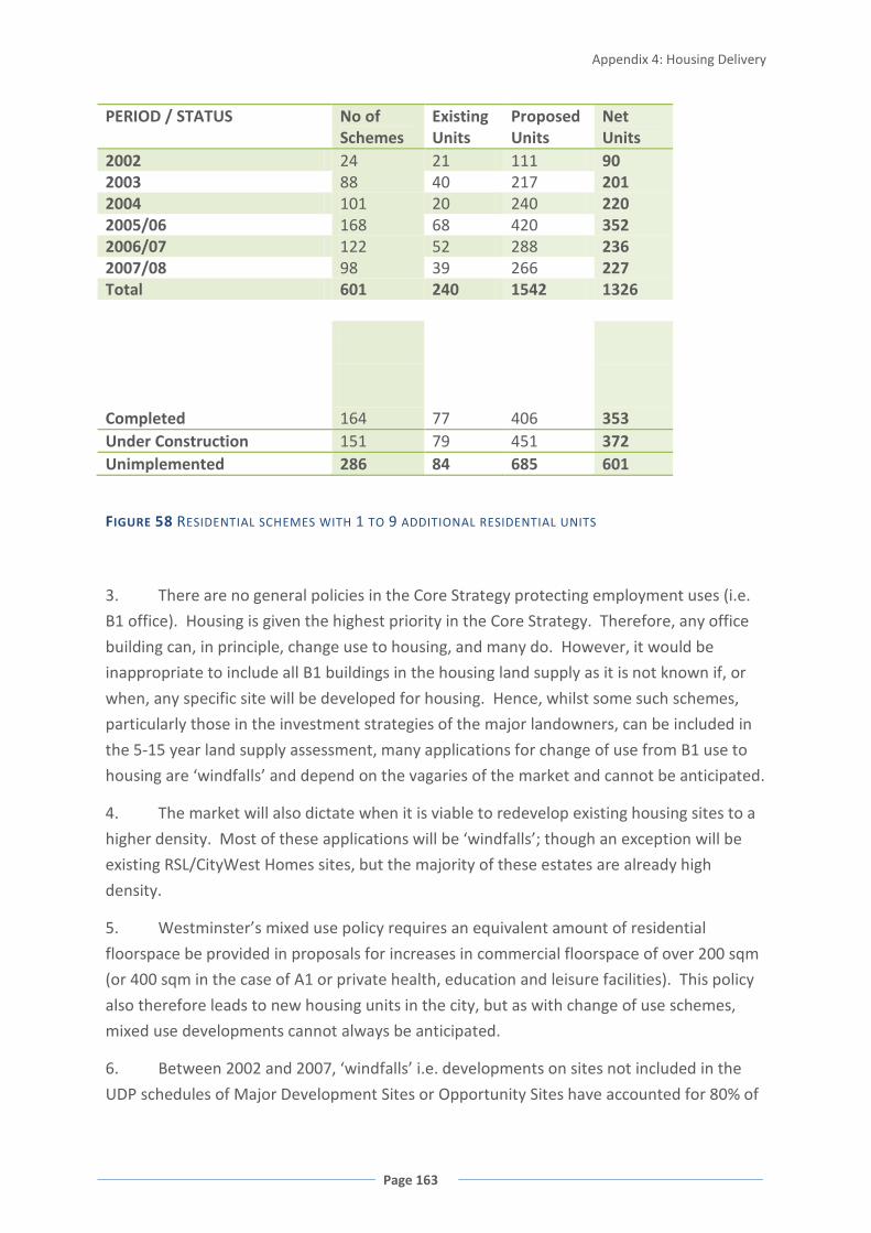
Appendix 4: Housing Delivery
Page 163
PERIOD / STATUS No of Schemes
Existing Units
Proposed Units
Net Units
2002 24 21 111 90 2003 88 40 217 201 2004 101 20 240 220 2005/06 168 68 420 352 2006/07 122 52 288 236 2007/08 98 39 266 227 Total 601 240 1542 1326 Completed 164 77 406 353 Under Construction 151 79 451 372 Unimplemented 286 84 685 601
FIGURE 58 RESIDENTIAL SCHEMES WITH 1 TO 9 ADDITIONAL RESIDENTIAL UNITS
3. There are no general policies in the Core Strategy protecting employment uses (i.e.
B1 office). Housing is given the highest priority in the Core Strategy. Therefore, any office
building can, in principle, change use to housing, and many do. However, it would be
inappropriate to include all B1 buildings in the housing land supply as it is not known if, or
when, any specific site will be developed for housing. Hence, whilst some such schemes,
particularly those in the investment strategies of the major landowners, can be included in
the 5-15 year land supply assessment, many applications for change of use from B1 use to
housing are ‘windfalls’ and depend on the vagaries of the market and cannot be anticipated.
4. The market will also dictate when it is viable to redevelop existing housing sites to a
higher density. Most of these applications will be ‘windfalls’; though an exception will be
existing RSL/CityWest Homes sites, but the majority of these estates are already high
density.
5. Westminster’s mixed use policy requires an equivalent amount of residential
floorspace be provided in proposals for increases in commercial floorspace of over 200 sqm
(or 400 sqm in the case of A1 or private health, education and leisure facilities). This policy
also therefore leads to new housing units in the city, but as with change of use schemes,
mixed use developments cannot always be anticipated.
6. Between 2002 and 2007, ‘windfalls’ i.e. developments on sites not included in the
UDP schedules of Major Development Sites or Opportunity Sites have accounted for 80% of

WESTMINSTER’S CORE STRATEGY
Page 164
housing units delivered in Westminster. However, the new system of preparing 5-15 year
Land Supply Assessments will capture many sites that were previously considered to be
‘windfalls’. So a reduced allowance for windfalls sites with the capacity for 10 plus
residential units needs to be made. In the five year period 2002 – 2006/7, 2,647 completed
units were the result of windfall sites of 10 or more units. It is therefore reasonable to make
an allowance of 100 units per annum, which represents about 20% of this figure, reflecting
the fact that windfalls will be significantly reduced in the future due to the improved site
capture afforded by the preparation of the 5 - 15yr supply list. However, at the time of
preparation of this Plan most sites which will deliver housing in the city beyond 2015 are
unknown to the council and therefore must be treated as windfalls, hence the ‘windfall’
allowance increases over time in the assessment.
MEETING LONDON PLAN TARGETS
The targets set out in the London Plan are both an annual target, and an overall target for a
set time period. They are updated over time, though changes to the London Plan itself. This
makes it difficult to assess performance against the London Plan targets because the overall
time period has never been completed before the target has been changed. Whenever a
new target is introduced, any surplus housing that may have been built in previous years
does not count against the new target, and the borough essentially starts from zero again.
The housing trajectory set out at Figure 37 assumes an annual target of 680 for the year
2010/11, and a target of 770 for every year after that. It applies these targets cumulatively
over the 15 year time period of the Core Strategy. However, the London Plan targets are
actually as follows:
1999-2003 No London Plan target
2004-2006/07 970p.a. 1997-2016 or 2,910 for the three year period
2007/08 -2010/11 680p.a. 2007/08-2016/17 or 2,720 for the four year period
2011/12 – 770p.a. 2011/12-2021/22 proposed target subject to Examination in Public and
subject to an early alteration.
The figure below shows past and projected performance against these targets. It also rolls
out the target of 770 p.a. beyond the 2021/22 time period of the London Plan to cover the
entire Core Strategy time period. This figure shows that, although the target may not be
reached in any one year, cumulatively sufficient surplus is built up in other years to cover
the target over the longer term. When the new 680 p.a. target was introduced in 2007/08,
the surplus that had been built up previously was essentially deleted, although in that year
the target was exceeded (1,011 homes were delivered) and therefore a surplus was still

Appendix 4: Housing Delivery
Page 165
recorded for that year. However, when the new 770 p.a. target is introduced in 2011/12,
this is not expected to be met in that year (528 homes are projected), but a surplus is built
up in subsequent years to come.
Overall, the figure demonstrates that Westminster has always met its London Plan target,
and is confident of doing so in the future.
FIGURE 59 HOUSING DELIVERY AGAINST LONDON PLAN TARGETS 1999-2024/25
Cumulative Surplus/ Shortfall against annual London Plan targets
-500
0
500
1000
1500
2000
1999
2000
2001
2002
2003
2004
2005
/6
2006
/7
2007
/8
2008
/9
2009
/10
2010
/11
2011
/12
2012
/13
2013
/14
2014
/15
2015
/16
2016
/17
2017
/18
2018
/19
2019
/20
2020
/21
2021
/22
2022
/23
2023
/24
2024
/25

WESTMINSTER’S CORE STRATEGY
Page 166
APPENDIX 5: UNITARY
DEVELOPMENT PLAN POLICIES
REPLACED BY CORE STRATEGY
Policy Title STRA 1 World Class City Status STRA 2 Capital City Status STRA 3 Westminster’s Central Area STRA 4 Mixed Use Development STRA 5 Regeneration and Economic Development STRA 6 Public and Private Sector Partnerships STRA 7 Planning Obligations and Benefits STRA 8 Paddington Special Policy Area STRA 9 Special Policy Areas STRA 10 Shopping in Westminster STRA 11 Shopping in the West End and Knightsbridge International Shopping Centres STRA 12 Tourism, Hotels and Visitor Attractions STRA 13 Arts, Culture and Entertainment STRA 14 Protecting and Providing Housing STRA 15 A Variety of Housing Types STRA 16 The Residential Environment STRA 17 Noise STRA 18 Crime and Security STRA 19 Local Community Services STRA 21 Walking, Cycling and Public Transport STRA 22 Reducing the Environmental Effects of Transport STRA 23 Reducing Traffic Congestion and Improving Safety STRA 24 Servicing, Delivery and Collection STRA 26 Improving Access to Facilities and Buildings STRA 27 Standards of Design STRA 28 Conservation Areas and the World Heritage Site STRA 29 Listed Buildings, Historic Parks and Gardens, and Archaeology STRA 30 Views and High Buildings STRA 31 The River Thames and Canals STRA 35 Waste Management and Recycling STRA 36 Metropolitan Open Land and Open Space STRA 37 Nature Conservation and Biodiversity STRA 39 Taking Enforcement Action CENT 2 The Central Activities Zone Frontages H 1 Preventing the Loss of Housing H 9 Sites for Gypsies SS1 Protecting A1 Retail

Appendix 5: UDP Policies Replaced by Core Strategy
Page 167
Policy Title SS2 Protecting Non-A1 Retail SS 15 Servicing PSPA 1 Encouraging Area-Wide Regeneration PSPA 2 Ensuring Mixed Use Development PSPA 3 Ensuring a Mix of Business Use PSPA 5 Transport in the PSPA PSPA 6 Ensuring a High Quality Sustainable Environment PSPA 7 Retaining and Improving St Mary’s Hospital Facilities ENV 11 Waste Management
WESTMINSTER’S CORE STRATEGY
Page 168
GLOSSARY
A1 Use Class (A1 retail use)
Shops - shops, hairdressers, undertakers, travel and ticket agencies, post offices, pet shops, sandwich bars, domestic hire shops, dry cleaners, funeral directors and internet cafés in accordance with the Town and Country Planning (Use Classes) Order 1987 and its subsequent amendments.
A2 Use Class Financial and professional services – banks, building societies, estate and employment agencies, professional and financial services and betting offices in accordance with the Town and Country Planning (Use Classes) Order 1987 and its subsequent amendments.
A3 Use Class Restaurants and cafés – For the sale of food and drink for consumption on the premises –restaurants, snack bars and cafés in accordance with the Town and Country Planning (Use Classes) Order 1987 and its subsequent amendments.
A4 Use Class Drinking establishments – Public houses, wine bars or other drinking establishments (but not nightclubs) in accordance with the Town and Country Planning (Use Classes) Order 1987 and its subsequent amendments.
A5 Use Class Hot food takeaways – For the sale of hot food for consumption off the premises in accordance with the Town and Country Planning (Use Classes) Order 1987 and its subsequent amendments.
Accessibility The ability of all people, including elderly and disabled people, those with young children and those carrying luggage and shopping, to reach places and facilities, and to move around and use those places and facilities.
Active frontages A ground floor frontage which generates passing trade and provides a ‘shop-type’ window display with interest at street level.
Air Quality Sensitive Receptors
Comprises schools, day care centres and nurseries, hospitals, care homes for the elderly and similar institutions where occupiers are particularly vulnerable to air pollution.
Affordable housing Subsidised housing at below market prices or rents intended for those households who cannot afford housing at market rates. The accommodation is usually managed by a Registered Social Landlord.
Affordable business
Business accommodation at the lower end or below market value. This can include accommodation for B1(a), B1(b) and B1(c) as defined
Glossary
Page 169
floorspace in the Town and Country Planning (Use Classes) Order 1987 and its subsequent amendments or retail units.
Amenity The pleasant or advantageous features of a place which contribute to its overall character and the enjoyment of residents or visitors.
Amenity spaces Private or public spaces that provide opportunities for informal activities close to home or work and which contribute to the appearance of localities or developments. They are normally small spaces where workers or visitors can relax, areas used for dog walking, play rest or quiet enjoyment, or merely to provide visual amenity in densely built-up developments.
Arts and cultural uses
Includes D1 Non-residential institutions museums and galleries, D2 Assembly and Leisure uses cinemas and concert halls, and sui generis uses theatres in accordance with the Town and Country Planning (Use Classes) Order 1987 and its subsequent amendments.
B1 Use Class Business – offices, research and development, light industry appropriate in a residential area in accordance with the Town and Country Planning (Use Classes) Order 1987 and its subsequent amendments.
B2 Use Class General industrial – in accordance with the Town and Country Planning (Use Classes) Order 1987 and its subsequent amendments.
B8 Use Class Storage or distribution – including open air storage in accordance with the Town and Country Planning (Use Classes) Order 1987 and its subsequent amendments.
Biodiversity The diversity, or variety, of plants, animals and other living things in a particular locality. It encompasses habitat diversity and genetic diversity. Arising from a belief that biodiversity is of value in its own right and has social and economic value for human society, international treaties and national planning policy expect local development plans to identify and protect a hierarchy of existing areas of biodiversity importance and to provide for the creation of new priority habitats.
Biodiversity Action Plan
Plans prepared at a local, regional and national level setting out priority habitats and species and actions to improve biodiversity outcomes. The Local Biodiversity Action Plan is prepared by the Westminster Biodiversity Partnership.
Blue Ribbon Network
A policy designation defined in the London Plan covering London’s waterways and water spaces and land alongside them. The Blue Ribbon Network includes the River Thames, the canal network, the other tributaries, rivers and streams within London and London’s open water spaces such as docks, reservoirs and lakes.
WESTMINSTER’S CORE STRATEGY
Page 170
Brownfield site Land that is or was occupied by a permanent structure, which has become vacant, underused or derelict and has the potential for redevelopment.
Business Improvement District
Area defined under Part 4 of the Local Government Act 2003 where businesses, through a partnership arrangement, contribute by means of an annual levy over a period of up to five years, to provide funds to secure environmental improvements, to enhance local services such as street cleaning and street wardens, and to carry out economic development activities within that area.
C1 Use Class Hotels – hotels, boarding and guest houses where no significant element of care is provided in accordance with the Town and Country Planning (Use Classes) Order 1987 and its subsequent amendments.
C2 Use Class Residential institutions – care homes, hospitals, nursing homes, boarding schools, residential colleges and training centres in accordance with the Town and Country Planning (Use Classes) Order 1987 and its subsequent amendments.
C2A Use Class Secure residential institution – use for a provision of secure residential accommodation, including use as a prison, young offenders institution, detention centre, secure training centre, custody centre, short term holding centre, secure hospital, secure local authority accommodation or use as a military barracks in accordance with the Town and Country Planning (Use Classes) Order 1987 and its subsequent amendments.
C3 Use Class Dwelling houses – family houses, or houses occupied by up to six residents living together as a single household, including a household where care is provided for residents in accordance with the Town and Country Planning (Use Classes) Order 1987 and its subsequent amendments.
C4 Use Class Houses in Multiple Occupation: Small shared dwelling houses occupied by between 3 to 6 unrelated individuals, as their only or main residence, who share basic amenities such as kitchen/bathroom.
Carbon footprint The total set of greenhouse gas emissions caused directly and indirectly by an individual, organisation, event or product.
CAZ (See ‘Central Activities Zone’)
CAZ Frontages Designated shopping streets within the Central Activities Zone, as designated on the Proposals Map and set out in Appendix 2.
Central Activities A diverse area covering Central London and extending across 10

Glossary
Page 171
Zone
London boroughs, as designated by an indicative boundary in the London Plan. In Westminster, the CAZ comprises eight locally distinct designations as follows: Paddington Opportunity Area; Victoria Opportunity Area; Tottenham Court Road Opportunity Area; Core Central Activities Zone; Marylebone and Fitzrovia; Knightsbridge; Pimlico; and the Royal Parks.
Change of use A type of development that requires planning permission if it is judged to be ‘material’. However, this excludes any change between uses which are within the same use class as defined in the Use Classes Order. It also excludes changes of use that are Permitted Development as defined in the General Permitted Development Order.
Character The distinctive or typical quality of a building or area; as described by historic fabric; appearance; townscape; and land uses.
Civic Amenity Spaces
Includes civic and market squares and other hard surfaced community areas designed for pedestrians with the primary purpose of providing a setting for civic buildings, and urban spaces for public congregation and public events.
Commercial development / floorspace
Comprises A1 Shops, A2 Financial and professional services, A3 Restaurants and cafés, A4 Drinking establishments, A5 Hot food takeaways, B1 Business and all other B uses, C1 Hotels, private C3 hospitals, private D1 Non-residential institutions such as medical care and schools, private D2 Assembly and leisure such as private gyms and clubs, and commercial sui generis uses in accordance with the Town and Country Planning (Use Classes) Order 1987 and its subsequent amendments.
Community facilities
See social and community facilities (separate definitions for public and private)
Community Infrastructure Levy
Part 11 of the Planning Act 2008 contains provisions to allow local authorities in England and Wales to establish a Community Infrastructure Levy (CIL). CIL is a financial charge on most types of new development based on simple formulae which relate the size of the charge to the size and character of the development paying. The proceeds of CIL are to be used to fund local and sub-regional infrastructure.
Comparison goods Predominantly durable goods and services where customers may wish to compare prices/quality/type of product sold, with other similar products sold in other shops. Comparison goods retail use falls within A1 Retail in accordance with the Town and Country Planning (Use Classes) Order 1987 and its subsequent amendments.
Comprehensive A system of inspection and assessment of local service providers,
WESTMINSTER’S CORE STRATEGY
Page 172
Area Agreements carried out by six independent watchdogs including the Audit Commission. It examines how well councils are working with other public bodies to meet local needs.
Conservation The process of managing change to a building or place that sustains its heritage values.
Conservation Area An area of special architectural or historic interest designated by the local planning authority under the provisions of the Planning (Listed Buildings and Conservation Areas) Act 1990, the character or appearance of which it is desirable to preserve and/or enhance.
Conservation Area Audit
The third stage of the council’s appraisal programme for Conservation Areas, and forming part of the Local Development Framework as Supplementary Planning Documents. Each audit provides the detailed assessment of the character and appearance of an area, the analysis and appraisal of key features and guidance to support the implementation of policies designed to preserve and/or enhance these features. Such features include listed buildings, unlisted buildings of interest, spaces and townscape; materials; uses; and important views.
Convenience goods
Basic goods or services which people may need on a weekly, if not daily, basis. Convenience goods retail uses include grocers and newsagents, and fall within A1 Retail in accordance with the Town and Country Planning (Use Classes) Order 1987 and its subsequent amendments.
Core Shopping Frontage
Shopping frontage in a Major, District or Local Shopping Centre where a high proportion of premises at ground floor level are in A1 Retail use, as designated on the Proposals Map and set out in Appendix 2.
Creative Content A sub-sector of Creative Industries including enterprises that produce intellectual property, usually copyright protected, distributed to customers and audiences through sales, advertising or subscription to earn revenue. Examples are broadcasters, record companies, and all kinds of publishers including software, computer games and electronic publishing.
Creative Experience
A sub-sector of Creative Industries in which the core business model is based around selling the right for consumers to witness or experience specific activities, performances or locations. These include live theatre, music, opera and dance.
Creative Industries Generic term for the following sub-groups defined within the Glossary:
Creative Content Creative Experience

Glossary
Page 173
Creative Originals Creative Services
Creative Originals A sub-sector of Creative Industries based on the manufacture, production or sale of physical artefacts, the value of which derive from their perceived creative or cultural value and exclusivity. Examples are designer fashion, bespoke tailoring, craft-based activities such as jewellery and arts and antiques.
Creative Services A sub-sector of Creative Industries including enterprises based around providing Creative Services for clients earning revenues in exchange for giving up their time and intellectual property. Examples are architects, advertising agencies, graphic design, new media design and post production.
Crossrail A proposed rail link from Maidenhead and Heathrow Airport in the west, through London including Central London, Canary Wharf and Stratford, into Essex and Kent in the east, as provided for in the Crossrail Act 2008.
Crossrail 2 A proposed rail link crossing Central London, potentially from Hackney to Clapham Junction or Wimbledon, the exact route of which has not been determined. Originally proposed in 1989, part of the route has been safeguarded by the Secretary of State.
Cross River Transit A proposed tram or other dedicated public transport route from Camden, through Covent Garden to Peckham and Brixton.
Cross River Partnership
A partnership organisation established in 1995 to secure the economic regeneration of areas in Westminster, the City of London, Lambeth and Southwark, on both sides of the River Thames between Vauxhall Bridge and Tower Bridge.
D1 Use Class Non-residential institutions – clinics, health centres, crèches, day nurseries, day centres, schools, art galleries, museums, libraries, halls, places of worship, church halls, law courts, non-residential education and training centres in accordance with the Town and Country Planning (Use Classes) Order 1987 and its subsequent amendments.
D2 Use Class Assembly and leisure – cinemas, music and concert halls, bingo and dance halls (but not nightclubs), swimming baths, skating rinks, gymnasiums or sports arenas (except for motor sports, or where firearms are used) in accordance with the Town and Country Planning (Use Classes) Order 1987 and its subsequent amendments.
Decentralised energy generation
The generation of electricity near to where it is used, thereby avoiding the wastage of traditional, centralised power stations.
Development The carrying out of building, engineering, mining or other operations

WESTMINSTER’S CORE STRATEGY
Page 174
in, on, over or under the land; or the making of any material change in the use of any buildings or other land, as defined in the Town and Country Planning Act 1990 as amended. Unless it is defined under the Act as ‘permitted development’, planning permission is required for the carrying out of any development of land.
Disabled person A person who has either a physical, sensory or mental impairment that has a substantial and long-term adverse effect on their ability to carry out normal day-to-day activities, in accordance with the Disability Discrimination Act 2005.
District Parks Large areas of open space that provide a landscape setting with a variety of natural features providing for a wide range of activities, including outdoors sports facilities and playing fields, children’s play for different age groups and informal recreation pursuits, with a size guide of 20 hectares.
District Shopping Centre
Service centre, usually with up to one hundred commercial premises of various kinds, with a predominantly retail function, as designated on the Proposals Map and set out in Appendix 2.
Entertainment Uses
Comprises A3 Restaurants and cafés, A4 Public houses and bars, A5 Takeaways, and other entertainment uses including D2 live music and dance venues and sui generis uses nightclubs, casinos and amusement arcades in accordance with the Town and Country Planning (Use Classes) Order 1987 and its subsequent amendments.
There are some uses (for example sui generis private members’ clubs, restaurants and casinos in hotels, and premises that contain a mix of retail and entertainment) where the nature of the use and its impact on the local environment is such that these will be considered under the entertainment policies.
The entertainment uses that are not considered within this definition are sports halls, swimming baths, gymnasiums, skating rinks, other indoor or outdoor sports or recreation areas, concert halls, cinemas and theatres.
Essential Infrastructure
Comprising essential transport Infrastructure that must cross areas of higher flood risk, and utility infrastructure as set out in Planning Policy Statement 25.
Exception Test A test set out in Planning Policy Statement 25 to be used if application of the Sequential Test is not possible. The test provides a method for managing flood risk while still allowing necessary development to occur.
Flood-related infrastructure
Includes infrastructure to defend against and manage flooding from a number of sources including tidal and fluvial flooding and surface

Glossary
Page 175
water flooding, such as the Embankment Wall and Thames Tunnel.
Flood Risk Assessment
An assessment required at planning application stage, in specified circumstances, as set out in Planning Policy Statement 25, to identify and assess the risks of all forms of flooding to and from the development, and how these risks will be managed.
Flood Zone 2 An area defined by the Environment Agency as having a medium probability of flood risk: Assuming that no tidal defences are in place, Flood Zone 2 has between a 1 in 100 and 1 in 1,000 annual probability of river flooding or between a 1 in 200 and 1 in 1,000 annual probability of flooding from the sea.
Flood Zone 3 An area defined by the Environment Agency as having a high probability of flood risk: Assuming that no tidal defences are in place, Flood Zone 3 has a 1 in 100 or greater annual probability of river flooding or a 1 in 200 or greater annual probability of flooding from the sea.
General Permitted Development Order
Regulations made by the Secretary of State, amended from time to time, defining a wide range of minor operation and changes of use which constitute development, but which can be carried out without obtaining specific planning permission.
Government Office for London
Government organisation which acts on behalf of the Secretary of State on land use planning matters in London.
GP-led Health Centres
Facilities for the provision of core GP services, open seven days a week, 365 days a year, providing appointments and walk-in services to registered and non-registered patients. These facilities can be provided in accessible locations and be integrated or co-located with and other community based services.
Greater London Authority
Regional government organisation established by the Greater London Authority Act 1999. It comprises a directly elected Mayor, a separately elected Assembly body, and a number of officers, including those within the wider Greater London Authority family of agencies including Transport for London, the Metropolitan Police Authority, the London Fire and Emergency Planning Authority and the London Development Agency.
Green Corridors Almost continuous areas of open space which are linked and may not be publicly accessible. They can act as conduits for plants and animals and serve amenity, landscape and access roles.
Green infrastructure
Parks, public and private squares and gardens, green spaces on council estates, linear open spaces, graveyards, private residential gardens, trees, green roofs and green landscaped areas.

WESTMINSTER’S CORE STRATEGY
Page 176
Heritage Resources inherited which people value for more than their function.
Heritage assets Inherited assets which people identify and value and which reflect their evolving knowledge, culture, beliefs and traditions. Can include Conservation Areas, Listed Buildings, Unlisted Buildings of Merit, historic parks, gardens and squares, archaeological deposits and World Heritage Sites.
Highly Vulnerable Uses
Comprising basement dwellings, police stations, ambulance stations and fire stations and command centres and telecommunications installations required to be operational during flooding, emergency dispersal points and installations requiring hazardous substances consent as set out in Planning Policy Statement 25.
Historic fabric Surviving original and historic fabric in the form of buildings, their structure, details and decoration.
Hostels Residential accommodation, usually not self-contained, often for a particular group of people and classified as sui generis uses where no significant element of care is provided in accordance with the Town and Country Planning (Use Classes) Order 1987 and its subsequent amendments. This does not include ‘youth hostels’ as these are a type of visitor accommodation (C1 Use Class).
Hotels Includes all hotels, guest houses, apart-hotels, bed and breakfast accommodation and other similar tourist accommodation, including tourist hostels.
Houses in Multiple Occupation
A single residential planning unit which is occupied by persons as their main or only residence, who do not form a single household. The living accommodation will normally be rooms or bedsits with some shared facilities e.g. kitchens and bathrooms, but could contain residential spaces with exclusive use facilities. HMOs are C4 Use Class and a sui generis use in accordance with the Town and Country Planning (Use Classes) Order 1987 and its subsequent amendments.
Inclusive design Consideration at the design stage to ensure that development makes provision for everyone. Inclusive design addresses the needs of those with mobility difficulties, poor vision and other physical disabilities. Inclusive design also aims to meet the needs and convenience of others such as people with small children, those carrying heavy or bulky items and the elderly.
Institutional Use Non-governmental institutions such as professional, research and development, cultural, learned and education, charitable institutions and trade federations.
Glossary
Page 177
International Shopping Centre
Shopping centre at the top of London’s retail hierarchy of international reputation and attracting global visitors, as designated on the Proposals Map and set out in Appendix 2.
In-vessel composting
An industrial form of composting biodegradable waste within an enclosed container, where conditions such as air flow, temperature and emissions are controlled.
Layout The way buildings, routes and open spaces are placed in relation to each other.
Legibility The degree to which a place can be easily understood and moved through.
Linear Open Spaces
Open spaces and towpaths alongside the Thames, canals and other waterways; paths; disused railways; nature conservation areas; and other routes that provide opportunities for informal recreation. Often characterised by features or attractive areas which are not fully accessible to the public but contribute to the enjoyment of the space.
Listed Building A building of special architectural or historic interest, as listed under s1 of the Planning (Listed Buildings and Conservation Areas) Act 1990. Listed Buildings are graded under the English Heritage classification to show their relative importance, with Grade I buildings being of exceptional interest, Grade II* being particularly important buildings of more than special interest. Most Listed Buildings are Grade II.
Local Area Agreement
A set of priorities for a local area, agreed between central government and the local authority and Local Strategic Partnership (see Westminster City Partnership). They are linked to funding from central government to deliver these priorities. These are required by the Local Government Act 2000. The Local Area Agreement, Sustainable Community Strategy (Westminster City Plan) and the Core Strategy sets out the vision and delivery priorities for each place in the UK.
Local Development Framework
The plan-making system set out in the Planning and Compulsory Purchase Act 2004, and comprising of a number of documents as set out in Figure 1.
Local Development Scheme
A document which forms part of the Local Development Framework, and which sets out the programme for preparation of the Local Development Framework documents.
Local distinctiveness
The positive features of a place and its communities which contribute to its special character and sense of place.
Local Parks Providing for court games, children’s play, sitting out areas and

WESTMINSTER’S CORE STRATEGY
Page 178
nature conservation areas, with a size guide of two hectares.
Local service provision facilities
Local community facilities providing a range of local services which may include council services (‘One Stop Shop’ type provision), housing estate offices, and spaces for other local service providers and/or the voluntary sector.
Local service provider
Westminster City Council, the National Health Service or related organisations such as a Primary Care Trust, the Metropolitan Police, Registered Social Landlords and other public sector services such as job centres and courts, and voluntary sector organisations operating within the borough. These are public social and community uses.
Local Shopping Centre
Small centre, usually containing convenience goods shops, local service uses, restaurants, cafés and pubs, mainly providing facilities for people living or working nearby, as designated on the Proposals Map and set out in Appendix 2
Local Strategic Partnership
Local organisation comprising representatives drawn from the council, local health services, the Metropolitan Police Service, voluntary and community sectors, local businesses, regeneration partnerships and residents’ groups. This partnership produces the Sustainable Community Strategy (Westminster City Plan) under the provisions of Section 4 of the Local Government Act 2004.
London Plan London’s Spatial Development Strategy published by the Mayor of London under the provisions of the Planning and Compulsory Purchase Act 2004.
London Squares A garden or enclosed or unenclosed land protected by the London Squares Preservation Act 1931.
Major development (Large scale)
Development where: the proposed number of new residential units to be attained from the
proposal is 200 or more or a site area of over 4 hectares; or the proposed gross floorspace to be built created is 10,000 sqm or
more or a site area of 2 hectares or more
Major development (Small scale)
Development where: the proposed number of new residential units to be attained from the
proposal is between 10 and 199 or a site area of between 0.5 hectares and less than 4 hectares; or
the proposed gross floorspace to be built created is between 1,000 sqm and 9,999 sqm or a site area of between 1 hectares and less than 2 hectares
Major Shopping Centre
Predominantly retail centre providing a range of services to a wide catchment area, as designated on the Proposals Map and set out in Appendix 2.
Glossary
Page 179
Mayor of London A directly elected Mayor with a wide range of functions relating to the governance of Greater London as set out in the GLA Act 2007.
Metropolitan Open Land
Strategically important open space defined in the London Plan. In Westminster, this comprises the Royal Parks – St James’s Park, Hyde Park, Kensington Gardens, Green Park and Regents Park.
Metropolitan Parks
Large areas of open space that provide a range of facilities and features offering recreational, ecological, landscape, cultural or green infrastructure benefits at a sub-regional level, are readily accessible by public transport and are managed to meet best practice quality standards, with a size guide of 60 hectares.
More Vulnerable Uses
Comprising hospitals, residential institutions such as residential care homes, children’s homes, prisons and hostels, buildings used for dwelling houses, student halls of residence, drinking establishments, nightclubs and hotels, non-residential uses for health services, nurseries and educational establishments, and sites used for managing hazardous waste as set out in Planning Policy Statement 25.
Noise Sensitive Receptors
Comprises residential use, educational establishments, hospitals, hotels, hostels, concert halls, theatres, law courts, and broadcasting and recording studios.
Non-A1 retail uses Comprises A2 Financial or professional services, A3 Restaurants and cafés, A4 Drinking establishments (not nightclubs), A5 Hot food takeaways in accordance with the Town and Country Planning (Use Classes) Order 1987 and its subsequent amendments.
Oasis Areas As provided for in Policy CS 7 and locations as indicated on the West End Special Retail Policy Area Map as follows: 1. Junction of Oxford Street with Balderton Street (leading to Brown Hart Gardens); 2. St Christopher’s Place; 3. Junction of Oxford Street with Woodstock Street; 4. Vere Street; 5. Old Cavendish Street; 6. Cavendish Square; 7. Argyll Street and Little Argyll Street; 8. Ramillies Place; 9. Hanway Street and Hanway Place; 10. Golden Square; 11. Warwick Street; 12. Glasshouse Street and Air Street; 13. Swallow Street.
Open space Includes all parks and gardens, regardless of size (whether public or private); the River Thames and the canals and their towpaths; civic spaces; children’s playgrounds, including school playgrounds; ballcourts and other outdoor sports facilities; amenity green spaces, such as open spaces on housing estates; churchyards; and community gardens.
Open space network
Includes all open spaces, plus other spaces that provide a break from the densely built-up urban form, such as pedestrianised areas and
WESTMINSTER’S CORE STRATEGY
Page 180
station concourses; hard-landscaped areas with private access; pedestrian/cycle and wildlife routes; and all the green infrastructure that links open spaces together, including green corridors, private residential gardens, trees, green roofs, and green landscaped areas.
Opportunity Areas Areas defined in the London Plan that provide London’s principle opportunities for accommodating large-scale development to provide substantial numbers of new employment and housing opportunities with good public transport accessibility.
Permitted development
Development which is granted planning permission under the terms of the Town and Country Planning (General Permitted Development) Order 1995 (as amended)(GPDO). This includes, for example, many changes of use such as a change from a restaurant (A3 Use Class) to a shop (A1 Use Class) as set out in the GPDO.
Planning obligation
An enforceable compact associated with the use and development of land. This may be either an agreement between a local planning authority and an organisation or individual having an interest in land; or a unilateral undertaking given by an applicant for planning permission. An obligation usually involves a restriction on the use or development of land; or a specific requirement about an operation or activity to be carried out on land; or a requirement that land should only be used in a specified way; or the payment of a sum or sums of money.
Planning permission
A written consent to the carrying out of “Development” issued by a local planning authority or, on appeal, by a Planning Inspector or the Secretary of State. The permission is normally subject to conditions and will lapse if the development is not started within a stated period of time. Planning permission for buildings may be in outline where the principle is approved, subject to the later submission of further applications for the approval of reserved matters.
Planning Policy Guidance and Planning Policy Statements
Publication issued by the Government department responsible for planning, setting out the principles to be taken into account by local planning authorities when exercising their planning functions.
Pocket Parks Small areas of open space that provide natural surfaces and shaded areas for informal play and passive recreation that sometimes have seating and play equipment, with a size guide of under 0.4 hectares.
Polysystems Polyclinics / polysystems will become the main stop for health and well-being support. GP practices might be based in these centres and the range of services is likely to include: Ante- and post-natal care; community mental health services; social care; healthy living information and advice services; outpatients; urgent care; extended

Glossary
Page 181
opening hours; One stop shop services for patients with long-term conditions; diagnostics.
Primary Shopping Frontages
The main shopping frontage in the International Shopping Centre, with the highest proportion of premises at street level in A1 retail use, as designated on the Proposals Map and set out in Appendix 2.
Priority species and habitat
Species and habitat are identified at national, regional and local level. The UK Biodiversity Partnership produce a list of species and habitats that are a priority for nature conservation action to prevent their decline. There is similarly a Biodiversity Partnership at regional and local level (see also Biodiversity Action Plan).
Private members’ clubs
Clubs which are only open to members who pay a subscription and may also have to meet other criteria. These are considered to be a private leisure use, and are sui generis uses in accordance with the Town and Country Planning (Use Classes) Order 1987 and its subsequent amendments.
Proposals Map The adopted proposals map illustrates the policy and proposal site boundaries referred to in the Core Strategy. It will be revised as each new Development Plan is adopted, and it should always reflect the up-to-date planning strategy for the area.
Public buildings A range of uses within the Town and Country Planning (Use Classes) Order 1987 and its subsequent amendments. Comprised of cinemas, concert halls, theatres, clubs (excluding sports and private members’ clubs, casinos and live entertainment), embassies and consulates, armed forces, museums, art galleries, broadcasting non-active entertainment, courts, emergency services, palaces, places of worship, places of active public entertainment, sports centres and gyms.
Public realm The parts of the city which are available free for everyone to use or see, including streets, squares and parks.
Rapid Inundation Zone
Low-lying areas close to the River Thames which would rapidly inundate to significant levels if the Embankment Wall was breached.
Registered Historic Parks and Gardens of Special Historic Interest
Designed ornamental landscapes which are included in the Register of Parks and Gardens of Special Historic Interest in England, published by English Heritage. Parks and gardens on the register are graded in the same manner as Listed Buildings in order to reflect the importance of the garden or park in comparison with others in England (Grades I, II* and II)
Registered Social Landlord
Organisation registered with the Housing Corporation under the provisions in Chapter 1 of the Housing Act 1996. The organisations concerned may be housing associations which are registered
WESTMINSTER’S CORE STRATEGY
Page 182
charities, or non-profit making provident societies or companies. They must provide housing kept available for letting, and meet other requirements set out in the Act.
Residential development
Comprises C3 Dwellinghouses in accordance with the Town and Country Planning (Use Classes) Order 1987 and its subsequent amendments.
Retail Includes all A-Class uses in accordance with the Town and Country Planning (Use Classes) Order 1987 and its subsequent amendments. See A1 Use Class (A1 retail use), and Non-A1 retail uses.
Retrofitting Adding new features to an existing building (to improve its performance).
Secondary Shopping Frontage
Shopping frontage in a Major, District or Local Shopping Centre where there is a mix of A1 and non-A1 retail uses, as designated on the Proposals Map and set out in Appendix 2
Section 106 agreement
An agreement made under Section 106 of the Town and Country Planning Act 1990 to secure a planning obligation.
Sense of place The unique perception of a place created by its local buildings, streets, open spaces and activities. The more distinctive the place the greater the sense of it being special. A character which is greater than the sum of the constituent parts.
Sequential Test A test set out in Planning Policy Statement 25 to direct the most vulnerable development to areas of lowest flood risk, to be used when drafting site or land allocation Development Plan Documents and when determining individual planning applications for any development other than minor development and changes of use.
Shopping Centres Designated areas containing a high proportions of A1 retail use, classified as International Shopping Centres, CAZ Frontages, Major, District and Local Shopping Centres, based on their size, location, catchment, character and function, as designated on the Proposals Map and set out in Appendix 2.
Shopping Frontage A street level frontage characterised by a predominance of shop-type premises.
Sites of Importance for Nature Conservation (SINCs)
The Greater London Authority designated SINCs to highlight areas of ecological value that are rich in wildlife within the city. The sites are graded as being of Metropolitan, Borough or Local Importance. Sites of Metropolitan Importance are those which contain the best examples of London’s habitats and rare species that are of significance to London. Sites of Borough Importance are those identified to have an importance to Westminster, and any damage
Glossary
Page 183
would mean a significant loss to the city. A site of Local Importance is identified because of its value to the nearby community, especially in areas that are deficient in wildlife sites.
Small Open Spaces Gardens, sitting-out areas, children’s play spaces or other areas of a specialist nature, including nature conservation areas, with a size guide of under two hectares.
Social and community facilities (private)
Includes hospitals, clinics, primary and secondary schools, colleges, crèches, nurseries, gyms and fitness clubs, and other leisure clubs, where the services are provided on a commercial basis, for residents, workers, non-residents and visitors. These private social and community facilities are comprised of buildings and external spaces, with uses within classes C2, D1, D2 and possibly some sui generis uses in accordance with the Town and Country Planning (Use Classes) Order 1987 and its subsequent amendments.
Social and community facilities (public)
These facilities are available to, and serve the needs of local communities and others provided by a local service provider or are often funded in some way by a grant or investment from a government department or public body or the voluntary sector. Social and community facilities are comprised of buildings and external spaces. They include social services uses such as day-care centres, luncheon clubs, and drop-in centres, facilities for children and families, elderly people, people with mobility and/or sensory impairments, people with HIV/AIDs or other diseases covered under the Disability Discrimination Act, people with mental health or substance misuse problems. Other facilities include education facilities such as schools, colleges and universities, health facilities, recreation facilities such as playgrounds, leisure centres, sports pitches and associated buildings, youth centres and local arts facilities. Libraries, places of worship, courts, general and social uses such as community meeting facilities, community halls, public toilets, facilities for emergency services, fire, ambulance and police. The public social and community facilities are in classes C2, D1, D2 and possibly some sui generis uses in accordance with the Town and Country Planning (Use Classes) Order 1987 and its subsequent amendments.
Specialist housing Affordable housing, hostels, Houses in Multiple Occupation, housing for those with special needs including elderly people, students, people with learning or physical disabilities, or mental health problems, or other supported accommodation. These fall within the C2 and C3 Use Classes, or are classified as sui generis uses.
Strategic Cultural Areas
Mixed use areas with strong arts, or cultural or entertainment character, as designated on the Proposals Map.

WESTMINSTER’S CORE STRATEGY
Page 184
Strategic Flood Risk Assessment
A document prepared by the local planning authority to provide information on areas that may flood and on all sources of flooding as required by Planning Policy Statement 25.
Stress Areas Areas identified by the council where it believes that restaurants, cafés, takeaways, public houses, bars and other entertainment uses have become concentrated to an extent that harm is being caused to residential amenity, the interests of other commercial uses, the local environment, and to the character and function of the locality.
Sui Generis Uses Those uses outside of any of the defined Use Classes in the Town and Country Planning (Use Classes) Order 1987 and its subsequent amendments, including those specifically listed in that Order as sui generis, including amusement centres, hostels providing no significant element of care, houses in multiple paying occupation, launderettes, nightclubs, petrol filling stations, shops selling and/or displaying motor vehicles, taxi and minicab businesses, theatres. This list is not a comprehensive summary of all sui generis uses.
Sustainable communities
Some of the key elements are: a flourishing local economy; strong leadership to respond positively to change; effective engagement and participation by local people, groups and businesses, especially in the planning, design, and long-term stewardship of their community and an active voluntary and community sector; a safe and healthy local environment with well-designed public and green space; sufficient size, scale and density, and the right layout to support basic amenities in the neighbourhood and minimise the use of resources; good public transport and other transport infrastructure both within the community and linking it to urban, rural and regional centres; buildings – both individually and collectively – that can meet different needs over time and that minimise the use of resources; a well-integrated mix of decent homes of different types and tenures to support a range of household sizes, ages, and incomes; good quality local services, including education and training opportunities, health care and community facilities especially for leisure; a diverse, vibrant and creative local culture, encouraging pride in the community and cohesion within it; a “sense of place”; and the right links with the wider regional, national and international communityi.
Sustainable development
Development which meets the needs of the present without compromising the ability of future generations to meet their own needs. There are five principles of sustainable development shared across the UK: living within environmental limits; ensuring a strong, healthy and just society; achieving a sustainable economy; using sound science responsibly; and promoting good governance. Sustainable development is the core principle underpinning planning, including this Core Strategy.
Glossary
Page 185
Sustainable transport modes
Walking, cycling and other non-vehicular means of movement; public transport including rail, Underground, buses, coaches, passenger ferry, light rail/tram and licensed cabs; and high occupancy and electric vehicles.
Tall building A building significantly taller than its surroundings.
Thames Policy Area
A policy designation identified in the London Plan and defined on the Proposals Map.
Tidal breach flood level
Predicted depth to which flooding will occur for a breach in the tidal flood defence walk. These have been modelled in Westminster’s Strategic Flood Risk Assessment.
Tourist attractions Includes museums and galleries (D1 Non-residential Institutions), theatres (sui generis), concert halls (D2 Assembly and Leisure), unique attractions such as London Zoo and Madame Tussards, internationally important cultural institutions, and buildings of state and Royal Palaces (Houses of Parliament, Westminster Abbey, Buckingham Palace, Horse Guards).
Town Centre Use A use serving visiting members of the public which may be appropriate at ground floor level in a designated Shopping Centre. Town centre uses include A1 retail uses, non-A1 retail uses, health uses, libraries, entertainment facilities, hotels and offices.
Use Class Order A statutory instrument made by the Secretary of State under section 22 of the Town and Country Planning Act 1990, subsequently amended several times, setting out broad classes of use for land and buildings. Under provisions in the Town and Country Planning (Use Classes) Order 1987 (as amended), a change from one use to another within the same use class does not need planning permission. For example, change from a book shop (A1 Use Class) to a shoe shop (also A1 Use Class) does not require planning permission as they are in the same use class category.
West End International Shopping Centre
Designation which collectively describes Westminster’s three main shopping streets: Oxford, Regent and Bond (Old and New).
Westminster City Partnership
Westminster’s Local Strategic Partnership, a non-statutory, multi-agency partnership matching the local authority boundary, was launched in 2002 and brings together different organisations including the council, police, Primary Care Trust, and representatives from the voluntary sector and other partnership organisations.
Westminster City Plan
Westminster’s Sustainable Community Strategy as required by the Local Government Act 2000, and prepared by the Westminster City

WESTMINSTER’S CORE STRATEGY
Page 186
Partnership.
Windfall development
Development that has not planned for and is not included in the identified Proposals Sites or the rolling housing land supply as set out in Policy 54.
Workshops and studios
Flexible spaces for B1 use that includes features like floor loadings capable of supporting machinery, ceiling heights suitable for the use of machinery and hoists, provision of a goods lift, wide doors and corridors to allow movement of large equipment / materials, servicing for goods vehicles.
World Heritage Site
An area designated as having “outstanding universal value” under the United Nations Convention Concerning the Protection of the World Cultural and Natural Heritage.
i As set out in Westminster City Council Sustainable Communities – building for the future, 2003
References
Page 187
REFERENCES 2012 London Olympic and Paralympic Games – Strategy and Action Plan (2008) Westminster City
Council.
Active Westminster: Sport and Physical Activity Strategy 2008-2013 (2008) Westminster City
Council.
Addressing Health Inequalities in Westminster CMB (2008) Westminster City Council.
Addressing PPS3 requirements for a 15 year housing land supply (2008) Greater London Authority
and Government Office for London.
Affordable Housing Evidence Base (2009) Westminster City Council.
Affordable Housing Proposed Threshold (2009) DTZ. Published by Westminster City Council.
Air Quality Progress Report (2008) Westminster City Council.
Annual Business Inquiry 2007 (2008) Office for National Statistics.
Annual Monitoring Report 2007/08 (2008) Westminster City Council.
Asset Management Plan and Property Strategy (2008) Property Division, Westminster City Council.
Asset Management Plan (draft) (2008) London Fire Brigade.
Bespoke Tailoring in London’s West End (2006) Westminster City Council.
Biodiversity Action Plan (2007) Westminster Biodiversity Partnership.
Building towards the safest city 2003-2008 A Property Estate Strategy (2003) Metropolitan Police
and Metropolitan Police Authority.
Business Directory 2008-10 (2008) Westminster City Council.
Census (2001) Office for National Statistics.
Central Activities Zone Map 1 Local Distinctiveness (2009) Westminster City Council.
Central Activities Zone Map 2 Boundary Comparisons (2009) Westminster City Council.
Chinatown Action Plan (2003) Westminster City Council.
Chinatown Night-time Pedestrian Flowcount (2008) Pedestrian Market Research Services.
Published by Westminster City Council.
Church Street Delivery Plan (2005) Church Street Neighbourhood Management Board.
Circular 01/06: Planning for Gypsy and Traveller Caravan Sites (2006) Office for the Deputy Prime
Minister.
Circular 05/05: Planning Obligations (2005) Communities and Local Government.
WESTMINSTER’S CORE STRATEGY
Page 188
Circular 07/09: Protection of World Heritage Sites (2009) Communities and Local Government.
City of Westminster Health Profile (2007, 2008, 2009) Department of Health.
Conservation Area Audits (including some adopted as Supplementary Planning Documents /
Supplementary Planning Guidance) (various) Westminster City Council.
Core Strategy: Issues and Options (2007) Westminster City Council.
Core Strategy: Preferred Options (2008) Westminster City Council.
Core Strategy - Preferred Options Initial Equality Impact Assessment (2008) Westminster City
Council.
Core Strategy - Preferred Options Initial Health Impact Assessment (2008) Westminster City
Council.
Core Strategy Sustainability Appraisal Scoping Report (2007) Westminster City Council.
Core Strategy Sustainability Appraisal - Preferred Options (2008) Westminster City Council.
Core Strategy Sustainability Appraisal - Publication Draft (2009) Westminster City Council.
Covent Garden Action Plan: working for the future of Covent Garden (2004) Westminster City
Council.
Creative Industries Report (2007) GVA Grimley; Burns and Owens. Published by Westminster City
Council.
Crime and Disorder Reduction Strategy 2005-2008 (2005) Westminster Crime and Disorder
Reduction Partnership7
Crime Reporting Information System (rolling database) Metropolitan Police.
Design Strategy for Chinatown (2008) The Prince's Foundation for the Built Environment. Published
by Westminster City Council.
Development of Polyclinics in Westminster - Report to Westminster Health and Care Network
Business Groups (2008) Westminster PCT.
Directory of Faiths in Westminster (2007) Westminster City Council.
Drink-related Crime Statistics by Entertainment Premises (2010) Westminster City Council.
Economic Development Strategy 2008-2011 (2007) Westminster City Council.
Edgware Road Action Plan (2006) Westminster City Council.
Employment projections for London by sector and trend-based projections by borough (Working
Paper 38) (2009) GLA Economics, Greater London Authority.
7 Westminster City Council, Metropolitan Police, Westminster NHS Primary Care Trust, Westminster City Partnership, London Fire Brigade, Metropolitan Police Authority, Crown Prosecution Service, Voluntary Action Westminster, Borough Criminal Justice Group, British Transport Police

References
Page 189
Estates Strategy 2008- 2013 (2008) Westminster NHS Primary Care Trust.
Guidance on Tall Buildings (2007) CABE / English Heritage.
Harrow Road W9 Renewal Plan Harrow Road LARP 2007-2010 (2007) Harrow Road Neighbourhood
Partnership.
High Buildings Study (2000) EDAW Ltd/Buro Happold Urban Projects. Published by Westminster City
Council.
Housing Density Study (2008) Westminster City Council.
Housing Needs Assessment 2006 (2007) Fordham Research. Published by Westminster City Council.
Housing Space Standards (2006) HATC Ltd. Published by Mayor of London.
Housing Strategy 2007-2012 (2007) Westminster City Council.
(The) Importance of the Historic Environment to the Office Market in Westminster (2007) Drivers
Jonas.
Index of Multiple Deprivation (2007) Communities and Local Government
Institutional Uses Study (1999) Westminster City Council.
Libraries, Archives, Arts and Culture Business Plan 2008/09 (2008) Westminster City Council.
Local Development Scheme (2009) Westminster City Council.
Local Implementation Plan 2005/06 to 2010/11 (2006) Westminster City Council.
London Biodiversity Action Plan (2007) The London Biodiversity Partnership.
London Boroughs' Gypsy and Traveller Accommodation Needs Assessment (2008) Fordham
Research. Published by Greater London Authority in partnership with the London Boroughs.
London Carbon Scenarios to 2026 Report (2006) London Energy Partnership.
London Hotel Demand Study (2006) Grant Thornton and the Leisure and Tourism Organisation.
Published by Greater London Authority.
London Office Policy Review (2007) Ramidus Consulting Ltd with Roger Tym and
Partners. Published by Mayor of London.
London Plan consolidated with alterations since 2004 (2008) Mayor of London.
(Greater) London Strategic Housing Market Assessment 2008 (2009) Opinion Research Services.
Published by Mayor of London.
London Town Centre Assessment Stage 1: Comparison Goods Floorspace Need (2004) Experian
Business Strategies. Published by the Greater London Authority.
London Travel Demand Survey 2007/2008 (2008) Transport for London.
London View Management Framework (2007) Greater London Authority.
WESTMINSTER’S CORE STRATEGY
Page 190
(Draft Revised) London View Management Framework (2009) Greater London Authority.
London Visitor Statistics 2007/2008 (2008) Visit London.
London Waste Apportionment Study (2006) Jacobs Babtie. Published by the Greater London
Authority.
London Waste Apportionment Study Update and Further Sensitivity Testing (2007) Jacobs Babtie.
Published by the Greater London Authority.
London’s Health Services : A Framework for Action (2007) Professor Darzi.
London’s Safety Plan 2008-2011 (2008) London Fire Brigade.
Long Term Land Use Trends in the Core Central Activities Zone (2009) Westminster City Council.
Managing the night-time economy Best Practice Guidance (2007) Mayor of London.
Market View Report for Central London Offices Third Quarter 2008 (2008) CB Richard Ellis.
Mayor’s Air Quality Strategy: Cleaning London’s Air (2002) Mayor of London.
Mayor’s Economic Development Strategy: Sustaining Success (2005) Mayor of London.
Mayor’s Energy Strategy: Green light to clean power (2004) Mayor of London.
Mayor’s Housing Strategy Draft for Consultation8
Mayor’s Industrial Capacity SPG (2008) Mayor of London.
(2009) Mayor of London.
Mayor’s Transport Strategy (2006) Mayor of London.
Mayor’s Transport Strategy Statement of Intent (2009) Mayor of London.
Metropolitan Police Estate Asset Management Plan (2007) Metropolitan Police and Metropolitan
Police Authority.
Municipal Waste Management Strategy (2004) Westminster City Council.
Municipal Waste Management Strategy (2007) Mayor of London.
Night-time Pedestrian Flowcounts (2002) Pedestrian Market Research Services. Published by
Westminster City Council.
Noise Attitudes Survey (2008) GfK NOP Social Research. Published by Westminster City Council.
Noise Survey (2008) Scott Wilson. Published by Westminster City Council.
Noise Survey (2003) BRE. Published by Westminster City Council.
8 Officers at the Greater London Authority advise that the earlier Housing Strategy was never made statutory and therefore there is no need to take into account. The draft Housing Strategy likewise has no statutory weight and is included for reference only.
References
Page 191
North London Sub-Region Strategic Housing Market Assessment (2009) Opinion Research Services.
Published by City of Westminster and the London Boroughs of Barnet, Enfield, Haringay, Islington
and Camden.
North West Westminster Planning Study (2000) WS Atkins. Published by Westminster City
Council.
North Westminster Community Space Audit (2009) Hansons. Published by Harrow Road
Neighbourhood Partnership.
Office Labour Market Statistics: ONS annual business inquiry employee analysis (March 2009)
Office for National Statistics.
Office Trends Mayfair and St. James’s Occupier Survey (2007) Drivers Jonas.
Office Trends UK Key Cities (2009) Drivers Jonas.
Open Space Strategy: Supplementary Planning Document (2007) Westminster City Council.
Our Strategy for Tackling Health Inequalities in Westminster 2009-2016 (2009) NHS Westminster /
Westminster City Council.
Oxford Street Regent Street and Bond Street ORB Action Plan. (2008) Westminster City
Council. Published by Westminster City Council/Transport for London/New West End Company.
Paddington Development Trust Annual Report 2007 - 2008 (2008) Paddington Development Trust.
Paddington Special Policy Area Factsheet May 2009 (2009) Westminster City Council.
Planning Act 2008
Planning and Compulsory Purchase Act 2004
Planning Policy Guidance 4: Industrial, Commercial Development and Small Firms (1992)
Communities and Local Government.
Planning Policy Guidance 13: Transport (2001) Communities and Local Government.
Planning Policy Guidance 15: Planning and the Historic Environment (1994) Communities and Local
Government.
Planning Policy Guidance 16: Archaeology and Planning (1990) Communities and Local
Government.
Planning Policy Guidance 17: Planning for Open Space, Sport and Recreation (2002) Communities
and Local Government.
Planning Policy Guidance 24: Planning and Noise (1994) Communities and Local Government.
Planning Policy Statement 1: Delivering Sustainable Development (2005) Communities and Local
Government.
WESTMINSTER’S CORE STRATEGY
Page 192
Planning Policy Statement: Planning and Climate Change – Supplement to Planning Policy
Statement 1 (2007) Communities and Local Government.
Planning Policy Statement 3: Housing (2006) Communities and Local Government.
Planning Policy Statement 6: Planning for Town Centres (2005) Communities and Local
Government.
Planning Policy Statement 9: Biodiversity and Geological Conservation (2005) Communities and
Local Government.
Planning Policy Statement 10: Planning for Sustainable Waste Management (2005) Communities
and Local Government.
Planning Policy Statement 12: Local Spatial Planning (2008) Communities and Local Government.
Planning Policy Statement 22: Renewable Energy (2004) Communities and Local Government.
Planning Policy Statement 23: Planning and Pollution Control (2004) Communities and Local
Government.
Planning Policy Statement 25: Development and Flood Risk (2006) Communities and Local
Government.
Polyclinics and GP-led Health Centers in Westminster (2008) Westminster PCT.
Public Health Annual Report 2006/2007 (2008) Westminster Primary Care Trust. Published by
National Health Service.
Queen’s Park Neighbourhood Plan 2008-2012 (2008) Queens Park Neighbourhood Management
Board.
Retrofitting Soho (2008) The Max Lock Centre, University of Westminster. Published by MLC Press,
University of Westminster in partnership with Westminster City Council.
Rolling Land Supply for Housing 2007/08 (2009) Westminster City Council.
Safer Westminster Partnership Plan 2008-2011 (2008) Safer Westminster Partnership.
Shopping Area Health Check Survey: Primary Shopping Area 1: Oxford Street , December 2008
(2009) Westminster City Council.
Shopping Area Health Check Survey: Primary Shopping Area 2: Regent Street, December 2008
(2009) Westminster City Council.
Shopping Area Health Check Survey: Primary Shopping Area 3: Bond Street, December 2008 (2009)
Westminster City Council.
Shopping Area Health Check Survey: Primary Shopping Area 4: Knightsbridge, December 2008
(2009) Westminster City Council.
Shopping Area Health Check Survey: CAZ Frontage Shopping Area 9: Covent Garden, December
2008 (2009) Westminster City Council.
References
Page 193
Shopping Area Health Check Survey: CAZ Frontage Shopping Area 11: Strand, December 2008
(2009) Westminster City Council.
Shopping Area Health Check Survey: CAZ Frontage Shopping Area 12: Victoria Street, December
2008 (2009) Westminster City Council.
Shopping Area Health Check Survey: CAZ Frontage Shopping Area 18: Baker Street (South),
December 2008 (2009) Westminster City Council.
Shopping Area Health Check Survey: CAZ Frontage Shopping Area 19: Edgware Road (South),
December 2008 (2009) Westminster City Council.
Shopping Area Health Check Survey: District Centre 3: Marylebone High Street, January 2007
(2007) Nathaniel Lichfield and Partners. Published by Westminster City Council.
Shopping Area Health Check Survey: District Centre 7: Warwick Way/Tachbrook Street, January
2007 (2007) Nathaniel Lichfield and Partners. Published by Westminster City Council.
Shopping Area Health Check Survey: CAZ Shopping Area 5: Piccadilly, December 2008 (2009)
Westminster City Council.
Shopping Area Health Check Survey: CAZ Shopping Area 6: Soho, December 2008 (2009)
Westminster City Council.
Shopping Area Health Check Survey: CAZ Shopping Area 7: Carnaby Street, December 2008 (2009)
Westminster City Council.
Shopping Area Health Check Survey: CAZ Shopping Area 8: Chinatown, December 2008 (2009)
Westminster City Council.
Shopping Area Health Check Survey: CAZ Shopping Area 10: Charlotte Street/Fitzrovia, December
2008 (2009) Westminster City Council.
Shopping Area Health Check Survey: CAZ Shopping Area 13: Wigmore Street, December 2008
(2009) Westminster City Council.
Shopping Area Health Check Survey: CAZ Shopping Area 14: Shepherd Market, December 2008
(2009) Westminster City Council.
Shopping Area Health Check Survey: CAZ Shopping Area 15: South Audley/Mount Street,
December 2008 (2009) Westminster City Council.
Shopping Area Health Check Survey: CAZ Shopping Area 16: Jermyn Street, December 2008 (2009)
Westminster City Council.
Shopping Area Health Check Survey: CAZ Shopping Area 17: Shaftesbury Avenue, December 2008
(2009) Westminster City Council.
Shopping Area Health Check Survey: District Centre 1: Church St/ Edgware Road, January 2007
(2007) Nathaniel Lichfield and Partners. Published by Westminster City Council.
WESTMINSTER’S CORE STRATEGY
Page 194
Shopping Area Health Check Survey: District Centre 2: Harrow Road, January 2007 (2007)
Nathaniel Lichfield and Partners. Published by Westminster City Council.
Shopping Area Health Check Survey: District Centre 4: Praed Street, January 2007 (2007) Nathaniel
Lichfield and Partners. Published by Westminster City Council.
Shopping Area Health Check Survey: District Centre 5: Queensway/Westbourne Grove, January
2007 (2007) Nathaniel Lichfield and Partners. Published by Westminster City Council.
Shopping Area Health Check Survey: District Centre 6: St John’s Wood, January 2007 (2007)
Nathaniel Lichfield and Partners. Published by Westminster City Council.
Shopping Area Health Check Surveys, Summer 2007 Local Centres 1-37 covering all local centres in
Westminster (2009) Westminster City Council.
Soho Action Plan: Your thoughts in action (2007) Westminster City Council.
South Westminster 1 Community Survey (2007) West Ham and Plaistow New Deal Partnership Ltd
& Newman Francis Ltd.
South Westminster Neighbourhood Renewal Strategy 2008-2011 (2008) South Westminster
Renewal Partnership.
Strategic Plan 2008-2013 (2008) Westminster NHS.
Strategic Service Development Plan 2008-2013 (2008) Westminster NHS Primary Care Trust
Statement of Community Involvement (2007) Westminster City Council.
Statement of Licensing Policy (2008) Westminster City Council.
Strategic Flood Risk Assessment (2009) Westminster City Council.
Street Market Regeneration Study (2008) Colin Buchanan. Published by Westminster City Council.
(A) Study of Small Offices in Westminster 2008 (2009) DTZ Research. Published by Westminster City
Council.
Sustainable Communities - building for the future (2003) Office of the Deputy Prime Minister.
Theatreland Strategy (2008) Westminster City Council, English Heritage, The Society of London
Theatre and The Theatres Trust.
Tomorrow’s Roads - Safer for Everyone 2000 – 2010 (2000) Department for Transport.
Towards the year 2010: monitoring casualties in Greater London Issue 8 August 2008 (2008)
London Road Safety Unit, Strategy Directorate Transport for London.
Travel in London: Key Trends and Development Report No. 1 (2007) Transport for London.
UK Air Quality Strategy (2007) Department for Environment, Food and Rural Affairs, Scottish
Executive, Welsh Assembly Government and Department of the Environment Northern
Ireland. Published by DEFRA.
References
Page 195
UK Biodiversity Action Plan (2007) UK Biodiversity Partnership.
Victoria Area Fact Sheet (2007) Westminster City Council.
(The) Walking Strategy for Westminster (2004) Westminster City Council.
Waste Sites Assessment (2009) Westminster City Council.
Waste Strategy for England (2007) Department for Food and Rural Affairs.
West End Entertainment Study (2001) Town Centres Limited. Published by Westminster City
Council.
Westbourne Neighbourhood Plan 2006-09 (2006) Westbourne Neighbourhood Forum.
Westminster Affordable Housing Viability Study (2009) DTZ Research. Published by Westminster
City Council (jointly commissioned with London Borough of Camden).
Westminster Building Schools for the Future Strategic Business Case 2003-2008 (2003)
Westminster City Council.
Westminster City Council Land Use Survey 1990 updated with data from the decisions analysis
system, annual ‘pipeline’ monitoring and annual GOAD retail surveys.
Westminster City Plan 2006 - 2016 Sustainable Community Strategy (2006) Westminster City
Partnership.
Westminster Infrastructure Plan: Technical Assessment 2006-2026 (2009) URS Consultants.
Published by Westminster City Council.
Westminster Noise Strategy (Draft) (2010) Westminster City Council.
Westminster Office Study – Impact of the Recession (2009) Drivers Jonas. Published by
Westminster City Council.
Westminster Play Strategy 2005-2009 (2005) Westminster City Council.
Westminster World Heritage Site Management Plan (2007) Aitkins. Published by World Heritage
Site Steering Group.
Wholesale Showroom uses in Westminster (2009) Westminster City Council.

WESTMINSTER’S CORE STRATEGY
Page 196

Translation Information
If you would like this document translated into another language or if you would like this information in another format please write to the address below giving your name, address, first language and the name of the document you are interested in.
AlbanianNëse e doni këtë dokument të përkthyer në gjuhë tjetër apo e doni këtë informacion në një tjetër format, ju lutemi të shkruani tek adresa e mëposhtme duke dhënë emrin, adresën, gjuhën amtare dhe titullin e dokumentit për të cilin jeni të interesuar.
Arabic
Bengali
Chinese
Polish W razie potrzeby uzyskania tłumaczenia tego dokumentu na inny język lub uzyskania niniejszych informacji w innym formacie proszę napisać pod poniższy adres podając: imię i nazwisko, adres, jęyzk ojczysty oraz nazwę dokumentu, którym jest się zainter-esowanym.
PortugueseCaso gostaria que este documento fosse traduzido em outra língua ou caso gostaria de receber informação em formato diferente, por favor, escreva parao endereço abaixo dando o seu nome e endereço, sua primeira língua e o nome do documento no qual você está interessado.
This and other Local Development Framework documents are or will be made available in large copy print, audio cassette, Braille or languages other than English. If you require the document in one of these formats please contact:
Mohammed UddinWestminster Language Service,4th Floor, City Hall, 64 Victoria Street, London SW1 6QPTel: 020 7641 1472 or 020 7641 2011Email: [email protected]
If you would like this document translated into another language or if you would like this information in another format please write to the address below giving your name, address, first language and the name of the document you are interested in.
��������������������������������������������������������������������������������������������������������������������������������������������������
�������������������������������������������������
���������������������������������������������������������������������������������������������������������������������������������������������
������������������������������������������������������
���������������������������������������������������������������������������������������������������������������������������������������������������������������������������������
������������������
ei ������ �� ������ ��� a�� ���� ����� ���� ��� a��� ei ������ ��� a�� ���� ��������� ����� ���� ��� ��� a��� ��� ����� ���� , ������, ��� ���� e�� �� ������ �� ����������� ���� ��� ��� u��� ��� ����� ������� ����� �
�����������������������������������������������������������������������

Westminster City Hall, 64 Victoria Street, London SW1E 6QPPlanning helpline: 020 7641 2513 www.westminster.gov.uk/ldf