cordell bank n ational marine sanctuary€¦ · · 2017-07-28cordell bank n ational marine...
TRANSCRIPT
CORDELL BANK
N ATIONAL MARINE SANCTUARY
FINAL MANAGEMENT PLAN
UPDATED IN RESPONSE TO THE SANCTUARY EXPANSION
UPDATED DECEMBER 2014
U.S. DEPARTMENT OF COMMERCE
NATIONAL OCEANIC AND ATMOSPHERIC ADMINISTRATION
NATIONAL OCEAN SERVICE
OFFICE OF NATIONAL MARINE SANCTUARIES

CORDELL BANK
NATIONAL MARINE SANCTUARY
FINAL MANAGEMENT PLAN
Updated December 2014
The Cordell Bank National Marine Sanctuary (CBNMS) Management Plan has been updated in
response to the sanctuary expansion. A sanctuary management review is conducted at a
sanctuary periodically, in accordance with the National Marine Sanctuaries Act (NMSA; 16
U.S.C. 1431 et seq.). The updated plan applies to the entire area encompassed by the sanctuary.
The issue areas and programs addressed in this document were built with guidance from the
general public, sanctuary staff, agency representatives, experts in the field and the sanctuary
advisory council.
For readers who would like to learn more about the management plan, CBNMS policies and
community-based management processes, we encourage you to visit our website at
www.cordellbank.noaa.gov. Readers who do not have Internet access may call the sanctuary
office at (415) 663-0314 to request relevant documents or further information.
The National Oceanic and Atmospheric Administration’s (NOAA) Office of National Marine
Sanctuaries (ONMS) seeks to increase public awareness of America’s ocean and Great Lakes
treasures by conducting scientific research, monitoring, exploration and educational programs.
Today, the program manages thirteen national marine sanctuaries and one marine national
monument that together encompass more than 170,000 square miles of America’s ocean and
Great Lakes natural and cultural resources.
The NOAA Ocean Service is the umbrella organization for ONMS and is dedicated to exploring,
understanding, conserving and restoring the nation’s coasts and oceans and works to balance
environmental protection with economic prosperity in its mission promoting safe navigation,
supporting coastal communities, sustaining coastal habitats and mitigating coastal hazards.
NOAA, an agency of the U.S. Department of Commerce, is dedicated to enhancing economic
security and national safety through the prediction and research of weather and climate-related
events and providing environmental stewardship of our nation’s coastal and marine resources.
For more information, contact:
Dan Howard, Sanctuary Superintendent
Cordell Bank National Marine Sanctuary
P.O. Box 159
Olema, CA 94950
(415) 663-0314
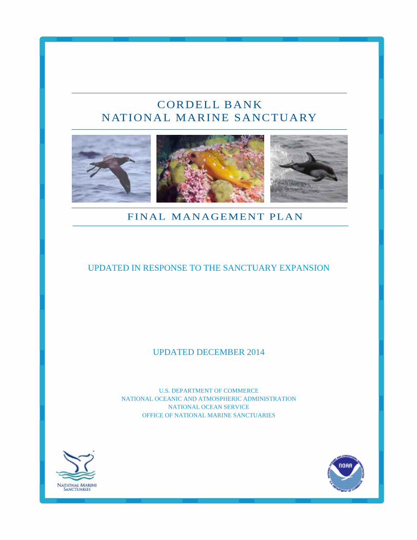
Cover Photo Credits:
Black-footed albatross (Phoebastria nigripes) –Rich Stallcup
Rosy rockfish (Sebastes rosaceus) –Jodi Pirtle/CBNMS
Pacific white-sided dolphin (Lagenorhynchus obliquidens) – Michael Carver/CBNMS
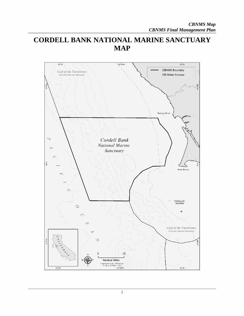
CBNMS Map
CBNMS Final Management Plan
i
CORDELL BANK NATIONAL MARINE SANCTUARY
MAP

Table of Contents
CBNMS Final Management Plan
iii
TABLE OF CONTENTS
Cordell Bank National Marine Sanctuary Map ............................................................................ i
Executive Summary ...................................................................................................................... iv
Introduction .................................................................................................................................... 1
Sanctuary Setting ........................................................................................................................... 8
Site-Specific Action Plans ............................................................................................................ 17
Structure of Action Plans ........................................................................................................19
Education and Outreach Action Plan ....................................................................................26 Performance Measures .......................................................................................................... 35
Resource Protection Action Plan ............................................................................................39 Performance Measures .......................................................................................................... 49
Partnerships with Community Groups Action Plan ............................................................53 Performance Measures .......................................................................................................... 57
Conservation Science Action Plan ..........................................................................................59 Performance Measures .......................................................................................................... 67
Administration Action Plan ....................................................................................................71 Proposed Staffing Plan .......................................................................................................... 75
Cross-CuttingAction Plans .......................................................................................................... 79
Cross-Cutting Introduction ....................................................................................................81
Administration and Operations Cross-Cutting Action Plan ...............................................83
Community Outreach Cross-Cutting Action Plan ...............................................................89
Ecosystem Monitoring Cross-Cutting Action Plan ...............................................................95
Maritime Heritage Cross-Cutting Action Plan ...................................................................103
Appendices ................................................................................................................................. 113
Appendix I: Jurisdictional Authorities .......................................................................... 115
Appendix II: Glossary of Terms ..................................................................................... 119
Appendix III: Acronyms ................................................................................................. 123
Appendix IV: National Marine Sanctuaries Act ........................................................... 127
Appendix V: Species List................................................................................................. 153
Executive Summary
CBNMS Final Management Plan
iv
EXECUTIVE SUMMARY
Current Status
This document is the management plan for Cordell Bank National Marine Sanctuary (CBNMS).
The National Oceanic and Atmospheric Administration (NOAA) prepared the management plan
in cooperation with sanctuary staff, the public, state and federal agencies, stakeholders, and the
Cordell Bank National Marine Sanctuary Advisory Council. The last version of the management
plan was published in 2008; it was updated in response to the boundary expansion of CBNMS.
The entire management plan has not been rewritten; the plan is scheduled to be reviewed five
years after the effective date of sanctuary expansion.
CBNMS Designation
CBNMS has been vested with the authority, in accordance with the National Marine Sanctuaries
Act (NMSA) to provide comprehensive and coordinated conservation and management of the
marine resources on the continental shelf and slope, from about 7 to 51 miles (6 to 44 nautical
miles) west of Bodega Head, California and about 52 miles (45 nautical miles) west-northwest of
San Francisco. The total area of the sanctuary is 1286 square miles. This is an area of special
significance due to unique geology and oceanic features that create conditions that support an
extraordinarily diverse and abundant marine community, and thus was designated a national
marine sanctuary in 1989. Cordell Bank is an offshore granite bank approximately 4.5 miles
wide by 9.5 miles long (3.9 nautical miles wide by 8.3 nautical miles long). The rocky bank
emerges from the soft sediments of the continental shelf, with the upper pinnacles reaching
within 115 feet of the ocean's surface. Shelf depths at the base of the Bank range from 300 to
400 feet deep. Another significant feature of the sanctuary is Bodega Canyon, which is north of
the Bank. The Canyon is about 12.4 miles (10.8 nautical miles) long and is over 5,000 feet deep.
History of Management Plans for CBNMS
The specific requirements of the CBNMS 1989 management plan were compatible with the
overall sanctuary management concept embodied in the NMSA and its implementing regulations
(15 CFR, Part 922), which require that a management plan be prepared for each national marine
sanctuary. This original management plan, developed at the time of designation of the sanctuary
in 1989, provided guidelines to ensure that all management actions undertaken in the first five
years of designation were directed to resolving important issues as a means of meeting CBNMS
objectives. Management objectives were considered in three areas: resource protection,
interpretation, and research. The management plan also called for promulgation of five
regulations or prohibitions.
The 1992 amendments to the NMSA required that each of the national marine sanctuaries engage
in a management plan review process periodically to reevaluate site-specific goals and
objectives, management techniques, and strategies. The Office of National Marine Sanctuaries
(ONMS) reviewed the management plans of Cordell Bank, Gulf of the Farallones, and Monterey
Executive Summary
CBNMS Final Management Plan
v
Bay national marine sanctuaries (CBNMS, GFNMS and MBNMS) jointly, and published
management plans for each site in 2008. These sanctuaries are located adjacent to one another,
are managed by ONMS, and share many of the same resources and issues. In addition, all three
sites share some overlapping interest and user groups. It was cost effective for the ONMS to
review the three sites jointly, rather than conducting three independent reviews.
The management plan review process provided CBNMS with the opportunity to: take a closer
look at environmental changes; better understand the cause and effect relationship of human
activity and natural perturbations on the marine resources; and engage the public in the
management decision making process. As a result of this process, CBNMS reshaped how it
manages sanctuary resources, from restructuring its program areas to updating its regulations.
The boundary expansion for CBNMS was both envisioned in an action plan strategy in the 2008
management plan (strategy AD-11 in that plan), and was also proposed legislatively for eight
years by then-Representative Lynn Woolsey and Senator Barbara Boxer. As part of its efforts to
evaluate the resource protection and other benefits from such a boundary expansion, NOAA has
produced this updated management plan, which is built upon the 2008 CBNMS final
management plan and is consistent with the Cordell Bank and Gulf of the Farallones National
Marine Sanctuaries Expansion Final Environmental Impact Statement (FEIS) and associated
final rule. Not all action plan strategies have been updated; many actions are ongoing, and some
have been revised. The overall action plans and ONMS requirements will apply to the expanded
CBNMS, if applicable.
Five action plans specific to CBNMS are contained in the management plan:
1. Education and Outreach
2. Resource Protection
3. Partnerships with Community Groups
4. Conservation Science
5. Administration
Updates in this plan from the 2008 management plan include: revisions to the description and
map of CBNMS; technical corrections, including removal of obsolete text and completed
strategies and actions and adding text relevant to the expanded sanctuary area; referencing where
the sanctuary regulations may be found in the Code of Federal Regulations online; renaming the
Ecosystem Protection Action Plan the Resource Protection Plan; moving the enforcement,
emergency response and regulations and permitting activities from the Administration Action
Plan to the Resource Protection Action Plan; adding an activity regarding ship strikes of whales
to the Resource Protection Action Plan; adding an activity to the Resource Protection Action
Plan to encourage and assist local and regional entities in improving the availability and use of
pump-out facilities and dump stations for vessels; adding an activity to the Resource Protection
Action Plan regarding participating in a national-level review of national marine sanctuary
Executive Summary
CBNMS Final Management Plan
vi
regulations pertaining to cruise ships for potential regulations changes; adding an activity to
evaluate specific previously proposed research activities to the Conservation Science Action
Plan; adding a new strategy and activity to the Administrative Action Plan to consider
conducting a public regulatory process to examine if additional regulatory amendments or
additions are needed to manage the expanded CBNMS (separately, or in conjunction with a
similar process for GFNMS); updating the Maritime Heritage Cross-Cutting Action Plan Issue
Description and Strategies XMHR-3 and 4 to reflect records located in 2014 of a historic
shipwreck in CBNMS; summarizing key partners at the action plan and cross-cutting action plan
level rather than at the strategy level; deleting specific products; revising action plan former
timelines and budgets into a summary implementation table in the Administration Action Plan;
and updating the species list appendix.


Introduction
CBNMS Final Management Plan
1
INTRODUCTION
OVERVIEW
Background about the Sanctuary
NOAA has been vested with the authority, in accordance with the National Marine Sanctuaries
Act (NMSA), to provide comprehensive and coordinated conservation and management of the
marine resources of Cordell Bank National Marine Sanctuary (CBNMS), off the north-central
coast of California. CBNMS is characterized by a combination of undersea topography and
oceanic conditions that provide for a highly productive environment in a discrete, well-defined
area. The Bank consists of a series of steep-sided ridges and narrow pinnacles resting on a
plateau 300 to 400 feet deep. The shallowest depth on Cordell Bank is 115 feet below the sea
surface, yet only a few miles to the west there are water depths of 6,000 feet. Another important
feature of CBNMS is Bodega Canyon, which is north of the Bank. The Canyon is about 12.4
miles (10.8 nautical miles) long and over 5,200 feet deep. CBNMS protects an area of 1286
square miles (mi²) (971 square nautical miles).
Point Arena is one of the major upwelling centers along the west coast of the United States.
Prevailing currents push nutrients from upwelling southward along the coast, moving nutrients
and other prey over the upper levels of the Bank. These highly productive waters sustain a
vigorous biological community that includes various algae and numerous invertebrates, fishes,
marine mammals, sea turtles and seabirds. The combination of sedentary plants and animals
typical of nearshore waters in close proximity to open ocean species like blue whales and
albatross creates a rare mix of species and a unique biological community at Cordell Bank.
Bodega Canyon is a prominent submarine feature in close proximity to Cordell Bank. This
seafloor feature cuts across the continental shelf and slope about 10 miles (8.5 nautical miles)
north of Cordell Bank. Submarine canyons provide areas of high bathymetric complexity,
support deep water communities, and affect local and regional circulation patterns. Bodega
Canyon provides habitat for adult stages of groundfish including rockfish and flatfish that rear in
nearshore waters and move offshore in their adult stages. Limited work in Bodega Canyon
revealed mud draped hard bottom on the canyon edges with deep corals and fishes associated
with the hard substrate (CBNMS unpublished report). In addition, offshore canyons and other
bathymetric features are important foraging areas for seabirds and marine mammals (Yen et al.
20041).
The eastern edge of the sanctuary is located about 7 miles (6 nautical miles) from shore at Point
Reyes and is separated from the coast of Marin and Sonoma counties by Gulf of the Farallones
National Marine Sanctuary (GFNMS). The coastal areas of west Marin and Sonoma counties are
sparsely populated, with ranching, dairy farms, agriculture, and public open space maintaining
1 Yen, P.W., W.J. Sydeman, and K.D. Hyrenbach. 2004. Marine bird and cetacean associations with bathymetric habitats and
shallow-water topographies: implications for trophic transfer and conservation. Journal of Marine Systems 50 pp. 79 – 99.
Introduction
CBNMS Final Management Plan
2
the rural character. Bodega Bay is a fishing port that harbors the closest marinas to the
sanctuary. The harbor also serves as the departure point for charter vessels that provide
recreational fishing and wildlife viewing opportunities in the sanctuary, although access to the
sanctuary is often limited by unfavorable sea conditions.
History of CBNMS
In July 1981, the National Oceanic and Atmospheric Administration (NOAA) received a
recommendation to establish Cordell Bank as a National Marine Sanctuary from Cordell
Expeditions, a non-profit organization dedicated to the exploration and description of the Bank.
NOAA evaluated the recommendation in accordance with the requirements of the National
Marine Sanctuary Program (now Office of National Marine Sanctuaries or ONMS) regulations
(15 CFR 922). Cordell Bank was found eligible for inclusion on the List of Recommended
Areas (LRA) and was placed on the LRA in 1981. More complete information on the site was
collected by NOAA and incorporated into a resource summary and site description that was
distributed to the public and agencies for comment in 1982. It was determined that Cordell Bank
was an area of special significance that was not adequately protected. The final rule went into
place in 1989, and Cordell Bank was designated a national marine sanctuary.
The original management plan, developed at the time of designation of the sanctuary, provided
guidelines to ensure that all management actions undertaken in the first five years of designation
were directed to resolving important issues as a means of meeting sanctuary objectives.
Management objectives were considered in three areas: resource protection, interpretation, and
research. The management plan also called for promulgation of five regulations or prohibitions.
The operation and management of CBNMS was originally combined with that of the adjacent
GFNMS, then known as the Point-Reyes Farallon Islands National Marine Sanctuary. Under
this approach, the management of the research, education, and resource protection programs was
a collateral function of the GFNMS manager. In 1998, a separate budget was allocated to
manage CBNMS independently of GFNMS and over the next few years additional staff
members were hired along with a sanctuary superintendent in 2003.
The proposal to expand CBNMS was initiated with a notice in the Federal Register on
December 21, 2012. The boundary expansion for CBNMS was both envisioned in an action plan
strategy in the 2008 management plan (strategy AD-11 in that plan), and was also proposed
legislatively for eight years by then-Representative Lynn Woolsey and Senator Barbara Boxer. A
Cordell Bank and Gulf of the Farallones Expansion Draft EIS, draft management plans for both
sanctuaries and the proposed rule were published in April 2014 (April 4 for the DEIS and April
14 for the draft management plans and proposed rule). Public comment was accepted from the
dates of publication of the documents through June 30, 2014. NOAA considered the comments
in the creation of this final management plan, the final environmental impact statement (FEIS)
for this action, and the final rule. This plan has been released concurrently with the FEIS,
followed by the final rule no less than 30 days later. The final rule would become effective after
a review period of 45-day of continuous session of Congress.
Introduction
CBNMS Final Management Plan
3
After expansion of its boundaries, CBNMS protects a total of 1286 mi² (971 square nautical
miles) including Bodega Canyon, an increase of 757 mi² over the original sanctuary area of 572
square nautical miles.
THE CBNMS MANAGEMENT PLAN
The overall management of CBNMS is carried out through two complementary elements:
regulatory and non-regulatory.
The regulatory component includes both site-specific regulations or prohibitions and general
regulations that apply to all thirteen national marine sanctuaries. Regulations are used to control
or restrict human behavior that is not compatible with resource protection. National Marine
Sanctuary regulations are codified in the Code of Federal Regulations (CFR), at Title 15 -
Commerce and Foreign Trade, Part 922. These may be accessed on the U.S. Government
Printing Office Electronic CFR web site, at http://www.ecfr.gov.
The non-regulatory component is largely described in the management plan and includes
CBNMS’s three program areas: Education and Outreach; Conservation Science; and Resource
Protection. These three program areas are supported by an administrative framework that
ensures all resource management activities are coordinated and provides an appropriate
infrastructure to help meet the goals and objectives set forth by this management plan.
Collectively, the above-mentioned parts make up the whole of the management plan and all the
parts are important tools for effective resource management.
The management plan is structured to address the priority resource management issue areas
identified during the Joint Management Plan Review (JMPR), which include the three program
areas mentioned above as well as partnerships with community groups and administration.
The spatial context for addressing these issues is not limited by the geographically drawn, and
often politically driven, boundaries of just a single sanctuary, but is across CBNMS, GFNMS,
and Monterey Bay National Marine Sanctuary (MBNMS) as well as areas outside these
sanctuaries. For that reason, the cross-cutting action plans were developed as a result of the
JMPR. The goals of these cross-cutting action plans are to build upon existing coordination
efforts and identify activities that should be jointly implemented so that these three sanctuaries
can operate as integrated and complementary sites to better protect the sanctuary resources. This
ensures scarce program resources are used more efficiently and that the result is more consistent
and coordinated delivery of programs, products and services to the public. The priority cross-
cutting action plans include: Administration and Operations Community Outreach; Ecosystem
Monitoring; and Maritime Heritage.
Management Plan Reviews
The 1992 congressional legislation that reauthorized the NMSA required that each of the
national marine sanctuaries engage in a management plan review process to reevaluate site-
Introduction
CBNMS Final Management Plan
4
specific goals and objectives, management techniques, and strategies. The periodic management
plan review process allows national marine sanctuaries the opportunity to: take a closer look at
how the environment has changed; better understand the cause and effect relationship of human
activity and natural perturbations on the marine resources; and engage the public in the
management decision making process. As a result of the JMPR, in 2008 CBNMS reshaped how
it manages the marine resources by restructuring its program areas and regulations. Management
issues are complicated by many factors including: incomplete ecosystem-based scientific
knowledge on which to base decisions; the diversity of uses and interests that need to be
considered; the environmental, social, economic, and cultural value of the resources; and the
complexity and diversity of the marine resources themselves.
The management plans of CBNMS, GFNMS, and MBNMS were jointly reviewed as part of the
JMPR, and were published in 2008 with the FEIS for each sanctuary. These sanctuaries are
located adjacent to one another, are managed by the same NOAA office, and share many of the
same resources and issues. In addition, all three sites share some overlapping interest and user
groups. During the review, the sanctuaries evaluated management and operational strategies,
regulations, and boundaries. The review process provided an opportunity to better coordinate
programs among the three sanctuaries, and included public and Sanctuary Advisory Council
reviews and issue prioritization.
As described above in the “History of CBNMS,” the management plan was again reviewed and
updated in 2014, in response to the sanctuary expansion. This document is the result of that
update.
The Value in Building Community Partnerships
The Sanctuary Advisory Council for CBNMS includes two agency and seven stakeholder
representatives, with an alternate for each seat. The Sanctuary Advisory Council provides advice
to sanctuary management and serves as a liaison to the community. Sanctuary Advisory Council
meetings provide a platform for public input on the management of the marine resources of
CBNMS. This partnership has allowed CBNMS to make use of and build on the knowledge,
roles, and resources that the private sector and other agencies have to offer. The Sanctuary
Advisory Council has also been a vehicle for drawing in public support, making progress
through cooperation, and including the community in the decision-making process.
BUILDING A MANAGEMENT PLAN
Vision Statement
The vision, goals, and objectives that follow are based on those in the original management plan.
At the commencement of the JMPR process, CBNMS staff worked together to build a vision for
the future of the site that reflects the sanctuary framework and needs. That vision, with small
wording changes, still applies today:
CBNMS is characterized by a combination of oceanic conditions and undersea
topography that supports rich and diverse marine communities. Two worlds come
Introduction
CBNMS Final Management Plan
5
together at this offshore site: open ocean species thrive in close proximity to a benthic
reef community.
CBNMS’s highest priority is resource protection. CBNMS takes a leading role in
ecosystem management, focusing on biological and physical processes. Together, with
our partners, we work to protect biological communities and their habitats. By
addressing current management issues and anticipating future challenges to CBNMS, we
strive to maintain a healthy marine environment now and for future generations.
CBNMS Goals and Objectives
In order to be consistent with the guiding legislation established in the NMSA, the overriding
mandate for the thirteen national marine sanctuaries, CBNMS has the following priority goals:
Improve the conservation, understanding, management, and sustainable use of marine
resources;
Enhance public awareness, understanding, and appreciation of the marine environment;
Investigate and enhance understanding of ecosystem processes through continued
scientific research, monitoring, and characterization to support ecosystem-based
management.
Maintain for future generations the habitat and ecological integrity of the natural
assemblage of living resources that inhabit these areas;
Maintain the natural biological communities, protecting and (where appropriate) restoring
natural habitats, populations, and ecological processes;
Provide authority for comprehensive and coordinated conservation and management of
these marine areas and activities affecting them, in a manner that complements existing
regulatory authorities;
Create models of, and incentives for, ways to conserve and manage these areas, including
the application of innovative management techniques; and
Cooperate with global programs encouraging conservation of marine resources.
The management strategies outlined in the plan for CBNMS aim to meet these goals and
objectives. It should be noted that although the goals and objectives are listed discretely, they
are overlapping. Collectively, the management strategies developed in the management plan
address the full range of goals and objectives set forth in the previous paragraph.
Addressing Goals and Objectives within an Ecosystem Context
These priority goals and objectives lead CBNMS to take an ecosystem-based approach to
managing a fluid marine environment with great temporal and spatial complexity and diversity.
Introduction
CBNMS Final Management Plan
6
CBNMS’s experience during the management plan review process has shown that the scientific
community, resource agencies, and the public recognize the importance of an integrated
ecosystem-based approach to protect marine biodiversity and habitats. The ONMS’s emphasis
on marine ecosystem management is consistent with other state and federal agencies’ programs
and initiatives.
Tools for Effective Management Planning
CBNMS’s management plan was built not only to protect the marine resources and biodiversity,
but also to consider maintenance of economic equity, cultural integrity, and human social
structures. In order to better evaluate human-use activities, their impacts on the resources, and
compatibility with resource protection, CBNMS used three strategic tools in the development of
the management plan: science, socioeconomics, and local knowledge.
Science
Protection of living and nonliving marine resources is the primary objective of the ONMS, and
science serves an important role in understanding, measuring, and predicting change in the status
of the marine ecosystem. Scientific inventories, research, and monitoring provide an important
information base for resource managers to understand and evaluate the effectiveness of
management regimes. NOAA collected data from individual researchers and institutions
throughout the region and, where possible, integrated it into a Geographic Information System
(GIS) to spatially identify significant living and nonliving marine resources, habitats, and
physical and geological features. These data were used to help describe and define the
ecosystem, identify areas of special significance, and locate important ecosystem support
systems.
Socioeconomics
In California alone, ocean industries such as fishing and shipping account for approximately 2
percent of the gross domestic product, amounting to roughly $800 billion annually. These
numbers paint an important picture about the need to properly manage the marine resources. A
sustainable community recognizes both ecosystem sustainability and economic sustainability as
mutually beneficial. The ONMS considers not only the potential cost of management restrictions
on income generating activities, but also public benefits derived from long-term protection of
nationally significant resources.
Local Knowledge
Local knowledge represents the voice of direct experience and interaction with the marine
resources over time. The knowledge of locals is more extensive and long range than much of the
scientific research available for the study area. CBNMS not only honors and incorporates local
knowledge, but also realizes stakeholder groups have a deep and integrated respect for the
natural world. These local voices represent local interests, issues, and concerns to be balanced
against those from the outside. The advisory council, local mariners, and the public provided
valuable input to the development and update of this management plan.
Introduction
CBNMS Final Management Plan
7
Looking at the Next Five Years and Beyond
Since its establishment in 1972, the ONMS has been building models for better marine resource
management. But even today, with better knowledge of the natural world and more experience
managing human behavior, the ONMS continues to build new models to enhance resource
protection. This is why we call the CBNMS management plan a “living document,” serving as a
flexible and responsive framework for managing impacts on natural marine systems.
This “living document” also serves as a proactive tool for planning a sustainable future. To
ensure a sustainable future, CBNMS’s “living document” will provide a framework for not only
addressing the resource management issues of the present, but also anticipating those emerging
issues of the future.
The emergence of new issues and other unforeseeable factors may affect specific aspects of
sanctuary management as described in this plan. However, the overall goals, management
objectives, and general guidelines will continue to be relevant. The aim is to carefully adjust the
plan to changing circumstances in light of the experience gained in actual management.
Modification to the scope and scale of the action plans may have to be made due to
unforeseeable changes in levels of funding. Again, the goals and objectives of the plan will
remain unchanged.
Sanctuary Setting
CBNMS Final Management Plan
8
SANCTUARY SETTING
PHYSICAL SETTING
Location
CBNMS protects an area of 1286 mi² (971 square nautical miles) off the north-central California
coast. Significant features of the sanctuary include Cordell Bank, an offshore granite bank
located on the edge of the continental shelf, about 52 miles (45 nautical miles) west-northwest of
San Francisco and 23 miles (20 nautical miles) west of the Point Reyes lighthouse in an open
ocean environment, and Bodega Canyon, a prominent seafloor feature that cuts across the
continental slope and into the shelf north of Cordell Bank. CBNMS is entirely offshore, in
federal waters, and shares its southern, eastern, and northern boundaries with GFNMS. The
CBNMS eastern boundary about 7 miles (6 nautical miles) from shore at Bodega Head and the
western boundary is on the continental slope about 51 miles (44 nautical miles) west of Bodega
Head. CBNMS is located in one of the world’s four major coastal upwelling systems. The
combination of oceanic conditions and undersea topography provides for a highly productive
environment in a discrete, well-defined area. The vertical relief and hard substrate of the Bank
provides benthic habitat with nearshore characteristics. Physical and biological processes
associated with the Bodega Canyon make this a dynamic oceanographic area.
Geology
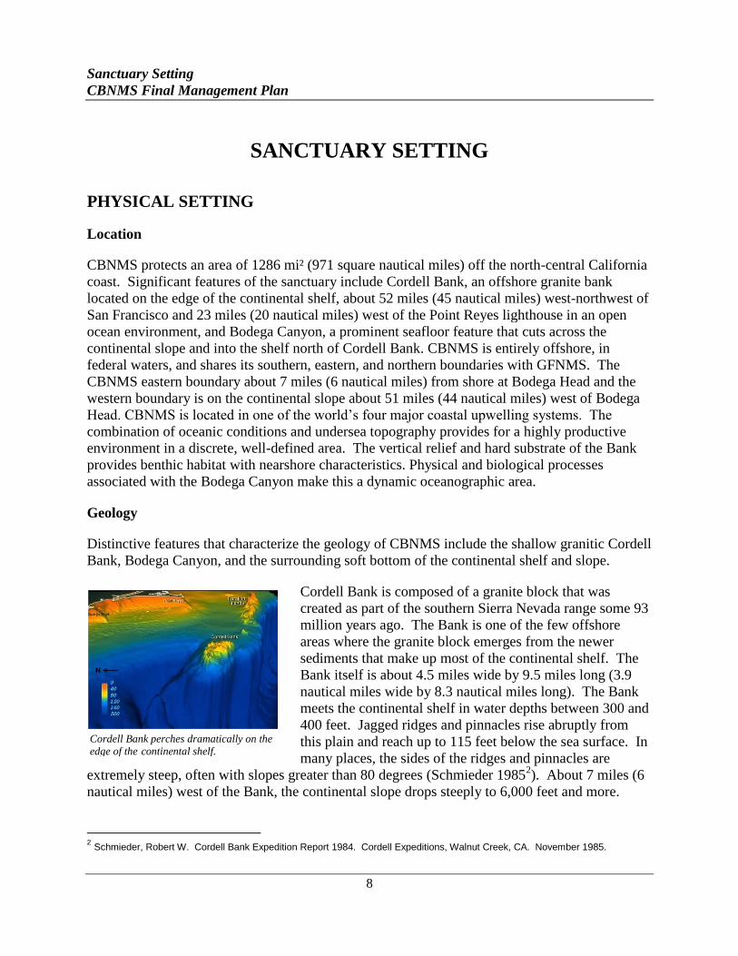
Distinctive features that characterize the geology of CBNMS include the shallow granitic Cordell
Bank, Bodega Canyon, and the surrounding soft bottom of the continental shelf and slope.
Cordell Bank is composed of a granite block that was
created as part of the southern Sierra Nevada range some 93
million years ago. The Bank is one of the few offshore
areas where the granite block emerges from the newer
sediments that make up most of the continental shelf. The
Bank itself is about 4.5 miles wide by 9.5 miles long (3.9
nautical miles wide by 8.3 nautical miles long). The Bank
meets the continental shelf in water depths between 300 and
400 feet. Jagged ridges and pinnacles rise abruptly from
this plain and reach up to 115 feet below the sea surface. In
many places, the sides of the ridges and pinnacles are
extremely steep, often with slopes greater than 80 degrees (Schmieder 19852). About 7 miles (6
nautical miles) west of the Bank, the continental slope drops steeply to 6,000 feet and more.
2 Schmieder, Robert W. Cordell Bank Expedition Report 1984. Cordell Expeditions, Walnut Creek, CA. November 1985.
Cordell Bank perches dramatically on the
edge of the continental shelf.
Sanctuary Setting
CBNMS Final Management Plan
9
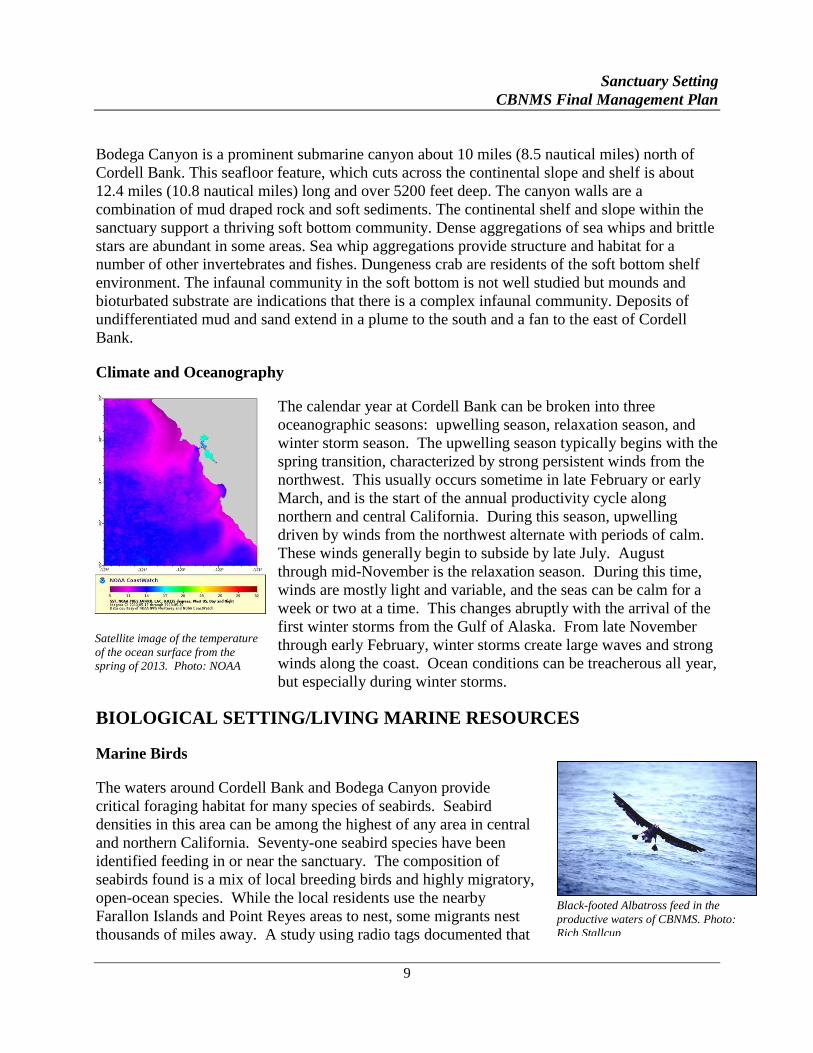
Satellite image of the temperature of the ocean surface from the
spring of 2013. Photo: NOAA
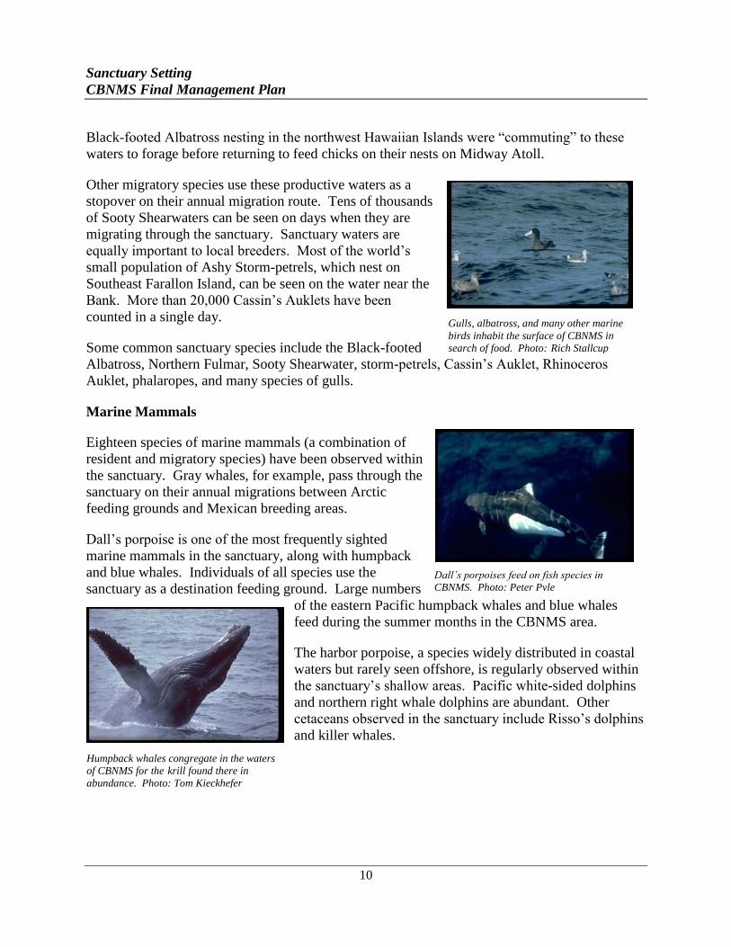
Black-footed Albatross feed in the
productive waters of CBNMS. Photo:
Rich Stallcup
Bodega Canyon is a prominent submarine canyon about 10 miles (8.5 nautical miles) north of
Cordell Bank. This seafloor feature, which cuts across the continental slope and shelf is about
12.4 miles (10.8 nautical miles) long and over 5200 feet deep. The canyon walls are a
combination of mud draped rock and soft sediments. The continental shelf and slope within the
sanctuary support a thriving soft bottom community. Dense aggregations of sea whips and brittle
stars are abundant in some areas. Sea whip aggregations provide structure and habitat for a
number of other invertebrates and fishes. Dungeness crab are residents of the soft bottom shelf
environment. The infaunal community in the soft bottom is not well studied but mounds and
bioturbated substrate are indications that there is a complex infaunal community. Deposits of
undifferentiated mud and sand extend in a plume to the south and a fan to the east of Cordell
Bank.
Climate and Oceanography
The calendar year at Cordell Bank can be broken into three
oceanographic seasons: upwelling season, relaxation season, and
winter storm season. The upwelling season typically begins with the
spring transition, characterized by strong persistent winds from the
northwest. This usually occurs sometime in late February or early
March, and is the start of the annual productivity cycle along
northern and central California. During this season, upwelling
driven by winds from the northwest alternate with periods of calm.
These winds generally begin to subside by late July. August
through mid-November is the relaxation season. During this time,
winds are mostly light and variable, and the seas can be calm for a
week or two at a time. This changes abruptly with the arrival of the
first winter storms from the Gulf of Alaska. From late November
through early February, winter storms create large waves and strong
winds along the coast. Ocean conditions can be treacherous all year,
but especially during winter storms.
BIOLOGICAL SETTING/LIVING MARINE RESOURCES
Marine Birds
The waters around Cordell Bank and Bodega Canyon provide
critical foraging habitat for many species of seabirds. Seabird
densities in this area can be among the highest of any area in central
and northern California. Seventy-one seabird species have been
identified feeding in or near the sanctuary. The composition of
seabirds found is a mix of local breeding birds and highly migratory,
open-ocean species. While the local residents use the nearby
Farallon Islands and Point Reyes areas to nest, some migrants nest
thousands of miles away. A study using radio tags documented that
Sanctuary Setting
CBNMS Final Management Plan
10
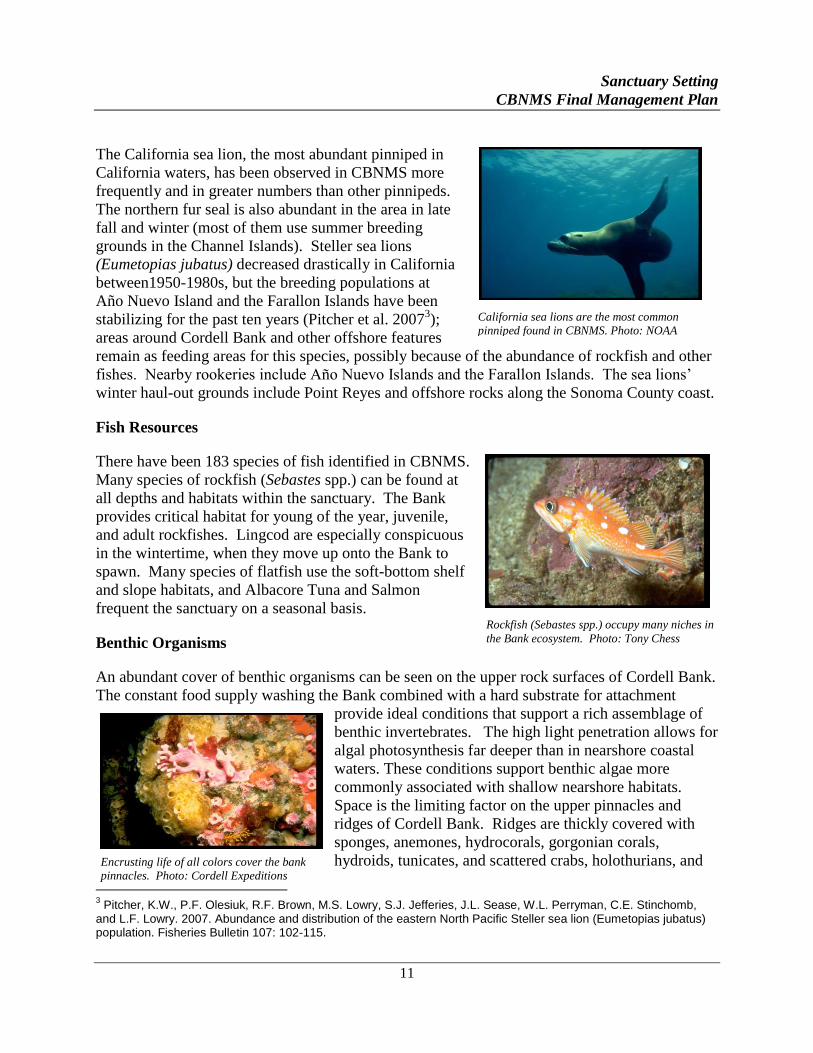
Gulls, albatross, and many other marine
birds inhabit the surface of CBNMS in
search of food. Photo: Rich Stallcup
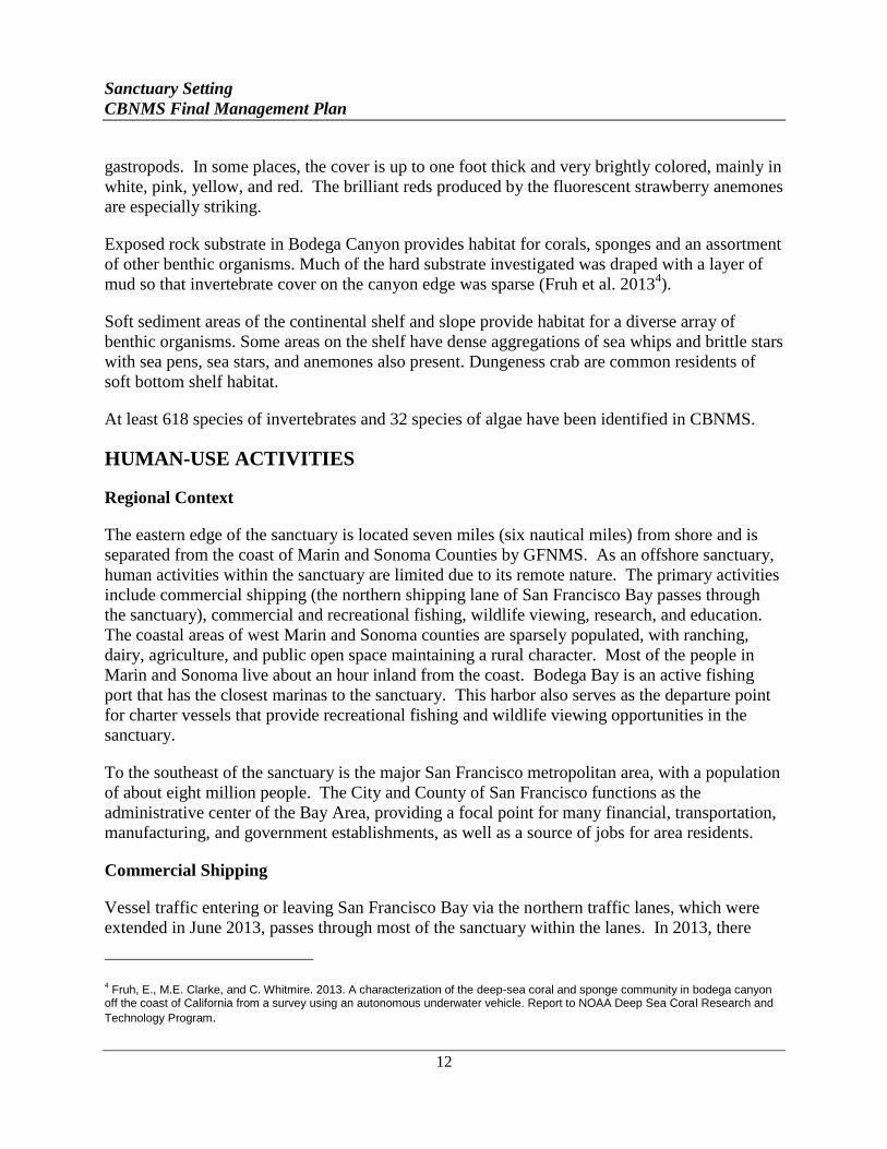
Humpback whales congregate in the waters
of CBNMS for the krill found there in
abundance. Photo: Tom Kieckhefer
Black-footed Albatross nesting in the northwest Hawaiian Islands were “commuting” to these
waters to forage before returning to feed chicks on their nests on Midway Atoll.
Other migratory species use these productive waters as a
stopover on their annual migration route. Tens of thousands
of Sooty Shearwaters can be seen on days when they are
migrating through the sanctuary. Sanctuary waters are
equally important to local breeders. Most of the world’s
small population of Ashy Storm-petrels, which nest on
Southeast Farallon Island, can be seen on the water near the
Bank. More than 20,000 Cassin’s Auklets have been
counted in a single day.
Some common sanctuary species include the Black-footed
Albatross, Northern Fulmar, Sooty Shearwater, storm-petrels, Cassin’s Auklet, Rhinoceros
Auklet, phalaropes, and many species of gulls.
Marine Mammals
Eighteen species of marine mammals (a combination of
resident and migratory species) have been observed within
the sanctuary. Gray whales, for example, pass through the
sanctuary on their annual migrations between Arctic
feeding grounds and Mexican breeding areas.
Dall’s porpoise is one of the most frequently sighted
marine mammals in the sanctuary, along with humpback
and blue whales. Individuals of all species use the
sanctuary as a destination feeding ground. Large numbers
of the eastern Pacific humpback whales and blue whales
feed during the summer months in the CBNMS area.
The harbor porpoise, a species widely distributed in coastal
waters but rarely seen offshore, is regularly observed within
the sanctuary’s shallow areas. Pacific white-sided dolphins
and northern right whale dolphins are abundant. Other
cetaceans observed in the sanctuary include Risso’s dolphins
and killer whales.
Dall’s porpoises feed on fish species in
CBNMS. Photo: Peter Pyle
Sanctuary Setting
CBNMS Final Management Plan
11
California sea lions are the most common
pinniped found in CBNMS. Photo: NOAA nnnnnNOAANOAANOAA
Rockfish (Sebastes spp.) occupy many niches in
the Bank ecosystem. Photo: Tony Chess
The California sea lion, the most abundant pinniped in
California waters, has been observed in CBNMS more
frequently and in greater numbers than other pinnipeds.
The northern fur seal is also abundant in the area in late
fall and winter (most of them use summer breeding
grounds in the Channel Islands). Steller sea lions
(Eumetopias jubatus) decreased drastically in California
between1950-1980s, but the breeding populations at
Año Nuevo Island and the Farallon Islands have been
stabilizing for the past ten years (Pitcher et al. 20073);
areas around Cordell Bank and other offshore features
remain as feeding areas for this species, possibly because of the abundance of rockfish and other
fishes. Nearby rookeries include Año Nuevo Islands and the Farallon Islands. The sea lions’
winter haul-out grounds include Point Reyes and offshore rocks along the Sonoma County coast.
Fish Resources
There have been 183 species of fish identified in CBNMS.
Many species of rockfish (Sebastes spp.) can be found at
all depths and habitats within the sanctuary. The Bank
provides critical habitat for young of the year, juvenile,
and adult rockfishes. Lingcod are especially conspicuous
in the wintertime, when they move up onto the Bank to
spawn. Many species of flatfish use the soft-bottom shelf
and slope habitats, and Albacore Tuna and Salmon
frequent the sanctuary on a seasonal basis.
Benthic Organisms
An abundant cover of benthic organisms can be seen on the upper rock surfaces of Cordell Bank.
The constant food supply washing the Bank combined with a hard substrate for attachment
provide ideal conditions that support a rich assemblage of
benthic invertebrates. The high light penetration allows for
algal photosynthesis far deeper than in nearshore coastal
waters. These conditions support benthic algae more
commonly associated with shallow nearshore habitats.
Space is the limiting factor on the upper pinnacles and
ridges of Cordell Bank. Ridges are thickly covered with
sponges, anemones, hydrocorals, gorgonian corals,
hydroids, tunicates, and scattered crabs, holothurians, and
3 Pitcher, K.W., P.F. Olesiuk, R.F. Brown, M.S. Lowry, S.J. Jefferies, J.L. Sease, W.L. Perryman, C.E. Stinchomb,
and L.F. Lowry. 2007. Abundance and distribution of the eastern North Pacific Steller sea lion (Eumetopias jubatus) population. Fisheries Bulletin 107: 102-115.
Encrusting life of all colors cover the bank
pinnacles. Photo: Cordell Expeditions
Sanctuary Setting
CBNMS Final Management Plan
12
gastropods. In some places, the cover is up to one foot thick and very brightly colored, mainly in
white, pink, yellow, and red. The brilliant reds produced by the fluorescent strawberry anemones
are especially striking.
Exposed rock substrate in Bodega Canyon provides habitat for corals, sponges and an assortment
of other benthic organisms. Much of the hard substrate investigated was draped with a layer of
mud so that invertebrate cover on the canyon edge was sparse (Fruh et al. 20134).
Soft sediment areas of the continental shelf and slope provide habitat for a diverse array of
benthic organisms. Some areas on the shelf have dense aggregations of sea whips and brittle stars
with sea pens, sea stars, and anemones also present. Dungeness crab are common residents of
soft bottom shelf habitat.
At least 618 species of invertebrates and 32 species of algae have been identified in CBNMS.
HUMAN-USE ACTIVITIES
Regional Context
The eastern edge of the sanctuary is located seven miles (six nautical miles) from shore and is
separated from the coast of Marin and Sonoma Counties by GFNMS. As an offshore sanctuary,
human activities within the sanctuary are limited due to its remote nature. The primary activities
include commercial shipping (the northern shipping lane of San Francisco Bay passes through
the sanctuary), commercial and recreational fishing, wildlife viewing, research, and education.
The coastal areas of west Marin and Sonoma counties are sparsely populated, with ranching,
dairy, agriculture, and public open space maintaining a rural character. Most of the people in
Marin and Sonoma live about an hour inland from the coast. Bodega Bay is an active fishing
port that has the closest marinas to the sanctuary. This harbor also serves as the departure point
for charter vessels that provide recreational fishing and wildlife viewing opportunities in the
sanctuary.
To the southeast of the sanctuary is the major San Francisco metropolitan area, with a population
of about eight million people. The City and County of San Francisco functions as the
administrative center of the Bay Area, providing a focal point for many financial, transportation,
manufacturing, and government establishments, as well as a source of jobs for area residents.
Commercial Shipping
Vessel traffic entering or leaving San Francisco Bay via the northern traffic lanes, which were
extended in June 2013, passes through most of the sanctuary within the lanes. In 2013, there
4 Fruh, E., M.E. Clarke, and C. Whitmire. 2013. A characterization of the deep-sea coral and sponge community in bodega canyon
off the coast of California from a survey using an autonomous underwater vehicle. Report to NOAA Deep Sea Coral Research and
Technology Program.
Sanctuary Setting
CBNMS Final Management Plan
13
Commercial and recreational fishing target rockfish,
Salmon, and pelagic species. Photo: NOAA
were 2,026 vessel transits of the northern traffic lanes in and out of San Francisco Bay. Of these,
720 were inbound and 1306 were outbound. San Francisco is a staging port for cruise ships
traveling north through CBNMS to Oregon, Washington and Alaska and, to a lesser degree, for
cruise ships going south to Monterey or other locations. Annually, the Port of San Francisco
reports it has approximately 60-80 cruise ship calls and 200,000 passengers.
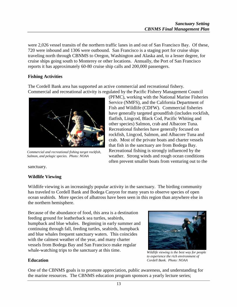
Fishing Activities
The Cordell Bank area has supported an active commercial and recreational fishery.
Commercial and recreational activity is regulated by the Pacific Fishery Management Council
(PFMC), working with the National Marine Fisheries
Service (NMFS), and the California Department of
Fish and Wildlife (CDFW). Commercial fisheries
have generally targeted groundfish (includes rockfish,
flatfish, Lingcod, Black Cod, Pacific Whiting and
other species) Salmon, crab and Albacore Tuna.
Recreational fisheries have generally focused on
rockfish, Lingcod, Salmon, and Albacore Tuna and
crab. Most of the private boats and charter vessels
that fish in the sanctuary are from Bodega Bay.
Recreational fishing is strongly influenced by the
weather. Strong winds and rough ocean conditions
often prevent smaller boats from venturing out to the
sanctuary.
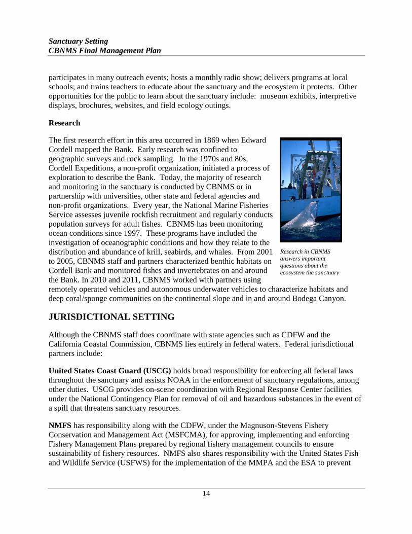
Wildlife Viewing
Wildlife viewing is an increasingly popular activity in the sanctuary. The birding community
has traveled to Cordell Bank and Bodega Canyon for many years to observe species of open
ocean seabirds. More species of albatross have been seen in this region than anywhere else in
the northern hemisphere.
Because of the abundance of food, this area is a destination
feeding ground for leatherback sea turtles, seabirds,
humpback and blue whales. Beginning in early summer and
continuing through fall, feeding turtles, seabirds, humpback
and blue whales frequent sanctuary waters. This coincides
with the calmest weather of the year, and many charter
vessels from Bodega Bay and San Francisco make regular
whale-watching trips to the sanctuary at this time.
Education
One of the CBNMS goals is to promote appreciation, public awareness, and understanding for
the marine resources. The CBNMS education program sponsors a yearly lecture series;
Wildlife viewing is the best way for people
to experience the rich environment of
Cordell Bank. Photo: NOAA
Sanctuary Setting
CBNMS Final Management Plan
14
participates in many outreach events; hosts a monthly radio show; delivers programs at local
schools; and trains teachers to educate about the sanctuary and the ecosystem it protects. Other
opportunities for the public to learn about the sanctuary include: museum exhibits, interpretive
displays, brochures, websites, and field ecology outings.
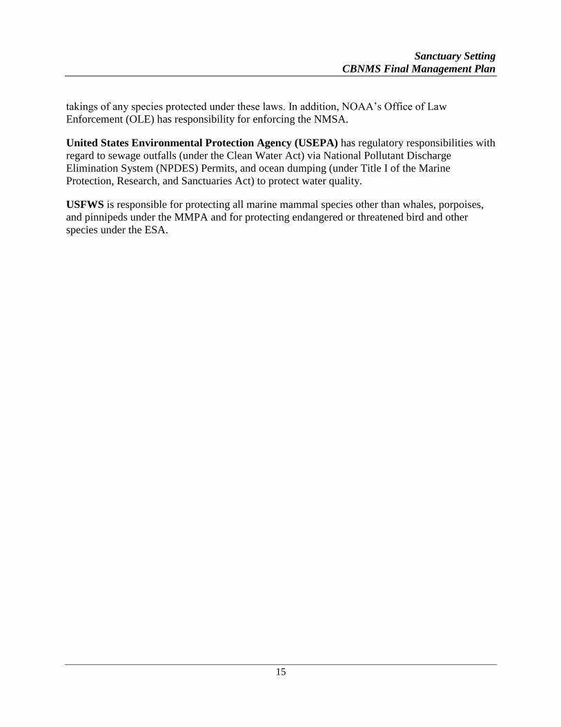
Research
The first research effort in this area occurred in 1869 when Edward
Cordell mapped the Bank. Early research was confined to
geographic surveys and rock sampling. In the 1970s and 80s,
Cordell Expeditions, a non-profit organization, initiated a process of
exploration to describe the Bank. Today, the majority of research
and monitoring in the sanctuary is conducted by CBNMS or in
partnership with universities, other state and federal agencies and
non-profit organizations. Every year, the National Marine Fisheries
Service assesses juvenile rockfish recruitment and regularly conducts
population surveys for adult fishes. CBNMS has been monitoring
ocean conditions since 1997. These programs have included the
investigation of oceanographic conditions and how they relate to the
distribution and abundance of krill, seabirds, and whales. From 2001
to 2005, CBNMS staff and partners characterized benthic habitats on
Cordell Bank and monitored fishes and invertebrates on and around
the Bank. In 2010 and 2011, CBNMS worked with partners using
remotely operated vehicles and autonomous underwater vehicles to characterize habitats and
deep coral/sponge communities on the continental slope and in and around Bodega Canyon.
JURISDICTIONAL SETTING
Although the CBNMS staff does coordinate with state agencies such as CDFW and the
California Coastal Commission, CBNMS lies entirely in federal waters. Federal jurisdictional
partners include:
United States Coast Guard (USCG) holds broad responsibility for enforcing all federal laws
throughout the sanctuary and assists NOAA in the enforcement of sanctuary regulations, among
other duties. USCG provides on-scene coordination with Regional Response Center facilities
under the National Contingency Plan for removal of oil and hazardous substances in the event of
a spill that threatens sanctuary resources.
NMFS has responsibility along with the CDFW, under the Magnuson-Stevens Fishery
Conservation and Management Act (MSFCMA), for approving, implementing and enforcing
Fishery Management Plans prepared by regional fishery management councils to ensure
sustainability of fishery resources. NMFS also shares responsibility with the United States Fish
and Wildlife Service (USFWS) for the implementation of the MMPA and the ESA to prevent
Research in CBNMS
answers important
questions about the
ecosystem the sanctuary
protects. Photo: NOAA
Sanctuary Setting
CBNMS Final Management Plan
15
takings of any species protected under these laws. In addition, NOAA’s Office of Law
Enforcement (OLE) has responsibility for enforcing the NMSA.
United States Environmental Protection Agency (USEPA) has regulatory responsibilities with
regard to sewage outfalls (under the Clean Water Act) via National Pollutant Discharge
Elimination System (NPDES) Permits, and ocean dumping (under Title I of the Marine
Protection, Research, and Sanctuaries Act) to protect water quality.
USFWS is responsible for protecting all marine mammal species other than whales, porpoises,
and pinnipeds under the MMPA and for protecting endangered or threatened bird and other
species under the ESA.

17
SITE-SPECIFIC
ACTION PLANS
CBNMS FINAL MANAGEMENT PLAN
I . Structure of Action Plans
II . Education and Outreach
III . Resource Protection
IV. Partnerships with Community Groups
V. Conservation Science
VI. Administration

Structure of Action Plans
CBNMS Final Management Plan
19
STRUCTURE OF ACTION PLANS
This management plan includes a set of functionally based action plans that outline how the
sanctuary will be managed for the next five to ten years. Each action plan outlines how different
strategies will be conducted and proposes performance indicators as a measure of management
effectiveness.
DEVELOPMENT OF ACTION PLANS
Through the management plan review and scoping for the proposed expansion, resource
management issues to be addressed in the management plan were identified. The following
issues and program areas are addressed in this management plan:
A. Education and Outreach
B. Resource Protection
C. Partnerships with Community Groups
D. Conservation Science
E. Administration
OUTLINE OF ACTION PLANS
Each action plan is divided into seven sections, which are described in detail below.
Issue Statement/Program Statement
The issue (or program) statement provides an introduction about “why” this is a priority issue to
be addressed by sanctuary management in the management plan. It may include a brief
description of the current situation or problem, and specific areas, which need attention.
Issue Description/Program Description
The issue (or program) description provides a general background on what the CBNMS staff
currently knows or understands about an issue. Program descriptions explicitly describe the
types of activities already undertaken by the CBNMS staff and the general direction it would like
to move in the future. It includes the status of natural resources, related human-use activities
occurring in the sanctuary, and jurisdictional authorities pertinent to the specific issue.
Goals
The goal states the desired future state of the CBNMS ecosystem and management actions
relevant to the specific resource management issue or program area. The goal is a broad
statement about a long-term desired outcome that may or may not be completely obtainable.
Structure of Action Plans
CBNMS Final Management Plan
20
Objectives
The objectives are measurable outcomes for evaluating progress and success in moving toward
the future desired condition.
Strategies
This section describes how the objectives will be accomplished for the particular issue or
program area. Each strategy addresses one or more objectives and is divided into specific
activities for the CBNMS staff to carry out. Activities are developed and implemented to
achieve the goals and objectives of the issue or program area.
Many activities within this plan complement each other by providing the groundwork for other
activities to take place or by being similar such that efficiencies can be achieved by working on
them together.
Performance Measures
Each action plan includes a chart presenting the outcomes expected and the performance
indicators that will be used to measure progress toward the outcome. This effort is being
undertaken to measure CBNMS management effectiveness (i.e. the achievement of a planned
effort or activity). The methodology to be used to assess the effectiveness of each strategy in
achieving the desired goal is detailed in this chart. The definitions for the performance measure
terminology follow.
Strategy The management action taken by the CBNMS staff to address a particular
issue.
Performance Goal The overarching, very broad target for the action plan. The goal(s) under
each issue area or program area action plan.
Desired Outcome
(Objective)
The more specific outcomes we want to achieve with our activities within
the scope of the performance goal. The objectives under each issue area
or program area action plan.
Outcome Measure A specific amount or degree of the indicator that shows progress towards
the desired outcome. Could contain temporal (by year) and range targets
(percent, fraction, etc.).
How Measured Describes exactly how the outcome measure will be measured.
Who Measures The staff or outside partner who will measure the outcome.
Output Measure A specific product or tool that results from the activity. Its production
demonstrates a completed objective.
Key Partners
Key partners are organizations that the sanctuary managers believe have common interests with
CBNMS on a particular activity. This list does not limit the partners CBNMS may work with,
Structure of Action Plans
CBNMS Final Management Plan
21
but merely serves as a guide when implementing the activity. The sanctuary staff may partner
with other organizations as work on a particular activity or strategy progresses. Likewise, the
products listed are projected, but additional or altered products may become more appropriate as
the strategy is completed.
IMPLEMENTATION OF THE MANAGEMENT PLAN
This plan is designed to guide management of the marine resources of CBNMS for the next five
to ten years. Implementation of this new management plan will require cooperation and
coordination among many federal, state, and local government agencies, as well as private
organizations and individuals. Information exchange, sharing facilities and staff, and the
coordination of policies and procedures within an ecosystem context are features of this
management plan and each of its program areas.
Limitations
Although this management plan for CBNMS details the action plans for the three program areas,
an action plan for community outreach, and an action plan for administration, how the strategies
within the action plans are implemented may be affected by multiple factors. These factors
include: (1) funding that comes primarily from congressional appropriations that may fluctuate
from year to year; (2) CBNMS’s ability to forge new partnerships in which staff, facilities and
financial resources may be shared; (3) CBNMS’s need to be responsive to the ever-changing
impacts on the sanctuary’s marine resources from both natural perturbations and human
activities; (4) an increased understanding of the complexity of the ecosystem, habitats, and living
marine resources; and (5) learning better ways to manage the resources through experience,
experimentation, and the sharing of knowledge. Sanctuary staff, the advisory council, the public,
and CBNMS’s partners will, as appropriate, provide oversight and guidance for redirecting any
management plan strategies.
Implementation of CBNMS Action Plans
Each of CBNMS’s program areas—Education and Outreach; Conservation Science; and
Resource Protection—has an associated action plan for implementing the management plan.
These action plans are designed to directly address resource management issues and guide
management of CBNMS over the next five to ten years. The level of implementation of an
action plan and its components will be based upon the funding or resources available each fiscal
year. As stated previously, full implementation of the management plan exceeds the resources
available to CBNMS, therefore requiring some prioritization of the action plan or strategies. As
resources become available, a greater level of implementation is possible. Implementation of
most of the strategies in this management plan requires some input or coordination from
partners, particularly other government agencies, research institutions and non-governmental
organizations (NGOs). Many action plans and strategies are completely dependent on
involvement from other agencies or dependent on research conducted by a research institution.
Implementation of the management plan will require: coordination within and between action
plans; sharing of staff and financial resources between program areas; and cooperation and
Structure of Action Plans
CBNMS Final Management Plan
22
coordination among many federal, state, and local government agencies, as well as private
organizations, institutions, and individuals.
Operating funds for CBNMS management come from federal appropriations to the ONMS.
These funds cover expenses such as personnel salaries, programs, vessel maintenance, property
rental, equipment, and supplies.
Unpredictable and variable funding for staff and program development may affect specific
aspects of the management plan. The scale and scope of certain programs may be modified due
to any unforeseeable changes in the level of funding; however the goals and objectives of the
plan will remain unchanged.
Funding for implementation of many of the strategies will require a mix of internal ONMS funds
as well as funding from external sources such as grants or in-kind work from partner agencies.
Table 1 depicts the implementation of the CBNMS Management Plan by Action Plan and
strategy, and shows several funding scenarios.
Structure of Action Plans
CBNMS Final Management Plan
23
Table 1: Implementation of CBNMS Management Plan
Table Legend
Strategy Status: Implementation
Ranking:
Necessary Partnership
Coordination:
Primary Funding
Sources:
– Existing w/o significant
modification
H – High
– Not possible w/o
partners
– External (e.g., grants)
– Existing w/significant
modification
M – Medium
– Significant reliance on
partners
– Internal/External
– New or future (not yet
implemented).
L – Low
– Little reliance on
partners
– Internal (increased
budget)
– Internal (base
budget)
Action Plans
Str
ate
gy
Sta
tus
Lev
el F
un
din
g
Sce
na
rio
1
Mo
der
ate
In
crea
se
Sce
na
rio
2
Su
bst
an
tia
l
Incr
ea
se
Sce
na
rio
3
Pa
rtn
ersh
ip
Co
ord
ina
tio
n
Inte
rna
l/E
xte
rn
al
Fu
nd
ing
So
urc
es
Education and Outreach
ED-1 General Outreach H H H
ED-2 Sanctuary Naturalist Program L M H
ED-3 Media and Communications H H H
ED-4 Educational Tools to Promote Ocean
Literacy H H H
ED-5 Interpretive Signage H H H
ED-6 Integrate Conservation Science into
Education H H H
ED-7 Adult Education M H H
ED-8 Education Working Group L M H
ED-9 Multicultural Programming L M H
Structure of Action Plans
CBNMS Final Management Plan
24
Table 1: Implementation of CBNMS Management Plan
Action Plans
Str
ate
gy
Sta
tus
Lev
el F
un
din
g
Sce
na
rio
1
Mo
der
ate
In
crea
se
Sce
na
rio
2
Su
bst
an
tia
l
Incr
ea
se
Sce
na
rio
3
Pa
rtn
ersh
ip
Co
ord
ina
tio
n
Inte
rna
l/E
xte
rn
al
Fu
nd
ing
So
urc
es
Resource Protection
RP-1 Track Human Use Activities H H H
RP-2 Address Ship Strikes of Whales H H H
RP-3 Profile Fishing Activities in Sanctuary M M M
RP-4 Assess Acoustic Impacts L M H
RP-5 Assess and Remove Marine Debris L M H
RP-6 Enforcement Plan H H H
RP-7: Emergency Response H H H
RP-8 Regulations and Permitting H H H
Partnerships with Community Groups
PC-1 Research Community Partnerships H H H
PC-2 Develop Sanctuary Advisory Council
Links to Community H H H
PC-3 Media Partnerships M M H
PC-4 Fiscal Partnerships H H H
Conservation Science
CS-1 Oceanographic Climatology Report L M H
CS-2 Habitat Characterization M H H
CS-3 Characterize Soft-Bottom Epifaunal
Communities L M H
CS-4 Characterize Soft-Bottom Infaunal
Communities L M M
CS-5 Voucher Specimen Collection L M H
CS-6 Survey Museum Collections L M M
Structure of Action Plans
CBNMS Final Management Plan
25
Table 1: Implementation of CBNMS Management Plan
Action Plans
Str
ate
gy
Sta
tus
Lev
el F
un
din
g
Sce
na
rio
1
Mo
der
ate
In
crea
se
Sce
na
rio
2
Su
bst
an
tia
l
Incr
ea
se
Sce
na
rio
3
Pa
rtn
ersh
ip
Co
ord
ina
tio
n
Inte
rna
l/E
xte
rn
al
Fu
nd
ing
So
urc
es
CS-7 Pelagic Monitoring H H H
CS-8 Fish and Invertebrate Monitoring H H H
CS-9 Data Management H H H
CS-10 Supply/Receipt of Larval Fishes L M M
CS-11 Proposed Research Activities L M H
Administration
AD-1 Operations M M H
AD-2 Staffing L M H
AD-3 Partnerships M H H
AD-4 Support Sanctuary Advisory Council H H H
AD-5 Interagency Coordination M H H
AD-6 Performance Evaluation Strategy H H H
AD-7 Consider Public Regulatory Process H H H
Education and Outreach Action Plan
CBNMS Final Management Plan
26
EDUCATION AND OUTREACH
ACTION PLAN
PROGRAM STATEMENT
CBNMS has developed a long-term education and outreach action plan that builds a greater
understanding of the sanctuary ecosystem. This action plan seeks to emphasize the ocean’s
influence on people and people’s influence on the ocean using the sanctuary and the greater
California Current ecosystem as a focus. CBNMS will work to increase ocean literacy and
awareness of the national marine sanctuaries to encourage ocean stewardship.
PROGRAM DESCRIPTION
This action plan addresses the need to cultivate an informed, involved constituency who cares
about protecting, conserving, and restoring our precious ocean resources and national marine
sanctuaries. It aligns with NOAA’s identified need to build a more informed and involved ocean
literate public. In addition, the U.S. Commission on Ocean Policy’s Final Report-An Ocean
Blueprint for the 21st Century, stresses the need to increase the nation’s ocean awareness and to
improve ocean related education efforts as “critical to building an ocean stewardship ethic,
strengthening the nation’s science literacy, and creating a new generation of ocean leaders.”
The report concluded an interested, engaged public is an essential prerequisite “to successfully
address complex ocean and coastal-related issues, balance the use of conservation of marine
resources, and realize future benefits from the ocean.”
A national survey by the Ocean Project (1999) indicates the American public has a superficial
awareness of the importance of the ocean on their daily lives, let alone its importance to all life
on the planet. The Ocean Blueprint goes on to state, “The ocean is a source of food and
medicine, controls global climate, provides energy, supplies jobs, supports economies, and
reveals information about the planet not gained from any other source. While most people do
not recognize the number of benefits the ocean provides, or its potential for further discovery,
many do feel a positive connection with it, sensing perhaps the vitality of the sea is directly
related to human survival.”
In an effort to increase awareness, the ONMS has partnered with the National Geographic
Society (NGS), the Centers for Ocean Sciences Education Excellence (COSEE) and the College
of Exploration to identify the critical elements of ocean literacy in the context of science. Ocean
literacy is defined as “an understanding of the ocean’s influence on you – and your influence on
the ocean.” An ocean-literate person understands:
Education and Outreach Action Plan
CBNMS Final Management Plan
27
the essential principles and fundamental concepts of ocean science (listed below),
can communicate about the oceans in a meaningful way,
can make informed and responsible decisions regarding the oceans and its resources.
Seven Essential Principles of Ocean Literacy:
1. The Earth has one big ocean with many features.
2. The ocean and life in the ocean shape the features of the earth.
3. The ocean is a major influence on weather and climate.
4. The ocean makes the Earth habitable.
5. The ocean supports a great diversity of life and ecosystems.
6. The ocean and humans are inextricably linked.
7. The ocean is largely unexplored.
Education programs listed in this plan are designed to enhance public awareness and
understanding of the sanctuary in the context of its larger ecosystem-the ocean, and how people
are connected to it, and to build stewards to take on the responsibility of protecting it. The
development of effective and coordinated education programs is a priority for all national marine
sanctuaries.
CBNMS will use education and outreach as a resource management tool to address specific
priority resource management issues that are identified in the management plan and will
coordinate with other program areas such as conservation science and resource protection to
disseminate key information. Developing partnerships with other agencies, institutions, and
organizations is the key to success in building effective, well-coordinated education strategies.
CBNMS and GFNMS will collaborate to serve common audiences.
Awareness raising activities cut both ways in generating greater support for sanctuary protection,
as well as greater demand to access sanctuaries. The harsh conditions and remoteness of
CBNMS has kept it from the public eye “out of sight, out of mind” and barring historical fishing
activities, it has been relatively untouched to date. But as more people learn about the beauty and
awe of CBNMS, many will want to go there and experience it either through diving or surface
wildlife viewing trips. The sanctuary staff must therefore consistently underscore the message
that in order to preserve the fragile balance of this special place, people must love it respectfully.
Education and outreach activities therefore will mostly focus on “bringing the place to the
people.”
EDUCATION AND OUTREACH GOALS
1. Use education as a management tool to protect the sanctuary’s resources.
2. Build an education program that complements and promotes other CBNMS
programs such as conservation science and resource protection.
3. Create an ocean literate public that is informed and involved.
Education and Outreach Action Plan
CBNMS Final Management Plan
28
EDUCATION AND OUTREACH OBJECTIVES
1. Take a hierarchical educational approach by developing awareness and building a
knowledge base to change behavior and build stewardship.
2. Increase communication and coordination among CBNMS education and
outreach programs and partners.
3. Develop programs to target students, teachers, content builders, user/impact
groups, influencers, decision makers, and citizens in Sonoma, Marin, and
Mendocino watersheds.
4. Develop programs that target diverse audiences including various multicultural,
socioeconomic, age and gender groups.
EDUCATION AND OUTREACH STRATEGIES
STRATEGY ED-1: Develop community support and partnerships for ocean conservation
through targeted outreach efforts.
Activity 1.1 In coordination with GFNMS and MBNMS, build community partnerships by
engaging and informing the public about CBNMS, neighboring sanctuaries, and the greater
California Current Ecosystem.
A. Develop tailored outreach messages for specific users and audiences and
implement in CBNMS communication plan.
B. Develop joint outreach materials for CBNMS, GFNMS and MBNMS, including
products, lectures, and programs based on established priorities that address ocean
literacy, and inspire stewardship by supporting and acknowledging behaviors that
protect ocean resources.
C. Work with the Sanctuary Advisory Council, scientists, users, and regulatory
agencies on identifying appropriate messages for reaching out to constituents.
D. Identify and target outreach/education strategies that are relevant to reach
culturally diverse and underserved communities.
STRATEGY ED-2: Utilize volunteers and interns to assist sanctuary staff in communicating
sanctuary messages to a broader audience and carrying out program needs.
Activity 2.1 Develop a broad-based umbrella program to train volunteers and interns to deliver
ocean and sanctuary messages in a variety of settings and venues.
Education and Outreach Action Plan
CBNMS Final Management Plan
29
A. Create a framework and plan for supporting or collaborating with a long term
volunteer Sanctuary Naturalist Program that trains volunteers and interns to:
deliver outreach and educational messages; and deliver interpretive programs to
schools, community groups, and at public events.
B. Explore potential partnership with organizations to collaborate or develop
volunteer programs to facilitate learning opportunities with volunteers and
docents about ocean stewardship.
C. Develop training program and materials for volunteers and interns and provide
ongoing learning opportunities for volunteer and interns including opportunities at
sea.
D. Evaluate volunteer/intern satisfaction and effectiveness of outreach program and
add new training and volunteering opportunities as appropriate.
E. Explore long term education/outreach formal intern opportunities.
Activity 2.2 Train volunteers and employees of existing interpretative and volunteer
organizations/agencies to deliver and incorporate CBNMS messages through their programs.
A. Identify and survey potential organizations for needs and willingness to partner
with CBNMS to distribute sanctuary and ocean conservation messaging.
B. Develop general training presentation on CBNMS to reach a variety of education
and interpretation audiences and continually update with current issues, topics of
interest, and more effective media such as videos and animations.
C. Create and distribute outreach materials about CBNMS.
D. Maintain regular communication with partners and provide materials to staff and
volunteers as needed.
STRATEGY ED-3: In coordination with other California national marine sanctuaries,
leverage local, regional, and national media opportunities to increase Californians’ ocean
awareness.
Activity 3.1 Communicate with the media. Components of the site’s media plan will be
developed in coordination and cooperation with other California national marine sanctuaries.
A. Complete CBNMS media and communications plan and review site plan annually
as needed. Incorporate ONMS Communication Playbook tools as appropriate.
B. Define staff’s roles and advisory council’s roles in working with the media and
have all staff and advisory council members and alternates participate in media
training.
Education and Outreach Action Plan
CBNMS Final Management Plan
30
C. Develop an annual media plan for upcoming events, including identifying and
creating media opportunities, roles, and timelines.
D. Continue a regular CBNMS spot on local radio station (KWMR). Continue
posting podcast of show on CBNMS website.
E. Develop and maintain relationships with local media.
F. Develop and distribute press kits at events as appropriate.
G. Participate in NOAA’s Ocean Communicators network (Thank You Ocean
campaign). Apply campaign tools to media work at the site.
STRATEGY ED-4: Promote ocean literacy and stewardship to far-reaching audiences
through the development of education and outreach tools.
Activity 4.1 Develop portable products as outreach tools to educate a broader audience about
the resources and activities of CBNMS and ocean conservation.
A. Identify audience, purpose, need and justification to design portable products such
as, but not limited to multimedia audio/visual products, internet based, hands on
activities, teaching aids, exhibits, displays, photo database accessible to the
public.
B. Identify audience, purpose, and need to plan and design printed materials about
CBNMS, such as posters, brochures, and one-pagers. Evaluate those in existence
and use results in future publications.
C. Maintain an active, dynamic, and robust website that is continually reflecting
changing programs and activities at Cordell Bank NMS and design standards.
D. Incorporate NOAA approved social media outlets into outreach and
communication strategies (e.g., Facebook).
Activity 4.2 Expand CBNMS’s reach into K-12 school audiences by creating standards-based
curricular activity sets that complement existing curriculum and provide targeted professional
development opportunities for teachers.
A. Identify ocean themes relevant to people’s everyday lives.
B. Identify Ocean Literacy themes, and how these topics apply to National/State
based standards.
C. Develop a finite number of standards-based activities in one or two different age
groups (i.e. 4-6th
, 7-8th
, 9-12 grades).
Education and Outreach Action Plan
CBNMS Final Management Plan
31
D. Engage partners and assemble an advisory group to review and provide feedback
on activity sets.
E. Present activities at science and environmental education related conferences to
engage users.
F. Lead activities at partners’ teacher trainings around northern California.
G. Develop in class program to be delivered in classrooms by interns/volunteers.
STRATEGY ED-5: In coordination with West Coast Region, increase awareness of CBNMS
through interpretive signage and exhibits throughout the region.
Activity 5.1 Install interpretive signage at key field locations; place exhibits in museums and
visitor centers throughout Marin and Sonoma counties and in visitor centers in other counties
that include a regional north-central coast focus. Coordinate and collaborate with West Coast
Region on presentation and messaging.
A. Choose sign/exhibit locations based on diversity of visitors, both geographically,
culturally, and relevance to messages.
B. Establish and coordinate partnerships with staff at key locations where signage
and exhibits are identified as high priority to message to visitors.
C. Secure funding, and create culturally and geographically relevant messages,
content and designs.
D. Construct and install signs and exhibits, beginning with highest priority locations
as outlined in the regional Long Range Interpretive Plan.
E. Complete priorities and implement facilities plan for visitor centers as outlined in
the regional Long Range Interpretive Plan.
F. Continue to work closely with the Oakland Museum of California to update
Cordell Bank exhibit and content as necessary.
STRATEGY ED-6: Increase awareness and knowledge of CBNMS Conservation Science
and Resource Protection programs by creating opportunities, programs, and materials for
teachers and students.
Activity 6.1 Link CBNMS research programs with teachers and students by exploring ways to
integrate conservation science projects into the classroom.
A. Collaborate with NOAA Teacher at Sea program to place a teacher on CBNMS
research/monitoring cruises. Note: due to variability of weather and ship time,
and projects, this program may vary from year to year.
Education and Outreach Action Plan
CBNMS Final Management Plan
32
B. Collaborate with scientists conducting research in the sanctuary to interpret their
findings so results can be understood by broader audiences including students,
teachers and media.
C. Work with participants from teacher at sea programs to develop activities and
curriculum associated with field experiences in the sanctuary.
Activity 6.2 Encourage development of marine technology skills and careers in marine
education. One of NOAA’s goals is to provide skills to the future workforce to become the next
leaders in ocean exploration and protection. The CBNMS staff will engage students and teachers
in the understanding of marine technology by creating programs that encourage development of
marine engineering skills, remote sensing, mapping skills, monitoring skills, and others.
A. Explore partnerships to further sanctuary awareness through education programs
that teach marine technology.
B. Create materials that are relevant to the Next Generation Science Standards for
teachers that utilize marine technology skills and information.
C. Explore use of GIS technology and partnerships to utilize sanctuary related data
sets for curriculum.
D. Implement marine technology workshops at sanctuary sites to integrate marine
technology activities into high school and/or college curriculum.
STRATEGY ED-7: Increase awareness, knowledge, and appreciation of CBNMS through
adult education programming.
Activity 7.1 Offer in-depth learning and field opportunities that explore the natural history of
CBNMS, ocean conservation issues and the California Current Ecosystem.
A. Facilitate on the water excursions to CBNMS and surrounding waters with
partners.
B. Create adult education course through community education programs or
community colleges in Marin and Sonoma, and create syllabus/curriculum to
include a broad overview of topics relating to the sanctuary and broad
surrounding ecosystem.
C. Develop educator focused coastal ecology workshop series to help teachers
gain knowledge and experience with the coastal environment, California
Current ecosystem and sanctuaries.
Education and Outreach Action Plan
CBNMS Final Management Plan
33
STRATEGY ED-8: Support the Sanctuary Advisory Council in creating an Education
Working Group for specific projects or issues.
Activity 8.1 Support the Sanctuary Advisory Council in creating a working group of education
experts from local schools, school districts, county offices of education, educational institutions
and, if appropriate, users and other agencies that can inform the Sanctuary Advisory Council on
the development and implementation of specific education related projects or management
issues.
A. Provide recommendations and guidance on CBNMS outreach and education
programs, or on issues where education can address a CBNMS management
issue.
B. Explore collaborations to create innovative education and outreach programs and
reduce potential duplication of efforts.
STRATEGY ED-9: Develop a multicultural education plan targeting changing demographics
in the CBNMS region of northern California.
Activity 9.1 Identify communities and populations with growing non-English speaking
populations. (North of San Francisco, the Hispanic population is the dominant non-English
speaking population.)
A. Assess demographic data from counties of Marin, and Sonoma and southern
Mendocino counties
B. Seek partnerships with other agencies, organizations looking to reach underserved
audiences in environmental/ocean literacy related content
C. Collaborate with West Coast Region sites implementing multi-cultural
programming at their sites (e.g., MERITO program at MBNMS and CINMS)
D. Create plan for CBNMS to implement culturally relevant programming for non-
English speaking populations, including secure funding scheme and partners’
roles.

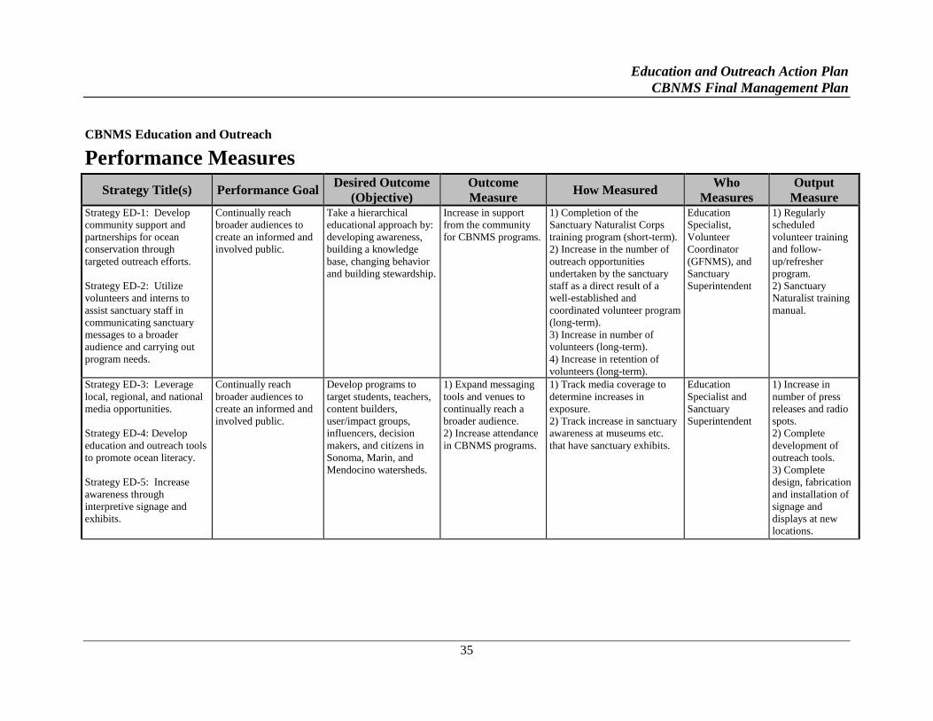
Education and Outreach Action Plan
CBNMS Final Management Plan
35
CBNMS Education and Outreach
Performance Measures
Strategy Title(s) Performance Goal Desired Outcome
(Objective)
Outcome
Measure How Measured
Who
Measures
Output
Measure Strategy ED-1: Develop
community support and
partnerships for ocean
conservation through
targeted outreach efforts.
Strategy ED-2: Utilize
volunteers and interns to
assist sanctuary staff in
communicating sanctuary
messages to a broader
audience and carrying out
program needs.
Continually reach
broader audiences to
create an informed and
involved public.
Take a hierarchical
educational approach by:
developing awareness,
building a knowledge
base, changing behavior
and building stewardship.
Increase in support
from the community
for CBNMS programs.
1) Completion of the
Sanctuary Naturalist Corps
training program (short-term).
2) Increase in the number of
outreach opportunities
undertaken by the sanctuary
staff as a direct result of a
well-established and
coordinated volunteer program
(long-term).
3) Increase in number of
volunteers (long-term).
4) Increase in retention of
volunteers (long-term).
Education
Specialist,
Volunteer
Coordinator
(GFNMS), and
Sanctuary
Superintendent
1) Regularly
scheduled
volunteer training
and follow-
up/refresher
program.
2) Sanctuary
Naturalist training
manual.
Strategy ED-3: Leverage
local, regional, and national
media opportunities.
Strategy ED-4: Develop
education and outreach tools
to promote ocean literacy.
Strategy ED-5: Increase
awareness through
interpretive signage and
exhibits.
Continually reach
broader audiences to
create an informed and
involved public.
Develop programs to
target students, teachers,
content builders,
user/impact groups,
influencers, decision
makers, and citizens in
Sonoma, Marin, and
Mendocino watersheds.
1) Expand messaging
tools and venues to
continually reach a
broader audience.
2) Increase attendance
in CBNMS programs.
1) Track media coverage to
determine increases in
exposure.
2) Track increase in sanctuary
awareness at museums etc.
that have sanctuary exhibits.
Education
Specialist and
Sanctuary
Superintendent
1) Increase in
number of press
releases and radio
spots.
2) Complete
development of
outreach tools.
3) Complete
design, fabrication
and installation of
signage and
displays at new
locations.
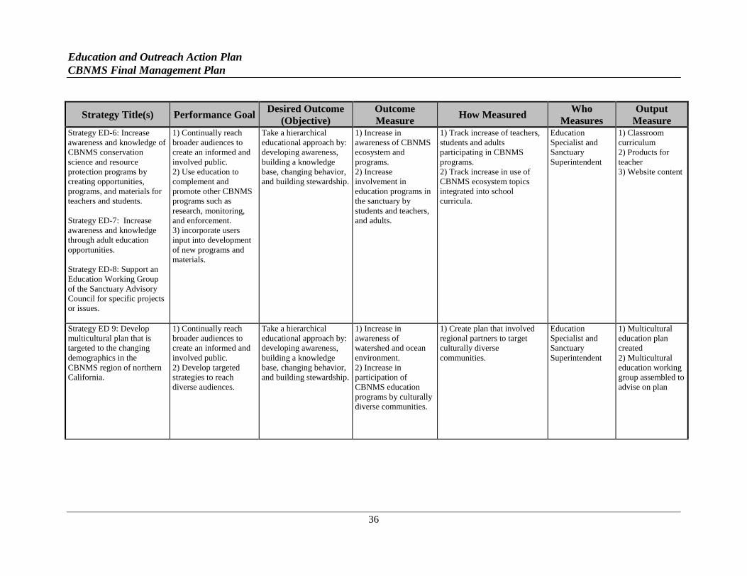
Education and Outreach Action Plan
CBNMS Final Management Plan
36
Strategy Title(s) Performance Goal Desired Outcome
(Objective)
Outcome
Measure How Measured
Who
Measures
Output
Measure Strategy ED-6: Increase
awareness and knowledge of
CBNMS conservation
science and resource
protection programs by
creating opportunities,
programs, and materials for
teachers and students.
Strategy ED-7: Increase
awareness and knowledge
through adult education
opportunities.
Strategy ED-8: Support an
Education Working Group
of the Sanctuary Advisory
Council for specific projects
or issues.
1) Continually reach
broader audiences to
create an informed and
involved public.
2) Use education to
complement and
promote other CBNMS
programs such as
research, monitoring,
and enforcement.
3) incorporate users
input into development
of new programs and
materials.
Take a hierarchical
educational approach by:
developing awareness,
building a knowledge
base, changing behavior,
and building stewardship.
1) Increase in
awareness of CBNMS
ecosystem and
programs.
2) Increase
involvement in
education programs in
the sanctuary by
students and teachers,
and adults.
1) Track increase of teachers,
students and adults
participating in CBNMS
programs.
2) Track increase in use of
CBNMS ecosystem topics
integrated into school
curricula.
Education
Specialist and
Sanctuary
Superintendent
1) Classroom
curriculum
2) Products for
teacher
3) Website content
Strategy ED 9: Develop
multicultural plan that is
targeted to the changing
demographics in the
CBNMS region of northern
California.
1) Continually reach
broader audiences to
create an informed and
involved public.
2) Develop targeted
strategies to reach
diverse audiences.
Take a hierarchical
educational approach by:
developing awareness,
building a knowledge
base, changing behavior,
and building stewardship.
1) Increase in
awareness of
watershed and ocean
environment.
2) Increase in
participation of
CBNMS education
programs by culturally
diverse communities.
1) Create plan that involved
regional partners to target
culturally diverse
communities.
Education
Specialist and
Sanctuary
Superintendent
1) Multicultural
education plan
created
2) Multicultural
education working
group assembled to
advise on plan
Education and Outreach Action Plan
CBNMS Final Management Plan
37
KEY PARTNERS
GFNMS, MBNMS, ONMS West Coast Regional Office (WCRO), advisory council for
CBNMS, advisory council for GFNMS, Point Reyes National Seashore (PRNS), Golden Gate
National Recreation Area (GGNRA), California Coastal Monument, California State Parks, San
Francisco Bay National Estuarine Research Reserve (SFBNERR), Sonoma County Regional
Parks, Spud Point Marina, U.C. Davis - Bodega Marine Laboratory (BML), Sonoma State
University, other local universities, Santa Rosa Community College, College of Marin, Monterey
Peninsula College, local schools, Tam Union High School District Adult and Community
Education, Offices of Education in the Bay Area, Bay Watershed Education and Training
(BWET) program/Ocean Guardian Grant recipients, Multicultural Education for Resource Issues
Threatening Oceans (MERITO) Program, Marine Advanced Technology Education (MATE)
Center, Center for Image Processing and Education (CIPE), California ocean communicators
alliance (Thank You Ocean), libraries, Porto Bodega, NGS, KWMR: Community Radio for
West Marin, The Sea Ranch Association, National Marine Sanctuary Foundation (NMSF),
Cordell Marine Sanctuary Foundation (CMSF), Farallones Marine Sanctuary Association
(FMSA), Point Reyes National Seashore Association (PRNSA), Oakland Museum of California,
California Academy of Sciences, Stewards of Coast and Redwoods, The Marine Mammal Center
(TMMC), Fort Ross Conservancy, Oikonos Ecosystem Knowledge, various watershed councils,
Environmental Forum of Marin, Point Blue Conservation Science (Point Blue), Pacific Coast
Science and Learning Center, various non-profits in Bay Area doing environmental education
and science education, and NGOs that work with multicultural populations.

Resource Protection Action Plan
CBNMS Final Management Plan
39
RESOURCE PROTECTION
ACTION PLAN
ISSUE STATEMENT
Specific impacts from various activities on CBNMS natural resources are complex and difficult
to document and manage. Some of the issues include: (1) emergency preparedness and
emergency response limitations; (2) vessel traffic and ship strikes on whales; (3) acoustic
impacts of anthropogenic noise in the ocean; (4) impacts on benthic habitats from fishing gear;
and (5) impacts from marine debris.
ISSUE DESCRIPTION
CBNMS is located in one of the world’s four major upwelling systems. The upwelling of
nutrient-rich, deep ocean water provides a food-rich environment and promotes the growth of
organisms at all levels of the marine food web. The vertical relief and hard substrate of Cordell
Bank provides habitat with nearshore characteristics in an open ocean environment about 23
miles (20 nautical miles) from shore. The tremendous biodiversity found in the sanctuary
includes fishes, marine mammals, seabirds, sea turtles, algae, and benthic and pelagic
invertebrates.
The northern traffic lane passes through CBNMS and provides entry and egress for commercial
vessels calling on ports in San Francisco Bay. In summer and fall, this same area is a feeding
area for endangered blue, fin and humpback whales. In years when large concentrations of
whales are feeding in the sanctuary, ships using the traffic lane have inadvertently struck and
killed whales. The sanctuary staff continues to coordinate with the USCG, NMFS, industry and
other partners to better understand this issue and will work with partners to reduce the risk of
ships striking whales.
Noise levels in the marine environment have been rising due to anthropogenic sources such as
increased shipping traffic, sonar technologies, and research projects. The effects of noise on
marine mammals, seabirds, fishes, and turtles is not entirely known, though it is thought to
negatively affect various life functions such as finding prey, navigating, mating, and evading
predators. For example, active sonar has been conclusively linked to the deaths of whales in
some areas. In addition, an increase in low frequency sounds from shipping traffic has been
shown to significantly alter ambient noise in various parts of the world’s oceans. Issues of
concern in CBNMS include the effects of acoustics on marine mammals by ships, the military,
research, or other influences. NOAA and its partners have conducted and continue to conduct
Resource Protection Action Plan
CBNMS Final Management Plan
40
research regarding the effects of sound disturbance on marine mammals; however additional
CBNMS-specific research and monitoring may be necessary.
Commercial and recreational fisheries in CBNMS have historically targeted rockfish, Lingcod,
flatfish, salmon, Albacore Tuna, and crab. Most of the private boats and charter vessels that fish
CBNMS are from Bodega Bay, although rough ocean conditions often prevent smaller
recreational boats from accessing CBNMS. Gear types used in CBNMS over the years have
included bottom trawl, mid-water trawl, hook and line, gill nets, crab traps, and long lines
(including troll long line, vertical long line, and fixed gear long line). Management of
commercial and recreational fisheries in California is the responsibility of NMFS the PFMC, and
CDFW. CBNMS is entirely in federal waters.
Debris in the ocean and along the shore is a growing concern. Various types of debris are known
to have adverse effects on marine species. Plastics in the marine environment never fully
degrade and recent studies show plastic is consumed by organisms at all levels of the marine
food web. Dichlorodiphenyltrichloroethane (DDT) and other hydrophobic compounds are
known to adhere to plastics. Ingestion and entanglement are some of the many problems
associated with marine debris, which may eventually lead to death for many organisms. The
types of marine debris causing the most concern include balloons, abandoned/discarded fishing
gear, Styrofoam, and consumer goods including 6-pack rings, plastic shopping bags, and other
plastics.
Significant amounts of derelict fishing gear have been documented in CBNMS. This includes
long lines, gill nets, crab gear, trawls and trawl warps entangled on and around the Bank.
CBNMS research has demonstrated that the Bank’s physical structure and benthic invertebrate
community provides critical habitat for recovering stocks of west coast rockfish (Sebastes spp.).
The PFMC identified Cordell Bank as a Habitat Area of Particular Concern under their Essential
Fish Habitat designation. One concern is that the abandoned fishing gear on Cordell Bank may
be negatively impacting sanctuary resources, creating artificial habitat for marine life, and
potentially impacting the physical structure of the Bank. This derelict gear also poses a danger
to personnel and equipment involved in CBNMS research and monitoring activities.
JURISDICTIONAL SETTING
Restricted Access Fisheries
Management of commercial and recreational fisheries in California is the responsibility of
CDFW, NMFS and the PFMC. Restricted access programs in fisheries limit the quantity of
persons, vessels, or fishing gear that may be engaged in the take of a given species of fish or
shellfish. Restricted access may also limit the catch allocated to each fishery participant through
harvest rights such as individual or community quotas. A primary purpose of restricted access
programs is to balance the level of effort in a fishery with the health of the fishery resources. In
Resource Protection Action Plan
CBNMS Final Management Plan
41
most situations, except harvest rights, this involves setting an appropriate fishery capacity goal
(California Department of Fish and Game 20015).
California’s Restricted Access Programs
In 1977, the California Department of Fish and Game (now CDFW) focused its first limited
access program on the abalone fishery, followed in 1979 with legislation requiring Salmon
limited entry permits. In the 1990s, industry began to demand more restricted access programs,
so the Department decided the time had come to address restricted access in a comprehensive
manner. In 1996, a limited entry review committee was formed to develop a standard restricted
access policy for the Fish and Game Commission (FGC). The commission approved the
restricted access policy in June 1999 (California Department of Fish and Game 2001).
Marine Life Protection Act (MLPA)
Passed by the California State Legislature in 1999, the MLPA required the California
Department of Fish and Game to redesign its system of marine protected areas (MPAs) to
increase its coherence and effectiveness at protecting the state's marine life, habitats, and
ecosystems. For the purposes of MPA planning, a public-private partnership commonly referred
to as the MLPA Initiative was established, and the state was split into five distinct regions (four
coastal and the San Francisco Bay) each of which had its own MPA planning process. The
planning processes for the four coastal regions was completed, and the coastal portion of
California's MPA network is in effect.
Marine Life Management Act (MLMA)
The California MLMA requires CDFW and the FGC to evaluate existing restricted access
programs every five years. These evaluations and increase in restricted access programs will
require CDFW to expand capabilities to collect and analyze economic and social data related to
fisheries. Socioeconomic data and biological data about fisheries resources are key components
in developing and evaluating restricted access policy alternatives.
Federal Restricted Access Program: MSFCMA
The implementation of the MSFCMA by the PFMC and NMFS virtually eliminated all foreign
fishing vessels by extending the United States jurisdiction and control over all marine fisheries
resources within 200 nautical miles of the U.S. coast. The act required the establishment of eight
regional fishery management councils composed of federal and state fishery management
officials and industry representatives. The councils have oversight on developing, monitoring,
and revising fishery management plans for each fishery within the U.S. Exclusive Economic
5 California Department of Fish and Game. December 2001, California’s Living Marine Resources: A Status Report,
Sacramento, California.
Resource Protection Action Plan
CBNMS Final Management Plan
42
Zone (EEZ) that requires management. Every fishery management plan drafted by a fishery
management council must be approved by the Secretary of Commerce by way of NMFS.
Marine Mammal Protection Act and Endangered Species Act
The NMFS shares responsibility with the USFWS for the implementation of the Marine
Mammal Protection Act (MMPA) and the Endangered Species Act (ESA) to protect of any
endangered, threatened or otherwise depleted species.
RESOURCE PROTECTION GOALS
1. Improved understanding of human use impacts.
2. Allow for activities that are compatible with ecosystem health.
RESOURCE PROTECTION OBJECTIVES
1. Maintain working relationship with state and federal fisheries management
agencies.
2. Track, evaluate, and address, as appropriate, existing, new, and emerging issues
for their potential impacts on sanctuary resources.
3. Support adaptive management plans that promote ecosystem health.
4. Broaden and formalize partnerships between CBNMS, fishing community, and
NGOs.
5. Increase awareness and monitoring of anthropogenic impacts on marine
organisms in CBNMS.
6. Document and remove marine debris in CBNMS
7. Be prepared to respond to incidents with the CBNMS emergency response plan.
RESOURCE PROTECTION STRATEGIES
STRATEGY RP-1: Establish ongoing process to track human use activities and their
impacts in and around sanctuary waters.
Activity 1.1 Work with the Sanctuary Advisory Council to establish resource protection working
groups of the Sanctuary Advisory Council.
A. Work with the Sanctuary Advisory Council to establish appropriate representation
from the fishing community, other stakeholders, interest groups, NGOs and
Resource Protection Action Plan
CBNMS Final Management Plan
43
agencies to sit on resource protection working groups as needed and advise the
Sanctuary Advisory Council on how to address specific types of activities that
may not be compatible with the CBNMS primary purpose of resource protection.
Activity 1.2 Develop a process to continually identify trends in current, new, and emerging
activities.
A. Work with the Sanctuary Advisory Council to identify current, new, and
emerging activities taking place in and around sanctuary waters.
B. Work with the fishing community, mariners, the research community, and other
resource management agencies to identify current, new, and emerging activities
taking place in and around sanctuary waters.
STRATEGY RP-2: Address the issue of ship strikes of whales in CBNMS, GFNMS and
MBNMS.
Activity 2.1 Endangered blue (Balaenoptera musculus), fin (Balaenoptera physalus) and
humpback whales (Megaptera novaeangliae) feed within GFNMS, CBNMS, and MBNMS.
Large commercial vessels also transit these sanctuaries heading to and from ports in San
Francisco Bay and major ports in the Pacific Rim. The co-occurrence of these two global
populations (whales and ships) in space and time creates an elevated risk of vessel strikes, and
thus mortality, to whales.
A. Continue to work with GFNMS, MBNMS, and the ONMS West Coast Region to
support activities that reduce ship strikes to whales.
B. Implement recommendations from the final report (June 2012) produced by
GFNMS and CBNMS Sanctuary Advisory Council Joint Working Group on
Vessel Strikes and Acoustic Impacts.
C. Continue monitoring whale abundance with at sea surveys, land based
observation points and aerial flight to collect data.
D. Use near real time data to communicate with USCG and have a USCG advisory
broadcast to vessels traveling in the vicinity of whale aggregations.
E. Develop an education and outreach plan focused on engaging and informing the
commercial maritime industry about the ship strike issue.
STRATEGY RP-3: Profile fishing activities and communities in and around the sanctuary to
better understand levels of impacts specific to CBNMS.
Activity 3.1 Update fishing activities and socioeconomic profile for fishing in the sanctuary.
Analysis would include information on numbers of boats actively engaged in each fishery; areas
Resource Protection Action Plan
CBNMS Final Management Plan
44
where the fishery is taking place; gear types; catch levels; a socioeconomic profile of the harbors
and marinas accessing the sanctuary; and an understanding of markets, changing gear types, and
changing fisheries management regulations that influence this profile. Information exchange
with mariners will provide important input to the profile, and provide support for continual
update of the database.
STRATEGY RP-4: Assess acoustics impacts from anthropogenic sources on sanctuary
resources.
Activity 4.1 Expand research and monitoring of acoustics in CBNMS.
A. Gather more information and data on the effects of sound in the marine
environment.
B. Work with partners to conduct passive acoustic monitoring to identify and
quantify sources of anthropogenic noise underwater and continue to be apprised
of survey and monitoring activities that are evaluating the effects of sound.
Activity 4.2 Continue evaluation of individual projects with potential acoustic disturbance.
A. Continue evaluating individual proposals on a case-by-case basis to determine
impacts of proposed projects, and make management recommendations.
B. Work with NMFS and other partners to determine acceptable sound levels in the
different frequency ranges affecting wildlife.
STRATEGY RP-5: Assess impacts from marine debris on sanctuary resources and conduct
mitigation activities.
Activity 5.1 Work with partners to expand GIS database to track and characterize type, location
and amounts of benthic marine debris in CBNMS observed during benthic monitoring, mapping
and characterization research activities.
Activity 5.2 Continue to monitor pelagic marine debris and incorporate into monitoring
activities.
Activity 5.3 Work with partners in removing derelict fishing gear from CBNMS.
A. Work with partners to assess the feasibility and test new methods of removing
derelict fishing gear from deep water environments like Cordell Bank.
B. Work with partners in the removal of derelict fishing gear from deep water
benthic habitats.
Resource Protection Action Plan
CBNMS Final Management Plan
45
STRATEGY RP-6: Enhance resource protection through increased compliance with
CBNMS regulations and other applicable state and federal statutes.
The mission of enforcement for the sanctuary is to ensure compliance with the NMSA (16 USC
§ 1431 et seq.) and appropriate CBNMS regulations (15 CFR § 922).The approach to the
enforcement program should be two-fold in nature: (1) the use of interpretive enforcement (such
as public outreach) as a tool to inform and encourage voluntary compliance; and (2) the use of
patrols and other traditional law enforcement methods to enforce regulations and investigate and
respond to suspected prohibited activities. Together, these two programs should result in a
regular and ongoing enforcement presence in sanctuary waters and compliance with CBNMS
regulations.
Activity 6.1 Ensure sufficient patrol presence in the sanctuary through the development of
partnerships and interagency coordination. To that end, CBNMS needs to maintain an active
enforcement relationship with the USCG, NOAA OLE, CDFW, and Sonoma County Sheriff's
Office (Bodega Bay).
A. Coordinate with other enforcement authorities on patrols in CBNMS or its
airspace, investigations, regulatory violations, permit violations, incidents, and
citizen complaints.
Activity 6.2 Use interpretive enforcement as a tool to inform and encourage voluntary
compliance with CBNMS regulations. Interpretive enforcement may be used to affect behavior
and change values. Interpretive enforcement efforts will include:
A. Train Sanctuary Naturalist Program volunteers to use interpretive enforcement
(see Education STRATEGY ED-2).
B. Develop signage program at Bodega Harbor.
C. Work with California Department of Motor Vehicles to include informational
inserts in boat license renewal packets (to be coordinated with all California
national marine sanctuaries).
D. Give presentations at yacht clubs and to Coast Guard Auxiliary Flotillas.
E. Provide follow-up letters to possible violators with “you may be in violation”
notices that inform the boater about CBNMS regulations.
Activity 6.3 Encourage and assist the efforts of local and regional port, harbor, and marina
management entities and state and local agencies to improve availability and use of wastewater
pump-out facilities and dump stations for vessels.
Resource Protection Action Plan
CBNMS Final Management Plan
46
Activity 6.4 Participate in a national-level review of national marine sanctuary regulations
pertaining to cruise ships, to determine if NOAA might consider a future proposed rule to amend
existing cruise ship regulations.
STRATEGY RP-7: Develop a plan that prepares sanctuary staff to respond to an emergency
in or adjacent to the sanctuary. This plan will provide the framework for a seamless operation
in cooperation with other federal, state, and local emergency response agencies in California.
The plan will be developed in coordination with GFNMS and MBNMS.
Activity 7.1 CBNMS will review and revise its emergency response plan, based on the Incident
Command System (ICS) and the USCG’s Area Contingency Plan (ACP), to respond to oil spills,
hazardous material spills, sunken vessels, or natural disasters. In coordination with GFNMS and
MBNMS, the response plan will be reviewed, evaluated, and updated on an annual basis.
CBNMS’s emergency response plan will:
A. Lay out emergency response notification plans (including all relevant agencies,
user groups and media) and preparation procedures.
B. Include coordination and decision-making responsibilities on use of dispersants.
C. Identify specific duties for sanctuary staff.
D. Develop damage assessment guidelines.
Activity 7.2 All appropriate sanctuary staff will be trained for their specific assigned roles in
emergency response on an ongoing basis with regular updates and refresher courses, and will be
ready to respond in the case of an emergency. Staff training to include:
A. Understanding the ICS.
B. Familiarization with the ACP.
C. Certification for assigned emergency response duties.
D. Taking part in emergency response drills.
E. Developing Natural Resource Damage Assessment skills.
F. Understanding alternative response technologies.
STRATEGY RP-8: Continuously evaluate the appropriateness and effectiveness of current
CBNMS regulations , including permit procedures in addressing the priority resource
management issues identified in the management plan.
CBNMS uses two complementary and strategic tools to carry out an ecosystem management
approach: (1) programs, which address resource management issues through the use of
Resource Protection Action Plan
CBNMS Final Management Plan
47
Education and Outreach, Conservation Science, and Resource Protection; and (2) regulations,
which help establish priorities for guiding or restricting human behavior that may not be
compatible with resource protection.
Activity 8.1 To ensure that CBNMS’s regulations provide protection for natural resources and
address the site's priority resource management issues, CBNMS will take the following steps:
A. Evaluate the appropriateness and effectiveness of current regulatory language on
a regular basis.
B. Propose new regulations or amendments to current regulations based on the
evaluation and need for action to respond to current, new and emerging human-
use activities that may be inconsistent with the CBNMS primary goal of resource
protection.
C. Provide guidance and understanding of policy in the NMSA.
D. Ensure, to the extent appropriate, coordination and consistency with other
resource management agencies’ regulations and permits.
E. Track, review, and comment on environmental assessments and environmental
impact statements prepared by other agencies.
Activity 8.2 The CBNMS permit program provides a mechanism to review requests to conduct
prohibited activities within the sanctuary, and where possible, permit these activities to be
conducted in a way that results in negligible effects. Generally, these requests are for research or
education purposes. CBNMS staff members evaluate these requests on a case-by-case basis in
detail to consider factors such as whether the activity needs to be conducted in the sanctuary; the
value of the activity; the proposed methods and procedures; and the activity’s effect in the
sanctuary.
A. In order to understand, measure, and control prohibited activities within the
sanctuary, and to minimize cumulative impacts from these activities, the permit
program will:
i. Evaluate permit requests on a case-by-case basis.
ii. Develop permit requirements to applicants on procedures and operations
to avoid or reduce impacts to sanctuary resources.
iii. Monitor permitted activities to ensure compliance with permit conditions
and to understand direct and cumulative impacts.
iv. Require applicants provide the sanctuary staff with the data and findings
gained through research conducted with research permits.
Resource Protection Action Plan
CBNMS Final Management Plan
48
B. Certain educational or research activities may violate CBNMS prohibitions,
although actual environmental impacts to sanctuary resources may be negligible.
A streamlined application process could be developed for activities that clearly
fall within this category.
i. Develop a streamlined application process by creating a simple form on
which applicants can submit concise and relevant information.
ii. Develop a system to issue programmatic permits that may include many
activities conducted by one organization or institution under one permit.
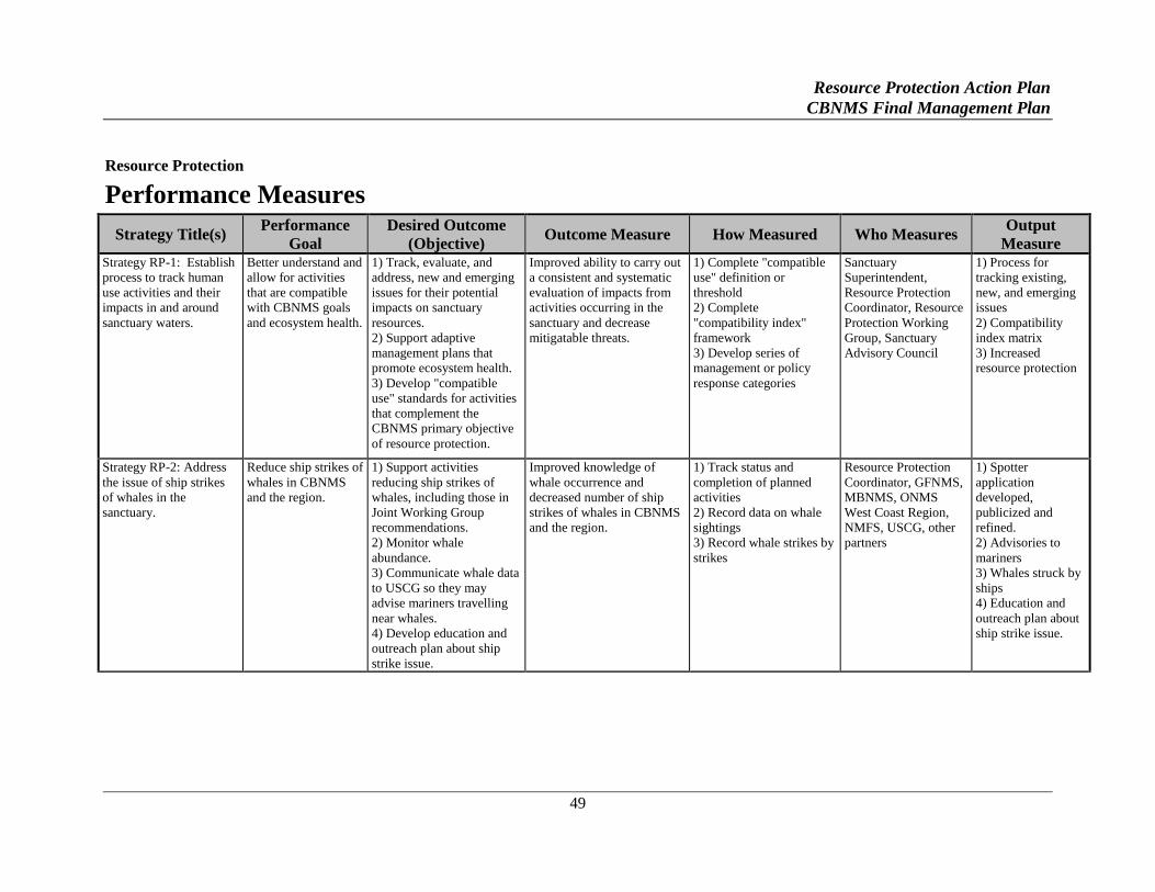
Resource Protection Action Plan
CBNMS Final Management Plan
49
Resource Protection
Performance Measures
Strategy Title(s) Performance
Goal
Desired Outcome
(Objective) Outcome Measure How Measured Who Measures
Output
Measure Strategy RP-1: Establish
process to track human
use activities and their
impacts in and around
sanctuary waters.
Better understand and
allow for activities
that are compatible
with CBNMS goals
and ecosystem health.
1) Track, evaluate, and
address, new and emerging
issues for their potential
impacts on sanctuary
resources.
2) Support adaptive
management plans that
promote ecosystem health.
3) Develop "compatible
use" standards for activities
that complement the
CBNMS primary objective
of resource protection.
Improved ability to carry out
a consistent and systematic
evaluation of impacts from
activities occurring in the
sanctuary and decrease
mitigatable threats.
1) Complete "compatible
use" definition or
threshold
2) Complete
"compatibility index"
framework
3) Develop series of
management or policy
response categories
Sanctuary
Superintendent,
Resource Protection
Coordinator, Resource
Protection Working
Group, Sanctuary
Advisory Council
1) Process for
tracking existing,
new, and emerging
issues
2) Compatibility
index matrix
3) Increased
resource protection
Strategy RP-2: Address
the issue of ship strikes
of whales in the
sanctuary.
Reduce ship strikes of
whales in CBNMS
and the region.
1) Support activities
reducing ship strikes of
whales, including those in
Joint Working Group
recommendations.
2) Monitor whale
abundance.
3) Communicate whale data
to USCG so they may
advise mariners travelling
near whales.
4) Develop education and
outreach plan about ship
strike issue.
Improved knowledge of
whale occurrence and
decreased number of ship
strikes of whales in CBNMS
and the region.
1) Track status and
completion of planned
activities
2) Record data on whale
sightings
3) Record whale strikes by
strikes
Resource Protection
Coordinator, GFNMS,
MBNMS, ONMS
West Coast Region,
NMFS, USCG, other
partners
1) Spotter
application
developed,
publicized and
refined.
2) Advisories to
mariners
3) Whales struck by
ships
4) Education and
outreach plan about
ship strike issue.
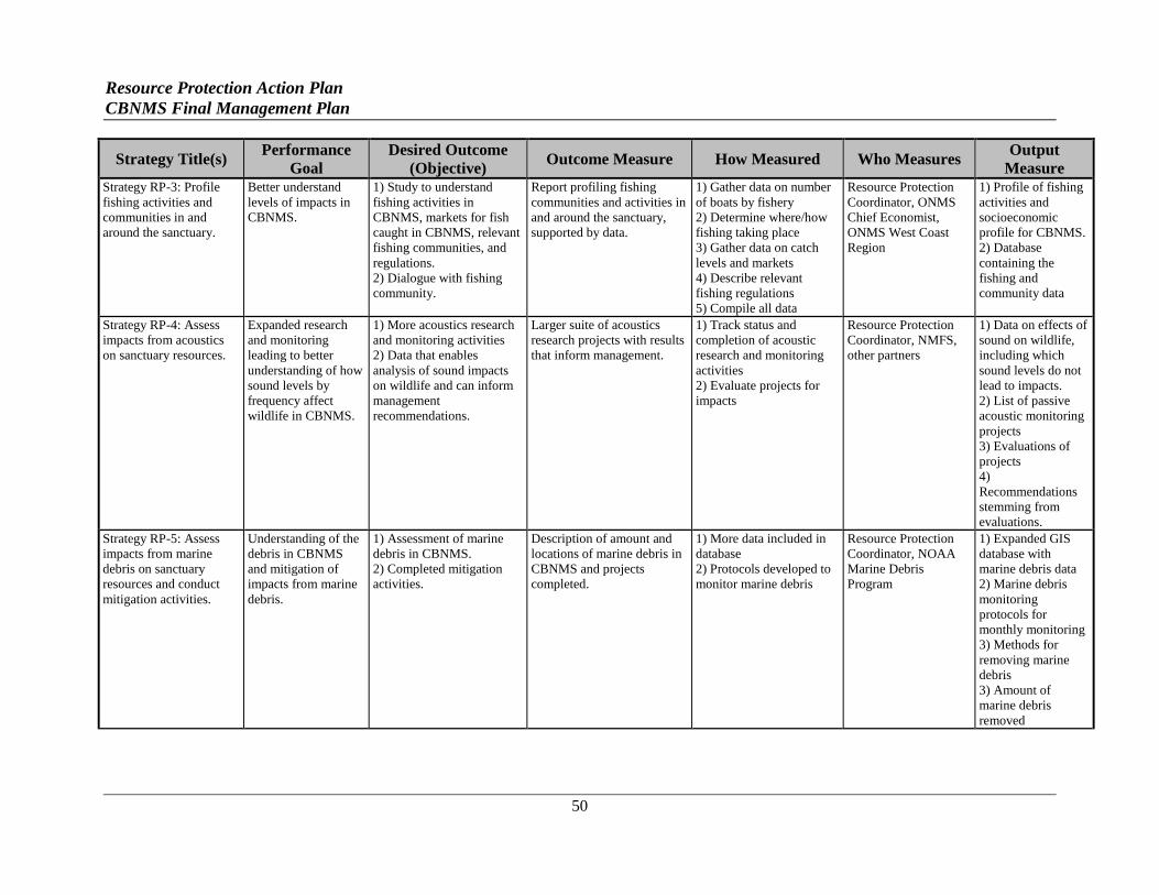
Resource Protection Action Plan
CBNMS Final Management Plan
50
Strategy Title(s) Performance
Goal
Desired Outcome
(Objective) Outcome Measure How Measured Who Measures
Output
Measure Strategy RP-3: Profile
fishing activities and
communities in and
around the sanctuary.
Better understand
levels of impacts in
CBNMS.
1) Study to understand
fishing activities in
CBNMS, markets for fish
caught in CBNMS, relevant
fishing communities, and
regulations.
2) Dialogue with fishing
community.
Report profiling fishing
communities and activities in
and around the sanctuary,
supported by data.
1) Gather data on number
of boats by fishery
2) Determine where/how
fishing taking place
3) Gather data on catch
levels and markets
4) Describe relevant
fishing regulations
5) Compile all data
Resource Protection
Coordinator, ONMS
Chief Economist,
ONMS West Coast
Region
1) Profile of fishing
activities and
socioeconomic
profile for CBNMS.
2) Database
containing the
fishing and
community data
Strategy RP-4: Assess
impacts from acoustics
on sanctuary resources.
Expanded research
and monitoring
leading to better
understanding of how
sound levels by
frequency affect
wildlife in CBNMS.
1) More acoustics research
and monitoring activities
2) Data that enables
analysis of sound impacts
on wildlife and can inform
management
recommendations.
Larger suite of acoustics
research projects with results
that inform management.
1) Track status and
completion of acoustic
research and monitoring
activities
2) Evaluate projects for
impacts
Resource Protection
Coordinator, NMFS,
other partners
1) Data on effects of
sound on wildlife,
including which
sound levels do not
lead to impacts.
2) List of passive
acoustic monitoring
projects
3) Evaluations of
projects
4)
Recommendations
stemming from
evaluations.
Strategy RP-5: Assess
impacts from marine
debris on sanctuary
resources and conduct
mitigation activities.
Understanding of the
debris in CBNMS
and mitigation of
impacts from marine
debris.
1) Assessment of marine
debris in CBNMS.
2) Completed mitigation
activities.
Description of amount and
locations of marine debris in
CBNMS and projects
completed.
1) More data included in
database
2) Protocols developed to
monitor marine debris
Resource Protection
Coordinator, NOAA
Marine Debris
Program
1) Expanded GIS
database with
marine debris data
2) Marine debris
monitoring
protocols for
monthly monitoring
3) Methods for
removing marine
debris
3) Amount of
marine debris
removed
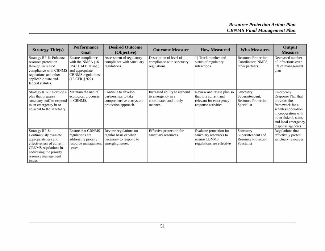
Resource Protection Action Plan
CBNMS Final Management Plan
51
Strategy Title(s) Performance
Goal
Desired Outcome
(Objective) Outcome Measure How Measured Who Measures
Output
Measure Strategy RP-6: Enhance
resource protection
through increased
compliance with CBNMS
regulations and other
applicable state and
federal statutes.
Ensure compliance
with the NMSA (16
USC § 1431 et seq.)
and appropriate
CBNMS regulations
(15 CFR § 922).
Assessment of regulatory
compliance with sanctuary
regulations.
Description of level of
compliance with sanctuary
regulations.
1) Track number and
status of regulatory
infractions
Resource Protection
Coordinator, NMFS,
other partners
Decreased number
of infractions over
life of management
plan
Strategy RP-7: Develop a
plan that prepares
sanctuary staff to respond
to an emergency in or
adjacent to the sanctuary.
Maintain the natural
ecological processes
in CBNMS.
Continue to develop
partnerships to take
comprehensive ecosystem
protection approach.
Increased ability to respond
to emergency in a
coordinated and timely
manner.
Review and revise plan so
that it is current and
relevant for emergency
response activities
Sanctuary
Superintendent,
Resource Protection
Specialist
Emergency
Response Plan that
provides the
framework for a
seamless operation
in cooperation with
other federal, state,
and local emergency
response agencies
Strategy RP-8:
Continuously evaluate
appropriateness and
effectiveness of current
CBNMS regulations in
addressing the priority
resource management
issues.
Ensure that CBNMS
regulations are
addressing priority
resource management
issues
Review regulations on
regular basis or when
necessary to respond to
emerging issues.
Effective protection for
sanctuary resources.
Evaluate protection for
sanctuary resources to
ensure CBNMS
regulations are effective
Sanctuary
Superintendent and
Resource Protection
Specialist
Regulations that
effectively protect
sanctuary resources
Resource Protection Action Plan
CBNMS Final Management Plan
52
KEY PARTNERS
GFNMS, MBNMS, Channel Islands National Marine Sanctuary (CINMS), Olympic Coast
National Marine Sanctuary (OCNMS), advisory council for CBNMS, NOAA's National Centers
for Coastal Ocean Science (NCCOS), NOAA's Coastal Services Center (CSC), USCG, NMFS,
PFMC, other federal agencies, CDFW, University of California-Davis Wildlife Health Center,
State Coastal Conservancy, Scripps Institute of Oceanography, other state agencies, Sonoma
County Sheriff’s Office, CMSF, FMSA, TMMC, National Fish and Wildlife Foundation, fishing
community, shipping industry, topical experts, stakeholders/experts/user groups, and NGOs.
Partnerships with Community Groups Action Plan
CBNMS Final Management Plan
53
PARTNERSHIPS WITH
COMMUNITY GROUPS
ACTION PLAN
ISSUE STATEMENT
In order to fully carry out its mission, CBNMS needs to develop community partnerships to
maximize its limited resources and minimize the risk of working in isolation and missing
partnership opportunities. Through community partnerships, opportunities will be leveraged to
develop public awareness, education, and stewardship; obtain volunteer, financial, and in-kind
support; and increase research opportunities.
ISSUE DESCRIPTION
The site’s primary programs are focused on conducting research, developing associated
education programs, and identifying and protecting the sanctuary’s natural resources and
habitats. CBNMS is an offshore site that, due to its more remote location, does not have the
same level of interest and support enjoyed by near-shore sanctuaries. As a result, CBNMS faces
a significant challenge in effectively augmenting its unique identity in the community and
increasing community interest and support.
One way to achieve the CBNMS management goals is through community partnerships.
Sanctuary management functions more effectively with community support. All sanctuary
managers and their staffs work with sanctuary advisory councils, community groups, and
agencies to provide support in reaching out to the community and building stewardship.
Working in concert with other agencies, institutions and organizations will allow CBNMS to:
Not duplicate efforts of other agencies and community groups; and
Have opportunities to leverage research partnerships and expertise, develop public
awareness and education, build public support, and leverage and build financial and in-
kind support.
PARTNERSHIPS WITH COMMUNITY GROUPS GOALS
1. Maximize partnerships to enhance the CBNMS staff’s ability to identify,
understand, and protect sanctuary resources.
2. Instill within the community a sense of value and stewardship of the sanctuary.
Partnerships with Community Groups Action Plan
CBNMS Final Management Plan
54
PARTNERSHIPS WITH COMMUNITY GROUPS OBJECTIVES
Create partnerships to:
1. Further research and monitoring that assist in answering resource management
questions.
2. Establish a strong identity for the sanctuary within various interest groups in the
community.
3. Identify and cultivate partners to increase in-kind support and, in cooperation with
non-profit partners, identify potential sources of revenue.
4. Build education programs that build stewardship to support and advocate for the
needs of the sanctuary.
PARTNERSHIPS WITH COMMUNITY GROUPS STRATEGIES
STRATEGY PC-1: Develop partnerships with the research and education community to
leverage opportunities and expertise to fulfill the CBNMS research and education goals.
Activity 1.1 Collaborate with other research entities including agencies and institutions to share
in-kind resources and services.
A. Identify potential research and education partners, including other resource
management agencies, marine research institutions, and individual researchers.
B. Identify ways to collaborate with potential partners. The CBNMS staff should
determine what it could offer to the partnership, including but not limited to
providing ship time, housing, and/or outreach opportunities. For example,
collaborations might include partnering on grants, internship programs, and
symposiums.
C. Identify opportunities for funding to support field researchers and an internship
program.
D. Partner on outreach components of research/monitoring programs (may also
satisfy grant requirements).
Activity 1.2 Collaborate with other education and outreach partners such as agencies, non-
profits, museums, and others to share projects, in kind resources, collaborate on shared audiences
and education goals.
A. Identify potential education partners with shared goals for education.
Partnerships with Community Groups Action Plan
CBNMS Final Management Plan
55
B. Identify CBNMS education/outreach programs that could be accomplished through
collaborations: criteria to include facilities, staff resources, related education goals
and shared audiences.
C. Identify opportunities for funding to support education/outreach interns to help
with site projects.
STRATEGY PC-2: Continue to develop the Sanctuary Advisory Council’s link to the
community.
Activity 2.1 Raise the profile of CBNMS by identifying the role of Sanctuary Advisory Council
members in increasing awareness of the sanctuary and encouraging them to reach out to their
constituencies and the community-at-large.
A. Review “lessons learned” from other sanctuary advisory councils and
coordinators in the ONMS to learn from successes and failures in reaching out to
their community and constituencies.
B. Provide media training to council members. Develop support materials such as
PowerPoint or slide presentations for council members to use.
C. Work with advisory council members on ways to engage constituents.
D. Clarify and evaluate the council chair’s role, responsibilities, and expectations for
representing the advisory council.
STRATEGY PC-3: Use media opportunities to promote the CBNMS programs and raise its
identity in Marin, Sonoma, and Mendocino counties.
Activity 3.1 Use media opportunities to raise the identity of CBNMS within the surrounding
coastal and greater communities.
A. Identify and implement effective use of media tools to reach broad audiences
(through newspaper, TV, radio). Incorporate key research findings into outreach
messages.
B. Keep the media informed about current CBNMS activities.
C. Nurture relationships with key media individuals and organizations. Work with
regular columnists to create marine-focused columns and features in the local
papers. Work with local radio stations to incorporate feature stories about the
sanctuary into their programming.
Partnerships with Community Groups Action Plan
CBNMS Final Management Plan
56
STRATEGY PC-4: Identify mechanisms to raise and manage additional sources of revenue
and in-kind services.
Activity 4.1 Developing partnerships will allow the sanctuary staff to leverage resources. As the
need arises, CBNMS will develop partnerships to manage and generate additional sources of
revenue and in-kind support to fully implement this management plan.
A. Coordinate with Cordell Marine Sanctuary Foundation (CMSF), a non-profit
organization with a mission to support the research, education and management
goals of CBNMS.
B. Explore mechanisms such as individual donations, grants, and events to generate
additional sources of revenue.
C. Implement mechanisms to build community capacity in helping generate
donations.
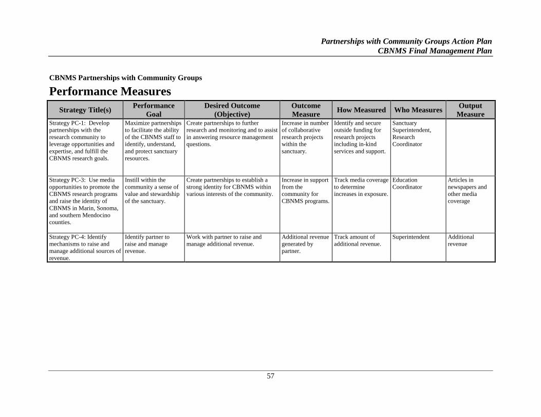
Partnerships with Community Groups Action Plan
CBNMS Final Management Plan
57
CBNMS Partnerships with Community Groups
Performance Measures
Strategy Title(s) Performance
Goal
Desired Outcome
(Objective)
Outcome
Measure How Measured Who Measures
Output
Measure Strategy PC-1: Develop
partnerships with the
research community to
leverage opportunities and
expertise, and fulfill the
CBNMS research goals.
Maximize partnerships
to facilitate the ability
of the CBNMS staff to
identify, understand,
and protect sanctuary
resources.
Create partnerships to further
research and monitoring and to assist
in answering resource management
questions.
Increase in number
of collaborative
research projects
within the
sanctuary.
Identify and secure
outside funding for
research projects
including in-kind
services and support.
Sanctuary
Superintendent,
Research
Coordinator
Strategy PC-3: Use media
opportunities to promote the
CBNMS research programs
and raise the identity of
CBNMS in Marin, Sonoma,
and southern Mendocino
counties.
Instill within the
community a sense of
value and stewardship
of the sanctuary.
Create partnerships to establish a
strong identity for CBNMS within
various interests of the community.
Increase in support
from the
community for
CBNMS programs.
Track media coverage
to determine
increases in exposure.
Education
Coordinator
Articles in
newspapers and
other media
coverage
Strategy PC-4: Identify
mechanisms to raise and
manage additional sources of
revenue.
Identify partner to
raise and manage
revenue.
Work with partner to raise and
manage additional revenue.
Additional revenue
generated by
partner.
Track amount of
additional revenue.
Superintendent Additional
revenue

Conservation Science Action Plan
CBNMS Final Management Plan
59
CONSERVATION SCIENCE
ACTION PLAN
PROGRAM STATEMENT
Characterization, monitoring, and research have been the cornerstone of CBNMS conservation
science activities. All three activities will continue to be a high priority, and CBNMS staff
members will integrate their project findings into management and education and outreach
programs. Two specific areas the CBNMS staff will focus on are: (1) development of a
coordinated and integrated characterization and research program for CBNMS; and (2)
continuation of long-term monitoring activities.
PROGRAM DESCRIPTION
CBNMS is an intriguing site because of its high biological diversity and its remote location. As
a result, scientific investigations have been taking place ever since its discovery. CBNMS is a
difficult place to study on a regular basis in large part because of unpredictable and harsh
offshore oceanic conditions. The first extensive study of the center piece of CBNMS, Cordell
Bank, was conducted from 1977 to 1987 by Cordell Expeditions. The researchers documented
life on the Bank in over 3000 photographs, considerable film and video footage, and a large
collection of biological specimens.
Since 1997, CBNMS and GFNMS have been involved in exploration and investigation of the
marine life and habitat of the site through an Ecosystem Dynamics Study. This long-term study
focuses on the distribution and relative abundance of krill, an important building block in the
food chain for this area. Through the use of acoustics and net sampling, krill are located and
identified. The physical parameters influencing their distribution are investigated. These data
are analyzed along with seabird and marine mammal sightings to better understand why marine
life concentrates in particular areas of the sanctuary. This program evolved into a partnership
with the Point Reyes Bird Observatory (now Point Blue) in 2004 and now called Applied
California Current Ecosystem Studies (ACCESS).
Remotely operated vehicles (ROV) and other technology are used to characterize the benthic
biota and habitats in CBNMS. In September 2001, sanctuary biologists and partners conducted
initial surveys of the Bank with the Delta submersible, characterizing habitats and documenting
species distribution and abundance. CBNMS conducted these studies between 2001 and 2005 to
increase the understanding of this unique environment and to better manage the sanctuary's
resources.
Conservation Science Action Plan
CBNMS Final Management Plan
60
CONSERVATION SCIENCE GOALS
1. Increase our knowledge and understanding of the CBNMS ecosystem.
2. Develop new and continue ongoing research programs to identify and address
specific resource management issues.
3. Develop new and continue ongoing monitoring programs to understand long-term
status and trends to guide management.
CONSERVATION SCIENCE OBJECTIVES
1. Characterize the habitats and communities of CBNMS; evaluate and synthesize
characterization data and information.
2. Continue monitoring activities to identify indicators and understand natural
variation and impacts from human activities on the CBNMS marine ecosystem.
3. Recommend research and monitoring results for inclusion in CBNMS’s outreach
and education programs.
4. Develop new and continue existing partnerships with other agencies and
institutions.
CONSERVATION SCIENCE STRATEGIES
STRATEGY CS-1: Prepare an oceanographic climatology report.
Physical oceanography is integral to the CBNMS ecosystem and is not well understood. To fully
characterize the sanctuary, a complete and detailed understanding of the oceanographic and
atmospheric conditions in and around the sanctuary is needed.
Activity 1.1 Prepare an oceanographic climatology report summarizing existing knowledge
about the physical oceanography and meteorology of this region. This information will expose
voids and shortcomings in the existing data, and serve as a guide for designing future programs.
A. Conduct short-term data analyses from compiled data.
B. Using existing data, construct a climatology of the oceanographic and
meteorological conditions in and around CBNMS and GFNMS. This document
will contain figures, diagrams, satellite images, and tables that illustrate the
prevailing environmental conditions, together with text that interprets,
synthesizes, and summarizes this information. The report will deliver
recommendations to the sanctuary management for future studies that are needed
to characterize the physical environment in and around the sanctuary.
Conservation Science Action Plan
CBNMS Final Management Plan
61
STRATEGY CS-2: Map and characterize CBNMS’s habitats.
Habitat maps will provide important baseline information for management including: relative
proportions of sanctuary habitats; the current state of sanctuary resources as a basis against
which to measure future change; unique habitats; unique potential habitat for species of concern
including essential fish habitat; and extent of habitat damage from human disturbance.
Activity 2.1 Conduct sonar surveys to determine habitat types and their spatial extent,
specifically delineate: (1) rocky regions and outcrops within low relief soft bottom areas of
sanctuary; (2) soft and mixed sediments within the Bank region; (3) trawl disturbance in soft
sediments; (4) submerged cultural resources; and (5) soft and hard bottom habitats associated
with Bodega Canyon.
A. Survey entire extent of sanctuary using sonar technology. Analyze information to
develop fine-scale bathymetry maps, habitat maps, and submerged cultural
resources. This information can be used in conjunction with biological surveys to
produce habitat suitability models for selected species.
B. Habitat maps created using sonar systems will be ground truthed using data
collected by manned submersible, ROV, and Autonomous Underwater vehicle
(AUV) surveys over high relief rocky regions of the sanctuary and towed camera
systems and grabs over low relief unconsolidated substrates.
C. Incorporate research findings into CBNMS education/outreach and management
programs and messages.
STRATEGY CS-3: Characterize the soft-bottom epifaunal communities of CBNMS.
Epifauna are animals that live in contact with the sea bottom, either moving freely over the
substrate or attached to it.
Activity 3.1 Survey the surface biota and sediment characteristics of the soft-sediment portion of
the shelf and slope of CBNMS.
A. Conduct survey of soft-bottom habitats of CBNMS. Survey will provide habitat
assessment, estimates of distribution and abundance of epifauna, assessment of
disturbance effects and marine debris, species list of invertebrates, and description
of any submerged cultural resources.
B. Results from this survey will be used to refine the habitat map.
C. Create partnerships to continue monitoring epifaunal communities over time.
STRATEGY CS-4: Characterize soft-bottom infaunal communities of CBNMS.
Infauna are animals that live within or burrow through substrate.
Conservation Science Action Plan
CBNMS Final Management Plan
62
Activity 4.1 Characterize the infaunal biota of the soft sediment portion of the shelf and slope of
CBNMS.
A. Conduct literature review to obtain current knowledge about infaunal
communities. Relevant sources may be the United States Environmental
Protection Agency (USEPA) status and trends information; Bureau of Ocean
Energy Management (BOEM) reports; invertebrate collections made by
NMFS/Northwest Fisheries Science Center (NWFSC) slope and shelf trawl
surveys; and regional universities and research institutions.
B. Conduct baseline survey of infaunal communities of CBNMS using bottom grabs.
Survey should determine species diversity, distribution, and abundance, as well as
describe characteristics of the sediment. Design sampling so that temporal
variability of infaunal community can be assessed and correlated to changing
oceanographic conditions.
C. Utilize partnerships to continue monitoring infaunal communities over time.
D. Use results to ground truth habitat map.
STRATEGY CS-5: Collect, inventory, and catalog new and previously unsorted CBNMS
benthic invertebrate specimens.
Activity 5.1 Continue to populate voucher specimen database of benthic invertebrates from
CBNMS; these specimens are maintained to provide permanent, physical documentation of
species identifications and associated data resulting from inventories.
A. Collections of CBNMS specimens at California Academy of Sciences (CAS) will
be taxonomically upgraded, computer catalogued, and maintained by CAS as
research specimens.
B. Coordinate with CAS to maintain a computerized species list for CBNMS and
provide the data to the sanctuary staff for future investigations.
C. Target specimens of interest for subsequent identification, description, and future
publication.
D. Coordinate with CAS to identify and describe sponge species collected from
CBNMS, including not-yet-described species.
Activity 5.2 Continue to collaborate with CAS on collection and identification of other CBNMS
benthic invertebrates.
A. Partner with CAS on future taxonomic identification, database maintenance, and
expansion of specimen collection.
Conservation Science Action Plan
CBNMS Final Management Plan
63
STRATEGY CS-6: Survey available museum collections, data archives, and literature indexing
services for CBNMS specimens, data, and publications.
Activity 6.1 Conduct a literature, specimen, and data search to compile existing knowledge
about Cordell Bank, and generate a verified species list. Methods should include:
A. Search natural history museums and other collections for specimens collected
from CBNMS.
B. Search standard literature indexes for references to CBNMS. Secure regular
access to Lexus-Nexus and/or other literature indexes for CBNMS.
C. Search agency and academic electronic databases (i.e., metadata clearing houses)
for data from CBNMS.
D. Construct and maintain a verified species list and store in an easily accessible data
repository (such as National Data Center or Sanctuary Integrated Monitoring
Network [SIMoN]).
STRATEGY CS-7: Understand the function and variability of pelagic ecosystems.
Activity 7.1 Continue ACCESS with GFNMS and partners to quantitatively assess the
distribution and abundance of marine birds, mammals, and sea turtles relative to ocean
conditions, seasons, and biological productivity. This study provides long term data on
production, populations, and trophic structure, and it will continue to support management.
A. Physical oceanography will be described with data collected in the field and from
remotely sensed data. Data will be collected on salinity and temperature at sea
surface and at depth. Remote data will include upwelling indices, satellite
images, and current information.
B. Systematically survey along transect lines and record the presence of marine
birds, mammals and sea turtles within CBNMS and GFNMS.
C. Assess biological productivity by sampling zooplankton and phytoplankton using
hydro-acoustics and net sampling.
D. Use an echosounder to map the distribution of zooplankton and fish.
E. Observe and document human activities within CBNMS and GFNMS.
Conservation Science Action Plan
CBNMS Final Management Plan
64
STRATEGY CS-8: Continue monitoring fish and invertebrate assemblages and marine
debris in relation to the fine-scale habitat on and adjacent to the hard bottom areas of
CBNMS.
Activity 8.1 Perform submersible, ROV, or AUV field surveys (one- to three- year intervals) to
monitor the distribution and abundance of fishes and invertebrates on and adjacent to the hard
bottom areas. This project will include the following components:
A. Assess and monitor distribution, abundance, and life history (size and maturity) of
fishes around Cordell Bank and other hard bottom areas.
B. Assess and monitor percent cover of invertebrates and distribution and abundance
of specific macroinvertebrate species.
C. Identify locations and quantity of derelict fishing gear and other benthic marine
debris using submersible transects and video footage.
D. Use video transects and rock grab samples to further characterize habitats
identified by the sonar survey.
E. Compare the biota of Cordell Bank with other deep reefs along the west coast
(e.g., Bowie Seamount in British Columbia, Point Sur Bank in California, and
Heceta Bank in Oregon).
F. Determine the fish assemblages associated with different habitat types.
STRATEGY CS-9: Continue to manage and store data in easily accessible and secure
formats and locations. Data collected by CBNMS should be accessible to interested public and
should be securely stored to prevent loss.
Activity 9.1 Maintain handwritten records from research cruises. Records will be kept in the
CBNMS office and the second set kept offsite. These records provide information that help
(e.g., location, time) describe the sampling environment.
Activity 9.2 Electronic media collected on research cruises (files and tapes) will be copied and
stored in the CBNMS office. Electronic media (files and video tapes) provide the detailed
information (e.g., water temperature profiles, number of organisms observed).
Activity 9.3 Data obtained from laboratory analyses of video transects or plankton collections
will be stored in a relational database, modeled after the National Park Service’s (NPS’s) Natural
Resources Database Template. All electronic data are available to sanctuary staff through the
CBNMS local area network. Since the relational databases comprise the core of the CBNMS
research program, copies of the databases are housed on an off-site computer to guard against
catastrophic loss.
Conservation Science Action Plan
CBNMS Final Management Plan
65
Activity 9.4 Ensure data are compliant with federal standards for accessibility and quality, and
formatted to be compatible with Federal Geospatial Data Center (FGDC) and other relevant
agency initiatives (e.g., the Integrated Ocean Observing System [IOOS]).
STRATEGY CS-10: Assess the role of Cordell Bank in the supply and receipt of fish larvae
within the regional marine ecosystem by linking population genetics and oceanography.
Activity 10.1 Determine the genetic make-up of adult, juvenile and larval populations of fish
with pelagic larval stages within the Cordell Bank region relative to regional populations to
understand levels of mixing and retention of early life history stages.
A. Collect adult, juvenile, and larval stages of several common species with pelagic
larvae from Cordell Bank as well as at multiple locations north and south of the
Bank within the California Current System. Conduct genetic analyses on
collected individuals to determine likely birthplaces of individuals.
Activity 10.2 Examine larval dispersal through simulations of coupled bio-physical models.
A. Develop or modify an existing 3-D bio-physical simulation model to determine:
1) the geographic fate of larvae released from Cordell Bank; 2) the geographic
origin of larvae that are likely to settle on Cordell Bank. Examine predicted
dispersal patterns for larvae with different behavioral characteristics as well as
larval periods. Examine predicted dispersal patterns given various oceanographic
conditions.
STRATEGY CS-11: Assess potential to conduct additional research activities in the future,
when time and resources allow.
Activity 11.1 Assess potential to conduct the following research activities, which originated
from various sources including: 1) discussions of the Conservation Science working group that
was assembled during the JMPR process; 2) comments received during the JMPR process; and
3) assessment report of the condition of CBNMS resources.
A. Quantify Temporal Patterns of Gelatinous Zooplankton. Use of Tucker trawl or
vertical haul sampling and acoustics to assess seasonal and interannual patterns of
abundance and community composition of gelatinous zooplankton as part of the
CBNMS pelagic monitoring program.
B. Assess Primary Productivity within the CBNMS Ecosystem. Examine spatial and
temporal variability in primary productivity and phytoplankton standing stock
using simulated in-situ and photosynthesis-irradiance incubations coupled with
satellite remote sensing data of ocean color.
C. Directed Oceanographic Field Studies. Use of current meter arrays and acoustic
Doppler current profiler to measure currents at different levels in the water
column around Cordell Bank, drifters to track motion at and near the surface, and
Conservation Science Action Plan
CBNMS Final Management Plan
66
remotely-sensed observations from satellites to provide information on both local
and regional conditions.
D. Marine Mammal Observations Using Ships of Opportunity. Use of volunteer
observers riding on ships of opportunity (e.g., wildlife viewing trips) to survey the
distribution and abundance of marine mammals.
E. Understanding the Emerging Role of Humboldt Squid in the CBNMS Ecosystem.
Use of submersible or ROV to conduct surveys within CBNMS to acquire basic
information on squid abundance and distribution. Use of hook and line sampling
to assess squid foraging habits and diet.
F. Geomorphology of Cordell Bank and Nearby Shelf and Slope Subsurface
Geology. Collect sub-bottom profile data and synthesize with rock samples from
Cordell Bank to summarize the subsurface geology and surficial geomorphology
of the region.
G. Water quality assessment. Assess potential environmental degradation of
sanctuary waters arising from certain changing physical processes and
anthropogenic inputs by reviewing and summarizing existing data sets to better
understand the potential water quality threats to the sanctuary waters.
H. Benthic contaminant assessment. Assess potential environmental degradation of
benthic habitats and bottom dwelling species (as well as transfer further along the
food chain) arising from concentrations of contaminants such as pesticides,
hydrocarbons, and heavy metals by collecting and analyzing benthic samples.
Conservation Science Action Plan
CBNMS Final Management Plan
67
CBNMS Conservation Science
Performance Measures
Strategy Title(s) Performance
Goal
Desired Outcome
(Objective) Outcome Measure How Measured Who Measures Output Measure
Strategy CS-1: Prepare
oceanographic climatology
report.
Strategy CS-2: Map and
characterize habitats.
Strategy CS-3:
Characterize epifaunal
communities.
Strategy CS-4:
Characterize infaunal
communities.
Increase our
knowledge and
understanding of the
CBNMS ecosystem.
Characterize the habitats
and communities of
CBNMS.
Increased understanding
of: oceanographic and
atmospheric conditions;
relative abundance and
distribution of habitats;
epifaunal and infaunal
benthic communities.
Complete site
characterization
including: detailed
oceanographic
climatology; clear
delineation of habitat
types; use surface biota
and soft bottom
characteristics to ground
truth habitat types; cross
reference infaunal with
habitat mapping to cross-
reference results.
Sanctuary
Superintendent,
Research Coordinator,
research partners
1) Oceanographic
climatology report
with effective maps
and graphics
2) Fine scale
bathymetric and
habitat maps
3) Technical data
summary on infaunal
and epifaunal
communities
Strategy CS-5: Collect,
inventory and catalog
benthic invertebrate
specimens.
Strategy CS-6: Survey
museum collections, data
archives, and literature
indexing for specimens.
Increase our
knowledge and
understanding of the
CBNMS ecosystem.
Characterize the habitats
and communities of
CBNMS.
Increase understanding of
species diversity.
1) Complete verified
species inventory.
2) Taxonomically
upgrade, catalog, and
maintain specimen
collection.
Sanctuary
Superintendent,
Research Coordinator,
research partners
1) Computerized
voucher specimen
database
2) House invertebrate
voucher specimens
3) Confirmed species
list
Strategy CS-7:
Characterize pelagic
ecosystems.
Develop research
programs to identify
and address specific
resource management
issues.
Determine monitoring
objectives and indicators
and conduct a
comprehensive
monitoring program.
Increase understanding of
oceanographic habitats and
communities (short-term);
and detect and evaluate
impacts from
anthropogenic or natural
perturbations (long-term).
1) Quantitatively assess
the distribution and
abundance of marine
mammals and seabirds.
2) Assess biological
productivity (food) and
assess human activity and
oceanographic
conditions. Cross-
reference for correlation.
Sanctuary
Superintendent,
Research Coordinator,
advisory council
research panel,
research partners
1) Technical data
summaries
2) Fine-scaled
seasonal/annual
distribution maps
Conservation Science Action Plan
CBNMS Final Management Plan
68
Strategy Title(s) Performance
Goal
Desired Outcome
(Objective) Outcome Measure How Measured Who Measures Output Measure
Strategy CS-8: Maintain
fish and invertebrate
monitoring.
Maintain monitoring
programs to
understand long-term
status and trends to
guide management.
Characterize the habitats
and communities of
CBNMS.
Track changes to
ecosystem over time and
correlate to environmental
conditions and to human
use.
Characterize CBNMS
habitats and characterize
and monitor faunal
communities, while
identifying locations and
quantities of
anthropogenic impacts.
Sanctuary
Superintendent,
Research Coordinator,
research partners
1) Technical data
summary
2) Peer reviewed
articles
3) Workshop
presentations
Conservation Science Action Plan
CBNMS Final Management Plan
69
KEY PARTNERS
GFNMS, MBNMS, NCCOS, NMFS (including its Santa Cruz Laboratory), National Weather
Service (NWS), United States Geological Survey (USGS) Coastal and Marine Geology Program,
CDFW, San Francisco State University (SFSU) Romberg – Tiburon Lab, BML, Moss Landing
Marine Laboratories (MLML), Point Blue, CAS, Partnership for Interdisciplinary Studies of
Coastal Oceans (PISCO), Census of Marine Life, Cordell Expeditions, US Seabed, and a
contractor.

Administration Action Plan
CBNMS Final Management Plan
71
ADMINISTRATION
ACTION PLAN
PROGRAM STATEMENT
In order to build a management plan that is effective in addressing the priority site-specific and
cross-cutting resource management issues, CBNMS will need to strengthen its infrastructure by
adding staff and financial resources to its base budget. In addition to basic infrastructure needs,
some administrative areas that will be addressed include: building partnerships; improving
interagency coordination; and addressing regulatory and enforcement issues.
PROGRAM DESCRIPTION
At its designation in 1989, the operation and management of CBNMS was combined with that of
the adjacent GFNMS, then known as the Point-Reyes Farallon Islands National Marine
Sanctuary. In 1998, a separate budget was allocated to manage CBNMS independently of
GFNMS and over the next few years additional staff members were hired along with a sanctuary
superintendent in 2003. In 2014, CBNMS has a staff of five federal employees and two
contractors.
The ONMS provides oversight and coordination among a system of fourteen marine protected
areas (thirteen national marine sanctuaries and Papahanaumokuakea National Marine
Monument) by developing a framework for resource management, and directing program and
policy development. The sanctuary superintendent oversees site-specific management functions
including implementation of the management plan. The management plan makes use of two
complementary and strategic tools for ecosystem management: (1) programs, or action plans,
carried out through research, education, and marine resource protection programs, and (2)
regulations for controlling or restricting human behavior that is not compatible with resource
protection. The sanctuary superintendent establishes who is responsible for implementing
specific programs, provides an administrative framework to ensure that all resource management
activities are coordinated, and provides and manages an appropriate infrastructure to meet the
goals and objectives of the management plan. The sanctuary superintendent reports to the
ONMS West Coast Regional Director. The sanctuary superintendent represents the ONMS and
is the primary spokesperson for CBNMS.
The ONMS is committed to coordinating with other federal, state, and local agencies in a
continuous ecosystem management process. This process is designed to ensure the long-term
protection of the unique resources of this region, while considering the demands of multi-use
interests. Because of the complexity of managing the activities and resources in the sanctuary,
cooperative efforts are necessary to effectively meet CBNMS goals. Overlapping jurisdictions,
Administration Action Plan
CBNMS Final Management Plan
72
different agency mandates, and limited resources necessitate the development of a management
plan that brings together multiple institutions for the common purpose of ecosystem
management. Achieving the long- and short-term goals for this region requires the development
of close and continuing partnerships.
ADMINISTRATIVE STRUCTURE
Thirteen national marine sanctuaries and one marine national monument are managed by the
ONMS. A management plan that is coordinated and consistent with the NMSA is prepared by
ONMS for each site. The site superintendent monitors the effectiveness of the management plan,
both regulations and programs, and may propose changes when necessary. The site
superintendent coordinates efforts to protect and manage sanctuary resources with other federal,
state, regional, and local agencies.
SANCTUARY SUPERINTENDENT
The CBNMS superintendent makes decisions on the annual allocation of funds for site-specific
resource protection needs. The superintendent coordinates with regional staff on enforcement
activities, violations, and emergencies. The superintendent also evaluates overall progress
toward the resource protection objectives of the ONMS.
SANCTUARY STAFF
Under the direction of the sanctuary superintendent, the sanctuary staff is directly responsible for
implementation of the management plan. Although each staff member is assigned to one of the
program areas, collectively the staff is responsible for coordinating their efforts in addressing all
the priority resource management issues.
SANCTUARY ADVISORY COUNCIL
The Sanctuary Advisory Council has been structured in accordance with the NMSA and national
guidelines developed by the ONMS. The Sanctuary Advisory Council, with its expertise and
broad based representation, offers advice to the sanctuary superintendent on resource
management issues and decisions. The 2009 CBNMS Advisory Council Charter provides for
seven nongovernmental representatives from stakeholder groups. They may have alternates. The
Charter also provides for two non-voting governmental representatives and their alternates; the
superintendent may sit on the Sanctuary Advisory Council as a non-voting member, as do the
superintendents of GFNMS, MBNMS and Channel Islands National Marine Sanctuary. The
Sanctuary Advisory Council is representative of a broad-based constituency to ensure that the
superintendent has relevant information upon which to make management decisions. The Charter
is reviewed for renewal every five years.
IMPLEMENTATION OF THE MANAGEMENT PLAN
Each of CBNMS’s program areas—Education and Outreach; Conservation Science; and
Resource Protection—has an associated action plan for implementing the management plan.
Administration Action Plan
CBNMS Final Management Plan
73
These action plans are designed to directly address resource management issues and guide
management of CBNMS over the next five to ten years.
The action plans presented in the management plan address current resource management issues
identified as priorities by the sanctuary staff during the management plan review process. The
implementation of these action plans is highly dependent on available staffing and financial
resource allocation.
CBNMS administration provides an organized structure and support system for implementing
management strategies while providing the flexibility and guidance necessary to address
changing, new, and emerging resource management issues.
OTHER MANAGEMENT TOOLS
With limited staff and financial resources, partnerships are an integral part of successful
ecosystem management of CBNMS. The sanctuary superintendent may draw from a selection of
standard management tools to formalize relationships with other federal, state and local agencies
or the private sector. Examples of these agreements are a Memorandum of Understanding or
Agreement, a Letter of Understanding or Agreement, an Interagency Agreement, a Cooperative
Agreement, a grant, or a contract.
ADMINISTRATION GOAL
1. Build a strong foundation which supports the development of: effective program
areas; a strong regulatory framework; effective enforcement, and an array of
partnerships. This foundation will allow for growth and flexibility in addressing
the priority issues and recommendations laid out in the management plan.
ADMINISTRATION OBJECTIVES
1. Develop a structured administrative framework to continuously evaluate,
maintain, and expand as necessary, administrative operations.
2. Identify appropriate staffing, budget levels, and facility needs to support
implementation of the management plan.
3. Continue to build on partnerships, collaborative efforts, and coordination with
other agencies, institutions, and organizations.
Administration Action Plan
CBNMS Final Management Plan
74
ADMINISTRATION STRATEGIES
STRATEGY AD-1: CBNMS will expand its facilities to include satellite offices, visitor
centers, signage, and vessels located throughout the region as necessary to support
implementation of the management plan.
Additional CBNMS facilities may be developed through various partnerships with GFNMS, and
the public and private sectors. CBNMS’s main office is located in Bear Valley on the grounds
of PRNS in Point Reyes Station, California.
Activity 1.1 Increase presence in Bodega Bay, the nearest access point to CBNMS, by opening a
satellite office and visitor center with GFNMS that would serve both research and outreach needs
and assist in the further development of partnerships.
Activity 1.2 Work with the PRNS to identify intern/researcher housing options on park lands.
These facilities may also include wet labs for researchers’ use. Several possible sites (existing
buildings) have been identified and preliminary investigations into potential partnerships are
taking place. Formalized agreements may include CBNMS providing restoration and
maintenance funds in return for use of the building(s).
Activity 1.3 Increase the sanctuary staff’s ability to access the marine waters of the sanctuary by
contracting more vessel time on the NOAA R/V FULMAR to support research and monitoring
efforts. This effort will include annual vessel time planning for research and education
programs. Vessel planning will include NOAA ship time and chartered boat time.
STRATEGY AD-2: CBNMS will fill basic staffing requirements to provide support for
administration and the program areas of conservation science, education and outreach, and
resource protection.
Activity 2.1 CBNMS staff skills should collectively represent expertise in policy, marine
resource management, education, outreach, volunteer development, research, monitoring,
geographic information systems (GIS), information technology, and administration. The actual
number and expertise of staff will depend on budget allocations and the operating priorities of
CBNMS. In order to meet the objectives of this management plan, minimum staffing
requirements have been proposed (see figure below).
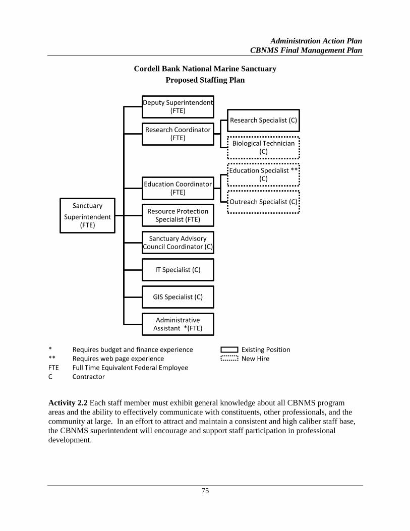
Administration Action Plan
CBNMS Final Management Plan
75
Cordell Bank National Marine Sanctuary
Proposed Staffing Plan
* Requires budget and finance experience Existing Position ** Requires web page experience New Hire FTE Full Time Equivalent Federal Employee C Contractor
Activity 2.2 Each staff member must exhibit general knowledge about all CBNMS program
areas and the ability to effectively communicate with constituents, other professionals, and the
community at large. In an effort to attract and maintain a consistent and high caliber staff base,
the CBNMS superintendent will encourage and support staff participation in professional
development.
Sanctuary
Superintendent (FTE)
Deputy Superintendent (FTE)
Research Coordinator (FTE)
Research Specialist (C)
Biological Technician (C)
Education Coordinator (FTE)
Education Specialist ** (C)
Outreach Specialist (C)
Resource Protection Specialist (FTE)
Sanctuary Advisory Council Coordinator (C)
IT Specialist (C)
GIS Specialist (C)
Administrative Assistant *(FTE)
Administration Action Plan
CBNMS Final Management Plan
76
STRATEGY AD-3: With limited staff and financial resources, CBNMS will develop
partnerships and identify outside funding sources and in-kind services to assist in the
implementation of the management plan.
Activity 3.1 In partnership with regional research and educational institutions and agencies,
establish a CBNMS-supported internship program with graduate students to assist the sanctuary
staff with monitoring, research, and education priorities.
Activity 3.2 Maintain and expand informal working relationship with federal, state, and local
agencies. Partnership activities include coordination on education and outreach projects,
research projects, data analysis, and cruise operations.
STRATEGY AD-4: Support the Sanctuary Advisory Council in its primary roles of providing
advice to the sanctuary superintendent and serving as a liaison between CBNMS and the
sanctuary community.
Activity 4.1 In consultation with the Sanctuary Advisory Council, strengthen the structure of the
council by: evaluating and amending as necessary the Sanctuary Advisory Council charter;
evaluating and developing organizational strategies to enhance the Sanctuary Advisory Council’s
level of participation and effectiveness; evaluating and adjusting, if necessary, Sanctuary
Advisory Council membership; and providing support to help the Sanctuary Advisory Council
develop a respected voice in the community.
Activity 4.2 Identify the role of the Sanctuary Advisory Council in addressing resource
management issues by developing a format for assisting in the building of CBNMS policies and
procedures.
Activity 4.3 Provide support, resources, and guidance to help the council engage and educate the
public about current, new, and emerging resource management issues in the sanctuary.
Activity 4.4 Working groups will be convened by the Sanctuary Advisory Council, as needed, to
focus on specific issues and to allow for participation by additional stakeholders and community
experts.
STRATEGY AD-5: CBNMS will formalize intra- and interagency partnerships to ensure
coordination and cooperation with federal, state, and local jurisdictions within or adjacent to
the sanctuary. NOAA and CBNMS recognize all other authorities in and around sanctuary
waters as important components of effective ecosystem management.
Activity 5.1 CBNMS will engage other agencies in reviewing each other’s proposed actions,
responding to Environmental Impact Statements, participating in CBNMS panels and working
groups. Building agency relationships allows for: coordination of the development of policies at
the federal, state and local level; the sharing of research and education resources; and the
opportunity to work together to identify resource management issues.
Administration Action Plan
CBNMS Final Management Plan
77
Activity 5.2 CBNMS will formalize agreements with federal co-trustee managers signaling that
the cooperative and integrated management approach established for CBNMS has been adopted
by other agencies. To formally implement cooperative management of the sanctuary, a number
of separate types of agreements may be entered into, including: cooperative agreements,
memoranda of understanding, memoranda of agreement, and consultation.
Activity 5.3 CBNMS will formalize agreements for the following programs: (1) Protected
Resources Enforcement Plan (USCG, NMFS, Sonoma County Sheriff's Department, CDFW);
and (2) Emergency Response Plan (local, state and federal emergency response agencies).
STRATEGY AD-6: Develop and make use of performance indicators to measure
effectiveness of the management of the sanctuary as a whole, as well as to evaluate specific
strategies within the management plan.
Performance Evaluation
As part of an effort to improve overall management of sanctuaries, ongoing and routine
performance evaluation is a priority for the ONMS. Both site-specific and programmatic efforts
are underway to better understand the CBNMS staff’s ability to meet the objectives outlined in
each of the action plans. Performance evaluation has many other benefits, including:
Highlighting successful (or not so successful) efforts of site management;
Keeping the public, Congress, and other interested parties apprised of sanctuary management
effectiveness;
Helping management identify resource gaps so that they may better manage their sites;
Improving accountability;
Improving communication among sites, stakeholders and the general public;
Fostering the development of clear, concise and, whenever possible, measurable outcomes;
Providing a means for superintendents to comprehensively evaluate their sites in both the
short and long term;
Fostering an internal focus on problem solving and improved performance;
Providing additional support for the resource allocation process; and
Motivating staff with clear policies and a focused direction.
Performance Evaluation Goal
1. Ensure that CBNMS’s management plan strategies are producing effective results
in addressing the priority resource management issues identified in the
management plan.
Performance Evaluation Objectives
1. CBNMS will continuously measure and evaluate the successes and challenges of
the strategies put forth in the five-year management plan.
Administration Action Plan
CBNMS Final Management Plan
78
2. Based on the outcome of these evaluations, CBNMS will modify existing
programs and make recommendations for the future that best support the CBNMS
primary objective of ecosystem protection.
Activity 6.1 CBNMS staff will conduct routine performance evaluations to collect and record
data on CBNMS performance over time. Using this data, staff will determine the effectiveness
of management plan strategies by (a) evaluating progress towards achievement of each action
plan’s desired outcomes and (b) assessing the role or added value of those outcomes in the
overall accomplishment of site goals and objectives.
Activity 6.2 An annual assessment on the implementation of the CBNMS management plan will
be conducted. This assessment will be conducted internally by CBNMS staff who will consider
the progress and effectiveness of activities implemented over the previous year. In this activity,
successes or weaknesses of specific activities will be determined. Activities deemed less than
successful in achieving desired outcomes will be addressed to correct or improve the
outcomes/outputs. Successful activities will be recognized with application of positive lessons
learned to other programs.
Activity 6.3 Performance data will be generated from internal annual assessment and shared with
advisory council to determine if management strategies need to be changed to better meet their
stated targets. The targets themselves may also be analyzed to determine their validity (if, for
instance, they are too ambitious or unrealistic given current site capacity to address during a
particular year). This activity will be conducted with the management plan review which takes
place every five to ten years.
STRATEGY AD-7: Consider conducting a public regulatory process, under the statutory
authority of the NMSA and in accordance with the NEPA, to examine if additional regulatory
amendments or additions are needed to manage the expanded CBNMS.
Activity 7.1 Work with GFNMS and the CBNMS advisory council to determine interest in
conducting a public regulatory process to consider amending or adding to CBNMS regulations,
separately or in conjunction with any public regulatory process to amend or add to GFNMS
regulations for the expanded GFNMS.
79
CROSS-CUTTING
ACTION PLANS
CBNMS FINAL MANAGEMENT PLAN
I . Cross-Cutting Introduction
II . Administration and Operations
III . Community Outreach
IV. Ecosystem Monitoring
V. Maritime Heritage

Cross-Cutting Introduction
CBNMS Final Management Plan
81
CROSS-CUTTING
INTRODUCTION
Cordell Bank (CBNMS), Gulf of the Farallones (GFNMS), and Monterey Bay (MBNMS)
National Marine Sanctuaries are located adjacent to one another along a 350-mile stretch of the
north-central California coast. All three sanctuaries are managed by the Office of National
Marine Sanctuaries (ONMS), share many of the same resources and issues, and have some
overlapping interest and user groups. There are many opportunities for these sites to work
cooperatively, share assets, and address resource management issues in a coordinated manner.
The three sanctuaries coordinate on many important resource management issues, such as oil
spills and monitoring. However, each site is, for the most part, managed independently of the
others. The three sanctuaries have separate advisory councils and independent education,
research and resource protection programs.
In February 2004 ONMS established the Northern Management Area (NMA) of Monterey Bay
National Marine Sanctuary extending from the San Mateo/Santa Cruz line northward to the
existing boundary between Monterey Bay and Gulf of the Farallones sanctuaries. The Gulf of the
Farallones assumed full administrative and management responsibilities of the NMA in March
2004. Existing Monterey Bay sanctuary regulations and congressional prohibitions apply in the
Northern Management Area. MBNMS continues to manage its Water Quality Protection
Program in San Mateo County. During the Joint Management Plan Review a Northern
Management Area Transition Action Plan was developed and published in the 2008 management
plans for the respective sanctuaries under the Cross-Cutting Action Plan. Many of the strategies
have been implemented since the publication of the plan. Ongoing Strategies have been
incorporated into this publication of the Cross-Cutting Action Plan.
GOALS
The goal of the cross-cutting action plans is to build upon existing coordination efforts and
identify some activities that should be jointly implemented so that these three sites can operate as
integrated and complementary sites to better protect the sanctuaries’ resources. This will ensure
scarce program resources are used more efficiently and result in a more consistent and
coordinated delivery of programs, products and services to the public. Cross-cutting action plans
address these topics: Administration and Operations; Community Outreach; Maritime Heritage;
and Ecosystem Monitoring. Though the implementation of other activities contained in the site-
specific plans may also be effectively coordinated, the cross-cutting action plans would be jointly
developed and implemented across the three sites.
Cross-Cutting Introduction
CBNMS Final Management Plan
82
IMPLEMENTATION WITHIN THE CONTEXT OF A REGIONAL
STRUCTURE
ONMS efforts to address certain priority issues in a cross-cutting framework was a first step in a
larger effort to begin looking at sanctuary resource management issues in a regional or
ecosystem-based context. Since the cross-cutting plans were developed, the ONMS adopted a
regional management structure, comprised of four regions, including a West Coast region, which
is led by a regional director. The purpose of this structure is to maximize program integration
among the ONMS sites, regions, and national program and to other state and federal programs
and partners – across all levels. The regional structure dedicates program leadership and
regional staff resources directly towards integrating programs and forging partnerships that
supports NOAA’s evolving ecosystem-based management approach.
The regional director and staff are based in the region and dedicate their efforts towards
addressing priority regional issues and capitalizing on regional opportunities and partnerships.
Some of their expertise and responsibilities includes working closely with individual sanctuary
staff to coordinate the implementation of certain cross-cutting action plans or projects, such as
regional ecosystem monitoring, community outreach, or maritime heritage. Individual
sanctuaries may also either take or share the lead for implementing the cross-cutting action plans.
Administration and Operations Cross-Cutting Action Plan
CBNMS Final Management Plan
83
ADMINISTRATION AND
OPERATIONS
CROSS-CUTTING ACTION PLAN
GOALS
The goals of the cross-cutting Administration and Operations Action Plan are to (1) improve and
sustain coordination and cooperation across the three sanctuaries to better and more efficiently
manage and protect sanctuary resources, and (2) for the individual sites to continue working and
functioning as an integrated team. Fulfilling these goals for the three sanctuaries requires
enhanced communication and collaboration among and between superintendents and program
staff.
ISSUE DESCRIPTION
During scoping meetings for the JMPR, the ONMS received many comments relating to the need
to coordinate various administration and operations across the sites. The three advisory councils
and sanctuary staff identified several of these issues as priority items to address in the
management plan review. These include:
Improving resource management consistency and efficiency
Expanding coordination and communication between sites and to the public
Evaluating emergency response capabilities in the region, and clarify and coordinate the
sanctuary’s role in relation to other agencies
Developing a mechanism to address current and emerging issues between the sites
Coordinating research/monitoring, education/outreach, and enforcement activities
ADDRESSING THE ISSUE
Each of the three sanctuaries developed site-specific administration and operations action plans
to address the staffing and infrastructure needed in order to implement their new management
plans. In contrast, this cross-cutting administration and operations plan targets some activities
that will be implemented by all three sites in order to improve communication and maximize
their ability to collaborate and cooperate on many important resource management and program
areas.
Administration and Operations Cross-Cutting Action Plan
CBNMS Final Management Plan
84
STRATEGY XAO-1: Improve internal communications among the three sanctuaries.
Successful collaboration and coordination among sanctuaries is related to the amount and
intensity of communication. This strategy focuses on improving communications between the
sites to ensure there are regular opportunities for the superintendents, staff and the advisory
councils to learn what is happening at each of the three sites and jointly plan regional programs
and activities.
Activity 1.1 Maintain regular communications between the sanctuary superintendents.
Superintendents will engage in informal (impromptu phone calls) and formal (regularly
scheduled calls or meetings) communications. GFNMS and MBNMS superintendents will meet
monthly by phone to discuss common issues.
Activity 1.2 The west coast superintendents will meet monthly by phone with the West Coast
Region staff to discuss regional issues and will meet annually in person to develop annual
regional priorities.
Activity 1.3 Maintain a new employee orientation program that includes information from the
three sanctuaries and the ONMS.
If funding allows, the orientation program will include travel to the other sites to meet staff and
learn about their program and activities. These efforts should be coordinated with similar efforts
at headquarters.
Activity 1.4 The program coordinators will meet at least once per year to share information and
plan joint activities prior to the development of the annual operating plans.
In cooperation with the regional office, the regional lead for each program will facilitate bringing
this group together, either via conference call or in person if budgets allow.
Activity 1.5 Schedule annual joint advisory council chair and sanctuary superintendent meeting.
The MBNMS and GFNMS advisory councils currently meet biannually to discuss issues and
program activities in the MBNMS NMA. GFNMS and CBNMS advisory councils will meet
jointly on an annual basis to discuss the expansion area.
Activity 1.6 Encourage and provide opportunities for site staff to give presentations at each
other’s advisory council meetings.
Superintendents, council chairs and coordinators should encourage program staff presentations at
each other’s meetings.
Administration and Operations Cross-Cutting Action Plan
CBNMS Final Management Plan
85
STRATEGY XAO-2: Improve the efficiency and cost-effectiveness of program operations
and administration.
Each of the three sanctuaries has been designated for over twenty years and during this time has
accumulated an inventory of equipment, vessels and resources to support their own
research/monitoring, education/outreach, and resource protection programs. This strategy
recognizes there are instances in which it is more cost-effective to share resources among the
sites and some instances when it may be more appropriate for each site to have their own.
Currently each sanctuary office is responsible for managing most of its own administration and
information technology functions, including contracts, procurements, time and attendance, travel
orders and vouchers, websites, databases, and geographic information systems. Each site
employs a varying number of staff or contractors to perform some of the administrative tasks.
The goal of this strategy is to evaluate the staffing plans at the sites and maximize opportunities
to share personnel and implement methods to make routine administrative functions more
efficient. The strategy also highlights the importance of building upon existing efforts to share
information technology resources.
Activity 2.1 Contact and inform the other sites early in the planning stages of field operations to
provide opportunities to plan joint missions and to share information and data.
Individual sites may have program personnel, technology or information that would benefit the
field operations of another site.
Activity 2.2 As opportunities arise, create short-term opportunities for staff exchanges,
rotations, details and informal staff loans for specific projects or to fulfill on-going needs across
the West Coast Region.
In addition to sharing valuable technical expertise, staff exchanges provide opportunities for
professional development of program staff.
Activity 2.3 Participate in each other’s interview panels to review candidates for new and vacant
positions, where possible.
This is particularly important when hiring for positions that work with other sites on a regular
basis.
Activity 2.4 Cordell Bank and Gulf of the Farallones superintendents and other planning staff
will discuss administrative and operational needs and expectations related to the expansion area.
Staff will meet to determine needs and best opportunities for efficiency in addressing the
management of the new expansion area. This relates to all programs, shared staffing, and budget
allocation across the two sites.
Activity 2.5 Evaluate alternative management strategies for offshore portions of northern
expansion areas.
Administration and Operations Cross-Cutting Action Plan
CBNMS Final Management Plan
86
GFNMS and CBNMS superintendents and WCRO will conduct a series of discussions regarding
the most efficacious means to manage the offshore portions of the expanded areas of GFNMS
and CBNMS, ensuring effective marine science, outreach and resource protection.
STRATEGY XAO-3: Improve the coordination of sanctuary resource protection activities
and programs.
Each of the three site-specific management plans proposes various strategies to address their own
resource protection programs (e.g., regulations/permitting, emerging issues, enforcement,
emergency response). This strategy is aimed at improving the communication and coordination
of resource protection activities across the three sites. The strategy addresses the need to
improve staff understanding and awareness of all of the three sites’ regulatory and permit
processes and activities. Secondly, it establishes a process to identify and, when appropriate,
jointly address emerging issues in a regional capacity. This includes coordination with local,
state and other federal entities. Third, it recommends the development of a regional sanctuary
emergency response plan so that the ONMS is better prepared to address emergencies on a
regional scale. Finally, it identifies the need to comprehensively evaluate enforcement needs in
relation to the new management plans and develop and implement a regional enforcement plan.
Activity 3.1 Improve staff awareness and understanding of each site’s regulations.
Establish a basic and consistent understanding of each site’s regulations. Ensure all staff have
and are familiar with the portion of the WCRO web page which consolidates the management
documents for the West Coast Region: regional regulations, terms of designation and
management plans. Produce a table listing all regulations of West Coast sanctuaries.
Activity 3.2 The West Coast sanctuaries will continue to work closely on any future proposed
regulatory changes that could affect other sites. The GFNMS and MBNMS Resource Protection
Teams will closely coordinate on any future proposed regulatory changes that could impact the
NMA.
Activity 3.3 GFNMS will facilitate a public process in the next five years to consider whether
the San Francisco Exemption Area should be incorporated into the MBNMS.
Such an action would require changing the MBNMS regulations and designation document and
require coordination with MBNMS staff, and approval from the MBNMS Superintendent. Public
scoping for this process was initiated in 2012.
Activity 3.4 The West Coast sanctuaries will share responsibilities for preparing regional permits.
GFNMS will be responsible for permit activities in the NMA.
West Coast sanctuaries will inform each other of any new permit applications or other activities
that could affect any of the sanctuaries. GFNMS will process permits within the NMA, except
for water quality permits, which will continue to be overseen by MBNMS.
Administration and Operations Cross-Cutting Action Plan
CBNMS Final Management Plan
87
Activity 3.5 MBNMS staff will continue to implement Water Quality Protection Program
activities including conducting site water quality needs assessment, review water quality permits
and authorizations.
MBNMS Water Quality staff will participate on Technical Advisory Committees that implement
strategies within the WQPP Action Plans, implement volunteer water quality monitoring events
including First Flush and Snapshot Day, review and comment on NPDES permits, respond to
discharges entering the MBNMS NMA, coordinate and collaborate with partners participating in
the Agriculture Water Quality Alliance, and oversee monitoring of Areas of Special Biological
Significance in a sub-contract to the San Mateo Resource Conservation District.
Activity 3.6 Coordinate emerging issues among the West Coast sanctuaries and develop
coordinated strategies to address emerging issues
As an individual site staff identifies emerging issues, staff members will determine the
significance and potential to impact another site, and communicate this to the potentially affected
site(s). They will jointly determine if a new or emerging issue needs action and identify a
strategy and activities to address the issue, depending on whether it is an immediate or long-term
threat, what is (or is not) known about it, and if there are adequate resources to address it
properly.
Activity 3.7 Implement West Coast Region emergency response plan.
The West Coast Region emergency response plan addresses broad emergency response issues
that affect the region, identifies ONMS staffing responsibilities and expertise, and outlines how
the ONMS will coordinate with existing federal, state and local emergency response agencies in
California. GFNMS staff will lead efforts to coordinate and implement site-specific activities to
respond to emergencies in the NMA.
Activity 3.8 Coordinate with the ONMS Damage Assessment Team on populating and making
the Sanctuary Hazardous Incident Emergency Logistics Database System (SHIELDS) functional
and operative for the three sanctuaries and integrating it with the existing SIMoN database.
Activity 3.9 Continue to work closely on enforcement activities in the region.
Regional enforcement staff will coordinate and cooperate on enforcement activities as they relate
to other sites. GFNMS staff will provide assistance as appropriate in the planning and
implementation of enforcement activities in the NMA and will coordinate with MBNMS to
ensure consistency across sites.
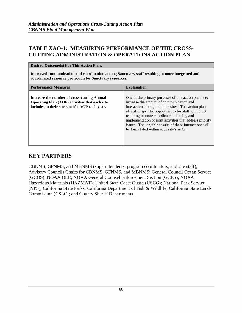
Administration and Operations Cross-Cutting Action Plan
CBNMS Final Management Plan
88
TABLE XAO-1: MEASURING PERFORMANCE OF THE CROSS-
CUTTING ADMINISTRATION & OPERATIONS ACTION PLAN
Desired Outcome(s) For This Action Plan:
Improved communication and coordination among Sanctuary staff resulting in more integrated and
coordinated resource protection for Sanctuary resources.
Performance Measures Explanation
Increase the number of cross-cutting Annual
Operating Plan (AOP) activities that each site
includes in their site-specific AOP each year.
One of the primary purposes of this action plan is to
increase the amount of communication and
interaction among the three sites. This action plan
identifies specific opportunities for staff to interact,
resulting in more coordinated planning and
implementation of joint activities that address priority
issues. The tangible results of these interactions will
be formulated within each site’s AOP.
KEY PARTNERS
CBNMS, GFNMS, and MBNMS (superintendents, program coordinators, and site staff);
Advisory Councils Chairs for CBNMS, GFNMS, and MBNMS; General Council Ocean Service
(GCOS); NOAA OLE; NOAA General Counsel Enforcement Section (GCES); NOAA
Hazardous Materials (HAZMAT); United State Coast Guard (USCG); National Park Service
(NPS); California State Parks; California Department of Fish & Wildlife; California State Lands
Commission (CSLC); and County Sheriff Departments.
Community Outreach Cross-Cutting Action Plan
CBNMS Final Management Plan
89
COMMUNITY OUTREACH
CROSS-CUTTING ACTION PLAN
GOAL
A coordinated, collaborative regional community outreach strategy will build awareness
throughout north-central California and beyond about (1) the existence and purpose of the three
sanctuaries, the West Coast region, and the ONMS; (2) the diverse natural resources and
ecosystems of each sanctuary and why they need protection; (3) the relevance of these
ecosystems to people; (4) the economic and intrinsic value of the three sanctuaries to coastal and
inland communities beyond such direct industries as fishing and ecotourism; (5) how these three
sanctuaries are working with constituent groups; and (6) how individuals and groups can be
engaged in helping the sanctuaries accomplish their resource protection, research, and education
goals.
ISSUE DESCRIPTION
Under the ONMS, each sanctuary in the system conducts education and outreach activities to
build broad public awareness about the existence and purpose of our nation’s marine sanctuaries.
The ONMS recognizes a well-informed local, regional, and national constituency greatly
enhances the ability of the sanctuaries to protect their natural and cultural resources. Therefore,
outreach activities should provide local and state governments, businesses, non-governmental
organizations, constituent groups, and the general public with the information necessary to be
effective partners in the stewardship of sanctuary resources.
This cross-cutting action plan identifies appropriate regional audiences and topics, regional
outreach strategies, and marketing and media exposure efforts that effectively highlight specific
program activities across all three sites, the region and the national system. It is also designed to
complement each site-specific program and to be flexible enough to incorporate new strategies
and topics over time.
Effective community outreach is accomplished through a continuous cycle of ocean and coastal
outreach, education, and stewardship. Community outreach expands awareness, knowledge and
ultimately changes attitudes and behaviors. By finding information on ocean and coastal
resources, and stewardship opportunities in which to get involved in the sanctuary, people begin
to have a personal relationship with the sanctuary and may be more likely to become
ambassadors helping to protect sanctuary resources. Community outreach involves three
Community Outreach Cross-Cutting Action Plan
CBNMS Final Management Plan
90
strategies tailored to the specific needs and interests of a given audience and may be delivered by
members of that audience.
Outreach provides audiences with sanctuary-related information and materials promoting
ocean and coastal stewardship.
Education provides fundamental scientific understanding, knowledge, training, or
professional development on topics relevant to the world’s atmosphere, climate, oceans
and coastal ecosystems, and resource protection.
Stewardship is a personal sense of responsibility to take informed action and make caring
choices, at home or work, which promote and protect the health of our coasts and oceans.
STRATEGY XCO-1: Build upon and expand existing ocean and coastal outreach
This strategy is aimed at raising general awareness of marine ecosystems, individual national
marine sanctuaries and the national marine sanctuary system, and inspiring stewardship of ocean
and coastal resources. Outreach provides audiences with sanctuary-related information and
materials based on NOAA science, products, and services that promote ocean and coastal
stewardship. These audiences may be: north-central California coastal residents; people who
live and work in inland California communities that regularly visit the ocean, such as divers,
kayakers, tidepoolers, etc.; those who make their living within the ocean environment, like
fishermen, maritime shipping companies, etc.; or people who live outside California that care
about the ocean even though they may never visit. These, and others, are important voices in the
protection and stewardship of the oceans. Key target audiences and messages should also be
closely coordinated with outreach needs identified in the issue-related action plans.
Activity 1.1 Develop or strengthen coordinated regional outreach programs and opportunities.
Outreach staff should coordinate on public service announcements, issue-specific workshops and
brochures (e.g., tide pool etiquette), docent programs, signage, learning centers, exhibits and
displays at community events that encompass or represent the region.
Activity 1.2 Plan and conduct regional sanctuary outreach events.
Outreach staff should promote the importance of national marine sanctuaries, conservation
science and resource protection programs, working together to improve understanding of marine
conservation and management.
Activity 1.3 Develop and implement joint media communications plan, e.g., print, radio, TV,
Internet.
Media personnel at respective sites should coordinate with the WCRO media liaison to develop a
plan.
Community Outreach Cross-Cutting Action Plan
CBNMS Final Management Plan
91
Activity 1.4 Identify and partner with external programs and partners to incorporate sanctuary-
related messages, identify best practices and achieve common goals.
Regional outreach personnel should work together to target partners and programs that can
effectively communicate ONMS messages on a regional level, and assign appropriate leads to
initiate contact and follow-up.
STRATEGY XCO-2: Enhance and coordinate ocean and coastal education
This strategy focuses on building community knowledge and fostering caring actions and
attitudes targeting priority issues identified in the management plans. The ONMS’s joint ocean
and coastal education efforts provide a fundamental understanding grounded in science,
knowledge, training, and/or professional development to a particular audience on topics
identified as important to protect sanctuary resources. There are many possible audiences such
as students, teachers, state and local agencies, community leaders, and the general public.
Sanctuary-related educational activities are based on NOAA science, systematic in design with
clear goals, objectives and measurable outcomes; aligned, where appropriate, with state or
national education standards; and designed to facilitate evaluation by a third party.
Activity 2.1 Collaborate on existing site-specific education programs and products as a means to
enhance and expand educational offerings.
Each year, the education staff will jointly meet to identify collaborative projects for inclusion in
their respective AOPs.
Activity 2.2 Take a multicultural/multilingual approach to all outreach efforts.
Assess demographics of geographic areas with programming and ensure multicultural relevance
to diverse audiences. Develop multicultural educational curricula and materials in response to
demographic assessment.
Activity 2.3 Identify and implement new education programs that can be developed jointly with
other sites.
Education leads should identify and implement new programs as needs arise and as budgets
allow.
STRATEGY XCO-3: Enhance ocean and coastal stewardship
Marine sanctuary stewardship is a personal sense of responsibility to take informed action and
make caring choices, at home or work, which promote and protect the health of our coasts and
oceans. A steward develops attitudes, motivations, and commitments that are reflected in
informed decisions and responsible actions. Stewards can be individuals, members of groups, or
entities that influence others’ opinions and actions about the oceans. Stewardship can be
demonstrated through a variety of means, including:
Community Outreach Cross-Cutting Action Plan
CBNMS Final Management Plan
92
Volunteering for an organized stewardship program,
Taking personal action to protect our ocean sanctuaries,
Providing informed public input into decisions regarding the sanctuaries, and
Informing others regarding marine ecosystems and the sanctuary program.
Similar to the audiences for outreach, ocean and coastal stewards may be north-central California
coastal residents, people who live and work in inland California communities that regularly visit
the ocean, those who make their living within the ocean environment, or people who care about
the ocean even though they may never visit.
Activity 3.1 Create, maintain and promote sanctuary and partner volunteer programs.
Cultivate volunteers to provide opportunities for stewardship as well as expand resource
protection, education, and outreach capabilities of the three sanctuaries.
Activity 3.2 Create new ways to inspire coastal and ocean stewardship in local communities.
The three sites will conduct needs assessments with targeted constituents and audiences to
identify innovative and creative methods of engaging specific groups of people in sanctuary
activities. Some examples include working with tourism industry, faith-based or cultural
organizations, retired citizens or local art groups.
Activity 3.3 Identify partners to incorporate stewardship messages.
Regional outreach personnel should work together to target partners that can effectively
communicate ONMS stewardship messages, and assign appropriate leads to initiate contact and
follow-up.
Community Outreach Cross-Cutting Action Plan
CBNMS Final Management Plan
93
Table XCO-1: Measuring Performance of the Cross-Cutting Community Outreach Action Plan
Desired Outcome(s) For This Action Plan:
Expand joint education and outreach efforts in a manner enhancing protection for Sanctuary resources
and the delivery of programs and services to local communities.
Performance Measures Explanation
Increase the number of joint education and outreach
efforts directed at communities
One of the main purposes of this action plan is to
expand general awareness of the three sanctuaries,
develop joint education products addressing priority
issues, and increase involvement of individuals in the
stewardship of the resources in the three sanctuaries.
Some of the programs directed at local communities
include schools and teachers, volunteers, fairs and
festivals, visitor centers, public lecture series, etc.
KEY PARTNERS
CBNMS, GFNMS, MBNMS, CINMS, OCNMS, West Coast Region Office, NMFS, NOAA
OLE, USCG, NPS, USEPA, Bureau of Land Management, California Coastal National
Monument, other federal agencies, California State Parks, Elkhorn Slough National Estuarine
Research Reserve, other state agencies, Association of Monterey Bay Area Governments,
Association of (SF) Bay Area Governments, Sonoma County Regional Parks, cities, local
parks/recreation departments, Advisory council members from all three sanctuaries/working
groups, FMSA, Monterey Bay and Channel Islands Sanctuary Foundation, Stewards of Coast
and Redwoods, Fort Ross Conservancy, local NGOs/non-profits, Save Our Shores, The JASON
Project, SIMoN, Community Outreach Working Group, Snapshot Day Water Quality Monitoring
Event, Long-term Monitoring Program and Experiential Training for Students (LiMPETS),
Beach Watch, Beach Coastal Ocean Mammal/Bird Educational and Research Survey (Beach
COMBERS), MBNMS Team Ocean Conservation Education Action Network (OCEAN), Global
Learning and Observation to Benefit the Environment (GLOBE), Bay Net, traditional and
electronic media (both coastal and inland, local and national, including local weekly papers,
community access TV stations, social media), California Ocean Communicators Alliance (Thank
You Ocean), pollution prevention programs, chambers of commerce, shipping trade associations,
tourism trade associations, dive clubs/shops, kayak clubs/shops, spot abalone divers, other
recreational groups, natural history museums, institutions with community service
requirements/marine sciences (high schools, colleges), state/local volunteer programs, high
school/college classes doing coastal monitoring, multicultural community leaders, and bilingual
school programs.

Ecosystem Monitoring Cross-Cutting Action Plan
CBNMS Final Management Plan
95
ECOSYSTEM MONITORING
CROSS-CUTTING ACTION PLAN
GOALS
The cross-cutting goal of coordinated ecosystem monitoring across CBNMS, GFNMS and
MBNMS is to better (1) determine the current and anticipate the future status of sanctuary
resources; (2) understand the limits of variation in resources; (3) detect temporal and spatial
changes in resources; (4) identify potential agents of change; and (5) provide scientific
information that can guide management decisions on priority issues.
INTRODUCTION
One of the express purposes and policies of the National Marine Sanctuaries Act is that long-
term monitoring of sanctuary resources be supported, promoted, and coordinated (16 U.S.C.
1431). Sanctuaries also promote data collection to assess resource or environmental change with
respect to implemented management actions. The suite of monitoring information required by
sanctuary management includes data from within the sanctuary and from areas outside the
boundaries that influence sanctuary waters.
For the most part, individual sanctuaries work independently to develop monitoring programs
and partnerships to inform their management concerns. These programs typically rely on
substantial support from other government, private, and academic institutions at the federal,
state, and local levels. The program designs are often only indirectly influenced by sanctuary
management responsibilities.
Undertaking ecosystem monitoring requires long-term comprehensive assessments and broad
scale integration of data collected in a wide variety of habitats (e.g., coastal interface, subtidal,
continental shelf, shelf break, and deep water) and in areas that directly influence them (e.g.,
watershed, estuaries, coastal currents). Such assessments and integration can only be achieved
through coordination with multiple partners focused on a variety of resources and geographic
scales. Because the three sanctuaries of Cordell Bank, Gulf of the Farallones, and Monterey Bay
have contiguous boundaries, they protect and manage many of the same habitats types and living
resources, some of which range throughout the combined area. As such, the sanctuaries should
consider each other as primary partners in monitoring efforts to evaluate the status and trends of
these shared resources. Coordination among the three sanctuaries to promote, conduct, integrate,
and synthesize data from ecosystem monitoring activities is the most effective and efficient
Ecosystem Monitoring Cross-Cutting Action Plan
CBNMS Final Management Plan
96
means to improve availability of information for resource conservation and management across
the region.
The combined areas of CBNMS, GFNMS and MBNMS also represent a substantial portion of
California coastal waters. Regional sanctuary monitoring coordination across this extensive area
will help promote sanctuary management concerns as a driver for large-scale monitoring
initiatives and partnerships. The data collected from coordinated efforts will be useful at the
local and regional scale, with the potential for influencing resource management actions
throughout a substantial portion of the West Coast.
ADDRESSING THE ISSUE
Most of the monitoring data that informs sanctuary management are not financed, collected, or
analyzed by the sanctuaries. Instead, sanctuaries support and promote these activities indirectly
by providing vessel time, staff support, and equipment, and coordinating the interests and
information of outside agencies and partners. They also assist in securing outside funding that
can be directed toward projects that address sanctuary information needs such as SIMoN.
Indirect support is appropriate to enhance capacities of the sanctuary programs to meet the
mandate of resource protection. Such expertise to collect and analyze the variety of information
required for management needs is accessible through partnerships with various research
institutions. However, effective resource management requires a holistic view, which
sanctuaries are uniquely positioned to achieve. To meet their resource management mandate,
sanctuaries must synthesize and integrate information from disparate research and monitoring
projects. They have the further responsibility of interpreting and applying available scientific
knowledge for resource managers and the public. Thus, coordination of ecosystem monitoring
efforts requires strategic action on various sanctuary-specific programmatic levels.
Recommended strategies focus on coordinating existing activities, identifying opportunities for
additional coordination, and establishing the administrative infrastructure, advisory panels, and
oversight mechanisms required to support, direct, and evaluate coordinated monitoring across the
three sanctuaries. Because many of the monitoring requirements common to CBNMS, GFNMS,
and MBNMS overlap with the interests of CINMS and OCNMS, the strategies recommended in
this proposed action plan should serve as a model for expanded coordination of appropriate
monitoring activities across all five of the West Coast sanctuaries. The strategies are also
consistent with efforts of the System Wide Monitoring Program (SWiM) to improve collection,
evaluation, and interpretation of monitoring information throughout the sanctuaries. Thus, these
activities promote system and regional integration across the program as well as improving
ecosystem conservation and management in the combined area of the three sanctuaries.
STRATEGY XEM-1: Coordinate existing targeted monitoring activities to promote greater
efficiency and effectiveness.
Priority activities for initiation of joint ecosystem monitoring within the region should be
focused on the coordination of existing sanctuary-specific monitoring programs that assess
Ecosystem Monitoring Cross-Cutting Action Plan
CBNMS Final Management Plan
97
similar ecosystems in at least two of the three sanctuaries. This includes coordinating targeted
programs that monitor conditions in the coastal interface and the pelagic/offshore systems.
These priorities are based on the need to establish common ecological monitoring efforts
throughout the region and the priority issue areas identified in the management plan that could
best be addressed through a coordinated approach among the sanctuaries. Some of the priority
habitats that have been identified for joint monitoring include: rocky intertidal shores, deep sea
benthos and pelagic/open ocean. The coordination channels and activities established to support
these targeted efforts could serve as a model for additional monitoring coordination in the future.
Other existing or newly emerging monitoring activities, not identified in this action plan,
represent potential opportunities for additional coordination. Assessment of such opportunities is
addressed in Strategies XEM-2 and XEM-3.
Activity 1.1 Regional science staff should coordinate regarding intertidal monitoring programs.
Coordinate individual sanctuary rocky intertidal monitoring programs and continue to
collaborate with other large-scale rocky intertidal monitoring efforts, such as PISCO and
MARINe.
Activity 1.2 Beach Watch and Beach COMBERS will continue to collaborate on sharing
information on the health of seabirds and trends in beachcast wildlife.
GFNMS Beach Watch staff should evaluate the feasibility of expanding existing citizen science
monitoring in the expansion area.
Activity 1.3 Maintain and expand ACCESS integrated sanctuary marine mammal, seabird and
sea turtle surveys.
CBNMS and GFNMS science staff should evaluate the feasibility of expanding existing at-sea
monitoring to the expansion area.
Activity 1.4 Regional science staff should coordinate regarding benthic habitat surveys.
Jointly develop research cruise plans and standards for sampling and reporting results for benthic
habitat survey work. Augment the benthic habitat survey work with new technologies such as
ROV and AUV surveys.
STRATEGY XEM-2: Implement existing regional ecosystem monitoring activities.
Over the last decade, many federal and state agencies have actively participated in collaborative
efforts to develop and implement integrated coastal and ocean observing and data management
systems. To further these efforts, the ONMS, and many individual sanctuaries, have been
working closely with their partners to build upon and integrate existing site monitoring programs
into regional ecosystem monitoring programs. The following activities have been identified as
Ecosystem Monitoring Cross-Cutting Action Plan
CBNMS Final Management Plan
98
pilot programs within the ONMS to test the concept of integrating observation data and making
it available to resource managers and the public.
Activity 2.1 Continue the West Coast Observation Project at CBNMS, GFNMS and MBNMS.
The West Coast Observation Project integrates ocean observation data collected at OCNMS,
CBNMS, GFNMS and CINMS. The project focuses on data streams collected at numerous new
instrument moorings installed at specific locations within each of the four sanctuaries. The
project intends to make the monitoring data accessible via the Internet in an IOOS compatible
format. The data from this project would be best shared through the Central and Northern
California Ocean Observing System (CeNCOOS).
Activity 2.2 Develop and implement an integrated Sanctuary System-Wide Monitoring (SWiM)
program for CBNMS, GFNMS and MBNMS by publishing Condition Reports and collaborating
with CeNCOOS.
The primary purpose of the SWiM program is to monitor specific ecological parameters of the
sanctuary and ensure the timely flow of data and information to those responsible for managing
and protecting resources in the ocean and coastal zone, and to those that use, depend on, and
study the ecosystems encompassed by the sanctuaries. It also provides a reporting strategy,
through Condition Reports, to enable the evaluation of status and trends in protected resources
and activities that affect them. These efforts will be integrated with SIMoN, which implements
the monitoring, coordinates with partners, and provides GIS, Web and other products that allow
for local and regional information sharing, as well as through CeNCOOS.
Activity 2.3 Continue expanding the Sanctuary Integrated Monitoring Network (SIMoN).
SIMoN is the primary mechanism to coordinate data and information among the sites. CB, GF
and MBNMS have their monitoring projects summarized with available data and images on the
SIMoN website. This information is linked to the National Program monitoring summary. Joint
interactive maps, images and “what’s new” items are also available. Project information and
new cross site tools will continue to be developed as needed.
Activity 2.4 Look for partnerships to support ecosystem monitoring.
Collaborate with NMFS on the California Current Integrated Ecosystem Assessment and
integrate this into SIMoN ecosystem assessments.
Activity 2.5 Look for innovative ways to support ecosystem monitoring.
Evaluate and identify ongoing funding opportunities to support regional and larger scale ongoing
monitoring activities.
Ecosystem Monitoring Cross-Cutting Action Plan
CBNMS Final Management Plan
99
STRATEGY XEM-3: Establish a joint internal monitoring coordination team.
Coordination of monitoring activities among the sanctuaries requires an administrative
infrastructure to identify and act on cross-boundary opportunities, collaborate with large-scale
initiatives, and interpret the results for resource managers and public audiences across the region.
Activity 3.1 Continue to coordinate research and monitoring across CBNMS, GFNMS and
MBNMS.
CBNMS, GFNMS, and MBNMS coordinate on the use of the research vessel FULMAR. In
addition, GFNMS and CBNMS coordinate and partner on offshore monitoring which includes
the NMA. Finally, monitoring information from all sites is shared through the SIMoN web page
and interactive maps.
Activity 3.2 The CBNMS, GFNMS, and MBNMS science staff will continue to work jointly
with the site and West Coast Region media staff to develop a research and communications plan
Activity 3.3 Develop annual ecosystem-based research and monitoring operating plans in
collaboration with each other to meet site, regional, and national monitoring needs. CBNMS,
GFNMS and MBNMS science staff should share research and monitoring information between
sites as annual operating plans are developed.
Ecosystem Monitoring Cross-Cutting Action Plan
CBNMS Final Management Plan
100
TABLE XEM-1: MEASURING PERFORMANCE OF THE CROSS-
CUTTING ECOSYSTEM MONITORING ACTION PLAN
Desired Outcome(s) For This Action Plan:
Increased collaboration among, capacity of, and productivity of the three sanctuary monitoring programs
in order to enhance our understanding of the ecosystem(s) in this region and those natural and human
factors affecting them.
Performance Measures Explanation
1. Increase the number of cooperative research and
monitoring activities.
2. Continue to include Cordell Bank and Gulf of the
Farallones in SIMoN and expand its infrastructure so
that it can be integrated with other coastal and ocean
observation systems along the West Coast.
3. Design and implement coordinated monitoring
programs consistent with the ONMS System Wide
Monitoring Framework (SWiM) at each site.
1. Research staff from the three sanctuaries currently
engage in limited joint research and monitoring
activities. However, to improve our knowledge and
understanding about the broader ecosystem in this
region, the three sites need to coordinate and
systematically plan and implement joint research and
monitoring activities with each other and other
partners. These new joint research and monitoring
activities will be reflected in each sites’ AOP.
2. SIMoN is rapidly evolving into a system-wide tool
for organizing and displaying research and
monitoring related information for MBNMS,
GFNMS, and CBNMS. In addition, SIMoN has
evolved so other regional coastal and ocean
observation systems could be integrated within
SIMoN.
3. The ONMS has been working for several years to
develop a System Wide Monitoring (SWiM) Program
Framework. The program is underway and ready to
be implemented at MBNMS, GFNMS, and CBNMS,
particularly through Condition Reports.
KEY PARTNERS
CBNMS, GFNMS, MBNMS, CINMS, OCNMS, WCR, NCCOS, NMFS, NESDIS, National
Coastal Data Development Center (NCDDC), National Oceanographic Data Center (NODC),
National Data Buoy Center (NDBC), NOAA National Estuarine Research Reserve System
(NERRS), advisory councils, NPS, USEPA, USFWS, BOEM, USGS, BML, University of
California-Santa Cruz (UCSC), State of California, Partnership for Interdisciplinary Studies of
Coastal Oceans (PISCO), Multi-Agency Rocky Intertidal Network (MARINe), Southern
California Coastal Water Research Project Authority (SCCWRP), Tenera Inc., Kinetic Labs,
Inc., SIMoN, Coastal Observation and Seabird Survey Team (COASST), California Cooperative
Oceanic Fisheries Investigations (CalCOFI), Monterey Bay Aquarium Research Institute
(MBARI), Alliance for California Current Ecosystem Observation (ACCEO), NCDFW, Ocean-
US, SWiM, Southeast Area Monitoring and Assessment Program (SEAMAP), Integrated Ocean

Ecosystem Monitoring Cross-Cutting Action Plan
CBNMS Final Management Plan
101
Observing System (IOOS), CeNCOOS, MBNMS RAP, CBNMS RAP, FMSA, Monterey Bay
and Channel Islands Sanctuary Foundation, and Point Blue.

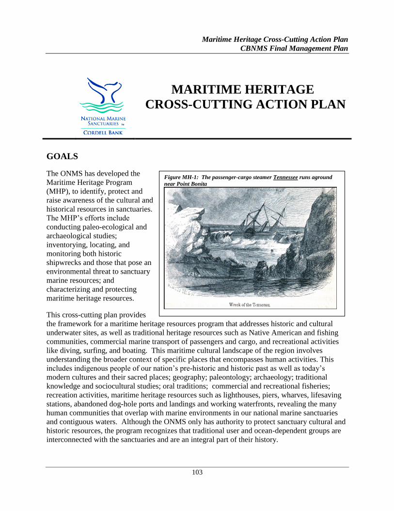
Maritime Heritage Cross-Cutting Action Plan
CBNMS Final Management Plan
103
MARITIME HERITAGE
CROSS-CUTTING ACTION PLAN
GOALS
The ONMS has developed the
Maritime Heritage Program
(MHP), to identify, protect and
raise awareness of the cultural and
historical resources in sanctuaries.
The MHP’s efforts include
conducting paleo-ecological and
archaeological studies;
inventorying, locating, and
monitoring both historic
shipwrecks and those that pose an
environmental threat to sanctuary
marine resources; and
characterizing and protecting
maritime heritage resources.
This cross-cutting plan provides
the framework for a maritime heritage resources program that addresses historic and cultural
underwater sites, as well as traditional heritage resources such as Native American and fishing
communities, commercial marine transport of passengers and cargo, and recreational activities
like diving, surfing, and boating. This maritime cultural landscape of the region involves
understanding the broader context of specific places that encompasses human activities. This
includes indigenous people of our nation’s pre-historic and historic past as well as today’s
modern cultures and their sacred places; geography; paleontology; archaeology; traditional
knowledge and sociocultural studies; oral traditions; commercial and recreational fisheries;
recreation activities, maritime heritage resources such as lighthouses, piers, wharves, lifesaving
stations, abandoned dog-hole ports and landings and working waterfronts, revealing the many
human communities that overlap with marine environments in our national marine sanctuaries
and contiguous waters. Although the ONMS only has authority to protect sanctuary cultural and
historic resources, the program recognizes that traditional user and ocean-dependent groups are
interconnected with the sanctuaries and are an integral part of their history.
Figure MH-1: The passenger-cargo steamer Tennessee runs aground
near Point Bonita
Maritime Heritage Cross-Cutting Action Plan
CBNMS Final Management Plan
104
ISSUE DESCRIPTION
The NMSA and site regulations mandate the management and protection of sanctuary cultural
and historical resources. Cultural resources are defined as any historical or cultural feature,
including archaeological sites, historic structures, shipwrecks, and artifacts. Historical resources
are defined as any resources possessing historical, cultural, archaeological or paleontological
significance, including sites, contextual information, structures, districts, and objects
significantly associated with or representative of earlier people, cultures, maritime heritage, and
human activities and events. Historical resources include “submerged cultural resources,” and
also include “historical properties,” as defined in the National Historic Preservation Act (NHPA),
as amended, and its implementing regulations, as amended.
The area encompassed by CBNMS, GFNMS, and MBNMS has a long and interesting maritime
history. The sea floor preserves remnants of the sites where people lived and of the vessels in
which they conducted trade and fought wars. Ships, boats, wharves, lighthouses, lifesaving
stations, fort, dog-hole ports, whaling stations, prehistoric sites, and a myriad of other heritage
treasures lie covered by water, sand, and time in GFNMS and MBNMS. Records show there is
one historic shipwreck within CBNMS boundaries, the ex-USS Stewart..
The history of California’s north-central coast is predominantly a maritime one. From the days
of the early Ohlone, Coast Miwok, and Kashia Pomo inhabitants to the exploration and
settlement of California to the present, coastal waterways remain a main route of travel,
subsistence, and supply. The heritage of the first peoples has been and is today represented not
only in the sites of former settlements but also by the traditions and heritage of those people, who
have persisted as important members of the coastal community. Their place names, their
memories and their traditions remain on these shores and waters whether written on a map or
not.
Ocean-based commerce and industries (e.g., fisheries, shipping, military, recreation, tourism,
extractive industries, exploration, research, and aesthetics) are important to the maritime history,
the modern economy, and the social character of this region. These constantly changing human
uses define the maritime cultural landscape of these sanctuaries and help interpret our evolving
relationship with the sanctuary resources. Ports such as San Francisco and Monterey, and
smaller coastal harbor towns, developed through fishing, shipping, and economic exchange.
Today these have become major urban areas, bringing millions of people in proximity to national
marine sanctuaries. Many of these people are connected to the sanctuaries through commercial
and recreational activities such as surfing, boating, and diving.
Records indicate that 787 vessel and aircraft losses were documented between 1595 and 2014
along California’s north-central coast from Cambria north to Manchester, including the Farallon
Islands. To date, 392 in GFNMS, 395 in MBNMS, and 1 in CBNMS have been documented.
Some sites have been located and inventoried by NOAA and the NPS. Although some vessels
were later salvaged or refloated, some artifacts associated with wrecking events may still exist.
GFNMS and MBNMS have also collaborated with state and federal agencies, and the private
Maritime Heritage Cross-Cutting Action Plan
CBNMS Final Management Plan
105
sector to gather resource documentation and to create opportunities to locate and record
submerged archaeological resources. GFNMS and MBNMS maintain shipwreck inventories,
created from established shipwreck databases, ongoing historical research and field surveys.
GFNMS and MBNMS are also faced with the challenge of identifying and monitoring historic
and non-historic shipwrecks posing environmental threats to sanctuary marine resources.
Lurking in the deep are the hazardous cargoes, abandoned fuel, and unexploded ordnance inside
sunken vessels that are slowly deteriorating in a corrosive marine environment.
Submerged Site Inventory and Assessment Initiative
ONMS regulations mandate that archaeological resources are managed consistently with the
Federal Archaeological Program. The ONMS’s MHP was established to emphasize the need for
research, education, outreach, and protection of maritime heritage resources. Issues to be
addressed regarding inventorying, assessing, and protecting submerged archaeological are below.
Shipwrecks as Environmental Threats
GFNMS and MBNMS both coordinate with the Damage Assessment Restoration Fund and other
relevant agencies. GFNMS and MBNMS will work with CINMS to expand their efforts to
identify shipwrecks that may pose environmental threats and will provide pertinent information
to NOAA’s Hazardous Materials (HAZMAT) division and the NMSP for development of the
Sanctuaries Hazardous Incident Emergency Logistics Database System (SHIELDS) and the
Resources and Under Sea Threats (RUST) Geographic Information Systems (GIS) database
systems.
Site Protection
As submerged shipwreck sites are inventoried in the sanctuaries and become more visible to the
public, they are also more at risk from divers wishing to remove artifacts. GFNMS and MBNMS
will consider enhancing visitor usage while mitigating damage to heritage resources by providing
the sport and commercial diving communities and visitors to shoreline sites with interpretive
information about archaeological sites and their protection. Sanctuary and California state
regulations prohibit the un-permitted disturbance of submerged archaeological and historical
resources. The ONMS and California State Lands Commission (CSLC) have an archaeological
resource recovery permit system in place. Protection and monitoring of these sites will become a
more pronounced responsibility in the sanctuaries’ heritage resources management program.
Partnerships will be established with local law enforcement agencies for site monitoring and
compliance of public access to submerged sites.
Traditional User and Ocean-Dependent Groups
There is the potential to cultivate partnerships with local, state, and federal programs (e.g.,
American Folk Life Center, universities, Department of the Interior) and the identified
communities. These partnerships could aid in the design and implementation of studies of living
maritime heritage and folk life to help educate the public about traditional cultures and practices
Maritime Heritage Cross-Cutting Action Plan
CBNMS Final Management Plan
106
including Native Americans, other ethnic residents, fishermen and economic activities reflecting
historic human interaction with the ocean.
Education and Outreach
GFNMS and MBNMS have partnered with CINMS and OCNMS in the development of the West
Coast Shipwreck Database online curriculum. The database serves to inform the public about
the historical significance of shipwrecks, including those posing environmental threats to
sanctuary marine resources, e.g., the Jacob Luckenbach story. The database is being expanded
to include living journals assisting families searching for information about shipwrecked vessels
their relatives may once have served on as crewmembers or passengers. Family members are
encouraged to share with the public their living journals associated with the shipwreck histories
for dissemination. CBNMS, GFNMS, and MBNMS will identify partners to explore exhibit
development at maritime or regional museums and learning centers that focus on the areas’
maritime heritage history; shipwrecks, exploration, fishing, and fisheries; vessel trades, routes
and nationalities; and shoreline structures such as lighthouses, lifesaving stations, canneries, dog-
hole ports, whaling facilities, surfing, and boating.
STRATEGY XMHR-1: Continue to build the Maritime Heritage Program.
The ONMS is placing increasing emphasis on the development of maritime heritage resources
programs to identify and protect submerged archaeological sites, and to increase public
awareness about the maritime history associated with individual sanctuaries. A well-coordinated
program will be required to identify and assess documented shipwrecks, some of which may
pose significant environmental hazards; to protect sites from unauthorized disturbance; and to
develop heritage partnerships and education programs.
Activity 1.1 Continue to identify potential maritime heritage partners and sources of funding.
Regional MHP staff should look for partners and funding opportunities to expand program into
the expansion area.
STRATEGY XMHR-2: Inventory and assess submerged sites.
CBNMS, GFNMS, and MBNMS, in conjunction with the West Coast Regional Maritime
Heritage Coordinator, will collaborate with state and federal agencies and the private sector to
gather resource documentation and to create opportunities to locate and record submerged
archaeological resources.
Activity 2.1 Inventory shipwrecks across the region.
Continue to establish external partnerships to inventory potential shipwreck sites with other
federal, state, and local agencies as well as avocational archaeologists, commercial divers and
fishermen, and recreational divers.
Maritime Heritage Cross-Cutting Action Plan
CBNMS Final Management Plan
107
Activity 2.2 Conduct systematic research and surveys of archaeological sites, including the
remains of prehistoric, as well as historic sites, representing ship and aircraft losses.
This effort would be focused on geographic regions with a high probability of cultural and
historic remains established by conducting remote sensing surveys and/or diver investigations of
target sites as part of larger research expeditions across the three sanctuaries. Such surveys
would include the development of a research plan, education materials and curriculum, a project
website, a site assessment report that include a comparison with previous surveys.
Activity 2.3 Establish a shipwreck reconnaissance and site monitoring program.
Use a model similar to that used at CINMS to record and monitor submerged sites and to
document new artifact discoveries and evaluation of human site disturbance. Record site
positions in NOAA’s National Marine Sanctuary Archeological Site (ARCH) GIS database.
Activity 2.4 Assess and nominate appropriate submerged archaeological sites for inclusion in the
National Register of Historic Places.
Regional MHP staff should look to contribute appropriate sites across the sanctuaries.
STRATEGY XMHR-3: Assess shipwrecks and submerged structures for hazards.
GFNMS, MBNMS and CBNMS are faced with the challenge of identifying and monitoring
historic and non-historic shipwrecks that may pose environmental threats to sanctuary marine
resources. Information pertaining to shipwrecks as environmental threats is provided to
NOAA’s Emergency Response Division and the ONMS for the development of the SHIELDS
and Remediation of Underwater Legacy Environmental Threats (RULET) database systems.
The sanctuaries will develop a plan to address this issue since there are many shipwrecks that
pose threats in the near future.
Activity 3.1 As needed, add to the inventory of shipwrecks, inside and outside of sanctuary
boundaries, posing environmental threats to sanctuary marine resources.
This inventory is based upon primary and secondary source documentation from established
shipwreck databases, interviews with commercial divers and fishermen, and recreational divers
who frequently visit submerged shipwrecks. The sanctuaries will also collaborate with other
organizations doing similar research. As the sanctuaries compile information regarding sites that
may pose environmental threats, this information will be coordinated with NOAA’s Emergency
Response Division and the ONMS for the development of the SHIELDS and RULET database
systems.
Maritime Heritage Cross-Cutting Action Plan
CBNMS Final Management Plan
108
Activity 3.2 Monitor shipwreck sites.
Direct efforts to monitor sites that have been located and are considered a threat to sanctuary
marine resources. Use protocols for site evaluation based on the monitoring work at such sites as
the Jacob Luckenbach and the Montebello.
Activity 3.3 Coordinate with partners to reduce threats from shipwrecks.
GFNMS and MBNMS will continue to work with ONMS to identify shipwrecks that may pose
environmental threats and will provide pertinent information to NOAA’s Emergency Response
Division and the ONMS for the inclusion in the SHIELDS and RULET GIS database systems.
ONMS will work with other trustee agencies to develop a plan to monitor and prevent, reduce,
and respond to environmental threats from any such vessels.
Activity 3.4 For historic shipwrecks, ensure compliance under Section 106 of the NHPA and the
NMSA.
STRATEGY XMHR-4: Protect and manage submerged archaeological resources.
As part of the NEPA compliance process CBNMS, GFNMS and MBNMS are required to submit
a review under Section 106 of the National Historic Preservation Act (NHPA) identifying
historic and pre-historic archaeological properties and to take into account activities that may
have an adverse or no adverse effect to these properties. Issues to be addressed by GFNMS,
MBNMS, and CBNMS, regarding the protection of submerged archaeological resources include:
Permitting
Site protection through enforcement and education
Shipwrecks as environmental threats
Activity 4.1 Coordinate stewardship of submerged resources.
Jointly develop a uniform protocol to manage, monitor, and protect submerged sites within the
three sanctuaries in partnership with appropriate local law enforcement agencies.
Activity 4.2 Provide training to sanctuary staff and facilitate training for partners.
The training will focus on the importance of submerged archaeological resources and the need
and tools to manage and protect them and Section 106 requirements.
Activity 4.3 Identify archaeological and historic resources currently outside sanctuary
boundaries that may be of significant historic interest or may pose a threat to sanctuary
resources.
Maritime Heritage Cross-Cutting Action Plan
CBNMS Final Management Plan
109
STRATEGY XMHR-5: Conduct public outreach with traditional user and ocean-dependent
groups and communities.
A key aspect of the CBNMS, GFNMS, and MBNMS maritime heritage program will be to
educate the public about traditional maritime cultures and practices including Native Americans;
exploration; settlement; ethnic groups; whalers; dog-hole ports, historic and present-day
fishermen; recreational uses; and traditional shipping, shipbuilding, canneries, and other
economic activities reflecting historic human interaction with the ocean. Although national
marine sanctuary maritime heritage protection status is given only to cultural and historical
resources within national marine sanctuary boundaries, the program recognizes that traditional
user and ocean-dependent groups are interconnected with the sanctuaries and are an integral part
of their history and cultural maritime landscape of the region. Therefore, this program will also
acknowledge those traditional maritime heritage activities and practices consistent with the
NMSA’s primary goal of resource protection.
Activity 5.1 Identify traditional user and ocean-dependent groups.
Solicit and document the range of traditional user and ocean-dependent groups’ ideas, values,
etc. Conduct a literature search to gather resource documentation on traditional users and ocean-
dependent groups and communities. Use this information to prioritize appropriate aspects of
their maritime heritage.
Activity 5.2 Develop collaborative programs and initiatives.
GFNMS will initiate a partnership with the fishing community at Pillar Point Harbor to enhance
relationships and jointly develop ways to educate the public on the interconnections with the
three sanctuaries.
Activity 5.3 Create an inventory of historic and present maritime heritage communities.
Focus on traditionally associated people to support mapping, traditional place names, and
interpretive programs. Assess and nominate appropriate sites for the National Register of
Historic Places.
Activity 5.4 Map and document traditional communities and sites.
These communities and sites may include fishing and whaling sites; place names;
shipping/commercial marine transport of passengers and cargo; lighthouses and life-saving
stations; dog-hole ports; fort, tribes (coastal); and recreational uses such as surfing and diving.
STRATEGY XMHR-6: Continue to provide maritime heritage-focused education and
outreach programs.
The maritime heritage landscape of CBNMS, GFNMS and MBNMS provides a unifying theme
to educate and inform people along the California coast and throughout the country about the
Maritime Heritage Cross-Cutting Action Plan
CBNMS Final Management Plan
110
human interaction with the ocean. This involves understanding the broader context of specific
places that encompasses human activities that includes indigenous people of our nation’s pre-
historic and historic past as well as today’s modern cultures and their sacred places; geography;
paleontology; archaeology; traditional knowledge and sociocultural studies; oral traditions;
commercial and recreational fisheries; recreation activities, maritime heritage resources such as
lighthouses, piers, wharves, lifesaving stations, abandoned dog-hole ports and landings and
working waterfronts, revealing the many human communities that overlap with marine
environments in our national marine sanctuaries and contiguous waters. Through websites,
museum exhibits, and other tools, the sanctuaries will continue to provide information on:
Programs by and about traditional cultures and practices including Native Americans, ethnic
groups, fishermen, and economic activities
Shipwrecks, exploration, fishing and fisheries; trade vessels, routes and nationalities
Shoreline structures such as lighthouses, life-saving stations, fort, canneries, dog-hole ports,
and whaling facilities
Traditional recreational activities such as diving, surfing, and boating
Stewardship of our cultural and historic maritime resources
Activity 6.1 Improve information sharing and dialogue.
Hold an annual maritime heritage event to highlight specific cultural and historic resources that
the sites are mandated to protect, such as archeological sites, shipwrecks, etc., and link to
adjacent communities and human uses.
Activity 6.2 Create, expand and populate individual sanctuary websites and/or the West Coast
Shipwreck Database.
The websites should include specific information about maritime heritage resources, such as
living journals of traditional users and ocean-dependent groups as well as shipwreck survivors,
archaeological project updates, potential environmental threats, and maps.
Activity 6.3 Develop and implement education and outreach programs and materials for the
MHP.
Incorporate traditional users/ocean-dependent groups and submerged archaeological resources
into existing and new education/outreach programs.
Activity 6.4 Collaborate on maritime heritage resource exhibits and signage.
The three sites will incorporate maritime heritage themes and messages as part of the California
Statewide Signage, Exhibits, and Facilities plan.
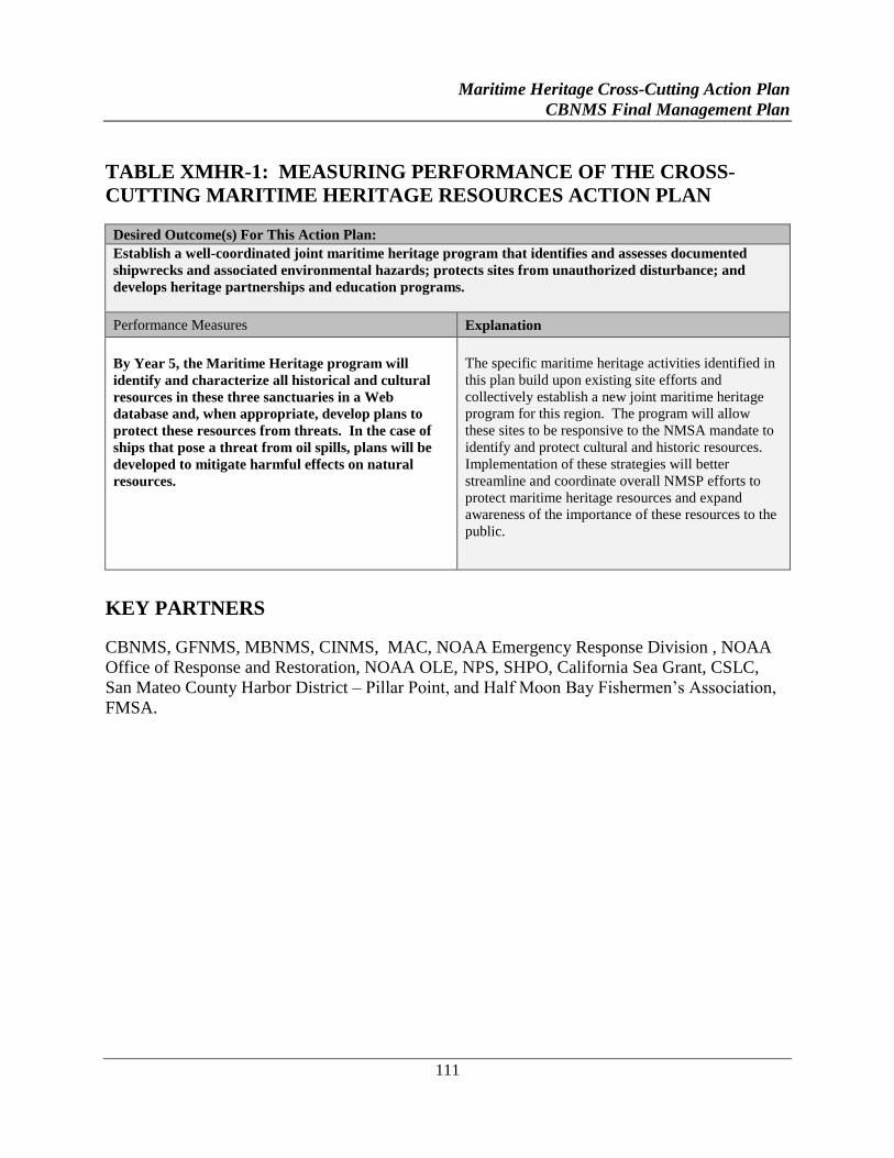
Maritime Heritage Cross-Cutting Action Plan
CBNMS Final Management Plan
111
TABLE XMHR-1: MEASURING PERFORMANCE OF THE CROSS-
CUTTING MARITIME HERITAGE RESOURCES ACTION PLAN
Desired Outcome(s) For This Action Plan:
Establish a well-coordinated joint maritime heritage program that identifies and assesses documented
shipwrecks and associated environmental hazards; protects sites from unauthorized disturbance; and
develops heritage partnerships and education programs.
Performance Measures Explanation
By Year 5, the Maritime Heritage program will
identify and characterize all historical and cultural
resources in these three sanctuaries in a Web
database and, when appropriate, develop plans to
protect these resources from threats. In the case of
ships that pose a threat from oil spills, plans will be
developed to mitigate harmful effects on natural
resources.
The specific maritime heritage activities identified in
this plan build upon existing site efforts and
collectively establish a new joint maritime heritage
program for this region. The program will allow
these sites to be responsive to the NMSA mandate to
identify and protect cultural and historic resources.
Implementation of these strategies will better
streamline and coordinate overall NMSP efforts to
protect maritime heritage resources and expand
awareness of the importance of these resources to the
public.
KEY PARTNERS
CBNMS, GFNMS, MBNMS, CINMS, MAC, NOAA Emergency Response Division , NOAA
Office of Response and Restoration, NOAA OLE, NPS, SHPO, California Sea Grant, CSLC,
San Mateo County Harbor District – Pillar Point, and Half Moon Bay Fishermen’s Association,
FMSA.

113
APPENDICES
CBNMS FINAL MANAGEMENT PLAN
I . Jurisdictional Authorit ies
II . Glossary
III . Acronyms
IV. National Marine Sanctuaries Act
V. Species List

Appendix I: Jurisdictional Authorities
CBNMS Final Management Plan
115
Appendix I: Jurisdictional Authorities
CBNMS is located entirely beyond the state tidelands and submerged lands (mean high tide to
three nautical miles offshore) and is therefore under the jurisdiction of federal statutes with the
exception that the CDFW exercises jurisdiction over certain fishing activities in CBNMS waters
together with the NOAA, NMFS. The other federal agencies with existing primary
responsibilities in the area of Cordell Bank are the USFWS and the BOEM and Bureau of Safety
and Environmental Enforcement (BSEE) of the U.S. Department of the Interior, the USCG of the
U.S. Department of Homeland Security, and the USEPA. This section will briefly review the
responsibilities of these agencies.
FEDERAL AUTHORITIES
NMFS
The NMFS is responsible for enforcing the (MSFCMA, the MMPA, and the ESA. Under the
MSFCMA, NMFS approves and enforces fishery management plans (FMP) prepared by regional
fishery management councils. NMFS relies heavily on CDFW and USCG for enforcement
operations both within and outside the territorial sea. Some of the CBNMS fish populations
affected by FMP regulations are Lingcod, rockfish, and Salmon.
The NMFS shares responsibility with the USFWS for implementation of the Marine Mammal
Protection Act and the Endangered Species Act (see USFWS entry below). NMFS is responsible
for protecting cetaceans and pinnipeds and their habitats under both laws, as well as sea turtles
and fish that are listed as threatened or endangered.
USFWS
Within the waters of CBNMS, the USFWS is responsible for protecting all marine mammal
species other than cetaceans, as well as pinnipeds under the MMPA, and for protecting
endangered or threatened bird species under the ESA. The Short-tailed Albatross is a bird
species listed as endangered which forages in CBNMS.
USCG
The USCG, part of the U.S. Department of Homeland Security, has maritime security, safety and
stewardship responsibilities, including investigation and law enforcement. It is also one of the
five armed forces of the U.S. The scope of USCG jurisdiction includes environmental
regulations, fisheries regulations (described under NMFS), pollution prevention and spill
response regulations and policies, vessel traffic management, drug interdiction, and other
maritime regulations (including vessel construction, design and operation).
Appendix I: Jurisdictional Authorities
CBNMS Final Management Plan
116
The USCG supports national marine sanctuary management by providing routine surveillance
and dedicated law enforcement of the national marine sanctuaries concurrently with other USCG
operations.
Beside enforcement of national marine sanctuary regulations, other important roles the USCG
fulfills relevant to national marine sanctuary management are: enforcement of Clean Water Act
(CWA) regulations to prevent pollution from vessel discharges of oil, hazardous substances, or
other pollutants; coordination of Area Contingency Plans, serving as the federal on-scene
coordinator during marine spill events; and coordinating search and rescue operations.
For ship traffic entering and exiting San Francisco Bay, the USCG has established a Vessel
Traffic Separation Scheme (VTSS) in accordance with the Ports and Waterways Safety Act
(PWSA). The VTSS consists of inbound and outbound vessel traffic lanes that are each one nm
wide with a separation zone between them that is also one nautical mile wide. The northern
traffic lanes extend into CBNMS, and vessels approaching San Francisco Bay from the north and
departing in that direction pass through CBNMS.
BOEM and BSEE
The BOEM and BSEE are two agencies that were created after the Bureau of Ocean Energy
Management, Regulation and Enforcement (formerly called the Minerals Management Service)
was reorganized in 2011.
The BOEM is responsible for managing development of the nation’s offshore resources in
accordance with the provisions of the Outer Continental Shelf Lands Act (OCSLA). BOEM’s
functions include offshore leasing, resource evaluation, review and administration of oil and gas
exploration and development plans, renewable energy development, National Environmental
Policy Act (NEPA) analysis and environmental studies. The BSEE is responsible for safety and
environmental oversight of offshore oil and gas operations, including permitting and inspections,
of offshore oil and gas operations, in accordance with the OCSLA. BSEE’s functions include the
development and enforcement of safety and environmental regulations, permitting offshore
exploration, development and production, inspections, offshore regulatory programs, oil spill
response and training and environmental compliance programs.
The OCSLA establishes federal jurisdiction over all submerged lands under U.S. jurisdiction
lying seaward of state coastal waters.
The Energy Policy Act of 2005, Section 388, granted the Secretary of the Interior authority to
regulate alternative energy and alternate use on the OCS. Section 388 authority does not apply to
areas within National Marine Sanctuaries.
USEPA
The USEPA has regulatory responsibilities with regard to ocean dumping. Title I of the Marine
Protection, Research and Sanctuaries Act prohibits the transportation of any materials from the
Appendix I: Jurisdictional Authorities
CBNMS Final Management Plan
117
United States for the purpose of dumping them into the territorial sea, the contiguous zone, and
the ocean beyond without a permit from USEPA.
STATE AUTHORITIES
CDFW
The CDFW, under the Fish and Game Code (and Chapter 14 of the Administrative Code),
regulates and manages a wide variety of activities affecting the living marine resources generally
out to three nautical miles from the California coast and in the EEZ. CDFW manages several
fisheries that occur in state and federal waters including Dungeness crab and squid. A number of
fisheries that occur in federal waters, including groundfish included in the federal Groundfish
Fishery Management Plan A are under the joint jurisdiction of the state and the federal
government.

Appendix II: Glossary of Terms
CBNMS Final Management Plan
119
Appendix II: Glossary of Terms
Action plan: A major section of a management plan contain related strategies and activities
designed to address a specific issue or function (NOAA, National Marine Sanctuary
Management Plan Handbook, 3rd
edition, 2002).
Activity: Specific actions that will be taken to carry out a strategy (NOAA, National Marine
Sanctuary Management Plan Handbook, 3rd
edition, 2002).
Bathymetry: Water depth measurement information used to produce depth-contoured charts.
Benthic: The region of the ocean consisting of the seabed and the organisms that live on or in it.
Benthic communities: Bottom-dwelling plants and animals.
Biodiversity: The variability among living organisms from all sources, including terrestrial,
marine, and other aquatic ecosystems and the ecological complexes of which they are part; this
includes diversity within species, between species and of ecosystems.
Continental shelf: A generally shallow, flat submerged portion of a continent, extending to the
point of step descent to the ocean floor.
Critical habitat: The specific areas within the geographical area occupied by a threatened or
endangered species on which are found those physical or biological features essential to the
conservation of the species, and which may require special management considerations or
protection.
Demersal: Fishes and other aquatic organisms that live near the bottom of the water column.
Depleted: A species is termed depleted when it falls below its optimum sustainable population.
Desired outcome: A succinct and concise statement that articulates a desired future for a
sanctuary relative to a specific problem statement (NOAA, National Marine Sanctuary
Management Plan Handbook, 3rd
edition, 2002).
Ecology: The science of the relationships between organisms and their environments.
Ecosystem: The sum total of all living and nonliving components of a particular area that
interact and exchange materials with each other; sometimes defined as the ecological community
of organisms plus the environment with which they interact. Energy flow and nutrient cycling
are regulated within a particular ecosystem and are studied as indicators of its overall health.
Endangered species: Any species that is in danger of extinction throughout all or a significant
portion of its range.
Appendix II: Glossary of Terms
CBNMS Final Management Plan
120
Epifauna: Animals that live on the ocean bottom, either attached or moving freely over it.
Food chain: A succession of organisms in a community that constitutes a feeding chain in
which food energy is transferred from one organism to another as each consumes a lower
member and in turn is preyed upon by a higher member.
Indigenous: Living or occurring naturally in a specific area or environment.
Infaunal: Organisms that live buried in sediments, including a variety of polychaetes,
burrowing crustaceans, and mollusks.
Infrastructure: Basic installations and facilities, such as roads, power plants, transportation,
and communication systems.
Invertebrate: An animal lacking a backbone or spinal column.
Isobath: An imaginary line or one drawn on a map connecting all points of equal depth below
the surface of a body of water.
Marine protected area: Any area of the marine environment that has been reserved by federal,
state, territorial, tribal, or local laws or regulations to provide lasting protection for part or all of
the natural and cultural resources therein. (Executive Order 13158 on Marine Protected Areas).
Under this broad definition, a wide variety of sites including fishery management zones, national
parks, national marine sanctuaries, national estuarine research reserves, state conservation areas,
critical habitats, and state reserves could be considered as marine protected areas.
Marine reserve: A kind of marine protected area generally agreed to have strict regulations
regarding the extraction of resources.
Mollusks: Any of various members of the phylum Mollusca, largely marine invertebrates,
including the edible shellfish and some 100,000 other species.
Multibeam: A type of sonar that has multiple beams to record water depth.
Organism: Plant or animal.
Pathogens: Any agent, most commonly a micro-organism, capable of causing a disease.
Pelagic: Of, relating to, or living in open seas or oceans rather than waters adjacent to land or
inland waters.
Planktonic: Organisms dependent on water movement and currents as their means of
transportation, including phytoplankton, zooplankton, and ichthyoplankton.
Program/Issue Statements: A one or two sentence articulation of the specific components of
an issue (NOAA, National Marine Sanctuary Management Plan Handbook, 3rd
edition, 2002).
Appendix II: Glossary of Terms
CBNMS Final Management Plan
121
Salinity: The relative concentration of salts, usually sodium chloride, in a given water sample.
It is usually expressed in terms of the number of parts per thousand (ppt) or parts per million
(ppm) of chlorine (Cl). As a reference, the salinity of seawater is approximately 35 ppt.
Side-scan sonar: A type of sonar that gathers sound reflections at oblique angles to the sensor.
Socioeconomic: Being both social and economic.
Strategy: The means by which a particular desired outcome can be achieved (NOAA, National
Marine Sanctuary Management Plan Handbook, 3rd
edition, 2002).
Substrate: A surface on which a plant or animal grows or is attached.
Terms of designation: A portion of the regulations for a given sanctuary that spells out its
boundaries, regulations, and those activities potentially subject to future regulation.
Threatened Species: Any species which is likely to become an endangered species within the
foreseeable future throughout all or a significant portion of its range.
Trawling: To fish using a trawl, a large tapered and flattened or conical net towed along the sea
bottom.
Trolling: To fish by running a baited line behind a slowly moving boat.
Trophic: A description related to feeding; it often refers to a feeding level in a food chain.
Trophic level: One of a succession of steps in the movement of energy and matter through a
food chain in an ecosystem.
Turbidity: The extent to which there are suspended or stirred up particles or sediments, as in the
water column.

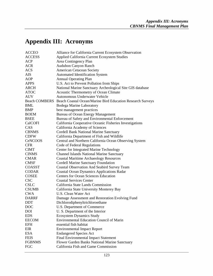
Appendix III: Acronyms
CBNMS Final Management Plan
123
Appendix III: Acronyms
ACCEO Alliance for California Current Ecosystem Observation
ACCESS Applied California Current Ecosystem Studies
ACP Area Contingency Plan
ACR Audubon Canyon Ranch
ACS American Cetacean Society
AIS Automated Identification System
AOP Annual Operating Plan
APPS U.S. Act to Prevent Pollution from Ships
ARCH National Marine Sanctuary Archeological Site GIS database
ATOC Acoustic Thermometry of Ocean Climate
AUV Autonomous Underwater Vehicle
Beach COMBERS Beach Coastal Ocean/Marine Bird Education Research Surveys
BML Bodega Marine Laboratory
BMP best management practices
BOEM Bureau of Ocean Energy Management
BSEE Bureau of Safety and Environmental Enforcement
CalCOFI California Cooperative Oceanic Fisheries Investigations
CAS California Academy of Sciences
CBNMS Cordell Bank National Marine Sanctuary
CDFW California Department of Fish and Wildlife
CeNCOOS Central and Northern California Ocean Observing System
CFR Code of Federal Regulations
CIMT Center for Integrated Marine Technology
CINMS Channel Islands National Marine Sanctuary
CMAR Coastal Maritime Archaeology Resources
CMSF Cordell Marine Sanctuary Foundation
COASST Coastal Observation And Seabird Survey Team
CODAR Coastal Ocean Dynamics Applications Radar
COSEE Centers for Ocean Sciences Education
CSC Coastal Services Center
CSLC California State Lands Commission
CSUMB California State University Monterey Bay
CWA U.S. Clean Water Act
DARRF Damage Assessment and Restoration Evolving Fund
DDT Dichlorodiphenyltrichloroethane
DOC U.S. Department of Commerce
DOI U. S. Department of the Interior
EDS Ecosystem Dynamics Study
EECOM Environmental Education Council of Marin
EFH essential fish habitat
EIR Environmental Impact Report
ESA Endangered Species Act
FEIS Final Environmental Impact Statement
FGBNMS Flower Garden Banks National Marine Sanctuary
FGC California Fish and Game Commission
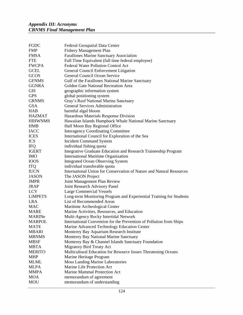
Appendix III: Acronyms
CBNMS Final Management Plan
124
FGDC Federal Geospatial Data Center
FMP Fishery Management Plan
FMSA Farallones Marine Sanctuary Association
FTE Full Time Equivalent (full time federal employee)
FWCPA Federal Water Pollution Control Act
GCEL General Council Enforcement Litigation
GCOS General Council Ocean Service
GFNMS Gulf of the Farallones National Marine Sanctuary
GGNRA Golden Gate National Recreation Area
GIS geographic information system
GPS global positioning system
GRNMS Gray’s Reef National Marine Sanctuary
GSA General Services Administration
HAB harmful algal bloom
HAZMAT Hazardous Materials Response Division
HIHWNMS Hawaiian Islands Humpback Whale National Marine Sanctuary
HMB Half Moon Bay Regional Office
IACC Interagency Coordinating Committee
ICES International Council for Exploration of the Sea
ICS Incident Command System
IFQ individual fishing quota
IGERT Integrative Graduate Education and Research Traineeship Program
IMO International Maritime Organization
IOOS Integrated Ocean Observing System
ITQ individual transferable quota
IUCN International Union for Conservation of Nature and Natural Resources
JASON The JASON Project
JMPR Joint Management Plan Review
JRAP Joint Research Advisory Panel
LCV Large Commercial Vessels
LiMPETS Long-term Monitoring Program and Experiential Training for Students
LRA List of Recommended Areas
MAC Maritime Archeological Center
MARE Marine Activities, Resources, and Education
MARINe Multi-Agency Rocky Intertidal Network
MARPOL International Convention for the Prevention of Pollution from Ships
MATE Marine Advanced Technology Education Center
MBARI Monterey Bay Aquarium Research Institute
MBNMS Monterey Bay National Marine Sanctuary
MBSF Monterey Bay & Channel Islands Sanctuary Foundation
MBTA Migratory Bird Treaty Act
MERITO Multicultural Education for Resource Issues Threatening Oceans
MHP Marine Heritage Program
MLML Moss Landing Marine Laboratories
MLPA Marine Life Protection Act
MMPA Marine Mammal Protection Act
MOA memorandum of agreement
MOU memorandum of understanding
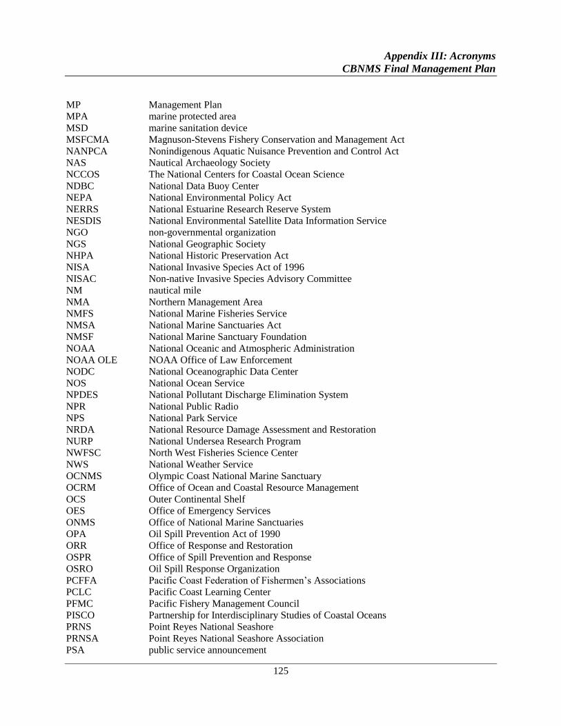
Appendix III: Acronyms
CBNMS Final Management Plan
125
MP Management Plan
MPA marine protected area
MSD marine sanitation device
MSFCMA Magnuson-Stevens Fishery Conservation and Management Act
NANPCA Nonindigenous Aquatic Nuisance Prevention and Control Act
NAS Nautical Archaeology Society
NCCOS The National Centers for Coastal Ocean Science
NDBC National Data Buoy Center
NEPA National Environmental Policy Act
NERRS National Estuarine Research Reserve System
NESDIS National Environmental Satellite Data Information Service
NGO non-governmental organization
NGS National Geographic Society
NHPA National Historic Preservation Act
NISA National Invasive Species Act of 1996
NISAC Non-native Invasive Species Advisory Committee
NM nautical mile
NMA Northern Management Area
NMFS National Marine Fisheries Service
NMSA National Marine Sanctuaries Act
NMSF National Marine Sanctuary Foundation
NOAA National Oceanic and Atmospheric Administration
NOAA OLE NOAA Office of Law Enforcement
NODC National Oceanographic Data Center
NOS National Ocean Service
NPDES National Pollutant Discharge Elimination System
NPR National Public Radio
NPS National Park Service
NRDA National Resource Damage Assessment and Restoration
NURP National Undersea Research Program
NWFSC North West Fisheries Science Center
NWS National Weather Service
OCNMS Olympic Coast National Marine Sanctuary
OCRM Office of Ocean and Coastal Resource Management
OCS Outer Continental Shelf
OES Office of Emergency Services
ONMS Office of National Marine Sanctuaries
OPA Oil Spill Prevention Act of 1990
ORR Office of Response and Restoration
OSPR Office of Spill Prevention and Response
OSRO Oil Spill Response Organization
PCFFA Pacific Coast Federation of Fishermen’s Associations
PCLC Pacific Coast Learning Center
PFMC Pacific Fishery Management Council
PISCO Partnership for Interdisciplinary Studies of Coastal Oceans
PRNS Point Reyes National Seashore
PRNSA Point Reyes National Seashore Association
PSA public service announcement
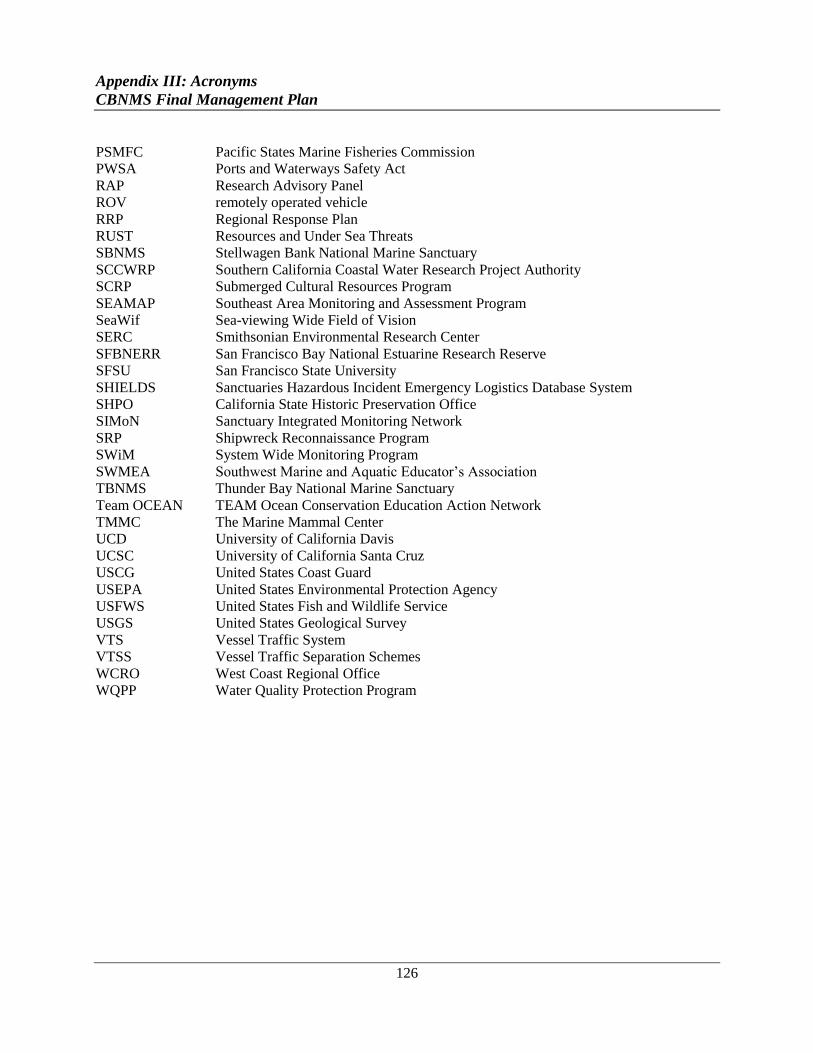
Appendix III: Acronyms
CBNMS Final Management Plan
126
PSMFC Pacific States Marine Fisheries Commission
PWSA Ports and Waterways Safety Act
RAP Research Advisory Panel
ROV remotely operated vehicle
RRP Regional Response Plan
RUST Resources and Under Sea Threats
SBNMS Stellwagen Bank National Marine Sanctuary
SCCWRP Southern California Coastal Water Research Project Authority
SCRP Submerged Cultural Resources Program
SEAMAP Southeast Area Monitoring and Assessment Program
SeaWif Sea-viewing Wide Field of Vision
SERC Smithsonian Environmental Research Center
SFBNERR San Francisco Bay National Estuarine Research Reserve
SFSU San Francisco State University
SHIELDS Sanctuaries Hazardous Incident Emergency Logistics Database System
SHPO California State Historic Preservation Office
SIMoN Sanctuary Integrated Monitoring Network
SRP Shipwreck Reconnaissance Program
SWiM System Wide Monitoring Program
SWMEA Southwest Marine and Aquatic Educator’s Association
TBNMS Thunder Bay National Marine Sanctuary
Team OCEAN TEAM Ocean Conservation Education Action Network
TMMC The Marine Mammal Center
UCD University of California Davis
UCSC University of California Santa Cruz
USCG United States Coast Guard
USEPA United States Environmental Protection Agency
USFWS United States Fish and Wildlife Service
USGS United States Geological Survey
VTS Vessel Traffic System
VTSS Vessel Traffic Separation Schemes
WCRO West Coast Regional Office
WQPP Water Quality Protection Program
Appendix IV: National Marine Sanctuaries Act
CBNMS Final Management Plan
127
Appendix IV: National Marine Sanctuaries Act
16 U.S.C. 1431 ET SEQ., as amended by Public Law 106-513
Sec. 301. FINDINGS, PURPOSES, AND POLICIES; ESTABLISHMENT OF SYSTEM
(a) FINDINGS.--The Congress finds that--
(1) this Nation historically has recognized the importance of protecting special areas of its public
domain, but these efforts have been directed almost exclusively to land areas above the high-
water mark;
(2) certain areas of the marine environment possess conservation, recreational, ecological,
historical, scientific, educational, cultural, archeological, or aesthetic qualities which give them
special national, and in some instances, international, significance;
(3) while the need to control the effects of particular activities has led to enactment of resource-
specific legislation, these laws cannot in all cases provide a coordinated and comprehensive
approach to the conservation and management of special areas of the marine environment; and
(4) a Federal program which establishes areas of the marine environment which have special
conservation, recreational, ecological, historical, cultural, archeological, scientific, educational,
or aesthetic qualities as national marine sanctuaries managed as the National Marine Sanctuary
System will-
(A) improve the conservation, understanding, management, and wise and sustainable use of
marine resources;
(B) enhance public awareness, understanding, and appreciation of the marine environment; and
(C) maintain for future generations the habitat, and ecological services, of the natural assemblage
of living resources that inhabit these areas.
(b) PURPOSES AND POLICIES.--The purposes and policies of this title are--
(1) to identify and designate as national marine sanctuaries areas of the marine environment
which are of special national significance and to manage these areas as the National Marine
Sanctuary System;
(2) to provide authority for comprehensive and coordinated conservation and management of
these marine areas, and activities affecting them, in a manner which complements existing
regulatory authorities;
Appendix IV: National Marine Sanctuaries Act
CBNMS Final Management Plan
128
(3) to maintain the natural biological communities in the national marine sanctuaries, and to
protect, and, where appropriate, restore and enhance natural habitats, populations, and ecological
processes;
(4) to enhance public awareness, understanding, appreciation, and wise and sustainable use of the
marine environment, and the natural, historical, cultural, and archeological resources of the
National Marine Sanctuary System;
(5) to support, promote, and coordinate scientific research on, and long-term monitoring of, the
resources of these marine areas;
(6) to facilitate to the extent compatible with the primary objective of resource protection, all
public and private uses of the resources of these marine areas not prohibited pursuant to other
authorities;
(7) to develop and implement coordinated plans for the protection and management of these
areas with appropriate Federal agencies, State and local governments, Native American tribes
and organizations, international organizations, and other public and private interests concerned
with the continuing health and resilience of these marine areas;
(8) to create models of, and incentives for, ways to conserve and manage these areas, including
the application of innovative management techniques; and
(9) to cooperate with global programs encouraging conservation of marine resources.
(c) ESTABLISHMENT OF SYSTEM.-There is established the National Marine Sanctuary
System, which shall consist of national marine sanctuaries designated by the Secretary in
accordance with this title.
Sec. 302. DEFINITIONS
As used in this title, the term--
(1) " management plan" means the plan described in section 304(a)(1)(C)(v);
(2) "Magnuson-Stevens Act" means the Magnuson-Stevens Fishery Conservation and
Management Act (16 U.S.C. 1801 et seq.);
(3) "marine environment" means those areas of coastal and ocean waters, the Great Lakes and
their connecting waters, and submerged lands over which the United States exercises
jurisdiction, including the exclusive economic zone, consistent with international law;
(4) "Secretary" means the Secretary of Commerce;
Appendix IV: National Marine Sanctuaries Act
CBNMS Final Management Plan
129
(5) "State" means each of the several States, the District of Columbia, the Commonwealth of
Puerto Rico, the Commonwealth of the Northern Mariana Islands, American Samoa, the Virgin
Islands, Guam, and any other commonwealth, territory, or possession of the United States;
(6) "damages" includes--
(A) compensation for--
(i)(I) the cost of replacing, restoring, or acquiring the equivalent of a sanctuary resource; and (II)
the value of the lost use of a sanctuary resource pending its restoration or replacement or the
acquisition of an equivalent sanctuary resource; or
(ii) the value of a sanctuary resource if the sanctuary resource cannot be restored or replaced or if
the equivalent of such resource cannot be acquired;
(B) the cost of damage assessments under section 312(b)(2);
(C) the reasonable cost of monitoring appropriate to the injured, restored, or replaced resources;
(D) the cost of curation and conservation of archeological, historical, and cultural sanctuary
resources; and
(E) the cost of enforcement actions undertaken by the Secretary in response to the destruction or
loss of, or injury to, a sanctuary resource;
(7) "response costs" means the costs of actions taken or authorized by the Secretary to minimize
destruction or loss of, or injury to, sanctuary resources, or to minimize the imminent risks of
such destruction, loss, or injury, including costs related to seizure forfeiture, storage, or disposal
arising from liability under section 312;
(8) "sanctuary resource" means any living or nonliving resource of a national marine sanctuary
that contributes to the conservation, recreational, ecological, historical, educational, cultural,
archeological, scientific, or aesthetic value of the sanctuary;
(9) "exclusive economic zone" means the exclusive economic zone as defined in the Magnuson-
Stevens Act; and
(10) ‘System’ means the National Marine Sanctuary System established by section 301.
Sec. 303. SANCTUARY DESIGNATION STANDARDS
(a) STANDARDS.--The Secretary may designate any discrete area of the marine environment as
a national marine sanctuary and promulgate regulations implementing the designation if the
Secretary determines that--
(1) the designation will fulfill the purposes and policies of this title;
Appendix IV: National Marine Sanctuaries Act
CBNMS Final Management Plan
130
(2) the area is of special national significance due to-
(A) its conservation, recreational, ecological, historical, scientific, cultural, archeological,
educational, or aesthetic qualities;
(B) the communities of living marine resources it harbors; or
(C) its resource or human-use values;
(3) existing State and Federal authorities are inadequate or should be supplemented to ensure
coordinated and comprehensive conservation and management of the area, including resource
protection, scientific research, and public education;
(4) designation of the area as a national marine sanctuary will facilitate the objectives in
subparagraph (3); and
(5) the area is of a size and nature that will permit comprehensive and coordinated conservation
and management.
(b) FACTORS AND CONSULTATIONS REQUIRED IN MAKING DETERMINATIONS
AND FINDINGS.--
(1) Factors.--For purposes of determining if an area of the marine environment meets the
standards set forth in subsection (a), the Secretary shall consider--
(A) the area's natural resource and ecological qualities, including its contribution to biological
productivity, maintenance of ecosystem structure, maintenance of ecologically or commercially
important or threatened species or species assemblages, maintenance of critical habitat of
endangered species, and the biogeographic representation of the site;
(B) the area's historical, cultural, archaeological, or paleontological significance;
(C) the present and potential uses of the area that depend on maintenance of the area's resources,
including commercial and recreational fishing, subsistence uses other than commercial and
recreational activities, and research and education;
(D) the present and potential activities that may adversely affect the factors identified in
subparagraphs (A), (B), (C);
(E) the existing State and Federal regulatory and management authorities applicable to the area
and the adequacy of those authorities to fulfill the purposes and policies of this title;
(F) the manageability of the area, including such factors as its size, its ability to be identified as a
discrete ecological unit with definable boundaries, its accessibility, and its suitability for
monitoring and enforcement activities;
Appendix IV: National Marine Sanctuaries Act
CBNMS Final Management Plan
131
(G) the public benefits to be derived from sanctuary status, with emphasis on the benefits of
long-term protection of nationally significant resources, vital habitats, and resources which
generate tourism;
(H) the negative impacts produced by management restrictions on income-generating activities
such as living and nonliving resources development;
(I) the socioeconomic effects of sanctuary designation;
(J) the area's scientific value and value for monitoring the resources and natural processes that
occur there;
(K) the feasibility, where appropriate, of employing innovative management approaches to
protect sanctuary resources or to manage compatible uses; and
(L) the value of the area as an addition to the System.
(2) Consultation.--In making determinations and findings, the Secretary shall consult with--
(A) the Committee on Resources of the House of Representatives and the Committee on
Commerce, Science, and Transportation of the Senate;
(B) the Secretaries of State, Defense, Transportation, and the Interior, the Administrator, and the
heads of other interested Federal agencies;
(C) the responsible officials or relevant agency heads of the appropriate State and local
government entities, including coastal zone management agencies, that will or are likely to be
affected by the establishment of the area as a national marine sanctuary;
(D) the appropriate officials of any Regional Fishery Management Council established by section
302 of the Magnuson-Stevens Act (16 U.S.C. 1852) that may be affected by the proposed
designation; and
(E) other interested persons.
Sec. 304. PROCEDURES FOR DESIGNATION AND IMPLEMENTATION
(a) SANCTUARY PROPOSAL.--
(1) Notice.--In proposing to designate a national marine sanctuary, the Secretary shall--
(A) issue, in the Federal Register, a notice of the proposal, proposed regulations that may be
necessary and reasonable to implement the proposal, and a summary of the management plan;
(B) provide notice of the proposal in newspapers of general circulation or electronic media in the
communities that may be affected by the proposal; and
Appendix IV: National Marine Sanctuaries Act
CBNMS Final Management Plan
132
(C) no later than the day on which the notice required under subparagraph (A) is submitted to
Office of the Federal Register, submit a copy of that notice and the sanctuary designation
documents prepared pursuant to section 304(a)(2), including an executive summary, to the
Committee on Resources of the House of Representatives, the Committee on Commerce,
Science, and Transportation of the Senate, and the Governor of each State in which any part of
the proposed sanctuary would be located.
(2) Sanctuary Designation Documents.--The Secretary shall prepare and make available to the
public sanctuary designation documents on the proposal that include the following:
(A) A environmental impact statement pursuant to the National Environmental Policy Act of
1969 (42 U.S.C. 4321 et seq.).
(B) A resource assessment that documents--
(i) present and potential uses of the area, including commercial and recreational fishing, research
and education, minerals and energy development, subsistence uses, and other commercial,
governmental, or recreational uses;
(ii) after consultation with the Secretary of the Interior, any commercial, governmental, or
recreational resource uses in the areas that are subject to the primary jurisdiction of the
Department of the Interior; and
(iii) information prepared in consultation with the Secretary of Defense, the Secretary of Energy,
and the Administrator of the Environmental Protection Agency, on any past, present, or proposed
future disposal or discharge of materials in the vicinity of the proposed sanctuary. Public
disclosure by the Secretary of such information shall be consistent with national security
regulations.
(C) A management plan for the proposed national marine sanctuary that includes the following:
(i) The terms of the proposed designation.
(ii) Proposed mechanisms to coordinate existing regulatory and management authorities within
the area.
(iii) The proposed goals and objectives, management responsibilities, resource studies, and
appropriate strategies for managing sanctuary resources of the proposed sanctuary, including
interpretation and education, innovative management strategies, research, monitoring and
assessment, resource protection, restoration, enforcement, and surveillance activities.
(iv) An evaluation of the advantages of cooperative State and Federal management if all or part
of the proposed sanctuary is within the territorial limits of any State or is superjacent to the
subsoil and seabed within the seaward boundary of a State, as that boundary is established under
the Submerged Lands Act (43 U.S.C. 1301 et seq.).
Appendix IV: National Marine Sanctuaries Act
CBNMS Final Management Plan
133
(v) An estimate of the annual cost to the Federal Government of the proposed designation,
including costs of personnel, equipment and facilities, enforcement, research, and public
education.
(vi) The proposed regulations referred to in paragraph (1)(A).
(D) Maps depicting the boundaries of the proposed sanctuary.
(E) The basis for the determinations made under section 303(a) with respect to the area.
(F) An assessment of the considerations under section 303(b)(1).
(3) Public Hearing.--No sooner than thirty days after issuing a notice under this subsection, the
Secretary shall hold at least one public hearing in the coastal area or areas that will be most
affected by the proposed designation of the area as a national marine sanctuary for the purpose of
receiving the views of interested parties.
(4) Terms of Designation.--The terms of designation of a sanctuary shall include the geographic
area proposed to be included within the sanctuary, the characteristics of the area that give it
conservation, recreational, ecological, historical, research, educational, or aesthetic value, and
the types of activities that will be subject to regulation by the Secretary to protect those
characteristics. The terms of designation may be modified only by the same procedures by
which the original designation is made.
(5) Fishing Regulations.--The Secretary shall provide the appropriate Regional Fishery
Management Council with the opportunity to prepare regulations for fishing within the
Exclusive Economic Zone as the Council may deem necessary to implement the proposed
designation. Draft regulations prepared by the Council, or a Council determination that
regulations are not necessary pursuant to this paragraph, shall be accepted and issued as
proposed regulations by the Secretary unless the Secretary finds that the Council's action fails to
fulfill the purposes and policies of this title and the goals and objectives of the proposed
designation. In preparing the regulations, a Regional Fishery Management Council shall use as
guidance the national standards of section 301(a) of the Magnuson-Stevens Act (16 U.S.C. 1851)
to the extent that the standards are consistent and compatible with the goals and objectives of the
proposed designation. The Secretary shall prepare the fishing regulations, if the Council declines
to make a determination with respect to the need for regulations, makes a determination which is
rejected by the Secretary, or fails to prepare the regulations in a timely manner. Any
amendments to the fishing regulations shall be drafted, approved, and issued in the same manner
as the original regulations. The Secretary shall also cooperate with other appropriate fishery
management authorities with rights or responsibilities within a proposed sanctuary at the earliest
practicable stage in drafting any sanctuary fishing regulations.
(6) Committee Action.--After receiving the documents under subsection (a)(l)(C), the Committee
on Resources of the House of Representatives and the Committee on Commerce, Science, and
Transportation of the Senate may each hold hearings on the proposed designation and on the
Appendix IV: National Marine Sanctuaries Act
CBNMS Final Management Plan
134
matters set forth in the documents. If within the forty-five day period of continuous session of
Congress beginning on the date of submission of the documents, either Committee issues a
report concerning matters addressed in the documents, the Secretary shall consider this report
before publishing a notice to designate the national marine sanctuary.
(b) TAKING EFFECT OF DESIGNATIONS.--
(1) Notice.--In designating a national marine sanctuary, the Secretary shall publish in the Federal
Register notice of the designation together with final regulations to implement the designation
and any other matters required by law, and submit such notice to the Congress. The Secretary
shall advise the public of the availability of the final management plan and the final
environmental impact statement with respect to such sanctuary. The Secretary shall issue a
notice of designation with respect to a proposed national marine sanctuary site not later than 30
months after the date a notice declaring the site to be an active candidate for sanctuary
designation is published in the Federal Register under regulations issued under this Act, or shall
publish not later than such date in the Federal Register findings regarding why such notice has
not been published. No notice of designation may occur until the expiration of the period for
Committee action under subsection (a)(6). The designation (and any of its terms not disapproved
under this subsection) and regulations shall take effect and become final after the close of a
review period of forty-five days of continuous session of Congress beginning on the day on
which such notice is published unless in the case of a natural [sic] marine sanctuary that is
located partially or entirely within the seaward boundary of any State, the Governor affected
certifies to the Secretary that the designation or any of its terms is unacceptable, in which case
the designation or the unacceptable term shall not take effect in the area of the sanctuary lying
within the seaward boundary of the State.
(2) Withdrawal of Designation.-- If the Secretary considers that actions taken under paragraph
(1) will affect the designation of a national marine sanctuary in a manner that the goals and
objectives of the sanctuary or System cannot be fulfilled, the Secretary may withdraw the entire
designation. If the Secretary does not withdraw the designation, only those terms of the
designation or not certified under paragraph (1) shall take effect.
(3) Procedures.-- In computing the forty-five-day periods of continuous session of Congress
pursuant to subsection (a)(6) and paragraph (1) of this subsection--
(A) continuity of session is broken only by an adjournment of Congress sine die; and
(B) the days on which either House of Congress is not in session because of an adjournment of
more than three days to a day certain are excluded.
(c) ACCESS AND VALID RIGHTS.--
(1) Nothing in this title shall be construed as terminating or granting to the Secretary the right to
terminate any valid lease, permit, license, or right of subsistence use or of access that is in
existence on the date of designation of any national marine sanctuary.
Appendix IV: National Marine Sanctuaries Act
CBNMS Final Management Plan
135
(2) The exercise of a lease, permit, license, or right is subject to regulation by the Secretary
consistent with the purposes for which the sanctuary is designated.
(d) INTERAGENCY COOPERATION.--
(1) Review of Agency Actions.--
(A) In General.--Federal agency actions internal or external to a national marine sanctuary,
including private activities authorized by licenses, leases, or permits, that are likely to destroy,
cause the loss of, or injure any sanctuary resource are subject to consultation with the Secretary.
(B) Agency Statements Required.-- Subject to any regulations the Secretary may establish each
Federal agency proposing an action described in subparagraph (A) shall provide the Secretary
with a written statement describing the action and its potential effects on sanctuary resources at
the earliest practicable time, but in no case later than 45 days before the final approval of the
action unless such Federal agency and the Secretary agree to a different schedule.
(2) Secretary's Recommended Alternatives.--If the Secretary finds that a Federal agency action is
likely to destroy, cause the loss of, or injure a sanctuary resource, the Secretary shall (within 45
days of receipt of complete information on the proposed agency action) recommend reasonable
and prudent alternatives, which may include conduct of the action elsewhere, which can be taken
by the Federal agency in implementing the agency action that will protect sanctuary resources.
(3) Response to Recommendations.--The agency head who receives the Secretary's
recommended alternatives under paragraph (2) shall promptly consult with the Secretary on the
alternatives. If the agency head decides not to follow the alternatives, the agency head shall
provide the Secretary with a written statement explaining the reasons for that decision.
(4) FAILURE TO FOLLOW ALTERNATIVE.--If the head of a Federal agency takes an action
other than an alternative recommended by the Secretary and such action results in the destruction
of, loss of, or injury to a sanctuary resource, the head of the agency shall promptly prevent and
mitigate further damage and restore or replace the sanctuary resource in a manner approved by
the Secretary.
(e) REVIEW OF MANAGEMENT PLANS.--Not more than 5 years after the date of designation
of any national marine sanctuary, and thereafter at intervals not exceeding 5 years, the Secretary
shall evaluate the substantive progress toward implementing the management plan and goals for
the sanctuary, especially the effectiveness of site-specific management techniques and strategies,
and shall revise the management plan and regulations as necessary to fulfill the purposes and
policies of this title. This review shall include a prioritization of management objectives.
(f) LIMITATION ON DESIGNATION OF NEW SANCTUARIES.--
Appendix IV: National Marine Sanctuaries Act
CBNMS Final Management Plan
136
(1) FINDING REQUIRED.--The Secretary may not publish in the Federal Register any
sanctuary designation notice or regulations proposing to designate a new sanctuary, unless the
Secretary has published a finding that--
(A) the addition of a new sanctuary will not have a negative impact on the System; and
(B) sufficient resources were available in the fiscal year in which the finding is made to--
(i) effectively implement sanctuary management plans for each sanctuary in the System; and
(ii) complete site characterization studies and inventory known sanctuary resources, including
cultural resources, for each sanctuary in the System within 10 years after the date that the finding
is made if the resources available for those activities are maintained at the same level for each
fiscal year in that 10 year period.
(2) DEADLINE.--If the Secretary does not submit the findings required by paragraph (1) before
February 1, 2004, the Secretary shall submit to the Congress before October 1, 2004, a finding
with respect to whether the requirements of subparagraphs (A) and (B) of paragraph 1 have been
met by all existing sanctuaries.
(3) LIMITATION ON APPLICATION.--Paragraph (1) does not apply to any sanctuary
designation documents for--
(A) a Thunder Bay National Marine Sanctuary; or
(B) a Northwestern Hawaiian Islands National Marine Sanctuary.
(g) NORTHWESTERN HAWAIIAN ISLANDS CORAL REEF RESERVE.--
(1) PRESIDENTIAL DESIGNATION.--The President, after consultation with the Governor of
the State of Hawaii, may designate any Northwestern Hawaiian Islands coral reef or coral reef
ecosystem as a coral reef reserve to be managed by the Secretary of Commerce.
(2) SECRETARIAL ACTION.--Upon the designation of a reserve under paragraph (1) by the
President, the Secretary shall--
(A) take action to initiate the designation of the reserve as a National Marine Sanctuary under
sections 303 and 304 of the National Marine Sanctuaries Act (16 U.S.C. 1433);
(B) establish a Northwestern Hawaiian Islands Reserve Advisory Council under section 315 of
that Act (16 U.S.C. 1445a), the membership of which shall include at least 1 representative from
Native Hawaiian groups; and
(C) until the reserve is designated as a National Marine Sanctuary, manage the reserve in a
manner consistent with the purposes and policies of that Act.
Appendix IV: National Marine Sanctuaries Act
CBNMS Final Management Plan
137
(3) PUBLIC COMMENT.--Notwithstanding any other provision of law, no closure areas around
the Northwestern Hawaiian Islands shall become permanent without adequate review and
comment.
(4) COORDINATION.--The Secretary shall work with other Federal agencies and the Director
of the National Science Foundation, to develop a coordinated plan to make vessels and other
resources available for conservation or research activities for the reserve.
(5) REVIEW.--If the Secretary has not designated a national marine sanctuary in the
Northwestern Hawaiian Islands under sections 303 and 304 of the National Marine Sanctuaries
Act (16 U.S.C. 1433, 1434) before October 1, 2005, the Secretary shall conduct a review of the
management of the reserve under section 304(e) of that Act (16 U.S.C. 1434(e)).
(6) REPORT.--No later than 6 months after the date of enactment of this Act, the Secretary shall
submit a report to the Senate Committee on Commerce, Science, and Transportation and the
House of Representatives Committee on Resources, describing actions taken to implement this
subsection, including costs of monitoring, enforcing, and addressing marine debris, and the
extent to which the fiscal or other resources necessary to carry out this subsection are reflected in
the Budget of the United States Government submitted by the President under section 1104 of
title 31, United States Code.
(7) AUTHORIZATION OF APPROPRIATIONS.--There are authorized to be appropriated to
the Secretary of Commerce to carry out the provisions of this subsection such sums, not
exceeding $4,000,000 for each of fiscal years 2001, 2002, 2003, 2004, and 2005, as are reported
under paragraph (6) to be reflected in the Budget of the United States Government.
Sec. 305. APPLICATION OF REGULATIONS AND INTERNATIONAL NEGOTIATIONS
(a) REGULATIONS.--This title and the regulations issued under section 304 shall be applied in
accordance with generally recognized principles of international law, and in accordance with the
treaties, conventions, and other agreements to which the United States is a party. No regulation
shall apply to or be enforced against a person who is not a citizen, national, or resident alien of
the United States, unless in accordance with--
(1) generally recognized principles of international law;
(2) an agreement between the United States and the foreign state of which the person is a citizen;
or
(3) an agreement between the United States and the flag state of a foreign vessel, if the person is
a crewmember of the vessel.
(b) NEGOTIATIONS.--The Secretary of State, in consultation with the Secretary, shall take
appropriate action to enter into negotiations with other governments to make necessary
Appendix IV: National Marine Sanctuaries Act
CBNMS Final Management Plan
138
arrangements for the protection of any national marine sanctuary and to promote the purposes for
which the sanctuary is established.
(c) INTERNATIONAL COOPERATION.--The Secretary, in consultation with the Secretary of
State and other appropriate Federal agencies, shall cooperate with other governments and
international organizations in the furtherance of the purposes and policies of this title and
consistent with applicable regional and multilateral arrangements for the protection and
management of special marine areas.
Sec. 306. PROHIBITED ACTIVITIES
It is unlawful for any person to--
(1) destroy, cause the loss of, or injure any sanctuary resource managed under law or regulations
for that sanctuary;
(2) possess, sell, offer for sale, purchase, import, export, deliver, carry, transport, or ship by any
means any sanctuary resource taken in violation of this section;
(3) interfere with the enforcement of this title by--
(A) refusing to permit any officer authorized to enforce this title to board a vessel, other than a
vessel operated by the Department of Defense or United States Coast Guard, subject to such
person's control for the purposes of conducting any search or inspection in connection with the
enforcement of this title;
(B) resisting, opposing, impeding, intimidating, harassing, bribing, interfering with, or forcibly
assaulting any person authorized by the Secretary to implement this title or any such authorized
officer in the conduct of any search or inspection performed under this title; or
(C) knowingly and willfully submitting false information to the Secretary or any officer
authorized to enforce this title in connection with any search or inspection conducted under this
title; or
(4) violate any provision of this title or any regulation or permit issued pursuant to this title.
Sec. 307. ENFORCEMENT
(a) IN GENERAL.--The Secretary shall conduct such enforcement activities as are necessary and
reasonable to carry out this title.
(b) POWERS OF AUTHORIZED OFFICERS.--Any person who is authorized to enforce this
title may--
(1) board, search, inspect, and seize any vessel suspected of being used to violate this title or any
regulation or permit issued under this title and any equipment, stores, and cargo of such vessel;
Appendix IV: National Marine Sanctuaries Act
CBNMS Final Management Plan
139
(2) seize wherever found any sanctuary resource taken or retained in violation of this title or any
regulation or permit issued under this title;
(3) seize any evidence of a violation of this title or of any regulation or permit issued under this
title;
(4) execute any warrant or other process issued by any court of competent jurisdiction;
(5) exercise any other lawful authority; and
(6) arrest any person, if there is reasonable cause to believe that such a person has committed an
act prohibited by section 306(3).
(c) CRIMINAL OFFENSES.--
(1) OFFENSES.--A person is guilty of an offense under this subsection if the person commits
any act prohibited by section 306(3).
(2) PUNISHMENT.--Any person that is guilty of an offense under this subsection--
(A) except as provided in subparagraph (B), shall be fined under title 18, United States Code,
imprisoned for not more than 6 months, or both; or
(B) in the case of a person who in the commission of such an offense uses a dangerous weapon,
engages in conduct that causes bodily injury to any person authorized to enforce this title or any
person authorized to implement the provisions of this title, or places any such person in fear of
imminent bodily injury, shall be fined under title 18, United States Code, imprisoned for not
more than 10 years, or both.
(d) CIVIL PENALTIES.--
(1) Civil penalty.--Any person subject to the jurisdiction of the United States who violates this
title or any regulation or permit issued under this title shall be liable to the United States for a
civil penalty of not more than $100,000 for each such violation, to be assessed by the Secretary.
Each day of a continuing violation shall constitute a separate violation.
(2) Notice.--No penalty shall be assessed under this subsection until after the person charged has
been given notice and an opportunity for a hearing.
(3) In Rem Jurisdiction.--A vessel used in violating this title or any regulation or permit issued
under this title shall be liable in rem for any civil penalty assessed for such violation. Such
penalty shall constitute a maritime lien on the vessel and may be recovered in an action in rem in
the district court of the United States having jurisdiction over the vessel.
Appendix IV: National Marine Sanctuaries Act
CBNMS Final Management Plan
140
(4) Review of Civil Penalty.--Any person against whom a civil penalty is assessed under this
subsection may obtain review in the United States district court for the appropriate district by
filing a complaint in such court not later than 30 days after the date of such order.
(5) Collection of Penalties.--If any person fails to pay an assessment of a civil penalty under this
section after it has become a final and unappealable order, or after the appropriate court has
entered final judgment in favor of the Secretary, the Secretary shall refer the matter to the
Attorney General, who shall recover the amount assessed in any appropriate district court of the
United States. In such action, the validity and appropriateness of the final order imposing the
civil penalty shall not be subject to review.
(6) Compromise or Other Action by Secretary.--The Secretary may compromise, modify, or
remit, with or without conditions, any civil penalty which is or may be imposed under this
section.
(e) FORFEITURE.--
(1) In General.--Any vessel (including the vessel's equipment, stores, and cargo) and other item
used, and any sanctuary resource taken or retained, in any manner, in connection with or as a
result of any violation of this title or of any regulation or permit issued under this title shall be
subject to forfeiture to the United States pursuant to a civil proceeding under this subsection.
The proceeds from forfeiture actions under this subsection shall constitute a separate recovery in
addition to any amounts recovered as civil penalties under this section or as civil damages under
section 312. None of those proceeds shall be subject to set-off.
(2) Application of the Customs Laws.--The Secretary may exercise the authority of any United
States official granted by any relevant customs law relating to the seizure, forfeiture,
condemnation, disposition, remission, and mitigation of property in enforcing this title.
(3) Disposal of Sanctuary Resources.--Any sanctuary resource seized pursuant to this title may
be disposed of pursuant to an order of the appropriate court or, if perishable, in a manner
prescribed by regulations promulgated by the Secretary. Any proceeds from the sale of such
sanctuary resource shall for all purposes represent the sanctuary resource so disposed of in any
subsequent legal proceedings.
(4) Presumption.--For the purposes of this section there is a rebuttable presumption that all
sanctuary resources found on board a vessel that is used or seized in connection with a violation
of this title or of any regulation or permit issued under this title were taken or retained in
violation of this title or of a regulation or permit issued under this title.
(f) PAYMENT OF STORAGE, CARE, AND OTHER COSTS.--
(1) Expenditures.--
Appendix IV: National Marine Sanctuaries Act
CBNMS Final Management Plan
141
(A) Notwithstanding any other law, amounts received by the United States as civil penalties,
forfeitures of property, and costs imposed under paragraph (2) shall be retained by the Secretary
in the manner provided for in section 107(f)(1) of the Comprehensive Environmental Response,
Compensation and Liability Act of 1980.
(B) Amounts received under this section for forfeitures and costs imposed under paragraph (2)
shall be used to pay the reasonable and necessary costs incurred by the Secretary to provide
temporary storage, care, maintenance, and disposal of any sanctuary resource or other property
seized in connection with a violation of this title or any regulation or permit issued under this
title.
(C) Amounts received under this section as civil penalties and any amounts remaining after the
operation of subparagraph (B) shall be used, in order of priority, to--
(i) manage and improve the national marine sanctuary with respect to which the violation
occurred that resulted in the penalty or forfeiture;
(ii) pay a reward to any person who furnishes information leading to an assessment of a civil
penalty, or to a forfeiture of property, for a violation of this title or any regulation or permit
issued under this title; and
(iii) manage and improve any other national marine sanctuary.
(2) Liability for Costs.--Any person assessed a civil penalty for a violation of this title or of any
regulation or permit issued under this title, and any claimant in a forfeiture action brought for
such a violation, shall be liable for the reasonable costs incurred by the Secretary in storage, care,
and maintenance of any sanctuary resource or other property seized in connection with the
violation.
(g) SUBPOENAS.--In the case of any hearing under this section which is determined on the
record in accordance with the procedures provided for under section 554 of title 5, United States
Code, the Secretary may issue subpoenas for the attendance and testimony of witnesses and the
production of relevant papers, books, electronic files, and documents, and may administer oaths.
(h) USE OF RESOURCES OF STATE AND OTHER FEDERAL AGENCIES.—The Secretary
shall, whenever appropriate, use by agreement the personnel, services, and facilities of State and
other Federal departments, agencies, and instrumentalities, on a reimbursable or nonreimbursable
basis, to carry out the Secretary's responsibilities under this section.
(i) COAST GUARD AUTHORITY NOT LIMITED.--Nothing in this section shall be considered
to limit the authority of the Coast Guard to enforce this or any other Federal law under section 89
of title 14, United States Code.
(j) INJUNCTIVE RELIEF.--If the Secretary determines that there is an imminent risk of
destruction or loss of or injury to a sanctuary resource, or that there has been actual destruction
Appendix IV: National Marine Sanctuaries Act
CBNMS Final Management Plan
142
or loss of, or injury to, a sanctuary resource which may give rise to liability under section 312,
the Attorney General, upon request of the Secretary, shall seek to obtain such relief as may be
necessary to abate such risk or actual destruction, loss, or injury, or to restore or replace the
sanctuary resource, or both. The district courts of the United States shall have jurisdiction in
such a case to order such relief as the public interest and the equities of the case may require.
(k) AREA OF APPLICATION AND ENFORCEABILITY.--The area of application and
enforceability of this title includes the territorial sea of the United States, as described in
Presidential Proclamation 5928 of December 27, 1988, which is subject to the sovereignty of the
United States, and the United States exclusive economic zone, consistent with international law.
(l) NATIONWIDE SERVICE OF PROCESS.- In any action by the United States under this title,
process may be served in any district where the defendant is found, resides, transacts business, or
has appointed an agent for the service of process.
Sec. 308. REGULATIONS
The Secretary may issue such regulations as may be necessary to carry out this title.
Sec. 309. RESEARCH, MONITORING, AND EDUCATION
(a) IN GENERAL- The Secretary shall conduct, support, or coordinate research, monitoring,
evaluation, and education programs consistent with subsections (b) and (c) and the purposes and
policies of this title.
(b) RESEARCH AND MONITORING.-
(1) IN GENERAL.- The Secretary may--
(A) support, promote, and coordinate research on, and long-term monitoring of, sanctuary
resources and natural processes that occur in national marine sanctuaries, including exploration,
mapping, and environmental and socioeconomic assessment;
(B) develop and test methods to enhance degraded habitats or restore damaged, injured, or lost
sanctuary resources; and
(C) support, promote, and coordinate research on, and the conservation, curation, and public
display of, the cultural, archeological, and historical resources of national marine sanctuaries.
(2) AVAILABILITY OF RESULTS.- The results of research and monitoring conducted,
supported, or permitted by the Secretary under this subsection shall be made available to the
public.
(c) EDUCATION-
Appendix IV: National Marine Sanctuaries Act
CBNMS Final Management Plan
143
(1) IN GENERAL.- The Secretary may support, promote, and coordinate efforts to enhance
public awareness, understanding, and appreciation of national marine sanctuaries and the
System. Efforts supported, promoted, or coordinated under this subsection must emphasize the
conservation goals and sustainable public uses of national marine sanctuaries and the System.
(2) EDUCATIONAL ACTIVITIES.- Activities under this subsection may include education of
the general public, teachers, students, national marine sanctuary users, and ocean and coastal
resource managers.
(d) INTERPRETIVE FACILITIES.-
(1) IN GENERAL.- The Secretary may develop interpretive facilities near any national marine
sanctuary.
(2) FACILITY REQUIREMENT.- Any facility developed under this subsection must emphasize
the conservation goals and sustainable public uses of national marine sanctuaries by providing
the public with information about the conservation, recreational, ecological, historical, cultural,
archeological, scientific, educational, or aesthetic qualities of the national marine sanctuary.
(e) CONSULTATION AND COORDINATION.- In conducting, supporting, and coordinating
research, monitoring, evaluation, and education programs under subsection (a) and developing
interpretive facilities under subsection (d), the Secretary may consult or coordinate with Federal,
interstate, or regional agencies, States or local governments.
Sec. 310. SPECIAL USE PERMITS
(a) ISSUANCE OF PERMITS.--The Secretary may issue special use permits which authorize the
conduct of specific activities in a national marine sanctuary if the Secretary determines such
authorization is necessary--
(1) to establish conditions of access to and use of any sanctuary resource; or
(2) to promote public use and understanding of a sanctuary resource.
(b) PUBLIC NOTICE REQUIRED.- The Secretary shall provide appropriate public notice
before identifying any category of activity subject to a special use permit under subsection (a).
(c) PERMIT TERMS.--A permit issued under this section--
(1) shall authorize the conduct of an activity only if that activity is compatible with the purposes
for which the sanctuary is designated and with protection of sanctuary resources;
(2) shall not authorize the conduct of any activity for a period of more than 5 years unless
renewed by the Secretary;
Appendix IV: National Marine Sanctuaries Act
CBNMS Final Management Plan
144
(3) shall require that activities carried out under the permit be conducted in a manner that does
not destroy, cause the loss of, or injure sanctuary resources; and
(4) shall require the permittee to purchase and maintain comprehensive general liability
insurance, or post an equivalent bond, against claims arising out of activities conducted under the
permit and to agree to hold the United States harmless against such claims.
(d) FEES.--
(1) Assessment and Collection.--The Secretary may assess and collect fees for the conduct of any
activity under a permit issued under this section.
(2) Amount.--The amount of a fee under this subsection shall be equal to the sum of--
(A) costs incurred, or expected to be incurred, by the Secretary in issuing the permit;
(B) costs incurred, or expected to be incurred, by the Secretary as a direct result of the conduct of
the activity for which the permit is issued, including costs of monitoring the conduct of the
activity; and
(C) an amount which represents the fair market value of the use of the sanctuary resource.
(3) Use of Fees.--Amounts collected by the Secretary in the form of fees under this section may
be used by the Secretary--
(A) for issuing and administering permits under this section; and
(B) for expenses of managing national marine sanctuaries.
(4) WAIVER OR REDUCTION OF FEES.- The Secretary may accept in-kind contributions in
lieu of a fee under paragraph (2)(C), or waive or reduce any fee assessed under this subsection
for any activity that does not derive a profit from the access to or use of sanctuary resources.
(e) VIOLATIONS.--Upon violation of a term or condition of a permit issued under this section,
the Secretary may--
(1) suspend or revoke the permit without compensation to the permittee and without liability to
the United States;
(2) assess a civil penalty in accordance with section 307; or
(3) both.
(f) REPORTS.--Each person issued a permit under this section shall submit an annual report to
the Secretary not later than December 31 of each year which describes activities conducted under
that permit and revenues derived from such activities during the year.
Appendix IV: National Marine Sanctuaries Act
CBNMS Final Management Plan
145
(g) FISHING.--Nothing in this section shall be considered to require a person to obtain a permit
under this section for the conduct of any fishing activities in a national marine sanctuary.
Sec. 311. COOPERATIVE AGREEMENTS, DONATIONS, AND ACQUISITIONS
(a) AGREEMENTS AND GRANTS- The Secretary may enter into cooperative agreements,
contracts, or other agreements with, or make grants to, States, local governments, regional
agencies, interstate agencies, or other persons to carry out the purposes and policies of this title.
(b) AUTHORIZATION TO SOLICIT DONATIONS.--The Secretary may enter into such
agreements with any nonprofit organization authorizing the organization to solicit private
donations to carry out the purposes and policies of this title.
(c) DONATIONS.--The Secretary may accept donations of funds, property, and services for use
in designating and administering national marine sanctuaries under this title. Donations accepted
under this section shall be considered as a gift or bequest to or for the use of the United States.
(d) ACQUISITIONS.--The Secretary may acquire by purchase, lease, or exchange, any land,
facilities, or other property necessary and appropriate to carry out the purposes and policies of
this title
(e) USE OF RESOURCES OF OTHER GOVERNMENT AGENCIES.- The Secretary may,
whenever appropriate, enter into an agreement with a State or other Federal agency to use the
personnel, services, or facilities of such agency on a reimbursable or nonreimbursable basis, to
assist in carrying out the purposes and policies of this title.
(f) AUTHORITY TO OBTAIN GRANTS.- Notwithstanding any other provision of law that
prohibits a Federal agency from receiving assistance, the Secretary may apply for, accept, and
use grants from other Federal agencies, States, local governments, regional agencies, interstate
agencies, foundations, or other persons, to carry out the purposes and policies of this title.
Sec. 312. DESTRUCTION OR LOSS OF, OR INJURY TO, SANCTUARY RESOURCES
(a) LIABILITY FOR INTEREST.--
(1) Liability to UNITED STATES.--Any person who destroys, causes the loss of, or injures any
sanctuary resource is liable to the United States for an amount equal to the sum of--
(A) the amount of response costs and damages resulting from the destruction, loss, or injury; and
(B) interests on that amount calculated in the manner described under section 1005 of the Oil
Pollution Act of 1990.
(2) Liability In Rem.--Any vessel used to destroy, cause the loss of, or injure any sanctuary
resource shall be liable in rem to the United States for response costs and damages resulting from
Appendix IV: National Marine Sanctuaries Act
CBNMS Final Management Plan
146
such destruction, loss, or injury. The amount of that liability shall constitute a maritime lien on
the vessel and may be recovered in an action in rem in the district court of the United States
having jurisdiction over the vessel.
(3) Defenses.--A person is not liable under this subsection if that person establishes that--
(A) the destruction or loss of, or injury to, the sanctuary resource was caused solely by an act of
God, an act of war, or an act or omission of a third party, and the person acted with due care;
(B) the destruction, loss, or injury was caused by an activity authorized by Federal or State law;
or
(C) the destruction, loss, or injury was negligible.
(4) Limits to Liability.--Nothing in sections 4281-4289 of the Revised Statutes of the United
States or section 3 of the Act of February 13, 1893, shall limit the liability of any person under
this title.
(b) RESPONSE ACTIONS AND DAMAGE ASSESSMENT.--
(1) Response Actions.--The Secretary may undertake or authorize all necessary actions to
prevent or minimize the destruction or loss of, or injury to, sanctuary resources, or to minimize
the imminent risk of such destruction, loss, or injury.
(2) Damage Assessment.--The Secretary shall assess damages to sanctuary resources in
accordance with section 302(6).
(c) CIVIL ACTIONS FOR RESPONSE COSTS AND DAMAGES.--
(1) The Attorney General, upon request of the Secretary, may commence a civil action against
any person or vessel who may be liable under subsection (a) for response costs and damages.
The Secretary, acting as trustee for sanctuary resources for the United States, shall submit a
request for such an action to the Attorney General whenever a person may be liable for such
costs or damages.
(2) An action under this subsection may be brought in the United States district court for any
district in which--
(A) the defendant is located, resides, or is doing business, in the case of an action against a
person;
(B) the vessel is located, in the case of an action against a vessel; or
(C) the destruction of, loss of, or injury to a sanctuary resource occurred.
Appendix IV: National Marine Sanctuaries Act
CBNMS Final Management Plan
147
(d) USE OF RECOVERED AMOUNTS.--Response costs and damages recovered by the
Secretary under this section shall be retained by the Secretary in the manner provided for in
section 107(f)(1) of the Comprehensive Environmental Response, Compensation and Liability
Act (42 U.S.C. 9607(f)(1)), and used as follows:
(1) RESPONSE COSTS.--Amounts recovered by the United States for costs of response actions
and damage assessments under this section shall be used, as the Secretary considers appropriate--
(A) to reimburse the Secretary or any other Federal or State agency that conducted those
activities; and
(B) after reimbursement of such costs, to restore, replace, or acquire the equivalent of any
sanctuary resource.
(2) OTHER AMOUNTS.--All other amounts recovered shall be used, in order of priority--
(A) to restore, replace, or acquire the equivalent of the sanctuary resources that were the subject
of the action, including for costs of monitoring and the costs of curation and conservation of
archeological, historical, and cultural sanctuary resources;
(B) to restore degraded sanctuary resources of the national marine sanctuary that was the subject
of the action, giving priority to sanctuary resources and habitats that are comparable to the
sanctuary resources that were the subject of the action; and
(C) to restore degraded sanctuary resources of other national marine sanctuaries.
(3) Federal-State Coordination.--Amounts recovered under this section with respect to sanctuary
resources lying within the jurisdiction of a State shall be used under paragraphs (2)(A) and (B) in
accordance with the court decree or settlement agreement and an agreement entered into by the
Secretary and the Governor of that State.
(e) STATUTE OF LIMITATIONS.--An action for response costs or damages under subsection
(c) shall be barred unless the complaint is filed within 3 years after the date on which the
Secretary completes a damage assessment and restoration plan for the sanctuary resources to
which the action relates.
SEC. 313. AUTHORIZATION OF APPROPRIATIONS
There are authorized to be appropriated to the Secretary--
(1) to carry out this title--
(A) $32,000,000 for fiscal year 2001;
(B) $34,000,000 for fiscal year 2002;
Appendix IV: National Marine Sanctuaries Act
CBNMS Final Management Plan
148
(C) $36,000,000 for fiscal year 2003;
(D) $38,000,000 for fiscal year 2004;
(E) $40,000,000 for fiscal year 2005; and
(2) for construction projects at national marine sanctuaries, $6,000,000 for each of fiscal years
2001, 2002, 2003, 2004, and 2005.
Sec. 314. U.S.S. MONITOR ARTIFACTS AND MATERIALS
(a) CONGRESSIONAL POLICY.--In recognition of the historical significance of the wreck of
the United States ship Monitor to coastal North Carolina and to the area off the coast of North
Carolina known as the Graveyard of the Atlantic, the Congress directs that a suitable display of
artifacts and materials from the United States ship Monitor be maintained permanently at an
appropriate site in coastal North Carolina. [P.L. 102-587 authorized a grant for the acquisition
of space in Hatteras Village, NC, for display of artifacts and administration and operations of the
Monitor National Marine Sanctuary.
(b) DISCLAIMER.--This section shall not affect the following:
(1) Responsibilities Of Secretary.--The responsibilities of the Secretary to provide for the
protection, conservation, and display of artifacts and materials from the United States ship
Monitor.
(2) Authority Of Secretary.--The authority of the Secretary to designate the Mariner's Museum,
located at Newport News, Virginia, as the principal museum for coordination of activities
referred to in paragraph (1).
Sec. 315. ADVISORY COUNCILS
(a) ESTABLISHMENT.--The Secretary may establish one or more advisory councils (in this
section referred to as an 'Advisory Council') to advise and make recommendations to the
Secretary regarding the designation and management of national marine sanctuaries. The
Advisory Councils shall be exempt from the Federal Advisory Committee Act.
(b) MEMBERSHIP.--Members of the Advisory Councils may be appointed from among--
(1) persons employed by Federal or State agencies with expertise in management of natural
resources;
(2) members of relevant Regional Fishery Management Councils established under section 302
of the Magnuson-Stevens Act; and
Appendix IV: National Marine Sanctuaries Act
CBNMS Final Management Plan
149
(3) representatives of local user groups, conservation and other public interest organizations,
scientific organizations, educational organizations, or others interested in the protection and
multiple use management of sanctuary resources.
(c) LIMITS ON MEMBERSHIP.--For sanctuaries designated after the date of enactment of the
National Marine Sanctuaries Program Amendments Act of 1992, the membership of Advisory
Councils shall be limited to no more than 15 members.
(d) STAFFING AND ASSISTANCE.--The Secretary may make available to an Advisory
Council any staff, information, administrative services, or assistance the Secretary determines are
reasonably required to enable the Advisory Council to carry out its functions.
(e) PUBLIC PARTICIPATION AND PROCEDURAL MATTERS.--The following guidelines
apply with respect to the conduct of business meetings of an Advisory Council:
(1) Each meeting shall be open to the public, and interested persons shall be permitted to present
oral or written statements on items on the agenda.
(2) Emergency meetings may be held at the call of the chairman or presiding officer.
(3) Timely notice of each meeting, including the time, place, and agenda of the meeting, shall be
published locally and in the Federal Register, except that in the case of a meeting of an Advisory
Council established to provide assistance regarding any individual national marine sanctuary the
notice is not required to be published in the Federal Register.
(4) Minutes of each meeting shall be kept and contain a summary of the attendees and matters
discussed.
Sec. 316. ENHANCING SUPPORT FOR NATIONAL MARINE SANCTUARIES
(a) AUTHORITY.--The Secretary may establish a program consisting of--
(1) the creation, adoption, and publication in the Federal Register by the Secretary of a symbol
for the national marine sanctuary program, or for individual national marine sanctuaries or the
System;
(2) the solicitation of persons to be designated as official sponsors of the national marine
sanctuary program or of individual national marine sanctuaries;
(3) the designation of persons by the Secretary as official sponsors of the national marine
sanctuary program or of individual sanctuaries;
(4) the authorization by the Secretary of the manufacture, reproduction, or other use of any
symbol published under paragraph (1), including the sale of items bearing such a symbol, by
Appendix IV: National Marine Sanctuaries Act
CBNMS Final Management Plan
150
official sponsors of the national marine sanctuary program or of individual national marine
sanctuaries;
(5) the creation, marketing, and selling of products to promote the national marine sanctuary
program, and entering into exclusive or nonexclusive agreements authorizing entities to create,
market or sell on the Secretary's behalf;
(6) the solicitation and collection by the Secretary of monetary or in-kind contributions from
official sponsors for the manufacture, reproduction or use of the symbols published under
paragraph (1);
(7) the retention of any monetary or in-kind contributions collected under paragraphs (5) and (6)
by the Secretary; and
(8) the expenditure and use of any monetary and in-kind contributions, without appropriation, by
the Secretary to designate and manage national marine sanctuaries.
Monetary and in-kind contributions raised through the sale, marketing, or use of symbols and
products related to an individual national marine sanctuary shall be used to support that
sanctuary.
(b) CONTRACT AUTHORITY.--The Secretary may contract with any person for the creation of
symbols or the solicitation of official sponsors under subsection (a).
(c) RESTRICTIONS.--The Secretary may restrict the use of the symbols published under
subsection (a), and the designation of official sponsors of the national marine sanctuary program
or of individual national marine sanctuaries to ensure compatibility with the goals of the national
marine sanctuary program.
(d) PROPERTY OF UNITED STATES.-- Any symbol which is adopted by the Secretary and
published in the Federal Register under subsection (a) is deemed to be the property of the United
States.
(e) PROHIBITED ACTIVITIES.--It is unlawful for any person--
(1) designated as an official sponsor to influence or seek to influence any decision by the
Secretary or any other Federal official related to the designation or management of a national
marine sanctuary, except to the extent that a person who is not so designated may do so;
(2) to represent himself or herself to be an official sponsor absent a designation by the Secretary;
(3) to manufacture, reproduce, or otherwise use any symbol adopted by the Secretary under
subsection (a)(1), including to sell any item bearing such a symbol, unless authorized by the
Secretary under subsection (a)(4) or subsection (f); or
(4) to violate any regulation promulgated by the Secretary under this section.
Appendix IV: National Marine Sanctuaries Act
CBNMS Final Management Plan
151
(f) COLLABORATIONS.--The Secretary may authorize the use of a symbol adopted by the
Secretary under subsection (a)(1) by any person engaged in a collaborative effort with the
Secretary to carry out the purposes and policies of this title and to benefit a national marine
sanctuary or the System.
(g) AUTHORIZATION FOR NON-PROFIT PARTNER ORGANIZATION TO SOLICIT
SPONSORS.--
(1) IN GENERAL.--The Secretary may enter into an agreement with a non-profit partner
organization authorizing it to assist in the administration of the sponsorship program established
under this section. Under an agreement entered into under this paragraph, the Secretary may
authorize the non-profit partner organization to solicit persons to be official sponsors of the
national marine sanctuary system or of individual national marine sanctuaries, upon such terms
as the Secretary deems reasonable and will contribute to the successful administration of the
sanctuary system. The Secretary may also authorize the non-profit partner organization to
collect the statutory contribution from the sponsor, and, subject to paragraph (2), transfer the
contribution to the Secretary.
(2) REIMBURSEMENT FOR ADMINISTRATIVE COSTS.--Under the agreement entered into
under paragraph (1), the Secretary may authorize the non-profit partner organization to retain not
more than 5 percent of the amount of monetary contributions it receives from official sponsors
under the agreement to offset the administrative costs of the organization in soliciting sponsors.
(3) PARTNER ORGANIZATION DEFINED.--In this subsection, the term `partner organization'
means an organization that--
(A) draws its membership from individuals, private organizations, corporation, academic
institutions, or State and local governments; and
(B) is established to promote the understanding of, education relating to, and the conservation of
the resources of a particular sanctuary or 2 or more related sanctuaries.
Sec. 318. DR. NANCY FOSTER SCHOLARSHIP PROGRAM
(a) ESTABLISHMENT.--The Secretary shall establish and administer through the National
Ocean Service the Dr. Nancy Foster Scholarship Program. Under the program, the Secretary
shall award graduate education scholarships in oceanography, marine biology or maritime
archeology, to be known as Dr. Nancy Foster Scholarships.
(b) PURPOSES.--The purposes of the Dr. Nancy Foster Scholarship Program are--
(1) to recognize outstanding scholarship in oceanography, marine biology, or maritime
archeology, particularly by women and members of minority groups; and
Appendix IV: National Marine Sanctuaries Act
CBNMS Final Management Plan
152
(2) to encourage independent graduate level research in oceanography, marine biology, or
maritime archeology.
(c) AWARD.--Each Dr. Nancy Foster Scholarship--
(1) shall be used to support graduate studies in oceanography, marine biology, or maritime
archeology at a graduate level institution of higher education; and
(2) shall be awarded in accordance with guidelines issued by the Secretary.
(d) DISTRIBUTION OF FUNDS.--The amount of each Dr. Nancy Foster Scholarship shall be
provided directly to a recipient selected by the Secretary upon receipt of certification that the
recipient will adhere to a specific and detailed plan of study and research approved by a graduate
level institution of higher education.
(e) FUNDING.--Of the amount available each fiscal year to carry out this title, the Secretary
shall award 1 percent as Dr. Nancy Foster Scholarships.
(f) SCHOLARSHIP REPAYMENT REQUIREMENT.--The Secretary shall require an
individual receiving a scholarship under this section to repay the full amount of the scholarship
to the Secretary if the Secretary determines that the individual, in obtaining or using the
scholarship, engaged in fraudulent conduct or failed to comply with any term or condition of the
scholarship.
(g) MARITIME ARCHEOLOGY DEFINED.--In this section the term `maritime archeology'
includes the curation, preservation, and display of maritime artifacts.
Appendix V: Species List
CBNMS Final Management Plan
153
Appendix V: Species List
This appendix includes species lists of marine vertebrates (birds, mammals, fish, and reptiles),
invertebrates, and algae occurring in CBNMS.
The following lists of species occurring in CBNMS have been compiled from verified species
lists collected from research and monitoring cruises conducted within CBNMS or from
specimens curated in collections at the California Academy of Sciences or the Smithsonian.
Scientific names have been verified through the World Register of Marine Species (WoRMS).
The lists include Federal listed status, estimated population size (when known), and geographical
distribution (when known). All of the lists include the following headings (except for Federal
listed status for invertebrates and algae):
COMMON NAME - The common (English) name of the species.
SCIENTIFIC NAME - The scientific (Latin) name of the species.
FS – The Federal listed status as of August 2014 (as found at http://www.fws.gov/endangered/).
These designations are given if any population or subspecies occurring in the sanctuary is so
listed.
E – Endangered
T – Threatened
SC – Species of Concern: may be endangered or threatened; not enough information
has been gathered to support listing at this time.
C – Candidate: to become a proposed species for listing as endangered or
threatened.
D – Delisted; to be monitored for 5 years.
The bird, mammal, and reptile lists also include the following headings:
POPEST – The estimated population size in a given location (LOCA, see below). When
numbers are given they represent 1000s of individuals.
LOCA - The geographic location (area) for which the population estimate applies, as follows:
World – World
N.Am – North America
Pacif – Pacific Ocean or Pacific North American Coast
Calif – California
Appendix V: Species List
CBNMS Final Management Plan
154
VERTEBRATES
BIRDS
The bird species list was compiled from verified observations from the Cordell Bank Ocean
Monitoring Program (CBOMP) and the Applied California Current Ecosystem Studies
(ACCESS) partnership, as well as from expert observations, per Rich Stallcup, Steve Howell,
and Peter Pyle. The list is consistent with the taxonomic ordering of species used by the
American Ornithologists Union. When no population estimates were available, the terms
"Common," "Uncommon,” and "Rare" were used as general indicators of the worldwide
population size.
Birds
COMMON NAME SCIENTIFIC NAME
FED.
STATUS
POP.
ESTIMATE
LOCATION OF
POP. EST
Brant Branta bernicla 50 Pacif
Surf Scoter Melanitta perspicillata 536 Pacif
Black Scoter Melanitta americana Common
Red-throated Loon Gavia stellate 25 N.Am
Pacific Loon Gavia pacifica 50 World
Common Loon Gavia immer 500 N.Am
Red-necked Grebe Podiceps grisegena 45 N.Am
Shy Albatross Thalassarche cauta 15 World
Light-mantled
Albatross Phoebetria palpebrata 50 World
Laysan Albatross Phoebastria immutabilis 2600 World
Black-footed Albatross Phoebastria nigripes 200 World
Short-tailed Albatross Phoebastria albatrus E 1 World
Northern Fulmar Fulmarus glacialis 1400 Pacif
Murphy's Petrel Pterodroma ultima Uncommon
Mottled Petrel Pterodroma inexpectata Uncommon
Dark-rumped Petrel Pterodroma phaeopygia T 70 World
Cook's Petrel Pterodroma cookii 1200 World
Pink-footed Shearwater Puffinus creatopus Common
Flesh-footed
Shearwater Puffinus carneipes Uncommon
Greater Shearwater Puffinus gravis Common
Buller's Shearwater Puffinus bulleri Uncommon
Sooty Shearwater Puffinus griseus Common
Short-tailed Shearwater Puffinus tenuirostris Common
Manx Shearwater Puffinus puffinus 1000 World
Black-vented
Shearwater Puffinus opisthomelas 30 World
Wilson's Storm-Petrel Oceanites oceanicus Common
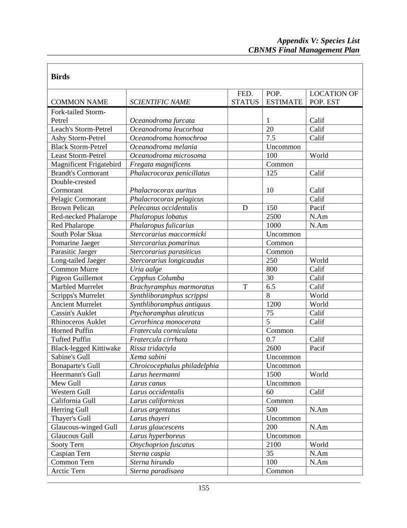
Appendix V: Species List
CBNMS Final Management Plan
155
Birds
COMMON NAME SCIENTIFIC NAME
FED.
STATUS
POP.
ESTIMATE
LOCATION OF
POP. EST
Fork-tailed Storm-
Petrel Oceanodroma furcata 1 Calif
Leach's Storm-Petrel Oceanodroma leucorhoa 20 Calif
Ashy Storm-Petrel Oceanodroma homochroa 7.5 Calif
Black Storm-Petrel Oceanodroma melania Uncommon
Least Storm-Petrel Oceanodroma microsoma 100 World
Magnificent Frigatebird Fregata magnificens Common
Brandt's Cormorant Phalacrocorax penicillatus 125 Calif
Double-crested
Cormorant Phalacrocorax auritus 10 Calif
Pelagic Cormorant Phalacrocorax pelagicus Calif
Brown Pelican Pelecanus occidentalis D 150 Pacif
Red-necked Phalarope Phalaropus lobatus 2500 N.Am
Red Phalarope Phalaropus fulicarius 1000 N.Am
South Polar Skua Stercorarius maccormicki Uncommon
Pomarine Jaeger Stercorarius pomarinus Common
Parasitic Jaeger Stercorarius parasiticus Common
Long-tailed Jaeger Stercorarius longicaudus 250 World
Common Murre Uria aalge 800 Calif
Pigeon Guillemot Cepphus Columba 30 Calif
Marbled Murrelet Brachyramphus marmoratus T 6.5 Calif
Scripps's Murrelet Synthliboramphus scrippsi 8 World
Ancient Murrelet Synthliboramphus antiquus 1200 World
Cassin's Auklet Ptychoramphus aleuticus 75 Calif
Rhinoceros Auklet Cerorhinca monocerata 5 Calif
Horned Puffin Fratercula corniculata Common
Tufted Puffin Fratercula cirrhata 0.7 Calif
Black-legged Kittiwake Rissa tridactyla 2600 Pacif
Sabine's Gull Xema sabini Uncommon
Bonaparte's Gull Chroicocephalus philadelphia Uncommon
Heermann's Gull Larus heermanni 1500 World
Mew Gull Larus canus Uncommon
Western Gull Larus occidentalis 60 Calif
California Gull Larus californicus Common
Herring Gull Larus argentatus 500 N.Am
Thayer's Gull Larus thayeri Uncommon
Glaucous-winged Gull Larus glaucescens 200 N.Am
Glaucous Gull Larus hyperboreus Uncommon
Sooty Tern Onychoprion fuscatus 2100 World
Caspian Tern Sterna caspia 35 N.Am
Common Tern Sterna hirundo 100 N.Am
Arctic Tern Sterna paradisaea Common
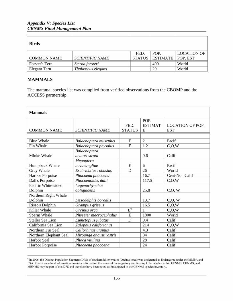
Appendix V: Species List
CBNMS Final Management Plan
156
Birds
COMMON NAME SCIENTIFIC NAME
FED.
STATUS
POP.
ESTIMATE
LOCATION OF
POP. EST
Forster's Tern Sterna forsteri 400 World
Elegant Tern Thalasseus elegans 29 World
MAMMALS
The mammal species list was compiled from verified observations from the CBOMP and the
ACCESS partnership.
Mammals
COMMON NAME SCIENTIFIC NAME
FED.
STATUS
POP.
ESTIMAT
E
LOCATION OF POP.
EST
Blue Whale Balaenoptera musculus E 2 Pacif
Fin Whale Balaenoptera physalus E 1.2 C,O,W
Minke Whale
Balaenoptera
acutorostrata 0.6 Calif
Humpback Whale
Megaptera
novaeangliae E 6 Pacif
Gray Whale Eschrichtius robustus D 26 World
Harbor Porpoise Phocoena phocoena 16.7 Cent-No. Calif
Dall's Porpoise Phocoenoides dalli 117.5 C,O,W
Pacific White-sided
Dolphin
Lagenorhynchus
obliquidens 25.8 C,O, W
Northern Right Whale
Dolphin Lissodelphis borealis 13.7 C,O, W
Risso's Dolphin Grampus griseus 16.5 C,O,W
Killer Whale Orcinus orca E6 1 C,O,W
Sperm Whale Physeter macrocephalus E 1800 World
Steller Sea Lion Eumetopius jubatus D 0.4 Calif
California Sea Lion Zalophus califorianus 214 C,O,W
Northern Fur Seal Callorhinus ursinus 4.3 Calif
Northern Elephant Seal Mirounga angustirostris 84 Calif
Harbor Seal Phoca vitulina 28 Calif
Harbor Porpoise Phocoena phocoena 24 Calif
6 In 2006, the Distinct Population Segment (DPS) of southern killer whales (Orcinus orca) was designated as Endangered under the MMPA and
ESA. Recent anecdotal information provides information that some of the migratory and feeding killer whales within GFNMS, CBNMS, and MBNMS may be part of this DPS and therefore have been noted as Endangered in the CBNMS species inventory.
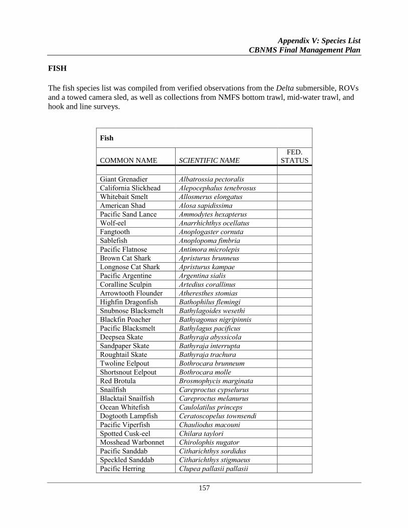
Appendix V: Species List
CBNMS Final Management Plan
157
FISH
The fish species list was compiled from verified observations from the Delta submersible, ROVs
and a towed camera sled, as well as collections from NMFS bottom trawl, mid-water trawl, and
hook and line surveys.
Fish
COMMON NAME SCIENTIFIC NAME
FED.
STATUS
Giant Grenadier Albatrossia pectoralis
California Slickhead Alepocephalus tenebrosus
Whitebait Smelt Allosmerus elongatus
American Shad Alosa sapidissima
Pacific Sand Lance Ammodytes hexapterus
Wolf-eel Anarrhichthys ocellatus
Fangtooth Anoplogaster cornuta
Sablefish Anoplopoma fimbria
Pacific Flatnose Antimora microlepis
Brown Cat Shark Apristurus brunneus
Longnose Cat Shark Apristurus kampae
Pacific Argentine Argentina sialis
Coralline Sculpin Artedius corallinus
Arrowtooth Flounder Atheresthes stomias
Highfin Dragonfish Bathophilus flemingi
Snubnose Blacksmelt Bathylagoides wesethi
Blackfin Poacher Bathyagonus nigripinnis
Pacific Blacksmelt Bathylagus pacificus
Deepsea Skate Bathyraja abyssicola
Sandpaper Skate Bathyraja interrupta
Roughtail Skate Bathyraja trachura
Twoline Eelpout Bothrocara brunneum
Shortsnout Eelpout Bothrocara molle
Red Brotula Brosmophycis marginata
Snailfish Careproctus cypselurus
Blacktail Snailfish Careproctus melanurus
Ocean Whitefish Caulolatilus princeps
Dogtooth Lampfish Ceratoscopelus townsendi
Pacific Viperfish Chauliodus macouni
Spotted Cusk-eel Chilara taylori
Mosshead Warbonnet Chirolophis nugator
Pacific Sanddab Citharichthys sordidus
Speckled Sanddab Citharichthys stigmaeus
Pacific Herring Clupea pallasii pallasii
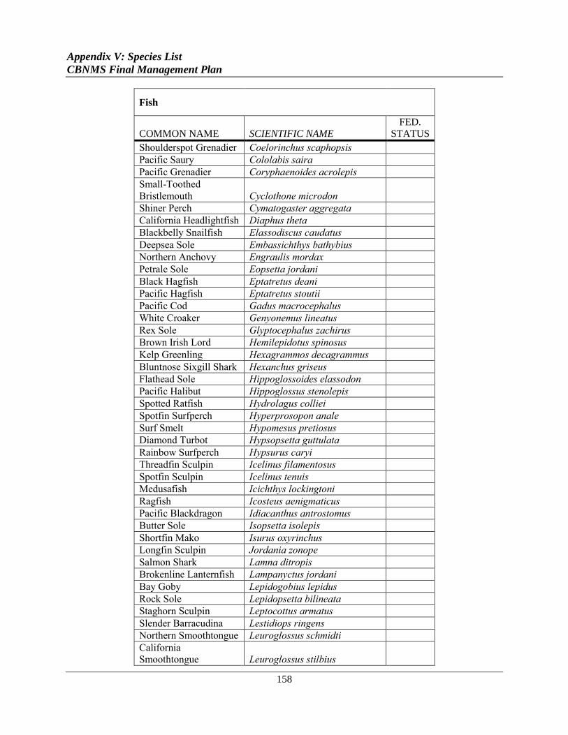
Appendix V: Species List
CBNMS Final Management Plan
158
Fish
COMMON NAME SCIENTIFIC NAME
FED.
STATUS
Shoulderspot Grenadier Coelorinchus scaphopsis
Pacific Saury Cololabis saira
Pacific Grenadier Coryphaenoides acrolepis
Small-Toothed
Bristlemouth Cyclothone microdon
Shiner Perch Cymatogaster aggregata
California Headlightfish Diaphus theta
Blackbelly Snailfish Elassodiscus caudatus
Deepsea Sole Embassichthys bathybius
Northern Anchovy Engraulis mordax
Petrale Sole Eopsetta jordani
Black Hagfish Eptatretus deani
Pacific Hagfish Eptatretus stoutii
Pacific Cod Gadus macrocephalus
White Croaker Genyonemus lineatus
Rex Sole Glyptocephalus zachirus
Brown Irish Lord Hemilepidotus spinosus
Kelp Greenling Hexagrammos decagrammus
Bluntnose Sixgill Shark Hexanchus griseus
Flathead Sole Hippoglossoides elassodon
Pacific Halibut Hippoglossus stenolepis
Spotted Ratfish Hydrolagus colliei
Spotfin Surfperch Hyperprosopon anale
Surf Smelt Hypomesus pretiosus
Diamond Turbot Hypsopsetta guttulata
Rainbow Surfperch Hypsurus caryi
Threadfin Sculpin Icelinus filamentosus
Spotfin Sculpin Icelinus tenuis
Medusafish Icichthys lockingtoni
Ragfish Icosteus aenigmaticus
Pacific Blackdragon Idiacanthus antrostomus
Butter Sole Isopsetta isolepis
Shortfin Mako Isurus oxyrinchus
Longfin Sculpin Jordania zonope
Salmon Shark Lamna ditropis
Brokenline Lanternfish Lampanyctus jordani
Bay Goby Lepidogobius lepidus
Rock Sole Lepidopsetta bilineata
Staghorn Sculpin Leptocottus armatus
Slender Barracudina Lestidiops ringens
Northern Smoothtongue Leuroglossus schmidti
California
Smoothtongue Leuroglossus stilbius
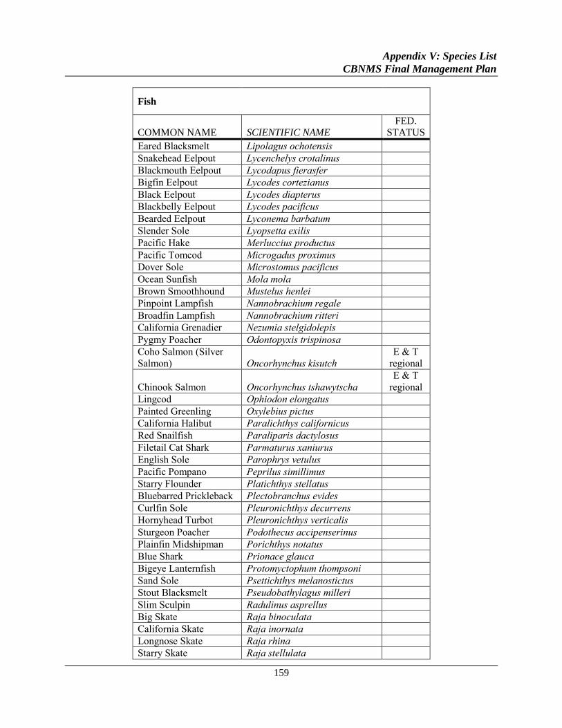
Appendix V: Species List
CBNMS Final Management Plan
159
Fish
COMMON NAME SCIENTIFIC NAME
FED.
STATUS
Eared Blacksmelt Lipolagus ochotensis
Snakehead Eelpout Lycenchelys crotalinus
Blackmouth Eelpout Lycodapus fierasfer
Bigfin Eelpout Lycodes cortezianus
Black Eelpout Lycodes diapterus
Blackbelly Eelpout Lycodes pacificus
Bearded Eelpout Lyconema barbatum
Slender Sole Lyopsetta exilis
Pacific Hake Merluccius productus
Pacific Tomcod Microgadus proximus
Dover Sole Microstomus pacificus
Ocean Sunfish Mola mola
Brown Smoothhound Mustelus henlei
Pinpoint Lampfish Nannobrachium regale
Broadfin Lampfish Nannobrachium ritteri
California Grenadier Nezumia stelgidolepis
Pygmy Poacher Odontopyxis trispinosa
Coho Salmon (Silver
Salmon) Oncorhynchus kisutch
E & T
regional
Chinook Salmon Oncorhynchus tshawytscha
E & T
regional
Lingcod Ophiodon elongatus
Painted Greenling Oxylebius pictus
California Halibut Paralichthys californicus
Red Snailfish Paraliparis dactylosus
Filetail Cat Shark Parmaturus xaniurus
English Sole Parophrys vetulus
Pacific Pompano Peprilus simillimus
Starry Flounder Platichthys stellatus
Bluebarred Prickleback Plectobranchus evides
Curlfin Sole Pleuronichthys decurrens
Hornyhead Turbot Pleuronichthys verticalis
Sturgeon Poacher Podothecus accipenserinus
Plainfin Midshipman Porichthys notatus
Blue Shark Prionace glauca
Bigeye Lanternfish Protomyctophum thompsoni
Sand Sole Psettichthys melanostictus
Stout Blacksmelt Pseudobathylagus milleri
Slim Sculpin Radulinus asprellus
Big Skate Raja binoculata
California Skate Raja inornata
Longnose Skate Raja rhina
Starry Skate Raja stellulata
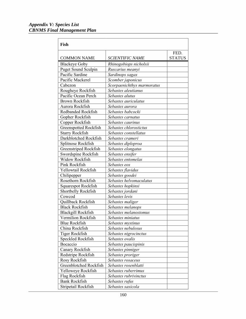
Appendix V: Species List
CBNMS Final Management Plan
160
Fish
COMMON NAME SCIENTIFIC NAME
FED.
STATUS
Blackeye Goby Rhinogobiops nicholsii
Puget Sound Sculpin Ruscarius meanyi
Pacific Sardine Sardinops sagax
Pacific Mackerel Scomber japonicus
Cabezon Scorpaenichthys marmoratus
Rougheye Rockfish Sebastes aleutianus
Pacific Ocean Perch Sebastes alutus
Brown Rockfish Sebastes auriculatus
Aurora Rockfish Sebastes aurora
Redbanded Rockfish Sebastes babcocki
Gopher Rockfish Sebastes carnatus
Copper Rockfish Sebastes caurinus
Greenspotted Rockfish Sebastes chlorostictus
Starry Rockfish Sebastes constellatus
Darkblotched Rockfish Sebastes crameri
Splitnose Rockfish Sebastes diploproa
Greenstriped Rockfish Sebastes elongatus
Swordspine Rockfish Sebastes ensifer
Widow Rockfish Sebastes entomelas
Pink Rockfish Sebastes eos
Yellowtail Rockfish Sebastes flavidus
Chilipepper Sebastes goodei
Rosethorn Rockfish Sebastes helvomaculatus
Squarespot Rockfish Sebastes hopkinsi
Shortbelly Rockfish Sebastes jordani
Cowcod Sebastes levis
Quillback Rockfish Sebastes maliger
Black Rockfish Sebastes melanops
Blackgill Rockfish Sebastes melanostomus
Vermilion Rockfish Sebastes miniatus
Blue Rockfish Sebastes mystinus
China Rockfish Sebastes nebulosus
Tiger Rockfish Sebastes nigrocinctus
Speckled Rockfish Sebastes ovalis
Bocaccio Sebastes paucispinis
Canary Rockfish Sebastes pinniger
Redstripe Rockfish Sebastes proriger
Rosy Rockfish Sebastes rosaceus
Greenblotched Rockfish Sebastes rosenblatti
Yelloweye Rockfish Sebastes ruberrimus
Flag Rockfish Sebastes rubrivinctus
Bank Rockfish Sebastes rufus
Stripetail Rockfish Sebastes saxicola

Appendix V: Species List
CBNMS Final Management Plan
161
Fish
COMMON NAME SCIENTIFIC NAME
FED.
STATUS
Halfbanded Rockfish Sebastes semicinctus
Olive Rockfish Sebastes serranoides
Pygmy Rockfish Sebastes wilsoni
Sharpchin Rockfish Sebastes zacentrus
Shortspine Thornyhead Sebastolobus alascanus
Longspine Thornyhead Sebastolobus altivelis
Spiny Dogfish Squalus acanthias
Northern Lampfish Stenobrachius leucopsarus
California Lanternfish Symbolophorus californiensis
California Tonguefish Symphurus atricaudus
Longfin Dragonfish Tactostoma macropus
Threadfin Slickhead Talismania bifurcata
Blue Lanternfish Tarletonbeania crenularis
Eulachon Thaleichthys pacificus
Albacore Thunnus alalunga
Pacific Electric Ray Torpedo californica
King-of-the-Salmon Trachipterus altivelis
Jack Mackerel Trachurus symmetricus
Blacktip Poacher Xeneretmus latifrons
Smootheye Poacher Xeneretmus leiops
Bluespotted Poacher Xeneretmus triacanthus
Pink Surfperch Zalembius rosaceus
Shortspine Combfish Zaniolepis frenata
Longspine Combfish Zaniolepis latipinnis
REPTILES
No population estimate was available, so the term "Rare" was used as a general indicator of the
worldwide population size.
Reptiles
COMMON NAME SCIENTIFIC NAME
FED.
STATUS
POP.
ESTIMATE
LOCATION OF
POP. EST
Leatherback Turtle Dermochelys coriacea E Rare World
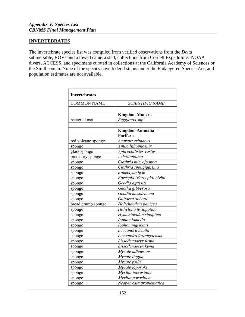
Appendix V: Species List
CBNMS Final Management Plan
162
INVERTEBRATES
The invertebrate species list was compiled from verified observations from the Delta
submersible, ROVs and a towed camera sled, collections from Cordell Expeditions, NOAA
divers, ACCESS, and specimens curated in collections at the California Academy of Sciences or
the Smithsonian. None of the species have federal status under the Endangered Species Act, and
population estimates are not available.
Invertebrates
COMMON NAME SCIENTIFIC NAME
Kingdom Monera
bacterial mat Beggiatoa spp.
Kingdom Animalia
Porifera
red volcano sponge Acarnus erithacus
sponge Antho lithophoenix
glass sponge Aphrocallistes vastus
predatory sponge Asbestopluma
sponge Clathria microjoanna
sponge Clathria spongigartina
sponge Endectyon hyle
sponge Forcepia (Forcepia) elvini
sponge Geodia agassizi
sponge Geodia gibberosa
sponge Geodia mesotriaena
sponge Guitarra abbotti
bread crumb sponge Halichondria panicea
sponge Haliclona textapatina
sponge Hymeniacidon sinapium
sponge Iophon lamella
sponge Iophon nigricans
sponge Leucandra heathi
sponge Leucandra losangelensis
sponge Lissodendoryx firma
sponge Lissodendoryx kyma
sponge Mycale adhaerens
sponge Mycale lingua
sponge Mycale psila
sponge Mycale toporoki
sponge Myxilla incrustans
sponge Myxilla parasitica
sponge Neopetrosia problematica
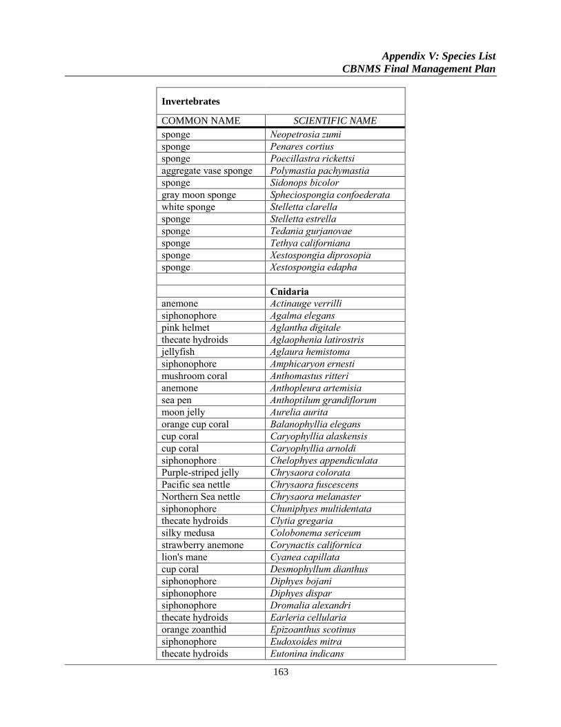
Appendix V: Species List
CBNMS Final Management Plan
163
Invertebrates
COMMON NAME SCIENTIFIC NAME
sponge Neopetrosia zumi
sponge Penares cortius
sponge Poecillastra rickettsi
aggregate vase sponge Polymastia pachymastia
sponge Sidonops bicolor
gray moon sponge Spheciospongia confoederata
white sponge Stelletta clarella
sponge Stelletta estrella
sponge Tedania gurjanovae
sponge Tethya californiana
sponge Xestospongia diprosopia
sponge Xestospongia edapha
Cnidaria
anemone Actinauge verrilli
siphonophore Agalma elegans
pink helmet Aglantha digitale
thecate hydroids Aglaophenia latirostris
jellyfish Aglaura hemistoma
siphonophore Amphicaryon ernesti
mushroom coral Anthomastus ritteri
anemone Anthopleura artemisia
sea pen Anthoptilum grandiflorum
moon jelly Aurelia aurita
orange cup coral Balanophyllia elegans
cup coral Caryophyllia alaskensis
cup coral Caryophyllia arnoldi
siphonophore Chelophyes appendiculata
Purple-striped jelly Chrysaora colorata
Pacific sea nettle Chrysaora fuscescens
Northern Sea nettle Chrysaora melanaster
siphonophore Chuniphyes multidentata
thecate hydroids Clytia gregaria
silky medusa Colobonema sericeum
strawberry anemone Corynactis californica
lion's mane Cyanea capillata
cup coral Desmophyllum dianthus
siphonophore Diphyes bojani
siphonophore Diphyes dispar
siphonophore Dromalia alexandri
thecate hydroids Earleria cellularia
orange zoanthid Epizoanthus scotinus
siphonophore Eudoxoides mitra
thecate hydroids Eutonina indicans
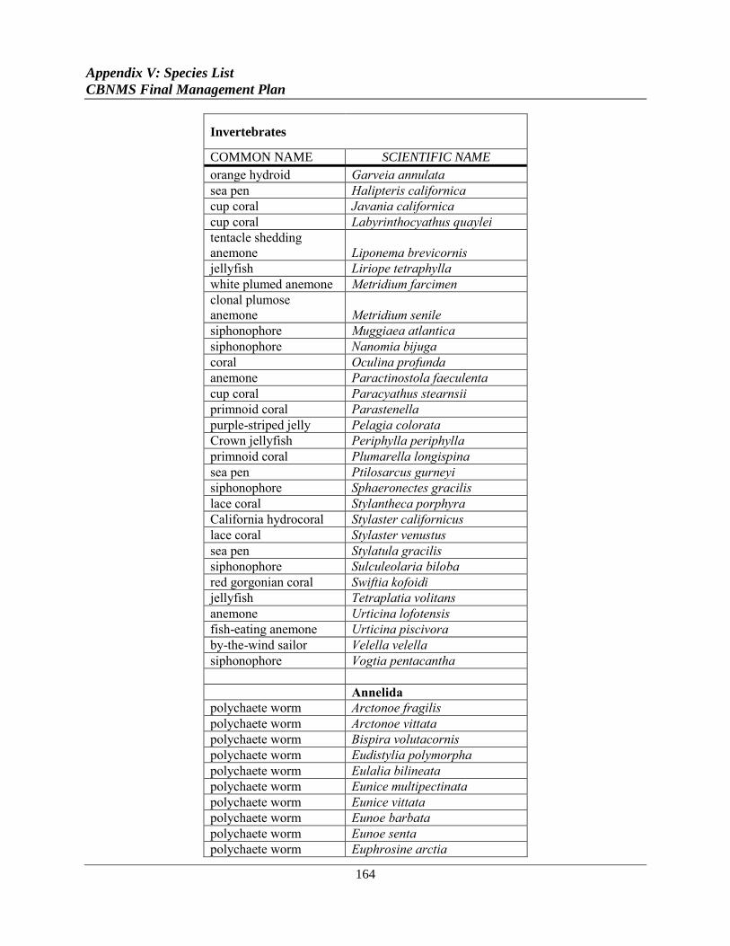
Appendix V: Species List
CBNMS Final Management Plan
164
Invertebrates
COMMON NAME SCIENTIFIC NAME
orange hydroid Garveia annulata
sea pen Halipteris californica
cup coral Javania californica
cup coral Labyrinthocyathus quaylei
tentacle shedding
anemone Liponema brevicornis
jellyfish Liriope tetraphylla
white plumed anemone Metridium farcimen
clonal plumose
anemone Metridium senile
siphonophore Muggiaea atlantica
siphonophore Nanomia bijuga
coral Oculina profunda
anemone Paractinostola faeculenta
cup coral Paracyathus stearnsii
primnoid coral Parastenella
purple-striped jelly Pelagia colorata
Crown jellyfish Periphylla periphylla
primnoid coral Plumarella longispina
sea pen Ptilosarcus gurneyi
siphonophore Sphaeronectes gracilis
lace coral Stylantheca porphyra
California hydrocoral Stylaster californicus
lace coral Stylaster venustus
sea pen Stylatula gracilis
siphonophore Sulculeolaria biloba
red gorgonian coral Swiftia kofoidi
jellyfish Tetraplatia volitans
anemone Urticina lofotensis
fish-eating anemone Urticina piscivora
by-the-wind sailor Velella velella
siphonophore Vogtia pentacantha
Annelida
polychaete worm Arctonoe fragilis
polychaete worm Arctonoe vittata
polychaete worm Bispira volutacornis
polychaete worm Eudistylia polymorpha
polychaete worm Eulalia bilineata
polychaete worm Eunice multipectinata
polychaete worm Eunice vittata
polychaete worm Eunoe barbata
polychaete worm Eunoe senta
polychaete worm Euphrosine arctia
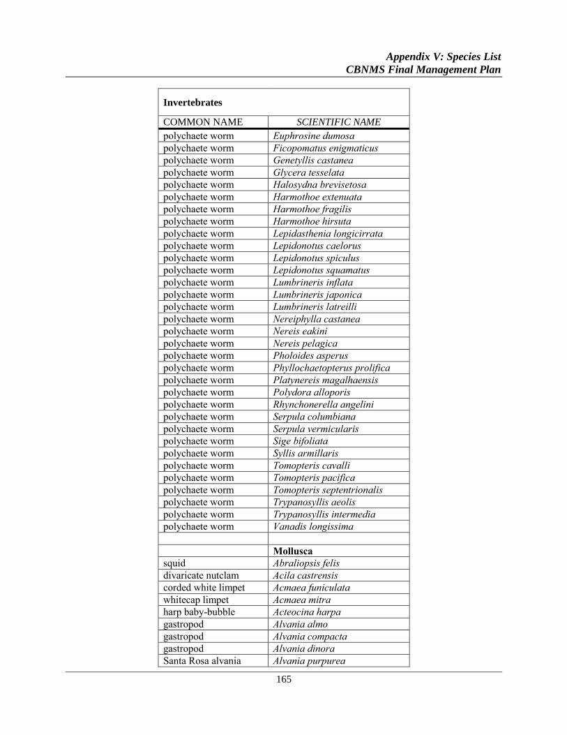
Appendix V: Species List
CBNMS Final Management Plan
165
Invertebrates
COMMON NAME SCIENTIFIC NAME
polychaete worm Euphrosine dumosa
polychaete worm Ficopomatus enigmaticus
polychaete worm Genetyllis castanea
polychaete worm Glycera tesselata
polychaete worm Halosydna brevisetosa
polychaete worm Harmothoe extenuata
polychaete worm Harmothoe fragilis
polychaete worm Harmothoe hirsuta
polychaete worm Lepidasthenia longicirrata
polychaete worm Lepidonotus caelorus
polychaete worm Lepidonotus spiculus
polychaete worm Lepidonotus squamatus
polychaete worm Lumbrineris inflata
polychaete worm Lumbrineris japonica
polychaete worm Lumbrineris latreilli
polychaete worm Nereiphylla castanea
polychaete worm Nereis eakini
polychaete worm Nereis pelagica
polychaete worm Pholoides asperus
polychaete worm Phyllochaetopterus prolifica
polychaete worm Platynereis magalhaensis
polychaete worm Polydora alloporis
polychaete worm Rhynchonerella angelini
polychaete worm Serpula columbiana
polychaete worm Serpula vermicularis
polychaete worm Sige bifoliata
polychaete worm Syllis armillaris
polychaete worm Tomopteris cavalli
polychaete worm Tomopteris pacifica
polychaete worm Tomopteris septentrionalis
polychaete worm Trypanosyllis aeolis
polychaete worm Trypanosyllis intermedia
polychaete worm Vanadis longissima
Mollusca
squid Abraliopsis felis
divaricate nutclam Acila castrensis
corded white limpet Acmaea funiculata
whitecap limpet Acmaea mitra
harp baby-bubble Acteocina harpa
gastropod Alvania almo
gastropod Alvania compacta
gastropod Alvania dinora
Santa Rosa alvania Alvania purpurea
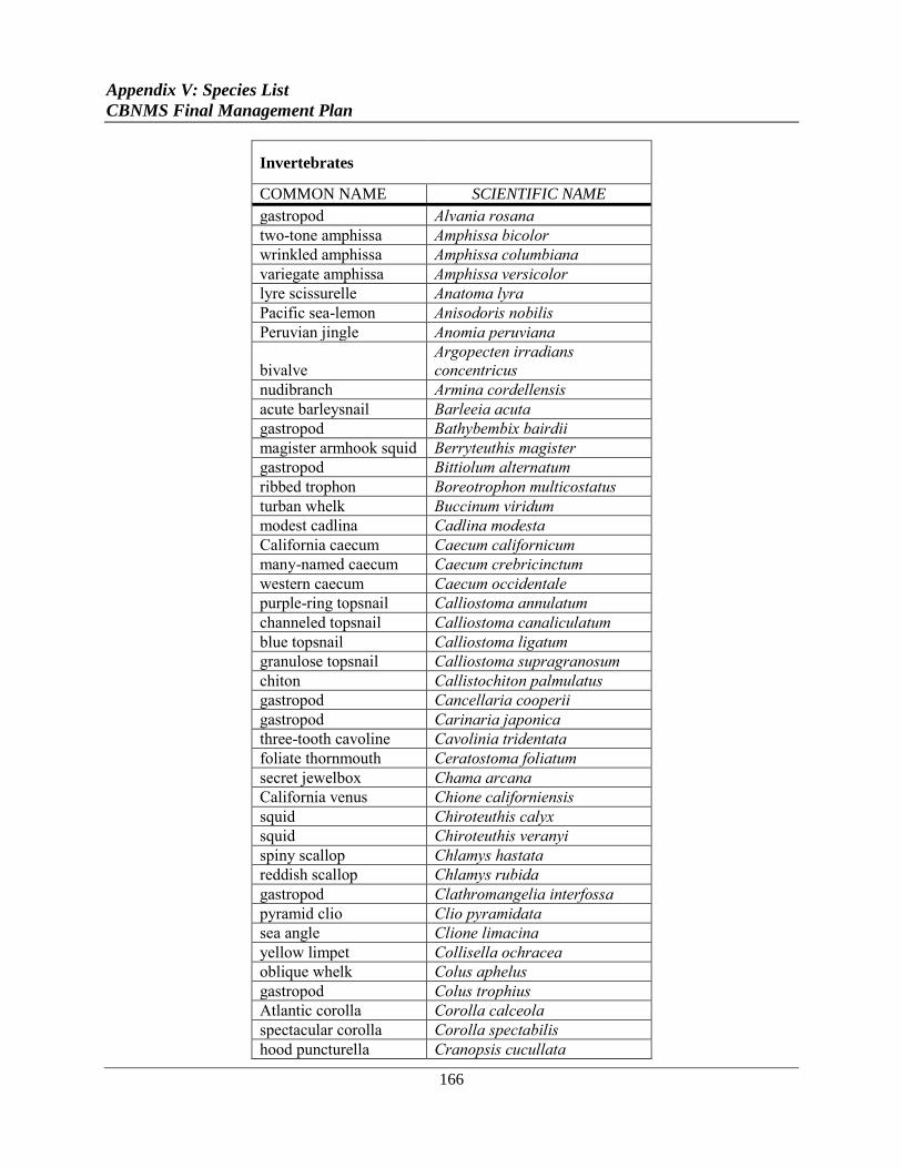
Appendix V: Species List
CBNMS Final Management Plan
166
Invertebrates
COMMON NAME SCIENTIFIC NAME
gastropod Alvania rosana
two-tone amphissa Amphissa bicolor
wrinkled amphissa Amphissa columbiana
variegate amphissa Amphissa versicolor
lyre scissurelle Anatoma lyra
Pacific sea-lemon Anisodoris nobilis
Peruvian jingle Anomia peruviana
bivalve
Argopecten irradians
concentricus
nudibranch Armina cordellensis
acute barleysnail Barleeia acuta
gastropod Bathybembix bairdii
magister armhook squid Berryteuthis magister
gastropod Bittiolum alternatum
ribbed trophon Boreotrophon multicostatus
turban whelk Buccinum viridum
modest cadlina Cadlina modesta
California caecum Caecum californicum
many-named caecum Caecum crebricinctum
western caecum Caecum occidentale
purple-ring topsnail Calliostoma annulatum
channeled topsnail Calliostoma canaliculatum
blue topsnail Calliostoma ligatum
granulose topsnail Calliostoma supragranosum
chiton Callistochiton palmulatus
gastropod Cancellaria cooperii
gastropod Carinaria japonica
three-tooth cavoline Cavolinia tridentata
foliate thornmouth Ceratostoma foliatum
secret jewelbox Chama arcana
California venus Chione californiensis
squid Chiroteuthis calyx
squid Chiroteuthis veranyi
spiny scallop Chlamys hastata
reddish scallop Chlamys rubida
gastropod Clathromangelia interfossa
pyramid clio Clio pyramidata
sea angle Clione limacina
yellow limpet Collisella ochracea
oblique whelk Colus aphelus
gastropod Colus trophius
Atlantic corolla Corolla calceola
spectacular corolla Corolla spectabilis
hood puncturella Cranopsis cucullata
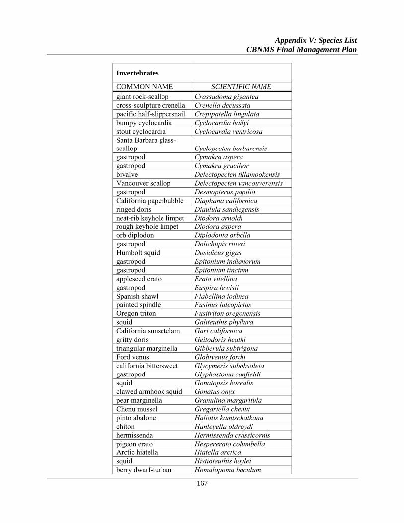
Appendix V: Species List
CBNMS Final Management Plan
167
Invertebrates
COMMON NAME SCIENTIFIC NAME
giant rock-scallop Crassadoma gigantea
cross-sculpture crenella Crenella decussata
pacific half-slippersnail Crepipatella lingulata
bumpy cyclocardia Cyclocardia bailyi
stout cyclocardia Cyclocardia ventricosa
Santa Barbara glass-
scallop Cyclopecten barbarensis
gastropod Cymakra aspera
gastropod Cymakra gracilior
bivalve Delectopecten tillamookensis
Vancouver scallop Delectopecten vancouverensis
gastropod Desmopterus papilio
California paperbubble Diaphana californica
ringed doris Diaulula sandiegensis
neat-rib keyhole limpet Diodora arnoldi
rough keyhole limpet Diodora aspera
orb diplodon Diplodonta orbella
gastropod Dolichupis ritteri
Humbolt squid Dosidicus gigas
gastropod Epitonium indianorum
gastropod Epitonium tinctum
appleseed erato Erato vitellina
gastropod Euspira lewisii
Spanish shawl Flabellina iodinea
painted spindle Fusinus luteopictus
Oregon triton Fusitriton oregonensis
squid Galiteuthis phyllura
California sunsetclam Gari californica
gritty doris Geitodoris heathi
triangular marginella Gibberula subtrigona
Ford venus Globivenus fordii
california bittersweet Glycymeris subobsoleta
gastropod Glyphostoma canfieldi
squid Gonatopsis borealis
clawed armhook squid Gonatus onyx
pear marginella Granulina margaritula
Chenu mussel Gregariella chenui
pinto abalone Haliotis kamtschatkana
chiton Hanleyella oldroydi
hermissenda Hermissenda crassicornis
pigeon erato Hespererato columbella
Arctic hiatella Hiatella arctica
squid Histioteuthis hoylei
berry dwarf-turban Homalopoma baculum
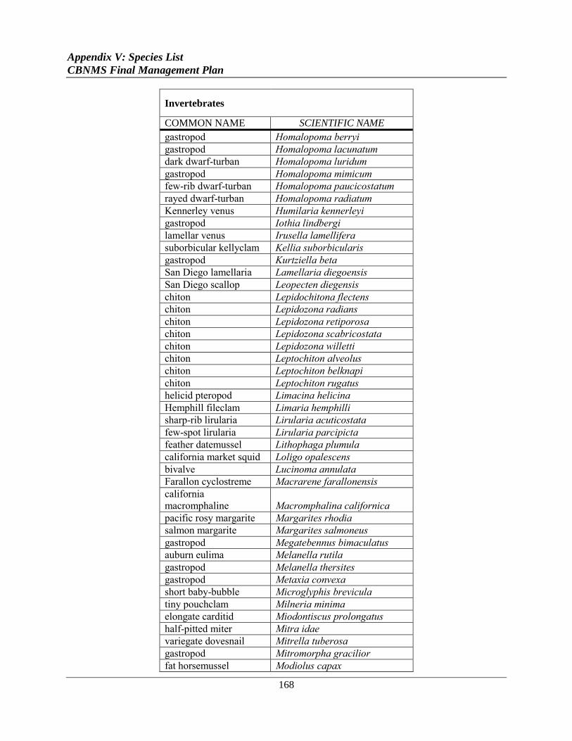
Appendix V: Species List
CBNMS Final Management Plan
168
Invertebrates
COMMON NAME SCIENTIFIC NAME
gastropod Homalopoma berryi
gastropod Homalopoma lacunatum
dark dwarf-turban Homalopoma luridum
gastropod Homalopoma mimicum
few-rib dwarf-turban Homalopoma paucicostatum
rayed dwarf-turban Homalopoma radiatum
Kennerley venus Humilaria kennerleyi
gastropod Iothia lindbergi
lamellar venus Irusella lamellifera
suborbicular kellyclam Kellia suborbicularis
gastropod Kurtziella beta
San Diego lamellaria Lamellaria diegoensis
San Diego scallop Leopecten diegensis
chiton Lepidochitona flectens
chiton Lepidozona radians
chiton Lepidozona retiporosa
chiton Lepidozona scabricostata
chiton Lepidozona willetti
chiton Leptochiton alveolus
chiton Leptochiton belknapi
chiton Leptochiton rugatus
helicid pteropod Limacina helicina
Hemphill fileclam Limaria hemphilli
sharp-rib lirularia Lirularia acuticostata
few-spot lirularia Lirularia parcipicta
feather datemussel Lithophaga plumula
california market squid Loligo opalescens
bivalve Lucinoma annulata
Farallon cyclostreme Macrarene farallonensis
california
macromphaline Macromphalina californica
pacific rosy margarite Margarites rhodia
salmon margarite Margarites salmoneus
gastropod Megatebennus bimaculatus
auburn eulima Melanella rutila
gastropod Melanella thersites
gastropod Metaxia convexa
short baby-bubble Microglyphis brevicula
tiny pouchclam Milneria minima
elongate carditid Miodontiscus prolongatus
half-pitted miter Mitra idae
variegate dovesnail Mitrella tuberosa
gastropod Mitromorpha gracilior
fat horsemussel Modiolus capax
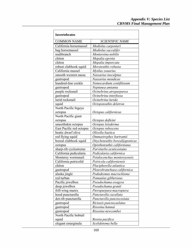
Appendix V: Species List
CBNMS Final Management Plan
169
Invertebrates
COMMON NAME SCIENTIFIC NAME
California horsemussel Modiolus carpenteri
bag horsemussel Modiolus sacculifer
nudibranch Montereina nobilis
chiton Mopalia egretta
chiton Mopalia imporcata
robust clubhook squid Moroteuthis robusta
California mussel Mytilus zonarius
smooth western nassa Nassarius insculptus
gastropod Nassarius mendicus
hundred-line cockle Nemocardium centifilosum
gastropod Neptunea amianta
purple rocksnail Ocinebrina atropurpurea
gastropod Ocinebrina interfossa
lurid rocksnail Ocinebrina lurida
squid Octopoteuthis deletron
North Pacific bigeye
octopus Octopus californicus
North Pacific giant
octopus Octopus dofleini
smoothskin octopus Octopus leioderma
East Pacific red octopus Octopus rubescens
beatic dwarf olive Olivella baetica
red flying squid Ommastrephes bartramii
boreal clubhook squid Onychoteuthis borealijaponicus
octopus Opisthoteuthis californiana
sharp-rib cyclostreme Parviturbo acuticostatus
California pedicularia Pedicularia californica
Monterey wormsnail Petaloconchus montereyensis
California petricolid Petricola californiensis
chiton Placiphorella atlantica
gastropod Pleurobranchaea californica
alaska jingle Pododesmus macrochisma
red turban Pomaulax gibberosus
Pacific jewelbox Pseudochama exogyra
deep jewelbox Pseudochama granti
frill-wing murex Pteropurpura macroptera
hood puncturella Puncturella cucullata
dot-rib puncturella Puncturella punctocostata
gastropod Rictaxis punctocaelatus
gastropod Rissoina hannai
gastropod Rissoina newcombei
North Pacific bobtail
squid Rossia pacifica
elegant emarginula Scelidotoma bella
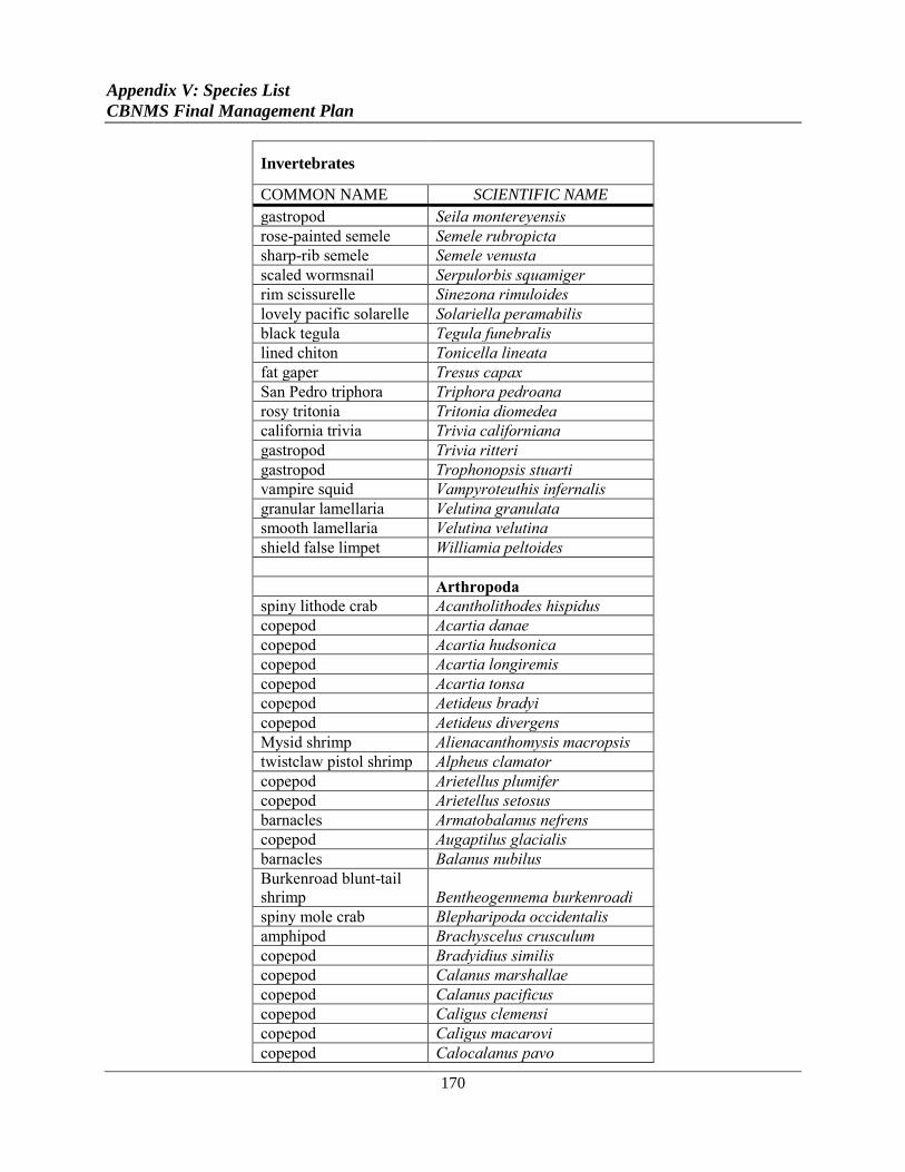
Appendix V: Species List
CBNMS Final Management Plan
170
Invertebrates
COMMON NAME SCIENTIFIC NAME
gastropod Seila montereyensis
rose-painted semele Semele rubropicta
sharp-rib semele Semele venusta
scaled wormsnail Serpulorbis squamiger
rim scissurelle Sinezona rimuloides
lovely pacific solarelle Solariella peramabilis
black tegula Tegula funebralis
lined chiton Tonicella lineata
fat gaper Tresus capax
San Pedro triphora Triphora pedroana
rosy tritonia Tritonia diomedea
california trivia Trivia californiana
gastropod Trivia ritteri
gastropod Trophonopsis stuarti
vampire squid Vampyroteuthis infernalis
granular lamellaria Velutina granulata
smooth lamellaria Velutina velutina
shield false limpet Williamia peltoides
Arthropoda
spiny lithode crab Acantholithodes hispidus
copepod Acartia danae
copepod Acartia hudsonica
copepod Acartia longiremis
copepod Acartia tonsa
copepod Aetideus bradyi
copepod Aetideus divergens
Mysid shrimp Alienacanthomysis macropsis
twistclaw pistol shrimp Alpheus clamator
copepod Arietellus plumifer
copepod Arietellus setosus
barnacles Armatobalanus nefrens
copepod Augaptilus glacialis
barnacles Balanus nubilus
Burkenroad blunt-tail
shrimp Bentheogennema burkenroadi
spiny mole crab Blepharipoda occidentalis
amphipod Brachyscelus crusculum
copepod Bradyidius similis
copepod Calanus marshallae
copepod Calanus pacificus
copepod Caligus clemensi
copepod Caligus macarovi
copepod Calocalanus pavo
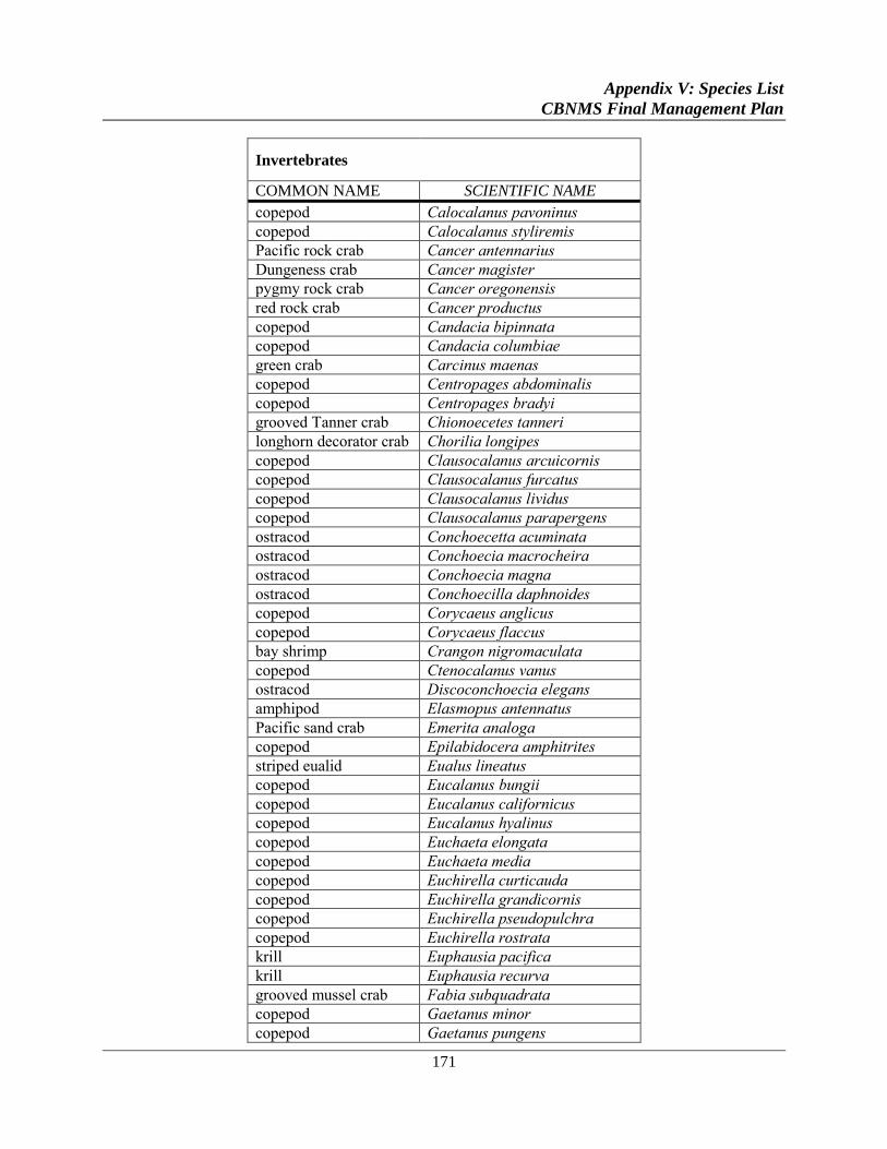
Appendix V: Species List
CBNMS Final Management Plan
171
Invertebrates
COMMON NAME SCIENTIFIC NAME
copepod Calocalanus pavoninus
copepod Calocalanus styliremis
Pacific rock crab Cancer antennarius
Dungeness crab Cancer magister
pygmy rock crab Cancer oregonensis
red rock crab Cancer productus
copepod Candacia bipinnata
copepod Candacia columbiae
green crab Carcinus maenas
copepod Centropages abdominalis
copepod Centropages bradyi
grooved Tanner crab Chionoecetes tanneri
longhorn decorator crab Chorilia longipes
copepod Clausocalanus arcuicornis
copepod Clausocalanus furcatus
copepod Clausocalanus lividus
copepod Clausocalanus parapergens
ostracod Conchoecetta acuminata
ostracod Conchoecia macrocheira
ostracod Conchoecia magna
ostracod Conchoecilla daphnoides
copepod Corycaeus anglicus
copepod Corycaeus flaccus
bay shrimp Crangon nigromaculata
copepod Ctenocalanus vanus
ostracod Discoconchoecia elegans
amphipod Elasmopus antennatus
Pacific sand crab Emerita analoga
copepod Epilabidocera amphitrites
striped eualid Eualus lineatus
copepod Eucalanus bungii
copepod Eucalanus californicus
copepod Eucalanus hyalinus
copepod Euchaeta elongata
copepod Euchaeta media
copepod Euchirella curticauda
copepod Euchirella grandicornis
copepod Euchirella pseudopulchra
copepod Euchirella rostrata
krill Euphausia pacifica
krill Euphausia recurva
grooved mussel crab Fabia subquadrata
copepod Gaetanus minor
copepod Gaetanus pungens
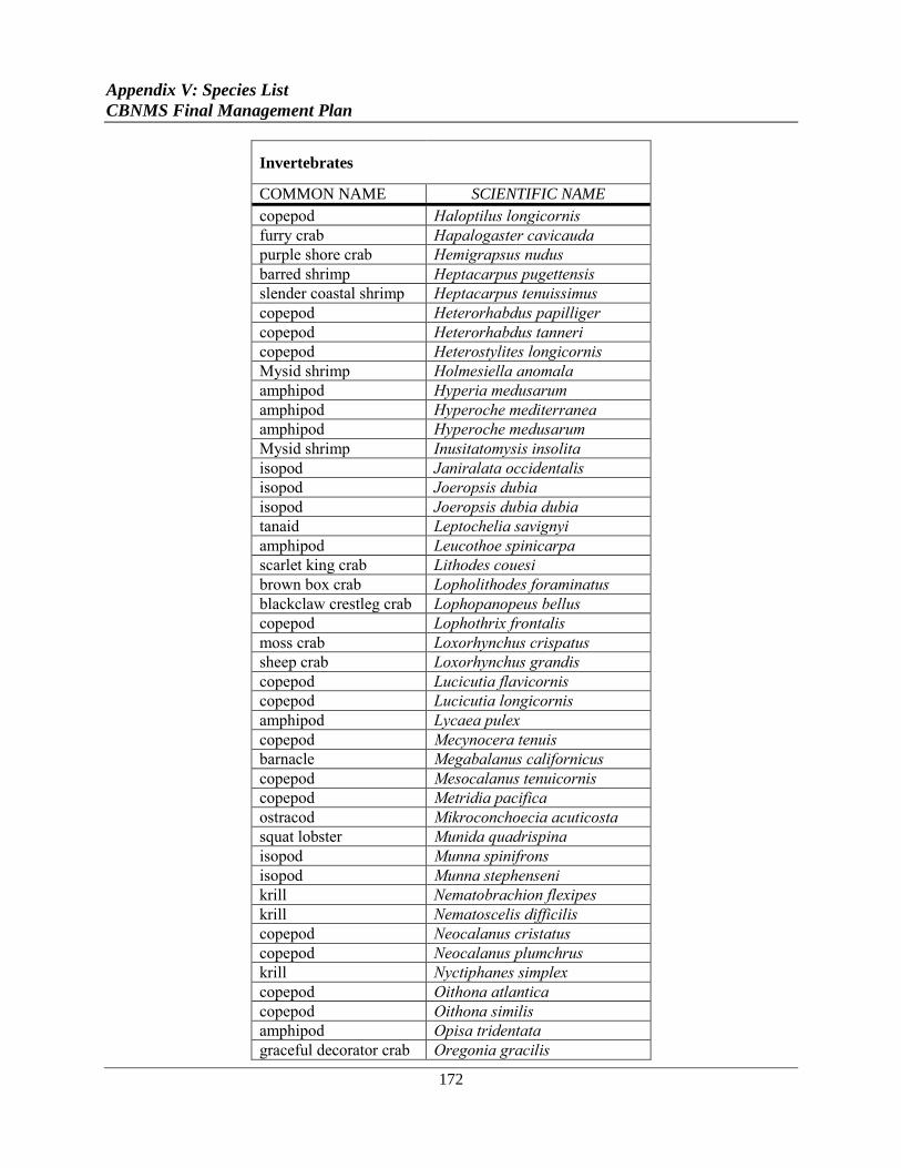
Appendix V: Species List
CBNMS Final Management Plan
172
Invertebrates
COMMON NAME SCIENTIFIC NAME
copepod Haloptilus longicornis
furry crab Hapalogaster cavicauda
purple shore crab Hemigrapsus nudus
barred shrimp Heptacarpus pugettensis
slender coastal shrimp Heptacarpus tenuissimus
copepod Heterorhabdus papilliger
copepod Heterorhabdus tanneri
copepod Heterostylites longicornis
Mysid shrimp Holmesiella anomala
amphipod Hyperia medusarum
amphipod Hyperoche mediterranea
amphipod Hyperoche medusarum
Mysid shrimp Inusitatomysis insolita
isopod Janiralata occidentalis
isopod Joeropsis dubia
isopod Joeropsis dubia dubia
tanaid Leptochelia savignyi
amphipod Leucothoe spinicarpa
scarlet king crab Lithodes couesi
brown box crab Lopholithodes foraminatus
blackclaw crestleg crab Lophopanopeus bellus
copepod Lophothrix frontalis
moss crab Loxorhynchus crispatus
sheep crab Loxorhynchus grandis
copepod Lucicutia flavicornis
copepod Lucicutia longicornis
amphipod Lycaea pulex
copepod Mecynocera tenuis
barnacle Megabalanus californicus
copepod Mesocalanus tenuicornis
copepod Metridia pacifica
ostracod Mikroconchoecia acuticosta
squat lobster Munida quadrispina
isopod Munna spinifrons
isopod Munna stephenseni
krill Nematobrachion flexipes
krill Nematoscelis difficilis
copepod Neocalanus cristatus
copepod Neocalanus plumchrus
krill Nyctiphanes simplex
copepod Oithona atlantica
copepod Oithona similis
amphipod Opisa tridentata
graceful decorator crab Oregonia gracilis
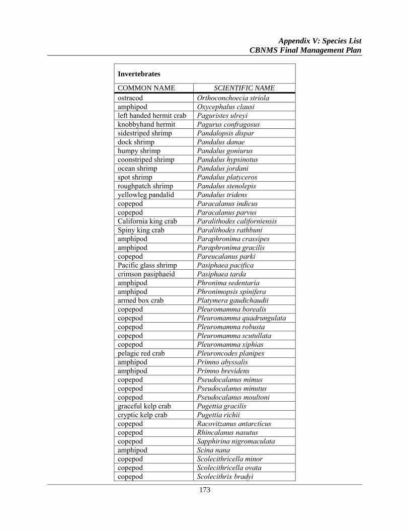
Appendix V: Species List
CBNMS Final Management Plan
173
Invertebrates
COMMON NAME SCIENTIFIC NAME
ostracod Orthoconchoecia striola
amphipod Oxycephalus clausi
left handed hermit crab Paguristes ulreyi
knobbyhand hermit Pagurus confragosus
sidestriped shrimp Pandalopsis dispar
dock shrimp Pandalus danae
humpy shrimp Pandalus goniurus
coonstriped shrimp Pandalus hypsinotus
ocean shrimp Pandalus jordani
spot shrimp Pandalus platyceros
roughpatch shrimp Pandalus stenolepis
yellowleg pandalid Pandalus tridens
copepod Paracalanus indicus
copepod Paracalanus parvus
California king crab Paralithodes californiensis
Spiny king crab Paralithodes rathbuni
amphipod Paraphronima crassipes
amphipod Paraphronima gracilis
copepod Pareucalanus parki
Pacific glass shrimp Pasiphaea pacifica
crimson pasiphaeid Pasiphaea tarda
amphipod Phronima sedentaria
amphipod Phronimopsis spinifera
armed box crab Platymera gaudichaudii
copepod Pleuromamma borealis
copepod Pleuromamma quadrungulata
copepod Pleuromamma robusta
copepod Pleuromamma scutullata
copepod Pleuromamma xiphias
pelagic red crab Pleuroncodes planipes
amphipod Primno abyssalis
amphipod Primno brevidens
copepod Pseudocalanus mimus
copepod Pseudocalanus minutus
copepod Pseudocalanus moultoni
graceful kelp crab Pugettia gracilis
cryptic kelp crab Pugettia richii
copepod Racovitzanus antarcticus
copepod Rhincalanus nasutus
copepod Sapphirina nigromaculata
amphipod Scina nana
copepod Scolecithricella minor
copepod Scolecithricella ovata
copepod Scolecithrix bradyi
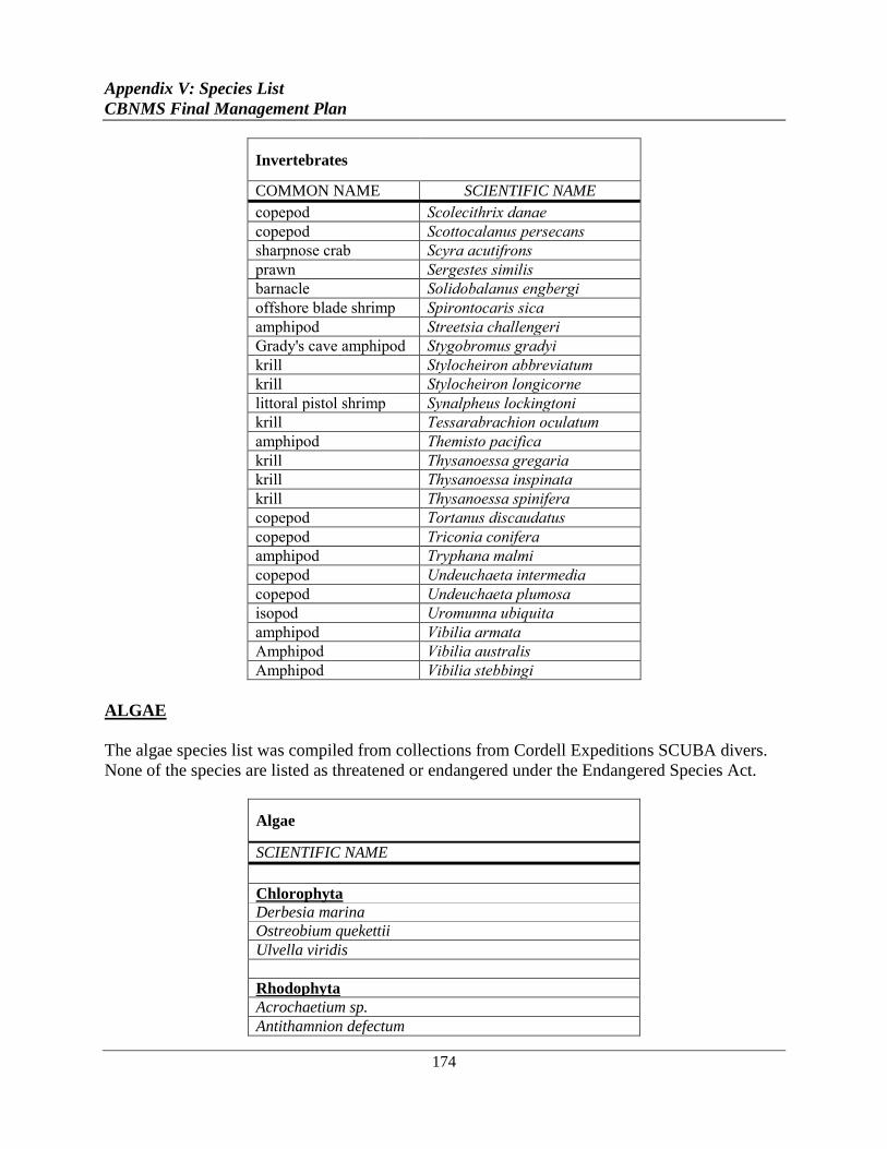
Appendix V: Species List
CBNMS Final Management Plan
174
Invertebrates
COMMON NAME SCIENTIFIC NAME
copepod Scolecithrix danae
copepod Scottocalanus persecans
sharpnose crab Scyra acutifrons
prawn Sergestes similis
barnacle Solidobalanus engbergi
offshore blade shrimp Spirontocaris sica
amphipod Streetsia challengeri
Grady's cave amphipod Stygobromus gradyi
krill Stylocheiron abbreviatum
krill Stylocheiron longicorne
littoral pistol shrimp Synalpheus lockingtoni
krill Tessarabrachion oculatum
amphipod Themisto pacifica
krill Thysanoessa gregaria
krill Thysanoessa inspinata
krill Thysanoessa spinifera
copepod Tortanus discaudatus
copepod Triconia conifera
amphipod Tryphana malmi
copepod Undeuchaeta intermedia
copepod Undeuchaeta plumosa
isopod Uromunna ubiquita
amphipod Vibilia armata
Amphipod Vibilia australis
Amphipod Vibilia stebbingi
ALGAE
The algae species list was compiled from collections from Cordell Expeditions SCUBA divers.
None of the species are listed as threatened or endangered under the Endangered Species Act.
Algae
SCIENTIFIC NAME
Chlorophyta
Derbesia marina
Ostreobium quekettii
Ulvella viridis
Rhodophyta
Acrochaetium sp.
Antithamnion defectum
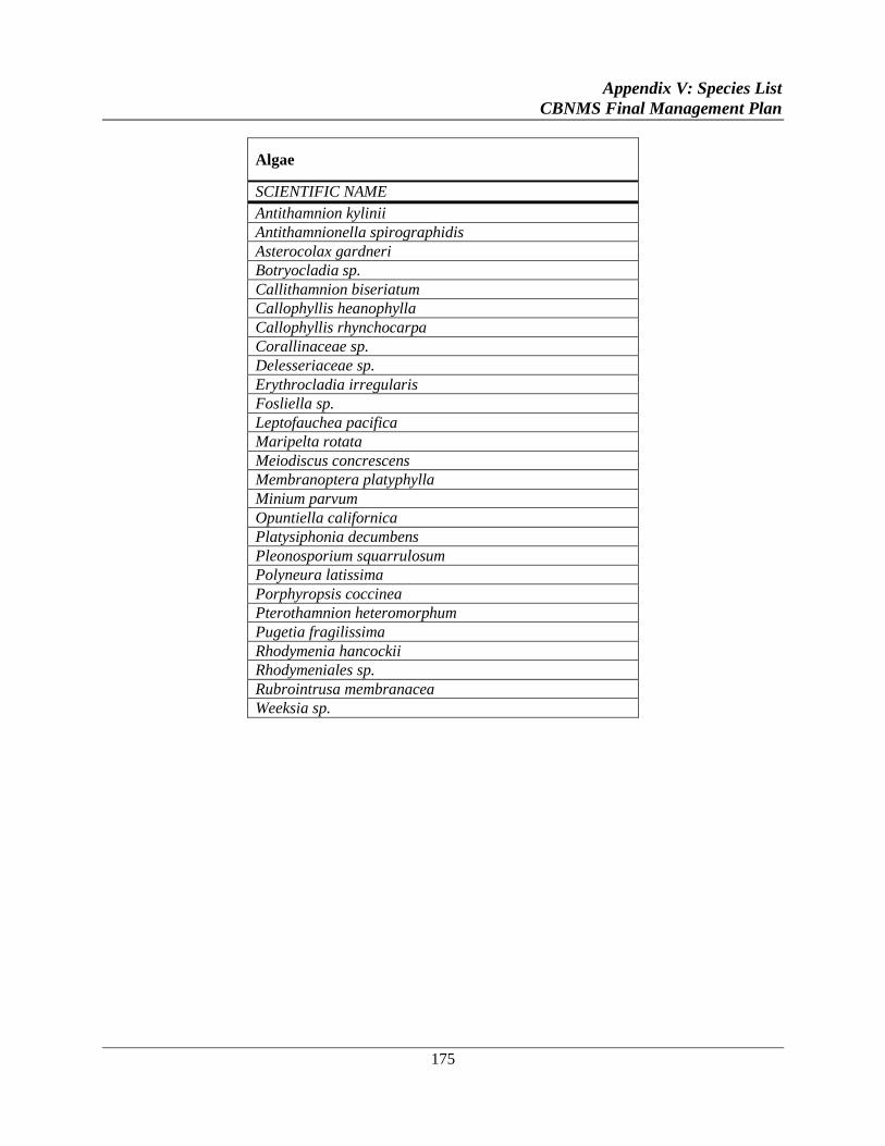
Appendix V: Species List
CBNMS Final Management Plan
175
Algae
SCIENTIFIC NAME
Antithamnion kylinii
Antithamnionella spirographidis
Asterocolax gardneri
Botryocladia sp.
Callithamnion biseriatum
Callophyllis heanophylla
Callophyllis rhynchocarpa
Corallinaceae sp.
Delesseriaceae sp.
Erythrocladia irregularis
Fosliella sp.
Leptofauchea pacifica
Maripelta rotata
Meiodiscus concrescens
Membranoptera platyphylla
Minium parvum
Opuntiella californica
Platysiphonia decumbens
Pleonosporium squarrulosum
Polyneura latissima
Porphyropsis coccinea
Pterothamnion heteromorphum
Pugetia fragilissima
Rhodymenia hancockii
Rhodymeniales sp.
Rubrointrusa membranacea
Weeksia sp.


