copyright by jean kathleen krejca 2005 dissertation.pdf · the dissertation committee for jean...
TRANSCRIPT

Copyright
by
Jean Kathleen Krejca
2005

The Dissertation Committee for Jean Kathleen Krejca Certifies that
this is the approved version of the following dissertation:
Stygobite phylogenetics as a tool for determining aquifer evolution
Committee:
David M. Hillis, Supervisor
Dean Hendrickson, Co-Supervisor
Ulrich G. Mueller
John M. Sharp, Jr.
George Veni

Stygobite phylogenetics as a tool for determining aquifer evolution
by
Jean Kathleen Krejca, B.S.
Dissertation
Presented to the Faculty of the Graduate School of
The University of Texas at Austin
in Partial Fulfillment
of the Requirements
for the Degree of
Doctor of Philosophy
The University of Texas at Austin May, 2005

Dedication
This work is dedicated to the most adventurous woman I know, my caving
partner and wife, Vivian I. Loftin.

v
Acknowledgements
This work could not have been accomplished without the unending
help of many different people. First, my parents for providing an
environment that allowed me to pursue a path of my own design. My
committee provided advice and comments on the manuscript, and
particularly to Dave Hillis, Dean Hendrickson and George Veni for their
unending help with navigating the steep topography of graduate school,
finding caves to sample, and going out with me to do field work. Everyone
in the Dave Hillis and Jim Bull labs helped me with learning DNA work,
from extraction to sequencing, and particularly to Derrick Zwickl for his
help with phylogenetic analysis. Tracy Heath and Shannon Hedtke were
also there for me in the last round of working through the analysis. The
Texas Speleological Survey and all of the volunteers there helped by
providing me with cave location and landowner information. Patrick
Connor at the U.S. Fish and Wildlife Service provided important help with
GIS distance matrix functions, and others at USFWS gave moral support
both during and after my tenure there. Travis LeDuc provided me with

vi
maps, Malia Ana Rivera and Frank Howarth helped with CO1 primers,
Radu Boghici and Sylvia Pope provided literature on border hydrology.
I am also indebted to all of the landowners that granted me
permission to access these sites and sample there, and to all of the land
managers that assisted with logistics of access and sampling. These
people include: Homero Amezcua, David Baker, Carlos Botello, Roger
Biggers, Tom Brown, Marco Antonio Cardozo M., DeeAnn Chamberlain,
Sam Dandridge, Michelle and Sean Devaney, José Falcón, Salvador
Martinez Garza, Darrell Hargrove, Jay Hess, Deirdre Hisler, John Hoyt,
James and Betty Klar, Dave Larson, Glenn Longley, Clark Lytle, Hugo
Martinez, Wayne Mathis, Robert McCurdy, AnnMarie Mikelski, Tom
Morris, Buddy Mostyn, MaryLynn Musgrove, Linda Palit, José H. Múzquiz
Quedea, Terry de la Rosa, Randy Rosales, Guillermo Osuna Saenz,
Geary Schindel, Lewis Tyra, Javier Valdez, Ross Whitten, P. Wiley. The
places that granted me permission and helped with logistics include:
Amistad National Recreation Area, Brackenridge Zoo, Bureau of
Reclamation, City of Austin, Colorado Bend State Park, Edwards Aquifer
Authority, Government Canyon State Natural Area, Guadalupe River State
Park, Junta Admistradora de Agua Potable y Alcantarillado de Múzquiz
Coahuila, Longhorn Caverns, Lost Maples State Park, Lower Colorado
River Authority, New Braunfels Utilities, Pedernales Falls State Park,
Texas State University, Wonder World Park.

vii
The following cavers and biologists helped me find and access
collecting localities: Jerry Atkinson, Roger Bartholemew, Paul Chippindale,
Jon Cradit, Randy Gibson, Andy Grubbs, Bob Hershler, John Holsinger,
Terry Holsinger, James Loftin, Glenn Longley, Scott Harden, Robert
Herschler, John Holsinger, Jim Kennedy, Dale Pate, James Reddell,
William Russell and Peter Sprouse.
Field work for this project was extensive, spanning many years and
a multitude of small, wet, muddy, vertical and sometimes uncomfortable
places. I am indebted to the following people for their help with that:
Nathan Allan, Melanie Alspaugh, Kaye Barlow, Aimee Beveridge, Don
Broussard, Chris Buntenbah, Terry Burgen, Giorgio Carramana, Jorge
Homero Rodríguez Castro, DeeAnn Chamberlain, Allan Cobb, Adam
Cohen, James Cokendolpher, Salvador Contreras-Balderas, John Cradit,
Don Dearborn, Brett Dodson, Gary Dunkley, Earthwatch Team 2001 and
2002, Fernando Vanage Eligio, Robert Escaline, Digger Feakes, Marcus
Gary, Robin Gary, Steve Gerrard, Andy Gluesenkamp, Alan Goodman,
Andy Grubbs, Aldo Antonio Guevara Carrizales, Tom Haile, Sue Hanna,
Greg Hanson, Scott Harden, Dean Hendrickson, Garrett Hendrickson,
Jacob Hendrickson, Dave Hillis, Goeff Hoese, Terry Holsinger, Jody
Horton, Whitney Howeth, Pete Hurd, Tom Iliffe, Joe Ivy, Chrissy Jett, Yara
Sanchez Johnson, Becky Jones, Jan Klein, Chris Krejca, Mike Lang, Bill
Larson, Dave Larson, Celene Denev Acuna Leal, Cindy Lee, Ted Lee,
Francisco Garcia de Leon, Mike Loeffler, Llyn Loftin, Vivian Loftin, James

viii
Lopez, Joyce Luck, Carol Malcom, Jane Marks, Tania Yssel Flores
Martinez, Robert McCurdy, R.D. Millholin, John Mitchell, Mike Moore,
Jaime Moreno, Collin Morris, Tom Morris, John Moseley, Jen Mui, Rae
Nadler-Olenick, Walt Olenick, Kane Overfield, Hector Espinosa Perez,
Chris Philips, Sammy Pizzo, Mary Poteet, Denise Prendergast, Julie
Rhodes, Jason Richards, William Russell, Azael Salazar, Mark Sanders,
Charley Savvas, Bill Sawyer, Greg Sedbrook, Kathy Scanlon, Geary
Schindel, Travis Scott, Pete Shifflett, Peter Sprouse, Lara Storm, Dave
Stuart, David Sweetin, Pam Tanino, Steve Taylor, Emily Thompson, Bruce
Tipps, Jody Trainey, Bill Tucker, Anastasio Urbina, George Veni, Chris
Vreeland, Erin Vreeland, Felicia Vreeland, Kate Walker, Mike Warton,
Cindy Warton, Faith Watkins, Andrew Wyatrick.
I have been lucky to work with several karst consultants during my
studies, and I’m grateful to them for their support of my dissertation work,
their help with placing it in the context of local conservation problems, and
their guidance for my career path: George Veni and Associates, James
Reddell, Peter Sprouse and Zara Environmental LLC.
Finally, a critical part of the success of this project was direct
funding that came from the following sources: P.E.O. Presidential
endowed Scholar award, UT Environmental Studies Institute Graduate
Fellowship, Ralph Stone Award of the National Speleological Society, UT
Continuing Tuition Fellowship, North American Native Fishes Association
research award, Sigma Xi Grants in Aid, National Speleological Society

ix
Research Advisory Council, Karst Research Grant from Cave Research
Foundation, UT Institute for Latin American Studies Tinker fellowship, UT
Zoology Departmental fellowship, Phi Kappa Phi.

x
Stygobite phylogenetics as a tool for determining aquifer evolution
Publication No._____________
Jean Kathleen Krejca, PhD
The University of Texas at Austin, 2005
Supervisors: David Hillis and Dean Hendrickson
Abstract: The use of aquifer-dwelling organisms (stygobites) for
learning about past and present subterranean hydrologic connections was
evaluated in the Edwards (Balcones Fault Zone), Trinity, and Edwards-
Trinity (Plateau) aquifers of Texas and adjacent areas in north Mexico, an
area with complex karst groundwater flow and sociopolitical problems
stemming from overuse and contamination. A priori predictions of
subterranean hydrogeologic history were made based on a literature
review, and these predictions were compared to phylogenies of two
aquifer dwelling isopods created based on mitochondrial gene sequences
(16S ribosomal RNA and cytochrome c oxidase subunit I). Using
likelihood and parsimony-based comparisons, Cirolanides (Isopoda:

xi
Cirolanidae) was found to have a phylogenetic history congruent with a
priori predictions of subterranean hydrogeologic history in its terminal
nodes. Conversely, basal branches of the phylogenetic tree had
placement that was not predicted by this history, a phenomenon that may
be indicative of a lack of understanding of subterranean hydrogeology of
the area. Lirceolus (Isopoda: Asellidae) had a phylogenetic history
congruent with an alternative hypothesis of water flow, namely the
patterns of surface drainages. This difference of patterns for two species
that both live in the aquifer is probably related to their ecology and
evolutionary history, with Cirolanides having invaded the cave habitat as a
single marine population and Lirceolus invading the cave habitat as a
freshwater migrant with possible pre-existing genetic structure determined
by surface drainages. This study pioneers testing of a priori
biogeographic hypotheses using phylogenies of aquifer organisms and the
creation of hydrogeologic histories in a karst setting, and supports the use
of these methods to aid in understanding biogeography and aquifer
evolution.

xii
Table of Contents
List of Tables ........................................................................................... xiv
List of Figures........................................................................................... xv
List of Figures........................................................................................... xv
Introduction ................................................................................................1
Materials and Methods ...............................................................................5 Study Area .........................................................................................5 Taxon Sampling .................................................................................7 Abiotic Hypotheses: Subterranean Hydrogeology ...........................10 Abiotic Hypotheses: Surface Rivers .................................................12 Abiotic Hypotheses: Distance Matrix ................................................13 DNA Methods...................................................................................13 Phylogenetic Analyses .....................................................................15 Testing Abiotic Hypotheses..............................................................16
Results .....................................................................................................19 Abiotic Hypotheses...........................................................................19
Subterranean Hydrogeology ....................................................19 Surface Rivers..........................................................................29 Distance Matrix ........................................................................31
Gene Trees ......................................................................................34 Tree comparison ..............................................................................39
Discussion................................................................................................46 Subterranean Hydrology ..................................................................46 Surface Rivers..................................................................................48 Distance Matrix.................................................................................49

xiii
Taxon Congruence...........................................................................51 Parametric Bootstrapping.................................................................52 The Rio Grande as a Barrier: Is Mexico Part of the Edwards-
Trinity Aquifer? .........................................................................62 Comparison to Relationships of Other Aquatic Taxa........................64 Conservation Implications ................................................................66
Appendix I ................................................................................................69
Appendix II ...............................................................................................74
Bibliography .............................................................................................89
Vita.. .........................................................................................................99

xiv
List of Tables
Table 1. Results of comparison between gene trees and abiotic trees
using maximum likelihood ranks and the TreeMap
randomization test. . .............................................................43
Table 2. Summary of constraint trees including results of parametric
bootstrapping.........................................................................45

xv
List of Figures
Fig. 1. Map of isopod localities ..................................................................6
Fig. 2. Abiotic tree showing relationships between Cirolanides
populations based on subterranean hydrogeology...........20
Fig. 3. Abiotic tree showing relationships between Lirceolus
populations based on subterranean hydrogeology...........26
Fig. 4. The river tree for Cirolanides collecting localities .........................30
Fig. 5. The river tree for Lirceolus collecting localities. ............................31
Fig. 6. Distance matrix tree showing relationships of sites where
Cirolanides were collected ...............................................32
Fig. 7. Distance matrix tree showing relationships of sites where
Lirceolus were collected...................................................33
Fig. 8. Cirolanides gene tree based on the criterion of maximum
likelihood ..........................................................................36
Fig. 9. Cirolanides gene tree based on the criterion of maximum
likelihood, showing non-parametric bootstrap values
and Bayesian posterior probabilities ................................37
Fig. 10. Lirceolus gene tree based on the criterion of maximum
likelihood. .........................................................................38
Fig. 11. Comparison of Cirolanides gene tree and subterranean
hydrogeology tree ............................................................40
Fig. 12. Comparison of Lirceolus gene tree and subterranean
hydrogeology tree. ...........................................................41

xvi
Fig. 13. Comparison of Lirceolus gene tree and surface river tree...........42
Fig. 14. Map showing genetic relationships of Cirolanides localities ........53
Fig. 15. Map showing genetic relationships of Lirceolus localities............60

1
Introduction
Central Texas karst aquifers, including the Edwards (Balcones
Fault Zone), Trinity, and Edwards-Trinity (Plateau) aquifers, and adjacent
areas in north Mexico, span a very large geographic area and include the
Edwards Aquifer, which is one of the most productive aquifers in the
southwestern United States, and is one of the most biodiverse of any
aquifer in the world (Longley 1981; Reddell 1994). Conflicts with these
aquifers are many, including endangered species, contamination, and
overuse by an expanding human population that has resulted in
accelerated rates of spring drying and species extinctions (Brune 1981).
Central to coordinating use of aquifers by different interests is a detailed
understanding of regional subterranean flowpaths. Hydrogeologists use
various methods to map these flowpaths to determine flowpaths, but
detailed studies are inconsistently available (Sharp and Banner 1997), and
most methods focus on current groundwater flowpaths, even though an
understanding of the evolution of the hydrogeologic system is an
invaluable tool for interpreting the current setting.
This study proposes use of evolutionary patterns of groundwater-
obligate species (stygobites) to aid in interpreting the hydrogeologic
setting of the central Texas karst aquifers and adjacent aquifers of north
Mexico. Just as biological populations change by expanding their range,
hybridizing or speciating, aquifer systems change through time. They can
2
be drained by freshly exposed springs, partitioned by surface erosion of
the host rock, or can join an adjacent system via piracy. In a karst setting,
typified by sinkholes, subterranean water-filled conduits, springs and
caves, historic groundwater flowpaths can play a significant role in
understanding modern hydrologic connections because those flowpaths
may still be used during high flow events, directing water (and therefore
fauna, contaminants, etc.) across what are, during normal aquifer levels,
drainage divides. These historic connections and high-flow routes can be
difficult to detect during standard hydrogeologic examinations that include
techniques such as potentiometric surface mapping, dye tracing, and karst
feature mapping. It seems likely that the genetic history of stygobites,
organisms restricted to living in the groundwater, could be a valuable tool
to add to the standard hydrogeologic methods toolbox. The Edwards
Aquifer in particular provides an excellent testing ground for this tool
because in many areas the patterns of surface water flow and
groundwater flow are strikingly different, with surface water typically
flowing southeast, and groundwater flowing northeast.
Many studies of genetics of cavernicoles (cave-dwellers) discuss
hydrologic connectivity or geologic vicariance events, but typically only in
a casual sense, and limited to an a posteriori interpretation to explain the
distribution of genetic diversity of species and populations (Ketmaier et al.
1998; Kane et al. 1992; Espinasa and Borowsky 2001; Berettoni et al.
1998; Baratti et al. 1999; Mathieu et al. 1997). Other authors use geologic

3
history to test hypotheses related to the mode of cave invasion and to
forces generating troglomorphy (physical cave adaptations such as
eyelessness) (Avise and Selander 1972; Culver et al. 1995; Kane et al.
1992; Leys et al. 2003). Only one study explicitly tested concordance of
genetic distances (measured by allozyme electrophoresis), drainage
basins, and morphology (Culver et al. 1995), finding that genetics and
hydrology had high concordance while genetics and species morphology
had low concordance. Although the present study is similar in asking
whether genetic similarity is bound by hydrologic connectivity, Culver et al.
(1995) were less extensive because they used a limited number of genetic
characters (13 enzyme systems encoded by 18 presumptive loci), a
simple clustering method for creating gene trees (UPGMA), and a test
statistic lacking significance values.
Though many studies in cladistic biogeography use geologic history
to explain the interaction of organisms with the areas that they inhabit,
geologic history is typically secondarily examined in an effort to explain
cladogenetic events (e.g. Hidding et al. (2003). A truly multi-disciplinary
approach would create an a priori geologic hypothesis that encompasses
the study area, then compare the geologic hypothesis to an independently
derived biological tree for taxa that occur in that range. At least one study
pointed out the need to create such independent, a priori area cladograms
based on specific analyses of geological characters in the same way
characters are analyzed in systematics (Morrone and Crisci, 1995), and

4
others have tended toward this approach by using a wealth of geologic
information in their discussion (Hendrickson 1986). However, there have
been no studies comparing a detailed a priori hydrogeologic hypothesis
with a biological one, essentially testing the congruence of biological
cladograms and cladograms of geological history.
This study creates a comprehensive a priori hydrogeologic history
of central Texas karst aquifers and translates it into a branching tree. Two
alternative abiotic trees are also created based on the relationships of
surface rivers and geographic distances between sites. Next, two groups
of stygobitic isopods are sampled across the aquifers and phylogenetic
trees are created for each one using mitochondrial DNA sequencing.
These biological trees are compared against the three abiotic trees. The
comparison is performed on each of the entire trees using a likelihood
based approach, a parsimony based approach, and an analysis of specific
clades of the trees is done using parametric bootstrapping. Given a
matching pattern to groundwater flow, the phylogenetic relationships of
stygobites may aid in understanding and managing this complex aquifer
system.

5
Materials and Methods
STUDY AREA
The study area mapped in Figure 1 covers several different karst
aquifers in Texas and some adjacent groundwater basins in northern
Mexico. Aquifers are named after the rock formation they occur in, and
the nomenclature and mapping for Texas is fairly detailed compared to
what is available in Mexico. Because the study area covers multiple
aquifers with similar names, during general discussions the terminology
“central Texas karst aquifers” will be used. Specifically, this term includes
the following: 1) Edwards (Balcones Fault Zone) Aquifer, which includes
the San Antonio, Barton Springs, Northern and Washita Prairie segments,
2) Edwards-Trinity (Plateau) Aquifer, (not the Edwards-Trinity High Plains
Aquifer), 3) parts of the Trinity Aquifer yielding water from the Glen Rose
Formation and Cow Creek Limestone (Ashworth and Hopkins 1995), 4) a
single site in the Ellenberger Group, and 5) a single site (Isopit) in the
Austin Chalk formation in Bexar County (see Figure 1). Adjacent karst
aquifers in the north Mexican states of Coahuila and Nuevo Leon are also
included in the study.
6
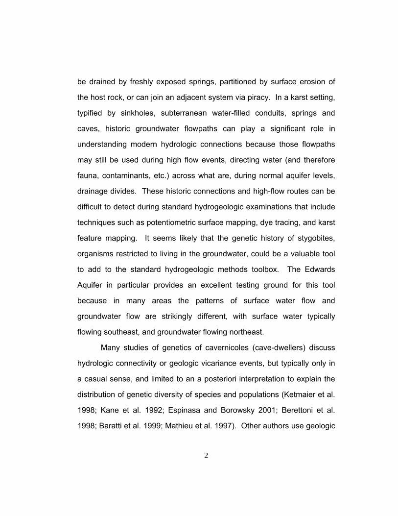
Fig. 1. Map of isopod localities. Icons indicate what taxa were collected, two letter site codes correspond to locality names in Appendix I, and shaded areas show aquifers and geologic units. One site, OE, is not shown on the map but is located in west central Tamaulipas, Mexico. The boundaries of the Ellenburger Group consist of exposed portions of Tanyard, Gorman and Honeycut Formations. The Edwards Aquifer boundaries represent both exposed and downdip buried strata in the Balcones Fault Zone. Dotted lines within the Edwards mark drainage divides: a = San Antonio Segment, b = Barton Springs Segment, c = Northern Segment, d = Washita Prairie Segment (generalized to include the Walnut formation). To the west of the Northern Segment and Washita Prairie Segment, fingers of Edwards limestone are hatched with a darker shade to indicate they are contiguous but thin and hydrologically distinct from the rest of the Edwards. The Trinity and Edwards-Trinity boundaries represent only exposed strata. Buried sections of the Edwards-Trinity in the northwest corner of the map are hatched to show subterranean continuity between sites.

7
Cretaceous deposition (approximately 144 to 65 mya) across vast
areas of Texas provided the large, continuous areas of limestone where
the species discussed herein now occur. The Edwards Limestone Group
is subdivided into several units which will be collectively referred to as
Edwards Limestone. Balcones faulting (approximately 20 to 12 mya)
separated the Balcones Fault Zone section of the Edwards Limestone
from the Edwards Plateau section along most of their boundaries,
delimiting the Edwards Aquifer and the Edwards-Trinity Aquifer.
The Laramide orogeny (approximately 60 mya) to the west and
Balcones faulting provided new topographical relief to streams running
across Texas, causing them to cut through sediments deposited above the
Edwards Limestone, exposing it for cave development. Though some
cave development occurred during one exposure of the Edwards
Limestone during the Late Cretaceous (Washitan time, end of
Comanchean), most cave development occurred after Balcones faulting
that provided the relief necessary for downcutting of riverbeds, drainage of
phreatic (=water filled) voids, and subsequent establishment of
underground drainage pathways (Woodruff and Abbott 1986; Barker and
Ardis 1996).
TAXON SAMPLING
The two isopod genera, Cirolanides and Lirceolus, in the families
Cirolanidae and Asellidae, respectively, were chosen because of their
strictly subterranean distribution across central Texas karst aquifers and

8
into northern Mexico, where the rock is geologically equivalent but
presumably hydrologically separate from central Texas. There are two
other isopod genera with approximately this same distribution,
Mexistenasellus (Stenasellidae) and Speocirolana (Cirolanidae), and
these were also collected, but they were relatively rare and were omitted
from the tree comparison analyses since the paucity of collecting localities
made comparisons among drainage basins meaningless. Distribution
records for the two study genera were obtained from the database of cave
invertebrates at the Texas Memorial Museum (University of Texas at
Austin), and several new localities were discovered during the course of
this study. Collecting localities are mapped in Figure 1, full names for
these sites are given in Appendix I, and site descriptions are given in
Appendix II.
Outgroups were chosen for the two genera based on a literature
review of the families. The genus Lirceolus is endemic to Texas and
Mexico, and although early studies suggested a basal placement within
the Asellidae (Lewis 1988) and a relationship to Lirceus (Bowman and
Longley 1976), recent work using more morphological characters from
more widely sampled taxa place Caecidotea as the outgroup to Lirceolus
(Lewis and Bowman 1996) and this placement is used herein.
The distribution of the freshwater stygobionts of the family
Cirolanidae along the ancient marine shoreline leads many authors to
suggest that these genera evolved from a marine ancestor (Bowman

9
1964; Botosaneanu et al. 1998; Cole and Minckley 1966; Cole and
Minckley 1970) but phylogenetic relationships within the family are not
resolved. One author considers that Cirolanides may be closest to
Antrolana, based on some pereopod characteristics (Bowman 1964).
Another study suggests that Sphaerolana and Speocirolana are in the
same family, but relationships between the genera are distant (Cole and
Minckley 1970). Although a morphology-based phylogenetic analysis of
the family is underway, results are not yet available (Julia Kouwenberg,
personal communication). Considering this lack of systematic
understanding within the family, outgroup taxa for this study were chosen
based on their allopatric distribution and availability, and include
Sphaerolana from Mexico and Speocirolana from Mexico and Texas.
Collecting in caves involved a team with extensive experience in
that environment, including technical ropework and cave SCUBA
methods, and followed high standards of safety and conservation etiquette
(Rea 1987; Padgett and Smith 1987; Prosser and Grey 1992). A
combination of capturing methods was used, including turkey baster
assisted suction combined with a dipnet, hand picking, and plastic inverted
funnel traps left for 24-48 hours or more. In many cases specimens of
Cirolanides could be found swimming through the water column or
traveling over mud and rocks on the bottom of stream pools, and Lirceolus
were found clinging to the undersides of rocks or walking on woody debris.
In some cases traps were left baited with Vienna sausage and weighted

10
with rocks. These traps were effective at catching Cirolanides but never
yielded Lirceolus, which may be more substrate dependent and less likely
to swim through the water column to bait than Cirolanides. Sampling
while on SCUBA was done by hand using screw top plastic tubes and a
turkey baster for suction. Spring sites were sampled by hand picking and
by leaving cotton mop heads or 500 micron mesh nets placed over the
flow. Well sampling was done using the same mesh nets placed over the
flow, or with baited plastic inverted funnel traps lowered into the well
casing. Live specimens were placed in a DMSO + NaCl
(dimethylsulfoxide and sodium chloride) solution, 95-100% ETOH
(ethanol), or liquid nitrogen. When enough specimens were collected,
some were also placed in 70% ETOH for morphological work.
ABIOTIC HYPOTHESES: SUBTERRANEAN HYDROGEOLOGY
Abiotic trees were generated for the Cirolanides and Lirceolus
aquifer sites mapped in Figure 1 using several independent data sets
compiled a priori. These data sets include: 1. subterranean hydrogeologic
connections, 2. surface drainage basins, 3. a geographic distance matrix.
There are no standard methods available to translate the entire
hydrogeologic history of an area into a branching tree that represents
historical relationships between subterranean drainage basins. In order to
develop a procedure, several pieces of geological and hydrological
information were used. The abiotic hypotheses were created under the

11
assumption of a single cave invasion of the aquifer-dwelling taxa, thus a
monophyletic history of these populations.
On a local scale, the underground drainage pathways are what
determined placement of specific collecting localities in the subterranean
hydrogeology tree. Information from karst hydrogeology studies, including
cave maps, dye tracing, potentiometric surface mapping, and local
geologic setting were used to infer probable relatedness of these within-
aquifer sites. Frequently the data are more complete on a local level, near
population centers in the eastern part of the study area, and for current
hydrogeologic connections. There are more data points in the form of
wells and dye traces near cities where contamination or drawdown
problems have demanded that thorough studies be done. Very few
studies address the evolution of central Texas aquifers (Veni 1994a; Veni
1997b; Woodruff, Jr. and Abbott 1986), although there are many studies
that map the modern and recent relationships among sites represented in
the terminal nodes of the tree (Hauwert et al. 2002; Maclay and Land
1988; Maclay 1995; Ogden et al. 1986; Stein and Ozuna 1996). For these
reasons, many of the local drainage relationships could be determined
with greater confidence than could the relationships across the entire
state. The uncertainty of deep relationships is reflected by alternative
placements of entire clades that result in a total of 16 plausible
hydrogeologic tree configurations for Cirolanides and 8 for Lirceolus, as
described in the results section.

12
ABIOTIC HYPOTHESES: SURFACE RIVERS
Another possibility is that gene flow in subterranean organisms is a
function of surface hydrology. Since these organisms are known to occur
at spring orifices, they may occasionally be involuntarily flushed out and
travel via surface drainages to invade other spring mouths and
consequently other subterranean drainage basins. River travel by eyeless
crustaceans is not likely during daylight and clear water times because
they are quickly eaten by eyed surface predators. Such predation was
repeatedly witnessed during collections at spring orifices. However, since
flood events often include reduced visibility and stream temperatures in
Texas seasonally approximate cave temperatures, it may be possible for
dispersal to occur via surface drainages. There are no records of a
stygobite caught in a surface stream during a flood event, but there has
likely been very little sampling aimed at that interval. Another possibility is
that these organisms can travel through the stream alluvium. Lirceolus
are known from a single alluvial location, but attempts to collect during this
study produced no more specimens for analysis. In review, this
phenomenon of surface dispersal has not been observed in the literature
or during this study.
Surface river trees were created for the sample locations simply
using the relationships of the surface drainage basins in which each site
occurs. When three or more caves occurred in a single basin, and
relationships between the sites were not clear, a polytomy was invoked.

13
There was also a basal polytomy assumed where all of the rivers meet the
Gulf of Mexico.
ABIOTIC HYPOTHESES: DISTANCE MATRIX
Another scenario of subterranean connections is that these
organisms disperse equally well through any area of the subsurface, and
relatedness of populations simply follows geographic proximity. Although
geologic evidence does not support the idea that all of the bedrock across
the range of this study is equally permeable, it is clearly possible that
these tiny crustaceans could follow spaces as small as 2 mm in diameter
where the permeability is not well mapped or studied because the majority
of subsurface water flows through larger conduits. If this scenario is true,
then it is expected that the gene tree will most closely match a tree
created using a linear geographic distance matrix.
A distance matrix was created for all sample locations using
Geographic Positioning System data collected in the field and the
“Distance Matrix of Point Features” extension in the Geographic
Information System ArcView. These data were transformed into a tree
using the unweighted pair group method using arithmetic averages
(UPGMA) as described in Swofford et al. (1996).
DNA METHODS
DNA was extracted from whole individuals (except for the largest
cirolanids, where half of the body was used) using a Qiagen DNeasy
extraction kit, following the protocol for animal tissues. Minor changes to

14
the kit protocol included using liquid nitrogen to finely crush specimens in
the first step and adding one microliter of 10 micrograms/microliter yeast
tRNA after lysis to act as a carrier DNA to help the host DNA bind to the
membrane and increase DNA yield. In addition, due to the small body
size of the asellids, the DNA was concentrated after the final step using a
vacuum centrifuge.
Polymerase chain reaction (PCR) was performed to amplify two
mitochondrial genes, a ribosomal RNA (16S) and a protein-coding gene
(cytochrome c oxidase subunit I). For amplifying the 16S rRNA, the
primers used were 16Sar (5’-CGCCTGTTTAACAAAAACAT-3’) and 16Sbr
(5’-CCGGTCTGAACTCAGATCACGT-3’) (Simon et al. 1994). For
amplifying COI, the primers used were LCO1490 (5’-
GGTCAACAAATCATAAAGATATTGG-3’) and HCO2198 (5’-
TAAACTTCAGGGTGACCAAAAAATCA-3’) (Folmer et al. 1994).
After successful amplification, the PCR product was gel purified
using a Qiagen QIAEX II kit, following the protocol for agarose gel
extraction. The clean PCR product and primer was delivered to the
Institute for Cellular and Molecular Biology DNA Sequencing Facility at
The University of Texas at Austin where the remaining steps were
performed. Those steps included cycle sequencing with Big Dye
terminators, removing the unincorporated dye terminators using Centri-
Sep spin columns from Princeton Separations, and finally sequencing the
sample using an automated sequencer (capillary-based AB3200 and
15
AB3100). In nearly every population, two individuals were sequenced
from both directions to verify the sequences, which were then aligned
using ClustalX (Thompson et al. 1997) and MegAlign (DNASTAR).
PHYLOGENETIC ANALYSES
Phylogenetic trees were created using the likelihood criterion with
the program PAUP* (version 4b10) (Swofford 2000). Tree searching was
done using successive approximation. An initial parsimony tree was
obtained using TBR branch swapping on 100 random stepwise addition
replicates. A likelihood-ratio test was employed in order to select the
model of sequence evolution; both isopod groups were found to fit the
GTR + I + Γ (general time reversible, invariant sites and gamma
distribution of rate heterogeneity) evolutionary model. The parameters
were then estimated on this parsimony tree and fixed. The next tree
search also used TBR branch swapping on 100 random stepwise addition
replicates under the likelihood criterion. Parameters were then re-
estimated on this maximum-likelihood tree and fixed for a second round of
searching. This was continued until the maximum-likelihood trees
recovered in the last two passes of successive approximation were
identical (two passes in Cirolanidae, three in Asellidae), and the likelihood-
based parameters from the final pass were used in the final tree.
For a measure of reliability of the branches, non-parametric
bootstrapping was performed using 200 pseudo-replicate datasets, NNI
branch swapping, and evaluated using maximum likelihood. Bayesian

16
posterior probabilities were calculated under the same evolutionary model
(GTR + I + Γ) using MrBayes v2.01; (Huelsenbeck and Ronquist 2001).
Four Monte Carlo Markov chains (MCMC) were run for 4 million
generations. The first 100,000 generations (= 1,000 trees) were discarded
to ensure the Markov chain had reached equilibrium. For the analysis,
one tree was sampled every 100 generations for a total of 40,000 trees.
TESTING ABIOTIC HYPOTHESES
Three methods were used to compare the gene trees obtained from
Lirceolus and Cirolanides DNA to the three different abiotic trees (based
on subterranean hydrogeology, surface rivers, and geographic distances).
The first method compared the likelihood score of each abiotic tree given
the genetic data. The best gene tree, without duplicate sequences and
outgroups, was searched as discussed above and scored in PAUP*
(version 4b10) (Swofford 2000) using maximum likelihood. The abiotic
trees defined a set of constraints that were placed on this gene tree, then
another successive approximation search using maximum likelihood was
used to find constrained trees, which were given likelihood scores. Each
of the multiple options for the hydrology trees were considered for this
analysis, such that there were 16 trees for the Cirolanides hydrology and 8
trees for the Lirceolus hydrology. These likelihood values were simply
ranked to determine which abiotic hypothesis best fit the genetic data.
The second method used to evaluate congruency of the datasets
was a parsimony-based approach in the program TreeMap v 1.0a (Page

17
1994). This program maximizes the number of shared nodes, or
cospeciation events, between two trees. Secondly, a randomization test
was performed to test the hypothesis that the number of cospeciation
events between the two trees is the same as would be expected between
one given tree (the abiotic tree) and another random tree (a randomized
gene tree). The distribution of cospeciation events in the randomized
sample is compared to the actual number of cospeciation events to obtain
a significance value. The settings used included heuristic searches for
maximizing cospeciation events between the two given trees, and 1000
random trees created using the Yule (Markovian) model.
The final analysis was parametric bootstrapping of constraint trees
targeting clades of particular interest (Hillis et al. 1996; Huelsenbeck et al.
1996). Five constraint trees for Lirceolus and nine constraint trees for
Cirolanides targeted hydrogeologic questions raised by the isopod
phylogenies. To perform these tests, the outgroup and all taxa with exact
duplicate sequences were eliminated from the gene trees unless they
were the only representative of a population. Successive approximation
was used to find the new best tree which was then scored in the same
manner as the original gene trees, using maximum-likelihood in PAUP*
(version 4b10) (Swofford 2000). Fourteen model trees, constrained to the
topology of each of the hypotheses, were also estimated this way.
Using each model tree and its appropriate model of sequence
evolution (as determined by a likelihood ratio test), 100 simulated datasets

18
were created using Seq-Gen (Rambaut and Grassly 1997). Each of these
simulated datasets had two heuristic searches performed on it, one to find
the overall best tree and the other to find the best tree compatible with the
constraint that was used to create the model tree. The difference of these
two scores on the simulated datasets was the distribution of expected
differences for each hypothesis being tested. The observed difference
between the best tree and the best constraint tree, using the actual data,
was then directly compared to this expected distribution to obtain a
significance value (Hillis et al. 1996; Goldman et al. 2000).

19
Results
This section details the three alternative abiotic trees created using
a literature review, the gene trees created from sequencing in this project,
and the comparison of these gene trees with the three alternative
hypotheses.
ABIOTIC HYPOTHESES
Subterranean Hydrogeology
Figure 2 summarizes known and probable subterranean
hydrogeologic relations (based on non-biological data) among sites where
Cirolanides were collected. In four cases, two alternative placements of a
branch were possible, and both are illustrated. For calculation of
likelihood scores for the abiotic trees and for TreeMap, all 24 topological
options were tested (four sites on the tree with two possible placements,
see Figure 2).
Characters defining the subterranean hydrogeologic tree (as
indicated in Figure 2) are listed below. Most of the hydrogeologic history
is based on Veni (1994a), and estimates of many of large-scale
relationships are based on potentiometric surface data (Kuniansky and
Holligan 1994). Many large-scale relationships supporting a general west
to east direction of aquifer evolution, and therefore cave development, are
based on dating of cave features summarized by Veni (1994a) and
unpublished data (Veni,

20
Fig. 2. Abiotic tree showing relationships between Cirolanides localities based on subterranean hydrogeology. Long colored bars represent aquifers the sites occur in and short colored bars show alternative placements for aquifers (MEX2 = alternative placement on tree for Mexico clade, ED2 = alternative placement of Edwards Aquifer clade, TR = Trinity Aquifer, T2 = alternative placement of Trinity Aquifer clade). Full names of sites are given in Appendix I. Asterisks indicate the best ranking location when two options for a clade were tested using maximum likelihood as in Table 1. In the case of the Edwards Aquifer, the two placements had equal maximum likelihood values.
in prep.). Regional information on subterranean hydrogeology is cited in
the following list of characters (numbers correspond to those in Figure2):

21
1. Initial cave invasion was from an assumed single marine population
that lived on the historic shallow sea floor during Cretaceous
deposition (and some erosion) of limestone units over the land
mass that is currently Texas and northern Mexico; the cavernous
Cretaceous units examined in this study were deposited 113 to 83
mya.
2, 3. There are no specific data on timing of isolation of these sites.
However, sites on opposite sides of the Rio Grande (2 is south, 3 is
north), which, along with the Pecos River, became a dominant
stream system as a result of Laramide mountain building to the
west, could have been isolated as early as the Eocene (Veni
1994a). These rivers probably began cutting into the Edwards
Limestone during Miocene (as a result of Balcones Faulting) and
the meanders were preserved in the late Miocene and early
Pliocene time, delimiting the boundaries of the Edwards Plateau
(Veni 1994a). This cladogenic event thus took place sometime
between 54 and 2 mya, though subsequent major downcutting of
the river occurred again in the early Pleistocene. The Rio Grande
was chosen as the most ancestral node because the Edwards-
Trinity Aquifer is shown on hydrology maps as ending at the Rio
Grande, which implies a more significant divide than the Pecos,
although the actual difference in timing of downcutting of the Rio

22
Grande and Pecos is unstudied, making this placement somewhat
arbitrary.
4, 5. Sites on opposite sides of the Pecos River (4 is west, 5 is east) on
the Stockton Plateau (54 to 2 mya, see description in character 2).
6, 7. Sites in the Trinity and Edwards-Trinity aquifers (collectively,
character 6) were separated from the Edwards Aquifer (character
7) during Balcones faulting (23 – 5 mya).
8. Sites in the Comal Springs groundwater drainage basin, or the
South Central Flow Unit of the Edwards Aquifer, which formed as a
result of Guadalupe River downcutting that exposed the limestone
along a permeable fault zone at the potentiometric surface where
Comal Springs could form (Maclay and Land 1988).
9. Trinity Aquifer sites have this placement because of their deep
connection to the Edwards Aquifer. This option is supported by
proven subterranean connections between Cibolo Creek and
Guadalupe River via Honey Creek Cave, and occurrence of the
cave dwelling salamander, Eurycea tridentifera, in both the
Guadalupe River and Cibolo Creek drainages, the latter known to
be pirated into the Edwards Aquifer (Veni 1997b; Chippindale et al.
2000).
10. Sites in the San Marcos Springs groundwater drainage basin, or
the Eastern Flow Unit of the Edwards Aquifer, formed as Blanco
River downcutting exposed the limestone along a permeable fault

23
zone at the potentiometric surface where San Marcos Springs
could form (Maclay and Land 1988).
11. A single site occurs in the Austin Chalk formation, and it could be
related to nearby Edwards Aquifer caves such as Banzai Mud
Dauber Cave via a shallow connection that may or may not
currently exist, in which case it is most closely related to sites in the
San Marcos Springs drainage.
12. This site probably drains directly into the Rio Grande (Hendrickson
et al. 2001).
13. These sites both drain into the Rio Sabinas.
14. The stream in Phantom Lake Cave drains to the east, and is
located far from all other Stockton Plateau sites (Tucker 2000).
15. These Stockton Plateau sites drain southeast. Sorcerer’s Cave
probably discharges to the Rio Grande (Veni 1994b), although
North Canyon Spring drains into Independence Creek, a Pecos
River tributary. These two are considered separate from the other
Stockton Plateau site, Phantom Lake Cave, because distance and
direction of flow indicate a probable drainage divide between them,
though no barrier to groundwater connectivity is known.
16. This locality in northern Mexico would be most closely related to the
Del Rio sites if the Rio Grande is not a significant barrier.
17. These two localities drain into the Devil’s River and are joined by
continuous cavernous limestone on the east side of the river.

24
18. The Del Rio localities are joined by proximity and continuous
cavernous limestone.
19. The Edwards Aquifer sites are alternatively related to the Edwards-
Trinity Aquifer via connection of the aquifers in Kinney County,
given that genetic communication may have been maintained,
currently or in the recent past, across the Kinney groundwater
divide shown in Figure 1 (e.g., stygobites can swim upstream and
across groundwater divides).
20. These sites make up the remainder of the Edwards-Trinity Aquifer,
outside of, and upgradient from, the Del Rio area and potentially
related sites in the Trinity Aquifer (see character 23).
21. These two sites are probably relatively young Edwards-Trinity
Aquifer caves. They occur near the northern margin of the Edwards
Plateau and are formed underneath relatively poorly permeable
Buda Limestone, which likely prevented significant speleogenesis
until eroded to allow sufficient recharge into the underlying Edwards
Limestone.
22. These two Edwards-Trinity Aquifer sites are in a relatively high
potentiometric region and therefore may be older than the other
sites in this branch. Specific evidence for timing of this node does
not exist, so placement is somewhat arbitrary.
23. Sites in the Trinity Aquifer may be more related to sites in the
Edwards-Trinity Aquifer than they are to Edwards Aquifer sites if
25
shallow connections between them were the path for isopod
migration. This option was also considered despite the fact that
modern hydrology does not support this hypothesis because non-
cavernous and poorly permeable areas in the upper member of the
Glen Rose Formation in Kendall, Kerr, and Medina counties divide
the Trinity Aquifer from the Edwards-Trinity Aquifer along most of
their boundaries.
24. Although these two caves have not been physically or
hydrologically connected, their proximity and position suggest that
Bufo Cave drains into Honey Creek Cave.
25. The only site in the Austin Chalk may be related to other sites via a
deeper connection with the Edwards Aquifer caves that recharge
Comal Springs, such as Panther Canyon, and possibly deeper
connections to Ezell’s Cave and Rattlesnake Cave.
The tree in Figure 3 summarizes known and probable subterranean
hydrogeologic relations among Lirceolus collection sites. In three cases,
there were two options for branch placement, and both are shown. For
calculations of likelihood scores for abiotic trees and for the TreeMap
analysis, all 23 topological options were tested (three sites with two
possible placements). Characters determining this tree (numbered as in
Figure 3) are as follows:

26
Fig. 3. Abiotic tree showing relationships between Lirceolus localities based on subterranean hydrogeology. Long colored bars represent aquifers the sites occur in and short colored bars show alternative placements for aquifers (MEX2 = alternative placement on tree for Mexico clade, ED2 = alternative placement of Edwards Aquifer clade, T2 = alternative placement of Trinity Aquifer clade). Full names of sites are given in Appendix I. Asterisks indicate the preferred Iocation when two options for a clade were tested using maximum likelihood as in Table 1.
1. The genus Lirceolus is endemic to Texas and North Mexico, thus
monophyly is assumed for cave-invading ancestors of Lirceolus.
Some genetic differentiation of surface populations may have
occurred prior to cave invasion, but these possibilities are too
complex to formulate on a series of trees, and will be treated later

27
in the discussion. Assuming that this species was never salt water
tolerant, cave invasions could have taken place as early as the end
of the Cretaceous or early Tertiary when the Laramide Orogeny
uplifted Texas from the ocean for the final time (approximately 60
mya).
2, 3. Sites on the north (2) and south (3) side of the Rio Grande (54 to 2
mya, see description in characters 2 and 3 of Cirolanides
description).
4, 5. Sites on the west (4) and east (5) side of Pecos River, on the
Stockton Plateau (54 to 2 mya, see description in character 2 of
Cirolanides description).
6, 7. Sites in the Trinity and Edwards-Trinity aquifers (collectively,
character 6) which were separated from the Edwards Aquifer
(character 7) during Balcones faulting (23 – 5 mya).
8. Localities around Del Rio are joined by proximity and continuous
cavernous limestone.
9. One option for the Edwards Aquifer sites is that they are related to
the Edwards-Trinity Aquifer via connection of the aquifers in Kinney
County, with genetic communication maintained, currently or in the
recent past, across the groundwater divide there by organisms
migrating upstream.
10. Lost Maples State Park spring could be most closely related to the
Trinity Aquifer sites if there is a shallow subsurface connection

28
between this upgradient site on the Edwards Plateau and the
downgradient sites in the Trinity Aquifer.
11. Sites in the Trinity Aquifer may be more related to sites in the
Edwards-Trinity Aquifer if shallow connections between them were
the path for isopod migration. Modern hydrology, however, does
not support this hypothesis because of the non-cavernous and
poorly permeable areas in the upper member of the Glen Rose
Formation in Kendall, Kerr, and Medina counties that divide the
Trinity Aquifer from the Edwards-Trinity Aquifer along most of their
boundaries.
12. Sites in the Comal Springs groundwater drainage basin, or the
South Central Flow Unit of the Edwards Aquifer, formed as a result
of Guadalupe River downcutting that exposed the limestone along
a permeable fault zone at the potentiometric surface where Comal
Springs could form (Maclay and Land 1988).
13. These geographically proximal sites are both south of the
Guadalupe River and in the Cow Creek Limestone with no
evidence for discontinuous cavern development between them.
14. These sites all occur north of the Guadalupe River, a local
groundwater trough that separates them from sites south of the
river.

29
15. Jacob’s Well is in a cavernous portion of the lower member of the
Glen Rose Formation, separating it from Pedernales Falls Spring
and Gorman Cave that occur in other formations.
16. These two sites may be related because they occur in limestone
that is continuous, but narrow between the sites (Marble Falls and
Cow Creek Formations).
17. Sites in the Trinity Aquifer have this placement given that there is a
deep connection to the Edwards Aquifer (see character 9 of
Cirolanides description).
18. Sites in the San Marcos Springs groundwater drainage basin, or
the Eastern Flow Unit of the Edwards Aquifer (Maclay and Land
1988), and in the Barton Springs segment of the Edwards Aquifer.
Even though there is a modern groundwater divide between San
Marcos Springs and Barton Springs, there is no evidence of a non-
cavernous barrier to organism movement or a barrier to high water
connections.
19. This site is in the Barton Springs segment of the Edwards Aquifer,
where Barton Springs formed as a result of Colorado River
downcutting that exposed the limestone along a permeable fault
zone at the potentiometric surface.
Surface Rivers
The river trees in Figures 4 and 5 represent the four main river
systems in the study area with a basal polytomy where they drain into the

30
Gulf of Mexico. Polytomies were also invoked where several sites drained
into the same river and there was no particular reason for any of those
locations to be more closely related than others.
Fig. 4. The river tree for Cirolanides collecting localities. Full names of sites are given in Appendix I.

31
Fig. 5. The river tree for Lirceolus collecting localities. Full names of sites are given in Appendix I.
Distance Matrix
Trees obtained using matrixes of geographic distances among sites are
shown in Figures 6 and 7. Although branch lengths were created in the

32
initial distance matrix, only the topology shown in the figures was used for
analysis.
Fig. 6. Distance matrix tree showing relationships of sites where Cirolanides were collected. Full names of sites are given in Appendix I.

33
Fig. 7. Distance matrix tree showing relationships of sites where Lirceolus were collected. Full names of sites are given in Appendix I.

34
GENE TREES
In most samples of Cirolanides, 465 base pairs were sequenced
(ranging from 464-471 base pairs) from the mitochondrial 16S ribosomal
RNA (16S rRNA) gene and 658 base pairs were sequenced (ranging from
646-659 base pairs) from the mitochondrial cytochrome c oxidase subunit
I (CO1) gene. In most samples of Lirceolus, 476 base pairs were
sequenced (ranging from 471-492 base pairs, except two samples of 231
base pairs) from the mitochondrial 16S rRNA gene and 658 base pairs
were sequenced (ranging from 281-658 base pairs) from the mitochondrial
CO1 gene. GenBank accession numbers for these sequences are given
in Appendix I. For each family, a partition homogeneity test was used in
order to verify that the two genes, 16S and CO1, support the same tree.
In this test, both groups of isopods were found to have high p values
(Asellidae, p = 0.28, Cirolanidae, p = 0.88), therefore the hypothesis that
the two genes were drawn from the same population could not be
rejected, and thus the genes were combined. Maximum likelihood trees
and accompanying non-parametric bootstrap values and Bayesian
posterior probabilities are shown in Figures 8 - 10.
Genetic variation within populations of cave isopods was nearly
always smaller than among populations, allowing a gene tree to be
constructed that had each population as a terminal node. For two
populations, Ezell’s Cave for Cirolanides and Knee Deep Cave for
Lirceolus, there was sufficient within-population genetic variation that they

35
were paraphyletic in the maximum likelihood phylogenetic estimation.
However, in both cases there was strong support for monophyly of the
next deepest node, allowing a simplified gene tree to be used for
comparison to the abiotic trees.
36
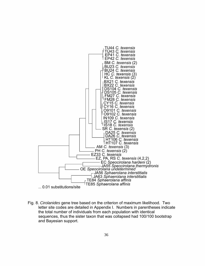
Fig. 8. Cirolanides gene tree based on the criterion of maximum likelihood. Two letter site codes are detailed in Appendix I. Numbers in parentheses indicate the total number of individuals from each population with identical sequences, thus the sister taxon that was collapsed had 100/100 bootstrap and Bayesian support.

37
Fig. 9. Cirolanides gene tree based on the criterion of maximum likelihood, showing non-parametric bootstrap values (top) and Bayesian posterior probabilities (bottom). Two letter site codes are detailed in Appendix I. Numbers in parentheses indicate the total number of individuals from each population with identical sequences, thus the sister taxon that was collapsed had 100/100 bootstrap and Bayesian support.

38
Fig. 10. Lirceolus gene tree based on the criterion of maximum likelihood. Two letter site codes are detailed in Appendix I. Non-parametric bootstrap values (top) and Bayesian posterior probabilities (bottom) show support for each node. Numbers in parentheses indicate the total number of individuals from each population that formed a clade with 100/100 bootstrap and Bayesian support.

39
TREE COMPARISON
Figure 11 demonstrates that for Cirolanides, the basal nodes of the
gene phylogeny were incongruent with the subterranean hydrogeology
hypothesis but many terminal nodes matched well. In contrast to this, the
Lirceolus gene tree was entirely incongruent with the subterranean
hydrogeology hypothesis (Figure 12) but was similar to the surface river
hypothesis (Figure 13).

40
Fig. 11. Comparison of Cirolanides gene tree and subterranean hydrogeology tree. Pink arrows show recent congruencies whereas orange arrows show historic events where timing was not perfectly predicted by the hydrogeology tree. Long colored bars represent aquifers sites occur in and short colored bars show alternative placements for aquifers (MEX2 = alternative placement on tree for Mexico clade, ED2 = alternative placement of Edwards Aquifer clade, T2 = alternative placement of Trinity Aquifer clade, AC = Austin Chalk, E-T = Edwards-Trinity Aquifer). Full names of sites are given in Appendix I.

41
Fig. 12. Comparison of Lirceolus gene tree and subterranean hydrogeology tree. Long colored bars represent aquifers sites occur in and short colored bars show alternative placements for aquifers (MEX2 = alternative placement on tree for Mexico clade, ED = Edwards Aquifer, ED2 = alternative placement of Edwards Aquifer clade, TR = Trinity Aquifer, T2 = alternative placement of Trinity Aquifer clade, EL = Ellenburger formation). Full names of sites are given in Appendix I.

42
Fig. 13. Comparison of Lirceolus gene tree and surface river tree. Colored bars show major surface river basins that sites occur in. Full names of sites are given in Appendix I.

43
Table 1. Comparison of gene trees and abiotic trees using maximum likelihood ranks and TreeMap randomization test. Section A includes best fit ranked as the negative log likelihood scores (-lnL) nearest to the gene tree. Scores of only the best abiotic trees were given when there were multiple abiotic trees tested, as in the subterranean hydrogeology. Section B includes best fit ranked as the highest number of cospeciation events, and an asterisk (*) denotes significantly more cospeciation events than would be expected with a random tree at the alpha level of 0.05.
The maximum likelihood scores of each of the abiotic trees
constrained on the genetic data are presented in Table 1. In the case of
A. Maximum Likelihood Rank Comparison Taxon and Ranking of Abiotic Tree -ln L Cirolanides (best tree) 3764.0 #1 Distance matrix 3861.3 #2 Subterranean hydrogeology (best two topologies of 16) 4162.7 #3 Surface rivers 4240.1 Lirceolus (best tree) 6709.7 #1 Surface rivers 6834.4 #2 Distance matrix 6979.8 #3 Subterranean hydrogeology (best two topologies of 8) 7189.2 B. TreeMap Randomization Comparison Taxon and Ranking of Abiotic Tree # cospeciation events p Cirolanides #1 Subterranean hydrogeology, topology 1 10 0.007<p<0.025*
Subterranean hydrogeology, topology 2 10 0.002<p<0.018*
#2 Distance matrix 9 0.018<p<0.070 #3 Surface rivers 8 0.043<p<0.190 Lirceolus #1 Surface rivers 9 p<<0.001* #2 Distance matrix 8 P<0.001* #3 Subterranean hydrogeology, topology 1 6 0.013<p<0.090
Subterranean hydrogeology, topology 2 6 0.015<p<0.089
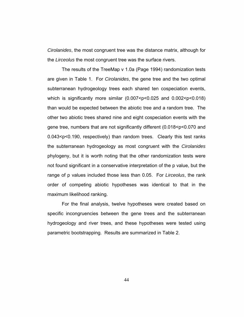
44
Cirolanides, the most congruent tree was the distance matrix, although for
the Lirceolus the most congruent tree was the surface rivers.
The results of the TreeMap v 1.0a (Page 1994) randomization tests
are given in Table 1. For Cirolanides, the gene tree and the two optimal
subterranean hydrogeology trees each shared ten cospeciation events,
which is significantly more similar (0.007<p<0.025 and 0.002<p<0.018)
than would be expected between the abiotic tree and a random tree. The
other two abiotic trees shared nine and eight cospeciation events with the
gene tree, numbers that are not significantly different (0.018<p<0.070 and
0.043<p<0.190, respectively) than random trees. Clearly this test ranks
the subterranean hydrogeology as most congruent with the Cirolanides
phylogeny, but it is worth noting that the other randomization tests were
not found significant in a conservative interpretation of the p value, but the
range of p values included those less than 0.05. For Lirceolus, the rank
order of competing abiotic hypotheses was identical to that in the
maximum likelihood ranking.
For the final analysis, twelve hypotheses were created based on
specific incongruencies between the gene trees and the subterranean
hydrogeology and river trees, and these hypotheses were tested using
parametric bootstrapping. Results are summarized in Table 2.

45
Table 2. Summary of constraint trees including results of parametric bootstrapping. The description of the constraint trees indicates the grouping of populations whose monophyly is being tested. In these descriptions, note that the Cirolanides Edwards Aquifer sites = (PA, RS, EZ), the Cirolanides Edwards-Trinity Aquifer sites = (PH, HT, DA, SR, FM, BX, DS, IN, O9, CY, IS, BM), the Lirceolus Edwards-Trinity Aquifer sites = (DA, SB, PH, LM), with two letter site codes as in Appendix I. A significant p value (asterisk) indicates that the proposed monophyletic grouping is rejected.
Constraint tree Best constraint best tree observed
difference p
Cirolanides (Isopit, Banzai Mud Dauber, Edwards) 3829.78 3764.01 65.77 <0.01*
Cirolanides (Isopit, Edwards) 3787.47 3764.01 23.45 <0.01* Cirolanides (Banzai Mud Dauber, Edwards) 3789.73 3764.01 25.72 <0.01*
Cirolanides (all Texas populations) 3764.83 3764.01 0.82 <0.07
Cirolanides (Four Mile Cave, Dandridge, HT Miers) 3794.73 3764.01 30.72 <0.01*
Cirolanides (Amezcua, Dandridge, HT Miers) 3767.41 3764.01 3.40 <0.03*
Cirolanides (Edwards-Trinity) 3811.02 3764.01 47.00 <0.01* Lirceolus (Knee Deep, Preserve) 6786.18 6709.68 76.49 <0.01* Lirceolus (Rattlesnake, Sunken Gardens) 6940.70 6709.68 231.02 <0.01*
Lirceolus ( Edwards-Trinity) 6868.57 6709.68 158.88 <0.01* Lirceolus (Preserve, Knee Deep, Rattlesnake, Jacob's Well) 6777.03 6709.68 67.35 <0.01*
Lirceolus (Phantom, Amezcua, Slaughter Bend, Dandridge) 6712.42 6709.68 2.73 <0.02*

46
Discussion
SUBTERRANEAN HYDROLOGY
The Cirolanides phylogeny shows congruence with subterranean
hydrology based on simple examination of the trees, maximum likelihood
rank comparison (where subterranean hydrology ranked 2nd, but above
surface rivers), and TreeMap randomization tests (Figure 11, Table 1).
Examination of the gene tree and hydrogeology tree in Figure 11 shows
six matching terminal nodes as well as congruence in composition of
deeper clades, but not in the exact placement of these clades. These
incongruent basal nodes may reflect an incorrect gene tree or some other
biological phenomenon that leads to genetic history not following the
hydrogeologic setting (such as dispersal across presumed barriers, a time
lag between hydrologic and genetic divergence, genetic divergence within
a drainage, or any combination therein), but more likely result from
incorrect reconstructions of the timing of separation of these areas, a
reflection of inadequate hydrogeologic research.
The Rio Grande and Pecos became major stream systems as early
as the Eocene (approximately 54 mya) (Veni 1994a), which was before
Balcones faulting (approximately 20 to 12 mya), thus these events were
placed more basally on the tree (also refer to text describing characters 2
and 3 on the cirolanid hydrogeology tree). It’s not known, however,
exactly when the downcutting rivers isolated the specific cave drainages

47
and contributed to speleogenesis to create habitat. Balcones faulting may
have isolated the Edwards Aquifer populations from the rest of Texas and
Mexico before the Rio Grande cut down through the cavernous limestone.
There is some geologic evidence to support this because prior to faulting
there was less topographic relief across the Edwards Plateau.
Consequently, most of the limestone was saturated and caves were
probably not particularly isolated from one another because few would
have been truncated by the shallow surface drainages of that time. In this
case, populations of isopods on either side of dominant drainages may not
have been separated until after faulting increased topographic expression
of these drainages, indicating that the gene tree is correct and the
hydrogeology is not known precisely enough to make these distinctions.
Some work has been done on entrenchment times for ancestral and
modern Rio Grande routes far upstream of the study area, in New Mexico,
and estimated these times around 3 - 4 mya for the ancestral Rio Grande
and 0.7 - 0.5 mya for the modern Rio Grande (Seager et al. 1984).
Overall, the timing of river downcutting events in the present study area is
very roughly estimated and has received little attention from
hydrogeologists. The order of events reconstructed from the genes is
likely to represent real phenomena that should be considered in future
work. More geomorphologic history data, such as estimation of
denudation rates and dating of karst features, are required to refine

48
estimations of isolation times and to find better correlations between
hydrogeology and genetics.
Likelihood and TreeMap comparisons of the gene trees and abiotic
trees each showed similar ranking of competing abiotic hypotheses for
Cirolanides (Table 1). The subterranean hydrogeology always ranked
above the surface rivers, these two being a priori thought to represent the
two most likely scenarios for genetic communication in this species (see
proceeding section for discussion of distance matrix). The difference
between the two comparisons was in the ranking of the distance matrix
tree which was first in likelihood score and second in TreeMap rank.
In contrast to Cirolanides, phylogenetic patterns of Lirceolus
consistently showed little similarity to the subterranean hydrogeology
hypothesis, with no visible similarities in the two trees and lowest ranking
using likelihood score and TreeMap randomization comparison methods
(Figure 12 and Table 1).
SURFACE RIVERS
The Cirolanides phylogeny shows no congruence with surface
rivers but Lirceolus has high congruence to surface rivers based on a
simple inspection of the trees and likelihood scores and TreeMap
comparisons (Figure 13 and Table 1). This is an unexpected result
considering that the taxon is aquifer-adapted, but aspects of its habitat
and evolutionary history are markedly different than Cirolanides and may
have contributed to this pattern. Lirceolus are known from eleven cave

49
sites, but also ten spring sites, one well site and even one alluvial location.
The species may thus be less restricted to the cave environment than is
Cirolanides, and their presence in an alluvial location shows that they may
disperse or have genetic communication via alluvial populations in river
beds. In addition, Lirceolus have freshwater ancestors, probably
originating from Caecidotea (Lewis and Bowman 1996) that could have
migrated from the midwestern U.S. after oceans receded from Texas.
Modern Caecidotea occur in non-karst areas, and the freshwater
ancestors of Lirceolus may have used surface rivers to invade the area. If
so, there was probably significant genetic structure prior to invasion of
cave and spring systems. The longer branch lengths in the Lirceolus vs.
Cirolanides support this hypothesis, given that rates of gene evolution are
somewhat consistent for these two taxa. Although this genetic structure
may not impact small-scale regional studies of groundwater flow, this
study’s hypotheses about subterranean connections are dependent on a
common ancestor simultaneously invading a large area across many
basins. The congruence of the surface river tree and the gene tree
support the conclusion that Lirceolus has experienced gene flow via
surface rivers.
DISTANCE MATRIX
For Cirolanides, the distance matrix ranked first in maximum
likelihood value and second in the TreeMap comparison. The distance
matrix may be most similar to the gene tree if these organisms travel

50
equally well through all areas of the subsurface, with or without large
cavern development, or the ranking may be due to some other artifact of
the test, such as an incorrectly estimated subterranean hydrogeology tree.
The presence of Cirolanides in wells and springs without known cave
passage supports the distance matrix theory, however, at all well and
spring sites where the species were collected for this study there are
either known voids that the wells intersect or known cave passages near
the springs. In general, this taxon is known from cave conduits (29 of 43
sites), with the minority of localities being from springs (4 of 43 sites) and
wells (10 of 43 sites). It seems unlikely that Cirolanides travels equally
easily through both non-cavernous and cavernous subsurface areas
because the majority of water flow in karst is through conduits
(Worthington et al. 2000), and this water flow probably provides most of
the habitat and energy input that aquatic species depend on. The ranking
is more likely from an incorrectly estimated hydrogeology tree, which is in
turn related to the paucity of data used to create the deep nodes, and a
lack of data in areas where hydrogeologic studies are in their early stages
(e.g., west Texas and the Austin Chalk of Bexar County). Populations
from two major aquifers, the Edwards and Trinity, did basically fall out as
monophyletic groups, and the Edwards-Trininty Aquifer as a paraphyletic
group, supporting the argument that clades are following the aquifers.
Specific tests of these clades are discussed in the parametric
bootstrapping section.

51
The TreeMap randomization test of Cirolanides showed that the
distance matrix tree and gene tree did not have significantly more
cospeciation events than would be expected between the distance matrix
and a random tree (0.018<p<0.070). The different ranking of the two tests
is due to the different methods, but also may reflect the fact that the trees
created from the competing abiotic hypotheses were not extremely
different (see Figures 2 and 6).
In Lirceolus the distance matrix ranked second in both maximum
likelihood and TreeMap comparisons. The TreeMap comparison, even
though ranked second, did share significantly more cospeciation events
than the abiotic tree and a random tree (p<0.001).
TAXON CONGRUENCE
Many authors concur that a study of congruence between an area’s
history and a species’ phylogeny should be corroborated by multiple taxa
(Morrone and Crisci 1995), and this study began with that intention. It was
found, however, that the taxon with freshwater ancestors and more
diverse tolerance for surface habitats had a phylogenetic pattern
apparently more strongly determined by surface hydrology, and the taxon
with marine ancestors and a strict subterranean existence followed
patterns of subterranean hydrogeology. The freshwater origin may have
contributed a pre-cave-invasion genetic structure, and certainly if they
have the ability to disperse via hyporheic gravels this would affect patterns
of communication. Lirceolus might still be used for testing subterranean

52
hydrogeologic hypotheses at a local level, such as within river basins, but
not on a wider scale across all central Texas karst aquifers. Taxa with
marine ancestors may generally be better for large scale testing because
they are more likely to have been one population when they started their
path to subterranean adaptation, therefore their phylogeny would more
closely track aquifer evolution. These results indicate that total range and
evolutionary history of a taxon should be considered before choosing it as
an indicator of subterranean hydrogeology.
PARAMETRIC BOOTSTRAPPING
Results of likelihood and TreeMap comparisons prompted
additional post-hoc questions about specific subsets of the abiotic
hypotheses, and the degree to which they were supported by the genetic
data. To address these, parametric bootstrapping was used to compare
the gene trees with selected parts of the abiotic relationships hypotheses.
The first unexpected result was that the population in Isopit, which
is located in the Austin Chalk formation of western Bexar County, was not
closely related to populations of nearby sites in the Edwards Aquifer (see
Figures 11 and 14). The geographic proximity of these two geologic units
indicates their waters may be shared, but genetic relationships contradict
this. The null hypothesis for the parametric bootstrapping is that Isopit is
within a monophyletic Edwards Aquifer clade (that includes other Edwards
Aquifer populations: Panther Canyon Well, Ezell’s Cave, and Rattlesnake
Cave). Since the population in Banzai Mud Dauber Cave also did not fall

53
into the Edwards Aquifer clade as expected, this hypothesis was tested
both with and without Banzai Mud Dauber Cave. Both of these
hypotheses were rejected (p<0.01), indicating that Isopit clearly does not
fall into the Edwards Aquifer clade.
Fig. 14. Map showing genetic relationships of Cirolanides localities. Note that Isopit (IS) is not most closely related to nearby Edwards Aquifer sites (PA, EZ, RS), even though they are in close proximity. Also Banzai Mud Dauber Cave (BM) is not most closely related to those same Edwards Aquifer sites (PA, EZ, RS) even though it is formed in the Edwards Limestone group. Finally Four Mile Cave (FM) is not sister to other Del Rio Area sites (DA, HT) as predicted by subterranean hydrogeology. Two letter site codes are listed in Appendix I.
The gene data place the Isopit population within the Edwards-
Trinity Aquifer clade which might result from it having been adjacent to

54
Edwards-Trinity outcrops before significant erosion isolated the cave.
While the proximity of karst formations indicates that water most likely
currently flows through this Austin Chalk cave, perched above the
Edwards Aquifer, and into the Edwards Aquifer, the path down to the
Edwards Aquifer may be inhospitable for fauna. Air-filled vertical passage
may prohibit free migration between these vertically separated water
sources. Also food resources may be limited in the intermediate areas.
Another possibility is that Isopit is located closer to a genetic pathway to
the Edwards-Trinity Aquifer in the far southwestern part of the Balcones
Fault Zone via the Kinney groundwater divide (see Figure 1).
Alternatively, Isopit may be the only Cirolanides locality sampled in the
San Antonio Springs drainage, or Western-Southern Flow Unit of the
Edwards Aquifer (Maclay and Land 1988), and there is an ancient barrier
to communication with the other flow units. These latter two options
require a major barrier to gene flow within the Edwards Aquifer, which is
not supported by hydrogeology. Increased sampling in the southwestern
part of the Edwards Aquifer and northern and eastern part of the Edwards-
Trinity Aquifer would help clarify which of these alternative hypotheses are
best supported.
Another result not predicted by hydrogeology is the placement of
Banzai Mud Dauber Cave in the Trinity Aquifer clade rather than in the
Edwards Aquifer clade (see Figures 11 and 14). This cave is developed in
the Edwards Limestone within the Eastern Flow unit of the Edwards

55
Aquifer, discharging at San Marcos Springs. Recent tracer studies
support a deep connection between Banzai Mud Dauber Cave and the
Edwards Aquifer (Johnson et al. 2005). The null hypothesis was that
Banzai Mud Dauber Cave would be within a monophyletic Edwards
Aquifer clade that includes other Edwards Aquifer populations: Panther
Canyon Well, Ezell’s Cave, and Rattlesnake Cave. This hypothesis was
rejected (p<0.01), and the gene data clearly support inclusion of Banzai
Mud Dauber Cave in the Trinity Aquifer clade. This finding probably
reflects the proximity of the cave to a fault where the upper member of the
Glen Rose Formation (which is in the Trinity Aquifer) is juxtaposed with
Edwards Limestone (the fault is 170 meters from the cave, Veni, pers.
comm.). Isopods from the Trinity Aquifer may be traveling along this fault
and passing into the Edwards Limestone through humanly impassable
conduits between the fault and the cave. The water in the cave comes
from local recharge, and this population may be limited to this water and
associated energy entering the cave, with no deep connection to other
Edwards Aquifer (Balcones Fault Zone) sites. In this case isopod
phylogenies demonstrate recharge from the Trinity Aquifer to the Edwards
Aquifer, a topic that has received attention by hydrogeologists studying
water budgets for the area (Kuniansky and Holligan 1994; Mace et al.
2000). This demonstrates the need to consider both the unit the cave is
formed in as well as area geology when deciphering population
boundaries for species management purposes.

56
Another reason why the Banzai Mud Dauber Cave populations may
be distinct from the Edwards Aquifer populations is that isopods in this
cave may be limited by a biological or environmental factor such as food
resources, inhospitable intermediate habitat, or competition with other
deeper fauna. Or, given the invasion of this cave was recent and from a
Trinity Aquifer population that was isolated since the Miocene from The
Balcones Fault zone, evolution of sexual isolating mechanisms could have
occurred. Any of these factors may limit the distribution of these Trinity
isopods to near surface sites like Banzai Mud Dauber Cave and keep
them from mixing with deep aquifer populations that communicate with
downgradient sites including Comal Springs and San Marcos Springs.
A recent study places Texas populations in the subspecies
Cirolanides texensis texensis and Mexican populations (including those of
Cueva de El Tule, Cueva de la Espantosa and Sótano de Amezcua) in C.
t. mexicensis (Botosaneanu and Iliffe 2002), demonstrating that
morphological characters can be used to differentiate these populations.
The hydrogeologic hypothesis created herein also divided Texas and
Mexico sites (Figure 2). The gene tree, however, indicates that Texas
populations are not monophyletic with respect to Mexican ones. Mexico
populations are paraphyletic and nested within Texas populations (Figures
8 and 9). Parametric bootstrapping was used to test the null hypothesis
that Texas is monophyletic, and it was found that this cannot be rejected
(p<0.07). This demonstrates that even though the Mexican populations fit

57
within the Edwards-Trinity Aquifer clade in the best gene tree (populations
TU, EP and AM in Figure 8), there is a way to force the division of
populations according to what side of the Rio Grande they are on. Low
non-parametric bootstrap and Bayesian posterior probability values
(13/74) for the node attaching Cueva de El Tule and Cueva de la
Espantosa indicates this branch may have an alternate placement that
aligns it with the other Mexican population, and therefore would be
potentially more concordant with the morphological boundaries. The
placement of Edwards Aquifer and Phantom Lake Cave populations in the
gene tree indicate that they may also show morphological differences
when examined more carefully.
On the basis of hydrogeological data, three populations north of Del
Rio were predicted to cluster together; Dandridge Spring Cave, H.T. Miers
Cave, and Four Mile Cave (see Figure 2). The gene data align Dandridge
Spring Cave and H.T. Miers Cave, but not Four Mile Cave (see Figures 11
and 14). The null hypothesis that placed these three populations in
monophyly was rejected (p<0.01). Although there is no known
hydrogeologic barrier that would isolate Four Mile Cave, one possible
explanation is that the Devil’s River influences a subtle groundwater divide
between Four Mile Cave and the Dandridge Spring Cave and H.T. Miers
Cave group, keeping the systems that discharge into the Devil’s River
distinct from those that discharge at San Felipe Springs.

58
In one scenario, Sótano de Amezcua, south of the Rio Grande, was
also predicted to be in the Del Rio cluster (see Figure 2). The gene data
do not support this alignment (see Figure 11). The null hypothesis
placing Dandridge Spring Cave and H.T. Miers Cave with Sótano de
Amezcua (Table 2) was rejected (p<0.03). Here the genetic data support
the hydrogeologic evidence of the Rio Grande as a drainage divide
between Texas and Mexico localities.
A final bootstrapping test performed with the Cirolanides data
rejected the null hypothesis of monophyly of Edwards-Trinity Aquifer
caves (p<0.01). This is not surprising considering that both the Trinity
Aquifer and Mexican populations were nested among Edwards-Trinity
Aquifer populations in the best gene tree. This finding is significant
because it emphasizes that the Trinity Aquifer populations, although
distinguishable from Edwards-Trinity Aquifer populations, are not
genetically distant. Mexican populations clustering within west Texas
populations indicates that the separation between Phantom Lake Cave
and the other west Texas populations is greater than that between the
Mexico and west Texas populations. Although these results do not
necessarily point to current gene flow among the Trinity Aquifer, Mexican
and Edwards-Trinity Aquifer populations, their affiliations are relevant
when considering hydrologic and conservation problems in these areas.
Some unexpected Cirolanides relationships that were not tested
using paramentric bootstrapping include the populations around the Pecos

59
River. It was expected that the Pecos River would be a prominent divide,
differentiating North Canyon Spring (IN in Figure 14) from Edwards-Trinity
sites east of the Pecos River. As in the case with the unexpected division
between Dandridge/H.T. Miers group and Four Mile Cave, one possible
hypothesis is that there is a subtle drainage divide between Sorcerer’s
Cave and North Canyon Spring, since Sorcerer’s Cave discharges south
to the Rio Grande and North Canyon Spring discharges east to the Pecos
River via Independence Creek. Also the North Canyon Spring may be
more closely related to Edwards-Trinity sites east of the Pecos River
because the Pecos River does not completely bisect the Edwards
Limestone in that area, as evidenced by the exposure of the top of the 50
to 100 meter deep Fort Terrett Member of the Edwards Limestone on
either side of the Pecos River (Barnes 1981). Another possibility is that
historically the Pecos River meandered west of North Canyon Spring.
Some surprises were also found in the Lirceolus dataset. Knee
Deep Cave and Preserve Cave, sites that are near one another in the
Cow Creek Limestone and that drain into the south side of the Guadalupe
River, aligned with two different clades (and species) and the null
hypothesis of monophyly was rejected (Table 2, p<0.01). Additionally, the
null hypothesis that all of the Guadalupe River populations (Knee Deep
Cave, Preserve Cave, Jacob’s Well, Rattlesnake Cave) are monophyletic
was rejected (p<0.01). Preserve Cave is the population that is not

60
clustering with the otherwise highly supported Guadalupe River basin
clade (see Figures 13 and 15).
Fig. 15. Map showing genetic relationships of Lirceolus localities. Note that Preserve Cave (PR) is not most closely related to the nearby Cow Creek Limestone site, Knee Deep Cave (KN), nor does it cluster with the other Guadalupe River sites (KN, JW, RS). Also two sites in the Edwards Aquifer, Rattlesnake Cave and Sunken Gardens Spring (RS and SG), aligned with surface rivers rather than subterranean hydrogeology.
One possible explanation for this is that Lirceolus pilus, which is
currently only known from the Nueces River basin, also occurs in the
Cibolo Creek basin where little sampling has been done, and has been
transported across the drainage divide to the Guadalupe River via
subterranean connections (Veni 1997b) to Preserve Cave. Such

61
subterranean piracy of Cibolo Creek into the Guadalupe is congruent with
the distribution of the cave adapted salamander Eurycea tridentifera
(Chippindale et al. 2000). If this were true, Lirceolus pilus could have
migrated from Cibolo Creek through Honey Creek Cave (where they are
not known from but where sampling has been minimal), out of the spring
resurgence at Honey Creek Cave, down Honey Creek, and up into
Preserve Cave which is on the opposite (east) side of the surface creek.
Migration in these smaller streams may be more feasible than migration in
large rivers such as the Guadalupe since floods in them would be
principally from springs and thus have more favorable physiochemical
properties and fewer predators than would be found in floods in large
rivers. Lirceolus pilus could also have invaded groundwater in the current
Preserve Cave drainage basin, east of Honey Creek, prior to exposure of
the resurgence to Honey Creek Cave when the cave extended east of
Honey Creek (Veni 1997b). In either scenario, this shows that Lirceolus
phylogenetics, though generally aligned with surface rivers, can also be
influenced by subterranean connectivity. More sampling of these two
basins may tease apart the history that led to the anomalous Preserve
Cave population.
Another Lirceolus relationship incongruent with subterranean
hydrology is paraphyly of Rattlesnake Cave and Sunken Gardens Spring;
both sites in the Edwards Aquifer (see Figure 11). A null hypothesis
forcing these two populations into a monophyletic group was rejected

62
(p<0.01). Although it is possible that the groundwater divide between San
Marcos Springs and Barton Springs permits subterranean migration, it is
also possible that genetic structure in this genus is more strongly
influenced by surface river basin relationships than by subsurface
hydrogeology, as indicated in the likelihood and TreeMap analyses
discussed above. Similarly, the null hypothesis of monophyly of all
Edwards-Trinity Aquifer populations was rejected (p<0.01). Although
divisions within the Edwards-Trinity Aquifer could be due to a groundwater
divide over the large unsampled geographic area between Lirceolus pilus
and Lirceolus cocytus populations, this pattern again seems better
explained by greater affinity of this genus to surface rivers rather than
subsurface drainages.
THE RIO GRANDE AS A BARRIER: IS MEXICO PART OF THE EDWARDS-TRINITY AQUIFER?
As shown in the Cirolanides gene tree (Figure 11), the Rio Grande
did not fall out as the greatest barrier to gene flow, as predicted by
hydrogeology. Two of the parametric bootstrapping tests, however, do
clearly support divisions of populations on either side of the river. The
scenario inferred from the gene tree is that the Mexican populations
(Sótano de Amezcua, Cueva de la Espantosa and Cueva de El Tule) are
nested within west Texas localities, indicating that other barriers, such as
the Balcones Fault Zone to the east, and an unidentified barrier west of
the Pecos River, are older. This indicates that some among aquifer
populations are more closely related than within aquifer populations (e.g.

63
northern Mexico populations are more closely related to most in the
Edwards-Trinity Aquifer than some populations within the Edwards-Trinity
Aquifer are to each other). Aquifer maps depict the Rio Grande as the
southern limit of the Edwards-Trinity Aquifer, indicating a major boundary,
but some studies found hydrogeologic evidence for water transport from
Texas to Mexico (Rodriguez and Hendrickson 1998; Rodriguez and
Berlanga 1992). This study does not address the hydrogeologic
evidence of those possibilities, but clearly modern communication of
Cirolanides isopods across the border is not supported. Lirceolus isopods
were only found in one locality so the gene topology of their divergence
from Texas populations could not be evaluated.
An unidentified barrier to the west of the Pecos River has
maintained the isolation of Phantom Lake Cave, the deepest node in the
Cirolanides tree after the Balcones Faulting. This was unexpected and
may be influenced by the buried sections of the Edwards-Trinity between
two of the Trans-Pecos sites (North Canyon Spring and Sorcerer’s Cave)
and the farthest west site, Phantom Lake Cave. Significant burial of karst
could create discontinuous subterranean habitat if the burial prevents
downward water movement, and therefore energy flow, such as with clay-
rich alluvial deposits. In addition to preventing energy flow, these deposits
may fill voids that could have supported populations intermediate to those
in question. The issue of burial has been addressed with other cave
species in Texas (Veni, in prep.).

64
COMPARISON TO RELATIONSHIPS OF OTHER AQUATIC TAXA
Relationships of one other freshwater cave and spring dwelling
taxon, the plethodontid salamander genus Eurycea, has been examined
extensively in Texas across the Edwards Limestone (Chippindale et al.
2000). Although there are not enough shared localities to make a
meaningful statistical comparison, anecdotal comparisons are possible.
Chippindale et al. (2000) describe four main clades. The
southwestern group is the Eurycea troglodytes complex and is located in
the western and southern edge of the Balcones Escarpment and includes
primarily Bandera, Edwards, Gillespie, Kerr, Medina, Real and Uvalde
counties. The southeast group is Eurycea sosorum, E. pterophila, E.
neotenes, E. tridentifera and the E. latitans complex. This group occurs
on the southeast part of the Balcones Escarpment and includes primarily
Bexar, Blanco, Comal, Hays, Kendall and Travis counties, except for the
area around San Marcos. The San Marcos group consists of E. nana and
E. rathbuni which are distributed immediately adjacent to San Marcos.
In the Lirceolus phylogeny, geographic distribution of the Lost
Maples State Park Spring and Valdina Farms Sinkhole clade (LM+VF), or
Lirceolus pilus, matches the distribution of the Eurycea troglodytes, or
southwestern group. The type locality for E. troglodytes is the isopod
locality VF and the Sabinal Springs population for the salamander is along
the same river, within a kilometer of the isopod locality LM. However, in
the isopod phylogeny, Preserve Cave is in the LM+VF clade though the

65
map of Eurycea localities (Chippindale et al. 2000) indicates that the
Preserve Cave population would probably contain individuals from the
southeast clade. The southeast clade of salamanders corresponds to
isopod localities such as Sunken Gardens, Pedernales Falls Spring, Knee
Deep Cave and Jacob’s Well, or the Lirceolus hardeni clade. The newly
discovered Eurycea specimens from Preserve Cave are yet to be placed
in the phylogenetic tree, so no definitive conclusions about this
congruence can be made.
Excluding the unanalyzed Preserve Cave population and the San
Marcos Eurycea and Lirceolus population at Rattlesnake Cave, the isopod
clade corresponding to Lirceolus hardeni roughly corresponds to the
southeast clade for Eurycea. The excluded population (Rattlesnake
Cave), however, is at the end of a deep split in the Eurycea tree and it is a
terminal node in the Lirceolus tree.
The Cirolanides phylogeny appears congruent with three clades of
the Eurycea phylogeny, including one with two Edwards Aquifer
populations (Ezell’s Cave and Rattlesnake Cave which correspond to E.
rathbuni), one with several populations in the Trinity Aquifer (Bufo Cave,
Klar Well, Honey Creek Cave and Banzai Mud Dauber Cave which
correspond roughly to the southeast Eurycea clade) and one with an
isopod population, Devil’s Sinkhole, that corresponds to the southwest
Eurycea clade. Excluding two populations, Isopit (corresponds to E.
neotenes), and Panther Canyon Well (Comal Springs), the relationship of

66
these three clades is congruent, with the deepest split at the
Ezell’s/Rattlesnake clade, and the ingroup consisting of the southeast and
southwest clades.
Congruence may also be expected with patterns of species breaks
in the freshwater fish fauna of Texas, and these have been analyzed using
a faunal resemblance index (Conner and Suttkus 1986). This index was
transformed into a faunal similarity matrix for rivers across Texas, with
three of those rivers overlapping the current study area. The pattern of
faunal similarity for those three rivers groups the San Antonio and Nueces
rivers, with the Colorado River as an outgroup to them. Since the
Cirolanides tree did not match surface rivers at all, a comparison is not
warranted. The Lirceolus tree had several clades that matched river
drainages, but because both Colorado and Guadalupe River populations
occurred in two different places in the tree no conclusions can be made.
CONSERVATION IMPLICATIONS
Many species in Texas rely directly on aquifer, spring, and
downstream water quality and quantity. Already there are documented
extinctions of several spring-dwelling vertebrates and invertebrates as a
result of spring drying (Brune 1981). Groundwater pumping continues to
expand unchecked due to a lack of understanding of sustainable yield,
and outdated “right of capture” laws in place over most of the area (Sharp
1998). Additionally, aquifer quality has been affected by human activities.

67
Patterns of population relatedness, such as revealed in this study,
are important for establishing geographic management units for these
species. For example in the Cirolanidae, the Edwards Aquifer sites Ezell’s
Cave, Panther Canyon Well and Rattlesnake Cave form a unique group
that should be treated separately from nearby Trinity Aquifer sites in terms
of potential future conservation actions (e.g. mitigation, captive breeding,
etc.). Other unique phylogenetic groups in that family include Sorcerer’s
Cave, Dandridge Spring Cave and H.T. Miers Cave, the Mexican sites
Cueva de El Tule and Cueva de la Espantosa as well as Sótano de
Amezcua, and the far west Texas site Phantom Lake Cave (SR, DA, HT,
TU, ES, AM, PH in Figure 14). Considering that the Mexican localities
were found to have morphological variation sufficient to describe a
subspecies (Botosaneanu and Iliffe 2002), it may be worth examining the
far west Texas site (Phantom Lake Cave) and the Edwards Aquifer sites
that are more genetically distant than Mexican populations for
morphologies that may warrant splitting into new species.
Unique subdivisions in the Lirceolus include the group consisting of
primarily Lirceolus cocytus localities (Sótano de Amezcua, Slaughter Bend
Springs, Phantom Lake Cave; AM, SB and PH in Figure 15), the group
consisting of some Lirceolus pilus localities (Dandridge Spring Cave, Lost
Maples State Park Spring, Valdina Farms Sinkhole and Preserve Cave;
DA, LM, VF and PR in Figure 15), the group consisting of primarily
Lirceolus hardeni localities (Jacob’s Well, Rattlesnake Cave, Knee Deep
68
Cave, Pedernales Falls Spring and Sunken Gardens Spring; JW, RS, KN,
PF and SG in Figure 15), and the Lirceolus bisetus site (Gorman Cave;
GM in Figure 15). The species that stands out as most rare in this group
is L. bisetus, though it is also known from Barton Springs. Individuals
collected from Barton Springs (Sunken Gardens) during this study were
not examined by a taxonomic expert to verify their identity as L. bisetus or
L. hardeni prior to sequencing, but reports indicate that L. hardeni is more
common there.
The patterns found for these two isopod groups demonstrate that
known hydrogeologic relationships may not perfectly predict organismal
gene flow (past or present), and relationships of other groundwater-
dwelling taxa may not exactly match taxa studied here. Both habitat
ecology and hydrogeologic history clearly played a role in determining
phylogenetic relationships of these two isopods, and all of these aspects
must be understood in order to create efficient conservation strategies.

69
Appendix I
The column headers in this appendix are as follows. The site name
is given in its entirety, with alternate or more specific names given in
parentheses. All counties are Texas counties, unless specified as
Mexican states. Due to the sensitive nature of cave locations, specific
location information on all of the sites is not provided here. The majority of
cave locations, landowner contact information, and cave maps were
borrowed from the Texas Speleological Survey, a repository for cave data
for the state of Texas, and most of the locations and associated
information may be borrowed from the Texas Speleological Survey
(http://www.txspeleologicalsurvey.org). The taxon collected from each
locality, and the individual specimen identification numbers (JKK ID) are
given in the next two columns. The two-letter site codes used in some of
the figures corresponds to the specimen identification numbers (JKK ID).
The final two columns show the GenBank accession numbers for the
mitochondrial 16S and CO1 genes.

70
Cave name County Taxon JKK ID 16S CO1 Barton Springs (Sunken Gardens) Travis
Lirceolus hardeni SG92 AY570135 AY566549
L. hardeni SG93 AY570136 AY566552 L. hardeni SG3 AY570137 AY566550 L. hardeni SG4 AY570138 AY566551
Bear Spring Bell Caecidotea reddelli BR62 ---- AY566522
Banzai Mud Dauber Cave Bexar
Cirolanides texensis BM65 AY570069 AY566484
C. texensis BM66 AY570070 AY566485 Boxed Spring Kerr C. texensis BX21 AY570073 AY566488 C. texensis BX22 AY570074 AY566489 Bufo Cave Kendall C. texensis BU23 AY570071 AY566486 C. texensis BU24 AY570072 AY566487 Cave Y (Whitten Cave) Schleicher C. texensis CY15 AY570075 AY566490 C. texensis CY16 AY570076 AY566491
Cueva de Jacobo Coahuila, Mexico
Speocirolana thermydronis JA55 AY570144 AY566526
Sphaerolana interstitialis JA56 AY570145 ----
Sphaerolana interstitialis JA63 AY570146 ----
Cueva de la Espantosa
Nuevo Leon, Mexico C. texensis EP41 AY570081 AY566494
C. texensis EP42 AY570082 AY566495
Cueva de El Tule
Nuevo Leon, Mexico C. texensis TU43 AY570111 AY566520
C. texensis TU44 AY570112 AY566521 Dandridge Spring Cave Val Verde C. texensis DA25 AY570077 AY566492 C. texensis DA26 AY570078 AY566493 L. sp. DA77 AY570115 AY566529 L. sp. DA78 AY570116 AY566530 Devil's Sinkhole Edwards C. texensis DS104 AY570079 AY566470 C. texensis DS105 AY570080 AY566471
Emerald Sink Val Verde Speocirolana hardeni EC47 AY570141 AY566524
EC48 AY570142 AY566525

71
Cave name County Taxon JKK ID 16S CO1 Ezell's Cave Hays C. texensis EZ33 AY570083 AY566500 C. texensis EZ34 AY570084 AY566496 C. texensis EZ89 AY570085 AY566499 C. texensis EZ90 AY570086 AY566497 C. texensis EZ91 AY570087 AY566498 Four Mile Cave Val Verde C. texensis FM27 AY570088 AY566501 C. texensis FM28 AY570089 AY566502 Gorman Cave San Saba L. bisetus GM73 AY570117 AY566532 L. bisetus GM74 AY570118 AY566533 L. bisetus GM1 ---- AY566531 H.T. Miers Cave Val Verde C. texensis HT106 AY570093 AY566473 C. texensis HT107 AY570094 AY566474 Honey Creek Water Cave
Comal and Kendall C. texensis HC94 AY570090 AY566503
C. texensis HC95 AY570091 AY566504 C. texensis HC96 AY570092 AY566505 Isopit Bexar C. texensis IS17 AY570095 AY566506 C. texensis IS18 AY570096 AY566507 Jacob's Well Hays L. hardeni JW97 AY570119 AY566534 L. hardeni JW98 AY570120 AY566535 Klar Well Comal C. texensis KL35 AY570097 AY566508 C. texensis KL36 AY570098 AY566509 Knee Deep Cave Kendall L. hardeni KN13 AY570121 AY566536 L. hardeni KN100 AY570122 AY566537 L. hardeni KN99 AY570123 ---- Lost Maples State Park Spring Bandera L. pilus LM79 AY570124 AY566538 L. pilus LM80 AY570125 AY566539 O-9 Well Crockett C. texensis O9101 AY570099 AY566477 C. texensis O9102 AY570100 AY566476
Ojo Encantado Tamaulipas Mexico
Speocirolana sp. OE52 AY570148 ----
Panther Canyon Well (Landa Park Well) Comal C. texensis PA37 AY570101 AY566510 C. texensis PA38 AY570102 AY566511 Pedernales Falls Spring Blanco L. hardeni PF9 AY570126 AY566540 L. hardeni PF10 AY570127 AY566541

72
Cave name County Taxon JKK ID 16S CO1 Phantom Lake Spring Cave
Jeff Davis C. texensis PH39 AY570103 AY566512
C. texensis PH40 AY570104 AY566513 L. cocytus PH81 AY570128 AY566542 L. cocytus PH82 AY570129 AY566543 L. cocytus PH83 AY570130 AY566544
Preserve Cave Comal
L. probably pilus - new locality PR49 AY570131 AY566545
L. probably pilus - new locality PR57 AY570132 AY566546
Rattlesnake Cave Hays C. texensis RS7 AY570105 AY566515 C. texensis RS103 AY570106 AY566514
L. probably hardeni - new locality RS19 AY570133 AY566547
L. probably hardeni - new locality RS72 AY570134 AY566548
Santa Tecla Coahuila, Mexico
Sphaerolana affinis TE84 AY570109 AY566518
S. affinis TE85 AY570110 AY566519 Slaughter Bend Springs (Indian Springs, highest elevation outlet)
Val Verde
L. probably cocytus - new locality SB110 AY570150 AY566480
L. probably cocytus - new locality SB111 AY570151 AY566479
Sorcerer's Cave Terrell C. texensis SR5 AY570107 AY566516 C. texensis SR6 AY570108 AY566517
Sótano de Amezcua Coahuila, Mexico C. texensis AM86 AY570066 AY566481
C. texensis AM87 AY570067 AY566482 C. texensis AM88 AY570068 AY566483 L. cocytus AM68 AY570113 AY566527 L. cocytus AM69 AY570114 AY566528

73
Cave name County Taxon JKK ID 16S CO1 Spring outflow of North Canyon, Independence Creek Tributary (called North Canyon Spring herein, also known as Isopod Spring) Terrell C. texensis IN109 ---- AY566475 Valdina Farms Sinkhole Medina L. pilus VF50 AY570139 AY566553 L. pilus VF59 AY570140 AY566554
74
Appendix II
Physical descriptions of collecting localities tabulated in Appendix I
are given below. The names are given in the same order as in Appendix I,
where county data are given and locality information is discussed.
Barton Springs (Sunken Gardens): Barton Springs is a complex of
spring openings on Barton Creek, and the spring opening sampled in this
study is Sunken Gardens. At Sunken Gardens there is an area
approximately two square meters where water boils up through sand and
rocks, approximately 3.3 meters deep. The water is pooled to this depth
because a concrete wall is built around the spring. Lirceolus hardeni were
found on the undersides of sticks in dark areas of the pool. They were
collected with the aid of SCUBA. Eurycea salamanders were also
observed in this pool.
Bear Spring: Bear Spring consists of two primary outlets on a
hillside. The water from these outlets is approximately 0.1 meters deep
and up to a meter wide, where it runs over rocks and through some
narrow concrete channels to a concrete holding pool. The two spring runs
join each other before going into the holding pool. Caecidotea reddelli
were found underneath rocks in the spring runs upstream of the holding
pool, and collected by hand.
Banzai Mud Dauber Cave: This cave is primarily vertical, with a
series of pits connected by very short passages. The total depth is 37

75
meters. A map, complete physical description of the cave, and
information on biology, history, geology and paleontology is given in Veni
et al. (1996). Cirolanides texensis were found in the water crawl at the
bottom of the cave and collected by hand.
Boxed Spring: This spring originates from an small hole in bedrock,
and is covered by a concrete box where water is pooled to a depth of less
than 0.5 meters for delivery to pipes. The floor of the box is covered with
rocks and silt, Cirolanides texensis were found swimming in the water
column and under rocks. They were collected by hand.
Bufo Cave: Bufo Cave is a short entrance crawl followed by an
eight meter deep pit. At the bottom of the pit a breakdown pile slopes to a
very small crawlway with pooled water. The total surveyed depth of the
cave is 10.5 meters. The map and cave location are available through the
Texas Speleological Survey. Cirolanides texensis were found in the pool
near the bottom of the pit, and were collected by hand.
Cave Y: Cave Y is also known as Whitten Cave. The entrance to
this cave was modified with concrete to accept a manhole cover as a gate.
The entrance is the top of a 15 meter vertical drop, which leads to a series
of rooms, crawlways and pits before accessing a small stream. Elliott
(1994b) describes the cave and gives a bibliography, and a complete
description and cave location are available through the Texas
Speleological Survey. Cirolanides texensis were found in the cobble

76
floored stream passage in less than 0.5 meters of water. They were
collected by hand.
Cueva de Jacobo: This cave was named during this study after
Jacob Hendrickson who first explored the site. The cave is located in the
Cuatro Ciénegas basin. This site was not previously known to contain
fauna. The cave has a vertical entrance about three to four meters deep
that intersects a joint seven meters long and one to two meters wide, the
floor of which is covered with water and mud. At either end of the joint the
water deepens to 0.3 meters where Speocirolana thermydronis and
Sphaerolana interstitialis were collected by hand. The water in the pools
was flowing and seems to be connected to a more extensive unenterable
stream.
Cueva de la Espantosa: This cave is located north of the town of
Bustamante on the Rancho Cerro Colorado. The entrance is at the
bottom of a cliff face with a slope of talus below the entrance. The cave
has a series of rooms and passages which can be followed for less than
100 meters to a silt floored sump pool. Cirolanides texensis were
collected by hand in the sump pool.
Cueva de El Tule: This cave is located north of the town of
Bustamante on the Rancho Cerro Colorado. It has a spring entrance, and
the cave stream can be followed less than 50 meters back to a sump pool.
Cirolanides texensis were collected by hand in the sump pool on bedrock

77
walls and silt floor and in the stream on flowstone and cobbles
immediately downstream of the pool.
Dandridge Spring Cave: This cave has a natural spring entrance
and a blasted entrance that intersects the passage approximately two
meters into the cave. The spring entrance and passage average a meter
or less in diameter, with water filling at least half of the passage. The
surveyed length of the single passage is 32 meters. A complete physical
description of the cave, the map, and cave location are available through
the Texas Speleological Survey. This site was not previously known to
contain fauna. Cirolanides texensis, Lirceolus sp., and amphipods were
captured by hand under rocks in the cobble floored passage, and in large
nets placed over the opening while cavers disturbed the substrate
upstream of the nets.
Devil’s Sinkhole: The Devil’s Sinkhole has a large, vertical
entrance leading to a breakdown cone. At two places along the perimeter
of the breakdown cone there are pools of water with a breakdown bottom,
sloping out of sight. The surveyed length of the cave is 329 meters and
depth is 107 meters. Veni (1994d) provides a description, map and
bibliography, and the cave location is available through the Texas
Speleological Survey. Cirolanides texensis were captured by hand in the
water column and on rocks in pool. Stygobromus hadenoecus amphipods
were also collected.

78
Emerald Sink: A sinkhole entrance leads to a series of rooms,
crawls, and pits that end at a silt-bottomed sump pool. The floor of this
sump pool slopes out of sight. Elliott and Reddell (1994a) give a physical
description of the cave, a map, and some biological observations and the
cave location is available through the Texas Speleological Survey.
Speocirolana hardeni isopods and Holsingerius smaragdinus amphipods
were captured by hand in the water column and on the silt floor in the
shallow areas of the sump pool.
Ezell’s Cave: The sinkhole entrance leads to a small shelf that
drops into an entrance room. From here the passage continues steeply
along the wall of a breakdown slope until reaching water table level. The
underwater passage continues down at this steep angle to at least 20
meters of depth below the water table. The surveyed length of the cave is
76 meters, the depth is 15 meters (to water level) and a description of the
cave, map, notes on the biology and bibliography are given by Cradit and
Cradit (1994). The cave location is available through the Texas
Speleological Survey. Cirolanides texensis were captured by hand in the
water column, on silt and rock substrates, and with the assistance of bait.
They were collected with the aid of SCUBA. Eurycea salamanders,
shrimp, and a variety of other invertebrates were also observed in this
pool.
Four Mile Cave: Also known as Sally Cave, the main level of
passages is a maze that is accessed by one of two climbable pit

79
entrances to the cave. Within the maze of passages, there are several
intersections with vertical pits that extend to pooled water. The surveyed
length is 1,555 meters and the depth is 23 meters. A description of the
cave, map, and cave location are given by Elliott and Reddell (1994b).
The cave location is available through the Texas Speleological Survey.
Cirolanides texensis were captured in bottle traps placed in a pool
approximately one meter in diameter and 1.5 meters deep, with bedrock
walls and rock and gravel floor. Eurycea salamanders were collected in
the same pool.
Gorman Cave: This cave entrance is a spring, and continues as a
single, large (up to ten meters high) passage with an intermittent stream
and pools. The cave is not commercial but can be toured with permission
from Texas Parks and Wildlife, therefore it is frequently visited. The
surveyed length is 914 meters with eight meters of vertical change. A
description of the cave, map, and bibliography is given by Elliott (1994a).
The cave location is available through the Texas Speleological Survey.
Lirceolus bisetus were collected by hand off of sticks in a small, gravel
bottomed stream pool less than 0.5 meters deep located between
Separation Lake and Swiss Cheese, features indicated on the cave map.
H.T. Miers Cave: This cave has a series of vertical drops that lead
to horizontal passage, including one section containing a small stream that
is pooled in places up to one meter wide and one meter deep. The
surveyed length is 1,122 meters and depth is 103 meters. A description of

80
the cave, simplified map and bibliography is given by Napper (1994). The
cave location, detailed map and more descriptions are available through
the Texas Speleological Survey. Cirolanides texensis were seen in the
stream passage which extends off of the south end of the Big Room
(stream passage is not shown on the map). They were collected by hand
in the water column and on the bedrock walls and rock and gravel
substrates of the stream pools.
Honey Creek Water Cave: The longest cave in Texas, this cave is
known for extensive stream passage, internal drainage divides, an artificial
drilled entrance upstream in the cave, and a natural spring entrance from
which the cave was discovered. The surveyed length is 32,101 meters,
and vertical extent is 37.9 meters. A description of the cave, simplified
map and bibliography is given by Veni (1994c). The cave location,
detailed map and more descriptions are available through the Texas
Speleological Survey. Isopods were not seen in the main passage,
probably because of the deep water which makes them difficult to spot.
Eurycea salamanders were seen in the main passage. Cirolanides
texensis were collected by hand in the “R Survey” section of the cave as
they swam through the water column.
Isopit: This cave has a small entrance opening (approximately 0.5
meters in diameter) which can be climbed down to a series of pits
descending approximately 20 meters to a stream passage. The surveyed
length is 417 meters, and vertical extent is 35 meters. A map and other

81
details of the cave can be found in Veni (1997a). The cave location is
available through the Texas Speleological Survey. Cirolanides texensis
were collected by hand in the stream passage that was less than 0.1
meters deep and one meter wide with a cobble floor.
Jacob’s Well: This is a natural spring opening in the bottom of a
creek. The opening is approximately one meter under water and the
entrance shaft, which is 4 meters wide, descends about ten meters to
another offset shaft. The passage continues past two squeezes upstream
at depths of up to 43 meters. The cave location, map, descriptions and
bibliography are available through the Texas Speleological Survey. This
site was not previously known to contain fauna. Lirceolus hardeni were
collected by hand off of sticks at the bottom of the second shaft, using
SCUBA between 15 and 20 meters deep. Eurycea salamanders were
also collected.
Klar Well: This is a drilled well that is 51 meters deep and 0.15
meters in diameter. The well log suggests that the fauna are probably
falling into the well from a conduit with perched water that is intersected by
the well bore, rather than coming in from deep in the when where no
conduits are apparent in the log. Veni (1997b) provides a complete
description of the site. Cirolanides texensis were collected in a baited trap
that was left for 48 hours.
Knee Deep Cave: The entrance to this cave is a spring on a small
bluff. The single passage averages 1.5 meters wide by 0.5 meters tall and

82
is typically half full of water. The surveyed length is 251.7 meters. The
cave location, map, descriptions and bibliography are available through
the Texas Speleological Survey. Lirceolus hardeni were collected by hand
off of the bottom of rocks on the floor of the passage.
Lost Maples State Park Spring: This is a spring opening less than
0.2 meters in diameter in the side of a valley. The spring was once used
as a water supply and there are remains of a stock tank nearby. The
spring immediately flows steeply down a bedrock wall to the main channel.
The location is available through the Texas Speleological Survey.
Lirceolus pilus were collected by hand off of the bottom of rocks at and
just inside the spring orifice.
O-9 Well: This cave has a series of vertical drops and pools that
lead in the downstream direction to a sump pool. The surveyed length is
1,372 meters, and vertical extent is 101 meters. Reddell et al. (1994) give
a description of the cave, map, notes on biology and bibliography. The
cave location and passage descriptions are available through the Texas
Speleological Survey. Cirolanides texensis were collected in a baited
wide mouth bottle placed in the sump pool.
Ojo Encantado: The entrance to this cave is a spring resurgence at
the bottom of a deep canyon. Just inside the ten meter diameter entrance
is a long, deep pool where isopods were collected by hand as they swam
through the water column. This site was not previously known to contain
fauna. The cave can be followed upstream for at least 100 meters. The

83
cave is mentioned in Hendrickson et al. (2001) as having isopods
preliminarily identified as Speocirolana pelaezi and S. bolivari but no blind
catfish.
Panther Canyon Well: Also known as Landa Park Well, this is a
man made well, approximately 0.15 meters in diameter, with casing down
to about 20 meters. This well has been traced to Comal Springs, with
travel time from the well to Comal Springs in less than three hours
(Schindel et al. 2005). The water level was about seven meters from the
surface when this site was visited. This site was not previously known to
contain fauna, but site managers using a downhole camera saw isopods
and flatworms. A baited trap was set on the bottom of the well,
approximately 20 meters deep. Cirolanides texensis isopods and
Stygobromus pecki amphipods were caught in traps set for 24 to 48 hours.
Pedernales Falls Spring: This spring emerges from a wide, low
opening several meters from a river. The spring location is available
through the Texas Speleological Survey. Lirceolus hardeni were found
clinging to the undersides of large (> 0.1 meters in diameter) rocks at and
just inside the spring orifice. They were collected by hand.
Phantom Lake Spring Cave: This spring emerges from the base of
a small bluff, and is only enterable for a very short distance without
SCUBA. The majority of the cave is underwater, with 2,575 meters of
surveyed passage, 24 meters of vertical extent, and passage diameters of
up to ten meters. This site is the type locality for Lirceolus cocytus (Lewis

84
2001) but was not previously known to contain other isopods or
amphipods. The cave location, map, descriptions and bibliography are
available through the Texas Speleological Survey. Lirceolus cocytus were
collected by hand from submerged roots while using SCUBA. Cirolanides
texensis were also collected by hand on bedrock walls and around a turtle
carcass. A single stygobitic amphipod, preliminarily assigned to
Holsingerius sp. (John Holsinger, pers. comm.), was also collected on a
silt floor near the root masses where asellids were found.
Preserve Cave: A two meter entrance climbdown leads to a low,
wide passage approximately 20 meters long before reaching a pool. The
surveyed length is 1,086 meters, and vertical extent is 14.5 meters.
During high water events, the entrance becomes a spring. This site was
not previously known to contain aquatic fauna. The cave location and
descriptions are available through the Texas Speleological Survey. In the
first pool, and in several small (< 0.05 meters in diameter) water filled
depressions in the clay before the pool, Lirceolus sp. isopods were
collected. They were not examined morphologically, but are presumed to
be L. pilus because of their location on the gene tree (see Figure 10).
Eurycea salamanders were also collected in the first pool.
Rattlesnake Cave: A one meter diameter entrance leads steeply
down approximately 6 meters to a sump pool. The pool is 0.5 meters
wide, one meter long and less than one meter deep in the center. At the
corners of the bottom of the pool, passage continues downward out of

85
sight. A map and description of the cave is given by Russell (1976). The
cave location is available through the Texas Speleological Survey. During
most visits to this site, Eurycea salamanders were seen in the pool. On
one occasion the water was extremely low (exposing part of the normal
pool bottom to the surface), no salamanders were seen, but Lirceolus sp.
isopods were abundant on rocks on the bottom of the pool and collected
by hand. These specimens were not morphologically examined, but prior
collections from here were preliminarily identified as Lirceolus sp. nr. pilus.
Collections from this study clustered genetically with Lirceolus hardeni
(see Figure 10). Cirolanides texensis were not previously known from this
site, but were discovered in baited bottle traps.
Santa Tecla: This site is in the Cuatro Ciénegas basin and the area
has at least four spring outlets, and is sometimes called La Sauza or
Antiguas Mineras del Norte. One of the spring outlets is a pool
approximately two meters in diameter and one to 1.5 meters deep with a
sediment bottom. The sediment roils where water resurges from the
bottom. From the map in the species description, this is the type locality,
or very close to the type locality, of Sphaerolana affinis (Cole and Minckley
1970). Sphaerolana affinis was found clinging to substrates including
sticks and rocks. Another unidentified isopod, not previously recorded,
was discovered clinging to sticks at this site. Isopods were collected by
hand with the aid of a mask and snorkel.

86
Slaughter Bend Springs: This area has many springs, clustered in
at least four areas, each area with up to three separate spring orifices.
The spring locations are available through the Texas Speleological
Survey. One of the areas is known as Indian Springs, and it is at the
highest outlet of Indian Springs where Lirceolus sp. isopods were
collected in drift nets left at the outlet for two weeks. They were not
examined morphologically, but are presumed to be L. cocytus because of
their location on the gene tree (see Figure 10). This is a new record for
asellid isopods at this locality.
Sorcerer’s Cave: The deepest cave in Texas, this cave is a series
of vertical drops and passages that lead to the Sirion River. The surveyed
length is 3,510 meters, and vertical extent is 173.7 meters. A description
of the cave, map, notes on biology, notes on archaeology, and a
bibliography is given by Veni (1994f). Cirolanides texensis were collected
by hand and with the assistance of bait in the bottom of the cave where
water is first encountered at the bottom of the cave. Here the stream is
less than 0.2 meters deep and less than 1 meter wide with cobble and
flowstone substrate.
Sótano de Amezcua: The entrance to this cave is in the bottom of
a 20 meter deep sinkhole, and consists of a 70 meter vertical shaft leading
into a large chamber where a stream passage is intersected. The
surveyed length is 675 meters and the total depth is 83 meters.
Hendrickson et al. (2001) discuss the Prietella blind catfish, isopods,

87
amphipods, and give a map and descriptions of the site. This site is the
only Mexican locality for Lirceolus cocytus, which were found downstream
of the entrance in ‘BBB Lake’ as indicated on the cave map. They were
locally abundant and could be collected by hand off of a small pile of
cricket or bat guano in a section of stream pool less than 0.1 meters deep
and one to two meters wide. Cirolanides texensis were collected by hand
from rocks and bedrock substrate in downstream sections of stream pool
and in by hand while on SCUBA in upstream sections of submerged
passage.
Spring outflow of North Canyon, Independence Creek Tributary
(called North Canyon Spring in this document): This site is also known as
Isopod Spring or McCurdy Spring. This spring flows (following periods of
heavy rainfall only) out from amid large limestone cobbles at the base of a
hillside along Independence Creek Road, just east of the mouth of the
North Canyon of the Oasis Ranch. The exact spring location is available
through the Texas Speleological Survey. The outflow flows along a
relatively flat stream bed along and then across Independence Creek
Road, and then into Independence Creek. This site was not previously
known to contain aquatic fauna, until Cirolanides texensis were collected
by hand by Robert McCurdy from the spring orifice.
Valdina Farms Sinkhole: This large sinkhole entrance has been
altered with a man-made channel to accept stream flow from the nearby
Seco Creek during floods. A series of entrance pits leads to a main level

88
that can be followed upstream and downstream. The surveyed length is
677 meters, and vertical extent is 57.9 meters. Veni (1994e) provides a
description of the cave, history, some notes on biology and geology, and a
bibliography. The cave location and other details are available through
the Texas Speleological Survey. This site was previously known to
contain Cirolanides texensis, but none were found. Their absence may be
due to the extirpation of a large bat colony which provided energy to the
system. Eurycea salamanders are also known to be extirpated from the
cave due to the artificial recharge project. Lirceolus pilus were collected
by hand off of rocks and leaf litter in the upstream portion of the cave, and
may be the only remaining stygobite in the cave.

89
Bibliography
Ashworth, J. B. and J. Hopkins. 1995. Aquifers of Texas. Texas Water Development Board Report No. 345:1-69.
Avise, J. C. and R. K. Selander. 1972. Evolutionary genetics of cave-dwelling fishes of the genus Astyanax. Evolution 26:1-19.
Baratti, M., M. Bazzicalupo, C. DeFilippo, and G. Messana. 1999. Detection of genetic variability in stygobitic isopods using RAPD markers. Crustaceana 72:625-634.
Barker, R. A. and A. F. Ardis. 1996. Hydrogeologic framework of the Edwards-Trinity Aquifer system, west-central Texas. U.S.Geological Survey Professional Paper 1421-B:1-61.
Barnes, V. E. 1981. Geologic atlas of Texas, Sonora Sheet. Roy Thorpe Hazzard memorial edition. University of Texas-Austin, Bureau of Economic Geology. Scale 1:250,000.
Berettoni, S., J. Mathieu, and F. Hervant. 1998. Genetic variation in the stygobite amphipod Niphargus rhenorhodanensis: Comparison of four hyporheic populations of the Rhône and the Ain Rivers (France). Arch.Hydrobiol. 142:485-492.
Botosaneanu, L. and T. M. Iliffe. 2002. Notes on the intraspecific variability of Cirolanides texensis Benedict, 1896 (Isopoda: Cirolanidae) from Texas and Mexico. Bulletin de L'Institut Royal des Sciences Naturelles de Belgique 72:113-117.
Botosaneanu, L., T. M. Iliffe, and D. A. Hendrickson. 1998. On a collection of stygobitic cirolanids (Isopoda: Cirolanidae) from northern Mexico, with description of a new species. Bulletin de L'Institute Royal des Sciences Naturelles de Belgique, Biologie 68:122-134.

90
Bowman, T. E. 1964. Antrolana lira, a new genus and species of troglobitic cirolanid isopod from Madison Cave, Virginia. International Journal of Speleology 1:229-236.
Bowman, T. E. and G. Longley. 1976. Redescription and assignment to the new genus Lirceolus of the Texas troglobitic water slater, Asellus smithii (Ulrich) (Crustacea: Isopoda: Asellidae). Proceedings of the Biological Society of Washington 88:489-496.
Brune, G. 1981. Springs of Texas. Texas A&M University Press, College Station, Texas. Pages 1-566.
Chippindale, P. T., A. H. Price, J. J. Wiens, and D. M. Hillis. 2000. Phylogenetic relationships and systematic revision of central Texas Hemidactyliine Plethodontid Salamanders. Herpetological Monographs 14:1-80.
Cole, G. A. and W. L. Minckley. 1966. Speocirolana thermydronis a new species of cirolanid isopod crustacean from central Coahuila, México. Tulane Studies in Zoology 13:17-22.
Cole, G. A. and W. L. Minckley. 1970. Sphaerolana, a new genus of cirolanid isopod from northern Mexico, with description of two species. Southwestern Naturalist 15(1):71-81.
Conner, J. V. and R. D. Suttkus. 1986. Zoogeography of Freshwater Fishes of the Western Gulf Slope of North America. Pages 413-456 in C. H. Hocutt and E. O. Wiley, eds. The Zoogeography of North American Freshwater Fishes. John Wiley & Sons, New York.
Cradit, J. and L. Cradit. 1994. Texas Wild Caves: Hays County: Ezell's Cave. Pages 212-213 in W. R. Elliott and G. Veni, eds. The Caves and Karst of Texas. The National Speleological Society, Huntsville, Alabama.
Culver, D. C., T. C. Kane, and D. W. Fong. 1995. Adaptation and natural selection in caves: the evolution of Gammarus minus. Harvard University Press, Cambridge, Massachusetts. Pages 1-223.

91
Elliott, W. R. 1994a. Texas Wild Caves: San Saba County: Gorman Cave. Pages 252-253 in W. R. Elliott and G. Veni, eds. The Caves and Karst of Texas. The National Speleological Society, Huntsville, Alabama.
Elliott, W. R. 1994b. Texas Wild Caves: Schleicher County: Cave Y. Page 260 in W. R. Elliott and G. Veni, eds. The Caves and Karst of Texas. The National Speleological Society, Huntsville, Alabama.
Elliott, W. R. and J. R. Reddell. 1994a. Texas Wild Caves: Val Verde County: Emerald Sink. Pages 284-285 in W. R. Elliott and G. Veni, eds. The Caves and Karst of Texas. The National Speleological Society, Huntsville, Alabama.
Elliott, W. R. and J. R. Reddell. 1994b. Texas Wild Caves: Val Verde County: Four-Mile Cave (Sally Cave). Pages 289-292 in W. R. Elliott and G. Veni, eds. The Caves and Karst of Texas. The National Speleological Society, Huntsville, Alabama.
Espinasa, L. and R. B. Borowsky. 2001. Origins and relationship of cave populations of the blind Mexican tetra, Astyanax fasciatus, in the Sierra de El Abra. Environmental Biology of Fishes 62:233-237.
Folmer, O., M. Black, W. Hoeh, R. Lutz, and R. Vrijenhoek. 1994. DNA primers for amplification of mitochondrial cytochrome c oxidase subunit I from diverse metazoan invertebrates. Molecular Marine Biology and Biotechnology 3:294-299.
Goldman, N., J. P. Anderson, and A. G. Rodrigo. 2000. Likelihood-based tests of topologies in phylogenetics. Systematic Biology 49:652-670.
Hauwert, N. M., D. A. Johns, and J. M. Sharp. 2002. Evidence of discrete flow in the Barton Springs segment of the Edwards Aquifer. Pages 162-167 in J. B. Martin, C. M. Wicks, and I. D. Sasowsky, eds. Hydrogeology and Biology of Post-Paleozoic Carbonate Aquifers. Karst Waters Institute, Inc., Charles Town, West Virginia.

92
Hendrickson, D. A. 1986. Congruence of bolitoglossine biogeography and phylogeny with geologic history: Paleotransport on displaced suspect terranes? Cladistics 3:113-129.
Hendrickson, D. A., J. K. Krejca, and J. M. R. Martinez. 2001. Mexican Blindcats, genus Prietella (Siluriformes: Ictaluridae): an overview of recent explorations. Environmental Biology of Fishes 62:315-337.
Hidding, B., E. Michel, A. V. Natyagoanova, and D. Yu. Sherbakov. 2003. Molecular evidence reveals a polyphyletic origin and chromosomal speciation of Lake Baikal's endemic asellid isopods. Molecular Ecology 12:1509-1514.
Hillis, D. M., B. K. Mable, and C. Moritz. 1996. Applications of molecular systematics and the future of the field. Pages 515-543 in D. M. Hillis, B. K. Mable, and C. Moritz, eds. Molecular Systematics. Sinauer, Sunderland, MA.
Huelsenbeck, J. P., D. M. Hillis, and R. Nielsen. 1996. A likelihood-ratio test of monophyly. Systematic Biology 45:546-558.
Huelsenbeck, J. P. and F. Ronquist. 2001. MrBayes: Bayesian inference of phylogenetic trees. Bioinformatics 17:754-755.
Johnson, S., G. M. Schindel, and G. Veni. 2005. Shavano Park/Sonterra research area (northern Bexar County). Pages 4-1-4-10 in G. M. Schindel, J. R. Hoyt, S. B. Johnson, G. Veni, B. P. Wilcox, C. L. Munster, S. D. Hovorka, C. W. Kreitler, and B. L. Shade, eds. An Introduction to the Balcones Fault Zone Segment of the Edwards Aquifer in South-Central Texas. National Groundwater Association and Edwards Aquifer Authority.
Kane, T. C., D. C. Culver, and R. T. Jones. 1992. Genetic structure of morphologically differentiated populations of the amphipod Gammarus minus. Evolution 46:272-278.
Ketmaier, V., R. Argano, M. Cobolli, E. De Matthaeis, and G. Messana. 1998. Cladogenetic events in two relict species of Stenasellidae

93
(Crustacea, Isopoda) from Sardinia Island (Tyrrhenian Sea): A biochemical approach. Vie Et Milieu 49:93-99.
Kuniansky, E. L. and K. Q. Holligan. 1994. Simulations of flow in the Edwards-Trinity Aquifer System and contiguous hydraulically connected units, West-Central Texas. U.S.Geological Survey Water-Resources Investigations Report 93-4039:1-40.
Lewis, J. J. The systematics, zoogeography, and life history of the troglobitic isopods of the Interior Plateaus of the eastern United States. 1-278. 1988. University of Louisville.
Lewis, J. J. 2001. Three new species of subterranean asellids from western North America, with a synopsis of the species of the region (Crustacea: Isopoda: Asellidae). Pages 1-15 in J. R. Reddell and J. C. Cokendolpher, eds. Texas Memorial Museum, Speleological Monographs, 5. The University of Texas, Austin, Texas.
Lewis, J. J. and T. E. Bowman. 1996. The subterranean asellids of Texas (Crustacea: Isopoda: Asellidae). Proceedings of the Biological Society of Washington 109:482-500.
Leys, R., C. H. S. Watts, S. J. B. Cooper, and W. F. Humphreys. 2003. Evolution of subterranean diving beetles (Coleoptera: Dytiscidae: Hydroporini, Bidessini) in the arid zone of Australia. Evolution 57:2819-2834.
Longley, G. 1981. The Edwards Aquifer: Earth's most diverse groundwater ecosystem? International Journal of Speleology 11:123-128.
Mace, R. E., A. H. Chowdry, R. Anaya, and S.-C. T. Way. 2000. Groundwater Availability of the Trinity Aquifer, Hill Country Area, Texas: Numerical Simulations through 2050. Texas Water Development Board Report No. 353.
Maclay, R. W. 1995. Geology and hydrology of the Edwards Aquifer in the San Antonio area, Texas. U.S.Geological Survey Water-Resources Investigations Report 95-4186:1-64.

94
Maclay, R. W. and L. F. Land. 1988. Simulation of flow in the Edwards Aquifer, San Antonio region, Texas, and refinement of storage and flow concepts. U.S.Geological Survey Water-Supply Paper 2336-A:A1-A48.
Mathieu, J., F. Jeannerod, F. Hervant, and T. C. Kane. 1997. Genetic differentiation of Niphargus rhenorhodanensis (Amphipoda) from interstitial and karst environments. Aquatic Science 59:39-47.
Morrone, J. J. and J. V. Crisci. 1995. Historical Biogeography: Introduction to Methods. Annual Review Ecological Systems 26:373-401.
Napper, G. 1994. Texas Wild Caves: Val Verde County: H. T. Miers Cave. Pages 292-296 in W. R. Elliott and G. Veni, eds. The Caves and Karst of Texas. The National Speleological Society, Huntsville, Alabama.
Ogden, A. E., R. A. Quick, and S. A. Rothermel. 1986. Hydrochemistry of the Comal, Hueco, and San Marcos Springs, Edwards Aquifer, Texas. Pages 115-130 in P. L. Abbott and C. M. Woodruff, eds. The Balcones Escarpment geology, hydrology, ecology and social development in central Texas. Geological Society of America, San Antonio.
Padgett, A. and B. Smith. 1987. On Rope. National Speleological Society, Huntsville, Alabama. Pages 1-341.
Page, R. D. M. 1994. Parallel Phylogenies: Reconstructing the History of Host-Parasite Assemblages. Cladistics 10:155-173.
Prosser, J. and H. V. Grey. 1992. NSS Cave Diving Manual. The Cave Diving Section of the National Speleological Society, Branford, Florida. Pages 1-377.
Rambaut, A. and N. C. Grassly. 1997. Seq-Gen: An application for the Monte Carlo simulation of DNA sequence evolution along phylogenetic trees. Comput.Appl.Biosci. 13:235-238.

95
Rea, T. 1987. Caving Basics. National Speleological Society, Huntsville, Alabama. Pages 1-128.
Reddell, J. R. 1994. The cave fauna of Texas with special reference to the western Edwards Plateau. Pages 31-49 in W. R. Elliott and G. Veni, eds. The Caves and Karst of Texas. National Speleological Society, Huntsville, Alabama.
Reddell, J. R., W. R. Elliott, M. Warton, and G. Veni. 1994. Texas Wild Caves: Crockett County: 0-9 Well. Pages 181-183 in W. R. Elliott and G. Veni, eds. The Caves and Karst of Texas. The National Speleological Society, Huntsville, Alabama.
Rodriguez, J. M and Hendrickson, D. A. 1998. Estudio de los Bagres Ciegos en el Noreste de Mexico e Impacto de Contaminantes sobre los diferentes cuerpos de agua entre las ciudades de acuna y Piedras Negras, Coahuila.
Rodriguez, J. M. and Berlanga, J. M. 1992. Posibilidades de contaminacion de tierras y aguas Mexicanas ante la apertura de los depositos de desechos radioactivos y toxicos peligrosos de Spofford y Dryden: perspectiva geohidrologica.1-29.
Russell, W. H. 1976. Distribution of troglobitic salamanders in the San Marcos area, Hays County, Texas. Biological Investigations of Troglobitic Eurycea Report, 7601,Pages 1-35.
Schindel, G. M., J. R. Hoyt, S. Johnson, and C. W. Kreitler. 2005. Comal Springs and Landa Lake. Pages 6-1-6-21 in G. M. Schindel, J. R. Hoyt, S. Johnson, G. Veni, B. P. Wilcox, C. L. Munster, S. D. Hovorka, C. W. Kreitler, and B. L. Shade, eds. An Introduction to the Balcones Fault Zone Segment of the Edwards Aquifer in South-Central Texas. National Groundwater Association and Edwards Aquifer Authority.
Seager, W. R., M. Shafiqullah, J. W. Hawley, and R. F. Marvin. 1984. New K-Ar dates from basalts and the evolution of the southern Rio Grande rift. Geological Society of America Bulletin 95:87-99.

96
Sharp, J. M. 1998. Sustainable groundwater supplies - an evolving issue: examples from major carbonate aquifers of Texas, U.S.A. Pages 1-12 in T. R. Weaver and C. R. Lawrence, eds. Groundwater: Sustainable Solutions. International Association of Hydrologists, Melbourne.
Sharp, J. M. and J. L. Banner. 1997. The Edwards Aquifer: A resource in conflict. GSA Today 7:1-9.
Simon, C., F. Francesco, A. Beckenbach, C. Bernie, H. Liu, and P. Flook. 1994. Evolution, weighting, and phylogenetic utility of mitochondrial gene sequences and a compilation of conserved polymerase chain reaction primers. Annals of the Entomological Society of America 87:649-699.
Stein, W. G. and G. B. Ozuna. 1996. Geologic framework and hydrogeologic characteristics of the Edwards Aquifer recharge zone, Bexar County, Texas. U.S.Geological Survey Water-Resources Investigations Report 95-4030:1-8.
Swofford, D. L. PAUP*. Phylogenetic Analysis Using Parsimony (*and Other Methods). Version 4. 2000. Sunderland, Massachusetts., Sinauer Associates.
Swofford, D. L., G. J. Olsen, P. J. Waddell, and D. M. Hillis. 1996. Phylogenetic Inference. Pages 407-514 in D. M. Hillis, C. Moritz, and B. K. Mable, eds. Molecular Systematics. Sinauer Associates, Inc., Sunderland, Massachusetts.
Thompson, J. D., T. J. Gibson, F. Plewniak, F. Jeanmougin, and D. G. Higgins. 1997. The ClustalX windows interface: flexible strategies for multiple sequence alignment aided by quality analysis tools. Nucleic Acids Research 24:4876-4882.
Tucker, B. 2000. Phantom Lake Cave. The Texas Caver 45:4-7.
Veni, G. 1994a. Hydrogeology and evolution of caves and karst in the southwestern Edwards Plateau, Texas. Pages 13-30 in W. R. Elliott

97
and G. Veni, eds. The Caves and Karst of Texas. National Speleological Society, Huntsville, Alabama.
Veni, G. 1994b. Sorcerer's Cave. Pages 265-266 in W. R. Elliott and G. Veni, eds. The Caves and Karst of Texas. National Speleological Society, Huntsville, Alabama.
Veni, G. 1994c. Texas Wild Caves: Comal County: Honey Creek Cave. Pages 175-178 in W. R. Elliott and G. Veni, eds. The Caves and Karst of Texas. The National Speleological Society, Huntsville, Alabama.
Veni, G. 1994d. Texas Wild Caves: Edwards County: Devil's Sinkhole. Pages 193-197 in W. R. Elliott and G. Veni, eds. The Caves and Karst of Texas. The National Speleological Society, Huntsville, Alabama.
Veni, G. 1994e. Texas Wild Caves: Medina County: Valdina Farms Sinkhole. Pages 236-238 in W. R. Elliott and G. Veni, eds. The Caves and Karst of Texas. The National Speleological Society, Huntsville, Alabama.
Veni, G. 1994f. Texas Wild Caves: Terrell County: Sorcerer's Cave. Pages 265-266 in W. R. Elliott and G. Veni, eds. The Caves and Karst of Texas. The National Speleological Society, Huntsville, Alabama.
Veni, G. 1997a. Evaluation of areas of potential influence on karst ecosystems for certain caves in Bexar County, Texas (part 2 of 2). Prepared for: U.S. Fish and Wildlife Service, Austin, Texas. George Veni and Associates, San Antonio, Texas. Pages 1-44.
Veni, G. 1997b. Geomorphology, Hydrogeology, Geochemistry, and Evolution of the Karstic Lower Glen Rose Aquifer, South-Central Texas. The Pennsylvania State University, Texas Speleological Survey, Texas Speleological Monographs, 1. Pages 1-409.
Veni, G., W. R. Elliott, R. S. Toomey III, and J. R. Reddell. 1996. Hydrogeologic and biological surveys of selected caves on Camp Bullis, Texas: Training areas 8,9,10, and 11. Prepared for: U.S.

98
Army Construction Engineering Research Laboratories, 2902 Farber Drive, Champaign, IL 61821. George Veni and Associates, San Antonio, Texas. Pages 1-201.
Woodruff, C. M., Jr. and P. L. Abbott. 1986. Stream piracy and evolution of the Edwards Aquifer along the Balcones Escarpment, Central Texas. Pages 77-89 in P. L. Abbott and C. M. Woodruff, Jr., eds. The Balcones Escarpment: Geology, Hydrology, Ecology, and Social Development in Central Texas. Geological Society of America, San Antonio, Texas.
Woodruff, C. M. and P. L. Abbott. 1986. Stream Piracy and Evolution of the Edwards Aquifer Along the Balcones Escarpment, Central Texas. Pages 51-54 in P. L. Abbott and C. M. Woodruff, eds. The Balcones Escarpment geology, hydrology, ecology and social development in central Texas. Geological Society of America, San Antonio.
Worthington, S. R. H., D. C. Ford, and P. A. Beddows. 2000. Porosity and permeability enhancement in unconfined carbonate aquifers as a result of solution. Pages 463-471 in A. B. Klimchouck, D. C. Ford, A. N. Palmer, and W. Dreybrodt, eds. Speleogenesis: evolution of karst aquifers. National Speleological Society, Huntsville, Alabama.

99
Vita
Jean Kathleen Krejca was born in Richmond, Indiana and grew up
outside of Chicago, graduating from Saint Charles High School in 1990.
From there she attended Southern Illinois University where she received a
B.S. with honors in Zoology, a minor in Chemistry, and graduated magna
cum laude. It was during her stay there that she took an interest in cave
exploration, diving, and the problems studied by karst researchers. For
two years of her undergraduate career she also worked for the Illinois
Natural History Survey performing a bioinventory of the state’s caves.
After her graduation in 1995 she spent two years as an environmental
consultant working in various Midwestern states on projects involving
endangered bats, bobcats, and some game species. In 1997 she entered
a Ph.D. program at the University of Texas at Austin where she combined
her interests in biology and cave exploration to pursue a dissertation
bridging cave biology and hydrogeology. Also during this time she worked
for the United States Fish and Wildlife Service as a karst invertebrate
specialist, and did some independent consulting related to endangered
species problems in central Texas. In July of 2003, she and a business
partner formed Zara Environmental LLC, an environmental consulting
company, where she is currently employed.
Permanent address: 4806 Savorey Ln., Austin, TX 78744.
This dissertation was typed by the author.