copernicus maritime surveillance product catalogue€¦ · • sentinel-1a and sentinel-1b image...
TRANSCRIPT
European Maritime Safety Agency
COPERNICUS MARITIMESURVEILLANCEPRODUCT CATALOGUE
© European Maritime Safety Agency 2018
Photo credits: Front Cover: WorldView-3 © [2015] DigitalGlobe supplied by European Space Imaging;
ESAATG medialab_backcover; also on pages 2, 9, 67; Rafael Ramirez Lee/shutterstock.com_back cover; jorisvo/shutterstock.
com_backcover; cc_Epicstockmedia/shutterstock.com_backcover; sakchaistockphoto/shutterstock.com_page 2;
andrey polivanov/shutterstock.com_page 2; Dahotski Dzmitry/shutterstock.com_pages 4 & 5; Irish Coast Guard_page 6;
European Space Imaging/DigitalGlobe (2015)_page 12; Rastislav Sedlak SK/shutterstock.com_page 34; dan_prat/Istock-photo.com
European Space Imaging/Digital Globe (2016)_page 63; WorldView3©European Space Imaging/DigitalGlobe (2016)_page 71;
Josef Hanus/shutterstock.com_page 72; Imagery © [2015] European Space Imaging/DigitalGlobe, Inc.
COPERNICUS MARITIMESURVEILLANCE PRODUCT CATALOGUE
Version 2018
2
Copernicus Maritime Surveillance Product Catalogue
TABLE OF CONTENTS
INTRODUCTION 4
CHAPTER 1 HOW TO ACCESS THE COPERNICUS MARITIME SURVEILLANCE SERVICE 6
• Service scope and access 7
• Setting up the CMS service 8
• Tasking CMS services 10
• Archive data access 11
CHAPTER 2 EARTH OBSERVATION PRODUCTS 12
• Overview 13
• Planning modes 14
• Resolution classes and products 15
• EO SAR image products 18
• EO optical image products 28
CHAPTER 3 EARTH OBSERVATION VALUE ADDED PRODUCTS 34
• Overview 35
• Oil spill detection 36
• Vessel detection 38
• Activity detection 40
• Met-ocean information 42
• Value added products: applications and uses 44
3
Copernicus Maritime Surveillance Product Catalogue Copernicus Maritime Surveillance
CHAPTER 4 FUSION PRODUCTS 46
• Overview 47
• Correlation with vessel reporting information 48
• Oil spill alert reports 50
ANNEX I SATELLITE LICENSE CONDITIONS 52• Overview 53
• Sentinel-1A and Sentinel-1B image products 54
• RADARSAT-2 image products 54
• TerraSAR-X/TanDEM-X/PAZ image products 55
• Pleiades 1A and 1B, and Spot 6 and 7 image products 57
• DEIMOS-1 and DEIMOS-2 image products 59
• WorldView 1, 2, 3 and 4, and GeoEye-1 image products 61
• Landsat 62
• Results of the exploitation of the contracts 62
ANNEX IIIMAGE CREDITS 64• Optical satellite data 65
• Synthetic aperture radar data 65
• EMSA derived products and value added products 66
ANNEX III
ACRONYMS AND ABBREVIATIONS 68
4
Copernicus Maritime Surveillance Product Catalogue
INTRODUCTION
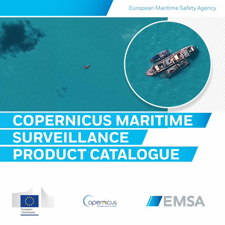
Copernicus is a European Union Programme aimed at developing European information services based on satellite Earth Observation (EO) and in-situ (non-space) data. The European Maritime Safety Agency (EMSA) is the Entrusted Entity responsible for implementing the Copernicus Maritime Surveillance (CMS) service under a Delegation Agreement signed with the European Commission for the period 2015-2020.
The CMS service supports monitoring of human activity at sea for a range of functions, including among others, maritime safety and security, fisheries control, marine pollution monitoring, customs, anti-piracy and law enforcement. The CMS service can be accessed by European Union (EU) and European Free Trade Association (EFTA) national administrations with responsibilities at sea, as well as relevant EU bodies and institutions. The service provides additional EO information through existing EMSA applications, and establishes new opportunities to use such data.
The CMS service offers users an extended geographical scope and enhanced range of high quality maritime information. Coverage can be provided in areas of European interest across the globe, with a variety of different resolutions and sensor types. In addition to image products, the service provides value-added products, including detection and classification of vessels based on automatic algorithms, and activity detection.
5
Copernicus Maritime Surveillance Product Catalogue
The catalogue is divided into four chapters:
The first chapter of the catalogue describes how to access the CMS service by contacting EMSA, and notes that the CMS service is provided through EMSA’s integrated maritime service (IMS) interface
The second chapter of the catalogue presents the EO image products available, both from synthetic aperture radar (SAR) and optical satellites
The third chapter of the catalogue describes the value added products. This type of information is extracted from the images using algorithms developed for that specific purpose, and is tailored to the end-users’ needs. Given the very particular nature of value added products, an overview table has been provided indicating which products may be useful for a range of different use cases
The fourth chapter provides information on the higher level fusion products available
In annex, the catalogue concludes by providing some information on the legal context, outlining certain restrictions to the use of CMS products, as well as the obligations in terms of acknowledging ownership of original or derived products when displayed for any purpose.
The CMS Product Catalogue will be updated on a regular basis to include new products that are deployed or to remove products that are considered obsolete.
The products listed in the Product Catalogue and provided by the CMS service are only for distribution to, and for the official use of, authorised users. For other distribution restrictions related to satellite products, please see Annex 1.
Copernicus Maritime Surveillance
6
Copernicus Maritime Surveillance Product Catalogue
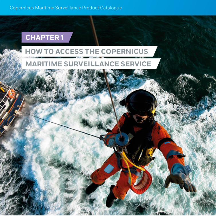
CHAPTER 1
HOW TO ACCESS THE COPERNICUS
MARITIME SURVEILLANCE SERVICE
7
Copernicus Maritime Surveillance Product Catalogue Maritime Surveillance Service
1 Please note that the CMS service does not support border surveillance functions, for which a separate Copernicus Border Surveillance service has been implemented. The European Commission entrusted Frontex with the border surveillance component of the Copernicus Security Service. For further information on the border surveillance service, contact: [email protected]
1.1 SERVICE SCOPE AND ACCESS
The CMS service provides EO products (satellite images and value adding products) to support a better understanding and improved monitoring of activities at sea. The CMS service is available through EMSA’s integrated maritime services (IMS) to support a wide range of operational functions.1 The CMS service provides support to interested Member State administrations and European bodies exercising functions in the maritime domain1, including in the areas of:
fisheries control
maritime safety and security
law enforcement
customs
marine environment monitoring, and
other (e.g. defence; anti-piracy).
Within IMS the existing access rights will continue to apply with regard to other data sources such as vessel position information.
EMSA delivers the CMS EO products via a dedicated web-based interface, or following a system-to-system approach (specific requests will be addressed on a case-by-case basis). The SafeSeaNet Ecosystem Graphical User Interface (SEG) is the preferred portal to access the CMS. However, users can also access CMS via the Web User Portal (WUP) and the Earth Observation Data Centre - GIS Viewer. Both the WUP and the GIS Viewer are expected to be phased out towards the end of 2018.
8
Copernicus Maritime Surveillance Product Catalogue
1.2 SETTING UP THE CMS SERVICE
To set up the CMS service users must complete the Operational User Requirements Questionnaire. This document details the user service needs to support their operations. Use of the CMS will depend on the functions being exercised:
1. Fisheries control:
If you are interested in CMS for the purposes of fisheries control, please contact the European Fisheries Control Agency (EFCA), which coordinates user access for this particular service component, at: [email protected].
2. Maritime safety and security, law enforcement, customs, marine environment monitoring, and other functions:
Please contact the EMSA Copernicus team directly at [email protected] to discuss your specific needs in terms of earth observation information and products.
If you are interested in using the CMS service for other functions, for example defence, or other areas not listed above, coordination with the European Commission (DG-GROW) may be necessary in order to include these functions in future implementation plans. Users are encouraged to contact EMSA to discuss how to proceed.
Users can also get in touch with DG GROW through the dedicated email address: [email protected].
Please contact the EMSA Copernicus team at [email protected] at any time with questions, comments, suggestions, or additional requirements.
9
Copernicus Maritime Surveillance Product Catalogue Maritime Surveillance Service
10
Maritime information services catalogue
1.3 TASKING CMS SERVICES
Once a user has contacted the EMSA Copernicus team to request access to CMS products, an iterative process of further defining the exact user requirements particular to that user will be initiated. While this process differs according to the user - for example depending on their level of previous experience of using EO products, the areas in which they are interested in receiving data, and their security requirements - there are some basic steps which will be taken in almost all cases, and which are outlined below in Table 1.
TABLE 1 - INITIAL ACTIONS TO TASK CMS SERVICES
CMS USER INITIAL ACTIONS EMSA INITIAL ACTIONS
Provide the following information:
Time interval of acquisitionsArea of interest (AOI) (in WGS84 coordinate system)Frequency of coverage or number of acquisitionsAdditional relevant information regarding object of interest (e.g. vessel length; structures to be identified; associated features; day/night preferences)Requested EO value-added products (vessel detection service, activity detection, EO images)
Users should note that EMSA can provide assistance in defining these parameters
Liaise with user to complete the Operational User Requirements Questionnaire (to detail the user service needs)
Liaise with user to complete Service Request form (to place a request for EO Services)
11
Maritime Surveillance Service
1.4 ARCHIVE DATA ACCESS
There are two types of archive data which may be of interest to CMS users:
1. EMSA archive data which has been previously ordered by EMSA and which is available in-house.
Authorised users have access to EMSA’s archive data. This is available online directly from the IMS interface for up to six months after acquisition. Archive data that is older than six months can be retrieved manually by EMSA; interested users should contact [email protected].
2. Satellite provider archive data, which may have been acquired by the satellite missions to which EMSA service providers have access, but which was not ordered directly by EMSA at any point in time, and is not archived in EMSA.
If users are interested in historic data from a given period and related to a specific area, e.g. to confirm whether a suspected activity took place, it may be possible to acquire this data post-hoc from EMSA’s contracted providers (even if it was not previously ordered by EMSA). If users are interested in historic data not available online they should contact [email protected] and place a service request providing the information described in Table 1 (period, area, purpose). The EMSA Copernicus team will then evaluate whether there is data available from any source to fulfil the request.
12
Copernicus Maritime Surveillance Product Catalogue
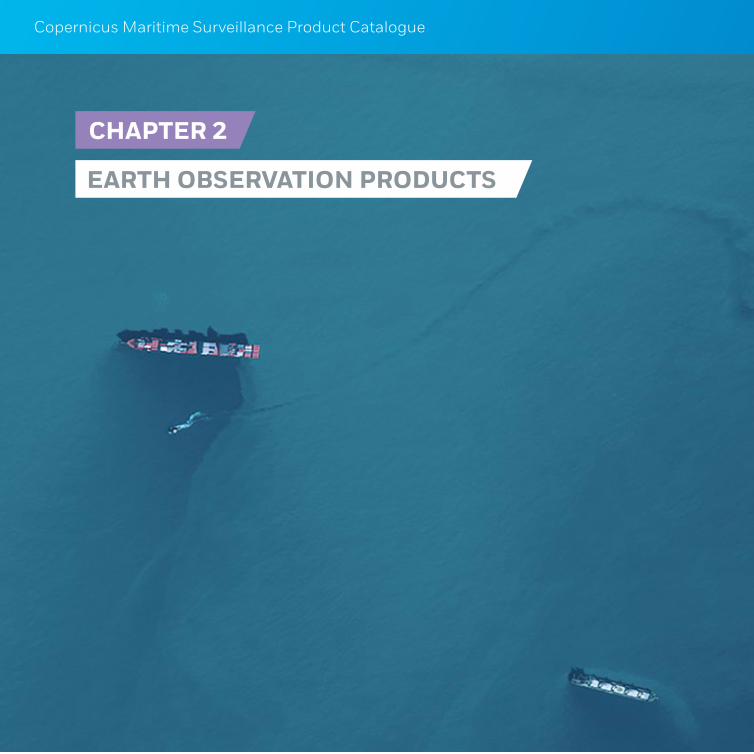
CHAPTER 2
EARTH OBSERVATION PRODUCTS

13
Copernicus Maritime Surveillance Product Catalogue Earth Observation Products
2.1 OVERVIEW
The products described in Chapter 2 constitute the core of the EO data being delivered by the CMS service. This part of the catalogue will be updated as new products are developed and released.
The CMS service offers image products, value added products and fusion products based on two types of earth observation data: SAR data and optical data.
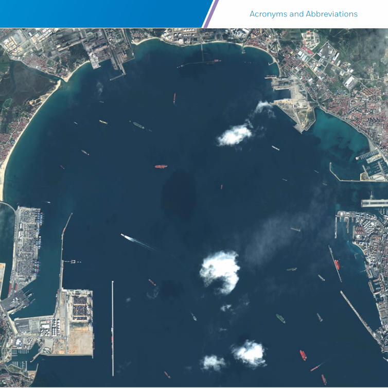
SAR sensors use microwave frequencies to retrieve backscatter measurements from the detected surface below (sea or land). The images can be acquired regardless of weather conditions and cloud cover, and at any time of day or night. SAR images of the ocean greatly depend on surface roughness caused by wind stress at the sea surface. By measuring the roughness of the sea surface, resulting images display features which stand out against the background; for example, vessels and other man-made structures appear as bright spots, while oil spills or areas with very low wind appear as dark shapes.
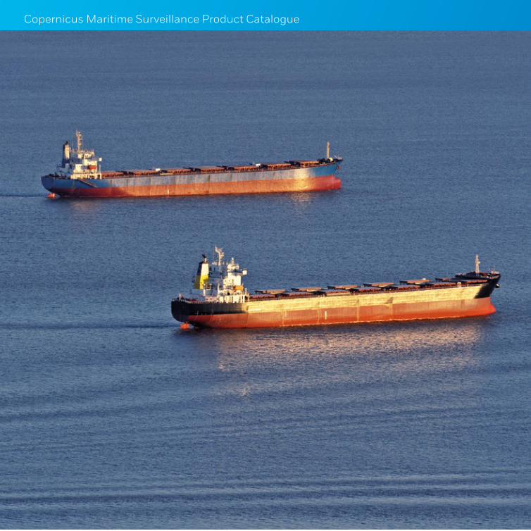
Optical images can provide a wealth of information in different spectral bands. They provide easier image interpretation and object identification due to the combination of Red-Green-Blue (RGB) frequencies and higher contrast, albeit the very high dependency on sunlight and weather conditions. Optical sensors cannot capture images during the night or in cloud cover conditions.
14
Copernicus Maritime Surveillance Product Catalogue
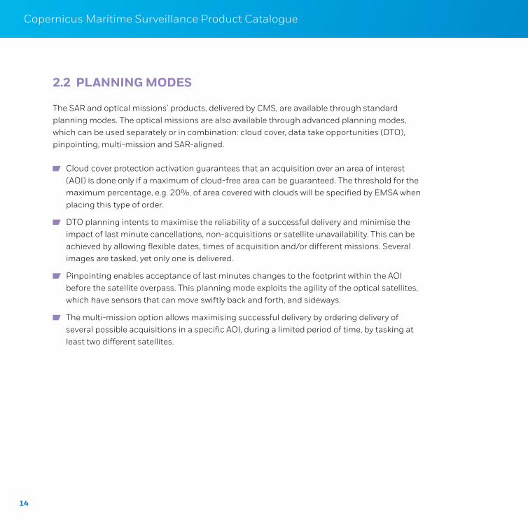
2.2 PLANNING MODES
The SAR and optical missions’ products, delivered by CMS, are available through standard planning modes. The optical missions are also available through advanced planning modes, which can be used separately or in combination: cloud cover, data take opportunities (DTO), pinpointing, multi-mission and SAR-aligned.
Cloud cover protection activation guarantees that an acquisition over an area of interest (AOI) is done only if a maximum of cloud-free area can be guaranteed. The threshold for the maximum percentage, e.g. 20%, of area covered with clouds will be specified by EMSA when placing this type of order.
DTO planning intents to maximise the reliability of a successful delivery and minimise the impact of last minute cancellations, non-acquisitions or satellite unavailability. This can be achieved by allowing flexible dates, times of acquisition and/or different missions. Several images are tasked, yet only one is delivered.
Pinpointing enables acceptance of last minutes changes to the footprint within the AOI before the satellite overpass. This planning mode exploits the agility of the optical satellites, which have sensors that can move swiftly back and forth, and sideways.
The multi-mission option allows maximising successful delivery by ordering delivery of several possible acquisitions in a specific AOI, during a limited period of time, by tasking at least two different satellites.
15
Copernicus Maritime Surveillance Product Catalogue Earth Observation Products
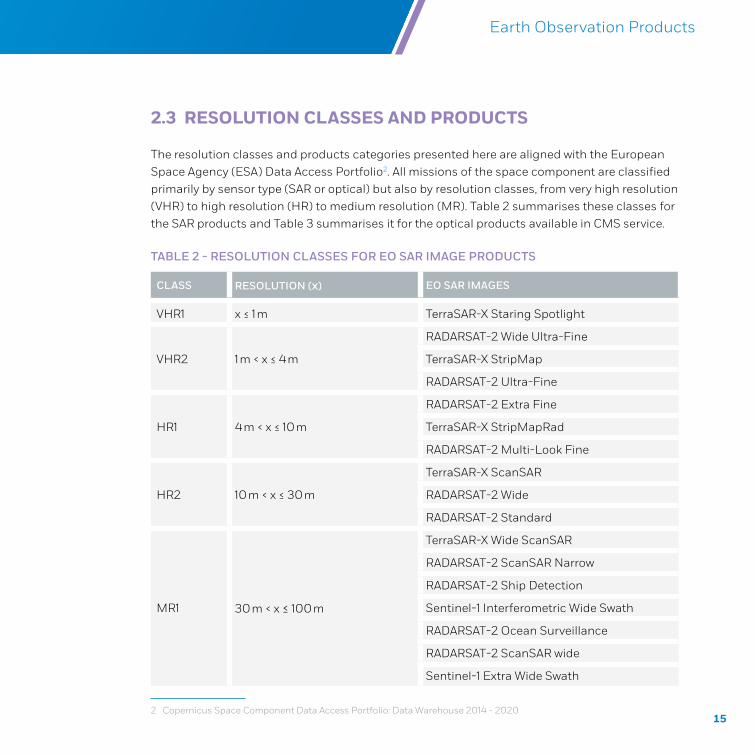
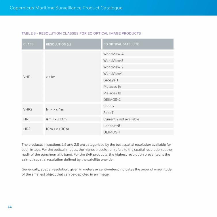
2.3 RESOLUTION CLASSES AND PRODUCTS
The resolution classes and products categories presented here are aligned with the European Space Agency (ESA) Data Access Portfolio2. All missions of the space component are classified primarily by sensor type (SAR or optical) but also by resolution classes, from very high resolution (VHR) to high resolution (HR) to medium resolution (MR). Table 2 summarises these classes for the SAR products and Table 3 summarises it for the optical products available in CMS service.
TABLE 2 - RESOLUTION CLASSES FOR EO SAR IMAGE PRODUCTS
2 Copernicus Space Component Data Access Portfolio: Data Warehouse 2014 - 2020
CLASS RESOLUTION (x) EO SAR IMAGES
VHR1 x ≤ 1 m TerraSAR-X Staring Spotlight
VHR2 1 m < x ≤ 4 m
RADARSAT-2 Wide Ultra-Fine
TerraSAR-X StripMap
RADARSAT-2 Ultra-Fine
HR1 4 m < x ≤ 10 m
RADARSAT-2 Extra Fine
TerraSAR-X StripMapRad
RADARSAT-2 Multi-Look Fine
HR2 10 m < x ≤ 30 m
TerraSAR-X ScanSAR
RADARSAT-2 Wide
RADARSAT-2 Standard
MR1 30 m < x ≤ 100 m
TerraSAR-X Wide ScanSAR
RADARSAT-2 ScanSAR Narrow
RADARSAT-2 Ship Detection
Sentinel-1 Interferometric Wide Swath
RADARSAT-2 Ocean Surveillance
RADARSAT-2 ScanSAR wide
Sentinel-1 Extra Wide Swath
16
Copernicus Maritime Surveillance Product Catalogue
TABLE 3 - RESOLUTION CLASSES FOR EO OPTICAL IMAGE PRODUCTS
CLASS RESOLUTION (x) EO OPTICAL SATELLITE
VHR1 x ≤ 1 m
WorldView-4
WorldView-3
WorldView-2
WorldView-1
GeoEye-1
Pleiades 1A
Pleiades 1B
DEIMOS-2
VHR2 1 m < x ≤ 4 mSpot 6
Spot 7
HR1 4 m < x ≤ 10 m Currently not available
HR2 10 m < x ≤ 30 mLandsat-8
DEIMOS-1
The products in sections 2.5 and 2.6 are categorised by the best spatial resolution available for each image. For the optical images, the highest resolution refers to the spatial resolution at the nadir of the panchromatic band. For the SAR products, the highest resolution presented is the azimuth spatial resolution defined by the satellite provider.
Generically, spatial resolution, given in meters or centimeters, indicates the order of magnitude of the smallest object that can be depicted in an image.
17
Copernicus Maritime Surveillance Product Catalogue Earth Observation Products
18
Copernicus Maritime Surveillance Product Catalogue
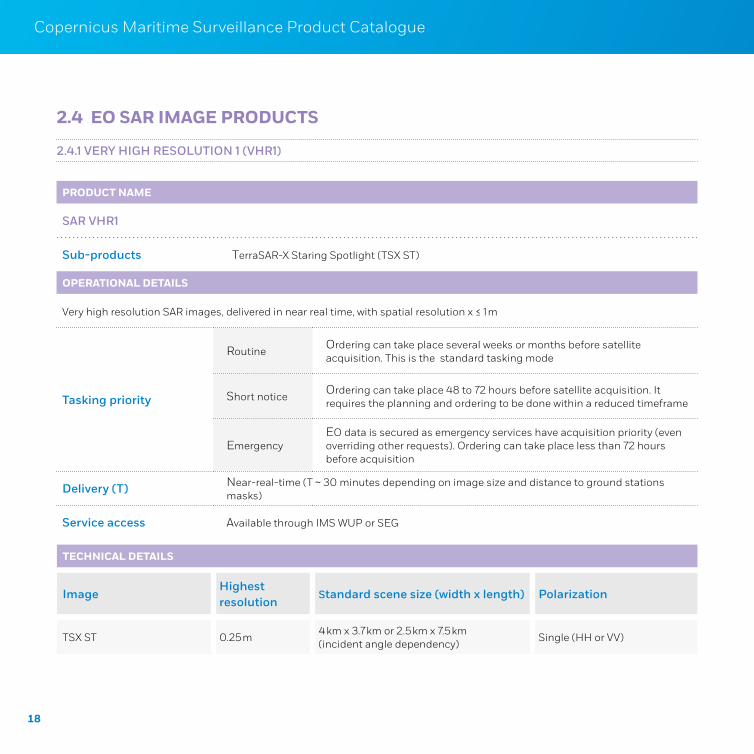
2.4 EO SAR IMAGE PRODUCTS
TECHNICAL DETAILS
ImageHighest resolution
Standard scene size (width x length) Polarization
TSX ST 0.25 m4 km x 3.7 km or 2.5 km x 7.5 km (incident angle dependency)
Single (HH or VV)
PRODUCT NAME
SAR VHR1
Sub-products TerraSAR-X Staring Spotlight (TSX ST)
OPERATIONAL DETAILS
Very high resolution SAR images, delivered in near real time, with spatial resolution x ≤ 1 m
Tasking priority
RoutineOrdering can take place several weeks or months before satellite acquisition. This is the standard tasking mode
Short noticeOrdering can take place 48 to 72 hours before satellite acquisition. It requires the planning and ordering to be done within a reduced timeframe
EmergencyEO data is secured as emergency services have acquisition priority (even overriding other requests). Ordering can take place less than 72 hours before acquisition
Delivery (T) Near-real-time (T ~ 30 minutes depending on image size and distance to ground stations masks)
Service access Available through IMS WUP or SEG
2.4.1 VERY HIGH RESOLUTION 1 (VHR1)
19
Copernicus Maritime Surveillance Product Catalogue Earth Observation Products
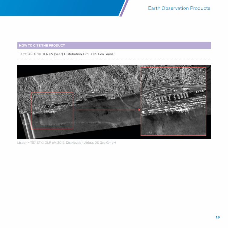
Lisbon - TSX ST © DLR e.V. 2015, Distribution Airbus DS Geo GmbH
HOW TO CITE THE PRODUCT
TerraSAR-X: “© DLR e.V. [year], Distribution Airbus DS Geo GmbH”
20
Copernicus Maritime Surveillance Product Catalogue
PRODUCT NAME
SAR VHR2
Sub-products
RADARSAT-2 Wide Ultra-Fine (RS2 UFW)
TerraSAR-X StripMap (TSX SM)
RADARSAT-2 Ultra-Fine (RS2 UF)
OPERATIONAL DETAILS
Very high resolution SAR images, delivered in near real time, with spatial resolution 1 m < x ≤ 4 m
Tasking priority
Routine Ordering can take place several weeks or months before satellite acquisition. This is the standard tasking mode
Short notice Ordering can take place 48 to 72 hours before satellite acquisition. It requires the planning and ordering to be done within a reduced timeframe
EmergencyEO data is secured as emergency services have acquisition priority (even overriding other requests). Ordering can take place less than 72 hours before acquisition
Delivery (T) Near-real-time (T ~ 30 minutes depending on image size and distance to ground stations masks)
Service access Available through IMS WUP or SEG
2.4.2 VERY HIGH RESOLUTION 2 (VHR2)
21
Copernicus Maritime Surveillance Product Catalogue Earth Observation Products
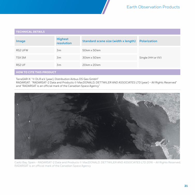
Cadiz Bay, Spain - RADARSAT-2 Data and Products © MacDONALD, DETTWILER AND ASSOCIATES LTD 2016 – All Rights Reserved; RADARSAT is an official mark of the Canadian Space Agency
TECHNICAL DETAILS
ImageHighest resolution
Standard scene size (width x length) Polarization
RS2 UFW 3 m 50 km x 50 km
Single (HH or VV)TSX SM 3 m 30 km x 50 km
RS2 UF 3 m 20 km x 20 km
HOW TO CITE THIS PRODUCT
TerraSAR-X: “© DLR e.V. [year], Distribution Airbus DS Geo GmbH”RADARSAT: “RADARSAT-2 Data and Products © MacDONALD, DETTWILER AND ASSOCIATES LTD [year] – All Rights Reserved” and “RADARSAT is an official mark of the Canadian Space Agency”
22
Copernicus Maritime Surveillance Product Catalogue
PRODUCT NAME
SAR HR1
Sub-products
RADARSAT-2 Extra Fine (RS2 XF)
TerraSAR-X StripMapRad (TSX SMR)
RADARSAT-2 Multi-Look Fine (RS2 MF)
OPERATIONAL DETAILS
High resolution SAR images, delivered in near real time, with spatial resolution 4 m < x ≤ 10 m
Tasking priority
Routine Ordering can take place several weeks or months before satellite acquisition. This is the standard tasking mode
Short notice Ordering can take place 48 to 72 hours before satellite acquisition. It requires the planning and ordering to be done within a reduced timeframe
EmergencyEO data is secured as emergency services have acquisition priority (even overriding other requests). Ordering can take place less than 72 hours before acquisition
Delivery (T) Near-real-time (T ~ 30 minutes depending on image size and distance to ground stations masks)
Service access Available through IMS WUP or SEG
2.4.3 HIGH RESOLUTION 1 (HR1)
23
Copernicus Maritime Surveillance Product Catalogue Earth Observation Products
TECHNICAL DETAILS
ImageHighest resolution
Standard scene size (width x length) Polarization
RS2 XF 6 m 125 km x 125 km
Single (HH or VV)TSX SMR 6 m 30 km x 50 km
RS2 MF 8 m 50 km x 50 km
HOW TO CITE THIS PRODUCT
TerraSAR-X: “© DLR e.V. [year], Distribution Airbus DS Geo GmbH”RADARSAT: “RADARSAT-2 Data and Products © MacDONALD, DETTWILER AND ASSOCIATES LTD [year] – All Rights Reserved” and “RADARSAT is an official mark of the Canadian Space Agency”
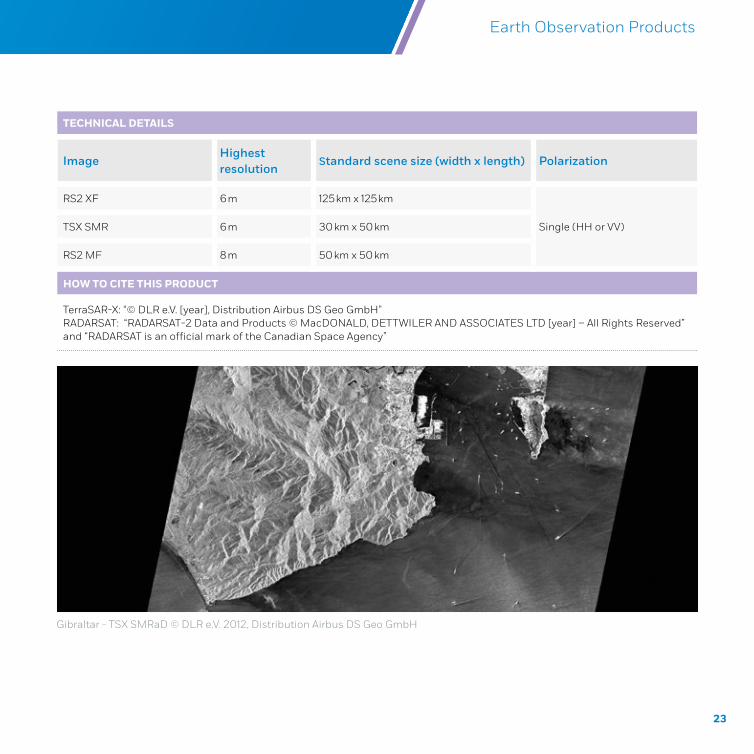
Gibraltar - TSX SMRaD © DLR e.V. 2012, Distribution Airbus DS Geo GmbH
24
Copernicus Maritime Surveillance Product Catalogue
PRODUCT NAME
SAR HR2
Sub-products
TerraSAR-X ScanSAR (TSX SC)
RADARSAT-2 Wide (RS2 W)
RADARSAT-2 Standard (RS2 S)
OPERATIONAL DETAILS
High Resolution SAR images, delivered in near real time, with spatial resolution 10 m < x ≤ 30 m
Tasking priority
Routine Ordering can take place several weeks or months before satellite acquisition. This is the standard tasking mode.
Short notice Ordering can take place 48 to 72 hours before satellite acquisition. It requires the planning and ordering to be done within a reduced timeframe
EmergencyEO data is secured as emergency services have acquisition priority (even overriding other requests). Ordering can take place less than 72 hours before acquisition
Delivery (T) Near-real-time (T ~ 30 minutes depending on image size and distance to ground stations masks)
Service access Available through IMS WUP or SEG
2.4.4 HIGH RESOLUTION 2 (HR2)
25
Copernicus Maritime Surveillance Product Catalogue Earth Observation Products
TECHNICAL DETAILS
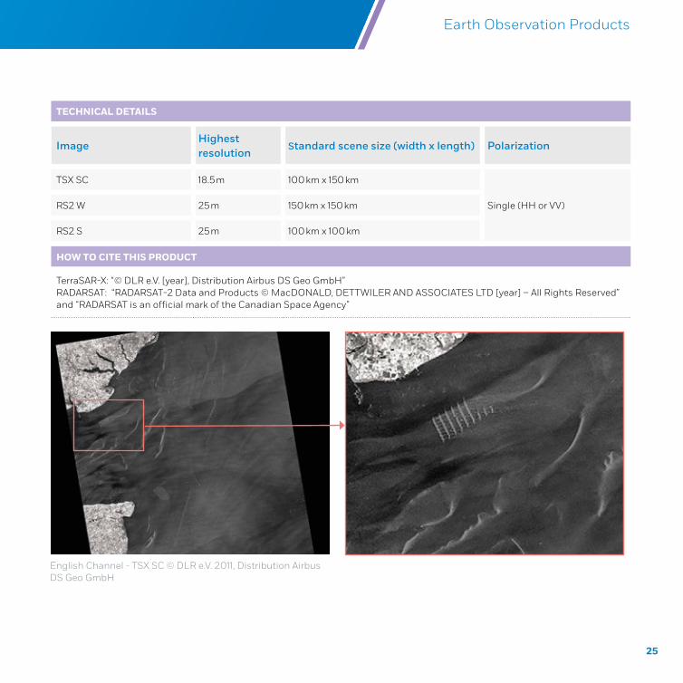
ImageHighest resolution
Standard scene size (width x length) Polarization
TSX SC 18.5 m 100 km x 150 km
Single (HH or VV)RS2 W 25 m 150 km x 150 km
RS2 S 25 m 100 km x 100 km
HOW TO CITE THIS PRODUCT
TerraSAR-X: “© DLR e.V. [year], Distribution Airbus DS Geo GmbH”RADARSAT: “RADARSAT-2 Data and Products © MacDONALD, DETTWILER AND ASSOCIATES LTD [year] – All Rights Reserved” and “RADARSAT is an official mark of the Canadian Space Agency”
English Channel - TSX SC © DLR e.V. 2011, Distribution Airbus DS Geo GmbH
26
Copernicus Maritime Surveillance Product Catalogue
PRODUCT NAME
SAR MR1
Sub-products
TerraSAR-X Wide ScanSAR (TSX WS)
RADARSAT-2 ScanSAR Narrow (RS2 SCN)
RADARSAT-2 Ship Detection (RS2 DVWF)
Sentinel 1 Interferometric Wide Swath (S1 IWS)
RADARSAT-2 Ocean Surveillance (RS2 OSVN)
RADARSAT-2 ScanSAR Wide (RS2 SCW)
Sentinel 1 Extra-Wide Swath Mode (S1 EWS)
OPERATIONAL DETAILS
Medium resolution SAR images, delivered in near real time, with spatial resolution 30 m < x ≤ 100 m. Please note that two of the products are optimised for particular tasks:
RS2 OSVN is optimized for ocean surveillance: ship detection, oil on water, ice analyses and wake detection. It can detect ships larger than 50 m in lengthRS2 DVWF is optimised for ship detection. It can detect ships larger than 20 m with high confidence level.
Tasking priority
Routine Ordering can take place several weeks or months before satellite acquisition. This is the standard tasking mode.
Short notice Ordering can take place 48 to 72 hours before satellite acquisition. It requires the planning and ordering to be done within a reduced timeframe
EmergencyEO data is secured as emergency services have acquisition priority (even overriding other requests). Ordering can take place less than 72 hours before acquisition
Delivery (T) Near-real-time (T ~ 30 minutes depending on image size and distance to ground stations masks)
Service access Available through IMS WUP or SEG
2.4.5 MEDIUM RESOLUTION 1 (MR1)
27
Copernicus Maritime Surveillance Product Catalogue Earth Observation Products
TECHNICAL DETAILS
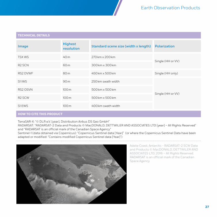
ImageHighest resolution
Standard scene size (width x length) Polarization
TSX WS 40 m 270 km x 200 kmSingle (HH or VV)
R2 SCN 60 m 300 km x 300 km
RS2 DVWF 80 m 450 km x 500 km Single (HH only)
S1 IWS 90 m 250 km swath width
Single (HH or VV)RS2 OSVN 100 m 500 km x 500 km
R2 SCW 100 m 500 km x 500 km
S1 EWS 100 m 400 km swath width
HOW TO CITE THIS PRODUCT
TerraSAR-X: “© DLR e.V. [year], Distribution Airbus DS Geo GmbH”RADARSAT: “RADARSAT-2 Data and Products © MacDONALD, DETTWILER AND ASSOCIATES LTD [year] – All Rights Reserved” and “RADARSAT is an official mark of the Canadian Space Agency”Sentinel-1 (data obtained via Copernicus): “Copernicus Sentinel data [Year]” (or where the Copernicus Sentinel Data have been adapted or modified: “Contains modified Copernicus Sentinel data [Year]”)
Adelie Coast, Antarctic - RADARSAT-2 SCW Data and Products © MacDONALD, DETTWILER AND ASSOCIATES LTD, 2016 – All Rights Reserved; RADARSAT is an official mark of the Canadian Space Agency
28
Copernicus Maritime Surveillance Product Catalogue
2.5 EO OPTICAL IMAGE PRODUCTS
PRODUCT NAME
OPTICAL VHR1
Sub-productsWorldView 1, 2, 3, 4 ( WV1, WV2, WV3, WV4) Pleiades 1A, 1B (PHR1A, PHR1B)
GeoEye-1 (GE1) Deimos 2 (DE2)
OPERATIONAL DETAILS
Very high resolution optical images are provided in several delivery categories with spatial resolution x ≤ 1 m and different band combinations: Panchromatic, Multispectral, Pansharpened and Bundle
Tasking priorityRoutine
Ordering can take place several weeks or months before satellite acquisition. This is the standard tasking mode
Short noticeOrdering can take place 48 to 72 hours before satellite acquisition. It requires the planning and ordering to be done within a reduced timeframe
Advance planning modesSimple Cloud cover protection, DTO planning, pinpointing, multi-mission
Combination Multi-mission and DTO planning; cloud cover and DTO planning
Delivery (T)
Near-real-time (T ~ 45 minutes depending on image size and distance to ground station masks)
T < 3 hours
T < 6 hours
T < 24 hours
T ≥ 24 hours
Service access Available through IMS, WUP or SEG
2.5.1 VERY HIGH RESOLUTION 1 (VHR1)
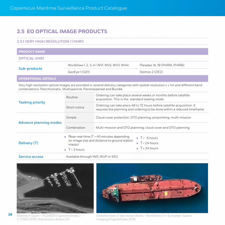
Detailed view of two vessel decks - WorldView 3 © European Space Imaging/DigitalGlobe 2016
Marina in Spain - PLEIADES (panchromatic) © CNES 2018, Distribution Airbus DS
29
Copernicus Maritime Surveillance Product Catalogue Earth Observation Products
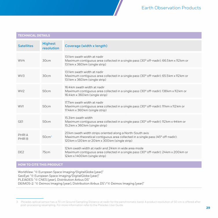
TECHNICAL DETAILS
SatellitesHighest resolution
Coverage (width x length)
WV4 30cm13.1 km swath width at nadirMaximum contiguous area collected in a single pass (30º off-nadir): 66.5 km x 112 km or 13.1 km x 360 km (single strip)
WV3 30cm13.1 km swath width at nadirMaximum contiguous area collected in a single pass (30º off-nadir): 65.5 km x 112 km or 13.1 km x 360 km (single strip)
WV2 50cm16.4 km swath width at nadirMaximum contiguous area collected in a single pass (30º off-nadir): 138 km x 112 km or 16.4 km x 360 km (single strip)
WV1 50cm17.7 km swath width at nadirMaximum contiguous area collected in a single pass (30º off-nadir): 111 km x 112 km or 17.4 km x 360 km (single strip)
GE1 50cm15.3 km swath widthMaximum contiguous area collected in a single pass (30º off-nadir): 112 km x 44 km or 15.2 km x 360 km (single strip)
PHR1 APHR1 B
50cm3
20 km swath width strips oriented along a North-South axisMaximum theoretical contiguous area collected in a single pass (45º off-nadir): 120 km x 120 km or 20 km x 300 km (single strip)
DE2 75cm12 km swath width at nadir and 24 km in wide area modeMaximum contiguous area collected in a single pass (30º off-nadir): 24 km x 200 km or 12 km x 1 400 km (single strip)
HOW TO CITE THIS PRODUCT
WorldView: “© European Space Imaging/DigitalGlobe [year]”GeoEye: “© European Space Imaging/DigitalGlobe [year]”PLEIADES: “© CNES [year], Distribution Airbus DS” DEIMOS-2: “© Deimos Imaging [year], Distribution Airbus DS”/“© Deimos Imaging [year]”
3 Pleiades optical sensor has a 70 cm Ground Sampling Distance at nadir for the panchromatic band. A product resolution of 50 cm is offered after post-processing resampling. For more information refer to the Pleiades User Guide.
30
Copernicus Maritime Surveillance Product Catalogue
PRODUCT NAME
OPTICAL VHR2
Sub-products Spot 6 and Spot 7
OPERATIONAL DETAILS
Very high resolution optical images are provided in several delivery categories, with spatial resolution 1 m < x ≤ 4 m and different band combinations: Panchromatic, Multispectral, Pansharpened and Bundle
Tasking priority
Routine Ordering can take place several weeks or months before satellite acquisition. This is the standard tasking mode
Short notice Ordering can take place 48 to 72 hours before satellite acquisition. It requires the planning and ordering to be done within a reduced timeframe
Advance planning modes
Simple Cloud cover protection, DTO planning, pinpointing, multi-mission
Combination Multi-mission and DTO planning; cloud cover and DTO planning
Delivery (T)
Near-real-time (T ~ 45 minutes depending on image size and distance to ground station masks)
T < 3 hours
T < 6 hours
T < 24 hours
T > 24 hours
Service access Available through IMS WUP or SEG
2.5.2 VERY HIGH RESOLUTION 2 (VHR2)
31
Copernicus Maritime Surveillance Product Catalogue Earth Observation Products
TECHICAL DETAILS
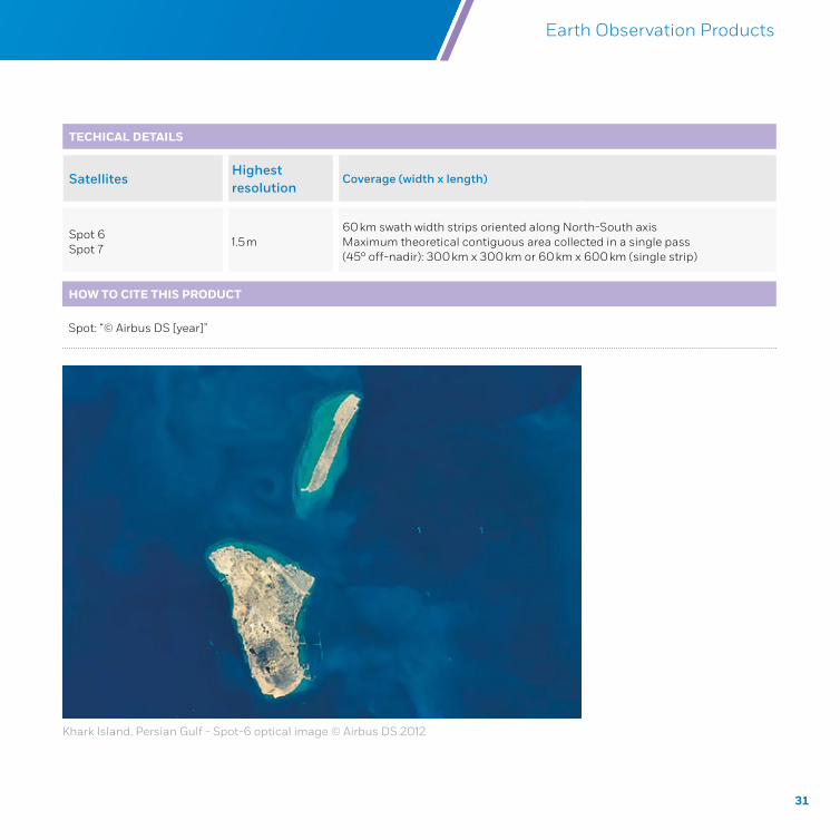
SatellitesHighest resolution
Coverage (width x length)
Spot 6 Spot 7
1.5 m60 km swath width strips oriented along North-South axisMaximum theoretical contiguous area collected in a single pass (45º off-nadir): 300 km x 300 km or 60 km x 600 km (single strip)
HOW TO CITE THIS PRODUCT
Spot: “© Airbus DS [year]”
Khark Island, Persian Gulf - Spot-6 optical image © Airbus DS 2012
32
Copernicus Maritime Surveillance Product Catalogue
PRODUCT NAME
OPTICAL HR2
Sub-productsLandSat 8 (LS8)
Deimos 1 (DE1)
OPERATIONAL DETAILS
High resolution optical images, are provided in several delivery categories with spatial resolution 10 m < x ≤ 30 m and different band combinations: Panchromatic4 , Multispectral, Pansharpened5 and Bundle.
Tasking priority
Routine Ordering can take place several weeks or months before satellite acquisition. This is the standard tasking mode
Short notice Ordering can take place 48 to 72 hours before satellite acquisition. It requires the planning and ordering to be done within a reduced timeframe
Advance planning modes
Simple Cloud cover protection, DTO planning, pinpointing, multi-mission
Combination Multi-mission and DTO planning; cloud cover and DTO planning
Delivery (T)
Near-real-time (T ~ 45 minutes depending on image size and distance to ground station masks)
T < 3 hours
T < 6 hours
T < 24 hours
T > 24 hours
Service access Available through IMS WUP or SEG
2.5.3 HIGH RESOLUTION 2 (HR2)
4 not available for DEIMOS-1
5 not available for DEIMOS-1
33
Copernicus Maritime Surveillance Product Catalogue Earth Observation Products
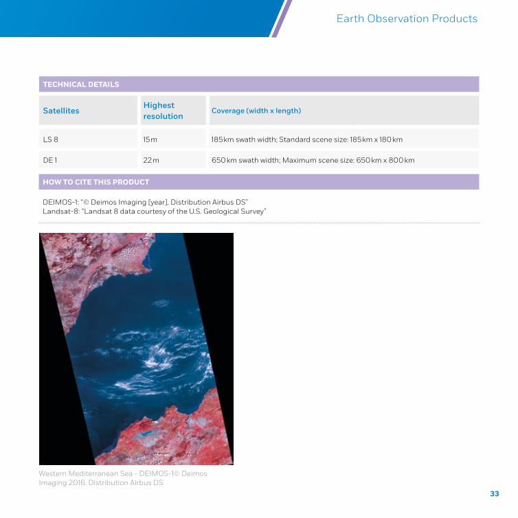
TECHNICAL DETAILS
SatellitesHighest resolution
Coverage (width x length)
LS 8 15 m 185 km swath width; Standard scene size: 185 km x 180 km
DE 1 22 m 650 km swath width; Maximum scene size: 650 km x 800 km
HOW TO CITE THIS PRODUCT
DEIMOS-1: “© Deimos Imaging [year], Distribution Airbus DS”Landsat-8: “Landsat 8 data courtesy of the U.S. Geological Survey”
Western Mediterranean Sea - DEIMOS-1© Deimos Imaging 2016, Distribution Airbus DS
34
Copernicus Maritime Surveillance Product Catalogue
CHAPTER 3
EARTH OBSERVATION
VALUE ADDED PRODUCTS
35
Copernicus Maritime Surveillance Product Catalogue Earth Observation Value Added Products
3.1 OVERVIEW
The vast quantity of earth observation data potentially available to users brings enormous opportunities, but also challenges in terms of choosing and using data selectively. For maritime surveillance purposes, the benefits to be derived from EO data do not lie solely in the volume of data available, but rather in the intelligent use of data in a targeted manner. The value added products offered by the CMS service aid users by extracting particularly valuable information from the basic image products, allowing authorities to undertake higher level analysis of objects, features or activities at sea more quickly and efficiently.
The value added products can be provided either as a layer on top of the original satellite image product or as a separate layer of information, for example a vector layer. This enables users to select which individual product or particular combination of products is relevant to them. For example, a user requesting high resolution optical data to support the search for an individual vessel may want a vessel detection layer to quickly identify the location of all vessels in the area, but also the original image product layer to see the details of the vessels to narrow down the search; however, a pollution response team using SAR imagery might prefer to receive just the vector coordinates of a suspected oil spill rapidly, and not wait for a download of the full original image product, in order to send assets to the area as quickly as possible. Within the CMS service, some value added products are already available, and others are currently under development. In order to support users as fully as possible, suggestions and requirements for future added value products are always welcomed.
The factsheets in this chapter contain the descriptions of the value added products and their relevant attributes. The value added products currently being offered to users include:
oil spill detection
vessel detection
activity detection
met-ocean information
36
Copernicus Maritime Surveillance Product Catalogue
3.2 OIL SPILL DETECTION
PRODUCT NAME
OIL SPILL DETECTION
Sub-products Not applicable
OPERATIONAL DETAILS
This product –comprising of the oil spill notification, the vessel detection and the derived package - is currently being provided through the CleanSeaNet service in European waters. It can be provided in other areas of interest beyond European waters through the CMS service.
The relevant attributes of the oil spill product are:
Centre - latitude/longitude coordinates
Geometry - polygon describing oil spill and associated slicks boundaries
Area - expressed in m2
Time stamp - date/time of the observation
Classification level - the probability/confidence that the detection is oil
Meteo-oceanographic conditions
Possible pollution source type/detection/vessel identification/track
Source detection position
Tasking priority
Routine Ordering can take place several weeks or months before satellite acquisition. This is the standard tasking mode
Short notice Ordering can take place 48 to 72 hours before satellite acquisition. It requires the planning and ordering to be done within a reduced timeframe
EmergencyEO data is secured as emergency services have acquisition priority (even overriding other requests). Ordering can take place less than 72 hours before acquisition
Delivery (T) Near-real-time (T ~ 30 min depending on image size and distance to ground stations masks)
Service access Available through the EODC GIS Viewer or IMS WUP or SEG
37
Copernicus Maritime Surveillance Product Catalogue
TECHNICAL DETAILS
Imagery used HR2 and MR1 SAR images with single polarisation (VV preferable)
Resolution Dependent on feature size. Consult Chapter 2 for more information on resolution of images
Earth Observation Value Added Products
HOW TO CITE THIS PRODUCT
© EMSA, contains modified [insert satellite mission and credit as relevant] data, [year]
Relevant missions include:TerraSAR-X: “© DLR e.V. [year], Distribution Airbus DS Geo GmbH”RADARSAT: “RADARSAT-2 Data and Products © MacDONALD, DETTWILER AND ASSOCIATES LTD [year] – All Rights Reserved” and “RADARSAT is an official mark of the Canadian Space Agency”Sentinel-1 (data obtained via Copernicus): “Copernicus Sentinel data [Year]” (or where the Copernicus Sentinel Data have been adapted or modified: “Contains modified Copernicus Sentinel data [Year]”)
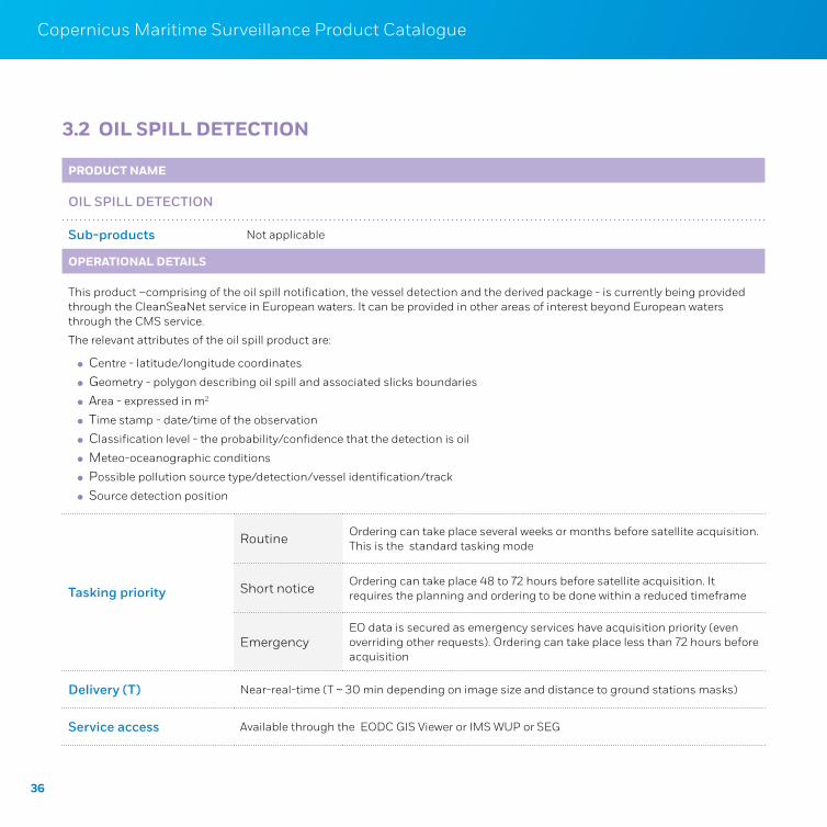
Oil spill detection © EMSA, contains modified Copernicus Sentinel-1 data, 2017
Oil spill detection © EMSA, contains modified RADARSAT-2 data, 2015. RADARSAT-2 Data and Products © MacDONALD, DETTWILER AND ASSOCIATES LTD, 2015 – All Rights Reserved; RADARSAT is an official mark of the Canadian Space Agency
38
Copernicus Maritime Surveillance Product Catalogue
3.3 VESSEL DETECTION
PRODUCT NAME
VESSEL DETECTION
Sub-products Not applicable
OPERATIONAL DETAILS
This service entails the delivery of value added products, mainly using high and very high resolution images, focusing on vessel detection.
Position – latitude/longitude coordinates
Time Stamp – date/time of acquisition
Speed – over ground expressed in m/s (when possible)
Heading – route direction (when possible)
Length and width - expressed in m (when possible)Vessel classification – category of the vessel e.g. fishing vessel, sailing vessel, merchant vessel (when possible)
Vessel identification – ID data (correlation - see section 4.2)
Confidence: three different confidence levels for vessel classification and detection from 0 to 100%
Tasking priority
Routine Ordering can take place several weeks or months before satellite acquisition. This is the standard tasking mode
Short notice Ordering can take place 48 to 72 hours before satellite acquisition. It requires the planning and ordering to be done within a reduced timeframe
Emergency
(SAR only)
EO data is secured as emergency services have acquisition priority (even overriding other requests). Ordering can take place less than 72 hours before acquisition
Advanced planning modes
Simple Cloud cover protection, DTO planning, pinpointing, multi-mission
Combination Multi-mission and DTO planning, cloud cover and DTO planning
39
Copernicus Maritime Surveillance Product Catalogue
Delivery (T)
SAR
Near-real-time
(T ~ 30 minutes depending on image size and distance to ground stations masks)
Optical
Near-real-time (T ~ 45 minutes depending on image size)
T < 3 hours
T < 6 hours
T < 24 hours
T ≥ 24 hours
Service access Available through IMS WUP or SEG
Earth Observation Value Added Products
TECHNICAL DETAILS
Imagery used SAR and optical images
Resolution Dependent on feature size. Consult Chapter 2 for more information on resolution of images
HOW TO CITE THIS PRODUCT
© EMSA, contains modified [insert satellite mission and credit as relevant] data, [year]
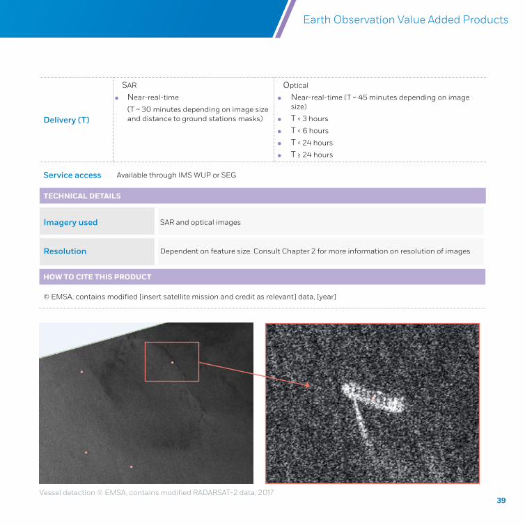
Vessel detection © EMSA, contains modified RADARSAT-2 data, 2017
40
Copernicus Maritime Surveillance Product Catalogue
3.4 ACTIVITY DETECTION
PRODUCT NAME
ACTIVITY DETECTION
Sub-products Not applicable
OPERATIONAL DETAILS
This service is used to report information about specific activities, over a defined area at a given time, detected during analysis of EO images, mainly using high and very high resolution data. The following attributes are included in the product:
Type - activity detected on a EO scene, e.g. vessels towing cages, rendezvous at sea, skiffs on the beach, object on the water, large spill on the shore, structures on the beach (buildings, barracks)
Area – latitude/longitude coordinates
Time Stamp – date/time of acquisition
Confidence level - expressed in high/medium/low levels
Associated vessels – attributes: described in the vessel detection factsheet
Other associated features attributes:
Description – e.g. fish farms, fish cages, oil and gas installations, icebergs
Position – latitude/longitude coordinates
Time Stamp – date/time of acquisition
Size – expressed in m or m2
Reference to other feature – previously reported feature
Tasking priority
Routine Ordering can take place several weeks or months before satellite acquisition. This is the standard tasking mode
Short notice Ordering can take place 48 to 72 hours before satellite acquisition. It requires the planning and ordering to be done within a reduced timeframe
Advanced planning modes
Simple Cloud cover protection, DTO planning, pinpointing, multi-mission
Combination Multi-mission and DTO planning; cloud cover and DTO planning
41
Copernicus Maritime Surveillance Product Catalogue
TECHNICAL DETAILS
Imagery used Optical images
Resolution Dependent on feature size. Consult Chapter 2 for more information on resolution of images
Earth Observation Value Added Products
Delivery (T)
Near-real-time (T ~ 45 minutes depending on image size)
T < 3 hours
T < 6 hours
T < 24 hours
T ≥ 24 hours
Service access Available through IMS SEG
HOW TO CITE THIS PRODUCT
© EMSA, contains modified [insert satellite mission and credit as relevant] data, [year]
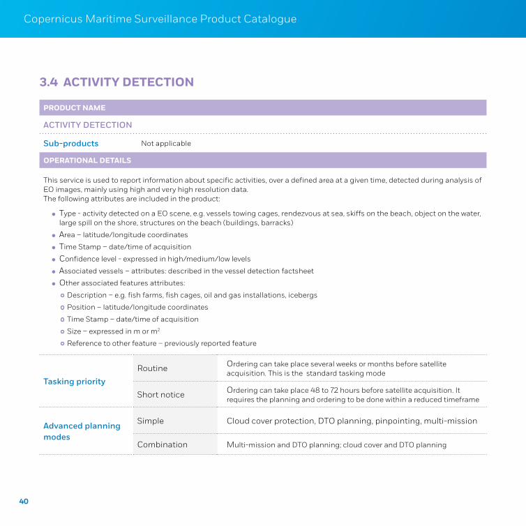
Port monitoring using optical VHR 1 © CNES 2016, Distribution Airbus DS
Fish cages monitoring using optical VHR 1 © European Space Imaging/DigitalGlobe, 2013
42
Copernicus Maritime Surveillance Product Catalogue
3.5 MET-OCEAN INFORMATION
PRODUCT NAME
SAR WIND AND SAR WAVE
Sub-productsSAR Wind
SAR Wave
OPERATIONAL DETAILS
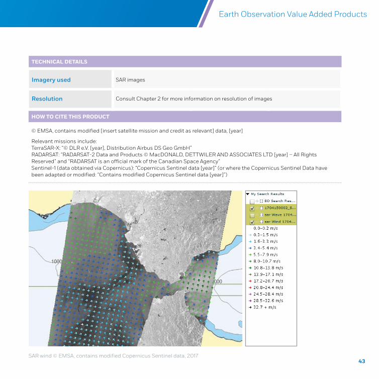
This service entails the delivery of a package containing ocean surface wind and wave (swell) derived from SAR imagery. The attributes of these products are:
Wind speed – expressed in m/s
Wind direction – wind from direction
Wave height – sea surface swell wave significant height, expressed in m
Wave direction – sea surface swell wave to direction
Tasking priority
Routine Ordering can take place several weeks or months before satellite acquisition. This is the standard tasking mode
Short notice Ordering can take place 48 to 72 hours before satellite acquisition. It requires the planning and ordering to be done within a reduced timeframe
EmergencyEO data is secured as emergency services have acquisition priority (even overriding other requests). Ordering can take place less than 72 hours before acquisition
Delivery (T) Near-real-time (T ~ 30 minutes depending on image size and distance to ground stations masks)
Service access Available through the EODC GIS Viewer or IMS SEG
43
Copernicus Maritime Surveillance Product Catalogue Earth Observation Value Added Products
HOW TO CITE THIS PRODUCT
© EMSA, contains modified [insert satellite mission and credit as relevant] data, [year]
Relevant missions include:TerraSAR-X: “© DLR e.V. [year], Distribution Airbus DS Geo GmbH”RADARSAT: “RADARSAT-2 Data and Products © MacDONALD, DETTWILER AND ASSOCIATES LTD [year] – All Rights Reserved” and “RADARSAT is an official mark of the Canadian Space Agency”Sentinel-1 (data obtained via Copernicus): “Copernicus Sentinel data [year]” (or where the Copernicus Sentinel Data have been adapted or modified: “Contains modified Copernicus Sentinel data [year]”)
TECHNICAL DETAILS
Imagery used SAR images
Resolution Consult Chapter 2 for more information on resolution of images
SAR wind © EMSA, contains modified Copernicus Sentinel data, 2017
44 45
Copernicus Maritime Surveillance Product Catalogue
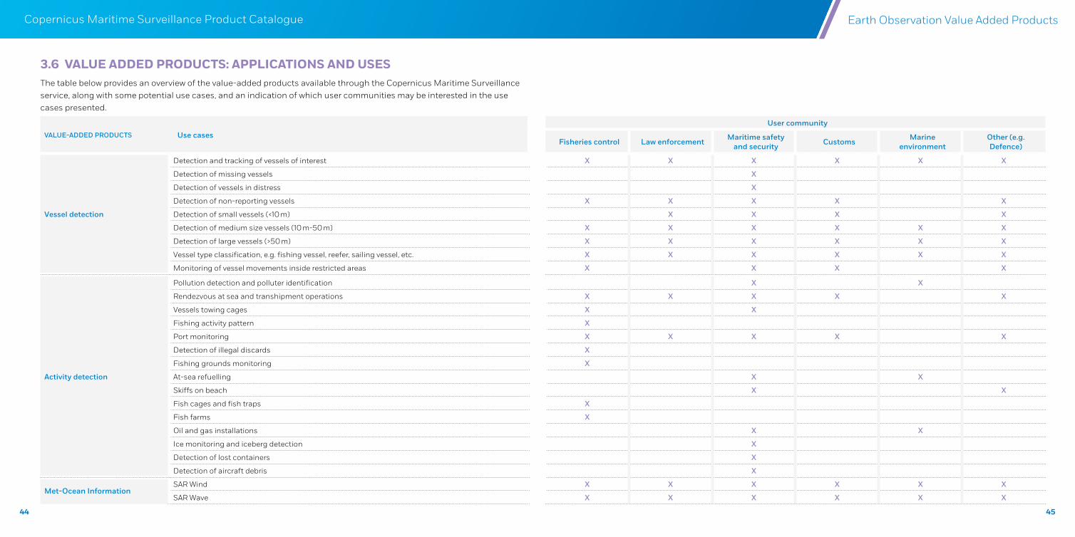
3.6 VALUE ADDED PRODUCTS: APPLICATIONS AND USESThe table below provides an overview of the value-added products available through the Copernicus Maritime Surveillance service, along with some potential use cases, and an indication of which user communities may be interested in the use cases presented.
VALUE-ADDED PRODUCTS Use cases
User community
Fisheries control Law enforcement Maritime safety and security Customs Marine
environmentOther (e.g. Defence)
Vessel detection
Detection and tracking of vessels of interest X X X X X X
Detection of missing vessels X
Detection of vessels in distress X
Detection of non-reporting vessels X X X X X
Detection of small vessels (<10 m) X X X X
Detection of medium size vessels (10 m-50 m) X X X X X X
Detection of large vessels (>50 m) X X X X X X
Vessel type classification, e.g. fishing vessel, reefer, sailing vessel, etc. X X X X X X
Monitoring of vessel movements inside restricted areas X X X X
Activity detection
Pollution detection and polluter identification X X
Rendezvous at sea and transhipment operations X X X X X
Vessels towing cages X X
Fishing activity pattern X
Port monitoring X X X X X
Detection of illegal discards X
Fishing grounds monitoring X
At-sea refuelling X X
Skiffs on beach X X
Fish cages and fish traps X
Fish farms X
Oil and gas installations X X
Ice monitoring and iceberg detection X
Detection of lost containers X
Detection of aircraft debris X
Met-Ocean InformationSAR Wind X X X X X X
SAR Wave X X X X X X
Earth Observation Value Added Products
46
Copernicus Maritime Surveillance Product Catalogue
CHAPTER 4
FUSION PRODUCTS
47
Copernicus Maritime Surveillance Product Catalogue Fusion Products
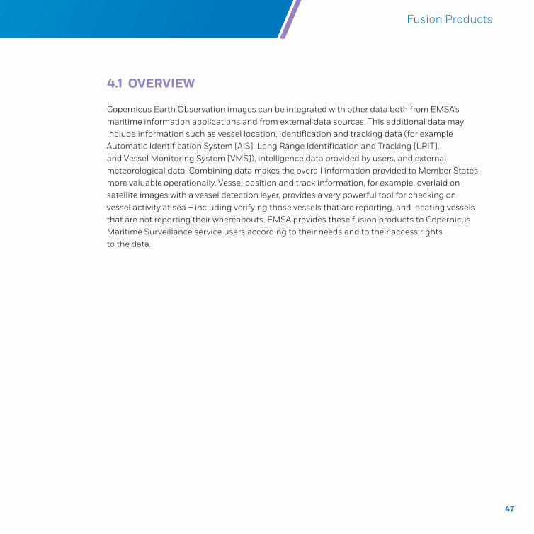
4.1 OVERVIEW
Copernicus Earth Observation images can be integrated with other data both from EMSA’s maritime information applications and from external data sources. This additional data may include information such as vessel location, identification and tracking data (for example Automatic Identification System [AIS], Long Range Identification and Tracking [LRIT], and Vessel Monitoring System [VMS]), intelligence data provided by users, and external meteorological data. Combining data makes the overall information provided to Member States more valuable operationally. Vessel position and track information, for example, overlaid on satellite images with a vessel detection layer, provides a very powerful tool for checking on vessel activity at sea – including verifying those vessels that are reporting, and locating vessels that are not reporting their whereabouts. EMSA provides these fusion products to Copernicus Maritime Surveillance service users according to their needs and to their access rights to the data.
48
Copernicus Maritime Surveillance Product Catalogue
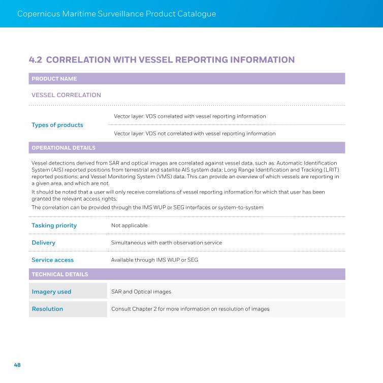
PRODUCT NAME
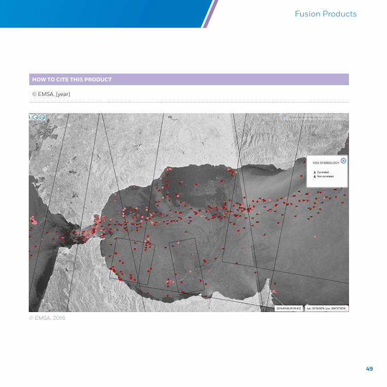
VESSEL CORRELATION
Types of productsVector layer: VDS correlated with vessel reporting information
Vector layer: VDS not correlated with vessel reporting information
OPERATIONAL DETAILS
Vessel detections derived from SAR and optical images are correlated against vessel data, such as: Automatic Identification System (AIS) reported positions from terrestrial and satellite AIS system data; Long Range Identification and Tracking (LRIT) reported positions; and Vessel Monitoring System (VMS) data. This can provide an overview of which vessels are reporting in a given area, and which are not.
It should be noted that a user will only receive correlations of vessel reporting information for which that user has been granted the relevant access rights.
The correlation can be provided through the IMS WUP or SEG interfaces or system-to-system
Tasking priority Not applicable
Delivery Simultaneous with earth observation service
Service access Available through IMS WUP or SEG
TECHNICAL DETAILS
Imagery used SAR and Optical images
Resolution Consult Chapter 2 for more information on resolution of images
4.2 CORRELATION WITH VESSEL REPORTING INFORMATION
49
Copernicus Maritime Surveillance Product Catalogue
© EMSA, 2016
HOW TO CITE THIS PRODUCT
© EMSA, [year]
Fusion Products
50
Copernicus Maritime Surveillance Product Catalogue
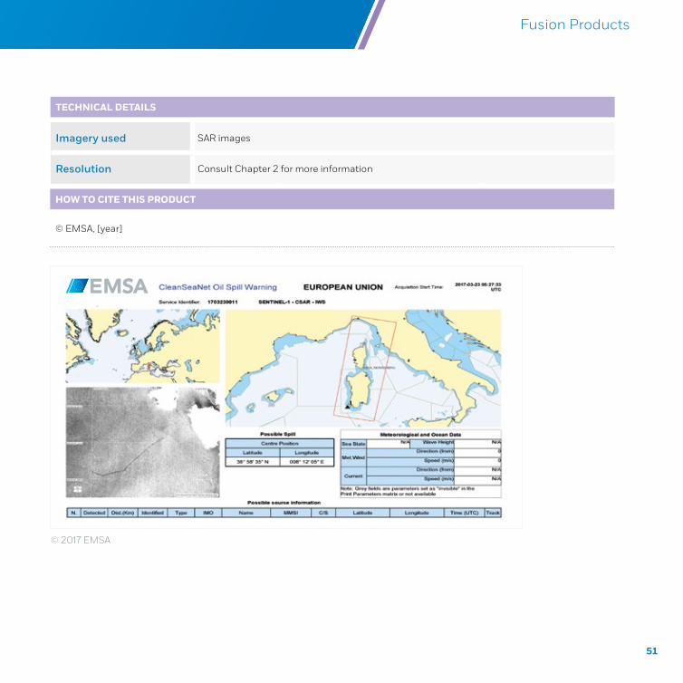
4.3 OIL SPILL ALERT REPORTS
PRODUCT NAME
OIL SPILL
Types of productsOil spill warning
Oil spill alert report
OPERATIONAL DETAILS
These products are based on the near real-time analysis of satellite images in order to detect possible oil spills on the sea surface. When a possible spill is detected within the alert area of a participating coastal state, an alert is immediately sent to the relevant authorities.
There are two types of notifications:
1. An ‘Oil spill warning report is sent immediately, without waiting for the end of image analysis, if there is the possibility of catching a polluter in the act.
2. If there is no ongoing spill, a full ‘Oil spill alert report’, providing a more complete analysis and details of all spills detected in the area, is sent.
Tasking priority Not applicable
Delivery During analysis/following analysis; near real time delivery approximately 30 minutes depending on image size
Service access Available through the EODC Alerting and emailed PDF alert report
51
Copernicus Maritime Surveillance Product Catalogue Fusion Products
TECHNICAL DETAILS
Imagery used SAR images
Resolution Consult Chapter 2 for more information
HOW TO CITE THIS PRODUCT
© EMSA, [year]
© 2017 EMSA
52
Copernicus Maritime Surveillance Product Catalogue
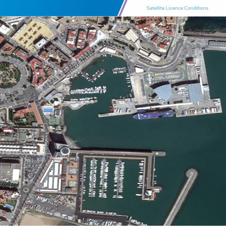
ANNEX I
SATELLITE LICENCE CONDITIONS
53
Copernicus Maritime Surveillance Product Catalogue
OVERVIEW
States are responsible under international law for regulating their space activities and ensuring that national activities, even if conducted by non-State actors such as corporations, respect international law. Authorisation is given by the State in the form of a licence to parties conducting space-related activities.
National regulations, which differ between States, supplement this international framework. At a national level, States have the prerogative – within the constraints set by International Law – to regulate, authorise, licence and supervise space activity. States exercise this power with two main objectives: 1) to protect national security and safeguard national interest; and 2) to gain priority access for government purposes to use of space capabilities.
There are two main types of restrictions imposed on satellite owners and operators: on data collection, and/or on data dissemination. This means that, depending on the licence conditions imposed and on national security legislation in the data provider’s country, there may be restrictions applied to end-users from certain countries and/or restrictions regarding the area over which an image is taken depending on the resolution of the image. For end-users of the Copernicus Maritime Surveillance service, who comprise European Union bodies and institutions and EU Member State national authorities, few such restrictions apply. End-users or potential end-users are encouraged to contact EMSA to discuss whether restrictions will apply to their requests.
The licence conditions also detail the authorised or permitted use of products6. Users are encouraged to contact EMSA if they require more information.
Satellite Licence Conditions
6 Only clauses which may interest external stakeholders have been listed, not clauses related to internal EMSA use; the permitted uses are more extensive then listed here.
54
Copernicus Maritime Surveillance Product Catalogue
SENTINEL-1A AND SENTINEL-1B IMAGE PRODUCTS
DISTRIBUTION RESTRICTIONS AND AUTHORISED OR PERMITTED USE OF PRODUCTS
Copernicus Sentinel-1 data is, in principle, provided to users on a free, full and open access basis to users with regards to Copernicus Sentinel Data and Service Information. The ‘Legal notice on the use of Copernicus Sentinel Data and Service Information’ (see https://sentinels.copernicus.eu/documents/247904/690755/Sentinel_Data_Legal_Notice) does however state that ‘EU law allows for specific limitations of access and use in the rare cases of security concerns, protection of third party rights or risk of service disruption’. Furthermore, it is worth noting that EMSA provides Copernicus Sentinel data to registered users of the Copernicus Maritime Surveillance service with a shorter time delay than that with which it is available through other services or to users accessing data via the Sentinel Data Hub. Sentinel 1 data is provided to users through the CMS service following near real time acquisition and additional processing undertaken by service providers.
RADARSAT-2 IMAGE PRODUCTS
DISTRIBUTION RESTRICTIONS
MacDonald, Dettwiler and Associates Ltd (MDA) is the licence provider for RADARSAT-2 products. MDA defines authorised end users according to an extensive Customer Access Profile, which determines what can be provided to any particular user type, and under what conditions. These range from full access with no latency for certain categories of users, to no access. For example, EU Member State and EFTA Government Users and EU Institution Government Users have full access to all products with no latency; whereas Government Users from other countries may be eligible to receive only certain categories of products, only after a latency period (e.g. 24 or 72 hours), or only over the territory – including the exclusive economic zone (EEZ) – under the jurisdiction of the national government of that country. Furthermore, the delivery of RADARSAT-2 products to end-users is also subject to other mandatory conditions defined in the License Distribution.
55
Copernicus Maritime Surveillance Product Catalogue
AUTHORISED OR PERMITTED USE OF PRODUCTS
For RADARSAT-2, MDA lists the following permitted uses, among others:
excluding SLC Data7 - to release hardcopy prints of the Product, publish the Product in research reports, journals, trade papers or similar publications, and post the Product or DIP, to Internet web sites provided that such Product is in a secure format that allows only printing and viewing and prohibits manipulating the Product’s pixel or metadata; all providing that such release, publishing or posting is solely for non-commercial uses and that the Copyright notice is conspicuously displayed alongside the Product; and
subject to provisions - to develop, reproduce and distribute any Value Added Product generated from the Product by the LICENCEE.
TERRASAR-X/TANDEM-X/PAZ IMAGE PRODUCTS
DISTRIBUTION RESTRICTIONS
Airbus DS Geo GmbH (Germany) has exclusive distribution rights for the provision of licences for TerraSAR-X/TanDEM-X/PAZ products. The following restrictions apply:
Distribution of TerraSAR-X and TanDEM-X data has to comply with the regulations of the German Satellite Data Security Law (SatDSiG). Data may be subject to restrictions because of the area over which the image is taken and/or the resolution of the image; the restricted countries are listed in the contract conditions. Data downlinked to Direct Receiving Stations (DRS) are subject to more stringent conditions. The Federal Office of Economics and Export Control (BAFA) has added EMSA to a ‘Recipients Positive List’, which means that EMSA’s requests are considered non-sensitive (i.e. are not forwarded to BAFA for approval) as long as the acquisition is not over one of the countries in the restricted list
With regard to PAZ, national Spanish legislation is still being drafted.
7 Single Look Complex (SLC) data is data which has been processed in a specific way
Satellite Licence Conditions
56
Copernicus Maritime Surveillance Product Catalogue
AUTHORISED OR PERMITTED USE OF PRODUCTS
Under the contract with Airbus DS GEO GmbH, EMSA has, for TerraSAR-X, TanDEM-X and PAZ, the following limited, non-transferable and non-exclusive rights under the condition that the “Products” are for non-commercial use, and the proper copyright is conspicuously marked:
To reformat the “Products” into different formats or media from those in which it is delivered. EMSA shall not or allow anyone to reverse engineer, disassemble or decompile the Product;
To use the “Products” for further analysis and/or processing and/or to create ‘Further Processed Data’;
To modify/process the “Products” through manipulation/processing techniques and/or the addition of other data, provided that the value-added products generated from data or “Products” do not retain the pixel structure of the original data or “Products” and include a significant addition of external information
To provide to all authorised end users of the EMSA service the “Products” in full resolution and derived information;
EMSA may
post “Products” to Internet websites provided that the “Products” are in a secure format that allows only printing and viewing and prohibits, at current technical standard, manipulating the “Product’s” pixel or metadata; and
make public presentation or display or display the data; and
communicate them through press information services
The proper copyright has always to be marked conspicuously.
To distribute hard-copies “Products” on a non-commercial basis to all authorised end users. These hard-copy “Products” can also be distributed, on a non-commercial basis to International Organisations, which are involved in oil spill monitoring and maritime surveillance provided that the proper copyright is conspicuously marked.
57
Copernicus Maritime Surveillance Product Catalogue
To use the “Products” for internal or external demonstration purposes, including as evidence or for other purposes in legal or administrative proceedings, on a non-commercial basis provided that such “Products” is not distributed, sold, leased, rent, sub-licensed, copied, transferred, reproduced or given in whole or in part.
PLEIADES 1A AND 1B, AND SPOT 6 AND 7 IMAGE PRODUCTS
Under the contract with Airbus DS GEO SA (France) for licences and services, EMSA can use and distribute products (meaning satellite images and derived products containing imagery data) from PLEIADES and Spot to authorised users. These include European Union institutions, agencies and bodies, and Member States’ institutions, other than those to which restrictions apply, as listed below.
DISTRIBUTION RESTRICTIONS
The data in the products remains the property of the satellite owner/operator, and so different end user licenses are applicable, as follows:
Centre National D’Etudes Spatiales for Pleiades satellite imagery dataThe end-users may not be established, incorporated or located in the following restricted territories: Canada and Japan
Airbus DS for Spot 6 and 7 satellite imagery dataThe end-users may not be established, incorporated or located in the following restricted territories: Canada, Azerbaijan, Georgia, Iran, Kyrgyzstan, Moldavia, Tajikistan, Turkmenistan, Uzbekistan and Japan
AUTHORISED OR PERMITTED USE OF PRODUCTS
For Pleiades and Spot products, Airbus DS GEO SA lists the following permitted uses, among others:
to alter or modify the product to produce VAP [value added products] and/or derivative works
Satellite Licence Conditions
58
Copernicus Maritime Surveillance Product Catalogue
to post one extract8 on an Internet site, in an Internet-compatible image format (without associated metadata), with the credit… conspicuously displayed. The posting of such extract shall be used for end-user’s promotion purposes only, and may in no event allow downloading of the extract posted or allow a third party to access the product or VAP as a stand-alone file, nor be used to distribute, sell, assign, dispose of, lease, sublicense or transfer such extract
to print one extract, and to distribute such print for promotion purposes only. Such print shall include the credit… conspicuously displayed;
to freely use and distribute derivative works; and
to share the product and/or any VAP with affiliated end-users in the framework of a Joint Project, subject to the following cumulative conditions: the end-user shall have detailed in the order form accepted by AIRBUS DS:
the name, legal structure, site address of each affiliated end-user;
the details of the Joint Project in which the end-user and the affiliated end-users are cooperating and for which the product is ordered; the end-user shall sign with each affiliated end-user an agreement under which;
each affiliated end-user may be granted the rights provided under [the paragraphs] above;
the terms and conditions of such agreement shall in no event be less protective to AIRBUS DS and its licensor’s respective rights than the provisions of this EULA; and the end-user shall guarantee that each affiliated end-user complies with the provisions and restrictions provided in the present EULA, and shall indemnify and hold AIRBUS DS harmless in connection thereto.
8 “EXTRACT”: means an extract of a PRODUCT or VAP which may consist of: (v) an extract of 1 024 x 1 024 pixels maximum; or (vi) if supplied with the PRODUCT (preview file) by Deimos IMAGING, the sub-sample (ratio 32 toward original PAN (8 toward original XS) ) of the original image of the PRODUCT

59
Copernicus Maritime Surveillance Product Catalogue
DEIMOS-1 AND DEIMOS-2 IMAGE PRODUCTS
DEIMOS-1 and DEIMOS-2 are owned and operated by Deimos Imaging (an Urthecast company). Deimos satellite imagery data is made available to EMSA through contracts with Airbus DS GEO SA and European Space Imaging GmbH.
DISTRIBUTION RESTRICTIONS
There are no distribution restrictions; however for countries involved in conflicts or subject to embargo or commercial sanction by the international community, this must be evaluated on a case by case basis by Deimos Imaging.
AUTHORISED OR PERMITTED USE OF PRODUCTS
For Deimos products, Airbus DS GEO SA lists the following permitted uses, amongst others:
to alter or modify the product to produce VAP [value added products] and/or derivative works
to post one extract9 on an Internet site, in an Internet-compatible image format (without associated metadata), with the credit… conspicuously displayed. The posting of such extract shall be used for end-user’s promotion purposes only, and may in no event allow downloading of the extract posted or allow a third party to access the product or VAP as a stand-alone file, nor be used to distribute, sell, assign, dispose of, lease, sublicense or transfer such extract
to print one extract, and to distribute such print for promotion purposes only. Such print shall include the credit conspicuously displayed
to freely use and distribute derivative works, and
Satellite Licence Conditions
9 “EXTRACT”: means an extract of a PRODUCT or VAP which may consist of: (v) an extract of 1 024 x 1 024 pixels maximum; or (vi) if supplied with the PRODUCT (preview file) by Deimos IMAGING, the sub-sample (ratio 32 toward original PAN (8 toward original XS) ) of the original image of the PRODUCT
60
Copernicus Maritime Surveillance Product Catalogue
to share the product and/or any VAP with affiliated end-users in the framework of a Joint Project, subject to the following cumulative conditions, the end-user shall have detailed in the order form accepted by Deimos IMAGING:
the name, legal structure, site address of each affiliated end-user
the details of the Joint Project in which the end-user and the affiliated end-users are cooperating and for which the product is ordered; the end-user shall sign with each affiliated end-user an agreement under which
each affiliated end-user may be granted the rights provided under [the paragraphs] above
the terms and conditions of such agreement shall in no event be less protective to Deimos IMAGING and its licensor’s respective rights than the provisions of this EULA; and the end-user shall guarantee that each affiliated end-user complies with the provisions and restrictions provided in the present EULA, and shall indemnify and hold Deimos IMAGING harmless in connection thereto.
When DEIMOS-2 products are supplied via European Space Imaging, the standard Deimos Unlimited/Broadcast User License applies. Under Permitted Uses, the Licensee may:
LICENSEE may:
make an unlimited number of soft and hard copies of the Product
alter or modify the Product to produce Value Added Products and/or Derivative Works
freely use the Product and Value Added Products for any purpose (including commercial purposes), which for greater certainty includes any internal purpose and the right to publicly post, publish and broadcast the Product and Value Added Products in any manner, provided that the Product and Value Added Products are in a secure format that prohibits manipulating the Product’s and Value Added Products’ pixel or metadata, and
freely use and distribute Derivative Works.

61
Copernicus Maritime Surveillance Product Catalogue
WORLDVIEW 1, 2, 3 AND 4, AND GEOEYE-1 IMAGE PRODUCTS
European Space Imaging GmbH owns European distribution rights for DigitalGlobe satellites. These include: WorldView 1, 2, 3 and 4; GeoEye-1.
DISTRIBUTION RESTRICTIONS
Use of data from these satellites must comply with the NOAA License (which is in accordance with U.S. laws and national security interests). More specifically, DigitalGlobe and EUSI imagery may not be supplied to any persons listed at http://www.bis.doc.gov/dpl/default.shtm and http://www.treas.gov/offices/enforcement/ofac/sdn/ or any individual or entity in the following embargoed countries: http://www.treas.gov/offices/enforcement/ofac/programs/, or to any of the entities on the denied persons lists published by the Bureau of Industry and Security of the United States.
AUTHORISED OR PERMITTED USE OF PRODUCTS
The Group License from European Space Imaging (the certified reseller of DigitalGlobe) allows authorised users to, amongst other uses10:
to use and develop Derivatives of the Products as permitted in Section 2 below solely for Customer’s Internal Use; and to store, access, reproduce and display the Products and permitted Derivatives solely for Customer’s Internal Use. In addition, Customer may display an extract of the Product or a permitted Imagery Derivative on a public website in a non-extractable and non-downloadable manner as follows:
on one domain name
2 048 x 2 048 pixels
at a resolution no better than resolution of imagery in the Product
png, .tif, .tiff, .gif, .jpg, .jpeg, .jpe, .jfif, .bmp, .pdf; or any format without geo-referencing information
Satellite Licence Conditions
10 See full terms here: https://www.digitalglobe.com/legal/group-license
62
Copernicus Maritime Surveillance Product Catalogue
only collection date/time, vehicle, and band combination metadata can be published with the extract, and
properly attribute the imagery to DigitalGlobe as required… [[Product] © [YEAR] DigitalGlobe, Inc.]]
USE AND DEVELOPMENT RIGHTS. The license granted… above includes the following use and development rights:
VIEW. Customer may view the Products and create new imagery from the Products via formatting, editing, digitization, and/or data combination (each, an “Imagery Derivative”), and
ANALYSIS. Customer may extract geographic features, human-made features, persons or animals and related data from the Products via identification, measurement, and/or analysis (each, a “Feature Derivative”).
LANDSAT
Landsat data is in the public domain, and is free and open to the public.
RESULTS OF THE EXPLOITATION OF THE CONTRACTS
EMSA acquires ownership of the results of the exploitation of the contracts, where ‘results’ means any intended outcome of the performance of the contract which is delivered and finally accepted by EMSA. EMSA does not acquire ownership of the pre-existing rights. Without prejudice to the restrictions imposed by the contractors, EMSA may make these results available to Union institutions, agencies and bodies, and Member States’ institutions, and may distribute them to the public in any form and by any method.
63
Copernicus Maritime Surveillance Product Catalogue Satellite Licence Conditions
64
Copernicus Maritime Surveillance Product Catalogue
ANNEX II
IMAGE CREDITS
65
Copernicus Maritime Surveillance Product Catalogue Image Credits
OPTICAL SATELLITE DATA
EMSA has a contract with Airbus DS GEO SA for licences and services for PLEIADES 1A/1B, Spot 6/7, and DEIMOS-1 and DEIMOS-2 missions. When acquired via Airbus DS GEO SA, the Product, when displayed, distributed, made available and/or printed shall include the following credit conspicuously displayed:
PLEIADES 1A and 1B: “© CNES (year of acquisition), Distribution Airbus DS”
Spot 6 and 7: “© Airbus DS (year of acquisition)”
DEIMOS-1 and DEIMOS-2: “© Deimos Imaging (year of acquisition), Distribution Airbus DS”
EMSA has a contract with European Space Imaging GmbH for licences and services for WorldView 1-4, GeoEye-1, Landsat, and DEIMOS-2 missions. When acquired via European Space Imaging GmbH, the following credits should be applied when the product is displayed:
WorldView: “© European Space Imaging/DigitalGlobe (year of acquisition)”
GeoEye: “© European Space Imaging/DigitalGlobe (year of acquisition)”
Landsat 8: “Landsat 8 data courtesy of the U.S. Geological Survey”
DEIMOS-1 and DEIMOS-2: “© Deimos Imaging (year of acquisition)”
SYNTHETIC APERTURE RADAR DATA
For the SAR missions available through the Copernicus Maritime Surveillance service, the copyright notices/credits are determined by the satellite owner/operator and licence provider:
For Copernicus Sentinel data: “Copernicus Sentinel data (year of acquisition)”
66
Copernicus Maritime Surveillance Product Catalogue
For RADARSAT-2 data: “RADARSAT-2 Data and Products © MacDONALD, DETTWILER AND ASSOCIATES LTD (year of acquisition) – All Rights Reserved” and “RADARSAT is an official mark of the Canadian Space Agency”
For TerraSAR-X data: “© DLR e.V. (year of acquisition), Distribution Airbus DS Geo GmbH”
EMSA DERIVED PRODUCTS AND VALUE ADDED PRODUCTS
If an end-user wishes to display an EO image product which has subsequently been overlaid with other information (e.g. value-adding products) or is provided through the means of a fusion product, or is conspicuously displayed in the context of the EMSA web interface, EMSA should be credited as follows:
Image credit: © EMSA, [year], contains modified [insert satellite mission and credit as relevant] data. All rights reserved. Certain parts are licenced under conditions to EMSA.
If an end-user wishes to display only the value added product or fusion product and/or if the EO image product has been further processed to such an extent that the original image product cannot be specifically identified, EMSA should be credited as follows:
Image credit: © EMSA, [year]. All rights reserved. Certain parts are licenced under conditions to EMSA.
67
Copernicus Maritime Surveillance Product Catalogue Image Credits
68
Copernicus Maritime Surveillance Product Catalogue
ANNEX III
ACRONYMS AND ABBREVIATIONS
69
Copernicus Maritime Surveillance Product Catalogue Acronyms and Abbreviations
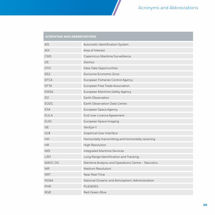
ACRONYMS AND ABBREVIATIONS
AIS Automatic Identification System
AOI Area of Interest
CMS Copernicus Maritime Surveillance
DE Deimos
DTO Data Take Opportunities
EEZ Exclusive Economic Zone
EFCA European Fisheries Control Agency
EFTA European Free Trade Association
EMSA European Maritime Safety Agency
EO Earth Observation
EODC Earth Observation Data Centre
ESA European Space Agency
EULA End User Licence Agreement
EUSI European Space Imaging
GE GeoEye-1
GUI Graphical User Interface
HH Horizontally transmitting and horizontally receiving
HR High Resolution
IMS Integrated Maritime Services
LRIT Long Range Identification and Tracking
MAOC (N) Maritime Analysis and Operations Centre – Narcotics
MR Medium Resolution
NRT Near Real Time
NOAA National Oceanic and Atmospheric Administration
PHR PLEIADES
RGB Red-Green-Blue
70
Copernicus Maritime Surveillance Product Catalogue
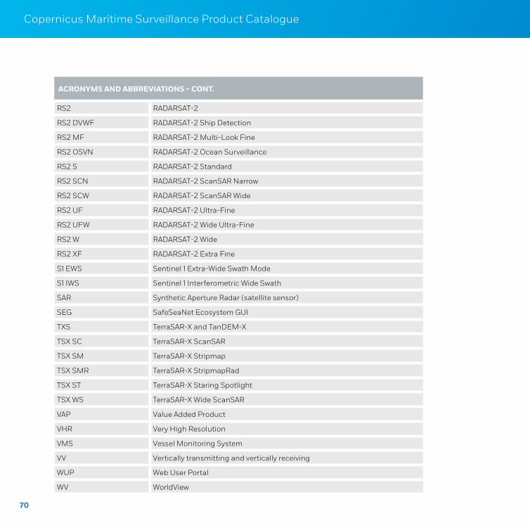
ACRONYMS AND ABBREVIATIONS - CONT.
RS2 RADARSAT-2
RS2 DVWF RADARSAT-2 Ship Detection
RS2 MF RADARSAT-2 Multi-Look Fine
RS2 OSVN RADARSAT-2 Ocean Surveillance
RS2 S RADARSAT-2 Standard
RS2 SCN RADARSAT-2 ScanSAR Narrow
RS2 SCW RADARSAT-2 ScanSAR Wide
RS2 UF RADARSAT-2 Ultra-Fine
RS2 UFW RADARSAT-2 Wide Ultra-Fine
RS2 W RADARSAT-2 Wide
RS2 XF RADARSAT-2 Extra Fine
S1 EWS Sentinel 1 Extra-Wide Swath Mode
S1 IWS Sentinel 1 Interferometric Wide Swath
SAR Synthetic Aperture Radar (satellite sensor)
SEG SafeSeaNet Ecosystem GUI
TXS TerraSAR-X and TanDEM-X
TSX SC TerraSAR-X ScanSAR
TSX SM TerraSAR-X Stripmap
TSX SMR TerraSAR-X StripmapRad
TSX ST TerraSAR-X Staring Spotlight
TSX WS TerraSAR-X Wide ScanSAR
VAP Value Added Product
VHR Very High Resolution
VMS Vessel Monitoring System
VV Vertically transmitting and vertically receiving
WUP Web User Portal
WV WorldView
71
Copernicus Maritime Surveillance Product Catalogue Acronyms and Abbreviations
72
Copernicus Maritime Surveillance Product Catalogue

Copern
icus M
aritime S
urveillan
ce Produ
ct Catalogu
e
ABOUT THE EUROPEAN
MARITIME SAFETY AGENCYThe European Maritime Safety Agency is one of the European Union’s decentralised agencies. Based in Lisbon, the Agency’s mission is to ensure a high level of maritime safety, maritime security, prevention of and response to pollution from ships, as well as response to marine pollution from oil and gas installations. The overall purpose is to promote a safe, clean and economically viable maritime sector in the EU.
Copernicus is a European Union Programme aimed at developing European information services based on satellite Earth Observation and in-situ (non-space) data analyses. The Programme is coordinated and managed by the European Commission. It is implemented in partnership with the Member States, the European Space Agency (ESA), the European Organisation for the Exploitation of Meteorological Satellites (EUMETSAT), the European Centre for medium-range Weather Forecasts (ECMWF), EU Agencies and Mercator Océan.
ABOUT COPERNICUS
Get in touch for more information
Copernicuscopernicus.eu / Twitter CopernicusEU / Facebook Copernicus EU
European Maritime Safety AgencyPraça Europa 4 1249–206 Lisboa PortugalTel +351 21 1209 200 Fax +351 21 1209 210emsa.europa.eu Twitter EMSA_Lisbon