cooperative institute for climate and satellites...
TRANSCRIPT

i
COOPERATIVE INSTITUTE FOR
CLIMATE and SATELLITES (CICS)
Scientific Report
VOLUME I: ACTIVITIES SUMMARY
For the period:
April 1, 2012 – March 31, 2013
NOAA Grant NA09NES4400006
Dr. Phillip Arkin, Director
April 30, 2013
Volume I CICS Annual Report 2013
- ii -
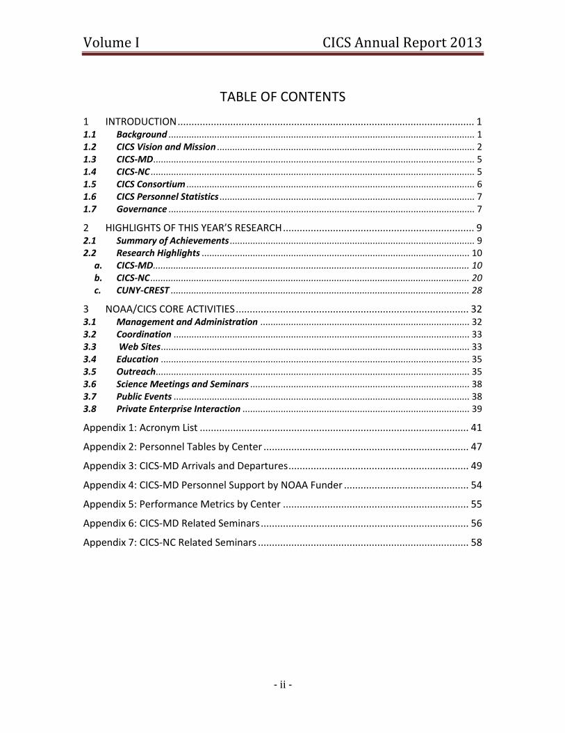
TABLE OF CONTENTS
1 INTRODUCTION ........................................................................................................... 1 1.1 Background ........................................................................................................................ 1 1.2 CICS Vision and Mission ..................................................................................................... 2 1.3 CICS-MD .............................................................................................................................. 5 1.4 CICS-NC ............................................................................................................................... 5 1.5 CICS Consortium ................................................................................................................. 6 1.6 CICS Personnel Statistics .................................................................................................... 7 1.7 Governance ........................................................................................................................ 7
2 HIGHLIGHTS OF THIS YEAR’S RESEARCH ..................................................................... 9 2.1 Summary of Achievements ................................................................................................ 9 2.2 Research Highlights ......................................................................................................... 10
a. CICS-MD ............................................................................................................................ 10 b. CICS-NC ............................................................................................................................. 20 c. CUNY-CREST ..................................................................................................................... 28
3 NOAA/CICS CORE ACTIVITIES .................................................................................... 32 3.1 Management and Administration .................................................................................. 32 3.2 Coordination .................................................................................................................... 33 3.3 Web Sites ......................................................................................................................... 33 3.4 Education ......................................................................................................................... 35 3.5 Outreach........................................................................................................................... 35 3.6 Science Meetings and Seminars ...................................................................................... 38 3.7 Public Events .................................................................................................................... 38 3.8 Private Enterprise Interaction ......................................................................................... 39
Appendix 1: Acronym List ................................................................................................. 41
Appendix 2: Personnel Tables by Center .......................................................................... 47
Appendix 3: CICS-MD Arrivals and Departures ................................................................. 49
Appendix 4: CICS-MD Personnel Support by NOAA Funder ............................................. 54
Appendix 5: Performance Metrics by Center ................................................................... 55
Appendix 6: CICS-MD Related Seminars ........................................................................... 56
Appendix 7: CICS-NC Related Seminars ............................................................................ 58
1
1 INTRODUCTION The annual report of the Cooperative Institute for Climate and Satellites (CICS) is divided into two volumes. The first is a summary of all the activities of CICS including the admin-istration and core tasks and the highlights of this year’s scientific research and opera-tional results, along with relevant appendices. The second volume is a compilation of reports on the over 100 individual CICS tasks that were undertaken this year for various National Oceanic and Atmospheric Administration (NOAA) funders, including the Center for Satellite Applications and Research (STAR); National Climatic Data Center (NCDC); Office of Oceanic and Atmospheric Research (OAR), National Oceanographic Data Cen-ter (NODC); Climate Program Office (CPO); National Weather Service (NWS); and Air Re-sources Laboratory (ARL). The acronyms in this report are compiled and defined in Ap-pendix 1.
1.1 Background The Cooperative Institute for Climate and Satellites (CICS) is a national consortium of academic, non-profit and community organizations with leadership from the University of Maryland, College Park (UMCP) and the University of North Carolina (UNC) System through North Carolina State University (NCSU). This partnership includes Minority Serving Institutions as well as others with strong faculties that enhance CICS' capability to contribute to NOAA's mission and goals. CICS has two principal locations, one on the M-Square Research Park campus of UMCP adjacent to the NOAA Center for Weather and Climate Prediction, and the other within the National Climatic Data Center. The two locations are referred to as CICS-MD, locat-ed in College Park MD, and CICS-NC, located in Asheville NC. CICS scientific vision centers on the observation, using instruments on Earth-orbiting satellites and in situ networks, and prediction using realistic mathematical models of the present and future behavior of the Earth System. In this context, observations include the development of new ways to use existing observations, the invention of new meth-ods of observation, and the creation and application of ways to synthesize observations from many sources into a complete and coherent depiction of the full system. Prediction requires the development and application of coupled models of the complete climate system, including atmosphere, oceans, land surface, cryosphere and ecosystems. Un-derpinning all of these activities is the fundamental goal of enhancing our collective in-terdisciplinary understanding of the state and evolution of the full Earth System. This vision is consistent with and supportive of NOAA's Strategic Goals, and CICS tasks com-prise research projects that advance NOAA objectives. In November 2012, NOAA conducted its midterm review of the Institute. The review panel concluded that CICS is addressing NOAA scientific and strategic needs related to climate and satellites. In most cases there is a clear path from research into operations.

Volume I CICS Annual Report 2013
- 2 -
CICS-NC is remarkably well-aligned with NOAA’s National Climatic Data Center. CICS-MD collocation supports broad connectivity between the University of Maryland, NOAA and NASA that is particularly important to support current and emerging satellite-related research and workforce planning. The Report of the Midterm Review Panel gave CICS a rating of outstanding, recommended a five-year renewal of the award, and was accept-ed by NOAA Science Advisory Board on March 28, 2013.
1.2 CICS Vision and Mission CICS' vision and mission derive from the historical expertise of the lead institutions and partners that comprise the CICS Consortium, together with NOAA's requirements. The CICS vision and mission are closely tied to NOAA’s Strategic Goals. VISION CICS’ vision is to perform collaborative research aimed at enhancing NOAA's ability to use satellite and in situ observations and Earth System models to advance the national climate mission, including monitoring, understanding, predicting, and communicating information on climate variability and change. MISSION CICS’ mission is to conduct research, education, and outreach programs in collaboration with NOAA to:
Develop innovative applications of national and international satellite observa-tions and advance transfer of such applications to enhance NOAA operational ac-tivities;
Investigate observations and design information products and applications to de-tect, monitor, and understand the impact of climate variability and change on coastal and oceanic ecosystems;
Identify and satisfy the climate needs of users of NOAA climate information products, including atmospheric and oceanic reanalysis efforts;
Improve climate forecasts on scales from regional to global through the use of observation-derived information products, particularly through participation in the Climate Test Bed at the National Centers for Environmental Prediction (NCEP);
Develop and advance regional ecosystem models, particularly aimed at the Mid-Atlantic region, to predict the impact of climate variability and change on such ecosystems; and
Establish and deliver effective and innovative strategies for articulating, com-municating, and evaluating research results and reliable climate change infor-mation to targeted public audiences.
Volume I CICS Annual Report 2013
- 3 -
The Research Themes for CICS are:
Theme 1: Climate and Satellite Research and Applications incorporates the de-velopment of new observing systems, or new climate observables from current systems.
Theme 2: Climate and Satellite Observations and Monitoring, focuses on: (a) development and improvement of climate observables from current systems, and (b) development of all continental and global fields of climate parameters that can be used for climate analysis and climate model initialization.
Theme 3: Climate Research and Modeling is the research component that brings together (a) climate observables, modeling and validation in a compre-hensive integrated whole, and (b) observational products with model develop-ment efforts to enable research into the improvement of forecasts of climate system variability on space scales ranging from regional to global, and time scales from a week or two to centuries.
Research is conducted through in situ and remotely sensed observations, together with component and coupled ocean-atmosphere-land modeling. This multi-pronged ap-proach provides a foundation for understanding and forecasting changes in the global environment and regional implications. Data assimilation and regional downscaling are used to link the observations and models, enabling us to study the interactions between the physical climate system and biogeochemical cycles from global to regional scales. The CICS Themes are unchanged from the original submitted proposal. As CICS research has evolved since 2009 in response to NOAA’s needs, Topic Areas have been identified as useful organizing devices. The table below illustrates the relationship between the Themes and the Topic Areas.

Volume I CICS Annual Report 2013
- 4 -
The total task funding for CICS research is $48.4 Million, an increase of more than $16 Million during the past year. In Figure 1 we summarize graphically the stratification of active task funding by CICS Research Theme and by NOAA Strategic Goal.
2012 CICS Research by Themes 2012 CICS Research by NOAA Goals
Funding (%) by CICS research theme and by NOAA goals.
Data Fusion and Algorithm Development
Theme 1: Climate and Satellite Re-search and Applications
Calibration / Validation
Climate Research, Data Assimi-lation and Modeling
Theme 2: Climate and Satellite Obser-
vations and Monitoring
Theme 3: Climate Research and Mod-
eling
Future Satellite Programs
Climate Data & Information Rec-ords
Scientific Data Stewardship
Earth System Monitoring from Satellites (Atmosphere, Land, Ocean, Cryosphere)
Land and Hydrology
Surface Observing Networks
National Climate Assessments
National Climate Model Portal
Education, Literacy, and Outreach
Climate Research, Data Assimi-lation and Modeling
Consortium Projects
Volume I CICS Annual Report 2013
- 5 -
1.3 CICS-MD CICS-MD is based upon the model and experience gained by UMCP through its man-agement of the Cooperative Institute for Climate Studies in collaboration with NOAA beginning in 1984. CICS-MD focuses on the collaborative research in satellite observa-tions and Earth System modeling conducted by STAR, which is part of the NOAA Na-tional Environmental Satellite, Data and Information Service (NESDIS) and NO-AA/NWS/NCEP. During the first several years of the award, CICS-MD has initiated addi-tional collaborations with other NOAA units in the Washington, DC area, including NODC and ARL. CICS-MD’s host organization is the Earth System Science Interdisciplinary Center (ESSIC), which is a joint center in the College of Computer, Mathematical, and Natural Sciences (CMNS) between the University of Maryland Departments of Atmospheric & Oceanic Science, Geology, and Geography, and the Earth Sciences Directorate at the National Aeronautics and Space Administration (NASA) Goddard Space Flight Center (GSFC). ESSIC seeks to understand better how the atmosphere-ocean-land-biosphere compo-nents of Earth interact as a coupled system and how human activities influence this sys-tem through re-search that concentrates on four major areas: climate variability and change; atmospheric composition and processes; the global carbon cycle (including ter-restrial and marine ecosystems/land use/cover change); and the global water cycle. ESSIC has fiduciary responsibility for CICS, provides the large majority of CICS-MD space, and hires and employs the majority of CICS-MD scientists and support staff. ESSIC has a cooperative agreement with NASA/GSFC that is in many respects similar to CICS. Since CICS-MD includes UMCP faculty, staff and students from several units, we have found it helpful to define CICS-MD members as faculty members who serve Task Lead-ers of a CICS task, individuals paid by a CICS task, and students and non-faculty employ-ees who have been paid from a CICS task. The Satellite Climate Studies Branch (SCSB) of NESDIS/STAR is collocated with CICS-MD in ESSIC, and so we also include the federal employees in the SCSB as CICS-MD members.
1.4 CICS-NC CICS-NC is an Inter-Institutional Research Center (IRC) of the UNC System, referred to as North Carolina Institute for Climate Studies (NCICS). It is administered by North Carolina State University (NCSU) and affiliated with all of the UNC academic institutions as well as a number of other academic and community partners. CICS-NC focuses primarily on the collaborative research into the use of in situ and remotely sensed observations in climate research and applications that is led by the National Climatic Data Center of NOAA/NESDIS. CICS-NC also is engaged in productive collaborative research with other NOAA elements, including the ARL Atmospheric Turbulence and Diffusion Division
Volume I CICS Annual Report 2013
- 6 -
(ATDD). CICS-NC includes numerous partners from academic institutions with specific expertise in utilizing satellite observations in climate research, applications, and models.
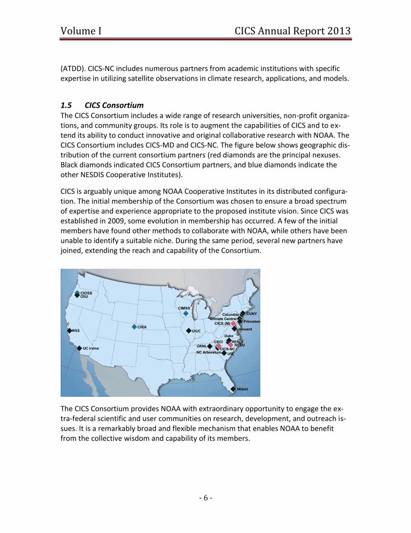
1.5 CICS Consortium The CICS Consortium includes a wide range of research universities, non-profit organiza-tions, and community groups. Its role is to augment the capabilities of CICS and to ex-tend its ability to conduct innovative and original collaborative research with NOAA. The CICS Consortium includes CICS-MD and CICS-NC. The figure below shows geographic dis-tribution of the current consortium partners (red diamonds are the principal nexuses. Black diamonds indicated CICS Consortium partners, and blue diamonds indicate the other NESDIS Cooperative Institutes).
CICS is arguably unique among NOAA Cooperative Institutes in its distributed configura-tion. The initial membership of the Consortium was chosen to ensure a broad spectrum of expertise and experience appropriate to the proposed institute vision. Since CICS was established in 2009, some evolution in membership has occurred. A few of the initial members have found other methods to collaborate with NOAA, while others have been unable to identify a suitable niche. During the same period, several new partners have joined, extending the reach and capability of the Consortium.
The CICS Consortium provides NOAA with extraordinary opportunity to engage the ex-tra-federal scientific and user communities on research, development, and outreach is-sues. It is a remarkably broad and flexible mechanism that enables NOAA to benefit from the collective wisdom and capability of its members.
Volume I CICS Annual Report 2013
- 7 -
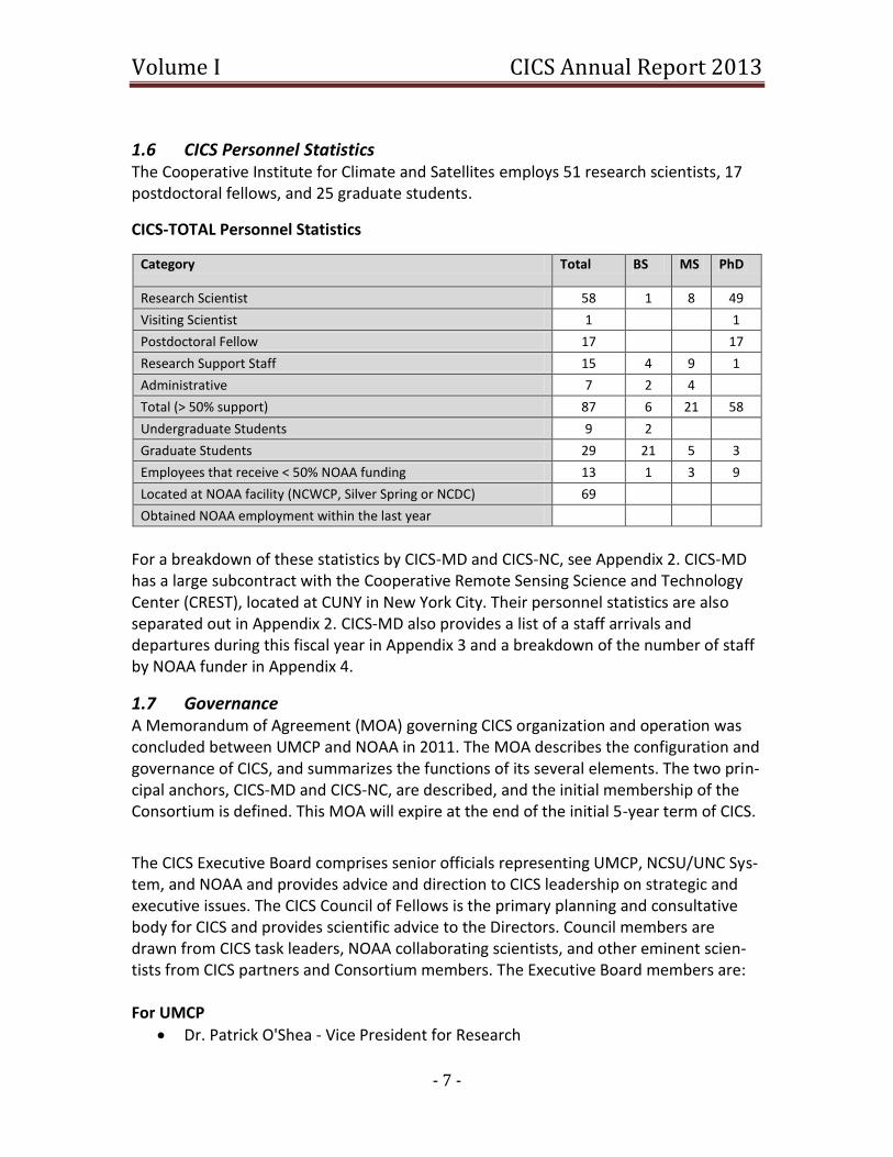
1.6 CICS Personnel Statistics The Cooperative Institute for Climate and Satellites employs 51 research scientists, 17 postdoctoral fellows, and 25 graduate students.
CICS-TOTAL Personnel Statistics
Category Total BS MS PhD
Research Scientist 58 1 8 49
Visiting Scientist 1 1
Postdoctoral Fellow 17 17
Research Support Staff 15 4 9 1
Administrative 7 2 4
Total (> 50% support) 87 6 21 58
Undergraduate Students 9 2
Graduate Students 29 21 5 3
Employees that receive < 50% NOAA funding 13 1 3 9
Located at NOAA facility (NCWCP, Silver Spring or NCDC) 69
Obtained NOAA employment within the last year
For a breakdown of these statistics by CICS-MD and CICS-NC, see Appendix 2. CICS-MD has a large subcontract with the Cooperative Remote Sensing Science and Technology Center (CREST), located at CUNY in New York City. Their personnel statistics are also separated out in Appendix 2. CICS-MD also provides a list of a staff arrivals and departures during this fiscal year in Appendix 3 and a breakdown of the number of staff by NOAA funder in Appendix 4.
1.7 Governance A Memorandum of Agreement (MOA) governing CICS organization and operation was concluded between UMCP and NOAA in 2011. The MOA describes the configuration and governance of CICS, and summarizes the functions of its several elements. The two prin-cipal anchors, CICS-MD and CICS-NC, are described, and the initial membership of the Consortium is defined. This MOA will expire at the end of the initial 5-year term of CICS.
The CICS Executive Board comprises senior officials representing UMCP, NCSU/UNC Sys-tem, and NOAA and provides advice and direction to CICS leadership on strategic and executive issues. The CICS Council of Fellows is the primary planning and consultative body for CICS and provides scientific advice to the Directors. Council members are drawn from CICS task leaders, NOAA collaborating scientists, and other eminent scien-tists from CICS partners and Consortium members. The Executive Board members are: For UMCP
Dr. Patrick O'Shea - Vice President for Research
Volume I CICS Annual Report 2013
- 8 -
Dr. Jayanth Banavar - Dean, College of Computational, Mathematical and Natural Sciences
Prof. Antonio Busalacchi - Director, ESSIC For NCSU/UNC System
Dr. Terri Lomax - Vice Chancellor, Research, Innovation and Economic Develop-ment, NCSU
Prof. Emeritus Ray Fornes - Professor of Physics, College of Physical and Mathe-matical Sciences, NCSU
Dr. Chris Brown - Vice President for Research and Graduate Education, UNC For NOAA
Dr. Al Powell, Director, NESDIS Center for Satellite Research and Applications
Dr. Wayne Higgins, Acting Director, NWS/NCEP
Dr. Michael Tanner, Deputy Director, NESDIS National Climatic Data Center
Dr. Richard Artz/Dr. Bruce Baker OAR Air Resources Laboratory Meetings of the Executive Board were held on October 1, 2012, and April 9, 2013. Both were held simultaneously in College Park, MD and Asheville, NC, linked by a video-conference system. The CICS Council of Fellows, in accordance with the MOA, advises the CICS leadership on research needs and opportunities related to CICS research themes, including but not limited to those at NOAA, CICS-MD, CICS-NC, and consortium academic institutions. The membership of the permanent Council includes approximately 36 CICS and NOAA scien-tists who are familiar with CICS research, meets at least annually to consider the CICS research portfolio. Focus groups drawn from the Council, and including NOAA managers where appropriate, are charged with evaluating CICS interaction with its NOAA partners and identifying innovative research opportunities. The Council of Fellows met this year in College Park, MD, on September 5, 2012. Discus-sion focused around possible roles for the Council, such as forming sub groups to identi-fy scientific priorities for CICS research, facilitating collaborations among CICS and NOAA scientists and organizations and attending and participating in CICS Executive Boards.
Volume I CICS Annual Report 2013
- 9 -
2 HIGHLIGHTS OF THIS YEAR’S RESEARCH 2.1 Summary of Achievements This year we added new metrics to reflect the large involvement of CICS in the transfer of research to operations, including both the number of new and improved products that were developed. Our efforts to communicate our scientific discoveries and techno-logical innovations to other scientists are measured by publications and presentations. CICS also continues to train the next generation of NOAA scientists.
Performance Metrics TOTAL FY12
# of new or improved products developed 165
# of products or techniques transitioned from research to ops 46
# of peer reviewed papers 139
# of non-peered reviewed papers 55
# of invited presentations 198
# of graduate students supported by a CICS task 21
# of undergraduate students supported by a CICS task 21
These metrics are a first attempt to quantify the annual accomplishments of CICS. This table is a sum of the performance metrics reported by individual task leaders and may contain errors or duplications. No auditing or verification of the results was performed. The CICS directors are currently evaluating, clarifying, and developing these metrics to better meet the needs of NOAA funders for budget accountability. Performance metrics broken out for CICS-MD, CICS-NC, and CUNY-CREST are included in Appendix 5. Each task report in Volume 2 of this report also has a performance metrics table.
The authorship for both peer reviewed and non-peer reviewed papers are broken down in the following table to highlight CICS and NOAA lead authors.
CICS Publication Statistics
Publications Institute Lead
Author NOAA Lead
Author Other Lead
Author
Peer Reviewed 32 7 100
Non-Peer Reviewed (includes vide-os and invited presentations)
110 14 129

Volume I CICS Annual Report 2013
- 10 -
2.2 Research Highlights In the following sections we summarize the research highlights from the past twelve months of this agreement. a. CICS-MD These highlights for CICS-MD are segmented according to topic and NOAA partner. Fun-ders from NESDIS include STAR, NCDC, NODC, OSD (Office of Systems Development), GOESPO (GOES-R Program Office), and JPSSO (JPSS Office). Other NOAA funders include ARL, CPO, CPC (Climate Predictions Center), and NWS.
Data Fusion & Algorithm Development GOES SST Enhanced Cloud Clearing and Accuracy Updates: Code for increasing the reso-lution of the input atmospheric profile data for the GOES (Geostationary Orbiting Envi-ronmental Satellite) sea surface temperatures (SST) product has been developed, tested and supplied to NESDIS Operations and this improvement is already being assessed for operational implementation. [NESDIS/OSD] Microwave and Diurnal Corrected Blended SST: The experimental version of the 0.05° × 0.05° resolution version of the analysis has been successfully transferred to operations. [NESDIS/OSD] Development of a 4-km Snow Depth Product for the Version 3 Interactive Multi-Sensor Snow and Ice System (IMS-V3): A new 4-km global snow depth analysis has been devel-oped and is being integrated into NOAA’s Interactive Multi Sensor Snow and Ice Map-ping System (IMS). Main utility is ingestion into Numerical Weather Prediction (NWP) models by NCEP for its Global Forecast System (GFS) land surface initialization. [NESDIS/OSD] Developing GOES-R Land Surface Albedo Product: A new methodology of data fusing multiple existing satellite albedo products was developed and implemented resulting on a significant reduction of the inconsistency and uncertainty of different albedo datasets. [STAR] Combining GLM and ABI Data for Enhanced GOES-R Rainfall Estimates. CICS scientists developed a new satellite rainfall retrieval technique for use in GOES-R using a combina-tion of infrared (IR) data and lightning information from the Geostationary Lightning Mapper (GLM) and Advanced Baseline Imager (ABI). The new technique significantly re-duces biases and uncertainties compared to the infrared technique. [NESDIS/GOESPO]
Volume I CICS Annual Report 2013
- 11 -
Calibration/Validation Satellite Calibration and Validation (Cal/Val) efforts for STAR Precipitation Products Task: The Advanced Microwave Sounding Unit (AMSU) snowfall rate product was extensively evaluated with in-situ and stage IV precipitation data. Evaluation results showed rea-sonable agreement with reference data. The product was approved for operational ap-plications. [STAR] Evaluation of Megha-Tropiques (M-T) Products: Continued evaluation of the quality of the satellite data from the Spectrometer Arrangement for Photon Induced Reactions (SAPHIR) and Multi-Frequency Microwave Scanning Radiometer (MADRAS) instruments aboard the Megha-Tropiques satellite. [STAR] Global Space-based Inter-Calibration System (GSICS) Framework using CrIS Sensor Data Records (SDR): CICS scientists developed methods that use inter-sensor calibration to evaluate and improve radiometric, spectral, and geolocation accuracy of Cross-track In-frared Sounder (CrIS) Sensor Data Records (SDR), which are fundamental for the GSICS Framework. [STAR]
A Recalibration of the AVHRR data record to provide an accurate and well parameterized Fundamental Climate Data Record (FCDR): A new Advanced Very High Resolution Radi-ometer (AVHRR) calibration is being derived to reduce known scene and time depend-ent biases. Infrared Atmospheric Sounding Interferometer (IASI) and (Advanced) Along Track Scanning Radiometer [(A)ATSR] sensors are used as accurate top-of-atmosphere (TOA) radiance source to determine the corrections to be used so that, for example, the (A)ATSR can be used as a climate TOA reference. [NCDC]
Satellite Calibration and Validation (Cal/Val) efforts for STAR Precipitation Products: A precipitation Cal/Val center has been established at CICS and is maintained to provide critical validation information on a range of NESDIS datasets including Microwave Inte-grated Retrieval System (MiRS) estimates from several sensors such as the Advanced Technology Microwave Sounder (ATMS) on the National Polar Orbiter Environmental Satellite System (NPOESS) Preparatory Project (NPP) satellite. [STAR]
Support for NPP and Joint Polar Satellite System (JPSS) GSICS: 1) Performed calibration accuracy evaluation of Advanced Microwave Scanning Radiometer 2 (AMSR2) meas-urements by using “Double Difference” method; 2) It was found that the scan biases of Defense Meteorological Satellite Program (DMSP) satellites F-16 and F-18 are depend-ent on ascending and descending nodes; 3) it is important to add the cloud liquid water contributions for simulating Global Positioning System Radio Occultation (GPSRO) re-fractivity in cloudy conditions, especially in the Hurricane Genesis stage. [STAR]
Volume I CICS Annual Report 2013
- 12 -
Science and Management Support for NPP Visible/Infrared Imager Radiometer Suite (VIIRS) Aerosol Optical Thickness (AOT), Aerosol Particle Size Parameter (APSP), and Sus-pended Matter (SM): CICS scientists maintained, evaluated, and improved the current operational Suomi-National Polar-orbiting Partnership (S-NPP) VIIRS aerosol products, by closely monitoring global aerosol observations, conducting intense calibration and validation of the products to evaluate data maturity, developing and implementing new schemes to improve global aerosol retrievals, and supporting research and application communities on data use. [STAR] Microwave Surface and Precipitation Products System (MSPPS) Meteorological Opera-tional Polar Satellite-B (Metop-B) Readiness: A scan bias correction scheme for Metop-B Advanced Microwave Sounding Unit-A (AMSU-A) window channels has been developed and verified using MSPPS suites. This scheme has been transitioned to operations. [STAR] GOES-R Calibration Working Group (CWG) Support: CICS scientists support Calibration and Validation work for GOES-R ABI instrument through lunar calibration and long-term monitoring of radiometric parameters at desert areas. [STAR] NPP VIIRS Cal/Val Support: CICS scientists support calibration and validation work for NPP VIIRS instrument through developing routine Simultaneous Nadir Overpass predic-tions web services, performing long-term instrument stability monitoring with lunar and vicarious calibration. [STAR] Wind Effects on Estimates of Sea Level Rise Offsite—A Retrospective Analysis of the In-tergovernmental Panel on Climate Change (IPCC) TAR (Third Assessment Report) and FAR (Fourth Assessment Report) Model Projections of Sea Level Rise: Continued to quan-tify the impact of components of sea level rise through analysis of coupled atmosphere-ocean-land climate models, observations, and surface forced ocean simulations. [STAR]
Surface Observation Networks Participation in Climate Research Activities at the Air Resources Laboratory NOAA: In 2012, CICS hired six research scientists working with NOAA’s ARL. They are making air quality measurements and forecasts that complement ongoing atmospheric chemistry studies at UMD. [ARL] Assessment of Global Oceanic Net Freshwater Flux Products Using Argo Salinity Observa-tions: Ten E - P (Evaporation minus Precipitation) sets were examined employing ocean rain gauges as a valid reference. The combination of E- P from the Objectively Analyzed Air-Sea Fluxes (OAFlux) Project/Tropical Rainfall Measuring Mission (TRMM) has the best agreement for the annual mean spatial distribution. The zonal averaged analysis
Volume I CICS Annual Report 2013
- 13 -
indicates that direct estimate products likely overestimate in their high value regions. [STAR]
Future Satellite Programs Observing System Simulation Experiments (OSSEs) for an Early-Morning-Orbit Meteoro-logical Satellite: Simulated environment experiments demonstrated that the loss of DMSP/F-16 could have significant negative effects on medium-range forecasts, and that two of three proposed follow-on missions would have significant positive impacts. [NWS] GOES-R/JPSS Proving Ground Support: Michael Folmer has lead the GOES-R and JPSS Proving Ground activities at the NOAA Center for Weather and Climate Prediction (NCWCP) since May 2011. Proving grounds provide forecasters and researchers the op-portunity to evaluate new satellite technologies in every day operations. [NESDIS/GOESPO]
Future Satellite Programs: GOES-R Validation of Cryospheric Environmental Data Records (EDRs) for the Global Change Ob-servation Mission (GCOM): The AMSR2 instrument was launched on May 18, 2012 onboard the GCOM 1st - Water (GCOM-W1) satellite. A suite of AMSR2 operational al-gorithms are being developed for the retrieval of snow cover, snow depth and Snow Water Equivalent (SWE) using heritage Advanced Microwave Scanning Radiometer - EOS (AMSR-E) data as proxy. [STAR] Application of the GOES-R Land Surface Temperature Product for Snowmelt Mapping: A snowmelt detection technique for the future GOES-R ABI sensor has been developed using GOES-13 and VIIRS data as proxy. [STAR] GOES-R Radiometric Calibration: A time-series based algorithm was developed for as-sessing sensor degradation; the algorithm removes the variability in TOA reflectance without using ancillary information. [STAR] Development of Longwave Radiation Budget Products for GOES-R ABI: The GOES-R ABI longwave earth radiation budget (ERB) products have been implemented in the GOES-R Framework. The offline four-month extended validation for Outgoing Longwave Radia-tion (OLR) has been performed with results consistent to earlier evaluations but the Deep Dive Validation Tool has demonstrated possibility of catching production errors. [STAR]
Volume I CICS Annual Report 2013
- 14 -
Land Surface Temperature Diurnal Analysis to Validate the Performance of GOES-R Ad-vance Baseline Imager: The work consists of statistical evaluation of angular anisotropy of Land Surface Temperature (LST), developing of algorithm for correcting GOES-R re-trieved LST for angular anisotropy, and testing the algorithm using independent data. [STAR] Aircraft Observations in Support of GOES-R: Aircraft profiles were employed to deter-mine a relationship between fine particle mass concentrations measured at ground level and satellite aerosol optical depth. Satellite measurements of aerosol optical depth from NOAA satellites can now be used to fill gaps between monitors and between sam-pling times in the fine particle monitoring network. [ARL] Development of Algorithms for Shortwave Radiation Budget from GOES-R: A collocated database that matches Geostationary Earth Radiation Budget (GERB) reference observa-tions with the shortwave (SW) radiative flux algorithm products for ABI as driven with Moderate Resolution Imaging Spectroradiometer (MODIS) proxy data has been expand-ed to address issues of angular matching and algorithm evaluation. Visualization tools for validation have been developed. [STAR] GOES-R Active Fire/Hot Spot Characterization - Validation and Refinement of GOES-R/ABI Fire Detection Capabilities: Deep-dive active fire validation tool is being developed in support of GOES-R/ABI Fire Detection and Characterization (FDC) algorithm. Airborne reference data sets were developed using NASA airborne multispectral sensors flown over fires located in the Western United States. [STAR]
Future Satellite Programs: JPSS Enhancing Agricultural Drought Monitoring Using NPP/JPSS Land EDRs for the National Integrated Drought Information System (NIDIS): CICS scientists are developing methods to implement new Land EDRs from the NPP/JPPS system in the NASA Land Information System (LIS) to quantify the impacts of these new products towards improving agricul-tural drought and soil moisture monitoring. [STAR] Evapotranspiration and Drought Monitoring Using GOES-R Products for NIDIS: CICS sci-entists are developing methods to implement the two-source energy balance model, the Atmosphere-Land Exchange Inverse (ALEXI) model, using Meteosat Second Generation (MSG) data (e.g., LST, Leaf Area Index (LAI), and incoming solar radiation) as a proxy for future GOES-R products to monitor evapotranspiration and drought conditions over Eu-rope. [STAR] Development of a snowfall detection and rate algorithm for ATMS: A new method for snowfall detection and an improved technique for the retrieval of snowfall rate using
Volume I CICS Annual Report 2013
- 15 -
ATMS measurements are being developed. The new snowfall detection method uses principal components and logistic regression to compute the probability of snowfall. [STAR] Cross-track Infrared Microwave Sounder Suite (CrIMSS) Rain Flag: By comparing to a suite of datasets, defects of the CriMSS EDR rain flag have been found. A reasonable ini-tial and update set of MSPPS-like products for ATMS have been developed; the underlin-ing algorithm will be suitable as a substantial upgrade to the current CrIMSS rain flag. [STAR] Satellite Land Surface Temperature and Albedo Development: CICS scientists provided scientific support for Land Surface Temperature and Albedo products, which are the two key EDRs from VIIRS onboard NPP satellite. [STAR] Scientific Support for JPSS Instrument Calibration/Cloud Fraction: A linear combination of maximum and random overlapping scheme with a weighted factor that is a function of de-correlation length (Lcf) and separation distance was applied to assess cloud fraction for three representative layers. Use of the observation-constrained Lcf leads to an im-provement for high-level clouds, has a neutral impact for mid-level clouds and deterio-ration for low-level clouds. [STAR] Scientific Support for JPSS Instrument Calibration: Provide NPP/JPSS ATMS SDR calibra-tion/validation support. Develop NPP ATMS instrument performance long-term moni-toring and SDR data bias trending system. [STAR]
Climate Research, Data Assimilation and Modeling CICS Support of CPC’s Climate Monitoring and Prediction Activities: Investigated the be-havior of NCEP dynamical models during the Dynamics of the Madden-Julian Oscillation (DYNAMO) campaign period and documented differences and proposed some potential reasons for discrepancies from observation. The methodologies developed and knowledge gained are being applied and implemented to support the operational Global Tropics and Benefits Outlook. [CPC] Use of Local Ensemble Transform Kalman Filter (LETKF) Sensitivity to Detect the Origin of the NCEP “5-Day Forecast Dropouts” and Improve quality control (QC) of JPSS Instru-ments: An accurate Ensemble Forecast Sensitivity to Observations (EFSO) was developed and tested on the GFS with real observations showing that it can be used to detect ob-servation flaws within 12 to 24 hours. [NESDIS/JPSSO] Participation in Climate Research Activities at ARL: 1) CICS scientists have developed a novel observation-based dust identification approach and applied it to reconstruct long-
Volume I CICS Annual Report 2013
- 16 -
term dust climatology in the western United States; 2) CICS scientists have successfully proposed to combine the Suomi-NPP ocean color data and NOAA weather forecasting model to develop a new marine isoprene emission product. [ARL] Development of AMSU Climate Data Records: Geolocation Correction for all AMSU-A, AMSU-B, and Microwave Humidity Sounder (MHS) sensors aboard the NOAA Polar Or-biting Environmental Satellites (POES) has been achieved; Cross scan asymmetry for AMSU-A window channels has been characterized, corrected and verified; Inter-satellite calibration is on-going. [STAR]
Climate Data and Information Records/Scientific Data Stewardship Reconstruction of Global Phytoplankton Biomass: Tropical Pacific sea surface chlorophyll concentrations were reconstructed for the period 1958-2008 using physical proxies [SST, Sea Surface Height (SSH), and Mixed Layer Depth (MLD)]. It was found that decadal chlorophyll anomalies are dominated by the El Niño Southern Oscillation (ENSO) with some interesting exceptions. [STAR] Global Precipitation Climatology Project (GPCP) Data Products – Transfer to Operations at NCDC: Routine production of the well-used and highly cited GPCP V2.2 global precipi-tation dataset is being transferred from a distributed network of centers to NCDC. At the project’s conclusion, NCDC will be the operational producer of GPCP V2.2 at month-ly, pentad and daily resolutions and will be able to retrospectively process the entire record. [NCDC] CICS Support for the National Oceanographic Data Center: In 2012 CICS played a signifi-cant role in the development of improved satellite data products, working with the ocean science community to provide global and regional ocean data, and by validating new space-based ocean observing technologies. CICS enhanced NOAA’s ability to un-derstand, predict and communicate climate variability by data distribution and educa-tion through web based satellite data, detailed descriptions of these data and the World Ocean Database. [NODC] Operational Generation of the High-Resolution Infrared Radiation Sounder (HIRS) Out-going Longwave Radiation Climate Data Record: NOAA/NCDC Climate Data Record (CDR) Program has acquired the Initial Operational Capability (IOC) for HIRS OLR CDR Product and is moving toward Full Operational Capability (FOC), while CICS continues to take charge of maintaining science integrity and developing quality assurance (QA)/quality control (QC) system. In the coming year, we will be developing the 1°x1° Daily HIRS OLR CDR product in response to the continued requests for an OLR CDR product with higher temporal and spatial resolution. [NCDC]
Volume I CICS Annual Report 2013
- 17 -
Land and Hydrology A GOES Thermal-Based Drought Early Warning: CICS scientists are developing a land da-ta assimilation system using the NASA LIS which assimilates soil moisture retrievals from a thermal infrared methodology (e.g., ALEXI) and from passive microwave sensors (e.g., AMSR-E; Windsat; AMSR2) to improve drought monitoring over the continental United States. [STAR] Hydrological Support for the Climate Prediction Center: CICS researchers developed the first application product for meteorological drought prediction using the National Multi-Model Ensemble (NMME) data. The new product has shown higher skill in predicting meteorological drought than that based on single-model forecasts. [CPC] Modeling Carbon Cycle Variability for the North American Carbon Program: High-resolution simulations (0.125° by 0.125° and 0.5° by 0.5°, both globally) for the VEGAS (Vegetation Global Atmosphere and Soil) dynamic vegetation and carbon cycle model were conducted. Sensitivity experiments explore the role of CO2, climate and land use change on the long-term carbon sources and sinks. Land use is identified as crucially im-portant for both mean carbon sink, as well as seasonal amplitude change in atmospheric CO2. Simulations are contributing to IPCC Fifth Assessment Report (AR5), the Global Carbon Project and the North American Carbon Program. [CPC] Improvements to the AMSR-E Rain over Land Algorithm: CICS scientists continued to de-velop improvements to the retrieval of rainfall over land from passive microwave sen-sors. This past year focused on completing an emissivity study that is contributing to the advancement of the land based retrievals for AMSR-E and other sensors. [STAR] Development of JPSS AMSR-2 Hydrology Products: Algorithm development for the AMSR-2 passive microwave sensor continued, with effort focused on improving retriev-als of rainfall over land and implementing new emissivity models for hydrological re-trievals over ocean. [STAR]
Earth System Monitoring from Satellites Investigations over Arctic Sea Ice using Satellite and Aircraft Altimetry: The continued decline of Arctic sea ice demands routine monitoring of the ice pack by satellite and air-craft. Key to meeting this need CICS scientists have assessed the quality and accuracy of data from the Ice, Cloud and Land Elevation Satellite (ICESat) and CryoSat-2 missions via a nested approach that relies on data from the NASA IceBridge mission as well as coinci-dent in situ snow and sea ice thickness measurements. [STAR]
Volume I CICS Annual Report 2013
- 18 -
Development of Land Surface Characterization for GPM-era Precipitation Measurement: CICS researchers focused on the construction of an at-launch Global Precipitation Meas-urement Mission (GPM) Goddard Profiling Algorithm (GPROF) database for over land. GPROF relies on a realistic database that presents the microwave radiometer observa-tions of rainfall frequency and intensity. The decision at the GPM Algorithm Team was to construct an at-launch database for land from the empirical databases derived from the Special Sensor Microwave Imager/Sounder (SSMIS) data, NOAA National Mosaic & Multi-Sensor Quantitative Precipitation Estimates (NMQ), and NASA Multi-Scale Model-ing Framework (MMF) Cloud Resolving Model (CRM) simulations. [STAR] Using Satellite Data to Improve Operational Atmospheric Constituents Forecasting Ca-pabilities: CICS scientists developed a new global biomass burning emissions product. This product blends fire observations from polar orbit satellites and geostationary satel-lites. It is expected to serve as a significant input to the GFS aerosol module, Goddard Chemistry Aerosol Radiation and Transport (GOCART), in the next-generation opera-tional weather forecasting system, National Environmental Modeling System (NEMS), for predicting global aerosols. [STAR]
National Climate Assessments
Research, Development and Implementation of National and Regional Physical, Ecologi-cal, and Societal Climate Indicators for the NOAA and the United States Global Change Research Program (USGCRP) National Climate Assessment: Kenney is leading the devel-opment of an interagency indicator system to bring together data, observations, and indicator products in innovative ways to better assess climate changes, impacts, vulner-abilities, and preparedness. [CPO]
Education, Literacy, and Outreach Program Management at the Climate Program Office: Scientific progress has been fos-tered through new digital outreach techniques in addition to traditional facilitated community meetings. This outreach effort has helped coordinate and maximize the fed-eral climate and Earth system model effort. [CPO] Interpretation of Real‐Time Weather and Climate Data for Spherical Displays: By provid-ing audio clips so that narrated visualizations can play in autorun, with or without a live docent present, we increased the visibility of NOAA products at venues where Science-on-a-Spheres are installed world-wide. [STAR]

Volume I CICS Annual Report 2013
- 19 -
Geographical Sciences A Terrestrial Surface Climate Data Record for Global Change Studies: A 30+ years of daily surface reflectance and vegetation index global data at the resolution of 0.05° is now available. This dataset has also been tested in applications such as forest cover change detection as well as drought monitoring or yield prediction in the context of agricultural production and food security. [STAR] NPP/VIIRS Land Surface Albedo Validation Research and Algorithm Refinement: The quality of the current surface albedo EDR was evaluated and compared with existing products. [STAR] NPP/VIIRS Land Product Validation Research and Algorithm Refinement: Land Surface Type EDR: A thorough investigation of the Suomi-NPP/VIIRS Land Surface EDR products was conducted. The Surface Type EDR algorithm performed as designed. The EDR prod-uct achieved Beta status in a review conducted last month. [NESDIS/JPSSO] NPP/VIIRS Land Product Validation Research and Algorithm Refinement: Active Fire Ap-plication Related Product: A thorough investigation of the Suomi-NPP/VIIRS Active Fire Application-Related Product (AF-ARP) being generated by the Integrated Data Pro-cessing Segment (IDPS) was implemented during the initial 12 months of post-launch sensor operation. The active fire product achieved Beta status in May 2012, and all ma-jor performance anomalies were identified and fixed with the implementation of ver-sion Mx6.3 of the IDPS in October 2012. Initial assessment of the VIIRS active fire algo-rithm was performed using near-coincident Aqua/MODIS active fire data. [STAR] Implementation and support of a VIIRS Near-Real Time Rapid Fire System for Fire Moni-toring at the US Forest Service: CICS scientists did product evaluation and improvement and developed a near-real-time enhanced product delivery system to support fire man-agement and NOAA operations. [STAR] NPP/VIIRS Land Product Validation Research and Algorithm Refinement: CICS scientists have made great progress in the evaluation of the VIIRS Cloud Mask (VCM) and VIIRS surface reflectance. The VIIRS surface reflectance and VCM will be promoted to beta provisional status shortly. The methods and metrics for evaluation are well in place. [STAR]
Volume I CICS Annual Report 2013
- 20 -
Consortium Projects Howard University Support of NOAA's commitment to the Global Climate Observing Sys-tem (GCOS) Reference Upper Air Network (GRUAN): Weekly radiosonde releases will be timed to match S-NPP overpass times and data will be used for ground validation pur-poses. [NCDC] Cooperative Institute for Mesoscale Meteorological Studies (CIMMS) and Texas Tech University Support to GOES-R Risk Reduction: Three Lightning Mapping Arrays (LMAs) now cover a greater than 600 km continuous swath from West Texas through Oklaho-ma. These networks serve as an important GOES-R GLM validation resource. Examina-tion of average local flash areas from these arrays suggests flash area is related to elec-trical energetics and the energy of the convection that drives electrification. [NESDIS/GOESPO] Princeton Prototype Development of a Microwave Radiometer Simulator for Land Sur-face and Precipitation Characterization: The Community Radiative Transfer Model (CRTM) model used AMSR-E brightness measurements to assess the land surface mi-crowave emissivity. The CRTM had good performance and its sensitivity to input data has been analyzed. [STAR] b. CICS-NC CICS-NC highlights are arranged by topic with funders noted at the end of the highlight. Our primary NOAA funding comes from NCDC but we also receive grants from CPO, the NWS Office of Science and Technology (OST), NODC, ATDD, JPSSO, the National Ocean Services (NOS), and the Earth System Research Laboratory (ESRL). Other funding comes from the National Science Foundation (NSF) and EarthRisk.
Administrative Information Technology Systems Improvement, Management, and Maintenance: The CICS staff requires technological infrastructure and resources at a variety of levels. To support these activities:
A more modern, compute cluster was installed, while other computing environ-ment improvements were made through operating system (OS) and server up-grades.
All servers, and most user operating systems, were upgraded to support latest capabilities.
Building WIFI implementation was re-designed and completed for full user cov-erage in all desired spaces. Server virtualization was implemented, with multiple services migrated and specialized user tasks supported.
Volume I CICS Annual Report 2013
- 21 -
Video conferencing solution was obtained, installed and is in use with desktop, mobile and multi-head conference room support.
Monitoring was completed and enhanced to support real-time server availability, IT staff notification, and real-time user status updates.
Data ingest systems were updated to support quadrupling of data flow and sup-port of data pull model. [NCDC/NCSU]
Climate Literacy, Outreach, and Engagement
Activities to Advance Climate Literacy and Outreach across Public, Private and Academic Institutions: CICS-NC engages in the various formal and informal interdisciplinary educa-tion approaches to advance climate literacy for climate-adaptive society. The literacy, outreach and engagement activities are broadly grouped within K-12 Education, Higher Education (including Undergraduate and Graduate Studies), Private Sector Engagement. Partnering with NCDC’s Sectoral Engagement team, CICS-NC Outreach activities focuses on one-day user engagement workshops (called Dataset Discovery Days) as well as the Executive Forum on Business and Climate, which targets business leaders from the in-dustry. [NCDC] Highlighting 150 Years of Weather Observations in Asheville: The Science House of NCSU provided K-12 educational outreach for climate and Earth system science in partnership with NOAA’s NCDC and CICS-NC. Educational support materials will be created for a mu-seum exhibit called: “Highlighting 150 Years of Weather Observations in Asheville”. [NCDC] Stakeholder Engagement to Better Understand Climate Information Needs I: Profession-al business sectors and cultural institutions with key risk factors related to climate change are now engaged and building specific adaptation and education strategies. De-veloped case studies for upcoming Executive Forum on Business and Climate. [NCDC] Stakeholder Engagement to Better Understand Climate Information Needs II: This pro-ject engaged different U.S. business communities to assess their climate information needs and identify opportunities for NOAA and the private sector to meet them through several Dataset Discovery Days. [NCDC] CICS Support of Climate Kits and Climate at the Keywall (Year 3): Climate Central seeks to raise climate literacy by showcasing the findings of the upcoming National Assess-ment report, highlighting NOAA products and showcasing the expertise of NOAA scien-tists. [NWS/OST]
Volume I CICS Annual Report 2013
- 22 -
Climate Data and Information Records and Scientific Data Stewardship Suomi NPP VIIRS Land Surface Temperature EDR Validation: The quality of LST products derived from the VIIRS sensor onboard the NPP satellite was evaluated using ground-based measurements. [NCDC/JPSSO] Suomi-NPP VIIRS Climate Raw Data Record Production Software: Development of the VIIRS Climate Raw Data Record production software entered the testing phase. [NCDC] Optimum Interpolation Sea Surface Temperature (OISST) Transition to Operations: NCDC’s Optimum Interpolation Sea Surface Temperature software was refactored in or-der to meet CDR Program requirements for operational readiness. [NCDC] Suomi-NPP VIIRS Climate Raw Data Record System Infrastructure: The VIIRS C-RDR pro-cessing framework is being integrated with inputs from the NPP mission routed through the NOAA Comprehensive Large Array-data Stewardship System (CLASS) and archived to the Hierarchical Data Storage System (HDSS) at NCDC. [NCDC] Transfer NOAA/NASA AVHRR Pathfinder SST Processing to NODC: The Pathfinder SST time series has been extended to include NOAA-19 observations. [NCDC/NODC] Detection of Aerosol Signal from Geostationary Imager Visible Channel: A novel ap-proach has been developed for the retrieval of aerosols from the geostationary orbit (GEO) satellites around the world, through combining GEO satellite visible data with AVHRR mid infrared channel information. [NCDC] Improvements to the Calibration of the GEO Satellite Imager Visible Channel in the Inter-national Satellite Cloud Climatology Project (ISCCP) B1 Data: Further improvements to the calibration of GEO satellite imager visible channel have been implemented following suggestions from the ISCCP processing group led by Dr. William Rossow. Separately, the pre-GVAR (GOES Variable Format) GOES data has been reprocessed to conform to a more consistent format with less noise, and these reprocessed data files will soon re-place the present ISCCP B1 data in the archive. [NCDC] Maintenance and Production of CDRs for Microwave Sounding Unit (MSU) and AMSU Atmospheric Temperatures and SSMIS Brightness Temperatures: MSU/AMSU brightness temperatures transferred to CDR Archive at NCDC Special Sensor Microwave Imager (SSM/I) Version 7 brightness temperatures transferred to CDR Archive at NCDC. [NCDC] Implementation of Geostationary Surface Albedo (GSA) Algorithm with GOES Data: The GSA algorithm was implemented as the American contribution of an international col-
Volume I CICS Annual Report 2013
- 23 -
laboration between Europe, Japan, and the United States to produce a joint Climate Da-ta Record. [NCDC] Uncertainty Quantification for Climate Data Records: A national workshop was held in Asheville, NC, bringing together climate scientists, statisticians and mathematicians, in-cluding students from all over the country. Identification of possible steps to work to-wards the mutual goal of robustly characterizing uncertainty in climate observation was a major outcome. Due to its success, this workshop is intended to evolve into a regular event. [NCDC] Evaluation and Characterization of Satellite Products:
Evaluation and characterization of the NOAA National Snow and Ice Data Center (NSIDC) passive microwave sea ice concentration climate data record;
Evaluation of the NCDC satellite-based blended sea winds product;
Scientific stewardship of NPP Cal/Val data. [NCDC] Characterization of Precipitation Features in the Southeastern United States Using a Multi-sensor Approach: Quantitative Precipitation Estimates (QPE): A multi-sensor ap-proach to characterize precipitation features at high spatial and temporal resolution was used with a focus on the Southeastern United States, this work represents a first step toward the development of rainfall climatologies at high spatial and temporal resolu-tion. [NCDC] Mapping the World’s Tropical Cyclone Rainfall Contribution Over Land Using Satellite Data: Precipitation Budget and Extreme Rainfall: This work examined the over-land rain-fall contribution originating from tropical cyclones for basins around the world for the period 1998-2009. Using the global database International Best Track Archive for Cli-mate Stewardship (IBTrACS) and satellite precipitation data from the TRMM Multi-satellite Precipitation Analysis (TMPA) product 3B42, the precipitation budget and ex-treme rainfall were determined for different tropical cyclone (TC) basins around the world. [NCDC] High Resolution SST Analysis: A 2-stage analysis SST has been developed to best utilize the improved coverage of low resolution microwave satellite data along with the re-stricted coverage and high resolution of infrared satellite data. An objective method was designed compare two analyses and to improve the signal-to-noise ratio of the final two-stage product. [NCDC] Identifying Tropical Variability with CDRs: Climate Data Records are being leveraged to develop new diagnostics for tracking and predicting the Madden-Julian Oscillation (MJO) and equatorial waves. These diagnostics are tested in near-real time on moni-
Volume I CICS Annual Report 2013
- 24 -
tor.cicsnc.org/mjo where they are served to hundreds of users in the public and private sectors every month. [NCDC] Reanalyzing Tropical Cyclone Imagery with Citizen Scientists: CICS-NC launched Cyclone Center in partnership with NCDC, the University of North Carolina Asheville, and the Cit-izen Science Alliance. CycloneCenter.org is a website that enables the public to help ana-lyze the intensity and structure of past tropical storms. It has already produced more than 150,000 classifications since launching in September 2012. [NCDC] Satellite Data Support for Hydrologic and Water Resources Planning and Management: University of California, Irvine (UCI) Center for Hydrometeorology and Remote Sensing (CHRS) researchers developed an approach to generate near global daily precipitation from 1980 to 2009 using geostationary imagery [ISCCP Gridded Satellite Data (GridSat) B1 IR] and monthly GPCP data. The new product can be used for hydro-climatological studies. [NCDC] Precipitation Re-analysis using NMQ Next Generation QPE (Q2): Successfully completed radar mosaics for continental United States by optimizing usage of the CICS computing cluster. Results have been compared to output from National Severe Storms Laboratory for quality assurance. Processing has begun on hydrological phase of reanalysis to pro-duce precipitation fields. [NCDC] Satellite Product Evaluation and Near Real Time Monitoring: Significant improvements were made to anomaly detection and filtering capabilities of Satellite Product Evaluation Center (SPEC), an operational near-real-time product evaluation system. [NCDC] Providing SSM/I Fundamental Climate Data Records to NOAA: Delivery of 25 years of Updated Version 7 SSM/I Climate Data Records for all 6 SSM/Is. [NCDC]
National Climate Assessment Trends in Extratropical Cyclone (ETC) Occurrence: An extensive analysis of potential bi-ases in the temporal trends of ETCs was completed and found that the observed in-creases in input data over time are likely to cause an artificial downward trend in ETC counts. Thus, the observed upward trends are likely a robust finding and not an artifact of inhomogeneities in data availability. [NCDC/CPO] National Climate Assessment Scientific Support Activities: A series of nine NOAA Tech-nical Reports (NESIDS 142-Parts 1 through 9) was published to support the authors of the Third National Climate Assessment Report. These reports involved 35 co-authors (including 5 CICS scientists) and went through an extensive review process including 20 external reviewers and a thorough internal NOAA review. [CPO]

Volume I CICS Annual Report 2013
- 25 -
National Climate Assessment Technical Support Unit (TSU) Program Support Activities: Developing the TSU’s business process model and building a supportive workforce was a primary accomplishment in 2012. Identifying, onboarding, and managing the growing TSU team, coordinating team activities and developing necessary technical and process interfaces, all the while facilitating purposeful interaction between CICS-NC, NOAA NCDC, and the USGCRP are ongoing activities. [CPO] Development of Decision Support Tools using Geospatial Visualizations, Digital Re-sources, and Facilitation Processes for the National Climate Assessment: Staff from UNC Asheville’s ) National Environmental Modeling and Analysis Center (NEMAC) created maps and products for draft chapters of the Third Climate Assessment; co-developed digital resource environments for the authors and users of the Climate Assessment; and presented a decision framework for use by the Climate Assessment. [CPO] National Climate Assessment Technical Support Unit: the following efforts contributed to the Draft National Climate Assessment (NCA) -
Graphical Services: CICS staff provided editorial, graphics, and production sup-port for the National Climate Assessment, making significant contributions to the release of a draft NCA in January 2013.
Web Development: Concluded a performance evaluation of the NCA Comment and Review system. Completed web development support for Dataset Discovery Days and the Executive Forum on Business and Climate websites.
Copy Editor: CICS staff provided editorial, graphics, and production support for the National Climate Assessment, making significant contributions to the release of a draft NCA in January 2013.
Data Management: The design and the implementation of the NCA Review and Comment System were completed. This system is currently hosting the 2013 NCA draft report and two IPCC draft reports. The development and implementa-tion of four additional web-systems that support the NCA process was also com-pleted.
Analysis of Observational and Modeled Climate Data: Processing and analysis of several observational and modeled climate datasets has been performed for the ongoing National Climate Assessment, as well as the ad hoc creation of graphics for the draft Third National Climate Assessment report.
Science Editor/Publication Support: CICS staff provided editorial, graphics, and production support for NOAA’s TSU to the NCA, making significant contributions to the release of a draft report in January 2013.
Scientific Support Activities: Processing and analysis of observational and model data has been performed to support the development of the NOAA Technical Reports and the NCA. An ongoing research of climate changes in the Southern Plains indicates that the Coupled Model Intercomparison Project, Phase 5 (CMIP5) models are capable of reproducing the frequency of observed precipita-
Volume I CICS Annual Report 2013
- 26 -
tion events, but fail to capture the intensity of the observed precipitation events. This finding has important implications for development of new and improved climate products. [CPO]
Surface Observing Networks
Validation of US Climate Reference Network (USCRN) Soil Moisture and Temperature: Work was conducted to improve the quality assurance of USCRN soil observations by addition of near real-time quality control and development of post-processing statistics. Three manuscripts explaining USCRN soil observations and data were accepted for pub-lication. [NCDC/CPO] Comparison of ground based temperature measurements with satellite-derived phenol-ogy: This activity is a comparison of satellite derived phenology measurements with ground based temperature metrics. The goal of this project is to determine if air or soil temperatures are better for estimating the growing season and will serve to improve USCRN drought monitoring. [NCDC] Climate Monitoring and Research Services to the Atmospheric Turbulence and Diffusion Division (ATDD) of NOAA’s Air Resources Laboratory: Installed three additional USCRN sites in Alaska in 2012. Sites installed near King Salmon, Gustavus, and Metlakatla. [ATDD] Investigating the hydrological effects of Tropical Cyclones over the Carolinas from obser-vational and modeling based perspectives: Five Tropical cyclones (Floyd 1999, Isabel 2003, Frances 2004, Alberto 2006, Irene 2011) that impacted the Carolinas were simu-lated using the Weather Research and Forecasting model (WRF) for an ensemble of mi-crophysical parameterizations. Modeling results were compared against surface and remotely sensed observations to assess the model’s ability to capture such extreme events and their impacts on local communities. [NCDC] Development and verification of USCRN Quality Assurance Methods: The USCRN high-lighted a decade of accomplishments since commission with two publications featuring a description of the network in the Bulletin of the American Meteorological Society (BAMS) and a soils-focused manuscript in the Journal of Hydrometeorology. In addition, the recently developed new precipitation algorithm was deployed against archived data for all USCRN stations. Comparisons indicated the new QA approach was less sensitive to gauge evaporation and sensor noise, resulting in an increase of network-calculated precipitation of 2.5%. [NCDC] Collocated USCRN and NWS Cooperative Observer Program (COOP) Comparisons: Close-ly collocated USCRN and COOP observations of temperature and precipitation were sen-
Volume I CICS Annual Report 2013
- 27 -
sitive to station design (shielding, sensor redundancy, and QA strategies). Temperature biases were generally more pronounced during lighter wind conditions, and greater for maximum than minimum temperatures. Precipitation bias was primarily driven by gauge shielding, which affected observations of frozen hydrometeors more so than liquid. [NCDC] Maintenance and Streamlining of the Global Historical Climatology Network – Monthly (GHCN-M) Dataset: The International Surface Temperature Initiative has released its new land surface temperature databank, containing over 30,000 stations, and provides better means of versioning control and data provenance. The databank will lay the groundwork for the next iteration of GHCN-M version 4, which will include updates to its quality assurance and bias correction algorithms. [NCDC] Regional and Decadal Analysis of the Air Freezing Index: Work is underway to develop a climatology of the Air Freezing Index using long term COOP stations in the United States. Using statistical measures, results will highlight the annual, decadal, and regional varia-bility of this product and its effect on soil characteristics. [NCDC] Assessments, improving understanding of historical observations and instigation of fu-ture reference observations: Work continued in support of next generation surface tem-perature products with Jared Rennie and NCDC colleagues. [NCDC]
Consortium Projects Maps, Marshes, and Management Application - Ecological Effects of Sea-Level Rise in North Carolina: Project researchers have assimilated data, conducted exploratory and scoping workshops, concluded a needs assessment, and begun providing a draft online portal for sea-level rise maps and associated coastal geospatial data. A partnership has developed out of the initiative to establish a North Carolina Digital Coastal Atlas, with this online infrastructure rapidly being implemented. [NOS] Radar-based SPI to Support NIDIS: With support from a United States Department of Ag-riculture (USDA) National Institute of Food and Agriculture (NIFA) grant, Boyles is im-plementing estimates of Standardized Precipitation Index using gauge-calibrated radar estimates of precipitation for the Continental United States (CONUS) region. Support from NIDIS via CICS is enabling these data to be made available in an operational envi-ronment using Thematic Real-Time Environmental Distributed Data Services (THREDDS) and Open-Source Project for a Network Data Access Protocols (OpeNDAP). Once com-plete, high resolution gridded standardized precipitation index (SPI) will be available for direct access and display on Drought.gov and for use by NIDIS and US Drought Monitor authors. [NCDC]

Volume I CICS Annual Report 2013
- 28 -
Programming and Applications Development for Climate Portal: Staff from UNC Ashe-ville’s NEMAC assisted with the enhancement of data visualization capabilities with the Global Climate Dashboard, specifically with the development of Multigraph and the Cli-mate Explorer prototype. [CPO] Prototypes of Weather Information Impacts on Emergency Management Decision Pro-cesses: Team members evaluated the effectiveness of the experimental Impact-Based Warnings, a Weather-Ready Nation initiative. Actionable findings and recommendations were provided to NWS Central Region Headquarters as they expand the experiment from five to 38 offices. [NWS/OST] Production mechanism, number concentration, size distribution, chemical composition, and optical properties of sea spray aerosols: Conducted a workshop that addressed the most urgent open science questions for improved quantification of sea spray aerosol-radiation-climate interactions. [CPO] Spatio-temporal patterns of precipitation and winds in California: The predictability of flooding associated with atmospheric river storms in California is dependent on the re-peatability of the spatial pattern of precipitation as a function of environmental charac-teristics that can be reliably forecast. Analysis indicates considerable variability in the spatial distribution of precipitation frequency among atmospheric river storms with sim-ilar environments. [ESRL]
Other CICS PI Projects Water Sustainability and Climate Change: A Cross-Regional Perspective: This is a multi-institutional research project that has just begun. A post-doctoral research associate has been hired and plans for analysis of CMIP5 decadal hindcasts have been developed. [NSF] Developing of a Western Hemisphere MJO Index for the Energy Sector: CICS scientists developed an index for determining which Madden–Julian Oscillation events will impact North American temperatures and which will not. Real time monitoring of this index helps the industry anticipate energy demand. [EarthRisk] c. CUNY-CREST CUNY-CREST project highlights are listed below with the NOAA funder noted after the highlight. CUNY-CREST receives funding through CICS from NESDIS STAR and GOESPO. Improving Monitoring of Tropical Forests and their Characterization in NCEP Models Us-ing GOES-R ABI Land Products: Within this project, support has been provided to the Task Leader, Dr. Tian of the I. M. Systems Group, Inc. (IMSG). We continued collection of
Volume I CICS Annual Report 2013
- 29 -
Meteosat Second Generation data for the study of Tropical Forests. Collected data in-clude Spinning Enhanced Visible and Infrared Imager (SEVIRI) full disk observations at 30 min interval in shortwave and infrared spectral bands. In house collection of MSG data is needed due to complexity of the access to this data through the European Organisation for the Exploitation of Meteorological Satellites (EUMETSAT) ordering system. [NESDIS/GOESPO] Development of Algorithm & Software to Validate Snow Cover Product from VIIRS NPP: The performance of the JPSS VIIRS operational snow cover algorithm and the snow cov-er product during the first year of the instrument operation has been examined. The quality of the product has gradually improved in the course of the year mostly due to improvements introduced to the VIIRS cloud mask. The accuracy of the current VIIRS snow cover product is very close to specifications. The agreement of VIIRS snow maps to NOAA interactive charts in cloud clear portions of the VIIRS imagery exceeds 95% most of the time. [STAR] Uniform Multi-Sensor Algorithms for Consistent Products: Snow Cover: The develop-ment of an improved snow identification and mapping algorithm for NPP VIIRS has started. The algorithm will incorporate a two-stage image classification procedure. First, “potential snow” will be identified with threshold-based tests which use the scene spec-tral response. At the second step all “potential snow” pixels will be subjected to a series of consistency tests to identify “spurious snow” that occurred due to clouds missed by the cloud mask algorithm. The performance of the algorithm and the quality of the new VIIRS snow map will be assessed by the visual analysis of the VIIRS imagery and by com-paring the VIIRS snow product with ground truth data and other independent satellite-based products. [STAR] Development of an Upgraded Southern Hemisphere Automated Snow/Ice Product: A new upgraded Automated Multisensor Snow and Ice Mapping System for Southern Hemisphere has been developed and is being implemented at the NOAA Office of Satel-lite and Product Operations (OSPO) and the National Ice Center. Within the system snow cover is mapped daily at 2 km spatial resolution. The new product provides a much more detailed and accurate characterization of the snow cover distribution in the Southern Hemisphere for NCEP NWP models as compared to the currently used U.S. Air Force Weather Agency (AFWA) snow cover product resolved on a 50 km grid. [STAR] Cloud-top Relief Spatial Displacement Adjustments for GOES-R Images: An algorithm, based on using corresponding GOES-East and –West Infrared images and stereoscopic principals to estimate cloud-top height and its associated spatial displacement to ad-just/improve GOES-R IR images. [NESDIS/GOESPO]
Volume I CICS Annual Report 2013
- 30 -
Analysis and Validation of Snowpack Grain Size, Density and Temperature using Snow Physical Model: CREST-Snow Analysis and Field Experiment (SAFE) field experiment is carried out throughout the winter seasons (2011-12 and ongoing this winter), to meas-ure the snow grain size, and snow density at CREST-SAFE site along with other micro-wave and meteorological measurements. [STAR] CICS Support to the NESDIS Cooperative Research Exchange Program: This work propos-es the development of a new data product that provides information on inland ice (lakes and major rivers) which constitute principal components of hydrological processes in northern watersheds. [STAR] NOAA-CREST Land Emissivity Products from Passive Microwave Observations: NOAA-CREST scientists have developed a global land emissivity product from AMSR-E observa-tions. The product is available at http://water.ccny.cuny.edu/research-product/emissivity/. The product addresses the effect of discrepancies between micro-wave and thermal temperatures in the retrieval of emissivity. [STAR] Assessment of Assimilating NPP/JPSS ATMS Land Surface Sensitive Observations in the NOAA Data Assimilation System: NOAA-CREST scientists run several simulations with the NOAA NCEP GFS to assess the assimilation of window channels microwave observation from the recent ATMS sensor. [STAR] Development of validation tools and proxy data for GOES-R ABI Air Quality Proving Ground for the Northeast (New York Metro Region): Development of PROXY datasets that can be used to test GOES-R ABI algorithms as assessment and preliminary PM2.5
(particulate matter less than 2.5 microns in diameter) estimator combining MODIS and Community Multi-scale Air Quality (CMAQ) model data. [NESDIS/GOESPO] Quantitative Image Restoration: We have developed a model for simulating ABI poten-tial damage based on ABI onboard resampling procedure; developed a software imple-menting possible damage simulator for 2 damage scenario classes; evaluated simulated damage for different bands and adapted Quadratic Interval Refinement (QIR) algorithm to work with ABI simulated damage including preliminary restoration results. [NESDIS/GOESPO] Convective Storm Forecasting 1-6 Hours Prior to Initiation: By providing back trajectories of Convective Initiation at several different altitudes, validation is provided for a set of pre-convective initiation algorithms. [STAR] Coastal Site Data Uncertainties and In situ Validation: VIIRS Ocean Color data quality of coastal regions has been evaluated through the ocean color component of the Aerosol Robotic Network (AERONET-OC) and MODIS data. A novel algorithm for the better esti-
Volume I CICS Annual Report 2013
- 31 -
mation of water leaving radiance data from above water measurements was developed and validated based on Long Island Sound Coastal Observatory (LISCO) data. [STAR] Development of Neural Network (NN) algorithms for retrieval of chlorophyll-a in the Chesapeake Bay and other coastal waters based on JPSS-VIIRS bands: NN approach is explored together with other available algorithms to retrieve chlorophyll and mineral concentrations, as well as Chromophoric/Colored Dissolved Organic Matter (CDOM) ab-sorption in Chesapeake Bay and potentially other coastal waters for the JPSS/VIIRS sen-sor. Early Career Summer Exchange Program: In Summer 2012, Juan Pinales visited ESRL dur-ing the week of July 30, 2012 to August 4, 2012. ESRL located in the David Skaggs Re-search Center in Boulder, Colorado. The goal of my visit was to become familiar with the ESRL Global Monitoring Division’s Carbon Cycle Greenhouse Gases Group (CCGG), which is dedicated to the analysis, characterization, and modeling of the emissions of green-house gases commonly associated with the carbon cycle. [STAR] CUNY High School Weather Camp: Seven High school Students spent two weeks inten-sively studying weather and climate using hands-on activities. The first week was on the campus of the City University of New York, the second week was at the NWS office on Long Island. [STAR] NOAA CREST Satellite Receiving Station Upgrade: CREST scientists developed and im-plemented a new tools and approaches to various climatic and environmental topics with the use of satellite remote sensing products from polar and geostationary satel-lites. [STAR]
Volume I CICS Annual Report 2013
- 32 -
3 NOAA/CICS CORE ACTIVITIES
CICS core activities include education, coordination, scientific computing, outreach, management and administration related to CICS-MD, CICS-NC and Consortium efforts. During the past 12 months, CICS leaders have continued to establish the essential ad-ministrative and management activities required to support the collaborative science and research. Activities include institute administration, office administration, account-ing and finance, proposal development/support, contracts and grants management, human resources, information technology, international linkages, and education and outreach. In addition, further progress has been achieved on the full suite of core activi-ties, as described below.
3.1 Management and Administration CICS is led by its Executive Director, Dr. Phil Arkin of ESSIC, and is hosted by ESSIC. The primary mechanisms that support the Executive Director in ensuring coherent collabora-tion across the entire Consortium include the Council Fellows, the Science Meeting, and the personal efforts of the CICS-MD and CICS-NC Directors. CICS-MD is led by Dr. Hugo Berbery of UMCP. CICS-MD includes research and professo-rial faculty members from ESSIC and the Department of Atmospheric and Oceanic Sci-ence (AOSC), the Department of Geographical Sciences (GEOG), and the Department of Astronomy (ASTR), and supports a number of Research Associate and Faculty Research Assistant positions in each unit. In addition, CICS-MD supports a number of graduate research assistants. CICS-MD financial and personnel operations are supported by each employing unit. Administrative work is handled by the CICS-MD Coordinator, Debra Baker. ESSIC Assistant Director Andrew Negri also provides support on personnel and other matters. The ESSIC Business Office, directed by Mr. Jean La Fonta, manages the UMCP funding and accounting efforts as well as the subcontracts for CICS-NC and Con-sortium members. CICS-NC is led by Dr. Otis B. Brown, Director of the North Carolina Institute for Climate Studies (NCICS) and is hosted by NCSU on behalf of UNC System. CICS-NC collocated within the National Climatic Data Center in Asheville, NC. The CICS-NC administrative team includes:
Janice Mills, Business Manager
Jenny Parmar Dissen, Director of Climate Literacy, Outreach and Engagement
Geraldine Guillevic, Communications Specialist
Jonathan Brannock, Network/Systems Analyst
Scott Wilkins, Operations/Systems Specialist

Volume I CICS Annual Report 2013
- 33 -
3.2 Coordination A major challenge for CICS is to ensure that collaboration and communication across the entire Consortium contributes effectively to advancing NOAA’s research mission. Sever-al mechanisms are utilized to this end, ranging from direct discussions among the Direc-tors to participation in the annual Cooperative Research Program (CoRP) Symposium to facilitating visits among students and scientists associated with CICS and other Coopera-tive Institutes.
3.3 Web Sites The CICS web site, climateandsatellites.org, intended to provide a comprehensive de-scription of the CICS Consortium, has been established and is in the process of being en-hanced. This site provides the background, mission and vision statements for CICS, as well as links to Consortium participants. Links also lead to the CICS-MD and CICS-NC web sites. CICS-MD web site construction is well advanced and will soon become live. Front and Internal Pages have been designed, and now work is progressing in the content man-agement system that will allow an easy search of projects. The concept for the research information search is summarized on the following table:
When users click on the Explore Re-
search banner button it takes them to a
page that would allow them to find posted
research based on these criteria’s:
Project Name (text)
Project Themes (checkboxes)
Task Leader (text)
CICS Scientist (text)
Sponsor (text)
Keywords (text)
Search button
Reset button
Individual Research Landing Page
Name of research
CICS-MD Theme
Task Leader
NOAA Collaborator
CICS Scientist
Sponsor
NOAA
Other Partner
Other collaborator
Description text
Thumbnail
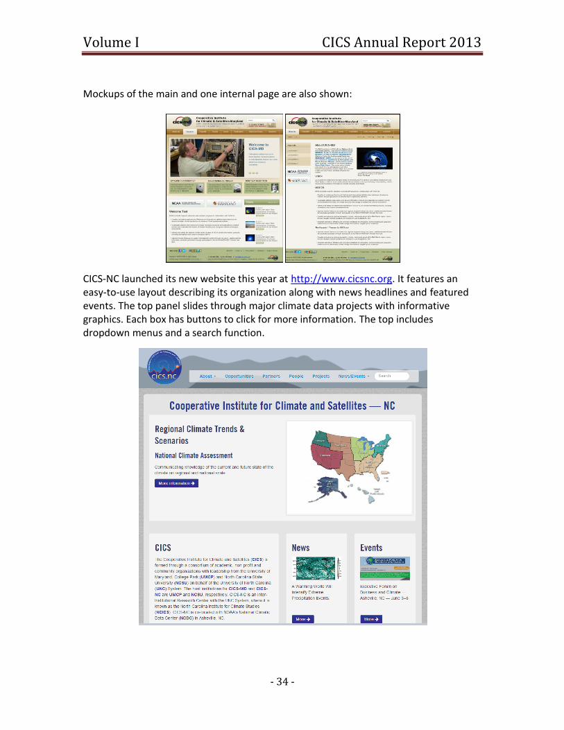
Volume I CICS Annual Report 2013
- 34 -
Mockups of the main and one internal page are also shown:
CICS-NC launched its new website this year at http://www.cicsnc.org. It features an easy-to-use layout describing its organization along with news headlines and featured events. The top panel slides through major climate data projects with informative graphics. Each box has buttons to click for more information. The top includes dropdown menus and a search function.
Volume I CICS Annual Report 2013
- 35 -
3.4 Education Young scientists, including students and post-doctoral researchers, play an important role in the conduct of research at CICS-MD and CICS-NC. Both CICS-MD and CICS-NC strive for close integration with the graduate programs at the respective host institu-tions of UMCP and NCSU.
CICS-MD is closely linked to University of Maryland’s undergraduate programs. The De-partment of Physics offers a B.S. degree with a concentration in Atmospheric Sciences, while GEOG and ASTR have their own undergraduate programs. AOSC, where many CICS-MD scientists are either members or affiliated researchers, has recently established its own undergraduate program. The program has been designed to teach broad based knowledge in meteorology, oceanography, climate and air pollu-tion. The degree satisfies the requirements for federal service positions as a meteorolo-gist or oceanographer, and also follows the American Meteorological Society's state-ment on bachelor's degrees in Atmospheric Science. The emphasis of the program is on preparing undergraduates to become generators of knowledge, or researchers, instead of idle consumers of knowledge that others produce. Undergraduates are already work-ing on thesis projects with CICS advisors, and the close partnership between the AOSC department and CICS is a major recruiting tool for the undergraduate program. For the last two summers, CICS has hosted an undergraduate student in Maryland to train her in scientific methods applied to climate studies. Given the growing interest in students as well as scientists, the intent is to expand this activity. CICS personnel are involved in teaching courses like GEOG 415 (Land Use, Climate Change, and Sustainability), AOSC 432 (an undergraduate atmospheric dynamics course), and AMSC 460 (an undergraduate scientific computation course in the Applied Mathematics & Statistics, and Scientific Computation program). Other CICS researchers are engaged in teaching courses and classes at other universities. CREST personnel incorporated radiative transfer examples into graduate and under-graduate courses, including Optical Remote Sensing, Earth Surveillance, and the under-graduate Introduction to Remote Sensing. Components of Graphyte were developed as prototypes in an undergraduate web-development class, while other components of the web service were developed in a graduate Web-Service class. 3.5 Outreach CICS-MD has prepared the 2nd and 3rd issues of its Circular, and intends to continue pub-lishing it twice a year. The Circular provides information on CICS-MD vision and mission, its research themes and brief descriptions of research being done at the institute. The titles of the scientific contributions to the second issue are: - CICS Support of the CHUVA Field Campaign in Brazil (Scott Rudlosky)
Volume I CICS Annual Report 2013
- 36 -
- Coral Reef Temperature Anomaly Database (Gregg Foti) - GOES-R Proving Ground Activities (Michael Folmer) Titles for the third issue are: - Monitoring Drought and Evapotranspiration from Geostationary Satellite Platforms (Christopher Hain) - AMSR-2 Environmental Data Records (Patrick Meyers) CICS-MD reaches out through various activities to K-12 students to help advance climate science, literacy and education particularly focusing in on Science, Technology, Engi-neering and Mathematics (STEM) skill sets. Over the past several years, CICS scientists have given presentations, led lectures, taught courses, developed curricula, lent equip-ment, and mentored high-school students. CICS-MD scientists’ activities include mentoring at local elementary schools, serving ei-ther as guest or regular scientists to discuss weather and oceanography lessons, and us-ing the Magic Planet (animated globe for environmental data display) spherical display. One scientist (Stephanie Scholaert-Uz of CICS-MD) supported building and maintaining the McKinley Elementary School rain garden, where she conducts semi-annual outdoor lessons with K-5 students. An honors student at the Montgomery County MD science and technology magnet high school completed a summer internship at CICS-MD and used the work accomplished as his senior thesis. CICS-NC supports NOAA’s commitment to the development of a society that is environ-mentally responsible, climate resilient, and adaptive, and which utilizes effective, sci-ence-based problem-solving skills (e.g. STEM-based learning) in education. The CICS-NC team participates in various climate education programs to advance the development of strong and comprehensive education and outreach activities about climate and oceanic and atmospheric sciences. Through CICS education, literacy, and outreach activities, CICS-NC participates in a num-ber of activities that enable a variety of stakeholders to understand the large volumes of climate data that NOAA collects about the Earth. Working collaboratively with other ac-ademic and public partners, stakeholders, and the private sector, CICS-NC supports and engages in various educational, engagement, and outreach-related activities to advance the following areas:
Advancing climate literacy for the education communities, including those in the K-12, undergraduate, and graduate levels and other organizations (e.g. Boy Scouts)
Advancing climate literacy for private sector partnerships through interdiscipli-nary activities, including outreach to energy industry, insurance industry, plant-based sector, and executive roundtable sessions

Volume I CICS Annual Report 2013
- 37 -
Outreach to local and national TV meteorologists and other media interested in climate information through CICS-NC partners
Providing operational support to activities in NOAA organizations like NCDC in advancing their outreach with the Sectoral Engagement Team, communication with the Communications Officer, and literacy with the Education Lead
Advancing outreach and engagement activities to public policy groups and eco-nomic development groups.
CICS-NC partners with NOAA’s NCDC and the NC State University Science House to pro-vide K-12 educational outreach for climate and Earth system science. The Science House serves over 5,000 teachers and over 36,000 students annually from six offices spread across the state of North Carolina. The Science House leads teacher professional devel-opment sessions that focus on understanding the Earth System, the changing nature of the climate and its impacts, resource management, and sustainability. The Science House supports students and teachers by providing climate materials and teaching techniques, and by sharing cutting edge research from climate scientists. Laboratory equipment is loaned out to participating teachers at no cost. Students can use this equipment to collect local data, which can then be compared with various data from the National Climatic Data Center. The Science House has engaged in two educational activities in partnerships with CICS-NC and NCDC. The first one is targeted at developing educational materials to enhance the exhibit “Highlighting 150 Years of Weather Observations in Asheville” at Asheville's Colburn Earth Science Museum. The other activity involves the development of an edu-cational curriculum using NCDC’s climate data, where specific climate datasets will be used for teaching exercises for teachers across the U.S. Through this educational en-gagement, CICS also hopes to increase their understanding of teachers’ needs for cli-mate information so they can effectively teach climate science to their students. CREST carries out a Summer Outreach program where more than 20 high school stu-dents are involved each summer for 8 weeks (leveraged through CREST) to work on var-ious research projects. Some of the research results are then incorporated in the mate-rial for the junior level class “Remote Sensing and Satellite Imagery”. Senior level under-graduate students are involved in the design of the class, developing instrumentation related to the coastal platform. Each summer since 2009, CREST has organized a Weather Camp (partially funded by CICS) where 8-10 high school students spend one week on the campus of CCNY and 1 week at the NWS office on Long Island learning about weather concepts, operations, and future college and job careers in STEM fields.

Volume I CICS Annual Report 2013
- 38 -
3.6 Science Meetings and Seminars The First CICS-MD Science Meeting, with the title “From Satellite Observations to Cli-mate Prediction” was held at ESSIC in September 2012 with participation from CICS-MD and NOAA scientists, together with NOAA managers. The meeting was organized by six young scientists from CICS and NOAA with goals of the meeting were:
To spotlight the research activities carried out at CICS-MD
Identify and promote new areas of research
Help establish new collaborations within CICS-MD and with other UMD and NO-AA units
Develop a sense of community among University and NOAA scientists. The meeting was held for two days and sessions followed the Topic Areas identified in section 1.2. A poster session and icebreaker were also held.
CICS-MD Director Hugo Berbery welcomes attendees to the CICS-MD Science Meeting (left); discussions at the poster session (right).
Additional outreach through communication occurs through seminar participation. CICS scientists participate in the AOSC, ESSIC, and NCSU Department of Marine, Earth, and Atmospheric Sciences (MEAS) seminar series, as well as give seminars and presentations at other institutions. Scientific seminars held this fiscal year by CICS-MD are listed in Ap-pendix 6 and by CICS-NC in Appendix 7.
3.7 Public Events CICS-MD has been using a visualization technique called “The Magic Planet” to reach out to the public. The Magic Planet displays datasets of weather and climate moving across its surface. The images displayed are used to educate visitors of all ages, school groups, or other expert audiences about earth systems and how they relate to the environment. CICS makes presentations at Maryland Day, the Maryland Science Center in Baltimore, and the National Zoo. Furthermore, a supplemental target was to promote the use of
Volume I CICS Annual Report 2013
- 39 -
EarthNow, a web-based blog operated by the same research institutes, among docents (staff and volunteers) that carry out presentations at SOS sites in museums and science centers across the country (and around the globe). To fulfill this task, training sessions were held bi-weekly at the Maryland Science Center (MSC) in Baltimore, Maryland. The project identified supplemental methods to promote public learning, interest, and focus on earth science, short-term weather, and long-term climate change. These methods included (a) podcasting some of the EarthNow content and including it in automatic Science On a Sphere (SOS) playlists, (b) promoting the use of local stories and topical events in SOS presentations and EarthNow posts (by using local sources, working closely with museum staff and data providers and developers) and (c) creating future docent training material based on feedback received in an online survey of docents, as well as on the systematic observation of the public’s engagement and perception (opinion) of the SOS live presentations. CICS-NC works with Climate Central to highlights how NCDC data and tools can be used to better understand and manage climate and weather-related risks on seasonal to de-cadal and longer timescales through two video series. The content routinely utilizes the data, maps, and forecast products produced by NCDC scientists. CICS-NC recently supported the launch of CycloneCenter.org, a joint activity with NCDC, UNC Asheville, and Zooniverse that enables the public to help analyze the intensities of past tropical cyclones around the globe. The general public is able to log in and answer questions about images as part of a simplified technique for estimating the maximum surface wind speed of tropical cyclones. This example of public collaboration allows for the completion of a large number of classifications in just a few months—something that would take a team of scientists more than a decade to accomplish. The end product will be a new global tropical cyclone dataset that provides tropical cyclone intensity es-timates, confidence intervals, and a wealth of other metadata that could not be realisti-cally obtained in any other fashion. CICS-NC also supported the successful world-premiere launch of the video game Fate of the World and the corresponding film Gaming the Future, which demonstrates global strategy games as an effective educational and scenario-building tool for discussing the impacts of climate change. The film can be viewed here: http://www.cicsnc.org/people/jenny-dissen/progress-update/
3.8 Private Enterprise Interaction The Climate Information Responding to User Needs (CIRUN) project, supported through CICS-MD by NOAA CPO, provides outreach to climate data stakeholders. On April 23, 2012, CIRUN helped co-sponsor an all-day workshop at UMUC (University of Maryland University College, College Park campus). The workshop was organized by the Maryland
Volume I CICS Annual Report 2013
- 40 -
SeaGrant Program and by the Center for Watershed Protection. The participants were welcomed by Dr. O'Shea, Vice President for Research, and Dean Wei of the College of Agriculture and Natural Resources. Antonio Busalacchi gave the opening plenary ad-dress, followed by Don Bosch, President of UMCES (University of Maryland Center for Environmental Science) and Zoe Johnson from the State Department of Natural Re-sources. The workshop attracted about 100 participants from climate science, govern-ment and local community representatives, non- profits, and social scientists. A CIRUN-NOAA Executive Roundtable was convened on November 29, 2012 in College Park, MD at ESSIC. It was attended by representatives of business, government, and ac-ademic sectors with the goal of connecting providers of climate information with deci-sion makers. Participants discussed the NOAA climate information products that they currently use and what improvements and new products they would help them better meet their needs. NOAA provided an overview of current products and well as plans for the future. Desire was expressed for finer resolution, both spatial and temporal, greater consistency, watershed and basin-scale data, and a clearer representation of uncertain-ty in climate products. Understanding the potential return on investment of adapting to climate changes was critically important to most users. CICS-NC, In collaboration and partnership with NCDC’s Climate Services and Monitoring Branch, has lead the development of an ongoing framework and approach for advancing climate data applications through a new activity called Dataset Discovery Day. This two-day workshop organized by Jenny Dissen allows NCDC staff to discuss their data prod-ucts and CICS-NC staff to discuss application opportunities in various sectors. Infor-mation on Dataset Discovery Day can be found on the CICS-NC website: http://cicsnc.org/events/ddd/ Through collaboration with the president of the Institute for Global Environmental Strategies (IGES), Nancy Colleton, CICS-NC has participated in stakeholder engagement activities to better understand climate information needs. This research (a) examined mechanisms and models for private sector engagement; (b) assessed various business and economic strategic forecasting needs; and (c) further examined the specific climate information needs and potential economic impacts of climate change on plant-based businesses. Working with the North Carolina Arboretum, as an affiliate entity of the University of North Carolina system, CICS-NC has expanded educational capacity through training of professional staff of American botanical gardens, arboreta, zoos, and nature centers, with the goal of reaching approximately 200 million people who annually visit these cul-tural institutions.

Volume I CICS Annual Report 2013
- 41 -
Appendix 1: Acronym List Acronym Definition AAAS American Association for the Advancement of Science (A)ATSR (Advanced) Along Track Scanning Radiometer ABI Advanced Baseline Imager AC4 Atmospheric Chemistry, Carbon Cycle, & Climate (CPO) AERONET-OC Aerosol Robotic Network-Ocean Color data AF-ARP Active Fire Application-Related Product AFWA Air Force Weather Agency ALEXI Atmosphere-Land Exchange Inverse model AMSC Applied Mathematics & Statistics, & Scientific Computation (UMCP) AMSR-2 Advanced Microwave Scanning Radiometer 2 AMSR-E Advanced Microwave Scanning Radiometer - EOS AMSU Advanced Microwave Sounding Unit AMSU-A Advanced Microwave Sounding Unit-A AMSU-B Advanced Microwave Sounding Unit B AOSC Department of Atmospheric and Oceanic Science (UMCP) AOT Aerosol Optical Thickness APSP Aerosol Particle Size Parameter AR5 Fifth Assessment Report (IPCC) ARL Air Resources Laboratory ASTR Department of Astronomy (UMCP) ATDD Atmospheric Turbulence and Diffusion Division ATMS Advanced Technology Microwave Sounder AVHRR Advanced Very High Resolution Radiometer BAMS Bulletin of the American Meteorological Society CAS Chinese Academy of Sciences Cal/Val Calibration/Validation CalTech California Institute of Technology CCGG Carbon Cycle Greenhouse Gases CDOM Chromophoric/Colored Dissolved Organic Matter CDR Climate Data Record CHRS Center for Hydrometeorology and Remote Sensing CICS Cooperative Institute for Climate and Satellites CICS-MD Cooperative Institute for Climate and Satellites-Maryland CICS-NC Cooperative Institute for Climate and Satellites-North Carolina CIMMS Cooperative Institute for Mesoscale Meteorological Studies CIRUN Climate Information Responding to User Needs CLASS Comprehensive Large Array-data Stewardship System CMAQ Community Multi-scale Air Quality model CMIP Coupled Model Intercomparison Project, Phase 5 CMNS College of Computer, Mathematical and Natural Sciences
Volume I CICS Annual Report 2013
- 42 -
CONUS Continental United States COOP Cooperative Observer Program (NWS) CoRP Cooperative Research Program CPC Climate Prediction Center CPO Climate Program Office CREST Cooperative Remote Sensing Science and Technology Center CrIMSS Cross-track Infrared Microwave Sounder Suite CrIS Cross-Track Infrared Sounder CRM Cloud Resolving Model CRTM Community Radiative Transfer Model CTD Conductivity-Temperature-Depth probe CUNY City University of New York CWG Calibration Working Group (GOES-R) DMSP Defense Meteorological Satellite Program DYNAMO Dynamics of the MJO EDR Environmental Data Record EFSO Ensemble Forecast Sensitivity to Observations ENSO El Niño Southern Oscillation ERB Earth Radiation Budget ESRL Earth System Research Laboratory ESSIC Earth System Science Interdisciplinary Center ETC Extratropical Cyclone EUMETSAT European Organisation for Exploitation of Meteorological Satellites FAR Fourth Assessment Report (IPCC) FCDR Fundamental Climate Data Record FDC Fire Detection and Characterization FOC Full Operational Capability GCOM Global Change Observation Mission (JAXA) GCOM-W1 Global Change Observation Mission 1st - Water GCOS Global Climate Observing System GEO Geostationary Orbits GEOG Department of Geographical Sciences (UMCP) GERB Geostationary Earth Radiation Budget GFS Global Forecast System GHCN-M Global Historical Climate Network Monthly GLM Geostationary Lightning Mapper GOCART Goddard Chemistry Aerosol Radiation and Transport module GOES Geostationary Orbiting Environmental Satellite GOESPO GOES-R Program Office (NOAA) GOES-R Geostationary Orbiting Environmental Satellite – R-Series GPCP Global Precipitation Climatology Project GPM Global Precipitation Measurement Mission
Volume I CICS Annual Report 2013
- 43 -
GPROF Goddard Profiling Algorithm GPS Global Positioning System GPSRO Global Positioning System Radio Occultation GridSat Gridded Satellite Data GRUAN GCOS Reference Upper Air Network GSA Geostationary Surface Albedo GSFC Goddard Space Flight Center GSICS Global Space-based Inter-Calibration System GVAR GOES Variable Format HDSS Hierarchical Data Storage System HIRS High-Resolution Infrared Radiation Sounder IASI Infrared Atmospheric Sounding Interferometer IBTrACS International Best Track Archive for Climate Stewardship ICESat Ice, Cloud and Land Elevation Satellite IDPS Integrated Data Processing Segment IGES Institute for Global Environmental Strategies IMSG I. M. Systems Group, Inc. IMS-V3 Interactive Multi-Sensor Snow and Ice System, Version 3 IOC Initial Operational Capability IPCC Intergovernmental Panel on Climate Change IR Infrared ISCCP International Satellite Cloud Climatology Project JAXA Japan Aerospace Exploration Agency JPL Jet Propulsion Laboratory JPSS Joint Polar Satellite System JPSSO JPSS Office (NOAA) LAI Leaf Area Index LETKF Local Ensemble Transform Kalman Filter LIS Land Information System LISCO Long Island Sound Coastal Observatory LMA Lightning Mapping Arrays LST Land Surface Temperature MADRAS Multi-Frequency Microwave Scanning Radiometer MEAS Department of Marine, Earth, and Atmospheric Sciences (NCSU) METEOSAT Meteorological Satellite operated by EUMETSAT Metop-B Meteorological Operational Polar Satellite-B MHS Microwave Humidity Sounder MiRS Microwave Integrated Retrieval System MJO Madden-Julian Oscillation MLD Mixed Layer Depth MMF Multi-Scale Modeling Framework (NASA) MOA Memorandum of Agreement
Volume I CICS Annual Report 2013
- 44 -
MODIS Moderate Resolution Imaging Spectroradiometer MSC Maryland Science Center MSG METEOSTAT Second Generation MSPPS Microwave Surface and Precipitation Products System MSU Microwave Sounding Unit M-T Megha-Tropiques satellite NASA National Aeronautics and Space Administration NCA Draft National Climate Assessment NCDC National Climatic Data Center NCEP National Centers for Environmental Prediction NCICS North Carolina Institute for Climate Studies NCSU North Carolina State University NCWCP NOAA Center for Weather and Climate Prediction NEMAC National Environmental Modeling and Analysis Center NEMS National Environmental Modeling System NEON National Ecological Observatory Network NESDIS National Environmental Satellite, Data and Information Service NIDIS National Integrated Drought Information System NIFA National Institute of Food and Agriculture (USDA) NMME National Multi-Model Ensemble NMQ National Mosaic and Multi-Sensor QPE NN Neural Network NOAA National Oceanic and Atmospheric Administration NODC National Oceanographic Data Center NOS National Ocean Service (NOAA) NPOESS National Polar Orbiter Environmental Satellite System NPP NPOESS Preparatory Project NSF National Science Foundation NSIDC National Snow and Ice Data Center NWP Observing Systems Simulation Experiment NWRI National Water Research Institute NWS National Weather Service OAFlux Objectively Analyzed Air-Sea Fluxes for Global Oceans (WHOI) OAR Office of Oceanic and Atmospheric Research (NOAA) OESD Office of Education and Sustainability (NOAA) OISST Optimum Interpolation Sea Surface Temperature OLR Outgoing Longwave Radiation OpeNDAP Open-Source Project for a Network Data Access Protocol OS Operating System OSD Office of Systems Development (NESDIS) OSPO Office of Satellite and Product Operations (NESDIS) OSSE Observing Systems Simulation Experiment

Volume I CICS Annual Report 2013
- 45 -
OST Office of Science and Technology OSU Oregon State University PM2.5 Particulate Matter less than 2.5 microns in diameter POES Polar Orbiting Environmental Satellites Q2 Next Generation QPE QA Quality Assurance QC Quality Control QIR Quadratic Interval Refinement QPE Quantitative Precipitation Estimates SAFE Snow Analysis and Field Experiment SAPHIR Spectrometer Arrangement for Photon Induced Reactions SCSB Satellite Climate Studies Branch SDR Sensor Data Record SeaWiFS Sea-viewing Wide Field of View Sensor SEVIRI Spinning Enhanced Visible and Infrared Imager SIP Standardized Precipitation Index SM Suspended Matter SMOS Soil Moisture and Ocean Salinity satellite S-NPP Suomi-National Polar-Orbiting Partnership SOS Science on a Sphere network (NOAA) SPEC Satellite Product Evaluation Center SSH Sea Surface Height SSM/I Special Sensor Microwave Imager SSMIS Special Sensor Microwave Imager/Sounder SST Sea Surface Temperature STAR Center for Satellite Applications and Research STEM Science, Technology, Engineering and Mathematics SW Shortwave SWE Snow Water Equivalent TAR Third Assessment Report (IPCC) TC Tropical Cyclones THREDDS Thematic Real-Time Environmental Distributed Data Services TMPA TRMM Multisatellite Precipitation Analysis TOA Top of the Atmosphere TPW Total Precipitable Water TRMM Tropical Rainfall Measuring Mission TSU Technical Support Unit (National Climate Assessment) UCI University of California, Irvine UMCES University of Maryland Center for Environmental Science UMCP University of Maryland, College Park UMUC University of Maryland University College UNC University of North Carolina

Volume I CICS Annual Report 2013
- 46 -
USCRN United States Climate Reference Network USDA United States Department of Agriculture USGCRP United States Global Change Research Program VCM VIIRS Cloud Mask VEGAS Vegetation Global Atmosphere and Soil model VIIRS Visible/Infrared Imager Radiometer Suite WERF Water Environment Research Foundation WHOI Woods Hole Oceanographic Institution WRF Weather Research and Forecasting model XBT eXpendable BathyThermograph
Volume I CICS Annual Report 2013
- 47 -
Appendix 2: Personnel Tables by Center
CICS-MD Personnel Statistics Category Total BS MS PhD
Research Scientist 21 21
Visiting Scientist
Postdoctoral Fellow 15 15
Research Support Staff 8 8 0
Administrative 2 1 1 0
Total (> 50% support) 46 1 9 36
Undergraduate Students 5
Graduate Students 21
Employees that receive < 50% NOAA funding (not including students)
3 2 1
Located at NOAA facility (Camp Springs or Silver Spring) 33
Obtained NOAA employment within the last year
*Note: These numbers include CICS-MD sub-award (3) personnel, but exclude CUNY, listed in a companion table.
CICS-NC Personnel Statistics Category Total BS MS PhD
Research Scientist 23 1 8 14
Visiting Scientist
Postdoctoral Fellow 1 1
Research Support Staff 7* 4 1 1
Administrative 4* 3
Total (> 50% support) 35* 5 12 16
Undergraduate Students 2
Graduate Students 1 1
Employees that receive < 50% NOAA funding (not including stu-dents)
1 1
Located at NOAA facility (National Climatic Data Center) 35
Obtained NOAA employment within the last year
* Two employees hold less than a bachelors degree, therefore these totals are more than the sum of the columns.
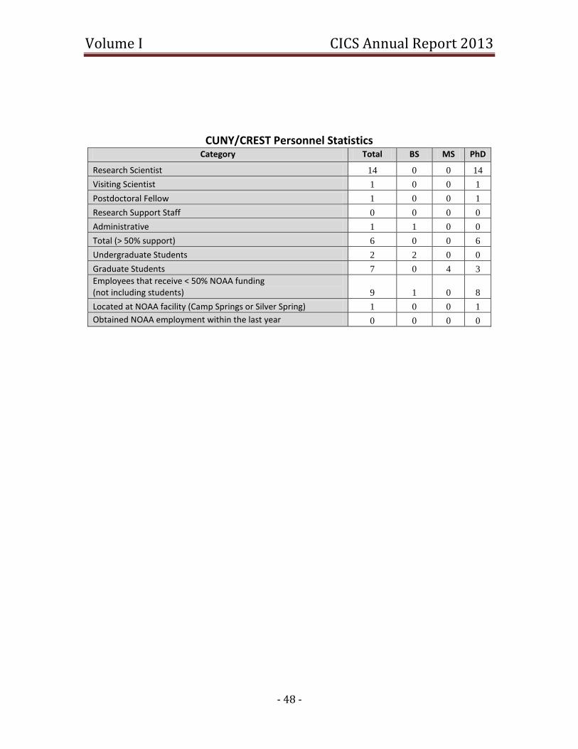
Volume I CICS Annual Report 2013
- 48 -
CUNY/CREST Personnel Statistics Category Total BS MS PhD
Research Scientist 14 0 0 14
Visiting Scientist 1 0 0 1
Postdoctoral Fellow 1 0 0 1
Research Support Staff 0 0 0 0
Administrative 1 1 0 0
Total (> 50% support) 6 0 0 6
Undergraduate Students 2 2 0 0
Graduate Students 7 0 4 3
Employees that receive < 50% NOAA funding (not including students) 9 1 0 8
Located at NOAA facility (Camp Springs or Silver Spring) 1 0 0 1
Obtained NOAA employment within the last year 0 0 0 0

Volume I CICS Annual Report 2013
- 49 -
Appendix 3: CICS-MD Arrivals and Departures Jun Park joined in Spring of 2012 to CICS-MD as a Faculty Research Assistant, working with Ralph Ferraro (NOAA/NESDIS/STAR) to develop and validate on GCOM-W1/AMSR2 ocean EDR process . Mr. Park studied at Konkuk University, Seoul, Korea and received his B.S. degree in 1993, M.S. degree from Florida Institute of Technology, Melbourne, Florida in 1996 and a Ph.D. program at University of Central Florida, Orlando, Florida, all in Electrical Engineering. His research interests are mainly focused on Satellite micro-wave radiometers and scatterometers and their remote sensing applications. Mr. Park collaborates with the NOAA/NESDIS/STAR Ocean Surface Winds Team to develops re-trieval algorithms of geophysical parameters over the ocean for NOAA’s Operational GCOM-W1/AMSR2 Mission. Xiaoyang Zhang received the B.A. degree in geography from Peking University, Beijing, China, in 1984, the M.S. degree from the Nanjing Institute of Geography and Limnology, Chinese Academy of Sciences (CAS), Nanjing, China, in 1991, and the Ph.D. degree in remote sensing from King's College London, London, UK, in 1999. He was a Research As-sistant Professor in the Institute of Hydrobiology, CAS, and a Research Associate Profes-sor in the Institute of Geodesy and Geophysics, CAS, from 1984 to 1995, and a Research Associate and Research Assistant Professor at the Department of Geography, Boston University, from 1999-2005. As a Senior Research Scientist from April 2005-May 2012 at Earth Resources Technology Inc and an Associate Research Scientist at the Cooperative Institute for Climate and Satellites (CICS) at the University of Maryland from June 2012, he has been working at NO-AA/NESDIS/STAR through a contractor/visiting scientist. His research interests include satellite remote sensing of vegetation phenology and biomass burning emissions, cli-mate-vegetation interaction, and land surface process and modeling. Jingfeng Huang joined the CICS-MD in June 2012 as an Assistant Research Scientist, working with Dr. Shobha Kondragunta and Dr. Istvan Laszlo at the NOAA/NESDIS Center for Satellite Application and Research (STAR) on the calibration and validation of Suomi NPP VIIRS aerosol retrievals. Dr. Huang studied at Tsinghua University (Beijing), Hong Kong University of Science and Technology (Hong Kong), and University of Manchester (Manchester, United Kingdom) respectively for his Bachelor of Engineering (2000), Bachelor of Management (2000), Master (2002) and PhD (2006) degrees on a wide range of disciplines from environmental engineering to hydraulics, from geographical information system to remote sensing, and from land surface processing to atmospheric science. He developed his research interest on the aerosol-cloud-precipitation-climate interaction as well as satellite aerosol retrieval and monitoring when he joined Universi-ty of Miami in 2006 and explored African dust outbreaks and climatic effects of African aerosols on Atlantic rainfall. Before he joined UMCP, Dr. Huang further expanded his expertise deep into satellite aerosol retrievals when he worked on MODIS Deep Blue
Volume I CICS Annual Report 2013
- 50 -
aerosol algorithm and VIIRS aerosol product calibration and validation with Dr. Christina Hsu at NASA Goddard Space Flight Center as an assistant research scientist affiliated with UMBC and Morgan State University from 2009 to 2012. Affiliated with the Earth System Science Interdisciplinary Center at the University of Maryland and working at NOAA NESDIS, Dr. Huang collaborates with colleagues from NASA, NOAA and American and Chinese Universities on broad research interests on global aerosol retrieval and ob-servations, aerosol radiative and microphysical effects, aerosol transport and monitor-ing, and atmospheric remote sensing techniques. Peng Yu recently joined CICS-MD as a Research Associate, working with Dr. Yunyue ‘Bob’ Yu on the development, validation, and application of satellite Land Surface Tem-perature (LST) product. Dr. Yu Studied at Florida State University and received his Ph.D. in Physical Oceanography in 2006, and then worked in California Institute of Technology (Caltech)/Jet Propulsion Laboratory (JPL) and Oregon State University (OSU) focusing on data assimilation technique. His major research interests are satellite and in-situ obser-vations and their applications, and data assimilation technique. Dr. Yu is currently work-ing on the validation of GOES-R LST product, using data from other satellite sensors as proxies. Ho-Chun Huang recently joined CICS-MD as a Visiting Assistant Research Scientist. Dr. Huang studied at the National Taiwan University, Taipei, Taiwan and received his B.S. degree in Atmospheric Science in 1984. He obtained his M. Sci. degree in Meteorology from the Massachusetts Institute of Technology, Cambridge, Massachusetts in 1989 and a Ph.D. degree in Atmospheric Sciences at the State University of New York, Albany, New York in 1999. His research interests are mainly focused on the remote sensing of atmospheric gases and aerosols and the chemical and transport modeling to understand the impact of natural and anthropogenic emissions on earth environments. Dr. Huang collaborates with Dr. Istvan Laszlo and Dr. Shobha Kondragunta at the NOAA/NESDIS/ STAR and is currently working on the calibration and validation of NPP VIIRS aerosol products. Liqing Jiang joined CICS-MD as an Assistant Research Engineer in July 2012. He works at NOAA's National Oceanographic Data Center (Silver Spring, MD) as a Physical Scien-tist/Oceanographer. Liqing received his B.S degree in Marine Chemistry from the Ocean University of China, and his Ph.D degree in Marine Sciences from the University of Geor-gia. His research at UGA was focused on carbon cycling and ocean acidification, in par-ticular the study of air-sea exchange of carbon dioxide and its underlying biogeochemi-cal processes in estuaries and continental shelves. After graduating, Liqing worked at NOAA's Climate Program Office as a John A Knauss Ocean Policy Fellow for a year, be-fore he joined Yale University under the Yale Institute for Biospheric Studies Postdoctor-al Fellowship. His research at Yale was focused on the acidity of rivers in the United States over the past century, as well as hypoxia in Long Island Sound.

Volume I CICS Annual Report 2013
- 51 -
Yongsheng Zhang recently joined the Cooperative Institute for Climate and Satellites (CICS) at the University of Maryland as an Assistant Research Engineer. Dr. Zhang stud-ied in Institute of Atmospheric Physics, Chinese Academy of Sciences and received a Ph. D degree in Atmospheric Science in 1995. Before that, he also received a M.S. and B. S. degree in Meteorology in Peking University in 1991 and 1988, respectively. As a mem-ber of satellite team at National Oceanographic Data Center (NODC), NESDIS/NOAA, Dr. Zhang’s task is to implement data archival, distribution, integration, and public access services for satellite altimetry (GEOSAT, Jason-2 and future Jason-3), sea surface salinity [Soil Moisture and Ocean Salinity (SMOS) and Aquarius satellites] and Ocean Color products [Sea-viewing Wide Field of View Sensor (SeaWiFS), MODIS/Aqua, and MODIS/Terra] at NODC. He also works to develop quality monitoring tools for above satellite products and user-friendly web interfaces to facilitate access to the derived in-formation. His research interests are mainly focused on development of massive satel-lite data processing and quality monitoring systems, development of value-added satel-lites products and operational applications of the satellite data in monitoring of the ex-treme weather and climate. Nisha Kurian joined the CICS-MD as a Faculty Research Assistant, working with Tim Boy-er on the XBT and MBT bias corrections. Dr. Nisha Kurian studied at Cochin University of Science and Technology, India and received her M.Sc degree in Oceanography in 2002 and received her Ph.D degree in 2013 for the dissertation titled ‘Variability of the near-surface thermohaline structure of the Lakshadweep Sea” from Goa University, India. Her prime research interests are the temperature variability of upper ocean, Expendable Bathythermographs (XBT) bias corrections and its relation to the climatic studies. Dr. Nisha Kurian collaborates with NODC/NOAA and is currently working towards providing the oceanographic community with the XBT data with different bias corrections applied. She is also involved in updating the XBT bibliography table for NODC website which has a list of all known research papers that deal with studies based on XBT data and compar-ison studies of XBTs and Conductivity-temperature-depth (CTD) probes. William Chong recently joined the CICS-MD as a Faculty Research Assistant, working at the NOAA Climate Program Office. William studied at Virginia Polytechnic Institute and State University (Virginia Tech) and received his B.A. in Geography in 2011. He is cur-rently working on his masters degree at the University of Maryland. At the Climate Pro-gram Office, William provides a capability to augment the communication and distribu-tion of research results by creating web-based and other outreach and communication tools that will link research products at NOAA and universities and promote scientific stewardship of climate-related information. Debra Ratterman Baker joined CICS-MD as a Coordinator on March 25, 2013. She re-ceived her M.S. in atmospheric science from the University of Maryland, College Park.

Volume I CICS Annual Report 2013
- 52 -
For the last four years, she worked on air quality issues at the Maryland Department of the Environment. Debra also has a law degree from Harvard Law School and managed grant projects at the ABA Center on Children and the Law. Dr. Melissa A. Kenney is Research Faculty in Environmental Decision Analysis at the University of Maryland, Earth System Science Interdisciplinary Center (ESSIC) and Lead Principal Investigator of the U.S. Global Change Research Program (USGCRP) National Climate Assessment Indicator System. Her research in environmental decision analysis broadly addresses how to integrate both scientific knowledge and societal values into policy decision-making under uncertainty. Dr. Kenney was a Research Assistant Scientist at Johns Hopkins University in the Department of Geography and Environmental Engi-neering and an American Association for the Advancement of Sciences (AAAS) Science and Technology Policy Fellow hosted by the NOAA Climate Program Office and the USGCRP, National Climate Assessment. During her AAAS fellowship, Dr. Kenney coordi-nated the development of 1) the physical, ecological, and societal indicator framework for National Climate Assessment, 2) transboundary climate adaptation and sustained assessment services in the Columbia River and Pacific Northwest, and 3) enhanced col-laboration between NOAA and the National Science Foundation, Social Behavioral and Economic Sciences Directorate. Dr. Kenney received a B.A. with Distinction in Environ-mental Sciences at the University of Virginia, a Ph.D. in Water Quality Modeling and De-cision Analysis in the Nicholas School of the Environment and Earth Sciences at Duke University, and was a postdoctoral scholar with the NSF National Center for Earth-surface Dynamics at The Johns Hopkins University. Mathew Biddle recently joined the Cooperative Institute for Climate and Satellites (CICS) at the University of Maryland as a Faculty Research Assistant, working with the National Oceanographic Data Center on archiving and making publicly available oceano-graphic data. Mr. Biddle studied at Humboldt State University in California and received his B.S. degree in Oceanography in 2010. His research interests are mainly focused on data management and it's applications to in-situ measurements. Mr. Biddle also collabo-rates with NOAA/NESDIS/NODC in composing regional climatologies, Arctic Ocean and Gulf of Mexico, of in-situ oceanographic salinity profiles from the World Ocean Data-base. Li Fang received the B.Sc degree in Geographic Information Systems from Wuhan Uni-versity, Hubei, China, in 2005, the M.Sc. in Geographic and Cartographic Sciences and the Ph.D. degree in Earth System and Geoinformation Sciences from George Mason Uni-versity (GMU), Fairfax, VA, U.S., in 2011 and in 2012, respectively. Before obtaining M.S. degree in GMU, she worked as research assistant in Chinese Academy of Sciences (CAS), Beijing, China for three years and became a Ph.D. candidate in Cartography and Geo-graphical Information System. Her research interests focus on the reversion and applica-tions of land surface temperature (LST). During her study in GMU, she engaged in NOAA

Volume I CICS Annual Report 2013
- 53 -
PSID projects as a key member to develop a software package for operational Geosta-tionary Operational Environmental Satellite LST product. She is currently a research as-sociate with the National Environmental Satellite, Data, and Information Service Center for Satellite Applications and Research, National Oceanic and Atmospheric Administra-tion, College Park, MD. Wei Han received the B.A. degree in meteorology in 1997, the M.S. degree in Dynamical Meteorology in 2000 and the Ph.D. degree in atmospheric sciences in 2003 from Nanjing Meteorology Institute, China, respectively. He was a Research Associate in Chinese Academy of Meteorology Sciences, from 2005 to 2010, and a Research Scientist at the Numerical Prediction Centre of Chinese Meteorological Administration, from 2010 to 2012. As a Associate Research Scientist at the Cooperative Institute for Climate and Sat-ellites (CICS) at the University of Maryland from June 2012, he has been working at NO-AA/NESDIS/STAR through a contractor/visiting scientist. His research interests include the use of satellite radiances in Numerical Weather Prediction (NWP), quantification and identification the biases and observation errors in satellite radiances using NWP by dou-ble difference methods. Departures: Janowiak, John (retired) Devaraj, Chabitha (San Diego State University) Chen, Meilin (NASA/Goddard) Hernandez, Cecilia (Puerto Rico) Qi, Chengli (China)
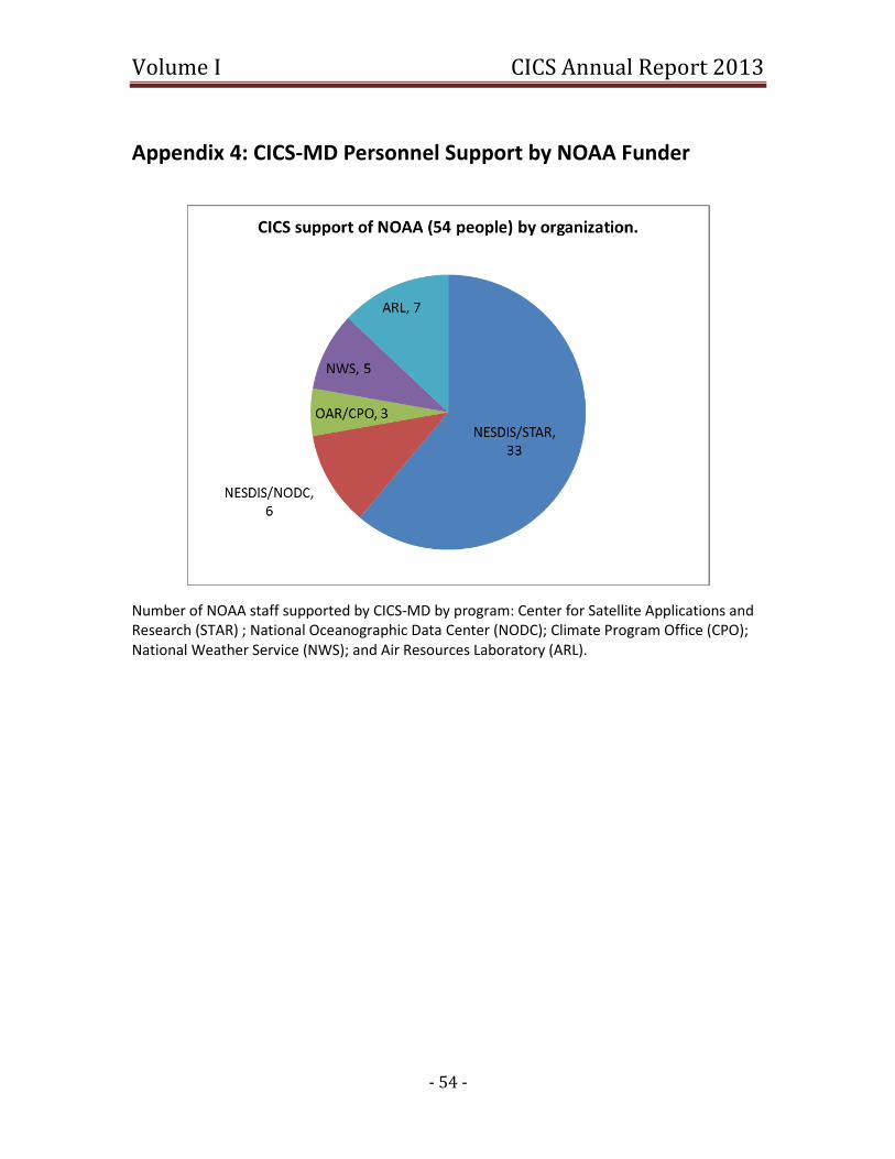
Volume I CICS Annual Report 2013
- 54 -
Appendix 4: CICS-MD Personnel Support by NOAA Funder
Number of NOAA staff supported by CICS-MD by program: Center for Satellite Applications and Research (STAR) ; National Oceanographic Data Center (NODC); Climate Program Office (CPO); National Weather Service (NWS); and Air Resources Laboratory (ARL).
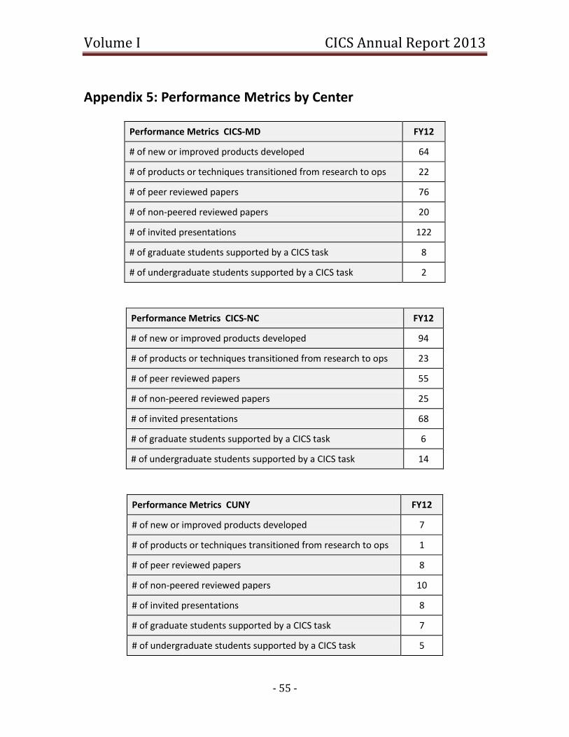
Volume I CICS Annual Report 2013
- 55 -
Appendix 5: Performance Metrics by Center
Performance Metrics CICS-MD FY12
# of new or improved products developed 64
# of products or techniques transitioned from research to ops 22
# of peer reviewed papers 76
# of non-peered reviewed papers 20
# of invited presentations 122
# of graduate students supported by a CICS task 8
# of undergraduate students supported by a CICS task 2
Performance Metrics CICS-NC FY12
# of new or improved products developed 94
# of products or techniques transitioned from research to ops 23
# of peer reviewed papers 55
# of non-peered reviewed papers 25
# of invited presentations 68
# of graduate students supported by a CICS task 6
# of undergraduate students supported by a CICS task 14
Performance Metrics CUNY FY12
# of new or improved products developed 7
# of products or techniques transitioned from research to ops 1
# of peer reviewed papers 8
# of non-peered reviewed papers 10
# of invited presentations 8
# of graduate students supported by a CICS task 7
# of undergraduate students supported by a CICS task 5
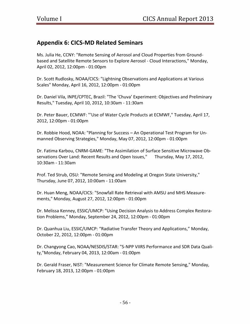
Volume I CICS Annual Report 2013
- 56 -
Appendix 6: CICS-MD Related Seminars
Ms. Julia He, CCNY: "Remote Sensing of Aerosol and Cloud Properties from Ground-based and Satellite Remote Sensors to Explore Aerosol - Cloud Interactions," Monday, April 02, 2012, 12:00pm - 01:00pm Dr. Scott Rudlosky, NOAA/CICS: "Lightning Observations and Applications at Various Scales" Monday, April 16, 2012, 12:00pm - 01:00pm Dr. Daniel Vila, INPE/CPTEC, Brazil: "The ‘Chuva’ Experiment: Objectives and Preliminary Results," Tuesday, April 10, 2012, 10:30am - 11:30am Dr. Peter Bauer, ECMWF: "'Use of Water Cycle Products at ECMWF," Tuesday, April 17, 2012, 12:00pm - 01:00pm Dr. Robbie Hood, NOAA: "Planning for Success – An Operational Test Program for Un-manned Observing Strategies," Monday, May 07, 2012, 12:00pm - 01:00pm Dr. Fatima Karbou, CNRM-GAME: "The Assimilation of Surface Sensitive Microwave Ob-servations Over Land: Recent Results and Open Issues," Thursday, May 17, 2012, 10:30am - 11:30am Prof. Ted Strub, OSU: "Remote Sensing and Modeling at Oregon State University," Thursday, June 07, 2012, 10:00am - 11:00am Dr. Huan Meng, NOAA/CICS: "Snowfall Rate Retrieval with AMSU and MHS Measure-ments," Monday, August 27, 2012, 12:00pm - 01:00pm Dr. Melissa Kenney, ESSIC/UMCP: "Using Decision Analysis to Address Complex Restora-tion Problems,” Monday, September 24, 2012, 12:00pm - 01:00pm Dr. Quanhua Liu, ESSIC/UMCP: “Radiative Transfer Theory and Applications,” Monday, October 22, 2012, 12:00pm - 01:00pm Dr. Changyong Cao, NOAA/NESDIS/STAR: "S-NPP VIIRS Performance and SDR Data Quali-ty,"Monday, February 04, 2013, 12:00am - 01:00pm Dr. Gerald Fraser, NIST: "Measurement Science for Climate Remote Sensing," Monday, February 18, 2013, 12:00pm - 01:00pm

Volume I CICS Annual Report 2013
- 57 -
Dr. Weixin Xu, ESSIC/CICS: "Combining Satellite Infrared and Lightning Information to Estimate Warm Season Convective and Stratiform Rainfall,"Wednesday, March 13, 2013, 02:00pm - 03:00pm
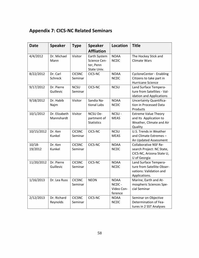
58
Appendix 7: CICS-NC Related Seminars
Date Speaker Type Speaker Affliation
Location Title
4/4/2012 Dr. Michael Mann
Visitor Earth System Science Cen-ter, Penn State Univ.
NOAA NCDC
The Hockey Stick and Climate Wars
8/22/2012 Dr. Carl Schreck
CICSNC Seminar
CICS-NC NOAA NCDC
CycloneCenter - Enabling Citizens to take part in Hurricane Science
9/17/2012 Dr. Pierre Guillevic
NCSU Seminar
CICS-NC NCSU Land Surface Tempera-ture from Satellites - Val-idation and Applications
9/18/2012 Dr. Habib Najm
Visitor Sandia Na-tional Labs
NOAA NCDC
Uncertainty Quantifica-tion in Processed Data Products
10/1/2012 Dr. Elizabeth Mannshardt
Visitor NCSU De-partment of Statistics
NCSU - MEAS
Extreme Value Theory and Its Application to Weather, Climate and Air Quality
10/15/2012 Dr. Ken Kunkel
CICSNC Seminar
CICS-NC NCSU MEAS
U.S. Trends in Weather and Climate Extremes – An Updated Assessment
10/18-19/2012
Dr. Ken Kunkel
CICSNC Seminar
CICS-NC NOAA NCDC
Collaborative NSF Re-search Project: NC State, CICS-NC, Arizona State U, U of Georgia
11/20/2012 Dr. Pierre Guillevic
CICSNC Seminar
CICS-NC NOAA NCDC
Land Surface Tempera-ture from Satellite Obser-vations: Validation and Applications.
1/16/2013 Dr. Lea Russ CICSNC Seminar
NEON NOAA NCDC - Video Con-ference
Marine, Earth and At-mospheric Sciences Spe-cial Seminar
2/12/2013 Dr. Richard Reynolds
CICSNC Seminar
CICS-NC NOAA NCDC
Seminar on Objective Determination of Fea-tures in 2 SST Analyses

- 59 -
3/22/2013 Kathy Jacob & Dr. Ken Kunkel
CICSNC Seminar
NOAA / CICS-NC
NOAA NCDC
National Climate Assess-ment / Regional Climate Scenarios for the U.S. National Climate Assess-ment
3/26/2013 Jennifer Meyer
CICSNC Seminar
CICS-NC NOAA NCDC
Evaluation of air and soil temperatures for deter-mining onset of growing season
3/26/2013 Dr. Peter Thorne
CICSNC Seminar
CICS-NC NCSU MEAS
Creating Land Surface Air Temperature Datasets for 21st Century Science and Societal Needs
4/17/2013 Dr. Peter Dailey
Visitor AIR World-wide
NOAA NCDC
What is a Catastrophe Model?