cooperative agreement on human …pdf.usaid.gov/pdf_docs/pnaat467.pdffinal report. the ufrd cameroon...
TRANSCRIPT

COOPERATIVE AGREEMENT ON HUMAN SETTLEMENTS
AND NATURAL RESOURCE SYSTEMS ANALYSIS
THE WAERON URBAN FUNCTIONS IN
RURAL DEVELOF NT PROJECT:
FINAL REPORT
THE UFRD CAMEROON PROJECT TEAM
with the assistance of
E. Perry
Rural Marketing Centers Working Group Clark University/Institute for Development Anthropology
Cooperative Agreement (USAID)
Clark University Institute for Development Anthropology International Development Program Suite 302, P.O. Box 818
950 Main Street 99 Collier Street Worcester. MA 01610 Binghamton. NY 13902

THE CAMEROON URBAN FUNCTIONS
IN RURAL DEVELOPMENT PROJECT:
FINAL REPORT
THE UFRD CAMEROON PROJECT TEAM with the assistance of
E. Perry
Rural Marketing Centers Working GroupClark University/Institute for Development Anthropology
Cooperative Agreement (USAID)
1983

TABLE OF CONTENTS
Page
List of Figures ............................................. ii
INTRODUCTION ................................................. . 1
The UFRD Project ....................................... 1 Contents ................................................ 4
CONCEPTUAL FRAMEWORK ......................................... . 5
The Central Place Hierarchy Concept .................... 5 The Linkage Concept .................................... 7 The Central Place Model ................................ 8
DESCRIPTION OF THE HIERARCHY IN THE PROJECT AREA ............. 12
Identification of Hierarchy of Functions and Centers.... 13
Implication for Project Identification ................. 26
SECTORAL STUDIES ............................................. 28
Administrative Services ................................ 28 Agriculture, Livestock, and Forest Resources ........... 29 Productive Sector ...................................... 31 Tourism ................................................ 32 Transport .............................................. 33 Communications ......................................... 33 Electricity ............................................. 34 Water Supply ........................................... 35 Health ................................................. 35 Education .............................................. 36 Institutions ........................................... 37
FINDINGS ..................................................... 38
APPENDIX .................................................... 42
REFERENCES ......................................................... 46
i

LIST OF FIGURES
Map Page
1. The United Republic of Cameroon .................. 2
2. Seccndary Cities of the Study Area: Northern Province, U.R. Cameroon ............... 18
APPENDIX A
Maps of Population Movements .......................... 42
Map A: Population Movements (Level III) ......... 43
Map B: Population Movements (Level II) .......... 44
Map C: Population Movements (Level I) ........... 45
ii
INTRODUCTION
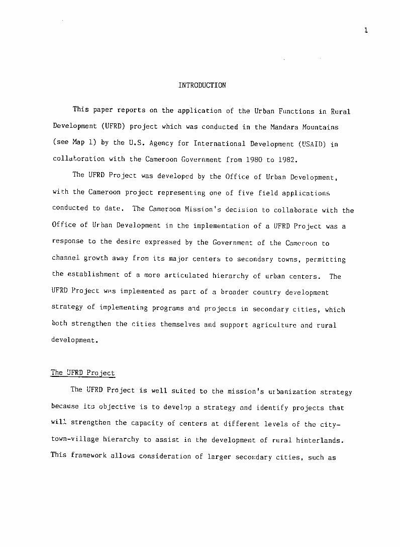
This paper reports on the application of the Urban Functions in Rural
Development (UFRD) project which was conducted in the Mandara Mountains
(see Map 1) by the U.S. Agency for International Development (USAID) in
collaboration with the Cameroon Government from 1980 to 1982.
The UFRD Project was developed by the Office of Urban Development,
with the Cameroon project representing one of five field applications
conducted to date. The Cameroon Mission's decision to collaborate with the
Office of Urban Development in the implementation of a UFRD Project was a
response to the desire expressed by the Government of the Cameroon to
channel growth away from its major centers to secondary towns, permitting
the establishment of a more articulated hierarchy of urban centers. The
UFRD Project was implemented as part of a broader country development
strategy of implementing programs and projects in secondary cities, which
both strengthen the cities themselves and support agriculture and rural
development.
The UFRD Project
The UFRD Project is well suited to the mission's urbanization strategy
because its objective is to develop a strategy and identify projects that
will strengthen the capacity of centers at different levels of the city
town-village hierarchy to assist in the development of rural hinterlands.
This framework allows consideration of larger secovdary cities, such as

MAP 1
THE UNITED REPUBLIC OF CAMEROON
PROVINCES Capital Provincal Capitals
USAID Study Area NIGERIA
CHAD
0Garoua
/-
NORTHERN PROVINCE NIGERIA /........ ...
Ba mena CENTRAL
SOUTHWEST. _Safouram/
WES'7 AFRICANI
' DnATA .. REPUBLIC
COASTAL 0 iiiiiiiiiiiii!iiiiSOiUtH-CENTRALC EAST PROVINCE Ii~~iiiiiii"......................:.:.i!i~~~~iiii:::::i" Q G IN A- G B N,................... AT_R A__ o ::i:::::i:::i:i:iii:iiiiiii:::ii"
3
Garoua and Maroua, as well as much smaller places possessing important
functions and linkages, as potential points of interventions.
The UFRD approach is designed to produce a spatially and sectorally
integrated regional plan while addressing local conditions and needs.
Spatial integration is accomplished by analyzing and building on the exist
ing settlement pattern to help develop rural areas. As investments cannot
be made in all places at the same time, interventions are proposed for
centers with strong functional ties to surrounding villages. Thus, the
provision of new functions, and improvements .o existing ones, contribute
not only to the development of the place where the intervention is made,
but to the hinterland population as well, since benefits filter down
through the hierarchy.
Integration between sectors is accomplished in this approach by apply
ing a spatial model in which development in one secto, opens up possib
ilities for development in another. Such an approach also addresses local
conditions by assuming that in any region there is heterogeneity and that
social, economic and environmental conditions may vary considerably from
one place to another.
The UFRD Project originated from the idea that human settlements have
an important role in the development of rural areas. In general, however,
this role has been poorly defined and its potential poorly exploited. The
project's objective was to describe the role that human settlements can
play in the development of rural areas and to apply a regional planning

4
methodology that could be integrated sectorally and spatially in Cameroon.
Conceptually this study owes much to Johnson (1970) and Rondinelli and
Ruddle (1978). Methods and techniques for analysis and planning were drawn
from numerous sources, including Rondinelli (1978), Sen, Tripathy, Misra
and Thaha (1975) and Pahang Tenggara Development Authority (1978). A
general overview of basic concepts, methods and techniques and a listing of
additional sources of information is available in Rhoda (1981).
Contents
This paper reports on those aspects of the UFRD Project which
constitute the unique contribution of the UFRD approach to more conven
tional methods of planning. First, the conceptual basis for the UFRD
approach is discussed. Following this discussion, the organization of the
settlement system in the project region is described, the methods by which
the settlement system was analyzed are explained, and the implications of
these spatial analyses for planning are discussed. Next, analyses of
individual sectors conducted for the project and later integrated with the
spatial analyses are summarized. Finally, project findings are enumner
ated.
This paper is supported by two addicional reports which are also
products of the project: (i) a profile of Cameroon, arid the project
region; and (ii) a collection of more detailed sectoral studies that were
conducted for the project.

5
CONCEPTUAL FRAMEWORK
In order to understand the unique contribution which UFRD Lan make to
planning it is first necessary to understand thr concepts upon which UFRD
rests. Particularly important are the concepts of central place hierarchy:
linkages, threshold, range, and economies of scale. These concepts are
explained below. By organizing them into a central place " model," the
importance of these concepts in understanding settlement pat'erns and their
relationship to development is demonstrated.
The Central Place Hierarchy Concept
Centers may be thought of as comprising a hierarchy in which the
position of a center in the hierarchy is determined according to the
functions (economic, social and political) which it possesses. The greater
the number of different goods anid services supplied by a center, the higher
its position in the hierarchy.
Higher level places have functions that require support from larger
areas of influence and greater population size than do lower level places.
Basic to this notion are the concepts of range and threshold. Range deter
mines the geographic extent of the influence of a function. It is defined
as the maximum distance which people are willing to travel to obtain
certain goods and services (Rhoda 1981). In the case of lower level
services, such as a primary school or a low-capacity grain mill, travel of
only two or three kilometers might be necessary. For higher order goods
and services, such as a hospital or an outlet for the purchase of a moby
lette, it might be necessary to travel more than fifty or a hundred

6
kilometers. Threshold is the minimum amount cf demand needed for an
activity to survice (Rhoda 1981). Demand is usually defined in terms of
population size. Other measures of demand include an accounting of sales
and production. Goods and services of different orders require varying
degrees of demand for support. For example, a relatively low level
function, such as a dispensary, might require a population of 15,000 for
support, whereas a higher order health function could need 100,000 people.
Higher level places have not only unique functions but also offer
lower level functions in larger numbers and volume than do lower level
places. This is because higher level places are in command of larger areas
and customers minimize their travel cost by availing themselves of higher
and lower level goods in the same place. Moreover, higher order places
have greater economies of scale than lower places because they have more
specialized functions and a larger number of institutions providing lower
level functions than do lower level places. This acts to attract addi
tional economic activity. Such concentration makes possible "economies of
proximity, agglomeration, and specialization and division of labor; oppor
tunities to exploit forward and backward linkages; reductions in transfer
and shipping costs; and widening rural market areas" (Rondinelli and Riddle
1978).

7
The Linkage Concept
Connecting various levels of the city-town-village hierarchy are a
number of functional linkages that can be classified as physical and econ
omic linkages, population movement, and techno-logical, social, service
delivery and administrative linkages. Physical linkages consist of trans
portation networks such as roads, waterways and railroads. Increased
linkages of this type may promote growth and diversification in existing
settlements or gePerate new central places by integrating them into the
larger national economy (RondinelLi and Ruddle 1978). This would make
larger markets for the commercialization of local production accessible and
facilitate the flow of inputs to production. In addition to improving
economic and technological linkages, transportation networks allow wider
opportunities for migration, permit increased access to nonagricultural
employment and extend the range of service delivery.
Economic linkages are necessary to integrate settlements into larger
production and marketing systems. These linkages include flows of commod
ities raw material and intermediate goods between the various centers in
the hierarchy, income and capital flows, aid backward, forward and lateral
production linkages. Strong ties of tiiis nature stimulate increased and
diversified production and commercialization.
Population movement includes permanent and temporary migration.
Strong linkages between low and high level places provide employment and
income for migrants, which in turn benefit the place of origin through
remittances. Of course, the effects are not always positive, as migration

8
may drain rural areas of their best talent and overburden public services
in major centers where there are few alternative destinations.
Technological linkages are made up of flows of "equipment, procedures
and methods of production." These flows might include agricultural inputs,
such as improved seeds, fertilizers and insecticides, as well as improved
farming techniques. When such ties are weak or absent, the possibility for
increased and diversified production is reduced.
Service delivery linkages include education, training, and extension
networks and professional, commercial, and technical service networks.
These services form a hierarchy with different levels requiring different
thresholds and ranges.
Political, administrative and organizational linkages are reflected in
government budgetary flows, organizational interdependencies and admin
istrative authority. Through the government structure services, facilities
and budgetary resources are distributed throughout the city-town-village
hierarchy. Policy decisions made in the capital city flow down the
hierarchy to the smallest village in a well articulated spatial system.
The Central Place Model
The following discussion assembles the different concepts already
discussed and integrates them into a general model of a hierarchy of
centers in Third World nations. According to this model, a nation-wide
hierarchy of settlements exist in the Third World countries, consisting of

9
a primate city, secondary cities, market towns, village centers and
dependent villages.
A primate city usually has the largest population concentration and
possesses significant economies of scale important for manufacturing and
large commercial enterprises. Services and functions found at this level
of the hierarchy are of a high order but also include those of a lower
order. These higher order functions generally include airports Linking the
city and the nation to the rest of the country and the world, the head
qaarters of nationaland international banking and financial institutions,
the headquarters of national ministries and other national governmental
organizations, the most specialized technical skills, equipment and repair
facilities, and major educational and medical facilities. A primate city
usually exerts a powerful influence over all parts of the country and
overall levels of the hierarchy of centers.
In this model, the regional or secondary city is defined as:
a regional or provincial economic and administrative center and is the headquarters for specialized government .3ervices, such as those concerned with agriculture, health, regional police, and the judicial system. Such cities offer relatively good medical facilities--regional medical offices, nospitals, specialized medical practitioners, large drugstores--as well as public sewer systems, electricity, large post offices, and telegraph and telephone offices.Secondary schools are ubiqiitous, and colleges or technical schools have often been established at these locations. Intermediate cities generally function as regional collection and distribution centers, containing large wholesaling and distributing firms in addition to awide range of general and specialized retail outlets (Rondinelli and Ruddle 1978).

10
Trade is often channeled through secondary cities to provincial towns and
rural areas and from the province to national and international markets.
They are usually located on an all-weather road linking them with the
primate city and some lower level centers. Secondary cities in Africa have
been shown to either attract and hold rural migrants or to serve as a step
on the migrant's way to the primate city. Secondary cities are more
heterogeneous than lower level settlements. Social linkages exist between
secondary cities and higher and lower level centers. At this level of the
central place hierarchy there is sufficient population size, service area,
and support capability to supply services of a relatively high order.
These usually include general hospitals and secondary schools. Poli
tically, administratively, and organizationally, secondary cities form part
of a chain that extends from the capital city down to the small villages.
Flows work in both directions as in the case of taxes that pass from the
rural areas and public budget resources that flow downward from the capital
city through the secondary city for the provision of certain services.
The market town or service center characteristically provides some
lower level administrative functions: health services, such as well
equipped dispensaries; educational services, such as secondary and full
cycle primary schools; a small pharmacy; and a post office. Some centers
at this level will have domestic electricity and running water. The
marketplace begins to replace retail stores at this level of settlement.
Retailers provide such goods and services as cement, bicycles, motorbikes,
gasoline. radios, repair services for certain consumer durables, improved

seeds, fertilizers, insecticides and plows.
Market towns are often connected to larger centers by a surfaced or
all weather road. However, lower level centers are usually not as well
linked with the market town. Farm produce moves from the surrounding area,
some of which finds its way to larger centers, having been bought and
transferred by wholesalers and their agents. Manufactured goods flow to
small centers from market towns. Towns at this evel of settlement attract
migrants when job availability is perceived. Market towns provide diff
erent kinds of technical inputs to lower level centers, including physical
inputs to agricultural production, methods of production as dispersed by
extension agents and the repair of farm equipment. Where these techno
logical linkages are weak or nonexistant, agriculture and rural development
will not be maximized. Market towns also furnish a number of sociil and
commercial services to thefr populations and to those in their area of
influence.
Village centers are the smallest central places in the hierarchy in
the Third World that still serve a si:.nificant h.nterland population
through the services they offer. These centers often have important market
functions which not only act as points of collection and distribution but
also attract a wide variety of artisans and repair peoplt. Centers at this
level of the hierarchy generally furnish lower level public services such
as first cycle primate schools, health centers and agricultural extension
posts.

12
Below this level are dependent villages which possess few, if any,
central functions and rely on higher order centers for most or all services
and functions.
DESCRIPTION OF THE HIERARCHY IN THE PROJECT AREA
Applying the concepts previously introduced, a hierarchy of functions
and centers has been identified, and corresponding hinterlands have been
delineated for the project.
Primary data necessary to identify the central place hierarchy were
gathered using a questionnaire as survey instrument. Because of the
impossibility of surveying all 684 places found in the core project zone, a
sample was chosen. Based on the criteria of population size, number of
important functions, geographic representativeness, and extraordinary
characteristics (such as a large market or an active religious mission), 72
settlements were chosen. For this sample, 75 goods and services were
inventoried. An abbreviated list of seventeen functions was established
for the approximately 600 remaining villages. In addition, information was
collected on the movement of people from their villages to other centers
that offer various types and levels of functions. This information made it
possible to produce a map of spatial preferences for goods and services at
.'arious levels of the hierarchy. In the case of the remaining centers in
the core project zone, knowledgeable informants at the level of the canton
headquarters were queried regarding the availability of 'services and

13
facilities in the villages within their districts. These respondents
included those individuals knowledgeable of socioeconomic conditions in the
canton, such as the canton chief, the chief's secretary, and respected
local elders.
Identification of a Hierarchy of Functions and Centers
The inventory of functions for the 72 centers surveyed was presented
in the form of a scalogram. With the help of a scalogam analysis, a
ranking and grouping of functions was completed. In some cases, a hier
archy of functions can be identified by using population thresholds.
However, population is riot always related to the importance of a function
in the study area. Therefore, the technique employed for the ranking of
functions amounted to the assignment of different weights to different
functions on the basis of function ubiquity (Marshall 1969).
Once the weights of each function were calculated, the scores were
inspected for natural break points separating levels in the functional
hierarchy. Ubiquitous functions that served only the center in which they
were located or that were judged to have little development value were
excluded from the analysis. Following these calculations, 41 functions
were ranked. Three breaks in the ranking became evident and yielded three
groups of functions arranged hierarchically. These goods and services
are:
Level I
1. Sales point for bicycle parts 2. Sales or distribution point for inorganic fertilizers 3. Sales point for shovels 4. Sales point for shoes

14
5. Sales or distribution point for insecticides and fungicides 6. Groundnut market 7. Mobylette repair service 8. Cotton market 9. Radio repair service 10. Second cycle primary school II. Sales point for pousse-pousse 12. CDMP 13. Groundnut sheller 14. Dispensary 15. Extension agent 16. First cycle primary school 17. Sales or distribution point for chemical powder for storage18. Sales or distribution point for chemical powder for seed
protection 19. Midwife 20. Sales or distribution point for improved seeds.
Level II
21. Sales point for mobylette parts 22. Sales point for radios 23. Distribution point fo FONADER credit 24. Agriculture extension post 25. Shop 26. Daily market 27. Sales point for melange 28. Automobile repair service 29. Livestock extension post 30. Soil conservation post 31. Pro-pharmacy 32. Sales point for gasoline
Level III
33. Sales point for cement 34. Hospital 35. Sales point for bicycles 36. Secondary school 37. Telephone/telegraph 38. Sales point for wheelbarrows 39. Sales point for motorbikes 40. Sales point for automobile parts 41. Pharmacy
During the field survey, respondents were asked where the inhabitants
of their village went most often for locally unavailable functions. If
villagers preferred a center for 35 percent or more of the functions

15
considered at a particular level, excluding those available locally, an
arrow was drawn between the two centers showiing the inter-linkage. This
exercise was carried out for the 72 selected centers at the second and
third levels of the hierarchy and for all project area centers that could
be located on existing maps at the first level of the hierarchy. In this
way it was possible to identify centers at each level of the region's
hierarchy of central places. A series of maps (see appendix) shows actual
movement patterns of people seeking functions at different levels of the
hierarchy and at the center identified. Hinterlands of designated central
places were then determined from patterns of use of functions supplied by
that level of the hierarchy and from information on transportation networks
and natural barriers.
Based on the methodology of ranking functions as outlined above, a
three-level hierarchy of central places has been identified. At a fourth
level is Garoua which possesses high Level functions influencing not only
the core project zone but all of the Northern Province and parts of Nigeria
and Chad, as well. This relationship would have become more apparent had
still higher level goods and services been included in the inventory.
Therefore, four categories of centers will be referred to, indicating a
direction from most to least specialization: regional city (Level IV),
secondary towns (Level III), service centers (Level II), and village
centers (Level I).
Regional city. Garoua is the only center in the project zone which
qualifies as a regional city. It not only has high level specialized
16
functions but also a larger number of lower level functions than are found
in all of the less important centers of the region. It can be charac
terized as a regional economic and administrative center containing most of
the higher level economic, adninistrative and marketing functions in the
North. Garoua is well connected to the national network of transportation,
as it is located on a national paved road that links North and South
Cameroon. However, physical interaction with other urban ceriters (that is,
Maroua and Ngaoundere) is much more significant than with the surrounding
rural hinterlands. Additional linkages to the national, and to a lesser
extent international transportation system, are provided through its air
port. International transportation ties will be significantly strengthened
with completion of the international airport.
A relatively well developed infrastructure consisting of social
services and facilities that extends beyond the city and its immediate
surroundings to serve all of the north can be found in Garoua. Once again,
however, it is the inhabitants of other urban centers who are the main
beneficiaries of such linkages.
Garoua is the provincial headquarters of the various central
ministries based in Yaounde that extend specialized government services to
the province through divisional and subdivisiona! representatives. As a
regional distribution center, it possesses a number of large wholesale
outlets, including CFAO, CGA, and RW King. These firms are complemented by
a range of general and specialized retail outlets, although it must be
noted that trade linkages with other centers are sporadic and shortages of

17
many goods are not uncommon.
In a limited sense, Garoua can also be considered an industrial
center. Industrial activity is represented by textile (SODECOTON and
CICAM) industries, whose activities are linked to resource areas and
markets throughout the region. Due to its role as a regional economic
center, many higher level financial, insurance and transportation
facilities are located in Garoua. Concentration of economic activity in
Garoua and social linkages with the surrounding region have resulted in a
population of approximately 60,000 (in 1976) making it one of the fastest
growing centers in Cameroon. With a 9.,1 percent an annual rate of growth,
it is estimated that Garoua will become an urban center of 121,110
inhabitants by 1987 and of 149,100 by 1992.
Secondary towns. This group is.made up of Maroua, Guider and Mokolo
in the United Republic of Cameroon and Mubi in Nigeria (see map 2). All
four centers command more or less significant areas of the core project
area through socioeconomic relationships carried on with their hinterlands.
Centers at this level provide most or all level three functions (such as
pharmacy, mobylette auto parts, and wheelbarrow sales, telecommunications,
high school, and bicycle, hospital and cement sales) and generally all
functions at lower levels of the functional hierarchy. Mubi is of interest
only because it demonstrates the Nigerian economy's important role in the
core project area.
Maroua, administrative headquarters of the Diamare Division, had a
population of 62,000 in 1976 with a growth rate comparable to that of

MAP 2
SECONDARY CITIES OF THE STUDY AREA, NORTHERN PROVINCE, U.R. CAMEROON
( Provincial Capital
*
Secondary Cities
of the
USAID Study Area
Maroua
Mubi Guider
@Garoua

19
Garoua (Beauvilain 1981). Within the core project area, it serves a popu
lation of about 140,000. It has good transportation linkages as it is
located on a paved road that connects it with Garoua and points south, and
has an airport of national standing. Physical connections with smaller
towns are not nearly as strong. Like Garoua, Maroua contains wholesaling
and distributing firms. However, the retail industry appears to play a
greater role in the economic life of Maroua where 21.8 percent of the
active population is involved in either handicrafts or retailing.
Specialized goods, such as mobylettes, bicycles, and spare parts for auto
mobiles and wheelbarrows, attract buyers who may travel over a hundred
kilometers from smaller centers. Manufacturing employs 13.9 percent of the
active population. The two principle subsectors are leatherwork (SCTP) and
textiles (SODECCTON). With a growth rate of 10.2 percent per annum it is
estimated that Maroua will have a population 84,000 in 1987 and 164,760 by
1992.
Guider is the largest settlement found within the limits of the core
project area. With 16,066 inhabitants and a growth rate of 8.2 percent,
Guider is a small town in full growth despite considerable population loss
through emigration (Beauvilain 1981). Its area of influence covers a
population of approximately 162,000. Physically, it is well connected to
the larger centers of Garoua and Maroua. Its transportation Linkages with
smaller places will be strengthened upon completion of the Bidzar-Guider-
Dourbeye road. Guider is a sub-regional collection center for agricultural
commodities, such as cotton, peanuts and tubers, that originate from its

20
area of influence and a distribution center for manufactured goods flowing
down the urban hierarchy. The sector's cotton production is ginned at the
SODECOTON factory and then shipped to Caroua and Doula for further
processing. In the case of certain cash crops, Guider links the rural
economy and national and international markets. Because of the primary
product flows associated with Guider, it has become a subregional center
for transportation facilities. Guider's population will be an estimated
30,530 by 1987 and 37,110 by 1992.
Mokolo is the smallest of the secondary towns identified (Steck 1972),
with an estimated population of 5,700 persons in 1980 (an estimation based
on the number of voters participating in the April 5, 1980 legislative
elections that includes the center of Mboua). It serves a population of
86,000 in the core zone. Located in an area with no urban tradition, it
owes its development to its origins as a divisional administrative center.
Situated at an intersection, it links the plains of the Diamare and
Madagali (Nigeria) to the east and west and the plains of Mora and piedmont
of Gawar to the north and south. It has above average transportation
connections such as the all-weather, unpaved roads leading to Maroua, Mora
and Garoua Rhumsiki. It is over these and lesser quality roads that Mokolo
connects rural areas within its area of influence to one another and to
larger regional and national economies. However, the strength of the
physical connections provided by these roads weakens considerably with
distance from the centers due to the rugged terrain and poor condition of
lower class roads and tracks.

21
Goods are bought and sold in the Mokolo market by those who inhabit
the different ecological zones that surround the town. Groups located in
the plains area to the east and the plateau to the south commercialize
sorghum which is in turn purchased by the mountain population to the north,
typically a deficit area for sorghum. Mokolo also acts as a collection and
bulking center as groundnuts, sweet potatoes, fruits, vegetables and
cowpeas are assembled there and shipped primarily to the larger northern
towns. Some products, notably groundnuts, are transported to southern
Cameroon and to international markets.
Mokolo is also a distribution center for products originating in other
regions or countries. These include commodities such as manufactured
goods, dried and smoked fish, and beef. For its supply of manufactured
goods, Mokolo depends principally on Maroua, Nigeria and, to a lesser
extent, on Garoua. Smoked fish is bought by local merchants in Maroua and
resold principally to the surrounding mountain population. Beef cattle are
purchased by local butchers primarily from Gazawa to the east and the
plateau region to the south. The butchered meat is sold in Mokolo, 40
percent of which is sold to buyers originating in the mountain areas.
As a trade center Mokolo is of regional significance and has a limited
zone of influence: 93 percent of market participants originate within 20
kilometers and 61 from within 10 kilometers. For higher order goods the
surrounding population must travel to either Maroua or Garoua.

22
Through the influence of the Fulbe, Mokolo plays an important social
role for its hinterland population. Although a minority group, the
socially dominant Fulbe subject immigrants from the surrounding areas to
strong social pressure to conform to Fulbe customs. To adopt such customs
is considered a social promotion. This phenomenon, together with admini
strative efforts, has helped integrate the mountain population and develop
a regional and national sense of identity. In general, social services
provided by Mokolo have a limited impact on the zone's population. As an
example, 75 percent of the hospital patients originate within a radius of
10 kilometers, with 45 percent from Mokolo itself. In the case of educa
tion the level of primary school attendance drops considerably as a
function of distance from the center, especially beyond 10 kilometers.
The administrative structure influences a large area and affects the
very lowest levels of the center hierarchy in the Margui-Wandala division.
Its influence is felt most through tax collection and the village popu
lation's construction and maintenance of local roads. As the Margui-
Wandala division has been recently divided into the departments of Mayo
Tsanaga and Mayo Sana, this influence will be reduced.
Assuming an annual growth rate of 3.5 percent, Mokolo's population
will reach an estimated 7,100 inhabitants in 1987; 8,090 by 1992.
Mubi, located in Nigeria, commands a relatively large area in the core
project zone. It maintains strong linkages of a physical, social service
delivery, economic and social nature. The strength of these connections is

23
due to the following elements:
i) the relative capacity of the Nigerian transportation network;
ii) better equipped social facilities such as hospitals and pharmacies;
iii) relatively low priced consumer goods;
iv) relative availability of agricultural inputs and other technologies;
v) relatively high prices for some Cameroonian agricultural products, and;
vi) until recently, the relative strength of the CFA franc to the Nigerian naira.
Service centers. In addition to the secondary towns previously
discussed, Mayo Oulo, Hina Marbak, Bourrah, Figuil and Mogode comprise
level two centers (see maps in appendix). In terms of population they are
less important. They are characterized by some or all of the twelve Level
II functions. In the case of the secondary towns, which also comprise this
group, Level III functions are usually present. Administrative functions
predominate in these centers, all of whom have a poste agricole, which also
functions as a formal credit outlet for FONADER, and in some cases a poste
d'el tage and poste forestier. They provide an important link between
administrative authority located in Garoua or Mokolo and the zone's
villages.
Service centers are trade centers that provide specialized goods and
services such as gasoline, melange, radios, spare parts for mobylettes, and
automobile repair. These places are all located on paved or all-weather

24
dirt roads which explains the preponderance of transport functions. Most
have shops, and some have daily markets. Goods and services are provided
to lower level villages after having been passed downward via the larger
centers of the region. Some level two centers act as important collection
centers for local produce, Mogode, for instance, in the case of groundnuts
and Bourah for sweet potatoes.
Although the level of social services is no higher than in some
smaller settlements, those located in service centers are usually better
maintained, equipped and staffed. Thus, the surrounding population is
prepared to travel the extra distance for a reliable higher quality
service.
Village centers. There are 29 village centers. This includes the ten
already mentioned (excluding Garoua, Maroua and Mubi, which at this level
no longer influence the core area project zone) plus the 22 listed below
(see maps in appendix).
1. Tchontchi 12. Guili
2. Babouri 13. Gambourra
3. Bidzar 14. Mofou
4. Libe 15. Gawar
5. Dourbeye 16. Mokong
6. Doumo 17. Zamay
7. Guirviza 18. Soulede
8. Lam 19. Tourou
9. Matafal 20. Wanarou
10. Douroum 21. Boukoula
11. Mousgoy 22. Gazawa

25
The central places that most directly serve rural populations are the
Level I centers, with an average area of influence between 10 and 15 kilo
meters. At this level, most centers owe their importance to their admini
strative functions as either canton or groupement headquarters. They
provide the last administrative link between the central authori.ties and
over 600 villages that are located in the project zone. All possess weekly
markets of generally low integration levels with higher level centers for
the sale of procesjed and non-processed agricultural produce and locally
produced goods (pottery, hoes, shovels, and so on). Such markets also
serve as places where non-locally manufactured consumer goods like bicycle
parts, shoes, and fabric and technical inputs to agriculture can be
purchased. (The availability of agricultural inputs is generally
restricted to SODECOTON areas). Most trade is localized. However, some of
the centers act as collection points for agricultural produce, groundnuts,
cotton, cowpeas and tubers, for instance, that is shipped to higher level
centers for consumption or processing. Manufacturing activities at this
level are limited and rudimentary. Output from these activities is locally
marketed. Since there is little specialized commercial or industrial
activity at this level of the city-town-village hierarchy, interactions
will be vertical in nature with few inter-village transfers.
While many of these level one centers provide the services of an
agricultural extension agent, their ability to improve production practices

26
is limited partially because of a lack of physical inputs. Thus, techno
logical linkages remain weak.
Much the same is true of schools, health facilities, and other social
services where linkages have been weakened by the lack of personnel and
supplies. Less than ten years ago most students residing in Margui-Wandala
division who wished to finish their primary school education were obliged
to go to Mokolo for the second cycle.
Finally, road connections at this level are generally inadequate and
therefore reinforce the localized activities of the vast majority of the
rural population. Some village centers become isolated For long periods
during the rainy season when roads become impassable.
In conclusion, it has been observed that much of the zone's population
does not have adequate access to functions necessary for social and econo
mic development due to physical dIstance and the low efficiency and quality
of existing services. Inadequate staffing, equipment and supplies deprive
some of the population access to social infrastructure such as school and
health facilities.
Implications for Project Identification
Four hierarchic levels were established for the project area. As they
are places of different sizes with differing magnitudes of area and popu
lation served, different levels also indicate the nature of potential
interventions.

27
Village centers of the lowest level are best suited for the location
of small scale social facilities and agricultural infrastructure. For
agricultural input purchase and crop production commercialization or
processing, the region's cultivators need travel only relatively short
distances. In t'e case of processing units, the range rarely exceeds five
kilometers.
In the case of certain social facilities the area of influence is
still more limited. Children attending first cycle primary schools seldom
travel more than two or three kilometers, although older children are
capable of longer distances. Dispensaries command large areas with
patients covering up to ten kilometers and more for medical and health
care.
For larger scale interventions higher level centers of the third or
fourth order are more appropriate. These centers have larger economies of
scale, populations, and areas of influence. In the case of a sizeable
industrial unit this level is most appropriate. For economic viability, a
large industrial plant requires an extensive hinterland to procure nece
ssary raw materials. In populated areas such measures as crop production
or areas under cultivation are used to determine demand.
In many cases services or facilities exist at locations and serve a
hinterland population, although the quality of their equipment, supplies
and personnel are often inadequate. Recommendations will be made for
upgrading these existing functions to strengthen linkages for stimulating
development in the area commanded by the center.

28
All settlements, even the smallest, should benefit from public and
private investment. Unfortunately, it is impossible to simultaneously
locate interventions at all places, due to the scarcity of resources and to
the fact that the smallest villages cannot support large scale industry or
a secondary school or hospital. However, centers that have hinterlands
made up of other centers can support investments of different sizes.
SECTORAL STUDIES
UFRD spatial analysis identifies a number of critical locations of
various population and hinterland sizes for project interventions. The
precise locations selected depended on the sector and on the size of
investment. In order to provide sectoral information, eleven studies were
conducted for the project. Summaries of analyses for these eleven sectors
in the Cameroonian economy follow.
Administrative Services
Officially, there are eight administrative units (division, subdivi
sions and districts) in the central zone of the project, two of which were
created in December 1981. Before this reorganization, there was one
administrative unit for about 85,000 persons in the zone, which is far from
the national average of one administrative unit per 41,000 inhabitants.
Recent changes have improved the zone's average which is now one

29
administrative unit for 64,000 inhabitants. This recent expansion of the
administrative cover corresponds to the general strategy of the UFRD
project which attempts to improve access of populations to infrastructures
and services necessary to the area's development. After the creation of
these new administrative units and considering the necessity for improving
existing centers before December 1981, this study found that there is a
need for three new offices for the chief towns of administrative units, six
new residences for administrative authorities, five new vehicles, six new
guest houses and three hundred and twenty agents in total. The estimated
total cost of these improvements is 1.1 billion CFA Francs for the 1982
1987 period.
Agriculture, Livestock and Forest Resources
Agriculture represents more than 90 percent of human activities within
the project area. Due to the great divprsity of milieux, there is a great
disparity in the levels of practices, operations, production, incomes, ctd
environmental consequences of agriculture. Today, with changes affecting
the rural population (significant population increases, rural migration,
the desire of the rural population to attain a better standard of living),
this agricult-'rc which is little organized and not always adapted is
generally oriented towards short-term goals. This leads to a profound
impact on the territory: degradation and erosion of soils, overgrazing and
overexploitation of forest resources, and so on. The medium-term result is
a decrease in production.

30
Problems related to agriculture-, especially those concerning natural
resources could not be studied exhaustively. However, using surveys
carried out throughout the region and inventory studies made locally in
four test-zones representing the main ecological areas, an attempt was made
to: i) identify the main constraints to agricultural development;
ii) characterize and quantify the present level of crop production;
iii) propose agro-sylvo-pastoral development schemes, according to
existing conditions and the potentiil of the test-zones. These aim at:
a) increasing agricultural prouuction through the expansion of cultivated areas with introduction of anim.i traction, use offertilizers, use of pesticides, measures against erosion of water and soil resources, and agricultural extension;
b) improving animal breeding through range management measures (rotation, constitution of fodder reserves for periods ofscarcity, adaptation of stock ingrates, creation of watering points), development of domestic breeding for the production of quality meat and using surpluses of agriculture production; and
c) managing forest resources through Lhe organization of exploitation(temporary suspension of exploitation, creation of communal woods with sequential cuttings), reforestation where possible and according to the means, development sylviculture, and training in forestry and animal breeding.
The estimated cost of these interventions during the 1982-1987 period
amounts to 3.712 billion CFA Francs distributed as follows:
606 million CFA F. for animal traction 3.065 billion CFA F. for chemical fertilizers
16 million CFA F. for agricultural product processing 25 million CFA F. for chemical powders used during storage.

31
This amount does not include training costs, creation of a loan fund, and
exploitation costs of forests (reforestation and sylviculture).
Livestock raising is not a primary activity for most people within the
project zone. However, the proportion of goats and sheep to the human
population is more than double the national average. In terms of a
ruminants/technical agents ratio, the sub-sectors of Mokolo and Guider are
the poorest in the Northern Province. Within the project zone, there were
disparities from one sub-region to another. In order to eliminate these
inequalities in the levels of services and to improve the livestock in
quantity and quality, the following recommendations have been made:
- 2 new zootechnical and veterinary centres; - 135 vaccination stations to build or rebuild; - 6 new livestock dips; - 3 new slaughter shelters; - 1 research center for the study of problems related to
small ruminant breeding.
The total cost of these interventions, not including zootechnical and
veterinary centers and the research center, is estimated at 580.2 million
CFA Francs.
Productive Sector
In the central zone of the project, industry is dominated by rudi
mentary individual enterprises using traditional techniques. The main
exceptions to this are the lime quarry and the cementry in Figuil, on one
hand, and the cotton ginning unit in Guider, on the other. The other
important modern industries are located in Garoua and Maroua. The region

32
depends greatly on industries conceptrated in Douala and abroad for indus
trial products. Local industry's growth problems appear to center on lack
of funds, on investment policy which tend favoito large industries, and on
lack of necessary inputs and services in the project zone. In order to
create an environment which is more favorable to the growth of the produc
tive sector in the project zone three types of interventions are recomm
ended: the creation of a priv3te fund of about 30 million CFA Francs to
allow loans and promote small enterprises; the provision of technical
assistance to CAPME so as to extend this support directly to the small
enterprises of the project zone (the cost of this intervention would amount
to 152 million CFA Francs for 3 years, including' the salaries of two
experts); and the creation of an office for identification and promotion of
agro-industrial projects in the Northern Province (at an estimated cost of
108.3 million CFA Francs for 3 years, including the salary of an expert).
Tourism
The project zone attracts increasing numbers of tourists because of
the beauty of its landscape and its proximity to the national parks. The
public and private hotel infrastructure has generally kept pace with
demand, subject to some seasonal pressures. A plan aimed at continuous
geographical expansion of tourism in the region takes into account the
improvement of the road network and recommends the creation of a cooper
ative for handicraft. The construction cost of the 264 hotel. rooms and
camps which the study found to be necessary to further meet the increasing

33
demand during the 1982-1987 period amounts to about 4 billion CFA Francs.
The restoration of 22 rooms will cost 33 million CFA Francs.
Transports
At the time of the project there were 964 kilometers of roads in the
project zone; 53 percent of them were passable only during the dry season.
This situation should improve greatly with the completion of the Bidzar
Guider-Mayo, Oulo-Dourbeye and Mokolo-Maroua roads. However, despite this
improvement, this study found that significant parts of the highlands in
the project zone will remain isolated because all-season secondary roads
are insufficient. Such inaccessibLlity is an obstacle to the region's
development. In order to overcome the deficiences of the present transport
system, 9 new road sections with a total length of 162 kilometers were
proposed for the region between 1.982 and 1987. The cost of the works is
estimated at 993 million CFA Francs.
Communications
At the time of the project there were four post offices and four
telephone exchange centers in the project zone. Compared to national
norms, postal services in the zone were inadequate. Considering the exten
sion of present systems, telephone services appeared adequate, at least for
the next five years. In order to remedy the insufficient access to post
and telecommunication services in the project zone, it was proposed that an
existing post office be rebuilt and a new one created. In order to

34
increase the efficiency of these services, it was recommended that thirty
nine extra post and telecommuniction agents be transferred into the zone.
Finally it was proposed that two rural mobile post offices be created for
better postal coverage of the zone. The total estimated cost of these
measures amounts to 310 million CFA Francs for the 1982-1987 period.
Electricity
The electrification rate in the project zone is largely insufficient
compared to national norms. In 1976, only 0.4 percent of all the houses in
the zone had electricity, compared to 8 percent for the whole country. The
National Electricity Company of Cameroon (SONEL) is now tackling this
problem by setting up a network that would link the main towns of the
extreme north with thermal power stations, and eventually with the hydro
electric complex of Lagdo. This study found that this network should be
extended so as to reach a greater portion of the rural population in order
to support the development of small industries and to improve services in
schools and health centers. The electrification cost for the eight centers
amounted to 710 million CFA Francs between 1982 and 1987. The electri
fication cost for 18 extra villages from 1987 to 1992 is estir.'ted at 1.5
billion CFA Francs.

35
Water Supply
According to local citizens, lack of water is #ne LLhe most serious
problems in the project zone. In villages which are not served by SNEC,
wells had an average output of 1.2 liter per inhabitant per day between
November and December 1981. For water supply improvement in the thirty-one
villages, the following interventions were recommended to take place
between 1982 and 1987:
- thirty-nine new wells
- thirty wells redug - one small water supply system - one small dam - one livestock watering point.
The total cost of these interventions, including personnel and
necessary extra materials was estimated at 170.4 million CFA Francs.
Another amount of 264.4 million CFA Francs would be necessary for the
installation of 3,833 domestic connections and 51 foundations by SNEC.
Health
Health infrastructure in the project zone must now serve a greater
number of people than those of other areas in the Northern Province. There
are also disparities within the project zone among various sub-regions and
existing health centers. The Elementary Health Centers (CSE) care for
three times as many persons as the official norm. The Developed Health
Centres (CSD) of the project zone serve twice as many persons as the
Ministry of Health's norms. However, improvement of healtr services
requires both the improvement of care in existing infrastructures and the

36
construction of new infrastructures. The UFRD project plan for health
services recommended construction of two CSEs, one CSD and one urban
dispensary. It was recommended that two other CSDs should also be entirely
rebuilt and a Mother and Child Care Center renovated. Eleven units of
various types needed structural repair, and 38 public infrastructures must
be re-equipped. However, the most important costs concerning health
services were personnel costs. It was recommended that the number of
doctors be raised from 29 to 41 between now and 1987 and to 47 in 1992. It
was also recommended that the number of nurses, assistant nurses and othier
agents reach 537 in 1987. The total cost of the recommended interventions
is approximately 1.8 billion CFA Francs for the 1982-1987 period, and to
1.9 billion CFA Francs between 1987 and 1992, calculated on the basis of
1982 prices.
Education
The primary education rate in the central area of the project is one
of the lowest in the country; about 13 percent, against 65 percent for the
whole country. The factors contributing to this situation are among
others, the zone's isolation, thq reticence of the local population toward
education and the lack of school infrastructure and teachers. The proposed
strategy is aimed at the construction or reconstruction of classrooms
within the 1982-1987 period and at eliminating disparities by bringing each
sub-region of the central zone of the project up to the project zone's
"general average. This implies the complete construction or reconstruction
of 398 primary school classrooms and 144 secondary school classrooms at a

37
cost of 1.5 billion CFA Francs. The cost of the teaching personnel during
the same period would amount to 3.1 billion CFA Francs for the five-year
period from 1982 to 1987.
Institutions
In the past, investments in the UFRD project zcne have essentially
been punctual, sectorial actions, ignoring the comolementarity which can
exist among the different sectors. In order to make the best use of the
recommended interventions, the creation of an implementation body was
proposed. This new institution would be in charge of coordinating project
activities and collaborating with other regional projects (for example, the
Center-North project) and in bordering regions (for example, the North-East
Benoue project) in order to ensure greater levels of cooperation among
projects.
Two possibilities were advanced to organize and manage the projects
identified in the UFRD project zone: i) delegate responsibilities to a
governmental unit composed of the Mayo-Tsanaga and Mayo-Louti divisions; or
ii) create an independent and temporary development mission, on the North-
East Benoue model. It is propoF-d that advantages and disadvantages of
both approaches be discussed with the MINER delegate in the North and other
local authorities, before any final decision is taken.

38
FINDINGS
The project's special, sectoral and spatial analyses made it possible
to identify critical conditions in the region and thus to establish a
framework for development interventions. Most of these conditions have
been referred to in the foregoing. Further description and analysis will
be provided in the individual sectoral analyses. All conditions outlined
in this section are addressed by the strategy and the projects identified.
In summary form these consist of:
i) a general inadequacy of services, facilities and infrastructure necessary for serving basic human needs and generating economic development for the rural population.
ii) a concentration of those services, facilities and infrastructurethat exist in a few major centers and leave many areas poorlyserved, if at all. The general pattern is one of small dispersedsettlements possessing few if any central functions. Most functions important for rural development are concentrated in Garoua andMaroua and to a much lesser extent in some twenty centers of less importance.
iii) inadequate distribution of functions is worsened by thC weak economic, service and physical link between settlements and betweensettlements and rural areas. For example, on the average, settlements in the zone are nine kilometers from an all-weatherroad. Many inhabitants of mountain villages must travel significantly further.
iv) a lack of specialization between settlements strengthening the core region's dependence on larger centers like Douala, Yaounde and Garoua.
v) an unequal distribution of the region's population that does not correspond to its productive potential. Twenty-five percent of the core zone population is located in the low potential mountainous canton of Matakam-Sud on only 14 percent of the total surface area.

39
vi) important population movements, Generally the zone is losing population through emigration with significant numbers going to Nigeria.
vii) environmental problems caused by deforestation, over-grazing and destructive cultural practices.
viii) generally low levels of commercialization and monetarization which limit investment in productive sector activities.
The strategy adopted by UFRD to deal with these conditions consists of
the following:
i) decentralization of investments to village centers and in so doing:
a) improve access of the rural population to services,facilities and infrastructure;
b) strengthen linkages between settlements and the rural population;
c) improve the development of the settlement hierarchy of the zone;
d) reduce the intra- and inter-regional disi,arities.
ii) creation of a better distribution of the region's population by;
a) facilitating emigration through such interventions as education and road infrastructure;
b) preparing the population for emigration by teaching them better agricultural techniques.
iii) introduction of more intensive cultural methods and soil conservation measures.
iv) public interventions in support of private enterprise.
By using the strategies summarized above, an integrated regional
development plan for the departments of Mayo Tsanaga and Mayo Louti and the
urban centers of Maroua and Garoua was developed. Twelve sectors were

40
examined: administrative services, agriculture, forestry, livestock,
productive sector, tourism, transport, communications, electricity, water
supply, health and education.
The plan is integrated both functionally and spatially. Functional
integration of the twelve sectors was made possible by using a framework
whereby interventions in one sector complement those in another.
The application of this framework is made vividly clear in the case of
agricultural development. Proposals were made for increasing agricultural
production through the increased application of agricultural inputs.
However, in order to make such inputs available better roads and a reliable
system of supply and increased credit are required. Furthermore, these
same improved roads as well as increased processing units and storage
chemicals are necessary to handle projected expanded production.
Spatial integration was made possible by the use of the existing urban
centers (regional city, secondary towns, service centers and village
centers) in planning for the development of rural areas. Thus, inter
ventions were proposed for selected settlements in response to the develop
ment needs of their rural hinterland population.
Conclusion
The project ai a is a veritable prototype of an economically backward
area suffering from years of neglect. It is typified by a general
inadequacy of services, facilities and infrastructure when compared with

41
provincial and national averages; a geographic concentration of existing
services; weak economic, physical and service linkages that reinforce the
region's physical isolation. The region also suffers from generally low
agricultural potential with potential scope for expansion and intensi
fication; diminishing agricultural potential due to deforestation and
overgrazing; population distribution that does not correspond to the area's
potential; and levels of monetarization and limited access to capital.
Broadly, the strategy elaborated )y UFRD proposes greater decentral
ization of investment, a better distribution of the region's population,
expansion and intensification of agricultural production and public support
of private enterprise. This general approach has been adapted to the
region's sub-areas taking into account the differences in micro-level
conditions.

42
APPENDIX
POPULATION MOVEMENTS BY SETTLEMENT LEVEL
A. Settlement Level III .......................... 43
B. Settlement Level II ........................... 44
C. Settlement Level I ............................ 45

MAP A
POPULATION MOVEMENTS (LEVEL III)
LEGEND
Indicates the
preference shared between two centers of the third level.
-..-- --. Indicates the
preference shared at 25-49% between
two centers of the third level
-- trIdicates the Mo _olo preference shared at 50% between
two centers of the third level.
Indicates the
preference of 50% or more.

MAP B
POPULATION MOVEMENTS (LEVEL 11)
LEGEND
Indicates centers preferred at 25-49% at the second
level
Indicates the centers for which the preference is shared at 25-49% between centers of the Second level.
Indicates the centers of which preference is shared at 50% between two centers of the second Mogod level.
Indicates the centers which are preferred at 50% or more of second level functions.
Mubi M ak
Bourrah
rie
Fiui

MAP C
POPULATION MOVEMENTS (LEVEL I)
LEGEND
indicates centers of preferenceassuring functions of the first level
Mokolo Soulede
og de Zamay
kong
Wanaro
Mofou
ba
Boura
Guili - .ak
rous y Dou Ou
uirvi a 7L
Dourbeye Mayo MataLiabe
Guider
iguil
c onct

46
REFERENCES
Ahidjo, A. 1980. Le temps de la maitrise et du developpement. Bufoussam.
Barbier, J.C. n.d. Zone de Bobouri (N~ord Cameroon). Carte des sols i/100,O00 SSC. ORSTOM, Bondy.
Beauvilain, A. 198U. Les migrations au Nord Cameroon. Revue de geograpnie au Cameroon I(t): t-3.
19bi. Notes sur les villes de la Province du Nord. Revue de Geographie du Cameroon 2(l): 2--36.
Boulet, J., 19/5. Magoumoz-eays Mara (Nord Cameroon). Atlas des structures agraires au Sua du Sahara. 11. Paris: OR6TOM.
Boutrais, J. 19/3. La colirisation des piaiches pour les montagnards du Nord Cameroon (Mouts Mandara). Paris: ORSTOM.
Brabart, P. 1978. Carte pedologigue du Cameroun teuille de bere 1/i,OuO,UOO. Carte des constraints edapniques I/1,OOu,OuO.Paris: ORSTOM; Yaounde: IRAF/ONAREST.
Cameroon, Government of. 197J. Carte routiere du Cameroun. Yaounde: Centre Geographique National.
__ 19/6. Recensement general de la population et de i'habitat. Yaoune: MinIstere de l'Economie et du Plan.
• 19/7. Necensement solaire du Cameroun, 1976/77. Yaounde: Ministere de l'Education.
_ 198Ua. bilan diagnostic 1976/8U. Mokolo: Service Departementai de i'Agriculture.
.1980b. Rapport annuel de 197b/79. Garoua: Ministere de i'Eievage, Sousecteur de Garoua.
_ IV80c. Rapport annuel ae 1979/80. Garoua: Delegation du Tourisme.
__. 198Ud. Propositions pour l'elaDoration du plan provincialde la Province du Nord, 1981/86. Garoua: Ministere de l'Economie et du Plan.

47
_ 1980e. Survey of health facilities. Yaounde: Ministry of Health.
._ 1981a. Enclyopedie du Cameroun. vols. t-4.
._ 1981b. Rapport annuei de 197q/80. Garoua: Ministere de l Elevage, Sous-Secteur de Garoua. ._ 1982. Rapport annuel de 1960/81. Garoua: Delegation du
Tourisme.
Cameroon Tribune 1981. No. 1997, February 17.
Campbell, D.j. 1980. Soil and-water resource and land use. Yaounde: United States Agency for International Development.
Campbell, D., L. Berry, and J. Holtzman. 198U. Preliminary report ot a socioeconomic survey of the Department of Merqui-Wandale and the Arrondissement or Meri, North Cameroon, April-May 1980.
Centre Technique. 1979. Conser ation des sols au sud du Sahara. Paris: iinistere de le Cooperation.
Connele, j., U. Bifl. K. Laisnley, and M. Lipton. 1976.Migratbon from rual areas. New York: Oxford University Press.
i~ain, R. 1954. Densite de la population, demographigue, economie ruraie dans les sub-divisions de Guider, Kaele, et Yagoua(Nord-Cameroun). Yaounae: ORSIOM/IRCAM.
Food and Agriculture Organization of the United Nations. 1977. Agriculture census of Cameroon. Rome: FAO.
France, Government of. Memento a l'agronomie. Paris: mlinistere de la Cooperation.
Fulton, D., et al. n.d. Resource inventory of North Cameroon. Washington, D.C.: United States Agency for International Development.
Gauthier, J.G. 1973. Les fali du Cameroun septentional. Paris.
Johnson, E.A.J. i970. The organization of space in developing countries. Cambridge, MA: Harvard University Press.
Jeune Afrique Economie. 19i1. December.
Laclavere, G. 19/9. Atlas de la Republique Unie du Cameroun. Paris: Edition Jeune Afrique.

48
Lambert, B. 1950. Les populations paiennes du Nord Cameroun. Paris: PUF
Lestringant, J. 1964. Les pays de Guider au Cameroun. Essai d'histoire regionale.
Letouzay, R. 196b. Etude physiographique du Cameroun. edit Paul Lechevalier. Paris.
Lev, L. 1980. Farming Systems. Mokolo: UbAID/MSU.
Marshall, J.V. 1909. The Location ot service towns. Toronto: University of Toronto Press.
Martin, J.Y. 197u. Les Mataksou du Nord Cameroun. Essai sur le dynamique d'une societe pre-industrielle. Paris: OKSTOM.
Moukoury, K.H., and R. Pontanier. 1981. Propositions d'actions de recherches pedologigues dans le Nord Cameroun. Nkolbisson: IRA.
Naah, E. 1977. Etude du Mayo rsanaga a Minglia. Yaounie: UNARESI/ IURM.
Pahang Tenggara Development Autnority. 19/8. A proposed general hierarcny of towns in Pahang Tenggara and implications for the distribution of commercial activities and basic institutional services.
Podlewski, A.M. 19o6. Le dynamique des principales populations au Nord Cameroun. Paris: ORSTOM.
Fontanier, R. 1981. Rapport de la mission d'expertise autres des projects de developpement integre. Sud-Uuest Benoune (SE6) et Centre-Nord (CN). Nkolbisson: IRA.
Pontanier, R., and Vieilleton. 19/7. Carte des resources en sol de la Tunisie au 1/2U0,UOO. Feuille Gabes St. Chemmokh. Tunis: DRtS/URSTOM.
Pontie, G. 1973. Les Guiziga du Cameroun Septemtrional. L'organisation traditionnelle et se mise en emtestation. Memoires no. b5. Paris: ORSTOM.
Rhoda, R. 1979. Rural-urban migration. Washington, D.C.: uSAID.
1981. Guidelines tor urban and regional analysis. Wasnington, D.C.: USAID.

49
Rondinelli, D. 1978. Bicol River Basin Urban Functions in Rural Development Project: Summary and evaluation. Washington, D.C.: USAID, Oftice of Urban Developme-nt.
Rondineili, D., and K. Ruddle. 19/8. Urbanization and rural development: A policy for equitable growtn. New York: Praeger.
Roose, E. 1981. Dynamique actuelle des sols ferroilitiques et ferrugineux tripicaux d'Afrigue Occidentale. Traveaux et Documents de 1'ORSTOM no. 13U. Paris: ORSTOM.
Segaler, P., and im.Vallerie, n.d. Carte pedologigue du iNord Cameroun au 1/100,OUO. Feuille Mokolo. Paris: ORSTOM; Yaounde: IRCAM.
Sen, L., R.N. Tripathy, G. Mira, ana A. laka. 1975. Growtn centres in Raichur. In An intrepreted area development plan for a district in Karnataka.
Sieffermann, G., ana D. Martin. n.d. Carte pedologique du Nurd Cameroun au 1/100,000. Feuille Mousgay. Paris: ORSTOM; Yaounde: IRCAM
SOUECUTON. 1980. Compto-rendu annuel/Campagne 19/9/60.
Steck, B. 1972. Mokolo dans ses relations avec le milieu rural environment. Cahiers de l'OR6TOM, Serie Science Humaines 93).
Steele, W. 1979. Development of urban artisinal sector. Journal of iModern African Studies.
Suchel, J.B. 197z. Le repartition des tluies et les regimes pluviometriques au Cameroun. CEGET, CNRS.
Tillemeut, B. 1970. Hycirogeology du Nord Cameroun. Builetin de la Direction des Mines et de la Geologie (6).
UNIVO. 1981. Bilou diagnestic du CAPME.
Vallerie, M. 1964a. Etudes pedologigues dans le MarqueWendieiie/Peimetre Matakam. Paris: ORSTOM; Yaounde: IRUAM.
_ . 1964b. Carte pedologigue du Nord Cameroun au I/DO,UO0. Feuilles Biotzar et Guider. Paris: ORSTOi; YAOUiNDE: IRCAM.
• 19o7. Etude pedologique du Piedmont sud du Peske-Bori au 1/20,000. Paris: ORSTOM; Yaounde: IRCAM.

59
Wickam, C. 1981. A study on Cameroonian agro-industries. Yaounde: USAID/Cameroon.
World Bank. 198Oa. Cameroon Statf appraisal report: Artisans, small and medium scale enterprise. Washington, D.C.: World Bank.
_ 19Ob. United Republic of Cameroon: Economic memorandum. Washington, D.C.: World Bank.
_ . 1981c. World Bank news reiease. No. 81/Z6, November 20.
Zalla, T., D. Campbell, J. Holtzman, L. Lev, and D. Trechter. 1981. Agricultural production potential in the Mandere Mountains in Northern Cameroon. working paper no. 18.