controlling the chora topographical investigations in the...
TRANSCRIPT

www.fastionline.org/docs/FOLDER-it-2016-351.pdf
The Journal of Fasti Online (ISSN 1828-3179) ● Published by the Associazione Internazionale di Archeologia Classica ● Palazzo Altemps, Via Sant'Appolinare 8 – 00186 Roma ● Tel. / Fax: ++39.06.67.98.798 ● http://www.aiac.org; http://www.fastionline.org
Controlling the Chora. Topographical Investigations in the Territory of Locri Epizephyrii
(southeastern Calabria, Italy) in 2013-2015
Paolo Visonà
Three previously undocumented Greek sites have been identified at contrada Palazzo (Cittanova), at località “Coculédi” and at contrada Bregatorto (Antonimina), as a result of topographical surveys conducted in 2013-2015 by the Foundation for Calabrian Archaeology and the University of Kentucky on the Dossone della Melìa, a high plateau on the western borders of the chora of Locri Epizephyrii. All three sites are located near the most direct overland route from ancient Locri to the Tyrrhenian coast, which traversed the plateau c. 4 km to the south of the Passo del Mercante (the main pass on the Strada Provinciale 1 di Gioia Tauro e Locri). The presence of a military installation at contrada Palazzo, on the western edge of the plateau, has been inferred from finds of re-used Greek materials. A lookout tower at this site would have allowed the Locrians to guard a trail leading to the plat-eau from the Tyrrhenian coast and to keep watch over the chora of Medma, Locri’s closest Tyrrhenian sub-colony. The functions of a Greek masonry structure at località “Coculédi”, a site on the eastern edge of the plat-eau, cannot yet be determined. A nearby site, at contrada Bregatorto, was occupied by a fortification similar to the Locrian fort on Monte Palazzi (Grotteria) and may have been the main control point on this overland route be-tween c. 500-300 B.C. These findings point to the existence of a defensive network guarding the borders of Locri’s territory and strategic routes linking the eastern and western coasts of Calabria.
Introduction
Archaeological investigations conducted by American teams between 2005-2010 on the summit of Monte
Palazzi near the Croceferrata Pass in south-central Calabria cast new light on a Greek mountain fort of Locri
Epizephyrii that functioned as a control point from the late Archaic the to early Hellenistic periods. This fortifica-
tion was constructed on the right bank of the Fiumara Allaro, the main geographical and political boundary be-
tween the territories of Locri and Kaulonia, identifiable with Strabo’s Sagra River. It guarded the Locrian border-
lands against invasions by Kroton and Kaulonia and kept an overland route leading to the Locrian sub-colonies
of Medma and Hipponion under surveillance. Similar fortifications were built by the Greeks of Rhegion and
Kaulonia at Serro di Tavola (Sant’Eufemia), San Salvatore (Bova Superiore), and Monte Gallo (Placanica).
Each of them was occupied in the 6th and 5
th centuries B.C., a period of intense interstate rivalry in Magna
Graecia, which continued into the first half of the 4th century
1. Information from literary sources (Thucyd. 3.99;
3.115.7) also indicates that the Locrians had forts near their territorial boundaries. This suggests that perma-
nent fortifications were essential to the defense of the Greek colonies in the toe of Italy from early on2. M.T.
Iannelli’s and G. Cordiano’s surveys, in particular, have found evidence that Kaulonia and Rhegion protected
the borders of their territories with a line of outposts3. The study of these fortifications could therefore provide
new insights into Greek territorial organization and borderland processes in southern Calabria4.
* School of Art and Visual Studies, 236 Bolivar Street, University of Kentucky, Lexington, KY 40506 U.S.A. 1 See WONDER 2012: 129, 132-140; DE SENSI SESTITO 2011: 31, 34; DE SENSI SESTITO 2014: 21-27, 29, 36-42.
2 VISONÀ 2013; VISONÀ 2016.
3 IANNELLI 2011: 402-405; CORDIANO 2014b: 33, 46-47; INSOLERA 2014: 114.
4 Cf. GIANGIULIO 2001: 333, n. 3 and PARKER 2006.

Paolo Visonà ● Controlling the Chora. Topographical Investigations in the Territory of Locri Epizephyrii (southwestern Calabria, Italy) in 2013-2015
www.fastionline.org/docs/FOLDER-it-2016-351.pdf 2
Fig. 1. Satellite map of southern Calabria showing the location of sites investigated in 2013-2015. 1 = Monte Gallo; 2 = Monte Granieri; 3 = Monte Gremi; 4 = Monte Palazzi; 5 = Passo della Limina; 6 = Passo del Mercante; 7 = contrada Palazzo; 8 = località “Coculédi” and con-trada Bregatorto. Computer-aided visualization by J.R. Jansson and L.F. Chapman.
Locri bordered with two rival city-states (Rhegion and Kaulonia) and with its two Tyrrhenian sub-colonies,
unlike other Greek polities in southern Italy5. The presence of a thriving indigenous settlement at Castellace in
the middle Petrace River Valley, which was a nexus for contacts with both the Tyrrhenian and the Ionian coasts
of Italy from the 6th to the 3
rd centuries B.C., may have been an additional matter of concern to the Locrians
6.
The geomorphology and longitudinal extension of the Locrian chora allowed for several possible points of entry
from the north, west and south. Hence, it is conceivable that the Locrians could have established a system of
territorial defense based upon a series of control points. Situated on the outskirts of the chora within a few
hours’ distance from the asty, relatively small, yet protected by massive wall circuits, these fortified sites would
have commanded strategic positions in the vicinity of important trails and mountain passes. Their occupants
were lightly armed perípoloi (‘patrolmen’), who watched the main routes into the Locrian heartland and sent ad-
vance warning to the city in case of enemy movements in the borderlands7. The topographical investigations
conducted in 2013-2015 by a team from the Foundation for Calabrian Archaeology and the University of Ken-
tucky aimed to test this model and to identify other sites similar to Monte Palazzi along the borders of the
Locrian chora8.
New Greek Sites in the Borderlands of Locri Epizephyrii
A starting point in the research strategy was to understand Monte Palazzi’s “landscape context”9 by tar-
geting nearby mountaintops for visual inspection to determine whether they might have been occupied by in-
digenous groups, or by the Locrians (Fig. 1). The surface find of a Greek roof tile fragment by a goat herder on
Monte Gremi (1,241 m), at a distance of 2.5 km to the east of Monte Palazzi, hinted at the possible presence of
a Greek settlement on this mountain10
. However, field checks of Monte Gremi’s summit and of Monte Cannali
5 Cf. OSANNA 1992: 210-214 ; FISCHER-HANSEN ET AL. 2004: 274.
6 SICA 2008; SICA 2009: 249-256, 273-275.
7 Cf. CHANIOTIS 2008: 104-107; FACHARD 2012: 251-253, 263-273; 279-280.
8 For satellite images of the Locrian chora and of Locri’s sphere of influence on the Tyrrhenian coast see VISONÀ 2010: 1, 10, Figs. 1 and
18. 9 This phrase is used by FRENCH 2014: 339.
10 VISONÀ 2016: 246, n. 91.

Paolo Visonà ● Controlling the Chora. Topographical Investigations in the Territory of Locri Epizephyrii (southwestern Calabria, Italy) in 2013-2015
www.fastionline.org/docs/FOLDER-it-2016-351.pdf 3
(1,054 m) and Monte Granieri (856 m) – at 4 and 6.5 km to the northeast and southeast of Monte Palazzi, re-
spectively – yielded no traces of prehistoric or ancient frequentation. A Locrian outpost on Monte Granieri
would have dominated the middle course of the Fiumara Allaro and of Kaulonia’s stronghold on Monte Gallo
(780 m), but the apparent lack of sources of water may have made this hilltop unsuitable for long-term occupa-
tion. Repeated surface inspections at the Passo della Limina (822 m), c. 10 km to the southwest of Monte
Palazzi (Fig. 1, no. 5), were equally inconclusive, even though this pass may have been a key node on a pre-
sumed overland route along the Torbido River Valley that would have been controlled by the Locrians11
. The
discovery in 1914 of a large hoard of Greek coins “in the territory” of S. Giorgio Morgeto, a town on the Tyrrhe-
nian side of the Limina Pass, could indicate that this pass was used by ancient travelers12
. Furthermore, the
absence of fortifications on Monte Limina (888 m) – the highest point in the area – does not preclude the possi-
bility that a Locrian outpost existed elsewhere near the pass13
. Intersignaling by fire or smoke signals between
Monte Limina and Monte Palazzi (1221,51 m) would have been feasible without any permanent structures, alt-
hough S. Fachard has pointed out that “L’intervisibilité entre deux points fortifies ne suffit pas pour supposer
une ligne de communication visuelle par signaux”: in his view, signaling with torches or smoke was practiced
within distances between 1 and 5 km14
.
From the results of these reconnaissances it may be inferred that certain routes and passes were kept
under surveillance by the Locrians depending on various considerations, including their strategic importance in
case of warfare and the seasonality and frequency of their use in peacetime15
. Moreover, constructing and
maintaining mountain forts that were closely spaced would not have been cost-effective. These military installa-
tions were not designed to withstand an attack by a large opposing force, and could be easily circumvented16
.
Topographical investigations also encompassed the Passo del Mercante (‘the Merchant’s Pass’), the
main pass on the Strada Provinciale 1 di Gioia Tauro e Locri (S.P. 1), c.10 km to the southwest of the Piano
della Limina on a high plateau (known as the Dossone della Melìa, or dorsale tabulare) linking the Aspromonte
massif to the Serre uplands to the north17
. A natural gateway between the eastern and western coasts of Italy,
at an elevation of 967 m, this pass is believed to have been used continuously at least since the 16th century
(Fig. 1, no. 6)18
. It has even been argued (partly because of the discovery in 1878 of a hoard of c. 600 archaic
Greek coins near Cittanova, a town on the Tyrrhenian side of the Passo del Mercante) that the route through
this pass was used in classical antiquity19
. Its landscape setting, which resembles that of the Croceferrata Pass
near Monte Palazzi, and its strategic implications (made apparent by a WW II pillbox dominating the approach
to the pass) thus suggested that it could have been a Locrian control point. But the current road through the
Passo del Mercante (the S.P. 1, formerly known as the Strada Statale 111) was built in the third quarter of the
19th century
20. This may explain why inspections of the immediate surroundings of the pass in 2007 and in 2012
did not yield any finds of archaeological interest21
. Only in 2013, thanks to new information provided by an of-
ficer in the Italian Forest Service22
, could the presence of Greek cultural material be documented at c. 4 km to
the south of the Passo del Mercante. Subsequent field checking in this area led to the identification of three
sites at contrada Palazzo, località “Coculédi”, and contrada Bregatorto (Fig. 1, nos. 7-8).
11
For the valley of the Fiumara Torbido see Carta Topografica d’Italia (F. 590), sez. I, Gioiosa Iònica, ser. 25, ed. 1/A, IGMI, Firenze 1998 (scale 1: 25 000). Cf. GIVIGLIANO 1994: 273; VISONÀ 2010: 9; VISONÀ 2016: 246, n. 96. 12
See IGCH 1948 and PUTORTÌ 1914: 211-212. There is no mention of this hoard (which may have been buried c. 300 B.C.) in TALIERCIO
MENSITIERI 2008. 13
The remains of a 16th-century circular tower overlooking the Torbido River Valley (Torre di Carditto), c. 3 km to the southwest of Monte
Limina, at an elevation of c. 800 m, are illustrated by CARBONE 2005b: 69-76. For old and recent archaeological finds on Monte Limina and its environs see VISONÀ 2013: 15-16; VISONÀ 2016: 246, n. 93-94. 14
FACHARD 2012: 273. Fachard believes that mobile units (scouts and horsemen) who had an intimate knowledge of the territory could transmit messages more effectively than fire or smoke signals. 15
BILINSKI 1962: 83-84, pointed out that “Lo studio delle vie greche nell’Italia meridionale deve prendere in esame anche la possibilità dell’esistenza delle varie vie che cambiavano il loro percorso secondo le stagioni. Esse erano diverse in estate o in inverno, avevano diver-so percorso di andata o di ritorno poichè era importante la posizione del sole in faccia o alle spalle.” 16
Cf. FACHARD 2012: 254, 265-267. 17
LACQUANITI 1950: 20-26; cf. RASO 2001b: 46. 18
RASO 2001a: 15-18; RASO 2001b: 35-40, 55-56; cf. TALBERT 2000: 46. The name of this pass, which is reminiscent of its “persistente funzione commerciale sino ad età recente” (COSTABILE 2007: 23), probably predates the 18
th century: see VISONÀ 2016: 250, n. 100.
19 RASO 2001b: 34. For this hoard (IGCH 1889), which may have been buried c. 470-460 B.C., cf. GIVIGLIANO 1994: 273 and TALIERCIO
MENSITIERI 2008: 320. 20
RASO 2001b: 33; VISONÀ 2016: 250. 21
VISONÀ 2012: 16, n. 68. 22
Sovraintendente Pasquale Mammone, a resident of Piminoro (Oppido Mamertina) who told P. Visonà about the presence of architectural remains at contrada Palazzo, had blocked an attempt to illegally harvest the trees surrounding the ruins and to bulldoze the site.

Paolo Visonà ● Controlling the Chora. Topographical Investigations in the Territory of Locri Epizephyrii (southwestern Calabria, Italy) in 2013-2015
www.fastionline.org/docs/FOLDER-it-2016-351.pdf 4
That conspicuous architectural remains existed at contrada Palazzo near the Piano Melìa (a small plain
within the boundaries of the Comune of Cittanova), on the western side of the Dossone plateau, was already
known, even though this site’s name is not found in recent topographical maps23
. As a place-name, the word
“Palazzo” (‘palace’) is commonly associated with the presence of ancient ruins in Calabria and elsewhere in
southern Italy and Sicily, e.g. at Monte Palazzi24
. A document dated July 12, 1815, lists a “pantano del Palazzo”
(‘Palazzo’s marsh’) as a node on a trail from the town of Casalnuovo (= Cittanova) to an ancient ‘Consular
Road’ that ran along the Dossone25
. The presence on the Piano Melìa of “ruderi antichissimi, chiamati “la
Caserma”,” (‘very ancient ruins, known as “the Barracks”’) that may be those at contrada Palazzo, is also men-
tioned in a short story published in a Cittanova periodical in 1927. Projectile points and potsherds were said to
have been found in this place26
. The topographical details supplied by the unknown author of the story rule out
the possibility that “la Caserma” be identified with a guard post that was built in the early 1700s near the
contrada Omo Morto, where the Passo del Mercante was then located27
.
Different historical interpretations of the structures at contrada Palazzo were offered by Domenico Raso
(an independent scholar from Cittanova, now deceased) in an article and a book published in 1987 and 2001
respectively28
. and by Carla Carbone in a volume edited by A. Picone Chiodo in 2005. Raso argued that the ru-
ins belong to a Roman “posto di presidio stabile… or una casermetta” (‘a permanent military outpost’… or ‘
small barracks’) built on a site that he believed to have been fortified by the Romans in 71 B.C., during an epi-
sode in Spartacus’ bellum servile, whereas Carbone has claimed that they belong to a late antique or early Me-
dieval fortification29
. Neither dating was based upon archaeological evidence from the site.
Palazzo’s ruins occupy the eastern side of a thickly wooded ridgetop flanked by two streams converging
into the Vallone Lo Stretto. At an elevation of 935 m above sea level, the site would have commanded a fine
view of the Gioia Tauro Plain and the Tyrrhenian coast. The most impressive architectural remains include por-
tions of two parallel walls of a building extending c. 27 m from north to south and of uncertain width. Both the
masonry technique of the walls, consisting of regular courses of mostly medium-sized stones and tile fragments
bonded with mortar30
, and their thickness (70 and 80 cm), point to a recent dating. Although these were known
to previous observers, no one had noticed the presence of a large (32 x 60 cm) block of granite, which appears
to have been re-used, in the western wall (Fig. 2) and of numerous Greek roof tile fragments embedded in the
masonry (Fig. 3). Other Greek pantiles found in the soil around the walls in the 2013 and 2014 surveys are
similar to those from the Locri excavations; they are datable from the late archaic to the Hellenistic periods (Fig.
4, a-b)31
. The dating of the cover tiles is uncertain32
. In addition, an iron implement found beneath the
23
See Carta Topografica d’Italia ( F. 590), sez. IV, Taurianova, ser. 25, ed. 1, IGMI Firenze 1998, ed. 1/A (scale 1: 25 000) and Aerofoto-grammetria Cittanova 1994. UTM: (n) 4241450; (e) 597975. GPS data: 38° 18.51 N / 016° 07.19 E (6.05.2014, at 17:30; elevation 935 m). 24
For the frequency of this place-name see e.g. IANNELLI 1989: 705; RASO and SPANÒ 2002: 15-16; KNAPP ET AL. 2007: 487, n. 16; SPANÒ 2010: 70, 128, 129, n. 52; 130; VISONÀ 2010: 3, n. 8. Cf. BACCHELLI 1942: 238-239: ”[...] una famiglia di contadini, alloggiata in quel che chiamano il Palazzo, rovine dell’Abbazia, che fu, dicono, una stazione di crociati e di pellegrini [...] sulla via di Monte Sant’Angelo e di Santa Maria di Siponto.” (‘a family of peasants, living in what they call the Palace, ruins of the Abbey, which was, they say, a station of crusaders and pilgrims […] on the road of Monte Sant’Angelo and Santa Maria di Siponto.’ 25
MUSTICA 1991: 12-13; cf. RASO 200b1: 51-52. According to CARBONE 2005a: 48, contrada Palazzo was known until recently as “Pantano Palazzo” because of the presence of marshes. 26
A.B.C.1927: 9: “Sui piani di Milea (sic!), da poco oltrepassato il Passo del Mercante, a tre ore circa da Cittanova [...] ove, le indagini stori-che degli studiosi locali voglion porre una cittadella locrese, la Meleia che guardava le vie di comunicazione commerciale di quella fiorente città con le colonie di Ipponium e Metauria. Su quelle quattro mura a fior di terra si sbizzarrirono la fantasia e l’avidità popolare per lungo volger di secoli [...]. Certo è che i locresi di buono non ci lasciarono nulla, ed i cercatori non ci trovarono altro che qualche cuspide e il solito cocciame fittile del quale se ne trova un po’ dappertutto nella Piana.” The relevant passages in the story are: ‘On the plains of Milea [prob-ably an error for: Melìa] a little after the Merchant’s Pass…’ and ‘treasure hunters found only some projectile points and the usual fragments of pottery that one finds nearly everywhere in the [Gioia Tauro] Plain.’ 27
See RASO 2001b: 55. According to Raso, the ruins of this guardpost, which was manned until the early 1800s (when the French army of Napoleon I occupied Calabria), were still visible in 2001. 28
RASO 1987: 83-84, 86-87, 96; RASO 2001b: 103-109; PICONE CHIODO 2005. G.M. Genovese’s mention of “una sorta di fortificazione male individuata e [...] ancora peggio datata” (‘a sort of fortification poorly identified and [...] even less convincingly dated’) at “Piano Melia” in a thesis completed in 1987, is unhelpful: see GENOVESE 1986-1987: 215. 29
See RASO 1987: 96; RASO 2001b: 107; CARBONE 2005a: 54, quoting MINUTO 1998. Raso’s interpretation of these structures has been accepted acritically by GENOVESE 2012: 50. Cf. STRAUSS 2009: 148-149. 30
According to CARBONE 2005a: 54, the longer wall at contrada Palazzo was built “con pietrame irregolare a secco” (‘dry-built with irregular stones’), whereas Raso correctly noted that these walls were constructed “a regola d’arte, apparentemente cementati e con la faccia a vista assai regolare” (‘very well built, apparently with mortar and with a very regular facing’): see RASO 1987: 83. FTIR and XRD analyses of a sample of the mortar, which were conducted by C. Corti and L. Rampazzi, have revealed the presence of calcite, quartz, silicates (feldspars and phyllosilicates), and of probable but unidentified organic matter. 31
Fig. 4a: Munsell of paste 10YR 7/4; height of flange: 6.28 cm; width of flange at base: 5.37 cm; thickness of pan: 3.43 cm. Fig. 4b: Munsell of paste 5YR 7/4 – 6/4 and 10YR 8/3; height of flange: 5.66 cm; width of flange at base 5.9 cm; thickness of pan: 2.96 cm. Cf. NO-
TARIO 1992: 321-322, 324, types D2, E1, E3-E4, X1, X3, and Pl. XCIV, nos. 12, 17-19; VISONÀ 1999: 359-360, Fig. 362.

Paolo Visonà ● Controlling the Chora. Topographical Investigations in the Territory of Locri Epizephyrii (southwestern Calabria, Italy) in 2013-2015
www.fastionline.org/docs/FOLDER-it-2016-351.pdf 5
turf is identifiable as a javelin point (Fig. 5). This kind of projectile is akin to examples from Monte Palazzi, pre-
sumably datable between 550-250 B.C., and recalls the finds of “qualche cuspide” (‘some projectile points’)
mentioned in the story about “la Caserma”33
. The evidentiary value of these materials is considerable, for it
supports the possibility that the site was occupied by the Locrians. Contrada Palazzo’s dominant position, over-
looking the upper course of the Torrente Serra (a stream which merges with the Razzà past Cittanova) and the
32
Fig. 4c: Munsell of paste 5R 4/6 – 3/6; thickness at finished end: 1.67, decreasing to 1.2 -1.3 cm; Fig. 4d: Munsell of paste 10YR 6/4; thickness: 1.35 cm decreasing to 1-1.12 cm; Fig. 4e: Munsell of paste 10YR 6/4; thickness: 1.56 decreasing to 1.05-1.39 cm. 33
See above, footnote 26 and cf. VISONÀ 2010: 16, Fig. 34 ; VISONÀ 2013: 5, Fig. 9.
Fig. 2. Contrada Palazzo seen from the southwest.in 2013. Re-mains of the western wall with large granitic block in the bottom course.
Fig. 3. Contrada Palazzo 2014. Detail of the western wall (seen from the southwest) with Greek pantile fragment embedded in the masonry.
Fig. 4. Greek roof tiles from contrada Palazzo (a-b), contrada Brega-torto (f-g), Monte Varraro (h-i). The dating of the cover tiles c-e from contrada Palazzo is uncertain. Fig. 5. Contrada Palazzo 2013. Iron (javelin?) point broken at base. Length: 5.42 cm; max. width 2.4 cm; shaft has quadrangular section (6.7 – 7.7 mm). Weight: 31.66 g. Photo by P. Visonà enhanced by L.F. Chapman.

Paolo Visonà ● Controlling the Chora. Topographical Investigations in the Territory of Locri Epizephyrii (southwestern Calabria, Italy) in 2013-2015
www.fastionline.org/docs/FOLDER-it-2016-351.pdf 6
chora of Medma, the sub-colony closest to
Locri, would have certainly made it suitable
for a lookout. Significantly, the oldest trail
from Cittanova to the Dossone plateau was
the so-called “Meda”, which “attraverso il tor-
rente Serra-Razzà e il passo di Scarpa della
Pietra [...], porta al piano Zomaro, prose-
guendo poi verso lo Jonio Locrese”, ‘via the
Serra-Razzà stream and the Scarpa della
Pietra pass [...], reaches the Zomaro plain,
and then continues towards Locri’s Ionian co-
ast’, according to Raso34
. It would therefore
have been important for the Locrians to guard
this potential invasion route into their home-
land, particularly during the war against their
Tyrrhenian sub-colonies in 422 B.C. (Thucyd.
5.5.3). The Greek roof tiles and some cut
blocks from contrada Palazzo may have
come from a small military installation (possi-
bly a watchtower, since the available space
seems too cramped for a fort) in close prox-
imity to the ruins, whose functions and occu-
pational history cannot be fathomed without
remote sensing and ground truthing.
The search for an ancient Greek fortifi-
cation at contrada Bregatorto (a wooded area
within the boundaries of the Comune of Antonimina)35
, c. 800 m to the southeast of contrada Palazzo, was in-
spired by descriptions provided by Raso. Information obtained from the Italian Forest Service also indicated
that a site similar to contrada Palazzo and ‘overlooking Locri’, existed across the Piano Melìa, on the eastern
side of the Dossone plateau. Raso only referred to a “bella fortificazione trapelante dal terreno a Bracatorta” (‘a
handsome fortification protruding from the ground at Bregatorto’) in his 2001 book. He also claimed that the
“modesta altura di Bracatorta” (‘Bregatorto’s low hill’) was fortified by the Locrians against the Brettians, their
Italic foes, between the 4th and 3
rd centuries B.C. A Locrian outpost at contrada Bregatorto would have guarded
a pass, because the main mule-trail which led from Locri to the Tyrrhenian coast across the Dossone plateau
ran by this place36
. Raso described the site more clearly in a contemporary article37
, and he mentioned a struc-
ture “con i resti di una torre circolare... a Bragatorta sopra Antonimina ” (‘with the remains of a round tower… at
Bregatorto above Antonimina’) in an article written jointly with Enzo Spanò in 200238
.
The second Greek site after contrada Palazzo was located in 2014. Antonimina’s Mayor Antonio Condelli
later identified its place-name as “Coculédi” (Fig. 6)39
. Our first surface inspection hoped to locate the
Bregatorto site described by Raso and the ‘handsome fortification protruding from the ground’ that he had men-
tioned in 2001. The “Coculédi” site lies at 400 m to the south of contrada Bregatorto, however. Good light con-
34
RASO 2001b: 33 and 25 (for a photograph of the Torrente Serra riverbed). 35
For contrada Bregatorto see ROHLFS 1974: 28 (Bracatorto) and ESPOSITO 2012: 18 (Brecatorto). The spelling Bregatorto is used in the Aerofotogrammetria Antonimina 1987 and in the Carta Topografica d’Italia (see above, footnote 23). Raso (who used the spelling Bracatorta) believed that this place-name means “fortified plain” and refers to the Greek fortification that existed at this site. See RASO 2001b: 105, n. 7. See also Catasto Regionale, foglio 3, particella 6 (Bregatorto). 36
RASO 2001b: 101 and 105. 37
RASO 2001a: 18: “la collina fortificata di Bracatorta, … in vista dello Ionio, le cui mura a doppia lista e le cui torri rotonde trapelano ancora dal terreno; il pianoro posto accanto e del quale la collina è un prolungamento continua a chiamarsi ancora oggi “Piano Melia” ” (‘the forti-fied hill of Bregatorto, overlooking the Ionian sea... whose double-faced walls and round towers still protrude from the ground; the nearby plain, of which the hill is an extension, continues to be called “Melia Plain” to this day’). 38
RASO and SPANÒ 2002: 16. 39
For the meaning of this place-name, see the remarks by RASO 2001b: 201-202: “si chiama così perché vi passava la via dove canta il cuculo” (‘it is so named because the trail where the cuckoo-bird sings passed by this site’). According to Mario Raso (D. Raso’s brother), this name may derive from “cóccola” = “pietra rotonda” (‘pebble’) or “castagna cotta” (‘cooked chestnut’). GPS data: 38° 18.21 N / 016° 07.21 E (17.05.2014, at 13:30; 985 m). For “Coculédi”’s location see Catasto Regionale, foglio 3, particella 3 (L’Acqua di Maria).
Fig. 6. Location of località “Coculédi” and contrada Bregatorto in Aerofoto-grammetria Antonimina 1987. Courtesy of Comune di Antonimina, Ufficio Tecnico.

Paolo Visonà ● Controlling the Chora. Topographical Investigations in the Territory of Locri Epizephyrii (southwestern Calabria, Italy) in 2013-2015
www.fastionline.org/docs/FOLDER-it-2016-351.pdf 7
ditions allowed a scatter of Greek roof tile and
pottery fragments to be detected on a small ter-
race overlooking the Ionian sea. Thickly clad with beech trees, at an elevation of 985 m, the “Coculédi” site ap-
peared undisturbed. The terrace covers a surface of c. 900 m² and is flanked by a gully on the northern side
and by a steep slope on the eastern side, which affords a clear view of Tre Pizzi, a group of three mountain
peaks towering above the Fiumara Portigliola.40
There are no natural defenses on its western and southern
sides. Subsequent inspections revealed the presence of cut blocks of granite (Fig. 7) of various sizes (up to 24
x 31 x 43 cm), and the remains of a dry-built stone wall, at least 1 m wide, oriented northwest-southeast at 120°
along the northern side of the terrace. Traces of a parallel wall along the southern flank of the terrace indicate
that a substantial enclosure or building occupied the entire area of the terrace. Fragments of pantiles and ce-
ramics found on the eastern slope suggest that the site may have been affected by sheetwash erosion41
, or by
landslides. Surface foragers and roaming livestock may also have contributed to the horizontal dispersion of
roof tile and pottery fragments (Fig. 8). The site’s location, and the fact that the architectural features were
barely visible above ground, thus seemed to fit the observations made by Raso in 200142
.
Isolated finds of archaeological material extended beyond the terrace and across an adjacent clearing,
measuring over 300 m north-south by 33 to 93 m east-west, an area which was used for pasture until the
1960s, when a forest of black pine (Pinus nigra) was planted43
. It was forested until 2008 (as could be deter-
mined by satellite photos) and has since been re-planted with young conifer trees, and fenced off; it is almost
entirely overgrown today44
. Even if ground visibility in 2014 was relatively poor and never exceeding 20%, other
seemingly cut blocks of granite (dimensions: 39 x 38 cm, 43 x 23 cm to 52 x 25 cm) and additional fragments of
pottery, ranging in date from classical antiquity to the present, were seen in this clearing (Fig. 9). The diagnostic
potsherds comprise a very worn black gloss everted rim (Fig. 10, a) and an incomplete fineware rim that could
not be identified45
, the rim of a Hellenistic commonware vessel (Fig. 10, b)46
, and two non-descript, undatable
40
A marine reconnaissance conducted by a team from The Foundation for Calabrian Archaeology in 2015 on a fishing vessel that sailed from Roccella Jonica to Capo Bruzzano, along the seaward side of the Locrian chora, has found that Tre Pizzi was the most distinctive landmark for the site of Locri. Otherwise the coastline is rather featureless. Even the estuaries of the Fiumara Portigliola and Fiumara di Gerace are not clearly visible to sailors coming from the north or the south. The Greeks understood geography as “la terra vista dal mare” (‘the land seen from the sea’), i.e. from a ship-to-shore perspective, according to BRANCACCIO 1991: 17. 41
HILL 1998: 258. 42
Raso mentioned “lo stato di quasi totale infossamento dei resti soprattutto a Bracatorta” (‘the remains [are] almost entirely buried, espe-cially at Bregatorto’): see RASO 2001b: 100. 43
Information from M. Raso (interviewed on 11.06.2015). 44
These measurements were taken in 2014 by J.R. Jansson using a Simmons LRF 600 Rangefinder. 45
According to L. Toniolo, the rim in Fig. 10, a is an “orlo estroflesso di bottiglia… in ceramica a vernice nera di produzione locale” (‘an everted rim of a bottle...of locally made black gloss pottery’); cf. BITTI 1989: 170, no. 58 (400-350 B.C.). Munsell of the incomplete fineware rim, outer side: 2.5Y N3/ (very dark gray), 10YR 5/6 (red); inner side: 2.5Y N2/ (black), 2.5YR 5/6 (red). These sherds were located at c. 25 m from the terrace. 46
L. Toniolo has described it as an “orlo di grande contenitore” (‘a rim of a large vessel’). Cf. MANZO 1989: 329, no. 398 (4th and 3
rd centu-
ries B.C., lasting possibly until the beginning of the 2nd
century B.C.).
Fig. 7. Località “Coculédi”, 2015 photo. Cut granite block.
Fig. 8. Località “Coculédi”, 2015. Commonware strap handle (possibly a basket-handle) with a slight twist and central groove. Hel-lenistic. Munsell 10YR 7/3. Preserved length: 5 cm; width 2.6 cm; thick-ness 1-1.2 cm. Data and image by J.E. Knapp.
Paolo Visonà ● Controlling the Chora. Topographical Investigations in the Territory of Locri Epizephyrii (southwestern Calabria, Italy) in 2013-2015
www.fastionline.org/docs/FOLDER-it-2016-351.pdf 8
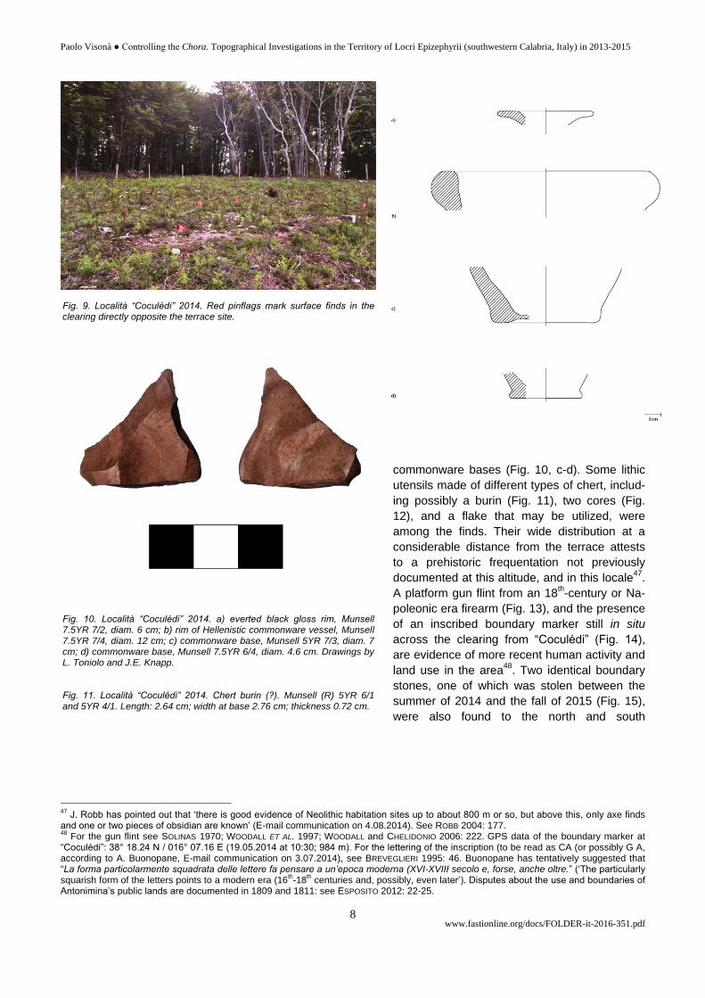
commonware bases (Fig. 10, c-d). Some lithic
utensils made of different types of chert, includ-
ing possibly a burin (Fig. 11), two cores (Fig.
12), and a flake that may be utilized, were
among the finds. Their wide distribution at a
considerable distance from the terrace attests
to a prehistoric frequentation not previously
documented at this altitude, and in this locale47
.
A platform gun flint from an 18th-century or Na-
poleonic era firearm (Fig. 13), and the presence
of an inscribed boundary marker still in situ
across the clearing from “Coculédi” (Fig. 14),
are evidence of more recent human activity and
land use in the area48
. Two identical boundary
stones, one of which was stolen between the
summer of 2014 and the fall of 2015 (Fig. 15),
were also found to the north and south
47
J. Robb has pointed out that ‘there is good evidence of Neolithic habitation sites up to about 800 m or so, but above this, only axe finds and one or two pieces of obsidian are known’ (E-mail communication on 4.08.2014). See ROBB 2004: 177. 48
For the gun flint see SOLINAS 1970; WOODALL ET AL. 1997; WOODALL and CHELIDONIO 2006: 222. GPS data of the boundary marker at “Coculédi”: 38° 18.24 N / 016° 07.16 E (19.05.2014 at 10:30; 984 m). For the lettering of the inscription (to be read as CA (or possibly G A, according to A. Buonopane, E-mail communication on 3.07.2014), see BREVEGLIERI 1995: 46. Buonopane has tentatively suggested that “La forma particolarmente squadrata delle lettere fa pensare a un’epoca moderna (XVI-XVIII secolo e, forse, anche oltre.” (‘The particularly squarish form of the letters points to a modern era (16
th-18
th centuries and, possibly, even later’). Disputes about the use and boundaries of
Antonimina’s public lands are documented in 1809 and 1811: see ESPOSITO 2012: 22-25.
Fig. 10. Località “Coculédi” 2014. a) everted black gloss rim, Munsell 7.5YR 7/2, diam. 6 cm; b) rim of Hellenistic commonware vessel, Munsell 7.5YR 7/4, diam. 12 cm; c) commonware base, Munsell 5YR 7/3, diam. 7 cm; d) commonware base, Munsell 7.5YR 6/4, diam. 4.6 cm. Drawings by L. Toniolo and J.E. Knapp. Fig. 11. Località “Coculédi” 2014. Chert burin (?). Munsell (R) 5YR 6/1 and 5YR 4/1. Length: 2.64 cm; width at base 2.76 cm; thickness 0.72 cm.
Fig. 9. Località “Coculédi” 2014. Red pinflags mark surface finds in the clearing directly opposite the terrace site.

Paolo Visonà ● Controlling the Chora. Topographical Investigations in the Territory of Locri Epizephyrii (southwestern Calabria, Italy) in 2013-2015
www.fastionline.org/docs/FOLDER-it-2016-351.pdf 9
of this marker: satellite photography has shown that all three stones follow an alignment that must represent a
centuries-old land subdivision49
.
Some jarring discrepancies between Raso’s accounts and the geomorphological and archaeological fea-
tures of the “Coculédi” site, however, prompted further investigations. Although Raso had mentioned a fortified
hilltop, “Coculédi”’s terrace shows little, if any, military potential, because it is naturally protected only on its
northern flank. Arguably, no threat could be expected from the slope on the eastern side, which faces the
Locrian chora, yet the western and southern sides have no natural defenses. Surface inspections yielded no
traces of the ‘double-faced walls’ and ‘round towers’ described in Raso’s 2001 article. Yet, Raso (who had also
49
Information from J.R. Jansson. GPS data of the original location of the stolen boundary stone: 38° 18.05 N / 016° 06.88 E (7.06.2014 at 11.40; 992 m). Another boundary stone inscribed with same letters was located to the north of “Coculédi”’s marker at 38° 18.63 N / 016° 07.54 E (5.06.2014 at c. 19:25; 960 m); it was taken to Antonimina’s City Hall for safekeeping, because it had been pulled out of the ground.
Fig. 12. Località “Coculédi” 2014. Chert cores. Left: Munsell (R) N6 – N5. Dimensions: 2.27 x 1.32 cm. Right: Munsell (R) 5YR 2/1 and 5YR 4/1. Length: 4.15 cm; width at base: 3 cm; max. thickness: 1.55 cm. Fig. 13. Località “Coculédi” 2014. Gun flint. Munsell (R) 10YR 6/2. Length: 2.98 cm; Width: 2.16 cm; thickness: 8 mm.
Fig. 14. Località “Coculédi” 2014. Stone boundary marker in situ. Munsell (R) N6. Height above ground: 76 cm; width: 25 cm; thickness: 11 to 13 cm at top. Dimensions of letters C or G: 6.84 x 6.45 cm. Width of letter A: 5.3 cm; length of diagonal strokes: 8.2 cm (left), 7.5 cm (right).
Fig. 15. Stone boundary marker in situ to the south of località “Coculédi”, 2014. It was stolen before October 2015.

Paolo Visonà ● Controlling the Chora. Topographical Investigations in the Territory of Locri Epizephyrii (southwestern Calabria, Italy) in 2013-2015
www.fastionline.org/docs/FOLDER-it-2016-351.pdf 10
written about “Coculédi” in his book, indicating
that it was a wooded area)50
, had consistently
referred to contrada Bregatorto as the site where
a fortification was located. The accuracy of his
information could not be verified in 2014, partly
because the name “Coculédi” is not found on
maps. Both the topographical setting and the
characteristics of the architectural remains at
“Coculédi” also seemed to be more in keeping
with those of a small frontier sanctuary rather
than a fortification. The location of the “Coculédi”
site on Locri’s western horizon, coinciding with
the visible limits of the Locrian chora, would
support this possibility. Standing on prominent
positions near the borders of a Greek city’s terri-
tory, frontier sanctuaries identified the outer
limits of its domain and marked the boundaries
between a “wild” and a “civilized” landscape, and
between nature and culture51
. They thus served
both political and religious functions.
New surface inspections in 2015, which began at Piano Liso (another small plain c. 600 m to the north of
contrada Bregatorto) sought to understand the topography of a broader area of the plateau and to verify the
presence of a fortification. Notable finds at Piano Liso consisted of a fragment of volcanic basalt possibly from
an ancient grindstone (dimensions: 25 x 30 cm), which was embedded into a cobblestone pavement, and two
isolated sherds of pottery, including a fragment of a cookpot handle, that cannot be closely dated52
. A ‘large
structure built with stones and bricks bonded with mortar’, which Raso had seen at contrada Bregatorto and il-
lustrated (without a scale) in his 1987 essay53
, was identified on the right side of a dirt road leading from
Bregatorto toward Monte Cola, precisely where he had said it was located. But the masonry of its walls cannot
be ancient, and their function remains enigmatic54
. A subsequent visit to Monte Cola (931.2 m), c. 600 m to the
south of contrada Bregatorto, yielded only a fragment of cover tile of uncertain date from the northwestern
slope of this hill. Nonetheless, the summit of Monte Cola could have been a lookout point to the Greeks, as it
affords a sweeping view of the Locrian chora from the acropolis of Gerace to the mountain Tre Pizzi. One of the
easiest and most direct routes from Locri Epizephyrii to the Tyrrhenian coast would probably have passed by
Monte Cola, which is a landmark and a dividing point for trails to the Dossone plateau55
. After Monte Cola was
inspected, field checking of the area to the northeast of località “Coculédi” allowed another Greek site to be
identified at contrada Bregatorto itself.
This third site lies at only 400 m from località “Coculédi” and occupies an elongated terrace ringed by
beech trees, at an elevation of 973 m (Fig. 6)56
. It is protected by steep slopes on three sides and appears un-
disturbed. The only approach to the terrace is from the west. Substantial remains of three perimeter walls, en-
closing a trapezoidal area that may exceed 1,300 m², are visible above ground along the northern, eastern, and
southern sides of the terrace. The eastern (Fig. 16) and southern walls, which measure c. 38 m and 43 m re-
50
RASO 2001b: 201. 51
DAVERIO ROCCHI 1988: 55-57; DE POLIGNAC 1995: 33-41; LEONE 1998: 14, 15 and 26-27; PEDLEY 2005: 11-12 and 46-53; CHANIOTIS
2008: 109. 52
GPS data of basalt block in cobblestone pavement: 38° 18.54 N / 016° 08.26 E (5.06.2015 at 12.06; the elevation at 884 m may be unre-liable). 53
RASO 1987: 85. This structure, consisting of two parallel walls, is illustrated on p. 89. 54
According to C. Carbone, the longer wall is 5.10 m long and up to 1.90 m high; its width tapers from 1.12 m at the base to 0.53 m at the top. Its upper portion consists of courses of bricks and stones bonded with mortar, representing a later building phase. Carbone has pro-posed to date this structure between the 6
th and the 8
th centuries A.D.: see CARBONE 2005b: 56. In June 2014 a resident of Antonimina said
that these or other ruins at contrada Bregatorto were known as “li muredi dei vagni” (‘the walls of the baths’). G. Murdaca, a 53-year old driver at Antonimina, interviewed in June, 2014, said that according to stories told by his father, “a Bragatorto una volta c’erano i briganti” (‘outlaws once lived at Bregatorto’). For a similar legend about Monte Palazzi see KNAPP ET AL. 2007: 493, n. 18. 55
Our team followed the ridge road from Monte Cola all the way to the Fiumara Portigliola on the valley floor in 2015. A trail from Antonimina to contrada Bregatorto also goes by Monte Cola: see RASO 2001: 191 and 202. 56
GPS data: 38° 18.36 N / 016° 07.64 E (17.10.2015 at 11:30; 973 m). UTM: (n) 4240560; (e) 598725. The terrace points towards the Ioni-an coast at 120°.
Fig. 16. Contrada Bregatorto, October 2015. The Greek fortification’s eastern wall.

Paolo Visonà ● Controlling the Chora. Topographical Investigations in the Territory of Locri Epizephyrii (southwestern Calabria, Italy) in 2013-2015
www.fastionline.org/docs/FOLDER-it-2016-351.pdf 11
spectively, are possibly the best preserved57
.
Both their masonry, which consists of dry-
packed, unmodified cobbles and roughly hewn
stones (resembling the construction technique
of the ramparts of the late archaic fort on Mon-
te Palazzi), and the ubiquitous presence of
Greek flanged pantile fragments (Fig. 17, top;
Fig. 4, f-g), corroborate an identification of this
complex as an ancient fortification. Samples of
these roof tiles show close similarities to those
found at contrada Palazzo, the first Greek site
located in the 2013-2014 surveys58
. Their da-
ting tentatively suggests that this site was oc-
cupied between the late 6th and the second
half of the 4th centuries B.C. After a prelimi-
nary inspection of the site was completed, Mar-
io Raso visited contrada Bregatorto and con-
firmed that this was the fortification described
by his brother, Domenico, in 2001 and 200259
.
No remains of the round tower or towers men-
tioned by D. Raso were in evidence in 2015,
however. A large outer structure seemingly
parallel to the eastern wall, which would have
faced the Ionian coast, may represent the fea-
ture he referred to in 2001 as “mura a doppia
lista” (‘double-faced walls’)60
. The relationship
between the “Coculédi” site and this fortifica-
tion also needs to be explained61
.
The finds from contrada Palazzo and
from two adjacent sites at “Coculédi” and
contrada Bregatorto have important implica-
tions for our understanding of the defense of
the Locrian chora. It would have been possible
to send warning of an impending threat from
contrada Palazzo to the fortification at contrada
Bre-gatorto, which does not command a view
of the Tyrrhenian littoral, even though it lies at
a higher elevation. A messenger could have
covered the distance between these two sites (c. 800 m) in a short time. Signals could also have been sent
from either “Coculédi” or contrada Bregatorto (or perhaps from Monte Cola) to Locri. It seems unlikely that the
Greek materials found at contrada Palazzo were simply transported there in recent times from contrada
Bregatorto (or località “Coculédi”) to be re-used. Clearly, a Locrian lookout was needed on the western rim of
the plateau. Without it, the stronghold at contrada Bregatorto could have been easily overrun by an invading
force reaching the top of the plateau from the Tyrrhenian coast62
.…………………………………………………...
57
These preliminary measurements were taken in 2015 by J.R. Jansson using a Simmons LRF 600 Rangefinder. 58
Cf. NOTARIO 1992: 322, types E1, E3; Pl. XCV, 17-18. Some small fragments of cover tiles have also been seen inside the fortification at contrada Bregatorto. 59
According to M. Raso (interviewed on 11.06.2015), D. Raso stumbled upon the site while he was looking for mushrooms with his brother in the month of September, “after 1987”. M. Raso pointed out that the terrace was then covered with underbrush. 60
See above, footnote 37. 61
Only an isolated scatter of small Greek pantile fragments (dimensions: 5 x 8 cm, 10 x 15 cm) was found between località “Coculédi” and the fortification at contrada Bregatorto. GPS data: 38° 18.38 N / 016° 07.51 E (8.06.2015 at 10:05; the elevation at 996 m is unreliable). 62
During most of the year, lightly armed troops could have travelled from the Gioia Tauro Plain to the Dossone plateau in a relatively short time via the Torrente Razzà-Serra and the pass at contrada “Scarpa della Pietra”, since the reverse journey from this pass takes only an hour, according to Raso. For the presence of a spring and ruins at this location see RASO 1987: 87 and 96; RASO 2001b: 87-88. The trail
Fig. 17. Fragments of Greek pantiles from contrada Bregatorto (top) and Monte Varraro (bottom) 2015. Upper left: Munsell of paste 10YR 7/3 – 6/3. Height of flange: 5.6 cm; width of flange at base: 5.5 cm; thickness of pan: 2.75 cm. Upper right: Munsell of paste 2.5Y 7/3. Height of flange: 5.8 cm; width of flange at base: 5.4 cm; thickness of pan: 2.7 – 2.95 cm. Lower left: Munsell of paste 5YR 7/4 and 10YR 7/3 (core). Height of flange: 5.55 cm; width of flange at base: 5 cm; thickness of pan: 3.1-3.15 cm. Lower right: Munsell of paste 10YR 7/3 – 6/3 and 5YR 7/4 (core). Height of flange: 5.25 cm; width of flange at base: 5.25 cm; thickness of pan: 1.9 cm.

Paolo Visonà ● Controlling the Chora. Topographical Investigations in the Territory of Locri Epizephyrii (southwestern Calabria, Italy) in 2013-2015
www.fastionline.org/docs/FOLDER-it-2016-351.pdf 12
Furthermore, the concentration of Greek sites at c. 4 km to the south of the Passo del Mercante indi-
cates that an older overland trail traversed the Dossone plateau in their vicinity rather than where this pass is
located today63
. If so, the fortification at contrada Bregatorto would have been the main control point on the
most direct route from Locri Epizephyrii to the plateau (via the Fiumara Portigliola and the Fiumara di Anto-
nimina to Monte S. Mauro and Monte Cola), and from the plateau to Locri’s Tyrrhenian dominions. The place-
ment of the “Coculédi” and Bregatorto sites at the outer limits of the Locrian chora suggests that they could also
have been boundary markers.
Controlling a territory as diverse as that of the Locrian chora was probably not limited to the borderlands.
Strategically important locations near the border region, mid-way between the sea and the mountains on Locri’s
western horizon, would have been guarded as well. Thus, numerous surface finds of Greek pantile fragments
from the ruins of a Byzantine monastery at contrada “Previteju” on Monte Varraro, a naturally fortified hilltop in
the Comune of Benestare, c.16.7 km to the south of contrada Bregatorto (Fig. 18), may be indicative of a
Locrian presence at this site. The dating of these materials ranges from the late archaic to the Hellenistic peri-
ods (Fig. 17, bottom; Fig. 4, h-i)64
. Rising at 655 m above sea level, the summit of Monte Varraro offers an un-
restricted view of the Fiumara Careri leading directly to the Ionian coast (and to a presumed coastal road to
Locri), and of a route through Platì to the Petrace River Valley and the Tyrrhenian coast65
. Large troop move-
called “Salita Mella” takes 45 minutes from the Casino del Granduca (a dilapidated mansion c. 1.5 km to the west of contrada Palazzo) to Cittanova, according to Luigi Abramo, a Cittanova resident (interviewed on 7.06.2015). 63
The Passo del Mercante’s original location was at some distance to the north-west of the S.P. 1, near the Contrada Omo Morto. See above, footnote 27. 64
For these architectural remains on Monte Varraro (also known as Monte Verraro), see MACRÌ 2014 and cf. MINUTO 1977: 342 (I owe this reference and the spelling of “Previteju” to G. Frammartino). For the profiles and dating of the pantiles see NOTARIO 1992: 322, types D3 and E4; Pl. XCV, 14, 19. Some Greek pantiles were re-used for the base of the altar of the monastery’s church. 65
GPS data: 38° 11.75 N / 016° 06.87 E (6.06.2015 at 18:20; 655 m). Cf. CATALDI 1975: 95 and BARRA BAGNASCO 1996: 240, n. 14.
Fig. 18. Satellite map showing the location of Monte Varraro (left) and contrada Bregatorto (right) marked in yellow. Computer-aided visu-alization by J.R. Jansson and R.F. Chapman.

Paolo Visonà ● Controlling the Chora. Topographical Investigations in the Territory of Locri Epizephyrii (southwestern Calabria, Italy) in 2013-2015
www.fastionline.org/docs/FOLDER-it-2016-351.pdf 13
ments originating from the west and from the south would have been visible from this high perch. If indeed
Monte Varraro was used as an observation post by the Locrians, it could have monitored both access routes66
.
Conclusions
The topographical investigations conducted in 2013-2015 have located three previously undocumented
Greek sites along the western borders of the Locrian chora. They may now be added to Torre Camillari and
Monte Palazzi, two outposts on the northeastern flank of Locri’s territory (Fig. 19). Their concentration near a
major overland route between the eastern and the western coasts of Italy shows that the Locrians guarded their
territory from multiple control points and also maintained surveillance over the Gioia Tauro Plain and the chora
of Medma, their closest Tyrrhenian sub-colony. Two of these sites (at contrada Palazzo and località “Coculédi”)
left a small archaeological footprint and their specific functions cannot be defined at present without further re-
search. The largest site (at contrada Bregatorto) was occupied by a fortification, whose features recall those of
the Locrian fort on Monte Palazzi and which may have been in use between c. 500-300 B.C.
These findings underscore the potential value of an integrated research approach combining satellite im-
aging, fieldwalking, and close interaction with local informants as precursors to terrestrial remote sensing and
targeted excavations. They also suggest that more Locrian fortified sites and control points can be expected to
be situated along the southeastern border of the chora, where Rhegion was an enemy to be reckoned with
throughout the late archaic and classical periods.
66
In an undated essay on the history of Bovalino, a costal town to the south-east of Benestare, D.A. Morisciano (1816-1909) wrote that “… alla n[ost]tra montagna denominata, “Serre di Furraina”, venuti Uffiziali del Genio, per vedute strade greche, constataron con certezza, l’esistenza in tal luogo di strada rotabile, da buoni tratti ancor rimasti non solo, ma quel, ch’è più chiaro, rinvennero le vestigia pure delle case di posto di guardia, o caserme.” (‘after officers of the Army Corps of Engineers came to our mountain known as “Serre di Furraina” and saw Greek roads, they realized that a road for wheeled traffic must have existed there, because some decent stretches of it still re-mained. More remarkably, they also found the remains of the guard posts houses, or barracks.’) See MORISCIANO undated: 63.
Fig. 19. Location of Torre Camillari (1), Monte Palazzi (2), contrada Bregatorto (3), and Monte Varraro (4) in relation to the boundaries of the chora of Locri Epizephyrii (highlighted pale green). Computer-aided visualization by J.R. Jansson and L.F. Chapman (from VISONÀ 2010: 1, Fig. 1).

Paolo Visonà ● Controlling the Chora. Topographical Investigations in the Territory of Locri Epizephyrii (southwestern Calabria, Italy) in 2013-2015
www.fastionline.org/docs/FOLDER-it-2016-351.pdf 14
Acknowledgments
This report would not have been possible without the contributions of the following individuals and organizations: Geom. Luigi Abramo (Cittanova); Prof. Steven R. Ahler (Department of Anthropology, University of Kentucky), Prof. Alfredo Buonopane (Dipartimento di Culture e Civiltà, Università di Verona), Francesco Arena (Palmi, RC), Lesley F. Chapman (Visual Resources Curator, Department of Art and Art History, Colgate University, NY), Mayor Antonio Condelli (Antonimina, RC), Prof. Cristina Corti and Prof. Laura Rampazzi (Dipartimento di Scienza e Alta Tecnologia, Università degli Studi dell’Insubria, Como), Prof. George M. Crothers (Director, W.S. Webb Museum of Anthropology and Office of State Archae-ology, University of Kentucky), Giuseppe D’Amico (Cittanova, RC), Rosa Fedele, Renato Lombardo, Sebastiano Olivarelli (Biblioteca Comunale “D. Topa”, Palmi), Dr. Giuseppe Frammartino (Marina di Ardore, RC), Ryan T. Hagan (University of Kentucky), James R. Jansson (The Foundation for Calabrian Archaeology, Parker, CO), Prof. Jennifer E. Knapp (Depart-ment of History, Langara College, Vancouver), Ing. Giuseppe F. Macrì (Locri, RC), Prof. M. Cecilia Parra (Dipartimento di Civiltà e Forme del Sapere, Università di Pisa), Sovraintendente Pasquale Mammone (Corpo Forestale dello Stato), Giu-seppe Murdaca (Antonimina), Ing. Vincenzo Predoti (Ufficio Tecnico, Comune di Cittanova, RC), Dr. Nicola Raco (Ufficio Tecnico, Comune di Antonimina, RC), † Dr. Domenico Raso (Cittanova), Dr. Mario Raso (Cittanova), Prof. John E. Robb (Department of Archaeology, Cambridge University, UK), Ing. Cristian Scattarreggia (Oppido Mamertina, RC), John R. Svo-boda (The Foundation for Calabrian Archaeology, Parker, CO), Dr. Luana Toniolo (Rome), Marian Visonà (Providence, RI), Prof. Monica Blackmun Visonà (School of Art and Visual Studies, University of Kentucky), Prof. John W. Wonder (Classics Department, San Francisco State University, CA), Domenico Zappia (Ufficio Tecnico, Comune di Antonimina, RC).
Paolo Visonà
E-mail: [email protected]
BIBLIOGRAPHY
A.B.C., 1927, “Il Camaleonte”, in Albori III, Serie II, nos. 22-23: 9-11.
Aerofotogrammetria Antonimina 1987: Comune di Antonimina, Provincia di Reggio Calabria, Scala 1:5000;
S.T.A.C. s.a.s., Siderno M. (R.C.).
Aerofotogrammetria Cittanova 1994: Comune di Cittanova. Villaggio Zomaro. Cartografia numerica del Territo-
rio Comunale. Aggiornamento con volo del 02.12.1994 elemento 590060, Scala 1: 10000; Gualtieri, Ca-
tanzaro Lido.
BACCHELLI R., 1942, Il brigante di Tacca del Lupo ed altri racconti disperati, Milan.
BARRA BAGNASCO M. (ed.), 1989, Locri Epizefiri II. Gli isolati I² e I³ dell’area di Centocamere, Florence.
BARRA BAGNASCO M., 1996, “Fortificazioni e città a Locri Epizefiri alla luce delle più recenti scoperte”, in Römi-
sche Mitteilungen 103: 237-274.
BILINSKI B., 1963, intervento, in Atti Taranto 2: 80-84.
BITTI M.C., 1989, “Il vasellame del II strato”, in M. BARRA BAGNASCO (ed.), Locri Epizefiri II. Gli isolati I² e I³
dell’area di Centocamere, Florence: 141-188.
BRANCACCIO G., 1991, Geografia , cartografia e storia del Mezzogiorno, Ercolano.
BREVEGLIERI B., 1995, “Le iscrizioni dell’Appennino emiliano”, in La Ricerca Folklorica no. 31 (Scrittura e figura.
Studi di storia e antropologia della scrittura in memoria di Giorgio Raimondo Cardona): 41-51.
CARBONE C., 2005a, “Palazzo di Zomaro”, in A. PICONE CHIODO (ed.), Segni dell’uomo nelle terre alte d’Aspro-
monte, Pescia (PT): 47-54.
CARBONE C., 2005b, “Bragatorta”, in A. PICONE CHIODO (ed.), Segni dell’uomo nelle terre alte d’Aspromonte,
Pescia (PT): 55-56.
CATALDI G., 1975, “Il territorio della Piana di Gioia Tauro”, in Studi e documenti di architettura 4, Istituto di com-
posizione architettonica I-II della Facoltà di Architettura di Firenze.
CHANIOTIS A., 2008, “Policing the Hellenistic Countryside. Realities and Ideologies”, in C. BRÉLAZ, P. DUCREY
(eds.), Sécurité collective et ordre public dans les sociétés anciennes, Geneva: 103-145.
CORDIANO G. (ed.) 2014a, Tra Rhegion e Lokroi Epizephyrioi. Un quindicennio di ricerche topografico-archeo-
logiche tra Palizzi e Capo Bruzzano. Atti del Seminario di Studi (Bova Marina, 24 settembre 2011), Pisa.
CORDIANO G., 2014b, “Tra Rhegion e Lokroi Epizephyrioi. Le ricerche dell’Ateneo senese nell’ultimo quindicen-
nio in un’antica area confinaria della Magna Grecia. Dalla protostoria agli albori dell’età romana”, in G.
CORDIANO (ed.), Tra Rhegion e Lokroi Epizephyrioi. Un quindicennio di ricerche topografico-

Paolo Visonà ● Controlling the Chora. Topographical Investigations in the Territory of Locri Epizephyrii (southwestern Calabria, Italy) in 2013-2015
www.fastionline.org/docs/FOLDER-it-2016-351.pdf 15
archeologiche tra Palizzi e Capo Bruzzano. Atti del Seminario di Studi (Bova Marina, 24 settembre
2001), Pisa: 13-60.
COSTABILE F., 2007, “La prima stazione neolitica stentinelliana in Calabria. Prestarona in Comune di Canolo.
Relazione preliminare”, in F. COSTABILE, Enigmi delle civiltà antiche dal Mediterraneo al Nilo. Atene La
Magna Grecia L’impero di Roma, I. Dalla preistoria all’età ellenistica, Reggio Calabria: 19-27 (updated
version of COSTABILE F., 1972, “ La stazione neolitica di Prestarona in Comune di Canolo. Relazione pre-
liminare”, in Klearchos 14 nos. 52-56 (1972): 5-27.
DAVERIO ROCCHI G., 1988, Frontiera e confini nella Grecia antica, Rome.
DE POLIGNAC F., 1995, Cults, Territory, and the Origins of the Greek City-State, Chicago – London.
DE SENSI SESTITO G., 2011, “Cartagine e la Magna Grecia in età dionisiana. Il ruolo di Ipponio”, in M. INTRIERI,
S. RIBICHINI (eds.), Fenici e Italici, Cartagine e la Magna Grecia. Popoli a contatto, culture a confronto.
Atti del Convegno Internazionale Cosenza, 27-28 maggio 2008 (Rivista di Studi Fenici 36, 1-2), Pisa-
Rome: 29-50.
DE SENSI SESTITO G., 2014, “Siracusa, le guerre di confine tra Locri e Reggio e il trattato” di Eliano”, in Aiônos
17 (2011-2012): 17-48.
ESPOSITO D., 2012, Antonimina. Luoghi, vicende e volti 1806-2006, Marina di Gioiosa Jonica (RC).
FACHARD S., 2012, La défense du territoire. Étude de la chôra érétrienne et de ses fortifications, Eretria XXI
Fouilles et recherches, Rennes.
FISCHER-HANSEN T., HEINE-NIELSEN T., AMPOLO C., 2004, “Italia and Kampania”, in M.G. HANSEN, T. HEINE
NIELSEN (eds.), An Inventory of Archaic and Classical Poleis. An Investigation conducted by the Copen-
hagen Polis Centre for the Danish National Research Foundation, Oxford: 249-320.
FRENCH C., 2014, “Investigating Large Landscapes: Constraints and Developing Techniques”, in K. BOYLE, R.J.
RABETT, C.O. HUNT (eds.), Living in the Landscape. Essays in Honour of Graeme Barker, Cambridge:
339-350.
GENOVESE G.M., 1986-1987, I Bruttii e l’organizzazione del loro territorio nel IV-III sec. a.C., tesi di laurea, Uni-
versità degli Studi della Calabria, Facoltà di Lettere e Filosofia, corso di laurea in lettere moderne (rel.
G.P. Givigliano), Cosenza.
GENOVESE G., 2012, Greci e non greci nel Bruzio preromano. Formule integrative e processi di interazione, La-
vello.
GIANGIULIO M., 2001, “L’eschatia. Prospettive critiche su rappresentazioni antiche e modelli moderni”, in Atti Ta-
ranto 40 (2000): 333-355.
HILL M., 1998, “Spatial Analysis”, in B. LOGAN (ed.), Prehistoric Settlement of the Lower Missouri Uplands. The
View from DB Ridge Fort Leavenworth, Kansas (University of Kansas Museum of Anthropology Project
Report Series No. 98), Kansas City, MO: 254-300.
IANNELLI M.T., 1989, “Hipponion-Vibo Valentia: documentazione archeologica e organizzazione del territorio”,
Annali della Scuola Normale Superiore di Pisa 3, XIX, 2: 683-736.
IANNELLI, M.T., 2011, “Introduzione”, in M.T. IANNELLI, F.A. CUTERI, C. MANTELLO, B. MINNITI, G. HYERACI, P. SA-
LAMIDA, “Appendice II. Indagini topografiche e archeologiche lungo la valle dell’Allaro”, in M.C. PARRA, A.
FACELLA (eds.), 2011, Kaulonía, Caulonia, Stilida (e oltre), III. Indagini topografiche nel territorio, Scuola
Normale Superiore di Pisa Studi 20, Pisa: 387-405.
IGCH: THOMPSON M., MØRKHOLM O., KRAAY C.M., 1973, An Inventory of Greek Coin Hoards, New York.
INSOLERA E., 2014, “Perioikides. Gli abitati minori greci dell’antico territorio reggino”, in G. CORDIANO (ed.),
2014, Tra Rhegion e Lokroi Epizephyrioi. Un quindicennio di ricerche topografico-archeologiche tra Pa-
lizzi e Capo Bruzzano. Atti del Seminario di Studi (Bova Marina, 24 settembre 2011), Pisa: 79-115.
KNAPP J.E., MAZZAGLIA P., SABBIONE C., VISONÀ P., 2007, “Monte Palazzi (Passo Croce Ferrata, Comune di
Grotteria), 2005: primi saggi stratigrafici”, in Atti della Accademia Nazionale dei Lincei, anno CDIV –
2007, Classe di scienze morali, storiche e filologiche, Rendiconti, ser. IX, vol. XVIII: 481-509.
LACQUANITI L., 1950, “Il Dossone della Melìa (Calabria meridionale)”, in Rivista Geografica Italiana 57: 20-39.
LEONE R., 1998, Luoghi di culto extraurbani d’età arcaica in Magna Grecia, Florence.
MACRÌ G.F., 2014, “Scoperta archeologica. Il monastero di San Teodoro”, http://www.inaspromonte.it/scoperta-
archeologica-il-monastero-di-san-teodoro/
MANZO L., 1989, “Ceramica da mescita”, in M. BARRA BAGNASCO (ed.), 1989, Locri Epizefiri II. Gli isolati I² e I³
dell’area di Centocamere, Florence: 327-343.

Paolo Visonà ● Controlling the Chora. Topographical Investigations in the Territory of Locri Epizephyrii (southwestern Calabria, Italy) in 2013-2015
www.fastionline.org/docs/FOLDER-it-2016-351.pdf 16
MINUTO D., 1977, Catalogo dei monasteri e dei luoghi di culto tra Reggio e Locri, Thesaurus Ecclesiarum Italiae
XVII, 1, Rome.
MINUTO D., 1998, “Scheda A - Approfondimento. La tecnica ad “incertum mixtum” e a “filare spezzato”, in FAL-
CONE D., MINUTO D., OLIVA G., VENOSO S.M., “La tecnica ad “incertum mixtum” e a “filare spezzato”, in P.
BORZOMATI et al., Chiesa e Società nel Mezzogiorno. Studi in onore di Maria Mariotti, Tomo II, Soveria
Mannelli: 1213-1218.
MORISCIANO D.A., undated, “Bovalino”, in R. LA CAVA (ed.), 1995, Gerace e Bovalino nella memoria storica dei
fratelli Morisciano, Marina di Gioiosa Jonica (RC): 59-88.
Munsell (R): THE GEOLOGICAL SOCIETY OF AMERICA, 1995, Rock-Color Chart, Boulder, CO.
MUSTICA G.B., 1991, “Mallia & Altano & Casignano”, in Il Taurikano IV: 1-27.
NOTARIO C., 1992, “I prodotti laterizi da costruzione”, in M. BARRA BAGNASCO (ed.), Locri Epizefiri IV. Lo scavo di
Marasà Sud. Il sacello tardo arcaico e la “casa dei leoni”, Florence: 320-335.
OSANNA M., 1992. Chorai coloniali da Locri a Taranto. Documentazione archeologica e ricostruzione storica,
Rome.
PARKER B.J., 2006, “Toward an Understanding of Borderland Processes”, in American Antiquity 76, 1: 77-100.
PEDLEY J., 2005, Sanctuaries and the Sacred in the Ancient Greek World, New York.
PUTORTÌ N., 1914, “S. Giorgio Morgeto – Scoperta di tesoro monetale”, in Notizie degli Scavi di Antichità 39:
211-212.
RASO D., 1987, “Tinnaria. Antiche opere militari sullo Zomaro”, in Calabria Sconosciuta 10, no. 37: 79-102.
RASO D., 2001a, “Sul Passo del Mercante l’asse più importante di Locri Epizephiri”, in Calabria Sconosciuta 24,
nos. 89-90: 15-20.
RASO D., 2001b, Zomaro la montagna dei sette popoli. Tra i misteri della montagna calabrese, Villa San Gio-
vanni (RC).
RASO D., SPANÒ E., 2002, “Romani in Aspromonte”, in Calabria Sconosciuta 25, no. 96: 15-18.
ROBB J., 2004, “Il Neolitico dell’Aspromonte”, in Istituto Italiano di Preistoria e Protostoria, Preistoria e Protosto-
ria della Calabria, Atti della XXXVII Riunione Scientifica, Scalea, Papasidero, Praia a Mare, Tortora 29
settembre – 4 ottobre 2002, I: 175-188.
ROHLFS G., 1974, Dizionario toponomastico e onomastico della Calabria. Prontuario filologico-geografico della
Calabria, Ravenna.
SICA M.M., 2008, “Eracle reggino a Castellace. Tra Greci e Indigeni sul Métauros”, Siris 8: 21-31.
SICA M.M., 2009, “Da Métauros alla Sila silva. Alcune osservazioni conclusive”, in M.M. SICA (ed.), La media
valle del Métauros tra VII e III secolo a.C. L’insediamento di Torre Cillea a Castellace, in R. AGOSTINO,
M.M. SICA (eds.), Sila Silva ho drumós... hón Sílan kaloûsin. Conoscenza e recupero nel Parco Naziona-
le d’Aspromonte, Soveria Mannelli: 243-275.
SOLINAS G., 1970, “Selci lavorate per acciarino”, in Sibrium 10: 351-355.
SPANÒ V., 2010, La Via Annia Popilia in Calabria. Rilievo e Ricostruzione, 2nd
ed., Villa S. Giovanni (RC).
STRAUSS B., 2009, The Spartacus War, New York.
TALBERT R.J.A., 2000, Barrington Atlas of the Greek and Roman World, Princeton, N.J.
TALIERCIO MENSITIERI M., 2008, “Monete e scambi nella Calabria tirrenica in epoca greca”, in G. DE SENSI SE-
STITO (ed.), La Calabria tirrenica nell’antichità. Nuovi documenti e problematiche storiche. Atti del Conve-
gno (Rende 23-25 novembre 2000), Soveria Mannelli: 317-341.
VISONÀ P., 1999, “I prodotti laterizi”, in L. COSTAMAGNA, P. VISONÀ (eds.), Oppido Mamertina (Calabria – Italia).
Ricerche archeologiche nel territorio e in contrada Mella, Rome: 359-361.
VISONÀ P., 2010, “University of Colorado / University of Kentucky Excavations at Monte Palazzi, Passo
Croceferrata (Grotteria, Calabria): The 2005, 2007, and 2008 Field Seasons”, in www.fastionline.-
org/docs/FOLDER-it-2010-188.pdf: 1-25.
VISONÀ P., 2013, “University of Kentucky Archaeological Investigations at Monte Palazzi (Passo Croceferrata,
Grotteria, Calabria) and in the Locrian chora in 2010-2012”, in www.fastionline.org/docs/FOLDER-it-
2013-281. pdf: 1-23.
VISONÀ P., 2016, “Monte Palazzi (Reggio Calabria). – Monte Palazzi (Passo Croceferrata, Comune di Grotteria)
2007-2014: ultimi saggi stratigrafici, prospezioni geofisiche e indagini nel territorio”, in Notizie degli Scavi
di Antichità 139: 217-261 [in press].

Paolo Visonà ● Controlling the Chora. Topographical Investigations in the Territory of Locri Epizephyrii (southwestern Calabria, Italy) in 2013-2015
www.fastionline.org/docs/FOLDER-it-2016-351.pdf 17
WONDER J.W., 2012, “The Italiote League: South Italian Alliances of the Fifth and Fourth Centuries B.C.”, in
Classical Antiquity 31, 1: 128-151.
WOODALL J.N., TRAGE S.T., KIRCHEN R.W., 1997, “Gunflint Production in the Monti Lessini, Italy’, in Historical Ar-
chaeology 31, 4: 15-27.
WOODALL J.N., CHELIDONIO G., 2006, “Gunflint Workshop Traces in the Lessini Mountains (Verona, Italy):
Flintknappers and Smugglers at the End of the Venetian Republic”, in G. KÖRLIN, G. WEISGERBER (eds.),
Stone Age – Mining Age (Der Anschnitt Beiheft 19), Bochum: 213-226.