control of the geomorphology and gas hydrate extent...
TRANSCRIPT

1
Please note that this is an author-produced PDF of an article accepted for publication following peer review. The definitive publisher-authenticated version is available on the publisher Web site.
Bulletin De La Societe Geologique De France 2017, Volume 188 Issue 4 Pages 26 (1-12) http://dx.doi.org/10.1051/bsgf/2017182 http://archimer.ifremer.fr/doc/00407/51860/ © SGF, Published by EDP Sciences 2017
Achimer http://archimer.ifremer.fr
Control of the geomorphology and gas hydrate extent on
widespread gas emissions offshore Romania
La géomorphologie des fonds marins et la présence d’hydrates de gaz contrôlent les émissions de gaz dans la
Mer Noire au large de la Roumanie
Riboulot Vincent 1, *
, Cattaneo Antonio 1, Scalabrin Carla
1, Gaillot Arnaud
1, Jouet Gwenael
1,
Ballas Gregory 1, Marsset Tania
1, Garziglia Sebastien
1, Ker Stephan
1
1 IFREMER, Ctr Brest, Inst CARNOT EDROME, Geosci Marines, F-29280 Plouzane, France.
* Corresponding author : Vincent Riboulot, email address : [email protected]
Abstract : The Romanian sector of the Black Sea deserves attention because the Danube deep-sea fan is one of the largest sediment depositional systems worldwide and is considered the world's most isolated sea, the largest anoxic water body on the planet and a unique energy-rich sea. Due to the high sediment accumulation rate, presence of organic matter and anoxic conditions, the Black sea sediments offshore the Danube delta is rich in gas and thus shows Bottom Simulating Reflectors (BSR). The cartography of the BSR over the last 20 years, exhibits its widespread occurrence, indicative of extensive development of hydrate accumulations and a huge gas hydrate potential. By combining old and new datasets acquired in 2015 during the GHASS expedition, we performed a geomorphological analysis of the continental slope north-east of the Danube canyon compared with the spatial distribution of gas seeps in the water column and the predicted extent of the gas hydrate stability zone. This analysis provides new evidence of the role of geomorphological setting and gas hydrate extent in controlling the location of the observed gas expulsions and gas flares in the water column. Gas flares are today considered an important source of the carbon budget of the oceans and, potentially, of the atmosphere.
Résumé
Le secteur roumain de la Mer Noire est dominé par la présence du canyon du Danube et d'un des plus grands systèmes de dépôts de sédiment du monde. La Mer Noire est considérée comme la plus grande mer isolée du monde, la plus grande masse d’eau anoxique de la planète et une mer riche en énergie

2
Please note that this is an author-produced PDF of an article accepted for publication following peer review. The definitive publisher-authenticated version is available on the publisher Web site.
fossile. En raison d’un taux de sédimentation élevé, de la présence d’une grande quantité de matière organique et des conditions anoxiques, les sédiments de Mer Noire situés au large du delta du Danube sont riches en gaz et l’étude de données de sismique réflexion montre la présence d’un réflecteur sismique particulier appelé communément « Bottom Simulating Reflector ou BSR » qui marque la base de stabilité des hydrates de gaz. La cartographie du BSR au cours des 20 dernières années montre que les hydrates de gaz se seraient accumulés sur de vastes zones géographiques et que le secteur roumain de la Mer Noire a un fort potentiel d'hydrate de gaz. En combinant les anciens et les nouveaux jeux de données acquis en 2015 lors de la campagne océanographique GHASS, nous avons réalisé (1) une analyse géomorphologique de la pente continentale au nord-est du canyon du Danube, (2) une cartographie des panaches de gaz acoustiquement détectés dans la colonne d'eau et (3) le calcul et la cartographie de la zone de stabilité des hydrates de gaz. La comparaison de ces résultats fournit de nouvelles preuves du rôle de la géomorphologie et de la présence des hydrates de gaz sur la migration du gaz libre et la localisation des panaches de gaz dans la colonne d'eau. L’expulsion de gaz dans la mer est aujourd'hui considérée comme une source importante alimentant le budget carbone des océans et, potentiellement, de l'atmosphère.
Keywords : gas hydrates, free gas, gas flares, BSR, Black Sea, geomorphology Mots clés : hydrates de gaz / gaz libre / panaches de gaz / BSR / Mer Noire / géomorphologie

Control of the geomorphology and gas hydrate extent on widespread gas emissions offshore Romania 1
V. Riboulot (1)*, A. Cattaneo (1), C. Scalabrin (1), A. Gaillot (1), G. Jouet (1), G. Ballas (1), T. Marsset 2
(1), S. Garziglia (1), S. Ker (1) 3
(1) IFREMER, Centre de Brest, Institut CARNOT-EDROME, Géosciences Marines, 29280 Plouzané, France, 4
*corresponding author: Vincent Riboulot, Ifremer, Géosciences Marines, BP70, 29280 Plouzané, France. Phone: +33 5
(0)298 224248 Fax: +33 (0)298 224570 E-mail: [email protected] 6
Abstract 7
The Romanian sector of the Black Sea deserves attention because the Danube deep-sea fan is one of the 8
largest sediment depositional systems worldwide and is considered the world's most isolated sea, the largest 9
anoxic water body on the planet and a unique energy-rich sea. Due to the high sediment accumulation rate, 10
presence of organic matter and anoxic conditions, the Black sea sediments offshore the Danube delta is rich 11
in gas and thus show Bottom Simulating Reflectors (BSR). The cartography of the BSR over the last 20 12
years, exhibits its widespread occurrence, indicative of extensive development of hydrate accumulations 13
and a huge gas hydrate potential. By combining old and new datasets acquired in 2015 during the GHASS 14
expedition, we performed a geomorphological analysis of the continental slope north-east of the Danube 15
canyon compared with the spatial distribution of gas seeps in the water column and the predicted extent of 16
the gas hydrate stability zone. This analysis provides new evidence of the role of geomorphological setting 17
and gas hydrate extent in controlling the location of the observed gas expulsions and gas flares in the water 18
column. Gas flares are today considered an important source of the carbon budget of the oceans and, 19
potentially, of the atmosphere. 20
1. Introduction 21
The Black Sea is considered as the world's most isolated sea, the largest anoxic water body on the planet 22
and a unique energy-rich sea (Overmann and Manske, 2006). CH4 seepage is extremely intense on the shelf 23
and on the slope of the Black Sea (Dimitrov, 2002; Mert Küçük et al.; Vassilev and Dimitrov, 2003), 24
especially along the Ukrainian (Greinert et al., 2010; Naudts et al., 2009; Naudts et al., 2008; Naudts et al., 25
2006) and Romanian margins (Popescu et al., 2007). Black Sea sediment abundantly contains GHs and H2S 26
as CH4 and hydrogen source, respectively (Demirbas, 2009). GH occurrence in the Danube fan has been 27
known since the first hydrate discovery in shallow sub-bottom sediments at water depth of 1950 m in 1972 28
(Ginsburg, 1998; Yefremova and Zhizhchenko, 1974). Recently, the presence of GHs in deep sediments 29
was inferred from Bottom-Simulating Reflector (BSR) observations in the southern part of the Black Sea 30
fan (Ion et al., 2002) and in the northwestern Black Sea (Lüdmann et al., 2004; Zillmer et al., 2005). Multiple 31
BSRs occur on high-resolution reflection seismic data in the Danube deep-sea fan, associated with acoustic 32

features indicating free gas (Popescu et al., 2006). The shallowest BSR in the Black Sea exhibits its 33
widespread occurrence, indicative of extensive development of hydrate accumulations and thus a huge gas 34
hydrate potential (Merey and Sinayuc, 2016). The origin of CH4 source for GHs is mainly biogenic (Hester 35
and Brewer, 2009), and formed during diagenesis stage in the evolution of organic materials within 36
sediment. CH4 forms sI type of GH at hydrate forming conditions (Sloan and Koh, 2007). 37
The Romanian margin is composed by a wide continental shelf and a slope incised by several submarine 38
canyons including the Danube canyon (Popescu et al., 2004). This canyon results from erosive sediment 39
flows which fed the Danube deep-sea fan, one of the most developed deep-sea sediment depositional 40
systems worldwide (Winguth et al., 2000; Wong et al., 1994), mainly during lowstand periods 41
(Constantinescu et al., 2015). During the Late Quaternary, the Black Sea and the Mediterranean experienced 42
several phases of connection and disconnection with relevant impact on the salinity of the Black Sea 43
oscillating between freshwater lake and salt-water sea conditions (Zubakov, 1988). Since the last phase 44
(9000 years ago), the Black Sea communicates with the Mediterranean Sea through the Bosphorus and 45
Dardanelle straits (Ross et al., 1970). So, the Black Sea which was a freshwater lake, has become a salt-46
water sea. The salinity of the Black Sea reached its current value of 22 psu at ∼2000 yr cal BP (Soulet et 47
al., 2010). The Black Sea salinity is significant to appraise the extent of the Gas Hydrate Stability Zone 48
(GHSZ). Indeed, the thermodynamic stability of the GHs primarily depends on temperature, pressure, gas 49
composition and salinity (Sloan, 2003). GH deserve attention because their destabilization can provoke 50
seafloor instability (Crémière et al., 2016; Nisbet and Piper, 1998), and release significant quantities of gas 51
into the ocean, thus affecting gas inputs into the atmosphere (McGinnis et al., 2006; Solomon et al., 2009). 52
The study area, poorly known due to a lack of proper data resolution, is located in the Romanian sector of 53
the Black Sea, north-east of the Danube canyon. The aim of this paper is to improve the knowledge about: 54
(1) the seafloor morphology of the Romanian sector of the Black Sea, and (2) the influence of the 55
geomorphology and the GH occurrence in the distribution of gas flares acoustically detected in the water 56
column. 57
2. Data and Method 58
2.1. Bathymetry and water column acoustic data 59
The study is based on the analysis of bathymetry and water column acoustic data acquired during the 2015 60
GHASS cruise on board the R/V Pourquoi Pas ? (doi:10.17600/15000500). Ship-borne multibeam surveys 61
were conducted to map the external continental shelf and upper-mid slope adjacent to the Danube canyon 62
and to detect and locate the presence of free gas in the water column (Figs. 1, 2, 3). The acoustic data were 63
acquired with 1) a Reson seabat 7111 multibeam echo-sounder for shallow water from 5 to 500 m (100 kHz, 64
301 beams, 1.8°x1.5° beam width, 0.17 to 3 ms pulse length, up to 20 pings per second), and 2) a Reson 65

seabat 7150 multibeam echo-sounder for mid and deep water from 200 to 2000 m (24 kHz, 880 beams, 66
0.5°x0.5° beam width, 2 to 15 ms pulse length, up to 15 pings per second). The shelf and upper slope were 67
surveyed with both echo-sounders, while the deepest area was only surveyed by the Reson seabat 7150. 68
Bathymetric resolution of the whole study area is 20 metres. Water column processing was performed 69
onboard with SonarScope and GLOBE softwares (© Ifremer). 70
2.2. High resolution seismic data 71
High-resolution reflection seismic data were acquired during the 1998 BLASON (doi 10.17600/98020030) 72
and 2002 BLASON2 (doi 10.17600/2020070) surveys of IFREMER and GeoEcoMar (Figs. 4, 5). Data were 73
obtained using consecutively two seismic sources: a GI gun (central frequency 70 Hz) and a mini GI gun 74
(central frequency 150 Hz). The receiver was a 24-channel streamer, 300 m long. Data were processed using 75
Landmark's ProMAX software. The conventional processing flow included CDP gather formation, velocity 76
analysis, removal of noisy traces, normal moveout correction and stack, migration, and seabed mute. No 77
amplitude corrections were applied. Analysis and interpretation of seismic data were conducted using 78
Seismic Microsystems' Kingdom Suite software. 79
3. Results 80
3.1. Geomorphology 81
3.1.1. Margin physiography 82
The continental shelf of the Romanian sector of the Black Sea has an average width of 160 km with a very 83
subdued bathymetric gradient of 0.5°in the outer shelf. The shelf edge occurs between 180 and 190 m water 84
depth with a local slope angle of 4° (Fig. 1). The continental slope has a regional slope of about 2°, but 85
attains 4° between 200 and 500 m water depth. In correspondence of some geological features such as 86
pockmark and canyon flanks, the slope locally reaches 35°. The outer shelf and slope are incised by two 87
canyons which could act as zones of confined sediment transport/bypass (Figs. 1, 2). The upper slope shows 88
many fluid expulsion features including pockmarks. The western part of the slope is affected by sediment 89
gravity processes, while its central - eastern part by the presence of sediment wave fields and small mounts 90
(Fig. 2). 91
3.1.2. Canyons 92
The two major canyons presented above have incised the 1200 km2 study area. In the 2.2 km wide Canyon 93
1 (Fig. 2), flank height reaches 160-110 m in the head with, locally, a slope angle of 15°. Canyon 1 head 94
reaches the shelf at about 180 m of water depth. Canyon 1 is narrower downstream with a width of 1.5 km 95
at around 1500 m water depth. A single well developed thalweg with axial incision, 350 m wide and 50 m 96
high on average, is well developed with a mean height of 100 m and an average width of 700 m starting 97
from 1200 m water depth. Canyon 1 is wider between 200 and 700 m water depth probably due to the effect 98

of several submarine landslides (Fig. 2). Paradoxically, the slope value of the flanks, 15° in the upper part 99
of the canyon, increases downstream to reach 25° where the axial incision is the most developed. 100
Canyon 2, located to the east, is less incised than Canyon 1. It is 1.5 km wide. Its thalweg reaches 70 m in 101
the head with, locally, a 10° flank slope. Further seaward, the height increases to reach 100 m with a 25° 102
flank slope. The axial incision, 15 m high, disappears at about 750 m of water depth (about 20 km from the 103
canyon head). Two other small canyons/gullies incise the upper slope northward of Canyon 2. 104
3.1.3. Mass transport Complexes 105
The seafloor instabilities identified in the bathymetric map correspond to the morphologies of the headwall 106
scarps and lateral margins of the translational domain of the Mass Transport Complex (MTC) described in 107
Bull et al. (2009).They are observed between 200 and 900 m water depth, but most of them are detected 108
between 500 and 750 m. Mainly on the both sides of the Canyon 1 (the scarp limits, in orange, are shown 109
in Fig. 2), we distinguish the destabilisations associated with the canyon from open slope scarps. All the 110
scarps disturb 20% of the surface of the seafloor of the study area. Their size is comprised between 1 and 111
15 km2 with an average slope of 12° that may locally reach 25°. 112
3.1.4. Other seafloor features 113
Some 50 pockmarks with diameters ranging from 100 to 150 m were detected at the seafloor in a region of 114
3000 km2. The largest is 160 m wide and 9 m deep. The value of the slope of pockmark flanks is around 115
10°, but it reaches up to 14°. Pockmarks were observed in the free gas area defined by Popescu et al. (2007), 116
in a water depth range of 175-475 m. All pockmarks have the same morphology as those first documented 117
in the literature (King and MacLean, 1970). They are mostly circular or oval in shape and have a conical or 118
dish-shaped vertical section. The 20 m resolution of the bathymetric data prevented the detection of small 119
pockmarks. 120
The central sector of the study area, between Canyons 1 and 2 at around 500-600 m water depth, is affected 121
by seafloor undulations originated by sediment transport and/or, less likely, by creeping processes (Fig. 2). 122
Some 63 sediment waves cover a region of 90 km2. The magnitude of the positive relief is around 2 m. 123
Further seawards, numerous small mounts are detected between 700 and 1000 m water depth. The 140 124
mounts have an average diameter of 800 m and a positive relief of about 15 m with, locally, 12° flank slope 125
(Fig. 2). The analysis of seismic profiles presented in Figure 5 suggests that the mounts are an inherited 126
morphology resulting from a compressive bulge of a landslide deposit buried under 35 mbsf. 127

3.2. Free gas versus gas hydrates in the study area 128
3.2.1. Evidence of free gas in the water column 129
We identified some 1409 gas seeps within the water column acoustic records (15 days acquisition during 130
GHASS cruise). The seepage activity does not appear homogenous, as the density of gas flares varies with 131
bathymetry and laterally. Many of the numerous and widespread gas flares that were recorded at the scale 132
of the Romanian sector of the Black Sea reach several hundreds of meters above the seafloor, attesting to a 133
vigorous seepage activity with high fluid fluxes (Fig. 3) and questioning about the fate of the gas in the 134
water column. Gas emissions may be particularly numerous within some sectors between 200 m and 800 135
m. No gas flares were detected in deeper areas. Gas emissions can be classified into 6 groups based on their 136
distribution and origin: (1) non-random gas seeps along the canyons/gullies; (2) non-random gas seeps along 137
headwall scarps and lateral margin of the MTC (Fig. 3C); (3) non-random gas seeps along fault/ crest line 138
(Fig. 3A); (4) non-random gas seeps at the landward termination of the GHSZ above small mounts; (5) non-139
random gas seeps right above pockmark (Fig. 3B); and (6) other random gas seeps (Figs. 2, 7). 140
The maximum density of acoustic anomalies was found along the canyon path. The 606 gas seeps detected 141
at the break of slope of the canyon flanks represent 43% of the whole degassing sites. 495 gas seeps are 142
localized right above the scarps of the MTC, 116 around the faults identified on the outer shelf, 30 right 143
above the 50 pockmarks, 26 above a crest line at 750 mbsl inside the GHSZ, and 81 in the sector of the 144
small mounts. Overall, 96% of the all gas seeps observed are above geomorphological structures: 78% are 145
right above escarpment induced by sedimentary destabilizations inside or outside canyons and 60% of the 146
pockmarks appear active. Only 4% (55) of the gas seeps appear randomly distributed in the study area. 147
These gas seeps seem to be at location not affected by geomorphological structures. 148
3.2.2. Evidence of free gas in seismic data 149
The 2D HR seismic profiles show a relatively well preserved sedimentary stratification (Figs. 4, 5). Seismic 150
facies is dominated by high amplitude parallel seismic reflectors. From the shelf down to the slope, a MTC 151
is identified buried under 40 m of sediment. The source area of the MTC is delimited to the north in about 152
200 m water depth by the shelf edge. The MTC is characterized by a transparent chaotic seismic facies. The 153
thickness of the mass deposit, about 20 m at 300 m water depth, progressively increases seawards to attain 154
75 m at 700 m water depth. The thickness is not homogeneous and varies in function of the inherited relief 155
(Fig. 4B). The compressional domain of the MTC show many bulges draped by overlying sediment resulting 156
from the presence of small mounts at the seafloor. 157
Under the MTC, the seismic signature of sediment shows anomalies interpreted as the localized 158
accumulation of free gas (Figs. 4B, 4C). In marine sediments, free gas often yields anomalous seismic 159
signatures, making seismic methods a useful tool for the identification and characterization of the sub-160

seafloor gas charged body and the gas migrating system. Gas may appear as amplitude enhancement with 161
an attenuation of the signal (Fig. 4) (Gay et al., 2007; Judd and Hovland, 1992; Netzeband et al., 2010). In 162
Figure 4 we interpret the upward bending reflections observed right under the MTC as corresponding to a 163
velocity pull-up artefact (Hustoft et al., 2007), and the inflection of seismic reflectors as corresponding to a 164
velocity pull-down effect (Hustoft et al., 2010). The amplitude enhancement of sedimentary layers (i.e., 165
“bright spots”) under the MTC may occur when gas preferentially accumulates in highly permeable layers 166
(Riboulot et al., 2013; Taylor et al., 2000; Tréhu et al., 2004). 167
The disruption of seismic reflections often referred to as “acoustic turbidity” (Gay et al., 2007; Jones et al., 168
2010; Judd and Hovland, 1992; Mathys et al., 2005; Schroot et al., 2005), and/or as “disturbed zones” 169
(Schroot and Schuttenhelm, 2003) is observed right beneath the pockmarks above the MTC, where its 170
thickness is reduced (Figs. 4A, 4B). These anomalies can be caused by the presence of vertical gas chimneys 171
representing current migration of fluids in the sedimentary column (Heggland, 1997; Hempel et al., 1994). 172
Moreover, the lack of reflection in such vertical conduits may occur due to physical disruption of 173
sedimentary layering by migrating, gas-charged pore fluids (Davis, 1992; Gorman et al., 2002), or by highly-174
reflective overlying interfaces that significantly reduce the transmission of energy (Garcia-Gil et al., 2002; 175
Judd and Hovland, 1992). 176
3.2.3 Evidence of gas hydrates in seismic data 177
In the Romanian sector, BSR observation from conventional High Resolution (HR) seismic profiles, 178
acquired during the BLASON and BLASON2 cruises, provides indirect evidence of GH occurrence (Fig. 179
4). It represents the base of the GHSZ that appears as strong, negative-polarity, high-impedance seismic 180
reflections caused by free gas at the base of the phase boundary (Holbrook et al., 1996; Shipley et al., 1979). 181
The BSR in the study area is characterized by a distinct seismic reflection, sub-parallel to the seafloor, 182
showing reversed polarity, semi-continuous, crosscutting the sedimentary stratification and their position 183
can also be inferred on the basis of aligned amplitude terminations as Bangs et al. (2005) described offshore 184
Oregon (Fig. 5). Popescu et al. (2006) observed the same characteristics for multiple BSRs present in the 185
Danube sea-fan zone. The appearance of a strong impedance contrast at the location of the BSR with an 186
enhancement of the seismic reflection amplitude is an indication of the presence of gas beneath GHs (Dillon 187
and Paull, 1983; Paull et al., 1995). The absence of gas signature on seismic data over the BSR, presented 188
in Figure 5, provides useful information about the location of the gas, trapped beneath the BSR. The seal 189
formed by GHs could be impermeable. At the landward termination of the GHSZ, the observed seismic 190
hyperbola and deformation zone in the surficial sedimentary layers suggest gas migration or the presence of 191
GHs close to the seafloor (Fig. 5-Inset). 192
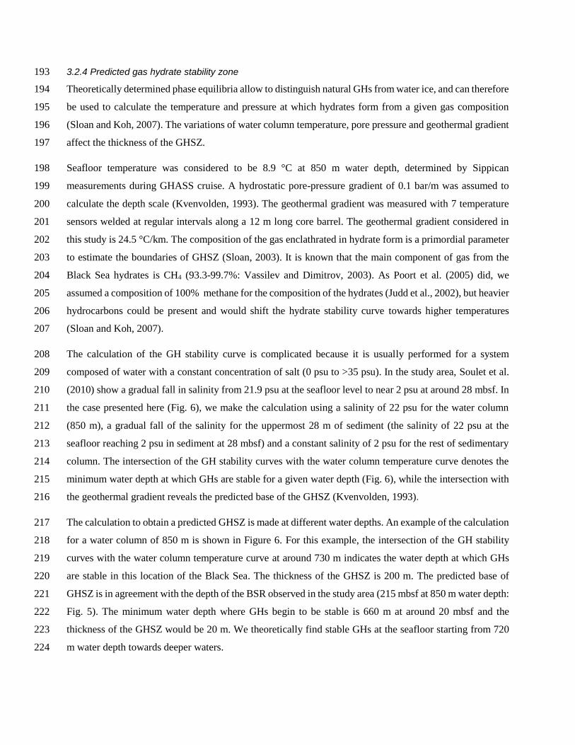
3.2.4 Predicted gas hydrate stability zone 193
Theoretically determined phase equilibria allow to distinguish natural GHs from water ice, and can therefore 194
be used to calculate the temperature and pressure at which hydrates form from a given gas composition 195
(Sloan and Koh, 2007). The variations of water column temperature, pore pressure and geothermal gradient 196
affect the thickness of the GHSZ. 197
Seafloor temperature was considered to be 8.9 °C at 850 m water depth, determined by Sippican 198
measurements during GHASS cruise. A hydrostatic pore-pressure gradient of 0.1 bar/m was assumed to 199
calculate the depth scale (Kvenvolden, 1993). The geothermal gradient was measured with 7 temperature 200
sensors welded at regular intervals along a 12 m long core barrel. The geothermal gradient considered in 201
this study is 24.5 °C/km. The composition of the gas enclathrated in hydrate form is a primordial parameter 202
to estimate the boundaries of GHSZ (Sloan, 2003). It is known that the main component of gas from the 203
Black Sea hydrates is CH4 (93.3-99.7%: Vassilev and Dimitrov, 2003). As Poort et al. (2005) did, we 204
assumed a composition of 100% methane for the composition of the hydrates (Judd et al., 2002), but heavier 205
hydrocarbons could be present and would shift the hydrate stability curve towards higher temperatures 206
(Sloan and Koh, 2007). 207
The calculation of the GH stability curve is complicated because it is usually performed for a system 208
composed of water with a constant concentration of salt (0 psu to >35 psu). In the study area, Soulet et al. 209
(2010) show a gradual fall in salinity from 21.9 psu at the seafloor level to near 2 psu at around 28 mbsf. In 210
the case presented here (Fig. 6), we make the calculation using a salinity of 22 psu for the water column 211
(850 m), a gradual fall of the salinity for the uppermost 28 m of sediment (the salinity of 22 psu at the 212
seafloor reaching 2 psu in sediment at 28 mbsf) and a constant salinity of 2 psu for the rest of sedimentary 213
column. The intersection of the GH stability curves with the water column temperature curve denotes the 214
minimum water depth at which GHs are stable for a given water depth (Fig. 6), while the intersection with 215
the geothermal gradient reveals the predicted base of the GHSZ (Kvenvolden, 1993). 216
The calculation to obtain a predicted GHSZ is made at different water depths. An example of the calculation 217
for a water column of 850 m is shown in Figure 6. For this example, the intersection of the GH stability 218
curves with the water column temperature curve at around 730 m indicates the water depth at which GHs 219
are stable in this location of the Black Sea. The thickness of the GHSZ is 200 m. The predicted base of 220
GHSZ is in agreement with the depth of the BSR observed in the study area (215 mbsf at 850 m water depth: 221
Fig. 5). The minimum water depth where GHs begin to be stable is 660 m at around 20 mbsf and the 222
thickness of the GHSZ would be 20 m. We theoretically find stable GHs at the seafloor starting from 720 223
m water depth towards deeper waters. 224

4. Discussion 225
4.1. Impact of geomorphology in free gas expulsion 226
Overall, the distribution of gas flares observed in the water column of the study area are in agreement with 227
the free gas areas defined in Popescu et al. (2007). However, in some cases, several gas flares are detected 228
downward the areas defined in the literature: many gas flares are inside the BSR zone defined in (Popescu 229
et al., 2006) close to the landward termination of the BSR (Fig. 7). The causes of this mismatch could be 230
attributed to an evolution of the degassing zone in the water column over the last 10 years and/or to the 231
variety of the data analysis. The free gas area described by Popescu et al. (2006) was derived from seismic 232
data interpretation while our gas flare areas from analysis of acoustic data recently acquired. Indeed, the 233
identification of seepage activity at continental margins, which is a relatively widespread phenomena (Judd 234
and Hovland, 2007), is emphasized by the water column mapping and technological advances in the last 235
decade (Dupré et al., 2015). 236
The distribution of the gas seeps in the Romanian sector of the Black Sea coincides in most cases with the 237
presence at the seafloor of sediment deformation features. 96% of the gas flares are located above canyons 238
(Fig. 7C), landslides (Figs. 3C, 7A), pockmarks (Figs. 3B, 7B), and fault/ crest line (Fig. 3A). These 239
observations and interpretations coincide with: (1) the recent analysis made in the Sea of Marmara where it 240
was demonstrated that gas emissions in the water column are spatially controlled by fault and fracture 241
networks in connection with the Main Marmara Fault system (Dupré et al., 2015); (2) several studies 242
offshore California showing active seeps right above a vertically faulted and fractured region along the walls 243
of the Monterey Canyon (Barry et al., 1996; Paull et al., 2005); and (3) previous studies in the Dnepr paleo-244
delta (northwestern Black Sea), where seeps generally occur in association with pockmarks on the 245
continental shelf, along crests of sedimentary ridges, canyon flanks and near submarine landslides on the 246
continental slope (Naudts et al., 2006). Studies about the geomorphological control of the distribution of 247
gas seepages finally show they follow the same pattern as the control of the distribution of pockmarks. 248
Studies published during the last 20 years have demonstrated that the spatial organization of pockmarks 249
(seafloor deformation due to fluid expulsion) may be the result of fluid seepage from underlying sedimentary 250
structures such as fault systems (Pilcher and Argent, 2007), channels (Gay et al., 2003), mud volcanoes, 251
mud diapirs, glaciogenic deposits (Forwick et al., 2009), and mass transport deposits (Riboulot et al., 2013). 252
The spatial distribution of pockmarks suggests that all the discontinuities within the sedimentary column 253
represent potential drains for fluid flow, and that simple diffusion through the sediments cannot explain the 254
observed pattern of fluid expulsion. The spatial distribution of a large proportion of the gas flares in the 255
study area seems to be associated with gas contained in underlying sediment using discontinuities formed 256
by landsliding. The discontinuities resulted from mass wasting processes inside and outside the canyons are 257
probably responsible for the gas seepages, by providing preferential migration pathways to gas as Riboulot 258

et al. (2013) demonstrated in the Niger delta where a buried landslide controls the distribution of the seafloor 259
pockmarks. 260
4.2. Impact of Gas Hydrates Stability Zone in free gas expulsion and sedimentary deformation? 261
We observed only 26 gas seeps of the 1409 detected in the study area really inside the GHSZ (Figs. 2, 3A, 262
7). They are right above a crest line that represents 2% of the whole gas seeps detected in the study area. 263
We interpret the crest line as the seafloor evidence of the presence of a fault affecting the underlying 264
sedimentary sediments. If this is the case, as Gay et al. (2006) suggest in the Lower Congo Basin, we suppose 265
the fluids accumulate under the base of the hydrate stability zone form a layer of free gas and the generation 266
of excess pore fluid pressure in the free gas accumulation leads to the release of fluids along faults of the 267
highly faulted interval responsible of the presence of free gas at the seafloor and in the water column. 268
Due to the concentration of gas seepages outside and at the landward termination of the GHSZ (98% of the 269
whole degassing site) and the seismic anomalies observed under the BSR (Fig. 5), we suggest that the 270
presence of GHs at the base of GHSZ constitutes an impermeable caprock over an accumulation of free gas. 271
Indeed, GHs may fill pore spaces and reduce sediment permeability, so that in some cases hydrate-bearing 272
sediment may act as seal and result in gas traps (Max and Dillon 1998). This interpretation is in agreement 273
with the observations of Naudts et al. (2006) in the Dnepr paleo-delta area where the depth limit for 99.5% 274
of the detected seeps coincides with the phase boundary of pure methane hydrate at 725 m water depth. 275
They suggest GHs play the role of buffer for the upward migration of methane gas and thus prevent seepage 276
of methane bubbles into the water column as it was proposed by Popescu et al. (2007) in the Danube Deep-277
Sea Fan area and by Westbrook et al. (2009) in the West Spitsbergen margin. This process may explain the 278
lack of deformation of the overlying sedimentary layers (Fig. 5), the absence of gas flares in the water 279
column inside the GHSZ and the possible deformation at the landward termination of the GHSZ around the 280
small mounts. 281
Indeed, the analysis of the seafloor morphology inside the GHSZ combined with the seismic stratigraphy 282
provide useful information on the impact of GHs on sedimentary deformation. The seafloor deformation, 283
characteristics of the features named “gas-hydrate pockmarks” and described around the world (Macelloni 284
et al., 2012; Riboulot et al., 2016; Simonetti et al., 2013; Sultan et al., 2014), are not observed in the study 285
area. GH pockmarks characterize seafloors where GHs are present in the shallow sedimentary layers. 286
Sediment deformation at the landward termination of the BSR may be induced by GH dynamics as it was 287
described in the Niger delta by Riboulot et al. (2016) and Sultan et al. (2014). The presence of GHs close to 288
the seafloor generate a disturbance of the sedimentary deposits and the loss of their original sedimentary 289
structures. The small mounts, observed around this area and mentioned in Figures 2 and 5, rather seem to 290

be the result of an inherited morphology from the compressive bulge of an underlying landslide without 291
implication of GH dynamics. 292
It may be noted that several headwall scarps are observed at around 650 m water depth. The landward 293
termination of the GHSZ coincide with these escarpments. 35% of the gas seeps observed in the water 294
column are localized right above scarps at the boundary with the GHSZ. It suggests GH dynamics may have 295
an implication in sediment failure as it was interpreted by Westbrook et al. (2009). Further investigation 296
will be needed to confirm this hypothesis. 297
Conclusions 298
The continental slope morphology of the Romanian sector of the Black Sea is incised by several landslides 299
inside and outside canyons. It is a complex study area presenting sedimentary processes such as seafloor 300
erosion and instability, mass wasting, formation of GHs, fluid migration, gas escape, where the imprint of 301
geomorphology seems to dictate the location where gas seep occurs. We have detected 1409 active seeps 302
within the 1200 km2 of the shelf and slope north-east of the Danube canyon. Most gas seeps (96%) are not 303
randomly distributed in this area. They occur along canyon flanks, scarps, crest lines, faults and in 304
association with pockmarks and mounts. 305
Moreover the depth limit for 98% of the gas seeps coincides with the predicted landward termination of 306
GHSZ. This suggest GHs formed at the base of the GHSZ act as an effective seal preventing gas to reach 307
the seafloor and the water column. The extent and the dynamics of GHs have a probable impact on the 308
sedimentary destabilization observed at the seafloor and the stability of the GHs is dependent on the salinity 309
gradient through the sedimentary column and thus on the Black Sea recent geological history. 310
Acknowledgment 311
The support by officers and crew during the GHASS cruise on board R/V Pourquoi Pas ? (2015) is greatly 312
appreciated, as is the dedication of the Genavir and Ifremer technical staff during the cruise. We thank 313
sincerely Alison Chalm for her revision of the English language. 314
References 315
Bangs, N.L.B., Musgrave, R.J., Tréhu, A.M., 2005. Upward shifts in the southern Hydrate Ridge gas hydrate 316
stability zone following postglacial warming, offshore Oregon. Journal of Geophysical Research: Solid 317
Earth 110. 318
Barry, J.P., Greene, H.G., Orange, D.L., Baxter, C.H., Robison, B.H., Kochevar, R.E., Nybakken, J.W., 319
McHugh, C.M., 1996. Biologic and geologic characteristics of cold seeps in Monterey Bay, California. Deep 320
Sea Research Part I: Oceanographic Research Papers 43, 1739-1762. 321

Bull, S., Cartwright, J., Huuse, M., 2009. A review of kinematic indicators from mass-transport complexes 322
using 3D seismic data. Marine and Petroleum Geology 26, 1132-1151. 323
Constantinescu, A.M., Toucanne, S., Dennielou, B., Jorry, S.J., Mulder, T., Lericolais, G., 2015. Evolution 324
of the Danube Deep-Sea Fan since the Last Glacial Maximum: new insights into Black Sea water-level 325
fluctuations. Marine Geology 367, 50-68. 326
Crémière, A., Lepland, A., Chand, S., Sahy, D., Condon, D.J., Noble, S.R., Martma, T., Thorsnes, T., Sauer, 327
S., Brunstad, H., 2016. Timescales of methane seepage on the Norwegian margin following collapse of the 328
Scandinavian Ice Sheet. Nature Communications 7. 329
Davis, A.M., 1992. Shallow gas: an overview. Continental Shelf Research 12, 1077-1079. 330
Demirbas, A., 2009. Methane from gas hydrates in the black sea. Energy Sources, Part A: Recovery, 331
Utilization, and Environmental Effects 32, 165-171. 332
Dillon, W.P., Paull, C.K., 1983. Marine gas hydrates, II. Geophysical evidence. Natural Gas Hydrates: 333
Properties, Occurrences, and Recovery: Woburn, MA (Butterworth), 73-90. 334
Dimitrov, L., 2002. Contribution to atmospheric methane by natural seepages on the Bulgarian continental 335
shelf. Continental Shelf Research 22, 2429-2442. 336
Dupré, S., Scalabrin, C., Grall, C., Augustin, J.M., Henry, P., Şengör, A.M., Görür, N., Çağatay, M.N., Géli, 337
L., 2015. Tectonic and sedimentary controls on widespread gas emissions in the Sea of Marmara: Results 338
from systematic, shipborne multibeam echo sounder water column imaging. Journal of Geophysical 339
Research: Solid Earth 120, 2891-2912. 340
Forwick, M., Baeten, N.J., Vorren, T.O., 2009. Pockmarks in Spitsbergen fjords. Norwegian Journal of 341
Geology 89, 65-77. 342
Garcia-Gil, S., Vilas, F., Garcia-Garcia, A., 2002. Shallow gas features in incised-valley fills (Rıa de Vigo, 343
NW Spain): a case study. Continental Shelf Research 22, 2303-2315. 344
Gay, A., Lopez, M., Berndt, C., Seranne, M., 2007. Geological controls on focused fluid flow associated 345
with seafloor seeps in the Lower Congo Basin. Marine Geology 244, 68-92. 346
Gay, A., Lopez, M., Cochonat, P., Sultan, N., Cauquil, E., Brigaud, F., 2003. Sinuous pockmark belt as 347
indicator of a shallow buried turbiditic channel on the lower slope of the Congo Basin, West African Margin. 348
Geological Society, London, Special Publications 216, 173-189. 349
Gay, A., Lopez, M., Cochonat, P., Séranne, M., Levaché, D., Sermondadaz, G., 2006. Isolated seafloor 350
pockmarks linked to BSRs, fluid chimneys, polygonal faults and stacked Oligocene–Miocene turbiditic 351
palaeochannels in the Lower Congo Basin. Marine Geology 226, 25-40. 352
Ginsburg, G.D., 1998. Gas hydrate accumulation in deep-water marine sediments. Geological Society, 353
London, Special Publications 137, 51-62. 354
Gorman, A.R., Holbrook, W.S., Hornbach, M.J., Hackwith, K.L., Lizarralde, D., Pecher, I., 2002. Migration 355
of methane gas through the hydrate stability zone in a low-flux hydrate province. Geology 30, 327-330. 356
Greinert, J., McGinnis, D.F., Naudts, L., Linke, P., De Batist, M., 2010. Atmospheric methane flux from 357
bubbling seeps: Spatially extrapolated quantification from a Black Sea shelf area. Journal of Geophysical 358
Research: Oceans 115. 359
Heggland, R., 1997. Detection of gas migration from a deep source by the use of exploration 3D seismic 360
data. Marine Geology 137, 41-47. 361
Hempel, P., Spiess, V., Schreiber, R., 1994. Expulsion of shallow gas in the Skagerrak—evidence from sub-362
bottom profiling, seismic, hydroacoustical and geochemical data. Estuarine, Coastal and Shelf Science 38, 363
583-601. 364
Hester, K.C., Brewer, P.G., 2009. Clathrate hydrates in nature. Annual review of marine science 1, 303-365
327. 366
Holbrook, W.S., Hoskins, H., Wood, W.T., Stephen, R.A., Lizarralde, D., 1996. Methane hydrate and free 367
gas on the Blake Ridge from vertical seismic profiling. Science 273, 1840. 368
Hustoft, S., Bünz, S., Mienert, J., 2010. Three‐dimensional seismic analysis of the morphology and spatial 369
distribution of chimneys beneath the Nyegga pockmark field, offshore mid‐Norway. Basin Research 22, 370
465-480. 371

Hustoft, S., Mienert, J., Bünz, S., Nouzé, H., 2007. High-resolution 3D-seismic data indicate focussed fluid 372
migration pathways above polygonal fault systems of the mid-Norwegian margin. Marine Geology 245, 89-373
106. 374
Ion, G., Lericolais, G., Nouzé, H., Panin, N., Ion, E., 2002. Seismo-acoustic evidence of gases in 375
sedimentary edifices of the paleo-Danube realm, pp. 91-95. 376
Jones, A.T., Greinert, J., Bowden, D.A., Klaucke, I., Petersen, C.J., Netzeband, G.L., Weinrebe, W., 2010. 377
Acoustic and visual characterisation of methane-rich seabed seeps at Omakere Ridge on the Hikurangi 378
Margin, New Zealand. Marine Geology 272, 154-169. 379
Judd, A., Hovland, M., 2007. Seabed fluid flow. The impact on geology, biology and the marine 380
environment. Cambridge University, Cambridge. 381
Judd, A.G., Hovland, M., 1992. The evidence of shallow gas in marine sediments. Continental Shelf 382
Research 12, 1081-1095. 383
Judd, A.G., Hovland, M., Dimitrov, L.I., Garcia Gil, S., Jukes, V., 2002. The geological methane budget at 384
continental margins and its influence on climate change. Geofluids 2, 109-126. 385
King, L.H., MacLean, B., 1970. Pockmarks on the Scotian shelf. Geological Society of America Bulletin 386
81, 3141-3148. 387
Kvenvolden, K.A., 1993. Gas hydrates-geological perspective and global change. Reviews of Geophysics 388
31, 173-173. 389
Lüdmann, T., Wong, H.K., Konerding, P., Zillmer, M., Petersen, J., Flüh, E., 2004. Heat flow and quantity 390
of methane deduced from a gas hydrate field in the vicinity of the Dnieper Canyon, northwestern Black Sea. 391
Geo-Marine Letters 24, 182-193. 392
Macelloni, L., Simonetti, A., Knapp, J.H., Knapp, C.C., Lutken, C.B., Lapham, L.L., 2012. Multiple 393
resolution seismic imaging of a shallow hydrocarbon plumbing system, Woolsey Mound, Northern Gulf of 394
Mexico. Marine and Petroleum Geology 38, 128-142. 395
Mathys, M., Thießen, O., Theilen, F., Schmidt, M., 2005. Seismic characterisation of gas-rich near surface 396
sediments in the Arkona Basin, Baltic Sea. Marine Geophysical Researches 26, 207-224. 397
McGinnis, D.F., Greinert, J., Artemov, Y., Beaubien, S.E., Wüest, A., 2006. Fate of rising methane bubbles 398
in stratified waters: How much methane reaches the atmosphere? Journal of Geophysical Research: Oceans 399
111. 400
Merey, S., Sinayuc, C., 2016. Investigation of gas hydrate potential of the Black Sea and modelling of gas 401
production from a hypothetical Class 1 methane hydrate reservoir in the Black Sea conditions. Journal of 402
Natural Gas Science and Engineering 29, 66-79. 403
Mert Küçük, H., Dondurur, D., Özel, Ö., Sinayuç, Ç., Merey, S., Parlaktuna, M., Çifçi, G., Gas and Gas 404
Hydrate Potential Offshore Amasra, Bartin and Zonguldak and Possible Agent for Multiple BSR 405
Occurrence, p. 10310. 406
Naudts, L., De Batist, M., Greinert, J., Artemov, Y., 2009. Geo-and hydro-acoustic manifestations of 407
shallow gas and gas seeps in the Dnepr paleodelta, northwestern Black Sea. The Leading Edge 28, 1030-408
1040. 409
Naudts, L., Greinert, J., Artemov, Y., Beaubien, S.E., Borowski, C., De Batist, M., 2008. Anomalous sea-410
floor backscatter patterns in methane venting areas, Dnepr paleo-delta, NW Black Sea. Marine Geology 411
251, 253-267. 412
Naudts, L., Greinert, J., Artemov, Y., Staelens, P., Poort, J., Van Rensbergen, P., De Batist, M., 2006. 413
Geological and morphological setting of 2778 methane seeps in the Dnepr paleo-delta, northwestern Black 414
Sea. Marine Geology 227, 177-199. 415
Netzeband, G.L., Krabbenhöft, A., Zillmer, M., Petersen, C.J., Papenberg, C., Bialas, J., 2010. The 416
structures beneath submarine methane seeps: seismic evidence from Opouawe Bank, Hikurangi Margin, 417
New Zealand. Marine Geology 272, 59-70. 418
Nisbet, E.G., Piper, D.J.W., 1998. Giant submarine landslides. Nature 392, 329-330. 419
Overmann, J., Manske, A.K., 2006. Anoxygenic phototrophic bacteria in the Black Sea chemocline, Past 420
and Present Water Column Anoxia. Springer, pp. 523-541. 421

Paull, C.K., Schlining, B., Ussler, W., Paduan, J.B., Caress, D., Greene, H.G., 2005. Distribution of 422
chemosynthetic biological communities in Monterey Bay, California. Geology 33, 85-88. 423
Paull, C.K., Ussler, W., Borowski, W.S., Spiess, F.N., 1995. Methane-rich plumes on the Carolina 424
continental rise: associations with gas hydrates. Geology 23, 89-92. 425
Pilcher, R., Argent, J., 2007. Mega-pockmarks and linear pockmark trains on the West African continental 426
margin. Marine Geology 244, 15-32. 427
Poort, J., Vassilev, A., Dimitrov, L., 2005. Did postglacial catastrophic flooding trigger massive changes in 428
the Black Sea gas hydrate reservoir? Terra Nova 17, 135-140. 429
Popescu, I., De Batist, M., Lericolais, G., Nouzé, H., Poort, J., Panin, N., Versteeg, W., Gillet, H., 2006. 430
Multiple bottom-simulating reflections in the Black Sea: potential proxies of past climate conditions. Marine 431
Geology 227, 163-176. 432
Popescu, I., Lericolais, G., Panin, N., De Batist, M., Gillet, H., 2007. Seismic expression of gas and gas 433
hydrates across the western Black Sea. Geo-Marine Letters 27, 173-183. 434
Popescu, I., Lericolais, G., Panin, N., Normand, A., Dinu, C., Le Drezen, E., 2004. The Danube submarine 435
canyon (Black Sea): morphology and sedimentary processes. Marine Geology 206, 249-265. 436
Riboulot, V., Cattaneo, A., Sultan, N., Garziglia, S., Ker, S., Imbert, P., Voisset, M., 2013. Sea-level change 437
and free gas occurrence influencing a submarine landslide and pockmark formation and distribution in 438
deepwater Nigeria. Earth and Planetary Science Letters 375, 78-91. 439
Riboulot, V., Sultan, N., Imbert, P., Ker, S., 2016. Initiation of gas-hydrate pockmark in deep-water Nigeria: 440
Geo-mechanical analysis and modelling. Earth and Planetary Science Letters 434, 252-263. 441
Ross, D.A., Degens, E.T., MacIlvaine, J., 1970. Black Sea: recent sedimentary history. Science 170, 163-442
165. 443
Schroot, B.M., Klaver, G.T., Schüttenhelm, R.T.E., 2005. Surface and subsurface expressions of gas 444
seepage to the seabed—examples from the Southern North Sea. Marine and Petroleum Geology 22, 499-445
515. 446
Schroot, B.M., Schuttenhelm, R.T.E., 2003. Expressions of shallow gas in the Netherlands North Sea. 447
Netherlands Journal of Geosciences 82, 91-106. 448
Shipley, T.H., Houston, M.H., Buffler, R.T., Shaub, F.J., McMillen, K.J., Ladd, J.W., Worzel, J.L., 1979. 449
Seismic evidence for widespread possible gas hydrate horizons on continental slopes and rises. AAPG 450
bulletin 63, 2204-2213. 451
Simonetti, A., Knapp, J.H., Sleeper, K., Lutken, C.B., Macelloni, L., Knapp, C.C., 2013. Spatial distribution 452
of gas hydrates from high-resolution seismic and core data, Woolsey Mound, Northern Gulf of Mexico. 453
Marine and Petroleum Geology 44, 21-33. 454
Sloan, E.D., 2003. Fundamental principles and applications of natural gas hydrates. Nature 426, 353-363. 455
Sloan, E.D., Koh, C., 2007. Clathrate hydrates of natural gases. CRC press. 456
Solomon, E.A., Kastner, M., MacDonald, I.R., Leifer, I., 2009. Considerable methane fluxes to the 457
atmosphere from hydrocarbon seeps in the Gulf of Mexico. Nature Geoscience 2, 561-565. 458
Soulet, G., Delaygue, G., Vallet-Coulomb, C., Böttcher, M.E., Sonzogni, C., Lericolais, G., Bard, E., 2010. 459
Glacial hydrologic conditions in the Black Sea reconstructed using geochemical pore water profiles. Earth 460
and Planetary Science Letters 296, 57-66. 461
Sultan, N., Bohrmann, G., Ruffine, L., Pape, T., Riboulot, V., Colliat, J.L., De Prunelé, A., Dennielou, B., 462
Garziglia, S., Himmler, T., 2014. Pockmark formation and evolution in deep water Nigeria: Rapid hydrate 463
growth versus slow hydrate dissolution. Journal of Geophysical Research: Solid Earth 119, 2679-2694. 464
Taylor, M.H., Dillon, W.P., Pecher, I.A., 2000. Trapping and migration of methane associated with the gas 465
hydrate stability zone at the Blake Ridge Diapir: new insights from seismic data. Marine Geology 164, 79-466
89. 467
Tréhu, A.M., Flemings, P.B., Bangs, N.L., Chevallier, J., Gràcia, E., Johnson, J.E., Liu, C.S., Liu, X., Riedel, 468
M., Torres, M.E., 2004. Feeding methane vents and gas hydrate deposits at south Hydrate Ridge. 469
Geophysical Research Letters 31. 470
Vassilev, A., Dimitrov, L., 2003. Model evaluation of the Black Sea gas hydrates. Comptes Rendus de 471
l'Academie bulgare des Sciences 56, 3-15. 472

Westbrook, G.K., Thatcher, K.E., Rohling, E.J., Piotrowski, A.M., Pälike, H., Osborne, A.H., Nisbet, E.G., 473
Minshull, T.A., Lanoisellé, M., James, R.H., 2009. Escape of methane gas from the seabed along the West 474
Spitsbergen continental margin. Geophysical Research Letters 36. 475
Winguth, C., Wong, H.K., Panin, N., Dinu, C., Georgescu, P., Ungureanu, G., Krugliakov, V.V., 476
Podshuveit, V., 2000. Upper Quaternary water level history and sedimentation in the northwestern Black 477
Sea. Marine Geology 167, 127-146. 478
Wong, H.K., Panin, N., Dinu, C., Georgescu, P., Rahn, C., 1994. Morphology and post‐Chaudian (Late 479
Pleistocene) evolution of the submarine Danube fan complex. Terra Nova 6, 502-511. 480
Yefremova, A.G., Zhizhchenko, B.P., 1974. Gas hydrate occurrences in offshore deposits. DAN SSSR 481
(Proceedings of the USSR Academy of Sciences) 214, 1179-1181. 482
Zillmer, M., Flueh, E.R., Petersen, J., 2005. Seismic investigation of a bottom simulating reflector and 483
quantification of gas hydrate in the Black Sea. Geophysical Journal International 161, 662-678. 484
Zubakov, V.A., 1988. Climatostratigraphic scheme of the Black Sea Pleistocene and its correlation with the 485
oxygen-isotope scale and glacial events. Quaternary Research 29, 1-24. 486
Figure captions 487
Figure 1: Bathymetric map, acquired during the 2015 GHASS cruise, showing the study area with the 488
location of seismic profiles. Fine grey lines show the multibeam navigation where the presence of free gas 489
in the water column was searched. The continental slope is dissected by the Danube canyon and the Canyons 490
1 and 2 with several submarine landslide scars along canyon flanks. 491
Figure 2: Geomorphologic map of the study area with superposed: free gas and BSR areas detailed in 492
Popescu et al. (2006, 2007), cartography of the gas bubbles acoustically detected in the water column, and 493
the predicted landward limit of the predicted GHSZ (bold black line). The modern landward termination of 494
the GHSZ correspond to the 660 mbsl bathymetric contour. 495
Figure 3: The 3D views of the seafloor and water column (GLOBE software © Ifremer), with processed 496
polar echograms, show (A) a crest line inside the GHSZ, (B) a pockmark and (C) a headwall scarp. The 497
acoustic anomalies recorded in the water column are echoes caused by escaping gas bubbles through the 498
seafloor. The acoustic imprint of the plumes almost reaches a height of 300 m above the seafloor. The 3 499
examples are localized on the figure 1. 500
Figure 4: Seismic reflection profile Bla 1-8 (BLASON cruise). Across the shelf break and the upper slope 501
within the free gas area defined in Popescu et al. (2007; location in Fig. 1). The close up views (A, B and 502
C) show how the occurrence of free gas affects seismic data. The most apparent free gas zones are identified 503
under a mass transport complex (in orange). Several free gas zones coincide with the presence of gas 504
chimneys and pockmarks (A and B) while when the seafloor depth is deeper we have a lack of seafloor fluid 505
features. The gas seems to be trapped under the MTC. 506
Figure 5: Seismic reflection profile Bla 1-7 (BLASON cruise): across the slope partly within the BSR area 507
defined in Popescu et al. (2006; location in Fig. 1). The presence of a BSR is suggested by a strong and 508

negative polarity reflector associated to an increase in the attenuation and amplitude anomalies (seismic 509
signature of the free gas – green arrows). Within the predicted GHSZ, right above the BSR, we do not 510
observed seismic signature of the presence of free gas. The free gas seems to be trapped under the MTC. 511
The black rectangle indicates the area of inset. The inset highlights the location of the supposed GH 512
occurrence within a deformed sedimentary layers at the landward termination of the BSR. 513
Figure 6: Gas hydrate stability using pure s-I methane hydrate and the water column (S = 22 psu) and 514
porewater (S=2; in depth higher than 25 mbsf) salinities. For this example used to illustrate the calculation 515
(Seafloor: 850 m water depth), the minimum water depth where GHs are stable is 720 mbsl. The bottom 516
water temperature used is 8.9 °C. For the regional observed geothermal gradients of 24.5 °C/km, the base 517
of GHSZ is 200 mbsf. These results are calculated in 2D and change with depth of the seafloor due to the 518
evolution of the salinity within the sediment. 519
Figure 7: Dip map derived from the bathymetric map of the study area with superimposed (1) 520
geomorphological features/zones, (2) limits of the GHSZ and (3) presence of measured gas bubbles in the 521
water column. Red marks stand for water column acoustic anomalies recorded from Sept 1st to 15th, 2015. 522
The white rectangles indicate the areas of inset. The insets highlight key zones showing the spatial 523
distribution of bubbles along headwall scarps (A), pockmarks – destabilized zones (B), canyon flanks (C), 524
and the landward termination of the GHSZ (D). 525
526

527
528

529
530

531
532

533
534

535
536

537
538
