contents · web viewwith the exception of the commonwealth coat of arms, photographs, the...
TRANSCRIPT
Plain English summary — proposed Basin Plan amendments
22 November 2016

Published by the Murray‒Darling Basin Authority
Postal Address: GPO Box 1801, Canberra ACT 260102 6279 0100 international + 61 2 6279 0100Email: [email protected]: mdba.gov.au
MDBA publication no.: 26/16ISBN (online): 978-1-925221-71-8
All material and work produced by the Murray‒Darling Basin Authority constitutes Commonwealth copyright. The MDBA reserves the right to set out the terms and conditions for the use of such material.
With the exception of the Commonwealth Coat of Arms, photographs, the Murray‒Darling Basin Authority logo or other logos and emblems, any material protected by a trade mark, any content provided by third parties, and where otherwise noted, all material presented in this publication is provided under a creative commons licence.
https://creativecommons.org/licenses/by/4.0
© Murray‒Darling Basin Authority 2016
The Murray‒Darling Basin Authority’s preference is that you attribute this publication (and any MDBA material sourced from it) using the following wording within your work:
Title: Plain English summary — proposed Basin Plan amendmentsSource: Licensed from the Murray‒Darling Basin Authority under a Creative Commons Attribution 4.0 Australia Licence
As far as practicable, material for which the copyright is owned by a third party will be clearly labelled. The Murray‒Darling Basin Authority has made all reasonable efforts to ensure that this material has been reproduced in this publication with the full consent of the copyright owners.
Inquiries regarding the licence and any use of this publication are welcome by contacting the Murray‒Darling Basin Authority.
Cover image: Balonne, near Breadmore Dam, NSW (photo by Amy Hankinson)
DisclaimerTo the extent permitted by law, the MDBA and the Commonwealth excludes all liability to any person for any consequences, including but not limited to all losses, damages, costs, expenses and any other compensation, arising directly or indirectly from using this report (in part or in whole) and any information or material contained within it.
AccessibilityThe MDBA makes its documents and information available in accessible formats. On some occasions the highly technical nature of the document means that we cannot make some sections fully accessible. If you encounter accessibility problems or the document is in a format that you cannot access, please contact us.
Acknowledgement of the Traditional Owners of the Murray–Darling Basin
The Murray–Darling Basin Authority acknowledges and pays respect to the Traditional Owners, and their Nations, of the Murray–Darling Basin, who have a deep cultural, social, environmental, spiritual and economic connection to their lands and waters. The MDBA understands the need for recognition of Traditional Owner knowledge and cultural values in natural resource management associated with the Basin.
The approach of Traditional Owners to caring for the natural landscape, including water, can be expressed in the words of Darren Perry (Chair of the Murray Lower Darling Rivers Indigenous Nations) —
‘the environment that Aboriginal people know as Country has not been allowed to have a voice in contemporary Australia. Aboriginal First Nations have been listening to Country for many thousands of years and can speak for Country so that others can know what Country needs. Through the Murray Lower Darling Rivers Indigenous Nations and the Northern Basin Aboriginal Nations the voice of Country can be heard by all’.
The use of terms ‘Aboriginal’ and ‘Indigenous’ reflects usage in different communities within the Murray–Darling Basin.

ContentsIntroduction......................................................................................................................................3
Reason for the changes...............................................................................................................3
How changes will be made..........................................................................................................3
Making a submission...................................................................................................................4
Northern Basin Review....................................................................................................................5
Changes to surface water sustainable diversion limit resource units..........................................5
Changes to surface water SDL resource unit local reduction amounts...................................6
Changes to surface water SDL resource unit shared reduction amounts................................6
Toolkit measures......................................................................................................................7
Social and economic analysis and scientific knowledge..............................................................8
Social and economic analysis..................................................................................................8
Scientific knowledge.................................................................................................................9
Groundwater management............................................................................................................10
Definitions..................................................................................................................................10
Water resource plan area boundaries.......................................................................................10
Sustainable diversion limit resource units and compliance methodology..................................11
SDL resource unit boundaries................................................................................................11
Compliance test......................................................................................................................11
Local management rules and adjustment to review provision...................................................13
Changes to matters relating to groundwater SDL resource units..............................................13
Sustainable diversion limit changes.......................................................................................13
Proposed changes to groundwater SDL resource unit boundaries........................................17
Social and economic analysis and scientific knowledge............................................................17
Surface water management — boundary changes.......................................................................19
New South Wales surface water boundary changes.................................................................19
Queensland water resource plan amalgamation.......................................................................20
South Australian surface water boundary changes...................................................................20
Social and economic analysis and scientific knowledge............................................................25
Sustainable diversion limit resource unit shared reduction amount..............................................26
Sustainable diversion limit resource unit shared reduction amount...........................................26
Social and economic analysis and scientific knowledge............................................................26
Revised estimate of baseline diversion limit..................................................................................27
Social and economic analysis and scientific knowledge............................................................27
Method for determining compliance with the sustainable diversion limits.....................................28
Method for determining compliance with the long-term annual diversion limit..........................28
Removal of cumulative debits in a particular circumstance.......................................................28
Social and economic analysis and scientific knowledge............................................................29
Water trading rules........................................................................................................................30
Clarifying free trade in surface water systems...........................................................................30
Clarifying allowable restrictions on trade...................................................................................30
Maintaining information reporting requirements........................................................................31
Social and economic analysis and scientific knowledge............................................................31
Consequential amendments following the Water Act review........................................................32
Reporting requirements.............................................................................................................32
Annual reporting.....................................................................................................................32
Reporting to Ministerial Council.............................................................................................32
Re-phasing of reviews...............................................................................................................32
Water quality & salinity management and environmental watering plans..............................32
Social and economic impacts.................................................................................................33
Monitoring and reporting capabilities.....................................................................................33
Social and economic analysis and scientific knowledge............................................................33
Water Resource Plan requirements..............................................................................................34
Form of a water resource plan...................................................................................................34
Minor correction of note about water resource plan accreditation.............................................34
Social and economic analysis and scientific knowledge............................................................34

IntroductionThe Murray–Darling Basin Authority (the Authority) is proposing amendments to the Basin Plan 2012 (Cth; Basin Plan). This document explains the amendments and their effects.
The Basin Plan is a legislative instrument and came into effect in November 2012. Changes to the Basin Plan may be made through amendments proposed by the Authority and adopted by the Minister for Agriculture and Water Resources.
The process for amending the Basin Plan is set out in the Water Act 2007 (Cth; Water Act). This includes publishing a plain English summary of the proposed changes and giving the public an opportunity to comment by making a submission. Details about how to make a submission are set out below.
The plain English summary must include an outline of the scientific knowledge and social and economic analysis carried out for the proposed amendments to the Basin Plan. This information is provided where relevant.
Reason for the changesThe changes proposed in these amendments arise from several reviews: the Northern Basin Review of sustainable diversion limits; a review of sustainable diversion limits for three groundwater areas; and the Australian Government’s response to the independent review of the Water Act.
A number of other technical amendments are proposed to ensure the smooth operation of the Basin Plan. These include better aligning water resource plan areas with state water planning boundaries; clarifying certain water trade rules; and allowing additional time for states to nominate a preferred allocation of the shared reduction amounts.
How changes will be made The Authority is releasing the proposed amendments, background information and this plain English summary for public comment.
The Authority will consider what, if any, revisions should be made to the proposed amendments in response to public submissions.
A final package of amendments will be presented to the Minister for Agriculture and Water Resources, who may adopt them. Amendments adopted by the Minister must be laid before Parliament for parliamentary scrutiny.
Page 3
Making a submissionThe Authority is making the proposed amendments available to the public for consultation on Tuesday 22 November 2016. The period for making a submission will open on Tuesday 22 November 2016, and will close at 5.00 pm (AEST) on Friday 24 February 2017.
Online lodgement is the preferred way to lodge submissions. The online submission form is secure and is suitable for uploading sensitive and confidential material. If you lodge your submission via the Authority’s online form, you will receive an email straight away that lets you know that the Authority has received your submission.
Online submissions can be made at: mdba.gov.au/BPamendments
You can also email your submission to: [email protected]
or post a hard copy to:
Basin Plan amendment submissionMurray–Darling Basin AuthorityGPO Box 2256CANBERRA ACT 2601
Submissions lodged via email or by post should be clearly identified including the words 'Basin Plan amendment submission' in the document title, subject line or body of the submission.
If you post or email your submission you will also receive an acknowledgement, via email or letter through the post, to let you know that the Authority has received your submission. Unlike online lodgement, this is not an automated process, so it may take longer for you to receive an acknowledgement that your submission has been received.
Publishing submissions
The Authority must publish the submissions it receives on the proposed amendment to the Basin Plan on its website unless a person making a submission specifically asks the Authority to treat a submission or part of their submission confidentially.
More information
To find out more about the proposed amendments to the Basin Plan, visit our website mdba.gov.au/BPamendments, email us at [email protected] or phone 1800 230 067.
Page 4
Northern Basin ReviewIn finalising the Basin Plan in 2012, the Authority undertook to conduct research and investigations into aspects of the Basin Plan in the northern basin, including the basis for long-term average sustainable diversion limits (SDLs) for surface water SDL resource units.
The purpose of the review was to improve the Authority’s knowledge of the northern basin, including the water needs of water-dependent ecosystems, and how water recovery has affected communities.
As a result of this review, the Authority proposes to change the long-term average sustainable diversion limits for some northern basin surface water SDL resource units, to reflect the outcomes of the Northern Basin Review.
The proposed amendments also include changes to the northern basin zone shared reduction amount. The Authority is also proposing to divide the northern basin zone into two zones, each with its own shared reduction target.
For a complete outline of the proposed changes, refer to the Northern Basin Review report.
Changes to surface water sustainable diversion limit resource unitsThe Basin Plan sets long-term average SDLs for all basin water resources. Sustainable diversion limits represent the maximum long-term annual average quantities of water that can be taken on a sustainable basis from basin water resources as a whole, and from each SDL resource unit. A surface water SDL resource unit describes the geographical area which contains a set of water resources, generally based on catchments. The Water Act requires that SDLs reflect an environmentally sustainable level of take.
When the Basin Plan was prepared, it was estimated that water users in the northern basin were extracting 3,858 gigalitres (GL) a year on average. The Basin Plan set the limit for consumptive use in the north at 3,468 GL — around 10% or 390 GL less for consumptive use on average a year.
The Authority proposes to change the reduction amount for the northern basin from 390 GL a year to 320 GL a year, provided the Australian, New South Wales and Queensland governments commit to implementing a number of so-called ‘toolkit measures' designed to improve water management. A proposed note has been included at section 6.04(3) of the Basin Plan that states this change.
Page 5
Summary of changes
The Authority proposes a change to the overall long-term average sustainable diversion limits in the northern Basin.
This results in a change to the overall reduction amount for the northern Basin from the current settings of 390 GL per year to 320 GL per year.
This includes changes to local reduction amounts for a number of catchments in the northern Basin and a change to the shared reduction amount for the northern Basin zone.
In addition, the Authority proposes to divide the northern Basin zone into two zones, each with its own shared reduction
Summary of changes
The Authority proposes a change to the long-term average sustainable diversion limits in the northern basin, provided the Australian, New South Wales and Queensland governments commit to implementing a range of measures to improve water management.
This results in a change to the reduction amount for the northern basin from 390 gigalitres (GL) a year to 320 GL a year on a long-term average basis.
This includes changes to local reduction amounts for a number of catchments in the northern basin and a change to the shared reduction amount for the northern basin zone.
In addition, the Authority proposes to divide the northern basin zone into two zones for Queensland and New South Wales, each with its own shared reduction target.
The Authority also proposes to update the note at section 6.04 (2) to reflect this change at a basin-wide level. The note now states that the Authority estimates the long-term average sustainable diversion limit for all surface water SDL resource units to be 10,945 GL per year, which reflects a reduction of 2,680 GL per year from the Authority’s estimate of the baseline diversion limit.
The Basin Plan divides this reduction amount into a volume to meet local environmental needs and a volume that contributes to a shared reduction amount to meet the environmental needs of the Barwon–Darling River. The local reduction amount is (in most cases) the minimum reduction required within each SDL resource unit to satisfy local environmental needs. The SDL resource units of tributaries to the Barwon–Darling contribute to the shared reduction amount.
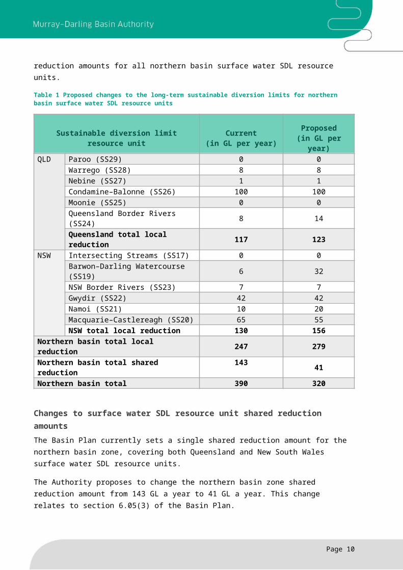
Changes to surface water SDL resource unit local reduction amountsThis proposed change relates to Schedule 2 of the Basin Plan, which sets out the long-term average sustainable diversion limits for all SDL resource units in the Murray–Darling Basin.
The Authority proposes changes to the local reduction amount specified in Schedule 2 for several northern basin SDL resource units. Table 1 sets out the current local reduction amounts, and the proposed local reduction amounts for all northern basin surface water SDL resource units.
Table 1 Proposed changes to the long-term sustainable diversion limits for northern basin surface water SDL resource units
Sustainable diversion limit resource unit Current(in GL per year)
Proposed(in GL per year)
QLD Paroo (SS29) 0 0Warrego (SS28) 8 8Nebine (SS27) 1 1Condamine–Balonne (SS26) 100 100Moonie (SS25) 0 0Queensland Border Rivers (SS24) 8 14Queensland total local reduction 117 123
NSW Intersecting Streams (SS17) 0 0Barwon–Darling Watercourse (SS19) 6 32NSW Border Rivers (SS23) 7 7Gwydir (SS22) 42 42Namoi (SS21) 10 20Macquarie–Castlereagh (SS20) 65 55NSW total local reduction 130 156
Northern basin total local reduction 247 279Northern basin total shared reduction 143 41Northern basin total 390 320
Changes to surface water SDL resource unit shared reduction amounts The Basin Plan currently sets a single shared reduction amount for the northern basin zone, covering both Queensland and New South Wales surface water SDL resource units.
The Authority proposes to change the northern basin zone shared reduction amount from 143 GL a year to 41 GL a year. This change relates to section 6.05(3) of the Basin Plan.
Page 6
The Authority proposes to divide the northern basin zone into two zones: the northern basin Queensland zone and the northern basin New South Wales zone. This change relates to section 6.05(2). This will assist each state to administer the allocation of the shared reduction in the SDL resource units in each of their respective zones.
The following SDL resource units comprise the proposed northern basin Queensland zone:
Condamine–Balonne (SS26) Moonie (SS25) Nebine (SS27) Paroo (SS29) Queensland Border Rivers (SS24) Warrego (SS28).
The following SDL resource units comprise the proposed northern basin New South Wales zone:
Barwon–Darling Watercourse (SS19) Gwydir (SS22) Intersecting Streams (SS17) Macquarie–Castlereagh (SS20) Namoi (SS21 NSW Border Rivers (SS23).
The Authority proposes that the shared reduction targets for the two new zones are as follows:
a) northern basin Queensland zone — 17 GL per year b) northern basin New South Wales zone — 24 GL per year.
These volumes have been calculated using the formula set out in section 6.05(4) of the Basin Plan which allocates the reduction target for the zone in proportion to the amount of its baseline diversion limit, including any component of water diverted for urban water use, but excluding any component due to interception activities.
The Authority may update the distribution of these shared reduction volumes assigned to these zones on the advice of the Queensland and New South Wales governments, including advice provided as part of consultation on the proposed amendments, or in a request provided under section 7.23 of the Basin Plan.
Toolkit measures The Authority is proposing to change the northern basin reduction amount from 390 GL a year to 320 GL a year provided the Australian, New South Wales and Queensland governments commit to implementing a number of so-called ‘toolkit measures' designed to improve water management.
These proposed measures include arrangements to protect environmental flows, event-based mechanisms (such as options for pumping and store-and-release) and improving the coordination and delivery of environmental water. In the Gwydir in particular, this includes measures to remove constraints and manage flows to the wetlands, and environmental works and measures to promote fish movement and habitat.
Page 7
The Authority is working with the Australian, New South Wales and Queensland governments to finalise the details of these measures and their implementation before the proposed amendment to the Basin Plan is presented to the Minister for Agriculture and Water Resources in 2017.
To reflect this arrangement, the Authority proposes including a note at section 6.04 (3) of the Basin Plan that recognises the importance of implementing a package of measures and the need to formalise any arrangement reached.
Social and economic analysis and scientific knowledgeIn finalising the Basin Plan in 2012, the Authority agreed to conduct research and investigations into aspects of the Basin Plan in the northern basin, including the basis for the long-term average SDLs for surface water SDL resource units. While the scientific knowledge and socio-economic analysis was the best available at the time, the Authority thought that more work in the north was needed, to try to improve the social and economic outcomes for all rural communities involved and to provide increased confidence in the environmental targets selected.
The Northern Basin Review began its investigations into the long-term average SDLs for surface water and groundwater SDL resource units in 2013. In partnership with the Queensland, New South Wales and Australian governments, the Authority undertook rigorous investigations to improve its understanding of the northern basin’s economic, environmental and social conditions. This improved understanding helped the Authority to determine whether a change in local and shared reduction amounts was needed, and if so, what these changes should be.
In undertaking the Northern Basin Review, the Authority considered the latest knowledge on climate change, surface water and groundwater connectivity, the outcomes of environmental watering and the implications for the southern basin. More information is available in the Northern Basin Review report.
Social and economic analysisThe Authority undertook a social and economic analysis as part of the Northern Basin Review. The review looked at how recovering water from different parts of the river system is likely to affect communities and industries. This involved a comprehensive assessment on irrigated agriculture and rural towns, and the likely social and economic impacts of reducing water available for irrigation.
The work is much more detailed than previous social and economic assessments the Authority has undertaken and has a local focus with significantly more stakeholder input. The Authority has improved its understanding about the effects of water recovery, including effects on farmers as well as communities and supporting businesses.
An important part of preparing the social and economic analysis was speaking with local community members. The review focused on 21 communities to understand how places with differing degrees of dependence on irrigation have changed over time. It looked at how changes in water availability affected the area of irrigation and the flow-on effect on community employment, in agriculture and other types of jobs such as retail, transport and government services.
Page 8
Purchasing large volumes of water over a short period has had lasting effects on some towns. The effects of water purchasing are generally greater for smaller economies that are highly dependent on irrigation, compared with communities which are larger and more diverse.
A number of communities studied are likely to experience quite small effects under the water recovery scenarios considered in the review. This level of change would be difficult to distinguish from the other processes of change affecting those communities.
The Northern Basin Review report contains references to all of the scientific research and social and economic work that informed these proposed amendments.
Scientific knowledgeThe Authority commissioned a suite of new science projects as part of the Northern Basin Review to improve its understanding of the water needs of native birds, fish and vegetation. The research also provided an insight into the responses of water-dependent ecosystems under the different water recovery scenarios that were modelled.
The projects focused mainly on the Condamine–Balonne and the Barwon–Darling Watercourse SDL resource units, because the Authority had more confidence about the existing knowledge base in other northern basin SDL resource units and the remaining water recovery effort was likely to be focused in these two SDL resource units.
By using hydrological modelling the Authority was able to understand how flows in northern rivers change when different volumes of water are returned. These changes can include how much water is in the river, when it flows, and for how long. By taking that information and applying it to the Authority’s understanding of how native fish, plants and birds respond to flow, the Authority was able to consider what this means for river health.
The analysis showed that water recovery delivers some improvements, for example habitat connectivity in the Condamine–Balonne. The work also highlighted the types of flows that are unlikely to improve through water recovery alone under current water management arrangements. These include small flows in the Lower Balonne which are important to meet stock and domestic needs, and to maintain waterholes — which are culturally significant for Aboriginal people — during dry periods. Additionally, the higher flows that support large-scale waterbird breeding in the Narran Lakes are unlikely to be achieved.
The volume of recovery is important as additional flows in the system support long-term river health. The Authority also learned that key environmental outcomes can be further improved, especially in the Condamine–Balonne, by targeting certain entitlement types in particular locations.
More information about the scientific knowledge on which the proposed amendment is based is available in the Northern Basin Review report.
Page 9

Groundwater managementThe Basin Plan is the first time sustainable diversion limits have been introduced on all groundwater use in the basin. The Basin Plan included a requirement for reviews of the baseline diversion limits and SDLs for three groundwater areas:
Western Porous Rock SDL resource unit (GS50) (NSW) Eastern Porous Rock water resource plan area (GW16)
(NSW) Goulburn–Murray: sedimentary plain SDL resource unit
(GS8) (Victoria).
The Authority engaged expert panels to review the limits for three groundwater areas following a request from the governments of New South Wales and Victoria.
As a result of these reviews, and subsequent requests from basin governments, the Authority proposes amendments to a number of Basin Plan provisions dealing with how groundwater is managed.
DefinitionsThe proposed amendments to Chapter 1 of the Basin Plan are minor and technical changes linked to the addition of a new groundwater compliance method discussed below.
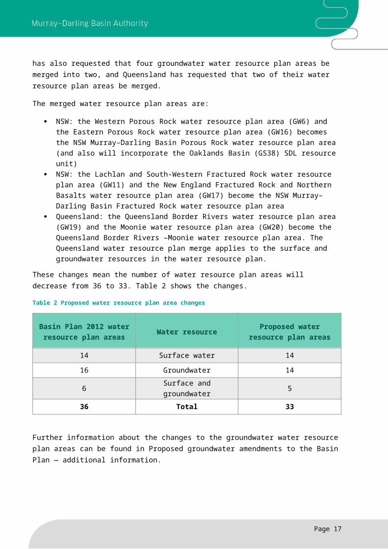
Water resource plan area boundariesSince the Basin Plan was made in 2012, a number of basin states have refined the boundaries of their own water planning areas. The states have requested that the Authority change the Basin Plan water resource plan boundaries, referred to in Chapter 3, to align them with the state water planning -boundaries. In New South Wales, the percentage of change is less than 1% of the NSW Murray–Darling Basin area. New South Wales has also requested that four groundwater water resource plan areas be merged into two, and Queensland has requested that two of their water resource plan areas be merged.
The merged water resource plan areas are:
NSW: the Western Porous Rock water resource plan area (GW6) and the Eastern Porous Rock water resource plan area (GW16) becomes the NSW Murray–Darling Basin Porous Rock water resource plan area (and also will incorporate the Oaklands Basin (GS38) SDL resource unit)
NSW: the Lachlan and South-Western Fractured Rock water resource plan area (GW11) and the New England Fractured Rock and Northern Basalts water resource plan area
Page 10
Summary of changes
The Authority proposes several changes to how groundwater is managed under the Basin Plan.
Boundaries of water resource plan areas and SDL resource units are changed to better align with state boundaries.
The way compliance with the SDLs is assessed changes to a 10-year rolling average method.
The SDLs for the three reviewed groundwater areas are increasing, subject to basin states demonstrating in water resource plans how they will limit impacts to acceptable levels.
Provisions about including rules in water resource plans to protect the structural integrity of groundwater units and their water quality are clarified.
Changes are proposed to the vertical boundaries of groundwater units to provide for more accurate accounting where a unit sits above another.
(GW17) become the NSW Murray–Darling Basin Fractured Rock water resource plan area
Queensland: the Queensland Border Rivers water resource plan area (GW19) and the Moonie water resource plan area (GW20) become the Queensland Border Rivers –Moonie water resource plan area. The Queensland water resource plan merge applies to the surface and groundwater resources in the water resource plan.
These changes mean the number of water resource plan areas will decrease from 36 to 33. Table 2 shows the changes.
Table 2 Proposed water resource plan area changes
Basin Plan 2012 water resource plan areas Water resource Proposed water resource
plan areas
14 Surface water 14
16 Groundwater 14
6 Surface and groundwater 5
36 Total 33
Further information about the changes to the groundwater water resource plan areas can be found in Proposed groundwater amendments to the Basin Plan — additional information.
Sustainable diversion limit resource units and compliance methodology
SDL resource unit boundariesNew South Wales, Queensland and Victoria have also requested changes to SDL resource unit boundaries to align them with state planning boundaries.
Changing these boundaries results in changes to maps and datasets referenced in Chapter 6 (section 6.03) and Schedule 4 of the Basin Plan.
Compliance test Under the Basin Plan, from 2019 the Authority will conduct a compliance test for each surface water and groundwater SDL resource unit. The test records the difference between the annual permitted take and annual actual take. Where annual actual take is greater than the annual permitted take, a debit is recorded on the register of take. Where annual actual take is less than the annual permitted take, a credit is recorded.
Debits and credits will accumulate from 1 July 2019. Non-compliance will occur if the accumulated debits are greater than the accumulated credits plus 20% of the annual SDL. Non-compliance will not apply if a state has a reasonable excuse.
Over time, credits and debits are expected to balance out in surface water SDL resource units but not in the case of many groundwater SDL resource units.
Page 11
As a result of the difference between the total basin-wide groundwater SDL (3,334 GL/y) and the current average basin-wide groundwater take (1,374 GL/y) an annual groundwater SDL credit of about 1,950 GL will accumulate. Under the current arrangements, the credit will continue to accumulate without a practical limit and well beyond any feasible extraction. For example, after 10 years there may be an accumulated groundwater SDL credit of 19,500 GL.
This credit will be an outcome of the current accounting method used for the compliance test. This problem was raised during the review of groundwater resource areas in Victoria which recommended that the Authority investigate and address the matter.
After consulting the basin states, the Authority proposes that a 10-year rolling average compliance method be used for groundwater SDL resource units (while the existing compliance method remains for surface water). Under this proposed method, non-compliance with an SDL in a water year for groundwater will occur if:
the average annual actual take over the 10 year period ending with that water year is greater than:the average annual permitted take over the same period, and the basin state does not have a reasonable excuse for the excess.
An interim approach is needed for the first nine years (1 July 2019 to 30 June 2028) before the ten-year rolling average compliance method can be fully introduced. The proposed interim method at section 6.12C(1) means non-compliance will occur if:
the cumulative sum of annual actual take in each water year since 1 July 2019 is greater than:the cumulative sum of annual permitted take for the same period, plus 20% of the annual SDL for the SDL resource unit and the basin state does not have a reasonable excuse for the excess.
The 20% tolerance is proposed to be retained to 2028 to provide for no change, compared to the current Basin Plan method. This tolerance is expected to be most relevant in the early years following 2019. It will not be continued beyond 2028 as discussions with the states concluded it was unnecessary.
An additional amendment is proposed to the compliance method for groundwater in line with a similar provision that is being introduced for surface water (refer proposed amendment to section 6.11(5) of the Basin Plan). In general terms, this amendment allows for the removal of any debits in the compliance test associated with water recovery that may occur after 30 June 2019.
More specifically, if the particular circumstance that is used as an example of ‘reasonable excuse’ applies (i.e. where, for reasons beyond a basin state’s control, the Australian Government has not achieved the water recovery target that it has set for itself in relation to the SDL resource unit, refer proposed section 6.12C (4)(b)), then the amount associated with this circumstance will be removed from the compliance test in subsequent years. This example, which is already provided for in the Basin Plan, refers to the Australian Government’s commitment to ‘bridge the gap’ to the SDLs under the Basin Plan. This issue is also discussed in relation to surface water on page 28, under the section Removal of cumulative debits in a particular circumstance.
Page 12
More information about the proposed changes to the groundwater compliance method and examples of its operation can be found in Proposed groundwater amendments to the Basin Plan — additional information.
Local management rules and adjustment to review provisionThe Authority has worked closely with New South Wales and Victoria to determine how best to implement the recommendations of the review panels of three groundwater areas:
Western Porous Rock SDL resource unit (GS50) (NSW) Eastern Porous Rock water resource plan area (GW16) (NSW) Goulburn–Murray: Sedimentary Plain SDL resource unit (GS8) (Victoria).
In particular the Authority and basin states focused on allowing more water to be taken from three groundwater areas once the states demonstrate how they will limit impacts to acceptable levels.
The Authority proposes to add a section (section 10.21A) to the Basin Plan that makes the local groundwater management rules (section 10.18 to section 10.21) mandatory in the three groundwater areas the review examined.
The New South Wales review panels also recommended a process to review these mandatory rules. The Authority proposes an additional section, which will provide an opportunity for New South Wales and Victoria to review the effectiveness of the local management rules whenever the water resource plan is reviewed.
While working with basin states on the mandatory local management rules, questions were raised about the interpretation of section 10.20 and section 10.21. Those sections deal with whether a water resource plan needs to include rules to protect the structural integrity of groundwater units and water quality. The Authority proposes minor amendments to clarify these two sections.
Further information on the changes to the groundwater elements of Chapter 10 can be found in Proposed groundwater amendments to the Basin Plan — additional information.
Changes to matters relating to groundwater SDL resource unitsSchedule 4 of the Basin Plan currently lists 81 groundwater SDL resource units, including name, SDL volume, BDL volume and the groundwater resources covered by each SDL resource unit.
Sustainable diversion limit changesThe panels for the two New South Wales and one Victorian groundwater SDL reviews supported an increase in SDL volumes in the review areas (Table 2). This reflects the view of the panels that a less conservative approach to setting SDLs than that taken by the MDBA can be justified if suitable management actions are in place to manage the potential impacts of increased groundwater take. Within the settings of the Basin Plan, the Authority considers that the mandatory local management rules are the most appropriate mechanism for managing the potential impacts of increasing the SDLs above their current volumes.
The Victorian review panel recommended small changes to the boundaries in the review area. This recommendation was adopted and also, after consultation with Victoria, applied in the other
Page 13

Victorian groundwater water resource plan area. This has resulted in a small reallocation of SDLs between two SDL resource units in the Wimmera–Mallee (groundwater) water resource plan area (Victoria) (GW3).
In addition to requests from New South Wales and Victoria to increase the SDL in some groundwater areas, South Australia asked the Authority to amend a number of baseline diversion limits and SDL volumes in the South Australian Murray Region water resource plan area, This was to account for some minor inaccuracies in the baseline diversion limit and SDL volumes when the Basin Plan was being made.
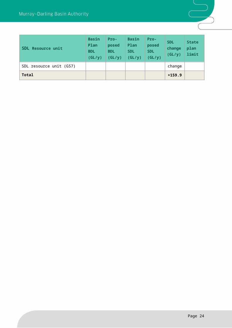
In total, the proposed SDL changes will affect eight SDLs and two BDLs across five water resource plan areas (two in New South Wales, two in Victoria and one in South Australia). The proposed SDL changes increase the basin-wide total for groundwater SDLs from 3,334 GL/y to 3,494 GL/y (an overall increase of 159.9 GL/y or 4.8%).
Table 3 provides the baseline diversion limits (BDLs) and SDLs of the SDL resource units where the SDL is changing. It also includes the state water management plan limits for these SDL resource units which differs from the baseline diversion limit in these cases due to the extent of issued entitlements at the time the Basin Plan was made. Figure 1 shows the locations of all the groundwater water resource plan areas with proposed changes to SDLs.
Table 3 and figure 1 refer to current Basin Plan water resource plan areas. Changes have been proposed to some water resource plan area boundaries, for example the Western Porous Rock water resource plan area (GW6) and the Eastern Porous Rock water resource plan area (GW16) becomes the NSW Murray–Darling Basin Porous Rock water resource plan area. Please see the section of this document on water resource plan area boundaries at page 14 for further details.
Now that the Authority has completed its review of the long-term average SDLs and baseline diversion limits for three groundwater areas as required by section 6.06(6) of the Basin Plan, the Authority proposes removing the spent sections relating to these reviews.
Page 14

Table 3: Proposed groundwater baseline diversion limit and sustainable diversion limit changes
SDL Resource unit
Basin Plan BDL (GL/y)
Pro-posed BDL (GL/y)
Basin Plan SDL (GL/y)
Pro-posed SDL (GL/y)
SDL change (GL/y)
State plan limit
Western Porous Rock water resource plan area (NSW) (GW6)
Western Porous Rock SDL resource unit (GS50)
63.1No
change116.6 226.0 +109.4 530.5
Eastern porous rock water resource plan area (NSW) (GW16)
Gunnedah–Oxley Basin MDB SDL resource unit (GS17)
22.1No
change114.5 127.5 +13.0 205.6
Sydney Basin MDB SDL resource unit (GS41)
3.12No
change17.2 19.1 +1.9 60.4
Goulburn–Murray water resource plan area (Vic) (GW2)
Goulburn–Murray: Sedimentary Plain SDL resource unit (GS8)
203.5No
change203.5 223.0 +19.5 223.0
Goulburn–Murray Highlands SDL resource unit (GS8)
38.3No
change50.5 68.7 +18.2 41.6
Wimmera–Mallee (groundwater) water resource plan area (Victoria) (GW3)
Wimmera–Mallee: Sedimentary Plain SDL resource unit (GS9b)
68.9No
change190.7 190.1 -0.6 68.9
Wimmera–Mallee Highlands SDL resource unit (GS9a)
1.26No
change2.14 2.75 +0.6 1.26
South Australian Murray water resource plan area (SA) (GW4)
Mallee (Murray Group Limestone) SDL resource unit (GS3b)
65.7 63.6 65.7 63.6 -2.14 63.6
South Australian Murray Salt Interception Schemes SDL resource unit (GS7)
11.1 13.2 28.6 28.6No
change13.2
Total +159.9
Page 15

Figure 1: Water resource plan areas with proposed groundwater SDL changes
Page 16

Proposed changes to groundwater SDL resource unit boundariesThe Authority proposes changes to groundwater SDL resource unit boundaries to address a number of matters that have emerged since the Basin Plan came into effect or that have arisen from the proposed merger of groundwater units.
New South Wales has requested that the vertical boundaries of some New South Wales groundwater SDL resource units be revised. This is to align with existing New South Wales water sharing plans and allow for separate accounting from a groundwater SDL unit that sits below another unit (a buried resource). A similar issue occurs in Queensland but not the other states. Currently Schedule 4 of the Basin Plan defines the groundwater resources of these SDL resource units as ‘all groundwater’ in or below a particular area, implying that whatever unit is at the surface of the ground goes to the centre of the Earth. This is problematic where a groundwater resource is located above another groundwater system. It causes inaccurate accounting in cases where two systems sit one above the other and extraction is from the buried resource.
As a result of the merging of the Queensland Border Rivers and Moonie water resource plan areas, the Queensland government requested that two groundwater SDL resource units be merged. The proposal merges what is currently the Sediments above the Great Artesian Basin: Border Rivers (GS57) and Sediments above the Great Artesian Basin: Moonie (GS59) SDL resource units to form the Sediments above the Great Artesian Basin: Border Rivers–Moonie SDL resource unit. There is no change to the total of the baseline diversion limit and the SDL for these SDL resource units as a result of this merger.
The Authority also proposes changes to the SDL resource unit boundaries flowing from the proposed changes to the Victorian state water planning areas. The proposed changes to SDL resource unit boundaries reflect the Victorian groundwater review panel’s support for the Victorian government’s proposed water planning boundaries.
There are nine groundwater SDL resource units that have a single groundwater system (GS) code (Schedule 4, Column 1 of the Basin Plan) that refers to separate SDL resource units with separate baseline diversion limit and SDL volumes. The Authority proposes to revise the coding, adding a second order letter (a, b or c) to individual GS codes to distinguish between individual SDL resource units.
More information on the changes to the SDLs and lists of the SDL resource units affected by the definition changes can be found in Proposed groundwater amendments to the Basin Plan — additional information.
Social and economic analysis and scientific knowledgeThe current Basin Plan requirement (section 6.06) to review the baseline diversion limit and the SDL for the three groundwater areas obligates each review to consider all relevant information about the SDL resource unit, including modelling, state planning and policy arrangements, and an evaluation of the appropriateness of any precautionary factors associated with setting the SDL.
The current Basin Plan also specifies the process for selecting experts to undertake the reviews. To collate the information relevant to each review, the Authority and states also agreed on an
Page 17
independent expert to produce a synthesis report of the available information for each reviewed area.
These reports, which were provided to the review panels, met the requirements as previously outlined.
The information used for each review and review panel recommendations can be found at Groundwater reviews and amendments on the MDBA website.
The Authority commissioned a social and economic study for the proposed groundwater SDL change with the intention of assessing only the costs and benefits of the proposed groundwater changes to the Basin Plan. The study drew upon the review panel reports, technical synthesis reports, state water registers and local resource and management plans to understand how proposed changes to SDLs might affect water use in these regions and any resulting social or economic costs or benefits. The Victorian review also considered the change to the methodology for ensuring compliance for groundwater extraction.
The analysis principally considered the potential social and economic impacts at the regional level, representing the four water resource plan areas, and the wider impacts from changing the compliance methodology. This analysis was undertaken separately to the social and economic analysis for the Northern Basin Review.
Overall, the analysis found that there is likely to be negligible impact on communities in the four regions where changes to groundwater SDLs are proposed. In the three regions where SDL increases are proposed, the changes may benefit these communities in the future. This will occur if water use reaches the current SDL, but there is limited information to suggest if and when those benefits will occur.
For the South Australian Murray Region water resource plan, the reduction in the SDL is associated with a reallocation of entitlements for salt interception schemes. While extractions from the salt interception schemes is not considered a productive use there are considerable social and economic benefits from reducing salt loads to the Murray River and improving water quality, including better quality water for irrigation and domestic water supply.
The assessment of social and economic impacts arising from the proposed changes to groundwater SDLs is limited to the change in the SDLs. The assessment did not consider the broader social and economic aspects of potential changes in mining activities in the Eastern Porous Rock and Western Porous rock areas arising from a change to the SDLs, as this is outside the Authority’s statutory responsibility.
The proposed change to the compliance methodology is expected to have negligible impact on water use, and therefore negligible social and-economic impacts.
More information on the social and economic assessment for changes in the groundwater SDLs can be found in Proposed groundwater amendments to the Basin Plan – additional information.
Page 18

Surface water management — boundary changesThe Basin Plan refers to maps which identify the sustainable diversion limit resource unit boundaries, and the water resource plan area boundaries. The maps are held by the Authority.
The water resource plan areas, where possible, are intended to align with state water planning areas. States have proposed modest changes to these maps as they have varied their existing state boundaries. For example, a small area has been moved from one water resource plan area to another water resource plan area.
The water resource plan areas are divided into SDL resource units. Each unit is generally based on a catchment, and is intended to align with state planning boundaries, where possible.
The states have asked the Authority to better align the Basin Plan water resource plan and SDL resource unit map boundaries with the state water management planning boundaries.
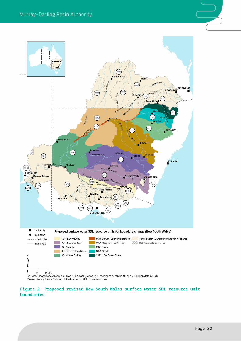
New South Wales surface water boundary changesThis proposed amendment relates to section 3.03(1)(c) and section 6.02(1)(c) of the Basin Plan. The change is to the boundaries of ten New South Wales surface water SDL resource units and nine New South Wales water resource plan areas. The proposed amendment will adopt the current New South Wales water sharing plan boundaries, identified under the Water Management Act 2000 (NSW), for the Basin Plan SDL resource unit and water resource plan area boundaries. The amendment reduces the administrative burden for both New South Wales and the Authority by assisting in facilitating the smooth transition from the current water sharing plans under the Water Management Act 2000 (NSW) to water resource plans under the Water Act 2007 (Cth).
The Basin Plan references maps that the Authority holds which identify the boundaries of both the SDL resource units and the water resource plan areas. This proposed amendment updates the reference in the Basin Plan to reflect the updated maps per this amendment. The updated maps are published below and will become effective at the commencement of the amendments.
The surface water SDL resource units affected by the boundary changes are the New South Wales Murray, Murrumbidgee, Lower Darling and Lachlan. In addition, changing the boundary of the Barwon–Darling Watercourse will result in changes to all adjoining SDL resource units: Namoi; Gwydir; Macquarie–Castlereagh; NSW Border Rivers and Intersecting Streams. All of these changes are very minimal. None of the changes have any impact on the SDLs in any of the SDL resource units listed in Schedule 2 of the Basin Plan.
Page 19
Summary of changes
The Authority is proposing amendments to the boundaries of water resource plan areas and SDL resource units for surface water.
These changes are to better align the water resource plan area boundaries and the SDL resource unit boundaries with the relevant state water planning boundaries which, in some cases, have changed since the Basin Plan came into effect.
The boundary changes do not change any of the SDLs for SDL resource units.
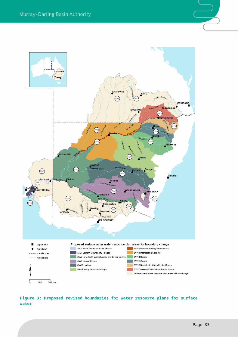
The water resource plan areas for surface water which are affected by the boundary changes are the New South Wales Murray and Lower Darling, Murrumbidgee and Lachlan. In addition, changing the boundary of the Barwon–Darling Watercourse will result in changes to all adjoining water resource plan areas in New South Wales: Namoi; Gwydir; Macquarie–Castlereagh; NSW Border Rivers and Intersecting Streams. All of these changes are very minimal. The percentage of change is less than 1% of the NSW Murray–Darling Basin area. The area changes do not change the SDLs in the associated SDL resource units. The changes are shown below in the map at Figures 2 and 3.
Queensland water resource plan amalgamation This proposed amendment relates to section 3.03(1)(c) and Schedules 2 and 3 of the Basin Plan. The amendment combines two Queensland water resource plan areas: SW17 — Queensland Border Rivers water resource plan area; and SW18 — Moonie water resource plan area.
The amalgamation of these two water resource plan areas results in one water resource plan area, the Queensland Border Rivers–Moonie water resource plan area. It will encompass two surface water SDL resource units: the Moonie SDL resource unit (SS25); and the Queensland Border Rivers SDL resource unit (SS24).
The Queensland government requested this amalgamation as it reduces the administrative burden on both the state and the Authority. There are no impacts on any of the SDLs currently set in either of the water resource plan areas, or the SDL resource units as a consequence of this amalgamation.
The proposed amendment involves changes to:
Chapter 3 of the Basin Plan to update the maps the Authority holds to reflect the updated boundaries (updated maps are shown below)
Schedules 2 and 3 of the Basin Plan to replace the Queensland names with the combined water resource plan name and align the SDL resource unit to the new single water resource plan area. There are no changes to the SDL resource unit boundaries, and no changes to the SDL or the baseline diversion limit in Schedule 2 or 3.
These changes are also reflected in schedule 4 of the Basin Plan (see Groundwater summary).
South Australian surface water boundary changesThis proposed amendment relates to section 3.03(1)(c) of the Basin Plan. The Authority proposes changes to the water resource plan boundaries of two South Australian water resource plan areas: SW 6 — South Australian River Murray water resource plan area and SW7 — Eastern Mount Lofty Ranges water resource plan area. The amendment to the water resource plan boundaries fixes an error in the boundary lines between the two areas which occurred during the drafting of the maps held by the Authority. The changes only impact the water resource plan area boundaries. No changes to the SDL resource unit boundaries are required. The percentage of change is less than 1% of the South Australian Murray–Darling Basin area. The area changes do not change the SDLs in the associated SDL resource units. The changes are shown in Figures 3 to 5 below.
Page 20

Figure 2: Proposed revised New South Wales surface water SDL resource unit boundaries
Page 21
Figure 3: Proposed revised boundaries for water resource plans for surface water
Page 22

Figure 4: Updated map of water resource plan areas for surface water (reflective of all proposed changes) to be held by the MDBA
Page 23

Figure 5: Updated surface water SDL resource unit map (reflective of all proposed changes) to be held by the MDBA
Page 24
Social and economic analysis and scientific knowledgeThe changes do not require a social and economic analysis as the change is an administrative arrangement that does not alter existing state planning arrangements. The change better aligns with state arrangements associated with water management.
Page 25

Sustainable diversion limit resource unit shared reduction amount
Sustainable diversion limit resource unit shared reduction amountThe Basin Plan sets an overall limit on the amount of water that can be taken for town water supplies, industry, agriculture and other human or consumptive uses, while ensuring there is enough water to achieve healthy river and groundwater systems. It sets the amount of water that needs to be recovered to achieve a healthy working basin.
The Basin Plan divides this recovery into a volume to meet local environmental needs and a volume that contributes to the environmental needs of the Murray and Darling rivers. The local reduction amount is (in most cases) the minimum reduction required within each SDL resource unit to satisfy local environmental needs. Shared reduction amounts are the further recovery required, in addition to the local reduction amounts, to satisfy the environmental needs of these large rivers.
Section 6.05(4) of the Basin Plan sets out a default method for allocating the shared reduction amount among SDL resource units in each of the shared reduction zones. Section 7.23 allows basin states to request a distribution of shared reduction amounts that is different to the default method. Section 7.23 then requires the Authority to prepare an amendment to the Basin Plan to accommodate those changes, and to update the requested shared reduction distribution in the model used to calculate an SDL adjustment.
The Authority proposes to amend section 7.23 of the Basin Plan to give states an additional 12 months (until 30 June 2017) to request a distribution of the shared reduction amount different to the default. Other amendments to section 7.23 clarify the existing provision that allows the Authority to propose Basin Plan amendments for shared reduction amounts and the outcome of the SDL adjustment mechanism at the same time. If a state does not make a request for the distribution of the shared reduction amount then the default will apply.
There are some proposed changes to section 6.05 of the Basin Plan relating to shared reduction zones and amounts as a result of the Northern Basin Review. Please refer to the section of this document covering Northern Basin amendments.
Social and economic analysis and scientific knowledgeA social and economic analysis cannot be undertaken as the change provides the opportunity for a Basin State to request a reallocation of the shared reduction amount and it is uncertain whether this request will be made or what the scale of the request would be.
Page 26
Summary of changes
Shared reduction amounts are specified under the Basin Plan to satisfy the environmental needs of the Murray and Darling rivers.
The Authority proposes amendments to allow the Basin states additional time to nominate the allocation of the shared reduction amount across SDL resource units.
Revised estimate of baseline diversion limit The Basin Plan defines a baseline from which to determine required reductions in diversions. The Basin Plan refers to this as the baseline diversion limit.
Schedule 3 of the Basin Plan sets out descriptions of the baseline diversion limits for each surface water SDL resource unit and includes notes of the Authority’s estimate of the quantity of water represented by the descriptions of BDLs.
The proposed change updates the description of the baseline diversion limit for the Australian Capital Territory (surface water) (SS1). This update is based on advice from the ACT that an improved description of the baseline diversion limit is available.
The ACT has met its contribution to The Living Murray with the recovery of 2 GL per year from outside of the ACT. To avoid double accounting this water, an amendment is proposed to better describe the baseline diversion limit and reflect these arrangements.
Schedule 3 describes the limit of water taken by reference to subclause 9(1) of Schedule E to the Murray–Darling Basin Agreement. The description addresses the water that needed to be recovered in order to achieve the ACT’s Living Murray contribution. As The Living Murray contribution has now been sourced from water outside of the ACT it is no longer required to also reduce the limit or the water that can be taken within the ACT.
The improved description of the Australian Capital Territory (surface water) (SS1) baseline diversion limit in schedule 3 of the Basin Plan results in a 2 GL per year increase to the estimate of the baseline diversion limit, from 52.5GL per year to 54.5 GL per year. This increase is reflected in Schedule 3 Item 29 Column 2 and its note, and in the estimate of the SDL in Schedule 2 Item 29 Column 2 and its note. Relevant basin-wide figures have also been updated where appropriate.
Social and economic analysis and scientific knowledgeThis change does not require a social and economic analysis as the change is an administrative arrangement and does not alter the water recovery target set by the Basin Plan.
Page 27
Summary of changes
The Authority proposes amendments to the description of the BDL for the Australian Capital Territory surface water SDL resource unit (SS1), and an improved estimate of the quantity of water represented by the new description.
Method for determining compliance with the sustainable diversion limits
Method for determining compliance with the long-term annual diversion limitThe method for assessing compliance with the SDLs is contained in Chapter 6 of the Basin Plan. Compliance will be determined for each SDL resource unit in each water accounting period, following 30 June 2019, through the development of the register of take. The method for determining compliance is currently provided in the Basin Plan as follows:
- If the annual actual take is greater than the annual permitted take, the difference is recorded as a debit.
- If the annual actual take is less than the annual permitted take, the difference is recorded as a credit.
- If the annual actual take and the annual permitted take are equal the difference is recorded as a zero.
- The cumulative balance of the difference between permitted take and actual take is recorded annually on a register kept by the MDBA.
- If there is a cumulative debit (adjusted to take into account any buying and selling of environmental water) equal to or greater than 20% of the SDL a basin state is required to provide a ‘reasonable excuse’ for the debit in the SDL resource unit.
The Basin Plan contains a ‘reasonable excuse’ provision to allow an SDL resource unit to remain compliant with the SDL despite exceeding the amount tolerated under validated situations. If a state is non-compliant, and a ‘reasonable excuse’ is provided, the state will not be listed as non-compliant.
Removal of cumulative debits in a particular circumstanceThis proposed amendment applies to the cumulative balance on the register of take for surface water (refer proposed section 6.11(5) of the Basin Plan). This amendment adjusts the cumulative balance on the register of take to allow for the annual removal of any debits which are incurred in the previous water accounting period, as a result of a particular circumstance that is considered beyond the basin state’s control. This is a separate matter to the accounting for the disposal and acquisition of held environmental water under section 6.12(1)(a). The particular circumstance is provided in the example used in the relevant clause (where, for reasons beyond the basin state’s control, the Australian Government has not achieved the water recovery target that it has set for itself in relation to the SDL resource unit). This example refers to the Australian Government’s commitment to ‘bridge the gap’ to the SDLs under the Basin Plan.
Progress towards meeting the water recovery target is available on the Department of Agriculture and Water Resources (Australian Government) website, along with the Water Recovery Strategy for the Murray–Darling Basin. Progress on water recovery is also available on the MDBA’s
Page 28
Summary of changes
The Authority proposes to amend the way the cumulative balance of water take is calculated for the purposes of assessing compliance with the SDL for a particular circumstance.
The proposed calculation would allow the Authority to account for a particular circumstance: that the Australian Government does not achieve the water recovery target that it is has set for itself.

website. Water recovery to bridge the gap is separate to, and not affected by, any trade by the Commonwealth Environmental Water Holder.
Social and economic analysis and scientific knowledgeThe changes do not require a social and economic analysis as the change is an administrative arrangement associated with water management.
Page 29

Water trading rulesThe Basin Plan Chapter 12 water trading rules (the water trading rules) came into effect on 1 July 2014. In implementing the water trading rules, the Authority has identified a small number of rules that may benefit from clarification to ensure they operate in the manner that was originally intended.
The Authority obtained advice from the Australian Competition and Consumer Commission in preparing these proposed amendments as required by the Water Act (section 46(2)).
The advice identified three minor amendments to the water trading rules to improve their clarity and function.
Clarifying free trade in surface water systemsSections 12.16 and 12.17 of the Basin Plan ensure trade in surface water systems occurs free of any restriction other than a restriction that is allowable under section 12.18 (see section 1.07 of the Basin Plan for definition of restriction). Section 12.17 currently identifies volumetric limits as a type of restriction, however, this is not required. Any such limit would already be considered a restriction under section 1.07.
To improve clarity, the Authority proposes to remove section 12.17 of the Basin Plan. This will in effect, consolidate sections 12.16 and 12.17. There will no longer be a direct reference to volumetric limits, however volumetric limits will still be prohibited as set out above.
The proposed change reduces confusion and also removes any ambiguity that exists in relation to the inappropriate use of volumetric limits to restrict trade within unregulated systems. This makes it easier for regulated entities to understand their obligations in relation to providing for free trade within a regulated system, between regulated systems and within unregulated systems.
Clarifying allowable restrictions on tradeSection 12.18 of the Basin Plan lists the allowable restrictions on trade for physical or environmental reasons. The Authority proposes to amend the meaning of hydrologic connections and water supply considerations to clarify its operation:
Firstly, the proposed change clarifies that section 12.18(2)(c) is an allowable restriction on trade within and between regulated systems. This has no change in effect but reduces confusion as to when this section can be applied.
Secondly, in order to enable trade as far as practicable within unregulated systems, the Authority proposes to further define hydrologic connections and water supply considerations. The nature of unregulated systems can mean that while two locations are physically connected, water may not always flow between those two points. The proposed amendment expressly states
Page 30
Summary of changes
The Authority proposes to amend the Basin Plan water trading rules to improve clarity.
The changes clarify definitions without changing the overall operation of the water trading rules.
The Authority obtained advice from the Australian Competition and Consumer Commission in preparing the proposed amendments.
that the occasional or regular absence of flow between two locations within an unregulated system may be a reason to restrict trade.
Maintaining information reporting requirementsSection 12.47 of the Basin Plan cross references criteria in the Water Charge (Infrastructure) Rules 2010 (Cth). The Basin Plan amendment seeks to maintain the current effect of section 12.47(5) which requires irrigation infrastructure operators that meet the criteria in the Water Charge (Infrastructure) Rules 2010 to provide their trading rules to a central point.
The amendment would remove this cross reference and include the criteria explicitly in the Basin Plan. The proposed amendment does not change how section 12.47 of the Basin Plan operates. This amendment is independent of any future decision to amend the Water Charge (Infrastructure) Rules 2010.
Social and economic analysis and scientific knowledgeThe Authority has had regard to the objectives in Schedule 3 of the Water Act and the formal advice of the Australian Competition and Consumer Commission in preparing these proposed amendments.
The changes are not based on social and economic analysis or scientific knowledge, as they relate to clarifying the administrative operation of the Basin Plan water trading rules.
Page 31

Consequential amendments following the Water Act review The Authority is proposing amendments to the Basin Plan as a result of the Independent Review of the Water Act. The Australian Government response to the review recommended changes to both the Water Act and the Basin Plan. The proposed amendments update some reporting requirements in the Basin Plan, re-phase the timing of reviews and fix a minor cross-reference to the Water Act.
Reporting requirements
Annual reportingThe Water Act previously required the Authority to report on the effectiveness of the Basin Plan each year in its corporate annual report. Following the 2016 amendments to the Water Act, the Authority must now make this a separate report to the Minister by the end of December each year (section 52A of the Water Act). The proposed amendment will update section 13.05(1)(a) of the Basin Plan to make it consistent with the Water Act.
Reporting to Ministerial CouncilThe Water Act previously required the Authority to provide a one off report to the Murray–Darling Basin Ministerial Council on impacts of the Basin Plan in 2017. The 2016 amendments to the Water Act postpone this report until 2020. The Authority proposes updating section 13.05(1)(b) of the Basin Plan to reflect this new timing.
Re-phasing of reviewsThe Authority is proposing to re-phase a number of reviews from 2017 to 2020 in accordance with the outcomes of the Water Act review. The re-phasing of these reviews to 2020, when the Basin plan is fully implemented, will allow time to observe outcomes and collect evidence to inform the reviews.
In the meantime, in responding to the Water Act review, the Australian Government has committed to performing an interim evaluation, including on the social and economic impacts of the Basin Plan, in 2017. The 2017 evaluation will report on the effects of the first five years of Basin Plan implementation, and will help to inform remaining implementation efforts as well as the 2020 evaluation and reviews.
Page 32
Summary of changes
The Authority is proposing amendments to the Basin Plan to implement changes the Australian Government agreed to in response to the Water Act review.
Reporting to the Murray–Darling Basin Ministerial Council on impacts of the Basin Plan, review of the water quality and salinity management plan targets, and review of the environmental watering plan will be deferred from 2017 until 2020.
Reviews of the social and economic impacts of the Basin Plan will be included as part of the monitoring and evaluation program.
An assessment of the Authority’s monitoring, evaluation and reporting capabilities is rescheduled from 2017 to 2020, to align with the new timing for other reviews.
Water quality and salinity management and environmental watering plansThe Basin Plan currently requires the Authority to conduct five-yearly reviews of the water quality and salinity management plan targets, and the environmental watering plan, starting in 2017. However, the review of the Water Act recommended delaying the timing of the first of these reviews to 2020. As a result, the Authority proposes amendments to sub-sections 13.08(1) and 13.09(1) of the Basin Plan to implement this change.
Social and economic impactsThe 2016 amendments to the Water Act include a requirement for the Basin Plan monitoring and evaluation program to include five-yearly reviews of the social and economic impacts of the Basin Plan. The new Water Act provision will commence in 2020. This aligns closely with the existing Basin Plan requirement under item 3 of Schedule 12, to report every five years on the extent to which the Basin Plan has affected social and economic outcomes. However, in order to fully implement the new Water Act requirement, the Authority is proposing to include a review of social and economic impacts in the Monitoring and Evaluation Program in Chapter 13.
Monitoring and reporting capabilitiesThe Authority is also proposing to reschedule an assessment of monitoring, evaluation and reporting capabilities from 2017 to 2020. The proposed change to section 13.23(1) of the Basin Plan will align this provision with the new 2020 timing of the reviews outlined above.
Social and economic analysis and scientific knowledgeThe proposed amendments correct references following amendments to the Water Act and implement changes to the timing for reporting in line with the Australian Government response to the Water Act review. These changes are of an administrative or procedural nature and are not based on social or economic analysis, or scientific knowledge.
Page 33
Water Resource Plan requirementsChapter 10 of the Basin Plan sets out what material must be contained in water resource plans for them to be accredited.
The Authority proposes minor amendments to the Basin Plan to simplify how this material is compiled by basin states.
These changes aim to reduce duplication and the potential for errors and inconsistencies.
Form of a water resource planA water resource plan can be constituted by a number of instruments and texts (see section 10.04 of the Basin Plan). Where two or more instruments are used, a water resource plan must include a list that specifies each Basin Plan requirement in Chapter 10 of the Basin Plan and the part of the water resource plan that addresses each requirement (section 10.04(4) of the Basin Plan).
This list enables the Authority and the Minister to know which parts of the water resource plan to assess when determining consistency with the Basin Plan.
The Authority proposes amendments to section 10.04(4)(a) and (b) of the Basin Plan and the addition of a note in section 10.04(4) to clarify that information which meets several water resource plan requirements may be compiled into a single document and the list for section 10.04(4) of the Basin Plan may specify that this document addresses a group of water resource plan requirements.
This approach may reduce the administrative workload for basin states in compiling the material to be included in a water resource plan, reduce the duplication of information in the water resource plan, and reduce the potential for errors and inconsistencies.
Minor correction of note about water resource plan accreditation The Authority is proposing a change to the note above section 10.10 of the Basin Plan about water resource plan accreditation. The 2016 amendments to the Water Act removed the default 10-year period for accreditation. Section 64 of the Water Act now provides that accreditation is valid as long as the water resource plan has effect under the state water management law, unless there is an amendment to the Basin Plan that affects water resource plan accreditations. The Authority proposes to amend the Basin Plan reference to the 10-year accreditation period so it is consistent with the Water Act.
Social and economic analysis and scientific knowledgeThe changes do not require a social and economic analysis as the change is an administrative arrangement associated with water management.
Page 34
Summary of changes
The Authority proposes amendments to Chapter 10 section 10.04 of the Basin Plan to simplify how material is compiled for water resource plans.
These changes aim to reduce duplication and the potential for errors and inconsistencies.