contents · pdf file · 2012-10-04representative c15t gas chromatograms 40....
TRANSCRIPT
CONTENTS
-
I n t r o d u c t i o n
.. Operat ional Summary
Sha l l ow Geo log ic Set t ing -
Se ismicRe f lec t i onCor re la t i on and V e l o c i t yA n a l y s i s
Paleonto logy and B i o s t r a t i g r a p h y
GeophysicalLog I n t e r p r e t a t i o n
Geochemi s t ry
EnvironmentalConsiderat ions
Sununary andConclusions
References
Appendix
ILLUSTRATIONS
F igu re 1. Locat ion map
2. F i n a ll o c a t i o np l a t
3. Graph s h o w i n gd a i l yd r i l l i n gp r o g r e s s
4. Schematicdiagramshowingcasing,str ings,plugging, andabandonment program
5. Changes w i t hd e p t h o f d r i l l i n g p r o p e r t i e s .
6. Locat iondiagramshowingNortonBasin, COST we1 1s 1 and 2, and USGS s e i s m i cl i n e s
7. Syn the t i c Seismogram
8. USGS s e i s m i c l i n e 807
9. USGS s e i s m i c l i n e 813
10. USGS s e i s m i cl i n e 802
11. T ime-st rat igraphiccolumn and s e i s m i cp r o f i l e
Page-1
5
17
21
39
58
98
129
141
153
A1 -A6
3
8
10
11
14
22
23
25
26
27
28

ILLUSTRATIONS (cont.)
12. Comparisonbetweenstackingveloci t ies and RMS v e l o c i t i e s
13. I n t e r v a l v e l o c i t i e s andtime-depthcurvefromsonic l o g o f COST No. 1 we1 1
14. I n t e r v a l v e l o c i t i e s and t ime-depthcurvesfromseismic datanear COST No. 1 w e l l
15. Comparisonbetweentime-depthcurvesderivedfrom seismic and s o n i cd a t af o r COST No. 1 w e l l
16. Comparisonbetweentime-depthcurvesfor COST w e l l s 1 and 2
17. B i o s t r a t i g r a p h i c c o r r e l a t i o n o f N o r t o n Sound COST w e l l s
18. S t r a t i g r a p h i c summary o fN o r t o n Sound COST No. 1 w e l l
19. S t r a t i g r a p h i c summary o fN o r t o n Sound COST No. 2 we l l
20. D e s c r i p t i o n o f convent iona lcore 2, Norton Sound COST No. 1 we l l
21. Desc r ip t i ono fconven t iona lco re 3
22. D e s c r i p t i o n o f convent iona lcore 4
23. D e s c r i p t i o n o f convent ionalcore 5
24. Desc r ip t i ono fconven t iona lco re 6
25. D e s c r i p t i o no fc o n v e n t i o n a lc o r e 7
26. D e s c r i p t i o no fc o n v e n t i o n a lc o r e 8
27. D e s c r i p t i o no fc o n v e n t i o n a lc o r e 9
28. Desc r ip t i ono fconven t iona lco re10
29. D e s c r i p t i o no fc o n v e n t i o n a lc o r e 11
30. D e s c r i p t i o n o f convent ionalcore12
31. Plo to fave rageporos i t yaga ins tdep th f o rconven t iona lco resands tone samples
ii
Page-32
33
35
36
38
51
52
53
64
65
66
69
72
7 7
78
79
82
85
86
92
~ ILLUSTRATIONS (cont.)
32. Plo to faveragepermeab i l i t yaga ins taverageporos i ty forconventionalsandstonesamples
33. High-resolut ionthermometerdata
34. C l a s s i f i c a t i o no fo r g a n i cm a t t e r
35. Van Krevelen Elementaldiagram. analyses
36.Van Krevelendiagram.(Selectedpyro lys isanalysesby Geochem Laborator ies,Inc. )
37. S e l e c t e di n d i c a t o r so ft h e r m a lm a t u r a t i o n
38. Organicr ichness and hydrocarbonpotent ia l
39. Representat ive C15t gaschromatograms
40. Representat ive Clot gas chromatograms
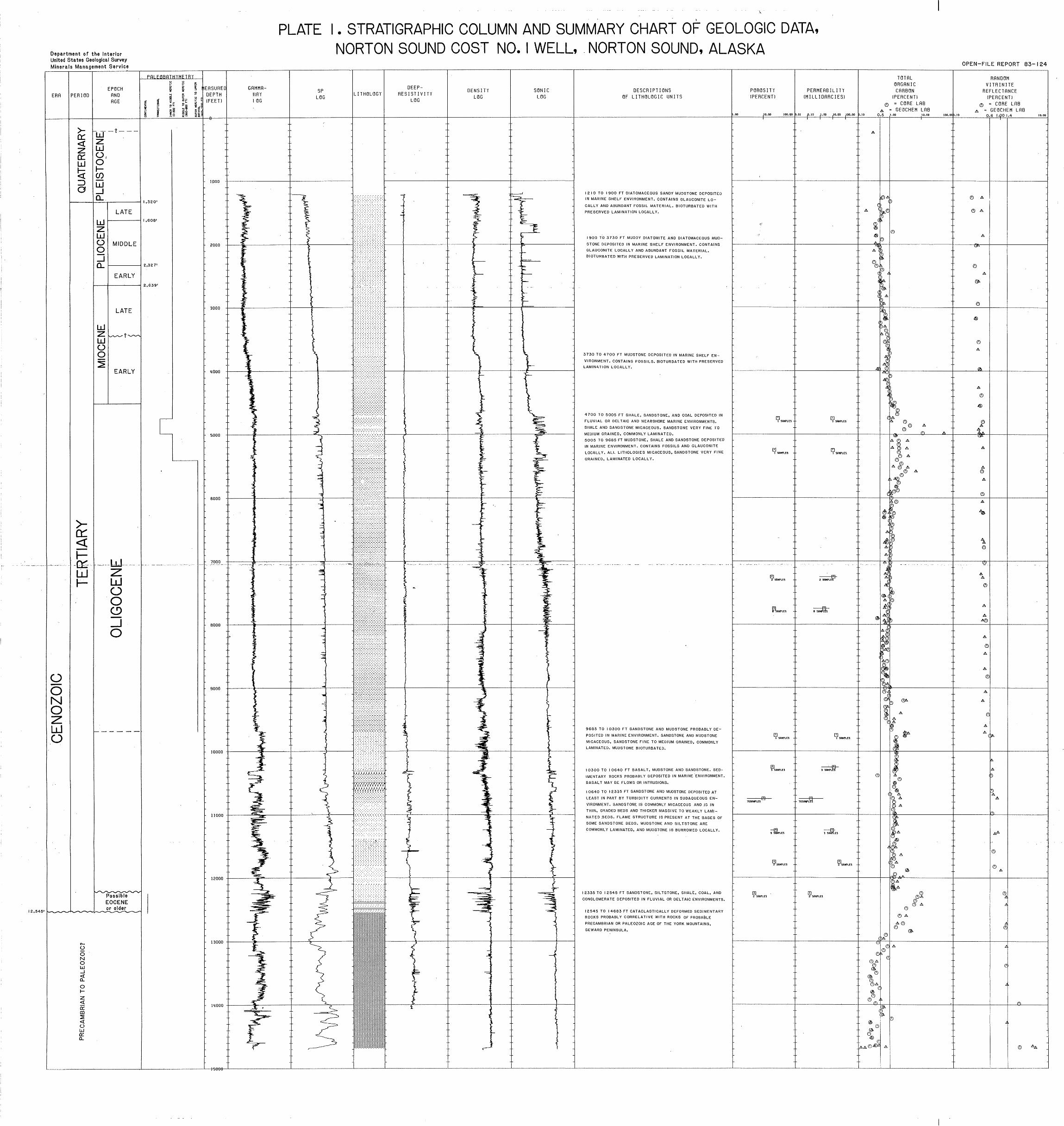
P l a t e 1. S t r a t i g r a p h i c columnand summary char to fGeo log icData , COST No. 1 we l l ,Nor ton Sound, Alaska
TABLES
Table 1. Basa l tchemis t rydata
2. P o r o s i t y and permeab i l i t y ,Nor ton 1
3. Potassium-argon age de terminat ions
4. Selectedgeochemicaldatafromsamples
5. Carbon i s o t o p er a t i o s (S 13c) i np a r t sp e rt h o u s a n d fromheavyhydrocarbonextracts
-6 . Summary o f h y d r o c a r b o np o t e n t i a li n d i c a t o r si n
o r g a n i c a l l y r i c h h o r i z o n s
Page-
93
100
102
104
105
107
112
118
119
74
88
96
116
121
127
iii
Geologic and Operat ional Summary
Norton Sound COST No. 1 Well
Norton Sound, Alaska
Ronald F. Tu rne r ,Ed i to r
INTRODUCTION
~~
T i t l e 30,Code ofFedera lRegulat ions (CFR), paragraph 251.14 s t i p u l a t e s
t h a tg e o l o g i c a ld a t a and processedgeologica lin format ionobta~inedfrom Deep
S t r a t i g r a p h i cT e s t w e l l s d r i l l e d on theOuterCont inenta lShe l f (OCS) be made
a v a i l a b l e f o r p u b l i c i n s p e c t i o n 60 ca lendardaysaf tertheissuanceofthe
f i r s t Federa ll easew i th in 50 n a u t i c a l m i l e s o f t h e w e l l s i t e or 1 0y e a r sa f t e r
complet ion o f t h ew e l l i f noleasesarei ssued .T rac tsw i th inth i sd i s tance
o f t h e f i r s t N o r t o n Sound Deep S t ra t i g raph icTes twe l l(des igna ted . the ARC0
Nor ton Sound COST No. 1 Wellby t h eo p e r a t o r and h e r e a f t e rr e f e r r e dt o as t h e
w e l lo rt h e No. 1 w e l l ) were o f f e r e d f o r l e a s e i n S a l e 57 on March15, 1983.
N ine ty -e igh tb idson64t rac tswererece ivedwi ththeto ta lh ighb idsamount ing
t o $325 m i l l i o n .F i f t y - n i n eb i d s wereacceptedand f i v er e j e c t e d . The e f f e c t i v e
i s s u a n c ed a t eo ft h el e a s e si s June1, 1983.
-Th isopen- f i l erepo r ti sp resen tedinacco rdancew i ththerequ i remen tso f
._ 30 CFR 251.14. The i n t e r p r e t a t i o n s h e r e i n c h i e f l yc o n t a i n e d a r e t h e work o f
M ine ra l s Management Serv icepersonne l ,a l thoughsubstan t ia lcon t r ibu t ionswere
made by geoscienceconsult ingcompanies.
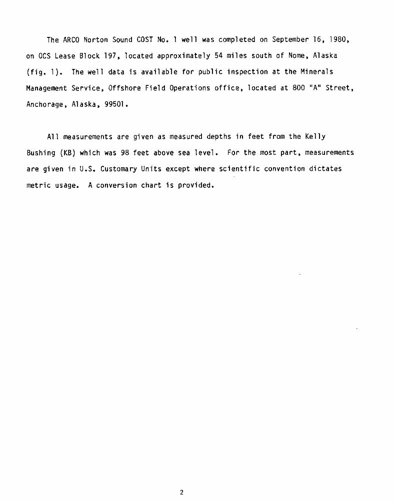
The ARC0 Norton Sound COST No. 1 w e l l was completed on September16,1980,
on OCS LeaseBlock 197, loca tedapprox imate ly 54 m i l e s s o u t h o f Nome, Alaska
( f i g .1 ) . The w e l ld a t ai sa v a i l a b l ef o rp u b l i ci n s p e c t i o na tt h eM i n e r a l s
Management Serv i ce ,O f f sho reF ie ldOpera t i onso f f i ce ,l oca ted a t 800 "A" S t ree t ,
Anchorage, A1 aska, 99501.
All measurements a reg iven as measureddepths i n f e e t f r o m t h e K e l l y
Bushing (KB) which was 98 f e e t abovesea leve l .Forthemostpar t , measurements
a r e g i v e n i n U.S. Customary Un i tsexcept where s c i e n t i f i c c o n v e n t i o n d i c t a t e s
m e t r i c usage. A convers ionchar t i s provided. ~~
2
�
I i
I I
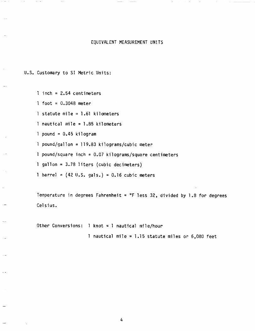
EQUIVALENT MEASUREMENT UNITS
U.S. Customary t o SI M e t r i cU n i t s :
1 i n c h = 2.54 cent imeters
1 f o o t = 0.3048 meter
1 s t a t u t e m i l e = 1.61 k i l omete rs
1 n a u t i c a lm i l e = 1.85 k i l omete rs
1 pound = 0.45 k i l og ram
1 pound/gal lon = 119.83 k i lograms/cubicmeter
1 pound/squareinch = 0.07 k i lograms/squarecent imeters
1 g a l l o n = 3.78 l i t e r s( c u b i cd e c i m e t e r s )
1 b a r r e l = (42 U.S. gals.) = 0.16 cubicmeters
Temperature i n degreesFahrenheit = O F l e s s 32, d i v i d e d by 1.8 fordegrees
Cels ius.
OtherConversions: 1 knot = 1 nau t i ca lm i le /hou r
1 n a u t i c a lm i l e = 1.15 s t a t u t em i l e so r 6,080 f e e t
4
OPERATIONAL SUMMARY
by
ColleenMcCarthy
The j a c k u p r i g Dan P r i n c ea r r i v e d on l o c a t i o n i n N o r t o n Sound on June12,
1980,1800hours A.S.T. and theNor ton Sound Con t inen ta lO f f sho reS t ra t i g raph ic
Test (COST)No. 1 we l l was spuddedJune14, 1980. D r i l l i n g was completed
94 days l a t e r on September 16,1983, a t a measureddepthof 14,683 fee t .
A f t e rw i r e l i n el o g g i n g ,s i d e w a l lc o r i n g , and d r i l l - s t e m t e s t i n g , t h e w e l l was
plugged andabandonedand t h e r i g undertowbySeptember 30,1980.
The d r i l l i n g r i g Dan P r i n c e i s a s e l f - e l e v a t i n g d r i l l i n g u n i t owned by OAN
TEX, Inc. The r i g i s r a t e d f o r d r i l l i n g up t o 25,000 f e e t deep i n water up t o
300 f e e t deep, 109-knotwinds,and50-fOOt waves. The r i g has a s to ragecapac i t y
o f 1500 tons. The p r e d r i l li n s p e c t i o n and m o b i l i z a t i o nt o o kp l a c e a t Homer,
A l a s k a ,b e f o r et h er i g was towed t o t h e d r i l l i n g l o c a t i o n i n t h e N o r t o n Sound.
Therewerenomajoracc identsorinc idents on t h e Dan P r i n c e d u r i n g t h e d r i l l i n g
o f t h e w e l l .
Nome, which i s approx imate ly54mi les NNE f romthewe l ll oca t i on ,se rved
as theshorebasefo r sea-and a i r - suppor tope ra t i ons , andKenai was an occasional
sourceofnonrout ineequipment and mater ia lssupply . Two sea-goingsupply
v e s s e l s t r a n s p o r t e d d r i l l i n g m a t e r i a l s and s u p p l i e s , i n c l u d i n g f u e l , t o t h e
r i g . They o p e r a t e do u to fe x i s t i n g dock f a c i l i t i e s a t Nome and Kenai,or,
5
dependinguponweather and a v a i l a b i l i t y o f supp l i es and s u p p o r t f a c i l i t i e s ,
i n t e r m i t t e n t l yf r o m each o ft h e s ep o i n t s . A largesea-goingstoragebarge was
a l s ou s e dt ot r a n s p o r t some mater ia lsfromKenai and was anchorednearthe
l o c a t i o n .H e l i c o p t e r sc e r t i f i e df o ri n s t r u m e n tf l i g h t wereused t ot r a n s p o r t
~~ ~ personnel ,grocer ies, and l igh twe igh tequ ipmentbetweenther ig and thepr imary
shorebase a t Nome. A t t imespersonnel,equipment,andsupplies were a l s o .~
t r a n s p o r t e d t o and f romtheshorebasebybothchar tered and commercial air
c a r r i e r s .
ARC0 Oil and GasCompany a c t e da st h eo p e r a t o rf o ri t s e l f and t h es i x t e e n
p a r t i c i p a t i n g p e t r o l e u m companies l i s t e d belowthatsharedexpensesforthe
we1 1:
AmericanPetroleum Company o f Texas
AMOCO Produc t ion Co.
Chevron, U.S.A., Inc.
C i t i e s S e r v i c e Co.
Cont inenta l Oil Co.
E l f -Aqu i taneExp lo ra t i onL td .
Get ty Oil Co.
G u l f Oil E x p l o r a t i o n and Produc t ion Co.
Marathon Oil Co.
Mob i lExp lo ra t i on and ProducingServ ices,Inc
Pennzoi 1 Co.
P h i l l i p s P e t r o l e u m Co.
She l l Oil Co.
SohioPetroleum Co.
Sunmark E x p l o r a t i o n Co.
Union Oil Company o f C a l i f o r n i a
6
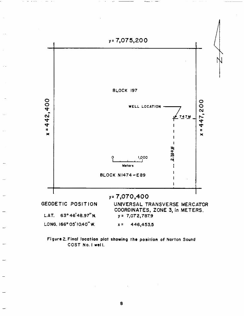
Norton Sound COST No. 1 we l l was l o c a t e d a t l a t 63O 46 f t 48.97" N.; l ong
166'05 f t 10.40" W., o r UTM coordinates(zone3) X = 446,453.5 m and Y =
7,072,787.9 m. The s u r v e yp l a tf o rt h ef i n a lw e l ls i t el o c a t i o ni s shown i n
depth a t l o c a t i o ni s 90 fee t . All measurements-~ Figu re 2. Water were made
from theKe l l yBush ingwh ich was 9 8f e e t above sea l e v e l and 188 f e e t above ~
mudline. The we l l was d r i l l e dt ot o t a ld e p t hw i t h nomore than1"dev ia t ion
f r o m v e r t i c a l .
s t i p u l a t i o n s t h e p r o v i d eo p e r a t o r t h e~~ D r i l l i n g r e q u i r e d t o M i n e r a l s
Management S e r v i c e( f o r m e r l y USGS, C o n s e r v a t i o nD i v i s i o n )w i t ha l lw e l ll o g s ,
samples,cores labs,geologicin format ion,andoperat ionalrepor ts .
Pack ice,sea- icecoverage, and icebreakupdata showed t h a t t h e e!arli e st
~~ ~ t h a to p e r a t i o n sc o u l d be i n i t i a t e di nN o r t o n Sound was mid-June, and t h el a t e s t
t h a t o p e r a t i o n s c o u l d c o n t i n u e was mid-October.
An add i t i ona lcons ide ra t i on for i n i t i a t i n g and t e r m i n a t i n go p e r a t i o n sw i t h
a j a c k u pr i g was stormoccurrence. I nN o r t o n Sound stormsoccurlessf requent ly
July, August- i n June, and than i no t h e r months. A good wind and wave f o r e c a s t
program was e s s e n t i a lt os e t up a j ackupr ig . More f requentstormoccurrence -
and rougher sea c o n d i t i o n s i n t h e l a t t e r p a r t o f t h e o p e r a t i n g season made
r e l i a b l ew i n d and wave f o r e c a s t sv i t a lt od e m o b i l d z a t i o n ;l o w e r i n gt h eh u l l
and f l o a t i n g t h e j a c k u p r i g away f romloca t ion . The Dan Pr ince was l a t e r l o s t
t o a s t o r m i n t h e G u l f o f A l a s k a d u r i n g r e t u r n t o w t o t h e n e x t c o n t r a c t l o c a t i o n .
7
y = 7,075,200
BLOCK197
W E L L LOCATION
2
0 1,000
Meters
BLOCK N1474-E89
y = 7,070,400 GEODETIC UNIVERSAL MERCATORPOSITION TRANSVERSE
4t--7 ,
I I I I
II
$.i I I I I
COORDINATES, ZONE 3, in METERS. LAT. 63'46'48.97"N. y = 7,072,7079
LONG. 166°05'10.40''W. x = 446,453.5
Figure 2. Fino1 locotionPlotshowing the posicion ofNorton Sound COST No. I well.
a
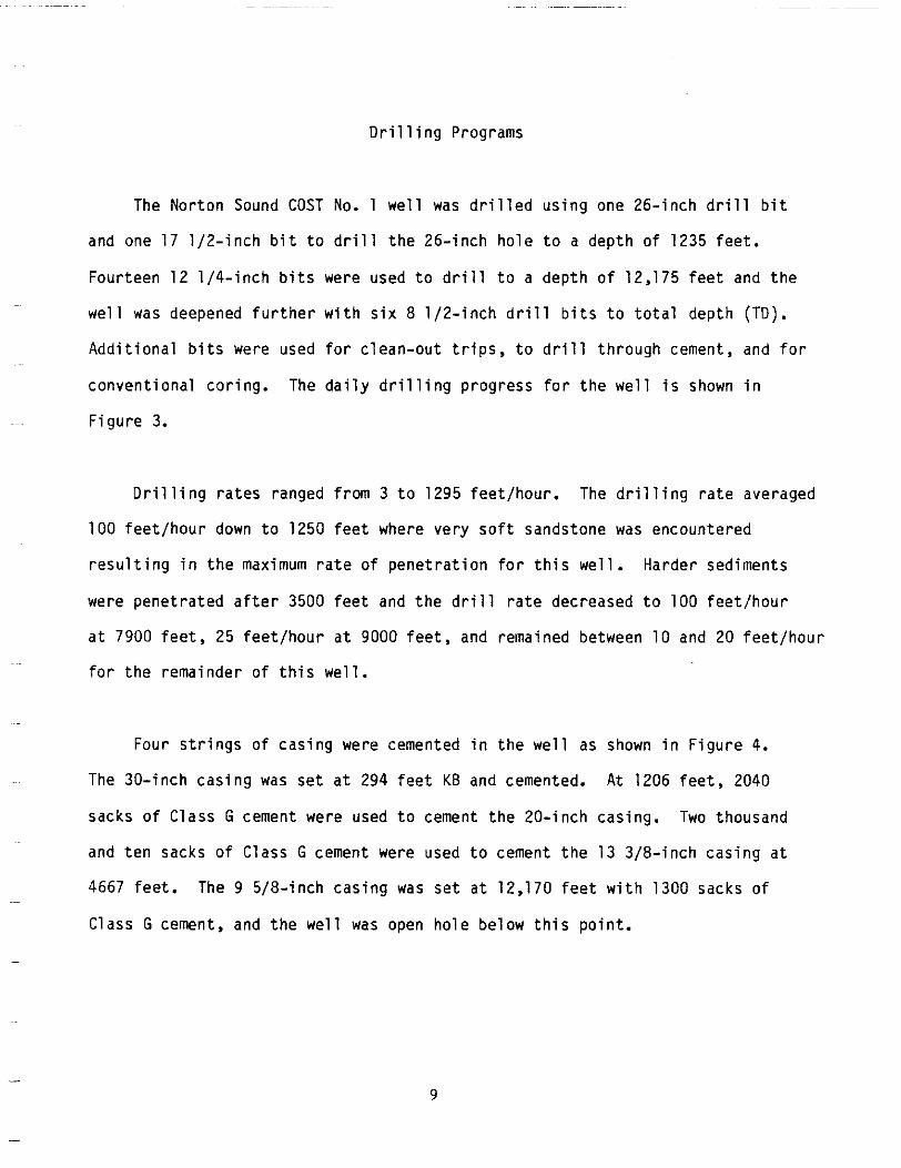
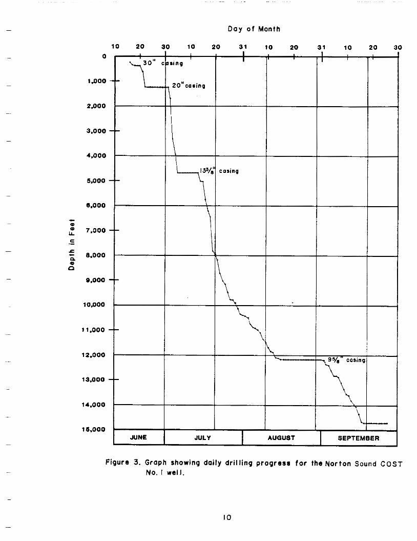
D r i l l i n g Programs
The Norton Sound COST No. 1 we l l was d r i l l e d u s i n g one 26- inch d r i l l b i t
andone17 1 / 2 - i n c h b i t t o d r i l l t h e 2 6 - i n c h h o l e t o a deptho f1235fee t .
Fou r teen121 /4 - inchb i t s wereused t o d r i l l t o a d e p t ho f 12,175 f e e t and t h e
we l l was deepened f u r t h e r w i t h s i x 8 1 / 2 - i n c h d r i l l b i t s t o t o t a l d e p t h (TD).
A d d i t i o n a lb i t s wereused f o rc l e a n - o u tt r i p s ,t od r i l l t h r o u g h cement,and f o r
convent ionalcor ing. The d a i l yd r i l l i n gp r o g r e s sf o rt h ew e l li s shown i n
~ F igure 3.
D r i l l i n gr a t e s rangedfrom 3 t o 1295feet/hour. The d r i l l i n g r a t e averaged
100feet /hour down t o 1250 f e e t whereverysoftsandstone was encountered
r e s u l t i n g i n t h e maximum r a t eo fp e n e t r a t i o nf o rt h i sw e l l .H a r d e rs e d i m e n t s
werepene t ra teda f te r 3500 f e e t and t h e d r i l l r a t e decreased t o 100feet /hour
a t 7900feet, 25 f e e t / h o u r a t 9000 f e e t , andremainedbetween10and20feet/hour
f o rt h er e m a i n d e ro ft h i sw e l l .
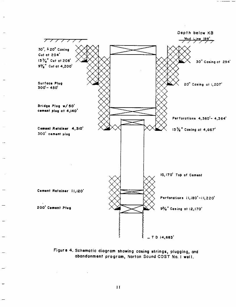
Fours t r ingsofcas ingwere cemented i n t h e w e l l as shown i n F i g u r e 4.
The 30- inchcasing was s e t a t 294 f e e t KB andcemented. A t 1206 f e e t , 2040
sacks o fC l a s s G cementwereused t o cement the20- inchcasing. Two thousand
and tensacksofC lass G cementwereused t o cement t h e 133/8- inchcas ingat
4667 f e e t . The 9 5/8- inchcasing was s e t a t 12,170 f e e t w i t h 1300sacks o f ~~
Class G cement,and t h ew e l l was open ho lebe lowth i spo in t .
9
--
--
--
--
--
--
--
Day o f Month
10 2 0 30 10 20 31 10 20 31 10 20 30
0 II
1.000
2.000
3.000 -'4.000
5.000 I
8.000
7.000
8.000
9.000
10,000
11.000
12.000 9% casing
13.000
14.000
15.000 I JUNE JULY AUGUST SEPTEMBER
Figure 3. Graphshowingdailydrillingprogress for the Norton Sound COST No. I well.
IO
,~es'+~a I -
II
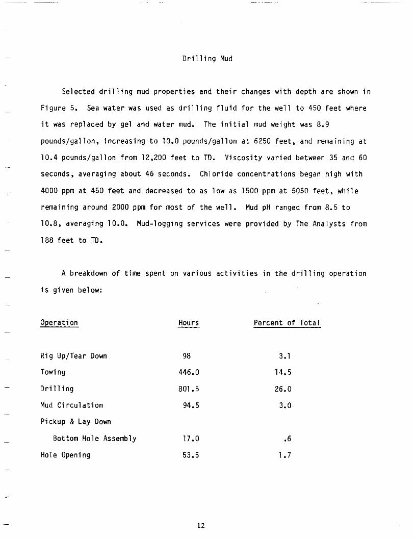
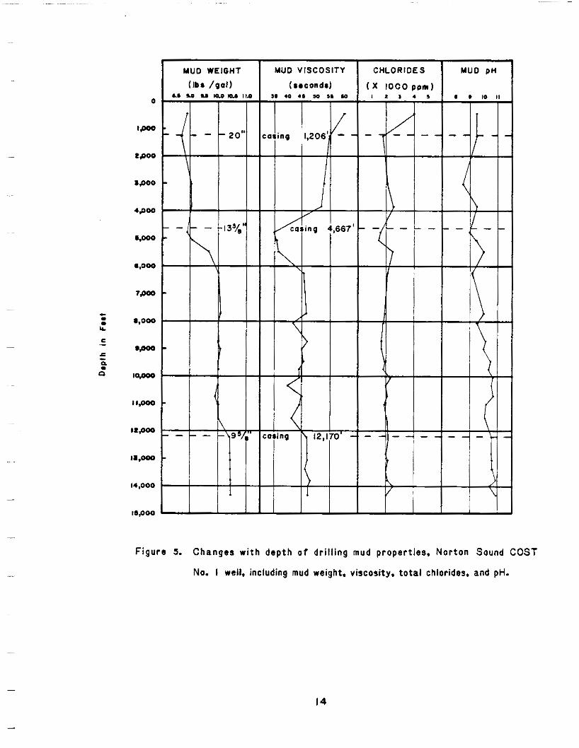
Drilling Mud
S e l e c t e d d r i l l i n g mud p r o p e r t i e s and t h e i r changes w i thdep tha re shown i n
F i g u r e 5.Sea water was used as d r i l l i n g f l u i d f o r t h e w e l l t o 450 f e e t where
i t was replacedbygelandwater mud. The i n i t i a l mud weight was 8.9
p o u n d s / g a l l o n ,i n c r e a s i n gt o 10.0 pounds/ga l lonat 6250 f e e t , and rema in inga t
10.4 pounds/gal lonfrom 12,200 f e e t t o TD. Viscosi tyvar iedbetween35 and 60
seconds,averagingabout46seconds.Chlor ideconcentrat ionsbeganhighwith
4000 ppm a t 450 f e e t and decreased t o as low as 1500 ppm a t 5050 f e e t , w h i l e
remainingaround2000 ppm f o r most o ft h ew e l l . MudpH rangedfrom 8.5 t o
10.8, averaging 10.0. Mud-loggingserviceswereprovidedby The Analystsf rom
188 f e e t t o TD.
A breakdown o ft imespent on v a r i o u s a c t i v i t i e s i n t h e d r i l l i n g o p e r a t i o n
i s givenbelow:
Operat ion
RigUp/Tear Down
Towing
D r i l l i n g
Mud C i r c u l a t i o n
Pickup & Lay Down
BottomHoleAssembly
Hole Openi ng
Hours
98
446.0
801 .5
94.5
17.0
53.5
P e r c e n t o f T o t a l
3.1
14.5
26.0
3.0
.6
1.7
12
%O'OO 1 1WlOl
-9' 0'02
1' 0'2
0' 0' 1
1' O'E
1' S-b
E' 0'8
8' 1 0-9s
9' 0'6 1
1' L S'EE
0.S S*ESL
1'8 0'6b2
E'LL S'OSE
8' 1 S.9S
L'E O'S6
8' 1 0.SS
2' 0'9
8' S*2Z
1' 1 S.2E
8' O'bZ
Z'L 0'022
0'0 S' 1
S-0's L
b. S'LL
E'b S'EE 1
I
14,000
l5.000 t F i g u r e 5. C h a n g e sw i t hd e p t h o f dr i l l ing mud p r o p e r t i e s ,N o r t o nS o u n dC O S T
No. I well, including mud weight,viscosity. total chlorides.and pH.
14
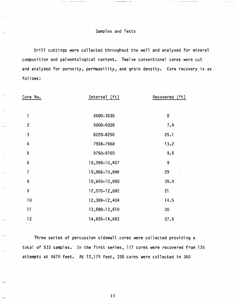
Samplesand Tests
Drill c u t t i n g s were c o l l e c t e dt h r o u g h o u tt h ew e l l andanalyzed f o r m i n e r a l
composi t ion and paleontologicalcontent.Twelveconvent ionalcoreswerecut
andana lyzedforporos i ty ,permeab i l i t y , and g ra indens i t y . Corerecovery i s as
f o l l o w s :
Core No.
6
~ 7
8 ~
9
10
11
12
~~
I n t e r v a l( f t )
3500-3530
5008-5028
6220-6250
7938-7968
9750-9760
10,398-10,407
10,866-10,896
10,960-10,990
12,070-1 2,092
12,389-1 2,404
13,580-13,610
14,655-14,683
Recovered ( f t 1
0
7.4
25.1
13.2
9.5
9
29
28.9
21
14.5
30
27.5
Threeser ies o f percuss ions idewal lcores were c o l l e c t e dp r o v i d i n g a
t o t a l o f 533samples. I nt h ef i r s ts e r i e s , 117coreswererecoveredfrom135 .~
a t t e m p t sa t 4670 fee t . A t 12,175 f e e t , 330coreswerecol lected i n 360
15
attempts,and a t TD, 86coresweretaken i n 90attempts. The r e c o v e r yr a t e
was 91 percent.
Loggingrunswere made a t - d e p t h so f 4670,12,175,and14,683 f e e t . The
Borehole Compensated SonicLog (BHC), Compensated Format ionDensi tyLog (FDC)
Compensated NeutronLog (CNL) w i thNeut ron Gamma Tool (NGT), Long Spaced
SonicLog (LSS) w i t hI n t e g r a t e dT r a v e l Time ( ITT) ,Prox imi tyLog-Mic ro log
(MPL) C a l i p e r Log, Veloci tySurvey,andtheHigh-Resolut ionCont inuousDipmeter
(HRT) wererecordedon all runs. On t h e secondand t h i r d runs, a Dual
I nduc t i onLa te r log(D IL ) was run,andRepeatFormationTests (RFT) r e s u l t i n g
i n sevenpressuresampleswererun a t 12,175 fee t . On t h ef i n a ll o g g i n g
s e r i e s ,t h r e ea d d i t i o n a ll o g s wererun; a Cement bondLog(CBL), a Temperature
Survey, and a Mic ro-La tero log (MLL).
~~ Two f o r m a t i o n p e r f o r a t e di n t e r v a l wast e s t s were made. The f i r s t t e s t
11,180-11,220 f e e t andno f o r m a t i o nf l u i d was recovered.Threesamples o f ~~
f o r m a t i o n f l u i d wererecovered on thesecondtes t done th roughtheper fo ra ted
i n t e r v a l 4360-4364 fee t .
- Weather
R ig down t imeowing t o weathercons is tedof a t o t a l o f 3 hours,only
0.1 p e r c e n to ft o t a lr i gt i m e .
16
o f
SHALLOWGEOLOGIC SETTING
NORTON SOUND COST NO. 1 WELL
By D a v i dS t e f f y
~~ S h a l l o w c h a r a c t e r i s t i c sd r i l l i n ag e o l o g i c t h e s i t e were i d e n t i f i e d
surveyconductedbyTetra Tech, Inc., i n 1979. The su rvey ,pa r to ftheperm i t ~~~
t o d r i l l a p p l i c a t i o n , i n c l u d e d a geotechn ica ls tudyoftheupper 25 f e e t o f
sediment and a h i g h - r e s o l u t i o ns e i s m i c - r e f l e c t i o ns u r v e yo ft h es e a f l o o r and ~~
i t s near-sur facefeatures. The r e g i o n a ld e s c r i p t i o no fN o r t o n Sound i s based
~~ on f i v e U.S. Geological o fSurvey maps prepared as p a r tt h ep r e l e a s ei n v e s t i g a
t i o n o f t h e s u r f a c e and near-sur facegeologicenvi ronmentofNor ton Sound
(Hoose, S t e f f y , andLybeck,1981; S t e f f y and Hoose, 1981; S t e f f y and Lybeck,
1981; S te f fy ,Turner , andLybeck,1981; Stef fy,Turner,Lybeck,and Roe, 1981).
Bathymetry
Norton Sound i s a f la t -bo t tomed embayment o ft h en o r t h e a s t e r nB e r i n g Sea
e p i c o n t i n e n t a ls h e l f . Waterdepths i n t h e OCS Sale 57 arearangefrom16 t o 89
fee t . The s a l ea r e ac o v e r sp a r to ft h e Yukon R i v e rd e l t af r o n t and p rode l ta ,
wh icharesepara tedf romtheprograd ingshore l ineby a subiceplat form(Larsen, .~
Nelson, and Thor,1980).Thisplatform i s 3 t o 12mi leswidea longthesouthern
boundary o ft h es a l ea r e a and occurs i nw a t e rd e p t h so fl e s st h a n 32feet. COST
17
No. 1 w e l l is l o c a t e di nt h e Yukon p r o d e l t ai n 90 fee to fwa te r . The d e l t af r o n t
i s t h e seawardextensionofHolocene,nearshoresanddeposits and i s c h a r a c t e r i z e d
by a 1- t o 2-degreeseawardslopingseafloor. Seaward, t h ef r o n t becomes t h e
p rode l ta , a verygent lys lop ingareatha tmarksthe edge o fd e l t a i cs e d i m e n t a t i o n .
I nt h es a l ea r e at h ep r o d e l t as l o p e sl e s st h a n 1 degreeand is 52 t o 89 f e e t
deep.
Sea-f l oor Geology
~~
The sea- f loortopographyoftheNor ton Sound area is t h e r e s u l t o f i n t e r
~ ~~ ac t ionswind , i ce , and processes. sedimentso f water , sedimentation Surface
range i n s i z e f r o m f i n e sand a t t h e d e l t a f r o n t t o sandy s i l t and s i l t i n t h e
p r o d e l t a area.Theseunconsol idatedsedimentsarecont inual lyreworkedby
i c e gouging,currentscour ,s tormsurg ing,andre leaseofb iogenic gas. The
s e a f l o o r i n t h e v i c i n i t y o f t h e number 1 andnumber 2 w e l l s is e s s e n t i a l l y
s i m i l a r and b o t ha r ed i s c u s s e di nt h i ss e c t i o n .
. Sing le -kee led and r n u l t i k e e l e d i c e f l o e s d r i v e n bywind and wa te rcu r ren ts
f u r r o wt h es e a f l o o rp a r a l l e lt ot h eb a t h y m e t r i cc o n t o u r s . Thesefurrowsoccur
i n waterdepths down t o 79 f e e t , and aremostdensebetweendepths o f 32 and 56
i n t e n s e~~ feet . The No. 2 w e l li sl o c a t e di n a r e l a t i v e l y i c e - g o u g i n g zone caused
by thewestward-moving i c e pack o fN o r t o n Sound shear ingaga ins ttheshore fas t ~.
icetha tex tendso f f sho ref romthede l ta . The s i n g l e - k e e l e di c e gouges i d e n t i f i e d
byside-scansonarrange i n w i d t h f r o m 16 t o 164 f e e t and areseldomgreater-
than 3 f e e t deep. A c t i v es e d i m e n t a t i o ni n f i l l st h e gouges i nt h er i v e r - d o m i n a t e d
- months o f summer.
18
Transientfeaturessuchascurrentscour ,megar ipp les, and l o n g i t u d i n a l
c u r r e n tl i n e a t i o n s were n o t f o u n d a t t h e d r i l l s i t e s , b u t werefound i n a
l i m i t e de x t e n te a s to ft h e No. 2 w e l l and j u s t west o fthede l ta .Cur ren tscour
i scha rac te r i zedbye longa teddepress ions 330 t o 490 f e e t l o n g , 1 1 5 t o 330 f e e t
wide,andlessthan 6 f e e t deep. They para l le lthedominantbo t tom-cur ren t
d i r e c t i o n andreworktheunconso l i da teds i l t yf i nesandcompr i s ingtheloca l
surfacesediments.Megaripplesoccuras a s e r i e so fr i p p l e sw i t h a wavelength
o f 65 t o 165fee t andanampl i tudeoflessthan 1.5 fee t . They occur i n a s u b t l e
b a t h y m e t r i ct r o u g hn o r t ho ft h e No. 2 w e l l , and t h e i r c r e s t s a r e normal t o t h e
dominantwestwardbot tom-cur ren td i rec t ion .Long i tud ina lcur ren tl inea t ions
occur as a se r ieso ffu r rowsw i thwave leng thso f 30 t o 100fee t and depthsof
l essthan 1.5 fee t . These l i nea t i onspara l l e lt hedominan tbo t tom-cu r ren t
d i r e c t i o n and occu rjus tsou tho fthemegar ipp les .
Degass ingofb iogen ic gasgeneratedbybur iedHolocenepeatlayersresul ts
i n gas c r a t e r i n gi nt h ee a s t e r nh a l fo fN o r t o n Sound. The c r a t e r i n g i s u s u a l l y
l e s st h a n 1.5 f e e t i n r e l i e f andon side-scan sonograms appearsas a patchy
t e x t u r a lf e a t u r e .
QuaternaryGeology
Norton Sound was s u b a e r i a l l y exposed i n t h e l a t e P l e i s t o c e n e o w i n g t o a
loweredsealeve l .Quaternarysed imentscons is to ff luv ia ldepos i tso fc layey
s i l t t o s i l t y sand w i t hv a r y i n g amounts o f wood fragments,shel ls, and organ ic
19
matter.About 10,000 t o 9500 y r B.P., t h e sea t ransgressedoverNor ton Sound
andbegan reworkingandburyingtundrapeatdeposi ts(Nelson, 1980). These
organ icdepos i tsrepresent a s e a - l e v e l s t i l l s t a n d 60 t o 80 fee tbe lowpresent
sea l e v e l and arethebaseoftheHolocene.Transgress ionresu l tedinHo locene
d e p o s i t sr a n g i n g f r o mf i n e sand i n t h e n o r t h e r n h a l f o f ' t h e s a l e a r e a t o c l a y e y
s i l t n e a r t h e Yukon Delta.Approximately 32 t o 40 fee tbe lowpresent sea
l e v e l , a younger,lessextensive,organic-r ichlayerextendsseawardfromthe
Yukon Del ta .Thisrepresents a l a t e rs t i l l s t a n dt h a ta l l o w e dt h e development
oftundrapeat . Subsequent t ransgress ionovertheareareworked and b u r i e d
t h ep e a tr e s u l t i n gi n an o rgan ic - r i chs i l tdepos i t .Th i sdepos i tg radesupward
i n t oc l a y e y silt i n t h e west and s i l t y sand i n t h e east. The b u r i e do r g a n i c - r i c h
depos i t sa recu r ren t l ygenera t i ng gas as i n d i c a t e d by t h e gas c r a t e r i n g andby
extens ive ,sha l lowacoust icanomal iestha toccur on boththeprocessed and
ana logreco rdso fthemin i spa rke r andwatergunsystems.
20
SEISMIC REFLECTIONCORRELATION
AND
VELOCITYANALYSIS
by Dav id S te f f y
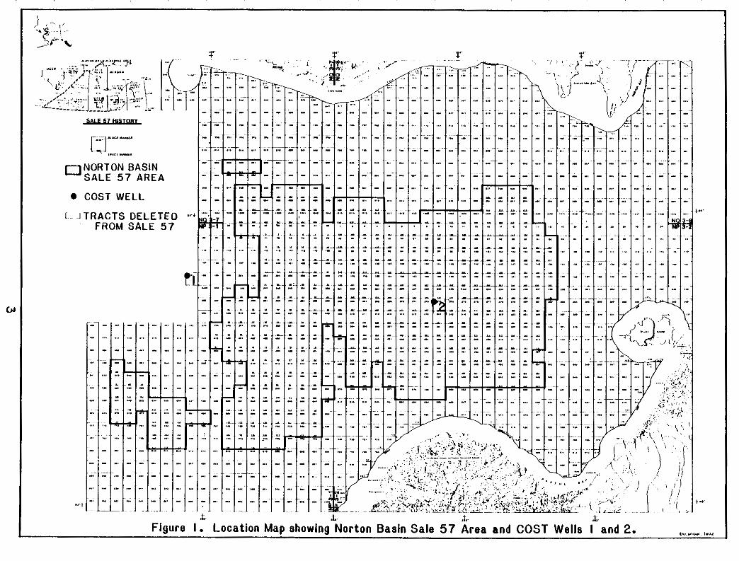
By t h e use o fv e l o c i t yi n f o r m a t i o nf r o mt h eN o r t o n Sound COST Nos. 1 and ~~
2 w e l l s and a 1978 se i sm icre f l ec t i onsu rveybythe U.S. GeologicalSurvey
( f i g . 6), se ism icco r re la t i ons and v e l o c i t i e s f r o mt h e twowellswerecompared
t o eachotherand tothosef romthenearbyse ismicl ines . The s t a c k i n g
v e l o c i t i e s used on t h e common-depth-point (CDP) t raceswereevaluatedbefore
s tack ingthegathers . These comparisonswereused t oa s s i g ng e o l o g i c
s i g n i f i c a n c e t o f e a t u r e s i d e n t i f i e d on t h e p r o f i l e s , and t h e s i g n i f i c a n t f e a t u r e s
~ wereused t oe s t a b l i s ht h eg e o l o g i ch i s t o r yo ft h eN o r t o nB a s i n i n theconc lud ing
s e c t i o no ft h i sr e p o r t . ~~
Se i sm icRe f lec t i onCor re la t i on
A syntheticseismogram was producedbyuse o f t h e borehole-compensated,
i n t e r v a l - t r a n s i t - t i m el o go ft h e No. 1 w e l l( f i g . 7). The s o n i cl o g was
v i s u a l l y a v e r a g e d w h i l e b e i n g s t r e a m d i g i t i z e d and was measured t o t h e n e a r e s t
f o o ti nd e p t h and t h en e a r e s tm i c r o s e c o n d / f o o ti nt r a n s i tt i m e .T h i sr e s u l t e d
i n l o g samp lesbe ingtakena ti r regu la ri n te rva l s . However, thesampl ing was
f requent enough t op r e v e n ta l i a s i n gi nt h e seismogram. The d i g i t i z e dd a t a
were t h e ne n t e r e di n t o a computerprogramthatproduced a syntheticseismogram -
2 1
I 6 5 O 164' 162 '
8 s w a r d Peninsula
--_ I970 USGS a t l 8 m l c Una.
1--
\ b y t h a l . O - K i l o m a t a r
81. Lewrenos
F i g u r e 6. L o c a t i o nm a po fN o r t o nB a s i n , COST W e l l s ,a n d USGS s e i s m i cl i n e s . A d o p t e df r o mF i s h e ra n do t h e r s ( 1 980).
wi thoutmul t ip les .Constan tdens i ty was assumed, t h e r e f o r ed e n s i t y was n o t
i n c o r p o r a t e di n t ot h ec a l c u l a t i o no ft h er e f l e c t i o nc o e f f i c i e n t s .T h i sa s s u m p t i o n
apparen t l y does n o ta d v e r s e l ya f f e c tt h er e s u l t so ft h es y n t h e t i c seismogram
i n a s i m p l eg e o l o g i cs e t t i n g( S h e r i f f , 1978). The computerprogramalso assumes
a s e r i e so fh o r i z o n t a l ,p a r a l l e le a r t hl a y e r sw i t h an e l a s t i cc o n s t a n t , and
assumes t h a t t h e i n c i d e n t waves arenormal t o t h e r e f l e c t i n g s u r f a c e and have
p lanarwavefronts . The c a l c u l a t e dr e f l e c t i o nc o e f f i c i e n t s werethenconvolved
w i t h a s tandardr i cke rwave le thav ing a f requencyrangeof8-55 Hz. This
c o n v o l u t i o n r e s u l t s i n a seismogram t h a t i s d i s p l a y e d w i t h b o t h normaland
r e v e r s ep o l a r i t y .
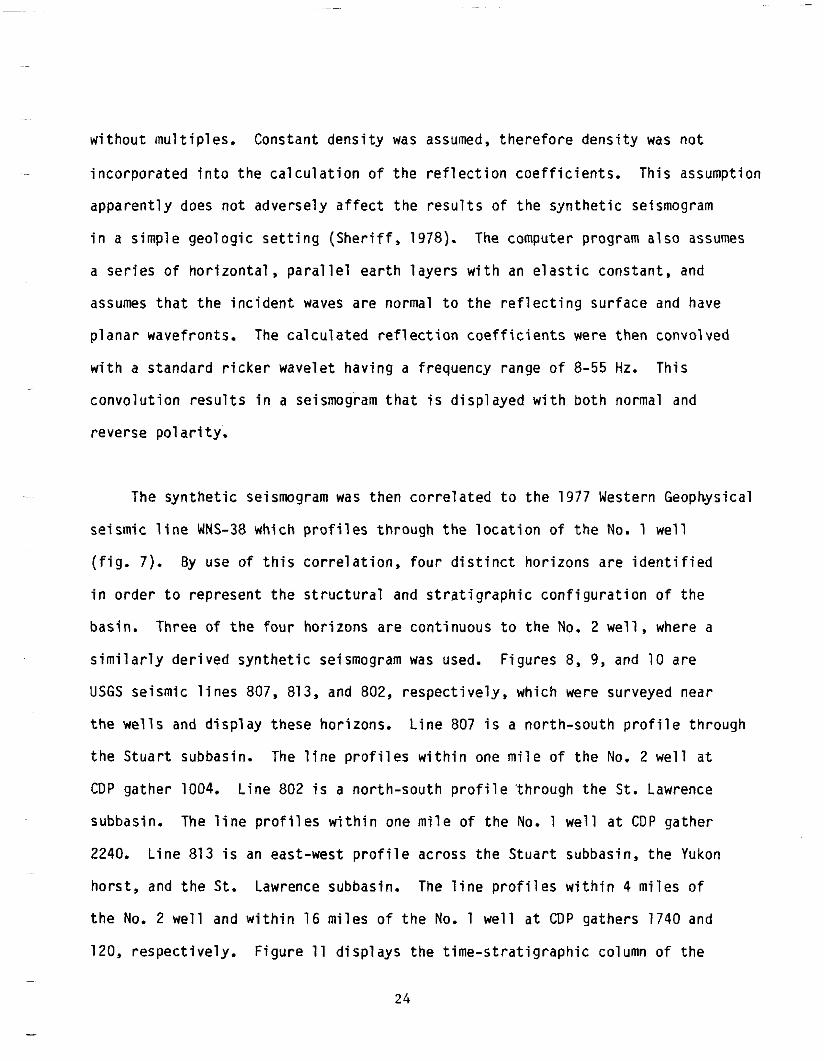
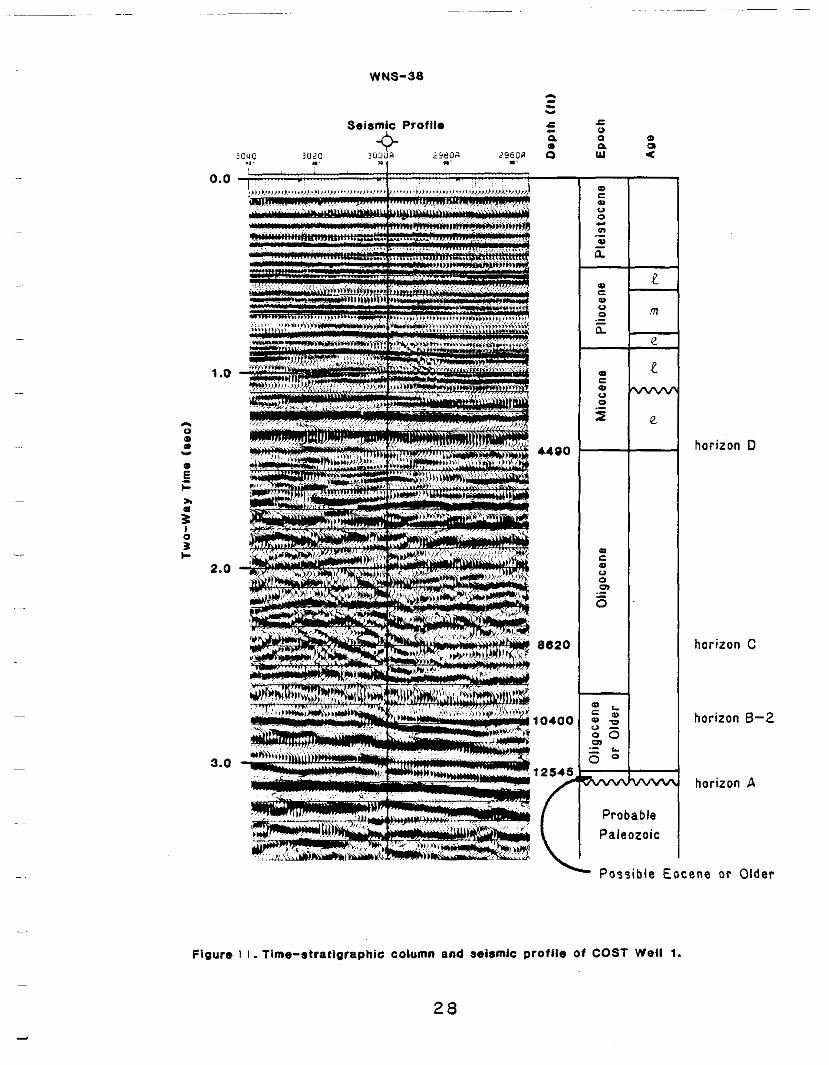
The syntheticseismogram was t h e n c o r r e l a t e d t o t h e 1977WesternGeophysical
s e i s m i c l i n e WNS-38 w h i c h p r o f i l e s t h r o u g h t h e l o c a t i o n o f t h e No. 1 we l l
( f i g . 7). By use of t h i sc o r r e l a t i o n ,f o u rd i s t i n c th o r i z o n sa r ei d e n t i f i e d
i n o r d e r t o r e p r e s e n t t h e s t r u c t u r a l and s t r a t i g r a p h i c c o n f i g u r a t i o n o f t h e
basin.Three o f t h ef o u rh o r i z o n sa r ec o n t i n u o u st ot h e No. 2 w e l l , where a
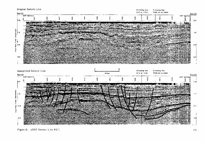
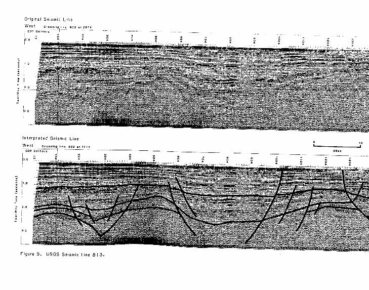
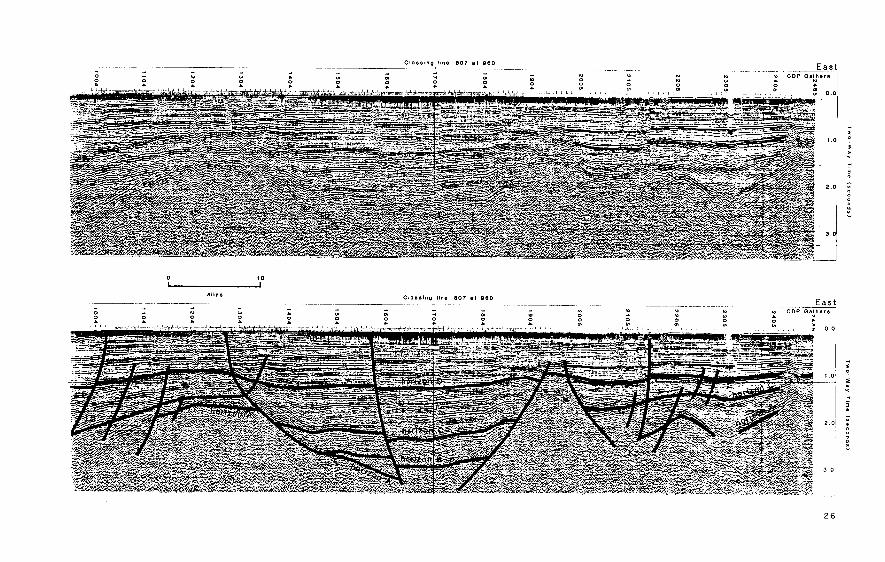
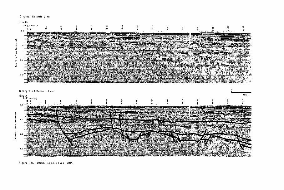
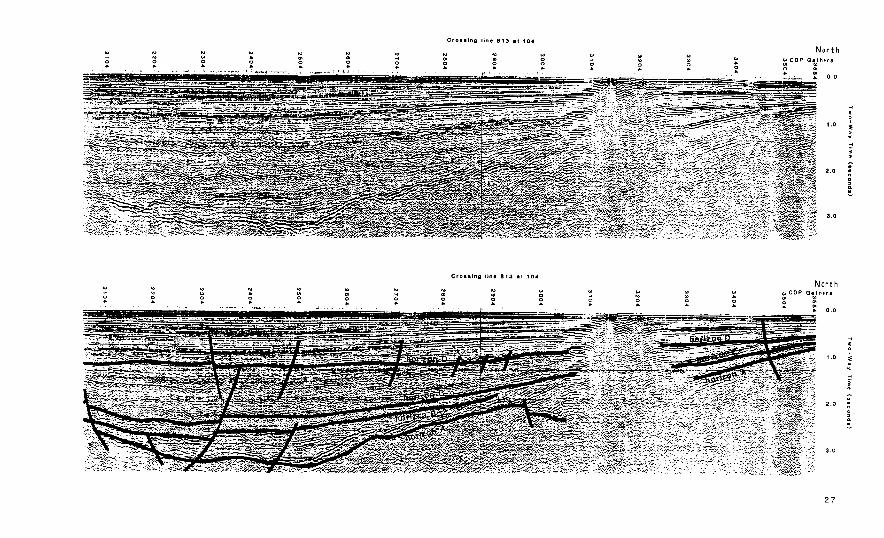
s i m i l a r l yd e r i v e ds y n t h e t i c seismogram was used. F igures 8, 9, and 10are
USGS s e i s m i cl i n e s 807, 813, and802, respec t ive ly ,wh ich weresurveyednear
t h ew e l l s and d i sp laythesehor i zons .L ine 807 i s a n o r t h - s o u t hp r o f i l et h r o u g h
theStuar tsubbasin. The l i n e p r o f i l e s w i t h i n one m i l eo ft h e No. 2 w e l l a t
CDP gather 1004. L i n e 802 i s a n o r t h - s o u t hp r o f i l e' t h r o u g ht h e S t . Lawrence
subbasin. The l i n e p r o f i l e s w i t h i n one m i l eo ft h e No. 1 w e l la t CDP ga ther
2240. L i n e 813 i s an e a s t - w e s tp r o f i l ea c r o s st h eS t u a r ts u b b a s i n ,t h e Yukon
h o r s t , and t h e S t . Lawrencesubbasin. The l i n ep r o f i l e sw i t h i n 4 m i l e so f
t h e No. 2 we l l and w i t h i n1 6m i l e so ft h e No. 1 we l l a t CDP gathers1740 and
120, respec t i ve l y .F igu re 11 d i s p l a y st h et i m e - s t r a t i g r a p h i c column o ft h e
24
96-SNM
OT
0.2
01
! -0'0
m D 0 0 f
No. 1 w e l l based on t h ei n t e r p r e t a t i o nd e s c r i b e di nt h eP a l e o n t o l o g y and Bio-
s t r a t i g r a p h ys e c t i o no ft h i sr e p o r t .L i t h o l o g i cc o r r e l a t i o n so ft h eh o r i z o n s
a r e based on t h e d e s c r i p t i o n si nt h e L i t h o l o g y and Geophys ica lLogIn terpre ta t ion
sect ion.
Hor izon A occu rsa t 3.10 seconds o r 12,550 f e e t i n t h e No. 1 w e l l , and a t
3.57 seconds o r 14,460 f e e t i n t h e No. 2 we l l . The h o r i z o ni sc h a r a c t e r i z e d
by la rgeamp l i t ude ,lowf requencyre f l ec t i onstha ta remos t l yd i scon t inuous .
Below t h e h o r i z o n t h e r e a r e f e w a r e a s i n t h e b a s i n where r e f l e c t i o n s o c c u r . ~
Above t h eh o r i z o nt h er e f l e c t i o n sd i s p l a y an on lapre la t i onsh ip . The ho r i zon
represents an unconformi tytha tsepara testhebaseofthebas in fill f r o mt h e ~
unde r l y ingPa leozo ic (?) metamorphic basement rock.Horizon A i sc o r r e l a t e d
between t h ew e l l s and d i s p l a y sm a j o rs t r u c t u r a ld e f o r m a t i o no f an e a r l y T e r t i a r y
t o l a t e Mesozoiceros ionalsur face.Thisdeformat ionin i t ia tedthesubsidenceof ~
t h e S t . LawrenceandStuartsubbasins.Dur ingthesubsidence,their common
~ bo rde r , no r th -sou th h igh .basemen tthe t rend ing Yukon ho rs t , was a re la t i ve l y
f e a t u r e( f i g . 9).Normal f a u l t i n gd e l i n e a t e st h es t r u c t u r a ld e p r e s s i o n sw i t h i n
thesubbasins,andthe Yukon ho rs t . Some o ft h e s ef a u l t s were a c t i v ei n t ot h e
Ple is toceneandprobablytheHolocene (Hoose, S t e f f y , andLybeck,1981).
Normal f a u l t sw i t hd i s p l a c e m e n t so fo v e r 4500 f e e to f f s e th o r i z o n A. Downwarping
o fthehor izona l lowedover 14,000 fee to fsed imen ta ry fill t o accumulate i n
theStuar tsubbas in .
Hor izon B-1 occurs a t 3.12 seconds o r 12,700 f e e t in t h e No. 2 we l l .
The h o r i z o ni s c h a r a c t e r i z e d by la rgeampl i tude,lowf requencyre f lec t ions .
Therea refewre f l ec t i onsjus tbe lowthehor i zon , and t h o s e t h a t do occurhave
29
va r iab leamp l i t ude and arediscont inuous.Thishor izon i s an apparentunconformable
su r facetha ton lapshor i zon A a ts t r u c t u r a lh i g h s and r e f l e c t ss y n d e p o s i t i o n a l
subsidence and f a u l t i n g .H o r i z o n 8-1 i sn e i t h e rc o n t i n u o u st h r o u g h o u tt h eS t u a r t
subbas inno rco r re la tedto any s p e c i f i ch o r i z o ni nt h e No. 1 we l l . A t t h e No.
2 w e l l , t h e h o r i z o n d e f i n e s t h e t o p o f anEocene coal-sandstonesequencethat
i s bounded a t thebot tombyhor izon A.
Hor izon 8-2 o c c u r sa t 2.78 seconds o r 10,400 f e e t i n t h e No. 1 we l l . A t
t h e w e l l , t h e h o r i z o n i s d e f i n e d by l a r g ea m p l i t u d e ,l o wf r e q u e n c yr e f l e c t i o n s
t h a ta r el a t e r a l l yd i s c o n t i n u o u s . The r e f l e c t i o n se v e n t u a l l y become u n d i s c e r n i b l e
butappear t oo n l a pH o r i z o n A. T h i sh o r i z o ni sn e i t h e rc o n t i n u o u st h r o u g h o u tt h e
S t . Lawrencesubbasinnorcorre la tedto any s p e c i f i c h o r i z o n i n t h e No. 2 w e l l .
The ho r i zon does show evidenceofcontemporaneoussubsidence and o f f s e t by
basement c o n t r o l l e df a u l t i n g . A t t h ew e l l ,t h eh o r i z o ni sc o r r e l a t i v ew i t h
anO l igoceneoro lde rbasa l t sequence ( f lowsorhypabyssal ) .Latera lchanges
i n t h e O l i g o c e n e o r o l d e r r e f l e c t i o n s t h a t d e f i n e t h e t o p o f t h i s i g n e o u s -
sedimentarysequenceindicatethattheseuni tsprobablygradeintosedimentary
d e p o s i t s o f e q u i v a l e n t age.
Hor izon C o c c u r sa t 2.41 seconds o r 8620 f e e t i n t h e No. 1 w e l l , and a t
2.33 seconds o r 8,500 f e e t i n t h e No. 2 w e l l .I nt h i sS t u a r ts u b b a s i n ,t h i s
h o r i z o n i s t h e boundarybetween a deeper zone o fsma l le ramp l i t ude ,d i scon t inuous
r e f l e c t i o n s and a sha l lower zone o fl a r g e ra m p l i t u d e ,c o n t i n u o u sr e f l e c t i o n s .
Bothzones o f r e f l e c t i o n s a r e c o n f o r m a b l e t o h o r i z o n C i n t h e b a s i n and t h i n
towardss t ruc tu ra lh ighs where theyonlaphor izons8-1, 8-2, and A. Hor izon C
30
is cont inuousthroughoutthe bas in and i s c o r r e l ated t o t h e No. 1 we l l . I n
t h e S t . Lawrencesubbasin, t h i s h o r i z o n i s n o t as d i s t i n c t as i t i s i n t h e
S tua r tsubbas ineas to fthe Yukon ho rs t .Bo ththe deepand sha l low zones o f
r e f l e c t i o n s i n t h e St. Lawrencesubbasinare more discont inuousandhavesmal ler
andmore v a r i a b l ea m p l i t u d e st h a nt h e i re q u i v a l e n t se a s to ft h e Yukon ho rs t .
Throughoutthebasin,thehor izon shows syndeposi t ionalsubsidence and f a u l t i n g
and p inchesout a t some s t r u c t u r a lh i g h s ,i n c l u d i n gt h e Yukon hors t . A t t h e
No. 1 w e l lt h eh o r i z o nc o r r e l a t e sw i t h a s h e l f a lm a r i n e mudstone,shale,and
interbeddedsandstone sequence. A t t h e No. 2 w e l l ,t h i sh o r i z o ni sc o r r e l a t e d
t o t h e boundarybetween an over ly ingmarinesandstoneand an under l y ingcoa l
sandstonesequence.
Hor izon D o c c u r sa t 1.42 seconds o rabou t 4,490 f e e t i n t h e No. 1 w e l l ,
and a t 1.18seconds o r 3,490 f e e t i n t h e No. 2 wel l .Throughoutthebasin,
t h i sh o r i z o ns e p a r a t e s a deeperzone o fla rgeampl i tude,h ighf requency ,
c o n t i n u o u sr e f l e c t i o n sf r o m a sha l lower zone o f s m a l l ampl i tude,d iscont inuous
r e f l e c t i o n s . The ho r i zon i s a conformablesurfacethroughoutthebasinand i s
c o r r e l a t i v ew i t h a l a teO l igocenecoa l - sands tone sequence.The ho r i zon i s
commonly o f f s e t bynormal f a u l t st h a ta r ey o u n g e rt h a nh o r i z o n C.
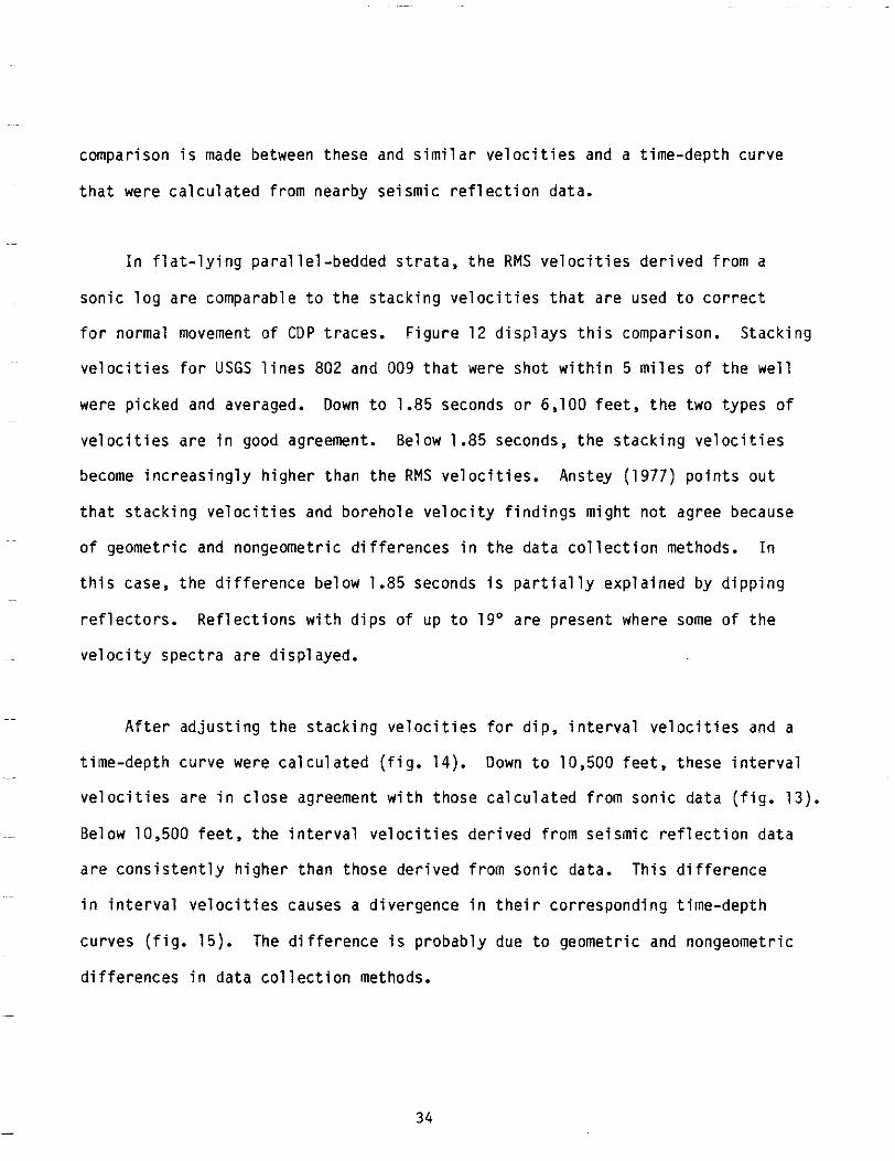
Ve loc i t yAna lys i s
RMS v e l o c i t i e s ,i n t e r v a lv e l o c i t i e s , and a t ime-depthcurvewerecalcu lated
( f i g s .1 2 and 1 3 )u s i n gt h ei n t e r v a l - t r a n s i t - t i m el o go ft h e No. 1 we l l . A
31
---
0 I I I I 1
\ \ \
\ Stacking Velocity
RMS Velocity I
1 .o
2.0
3.0
4.0 I I I I
5.000 8.000 7.000 8.000 9.000
VELOCITY(feetlsecondl
FIGURE I 2 -COMPARISON BETWEENSTACKINGVELOCITIES AND RMS VELOCITIES FOR COST WELL NO. I
32
TWO-WAY TIME (seconds)
C
2.00c
4.000 i e.000
e e m-0 w
r 8,000c n Y 0
10.000
12.000
14,000
5.000 10.000 15.000 20.000 25.000
INTERVAL VELOCITY (feet/second)
FIGURE I 3 - INTERVALVELOCITIES AND TIME-DEPTH CURVE FROMSONIC L O G OF COSTWELL NO. I
33
comparison i s made betweenthese and s i m i l a r v e l o c i t i e s and a t ime-depthcurve
t h a t were ca l cu la tedf romnearbyse ism icre f l ec t i onda ta .
I n f l a t - l y i n g p a r a l l e l - b e d d e d s t r a t a , t h e RMS v e l o c i t i e s d e r i v e d f r o m a
s o n i c l o g a r e c o m p a r a b l e t o t h e s t a c k i n g v e l o c i t i e s t h a t a r e used t o c o r r e c t
f o r normal movement o f CDP t races .F igure12d isp laysth iscompar ison.Stack ing
v e l o c i t i e s f o r USGS l i n e s 802and009 t h a t wereshotw i th in 5 m i l e so ft h ew e l l
werepicked andaveraged. Down t o 1.85 seconds o r 6,100 f e e t ,t h e twotypesof
v e l o c i t i e sa r ei n goodagreement.Below 1.85 seconds, t h es t a c k i n gv e l o c i t i e s
h ighe r the RMS ve loc i t ies . (1977) ou t~~ become inc reas ing l y than Anstey po in ts
~~
t h a ts t a c k i n g v e l o c i t i e s and boreholeveloc i tyf ind ingsmightnotagreebecause
o fgeomet r ic and n o n g e o m e t r i cd i f f e r e n c e si nt h ed a t ac o l l e c t i o n methods. I n
t h i s case,thedi f ferencebelow 1.85 seconds i s p a r t i a l l y e x p l a i n e d byd ipp ing
r e f l e c t o r s .R e f l e c t i o n sw i t hd i p so fu pt o 19' a represent where some o ft h e
v e l o c i t y s p e c t r aa r ed i s p l a y e d .
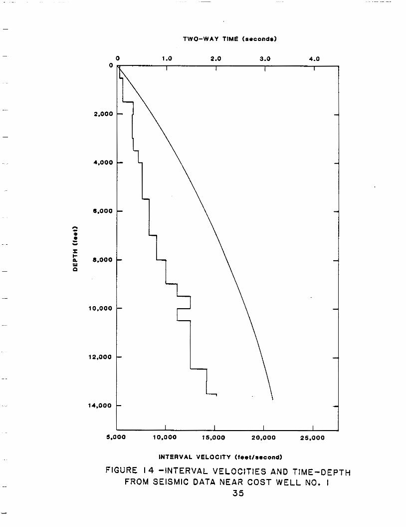
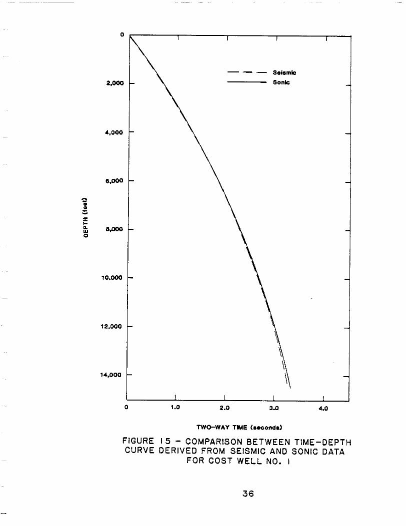
A f t e ra d j u s t i n gt h es t a c k i n gv e l o c i t i e sf o rd i p ,i n t e r v a lv e l o c i t i e s and a
t ime-depthcurvewerecalcu lated( f ig .14) . Down t o 10,500 f e e t ,t h e s ei n t e r v a l
v e l o c i t i e s a r e i n c l o s e agreement w i ththoseca lcu la tedf romson icda ta( f i g .13 ) .
Below10,500 f e e t ,t h ei n t e r v a lv e l o c i t i e sd e r i v e df r o ms e i s m i cr e f l e c t i o nd a t a
a r ec o n s i s t e n t l yh i g h e rt h a nt h o s ed e r i v e df r o ms o n i cd a t a .T h i sd i f f e r e n c e
i n i n t e r v a l v e l o c i t i e s causes a d ivergence i nt h e i rc o r r e s p o n d i n g t i m e - d e p t h
curves( f ig .15) . The d i f f e r e n c ei sp r o b a b l y due togeomet r i c and nongeometric
d i f f e r e n c e s i n d a t a c o l l e c t i o n methods.
34
TWO-WAY TIME (seconds)
0 1.o 2.0 3.0 4.0 0
2.000
4.000
6.000
I I-o 8.000 Y 0
10,000
L
12.000
\
14.000
5.000 10.000 15.000 20,000 25.000
INTERVAL VELOCITY (feetlsecond)
FIGURE 14 -INTERVALVELOCITIES AND TIME-DEPTH FROM SEISMICDATANEARCOSTWELL NO. I
35
0 1.o 2.0 3.0 4.0
TWO-WAY TME (aoconda)
FIGURE I 5 - COMPARISON BETWEENTIME-DEPTH CURVEDERIVED FROM SEISMIC AND SONIC DATA
FOR COSTWELL NO. I
36
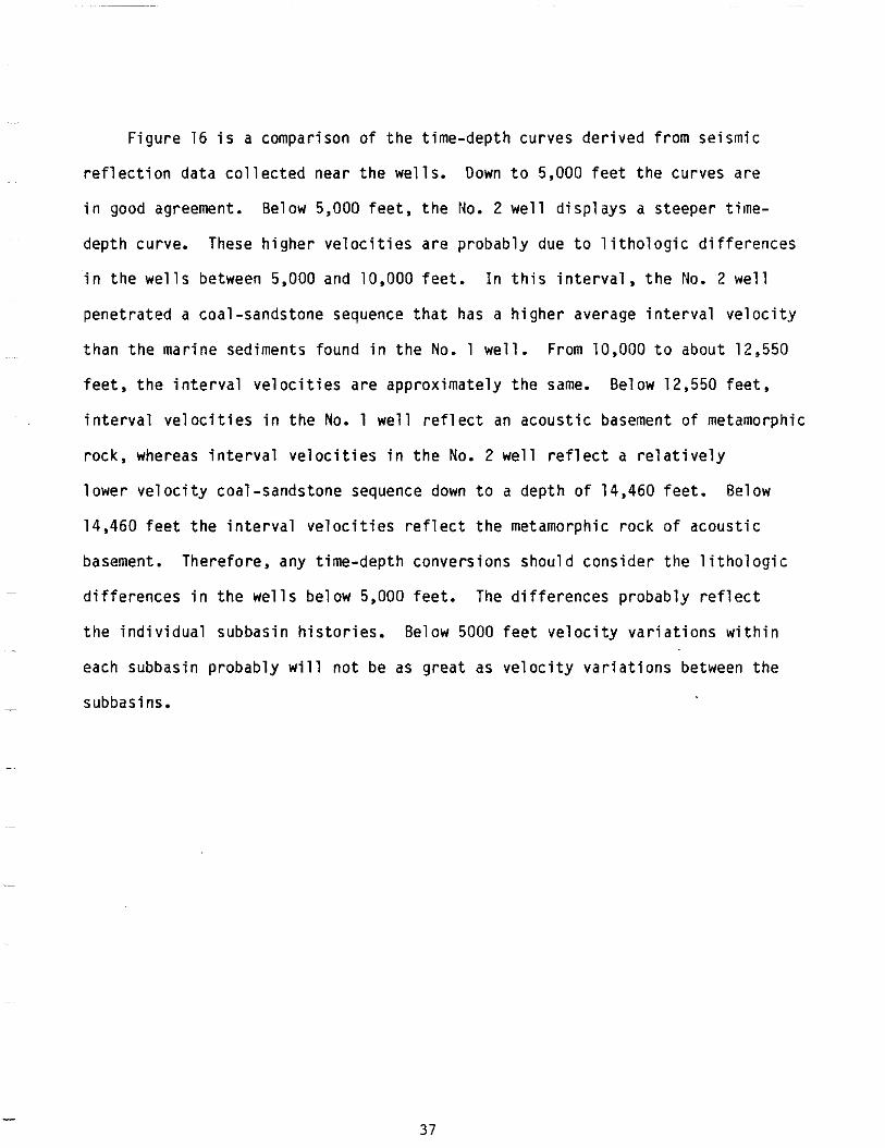
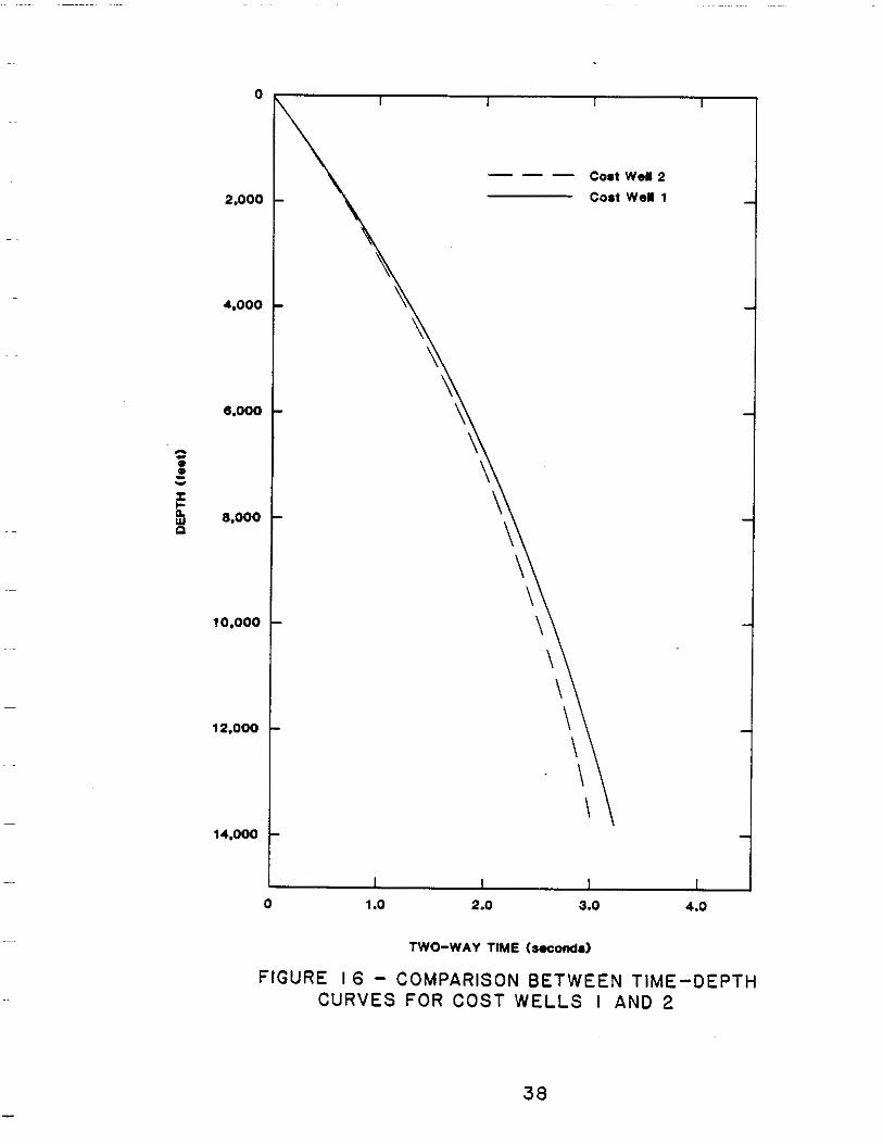
F igu re 16 i s a compar isonofthet ime-depthcurvesder ivedf romseismic
r e f l e c t i o nd a t ac o l l e c t e dn e a rt h ew e l l s . Down t o 5,000 f e e tt h ec u r v e sa r e
i n goodagreement.Below 5,000 f e e t ,t h e No. 2 w e l ld i s p l a y s a s teepert ime
depthcurve. These h i g h e rv e l o c i t i e sa r ep r o b a b l y due t ol i t h o l o g i cd i f f e r e n c e s
i n t h e w e l l s between 5,000 and 10,000 f e e t .I nt h i si n t e r v a l ,t h e No. 2 w e l l
penet ra ted a coal-sandstonesequencethat has a h i g h e ra v e r a g ei n t e r v a lv e l o c i t y
thanthemarinesedimentsfound i n t h e No. 1 w e l l . From 10,000 t o about 12,550
f e e t ,t h ei n t e r v a lv e l o c i t i e sa r ea p p r o x i m a t e l yt h e same. Below12,550 f e e t ,
i n t e r v a l v e l o c i t i e s i n t h e No. 1 w e l lr e f l e c t an acous t i c basement ofmetamorphic
r o c k ,w h e r e a si n t e r v a lv e l o c i t i e si nt h e No. 2 w e l l r e f l e c t a r e l a t i v e l y
l owerve loc i t ycoa l - sands tone sequence down t o a d e p t ho f 14,460 feet.Below
14,460 f e e t t h e i n t e r v a l v e l o c i t i e s r e f l e c t t h e metamorphicrock o fa c o u s t i c
basement.Therefore,anyt ime-depthconversionsshouldconsiderthel i thologic
d i f f e r e n c e si nt h ew e l l sb e l o w 5,000 fee t . The d i f f e r e n c e sp r o b a b l yr e f l e c t
t heind i v idua lsubbas inh i s to r i es .Be low 5000 f e e tv e l o c i t yv a r i a t i o n sw i t h i n
eachsubbasinprobably will notbe as grea tasve loc i tyvar ia t ionsbetweenthe
subbasins.
37
---
0
Coat Well 2
2,000 Coat WeY 1
4.000
6.000
10.000
12,000
14.000
0 1.o 2.0 3.0 4.0
TWO-WAYTIME (secondal
FIGURE I 6 - COMPARISON BETWEENTIME-DEPTH CURVES FOR COSTWELLS I AND 2
38
~~
~ ~~
._
~
~-
~
-
.~
PALEONTOLOGY AND BIOSTRATIGRAPHY
by
Ronald F. Turner
11eoecc) l o g i c and b i o s t r a t i g r a p h i cd e t e r m i n a t i o n si nt h e ARC0 Norton Sound
COST No. 1 Wellarebased on d e t a i l e da n a l y s e so fm i c r o f o s s i l assemblages
c o n t a i n i n gF o r a m i n i f e r a ,s i l i c o f l a g e l l a t e s anddiatoms,calcareousnannoplankton,
and marine and t e r r e s t r i a l palynomorphs.Rotary d r i l l b i t c u t t i n g s wereexamined
a t 3 0 - f o o ti n t e r v a l sf r o mt h ef i r s t sample a t 180 f e e tt ot h et o t a ld e p t ho f
14,683 feet.Datafromconvent ional and sidewal lcoreswerealsoexamined
and u t i l i z e d .I na d d i t i o n ,s l i d e s ,p r o c e s s e d samples,andrepor tspreparedfor
t h ep a r t i c i p a n t sb yc o n s u l t a n t s wereexamined, i n t e r p r e t e d , and i n t e g r a t e d i n t o
th isrepor t(Appendix) .DiscrepanciesbetweenMinera ls Management Serv ice and
i n t e r p r e t a t i o n s , t h e t o p s ,c o n s u l t a n t p r i n c i p a l l y l o c a t i o n o f b i o s t r a t i g r a p h i c
f o r t h e most p a r t canbe a t t r i b u t e d t o sampleconten tvar ia t ions and d i f f e r e n c e s
i n sampleprepara t iontechn iques .Foramin i fe ra lana lys is ,in te rpre ta t ion , and
syn thes i so fo the rda tawere done bytheau tho r .S i l i ceousmic ro foss i lana lys i s
was donebyDonald L. Olson.
S t ra taa red iscussed i n t h eo r d e rt h a tt h e y werepenetrated. The
b i o s t r a t i g r a p h i cu n i t sd e l i n e a t e dr e p r e s e n t a syn thes i so fda tader i vedf rom
v a r i o u ss u b d i s c i p l i n e st h a t do notagree i n e v e r yp a r t i c u l a r .F o l l o w i n g
c o n v e n t i o n ,f o s s i lo c c u r r e n c e sa r el i s t e d as h ighes tandlowestra therthan
39
t h ep o t e n t i a l l yc o n f u s i n g f i r s t and l a s t . Sample depths may d i s a g r e es l i g h t l y
w i t h measureddepths.Dataobtainedfromcoresaregiven somewhat more weight
t hanthosef romcu t t i ngs .Cor re la t i on with t h eo t h e rN o r t o n Sound COST w e l l
i s d iscusseda ttheconc lus ion o f t h i s r e p o r t .
Pa leoenv i ronmen ta lde te rm ina t ionsa rebasedontheen t i rem ic ro foss i l and
macro foss i lsu i tes .Pa leoc l ima to log i ca li n te rp re ta t i onsa rebased on spore
~ and p o l l e n assemblages and, t o a l esse rex ten t , on d i a t o m s ,s i l i c o f l a g e l l a t e s
andForamin i fe ra .F luv ia l ,l acus t r i ne , and pa luda lenv i ronmen tsa rec lass i f i ed
ascont inenta l or nonmarine. Trans i t iona lenv i ronmentsinc ludebrack ish
e s t u a r i e s , marshes,and hypersa l i ne and hyposal inelagoons. For sediments
depos i tedinmar ineenv i ronmen ts ,thepa leoenv i ronmen ti sexp ressedinte rms
ofbathymetry .Paleobathymetr icdeterminat ionsarepr imar i lybasedon
~~ f o r a m i n i f e r a l marine such asc r i t e r i a ,b u td i n o f l a g e l l a t e s and other organisms
bryozoans,echinoids,ophuroids, and c i r r i p e d sa r ea l s ou t i l i z e d . The marine
environment i sd i v i d e d i n t oi n n e rn e r i t i c( 0 - 6 0 f e e t ) ,m i d d l en e r i t i c( 6 0 - 3 0 0
f e e t ) ,o u t e rn e r i t i c( 3 0 0 - 6 0 0f e e t ) , andupperbathyal(600-1500feet).
40
P1e i stocene
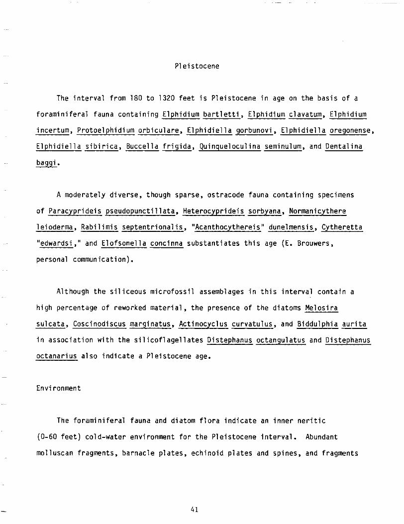
The i n t e r v a lf r o m1 8 0t o 1320 f e e t i s P l e i s t o c e n e i n ageon t h eb a s i so f a
f o r a m i n i f e r a lf a u n ac o n t a i n i n gE l p h i d i u mb a r t l e t t i ,E l p h i d i u mc l a v a t u m ,E l p h i d i u m
ince r tum,Pro toe lph id iumorb i cu la re ,E lph id ie l l ago rbunov i ,E lph id ie l l ao regonense ,
E l p h i d i e l l as i b i r i c a ,B u c c e l l af r i g i d a ,Q u i n q u e l o c u l i n a seminulum,andOentalina
~~ w.
A moderatelydiverse,thoughsparse,ostracodefaunacontainingspecimens
ofParacypr ide ispseudopunct i l la ta ,Heterocypr ide issorbyana,Normanicythere
le ioderma,Rabi l imisseptent r ional is ,"Acanthocythere is"dunelmensis ,Cytheret ta
~~ " edwards i , " E lo fsone l la subs tan t ia tesand conc inna th is age (E. Brouwers,
personalcommunication).
A l t h o u g ht h es i l i c e o u sm i c r o f o s s i la s s e m b l a g e si nt h i si n t e r v a lc o n t a i n a
h ighpercen tageo freworkedmate r ia l ,t hep resenceo fthed ia tomsMe los i ra
~~ su lca ta , marg ina tus , curva tu lus ,B iddu lph iaCosc inod iscus Ac t inocyc lus and aur i ta
i n a s s o c i a t i o n w i t h t h e s i l i c o f l a g e l l a t e s Distephanus octangulatusandDistephanus
o c t a n a r i u sa l s oi n d i c a t e a P le i s tocene age.
Environment
-
The fo ramin i fe ra lfauna and d i a t o m f l o r ai n d i c a t e an i n n e r n e r i t i c ~
(0-60 f e e t )c o l d - w a t e re n v i r o n m e n tf o rt h eP l e i s t o c e n ei n t e r v a l . Abundant
mo l luscanf ragments ,barnac lep la tes ,ech ino idp la tes andspines,andfragments
41
oferectbryozoancolonies(adeoni form and v i n c u l a r i i f o r m )g e n e r a l l ys u p p o r t
t h i si n t e r p r e t a t i o n ,a l t h o u g ht h eb r y o z o a n ss u g g e s tp o s s i b l em i d d l en e r i t i c
waterdepths(50-300feet) . The os t racodefaunaind ica testha ttheseenv i ronments
were c h a r a c t e r i z e db yp e r i o d so fr e d u c e do rf l u c t u a t i n gs a l i n i t i e s . The admixture
o fs tenoha l i ne and euryhal ineformscanbeexpla inedbythecomplexinterp lay
o f g l a c i o - e u s t a t i c a l l y c o n t r o l l e d f l u v i a l andmarineprocesses.
P1iocene
The i n t e r v a lf r o m 1320 t o 2639 f e e t i sP l i o c e n ei n age. A l thoughthe
P l i o c e n es i l i c e o u sm i c r o f o s s i l assemblage con ta ins a s u b s t a n t i a l number o f
older,reworkedforms as wel lasPleistocenespeciescavedfromuphole,the
i n t e r v a lc a n be p r o v i s i o n a l l ys u b d i v i d e di n t ol a t e ,m i d d l e , and e a r l y on t h e
b a s i so fd i a t o m and s i l i c o f l a g e l l a t ed i s t r i b u t i o n s . The l a t eP l i o c e n e , 1320
t o 1508 f e e t , i s i den t i f i edbytheh ighes toccu r renceo fthed ia tomsCosc inod iscus
marg ina tusfoss i l i s ,S tephanopyx isinermis ,Ac t inocyc lusehrenberg i i ,Tha lass ios i ra
u s a t c h e v i i , and N i t z s c h i af o s s i l i s . The middlePl iocene,1608 t o 2327 f e e t ,
i s d e f i n e d by t h e f i r s t o c c u r r e n c e o f Thalassionemarobusta,Thalassionema
convexaaspinosa,Cosmiodiscusintersectus,Dent iculopsiskamtschat ica, and
- D i s t e p h a n u s b o l i v i e n s i s . The ea r l yb o l i v i e n s i s P l i ocene , 2327 t o 2639 f e e t ,
i sd e f i n e db yt h el o w e s to c c u r r e n c e so fA c t i n o c y c l u so c h o t e n s i s and Ammodochium ~
r e c t a n g u l a r e .S i l i c e o u sm i c r o f o s s i lz o n a t i o n sf o ra l lp a r t so ft h ew e l la r e
based on Koizumi(1973),Schrader(1973),andBaron(1980).
42
The f o r a m i n i f e r a lf a u n ai se s s e n t i a l l yt h e same as t h a to ft h eo v e r l y i n g
Ple is tocenewi ththeexcept ionofthehighestoccurrenceofPseudopolymorphina
c f . -P. suboblonga a t 1500-30 feet.
The ostracodefauna i s a l s o q u i t e similar t o t h a t o f t h e o v e r l y i n g
P l e i s t o c e n e ,w i t ht h ea d d i t i o no fR a b i l i m i sp a r a m i r a b l i s ,C y t h e r e t t a
~~ teshekpukensis , tubercu lata,Rober tsoni tes and punct i l la ta .Eucyther idea Most
o fthesespec ieshavehere to fo re beencons ide redP le i so tcenew i ththeexcep t ion ~
o fR a b i l i m i sp a r a m i r a b l i s (1380 t o 1410 fee t ) ,wh ich hasbeen repo r tedon ly
f romBer ing ian-agesed iments( la teP l iocene-ear lyP le is tocene) . ~~~
t e r r e s t r i a l c o n t a i n s~ The s p a r s e p a l y n o f l o r a A l n i p o l l i n i t e s sp. and r a r e
specimens ofBetulaceae,Polypodiaceae,Polmoniaceae, andChenopodiaceae.
The mar inepa lyno f lo rai scha rac te r i zedbycommnspec imenso f Tasmanaceae
and t h ed i n o f l a g e l l a t e sL e j e u n i a spp., Pa ra lecan ice l l ainden ta ta , and
Operculd in ium sp. 2. The l a t t e rs p e c i e s first occurs i n a s idewa l lco re
t a k e n a t 1494 f e e t andmarks theapprox ima tepos i t i ono ftheP l iocene-P le i s tocene
boundary i n A laskaacco rd ingtotheconsu l tan ts . ~
Environment
The P l i o c e n em i c r o f o s s i l and macro foss i lassemblagesareind ica t iveo f
c o l dw a t e r , i n n e rn e r i t i cd e p o s i t i o n .
4 3
Miocene
The i n t e r v a lf r o m 2639 t o 4493 f e e t i s i n t e r p r e t e d h e r e t o r e p r e s e n t t h e
M iocenesec t i ono fthewe l l .Th i sin te rva lcan be f u r t h e rs u b d i v i d e di n t ol a t e
and ear lyMiocenesec t ions on t h eb a s i so fs i l i c e o u sm i c r o f o s s i l s . The absence
o f m i d d l e M i o c e n e s i l i c e o u s m i c r o f o s s i l t a x a i n c o n j u n c t i o n w i t h t h e r e l a t i v e l y
good l a t e and e a r l y Mioceneassemblagessuggests t h a t t h i s t i m e may be
representedby a h i a t u s ,a l t h o u g ht h ef o r a m i n i f e r a ld a t aa p p e a r st oc o n t r a d i c t
t h i si n t e r p r e t a t i o n .S e v e r a ld i s t i n c t i v ef o r a m i n i f e r a ls p e c i e sp r e v i o u s l y
repor tedf romtheMioceneofSakha l inIs land, U.S.S.R. a r e p r e s e n t i n t h e w e l l
a t 3630-60 fee t . The s t r a t af r o mw h i c ht h e s ef o r m sw e r er e p o r t e di n i t i a l l y were
c o n s i d e r e dt o be l a t e Miocene i n age (Voloshinova,andothers1970). More
r e c e n t l y t h e s e s t r a t a wereassigned tothemiddleMiocene(Serova,1976; Menner,
and o the rs 1977;Gladenkov,1977). The ages o ft h e s eu n i t sa r e still unse t t l ed ,
and i t i s q u i t e p o s s i b l e t h a t t h e y may provetobeo lderthanmidd leMiocene
( L . Marincovich,personalcommunication).
The l a t e Miocene i n t e r v a l ,d e f i n e d by s i l i c e o u sm i c r o f o s s i l assemblages
recoveredfromsidewal lcoresf rom 2639 t o 3464 f e e t , i s recognizedby
thelowes tcon t inuousoccu r renceo fMe los i rasu lca ta ;thelowes toccu r rences
ofThalass ios i razabel inae,Thalass ios i raconvexaaspinosa,Pseudopyxi l la
amer icana,andEbr iops isant iquaant iqua;thehighestoccurrencesofCoscinodiscus
temperei ,Coscinodiscusvetust issimus,andGoniothecumtenue;andtheubiqui tous
presence o f Act inocyclusingens.
44
The i n t e r v a lf r o m 3464 t o 4493 f e e t i s e a r l y Miocene i n age on t h eb a s i so f ~
t helowestoccur renceofTha lass ionemani tzsch io ides ,Stephanopyx istu r r i s , -Stephanopyxisschencki i ,andAct inocyclusingens.
~
The M i o c e n ef o r a m i n i f e r a lf a u n af i r s te n c o u n t e r e da t3 6 3 0 - 6 0f e e ti s
c h a r a c t e r i z e db yP o r o s o r o t a l i ac l a r k i ,E l p h i d i e l l ak a t a n g l i e n s i s ,E l p h i d i e l l a
c f . -E. t e n e r a , E l p h i d i e l l a c f . -E. c rasso rugosa , E lph id ie l l a c f . -E. nagaoi,
C r i b r o e l p h i d i u m c f . -C. vu lgare , Cr ib roe lph id ium c f . -C. paromaense, C r ib roe lph id ium ~
crassum, E l l i p s o g l a n d u l i n a c f . -E. subobesa, Pseudoglandulina sp., G landu l ina
B u c c e l l a B u c c e l l a B u l i m i n e l l a~~~ c f . G. j a p o n i c a , f r i g i d a , a f f . B. m a n s f i e l d i , c f . -B.- curta,and wi11iamsoni.
~~~
The t e r r e s t r i a l p a l y n o f l o r a o v e r t h i s i n t e r v a l i s q u i t e s i m i l a r t o t h a t o f
t heP l iocenesec t i on . New e lementsinc ludeUlmipo l len i tes sp., T i l i a e p o l l e n i t e s
sp., J u g l a n s p o l l i n i t e s sp., P te roca ryapo l l en i tes sp., andBosiduvaldnia sp.
-The d i n o f l a g e l l a t e assemb lageinc ludesSp in i fe r i t esc ingu la tus ,Sp in i fe r i t es
c f . -S. c r a s s i p e l l i s , S p i n i f e r i t e s c f . -S. i n c e r t u s , L e j e u n i a spp., and ~
Tubercu lod in ium vancampoae. Boththespore-pol lenanddinof lagel la teassemblages
t h i s~ suggest a Miocene age f o r i n t e r v a l .
Environment
Evidencefrom a l lo ft h em i c r o f o s s i lg r o u p ss u g g e s t sd e p o s i t i o ni n an
innertomidd lener i t i cenv i ronment(0-300fee t ) .Pa leo tempera tureswere
45
c o l d e rd u r i n gt h el a t eM i o c e n et h a ni nt h es u b t r o p i c a lt ow a r m - t e m p e r a t ee a r l y
Miocene.
01 igocene . The i n t e r v a lf r o m 4493 t o 9690 f e e t i s c o n s i d e r e d t o beOligocene i n
age.The t o po ft h eO l i g o c e n es e c t i o n i s markedbythehighestoccurrenceof
t h e d i n o f l a g e l l a t e Achomosphaera a f f . -A. a l c i co rnu . Acco rd ing to the
p a l y n o l o g i c a lc o n s u l t a n t ,t h i ss p e c i e s hasbeen p rev ious l yreco rdedinO l igocene
s t r a t ai nw e s t e r n Alaska. Achomosphaera a lc icornurangesf rommidd le Eocene
tom idd leMioceneinEurope and f romla tePa leocenethroughthe Eocene i n
eas tern Canada. O t h e rd i n o f l a g e l l a t e sa s s o c i a t e dw i t ht h i ss p e c i e s , Tenua c f .
-T. decorata, Systematophora placacantha (ear ly Eocene through late Miocene),
and D i s t a t o d i n i u me l l i p t i c u m( m i d d l e Eocene th roughear lyOl igocene)lend
s u p p o r tt o an Ol igocene age f o r t h e i n t e r v a l .
The calcareousnannoplanktonrecoveredfromthewel larerare,poor ly
preserved, and r e l a t i v e l yn o n d i a g n o s t i c . None occursabove5100feet. The
f r o m 5101 t o 10,590 f e e ti sc h a r a c t e r i z e d by appearances~ i n t e r v a l sporadic of
Braarudosphaera b i g e l o w ia s s o c i a t e dw i t hr a r ec o c c o l i t h s and p l a c o l i t h s o f a ~
smal l , somewhat p r o b l e m a t i c a lf o r mw i t ha f f i n i t i e st os p e c i e si nt h eC o c c o l i t h u s
miopelagicusplexus.Whi lenotdef in i t ive,theseformssuggest a middleMiocene ~
t ol a t eO l i g o c e n e age. Somewhat more d e f i n i t i v e i s t h e o c c u r r e n c e o f
~~ Thoracosphaera wh ich age thanheimi a t 9150-9240 fee t , i nd i ca tes anno o lde r
m idd leO l igocene ,poss ib l yw i th intheSpheno l i t husc ipe roens is zone.
46
- -
The f o r a m i n i f e r a l assemblagesupports an Ol igocene age a l though many o f
thespec iespresentrangein tothe Miocene. The u p p e rp a r to ft h ei n t e r v a l
(4493 t o 5400 f e e t ) i s charac ter izedby a faunatha tconta insdominant lysha l low
wa te rfo rmssuchasE lph id ie l l aka tang l i ens i s ,E lph id ie l l anagao i ,E lph id ium
spp., C r ib roe lph id ium spp. Bucce l l af r i g ida ,M i l i amminafusca ,Ro ta l i ac f . -R.
k a t a n g l i e n s i s ,R o t a l i aj a p o n i c a , and Ro ta l i ajapon icava r ian ta . A deeper
waterassemblage,presentfrom 5400 t o 9690 fee t ,con ta insmosto fthe above
l i s t e d s p e c i e s as wel las Psammosphaera carnata, Ammodiscus tenu is , Ammodiscus
s a k h a l i n i c u s ,L i b u s e l l al a e v i g a t a ,M a r t i n o t t i e l l ac f . -M. communis, M a r t i n o t t i e l l a
bradyana,Hippocrepinel lavar iabi l is ,Haplophragmoides spp., Haplophragmoides
tor tuosus,Gaudry inaquadrangular is ,P lect ina sp., Doro th ia sp., Rhabdamminina
aspera, Reophax spp., Bathysiphonedurus,Bathysiphon sp., T r i t a x i l i n a a f f . -T.
c o l e i ,P u l l e n i a sp., Cyclammina c f . -C. tumiens is , Cyclammina c f . -C. p a c i f i c a ,
cf. c f .Cyclammina sp., Eponides E. d o r f i , -E. gav io taens is ,
Pseudoglandul inanal lpeensis ,Sigmomorphinasuspecta,Sigmoidel lapaci f ica,
F i s s u r i n a m a r g i n a t a ,T r i c h y o h y a l u sb a r t l e t t i ,S i l i c o s i g m o i l i n a sp., Bucce l la
m a n s f i e l d i ,P o r o s o r o t a l i a Clark:, E l p h i d i e l l a c f . E. c a l i f o r n i c a , E l p h i d i e l l a
c f . -E. problemat ica, Globobul imina sp., Robulus cf. -R. midwayensis,Lagena
l aev i s ,Qu inque locu l i nasawanens is ,Qu inque locu l i nasacha l i n i ca ,E l l i psog landu l i na
subobesa, B u l i m i n e l l as u b f u s i f o r m i s , and severalspeciesofCaucasina. The
l a t t e ra r eq u i t es i g n i f i c a n t . Caucasinaschwageri(highestoccurrenceat
6570-6600feet) ,Caucasinaeocenicakamchat ica(highestoccurrenceat 6960-90
f e e t ) , andCaucasina bu l l a ta(h ighes toccu r rencea t8640-70fee t )cha rac te r i ze
theCaucasinaeocenicakamchatica Zone i n t h e I l p i n s k y andKamchatka pen insu las
i n t h e U.S.S.R. Th i s zone i s thoughtbySerova(1976) t od e f i n et h e Eocene-
47
01igocene boun da ry . Micral f o s s i le v i dence cIb tainedfrom theNor ton Sound COST
~~ No. 1 Wel l , ind icates the specieshowever , that a forement ioned ofCaucasina
range i n t o 01 igocene t ime. ~~
Environment
The O l i g o c e n es e c t i o no ft h ew e l li sd o m i n a n t l ym a r i n ei na s p e c t . The
u p p e rp a r to ft h ei n t e r v a l( 4 4 9 3t o 4740 f e e t ) was d e p o s i t e d i n e s s e n t i a l l y
t h e same environment as t h eo v e r l y i n g Miocene, i n n e rt om i d d l en e r i t i c . A
t r a n s i t i o n a lt oc o n t i n e n t a lc o a l - b e a r i n gs e c t i o ni sp r e s e n t between
4740and4980 fee t . The i n t e r v a lf r o m 4980 t o 5400 f e e t i s i n n e r t o m i d d l e
n e r i t i c and represents a shoal ingeventtransi t ionalbetweentheuppernonmarine
s e c t i o n and t h e deep wa te rsec t i onbe low5400fee t .Ou te rne r i t i ctoupper
ba thya ldepths(300to 1500 f e e t )p r e v a i l e do v e rt h ei n t e r v a lf r o m 5400 t o
9690 f e e t . The mostd iverse deep watermicrofossi lassemblagesarepresent
from8130 t o 9690 fee t . The t e r r e s t r i a l l yd e r i v e ds p o r e - p o l l e n assemblage
i n d i c a t e s t h a t s u b t r o p i c a l t o warm t e m p e r a t ec l i m a t i cc o n d i t i o n sp r e v a i l e d
d u r i n g most o f Oligocenetime.
O l igoceneorOlder
~~ M i c ro foss i l f rom 9690 t o 12,235 f e e t was q u i t erecove ry and preserva t ion
poor.Most o fthera refo ramin i fe ra loccu r rencesappeartorep resen tcaved
mate r ia l . The i n s i t u p a l y n o m o r p h sa r et e r r e s t r i a l l yd e r i v e d . Abundant p l a n t
mater ia li sd isseminatedthroughthemass ivesandstoneun i ts andas s u b p a r a l l e l
par t ings .Micaf lakes and p l a n tm a t e r i a la r e common i nt h ef i n eg r a i n e dl a m i n a e .
N e i t h e rt h e age northeenvironmentcan be unequivocal lydetermined. It i s
48
p o s s i b l e t h a t t h i s s e c t i o n i s i n p a r t e q u i v a l e n t t o t h e l a t e and middle Eocene
s e c t i o n so ft h eN o r t o n Sound COST No. 2 Well.Sedimentaryfeaturessuch as
gradedbedding and f l a m es t r u c t u r e s seen i n co rese igh t and n i n e (11,960-988
12,071-091 f e e t ) d e p o s i t i o nt u r b i d i t y B i o t u r b a t i o n i s~ and s u g g e s t b y c u r r e n t s .
no tex tens i veo rd iagnos t i c . The in f requentbur rowspresentinthemass ive
sands toneun i t scanno tbere la tedto a p a r t i c u l a ri c h n o f a c i e s . However, r a r e
t racesobserved on beddingplanes i n t h e l a m i n a t e d sequences o f c o r e e i g h t
resembletheichnogenusPlanol i tes and t h e" s c r i b b l i n gg r a z i n gt r a c e s "o f a
t r a c ef o s s i l assemblage t y p i c a lo fd i s t a lt u r b i d i t e s . These s t r a t ac o u l d have
been d e p o s i t e d i n e i t h e r a r e l a t i v e l y deep watermarineenvironmentor a
r a p i d l ys u b s i d i n gl a r g el a c u s t r i n ee n v i r o n m e n t .
Poss ib le Eocene o rO lde r
No age d i a g n o s t i cm i c r o f o s s i l s wererecoveredfromtheinterva lbetween
12,235 and 12,545 feet.Rare,poor lypreservedspores and po l l ena rep resen t .
The 310- foo t - th icksec t ion , boundedaboveandbelowbyunconformities,appears
t o b e r o u g h l y c o r r e l a t i v e w i t h much t h i c k e r Eocene o r o l d e r c o a l - b e a r i n g sequences
i nt h en e a r b yN o r t o n Sound COST No. 2 Well.
Environment
The p r e s e n c eo ft e r r e s t r i a ls p o r e s and p o l l e ni na s s o c i a t i o nw i t ha b u n d a n t
c o a li n d i c a t e st h a tt h es e d i m e n t sa r ec o n t i n e n t a l( f l u v i a l and p a l u d a l )i n
nature. The pa leoc l imate was p r o b a b l yt r o p i c a lt os u b t r o p i c a l .
49
Metamorphic Basement
The we l lpenet ra ted a 2 1 3 5 - f o o t - t h i c ks e c t i o no fc a t a c l a s t i c a l l yd e f o r m e d
p e l i t i c and psammiticmetasedimentaryrocks o f undetermined age. Several
l i n e so fe v i d e n c es u g g e s tt h a tt h e s er o c k s may b er e l a t e dt or o c k sf r o mt h e
YorkMountains i n t h e w e s t e r n p a r t o f t h e Seward Peninsulaconsideredtobe
Precambrian toPa leozo ic(Sa insbury , and o thers , 1970; A. Till, J. Dumoulin,
personalcommunication).
C o r r e l a t i o n
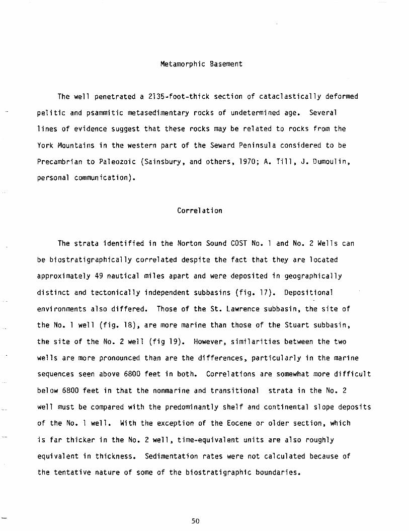
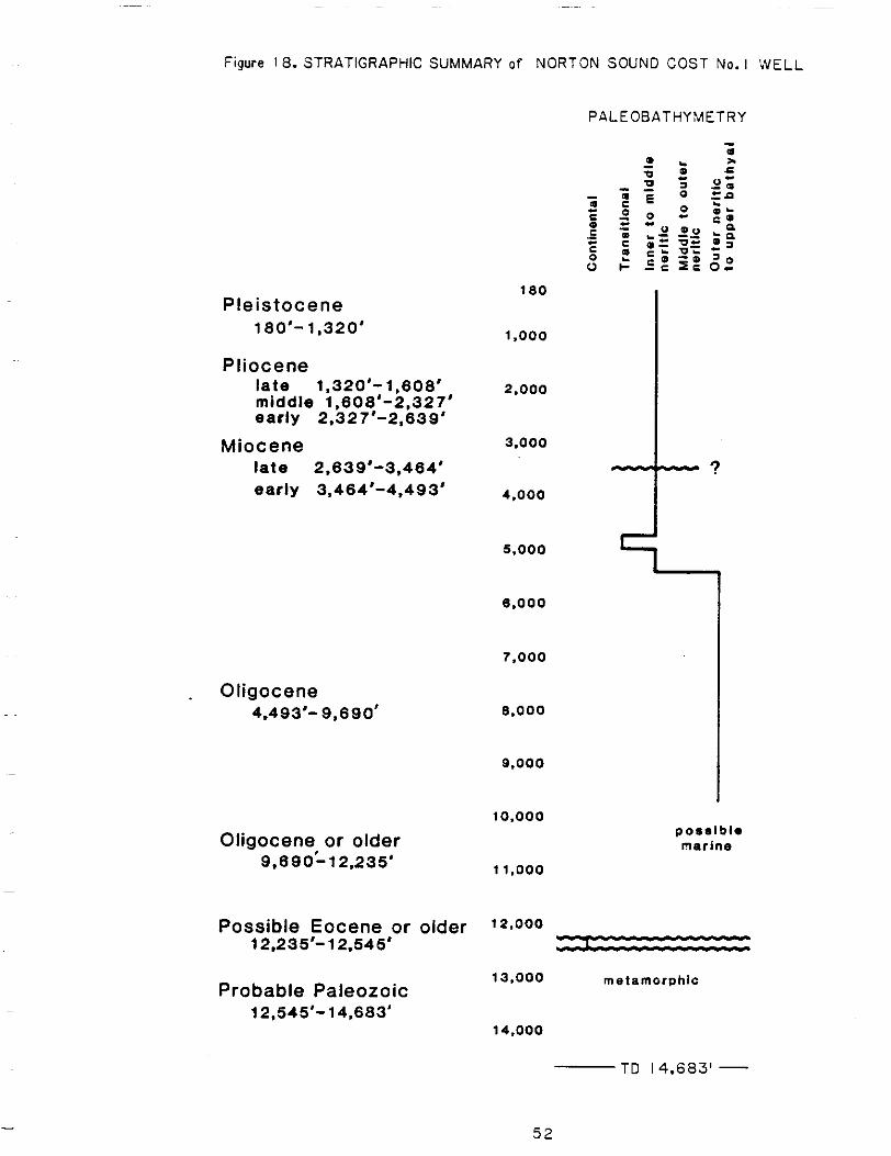
The s t r a t a i d e n t i f i e d i n t h e N o r t o n Sound COST No. 1 and No. 2 Wellscan
be b i o s t r a t i g r a p h i c a l l y c o r r e l a t e d d e s p i t e t h e f a c t t h a t t h e y a r e l o c a t e d
approx imate ly 49 nau t i ca lm i lesapar t andweredeposited i ng e o g r a p h i c a l l y
d i s t i n c t and tec ton ica l l yindependentsubbas ins( f ig .17) .Depos i t iona l
env i ronmentsa lsod i f fe red . Those of t h e S t . Lawrencesubbas in ,thes i teo f
t h e No. 1 w e l l( f i g .1 8 ) ,a r e moremarinethanthoseoftheStuartsubbasin,
t h e s i t e o f t h e No. 2 w e l l( f i g 19). However, s i m i l a r i t i e s between thetwo
w e l l s a r e morep ronouncedthanarethed i f f e rences ,pa r t i cu la r l yinthemar ine
sequencesseenabove6800 f e e t i n both.Corre la t ionsare somewhat more d i f f i c u l t
below 6800 f e e t i nt h a tt h e nonmarine and t r a n s i t i o n a ls t r a t ai nt h e No. 2
.~ wel l be wi th predominant ly s lopemustcompared the shel f and con t inen ta l depos i t s
o ft h e No. 1 w e l l .W i t ht h ee x c e p t i o no ft h e Eocene o ro lde rsec t i on ,wh ich ~ ~~
i s f a r t h i c k e r i n t h e No. 2 we l l ,t ime-equ iva len tun i t sa rea lsorough ly
equiva lentinth ickness.Sedimentat ionrateswerenotca lcu latedbecauseof
t h e t e n t a t i v e n a t u r e o f some o f t h e b i o s t r a t i g r a p h i c b o u n d a r i e s .
50
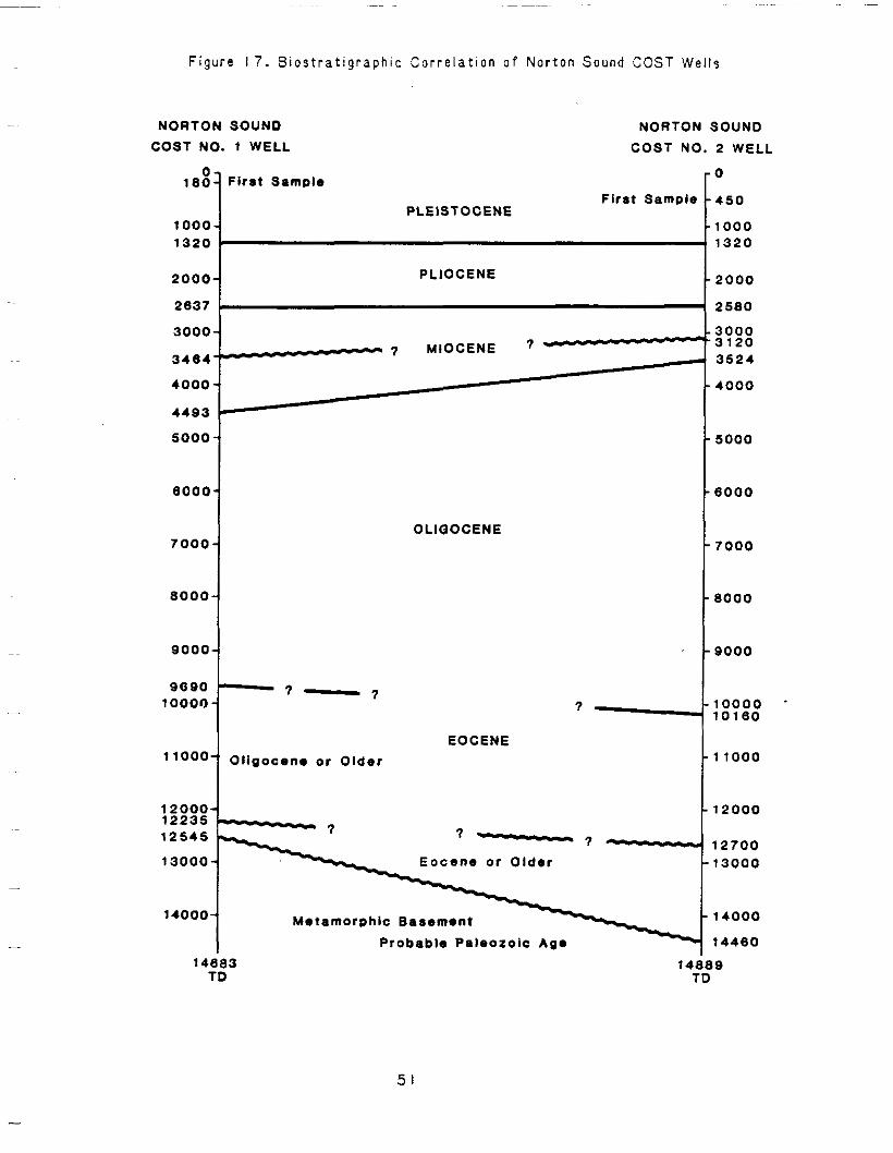
Figure 17. B i o s t r a t i g r a p h i cC o r r e l a t i o n o f N o r t o n Sound COST We l l s
NORTON SOUND
COST NO. 1 WELL
0 -180-Flr8t Sample
1000-1320 '
2000-
2637 L
3000-
34e4--
4000-
4493 I
5000
eooa
7000
8000
9000
9090
l1Oo0 Oligocene or
12000-12235
i-12545
13000-
14000- MetamorphicBasement
NORTON SOUND
COSTNO. 2 WELL
0
First Sample 450 PLEISTOCENE
1000 1320
PLIOCENE 2000
2580
3000 3120 -7 MIOCENE 7 -4 3524
4000
5000
6 0 0 0
OLIQOCENE 7 0 0 0
8000
9000
10000 10180
EOCENE Older 11000
12000
? - 7 - 12700 Eocene or Older 13000
14000
ProbablePaleozoicAge 14460 14883 14; 9
TD 1
51
~ ~~ ~~ ~~
Figure 18. STRATIGRAPHICSUMMARY of NORTON SOUND COST No. I 'WELL
PALEOBATHYLIETRY -
Pleistocene 180'-1.320'
Pliocene late1.320'-1,808' middle 1,808'-2,327' early2,327'-2,839'
Miocene late2.639'-3.484' early3,464'-4.493'
Oligocene 4.493'- 9,890'
Oligocene or older 9.890112.235'
Possible Eocene orolder 12.235'-12.545'
Probable Paleozoic 12.545'-14,683'
180
1.000
2.000
3.000
4.000
5.000
8,000
7.000
8.000
9,000
10.000
11.000
12,000
13.000
14,000
- ?
1posslb le marine
metamorphic
TO 14,683' -
5 2
Figure IS. STRATIGRAPHIC SUMMARY o f NORTON SOUND COST No. 2 WELL
Pleistocene 450'-1,320'
Pliocene late 1,320'-1.846' middle 1,846'-2,228' early 2.228'-2,580'
Miocene late 2,580'-3.120' early 3,120'-3,524'
Oligocene 3,524'-10.160'
Eocene 10.160'-12,700'
Eocene or older 12,700*-14,460'
ProbablePaleozoic 14,480'-14.889'
PALEOBATHYMETRY
-
4 5 0
1.000
2,000
3.000 - ?
4.000
5.000
6.000
7.000
8.000
9.000
10,000
1 1.000
12.000
13,000
14.000
TD 14,889'- metamorphic -
53
P1eis tocene
The f i r s t sample i n each w e l l i s P l e i s t o c e n ei n age, a l though i t i s almost ~
c e r t a i nt h a t a t h i n Holocenesect ion was penetrated. Sample q u a l i t y i s poor.
The base o ft h eP l e i s t o c e n ei sp l a c e da t 1320 f e e ti nb o t hw e l l s .M i c r o f o s s i l
assemblages, l i t h o l o g y , and d e p o s i t i o n a le n v i r o n m e n t sa r ee s s e n t i a l l yi d e n t i c a l .
Shal lowseismicev idencesuggeststhatthere may be a s l i g h t u n c o n f o r m i t y
between t h eP l i o c e n e and theP le i s tocene .
P1iocene
The t o p o f t h e P l i o c e n e i s a t 1 3 2 0 f e e t i n eachwel l ,thebaseat 2639
f e e t i n t h e No. 1 w e l l and2580 f e e t i n t h e No. 2 we l l . The P l iocene was
subd iv idedin toea r l y ,m idd le , and l a t e i n b o t h w e l l s on t h e b a s i s o f s i l i c e o u s
m i c r o f o s s i l assemblages,butthechaot icmixtureofreworkedandcavedforms
r e n d e r ss u c hs u b d i v i s i o nt e n t a t i v ea n dp r o v i s i o n a la tb e s t .I ng e n e r a l ,t h e
m i c r o f o s s i l assemblages i nb o t hw e l l sr e f l e c ts i m i l a rp a l e o e n v i r o n m e n t s .
Miocene
The t o p o f t h e Miocene i s a t 2639 f e e t i n t h e No. 1 w e l l , and a t 2580 f e e t
i n t h e No. 2 well.Thereappears t o b e a middleMiocenehiatus,perhaps a
pa racon fo rm i t y ,p resen tinbo th wells. Th is"sur face" i s d e f i n e di nb o t hw e l l s
by t h e t o p o f t h e e a r l y Miocene, 3464 f e e t i n t h e No. 1 we l l and3120 f e e t i n
t h e No. 2 we l l . The base o f t h e e a r l y Miocene i s a t 4493 f e e t i n t h e No. 1
54
w e l l and a t 3524 f e e t i n t h e No. 2 wel l .Microfoss i lassemblages and l i t h o l o g i e s
a r e q u i t e s i m i l a r i n b o t h w e l l s , a l t h o u g h t h e r e i s some ev idencetha tdepos i t i on
was a t s h a l l o w e r d e p t h s i n t h e No. 2 we l l .
01 igocene
S t ra taass ignedtotheOl igoceneepochaccoun tfo rrough lyha l fo fthe
sedimentarysect ionpenetratedbythewel ls , a 5197- foo t - th ick sequence i n t h e
No. 1 w e l l , 6644 f e e t i n t h e No. 2 w e l l .I nt h e No. 1 we l lt heO l igocene
s e c t i o n (4493-9690 f e e t )i sr e p r e s e n t e da l m o s te n t i r e l yb ym a r i n ed e p o s i t i o n ,
much o f i t o u t e rs h e l f and upperslope. By way o f c o n t r a s t ,i nt h eO l i g o c e n e
s e c t i o no ft h e No. 2 w e l l (3524-10,160 f e e t )w e l lo v e rh a l fo ft h es e d i m e n t sa r e
coa lbea r ing andweredepositedundercontinental t o t r a n s i t i o n a l c o n d i t i o n s .
~
There i s a smal l ,bu tpronounced,cont inenta ltot rans i t iona lenv i ronment ~~
p resen tnearthetop o f t h eO l i g o c e n es e c t i o ni nt h e No. 1 w e l l (4740-4980
f e e t ) t h a t i s c o r r e l a t i v e w i t h t h e c o a l bedsseen i n t h e No. 2 we l l a t 3424 t o
3930 f e e t and a t 4250 t o 4440feet. The m a r i n et r a n s g r e s s i v es e c t i o na t 5360
t o 6770 f e e t i n t h e No. 2 w e l l i s c e r t a i n l y i n p a r t c o r r e l a t i v e w i t h t h e u p p e r
bathyalenvironmentsseenbelow8130feet i n t h e No. 1 we l l .
55
Eocene
D e f i n i t e l a t e t o m i d d l e Eocene s t r a t aa r ep r e s e n tf r o m 10,160 t o 12,700
f e e t i n t h e No. 2 wel l .A l though noEocene f o s s i l s werefound i n t h e No. 1
w e l l , it i s poss ib letha ttheprob lemat icOl igocene or o l d e rs e c t i o n (9,690 t o
12,235 f e e t ) i s i n p a r t c o r r e l a t i v e w i t h t h e Eocene s e c t i o n i n t h e No. 2 w e l l .
Eocene o r O l d e r
I n b o t h w e l l s a coal -bear ingsect ionunconformablyov.er l iestheregional
e a r l yT e r t i a r yt ol a t e Mesozoicerosionalsurface.Thiscont inentalsect ion,
310 f e e t t h i c k i n t h e No. 1 w e l l and1760 f e e t t h i c k i n t h e No. 2 w e l l , i s
t runcatedby an unconformi ty a t 12,235 f e e t i n t h e No. 1 we l l and a t 12,700
f e e t i n t h e No. 2 we l l . Because b o t hd e p o s i t i o n and e r o s i o nt o o kp l a c ei n two
subbasinsseparatedby a p o s i t i v et e c t o n i ce l e m e n t , t h i s unconformi ty i s n o t
charac ter izedby a cont inuousseismicref lector .Never the less, i t i s reasonable
t o assume tha ttheuncon fo rm i t i esa reapprox ima te l ycoeva l .L i kew ise , on t h e
b a s i so fl i t h o l o g y ,d e p o s i t i o n a le n v i r o n m e n t ,s t r a t i g r a p h i cp o s i t i o n , and t h e
~~ s i m i l a rp r e s e r v a t i o n a ls t a t e o f t h e palynomorphs, i t seems p r o b a b l e t h et h a t
Eocene o r o l d e r s e c t i o n s i n t h e two w e l l s a r e i n p a r t c o r r e l a t i v e . ~
Basement Compl ex (Poss i b l e Paleozoic) -
Bothwel lspenetratedmetasedimentarysect ionsbelowtheregional
uncon fo rm i t ytha t marks acous t ic basement. The 2135- foo t - th ick sequence
56
LS
LITHOLOGY
AND
GEOPHYSICALLOG INTERPRETATION
by J. G. Bolm
~
Examinat ionofcu t t ings ,convent iona l and sidewal lcores,andgeophysical ~~ ~
l ogsf romtheNor ton Sound No. 1 we l lp rov idedin fo rma t ion on t h el i t h o l o g y ,
depos i t i ona lenv i ronmen t ,rese rvo i rcha rac te r i s t i cs , andhydrocarbonsource-rock
p o t e n t i a lo ft h es t r a t ap e n e t r a t e d .L i t h o l o g i e s and r e s e r v o i rc h a r a c t e r i s t i c s
discussed i n t h i s s e c t i o n a r e based on c o n s u l t a n t s 'r e p o r t s ,e s p e c i a l l yt h e
p e t r o l o g i cr e p o r t by AGAT Consultants,Inc.,and on examinat ionof samplesand ~
geophysicallogs. The gamma-ray, spontaneouspotent ia l(SP), deep r e s i s t i v i t y ,
dens i t y , and son iclogsa rep resen tedw i tho the rgeo log ica l and geochemical ~~
d a t a i n P l a t e 1.
~
Geophys ica llogg ingofthewel l began a t 1210 fee t ,andrecoveryo fcu t t i ngs -
was poorabove 1230 f e e to w i n gt op r o b l e m sw i t hl o s tc i r c u l a t i o n . The few c u t t i n g s
recove redf romth i suppermos tpa r t o f t h ew e l la r ep r e d o m i n a n t l ys i l t s t o n ew i t h
some veryf inesandstoneandf ragmentso fmuscov i te ,ch lo r i te ,andb io t i te ,
- s c h i s t , and greenstone. shel lMol luscandebr is i s common.
121 0-1 900f e e t
The i n t e r v a l from1210 t o 1900 f e e t i s charac ter,izedbydiatomaceoussandy
mudstone. Where b i o t u r b a t i o n hasnotbeentoosevere,laminat ion,def inedby
5%
va ry ing abundances o f sand and mud andby o r i e n t a t i o no fe l o n g a t e sand c l a s t s ,
i s seen. P y r i t e cement i s present i n a fewsmallareas o f sandylaminae,but
more commonly suchlaminaearethes i teso fcons ide rab lein te rg ranu la rpo ros i t y .
Sand c l a s t s a r e p r e d o m i n a n t l y v e r y f i n e t o f i n e and subangulartosubrounded
and c o n s i s t o f q u a r t z , f e l d s p a r , andgreenhornblendewi thminorbrownbiot i te ,
c h l o r i t e , and muscov i te .Quar tzc las tsaremost lymonocrys ta l l inewi thundu la to ry
e x t i n c t i o n ,b u tt h e r ea r e some p o l y c r y s t a l l i n eq u a r t zc l a s t s . The f e l d s p a r i s
p r i n c i p a l l y p l a g i o c l a s e w i t h m i n o r amounts o f potass ium-fe ldspar The m a t r i x
c o n t a i n ss c a t t e r e dp y r i t ef r a m b o i d s andminorglauconi te.
The gamma-ray and SP l o g ss u g g e s tt h i si n t e r v a li sd o m i n a t e d by25- t o 75-
f o o t - t h i c kb e d s o f r e l a t i v e l y c o a r s e - g r a i n e d s a n d w i t h t h i n , f i n e r g r a i n e d
i n t e r b e d s .R e s i s t i v i t i e sa r el o ww i t h a d i f f e r e n c e o f about 0.5 commonohm-m
between thedeepest and sha l lowest measured r e s i s t i v i t i e s . The d e n s i t yl o g
i n d i c a t e sd e n s i t i e sg e n e r a l l y between 1.75 and 2 g/cm3 fo rtheserocks . The
s o n i c l o g i s i n v a l i d f r o m 1680 t o 1817 f e e t owing t on o i s e ;e l s e w h e r ei n t e r v a l
t rans i tt imesaverageabout165ps/ foo t .
The presenceofabundantmar inefoss i lmater ia l and g l a u c o n i t ei n d i c a t et h a t
t h e r o c k s o f t h i s i n t e r v a l weredeposited i n a marineshel fenvironment.
1900-3730 f e e t
The i n t e r v a lf r o m1 9 0 0t o 3730 f e e t i s charac ter izedbyd ia tomi tes , muddy
d ia tomi tes , anddiatomaceousmudstones t h a t a r e s i m i l a r t o t h e r o c k s above
e x c e p t f o r t h e g e n e r a l l y g r e a t e r abundance o f diatoms.
5 9
The gamma-ray and SP c u r v e s l a c k d i s t i n c t i v e c h a r a c t e r t h r o u g h t h i s
i n t e r v a l .R e s i s t i v i t i e sr e m a i nl o w as i nt h ep r e v i o u si n t e r v a l . Below 2500
f e e ta l lt h r e er e s i s t i v i t yt o o l sg e n e r a l l yr e a dt h e same value. The d e n s i t y
l o gi n d i c a t e sd e n s i t i e so fa b o u t 1.75 g/cm3 fo rtheserocks , and average
i n t e r v a lt r a n s i tt i m e st a k e nf r o mt h es o n i cl o gd e c r e a s ef r o ma b o u t 160 u s / f o o t
t o about150ps/ foo t downward t h r o u g h t h e i n t e r v a l .
The rocks o f t h i s i n t e r v a l a r e q u i t e s i m i l a r t o t h e r o c k s i n t h e i n t e r v a l
above and weredeposited i n t h e same t ype of mar ineshel fenv i ronment .
3730-4700 f e e t
The i n t e r v a l f r o m 3730 t o 4700 f e e t i s c h a r a c t e r i z e d bymudstone s i m i l a r t o
t h a t i nt h ei n t e r v a l above. There i s a sudden b u ts l i g h ti n c r e a s ei n gamma-ray
and SP v a l u e sa tt h et o po ft h i si n t e r v a l .R e s i s t i v i t yc u r v e sc o n t i n u es m o o t h l y
down i n t o t h i s i n t e r v a l , and r e t a i nt h ec h a r a c t e rt h a tt h e y assumed a t 2500 f e e t
a l m o s tt ot h eb o t t o mo ft h ei n t e r v a l ,b u tv a l u e sa r e somewhat inore e r r a t i c i n
thebot tom 100 fee t . The d e n s i t yl o g shows a r a p i di n c r e a s ei nd e n s i t ya tt h e
t o po ft h i si n t e r v a l such t h a td e n s i t y exceeds 2 g/cm3 a t 3750 fee t . From
~~ 3750 f e e t ,d e n s i t yi n c r e a s e sg r a d u a l l yt ot h eb o t t o mo ft h ei n t e r v a l where it
averagesabout 2.2 g/cm3. The s o n i cl o g shows a s i m i l a rs h a r pd e c r e a s ei n .~
i n t e r v a l t r a n s i t t i m e f r o m 1 5 0 t o 135 p s / f o o t a t t h e t o p o f t h e i n t e r v a l and
a gradualdecrease t o an a v e r a g ei n t e r v a lt r a n s i tt i m eo fa b o u t1 3 0 ) ~ s / f o o ta t
t h e base o f t h e i n t e r v a l .
60
~~
The r o c k s o f t h i s i n t e r v a l w e r e d e p o s i t e d i n a mar ineshel fenv i ronment
as i n d i c a t e d by t h e i r c o n t e n t o f m a r i n e f o s s i l s .
4700-5005 f e e t
The i n t e r v a lf r o m 4700 t o 5005 f e e t i s c h a r a c t e r i z e d byshale,sandstone,
andminorcoal. The s h a l ec o n t a i n ss c a t t e r e ds i l t andsand g r a i n s .L o c a l l yt h i n ,
v e r y f i n e s a n d s t o n e l a m i n a e p a r a l l e l f i s s i l i t y i n t h e s h a l e , asdo t h eo r i e n t e d
p la teso fmuscov i te ,wh ichi sabundan tinthesha le , andwhisps o f opaque
mate r ia l . The sandstone i sp o o r l yt om o d e r a t e l ys o r t e d and c o n s i s t so fv e r y
f i n e t o medium sand g r a i n sw i t hv a r y i n g amounts o f d e t r i t a l mud mat r ix .Quar tz
i s t h e p r i n c i p a l sandcomponentand i s p r e s e n tp r i m a r i l yi ns u b a n g u l a r mono
c r y s t a l l i n eg r a i n st h a t show undu la to ryex t i nc t i on .P lag ioc lase , much o f i t
untwinned, i s t h e most common f e l d s p a r ,b u tp o t a s s i u m - f e l d s p a ri sa l s o common.
Mos tfe ldsparg ra insa reuna l te red .Oe t r i t a lmuscov i te ,de t r i t a lb rownb io t i t e ,
de t r i t a lche r t ,vo l can icrockf ragmen ts , a n df r a m b o i d a lp y r i t ea r ep r e s e n ti n
m ino ramoun tsloca l l y .De t r i t a l mud m a t r i xi sp r e s e n ti ns c a t t e r e da r e a so r
i n t h i n l e n s e s and pa r t i ngs , and t h e o r i e n t a t i o n o f e l o n g a t e c l a s t s d e f i n e s
l a m i n a t i o ni np l a c e s .
A u t h i g e n i cs m e c t i t i cc l a y and p y r i t ea r ep r e s e n t as cement i n sandstones
- f r o mt h i si n t e r v a l . Where i n t e r g r a n u l a r space i s n o t f i l l e d bycement o r mud,
up t o 25percen tin te rg ranu la rpo ros i t y may b ev i s i b l e .P o r o s i t yi si r r e g u l a r l y
6 1
d i s t r i b u t e d even on t h e s c a l e o f a t h i n s e c t i o n and i s most commonly present i n
thec leanestsandstones,a l though some p o r o s i t y i s p r e s e n t i n muddy sandstones.
c las t ( e s p e c i a l l y~~ E tched boundar ies , honeycombed c l a s t s f e l d s p a r ) , and t h e
presenceof a few o v e r s i z e dp o r e ss u g g e s tt h a tp o r o s i t yi sa tl e a s tp a r t l y
secondary. A s i d e w a l lc o r eo fs a n d s t o n ef r o mt h i si n t e r v a l had 28.7 percent
p o r o s i t y and 9.41 mD permeab i l i t y .
The SP cu rved isp layssevera lsca t te red ,th in ,sha rpk i cksind i ca t i veo f
minorsandstonebeds i nt h i si n t e r v a l .F o u r 10- to50- foo tsands tone beds
~~ w i t h a t o t a l t h i c k n e s s o f 110 f e e ta r ed e f i n e db yt h e gamma-ray and SP logs.
Deep and s h a l l o w r e s i s t i v i t y v a l u e s r e m a i n g e n e r a l l y t h e same t h r o u g h t h i s ~~
i n t e r v a l , b u t r e s i s t i v i t y v a l u e s v a r y more herethan i n t h e i n t e r v a l above.
~~ The d e n s i t y and s o n i c q u i t e t h r o u g hl o g sa r e v a r i a b l e t h i ss e c t i o n . The
d e n s i t yl o gi n d i c a t e sa v e r a g ep o r o s i t i e so f 24 t o 27 p e r c e n t f o r t h e t h i c k e r
~ sandstonebedsandaveragesonicporos i t iescorrectedforcompact ionrange
from26 t o 29percen tfo r the same beds.
~ ~~ Coal i s p r e s e n tc u t t i n g s t h i s e v i d e n t l yi n f r o m i n t e r v a l . Beds a r e t h i n ,
however,as theycannotbeunambiguouslylocated on geophysicallogs.
~-
The a s s o c i a t i o n o f coal ,shale,andpoor lysortedsandstonepresent i n t h i s
i n t e r v a ls u g g e s t sd e p o s i t i o ni n a f l u v i a l or del ta icenv i ronment .Recoveryof
- mar ine (seefoss i l s Pa leonto logy and B i o s t r a t i g r a p h ys e c t i o no ft h i sr e p o r t )
i n d i c a t e s t h a t some o f t h e r o c k s i n t h e i n t e r v a l were depos i ted i n a
62
~~
-
marineenvironment,and i t i s l i k e l y t h a t d e p o s i t i o n was near a c o a s t l i n e
wheremarine and nonmarineenvironmentsal ternatedthrought ime.
5005-9685 f e e t
The i n t e r v a lf r o m 5005 t o 9685 f e e t i s c h a r a c t e r i z e d bymudstoneand sha le
w i t h some interbeddedsandstone.Conventionalcores 2, 3, and 4 a r ef r o mt h i s
i n t e r v a l and a r ed e s c r i b e di nf i g u r e s 20, 21, and 22.
The shales andmudstones i n t h i s i n t e r v a l a r e g e n e r a l l y l e s s s i l t y o r
sandythanthosefromhigher i nt h e w e l l . Mica, especia l lymuscovi te , i s
common, and t h e o r i e n t a t i o n o f m i c a p l a t e s andwhispsof opaque m a t e r i a l p a r a l l e l
f i s s i l i t y i n t h e s h a l e s and d e f i n e l a m i n a t i o n s i n Inany o f t h e mudstones.
Burrowsare common i n s h a l e and mudstone i n c o n v e n t i o n a lc o r e sf r o mt h i si n t e r v a l ,
and b i va l vesa re common i n c o r e 2 n e a rt h et o po ft h ei n t e r v a l . AGAT Consul tants ,
Inc., r e p o r t s g l a u c o n i t e i n onesamplefrom 9440 fee t .
The sandstone i s s i m i l a r t o t h a t o f t h e i n t e r v a l above b u t commonly con ta ins
m i n o rg l a u c o n i t e .S p a r r yc a l c i t e ,m i c r i t i cs i d e r i t e ,a n dk a o l i n i t i cc l a ya r e
present i n a d d i t i o n t o a u t h i g e n i c s m e c t i t i c c l a y and p y r i t e ascements i n t h i s
i n t e r v a l . As insha l lowersandstones , up t o 25percen tin te rg ranu la rpo ros i t y
i s v i s i b l e i n t h e c l e a n e r p a r t s o f t h i s sandstone,andetchedclastboundar ies,
honeycombed c l a s t s , and o v e r s i z e dp o r e ss u g g e s tt h a tp o r o s i t yh e r ei sa l s oa t
l e a s tp a r t l y secondary.Porosityrangesfrom 16.7 t o 23.6 percent i n n i n e
6 3
I i 1 I I i ! 1,
0 - b i v a l v e @-gastropod A - f l a m e s t r u c t u r e p -pyri te
Z r c r o r s - b e d d i n g
F i g u r e 20. D e s c r i p t i o n o f convent ional c o r e 2, N o r t o nS o u n d COST No. I wel l [GeochemicalAnalysesbyDataCoreLaboratories,1nc.l
r i d. nl;;;‘c 2 M n
v)
0
m
d
N
N
W
W
I I
m
0
aD tn
(0
0
0
c
Vi trinite Ref1 ectance (Percent) Total Organic Carbon
(Percent)
Permeability(Millidarcies)
Porosity(Percent) --a
3-. 0 z
cn
0
0
In
0
v)
N
m
m
d
d
N
N
N
N
N
W
W
W
\o
W
OL
IGO
CE
NE
I I
I T
ER
TIA
RY
I
65
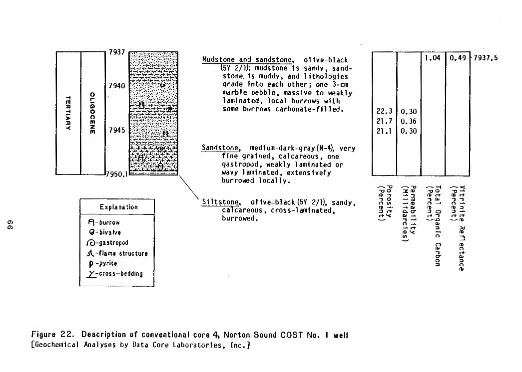
i 1
-I.04 ,7937.5
22.3 0.30 21.7 0.36 21.1 0.30
0-4 rmP Ei 2 0 > 0 P m 4 z
m
-
\ m m
0-b iva lve (&gastropod
A- f lame s t ruc ture p -pyrite
_LL-cross-bedding
Mudstone sandstone., o l i v e - b l a c kand (5Y 2/11; mudstone i s sandv.sand-.~. . ._
stone. i s mudd.y, and l i t h o l o g i e s g radein toeacho the r ; one 3-cm marblepebble,massivetoweakly 1 aminated, loca l burrows wi th some bur rowscarbonate- f i l l ed .
Sandstone, verymedium-dark-gray(N-4). f i neg ra ined .ca l ca reous , one gastropod.weaklylaminated or wavy laminated ,ex tens ive ly bu r rowedloca l l y .
S i l t s t o n e ,o l i v e - b l a c k (5Y 2/1), sandy, calcareous.cross- laminated, burrowed.
F i g u r e 22. D e s c r i p t i o n o f convent iona lcore 4, N o r t o n Sound COST No. I well [GeochemicalAnalysesbyDataCoreLaboratories,Inc.]
s idewa l l and th reeconvent iona lcoresamplesofsands tonef romth isin te rva l .
Permeabi l i t y rangesfrom 0.3 t o 21 mD i n t h e same samples,butthehigher
permeabi1ity v a l u e s i n t h i s range may be caused by disturbance of the 1i t h i c
~ f a b r i ca t t e n d a n t on t h et a k i n go fs i d e w a l lc o r e s . The h i g h e s tp e r m e a b i l i t yi n
a convent ionalcoresample was0.36 mD. Burrows and a gast ropodarepresent
i nt h es a n d s t o n eo fc o n v e n t i o n a lc o r e 4.
The SP c u r v e i s g e n e r a l l y f l a t t h r o u g h t h i s i n t e r v a l w i t h s c a t t e r e d ,
t h i n ,s h a r pk i c k si n d i c a t i v eo ft h i ns a n d s t o n e beds. The gamma-ray cu rveva r ies
e r r a t i c a l l y w i t h i n a l i m i t e dr a n g eo f A P I u n i t s . A s i n g l e6 0 - f o o t - t h i c k
sandstonebedfrom 5315 t o 5375 f e e t i s i n d i c a t e d by t h e SP and gamma-ray logs.
~ ~~ Deep and s h a l l o wr e s i s t i v i t y measurementsremain s i m i l a rt h r o u g ht h i si n t e r v a l ,
and r e s i s t i v i t y v a l u e s r e t a i n t h e v a r i a b i l i t y t h e y d i s p l a y e d i n t h e i n t e r v a l ~~ above. Average r e s i s t i v i t yi s between 1 and 2 ohm-m. Densi t iesrangefrom
2.0 t o 2.5 g/cm3 t h r o u g h t h i s i n t e r v a l , and t h e d e n s i t y l o g i n d i c a t e s an ~
a v e r a g ep o r o s i t yo f 25 pe rcen tfo rthe60- foo tsands tone bed. The s o n i cl o g
i n d i c a t e s a generaldecrease i n i n t e r v a l t r a n s i t t i m e f r o m 155 t o 95 p s / f o o t
downward t h r o u g h t h e i n t e r v a l , and t h ea v e r a g es o n i cp o r o s i t yc o r r e c t e df o r ~~
compaction i s 26 percentforthe60- footsandstone bed.
The presenceofg laucon i te and f o s s i l f r a g m e n t s i n t h e r o c k s i n t h i s
i n t e r v a l i n d i c a t e d e p o s i t i o n i n a marineenvironment.
67
9685-10,300 f e e t
The i n t e r v a lf r o m 9685 t o 10,300 f e e t i s c h a r a c t e r i z e d byinterbedded
sandstone andmudstone. Conventionalcore 5 i s from t h i si n t e r v a l and i s
descr ibed i n f i g u r e 23.
The sandstone i n t h i s i n t e r v a l i s m o d e r a t e l y t o w e l l s o r t e d and f i n e t o medium
grained. The sand g ra insa regenera l l ysub roundedto rounded. Pr incipalf ramework
components a requar tz ,muscov i te ,p lag ioc lase , andmetamorphicrockfragments.
Quartzcomprises 50 t o 65 percent o f t h e framework c l a s t s and inc ludesbo th
monoc rys ta l l i ne and p o l y c r y s t a l l i n eg r a i n s .M u s c o v i t ec o m p r i s e s1 5t o 30
percent o f thef rameworkc las ts and i s p r e s e n tg e n e r a l l yi nl a r g e ,u n a l t e r e d
grains.Plagioclasecomprises10 t o 20 percento fthef rameworkc las ts and i s
commonly untwinned,unal tered,andofa lb i t iccomposi t ion.Metamorphicrock
f ragmentscompr iseabout10percentofthef rameworkc lasts and c o n s i s t
predominant ly o f p h y l l i t e and f i ne -g ra inedmicasch is t andquartz-micaschist .
Minor amounts o f v o l c a n i cr o c kf r a g m e n t s ,p y r i t e ,c h l o r i t e , andbrown b i o t i t e
a r e commonly p resen tinthesands tone , and t h e o r i e n t a t i o n o f m i c a f l a k e s and
o t h e r e l o n g a t e c l a s t s commonly d e f i n e l a m i n a t i o n .
~~
D u c t i l eg r a i nd e f o r m a t i o n and p o s t d e p o s i t i o n a lc r i n k l e dm i c aa r e common
o f i n t e r v a l and have in tergranular~ i nt h e s a n d s t o n e st h i s reduced poros i ty .
Auth igen icquar tzcementa t ion has fu r the rreducedporos i t y . The combinat ion
quar tz g r a i n~ o f syn tax ia l overgrowths and d u c t i l e d e f o r m a t i o n has commonly
produced a t i g h t mosa ics t ruc tu reinthesequar t z - r i chrocks , and othercements
(descr ibed i ns h a l l o w e rs a n d s t o n e s )a r eg e n e r a l l yr e s t r i c t e dt oi s o l a t e d ,
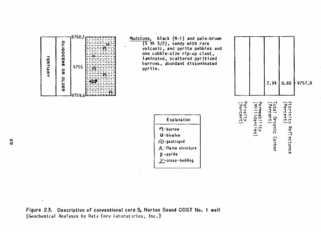
Mudstone, b lack (N-1 ) and pale-brown H~ T Y 5/2), sandy w i t h r a r e
vo lcan ic . and p y r i t ep e b b l e s and
2 n a<
IO m a
m u)
o n ec o b b l e - s i z er i p - u pc l a s t , l a m i n a t e d .s c a t t e r e dp y r i t i z e d burrows,abundantdissztninated p y r i t e .
Explanation
0 - b i v a l v e @-gastropod A- f lame structure p -pyriteix-cross-bedding
F igure 23. D e s c r i p t i o n o f convent ionalcore 5, Nor tonSound COST No. I well [GeochemicalAnal.yses b y D a t d C o r eL d h w d t J r i e s , Inc . ]
scatteredareas. Up t o 15 p e r c e n tv i s i b l ei n t e r g r a n u l a rp o r o s i t ye x i s t si n
some suchareaswithoutquartz cement. T h i sp o r o s i t ya p p e a r st ob el a r g e l y
secondary and t o havebeenformedbythedissolut ionofsparrycalc i te cement.
A s ing les idewa l lco ref rom a sandstone i n t h i s i n t e r v a l has 23.9 percent
p o r o s i t y and 18 mD pe rmeab i l i t y . The h i g hp e r m e a b i l i t yo ft h i s sample i s
probably due t of a b r i cd i s r u p t i o ni n d u c e d bysample co l lec t ion .Verylow
p e r m e a b i l i t i e ss h o u l d be expected f o r t h i s sandstone i n whichsmallporous
areasareiso la tedingenera l l yverynonporousrock .
Themudstone i s massive o r l a m i n a t e d w i t h t h e l a m i n a t i o n d e f i n e d by t h e
o r i e n t a t i o n o f m u s c o v i t e f l a k e s o r f l a t t e n e d c o n c e n t r a t i o n s o f o r g a n i c m a t e r i a l .
Themudstone i s l o c a l l y i n t e r l a m i n a t e d w i t h s a n d s t o n e and con ta inssca t te red
p a t c h e so fm i c r i t i cs i d e r i t e .R a r eb u r r o w sa r ep r e s e n ti nc o r e 5 (9750-9759.6
f e e t ) f r o m n e a r t h e t o p o f t h e i n t e r v a l .
The gamma-ray l o gm a i n t a i n st h e same c h a r a c t e rt h r o u g ht h i si n t e r v a l as i t
had i n t h e i n t e r v a l above bu tinc reasesabrupt ly20 A P I u n i t s i n averagevalue
a t t heupperboundaryo fthein te rva l . The SP l o gc o n t i n u e st h r o u g ht h i s
i n t e r v a lj u s t as i t was i nt h ei n t e r v a l above. An average deep r e s i s t i v i t y o f
about 4 ohm-m c h a r a c t e r i z e st h i si n t e r v a l .S h a l l o wr e s i s t i v i t y measurements
a r eg e n e r a l l y 1 ohm-m h igherthan deep r e s i s t i v i t y measurements,anddeepand
s h a l l o wr e s i s t i v i t y c u r v e s p a r a l l e l e a c ho t h e rt h r o u g ht h ei n t e r v a lw i t h a few
scat tered,largemagni tudekicks.Densi ty i sq u i t ev a r i a b l et h r o u g ht h i s
i n t e r v a lw i t he x t r e m ev a l u e so f 2 and 2.7 g/cm3, bu taveragedens i tyva lues
rangefrom 2.25 t o 2.55g/cm3. The d e n s i t yl o gi n d i c a t e s a p o r o s i t yo f 6
70
percent i n t h e v i c i n i t y o f a s i d e w a l lc o r et h a t has a measured p o r o s i t y o f
23.9 percent. The s o n i cl o g i s much l e s sv a r i a b l et h a nt h ed e n s i t yl o gt h r o u g h
t h i si n t e r v a l .I n t e r v a lt r a n s i tt i m er a n g e sf r o m 76 t o 102 Ps / foo tw i thave rage
valuesgeneral lybetween90and95)s/foot. The s o n i cl o gi n d i c a t e s a p o r o s i t y
o f 22 p e r c e n t i n t h e v i c i n i t y o f t h e abovementionedsidewallcore.
A l thoughne i the rmar inefoss i l sno renv i ronmen ta l l yspec i f i csed imen ta ry
s t r u c t u r e s havebeenobserved i n t h e r o c k s o f t h i s i n t e r v a l , it i s l i k e l y t h a t
t h e t h i c k sequence o f burrowedmudstone and sandstone was d e p o s i t e d i n a marine
envi ronment.
10,300-10,640 f e e t
The i n t e r v a lf r o m 10,300 t o 10,640 f e e t i s c h a r a c t e r i z e d byinterbedded
sandstone,mudstone,andigneousrock.Conventionalcore 6 i s f r o mt h i si n t e r v a l
and i s d e s c r i b e d i n f i g u r e 24.
The s e d i m e n t a r yr o c k so ft h i si n t e r v a la r es i m i l a rt ot h o s eo ft h ei n t e r v a l
above. The predominantigneousl i tho logy i sb a s a l t ,w h i c h i s f i n e -t o medium
~~ g r a i n e dw i t h a maximum g r a i ns i z eo fa b o u t 2 mm. Most o ft h i sb a s a l td i s p l a y s
an i n t e r s e r t a l t e x t u r e i n w h i c h t h e i n t e r s t i c e s between t h ep l a g i o c l a s el a t h s
~~ a r e f i l l e d w i t h c a l c i t e , c l a y , and magnet i te. Some raggedgra inso fc l inopyroxene
a r ep r e s e n ti nt h ei n t e r s t i t i a l fill. Calci te,chalcedony,andclayamygdules
7 1
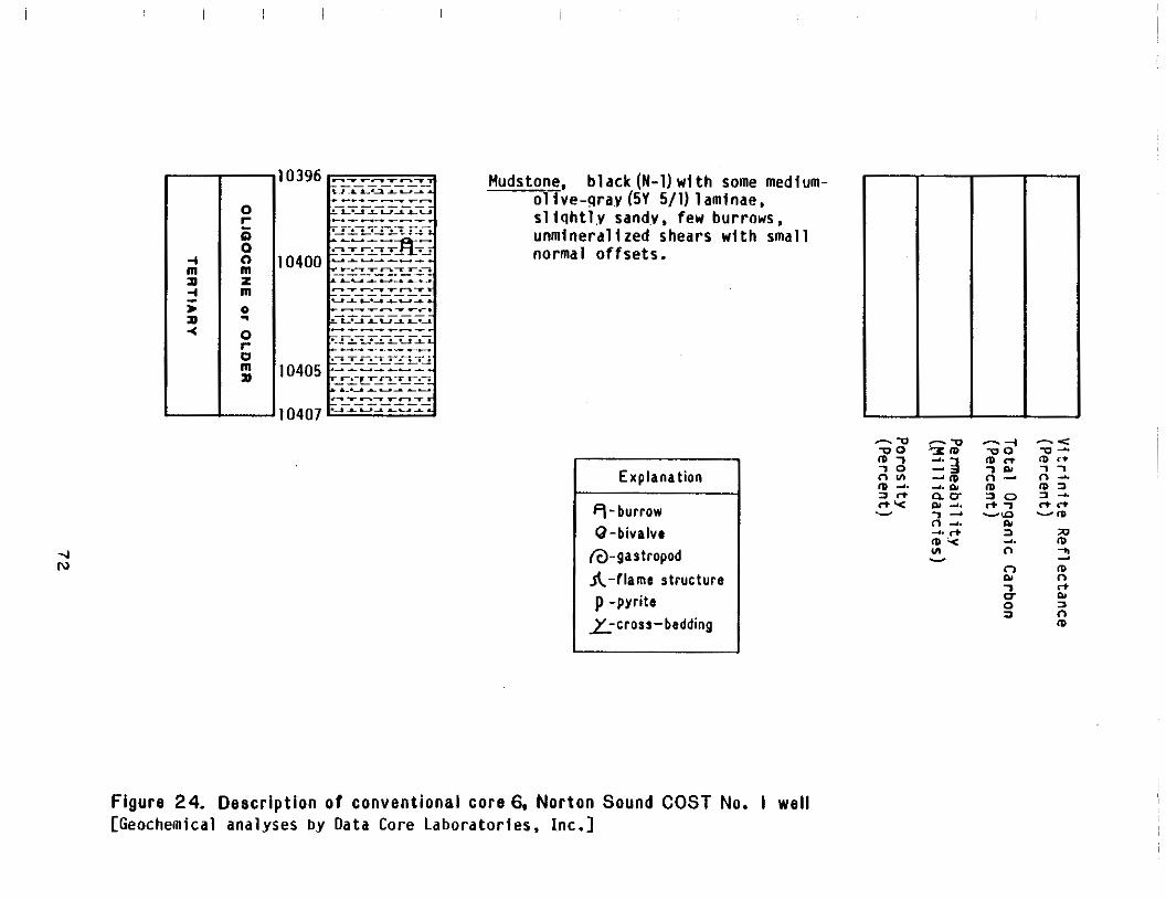
I
Mudstone, b lack (N-1) w i t h some medium-o l i v e - g r a y (5V 5/11 laminae. s l i q h t l y sand.v,fewburrows, unmineral izedshearswithsmall normalo f fse ts .
0 -b iva lve a-gastropod A-flame structure p -pyrite
L-cross-bedding
W m 2 m n
7 rr v n4 0 3 a 0 m
F i g u r e 24. D e s c r i p t i o n o f convent iona lcore 6. N o r t o nS o u n d COST No. 1 well [Geochemicalanalyses by DataCoreLaborator ies,Inc. ]
were
arepresent i n some samples. A s idewal l -coresamplefrom 10,332 f e e t i s a ~~
t r a c h y t e t e x t u r a l l y s i m i l a r t o t h e b a s a l t d e s c r i b e d abovebutconta inspotass ium
f e l d s p a ri n s t e a do fp l a g i o c l a s e . The i n t e r s t i c e s be tweenthefe ldsparla ths ~
a r e f i l l e d w i t h c a l c i t e , c l a y , and magne t i t ew i th some remnants o fc l i ' nopyroxene
analc l ime l i t h o l o g y- and subhedra l crysta ls . A t h i r d i g n e o u s i s b yr e p r e s e n t e d
a s idewal l -coresamplefrom 10,346 f e e t w h i c h c o n s i s t s o f a l t e r e d v i t r o p h y r e
i n whichcl inopyroxeneremnants and chalcedonyamygdulesarepresent i n a c l a y
mat r ix . ~
~~ Whole rock analysesrun on two samplesofchemical smal l f ine-grained
b a s a l t o b t a i n e d f r o m c u t t i n g s f r o m 10,320 t o 10,350and from 10,590 t o 10,620
fee t . The analyseswere made f o rM i n e r a l s Management ServicebyChemical and
Geo log ica lLabora tor ieso fA laska, Inc., u s i n gt h ei n d u c t i v e l yc o u p l e da r g o n
plasmamethod ofatomicemiss ionspect roscopy.Normal izedresul tsofthe
were c a l c u l a t e C.I.P.W. norms f o r Analyt ical~~ analyses used t o t h e samples.
resu l tsexpressedinox ideweigh tpercent ,normal izedox ide-we igh t -percent ~~
values,and norms arepresented i n Table 1 w i t h o x i d e c o m p o s i t i o n s o f t h o l e i i t i c
and a l ka l ibasa l t .To ta lox idewe igh tpe rcen ts as determined i nt h ea n a l y s e s
d e v i a t es i g n i f i c a n t l yf r o m 100. Loss on i g n i t i o n o f v o l a t i l e s was notrecorded,
~ and g i v e nt h el a r g e amounts o f c a l c i t e and c l a yo b s e r v e di nt h i ns e c t i o n so f
t h eb a s a l t , i t i s l i k e l y t h a t c o n s i d e r a b l e c a r b o n d i o x i d e andwaterwere so -.
l o s t . The b a s a l t samples areabnormal lylow i na l k a l i s ,e s p e c i a l l y sodium
(Table M i y a s h i r o ' s o f t o magnesium-oxide~ ox ide 1) . Based o n p l o ti r o n - o x i d e
r a t i o a g a i n s t s i l i c a (1974),which i s independento fa lka l icon ten t ,thesamples
~ a r e c l a s s i f i e d as t h o l e i i t i c .
7 3
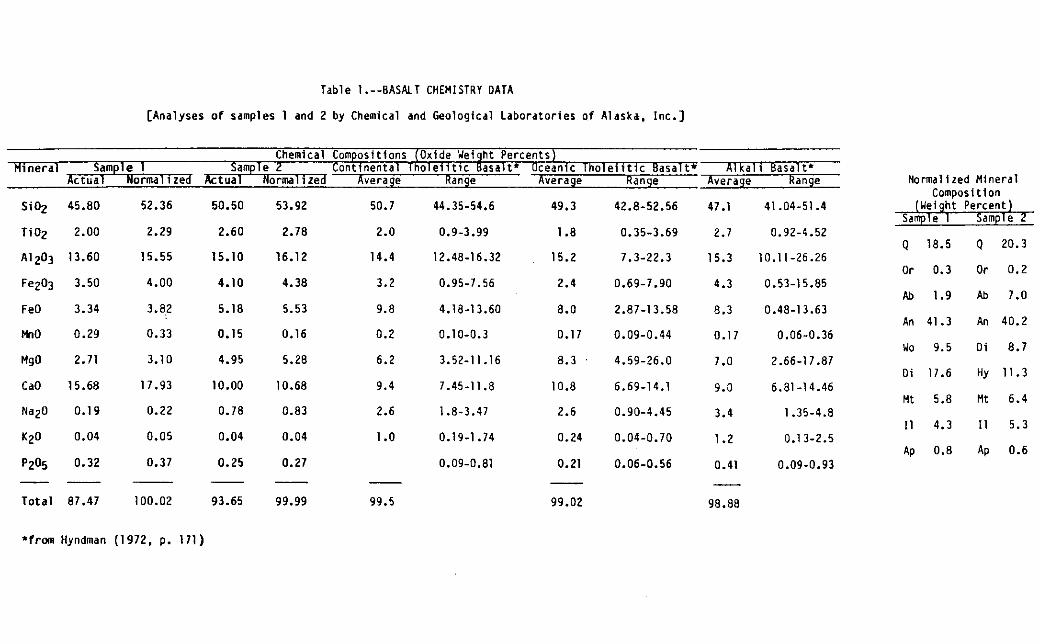
A1203
- - -
50.7
Normal ized
I I I I I I I
Table 1.--BASALT CHEMISTRY DATA
[Analyses o f samples 1 and2byChemicalandGeologicalLaboratories o f Alaska,Inc.]
ChemicalComposit ions(OxideUeightPercents) H ~ n e r a l
A c t u a l No r m a l l zed Ac t u a l Normal ized Average Range Average Range Average Range Mineral Composition
Si02 45.80 52.36 50.50 53.92 49.3 44.35-54.6 42.8-52.56 47.1 41.04-51.4 (WeightPercent) Sample 1 Sample2
Ti02 2.00 2.29 2.60 2.78 2.0 0.9-3.99 1.8 0.35-3.69 2.7 0.92-4.52 0 18.5 Q 20.3 ~
13.60 15.55 15.10 16.12 14.4 12.48-16.32 15.2 7.3-22.3 15.3 10.11-26.26 Or 0.3 Or 0.2 ,
Fez03 3.50 4.00 3.2 4.10 4.38 0.95-7.56 2.4 0.69-7.90 4.3 0.53-15.85 Ab 1.9 Ab 7.0 ~
FeO 3.34 3.82 5.18 5.53 9.8 4.18-13.60 8.0 2.87-13.58 8.3 0.48-13.63 An 41.3 An 40.2
MnO 0.29 0.33 0.15 0.16 0.2 0.10-0.3 0.17 0.09-0.44 0.17 0.06-0.36 no 9.5 Oi 8.7
Hg0 2.71 3.10 4.95 5.28 6.2 3.52-11.16 8.3 4.59-26.0 7.0 2.66-17.87
CaO 15.68 17.93 10.00 10.68 9.4 7.45-11.8 10.8 6.69-14.1 9.0 6.81-14.46 M t 5.8 M t 6.4
NaZO 0.19 0.22 0.78 0.83 2.6 1.8-3.47 2.6 0.90-4.45 3.4 1.35-4.8 I 1 4.3 I 1 5.3
K20 0.04 0.05 0.04 0.04 1 .o 0.19-1.74 0.24 0.04-0.70 1.2 0.1 3-2.5
P2O5 0.32 0.37 0.25 0.27 0.09-0.81 0.21 0.06-0.56 0.41 0.09-0.93 Ap 0.8 Ap 0.6
- - - - -T o t a l 87.47 100.02 93.65 99.99 99.5 99.02 98.88
Sample 1 Sample2 C o n t i n e n t a lT h o l e i i t i c B a s a l t ' Oceanic T h o l e i i t i cB a s a l t * A1 k a l i Basal t '
Oi 17.6 Hy 11.3
'fran Hyndman (1972. p. 171)
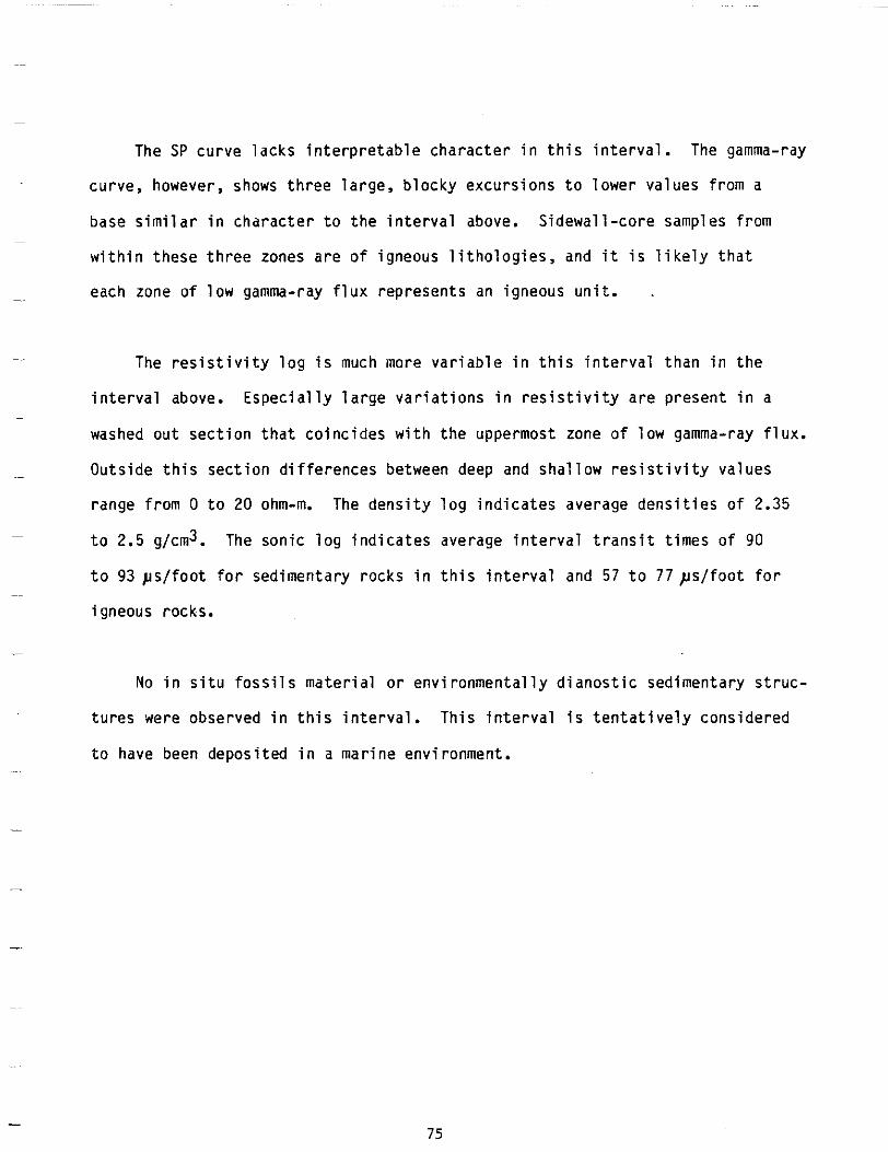
The SP curvelack s i n t e r p r e t a b l ec h a r a c t e ri nt h i si n t e r v a l . The gamma-ray
curve,however, shows th reela rge ,b lockyexcu rs ionstolowerva luesf rom a
b a s es i m i l a ri nc h a r a c t e rt ot h ei n t e r v a l above. Sidewall-coresamplesfrom
w i t h i nt h e s e t h r e e zones a r eo fi g n e o u sl i t h o l o g i e s , and i t i s l i k e l y t h a t
each zone o fl o w gamma-ray f l u xr e p r e s e n t s an igneousuni t .
-~ The r e s i s t i v i t y l o g i s much more v a r i a b l e i n t h i s i n t e r v a l t h a n i n t h e
i n t e r v a l above. E s p e c i a l l yl a r g ev a r i a t i o n si nr e s i s t i v i t ya r ep r e s e n ti n a
washed ou tsec t iontha tco inc ideswi ththeuppermost zone o f l o w gamma-ray f l u x .
~- O u t s i d e s e c t i o n and s h a l l o w v a l u e st h i s d i f f e r e n c e s between deep r e s i s t i v i t y
rangefrom 0 t o 20 ohm-rn. The d e n s i t yl o gi n d i c a t e sa v e r a g ed e n s i t i e so f 2.35
t o 2.5g/cm3. The s o n i cl o gi n d i c a t e sa v e r a g ei n t e r v a lt r a n s i tt i m e so f 90
t o 93 y s / f o o t f o r s e d i m e n t a r y r o c k s i n t h i s i n t e r v a l and 57 t o 77 p s / f o o t f o r
igneousrocks.
.-
No i ns i t uf o s s i l sm a t e r i a lo re n v i r o n m e n t a l l yd i a n o s t i cs e d i m e n t a r ys t r u c ~~ tureswereobserved i nt h i si n t e r v a l .T h i si n t e r v a li st e n t a t i v e l yc o n s i d e r e d
t o havebeendeposited i n a marineenvironment.
75
Nothing i nt h ep e t r o l o g yo ft h ei g n e o u sr o c k so ft h i si n t e r v a le n a b l e s a
~~ d e t e r m i n a t i o nt ob e made as t o whethertheywereemplacedassurfacef lowsor
hypabyssalintrusions. However, t h eh o l o c r y s t a l l i n et e x t u r e st h a tp r e d o m i n a t e ~~
i n c u t t i n g s and s idewa l lco re samples o f t h e i g n e o u s r o c k s a r e d i f f i c u l t t o
assoc ia tewi thsubmar ineerupt ion . The sedimentaryrocks i nt h i si n t e r v a la r e -
Ol igoceneoro lder(seePa leonto logy and B i o s t r a t i g r a p h ys e c t i o no ft h i sr e p o r t ) .
. I f the fromigneousrad iomet r i c age o f 19.9 m.y. derived an sample i sc o r r e c t ,
thenthevo lcan icrocksmustbein t rus ive(seerad iomet r ic age subsect ion .~~
be l ow).
10,640 t o 12,235 f e e t
~~
The i n t e r v a lf r o m 10,640 t o 12,235 f e e t is character izedbysandstones and -
mudstones t h a t a r e l i t h o l o g i c a l l y s i m i l a r t o t h o s e o f t h e two u n i t s above.
Conventionalcores 7, 8, and 9 a r ef r o mt h i si n t e r v a l and a r ed e s c r i b e di n -
f i g u r e s 25, 26, and 27.Much o ft h es a n d s t o n ei si nt h i n ,g r a d e d beds. Many
o f t h e s e a r e t o p p e d w i t h s i l t s t o n e o r mudstoneand may bedescribedasTbcd
Bouma sequences (Bouma, 1962). Thickersandstonebedsassociatedwiththese
Bouma sequences i n cores 7 and 8 a r e s i m i l a r t o t h o s e o f t h e M u t t i - R i c c i L u c c h i
f a c i e s C ( M u t t i and Ricc iLucchi ,1972) . Some beds i nc o r e 8 haveflame
s t ruc tu redeve lopeda longthe i r bases. Sha ler ip -upc las ts and p a r t i n g s , and
coalf ragments,s t r ingers, and l e n s e sa r es c a t t e r e di nt h et h i c k e r , more massive
sandstone beds. Thereare some burrows i n c o r e 7.
76
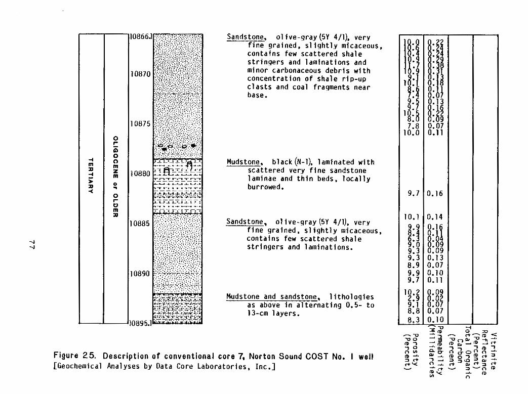
I I , I I I j I
0 c 0 0 0 m z m 0. 0 r 0 m n
-4 -4
Sandstone. 01 i ve -g ray (5Y 4/1), very f inegra ined,s1 ight l .ymicaceous, con ta ins few sca t te redsha le s t r i n g e r s and laminat ions and minorcarbonaceousdebr iswith concen t ra t i ono fsha ler ip -up c l a s t s andcoalfragmentsnear base.
Mudstone, b lack (N-1). l am ina tedw i th sca t te red ver.y f i n e sandstone laminae and t h i n beds, l o c a l l y burrowed.
Sandstone, o l i v e - g r a y (5Y 4/11, ver.y f inegra ined, s l i g h t l y micaceous, con ta ins few sca t te redsha le s t r i n g e r s and laminat ions.
Mudstone sandstone, l i t h o l o g i e sand a s above i n a l t e r n a t i n g 0.5- t o 13-cm layers .
--
9: 8 0.
7.8 0.07 0.0 0.11
9.7 0. I6
0.1 0.14 9.9
9.3 0.09 9.3 0.13 8.9 0.07 9.9 0.10 9.7 0.11
0.2 0.09 2.9 0.02 9.1 0.07 8.8 0.07 8.3-
F i g u r e 25. D e s c r i p t i o n o f c o n v e n t i o n a lc o r e 7, N o r t o nS o u n d COST No. I wel l [GeochemicalAnalysesbyDataCoreLaboratories,Inc.]
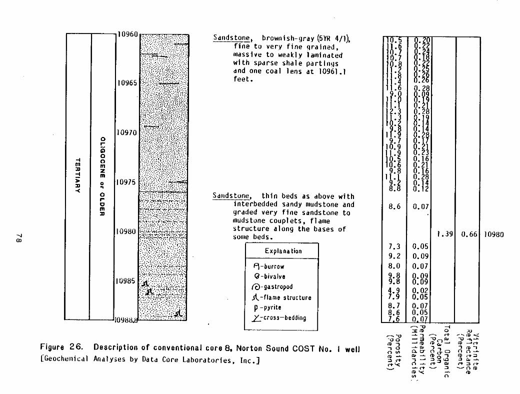
I
Sdrldstonebrownish-gray ( 5 V H 4/1), f i n e l t o v e r y f i n e qra ined , llldSSiVe t o wedklylal l l indted w i thspdrsesha lepar t i ngs dndone coa llens a t 10961.1 feet .
SdndstunI, t h i n beds a s dbove w i t h interbedded sandynludstoneand grddedveryf inesdndstoneto l l ludstonecouplets.f ldwe s t ruc tu rea longthebasesof sollle beds.
Explanation
0 - b i v a l v e m-gas t ropod A-flame structure p -pyrite
L-cross-bedding7
m
9.710.9 I 9b: 510.6
8.
8.6
7.3 9.2 8.0 9. a 9.8 4.9 7.9 8.7 8.67.6
0.28
0.2 0.16 0.21 0.16
0.
0.07
1.39 10980 0.05 0.09 0.07
F i g u r e 26. D e s c r i p t i o n o f convent iona lcore 8, N o r t o nS o u n d COST No. I w e l l [Geochewlicdl AndlyieS b.y o a t d Core Labordtor ies,Inc. ]
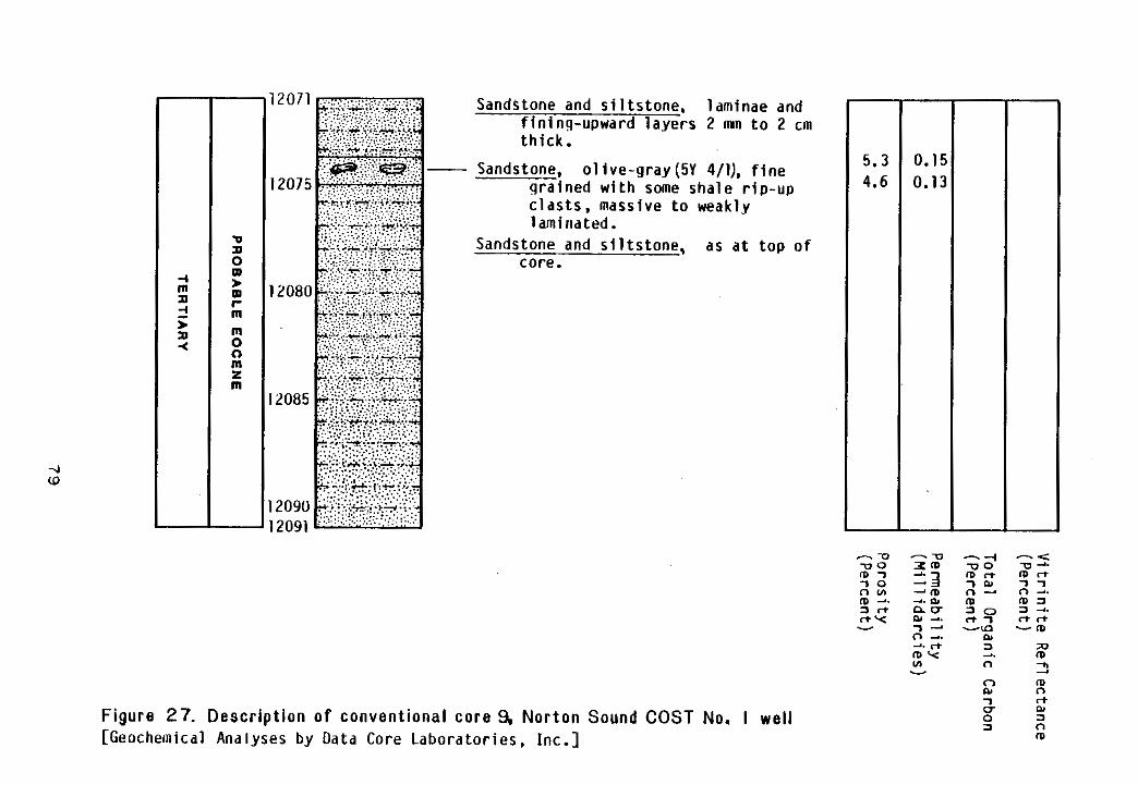
I ! l
Sandstoneand s i l t s t o n e ,l a m i n a e and f in ing-upwardlayers 2 mn t o 2 cm t h i c k .
Sandstone, 01 i ve -gray (5Y 4/1), f i n e g r a i n e dw i t h some s h a l er i p - u p c las ts ,mass ivetoweak ly laminated.
Sandstoneand s i l t s t o n e ,a sa tt o po f core.
--
5.3 0.1! 4.6 0.1:
F i g u r e 27. D e s c r i p t i o n o f convent iona l core 9,N o r t o nS o u n d COST No. I wel l [GeochemicalAnalysesbyData Core Labora tor ies ,Inc . ]
The same comb ina t iono fduc t i l eg ra inde fo rma t ion and authigeniccementat ion
t h a t a f f e c t e d i n t e r g r a n u l a r space i n t h e sandstone i n t h e t w oi n t e r v a l s above
o b t a i n si nt h es a n d s t o n eo ft h i si n t e r v a l .I n t e r g r a n u l a rp o r o s i t yi nt h i s
sandstone i s a l sos im i la rtotha tdesc r ibedf romsands tonesinthesha l l ower
in te rva ls .Poros i tyreaches 27.9 percent and p e r m e a b i l i t y 0.38 mD i ns i d e w a l l
c o r e sf r o mt h i si n t e r v a l . However, i n 71 samplesfromconventionalcores,
where f a b r i c d i s r u p t i o ni n sampling i s l e s sl i k e l yt h a ni ns i d e w a l lc o r e s ,
poros i tyrangesf rom 2.9 t o 11.9 pe rcen t(w i th all bu tth reeva luesh ighe r
than 5 percent) , and permeabi l i tyrangesf rom 0.02 t o 0.38 mD.
The SP l o g c u r v e i s e r r a t i c and cannotbemeaningfu l lyin terpreted. The
gama- raylogcu rvede f ines numerous sandstonebeds from 10 t o more than100
f e e tt h i c k . There i s approximatelyabout 720 f e e to fs a n d s t o n ei nt h i s1 5 9 5 - f o o t
i n t e r v a l . The r e s i s t i v i t yl o gc o n t i n u e ss m o o t h l yi n t ot h i si n t e r v a lf r o mt h e
i n t e r v a l above. The o v e r a l lb l o c k yc h a r a c t e ro ft h er e s i s t i v i t yc u r v e sr e f l e c t s
thepresenceoftheth icksandstone beds i n d i c a t e d on t h e gamma-ray log , and a
separat ionofaround 10 ohm-m i s common between t h e deepand s h a l l o w r e s i s t i v i t y
curves i n t h e sandstone beds. The d e n s i t yl o gc u r v e has t h e same v a r i a b l e
charac ter i t had i n sha l l owerin te rva l s . The extremedensi tyvaluesare 2.17
and 2.87 g / c d and theaveragevaluesrangefrom 2.5 t o 2.8g/cm3. The
d e n s i t y l o g i n d i c a t e s p o r o s i t i e s o f 0 t o 9 percentforsandstone i n t h i s i n t e r v a l .
80
The s o n i c l o g i s l e!ss v a r i a b l e t h Ian t h e d e n s i t y 1og i n t h i s i n l t e r v a l and has a
genera l lyb lockycharacter . Lower i n t e r v a lt r a n s i tt i m e sa r ea s s o c i a t e dw i t h
~~ sandstone beds. The t o t a l range o fi n t e r v a lt r a n s i tt i m e si s 55 t o 105 p / f o o t ,
buttheaveragevaluesarebetween 67 and 87 p s / f o o t . The s o n i cl o gi n d i c a t e s
~~ p o r o s i t i e s o f 6 t o 18percentforsandstone i n t h i s i n t e r v a l .
No m a r i n ef o s s i l s wererecovered.However, t h ep r e s e n c eo ft h i n Bouma
sequences among thickermassivesandstone bedsand f l a m es t r u c t u r e sa tt h e
basesandpreservedburrows a t t hetops o f some beds i n d i c a t e d e p o s i t i o n o f a t
l e a s t p a r t o f t h e i n t e r v a l b y t u r b i d i t y c u r r e n t s b e l o w wave base i n a subaqueous
environment. ~~-
12,235-12,545 f e e t
The i n t e r v a lf r o m 12,235 t o 12,545 f e e t i s c h a r a c t e r i z e d byinterbedded
sandstone,s i l ts tone,shale,coal , and conglomerate.Conventionalcore10 i s
f r o mt h i s i n t e r v a l and i s descr ibed i n F i g u r e 28.
Sandstone i s verypoor lysor ted.Coarserf rameworkc lastsconsis t
p r e d o m i n a n t l y o f p h y l l i t e and f ine-gra inedquar tz-muscovi teschis tf ragments.
Cons ide rab lede t r i t a lspa r rydo lomi tei sp resen t among t h e f i n e r framework
c lasts.Quartz,mostofwhich i s p o l y c r y s t a l l i n e , and che r ta rea lsop resen t
i n t h e sandstoneframework.Clastsaregeneral lysubangular, and o r i e n t a t i o n
o fe l o n g a t ec l a s t s commonly d e f i n e st h el a m i n a t i o ni nt h e sandstone. The
sandstone i nc o r e1 0c o n t a i n s some burrows.
81
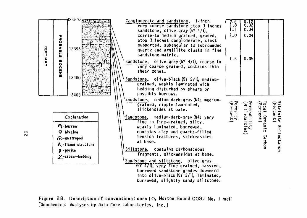
m ' c
I I
r m m
m Z m
Explanation
m 0-bivalveN
@-gastropod A- f lame structure p -pyrite
z-cross-bedding
Conglomerate Sandstone. 1 - inchand _____-I__
verycoarseSandstoneatop 3 inches sandstone, 01 ive-gray ( 5 ~4/1), coarse-tomedium-grdined.grdded, a top 3 inchesconglomerate,c last supported.subangul a r t o subrounded quar tz dnd a r g i l l i t e c l d s t s i n f i n e sandstonematrix.
Sandstone. 01 ive-gray (5Y 4/1), coarseto verv coarse gra ined, conta ins th in shearzones.
Sandstone, o l i v e - b l a c k (5Y 2/1), mediumgrained,weaklylaminatedwith beddingdisturbedbyshears or possibly burrows.
'Sandstone.medium-dark-gray (N4), medium- - w -'00gra ined.r ipp le- laminated, ID-? 3 m
s l i c k e n s i d e s a t base. 7 0 - 3 $ 2 . I: 3 r * nuSandstone,medium-dark-gray (N4!, very rtY w - .
f i n e n -.t of i n e - g r a i n e d , s i l t y , v 7 -
weaklylaminated,burrowed, 2.I+
con ta ins and q u a r t z - f i l l e d Y)c lay tens ionf rac tu res ,s l i ckens ides a t base.
Si l tstone, carbonaceouscontdins fragments,sl ickensides a t base.
Sandstoneand s i l t s t o n e , 01 ive-gray 5Y 4/11. veryf inegra ined,massive, burrowedsandstonegrades downward i n t o o l i v e - b l a c k (5Y Z/l),laminated. burrowed, s l i g h t l y sandy s i1 ts tone.
Figure 28. Description o f conventionalcore IO, NortonSound COST No. I well [GeochemicalAnalysesby D a t a Core Laborator ies, Inc.]
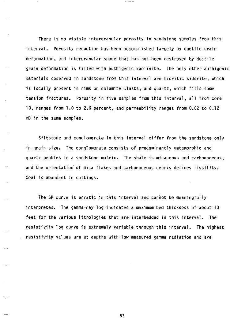
There i s no v i s i b l ei n t e r g r a n u l a rp o r o s i t yi ns a n d s t o n e samples f r o m t h i s
i n t e r v a l .P o r o s i t yr e d u c t i o n hasbeenaccompl ishedlarge lybyduc t i legra in
deformat ion, and i n t e r g r a n u l a r space t h a t has no t been des t royedbyduc t i l e
g r a i nd e f o r m a t i o ni sf i l l e dw i t ha u t h i g e n i ck a o l i n i t e . The on lyo the rau th igen ic
mater ia lsobserved i n sandstonefrom t h i s i n t e r v a l a r e m i c r i t i c s i d e r i t e , w h i c h
i s l o c a l l y p r e s e n t i n r i m s on do lomi tec las ts , and quartz,which f i l l s some
t e n s i o nf r a c t u r e s .P o r o s i t yi nf i v e samples f r o mt h i si n t e r v a l ,a l lf r o mc o r e
10,rangesfrom 1.0 t o 2.6 percent, and permeabi l i tyrangesf rom 0.02 t o 0.12
mD i n t h e same samples.
S i l t s t o n e and conglomerate i n t h i s i n t e r v a l d i f f e r f r o m t h e sandstoneonly
i ng r a i ns i z e . The conglomerateconsistsofpredominant lymetamorphic and
quartzpebbles i n a sandstonematrix. The shale i s micaceousandcarbonaceous,
and t h e o r i e n t a t i o n ' o f mica f l a k e s andcarbonaceous d e b r i s d e f i n e s f i s s i l i t y .
Coal i s abundant i nc u t t i n g s .
The SP curve i s e r r a t i c i n t h i s i n t e r v a l and cannot be mean ing fu l l y
i n t e r p r e t e d . The gamma-ray l o gi n d i c a t e s amaximum bedthicknessofabout10
f e e tf o rt h ev a r i o u sl i t h o l o g i e st h a ta r ei n t e r b e d d e di nt h i si n t e r v a l . The
r e s i s t i v i t yl o gc u r v ei se x t r e m e l yv a r i a b l et h r o u g ht h i si n t e r v a l . The h ighes t
r e s i s t i v i t y v a l u e s a r e a t d e p t h s w i t h l o w measured gamma r a d i a t i o n and are
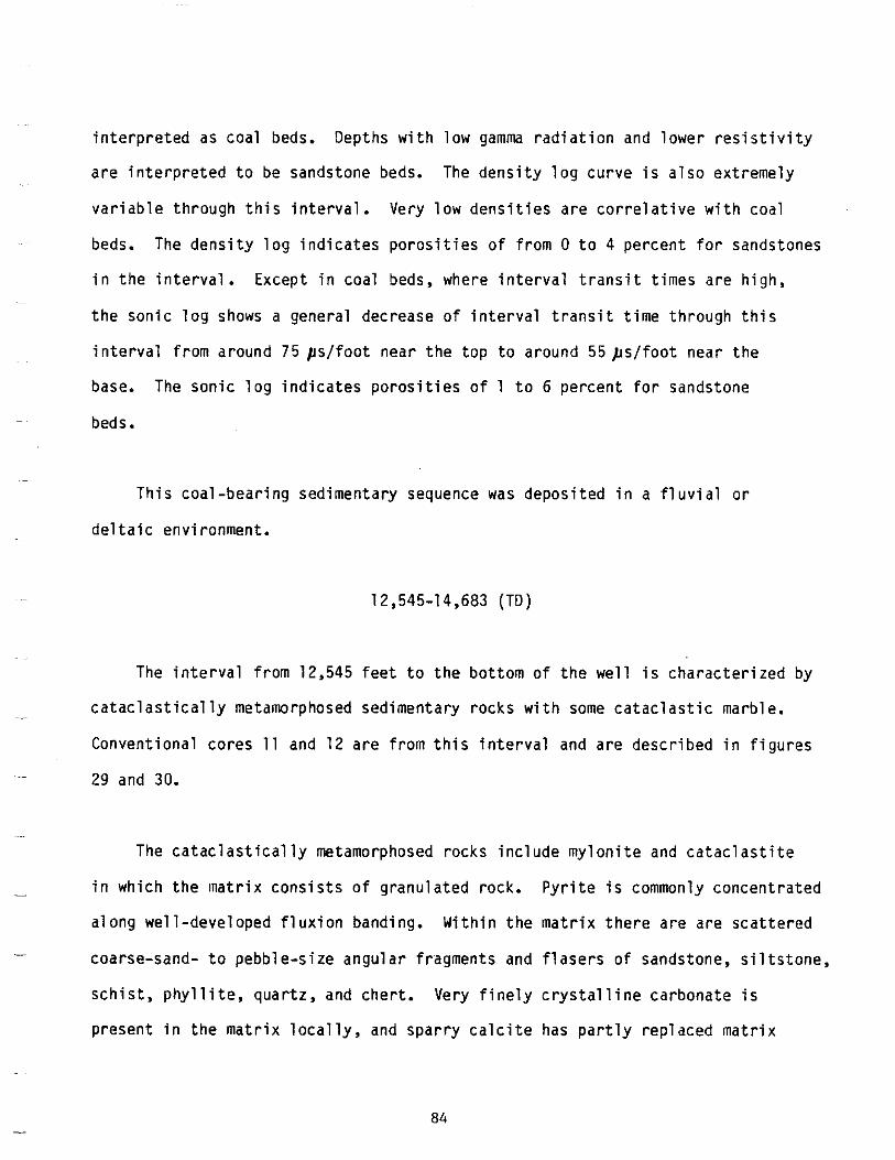
deltaic
i n t e r p r e t e d ascoal beds. Depthswithlow gamm r a d i a t i o n and l o w e rr e s i s t i v i t y
a r e i n t e r p r e t e d t o be sandstone beds. The d e n s i t yl o gc u r v ei sa l s oe x t r e m e l y
v a r i a b l et h r o u g ht h i si n t e r v a l . Ve rylowdens i t i esa reco r re la t i vew i thcoa l
beds. The d e n s i t yl o gi n d i c a t e sp o r o s i t i e so ff r o m 0 t o 4 percentforsandstones
i nt h ei n t e r v a l . Except i n coal beds,where i n t e r v a lt r a n s i tt i m e sa r eh i g h ,
t h es o n i cl o g showsa g e n e r a ld e c r e a s eo fi n t e r v a lt r a n s i tt i m et h r o u g ht h i s
in terva lf romaround 75 p / f o o t nea rthetoptoa round55ps / foo tnearthe
base. The s o n i cl o gi n d i c a t e sp o r o s i t i e so f 1 t o 6 percentforsandstone
~ beds.
~
Thiscoal-bear ingsedimentary sequence was deposi ted i n a f l u v i a l o r
-~ environment.
12,545-14,683 (TD)
The i n t e r v a lf r o m 12,545 f e e tt ot h eb o t t o mo ft h ew e l l i sc h a r a c t e r i z e db y
~ ~~ c a t a c l a s t i c a l l y metamorphosed rocks marb le .sedimentary with some ca tac las t i c
Conventionalcores 11 and12aref romth i sin te rva l and a r ed e s c r i b e di nf i g u r e s
~~.~ 29and 30.
._
The c a t a c l a s t i c a l l y metamorphosed rocksinc ludemy lon i te and c a t a c l a s t i t e
t h e c o n s i s t sg r a n u l a t e d P y r i t e- i n w h i c h l n a t r i x o f r o c k . i s commonly concentrated
a longwel l -developedf lux ionbanding.Wi th inthematr ixtherearearescat tered
- coarse-sand- t o pebble-sizeangularfragments and f l a s e r s ofsandstone, s i l t s t o n e ,
s c h i s t ,p h y l l i t e ,q u a r t z , and c h e r t .V e r yf i n e l yc r y s t a l l i n ec a r b o n a t ei s
present i n t h e m a t r i x l o c a l l y , and s p a r r y c a l c i t e has p a r t l y r e p l a c e d m a t r i x
84
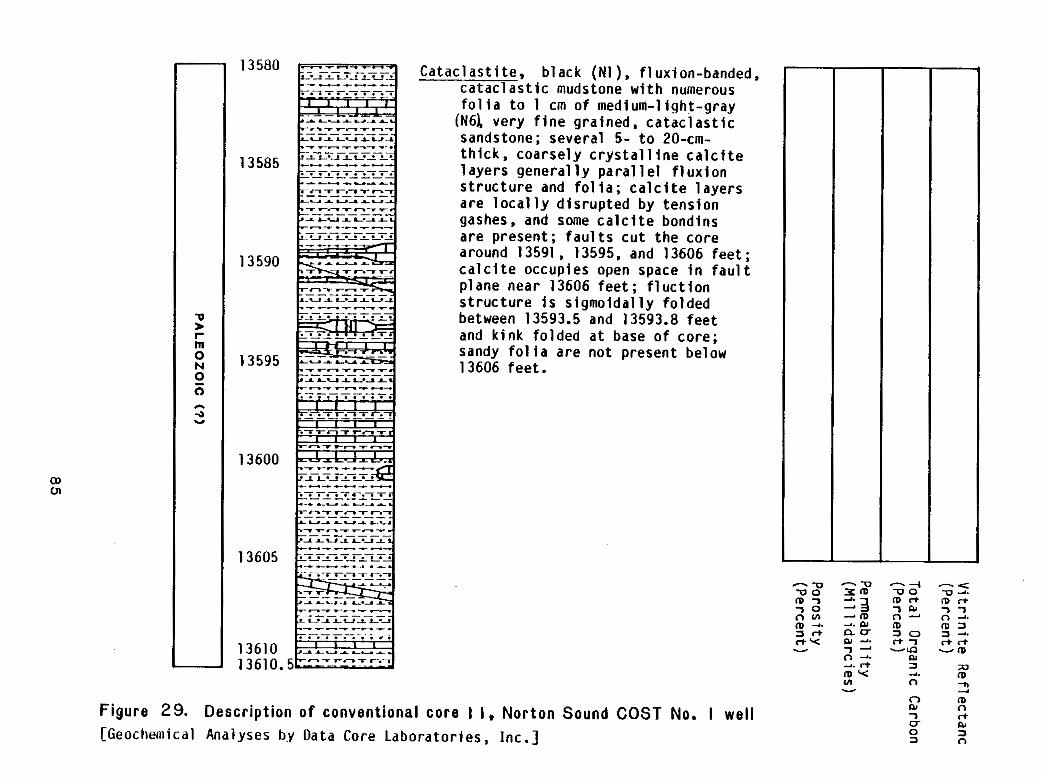
I ! I i I i 1
Cat a c l a s t i t e ,b l a c k ( N l ) . f luxion-banded,-c a t a c l a s t i c mudstone w i t h numerous f o l i a t o 1 cm ofmedium-l ight-gray
(N61 ve ryf i neg ra ined ,ca tac las t i c sandstone;several 5- t o 20-cm-t h i c k , c o a r s e l y c r y s t a l l i n e c a l c i t e l a y e r sg e n e r a l l yp a r a l l e lf l u x i o n s t r u c t u r e and f o l i a ; c a l c i t e l a y e r s a r e l o c a l l y d i s r u p t e d b y t e n s i o n gashes,and some c a l c i t e b o n d i n s a r e p r e s e n t ; f a u l t s c u t t h e c o r e around 13591 , 13595.and13606 f e e t ; c a l c i t e o c c u p i e s openspace i n f a u l t p lanenear 13606 f e e t ; f l u c t i o n s t r u c t u r ei ss i g m o i d a l l yf o l d e d between 13593.5 and 13593.8 f e e t and k inkfo ldedatbaseofcore : sandy fo l iaarenotpresentbe low 13606 f e e t .
--.QZ r n- 3 - m-. Iyn o Iy -.
13610 7 -n -.13610.5 -. rt m -VI v
Figure 29. Descr ip t ion o f conventional c o r e I I , Norton Sound COST No. I well [GeochemicalAnalyses b y D a t a CoreLaboratories,Inc.]
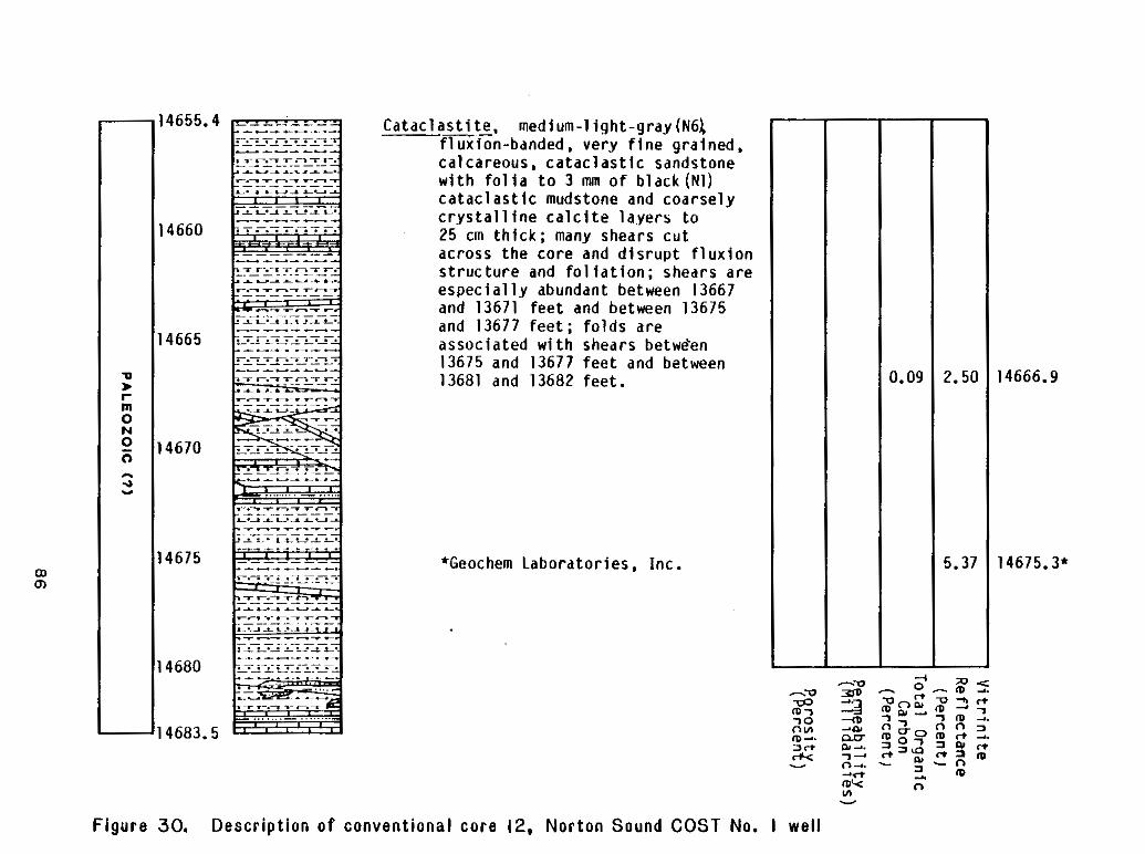
W
98
n -. (D c
I d
d
d
3
d
3
dI
e
e
e
P
e
e
e
m
m
m
m
m
m
mW
W
v
v
m
m
Ln
w
0
Ln
0
VI
0
cn
0
cn
e
m
v)0
-I -. V
0
a
c
m
s
-. 0 a
W
* GI c)
ID
0
-0 0
m
J
ID3
z
0
-3
C
T
n
0
a
0 d.
v)
m
0
v)
c
a
IC
L
a
0
n
0
v,
-I z
0
I I
4
e
m
U
cn
*
p a r t l y and rockf ragmentsorf lasers. A fewscatteredpressure shadows are
f i l l e dw i t ha u t h i g e n i ck a o l i n i t e . There i s no v i s i b l ep o r o s i t yi nt h e s er o c k s .
The c a t a c l a s t i cm a r b l e sa r ev e r yf i n e l yt oc o a r s e l yc r y s t a l l i n e .B o u n d a r i e s
betweencarbonategrainsare commonly sutured. The presence o fq u a r t zg r a i n s
o ra r g i l l a c e o u sm a t e r i a ll o c a l l yd e f i n e s a f o l i a t i o n i n t h e t h e marble. Numerous
de fo rmat iona lfea tu resinc lud ingfau l t s ,tens ion gashes, f o l d s , and boudins
arepresent i nt h ec o n v e n t i o n a lc o r e sf r o mt h i si n t e r v a l .
The SP curve wandersandcannotbeinterpreted. Thegamma-ray curve i s
b lockyon a l a rgesca le and suggestssegregation of shalyfromnonshaly
l i t h o l o g i e s .R e s i s t i v i t i e sa r eh i g h , and s h a l l o w r e s i s t i v i t y i s commonly f rom
20 t os e v e r a l 100 ohm-m h igherthan deep r e s i s t i v i t y . The d e n s i t yl o gi n d i c a t e s
d e n s i t i e so ff r o m 2.7 t o 2.75 g/cm3 t h r o u g h o u tt h i si n t e r v a l . The s o n i cl o g
shows l i t t l e v a r i a t i o n and i n d i c a t e si n t e r v a lt r a n s i tt i m e so ff r o m 55 t o
65 p s l f o o t .
P o r o s i t y and Permeab i l i t y
P o r o s i t y and pe rmeab i l i t yde te rm ina t ionsfo r samplesfromsidewalland
convent ional cores arepresented i n Table 2 , and p o r o s i t y and p e r m e a b i l i t y
datafromsandstonesamplesarepresentedgraphical ly i n P l a t e 1. Because o f
87
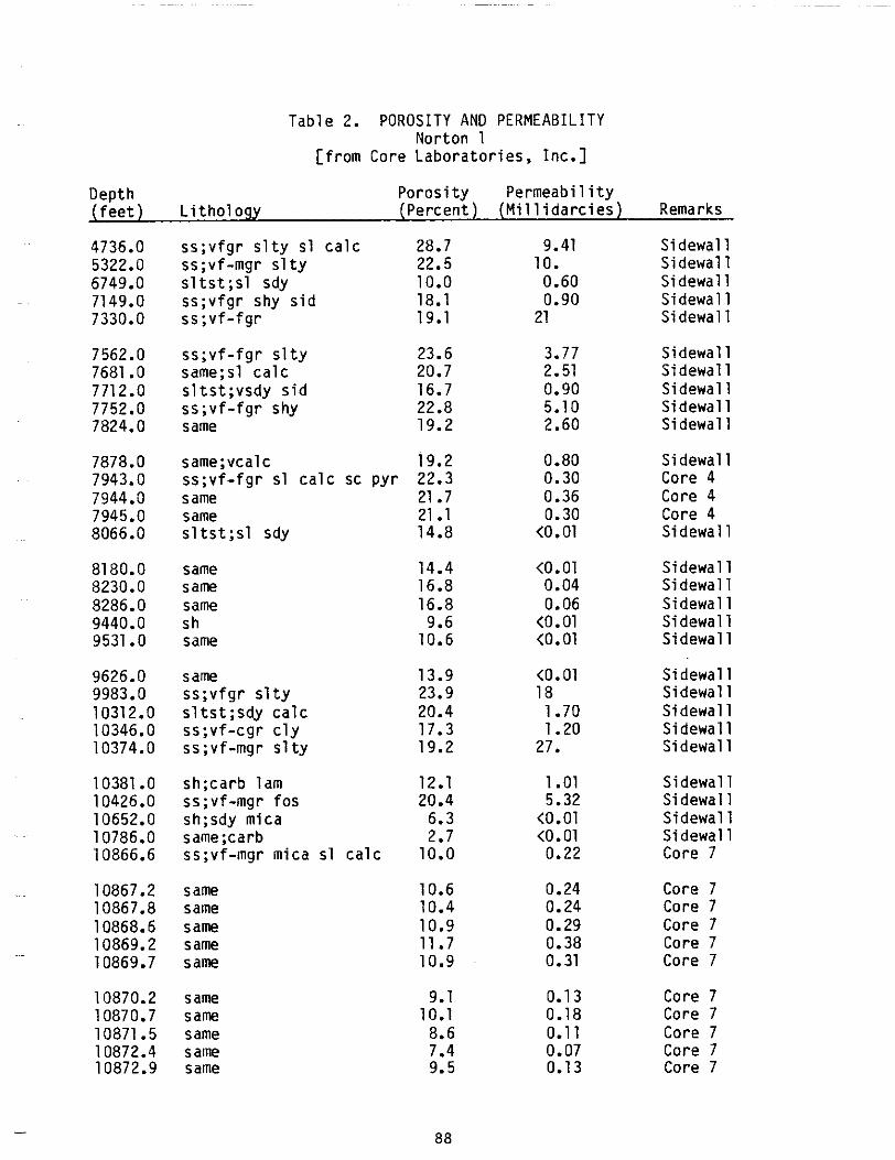
(feet)
Table 2. POROSITY AN0 PERMEABILITY Norton 1
[from Core Laboratories, Inc.]
DepthLithology
Permeability Porosity(Percent) (Millidarcies) Remarks
4736.0 ss;vfgr slty sl calc 5322.0 ss;vf-mgr slty6749.0 sltst;sl sdy7149.0 ss;vfgr shysid 7330.0 ss;vf-fgr
7562.0 ss;vf-fgr slty7681 .O same;sl calc 7712.0 s1tst;vsdy sid 7752.0 ss;vf-fgr shy7824.0 same
7878.0 same;vcalc7943.0 ss;vf-fgr sl calc sc pyr7944.0 same 7945.0 same 8066.0 s1tst;sl sdy
8180.0 same 8230.0 same 8286.0 same 9440.0 sh 9531.O same
9626.0 same 9983.o ss;vfgr slty10312.0 s1tst;sdy calc 10346.0 ss;vf-cgr cly10374.0 ss;vf-mgr slty
10381.O sh;carb lam 10426.0 ss;vf-mgr fos 10652.0 sh;sdy mica 10786.0 same;carb10866.6 ss;vf-mgr mica sl calc
10867.2 sa m 10867.8 same
same same same
10870.2 same 10870.7 s am 10871.5 same 10872.4 same 10872.9 same
28.7 9.41 Sidewall 22.5 10. Sidewall 10.0 0.60 Sidewall 18.1 0.90 Sidewall 19.1 21 Sidewall
23.6 3.77 Sidewall 20.7 2.51 Sidewall 16.7 0.90 Sidewall 22.8 5.10 Sidewall 19.2 2.60 Sidewall
19.2 0.80 Sidewall 22.3 0.30 Core 4 21.7 0.36 Core 4 21.1 0.30 Core 4 14.8 <0.01 Sidewal1
14.4 <0.01 Sidewal1 16.8 0.04 Sidewal 1 16.8 0.06 Sidewal 9.6 <o. 01 Sidewal 10.6 <0.01 Sidewal1
13.9 <0.01 Sidewall 23.9 18 Sidewall 20.4 1.70 Sidewall 17.3 1.20 Sidewall 19.2 27. Sidewall
12.1 1.01 Sidewall 20.4 5.32 Sidewall 6.3 <0.01 Sidewall 2.7 <0.01 Sidewall 10.0 0.22 Core 7
10.6 0.24 Core 7 10.4 0.24 Core 7 10.9 0.29 Core 7 11.7 0.38 Core 7 10.9 0.31 Core 7
9.1 0.1 3 Core 7 10.1 0.18 Core 7 8.6 0.1 1 Core 7 7.4 0.07 Core 7 9.5 0.1 3 Core 7
88
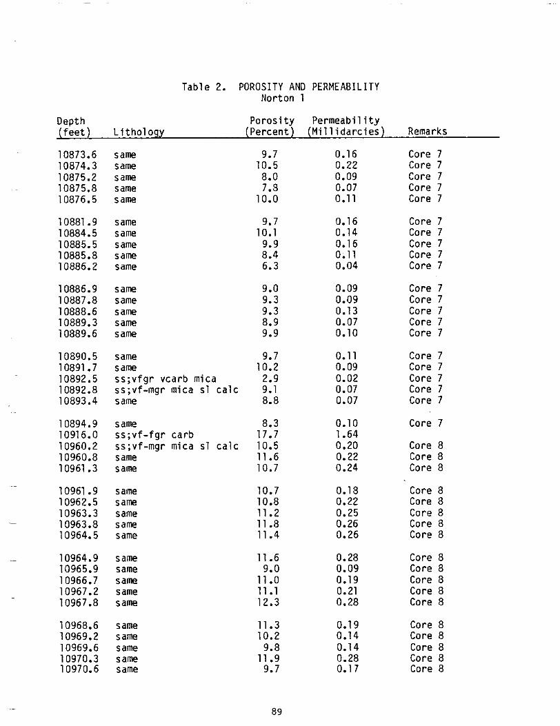
Permeab i l i t y Poros i ty
ss;vfgr
( P e r c e n t ) L i t h o l o g y
vcarb
Depth ( f e e t )( M i l l i d a r c i e s )
10873.6 10874.3 10875.2 10875.8 10876.5
10881.9 10884.5 10885.5 10885.8 10886.2
10886.9 10887.8 10888.6 10889.3 10889.6
10890.5 10891.7 10892.5 10892.8 10893.4
10894.9 10916.0 10960.2 10960.8 10961.3
10961.9 10962.5 10963.3 10963.8 10964.5
10964.9 10965.9 10966.7 10967.2 10967.8
10968.6 10969.2 10969.6 10970.3 10970.6
Table 2. POROSITY AN0 PERMEABILITY Norton 1
Remarks
same 9.7 0.16 Core 7 same 10.5 0.22 Core 7 same 8.0 0.09 Core 7 same 7.8 0.07 Core 7 same 10.0 0.11 Core 7
same 9.7 0.16 Core 7 same 10.1 0.14 Core 7 same 9.9 0.1 6 Core 7 same 8.4 0.11 Core 7 same 6.3 0.04 Core 7
same 9.0 0.09 Core 7 same 9.3 0.09 Core 7 same 9.3 0.13 Core 7 same 8.9 0.07 Core 7 same 9.9 0.10 Core 7
same 9.7 0.1 1 Core 7 same 10.2 0.09 Core 7
mica 2.9 0.02 Core 7 ss;vf-mgrmica sl c a l c 9.1 0.07 Core 7 same 8.8 0.07 Core 7
same 8.3 0.10 Core 7 carbss;v f - fgr 17.7 1.64
ss;vf-mgrmica sl c a l c 10.5 0.20 Core 8 same 11.6 0.22 Core 8 same 10.7 0.24 Core 8
same 10.7 0.18 Core 8 s arne 10.8 0.22 Core 8 same 11.2 0.25 Core 8 same 11.8 0.26 Core 8 same 11.4 0.26 Core 8
sam 11.6 0.28 Core 8 same 9.0 0.09 Core 8 Sam 1 1 .o 0.19 Core 8 same 11.1 0.21 Core 8 same 12.3 0.28 Core 8
same 11.3 0.1 9 Core 8 same 10.2 0.14 Core 8 same 9.8 0.1 4 Core 8 same 11.9 0.28 Core 8 same 9.7 0.1 7 Core 8
89
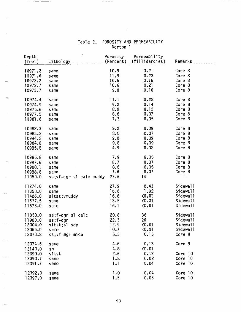
Permeabi l i ty Poros i ty ( P e r c e n t ) L i t h o l o g y
Table 2. POROSITY AN0 PERMEABILITY
Depth ( f e e t )( M i l l i d a r c i e s )
10971.2 10971.6 10972.2 10972.7 10973.7
10974.4 10974.9 10975.6 10977.5 10981.6
10982.3 10983.2 10984.2 10984.8 10985.8
10986.8 10987.6 10988.1 10988.8 11050.0
11274.0 11350.0 11426.0 11577.5
16.1 11673.0
11850.0 11900.0 12004.0 12065.0 12073.8
12074.6 12140.0 12390.0 12390.7 12391.7
12392.0 12397.0
same same same same same
same same same same same
same same same same same
same same same same ss ;v f -cgrs lca lc
same same s1tst;vmuddy same same
s s ; f - c g r c a l cs l ss;f-cgr s1 ts t ; s l sdy same
micass;vf-mgr
same sh s l t s t same same
same sa m
Norton 1
Remarks
10.9 0.21 Core 8 11.9 0.23 Core 8 10.5 0.16 Core 8 10.6 0.21 Core 8 9.8 0.16 Core 8
11.1 0.28 Core 8 9.2 0.14 Core 8 8.8 0.1 2 Core 8 8.6 0.07 Core 8 7.3 0.05 Core 8
9.2 0.09 Core 8 8.0 0.07 Core 8 9.8 0.09 Core 8 9.8 0.09 Core 8 4.9 0.02 Core 8
0.05 7.9 Core 8 8.7 0.07 Core 8 8.6 0.05 Core 8
0.07 7.6 Core 8 muddy27.6 14
8.43 27.9 Sidewal l 1.92 16.6 Sidewall
16.8 <o. 01 Sidewall <0.01 13.5 Sidewall <0.01 Sidewal l
20.8 36 Sidewall 22.3 26 Sidewall 12.9 <0.01 Sidewal
<0.01 10.7 Sidewal 5.3 0.1 5 Core 9
4.6 0.13 Core 9 4.8 <o .01 2.6 0.12 Core 10 1.a 0.02 Core10 1 ..1 0.04 Core 10
1.o 0.04 Core 10 1.5 0.05 Core 10
90
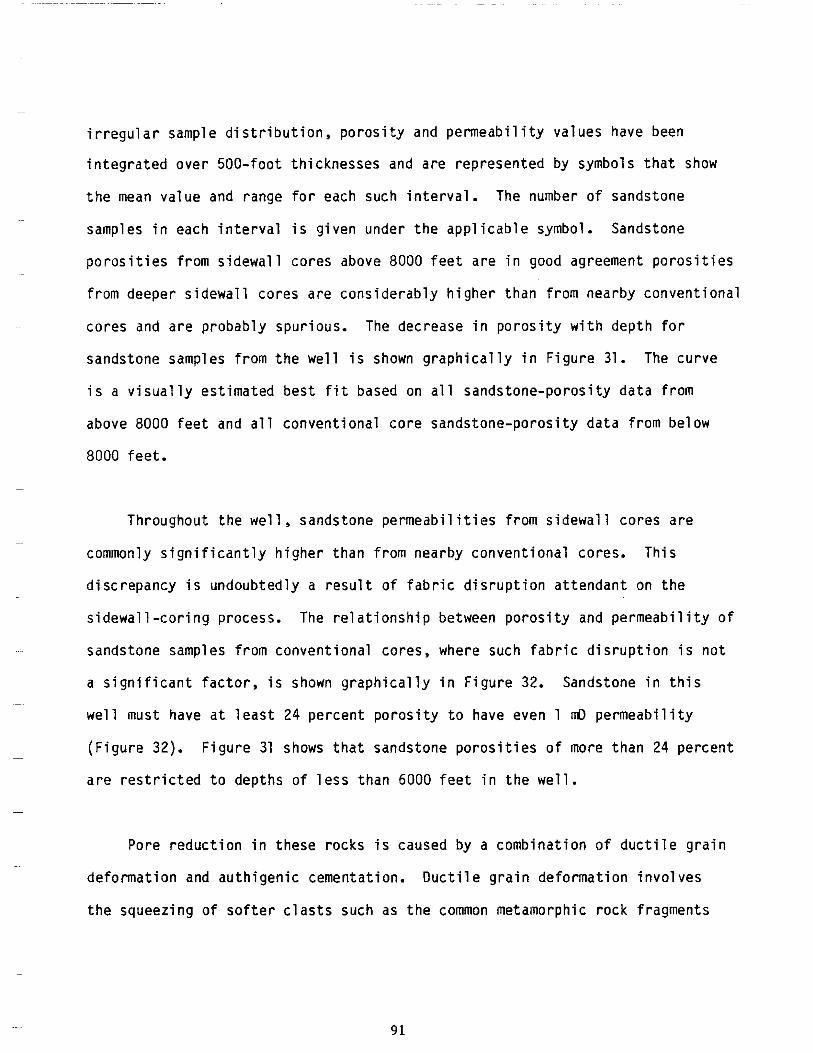
~~
~
~~
~
~
~
i r r e g u l a r sample d i s t r i b u t i o n , p o r o s i t y and pe rmeab i l i t yva lues havebeen
in tegratedover500- footth icknesses and arerepresentedbysymbolsthat show
t h e mean value and range f o r eachsuch i n t e r v a l . Thenumber o f sandstone
samples i n each i n t e r v a li sg i v e n undertheapp l icab le symbol.Sandstone
poros i t iesf roms idewal lcores above 8000 f e e t a r e i n goodagreement p o r o s i t i e s
f romdeepersidewal lcoresareconsiderablyhigherthanfromnearbyconvent ional
cores and areprobablyspur ious. The decrease i np o r o s i t yw i t hd e p t hf o r
sandstonesamplesfromthewell i s shown g r a p h i c a l l yi nF i g u r e 31. The curve
i s a v i sua l l yes t ima tedbes t f i t based on a l lsands tone-poros i tyda taf rom
above 8000 f e e t and all convent ionalcoresandstone-porosi tydatafrombelow
8000 f e e t .
Throughoutthewel l ,sandstonepermeabi l i t iesf romsidewal lcoresare
commonly s ign i f i can t lyh igherthanf romnearbyconvent iona lcores .Th is
discrepancy i s undoubtedly a r e s u l t o f f a b r i c d i s r u p t i o n a t t e n d a n t on t h e
s idewal l -cor ingprocess. The r e l a t i o n s h i p between p o r o s i t y and pe rmeab i l i t yo f
sandstonesamplesfromconventionalcores,wheresuchfabricdisruption i s n o t
a s i g n i f i c a n tf a c t o r , i s shown g r a p h i c a l l yi nF i g u r e 32. Sandstone i n t h i s
w e l l musthave a t l e a s t 24 p e r c e n tp o r o s i t yt o haveeven 1 mD p e r m e a b i l i t y
(F igure 32). F igure 31 shows t h a ts a n d s t o n ep o r o s i t i e so f more than 24 percent
a r e r e s t r i c t e d t o d e p t h s o f l e s s t h a n 6000 f e e t i n t h e w e l l .
Porereduct ion i n theserocks i s causedby a c o m b i n a t i o n o f d u c t i l e g r a i n
deformat ion and au th igen iccementa t ion .Duct i legra indeformat ioninvo lves
thesqueez ingo fso f te rc las tssuch as t h e common metamorphicrockfragments
91
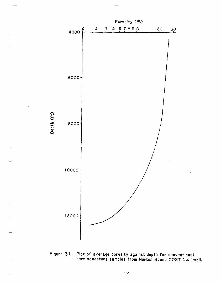
)OOb
3002I
0000I
0 m V cc
IO08 am 3 e v
3009
Permeability (mol
Figure 32. P l o t o f averagepermeabi l i tyaga instaverageporos i ty for conventionalcoresandstonesamplesfromNortonSound COST No.1 well.
93
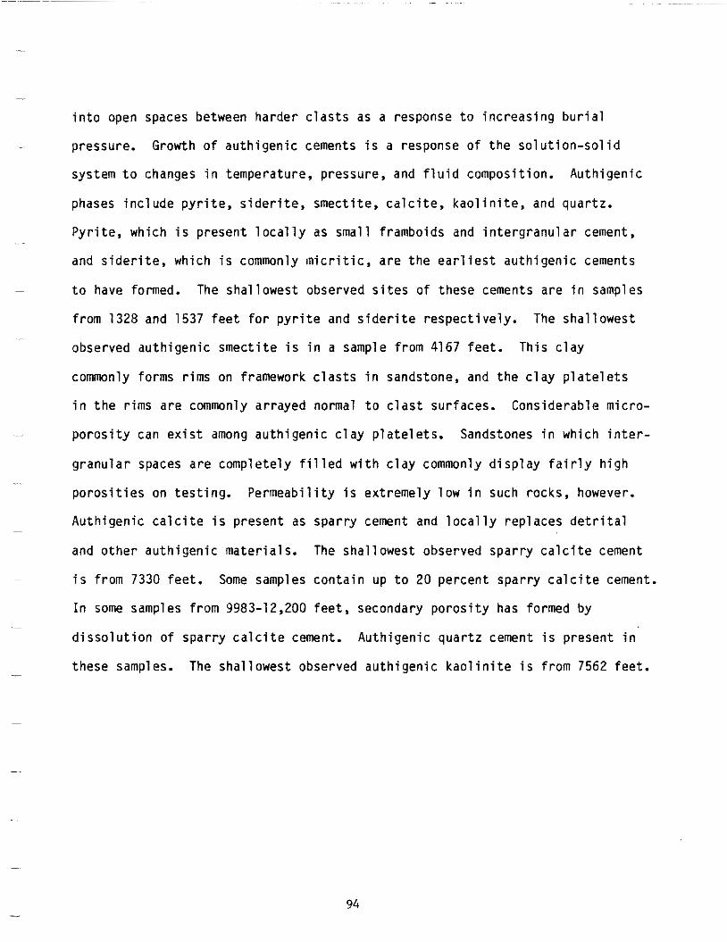
i n t o openspacesbetween ha rde rc las ts as a response t o i n c r e a s i n g b u r i a l
Growth o f t h e~- pressure. a u t h i g e n i c cements i s a response o f s o l u t i o n - s o l i d
system t o changes i n temperature,pressure,and f l u idcompos i t i on .Au th igen ic ~~
phases i n c l u d ep y r i t e ,s i d e r i t e ,s m e c t i t e ,c a l c i t e ,k a o l i n i t e , and quar tz .
Pyr i te ,wh ich i s p r e s e n tl o c a l l y assmallframboids and i n t e r g r a n u l a r cement, ~~
and s i d e r i t e , w h i c h i s commonly I n i c r i t i c , a r e t h e e a r l i e s t a u t h i g e n i c cements
~ t o have observed o fformed. The sha l lowest s i testhese cements a r ei n samples
from1328 and1537 f e e t f o r p y r i t e and s i d e r i t er e s p e c t i v e l y . The shal lowest ~
observedauthigenicsmect i te i s i n a samplefrom 4167 fee t .Th isc lay
commonly formsrims on framework c l a s t s i n sandstone, and t h e c l a y p l a t e l e t s
i nt h er i m sa r e commonly arrayednormal toc las tsur faces .Cons iderab lemicro
c l a y i n t e r ~~ p o r o s i t y can e x i s t among a u t h i g e n i c p l a t e l e t s . Sandstones i n w h i c h
granu lar spaces a r e c o m p l e t e l y f i l l e d w i t h c l a y commonly d i s p l a y f a i r l y h i g h
p o r o s i t i e s on t e s t i n g .P e r m e a b i l i t yi se x t r e m e l yl o wi n suchrocks,however.
A u t h i g e n i cc a l c i t ei sp r e s e n t as sparry cementand l o c a l l y r e p l a c e s d e t r i t a l
and o therauth igen icmater ia ls . The sha l lowestobservedspar ryca lc i te cement
~ i s from 7330 fee t . Some samples c o n t a i n up t o 20 spa r rype rcen t ca l c i t e cement.
I n some samplesfrom 9983-12,200 feet,secondaryporosi tyhas formedby ~
d i s s o l u t i o no fs p a r r yc a l c i t e cement. Auth igen icquar tz cement i s present i n
these samples. The sha l lowestobservedauth igen ickao l in i te i s f rom 7562 feet .-
94
Kaol in i tecompr ises nomore than 2 p e r c e n to f anysampleand i s present i n
decussatelyarrayedvermicularstackswhich f i l l o r p a r t l y fill i n t e r g r a n u l a r
spaces o r ,l e s s commonly, f ractures.Auth igenicquar tz was observedonly i n
~~~ samples f rom 9983 t o 12,200 f e e t , where i t i s presentassyntaxialovergrowths
on q u a r t zc l a s t s .E x c e p tf o rt h ef o r m a t i o no fs e c o n d a r yp o r o s i t yb yc a l c i t e
d i s s o l u t i o n , a l l d iagenet ic changesobserved i n sandstonesfromthewellhave
reservo i r~~ r educed po ten t ia l .
Radiometr ic Age Determinat ions
Thirteenpotassium-argon age determinationswere made on rocksfrom 5012
t o 14,671.8 fee t(Tab le 3). All b u t one of t h e age determinat ions were made
on sedimentary and cataclast icmetasedimentaryrocks. O f these,twowere made
on wholerocks and t e n on concen t ra t i onso fde t r i t a lmuscov i te . The ages thus
o b t a i n e d r e f l e c t t h e age o fthesourceareasra the rthanthedepos i t i ona l age.
Theageswere separatedintotwogroupswi th a breakbetween 10,397 and 10,893
fee t . Ages obtainedfromsedimentaryrocks above 10,397 feetrangefrom 81 t o
104 my., andagesfromsedimentary and metasedimentaryrocksbelow 10,893 -
feetrangefrom125 t o 206 m.y. w i t h mostbetween 141 and 151 m.y.
A s i n g l e age de terminat ion wasmade on a sample o f igneousrockfound
loose and p robab lyou to fp lace on topo fconven t iona lco re 6. Th isdeterminat ion
wasmade on a fe ldsparconcent ra te ,wh ichy ie lded measured con ten tso f 5.818
95
t
3.TABLE Potassium-argon age determinat ions
[ f rom Geochron Labora tor iesDiv is ionofKruegerEnterpr ises ,Inc . ]
Depth( fee t ) L i t h o 1ogy Mater ia lTes ted Age ( x 106 years )
501 2 shale muscovi teconcentrate 84.2 -t 3.6
6220 shale muscovi teconcentrate 99.7 -t 4.1
7942 shale muscovi te concentrate 81.3 -t 3.4
9750 shale muscovi teconcentrate 104 t 4-rubblefound vo lcan ic atopCore 6 rock fe ldspar concent ra te 19.9 -t 0.8
10397 shale muscovi teconcentrate 81.3 -t 3.3
10893 arkose muscovi teconcentrate 141 t 5-~~ 10964 arkose muscovi teconcentrate 151 t 6-
12074 arkose muscovi teconcentrate 147 t 6-~~
12398 arkose muscovi teconcentrate 146 t 6-13583 shale wholerock 206 t 10-
~
14658 shale wholerock 148 t 7-~ 14671.65-14671.8 phyl 1it e muscovi teconcentrate 125 5-
96
and 5.662 weightpercentpotassium on dupl icateanalyses. These analyses
i n d i c a t e t h e p r e s e n c e o f p o t a s s i u m f e l d s p a r d i l u t e d w i t h some o t h e r m a t e r i a l
intheconcentrate.Potass ium-argon agesbased on po tass iumfe lsparo ther
thansan id ine ,or on p lag ioc lasew i th more thanabout 2 percentpotashcontent,
a regenera l l ycons ide redunre l i ab le (F. H. Wilson,oralcommunication). As
ne i the r the t ype o fpo tass ium fe ldspar nor t h e n a t u r e o f t h e o t h e r m a t e r i a l
present in the dated concentrate were determined, the 19.9 -+ 0.8 my. age
cannotbeconsidereddef in i t ive.Pat ton and Csejtey(1971)havereported
potassium-argon ages o f 62.8 -+ 1.8 my. on hornblende from a t r a c h y t e f l o w on
S t . Lawrence I s l a n dn e a rt h ew e l ls i t e .
97
Geochemistry
Norton COST Well 1
by Tabe 0. F l e t t
I n t r o d u c t i o n
The geochemistryprogramforthe No. 1 we l l was designed t o
eva lua te the pe t ro leum poten t ia l of ro.cks i n westernNorton Sound and t o
i d e n t i f y , the spec i f i c sou rce - rock i n te rva l s capable of producing
hydrocarbons. The opera to ro fthewe l lau tho r i zed CoreLaboratories,
Inc., o f D a l l a s , Texas,and Geochem Laboratories,Inc.,ofHouston,
Texas, t o p e r f o r m geochemicalanalyses.
Cut t ings weretaken a t 6 0 - f o o t i n t e r v a l s f r o m 240 to 14,667 ' feet .
The c u t t i n g s wereplaced i n one-quar t cans wi th a bacter ic ide and sealed
w i thpress-onl ids .F i f t yn ines idewal lcores ,e igh tconvent iona l
cores,andtwelve d r i l l i n g mud sampleswere a l s o c o l l e c t e d f o r a n a l y s i s .
The f inalconvent ionalcoreproducedsamplesfrom 14,679 feet.Analyses
wereperformed f o r v i s u a l kerogen,thermal a l t e r a t i o n i n d e x , random
v i t r i n i t e re f l ec tance , o rgan ic ca rbon con ten t , C 1 - C7 hydrocarbons,
C15+ e x t r a c t andhydrocarboncontent,andcarbonisotopecontent o f t h e
ex t rac ts . Gas chromatography and rock-evalpyro lys iswerealso
98
performed. The o r i g i n a l d a t a i s on f i l e a t t h e M i n e r a l s Management
Service,800 A. S t ree t , Anchorage,Alaska99501,and i s a v a i l a b l e f o r
examination.
GeothermalGradient
The apparent mean geothermalgrad ien tfo rthe No. 1 w e l l was
computed fromrawdataand i s p l o t t e d on F igu re 33. Observed
temperaturesfrom 2,000 f e e t t o 14,660 feet(BottomHoleTemperature,
BHT) weretakenfromthehigh-resolut ionthermometerlog.
TotalOrganicCarbonContent
Tota lorganiccarboncontent (TOC) f romcut t ings ,s idewal lcores ,
andconvent ionalcoresanalyzedbybothCoreLaborator ies and Geochem
Labora tor iesared isp layed on P l a t e 1. The twolaborator iesused
e s s e n t i a l l yt h e same ana ly t i ca ltechn iques . Sampleswere dr ied ,
p u l v e r i z e d , t r e a t e d f i r s t w i t h c o l d and then w i th ho t hyd roch lo r i c ac id ,
and analyzed i n LECO carbonanalysers.Blanks,standards, and d u p l i c a t e
sampleswere per iod ica l l yana lyzed. The twodatasetsare i n good
agreement.
From1,260 to approx imate ly 4,500 f ee t , t he TOC i n c r e a s e s l i n e a r l y
w i t h d e p t h f r o m s l i g h t l y l e s s t h a n 0.5 pe rcen t t o abou t 1.1 or 1.2
percent. A t 4,860 f e e t t h e f i r s t o f s e v e r a l zones occu rwh ichexh ib i t
anomalouslyhigh TOC va lues(2percentto 52 percent).Anomalies i n
excess o f two t o t h r e e p e r c e n t TOC areobservedwherecoal i s recovered
i n t h e c u t t i n g s i n a n y t h i n g f r o m t r a c e amounts t o 15 p e r c e n t o f t h e
t o t a l l i t h o l o g y . From about 5,900 t o 9,500 fee t , TOC valuesdecrease
99
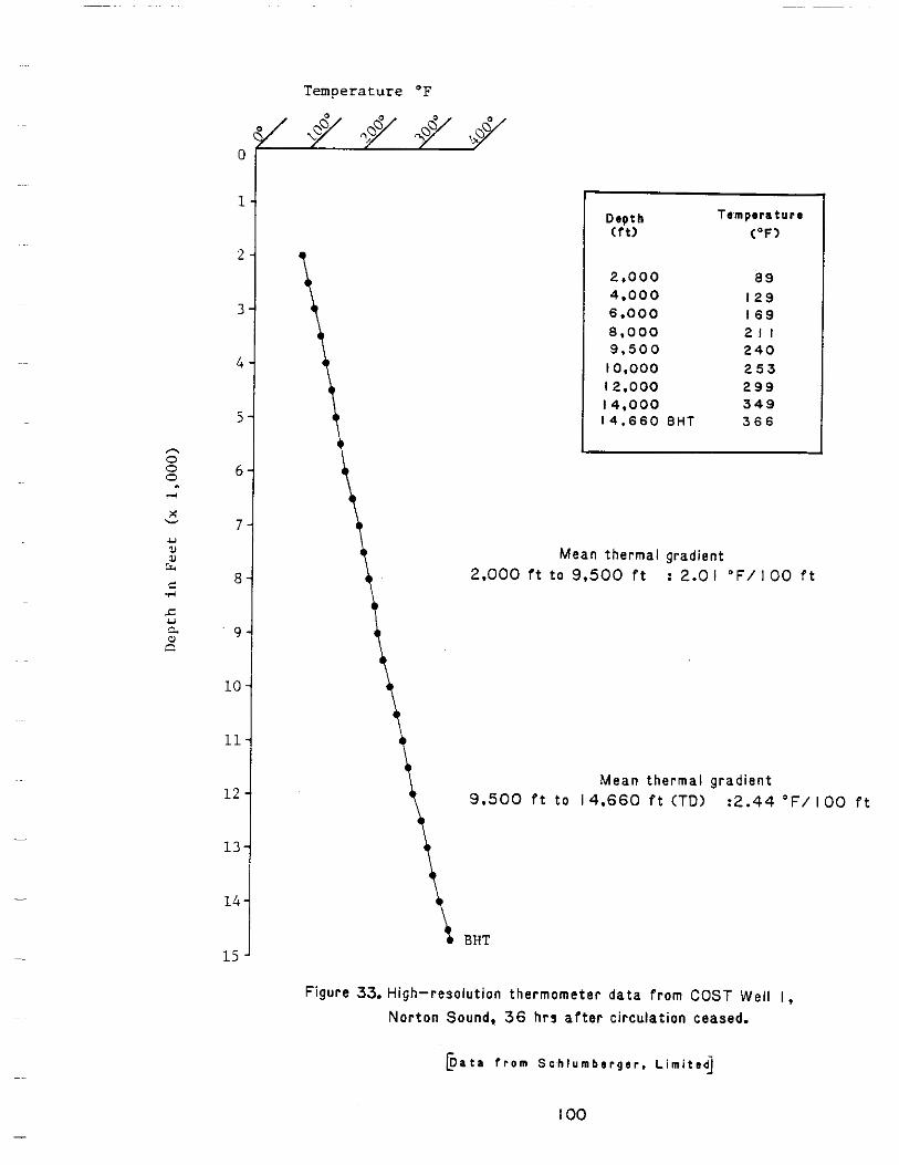
Temperature OF
0
1
2
3
4
5
6
7
a
9
10
11
12
13.
14.
L5 '
T e m p e r a t u r e D e p t h
2.000 89 4.000 I 2 9 6.000 I 6 9 8.000 21 I 9 . 5 0 0 2 4 0 l0.000 2 5 3 12.000 2 9 9 14.000 3 4 9 14.660 B H T 366
L I
Meanthermalgradient 2.000 I t t o 9,500 f t :2.0 I O F / I O 0 f t
\ Meanthermalgradient 9.500 f t t o 14.660 P t (TD) :2.44 "F/ I O 0 f t
BHT
Figure 33. High-resolutionthermometerdatafrom COST Well I, Nor ton Sound. 36 hrsaftercirculationceased.
b a t .f r o mS c h l u m b e r g e r .L i m i t e d
I O 0
gradual lyf romaround one pe rcen ttoapprox ima te l y 0.8 percent. A t
9.200 f e e t t h e r e a r e t r a c e s o f c o a l w i t h a s s o c i a t e d TOC va lues o f 3 t o 4
percent. From 9,500 t o 13,000 feet,backgroundorganiccarbonvalues
areh igh ,rang inggenera l l y between 1.0 and 2.0 percent ,w i thveryh igh
values where coaloccurs i n t h e c u t t i n g s . Between 13,000 f e e t t o t h e
t o t a l d e p t h o f t h e w e l l (14,683 f e e t ) , TOC valuesrangebetween 0.2 and
0.5 p e r c e n tw i t h twoexceptionswhichexceed 1.0 percent. It i s
i m p o r t a n t t o know i f TOC conten t hasbeen in f luenced by the presence o f
coal i n t h e samplesand t o w h a t e x t e n t t h i s i s t r u e i f such
contaminationhasoccurred. Sampleswere c a r e f u l l y washed, and Dr.
Bay l i ss(persona lcomnun ica t ion)o f Geochem Labora tor ies i s c o n f i d e n t
t h a t c o a l i s n o t a s i g n i f i c a n t f a c t o r i n t h e TOC analyses. However, t he
excess i ve l y h igh TOC valuesoftenappear when even t r a c e amounts o f c o a l
occur i n t h e c u t t i n g s .
D e s c r i p t i o n o f Kerogen
Microscopicexaminat ionofthekerogenpresent i n p o t e n t i a l s o u r c e
rock was performedbybothCoreLaboratoriesand Geochem Laborator ies.
The fo rmer app l i ed the coa l pe t rog rapher ' s re f l ec ted l i gh t t echn ique and
c l a s s i f i c a t i o n system. The l a t t e r used t ransmi t ted 1i g h t andadopted
t h ep a l y n o l o g i s t ' sc l a s s i f i c a t i o n .R e s u l t sf r o mt h e s es t u d i e sa r e
d i s p l a y e d i n F i g u r e 34 w i t h t h e h y d r o g e n t o c a r b o n r a t i o (H/C).
From the su r face to abou t 12,200 f e e t , t h e o r g a n i c m a t t e r i s
genera l l y humic, be ing composed predominant ly of herbaceous and woody o r
v i t r i n i t i c and e x i n i t i c kerogen. The H/C r a t i o s f r o m t h i s i n t e r v a l
rangefrom 1.087 t o 0.739, which i s c h a r a c t e r i s t i c o f a v e r a g e v a l u e s
101
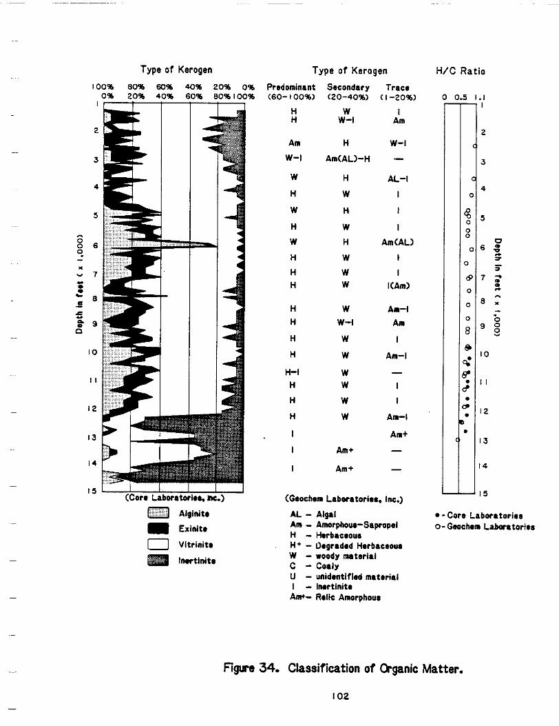
Type o f Kerogen Type o f Kerogen H/C Ratio ~~100% 80% 60% 40% )% 0% Predominant Secondary Trace
0% 20% 40% 60 1% 100% (60- 100%) (20-40%1 ( I -20%) 0 0 5 1 . 1
H W I H w-1 Am
Am H w-l w-1 Am(AL>-H -
W H AL-I
H W I
W H I
H W I W H Am(AL)
H W I H W I H W KAm)
H W Am-1 H w-l A n
H W I
H W Am-I
H - 1 W -H W I
H W I
H W An-l
I An+
I Am+ -I Am+
(Geochem Laboratories. Inc.)
A L -Am -H -H+ -W -c -U -I -Am+-
A l p 1 -Core Laboratories Amorph-Sapropel 0-Gwchon Laboratories Herbaceow Oegraded Herbaceour woody nuteriel Cody unidentified material Imrt inite Rdie Amorphous
Figure 34. Classification o f Organic Matter.
I 0 2
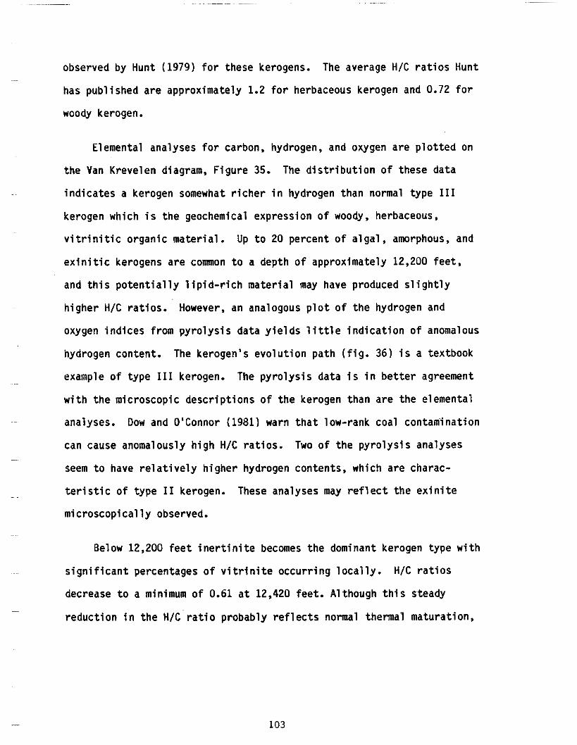
observedbyHunt(1979) f o rt h e s e kerogens. The average H/C r a t i o s Hunt
has publ ishedareapprox imate ly 1.2 f o r herbaceouskerogenand 0.72 f o r
woody kerogen.
Elementalanalysesforcarbon,hydrogen,andoxygenareplotted on
the Van Krevelendiagram,Figure 35. The d i s t r i b u t i o no ft h e s ed a t a
i n d i c a t e s akerogen somewhat r i c h e r i n hydrogenthannormaltype I11
kerogenwhich i s t h e geochemicalexpression o f woody, herbaceous,
v i t r i n i t i c o r g a n i c m a t e r i a l . Up t o 20 p e r c e n t o f a l g a l , amorphous,and
e x i n i t i c kerogensare common t o a depth o f approx imate ly 12,200 f e e t ,
and t h i s p o t e n t i a l l y l i p i d - r i c h m a t e r i a l may have produced s l igh t ly
h igher H/C r a t i o s . However,an analogous p l o t o f thehydrogen and
oxygen i n d i c e s f r o m p y r o l y s i s d a t a y i e l d s l i t t l e i n d i c a t i o n o f anomalous
hydrogencontent. The ke rogen 'sevo lu t i onpa th( f i g . 36) i s a textbook
example o f type I11 kerogen. The py ro l ys i sda ta i s i n b e t t e r agreement
w i th the m ic roscop ic desc r ip t i ons o f t he ke rogen than a re the e lemen ta l
O'Connor warn tha t coa l~~ analyses. Oow and (1981) low- rank contan i ina t ion
cancauseanomalouslyhigh H/C r a t i o s . Two o f t hepy ro l ys i sana lyses
seem t o have re la t i ve ly h igher hydrogen conten ts , wh ich are charac
t e r i s t i c o f t y p e I1 kerogen.Theseanalyses may r e f l e c t t h e e x i n i t e
m ic roscop ica l l y observed.
Below12,200 f e e t i n e r t i n i t e becomes thedominantkerogentypewith
s i g n i f i c a n t p e r c e n t a g e s o fv i t r i n i t eo c c u r r i n gl o c a l l y . H/C r a t i o s
decrease t o aminimum o f 0.61 a t 12,420 fee t . A l though th is s teady
r e d u c t i o n i n t h e H / C ' r a t i o p r o b a b l y r e f l e c t s normalthermalmaturation,
103
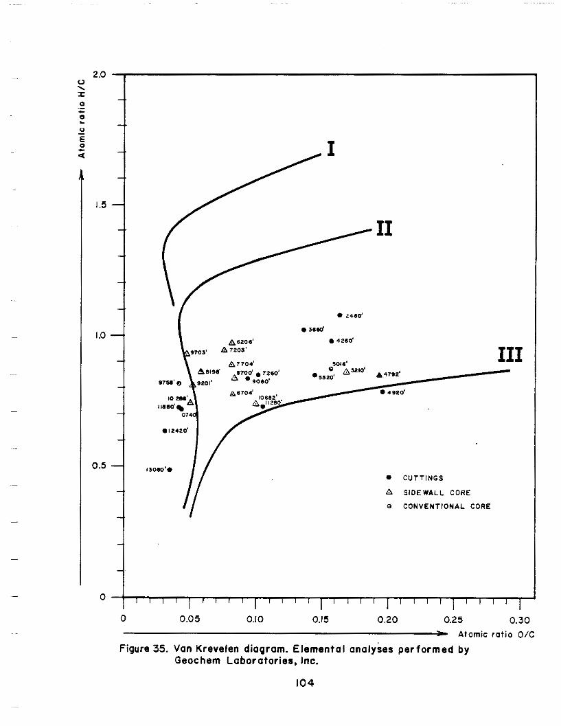
0 2.80'
0 36Sd
0 4260'
I11
0 CUTTINGS
A SIDEWALL CORE
0 CONVENTIONAL CORE
I
0 I 1 1 1 1 l l I 1 1 1 1 1 1 / 1 1 I l l l ] / l l l ~
0 0.05 0.10 0.15 0.20 0.25 0.30 - Atomic ratio O/C
Figure 35. Van Krevelen diagram. Elemental analyses performed by Geochem Laboratories, Inc.
104
3-
3-
I-
I-
1-
1-
2oo 9751
10682A
0 0
Cutt ings
A Sidewell Core 0 Conventional Core
I860 I0740 o'1280 024605016
0 1 3 0 8 0 I I I I I
25 50 7b IO0 I 2 5 I 50 Oxygen Index m g C 0 2
9 T O C
Figure 36. Van Krevelen Diagram. (Selectedpyrolysisanalyses by Geochern Laboratories, Inc.)
I05
t hese reduced va lues a re no t i ncons is ten t w i th measurements t h a t Hunt
(1979)considers t o be representa t ive o f woody kerogenand i n e r t i n i t e
(0.72and 0.47 respec t i ve l y ) . On t h em o d i f i e d Van Krevelendiagram
( f i g . 3 6 ) t h e O/C levelhasdecreased t o where it i s no l onger poss ib le
t o d i s t i n g u i s h among thethreepr inc ipa lkerogentypes on t h e b a s i s o f a
few i s o l a t e d a n a l y s e s a t t h i s l e v e l o f matur i ty .
The kerogenbelow 13,000 f e e t does n o t c o n t a i n s i g n i f i c a n t amounts
o f organ ic carbon (p la te 1) and the on ly H/C r a t i o o b s e r v e d a t t h i s
depth was0.504. It i s u n l i k e l y t h a t any hydrocarbonsotherthanminor
amounts o f d r y gas cou ld be genera ted by th is o rgan ic mater ia l .
Matura t ion
Thermal a1 te ra t i on i ndex (TA I ) andrandom v i t r i n i t e r e f l e c t a n c e
(Ro), t he twomost common measures o f t he rma l a l t e ra t i on , a re d i sp layed
i n F i g u r e 37, a long w i th the carbon pre ference index (CPI), andthe
T2-max OC valuesfromthesecondpyrolysisresponse.
T A I valuesassessedby Geochem L a b o r a t o r i e s a r e s l i g h t l y l e s s t h a n
Core Labora tor ies 'es t imates . On thescaleadopted i n t h i s r e p o r t a T A I
of 2.2 i s "moderatelymature'andapproximatelyequivalentto arandom
v i t r i n i t e r e f l e c t a n c e o f 0.6 percent. A T A I o f 3.2 i s "mature"and
equal t o an Ro o f 1.3 or 1.4 percent.Metagenesisbegins a t an Ro o f
approximately 2.0 percen t(T i sso t andWelte1978).Thiswouldbe
r o u g h l y e q u i v a l e n t t o a TA I o f 3.8.
106
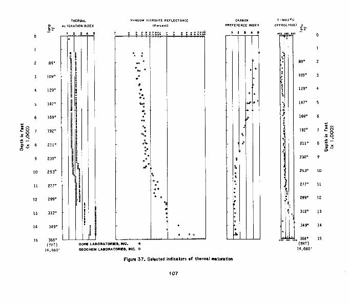
Random v i t r i n i t e r e f l e c t a n c e s measured by both laborator ies agree.
Thenumber o f measurements rangedfrom 4 t o 105 with populat ions of 20
t o 40 being most comnon. Several measurements f r o m c u t t i n g s a t 1,267,
1,860, and 2,460 f e e t and a s idewal l core at 1,467 f ee t a re anomalously
high,buttheseaverages were acqui red f rom t iny populat ions wi th
e r r a t i c d i s t r i b u t i o n s and arebestdiscounted. A t about 9,700 f e e t
there i s a d i s c o n t i n u i t y i n t h e t r e n d o f t h e data. The Ro appears t o
increasestepwiseaccrossthethresholdformajor o i l generation (0.6
percent), and the da taexh ib i t a broaderscatterofvalues. The present
temperature gradient also increases from an average r a t e o f about 2.01
OF/lOO f e e t t o 2.44 "F/lOO f e e t i n t h i s r e g i o n . A t approximately 11,900
feet , there i s a second more pronounced d iscont inu i ty i n v i t r i n i t e
ref lectance. Ro increasesdiscontinuouslyfrom 0.75 percentto 1.0
percent and then to 1.3 percentat 12,200 feet. From 12,200 t o 13,980
feet , Ro valuesrange between 1.2 and 1.4 percent. A t 13,980 feet , Ro
increases to 2.44, which i s metagenicgrade,and a t greater depths.
v i t r i n i t e r e f l e c t a n c e s a r e h i g h l y e r r a t i c and increase to metamorphic
grade. These o f f s e t s i n t h e random v i t r i n i t e r e f l e c t a n c e p r o f i l e c o u l d
be relatedtounconformat ies. However, owing t o t h e absence o f a wel l
def ined trend i n t h e Ro values i n t h e l o w e r p a r t o f t h e we11, it i s
inadvisable to apply Dow's method (1977) t o compute the amount o f
s t ra t ig raph icsec t iontha t may have been deletedfromtherecord. It i s
possible, however, t h a t s i g n i f i c a n t amounts o f sediment i n t h e most
favorable maturi ty range are not represented i n t h e s t r a t i g r a p h i c
sect ion penetrated by th is test we1 1.
108
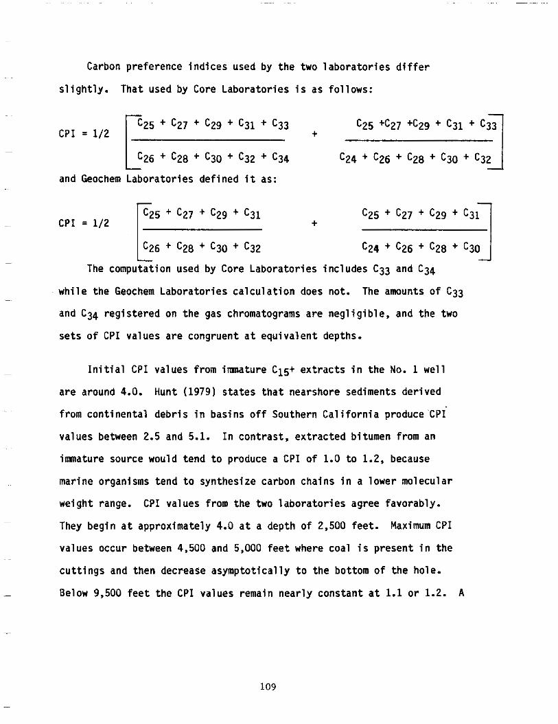
i n
Carbon preference indices usedby the two l a b o r a t o r i e s d i f f e r
s l ight ly .That used byCore Laboratories i s as fol lows:
C P I = 1/2 $,+ c27 + c29 + c31 + c33
~
L C 2 6 + c28 + c30 + c32 + c34
c24 + c26 + c28 + c30 I ~ -J
and Geochem Laboratories defined it as: ~~
CPI = 1/2 I c25 + c27 + c29 + c31 + c25 + c27 + c29 + c31 I
The computation usedby Core Laboratories includes C33 and C34
whi lethe Geochem Laborator iescalcu lat ion does not. The amounts o f C33 -
and C34 reg is tered on the gas chromatograms are negl ig ib le , and the two
~ se t s are e q u i v a l e n t depths.o f CPI valuescongruent a t
~ I n i t i a l C P I valuesimnature C15+ e x t r a c t sfrom t h e No. 1 wel l
are around 4.0. Hunt(1979)statesthatnearshoresedimentsderived
fromcontinentaldebris i n bas ins o f f Southern Cal i fornia produce'CP1
values between 2.5 and 5.1. Incontrast ,extractedbi tumenfrom an
imnaturesourcewouldtend t o produce a C P I o f 1.0 t o 1.2, because
marineorganismstend to synthesize carbon chains i n a lowermolecular
weight range. C P I valuesfromthetwolaboratoriesagreefavorably. ~
They begin a t approximately 4.0 a t a depthof 2,500 feet. Maximum CPI
valuesoccur between 4,500 and 5,000 f e e t where coal i s present i n the ~~
c u t t i ngs and thendecrease asymptotically t o the bo t tom o f t he hole.
- Below 9,500 fee tthe C P I values nearlyremain constant a t 1.1 o r 1.2. A
109
s l i g h t s c a t t e r o f t h e d a t a o c c u r s i n t h e metamorphic rocks a t 14,667
f e e t which i s n o t aspronouncedas t h a t e x h i b i t e d by the Ro va lues fo r
the same depth.
/Barker (19741,Claypool and Reed (19761, and E s p i t a l i e and others
(19771, have suggested t h a t T2-max, thetemperature a t which maximum ~ evolut ionofthermalhydrocarbonsoccursduringpyrolysis, canbe used
tocharac te r i zethe degree o f thermalmaturation o f kerogen. However,
these measurements can varyfrominstrument t o instrument, and are
~~ dependent upon thera teo fhea t ing and a lso upon thetypeof kerogen
beinganalyzed. Type 111 kerogenfrom a te r res t r ia lsourcetendsto ~~ e xh ib i t l ower T2-max values than would lacustr ine or marine types Iand
11. Geochem Laborator iesconductedthepyrolysis.Theirinterpret ive
char ts imp ly tha t the most favorable range o f T2-max values f o r o i l
~~ genera t ion T2-max va luesl ies between 435" and 460 "C. The p lo t ted on
Figure 37 suggest that the threshold for optimum petroleum generation
occursnear 432 "C, about 9,500 feet. A t roughly 12,300 feet, T2Lmax
valuesincreasesharply togrea terthan 450 "C and become e r ra t i c . A t
13,600 feet, T2-max has reached 500 OC and from t h i s depth t o 14,400
feet values are scattered from 352 t o 506 "C.
There seems t o be a general agreement among matu r i t y i nd i ca to rs
imp ly ing tha t the onset o f ma jor o i l genera t ion shou ld occur a t
would.~ approximately 9,500 f e e t and t h a t much o ft h eo i l generated be
preserved t o a t l e a s t 12,200 feet. Below 12,600 f e e t v i t r i n i t e -
re f lec tances are h igh bu t no t re l iab le , T2-max valuesfrompyrolysisare
e r r a t i c and veryhigh i n some cases, and T A I valuesindicateseverely
110
a l t e r e d t o metamorphosed sediments. Althoughthere i s no c l e a r sense o f
accord among m a t u r i t y i n d i c a t o r s a t t h i s depth, it i s probable that
kerogens have reachedmetagenicgradeand may havebeen metamorphosed
below 13,000 feet.
HydrocarbonSource Potent ia l
Totalorganiccarbon, l i g h t - ( C 1 - C4) and gasoline-range ( C 5 - C 7 )
hydrocarbons, C15+ hydrocarbon ex t rac t , and pyrolysisdatafrom whole
rock samples aredisplayed i n Figure 38.Geochem Laboratoriesanalyzed
bo th cu t t ings and airspace i n thesealed cans o f samples f o r l i g h t
hydrocarbons. The r e s u l t s o f t h e p a i r s o f a n a l y s e s were then sumned t o
y i e l d t h e C 1 - C7 hydrocarboncontent. Core Laboratoriesanalyzed
c u t t i n g s f o r C4 - C7 gasoline-rangehydrocarbons. The C4 con ten t o f t he
Core Laboratoriesanalyses i n f i g u r e 38 was subt rac ted to make possible
the comparison o f t h e i r gasol ine-range hydrocarbon values with those o f
Geochem Laboratories.Bothlaboratories a1so analyzedsidewal?cores
and conventionalcores.
C 1 - C4 con ten t o f samples fromapproximately 1,000 t o about 9,000
fee t genera l l y exceed 10,000 volumes o f gas p e r m i l l i o n volumes o f rock
(ppm) a t normal atmospherictemperature and pressure,except f o r t h e
i n t e r v a l between 7,000 and 9,000 f e e t i n which it dropss l ight ly . From
1,000 t o 9,000 feet,both C2 - C4 and C5 - C7 hydrocarbonsincrease
progressively two o rde rs o f magnitudefrom between 10 and 100 ppm t o
more than 10,000 ppm. Between 9,500 and 12,500 feet , C 1 - C4 and C2 -C4 valuesareapproximately 40,000ppm and thendecreasedramatically
w i t h f u r t h e r depth.Anomalously highvaluesoccur whereeven t race
111
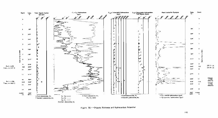
amounts o fcoa la represent . C5 - C7 values i n t h i s i n t e r v a l remain
approximately 10,000 ppm and beg in to d rop sha rp l y a t 12,200 feet.
CoreLaboratories and Geochem L a b o r a t o r i e s u s e d s l i g h t l y d i f f e r e n t
p rocedures to ob ta in C15+ extractable organic matter and heavy
hydrocarbons. Core Laborator iesper formedthesoxhletext ract ionswi th
ch loroform and f o r c e d e v a p o r a t i o n o f t h e s o l v e n t a t 40" C. The
ex t rac tedres idue was thenseparatedintosaturated,aromat ic , and
a s p h a l t i cf r a c t i o n sb ys i l i c ag e l chromatography. Geochem Laborator ies
~~ performedthesoxhl e te x t r a c t i o n sw i t h a c o - d is t i 11edto1uene-methanol
azeotropesolvent.Asphalteneswereseparatedfromsoluble C15+
.~ bitumenswithpentane.Adsorptionchromatographyon a s i 1i c a
gel-aluminacolumn was performedusingpentane,tolueneand ~~
toluene-methanolazeotropeeluants.
~~
Dataproducedbythetwolaborator iesare i n goodagreement.
Anomalous concen t ra t i ons o f C15+ ext ractable hydrocarbons occur a t about
the same depthsas maximum v a l u e s f o r l i g h t - and gasol ine-range
hydrocarbons i n t h e No. 1 wel l .Var iousempir icalthresholdvalueshave
been suggested t o d e f i n e anomalous l e v e l s o f C15+ e x t r a c t a b l e ~~
hydrocarbons.BaylissandSmith(1980)regard 200 t o 400 ppm ona
we igh ttowe igh tbas is asagood anomaly. Hunt(1979)considers 50 t o ~
150 ppm t o beadequate, b u t P h i l l i p i ( 1 9 5 7 ) has p lacedthethresho ld
a anomaly~~ l e v e lo f good as h i g h as 500 ppm. Measured C15+ e x t r a c t a b l e
hydrocarbon va lues f rom th is we l l in excess o f 200 ppm occurfrom 4.800 -
t o 5,580 f e e t andfrom 9,060 t o 12,420 feet.Observed C15+ e x t r a c t a b l e
hydrocarboncontents i n excess o f 500 ppm occur a t 4,920 feet , 4,980
113
feet,andbetween 9,600 and12,420 feet . A t depthsgreaterthan 12,420
f ee t , t he amount o f to ta l ex t rac tab lehydrocarbons decreases very
rap id l y as i ne r t i n i t e con ten t o f t he ke rogen inc reases and TOC
decreases.
Hunt (1979) c i t e s a s t u d y o f Mesozoic-Cenozoicrocks i n t h e w e s t e r n
Ciscaspianregion(LarskayaandZhabrev,1964) .ind icat ingthatthe
" b i t u m e n c o e f f i c i e n t , " t h e r a t i o betweenchloroformsolublecarbon and
to ta lorganiccarbon, i s r e l a t e d t o temperature.These i n v e s t i g a t i o n s
conc luded tha t i n the a rea where the rocks they s tud ied conta ined
predominant ly coa ly par t i c les , the "b i tumen coef f i c ien t " was verysmall
~~ andchanged very l i t t l e w i t h i n c r e a s i n g t e m p e r a t u r e . Where amorphous
mat te r occur red , the "b i tumen coef f i c ien t " was h i g h andincreased
rap id l yw i thtempera tu re .The i rs tud iesimp lytha tb i tumeny ie ldso f
rocks i n sedimentary are to type.~~ f i ne-gra ined basins relatedkerogen
The e x t r a c t a b l e heavyhydrocarbon-totalorganiccarbonrat io
C15+ HC's i n f i g u r e 38 i s analogous t ot h e" b i t u m e nc o e e f f i c i e n t "
TOC
discussedby Hunt.
These va lues are re la t i ve ly low, genera l l y less than 2 or 3 percent,
andchange l i t t l e u n t i l t h e i n t e r v a l between 9,600 and 12,420 feet .
MaximumC15+ HC's values o f 5.6 and 6.0 percentoccura tdepthsof
TOC
9,600 and10,140 f e e t r e s p e c t i v e l y and these depths correspond toa
present day temperaturerange o f 240' t o 255°F. Mean "bitumen
c o e f f i c i e n t " v a l u e s f o r o i l - b e a r i n g r o c k s o f 5 t o 6percentwere
114
observedbyLarskaya and Zhabre; (1964) a t about 230°F. Since C15+
extractable hydrocarbons do notcontainthe,nonhydrocarbon components
tha tare normal ly p resent in b i tumens, it i s assumed that"b i tumen
c o e f f i c i e n t s " f o r t h e Mo. 1 wel l wou ld ac tua l l y be somewhat greaterthan
theheavyhydrocarbon-organiccarbonrat io i n F i g u r e 38.
The TOC, C15+ HC's,andgross l i t h o l o g i c d e s c r i p t i o n s o f c u t t i n g s
TOC
f o r samples w i t h anomalous C15+ extractable hydrocarbon contents
mentioned above arepresented i n Table 4. The samples a t 4,920 and
4,980 fee taresuspect because o f t h e presence o f c a s i n g cement. The
c o n t r a s t i n TOC va lues measured by the two laborator ies at 4,980 f e e t
probablyoccurredbecauseeachlaboratoryhadseparate and d i s t i n c t c o a l ~
fragments i n t h e samples t h a t it analyzed.Bothmeasurementsare f a r
t o o h i g h t o havebeenproducedbykerogenalone. The d i f f e r e n c e i n t h e
C15+ extractable hydrocarbon measurements a t 4,920 f e e t a r e m o s t l i k e l y
~~ t h er e s u l to ft h ed i f f e r e n c ei nt h er e l a t i v ee f f i c i e n c i e so ft h e two
ext ract iontechniques. TOC va luesarewel l above 2 percent, ~
C15+ HC's va luesarelessthan 1 percent, and s i g n i f i c a n t amounts o f
TOC
coalarerecorded i nt h el i t h o l o g i cd e s c r i p t i o n .I nt h e samplesfrom
9,600 and 10.140 feet , TOC i s g r e a t e r t h a n 1 p e r c e n t b u t n o t much
greaterthan 2 percent. TheC15+ HC's i s high, andno
TOC
coalappears i n t h e l i t h o l o g i c d e s c r i p t i o n s .
115
Geochem
I I
Table 4. Selected GeochemicalData From Samples Yi thAnmolously Heavy HydrocarbonContents
Oepth Total Extractable Hydrocarbons ( Gross L i tho log lcDescr ip t ionOrganic Carbon (%) C15t Hydrocarbons (PPM) Q 5 t Extractable Lab Core Lab Core Lab Geochem Lab' TOC a)
2.8512.874,920 no data 210 570 0.7 no data Core Lab: 9 0 % mdst; m-d brn. s l t mica,s l t , sft-fm. assoc w/cly; m-d brn. s l t mica. s l t c a l c , 10% sh-coal; dk brn-blk. v f i s s . s f t . pres-pyrGeochem Lab: 60% mudstone, very s l ight lyca lcareous, chunky, soft, pa le ye l low ish brown: 25% shale, noncalcareous,platy,f iss le.sof t , dk gray; 15% casing cement
+ - 4.980 11.04 52.17 967 no data 0.9 no data CoreLab: 80% sh-coal; v carb. f i s s 3. b l c a ; % mdst; m-d b rn spec, s l t
mica. sft-frm. wlcly;a-dbrn. s l t ca lc Geochem Lab: 80% coalbituminous 2 0 % casing cement
9,600 1.15 1.15 no data 638 no data 5.6 CoreLab: S l t s t ; gy. brn-gy. mica. n s t l y t y , occ mass. f rm, spec. n calc,Pres-pyr; ss; wh, gy. gn. spec. calc. f g r Geochem Lab: 100% shale,noncalcareous. sp l i n te ry . chunky, mod. s o f t medium gray t o dk gray,t racesofl imestone
1C.140 1.54 1.65 no data 994 no data 6.0 Core Lab: Sh; brn-gy dk 9y.py. mica. i s t l y t y . frm. occ s l t y . occ bladed. occ wxy, occ b l k ca rb l a m Geochem Lab: 100% shale,noncalcareous, a i g h t l y carbonaceous,micaceous,occasiona l l ypyr i t i zed ,cha lky . f laky, moderatelysoft, med. gray to brownish b lack , t race o f mudstone, IS and p y r i t e
It appearsfromthesedatathatheavyhydrocarbonextracts a t
depths greater than 9,500 f e e t may bederivedfrombothmoderately
mature ,organ ica l l yr i chc las t i csed iments and coal . However,
re lat ivelyshal lowhydrocarbonanomal ies,wherethermalmatur i ty i s low
and TOC i s approximately 3 percent, suchasthose a t 4,920 and 4,980
f e e t , a r e r e l a t e d t o l i t h o l o g i e s r i c h i n c o a l .
Geochem Laborator ies produced chromatogramsdirect ly af ter
e x t r a c t i o n o f C15+ bitumensand a f t e r f i l t e r i n g C15+ ex t rac t t h rough a
molecularsieve.CoreLaboratories made chromatograms o fC ~ O +s a t u r a t e d ~~~
hydrocarbons.Extractableorganicmatter was d iso lved i n ch loroform and
iso-octaneused t o remove t h e c h l o r o f o r m w i t h o u t l o s s o f t h e l o w b o i l i n g
po in tf rac t ionofthesatura tedhydrocarbons . The concentrate was then ~~
separatedby s i 1i c a g e l columnchromatography w i t h ahexane eluant. The
CPI valuescomputedbyCoreLabwerederivedfrom t h i s data.
The f o u r chromatograms shown i n F i g u r e 39 aretakenfrom Geochem
Laboratoriesdata. The disappearance o f t heb imoda l i t yo fthen -a l kane
t h e i n s h i f t.~~ d i s t r i b u t i o n , d e c r e a s et h e CPI, and t h e t o w a r d
lower-molecular-weightrangen-paraf f ins a l l i n d i c a t e a progress ive ~~ -
increase i n m a t u r i t y w i t h d e p t h andsuggest t h a t i f o i l i s producedfrom
thesekerogens, it will probablyhave a p a r a f f i n i c c h a r a c t e r .
Two chromatograms f rom Core Laborator ies representat ive of C~O+
sa tura ted ex t rac tab le hydrocarbon conten t a t 12,180 and 12,240 f e e t a r e
~~ shown i n reduct ion i n c o n t e n tt h eF i g u r e 40. The dramat ic t h e o f h i g h e r
mo lecu la r we igh t pa ra f f i n and napthenemolecules i n t h e bitumen probably
r e f l e c t s a combina t ion o f the sudden increase i n t h e i n e r t i n i t e c o n t e n t
117
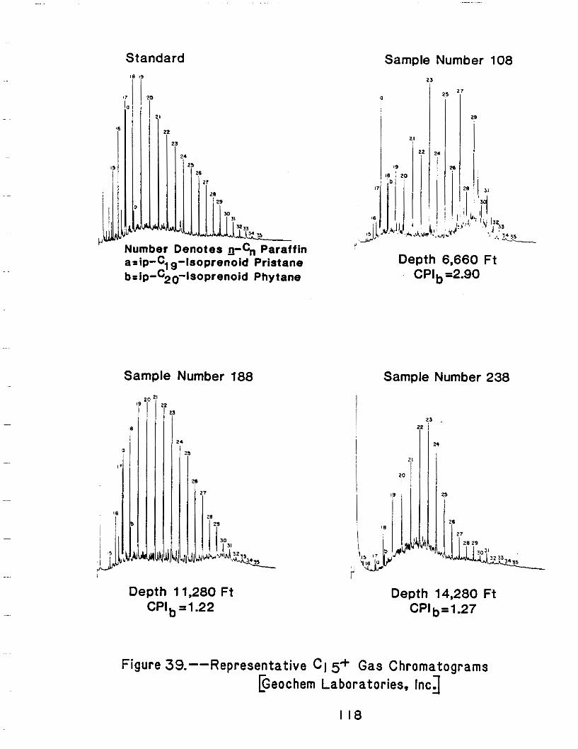
Standard
Number Denotes n-G Paraffin arip-Clg-IsoprenoidPristane b=ip-C20-lsoprenoidPhytane
Sample Number 188
'7 I
il
'i29
Sample Number 238
23
Figure 39.--Representative CI 5-t Gas Chromatograms Eeochem Laboratories, IncA
I 1 8
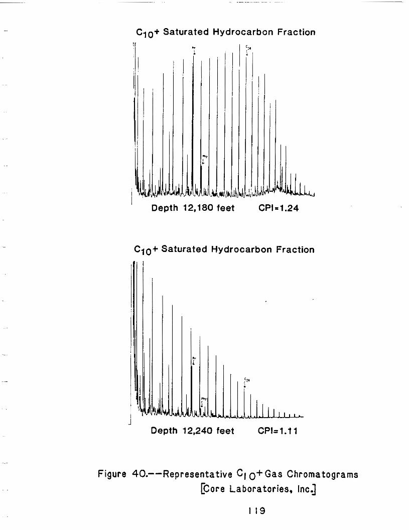
J 1
Depth 12,180 feet CPI= 1.24
C10+ Saturated Hydrocarbon Fraction
,b, , , , , ,
d Depth 12,240feet CPk1.11
Figure 40.--Representative CI o+ Gas Chromatograms [Core Laborator ies , Inc.]
I19
o f t h e k e r o g e n a t t h e expense o f v i t r i n i t e and e x i n i t i c kerogens,and a
discont inuousincrease i n t h e r m a l m a t u r i t y o f t h e k e r o g e n a t t h i s depth.
The "molecularsieved"chromatograms o f Geochem L a b o r a t o r i e s e x h i b i t a
s imi 1a r t rend .
The carbonisotoperat iosf rombothsaturated and aromaticheavy
hydrocarbon extracts were computedby Geochem Laborator ies f rom samples
c o l l e c t e d between 1,260 and 14,280 fee t us ing the Peedee belemnite
s tandard and the fo l lowing formula.
=6 1 3 ~ (13 c /%) sample - 1 x 1000
C/12C) standard
The r e s u l t s a r e g i v e n i n T a b l e 5.
120
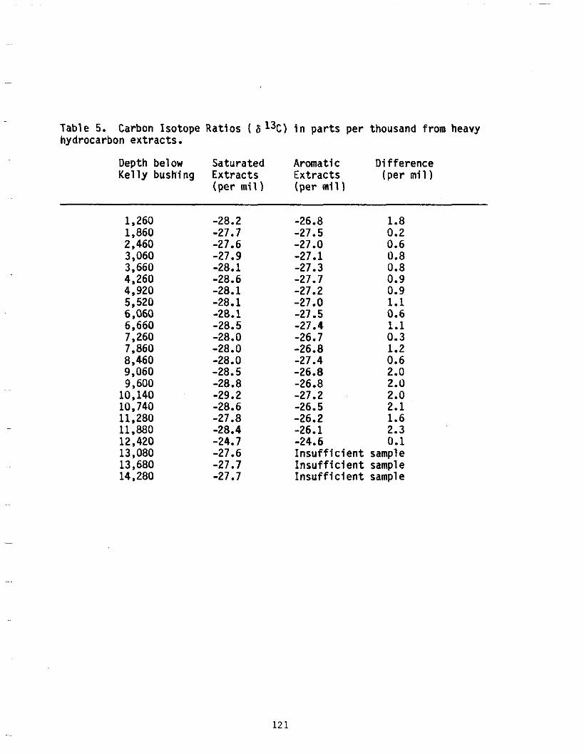
Table 5. Carbon IsotopeRatios ( 6 13C) i n parts perthousand from heavyhydrocarbon extracts.
Depth bel ow Saturated Aromatic Difference Kelly bushing Extracts Extracts (per mil)
(per mill (per mil)
1,260 -28.2 -27.71,860 0.2
2,460 0.6-27.6 3,060 0.8-27.9 3,660 0.8-28.1 4,260 -28.6 4,920 -28.1 5,520 -28.1 6,060 0.6-28.1 6,660 -28.5 7,260 -28.0 7,860 -28.0 8,460 0.6-28.0 9,060 2.0-28.5 9,600 2.0-28.8 10,140 2.0-29.2
-28.610,740 2.1 -27.811,280 1.6
11,880 2.3-28.4 -24.712,420 0.1
13,080 -27.6 13,680 -27.7 14,280 -27.7
-26.8 1.8 -27.5 -27.0 -27.1 -27.3 -27.7 0.9 -27.2 0.9 -27S O 1.1 -27.5 -27.4 1.1 -26.7 0.3 -26.8 1.2 -27.4 -26.8 -26.8 -27.2 -26.5 -26.2 -26.1 -24.6 Insufficient sampleInsufficient sampleInsufficient sample
12 1
Fuex (1977) suggests tha t the carbon iso top iccompos i t ion o f a
hydrocarbon dependsupon the 6 13C contentofthesourcemater ia l , any
f r a c t i o n a t i o n a t t e n d a n t upon i t s format ion, andany f r a c t i o n a t i o n
subsequent t o i t s formation. However, t h e 6 I3C valuesfrom
high-molecular-weighthydrocarboncomponents o f o i l androcksamplesare
re la t i ve l yf reef rombo thtypeso ff rac t i ona t ions .There fo re ,ca rbon
i so tope ra t i os f rom heavyhydrocarbonextractscan be usefu l as
ind ica tors o f the source o f the mater ia ls tha t p roduced the
hydrocarbons. However,Fuex warns thatthepresenceofnon- indigeneous
o i l s c o u l d beverymisleading.
Samples oftwenty-twosaturatedhydrocarbonshave a mean 6%
r a t i o o f -28.1 -+ 0.42 per mil. Samples o f n ine teen aromat ic
hydrocarbonshave a mean v a l u e o f -27.0 -+ 0.41 per mil. Samples
acquiredfrombelow 12,420 f e e t d i d n o t c o n t a i n s u f f i c i e n t a r o m a t i c
components tope rm i ti so top i cana lys i s .S i l ve rman (1964) and Silverman
and Epste in (1958) s t a t e t h a t t h e s e i s o t o p i c a l l y 1igh t b i tumens are
charac ter is t i co fkerogensder ivedf rom a t e r r e s t r i a l source.
One sample c o l l e c t e d a t 12,420 f e e t was n o t i n c l u d e d i n t h e
populat ionsaveraged above. The 6 13C values for saturateandaromat ic
hydrocarbonswere -24.7 per mil and -24.6 per mil respect ively.Park
and Epste in (1960) say tha t these heav ie r carbon iso tope ra t ios a re more
c h a r a c t e r i s t i c o f a marineor ig in.Nei thergeochemistrynor
paleobathymetry conclusively determined the probable source o f the
sediments a t 12,420 f e e t b u t t h e Van Krevelendiagrams(f igs. 35 and 36)
i n d i c a t e a type 111 kerogen, wi ththepredominantkerogenmaceralsbeing
122
herbaceousmaterial and i n e r t i n i t e . The H/C r a t i o i s low, and coal i s
present i n t h e c u t t i n g s . The c o n t r a d i c t o r yn a t u r eo ft h i s6 I 3 Cv a l u e
may ind i ca te tha t t he b i tum inous ex t rac ts sampled a t t h i s d e p t h were n o t
producedbyindigenouskerogen.
Rock-eval p y r o l y s i s i s performedbyheatingwholerocksamples i n
an i n e r t atmosphere a t a predeterminedrate.Free o r adsorbed
hydrocarbonsalreadypresent i n t h e r o c k a r e v o l a t i l i z e d f i r s t a t a
moderatetemperature. As thetempera tureincreases ,pyro lys iso f
kerogengenerateshydrocarbonsandhydrocarbon-l ike compounds. F i n a l l y
oxygen-bear ing vo lat i les suchascarbondioxideandwaterareevolved.
R e l a t i v e amounts o f thehydrocarbonsare measuredbyaflame i o n i z a t i o n
de tec tor and q u a n t i t i e s o f oxygen-bearing compounds by a thermal
conduct iv i t yde tec tor . The threeparametersaref requent lyrepor ted i n
w e i g h t t o w e i g h t r a t i o s o f evolved gas t o r o c k sampleand are
abbreviated by thesymbols SI, S2, and S3 respect ive ly .
StudiesbyClaypooland Reed (1976) i n d i c a t e t h a t t h e S1 peak i s
d i r e c t l y p r o p o r t i o n a l t o t h e c o n c e n t r a t i o n o f e x t r a c t a b l e C15+
hydrocarbons and t h e S2 peak i s approx imate ly p ropor t iona l tothe
organiccarboncontent o f therock. The sum S 1 + S2, i s termedthe
g e n e t i c p o t e n t i a l by T i s s o t andWelte (1978)because it accountsfor
bothtype andabundance oforganicmat ter . They suggestthefo l low ing
t h r e s h o l d v a l u e s f o r e v a l u a t i n g t h e o i l andgas p o t e n t i a l o f s o u r c e
rock.
123
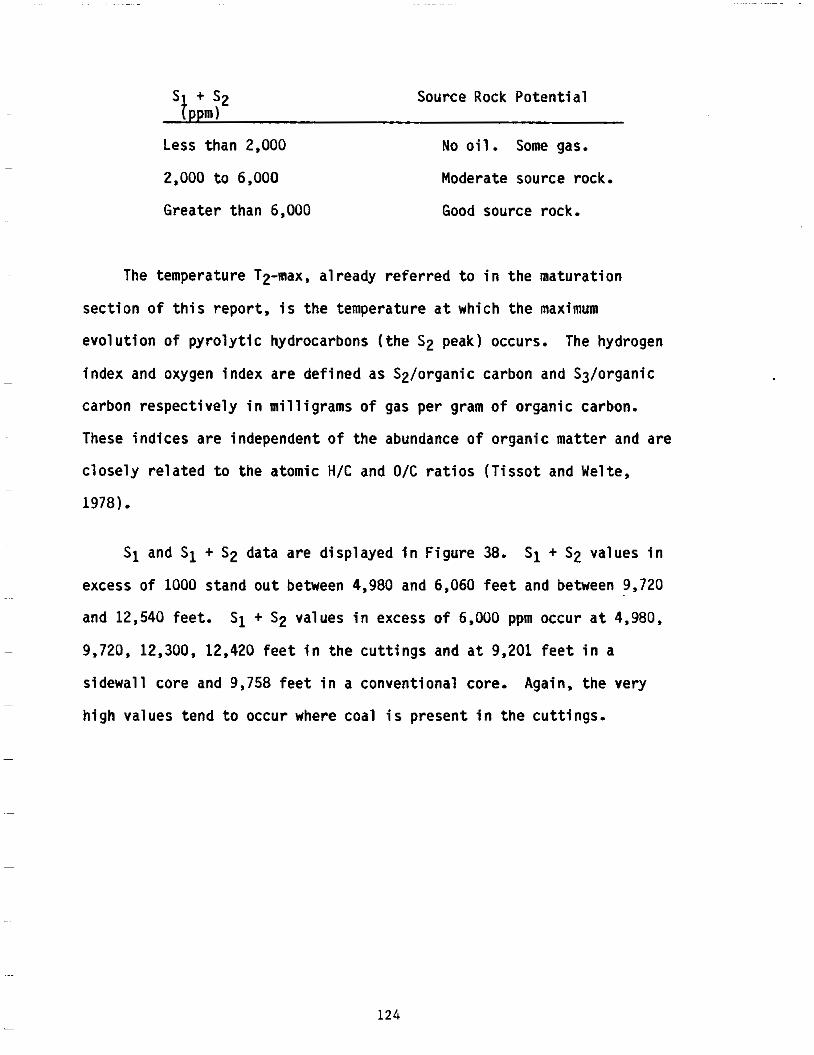
s + s2 Source Rock P o t e n t i a l tppm)
Lessthan 2,000 No o i l . Some gas.
2,000 t o 6,000 Moderatesourcerock.
Greaterthan 6,000 Good sourcerock.
The temperature T2-max, a l r e a d y r e f e r r e d t o i n t h e m a t u r a t i o n
s e c t i o n o f t h i s r e p o r t , i s t h e t e m p e r a t u r e a t w h i c h t h e maximum
evo lu t i ono fpy ro l y t i chyd roca rbons( the S2 peak)occurs. The hydrogen
index andoxygen indexare def ined as Sz/organiccarbon and S3/organic
c a r b o n r e s p e c t i v e l y i n m i l l i g r a m s o f gas per gram o f organiccarbon.
These ind ices are independent o f the abundance o f organ ic mat te r and are
c l o s e l y r e l a t e d t o t h e a t o m i c H/C and O/C r a t i o s ( T i s s o t andWelte,
1978).
~
SI and SI + S2 dataaredisplayed i n F i g u r e 38. SI + S2 values i n
excess o f 1000 s tand ou t between 4,980 and 6,060 f e e t andbetween 9,720 ~~
and12,540 feet . S 1 + S2 values i n excess o f 6,000 ppm occur a t 4,980,
~ 9,720, 12,300, 12,420 f e e ti nt h ec u t t i n g s and a t 9,201 f e e ti n a
s idewal lcore and 9,758 f e e t i n a conventionalcore.Again,thevery ~
h igh va lues tend to occur wherecoal i s present i n t h e c u t t i n g s .
124
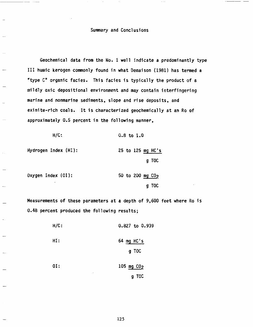
Sumnary and Conclusions
Geochemicaldatafromthe No. 1 w e l l i n d i c a t e a predominant lytype
I11 humickerogencomnonlyfound i n whatDemaison(1981)hastermeda
" type C" organicfac ies.Thisfac ies i s t y p i c a l l y t h e p r o d u c t o f a
mi ld ly ox ic depos i t iona l env i ronment and may c o n t a i n i n t e r f i n g e r i n g
marine andnonmarinesediments,slope and r i se depos i t s , and
ex in i t e - r i chcoa ls .
approximately 0.5
H/C :
HydrogenIndex(HI):
Oxygen Index(01):
It i s character izedgeochemical lyat an Ro o f
percent i n t h e f o l l o w i n g manner,
0.8 t o 1.0
25 t o 125 mg HC's
g TOC
50 t o 200
g TOC
Measurements o f these parameters a t a depth o f 9,600 f e e t where Ro i s
0.48 percent p roduced the fo l low ing resu l ts ;
H/C : 0.827 t o 0.939
H I : 64 mg HC' s
g TOC
01: 105 mg C02
g TOC
125
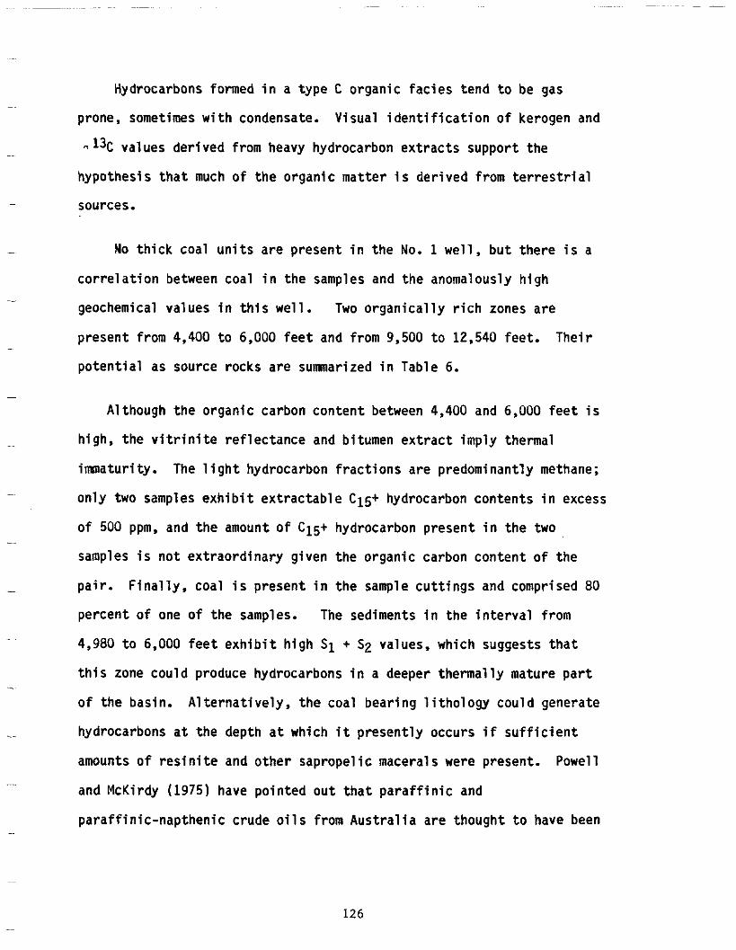
Hydrocarbonsformed i n atype C organ ic fac ies tend to be gas
prone, sometimes w i t h condensate.Visual i d e n t i f i c a t i o n o f kerogen and
n I3C values derived from heavy hydrocarbon extracts support the
hypothes is tha t much o f the organ ic mat te r i s d e r i v e d f r o m t e r r e s t r i a l
sources.
No t h i c k c o a l u n i t s a r e p r e s e n t i n t h e No. 1 w e l l , b u t t h e r e i s a
c o r r e l a t i o n betweencoal i n t h e samplesand theanomalouslyhigh
geochemicalvalues i nt h i sw e l l . Two o r g a n i c a l l yr i c h zones are
presentfrom 4,400 t o 6,000 f e e t and from 9,500 t o 12,540 feet .Thei r
p o t e n t i a l assourcerocksaresumnarized i n Table 6.
Althoughtheorganiccarboncontentbetween 4,400 and 6,000 f e e t i s
h i g h , t h e v i t r i n i t e r e f l e c t a n c e and b i tumenextractimplythermal
imnatur i t y . The l i g h t hydrocarbonfract ionsarepredominant ly methane;
onlytwo samples e x h i b i t e x t r a c t a b l e C15+ hydrocarboncontents i n excess
o f 500 ppm. and t h e amount o f C15+ hydrocarbonpresent i n t h e two
samples i s n o t e x t r a o r d i n a r y g i v e n t h e o r g a n i c c a r b o n c o n t e n t o f t h e
p a i r . F i n a l l y , c o a l i s p r e s e n t i n t h e sample c u t t i n g s and comprised 80
pe rcen to f one o ft h e samples. The sediments i nt h ei n t e r v a lf r o m
4,980 t o 6,000 f e e t e x h i b i t h i g h SI + S2 values,whichsuggeststhat
t h i s zone couldproducehydrocarbons i n a deeperthermal lymature part
o f t h e basin. A1 te rna t i ve l y , t he coa l bea r ing 1i tho logy cou ld genera te
hydrocarbons a t t he dep th a t wh ich it present ly occurs i f s u f f i c i e n t
amounts o f r e s i n i t e and othersapropel i c maceral s werepresent.Powell
andMcKirdy (1975) have p o i n t e d o u t t h a t p a r a f f i n i c and
p a r a f f i n i c - n a p t h e n i c c r u d e o i l s f r o m A u s t r a l i a a r e t h o u g h t t o havebeen
126
C4)
I I i
E X T R A C T A B L E C , 5 ~
DEPTH (It.) MATURITY >500 ppm (PYROLYSIS)
T-max. = 420V 4,400
LEVEL OF T.O.C. > I .O% LIGHT HYDROCARBONS HYDROCARBONS + S >. IO00 ppm
CPI = 4 4 400 ft. (C1-C4)>*(C2-C4)4920 ft. and 4980 ft. 4.980 ft. t o 6,060 ft. t o C 15+/7oc e 1% (S1+ S2) > 6000 ppm
6,060 ft. a t 4,980 ft.
T-rnax.= 43loC 6,000
CPI = 3
T-rnax. 432OC 9,500
CPI = 1.4 9.500 ft. t o
12.800 ft.
9,500' t o 12,200'
(C1-(C2- C4) 9.600 ft. t o 12,420 ft.
C15+ITOc > 1%
9,720 ft. t o 12,540 ft. (S1 + S2) > 6.000 ppm
9,201 ft. 9,720 ft.
12,540 T-max. z 467°C 9,757ft.
-12,300 ft. CPI = 1.1+ 12,420 ft.
TABLE 6. Summary o f Hydrocarbon Potentialindicators in Organically Rich Horizons
der ivedf romtheleaf ,po l len, and s p o r e c u t i c l e s o f h i g h e r p l a n t s .
Snowden and Powell(1982)describenapthenic o i l s and condensate i n t h e
Ter t iary of the Beaufor t -MacKenzie bas in that they suggest have been
genera ted f rom te r res t r i a l l y de r i ved o rgan ic ma t te r i n sou rce rocks
j u x t a p o s e d w i t h t h e r e s e r v o i r a t v i t r i n i t e r e f l e c t a n c e l e v e l s o f o n l y
0.4 t o 0.6 percent. Snowden (1980)hassuggested t h a t r e s i n i t e e x i s t i n g
incoalf ragmentswi th inthesediments i s thesourceofthese
hydrocarbons.
Sediments t h a t havebeen b u r i e d t o d e p t h s i n e x c e s s o f 9,500 f e e t
a r e s u f f i c i e n t l y m a t u r e and r i c h i n organiccarbon t o producehydro
carbons. The base o ft h eo i lg e n e r a t i o n andpreservat ion zone i s
approximately 12,545 f e e t where t h e r o c k s b e g i n t o assume ametamorphic
character. The c o n c e n t r a t i o n so fl i g h t - and gasol ine-rangehydro
carbons, C15+ extractable hydrocarbons. and p y r o l y s i s d a t a a r e a1 1
favo rab le fo r o i l genera t i on though no freehydrocarbonswerefound
d u r i n g d r i l l i n g o p e r a t i o n s . A t depthsgreaterthan 13,000 f e e t t h e r e i s
i nsu f f i c i en t o rgan ic ca rbon p resen t to se rve asa l i k e l y source fo r
comerc ia l quan t i t i es o f hyd roca rbons .
128
ENVIRONMENTAL CONSIDERATIONS
By PaulLowry
ARC0 Oil and Company,Gas as o p e r a t o rf o ri t s e l f and o ther
par t i c ipants ,submi t ted a l e t t e rd a t e d August 3, 1979, fortheproposed
d r i l l i n g o f aDeep St ra t ig raph icTes twe l lintheNor ton Sound areaofthe
AlaskaOuterCont inentalShel f . Documents i n suppor to fth isproposa l
inc luded a D r i l l i n g Plan, an EnvironmentalAnalysis, an O i l s p i l lC o n t i n g e n c y
Plan, and Coastal Zone Cons is tencyCer t i f i ca t i on . On t h eb a s i so f
p re l im ina ryin fo rma t ion on theproposedlocations, a s i t e - s p e c i f i c
b io log ica lsurvey, a geohazardssurvey, and a geotechnicalsurveyatthe
pr imary and a l te rna tes i tes ,tode ta i lenv i ronmen ta lcond i t i ons were
requi redbeforeapprovaloftheGeologica l and Geophysical (G&G) Permit
a p p l i c a t i o nf o rt h e Deep S t ra t i g raph icTes twe l l . The appl icantfo l lowed 30
CFR Par t 251 i n submissionofthe G&G P e r m i tf o rt h i sw e l l .
A Deep S t ra t i g raph icTes twe l l i s in tendedtoacqu i regeo log ica l and
eng ineer ingdatatodeterminethepoten t ia lfo rhydrocarbonaccumula t ion
w i t h i n a proposedsalearea. It i s commonly d r i l l e do f fs t r u c t u r e , and i t
i s notin tendedthat any hydrocarbonaccumulations be found.Althoughthe
r e v i s e dr e g u l a t i o n s do n o t f o r b i d d r i l l i n g on s t ruc ture ,theNor ton Sound
No. 1 we l l was d r i l l e do f fs t r u c t u r e . The in fo rmat iongatheredf romth is
t e s tw e l l was used tofu r the reva lua tethehydroca rbonpo ten t ia l of OCS
.
129
Lease Sale No. 57 (NortonBasin)held on March 15, 1983.
As par to fthepermi tapp l i ca t ionrev iewprocess , an Environmental
Assessment(EA) undertheNat ionalEnvi ronmenta lPol icyAct (NEPA) d i r e c t i v e
was prepared. An E A serves as a decision-making document t o determine i f
theproposedact ionisor i s no t a ma jo rFedera lac t i ons ign i f i can t l y
a f f e c t i n gt h eq u a l i t yo ft h e human environment i n t h e sense o f NEPA, Section
102(2)(C). An EA addresses and inc ludesthefo l l ow ing :desc r ip t i ono fthe
proposedact ion,descr ipt ionoftheaffectedenvironment,environmental
consequences, al ternat ivestotheproposedact ion,unavoidableadverse
environmentalef fects, and controvers ia lissues.
On thebas iso fex i s t i ngda ta and r e g u l a t i o n si ne f f e c ta tt h et i m et h e
proposal was beingrev iewed,thefo l lowingspeci f icenv i ronmenta l
aspects were consideredby MMS b e f o r e t h e d r i 11ing p lan was approved.
Geological
A s i t e - s p e c i f i c s h a l l o w d r i l l i n g h a z a r d s s u r v e y ( T e t r a Tech Inc.,
1979a) and a geotechnicalsurvey (Woodward-Clyde, 1979),requiredby MMS,
showed thesea f loo ra tthep roposeds i testo be n e a r l y f l a t and r e l a t i v e l y
fea ture less . The s i t e sl i ew i t h i nt h eN o r t o nB a s i n , a geologicdepression
f i l l e di nw i t hp r e d o m i n a n t l y Cenozoicsedimentaryrocks. The bottom
sedimentconsis tsofvery dense, sandy s i l t . The b a s i ns t r u c t u r ei s
dominatedbywest-northwesttrendingnormalfaultsthatoftenoccur as
grabens. Many o fthefau l t sa reg rowthfau l t stha texh ib i ti nc reased
130
displacement on the down-thrown side. Few f a u l t si nt h eN o r t o n Sound area
d i sp lacethesea f loo r ;sea - f l oo rfau l tsca rps have been r e p o r t e di nt h e
per ipheryo fthebas in ,bu tthereare none w i t h i n t h e v i c i n i t y o f t h e
subject we1 1.
Potent ia lhazards:
1. Ice-gougingofbottomsedimentsbyfloating pack i c e has been
r e p o r t e di nN o r t o n Sound.The predominant movement o ft h e pack
i c e i s t o t h e southwest.This movement creates azone o f
convergence seaward o ft h e Yukon Del ta ,causingpressurer idgesto
form where t h e d r i f t i n g pack iceshearspastthestat ionary
shorefastice.Bothpressure-r idgerak ing and s o l i t a r y gouges
occur, and theyare most comnon between the 33- to65 - foo t
i s o b a t h so f ft h e Yukon Del ta . No gougeswere r e p o r t e di nt h e
immediate v i c i n i t y o f t h e w e l l .
2. An area of intensecurrentscour hasbeen repor ted seaward o ft h e
Yukon Del ta . These scour zones areassociatedwi thice gouges and
increasedbot tomsteepness.Act ive lymigrat ing sand waves have
been observedoffPortClarenceneartheBeringStraits.Neither
scour zones nor sand waves have been r e p o r t e d i n t h e v i c i n i t y o f
t h e No. 1 we l lloca t ion .
3. S e i s m i c i t yi nt h eN o r t o n Sound r e g i o ni sg e n e r a l l yl o wt o
moderate. The largestrecordedearthquakereached a magnitudeof
6.5 R i c h t e r and was located on the Seward Peninsulaabout 18.4
131
milesin landfromNorton Sound. Mostrecordedearthquakes i nt h e
arearangefrommagnitude 1 t o 4.5 R ich te r .
4. Numerous b iogenic gas cratersoccurineasternNorton Sound; a
thermogenic gas seephasbeen repor ted 25 mi lessouthof
o f Nome.No gas anomalies were i d e n t i f i e da tt h ew e l ls i t e .
No undue r e s t r a i n t s wereimposed on t h i s Deep St ra t ig raph icTes twe l l
programbecause ofgeologichazards, and no operationalproblems
developed.
Meteoro log ica l and OceanographicData
Most o ft h eB e r i n g Sea l i e si ns u b a r c t i cl a t i t u d e s ;t h e r e f o r e , a
cyc lon ica tmospher icc i rcu la t ionpredominatesinth isreg ion .C loudysk ies ,
moderatelyheavyprecipi tat ion, and strongsurfacewindscharacter izethe
marineweather.Stormsare more f r e q u e n ti nt h e fall than i nt h es u m e r .
Therearetwodominantcurrentpatterns i nt h eN o r t o n Sound area;
nor thwardf low ingcur ren tstha t pass eas to f S t . Lawrence Is land, and the
coun te rc lockw isec i r cu la t i onsys temwi th inNor ton Sound. Wave he igh ts
greaterthan 8 feetare common lessthan 10 percent of thet imeinAugust
and September, and lessthan 20 percent of thet imeinOctober . A t Nome,
t h e mean datesofsea-icebreakup and freezeupare May 29 andNovember 12,
r e s p e c t i v e l y .S u p e r s t r u c t u r ei c i n gi sp o s s i b l ei n June and i s probable i n
October.
132
Sea i cecond i t i onsinNor ton Sound v a r y f r o m s i t e t o s i t e and i c e
movement i s causedbycombination of geography and p r e v a i l i n gn o r t h e a s t
winterwinds. The p r e v a i l i n gn o r t h e a s t winds r e s u l ti n an almostcontinuous
east-northeasttowest-southwestevacuat ion o f i c e from t h e Sound throughout
t h ew i n t e r .E x c e p tf o rt h es h o r e - f a s ti c e ,t h ei c ei nt h i sa r e ai se n t i r e l y
rep lacedbyth isprocesssevera lt imesdur ing a season. F i r s t - y e a ri c e
u s u a l l y moves outoftheareabythet ime it i s about18inchesthick. The
s i t ei sc h a r a c t e r i z e db yr e l a t i v e l yt h i n , weak i ceincons tan tmo t ionw i th
e x t e n s i v er a f t i n g
Pack i cegenera l l ybeg instofo rminNor ton Sound i n mid- t o l a t e
October. Some areas i n and around t h e Sound arecompletelyicecoveredby
mid-November. A f t e r mid-December,pack icegenera l l ycomole te lycoversthe
Sound.
By mid-March t h ei c e pack a t t he head o f t h e Sound begins t o t h i n ,b u t
does not show a p p r e c i a b l em e l t i n gu n t i l mid-May. By mid-June t h e Sound is,
comple te lyicef ree . TheNo. 1 w e l l was d r i l l e dd u r i n g an open-water
season.
Because l im i tedmeteo ro log i ca l and oceanographicdata were avai lab le,
t h e MMS i s s u e d t h e G u i d e l i n e s f o r C o l l e c t i o n o f M e t e o r o l o g i c a l ,
Oceanographic, and PerformanceData(January 21, 1982)and requ i redthe
o p e r a t o rt oc o l l e c tm e t e o r o l o g i c a li n f o r m a t i o nt oa i di nf u t u r eo p e r a t i o n s
w i th inNor ton Sound. Dur ingsetup and opera t i on ,c l ima t i c and sea s t a t e
cond i t ions were monitored t o ensu retha tl oca lcond i t i onsd idno t exceed r i g
to lerancesorjeopard ize human safety . Winds, barometr icpressure,a i r and
133
watertemperatures, waves, cur ren ts , and i c ec o n d i t i o n s were monitored. All
e n v i r o n m e n t a ld a t ac o l l e c t e dd u r i n gt h ed r i l l i n go ft h i sw e l la r ea v a i l a b l e
t o t h e p u b l i c .
Bio log ica lSurvey
Bio log ica lSurveyResul ts
A s i t e -spec i f i cmar ineb io log i ca lsu rvey was designedby lvMS i n concert
w i tho the rfede ra l and Stateagencies t op r o v i d eb i o l o g i c a ld a t aa tt h e
proposed Deep Strat igraphicTests i tes.Throughthe use o f underwatervideo
and photographicdocumentation,planktontows,infaunalsampling, and
t raw l ing ;Te t ra Tech Inc. ,(1979b)determinedtherelat ive abundance and
typesoforganizmspresent i nv a r i o u sh a b i t a t s . These s tud ies were
conductedduring June and J u l y 1979 t o determinebio log ica lresourcesatthe
proposed d r i l ls i t e s . The r e s u l t sa r e summarized as fo l l ows :
1. Underwaterte lev is ion and bathmetryrecordsind icatedthatthe
s e a f l o o ra tb o t hs i t e si s f l a t . Sediments i nb o t h areascons is to f
sand (60 percent), s i l t ( 35 percent ) ,she l ldebr is and c l a y( l e s st h a n
5 percent ) .
2. The zooplankton i nb o t h areas was dominatednumerical lybysmall
j e l l y f i s h and copepods. F i v ef i s hl a r v a e were co l l ec teda tthep r imary
s i t e and 17 a tt h ea l t e r n a t es i t e ;o ft h et o t a l , 11 were p leuronec t ids
(p robab ly Limanda sp.)and 9 weregadi,d larvae.
134
3 .
4.
5.
6.
Approximately 900 f i s h eggs were c o l l e c t e d a t thetwosi tes;overhal f
had n o td e v e l o p e ds u f f i c i e n t l yt o be i den t i f i ed .Approx ima te l y 40
percent were p leu ronec t i d eggs, probably Limanda sp.
About 1,000 larvalmalacostracans were co l lected,one- four thofwhich
were n o ti d e n t i f i a b l e . About h a l f were larvaeofthehermi tcrab
family (Parur idae) and 15 percent were shrimplarvae. No l a rvae of
k i n g o r Tannercrabs were co l l ec ted .
The in faunaatthepr imarys i teaveraged 38 taxa and 230 i n d i v i d u a l s
per 0.1 m2/grab. Annelids and arthropodsaccountedfor 85 percent o f
a l l organismscol lected. The threemost abundantorganismswere t h e
amphipod, Protomedeia sp.,and thepolychaetes,Myr iocheleoculata and
Haploscoloploselongatus. A t t hea l te rna tes i te ,theg rab samples
averaged 29 t a x a and346 indiv iduals.Annel idsalonecomprised80
percento fa l lo rgan ismsco l lec ted , and theth ree mostabundant
organisms were thepolychaetesTharyxparvus,Haploscoloploselongatus,
and Mediomastus c a l i f o r n i e n s i s .
Demersal t rawlsco l lec tedapprox imate ly 3 pounds o f f i s h each 30-minute
h a u l .O v e r a l l ,P a c i f i c tomcod (Microgadusproximus) and Y e l l o w f i ns o l e
most(Limandaaspera) were abundant. The inve r teb ra teca tchinbo th
areas was dominatednumericallybyechinoderms.
On thebasisofb io log ica lsurveysconductedbyTetra Tech, Inc.,
ne i thers i tesuppor teduniquehabi ta tsorspecies of s p e c i a li n t e r e s tt h a t
r e q u i r e dr e j e c t i o no rm o d i f i c a t i o no ft h et e s tw e l l program. The Regional
135
Superv isor ,Of fshoreFie ldOperat ions,concludedthatnormaldr i l l ing
o p e r a t i o n sa te i t h e ro ft h e two s i t e s wouldnotadverse lyaf fectthe
environment.
Marine Mammals/Endangered Species
Marine mammal d i s t r i b u t i o ni nt h e n o r t h e r nB e r i n g Seaand Norton Sound
i ss t rong lyin f l uencedbythepresence of sea i ce . Seasonal d i s t r i b u t i o n s
o fseve ra lspec ies ,pa r t i cu la r l y bowhead and beluga whales, walrus, and
r inged, bearded, and spottedsealsarecloselyassociatedwiththeadvancing
and r e t r e a t i n g edge of t he pack ice . These specieswinterintheNorton
Sound-northBering Sea reg ionatthesouthern limit ofthe pack i c e and
g e n e r a l l yf o l l o wi t sr e t r e a tn o r t h w a r dd u r i n g sumner. However, n o ta l l
i n d i v i d u a l s move n o r t ht ot h e Chukchi and Beaufor t Seas a t thatt ime. A few
walrus,spotted and beardedseals, and beluga and k i l l e r whales may still be
encountered i n Norton Sound dur ing summer.
The on ly endangered mammal s p e c i e sl i s t e df o rt h eN o r t o n Sound area
were thegray, bowhead, f i n , andhumpback whales. The endangered peregr ine
fa lconoccursa longthecoastintheNorton Sound area.
A fo rmalconsu l ta t ion was requestedfrom U.S. F ish and W i l d l i f eS e r v i c e
(USF&WS) and Nat ionalMar ineFisher iesServ ice (NMFS) regard ing endangered
spec iesfortheNor ton Sound area i n a l e t t e rd a t e d August 7, 1979. NMFS
concludedthat whales,which u t i l i z e t h e proposedleasearea i n general,
p r i m a r i l y o c c u r west o f a l i n e between Nome and t h e Yukon R ive rDe l ta
(166'W. l ong i tude ) . Because o fthel im i teda rea and du ra t i ono fthe
136
d r i l l i n g program, it was conc ludedtha ttheac t iv i t ywou ldnotjeoprad ize
gray, bowhead, f i n ,o r humpback w h a l e so rr e s u l ti nt h ed e s t r u c t i o no r
a d v e r s em o d i f i c a t i o no fc r i t i c a lh a b i t a t . The w e l ls i t e was ou ts idethe
normalrange f o rt h ep e r e g r i n ef a l c o n .
F i she r ies
The mar inef isheryo fNor ton Sound i s not as p roduc t ive as t h a t i n
o t h e rp o r t i o n so ft h eB e r i n g Sea; however, t h e r e i s a l imi tedcommerc ia l
u t i l i z a t i o no fl o c a ls h e l l f i s h and demersal f i s h . Most demersalabundant
f i s hi n c l u d e cod, f l a t f i sh ,scu lp ins ,he r r i ng , and smelt. Shrimp, k i n g and
Tannercrab, and clamsdominatetheshel l f ishresources.
B i rds
The Norton Sound avi faunaisdominated by the sumner waterfowl and
shorebirdpresence at. t h e Yukon Delta.Thisarea i s recognized as one o f
t h e most p roduc t ivenes t ing areas i n Alaska.Est imatesofsumer
popu la t ionsinc lude 3 m i l l i o nw a t e r f o w l and over 100 m i l l i onshoreb i rds ; 170
d i f f e r e n ts p e c i e s have been recorded.Coastalsal t marshes, whicharethe
key t ot h i sa r e a ' sp r o d u c t i v i t y ,p r o v i d en e s t i n gh a b i t a tf o rb i r d s such as
blackbrant; emperor, cack l ing, and wh i te - f ron ted qeese; comnon, spectacled,
and S t e l l a r ' se i d e r s ;w h i s t l i n g swans;and numerous ducks and shorebirds.
These b i r d s have a s t r o n ga f f i n i t yf o rc o a s t a lh a b i t a t s anddo notoccur
more than 2 t o 3 mi lesof fshore,exceptdur ingmigrat ions.
137
Norton Sound also supports several marine bird rookeries, although the
number of colonies and their individual sizes (number of birds) do not
compare with those in other Bering Sea regions. Murres, kittiwakes,
cormorants, and puffins are most common.
Cultural Resources
Cultural resource surveys may be required in order to assurethat no
disturbance of archeological or cultural resources on the seafloor. After
consultation with the resource agencies, MMS determined that suchsurveys
would not be required for the Norton Sound Deep Stratigraphic Test well
sites as they were located in low-probability areas for cultural resources.
If the TV transects and side-scan sonar taken in conjunction with the
biological survey had indicated unexplained anomalies, a review by a
qualified marine archeologist would have been required. No such anomalies
were detected. No cultural resources were identified during drilling
operations.
Discharges into the Marine Environment
Some liquid wastes, including oil from the oil/water separator, were
transported from the drilling vessel by supply boats and disposed of in
approved onshore locations. Solid wastes were compacted and similarly
transported t o an approved onshore disposal site. Liquid wastes, including
treated sewage, gray wa’ter, and some drilling by-products, were discharged
on site into marine waters in accordance with regulations set forth by the
U.S. Environmental Protection Agency (EPA).
138
The a p p l i c a n td i s p o s e do fd r i l lc u t t i n g s and waste d r i l l i n g mud i n t o
t h e ocean i n compl iancewi thex is t ingorders.Pasts tud ies on t h ef a t e and
e f fec tso frou t i ned ischargesf romof f sho reo i l and gas a c t i v i t i e si n t ot h e
marineenvironment and the known d i s p e r s i o nr a t e so f such discharges, show
t h a t such operat ions do n o ts i g n i f i c a n t l ya f f e c t on theenvironment. No
o i l - b a s e dd r i l l i n g mudwas used.Bentonite i s a con t inuousadd i t i vetothe
d r i l l i n g mud, whereas b a r i t e i s added as necessaryforincreas ing mud
weight.Bentonite and ba r i t ea reinso lub le ,non tox i c , and iner t .Other
addi t ivesare used i n minorconcentrations, and mostare used onlyunder
spec ia lcond i t ions . These o theradd i t i vesaree i thernontox icorwou ld
c h e m i c a l l yn e u t r a l i z ei nt h e mud o r upon contac tw i th sea water(i.e.,
caust icsoda). Excess cement entered and was d ispersedin tothe ocean when
thesha l l owcas ings t r i ngs were set.
Con t ingency P lan fo r O i l sp i l l s
P lansforprevent ing,repor t ing, and c lean ing up o i l s p i l l s were
addressed i n t h e O i l s p i l l ContingencyPlan (OSCP) which was a p a r t o f t he
d r i l l i n gp l a n . The OSCP l i s t e dt h e equipment and m a t e r i a la v a i l a b l et ot h e
permi t tee and desc r ibedthecapab i l i t i eso f such equipmentunder d i f f e r e n t
sea and weathercondit ions. The p lana lsoinc luded a d iscuss ionof
l o g i s t i c a ls u p p o r t programs forcont ingencyoperat ions. The p r o b a b i l i t yo f
encounteringhydrocarbonsthatcould cause a blowoutat any depth was
min imizedbylocat ing the w e l lo f f - s t r u c t u r e . The o p e r a t o rd r i l l e dt h ew e l l
according t o t h e OCS Orders and used standardwell-controlequipment and
procedures. The cas ing and cementingprograms and subsequent abandonment
139
requ i rements(asout l inedin OCS Order No. 3 ) were designedtoprevent
l eakageorcon tamina t iono ff l u idsw i th in a permeable zone.
Upon comple t ionofthewel l ,thes i te was c lea redo f all pipe and o ther
ma te r ia l on o r above the ocean f l o o r .
As p a r to ft h e E A process,theproposedprogram was submi t tedtothe
appropr iateFederal and Stateagencies, as we l l as i n t e r e s t e dp a r t i e s ,f o r
comments. Responseswere inc luded as p a r to ft h e EA. On thebas iso f EA
No. AK-80-1, it was determined, on June 6, 1980, t h a t ARCO's proposedaction
c o n s t i t u t e d a f i n d i n go f no s ign i f i can timpac t (FONSI), and t h a t an
EnvironmentalImpactStatement was notrequi red. A Not ice was issued t o
t h a te f f e c t . MMS consequentlyissued a l e t t e r t o ARCO, dated June 13, 1980,
approvingtheirproposedact ion. The EA and t h e FONSI documents are i n t h e
p u b l i cf i l ei nt h eo f f i c eo ft h eR e g i o n a lS u p e r v i s o r ,O f f s h o r eF i e l d
Operations,800 A St reet , Anchorage, Alaska, 99501.
140
SUMMARY AND CONCLUSIONS
Ronald F. Turner
Pr io rtotheComple t ionoftheNor ton Sound Deep St ra t ig raph icTes twe l l
program, very l i t t l e was known a b o u tt h ep e t r o l e u mp o t e n t i a lo ft h i s OCS f r o n t i e r
area. The mostwidelyacceptedbasinevolut ion model was thecomprehensive.~
a n a l y s i so fF i s h e r and o thers (1982).Sincethecomplet ionofthe second and
f i n a l t e s t w e l l , however, t h e number ofmodelshasapparentlyincreased t o near
t h a t o f t h e number o fp a r t i c i p a n t s .W i t ht h ep u b l i cr e l e a s eo ft h e s ed a t a i t
i s a l m o s tc e r t a i nt h a tt h e number will increaseagain.Basinevolut ion models
based on subsurfacegeological,geophysical, and geochemicaldataaredoubly
i n t e r p r e t i v e owing t ot h ev e r yn a t u r eo ft h ed a t a .T h i si n t e r p r e t a t i o ni s no
exception. It i s , however, t h ef i r s tp u b l i s h e di n t e r p r e t a t i o nm a d e . w i t ht h e
benef i to fwe l lda ta .A l thought imeconst ra in ts imposedby s t a t u t o r yd a t a
re leasedates have, t o some e x t e n t , l i m i t e d v a r i o u s a s p e c t s o f t h i s o n g o i n g
i n v e s t i g a t i o n , it i ss u b s t a n t i a l l yc o m p l e t e .P r e l i m i n a r ya n a l y s i s o f t heda ta
f romthetwowel lssuggests a b a s i n e v o l u t i o n t h a t d i f f e r s f r o m t h e p r e d i c t e d
models i n severa laspectsofdeposi t ional and subsidencehis tory .Ingenera l ,
t hebas in fill i s younger and f a r more marinethan hadbeen an t i c ipa ted , and
t h e t e c t o n o - e u s t a t i c h i s t o r y o f t h e b a s i n i s morecomplex.
The sedimentarybasin fill appears t o beyoungerthanpreviousestimates.
The presenceofCretaceoussedimentaryrocks and coalalongtheeasternshore
o fNor ton Sound (Patton,1973) l e dF i s h e r and o thers (1982) t o p o s t u l a t e t h a t
- 141
theNortonBasinmightconta insedimentaryrocksasold as LateCretaceous.
However, t h e m i d d l e t o l a t e Eocene s t r a t a p r e s e n t i n t h e No. 2 we l l (10,160-12,700
fee t )a retheo ldes tsed imen tsfo rwh ichthe rei s a firm age. T h i sd e f i n i t e
Eocene s e c t i o n i s u n d e r l a i n by a 1760- foot - th ick sequence ofinterbeddedsandstone,
s i l t s t o n e , mudstone,and coaldeposi tedunderf luv ia l and pa luda lcond i t ions .
Eocene fungalpalynomorphs were recoveredfromsidewallcorestaken i n t h i s
sect ionbutnotfromconvent ionalcores. The p rese rva t i ona ls ta teo fthese
palynomorphsmatched t h a t o f i n s i t u elementsof thesparse and poor lypreserved
spore-pol len assemblage.Because o ft h e somewhat equivocalnatureofthe
evidence, t h i s s e c t i o n , and a much t h i n n e r c o r r e l a t i v e s e c t i o n i n t h e No. 1
w e l l (12,235-12,545 fee t ) , was assigned an age o f Eocene o ro l d e r .I nb o t h
Norton Sound we l lstheses t ra taunconformab lyover l ie much oldermetamorphic
basement rocks. On thebas iso fthepresentda ta i t appears l i k e l y t h a t t h e y
representtheo ldes tsed imentaryrocksinthebas in and are no o lde rthan
Paleocene,probablyyounger.
Anotherlessd i rec tl ineo fev idencea lsosuppor ts an e a r l y T e r t i a r y age
forthesesediments. The metamorphicter ranesofthe Seward Peninsulaarethe
sourceof much o fthesed imen tintheNor tonbas in ,pa r t i cu la r l ythe S t . Lawrence
subbasin. A potassium-argondatefrom a muscovi teconcentratefrom one o f t h e -
lowermostsandstones i n t h e No. 1 we l l (12,398 fee t ,poss ib le Eocene o ro l d e r
y ie lded an age of 146 m.y. This represents~~ s ec t i on ) approximately date the
La teJurass ictoEar lyCre taceous metamorphism o fthesourcete r rane and i s i n
agreement withpotassium-argon ages obta inedfromwhi temicasf romblueschis t
faciesmetamorphicrocksfromthe Seward Peninsula (A. Till, personal
communication).Isolatedglaucophane-bearingrockshavelong been known from
t h e Seward Peninsula(Smith, 1910; Sainsbury and others,1970),but more r e c e n t l y
Forbesand others(1981), and Till (1982)described an extensivehigh-temperature
b luesch is tfac ieste r ranethere . These rocksarethoughtto have formed a t
8-10 kbpressure a t c r u s t a l d e p t h s o f a t l e a s t 24 km (A. Till, personal
communication). IntheLateCretaceous(68-69 my., K - A r date)theserocks
were in t ruded byep izona lgran i tes tocks( the" t ingran i tes" )a tdepthsof
perhaps 9 km (Hudson, 1979). The ove ra l lt h i cknesso ftheb luesch is trocks
cannotbeascertained,norcanthe amount o f s e c t i o n removed a t o r be fo rethe
t i m eo fg r a n i t e implacement. Even so, i t seems u n l i k e l yt h a tm i c a st h a t
rec rys ta l i zeda t b luesch is tfac iesdep thsintheLa teJu rass i c -Ear l yCre taceous ,
t h e n i n t r u d e d i n t h e L a t e C r e t a c e o u s w h i l e s t i l l a t greatdepth,wouldbe
a v a i l a b l e assedimentarybasin fill i nt h eL a t e Cretaceous. I nf a c t , i t appears
thatthebasalunconformi ty and theonseto f basement r i f t i n g b o t h may represent
ear l y Te r t i a ry even ts .
The S t . Lawrence and Stuar tsubbasinsresul tedf rommul t iphas icextens ional
tectonismexpressedasdi f ferent ia l ,nonsynchronoussubsidencealongnormal
fau l ts .Thereappearto be s i g n i f i c a n ti n t r a - f i l lu n c o n f o r m i t i e sp r e s e n ti n
bothsubbasins.Li thologic,dipmeter,geophysical , and geochemicalevidence
f o rt h el o w e s tu n c o n f o r m i t yi sb e s td e v e l o p e di nt h e No. 2 we l l .Th issur face
may haveformedcontemporaneously w i t h o r p r e c e d e d i n i t i a l u p l i f t i n g o f t h e h o r s t .
The ambiguous ev idencefo rangu la r i t y seen on one pub l icse ismicl inesuggests
t h a tt h eu n c o n f o r m i t y was i np a r tt e c t o n i c a l l yc o n t r o l l e d .E u s t a t i c changes
t h a t r e s u l t e d i n l o w e r base l e v e l may beinvoked as an a l t e r n a t i v e o r a n c i l l a r y
t o tectonism.Calculat ions made from v i t r i n i t er e f l e c t a n c ev a l u e s( f o l l o w i n g
t h e method o f Dow, 1977)suggestthatperhaps1000feetofsect ion may be
143
miss ing i n t h e No. 2 wel l . A more s u b t l em a t u r i t y anomaly oflessmagni tude
i s present i n t h e No. 1 we l lf o rwh ich no miss ingsect ioncouldbecalcu lated.
I f th islowerunconformi tysepara tesear ly and middle Eocene rocks,theeros ion
was r e l a t i v e l yr a p i d . The unconformi tycou lda lsobein te rpre ted as a marine
t ransgress iveevent i f thedepos i t iona lna tureo ftheOl igoceneoro ldersec t ion
o f t h e No. 1 we l l was lessequivocal and t h ep o s i t i o no ft h eu n c o n f o r m i t yi n
t h e No. 2 w e l l was moved up t o t h e base o f t h e t r a n s i t i o n a l i n t e r v a l a t 11,960
f e e t (a b e t t e r geochemical f i t , ra therthanthe 12,700 feetd ipmeterp ick) .
Samplesand o t h e rd a t af r o mt h i si n t e r v a li nb o t hw e l l sa r eb e i n gr e p r o c e s s e d
and reevaluated i n hopes o f c l e a r i n g up theseambigui t ies.Asidefromthe
majorunconformitybetweenPaleozoic and Cenozoicrocks, and t h e mid-Eocene
(?) unconformitydiscussed above, twootherunconformi t ies were i d e n t i f i e d , a
Pl iocene-Ple is toceneunconformi tyd iscern ib le on sha l lowse ismicl ines and a mid-
Miocenehiatus based on s i l i c e o u s m i c r o f o s s i l s .
Perhapsthemostin t r igu ingdeviat ionf romthepredic tedbasin model
concernsthenatureofPaleogenedeposit ion. On thebas iso fsca t te redou tc rops
o f nonmarinePaleogenerocksaroundNorton Sound, t h e presumed nonmarinenature
o f sediments o f t h i s presumedage i n t h e Hope basin, and re fe rencetotheAnadyr
bas in as an analog,Fisher and others(1982)speculatedthatthePaleogene
sec t ionoftheNor tonbas inconta inedon lynonmar inerocks .Infac t ,bo th
we l lsconta ins ign i f i can tth icknessesofPa leogene age mar inest rata. I f , as
postu la tedby Herman and Hopkins(1980),theBering Sea landbr idgeseparated
t h e P a c i f i c and A r c t i c oceans u n t i l 3.5 m.y. ago, t h i s Paleogenemarine
connection was probably an arm o f t h e P a c i f i c , and the Nun ivak a rch o f Scho l l
and Hopkins(1969) and Marlowandothers(1976) was n o t t h e b a r r i e r t o Paleogene
mar ineincurs ionspostu la tedbyFisher and o the rs(1982) .A l te rna t i ve l y ,the
144
-
seaway between theeastwardmovingSiberianblock(theChuktosk and Seward
peninsulas) and mainlandAlaska may nothave been e n t i r e l y c l o s e d a t t h e end o f
theCretaceousaspostulatedby Sachs and Strelkov(1961) andHolmesand Creager
1981). It i sa l s oc o n c e i v a b l et h a t an Arct icconnect ioncouldhave been
reestabl ishedthroughlowsoverthe Seward PeninsulabeforemajorlateCenozoic
u p l i f t s . The presence o f Pa leogeneforamin i fe ra lfaunaswi ths t rongaf f in i t ies
t o thoseo fSakha l i nI s land and t h e Kamchatka Peninsulasupports a P a c i f i c
ra therthanArc t icconnect ion .Inpar t i cu la r ,thepresenceofspec ies
Porosoro ta l ia , a p redominant lyaus t ra lPac i f i cPa leogeneforamin i fe ra l genus,
l e n d s f u r t h e r c r e d e n c e t o t h i s i n t e r p r e t a t i o n .
O f t hetwowe l l s ,t he No. 1 i s byfa rthemostmar ineinaspec t .Near ly
5000 f e e t o f t h e 5197 foo tth ickOl igocenesec t ion was deposited i n o u t e r
n e r i t i c t o upperbathyaldepths. I f theapparen ttu rb id i t esbe low i t ( t e n t a t i v e l y
c o r r e l a t e d w i t h t h e m i d d l e t o l a t e Eocene s e c t i o n i n t h e No. 2 w e l l ) a r e a l s o
m a r i n e , t h e n v i r t u a l l y t h e e n t i r e Paleogenesect ion,wi ththeexcept ionof 310
fee to fcoa l -bear ingsed imentso fposs ib le Eocene o r o l d e r age, i s marine.
More t h a nh a l fo ft h e 6536 f o o tO l i g o c e n es e c t i o ni nt h e No. 2 we l l i s made up
ofshel fa lmar inesediments;theremainderconsis tsofcoal -bear ingt rans i t ional
sedimentsdeposited i n marshand esturineenvironmentsundermarineinf luences.
The Eocene s e c t i o na l s or e f l e c t ss i g n i f i c a n tt r a n s i t i o n a lc o n d i t i o n s , and
d e f i n i t em a r i n ef o s s i l sa r ep r e s e n t as deep as 11,200 fee t . All i n a l l , t h e r e
i s probablylessthan 2400 fee tcumula t iveth icknessofpure lycont inenta l
Paleogenesectionpresent i n t h e No. 2 wel l . The la teOl igocenecoa l -bear ing
sequence descr ibed i n b o t h w e l l s ( o u r D seismichor izon) i s i n p a r t c o r r e l a t i v e
w i t h c o a l s o f t h e same age reportedfromnearUnalakleet(Patton, 1973; W.
145
Patton,wri t tencommunicat ion) and from S t . Lawrence I s l a n d byCsejteyand
Patton(1974). These s t r a t a appear t od e f i n e a reg iona lregress iveeventtha t
may have c o n t i n u e d i n t o t h e e a r l i e s t Miocene.
The Yukon h o r s t does notappear t o havebeen a m a j o r b a r r i e r between t h e
twosubbas insun t i la f te rthe mid-Eocene (? ) eros ionaleventwi thwhich i t may
becausal lyrelated.Thereafterthesubbasins had somewhat d i f f e r e n tt e c t o n i c
and depos i t i ona lh i s to r i esun t i lt hemid -O l igocenet ransg ress i veeven ttha t
breachedtheelongatenor th-southst ructure.Subsidenceaf terth ist imeappears
t o havebeen a basin-wideisostat icreponsetosedimentloading, and f o r t h e ~
f i r s t t i m e d e p o s i t i o n e x t e n d e d beyond theindependen t ,s t ruc tu ra l l yde l i nea ted
subbasins.Althoughdeposition i nt h e S t . Lawrencesubbasin (No. 1 w e l l ) was
always more marinethan i n t h e more eas ter lys i tua tedStuar tsubbas in (No. 2
wel ' l ) ,the Yukon ho rs t was no t an a l toge the re f fec t i vephys i ca lo rfauna l
b a r r i e r as ev idencedbythepresenceo ffoss i l i f e rousmar ines t r i nge rsin te r -
c a l a t e dw i t hc o n t i n e n t a l and t rans i t i ona lcoa lsth roughou tthe Eocene and
Ol igocenesec t i ono fthe No. 2 wel l .
e q u i v a l e n c y i s~~~ The most d i f f i c u l t t o t h a t between thee s t a b l i s h p rob lemat ic
O l i g o c e n eo ro l d e rn o n f o s s i l i f e r o u st u r b i d i t e s (? ) o f t h e No. 1 we l l and t h e .~~
m i d d l e t o l a t e Eocene t r a n s i t i o n a lt oc o n t i n e n t a lc o a l - b e a r i n gs e c t i o no ft h e
No. 2 well(as was noted i n t h e d i s c u s s i o n o f t heuncon fo rm i t ya tthebaseo f
both).Smallchipsofunweatheredglaucophaneschist i nc u t t i n g sf r o mt h i s
s e c t i o no ft h e No. 1 we l lind ica terap ideros ionf rom a nearbysource,probably
thehors t . I f thesewe l lsec t i onsa reco r re la t i ve , as wenow be l ieve ,thenthe
146
presence o f Eocene m a r i n e f o s s i l s i n t h e No. 2 w e l l makes a l a c u s t r i n e o r i g i n
f o r t h e t u r b i d i t e s e c t i o n o f t h e No. 1 we l l (9690-12,235 f e e t ) d i f f i c u l t t o
exp la ininte rmsofs imp lepa leogeography . Geochemicalevidence f o r a l a c u s t r i n e
environment i sn o tc o m p e l l i n g . The dominantorganicmater ia lpresentoverthe
i n t e r v a l i s t ype I11 kerogenassociatedwi thminor amounts o fp o s s i b l et y p e I 1
kerogen.Type I kerogen,espec ia l l ya lgan i te , i s t h et y p eo fo r g a n i cm a t e r i a l
c h a r a c t e r i s t i co fl a r g el a c u s t r i n ed e p o s i t i o n a l systems.Onlyonesample(from
a c o n v e n t i o n a lc o r ea t 9758 f e e t )y i e l d e d an ana lys i stha tm igh trep resen t
t ype I kerogen.
On thebas iso fsou rce ,ma tu r i t y ,s t ruc tu re , and p o t e n t i a lr e s e r v o i r s ,t h e
Paleogenesect ionoftheNortonbasinisthemostprospect iveforpet ro leum.
The Neogene sec t ionpenet ra tedbythetwotes twe l lsconformedra therwe l lto
expec ta t i onso fth i ckness ,cha rac te r , and hydrocarbonpotential.Perhaps a
t h i c k e r Miocenesectionelsewhere i nt h eb a s i nm i g h t havemore p o t e n t i a l . A t
f irst glance it wouldappear tha tthePa leozo icsec t i oncons is t so fnonprospec t i ve
metamorphics.Nothingseen i ne i t h e rw e l ls t r o n g l yc o n t r a d i c t st h a tn e g a t i v e
assessment.However, minor amounts o fmarb le werecored i nt h el o w e rp a r to f
t h e No. 2 w e l l , and a t h i c k sequence o fPa leozo icca rbona tesi sp resen t on t h e
Seward Peninsula. It i sp o s s i b l et h a tp o t e n t i a lP a l e o z o i cc a r b o n a t er e s e r v o i r s ,
perhapsenhancedbypre-mid-Oligocenekarsting,arepresent on t h eh o r s t . The
c a t a c l a s t i c a l l ys h e a r e ds l a t e andmarbleseen i n t h e No. 1 we l lm igh ta l so
d e v e l o pr e s e r v o i rq u a l i t i e si n some se t t i ngs . A much morethoroughunderstanding
o f t h e age and s t r u c t u r a l r e l a t i o n s h i p so ft h er o c k s o ft h e basement complex i s
~ necessary p o t e n t i a l as an exp lo ra t i on can be Althoughbefore i t s p lay addressed.
147
thepat ternobservedonthe Seward PeninsulabySainsbury and o thers(1970)o f
metamorphic eastward to~~ increasing grade appearshold i nt h eN o r t o n Sound we l l s ,
i t may bemoreperceivedthanreal .Studies on t h e s er o c k sc u r r e n t l y underway
shou ld he lp e luc ida te the comp lex geo log ic h i s to ry o f t henearby Seward
Peninsula,aswel l as t h ee v o l u t i o no ft h eN o r t o nB a s i n .
ARCO Nor ton Sound COST No. 1 Well Summary
The ARCO Nor ton Sound COST No. 1 w e l l was d r i l l e d t o a measureddepthof
14,683 fee t . The KB was 98fee t abovesea l e v e l and188 f e e t abovemudline.
The waterdepth was 9 0 f e e t . T h e w e l l s i t e was approx imate ly54mi lessoutho f
Nome, Alaska. D r i l l i n g commenced onJune 14, 1980and was completed i n 94
days on September 16, 1980. The w e l l was d r i l l e d f r o m t h e Dan Pr ince , a s e l f -
e l e v a t i n g d r i l l i n g r i g t h a t was l a t e r l o s t t o a s t o r m i n t h e G u l f o f A l a s k a
whi leenrouteundertowto a new l o c a t i o n .D r i l l i n gr a t e sr a n g e df r o m 3 t o
1296 f e e tp e rh o u r .F o u rs t r i n g so fc a s i n g were s e td u r i n gd r i l l i n g : 30 i n c h
t o 294 f e e t , 20 i n c h a t 1206 fee t ,133 /8incha t 4667 f e e t , and 9 5 / 8i n c ha t
12,170 feet . The d r i l l i n g f l u i d program was asfol lows: sea water t o 450
f e e t , 8.9 pounds/gal longel and water mud t o 6250 feet ,10pounds/gal lonf rom
6250 t o 12,200 f e e t , and 10.4 pounds/gal lonf rom 12,200 t o 14,683, t h e t o t a l
depth.
Twelveconvent ionalcores,533percussionsidewal lcores,and many w e l l
c u t t i n g s wereanalyzed f o rp o r o s i t y ,p e r m e a b i l i t y ,l i t h o l o g y ,h y d r o c a r b o n
Content,andpaleontology.Rotary d r i l l b i t c u t t i n g s werecol lectedf rom180
t o 14,683 fee t .
148
~~
~~
Loggingrunswere made a t dep thso f 4670, 12,175, and 14,683 fee t . A
Compensated NeutronLog (CNL) w i thNeut ron Gamma Tool (NGT), Compensated Format ion
Dens i t y Log (FDC), Borehole Compensated SonicLog (BHC), LongSpacedSonicLog
(LSS) w i t hI n t e g r a t e dT r a v e l Time ( I T T ) , Prox imi tyLog-Mic ro log (MPL), C a l i p e r
Log, HighResolut ionCont inuousOipmeter (HRT), and VelocitySurveywererecorded
on a l l runs. On t h e secondand t h i r dr u n st h eD u a lI n d u c t i o nL a t e r l o g( O I L )
andRepeatFormationTest (RFT) wererun. On t h ef i n a lr u nt h r e el o g s wereadded
t o t h e s u i t e , a TemperatureSurvey, Cement Bond Log (CBL),and Micro-
L a t e r o l o g (MLL). Two f o r m a t i o nt e s t s were made.
As requ i redby 30 CFR 251, t h eo p e r a t o r (ARCO) f i l e d a D r i l l i n g Plan,
Envionmenta lAnalys is ,Oi lsp i l lCont ingencyPlan,andCoasta l Zone Management
Cer t i f i ca t i on .Inadd i t i on ,geohazards ,geo techn ica l , and s i t e - s p e c i f i cb i o l o g i c a l
surveyswererequired. The zooplankton,infauna,epi fauna,vagi lebenthos,and
pe lag icfaunawereco l lec ted and analyzed.Part icularemphasis was p laced on
p r o t e c t i n gl o c a l and migra torymar ine mammals and avi fauna. Waste d ischarges
i n t ot h ee n v i r o n m e n t wereminimal,nontoxic,and i n compl iancewithFederal
env i ronmen ta lp ro tec t i on regu la t ions .
S t r a t i g r a p h i cu n i t s in t h e No. 1 wel lweredef ined on t h eb a s i so f
m i c r o f o s s i lc o n t e n t ,l i t h IO l o g i c a l and l o g c h a r a c t e r i s t i c s , c o r r e l a t i o n w i t h t h e
No. 2 we l l ,se i sm iccharac te r , and abso lu tedat ingtechn iques . The s t r a t a
penetratedbytheNorton Sound COST No. 1 we l l were P le is tocenef rom180to
149
~~
1320 fee t ,P l i ocenef rom1320to 2637 feet,Miocenefrom 2637 t o 4493 f e e t , and
Oligocenefrom4493 t o 9690 fee t . The i n t e r v a lf r o m 9690 t o 12,235 f e e t i s
Ol igoceneoro lde r and i s t e n t a t i v e l y c o r r e l a t e d w i t h t h e m i d d l e t o l a t e Eocene
s e c t i o no ft h e No. 2 we l l . The i n t e r v a lf r o m 12,235 t o 12,545 f e e ti sc o n s i d e r e d
c o r r e l a t i v ew i t ht h e Eocene o ro l d e rs e c t i o no ft h e No. 2 we l l . The w e l l
penet ra ted 2138 f e e to fc a t a c l a s t i cm e t a s e d i m e n t a r yr o c k ss i m i l a rt oP r e c a m b r i a n ( ? )
t oP a l e o z o i cs l a t e s exposed i n t h e YorkMountains on t h e Seward Peninsula.
Depos i t i on was a lmos ten t i re l ymar ineth roughou texcep tapprox ima te l y 200
f e e to ft r a n s i t i o n a ls e d i m e n t si nt h eu p p e rp a r to ft h eO l i g o c e n es e c t i o n , and
310 f e e to fc o n t i n e n t a l( f l u v i a l and p a l u d a l )i nt h ep o s s i b l e Eocene o ro l d e r
sect ion.
Samples f r o mt h eP l e i s t o c e n es e c t i o nw e r es p o r a d i c ,o fp o o rq u a l i t y , and
c o n s i s t e dp r i m a r i l yo fu n c o n s o l i d a t e ds h e l l y sand, l i t h i c fragments, mud and
~ silt. The P l i o c e n e i s sandys e c t i o np r e d o m i n a n t l y a diatomaceous mudstone
w i t h t h i n s t r i n g e r s t h a t canbecharacter ized as muddy d ia tomi tes . The Miocene
~~ s e c t i o n o f sandy, mudstones s i m i l a rt h o s et h ec o n s i s t s diatomaceous t o o f
Pl iocene. The Ol igocenesect ion i sc h a r a c t e r i z e d by t h i n ,t r a n s i t i o n a ld e p o s i t s
o f sands tone,s i l t s tone, andcoa lnearthetopo ftheun i t , and marinemudstone,
shale, and sandstonefrom4770 t o 9690 fee t . The O l igoceneoro lde rsec t i on
c o n s i s t so f mudstone and micaceoussandstone,oftendisplayinggradedbedding.
The i n t e r v a lf r o m 10,300 t o 10,640 fee tcon ta instabu la rigneousrocks(basa l t
and t r a c h y t e )t h a t may r e p r e s e n te i t h e rs i l l so rf l o w s . The poss ib le Eocene
o ro l d e rs e c t i o nc o n s i s t so fi n t e r b e d d e ds a n d s t o n e ,s i l t s t o n e ,s h a l e ,c o a l ,
and conglomerate. The sec t ionf rom 12,545 t o 14,683 f e e tc o n s i s t so fc a t a c l a s t
i c a l l y metamorphosed p e l l i t i c r o c k ( s l a t e ) andminor amounts o f m a r b l e and i s
t h o u g h tt o be l a t e Precambrian t o P a l e o z o i c i n age.
- 150
Sandstone p o r o s i t i e s o f g r e a t e r t h a n 2 4 p e r c e n t a r e r e s t r i c t e d t o d e p t h s
o fl e s st h a n 6000 f e e t i n t h e No. 1 well.Sandstones i nt h i sw e l l musthave a t
l e a s t 24 p e r c e n tp o r o s i t yi no r d e rt o have 1 nU permeab i l i t y .Porereduc t ion
was t h er e s u l to fd u c t i l eg r a i nd e f o r m a t i o n ,a u t h i g e n i cm i n e r a lg r o w t h , and
cementation.
Geochemicaldataind icatethatthemostcommnorganicmater ia lpresent
i s Type111humickerogen. S u f f i c i e n tm a t u r i t yf o rt h eg e n e r a t i o no fo i lf r o m
t h i st y p eo fk e r o g e ne x i s t sb e l o w 9500 fee t . Dry gasandwetgascondensate
a r e more l i k e l y , however.Below 13,000 f e e tt h e r ei si n s u f f i c i e n to r g a n i c
carbon t os e r v e as a commercialhydrocarbonsource.
A t h e r m a lg r a d i e n to f 2.01" t o 2.44OF per100fee t was ca l cu la ted .
~~
Fourseismichorizonswere mapped and c o r r e l a t e d :t h e basementunconformity
( A ) , igneous s i l l s o r f l o w s (B-2),mid-Ol igocenetransgressivemarinefacies
( C ) , and l a t eO l i g o c e n er e g r e s s i v ef a c i e s (D).
~~
I n t e r v a lv e l o c i t i e sc a l c u l a t e df r o mt h es o n i cl o ga r ei n agreement w i t h
thosef romnearbys tack ingve loc i t i esto a deptho f6100fee t . Below t h i s
d e p t ht h ec o m p a r a t i v e l yh i g h e ri n t e r v a lv e l o c i t i e sp r o b a b l ya r e a f u n c t i o n o f ~
d i f f e r e n tc o l l e c t i o n methods. L i t h o l o g i cd i f f e r e n c e s between t h e twosubbasins
~- probab lyaccoun tfo rthes teepert ime-dep thcu rveinthe No. 2 w e l lt h a ni nt h e
151
No. 1 wel l .Depthconversions o f se i sm icda tashou ldcons ide rve loc i t yva r ia t i ons
between thesubbasins. Check sho tda ta(ve loc i t ysu rvey )cou ldno tbepub l i shed
o r u t i l i z e d i n th iss tudybecause o f i t s l o n g e r p r o p r i e t a r y t e r m (USGS,
Conservat ionDiv is ion,Pol icyPaper ,January 22, 1982).
152
REFERENCES
Anderson,WarrenandAssociates,Inc., 1980, NortonBasin COST No. 1 Well
PaleontologyReport :32 p., 3 f i g .
Anstey, N. A., 1977, Se ismicIn te rpre ta t ion : The PhysicalAspects:
I n t e r n a t i o n a l Human ResourceDevelopmentCorporation,Boston, 625 p.
ARC0 Oil and Gas Company, undated,Envi ronmenta lAnalys isforNor ton Sound
COST No. 1: Alaska.Anchorage,
Barker, C., 1974, Pyro lys isTechn iquesforSource-BedEva lua t ion :Bu l le t in
o f t h e AmericanAssociat ion o f PetroleumGeologists,Vol. 58, p. 2349-
2361.
Barron, John,1980,LowerMiocene t o Q u a t e r n a r y d i a t o m b i o s t r a t i g r a p h y o f
l e g 57, o f fn o r t h e a s t e r n Japan Sea O r i l l i n g P r o j e c t , I n i t i a l R e p o r t s :
D.S.D.P. Leg 57, p. 641-686.
Bay l i ss , G. S . , 1980,Hydrocarbonsourcefaciesanalysis COST NortonBasin
Well ,Norton Sound, Alaska: Geochem Laborator ies,Inc. ,18 p.. f i g .
153
Bot t , M. H. P., 1976,Formation o f sedimentarybasinsofgrabbentypeby
ex tens iono fthecon t inen ta lc rus t :Tec tonophys ics ,vo l . 36,no. 1,
p. 77-86.
Brouwers,El izabeth,( inpress),OstracodeassemblagesfromBoreholes HLA 17
and18, westernBeaufor t Sea, northernAlaska,appendix G: Environmental
Assessment o ftheAlaskaCont inenta lShe l f ,BureauofLand Management/
NationalOceanicandAtmosphericAdministrat ion.
Bouma, A. H. , 1962,Sedimentary o f some f l yschdepos i t s : Amsterdam, E l s e v i e r
P u b l i s h i n g Company, 168 p.
Claypool , G. E., and Reed, P. R., 1976, Thermal -ana lys istechn iqueforsource
r o c ke v a l u a t i o n :Q u a n t i t a t i v ee s t i m a t e so fo r g a n i cr i c h n e s s and e f f e c t s
o fl i t h o l o g i cv a r i a t i o n :B u l l e t i no ft h e Amer icanAssociat ion-ofPetro leum
Geologists,Vol. 60, No. 4, p. 608-626.
Crimes, T. P., 1970, The s i g n i f i c a n c e o f t r a c ef o s s i l si ns e d i m e n t o l o g y ,
s t r a t i g r a p h y , andpaleoecology with examplesfromLowerPaleozoicstrata:
- -i n Crimes, T. P., and Foss i l s ,Harper, J. C., eds., T race Geo log ica l
Journa lSpec ia lIssue No. 3, p. 101-126. .~
Csejtey,Bela,andPatton, W.W., 1974, Pet ro logy o f t h e n e p h e l i n e s y e n i t e o f
S t . LawrenceIsland,Alaska:JournalResearch, U.S. GeologicalSurvey,
Vol. 2, No. 1, January-February,1974, p. 41-47.
154
No. 2,
Davey, R. J., Downie,Charles,Sarjeant, W. A. S., and Wi l l i ams G. L., 1966,
Studies on Mesozo icandCainozo icd ino f lage l la tecys ts :Bu l le t in
B r i t i s h Museum (NaturalHistory),GeologySupplement 3,248 p., 26 p l . ,
64 t e x t - f i g s .
Demaison, G., 1981, S t ra t i g raph icaspec tso fsou rce bedoccurrence. The
organ ic fac ies concept : -I n Geochemistry fo r Geo log is t s , AAPG Geochemistry
forGeologists,(ShortCourseNotes),Dallas,Texas,1981,101 p.
Demshur, D. M., and Swetland, P. J., 1980,Hydrocarbonsource-bedevaluation,
Nor tonBasin COST No. 1,Norton Sound, Alaska:CoreLaboratories,Inc.,
129 p.
Dow, W. G., 1977,Kerogen s tud ies and geo log ica li n te rp re ta t i ons :Jou rna l
o f Geochemical Explorat ion,Vol . 7, p. 79-99.
Dow, W. G., andO'Connor, D. J., 1981,Kerogen m a t u r i t y and t y p eb yr e f l e c t e d
l i g h t m ic roscopy app l i ed to pe t ro leum exp lo ra t i on : -I n Geochemistry f o r
Geologis ts , AAPG Geochemistry forGeologists,(ShortCourseNotes),
Da l las , Texas,1981, 27 p.
~~
E s p i t a l i e , J., Laporte, J. L., Madec, M., Marquis, F., Lep la t , P., Paulet ,
J., andBoutefeu, A., 1977, Methode r a p i d ed ec a r a c t e r i s a t i o n desroches ~ ~~
meres,de l e u rp o t e n t i e lp e t r o l i e re t de l e ud e g r ed ' e v o l u t i o n : Rev.
J 1 Inst .FrancaisPetro l . ,32(1 ), p. 23-42.
155
Fisher , M. A., Patton, W . W . , and Holmes, M. L., 1982,Geology o fN o r t o n
Basinandcont inenta lshel fbeneathnor thwesternBer ing Sea, Alaska:
AmericanAssociat ion o f Pe t ro leumGeo log is t sBu l l e t i n , v. 66, No. 3,
p. 255-285.
Forbes, R. B., Evans, 8. W . , and Po l l ock , S., 1981, The Nome Group b l u e s c h i s t
t e r rane : a poss ib leex tens iono ftheBrooks Range Sch is tBe l t :
Geologica lSocietyofAmer ica; 77 AnnualMeeting,Senora,Mexico,
A b s t r a c t sw i t h Program, Cord i l le ronSect ion ,Vo l . 13, No. 2, p.56.
Fuex, A. N., 1977,Theuse o f s tab lei so topesinhyd roca rbonexp lo ra t i on :
J o u r n a lo f Geochemical Explorat ion,Vol . 7, No. 2, p. 155-188.
Gladenkov, Y. B., 1977,Stages i nt h ee v o l u t i o no fm o l l u s k s and subdiv is ionsof
t h eN o r t hP a c i f i c Neogene: F i r s tI n t e r n a t i o n a l Congress on P a c i f i c Neogene
Stratigraphy,Tokyo,1976,Proceedings, p. 89-91.
Herman, Yvone, andHopkins, D. M., 1980, A r c t i c ocean c l i m a t e i n t h e l a t e
Cenozoic time: Science,vol. 209, August1, p. 557-562.
Holmes, M. L., andCreager, J. S., 1981, The r o l e .o f t h e K a l t a g and Kobuk f a u l t s
i n t h e t e c t o n i c e v o l u t i o n o f t h e B e r i n g S t r a i t r e g i o n : -i n D. W. Hood and
J. A. Calder, eds.,The eas ternBer ing Sea s h e l f andresources, p. 293-
302.
156
Hoose, P. J., S t e f f y , 0. A., andLybeck, L. D., 1981, Isopach map o f
Quaternary and u p p e rT e r t i a r ys t r a t a ,N o r t o n Sound, Alaska: U.S.
GeologicalSurveyOpen-FileReport81-723, 1 overs izedsheet ,sca le
1 :250,000.
Hudson, Trav is , 1979,Igneous and metamorphicrocksoftheSerpent ine
HotSpringsareas, Seward Peninsula: U.S. GeologicalSurveyProfessional
Paper 1079, 27 p.
Hunt, J. M., 1979,PetroleumGeochemistry and Geology: San Franc isco,
W . H. Freeman and Company, 617 p.
Hyndman, 0. W . , 1972, Pet ro logyofigneous and metamorphicrocks: New York,
McGraw-Hill Book Company, 533 p.
Ko izumi ,I ta ru , 1973, The La teCenozo icd ia tomsofs i tes 183-193, l e g1 9
Deep Sea D r i l l i n gP r o j e c t ,I n i t i a lR e p o r t s : D.S.D.P. Leg19, p. 505-856.
Larsen, M. C., Nelson, C. H., and Thor, D. R., 1980,Sedimentaryprocesses
and po ten t ia lgeo log ichazards on t h e sea f l o o r o f n o r t h e r n B e r i n g Sea,
32 p., fi Larsen, M. C., Nelson, C. H., andThor, D. R., eds.,
Geological ,geochemical ,andgeotechnicalobservat ions on t h eB e r i n g
Shel f ,Alaska: U.S. GeologicalSurveyOpen-Fi leReport 80-979.
157
2,
Larskaya, Ye S . , andZhabrev, D. H., 1964, E f f e c t so fs t r a t a lt e m p e r a t u r e s
andpressures on thecompos i t i ono fd i spe rsedorgan icmat te rf romthe
example oftheMesozoic-Cenozoicdeposi tsofthewesternCiscaspian
region:Dokl . Akad. Nauk SSSR, 157(4). p. 135-139.
Len t in , J. K., and Wi l l iams, G. L., 1977, F o s s i ld i n o f l a g e l l a t e s :I n d e xt o
GeneraandSpecies:Bedford I n s t i t u t e o f OceanographyRept.Serv.
BI-R-77-8, 209 p.
Marlow, M. S . , Scho l l , D. W . , Cooper, A. K., and Bu f f i ng ton , E. C., 1976,
S t r u c t u r e and e v o l u t i o n o f t h eB e r i n g Sea s h e l f s o u t h o f S t . Lawrence
I s land : AAPG B u l l e t i n , Vol. 60, No. p. 161-183.
Menner, V. V., Baranova, Y. P., andZhidkova, L. S . , 1977, Neogene o f t h e
Nor theas tern U.S.S.R. (KolymaRegion,Kamchatka,andSakhalin): F i r s t
I n t e r n a t i o n a l Congress on P a c i f i c Neogene S t ra t i g raphy , Tokyo,1976,
Proceedings, p. 83-88.
Minera ls Management S e r v i c e ,1 9 8 2 ,G u i d e l i n e sf o rc o l l e c t i o no fm e t e o r o l o g i c a l ,
oceanographic,andperformancedata:Anchorage,Alaska.
Minera ls Management Service,OffshoreFieldOperat ions,DeputyMineralsManager,
1980, OCS Environmental Assessment No. AK-80-1: AlaskaRegion,Anchorage,
Alaska.
158
Miyashiro,Akiho, 1974, V o l c a n i cr o c ks e r i e si ni s l a n da r c s and a c t i v e
cont inentalmargins:AmericanJournalofScience, v. 274, p. 321-355.
M u t t i , E., and R icc i ,Lucch i , F., 1972, Le t o r b i d i i d e l l Appennino
s e t t e n t r i o n a l e :i n t r o d u z i o n ea l l 'a n a l i s id if a c i e s : Memorie d e l l a
S o c i e t a lG e o l o g i c aI t a l i a n a , v. 11, p. 161-199.
Nelson, C. H., 1980, LatePleistocene-Holocenetransgressivesedimentat ion
i n d e l t a i c and non-de l ta i ca reaso ftheBer ingep icon t inen ta lshe l f ,
30 p., & Larsen, M. C., Nelson, C. H., andThor, D. R., eds.
Geological,geochemical, and geotechnica lobservat ions on t h eB e r i n g
Shelf,Alaska: U.S. GeologicalSurveyOpen-Fi leReport 80-979.
Park, R., andEpstein, S . , 1960, 1% i n l a k e w a t e r s and i t s p o s s i b l e b e a r i n g
onpaleol imnology:AmericanJournal o f Science,Vol. 258, p. '253-272.
Patton, W.W., 1973, Reconnaissancegeologyofthenorthern Yukon-Koyukuk
Province,Alaska: U.S. GeologicalSurveyProfessionalPaper 774-A, 17 p.
Patton, W. W . , andCsejtey,Bela Jr., 1971, P r e l i m i n a r yg e o l o g i ci n v e s t i g a t i o n s
o fwestern S t . LawrenceIsland,Alaska: U.S. GeologicalSurvey
Pro fess iona l Paper 684-C, 15 p.
159
P h i l l i p p i , G. T., 1957, I d e n t i f i c a t i o n o f o i l - s o u r c e bedsbychemical means:
20thInternat ionalGeologicalCongress,Proceedings,Mexico City, 1956,
Sec. 3, pp. 25-28.
Powel l , T. G., andMcKirdy, 0. M., 1975 ,Geo log icfac to rscon t ro l l i ngc rude
o i lc o m p o s i t i o ni nA u s t r a l i a and Papua, New Guinea: B u l l e t i no ft h e
AmericanAssociat ionofPetroleumGeologists,Vol. 59, No. 7, p. 1176-
1197.
Sachs, V. N., and S t re l kov , S. A., 1961,Mesozoic and Cenozoic o ft h eS o v i e t
A r c t i c : -i n G. 0. Raasch, ed., Geology o f the Arc t i c , Un iv . Toronto Press ,
P. 48-67.
Sainsbury, C. L., Coleman, R. G., andKachadoorian, R., 1970, B luesch is t and
re la tedg reensch is tfac iesrockso fthe Seward Peninsula,Alaska:
U.S. GeologicalSurveyProfessionalPaper 7008, p. 833442.
Scho l l , 0. W . , andHopkins, 0. M., 1969,NewlydiscoveredCenozoicbasins,
Be r ing Sea shel f ,A laska: AAPG B u l l e t i n , Vol, 53, p. 2067-2078.
~.
Schrader, Hans, 1973,Cenozoicd iatomsfromthenor theastPaci f ic ,leg18,
Deep Sea D r i l l i n gP r o j e c t ,I n i t i a lR e p o r t s : D.S.D.P. Leg 18, p. 673-798.
Serova, M. Y., 1976,The Caucasinaeocenicakamchatica Zone and t h e Eocene-
Oligoceneboundary i nt h en o r t h w e s t e r nP a c i f i c :P r o g r e s si n
Micropaleonto logy, p. 314-328, 1 pl., 1 t e x tf i g . , 3 t b l s .
160
S h e r i f f , R. E., 1978, A f i r s t course i n geophysicalexaminat ion and
i n t e r p r e t a t i o n :I n t e r n a t i o n a l Human ResourceDevelopmentCorporation,
Boston, 31 3 p.
Silverman, S . R., 1964, I n v e s t i g a t i o n so fp e t r o l e u mo r i g i n andmechanisms
by carbon isotope s tud ies: -I n S . L. M i l l e r and G. J. Wasserburg(eds.),
I s o t o p i c andCosmic Chemistry: Amsterdam, Nor th -Ho l landPub l ish ing
Company,p. 92-102.
Silverman, S . R., andEpstein, S., 1958,Carbon I s o t o p i cc o m p o s i t i o n o f
petroleums and o t h e rs e d i m e n t a r yo r g a n i cm a t e r i a l s :B u l l e t i no ft h e
AmericanAssociat ionofPetroleumGeologists,Vol . 42, No. 5, p. 998-
1012.
Smith, P. S . , 1910, Geology and minera lresourcesofthe Solomon and Casadepage
quadrangles, Seward Peninsula,Alaska: U.S. Geo log ica lSurveyBu l le t in
433, 234 p.
Snowdon, L. R., 1980, R e s i n i t e - a po ten t i a lpe t ro leumsource i ntheUpper
I n ,Cre taceous /Te r t i a ry o f t he Beau fo r t MacKenzie bas in : - A. D. Miall,
eds., Facts and pr inc ip lesofwor ldpetro leumoccurrence,Canadian
Soc ie ty o f Petro leumGeologis ts Memoir 6, p. 421-446.
161
Snowdon, L. R., andPowell, T. G., 1982,Immature o i l and condensate
mod i f i ca t ionofhydrocarbongenera t ion model f o rt e r r e s t r i a lo r g a n i c
Bul l e t i n o f t h e Amer icanAssociat ionofPetro leumGeologis ts ,matter:
Vol. 66, No. 6, p. 775-788.
S tap l i n , F.L., 1969, Sedimentaryorganicmatter,organicmetamorphism
and o i l and gas o c c u r r e n c e :B u l l e t i no f CanadianPetroleumGeology,
Vol.17, NO. 1, p. 47-66.
S t e f f y , 0. A., and Hoose, P. J., 1981, Map showingacousticanomalies and
near -su r facefau l t i ng ,Nor ton Sound, Alaska: U.S. GeologicalSurvey
Open-Fi leReport 81-722, 1 overs izedsheet ,sca le 1:250,000.
S t e f f y , 0. A., andLybeck, L. D., 1981, Map showingse lec tedgeo log icfea tures ,
Norton Sound, Alaska: U.S. GeologicalSurveyOpen-FileReport81-721,
1 overs izedsheet ,sca le 1:250,000.
S t e f f y , 0. A., Turner, 8. W . , andLybeck, L. D., 1981 , Bathymetr ic map o f
Norton Sound, Alaska: U.S. GeologicalSurveyOpen-Fi leReport 81-719,
1 overs izedsheet ,sca le 1:250,000.
S t e f f y , 0. A., Turner, B. W., Lybeck, L. D., and Roe, J. T., 1981, Isopach
map o f Holocenesedimentaryunits,Norton Sound, Alaska: U.S. Geologica l ~
SurveyOpen-FileReport81-720, 1 overs izedsheet ,sca le 1:250,000.
162
Alaska,
Gu l f
Stover, L. E., and E v i t t , W . R., 1978,Analyses o fp re -P le i s toceneorgan ic
w a l l e dd i n o f l a g e l l a t e s :S t a n f o r dU n i v e r s i t yP u b l i c a t i o n s , 300 p.
6 t b l s .
T e t r a Tech, Inc., 1979a, I n t e r p r e t a t i v eR e p o r t on COST S i t e No. 1 and 2 ~~
S i te-Speci f icHazardSurvey,Norton Sound, Alaska,Report t o ARCO Oil
.~ and Gas Company: Anchorage,Alaska.
Te t ra Tech,Inc.,1979b, Mar ineBio log ica lSurveyatProposedCont inenta l
O f f sho reS t ra t i g raph icTes t No. 1 - Norton Sound, Alaska.Report t o
ARCO Oil and Gas Company: Anchorage,Alaska.
Till, A. B., 1982, G r a n u l i t e ,p e r i d o t i t e , and b l u e s c h i s t - e a r l yt e c t o n i c -
h i s t o r yo ft h e Seward P?ninsula,Alaska Cabs]: AlaskaGeological
- Soc ie ty Symposium, Anchorage,Proceedings,1982, Alaska
Geologica lSociety , p. 33-35.
Tipsword, H. L., Setzer, F. M., andSmith, F. L., Jr., 1966, I n t e r p r e t a t i o no f ~
deposi t ionalenvironments i n G u l f Coastpet ro leumexplorat ionf rom
s t ra t i g raphy :Assoc ia t i on~ paleoecology and re la ted Coas t Geo log ica l
Societ iesTransact ions,Vol . X V I , p. 119-130.
T i s s o t , B. P. andWelte, D. H., 1978, PetroleumFormation and Occurrence:
B e r l i nH e i d e l b e r g New York,Springer-Verlag,538 p.
163
Van Krevelen, D. W., 1961,Coal: New York, E l s e v i e r , 514 p.
Voloshinova, N. A., Kuznetsova, V. N., andLeonenko, L. S., 1970, Neogene ~~
Fo ramin i fe ra o f Sakhalin:Proceedings a l lU n i o nP e t r o l e u mS c i e n t i f i c
Research ,Geo log ica lExp lo ra t ionIns t i tu te( t rans la tedf romRuss ianby
theNa t iona lT rans la t i onServ i ce , TT 76-53241),608 p., 51 p l .
Wi l l iams, G. L., andBujak, J. P., 1977,CenozoicPalynostrat igraphyofOffshore
Eastern Canada: Amer icanAssoc ia t ionofSt ra t ig raph icPa lyno log is ts ,
5A.Con t r i bu t i onSer ies No.p. 14-48, 5 pl., 9 t e x t - f i g s .
Wolfe, J. A., 1977,Paleogene f l o rasf romtheGu l fo fA laska : U.S. Geologica l
SurveyProfessionalPaper 997, 108 p., 30pl .
Woodward-Clyde Consul tants,1979,GeotechnicalInvest igat ionProgram and
S i t i n g S t u d y f o r Jack-Up R i gF o o t i n gB e h a v i o ri nN o r t o n Sound Of fshore
A laska,Repor ttoTet ra Tech,Inc.,Anchorage,Alaska.
164

Sonic
APPENDIX
Wel lDataandConsul tantsReportsAvai lableforPubl ic Inspec t ion ,Nor ton Sound COST No. 1 Well
~~ SchlumbergerOffshoreServices Anchorage,Alaska
~ 2 in .Borehole Compensated Log 3Runs 1, 2, 1210-14,676 f t
5 in .Boreho le Compensated SonicLog 3Runs 1, 2, 1210-14,676 f t
5 in .Boreho le GeometryLog Run 11210-4670 f t
5 in .Boreho le GeometryLog Run 24666-12.172 f t
5 in .Boreho le GeometryLog Run 24666-12,172 f t
5 in.BoreholeGeometryLog Run 312,166-14,682 f t
5 i n . Cement Bond LogVar iab leDens i ty Run 3 10,166-12,166 f t
2 i n . Compensated FormationDensityLog Gamma-Gamma Runs 1, 2, 3 3575-14,682 f t
5 i n . Compensated Format ionOensi tyLog Gamma-Gamma Runs 1, 2, 3 3575-14,682 f t
2 i n . Compensated NeutronFormat ionDensi ty Runs 1, 2, 3 1206-14,682 f t
5 i n . Compensated NeutronFormat ionDensi ty Runs 1, 2, 3 1206-14,682 f t
5 i n . ContinuousDipmeter Run 1121 0-4670 f t
5 in.ContinuousDipmeter Run 2 4666-12,172 f t
5 in.Cyberdip Run 11210-4670 f t
A- 1
1,
Schlumberger(continued)
5 in .Cyberd ip Run 24666-12,170 f t
5 in.Cyberdip Run 3 12,166-14,676 f t
2 in.Cyberlook Run 11210-4670 f t
5 in.Cyberlook Run 1121 0-4670 f t
2 in. .Cyberlook Pass 1 Run 24666-12,170 f t
5 in.Cyberlook Pass Run 31
2 in.Cyberlook Pass Run 31
2 in .Dua lInduc t ion Runs 1, 2, 3
5 in .Dua lInduc t ion Runs 1, 2, 3
2 in .Dua lInduc t ion Runs 2, 3
12,166-14,682 f t
12,166-14,682 f t
- SFL 1210-14,676 f t
- SFL 1210-14,676 f t
- SFL w/L inearCorre la t ionLog 1210-14,676 f t
5 in .H ighReso lu t ion Thermometer Run 3 100-14,660 f t
2 i n . Long Spaced SonicLog Runs 1, 2, 3 1210-14,660 f t
5 i n . LongSpacedSonicLog Runs 1, 2, 3 1210-14,660 f t
5 in.Long Spaced Sonic Waveforms8 f t - 1 0 f t - 1 2 f t Run 1121 0-4660 f t
5 i n . Long Spaced Sonic Waveforms8 f t - 1 0 f t - 1 2 f t Run 3 12,166-14,660 f t
2 i n .M ic ro log Run 11206-4670 f t
A-2
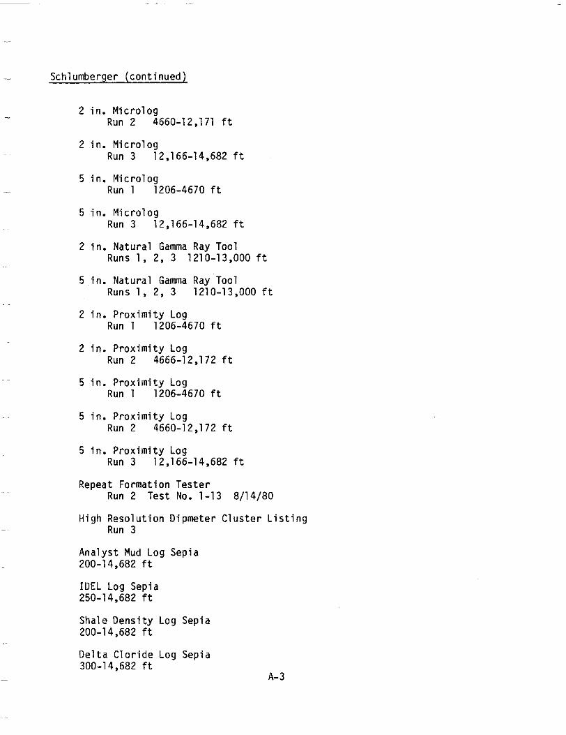
- Schlumberger(continued)
- Mic ro logRun 2
2 in .
2 i n .M ic ro log Run 3
5 i n .M ic ro log - Run 1
5 i n .M ic ro log Run 3
2 in .Natura l Runs 1,
5 in .Natura l Runs 1,
~~
4660-12,171 f t
12,166-14,682 f t
1206-4670 f t
12,166-14,682 f t
Gamma Ray Tool 2, 3 1210-13,000 f t
Gamma Ray Tool 2, 3 1210-13,000 f t
2 i n .P r o x i m i t y Log Run 1 1206-4670 f t
2 i n .P rox im i t yLog Run 2 4666-12,172 f t
5 in .Prox imi tyLog Run 1 1206-4670 f t
5 in. Prox imi tyLog Run 2 4660-12,172 f t
5 in .Prox imi tyLog Run 3 12,166-14,682 f t
RepeatFormationTester Run 2 Test No. 1-138/14/80
H ighReso lu t i onD ipmete r C lus te r L i s t i ng Run 3
Ana lys t Mud LogSepia 200-14.682 f t
IOEL LogSepia 250-14,682 f t
ShaleDensi tyLogSepia 200-1 4,682 f t
De l taClor ideLogSep ia 300-14,682 f t
A- 3
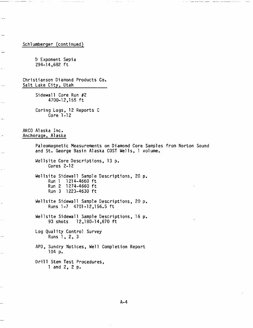
Schlumberger(continued) -
0 ExponentSepia 294-14,682 f t
-~
Chr i s t i anson Diamond Products Co. Sa l tLake City, Utah
SidewallCore Run #2 4700-12,155 f t
Cor ing Logs, 12Reports C Core1-12
ARC0 AlaskaInc. Anchorage,Alaska
PaleomagneticMeasurements on DiamondCoreSamples f romNorton Sound and S t . GeorgeBasinAlaska COST We1 1s , 1 volume.
W e l l s i t e CoreDescr ipt ions,13 p. Cores 2-12
W e l l s i t eS i d e w a l l Sample Desc r ip t i ons , 20 p. Run 1 1214-4660 f t Run 2 1274-4660 f t Run 3 1223-4630 f t
W e l l s i t eS i d e w a l l Sample Descr ip t ions ,20 Runs 1-7 4701-12,156.5 f t
W e l l s i t eS i d e w a l l Sample Descr ip t ions ,16 93shots 12,180-14,670 f t
Log Qual ity Control Survey Runs 1, 2, 3
APD, SundryNotices,WellCompletionReport 104 p.
Drill Stem TestProcedures, 1 and 2, 2 p.
p.
p.
A-4
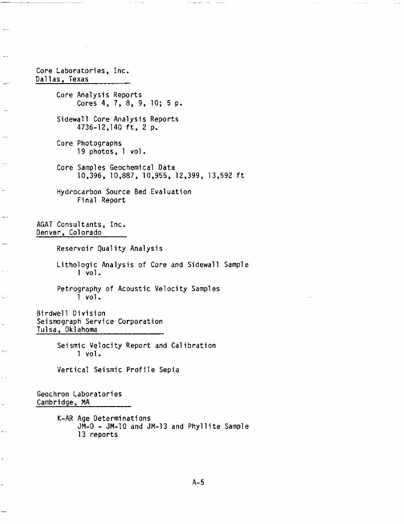
Core Labora tor ies ,Inc . Da l l as , Texas
CoreAnalysisReports Cores 4, 7, 8, 9, 10; 5 p.
Sidewal lCoreAnalysisReports 4736-12,140 f t , 2 p.
CorePhotographs 19photos, 1 v o l .
Core SamplesGeochemicalData 10,396, 10,887, 10,955, 12,399, 13,592 f t
HydrocarbonSource Bed Eva lua t i on F ina lRepor t
AGAT Consul tants,Inc. Denver,Colorado
R e s e r v o i r Q u a l i t y A n a l y s i s
L i t h o l o g i cA n a l y s i s o f CoreandSidewall Sample 1 vo l .
Pe t rog raphyo f Acous t i cVe loc i t y Samples 1 vo l .
B i rdwel 1 D i v i s i on SeismographService Corpora t ion Tu1sa, Oklahoma
SeismicVeloc i tyRepor t and C a l i b r a t i o n 1 vol .
V e r t i c a lS e i s m i cP r o f i l eS e p i a
Geochron Labora to r ies Cambridge, MA
K-AR Age Determinat ions JM-0 - JM-10 and JM-13 andPhyl l i t e Sample 13repor ts
A- 5
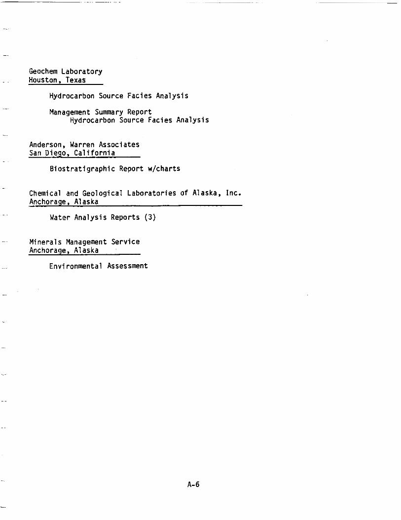
Geochem Laboratory Houston,Texas
HydrocarbonSourceFaciesAnalysis
Management Summary Report HydrocarbonSourceFaciesAnalysis
Anderson,Warren Associates San Diego,Cal i forn ia
BiostratigraphicReportw/charts
Chemical and GeologicalLaboratoriesofAlaska,Inc. Anchorage, Alaska
WaterAnalysisReports (3 )
Minerals Management Service Anchorage, Alaska
Environmental Assessment
A-6