construction #3 registrering | notation | kortlægning | diagrammatisering registration | notation |...
TRANSCRIPT

Construction #3
Registrering | Notation | Kortlægning | Diagrammatisering
Registration | Notation | Mapping | Diagrammatisation
R:\Institut_I\D_0506_II\Gibraltar\Construction#3_intro\
[D]
Institut I, Arkitektur & Æstetik
Arkitektskolen Aarhus
TiN 14. 03. 06

Notation + mapping, before Gibraltar

Datafield
R:/Institut_I/Gibraltar/datafelt
The datafield deliminates a potential ‘global’ foundation for further project development
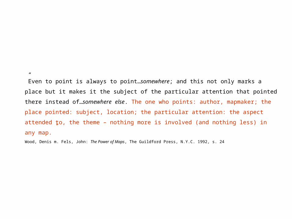
”Even to point is always to point…somewhere; and this not only marks a place but it
makes it the subject of the particular attention that pointed there instead of…
somewhere else. The one who points: author, mapmaker; the place pointed: subject,
location; the particular attention: the aspect attended to, the theme – nothing more is
involved (and nothing less) in any map.”
Wood, Denis m. Fels, John: The Power of Maps, The Guildford Press, N.Y.C. 1992, s. 24

Example
”Houses are worse than people”, an article from New Scientist on diminishing average
household sizes / excalating growth in ressource demands
+
Wikipedia information that the Gibraltar Government ‘pushes’ people with a low income
across the Spanish border by enforcing high housing standards by law.
+
Information from (amongst others) the newspaper Information on Africans migrating to
Europe
=
potentially a programme for an urban densification / low income housing project

Paulette Bernege, 1928, diagram fra Bernege, Paulette, Si les Femme faisaint les Maisons. Kilde: McLeod, Mary (red.), Charlotte Perriand – An Art of Living, Harry N. Abrams, N.Y.C. 2003

Notation + mapping, Gibraltar

Koreografi af en danseinstruktør fra Wolfenbüttel Daidalos 47, 1993, s. 66
Fra: Recueil de Contre dances mises en choregraphie par Ernest
August Jayme, Wolfenbüttel: Lannais 1717, s. 56

Louis Kahn, Urban space as place for movement, Studies for Sergei M. Eisenstein, The path taken by Vladimir Andrejevich from
Philadelphia, Pa., 1951-53 the Palace to the Cathedral in ”Ivan the Terrible”, 1942
Daidalos 47, 1993, s. 73 Daidalos 47, 1993, s. 78

Edward M. Muybridge, Woman Descending a stairway, 1887 (ø.); Woman Jumping over a Chair, 1883-87 (n.)
Daidalos 27, 1988, s. 65 (ø.); František Kupka 1871-1957. A Retrospective. Solomon R. Guggenheim, N.Y.C., 1975, s. 59

Etienne-Jules Marey, Fencer, 1882
František Kupka 1871-1957. A Retrospective. Solomon R. Guggenheim, N.Y.C., 1975, s. 56

Etienne-Jules Marey, Walking Horse
František Kupka 1871-1957. A Retrospective. Solomon R. Guggenheim, N.Y.C., 1975, s. 63
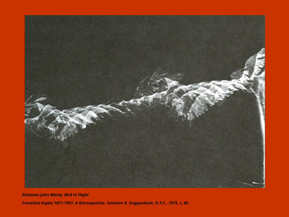
Etinenne-Jules Marey, Bird in Flight
František Kupka 1871-1957. A Retrospective. Solomon R. Guggenheim, N.Y.C., 1975, s. 60

Etienne-Jules Marey, Chronographic Study of Human Locomotion, 1887-88.
František Kupka 1871-1957. A Retrospective. Solomon R. Guggenheim, N.Y.C., 1975, s. 57

Robbert Flick, At Cambria A 010082401
Robbert Flick, Trajectories, Steidl Verlag 2004, s. 302-303

Robbert Flick, Bar Road C 010814 (udsnit)
Robbert Flick, Trajectories, Steidl Verlag 2004, s. 298-299 (297)

Robbert Flick, LD SV940520-#7 Oakwood Ave.
Robbert Flick, Trajectories, Steidl Verlag 2004, s.236-237

Robbert Flick, LD SV941220 Broadway SNW (udsnit)
Robbert Flick, Trajectories, Steidl Verlag 2004, s. 274-275 (273)

Kortlægning / Diagrammatisering
Mapping / Diagrammatization

Diagram (gr. di′agramma det (af linjer) omskrevne, figur) tegnemæssig skematisk
fremstilling af fx forholdet ml. klasser, talværdier, sproglige størrelser; skematisk
tegning af fx maskine, plante, hjerte
Gyldendals Fremmedordbog, 11. udg., 5. opl., Gyldendal 1960, 1993
Diagram (L; Gr. di′agram(ma) that is marked out by lines) 1. a figure, usually
consisting of a simple line drawing, made to accompany and illustrate a
geometrical theorem, mathematical demonstration, etc. 2. a drawing or plan that
outlines and explains the parts, operation, etc. of something: the diagram of a
machine. 3. a chart*, plan**, or scheme***.
Webster´s Encyclopedic Unabridged Dictionary of the English Language, Dilithium Press / Gramercy Books,
N.Y.C. 1989
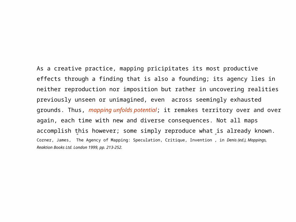
As a creative practice, mapping pricipitates its most productive effects through a
finding that is also a founding; its agency lies in neither reproduction nor imposition
but rather in uncovering realities previously unseen or unimagined, even across
seemingly exhausted grounds. Thus, mapping unfolds potential; it remakes territory
over and over again, each time with new and diverse consequences. Not all maps
accomplish this however; some simply reproduce what is already known.
Corner, James, ”The Agency of Mapping: Speculation, Critique, Invention”, in Denis (ed.), Mappings, Reaktion Books Ltd. London
1999, pp. 213-252.

”(…) every map facilitates some living by virtue of its ability to grapple with what is
known instead of what is merely seen, what is understood rather than what is no
more than sensed.”
Wood, Denis; Fels, John: The Power of Maps, The Guildford Press, N.Y.C. 1992, s. 7

The power inherent in the map lies in conveying a knowledge beyond the sum of the
many bits of information it encompasses. Local data are given new meaning, are
integrated into a set of relationships that bring forth new information about them, in an
interplay between the center and the periphery, empirical data and geometrical
construction.
Jakob, Christian, ”Mapping the Earth from Ancient Alexandria” i Cosgrove, Denis (ed.), Mappings, Reaktion Books Ltd. London 1999, p.32

(…) an abstract machine in itself is not physical or corporeal, any more than it is
semiotic; by function, not form (…).The diagrammatic or abstract machine does
not function to represent, even something real, but rather constructs a real that is
yet to come, a new type of reality.Deleuze, Gilles & Guattari Felix, 1987, A Thousand Plateaus. Athlone, London, 1992, pp. 141-142
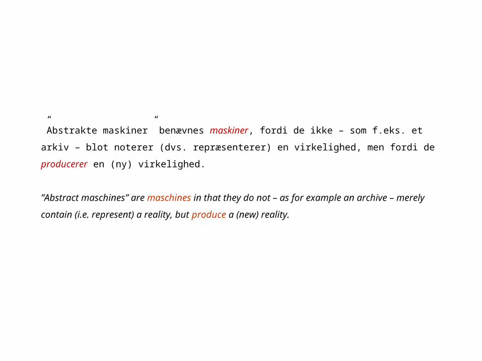
”Abstrakte maskiner” benævnes maskiner, fordi de ikke – som f.eks. et arkiv – blot
noterer (dvs. repræsenterer) en virkelighed, men fordi de producerer en (ny)
virkelighed.
”Abstract maschines” are maschines in that they do not – as for example an archive
– merely contain (i.e. represent) a reality, but produce a (new) reality.

Konfrontationen af data kan i kortlægningen / diagrammatiseringen bringes til at
sige andet og mere end summen af enkelt-data.
In the map or diagram the confrontation of data is potentially “conveying a
knowledge beyond the sum of the many bits of information it encompasses”.
Jakob, Christian, ”Mapping the Earth from Ancient Alexandria” i Cosgrove, Denis (ed.), Mappings, Reaktion Books Ltd. London 1999,
p.32
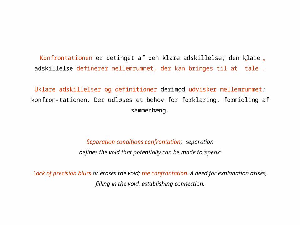
Konfrontationen er betinget af den klare adskillelse; den klare adskillelse definerer
mellemrummet, der kan bringes til at ”tale”.
Uklare adskillelser og definitioner derimod udvisker mellemrummet; konfron-
tationen. Der udløses et behov for forklaring, formidling af sammenhæng.
Separation conditions confrontation; separation
defines the void that potentially can be made to ‘speak’
Lack of precision blurs or erases the void; the confrontation. A need for explanation
arises, filling in the void, establishing connection.

PRECISION

The hallucinatory effect derives from the extraordinary clarity and not from mystery
or mist. Nothing is more fantastic ultimately than precision.Robbe-Grillet on Kafka. Cit. fra: Hejduk, John, Mask of Medusa, Rizzoli int. Publishers, N.Y., p. 39
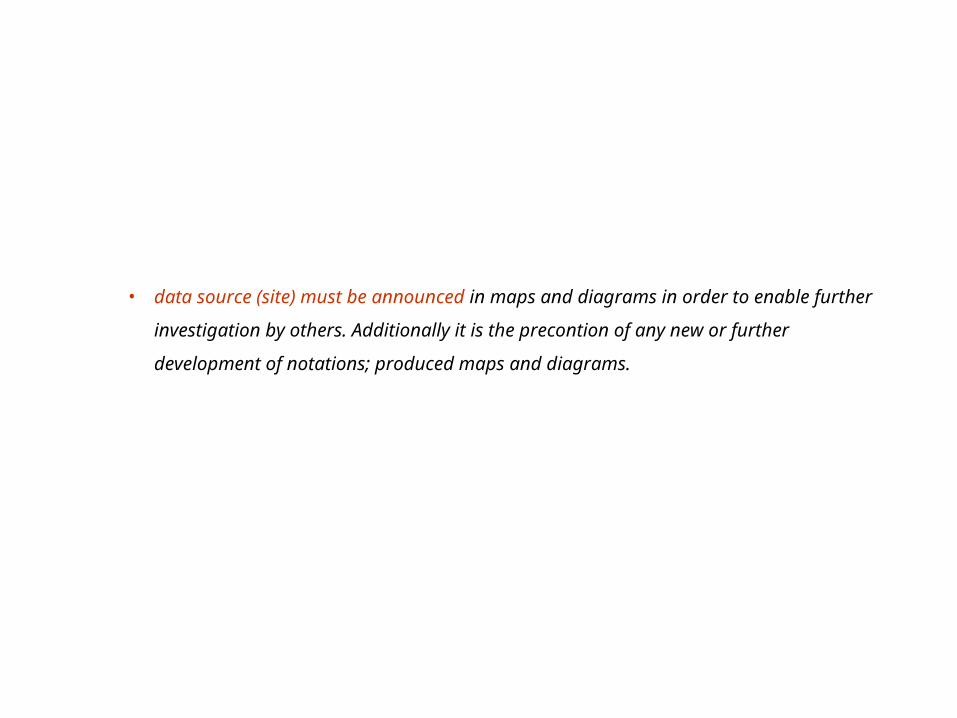
• data source (site) must be announced in maps and diagrams in order to
enable further investigation by others. Additionally it is the precontion of
any new or further development of notations; produced maps and diagrams.

• rules of production must be announced (examples: announcement of exact
registration time / timespan; use of scale; symbols, etc.). This preconditions any
new or further development of notations; produced maps and diagrams.

• before hand in maps and diagrams are given a subtitle naming the object (-s) of
the mapping / diagrammatization
• before hand in maps and diagrams are given a title naming the subject (theme)
of the mapping / diagrammatization
Example:
Title: Nosy trajectories
Subtitle: Stray dog (unleashed), stalked monday 20.03.06 9am-11am through
Gibraltar

Land Ordinance Act of 1785 (George Washington): The Survey Landscape 14 x 20”
Corner, J. & MacLean, A. S., Taking Measures Across the American Landscape, Yale Univ. Press 1996, s. 48.

Land Ordinance Act of 1785 (George Washington): Grid Correction Lines 14 x 20”
Corner, J. & MacLean, A. S., Taking Measures Across the American Landscape, Yale Univ. Press 1996,
s. 57.

Dry-Farming Strip 14 x 20”
”In the Northern Plains, strips of wheat run north and south,
alternating with strips that lie fallow in order to accumulate precious
water in these arid, windswept prairies. Sometimes a mile long and
only 140 feet wide, the planted strips protect the exposed fallow soil
from the drying and erosional effects of strong winds that blow from
the west. The ridge and furrow of plow lines mirror this orientation
with seed being sown in the protected and damper troughs. The
width of each band derives from a carefully gauged degree of
effective wind-shelter length for the fallow strips in combination
with the dimensions of harvester headers.”
Corner, J. & MacLean, A. S., Taking Measures Across the American
Landscape, Yale Univ. Press 1996, s. 125.

Pivot Irrigators I, 14 x 20”
”Sometimes a mile in diameter, these vast circles are
constructed using highly specialized survey
instruments to make their surfaces level. As the
water cools the circular area relative to its
surroundings, space satellites sometimes use the
resulting infrared temperature patterns as reliable
registration marks for orientation.”
Corner, J. & MacLean, A. S., Taking Measures Across
the American Landscape, Yale Univ. Press 1996, s.
90.

Windmill Topography, 14 x 20”
”The combination of high mountains and desert leads to dramatic
contrasts in air temperature and wind pressure. Atmospheric
inversions and turbulent airflows are common, resulting in high
winds (as strong as smog when winds subside). The energy that
these airflows yield is captured by strategically sited windmill
turbines.”
Corner, J. & MacLean, A. S., Taking Measures Across the American
Landscape, Yale Univ. Press 1996, s. 83.

Contour Farming, 14 x 20”
”These striking landscapes of curves, rolls, and turns are
literally measured expreseions of the farmer´s elaborate
negotiations with topography, soils, and weather. A
dimensional vocabulary accompanies such measures,
including phrases such as slope tolerance, pitch, strike, plow
depth, plow line, overplow, cross-sow, swale and datum.”
Corner, J. & MacLean, A. S., Taking Measures Across the
American Landscape, Yale Univ. Press 1996, s. 131.

Cahokia Mounds along the Mississippi, Collinsville Ill., 14 x 20”
”The elaborate geometry at Cahokia suggests that the mounds
functioned as great symbols of perfection, platforms upon
which the most sacred rites would occur and within which the
dead where buried and made immortal – measures of
permanence across an otherwise undifferentiated, shifting
horizon.”
Corner, J. & MacLean, A. S., Taking Measures Across the
American Landscape, Yale Univ. Press 1996, s. 155.

Hopi Horizon Calendar, 14 x 20”
”Hopi time is constructed by the
track of the sun across the
dramatically marked horizon. As the
sun rises and sets in the more
extreme location along the horizon
each day, and turns back at times of
solstice, the Hopi use the geological
callibrations across the distant
landscape as a timepiece, a calendar
to predict times for planting,
harvest, and religious ceremony.
The solstices are the most important
times of observation for the Hopi, as
the sun´s movement slows and rests
for a few days prior to returning
along the horizon and bringing in
the new season. If the sun were to
stay too long in its ”winter house”, a
long, cold winter followed by sprin g
frosts might delay planting and
damage young crops; whereas if it
failed to stay long anough in its
”summer house”, the growing
season might be too short for a
good harvest. Measured with
anticipation and hope, the track of
the sun along the horizon
constructs the varying rhythms of
being in time.”
Corner, J. & MacLean, A. S., Taking Measures
Across the American Landscape, Yale Univ. Press
1996, s. 158.

Hopi Cosmography, 14 x 20”
”Surrounded and watched over by
the four sacred mountains (to the
east, west, north, and south) and
oriented by a striking horizon of
distant cones and clefts, the Hopi
believe themselves to be duly
positioned to receive favorable
treatment from the gods.”
Corner, J. & MacLean, A. S.,
Taking Measures Across the
American Landscape, Yale Univ.
Press 1996, s. 157.

Spiral Calendar at Fajada Butte, Chaco Canyon, New Mexico, 14 x
20”.
”Close to the summit of Fajada Butte, on a vertical cliff, an
arrangement of large stones shields two spirals, one large and one
small, drawn into the rock wall. With remarkable precision, the
morning sun on the day of summer solstice draws a ”dagger” of
bright light through the center of the larger spiral. At winter solstice,
two daggers of light exactly frame the outer edges of the spiral.
Times of equinox are also recorded. Moreover, at times of lunar
standstill a dark shadow bisects the spiral. There are also ten turns
of the spiral on the left of center and nine on the right, paralleling
the alternation of ten- and nine-year ecliptic cycles. The total of
ninteen turns parallels the lunar declination cycle, which is slightly
less than nineteen years. Shrine and observatory, the calendrical
spiral at Fajada Butte both measures and embodies the unity of
natural and human time.”
Corner, J. & MacLean, A. S., Taking Measures Across the American
Landscape, Yale Univ. Press 1996, s. 167.

Acoma Pueblo, Acoma, New Mexico, 14 x 20”
”The orientation and depth of the houses are such that the
dwellings are shaded during the summer but penetrated
deeply by light and warmth in the winter. Furthermore, the
tiered organization exposes a large surface for solar gain in
the winter, wherein the low angle of winter sunlight is
absorbed by thick, heat-retentive clay walls. The three-story-
high wall on the northern side is especially thick and has few
windows or doors, thereby protecting inhabitants from cold
winter winds. During both winter and summer, the third-floor
rooms are ablaze in the red light of sunsets. From afar, the city
beckons. From within, the thermal radiation of warmth stored
in the thick walls helps the family sleep comfortably through
the cold desert nights.”
Corner, J. & MacLean, A. S., Taking Measures Across the
American Landscape, Yale Univ. Press 1996, s. 147.
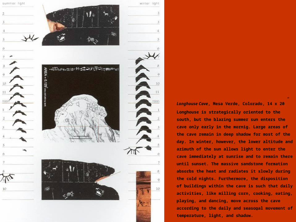
Longhouse Cave, Mesa Verde, Colorado, 14 x 20”
Longhouse is strategically oriented to the south, but the
blazing summer sun enters the cave only early in the
mornig. Large areas of the cave remain in deep shadow for
most of the day. In winter, however, the lower altitude and
azimuth of the sun allows light to enter the cave
immediately at sunrise and to remain there until sunset.
The massive sandstone formation absorbs the heat and
radiates it slowly during the cold nights. Furthermore, the
disposition of buildings within the cave is such that daily
activities, like milling corn, cooking, eating, playing, and
dancing, move across the cave according to the daily and
seasonal movement of temperature, light, and shadow.”
Corner, J. & MacLean, A. S., Taking Measures Across the
American Landscape, Yale Univ. Press 1996, s. 141.

Further examples:
R:/Institut_I/D_0506_II/Gibraltar/map_examples
1st presentation, Construction #4
Construction #1 + #2 + #3

15th IFHP Film/Video Competition
Main theme
• Urban life, Boundaries and Transformations
Three sub-themes
• living over the border
• deconstructing suburbia
• the invisible city
5 member international jury.
Prizes
1st – 4.000,00 EURO
2nd – 3.000,00 EURO
3rd – 2.000,00 EURO
Submission dead-line: 25th of August 2006.
R:/Institut_I/D_0506_II/Gibraltar/videokonkurrence