conservation assessment and strategy wet canyon talussnail
TRANSCRIPT

Conservation Assessment and Strategy
Wet Canyon talussnail Sonorella macrophallus(Gastropoda: Pulmonata: Helminthoglyptidae)
Pinaleno Mountains, Graham County, Arizona
USDA Forest ServiceCoronado National ForestSafford Ranger District
Final: December 15, 1999

i
EXECUTIVE SUMMARY
The Wet Canyon talussnail (Sonorella macrophallus) is a pulmonate land snail inhabiting
Wet Canyon in the Pinaleno Mountains, Graham County, Arizona. It apparently is restricted to
limestone talus slopes in a one-mile reach of Wet Canyon between 6,050 and 6,900 feet in
elevation. A 1989 status survey on land snails endemic to the Pinaleno Mountains stated that
"the population of S. macrophallus appears to be stable", and that "shells were found up to a mile
above the type locality in slides along Wet Canyon" (Hoffman, 1990). The observation on
stability, however, may be misleading as no data are available on population size, reproduction
and recruitment, or other demographic variables.
Land ownership is entirely held by the United States Government under administration of
the National Forest System, Coronado National Forest. The land is managed as a multiple-use
forest and is primarily used for recreation and watershed protection. Potential human-caused
threats to the species and its habitat include increased development and recreational use near and
in Wet Canyon, and wildfire.
Wet Canyon talussnail is a highly localized relict of the Pleistocene era. Factors that may
have contributed to its restriction include a general drying trend since the Pleistocene, which has
led to desert expansion and a contraction of southwestern forest communities. Whether the
distribution of Wet Canyon talussnail has changed in response to climatic variations cannot be

ii
stated with certainty, but there is evidence that suspected limiting environmental factors of high
temperature and low moisture were more relaxed during pluvial periods.
The Wet Canyon talussnail was placed on the Federal Notice of Review as a Candidate
species because of its extremely limited range and amount of development in its habitat. The
Service requested further information to help in determining threats to the species, and the
USDA Forest Service (USFS) responded by providing information about past and present land
uses in the area. The USFS noted the species was an endemic with a limited range whose
population was considered stable, and thus did not need listing at this time. USFS did agree,
however, that development and implementation of a management plan or conservation agreement
for the species could provide sufficient protection to the species and its habitat without listing
under the Endangered Species Act.
This Conservation Assessment and Strategy will lead to a Conservation Agreement
between the cooperating management agencies. It has been initiated to effectively remove all
human-caused threats to the Wet Canyon talussnail, to maintain stability of the population, and to
protect the watershed containing the habitat. This document's primary purpose is to conserve the
Wet Canyon talussnail through interim conservation measures under the Endangered Species Act
of 1973, as amended. Protection of the Wet Canyon talussnail through a Conservation
Agreement is particularly relevant because of the following factors:

iii
F The habitat is entirely under the control of the USFS, which is signatory to this
agreement.
F There is rudimentary understanding of the relationship between proper habitat
management and maintenance of the species, and of the specific management
actions that will be needed for its conservation.
F Habitat of the talussnail appears intact and in sufficiently good condition to
continue to support the species.
F Other than re-routing a 30-feet length in Wet Canyon, conservation actions mainly
involve refraining from some activity that would lessen the value of habitat for the
talussnail, rather than undertaking corrective or restorative action.
F Cooperators in this agreement commit to seek funding sources to implement all
aspects of this Conservation Agreement.

iv
Table of Contents
SPECIES INVOLVED . . . . . . . . . . . . . . . . . . . . . . . . . . . . . . . . . . . . . . . . . . . . . . . . . . . . . . . . . . 1
INVOLVED PARTIES . . . . . . . . . . . . . . . . . . . . . . . . . . . . . . . . . . . . . . . . . . . . . . . . . . . . . . . . . 1
STATUS AND DISTRIBUTION . . . . . . . . . . . . . . . . . . . . . . . . . . . . . . . . . . . . . . . . . . . . . . . . . 2Status . . . . . . . . . . . . . . . . . . . . . . . . . . . . . . . . . . . . . . . . . . . . . . . . . . . . . . . . . . . . . . . . . 2Description–T . . . . . . . . . . . . . . . . . . . . . . . . . . . . . . . . . . . . . . . . . . . . . . . . . . . . . . . . . . 4Distribution . . . . . . . . . . . . . . . . . . . . . . . . . . . . . . . . . . . . . . . . . . . . . . . . . . . . . . . . . . . . 4Existing Land Uses . . . . . . . . . . . . . . . . . . . . . . . . . . . . . . . . . . . . . . . . . . . . . . . . . . . . . . 6Habitat/Ecosystem . . . . . . . . . . . . . . . . . . . . . . . . . . . . . . . . . . . . . . . . . . . . . . . . . . . . . . . 9Life History/Ecology . . . . . . . . . . . . . . . . . . . . . . . . . . . . . . . . . . . . . . . . . . . . . . . . . . . . 10Conservation Measures . . . . . . . . . . . . . . . . . . . . . . . . . . . . . . . . . . . . . . . . . . . . . . . . . . 12
PROBLEMS FACING THE SPECIES . . . . . . . . . . . . . . . . . . . . . . . . . . . . . . . . . . . . . . . . . . . . 13Present or threatened destruction, modification, or curtailment of the species' habitat or
range . . . . . . . . . . . . . . . . . . . . . . . . . . . . . . . . . . . . . . . . . . . . . . . . . . . . . . . . . . . 13Over-utilization for commercial, recreational, scientific, or educational purposes . . . . . 14Disease or predation . . . . . . . . . . . . . . . . . . . . . . . . . . . . . . . . . . . . . . . . . . . . . . . . . . . . . 14Other natural or manmade factors affecting the species' continued existence . . . . . . . . . 15
HABITAT CONSERVATION STRATEGY . . . . . . . . . . . . . . . . . . . . . . . . . . . . . . . . . . . . . . . 16Existing direction . . . . . . . . . . . . . . . . . . . . . . . . . . . . . . . . . . . . . . . . . . . . . . . . . . . . . . 16
Management Emphasis and Intensity . . . . . . . . . . . . . . . . . . . . . . . . . . . . . . . . . . 17Management Area Description: . . . . . . . . . . . . . . . . . . . . . . . . . . . . . . . . . . . . . . 17Capability Area Types . . . . . . . . . . . . . . . . . . . . . . . . . . . . . . . . . . . . . . . . . . . . . 17Timber suitability . . . . . . . . . . . . . . . . . . . . . . . . . . . . . . . . . . . . . . . . . . . . . . . . . 18Proposed Vegetation Manipulation . . . . . . . . . . . . . . . . . . . . . . . . . . . . . . . . . . . 18Specific Management Prescription . . . . . . . . . . . . . . . . . . . . . . . . . . . . . . . . . . . 18
Recreation Management. . . . . . . . . . . . . . . . . . . . . . . . . . . . . . . . . . . . . 18Wildlife and Fish. . . . . . . . . . . . . . . . . . . . . . . . . . . . . . . . . . . . . . . . . . . 19Range Management. . . . . . . . . . . . . . . . . . . . . . . . . . . . . . . . . . . . . . . . . 19Timber Management. . . . . . . . . . . . . . . . . . . . . . . . . . . . . . . . . . . . . . . . 20Watershed/Soils . . . . . . . . . . . . . . . . . . . . . . . . . . . . . . . . . . . . . . . . . . . 20Minerals Management. . . . . . . . . . . . . . . . . . . . . . . . . . . . . . . . . . . . . . . 20Road Maintenance and Construction. . . . . . . . . . . . . . . . . . . . . . . . . . . 21Fire Management. . . . . . . . . . . . . . . . . . . . . . . . . . . . . . . . . . . . . . . . . . . 21Insect/Disease Management. . . . . . . . . . . . . . . . . . . . . . . . . . . . . . . . . . 21Talussnail Research. . . . . . . . . . . . . . . . . . . . . . . . . . . . . . . . . . . . . . . . . 22
New Direction . . . . . . . . . . . . . . . . . . . . . . . . . . . . . . . . . . . . . . . . . . . . . . . . . . . 22

v
Monitoring. . . . . . . . . . . . . . . . . . . . . . . . . . . . . . . . . . . . . . . . . . . . . . . 22Administration records and protection. . . . . . . . . . . . . . . . . . . . . . . . . . 23
IMPLEMENTATION SCHEDULE . . . . . . . . . . . . . . . . . . . . . . . . . . . . . . . . . . . . . . . . . . . . . . 25
LITERATURE CITED . . . . . . . . . . . . . . . . . . . . . . . . . . . . . . . . . . . . . . . . . . . . . . . . . . . . . . . . 26
ATTACHMENTS . . . . . . . . . . . . . . . . . . . . . . . . . . . . . . . . . . . . . . . . . . . . . . . . . . . . . . . . . . . . 28

1
I. SPECIES INVOLVED
Common Name: Wet Canyon talussnail
Scientific name: Sonorella macrophallus Fairbanks and Reeder
(Gastropoda: Pulmonata: Helminthoglyptidae)
II. INVOLVED PARTIES
A. USDA Forest Service
Coronado National Forest
Safford Ranger District
B. U. S. Fish and Wildlife Service
Arizona Ecological Services Field Office
C. Arizona Game and Fish Department
Nongame and Endangered Wildlife Program

1Category 1 comprised taxa for which the FWS has sufficient information on vulnerability and
threats to support a proposal to list them as threatened or endangered. Category 2 taxa were those thatlisting as endangered or threatened is possibly appropriate, but for which conclusive data on biologicalvulnerability and threat are not currently available to support proposed rules. Category 3 included taxathat once were considered for listing as threatened or endangered but are no longer under suchconsideration. On February 28, 1996, the Service issued the Endangered and Threatened Wildlife andPlants; Review of Plant and Animal Taxa that are Candidates for Listing as Endangered or Threatened
2
III. STATUS AND DISTRIBUTION
Status–The Wet Canyon talussnail is a highly localized endemic whose total range is
apparently restricted to talus slopes in a one-mile reach of Wet Canyon in the Pinaleno
Mountains Graham County, Arizona (Figures 1 and 2). It was described from specimens found
during several collecting trips to the area between 1965 and 1978 (Fairbanks and Reeder, 1980).
This species appears to require a somewhat wetter and possibly a lower elevation habitat than
other talussnails in this mountain range. Fluctuations in its population appear dependent on local
moisture conditions. Hoffman (1990) noted that the population appeared stable, and was
probably in no danger unless local conditions changed considerably. The strength of these
assertions may be misleading given the minimal information on past and present status of the
talussnail. If for no other reason, natural wasting of slope soils and infilling of talus in the
limited talussnail habitat may portend an uncertain future for this highly localized species.
The ESA requires the U.S. Fish and Wildlife Service to identify species of wildlife and
plants that may be endangered or threatened, based on the best available scientific and
commercial information. As part of this responsibility, the Service maintains a list of species
that are considered Candidates for listing. The Service placed the Wet Canyon talussnail on the
Federal Notice of Review as a Category 11 species because of its extremely limited range, the
Species, in which it proposed to discontinue the practice of maintaining a list of species regarded asCategory 1 and 2 Candidates. Species that were a Category 1 became the only candidates. Thisclassification meant that the Service had on file sufficient information on biological vulnerability andthreats to support issuance of a proposed rule to list as threatened or endangered (Service 1996).
2In 1994, the FWS, USFS, Bureau of Land Management, National Park Service, and National
Marine Fisheries Service signed a Memorandum of Understanding (MOU). The purpose of the MOU is to"... establish a general framework for cooperation and participation in the conservation of species that aretending toward federal listing as threatened or endangered under the Endangered Species Act." TheMOU provided that the cooperators would work together and participate in the conservation of selectedplant and animal species and their habitats to reduce, mitigate, and possibly eliminate the need for theirlisting under the Endangered Species Act by developing habitat conservation assessments leading toconservation agreements (Anonymous, 1994).
The five-member federal agency MOU was later amended to include the InternationalAssociation of Fish and Wildlife Agencies as a co-signor, thus bringing representation from state wildlifeagencies into the development and implementation of conservation agreements. Arizona Game and FishDepartment also has independently signed MOU's with the USFS and the FWS to cooperate in activitiespursuant to recovery of federally-listed species and the removal of threats from species considered forlisting.
3
amount of recreational development within that range, and the uncertainty of our knowledge
regarding the status and population trend of the species and its habitat (Metz, 1990; FWS, 1991;
S. E. Stefferud, FWS, pers. comm.). The Service requested further information to help in
determining threats to the species (Spiller, 1992), and the USDA Forest Service (USFS)
responded providing information about past and present land uses in the area. The USFS noted
the species was an endemic with a limited range whose population was considered stable, and
thus did not need listing at this time. Development of a management plan or conservation
strategy2 for the species was suggested to avoid the increase in administrative burdens associated
with listed species was suggested (Carpenter, 1993).
On February 28, 1996, the Service issued the Endangered and Threatened Wildlife and
Plants; Review of Plant and Animal Taxa that are Candidates for Listing as Endangered or
Threatened Species, in which it was proposed to discontinue the practice of maintaining a list of
species regarded as Category 1 or Category 2 Candidates (Service, 1996). When the rule was

4
finalized on December 5, 1996, any species that had been a Category 1 Candidate simply became
a Candidate. Since then the Wet Canyon talussnail has maintained status as a Candidate for
listing, and has been included in the most recent review of plant and animal taxa (Service 1999).
Sufficient biological information is currently on file to support a proposed rule for listing.
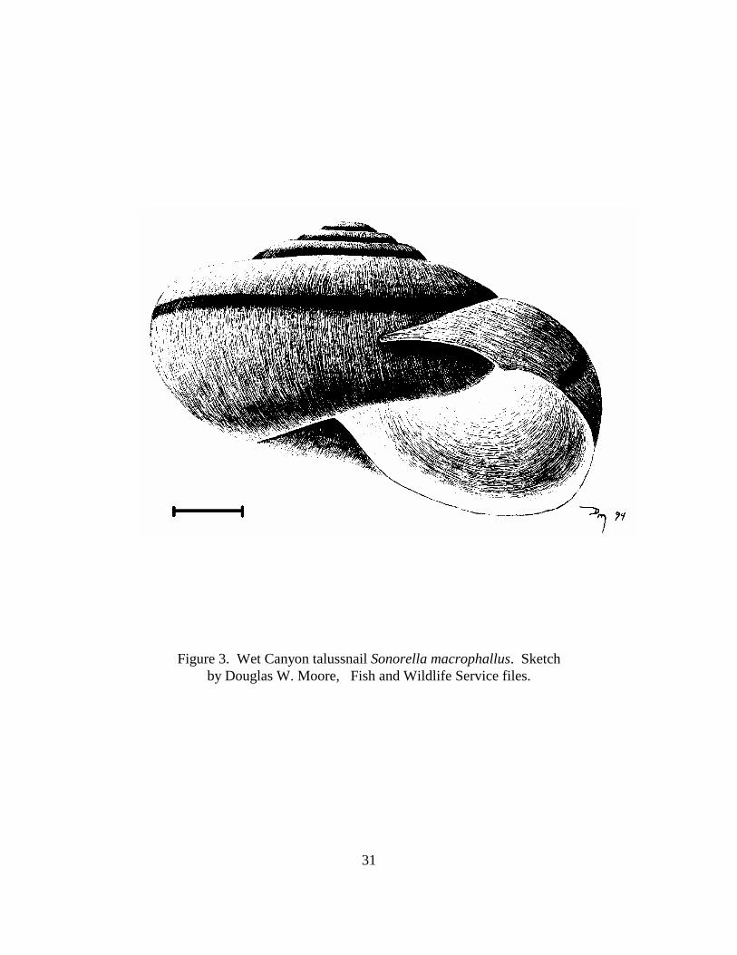
Description–The Wet Canyon talussnail is a land snail with a globose shell with about 4.5
whorls (Figure 3). The shell has a tan to olive tint and a chestnut-brown shoulder band that has
indistinctly pallid borders. It is approximately 0.7 inches in diameter. Wet Canyon talussnail has
a shell that is essentially identical to that of Pinaleno talussnail S. grahamensis, and which cannot
be reliably distinguished from shells of other species of Sonorella in the Pinaleno Mountains.
Positive identification of the species depends on examination of soft body parts, in particular the
reproductive organs (Fairbanks and Reeder, 1980). Members of the genus Sonorella may even
be confused with closely related genera including Eremarionta, Mohavelix, or Helminthoglypta
(Bequaert and Miller 1973).
Distribution--Present knowledge indicates that Wet Canyon talussnail occurs only in Wet
Canyon on the northeast slope of the Pinaleno Mountains, Graham County, Arizona. Legal
location is Township 09 South, Range 25 East, Sections 17 and 18, Gila and Salt River Meridian,
Arizona. The known extent of the talussnail's range within Wet Canyon is from the crossing of
Highway 366 to about one mile further upstream. It lives in talus slopes along the canyon bottom
adjacent to the perennially flowing portion of stream between 6,050 and 6,900 feet in elevation.
A status survey on land snails endemic to the Pinaleno Mountains stated that "the population of

5
S. macrophallus appears to be stable", and that "shells were found up to a mile above the type
locality in slides along Wet Canyon" (Hoffman, 1990).
Access to Wet Canyon is from Safford, Arizona. From the junction of U. S. Highway 70
travel south on U. S. Highway 191 to the junction with Arizona Highway 366 (also known as the
Swift Trail). Proceed on Highway 366 to Wet Canyon Picnic Area, which is signed.
Wet Canyon talussnail is a highly localized relict of the Pleistocene era. Whether the
distribution of Wet Canyon talussnail has changed in response to climatic variations cannot be
stated with certainty, but there is evidence that suspected limiting environmental factors of high
temperature and low moisture were more relaxed during pluvial periods. Given the climate and
topographic conditions of present day arid Southwest, dispersal into new territories by Sonorella
would be difficult (Bequaert and Miller, 1973). Factors that may have contributed to its
restriction include a general drying trend since the Pleistocene, which has led to desert expansion
and a contraction of southwestern forest communities (Van Devender, 1977 in Johnson, 1988).
The extent of changes in the distribution of vegetation communities in the Sonoran Desert during
the Ice Ages has been the subject of numerous scientific studies. Palynological studies in dry
lakes of New Mexico (Clisby and Sears, 1956) and Arizona (Martin, 1963) indicate that forest
and woodland communities grew as much as 3,300 feet lower in elevation during the last glacial
period, the Wisconsin, than at present. Packrat midden studies have further identified the
dynamic changes in distribution of many species of Sonoran Desert vegetation accompanying the
changes in glacial and interglacial climates (Van Devender et al., 1987; Van Devender, 1990).

6
The interpretation of comparable distributional changes for animal species from their remains in
packrat middens is more equivocal and problematic (Van Devender et al., 1991a; 1991b).
Existing Land Uses--The eastern slopes of the Pinaleno Mountains have a long history of
human occupation and use. Wet Canyon, along with other canyons, was logged extensively
during the late 1800's to early 1900's. In the upper reaches of the canyon, about a mile upstream
from occupied habitat, pieces of a cast iron stove and other evidence of human habitation and
development have been found. In addition, several old logging skid trails run directly into the
canyon bottom (Carpenter, 1993). To what extent logging and other activities may have altered
the canyon or affected the range of the talussnail is unknown. Currently, sawtimber or fuelwood
harvest is done only to enhance recreation, visual quality, and wildlife values, or to reduce
hazards. Any harvest of standing trees is limited to individual tree selection, and is done under
permit (less than one issued per year). Gathering of small amounts of firewood for local use
occurs in and near the developed recreation sites. Fuelwood harvesting of dead and down
material occurs on the mountain but is believed to be insignificant in the Wet Canyon watershed.
Current human activity in the habitat of the talussnail is primarily dispersed recreation,
i.e., hiking and picnicking. Search and rescue training occurs in the watershed three times a year
but does not affect the talus slope. Two USFS developed sites exist nearby: Arcadia
Campground, located on a knoll above Wet Canyon, and Wet Canyon Picnic Site, located where
Highway 366 crosses Wet Canyon at the lower end of occupied habitat. Arcadia has 26 units
(including one group site) available for overnight visits, and Wet Canyon has three day-use-only

7
units. Both are open from May to December, and campfires are permitted in metal fire-rings or
barbecues provided at each unit. No data are available on the amount of use at either site.
On May 13, 1995, a human-caused fire burned about 150 acres of ponderosa pine/oak
community near the Arcadia Campground; about one-half of the burned area was within the Wet
Canyon watershed. The closest the fire line and burned area came to an active drainage was
approximately 30 to 50 feet. No ash or line crossed the creek, and no talus was disturbed.
Because the fire was a low intensity ground fire with very little crowning, it should have an
overall positive impact on the ecosystem, and no impact on the talussnail or its habitat (G.
Froehlich, USFS, pers. comm.).
Drinking water for Arcadia Campground is supplied via pipeline from a horizontal well
near Wet Canyon Creek. The system is treated using household bleach diluted to provide 0.02 to
1.0 parts per million chlorine in the drinking water. A fountain at Wet Canyon Picnic Site was
used for many years by local residents seeking "pure, mountain" water. Evidence of surface
contamination of that water was found, and a horizontal well was drilled adjacent to Wet Canyon
Creek about 250 feet upstream from the road crossing. Recently, surface contamination was
found in that water also, and the drinking fountain was disconnected.
Arcadia National Recreation Trail is used by hikers between Shannon and Arcadia
campgrounds, and crosses Wet Canyon about one mile upstream from Wet Canyon Picnic Site.
A self-guided nature trail (Johnson, 1989) that is not maintained by the USFS leads from Arcadia

8
Campground to Wet Canyon. An extension of that trail leads downstream along Wet Canyon to
intersect with a user-built trail back to the campground. Another user-built trail extends along
Wet Canyon from the picnic area upstream about one mile to Arcadia National Recreation Trail.
This trail passes over and through talus slopes occupied by the talussnail. Construction and use
of the trail may have caused disturbance to habitat of the talussnail. It is not part of the USFS
trail system. However, as a result of the July 1998 amendment to the Coronado Land and
Resource Management Plan, this trail will be relocated outside of Wet Canyon talussnail's
habitat. No data are available on extent of use of any of the trails in the vicinity.
Designated roads and trails are open to vehicular travel; cross country travel by vehicles
is prohibited. Highway 366 is generally open past Wet Canyon year-round, but is seasonally
closed (November 15 to April 15) above the intersection of Forest Road 507, the access to High
Peak. Occasionally during snow removal operations, the road may be closed by gates as far
downslope as Wet Canyon Picnic Area.
Twilight Road (Forest Road 819) extends north from Highway 366 towards Wet Canyon
at about 7,500 feet elevation and terminates on the watershed boundary between Twilight and
Wet canyons. There are no plans to extend Twilight Road into the Wet Canyon watershed.
Currently, dispersed camping is allowed along the road and at the road end, where a toilet has
been constructed. A developed campground is still under consideration at the road end.

9
There are no certified water rights in Wet Canyon. The USFS has begun the procedure of
applying for four water rights: two claims for recreation (0.11 and 0.01 acre-feet), an application
for domestic use (0.61 acre-feet), and a notice of intent to drill a well for domestic use (1.00 acre-
feet) (R. Lefevre, USFS, pers. comm.).
The east-facing slopes of the Pinaleno Mountains, starting at approximately 6,000 feet in
elevation and extending over the crest, were closed to domestic livestock grazing in the 1940's.
Although current livestock allotment boundaries extend to about 6,000 feet, cattle are generally
restricted by topography to below about 4,500 feet. Rangeland within the area occupied by Wet
Canyon talussnail is managed at Level A (no livestock).
Habitat/Ecosystem--In addition to the Wet Canyon talussnail, five other talussnails are
endemic to the Pinaleno Mountains: Pinaleno talussnail, Clark Peak talussnail S. christenseni,
mimic talussnail S. imitator, Pinaleno mountainsnail Oreohelix grahamensis, and an undescribed
species of Sonorella. Pinaleno, Clark Peak, and the undescribed talussnail were formerly
designated as Category 2 species, whereas mimic talussnail and Pinaleno mountainsnail were
formerly in Category 3C (Service, 1991). None of these five species are currently considered
Candidates for Federal listing. All are inhabitants of wet mountain slopes above 6,000 feet in
elevation, where they are normally found in limestone rock slides that face northward, are
overgrown, or are otherwise protected from summer sun. These slides are fairly deep, with at
least four feet of talus rocks unchoked by soil or humus. In localities where it is dry or very cold
in winter, talus must be six to eight feet deep in order to support talussnails. Depth of the talus

10
protects the talussnail from desiccation or freezing, and calcium carbonate aids in shell
deposition and buffers the carbonic acid produced by the animal's inability to significantly expire
carbon dioxide during estivation. In addition to the talussnails, at least 22 other species of land
snails inhabit the Pinaleno Mountains (Hoffman, 1990).
Talussnails in the Pinaleno Mountains subsist primarily on fungus and decaying plant
matter. This diet is often supplemented with young green shoots when available. There are no
known significant predators of land snails on the Pinaleno Mountains. Talussnails are
presumably eaten by rodents or birds, but this is probably sporadic or of random occurrence. In
1989, an exotic pulmonate gastropod, Limax flavus, a large slug of creek banks and boggy areas
of central and northern Europe was collected in Wet Canyon (Hoffman, 1990).
Life History/Ecology--Wet Canyon talussnail is a Pleistocene relict and a highly localized
endemic species. It occupies talus slopes composed of rocks high in calcium carbonate along
north-facing banks of the perennial stream in Wet Canyon. These rock slides have a high soil
content, but retain sufficient interstitial spaces required by the talussnail for living space. The
dense vegetative overstory is composed of conifers and Arizona walnut. This habitat has a high
moisture content which probably prevents invasion by other species of Sonorella present on
uphill slopes (Hoffman, 1990).
Wet Canyon talussnail appears to require a somewhat wetter and possibly a lower
elevation habitat than other talussnails found in the Pinaleno Mountains. Moisture conditions

11
suitable for this talussnail to become active are likely to occur during most summers, but it
spends a large part of the year in estivation and may have limited activity in dry summers.
To prepare for estivation, the talussnail using mucus and calcium to attach the aperture of
its shell to the face of a rock to make a waterproof seal. Once sealed, the individual is
completely isolated from the air outside. Respiration does not stop completely in an estivating
talussnail; the individual does generate small amounts of carbon dioxide. The carbon dioxide
combines with water molecules to produce carbonic acid, which is neutralized by calcium
carbonate. Talussnails that estivate for comparatively short periods survive by mining calcium
carbonate from their shells, which is redeposited when active feeding resumes.
Talussnails are hermaphroditic, and when two talussnails meet, both are usually
inseminated. Most hermaphroditic pulmonates seem to be capable of self-fertilization, but only
do so as a last resort after failing to meet conspecifics for several years. Each talussnail lays a
clutch of thirty to forty eggs once, or in particularly good years, twice during summer.
Fluctuations in humidity may cause large variations in rates of maturation and life span of
talussnails. The life span of land snails is dependent on their cycle of activity, and talussnails in
the Pinaleno Mountains are active for a much greater number of days per year than are land snails
inhabiting the desert below. Most Pinaleno talussnails reach maturity in from two to three years
and their life span is approximately six years (Hoffman, 1990).

12
Talussnails are occasionally eaten by rodents or birds. When snails are eaten by rodents,
their shells are found with the top, or apical whorls, broken away so that the snail can be
removed from the shell by the rodent. Rodent predation, though it exists, is apparently random
and sporadic (Hoffman, 1990), and does not represent a significant threat to Wet Canyon
talussnail. The presence of Limax flavus should not affect the Wet Canyon talussnail, though it
may impact other invertebrates or plants within the wet part of Wet Canyon Creek (Hoffman,
1990).
Conservation Measures--During summer 1989, likely habitats for talussnails within the
Pinaleno Mountains were explored, as well as those in the immediately surrounding Santa
Teresa, Dos Cabeza, Galiuro, Winchester, and Peloncillo mountains. The location of all north-
facing slopes and those otherwise protected from summer sun was determined. If these areas had
talus slopes that appeared suitable for talussnail habitat, they were searched to determine the type
of rock, depth to which rocks were clear of choking soil, and presence of snail sign. Snail sign
included seals (marks indicating that snails had sealed to rocks during estivation), slime trails if
there had been recent moisture, "bones" (shells and pieces of shells), or presence of live snails
(Hoffman, 1990). Mountain ranges surrounding the Pinaleno Mountains are generally lower in
elevation than the Pinaleno Mountains, and no populations of Wet Canyon talussnail were found
in those ranges. Other nearby, higher elevation ranges, such as the Chiricahua Mountains, were
not surveyed. There is a very remote possibility that these nearby ranges offer suitable habitat for
the species.
13
No other suitable areas of habitat similar to Wet Canyon were found in the Pinaleno
Mountains during Hoffman's surveys. His survey, although thorough in searching for habitats
comparable to Wet Canyon, may have overlooked other, less similar, habitats. Slopes of the
Pinaleno Mountains are inaccessible and some of the best talus slopes are often obscured by
foliage and leaf litter to the point that detection is problematic. Also, many good limestone
outcrops are composed of such large boulders that it is impossible to uncover talussnails or sign
even though they are present. Finally, talussnails are often rare within even a good slide, so the
only way to be certain that a slide is uninhabited is to return to it repeatedly and to be present, at
least once, at dawn after a good soaking summer rain (Hoffman, 1990).
IV. PROBLEMS FACING THE SPECIES
Present or threatened destruction, modification, or curtailment of the species' habitat or
range. Wet Canyon talussnail is a limited endemic that is vulnerable to any disturbance that
would remove talus, increase interstitial sedimentation, open forest canopy, alter stream
discharge, or otherwise change moisture conditions.
Suppression of wildfires during the past half-century has resulted in considerable amounts
of dead woody material and decaying plant matter near to and/or on top of talus slopes within the
range of Wet Canyon talussnail. This material has built up to an extent that the heat of a large
fire may be intense enough to kill talussnails within. Thus intense wildfire could impact the
species.

14
Over-utilization for commercial, recreational, scientific, or educational purposes. A trail
exists from Wet Canyon Picnic Area up the canyon. This trail tends to follow the bottom of the
canyon along the riparian bottom. This trail is not a "system" trail, which means that it was not
built nor is it maintained by the Forest Service. The trail was originally designed and constructed
by a local schoolteacher, and over time has been maintained by hiker use. This trail crosses
several talus slopes that likely provide habitat for the talussnail. There is concern that the trail
and its associated recreational use may be impacting the talussnail. Potential problems could
include trampling of individual animals, and degradation of talus habitat. Habitat degradation
could include compaction of the talus substrate and/or removal of talus habitat in the trail "tread".
Trail maintenance might result in compaction and/or removal of habitat, which could fragment
range of the species.
The collection factor has unknown significance. The species is difficult to collect due to
its life habits and position in talus slopes, and therefore it is unlikely to be impacted by
collection, over-utilization, recreational, or commercial interests. It is not known if the highly
restricted distribution of this species will make it vulnerable to excessive collection from either
vandals or individuals curious about the talussnail. Monitoring of the population must involve
take of some individuals if identification to species level is necessary.
Disease or predation. Remarkable occurrences of disease or predation over and above
what is background for the species are unknown, thus cannot be considered a threat at this time.
There are no known significant predators of land snails in the Pinaleno Mountains. Occasionally

15
talussnails are eaten by rodents or birds, but this is of only sporadic or random occurrence. The
recent introduction of the exotic slug Limax flavus into Wet Canyon should not affect the
talussnail, although it may impact other invertebrates or plants within Wet Canyon. Even though
this particular introduction may be benign, it does demonstrate the continuing threat to the
biodiversity of the area by unauthorized or inadvertent introductions of nonnative species.
Other natural or manmade factors affecting the species' continued existence. Natural
wasting of slope soils in Wet Canyon, as evidenced by "pistol-butted" or leaning trees, slumping
or slope failures, and a "hummocky" appearance of the slopes, may cause infilling of the talus
slopes needed by this species for survival. Fragmentation of the habitat by user-built trails may
restrict natural movement of talussnails, and thus restrict colonization of existing talus slopes.
Due to its current configuration, location, and surfacing, Highway 366 is unlikely to
contribute sediment to Wet Canyon in the known range of the talussnail. The highway is being
widened to improve sight distance, safety, and remove slide material up to a point just below Wet
Canyon. Widening the highway beyond that point has been discussed but is not planned at this
time. If Highway 366 is widened where it crosses Wet Canyon, the existing crossing will have to
be replaced, which may have an impact on habitat of the talussnail. In addition, widening of the
highway may involve earth movement to accommodate a wider roadbed, which may increase
erosion and sedimentation of habitat of the talussnail.

16
Increased public use of Mt. Graham may indirectly affect habitat of the talussnail through
increased vehicle traffic and demands for an upgraded road. Any plans for improvement of the
highway or expanded recreation development near Wet Canyon must fully consider the needs of
the species. In addition, increased visitor use may elevate the risk of human-caused fire. The last
half-century of fire suppression has resulted in a build-up of dead brush and other fine fuels on
talus slopes used by the species to such an extent that heat of a wildfire may be intense enough to
kill snails within the talus.
It appears that the talussnail is dependent on moist conditions in Wet Canyon, thus some
perennial discharge in the creek can be considered necessary for continued existence of the
species. No claims for water rights exist in the area, but Coronado National Forest may apply for
water rights in support of recreational developments nearby. In total, potential applications by
Coronado National Forest amount to 0.73 acre-feet per year, plus an additional use of 1.00 acre-
feet to be supplied by a well. Discharge in Wet Canyon is not gauged, and no data exist on its
annual, monthly, or daily flow regime. Diversion of water from Wet Canyon, or its aquifer,
could have deleterious consequences for the talussnail if the moisture regime of Wet Canyon is
changed due to water withdrawal.
V. HABITAT CONSERVATION STRATEGY
Existing direction — Standards and guidelines applicable to all areas of the Forest in the
Coronado National Forest Land and Resource Management Plan (USFS, 1988), as amended,

17
(Forest Plan) provide for protection and improvement of habitat of threatened and endangered
species, and coordination with Arizona Game and Fish Department in the management of
wildlife habitat. The 1998 Forest Plan amendment specifically calls for the protection of
approximately 1,220 acres of the Wet Canyon watershed (USFS, 1998).
Standards and guidelines applicable to specific units of land were prescribed in the Forest
Plan. Wet Canyon watershed is included within Management Area 2B as follows:
Management Emphasis and Intensity: Manage to perpetuate the unique wildlife or
vegetative species, in particular the Wet Canyon talussnail, present within this
management area. Provide for an increase in habitat stability for the Wet Canyon
talussnail, while allowing for other uses in the area. Dispersed and developed recreation
activities and other uses may be allowed to the extent they do not degrade the unique
values of the management area. Facilities may be allowed and maintained as long as the
unique resource values are protected (USFS, 1998).
Management Area Description: Located in the Pinaleno Mountain Range, this
management area includes the Wet Canyon watershed downstream to the mouth of
Twilight Creek, but not including Twilight Creek or its associated watershed.
Capability Area Types: Total Acres = 1,220 acres.

18
Timber suitability: All acres unsuitable.
Proposed Vegetation Manipulation: None.
Specific Management Prescription
Recreation Management.
1. During periods of fire closure, the Wet Canyon Picnic area will be closed to campfires.
2. Open trails will be identified and signed. Non-system trails will be closed. The
monitoring program should evaluate the continued use of the closed portion of the trail
through the talus slope. Eliminate direct trail impact in talussnail habitat as soon as
possible. Trees and other natural debris that fall across the closed portion of the trail will
be allowed to remain.
3. Use existing water system at Arcadia Campground to supply drinking water to Wet
Canyon Picnic Site, if needed.
4. Provide a "Visitor Information Sign" at the loop trail in Arcadia Campground
presenting information about the floral and faunal components within Wet Canyon

19
stream/riparian complex. Provide information on the uniqueness of "Sky Island"
biogeography, the presence of Pleistocene relicts in the area, and the need to conserve
ecosystems intact while providing for human use and enjoyment should be highlighted.
Wildlife and Fish.
1. Inventory the riparian area in Wet Canyon using current Forest Service Riparian Area
Survey and Arizona Game and Fish Department standards. Document riparian conditions
and occupied talussnail habitats to serve as baseline for future monitoring activities.
Evaluate whether exact map locations and extent of habitats occupied by Wet Canyon
talussnail can be verified using Global Positioning System technology. This could be
advantageous for recovering locations for successive measurements during monitoring.
Complete by end of FY 00.
2. Evaluate the potential of Wet Canyon Creek aquatic macroinvertebrates for tracking
aquatic health trends as part of the monitoring program. Initiate in FY 00 to establish
baseline information.
Range Management.
1. Manage the rangeland at Level A (no livestock). See Appendix C in the Forest Plan
for definition of range management levels.
20
Timber Management.
1. Manage for a dense overstory canopy within the Wet Canyon riparian area. Do not
allow live or standing dead trees to be cut for recreational or fuelwood purposes. Limit
wood gathering to dead and down wood for recreational campfires. Individual tree
selection may be used to accomplish other management objectives such as hazard
reduction, visual quality enhancement, and wildlife habitat improvement.
Watershed/Soils
1. Maintain satisfactory watershed condition.
2. Submit an “Application for Permit" for an instream water right on Wet Canyon Creek
by the end of FY00 to help maintain a suitable environment for Wet Canyon talussnail
and to promote the health of the canyon’s riparian and aquatic systems. Monitor
discharge in Wet Canyon to establish a hydrographic baseline by the end of FY 01.
Monitoring procedures to be developed by the Forest Hydrologist.
Minerals Management.
1. Common materials may not be removed for any purpose. As needed, recommend
withdrawal from mineral entry and mineral leasing on entire area to protect essential
habitat for Wet Canyon talussnail. Issue "no surface occupancy" stipulations for mineral
leasing activities within the Management Area.

21
Road Maintenance and Construction.
1. Give full consideration to the habitat and movement needs of the talussnail when the
Highway 366 road crossing at Wet Canyon is upgraded. Road construction or
reconstruction projects should be designed to eliminate further fragmentation of the
talussnail's habitat (e.g. use a bridge or arched culvert over Wet Canyon crossing). Other
proposals for improvement will be evaluated in terms of their potential indirect impacts to
the Wet Canyon talussnail from increased public use of the area.
Fire Management.
1. Wet Canyon is within Fire Suppression Zone 1, (i.e. immediate suppression action to
protect high value resources).
2. Evaluate fuel loading situation and prescribe actions that reduce potential fire hazards
related to talussnail protection.
Insect/Disease Management.
1. Manage ecosystem health to prevent catastrophic impacts to talussnail habitat from
insect and disease infestation.

22
Talussnail Research.
1. Encourage scientific investigation of talussnail reproduction, recruitment, mortality,
population trends, ecology, etc. Encourage investigation of the Wet Canyon talussnail
with other species within the genus Sonorella in the Pinaleno Mountains.
New Direction - New actions that will help the species that are included in the Conservation
Agreement
Monitoring.
1. A monitoring plan for Wet Canyon talussnail and its habitat will be developed and
initiated by the Cooperators in the first 12 months of the Agreement. Monitoring of the
species is problematic because of the need to dissect individual talussnails for specific
identification, and the need to remove rocks and otherwise alter habitat in order to find
individuals. Monitoring efforts that place emphasis on non-destructive techniques (e.g.,
remote sensing, surrogate monitoring, photopoints, limits to acceptable change, etc.)
should be emphasized. Methods that require alteration of habitat or handling of
individual talussnails will be kept to a minimum, and done only after full consideration of
the effects on the species have been analyzed and documented.
2. Monitoring of habitat that focuses on recognition and reporting of events that deviate
from normal (e.g., significant flood or drought, wild or human-caused fires, severe insect

23
or disease defoliation) in the watershed may be considered as an alternative to detailed
habitat measurements on a scheduled basis.
3. Photopoints or other appropriate methods will be established to document habitat
conditions in occupied habitat, and will be retaken on a schedule acceptable to the
Cooperators. A narrative monitoring report to accompany the photos will be prepared.
The monitoring plan will define a photopoint monitoring protocol for locations where the
trail previously crossed the talus substrate. Photographs will be taken before and after
removal of the trail through the talus. Re-establishment of user built trails through the
talus slope will also be monitored and eliminated.
Administration records and protection.
1. Administration and protection of habitat to ensure survival and proliferation of Wet
Canyon talussnail will be the responsibility of Coronado National Forest. District
Ranger, Safford Ranger District, Safford, Arizona has direct responsibility. The primary
function of the Service will be to provide technical assistance and support to the Forest.
The Arizona Game and Fish Department will cooperate with the Forest Service to
provide technical assistance, monitoring, and analysis of studies.
2. Careful administrative records will be kept on development, maintenance, and review
of this Conservation Agreement. Records will be maintained in the following offices of
the Cooperators:

24
Coronado National Forest, Tucson, AZ
Safford Ranger District, Safford, AZ
Arizona Ecological Services Field Office, Phoenix, AZ
Arizona Game and Fish Department
Nongame and Endangered Wildlife Program, Phoenix, AZ
Arizona Game and Fish Department, Region V, Tucson, AZ
C:\Program Files\Adobe\Acrobat 4.0\Acrobat\plug_ins\OpenAll\Transform\temp\Wet Canyon TS CA&S.wpd

25
VI. IMPLEMENTATION SCHEDULE
FISCAL ACTIVITY DESCRIPTION RESPONSIBILITY COSTSYEAR FS FWS AGFD (dollars)
1998 Amend Forest Plan to designate WetCanyon as a Special Management Area
X 3,000
2001 Develop information and educationprogram
X X X 1,500
2000 Develop monitoring program X X X 5,000
2000 Remove trail from talus slope X 1,000
2000 Perform fuels evaluation X 750
2002 Issue "no surface occupancy" stipulationsfor mineral leasing
X 500
2000 Submit an "Application for Permit" for aninstream water right
X 1,500
2000 Inventory riparian area of Wet Canyon X X X 500
2000 Evaluate the potential of Wet CanyonCreek aquatic macroinvertebrates fortracking aquatic health trends as part of themonitoring program.
X 2,000
Ongoing Give full consideration to the talussnailduring reconstruction of Highway 366
X X none
Done Implement fire restriction during high firerisks
X 200
TOTAL 15,950
FS - Forest Service; FWS - Fish and Wildlife Service, AGFD - Arizona Game and FishDepartment

26
VII. LITERATURE CITED
Anonymous. 1994. Memorandum of understanding between U. S. Department of Agriculture,Forest Service; and U. S. Department of the Interior, Fish and Wildlife Service, Bureau ofLand Management, National Park Service; and U. S. Department of Commerce, NationalMarine Fisheries Service. 94-SMU-058.
Bequaert, J.C. and W.B. Miller. 1973. The Mollusks of the Arid Southwest with anArizona Check List. The University of Arizona Press.
Carpenter, R. F. 1993. Memorandum to Sam Spiller, U. S. Fish and Wildlife Service. USDAForest Service, Southwestern Region, Albuquerque, New Mexico.
Clisby, K. H., and P. P. Sears. 1956. San Augustin Plains: Pleistocene climatic changes. Science 124:537-539.
Fairbanks, H. L. and R. L. Reeder. 1980. Two new species of Sonorella (Gastropoda: Pulmonata: Helminthoglyptidae) from the Pinaleno Mountains, Arizona. Proceedings ofthe Biological Society of Washington 93:395-404.
Johnson, W. 1989. Pinaleno Trails, 2nd edition. Arizona Trailbuilders. Thatcher, Arizona.
Johnson, W. T. 1988. Flora of the Pinaleno Mountains, Graham County, Arizona. Desert Plants8:147-162, 175-191.
Hoffman, J. E. 1990. Status survey of seven land snails in the Mineral Hills and the PinalenoMountains, Arizona. Prepared under contract number 20181-88-00973 for U. S. Fish andWildlife Service, Ecological Services, Phoenix, Arizona.
Martin, P. S. 1963. The last 10,000 years. The University of Arizona Press, Tucson.
Metz, G. D. 1990. Memorandum to interested parties: status report on seven Arizona landsnails. U. S. Fish and Wildlife Service, Ecological Services, Phoenix, Arizona.
Spiller, S. F. 1992. Memorandum to interested parties and agencies: request for biologicalinformation on Wet Canyon talussnail and San Xavier talussnail. U. S. Fish and WildlifeService, Arizona Ecological Services Field Office, Phoenix.
U.S. Fish and Wildlife Service. 1989. Endangered and threatened wildlife and plants; Animalnotice of review. Federal Register 54(4) 554-579. January 6.
27
U. S. Fish and Wildlife Service. 1991. Endangered and threatened wildlife and plants;animal candidate review for listing as endangered or threatened species. FederalRegister 56:58804-58836.
U.S. Fish and Wildlife Service. 1996. Endangered and threatened wildlife and plants; Review ofplant and animal taxa that are candidates for listing as endangered or threatened species.Federal Register 61(40) 7596-7613. February 28.
U.S. Fish and Wildlife Service. 1999. Endangered and threatened wildlife and plants; Review ofplant and animal taxa that are candidates or proposed for listing as endangered or threatened,annual notice of findings on recycled petitions, annual description of progress on listingactions; Proposed Rule Federal Register 64(205) 57534-57546. October 25, 1999.
U.S. Forest Service (USDA Forest Service). 1988. Coronado National Forest Land and ResourceManagement Plan. USDA Forest Service, Albuquerque, NM.
U.S. Forest Service (USDA Forest Service). 1998. Coronado National Forest Land and ResourceManagement Plan. Amendment No. 9, July 1998. USDA Forest Service, Tucson, AZ.
Van Devender, T. R. 1977. Holocene woodlands in southwestern deserts. Science 198:189-192.
Van Devender, T. R. 1990. Late Quaternary vegetation and climate of the Sonoran Desert, UnitedStates and Mexico. Pp. 134-164 in J. L. Betancourt, T. R. Van Devender, and P. S. Martin(eds.). Packrat middens, the last 40,000 years of biotic change. The University of ArizonaPress, Tucson.
Van Devender, T. R., J. I. Mead, and A. M. Rea. 1991b. Late Quaternary plants and vertebratesfrom Picacho Peak, Arizona. Southwestern Naturalist 36:302-314.
Van Devender, T. R., A. R. Rea, and W. E. Hall. 1991a. Faunal analysis of late Quaternaryvertebrates from Organ Pipe Cactus National Monument, southwestern Arizona.Southwestern Naturalist 36(1):94-106.
Van Devender, T. R., R. S. Thompson, and J. L. Betancourt. 1987. Vegetation history of the desertsof southwestern North America; the nature and timing of the Late Wisconsin-Holocenetransition. Pp. 323-352 in W. F. Ruddiman and H. E. Wright, Jr. (eds.). North America andadjacent oceans during the last deglaciation. The Geology of North America, Vol. K-3.Geological Society of America, Boulder, Colorado.

28
VII. ATTACHMENTS
Figure 1. General location of Wet Canyon in Graham County, Arizona, showing access fromnearby communities. Source: USDA Forest Service, Coronado National Forest,Safford and Santa Catalina Ranger Districts.
Figure 2. Specific location of Wet Canyon, with elevations shown in feet. Source: USGS 7.5'Quadrangle Sheet MT. GRAHAM, ARIZONA.
Figure 3. Wet Canyon talussnail Sonorella macrophallus. Sketch by Douglas W. Moore, Fish andWildlife Service files.

29

30
31
Figure 3. Wet Canyon talussnail Sonorella macrophallus. Sketchby Douglas W. Moore, Fish and Wildlife Service files.