conplan atlantis - nevadadem.nv.gov/uploadedfiles/demnvgov/content/resources/nvng walker...conplan...
TRANSCRIPT

UNCLASSIFIED//FOUO
CONPLAN ATLANTIS
t
UNCLASSIFIED//FOUO
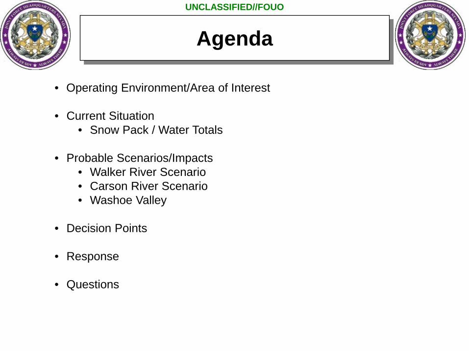
Agenda
• Operating Environment/Area of Interest
• Current Situation• Snow Pack / Water Totals
• Probable Scenarios/Impacts• Walker River Scenario• Carson River Scenario• Washoe Valley
• Decision Points
• Response
• Questions
UNCLASSIFIED//FOUO
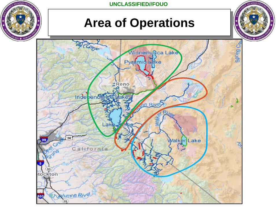
Area of Operations

UNCLASSIFIED//FOUO
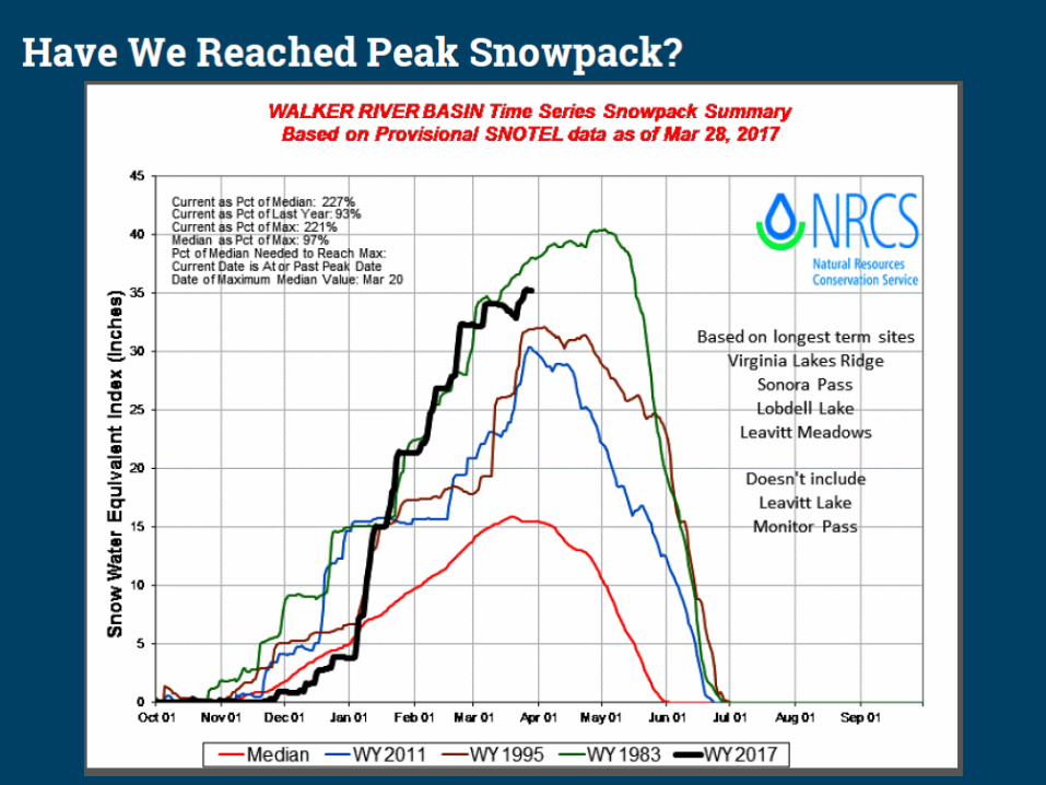
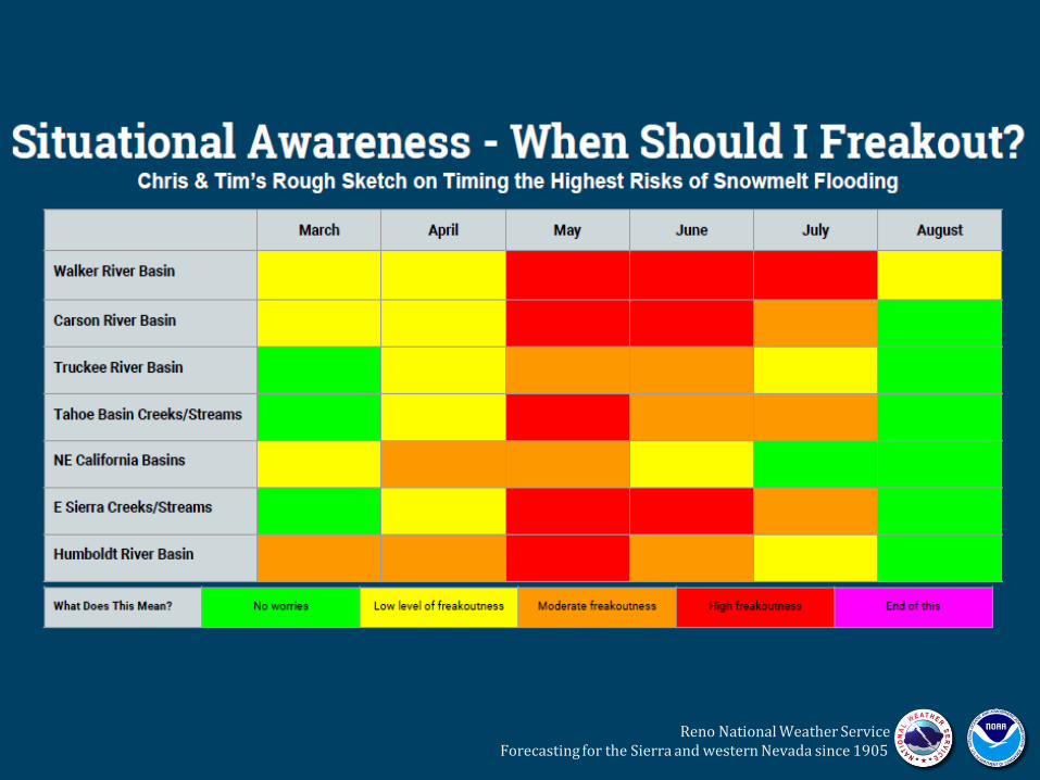
Spring Flood Outlook
UNCLASSIFIED//FOUO
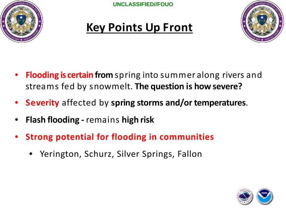
Key Points Up Front
• Flooding is certain from spring into summer along rivers andstreams fed by snowmelt. The question is how severe?
• Severity affected by spring storms and/or temperatures.
• Flash flooding - remains high risk
• Strong potential for flooding in communities
• Yerington, Schurz, Silver Springs, Fallon

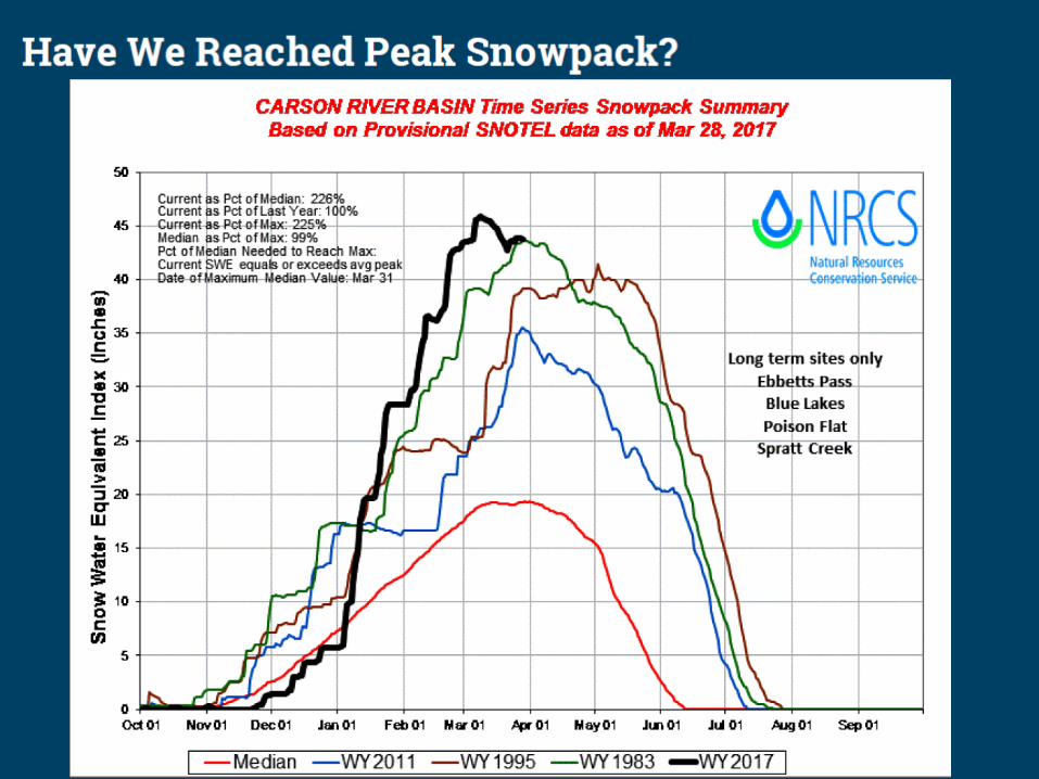
Snow Water Equivalent
As of 31 Mar 2017

UNCLASSIFIED//FOUO
How much water is in the snow pack?
Walker Basin: 640,000 acre ft. or 208 Billion Gallons.
This is enough water to fill the Empire State Building 753 times.
Carson Basin:736,000 acre ft. or 239 Billion Gallons.
This is enough water to fill the Empire State Building 866 times.

Reservoir Space vs What’s Coming...
Reservoirs - will help reduce flooding downstream, but due to expected runof f volumeand reservoir capacities, they will not eliminate downstream flood risk.
***Snowmelt equals 5x Topaz and Bridgeport or 47x the Weber Reservoir
Reno National Weather Service Forecasting for the Sierra and western Nevada since 190511
9
Reno National Weather Service Forecasting for the Sierra and western Nevada since 1905

What Does this Mean for the Walker River?
Walker Basin is the most likely major basin to experience significant and prolonged snowmelt flooding.
Minor flooding likely in upper basin, but longer and more significant flooding likely in valley locations.
Intensity based on snowmelt rate, contributing area, and runoff efficiency
Flooding impacts could last wellinto July.
daily data for 1983
Reno National Weather Service Forecasting for the Sierra and western Nevada since 1905

UNCLASSIFIED//FOUO
Spring Thaw / Flooding Declarations
Douglas County – est. 6 Apr 2017
Churchill County 3 March 2017 Lyon County – 16 March 2017
Flooding Emergency Declarations
Schurz – est. 13 Apr 2017

UNCLASSIFIED//FOUO
Walker River Basin Scenario

UNCLASSIFIED//FOUO
Schurz

Walker B
asin

UNCLASSIFIED//FOUO
What does 1,000 CFS look like?
Olympic Pool
25m x 50m x 2m= 2,500 m3
or 88,000 Cubic Feet
At a rate of 1,000 CFS, an Olympic sized pool would be filled in 1 minute 28 seconds.
Over the period of 24 hours a rate of 1,000 CFS would fill 981 Olympic Pools

UNCLASSIFIED//FOUO
Walker 1310 cfs
Control Gate
Wal
ker
1560
cfs Yerington, NV
2700 cfs = major flood stage
1400 cfs = moderate flood stage
3450 cfs = moderate flood stage
Rivers merge
Weir
Walker River Basin
800 cfs = flooding through wetlands
Schurz, NV
2200 cfs = flood stage
Walker Lake
**2700 cfs 1.8 Olympic pools per min
**5,000 cfs 3.3 Olympic pools per min

UNCLASSIFIED//FOUO
Walker Basin – Hydromapper

UNCLASSIFIED//FOUO
When Could Topaz Be Full?What does Topaz Full Mean?
• Topaz could be full as soon as May 23-30th
• Date varies by snow melt, rain events, draw down rate
• Topaz full = uncontrolled river flow into Smith & Mason Valleys
• Yerington Flooding Major flood stage May through July

UNCLASSIFIED//FOUO
≈70ft drop off
Bridgeport Reservoir
Elev. 6475 ft
Elev. 6473 ft
Elev. 6461 ftfor Spillway
Considerations1. Spillway elevation = 1 ft above Siphons2. Siphon vibration affects on Dam?? 3. US Army Corp of Engineers modify spillway elevation lower than siphons ASAP
40’ Drop Bridgeport Dam
Guard House SiphonsElev. 6459.94 ft

UNCLASSIFIED//FOUO
RV Park
WEST WALKER RIVER Wellington
UNCLASSIFIED//FOUO
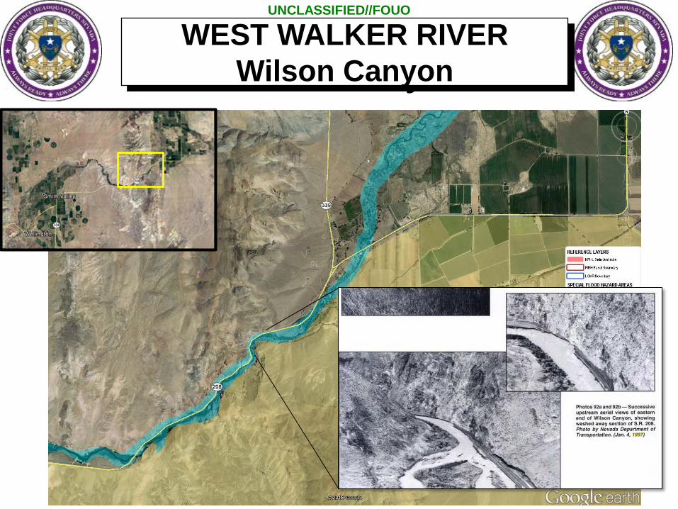
WEST WALKER RIVER Wilson Canyon

UNCLASSIFIED//FOUO
• 1997 Mason Flooding• Ditch running parallel to Walker
River overflowed in vicinity of Mason Rd.
• Waters seeped North until contained by Bridge Street –Flooding S. Yerington
• Recommended Mitigation: Shut down Spragg Ditch prior to prevent flooding
Bridge StSpraggDitch
WALKER RIVER S. Yerington Flooding

UNCLASSIFIED//FOUO
WALKER RIVER

UNCLASSIFIED//FOUO
Weir
WALKER RIVER

UNCLASSIFIED//FOUO
= bridge (Schurz, NV)
Spillway- Community
flooding- Hwy 95 impact
Potential isolation (Fallon / Yerington)
Potential River ImpactsSchurz
UNCLASSIFIED//FOUO
Walker River Basin Mitigation Efforts
UNCLASSIFIED//FOUO
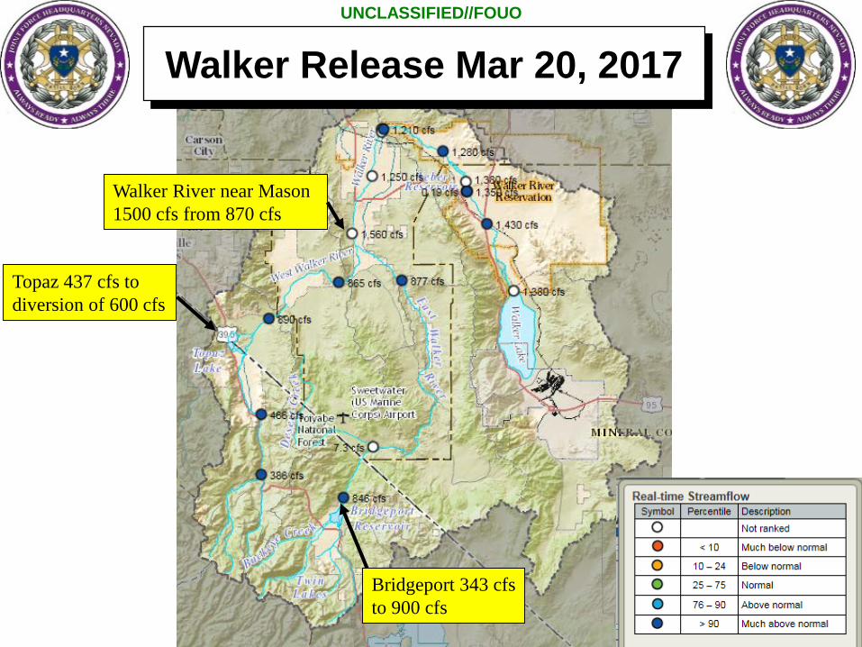
Bridgeport 343 cfsto 900 cfs
Topaz 437 cfs to diversion of 600 cfs
Walker River near Mason 1500 cfs from 870 cfs
Walker Release Mar 20, 2017
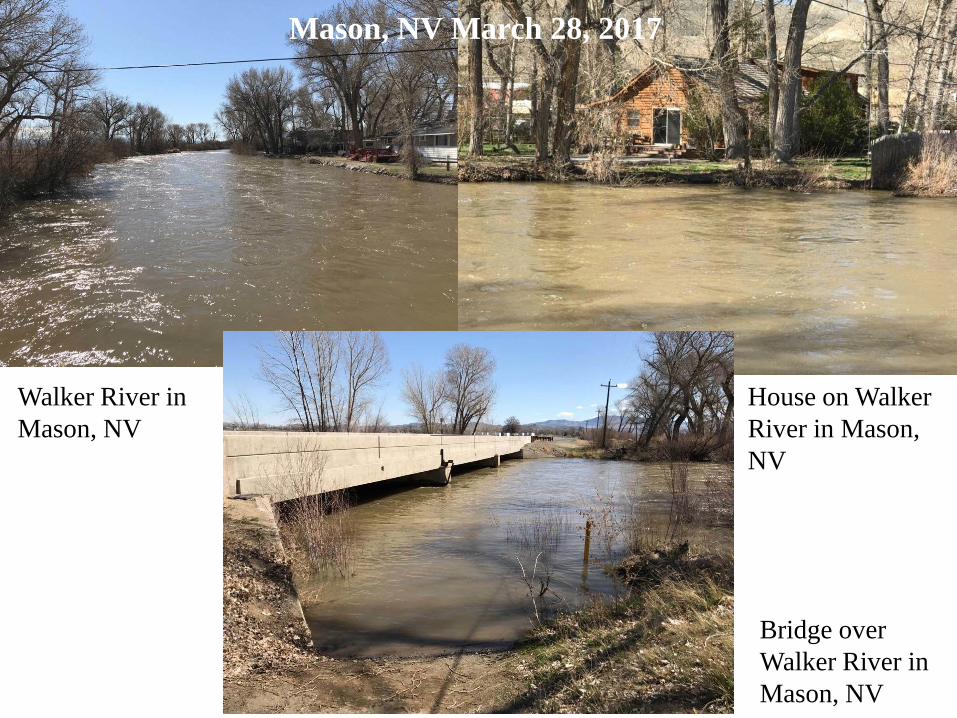
Bridge over Walker River in Mason, NV
Walker River in Mason, NV
House on Walker River in Mason, NV
Mason, NV March 28, 2017
UNCLASSIFIED//FOUO
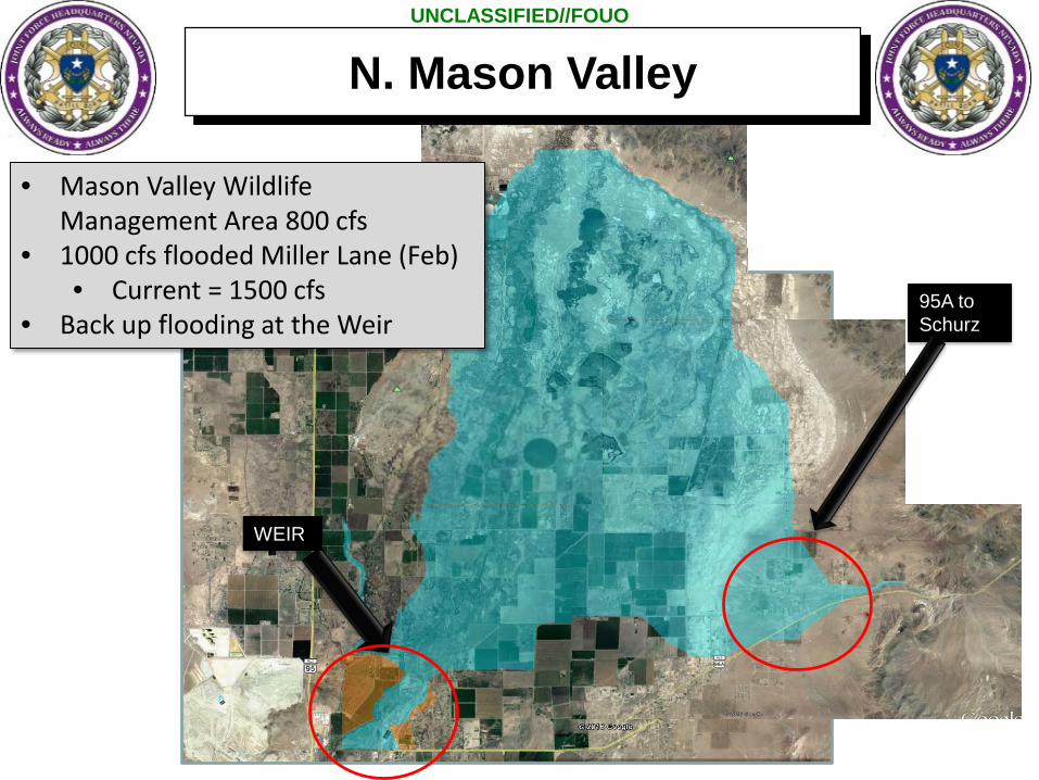
WEIR
95A to Schurz
• Mason Valley Wildlife Management Area 800 cfs
• 1000 cfs flooded Miller Lane (Feb)• Current = 1500 cfs
• Back up flooding at the Weir
N. Mason Valley
UNCLASSIFIED//FOUO
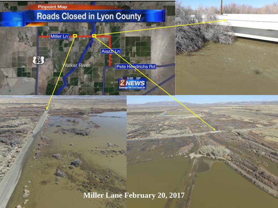
Miller Lane February 20, 2017

UNCLASSIFIED//FOUO
Miller Lane March 28, 2017

UNCLASSIFIED//FOUO
Night In the Country Venue
15,000-20,000 VisitorsJuly 27-29Possible Road Impacts
Road closure at Miller95 S. of Fallon95A @ Yerington
Potential Impacts to Night in the Country

UNCLASSIFIED//FOUO
Carson River Basin

UNCLASSIFIED//FOUO
Carson Basin

UNCLASSIFIED//FOUO
Douglas County
Cradlebaugh Bridge

UNCLASSIFIED//FOUO
Ash Creek
Kings Canyon
Water Treatment Facility
Carson City

UNCLASSIFIED//FOUO
CARSON RIVERSilver Springs
UNCLASSIFIED//FOUO
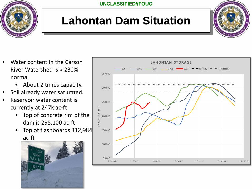
Lahontan Dam Situation
• Water content in the Carson River Watershed is ≈ 230% normal
• About 2 times capacity.• Soil already water saturated.• Reservoir water content is
currently at 247k ac-ft• Top of concrete rim of the
dam is 295,100 ac-ft• Top of flashboards 312,984
ac-ft

UNCLASSIFIED//FOUO
Lahontan Dam Situation
• Current inflow ≈ 1400-1700 cfs• Before problem discharging was ≈ 2460 cfs• 1 damaged, reduced outflow to ≈1000 cfs• Gaining 2,000 ac-ft per day• Tube fixed: new goal 2800 cfs tomorrow
Outlet tubes

UNCLASSIFIED//FOUO
Lahontan Dam Situation
Release starts
Problem discovered
• Crest spillway• ≈2800 cfs• Max spill 6100 cfs• Plus 2500 cfs
from outlet tubes• ≈4,000 cfs floods
Fallon
Flashboards Installed

UNCLASSIFIED//FOUO
HWY 95Elev. 3918
CJ DR Elev. 3916Weir
UNCLASSIFIED//FOUO
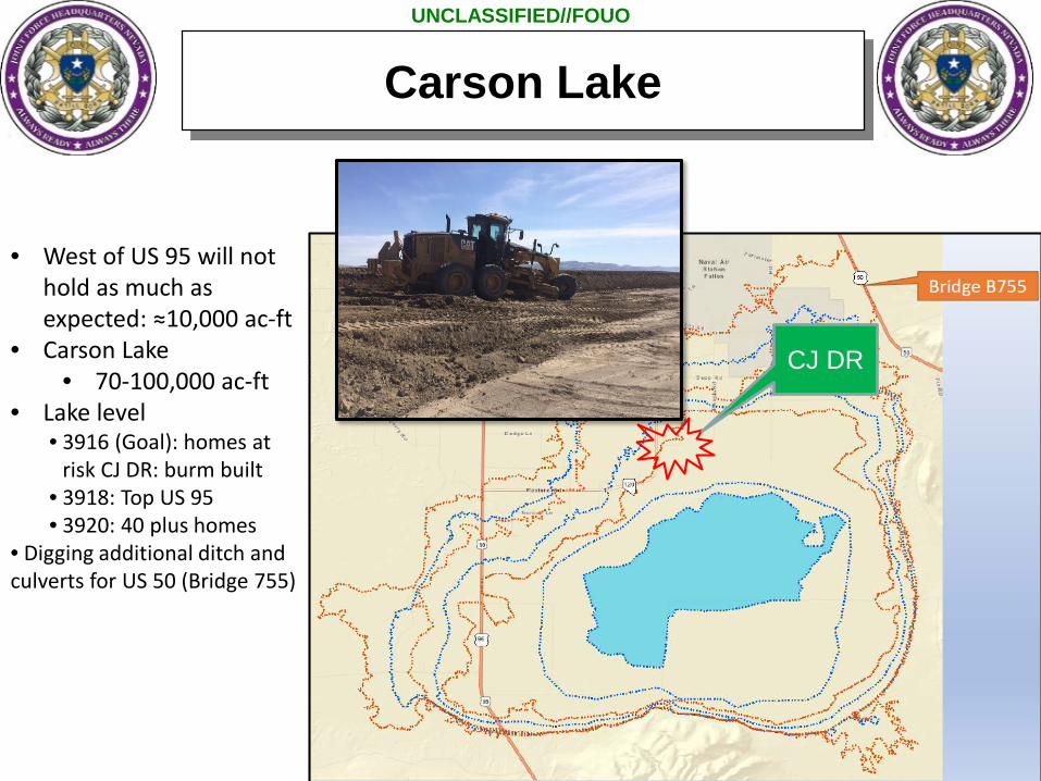
• West of US 95 will not hold as much as expected: ≈10,000 ac-ft
• Carson Lake• 70-100,000 ac-ft
• Lake level • 3916 (Goal): homes at
risk CJ DR: burm built • 3918: Top US 95• 3920: 40 plus homes
• Digging additional ditch and culverts for US 50 (Bridge 755)
CJ DR
Carson Lake

UNCLASSIFIED//FOUO
CARSON RIVER
Wal-Mart
US-95
Bridge
CARSON RIVER (Fallon)
UNCLASSIFIED//FOUO
Washoe Valley Situation
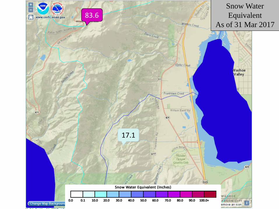
Snow Water Equivalent
As of 31 Mar 201783.6
17.1

UNCLASSIFIED//FOUO
Washoe Valley (I-580)
From NDOTCurrent ≈4 ft to RoadAverage Temp =2.4 ft
UNCLASSIFIED//FOUO
Mitigation & NG Support

UNCLASSIFIED//FOUO
• Precautionary draw-down• Sandbags, K-Rails (jersey barriers), HESCO• Allowing proper flow of river (e.g. Clearing out ditches, creeks,
environmental conservation areas, irrigation canals)• Identifying possible flood areas• Identifying critical infrastructure• Elevate and waterproof structures• Plan for alternate routes• Decon/HAZMAT Plan• Evacuation Plans (in particular for special needs, detention
facilities)• Plan for fuel shortage• Secure above ground fuel tanks
Mitigation

UNCLASSIFIED//FOUO
• Flood Insurance: Get it yesterday!• Flood Resources
– Sandbag Locations– Emergency Contact information– Resource Contact information
• Be prepared - 2 weeks worth of supplies (food; medications; toiletries etc.) • Grab and Go Emergency Preparedness kit with medications, important
documents, and non-replacable keepsakes• Pet plan• Shelter locations• Flood Forecast – know when to react• River level• It is going to flood and what it looks like
Messaging

UNCLASSIFIED//FOUO
Decision Support Matrix
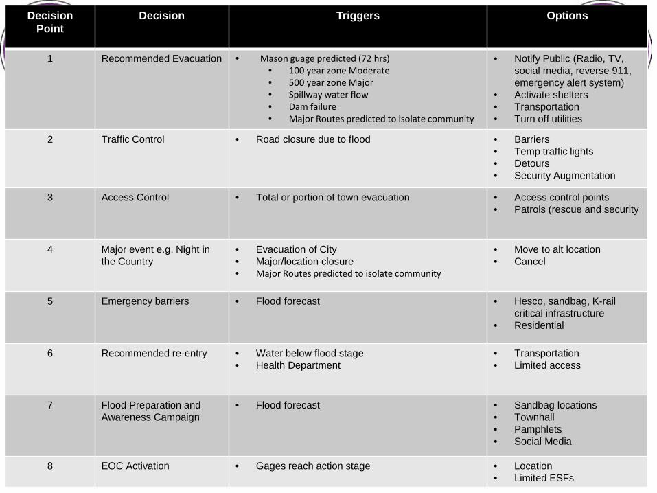
UNCLASSIFIED//FOUODecisionPoint
Decision Triggers Options
1 Recommended Evacuation • Mason guage predicted (72 hrs)• 100 year zone Moderate• 500 year zone Major• Spillway water flow• Dam failure• Major Routes predicted to isolate community
• Notify Public (Radio, TV, social media, reverse 911, emergency alert system)
• Activate shelters• Transportation• Turn off utilities
2 Traffic Control • Road closure due to flood • Barriers• Temp traffic lights• Detours• Security Augmentation
3 Access Control • Total or portion of town evacuation • Access control points• Patrols (rescue and security
4 Major event e.g. Night in the Country
• Evacuation of City• Major/location closure• Major Routes predicted to isolate community
• Move to alt location• Cancel
5 Emergency barriers • Flood forecast • Hesco, sandbag, K-rail critical infrastructure
• Residential
6 Recommended re-entry • Water below flood stage• Health Department
• Transportation• Limited access
7 Flood Preparation and Awareness Campaign
• Flood forecast • Sandbag locations• Townhall• Pamphlets• Social Media
8 EOC Activation • Gages reach action stage • Location• Limited ESFs

UNCLASSIFIED//FOUO
• Assistance in filling sandbags• Evacuation (high water vehicles)• Security (critical infrastructure; evacuated
communities; LE Augmentation)• Traffic Control Points• Logistical Movement (ground or air)• Aerial Assessment (IAA)• Aerial Hoist Rescue• Movement of personnel by bus• Health and Welfare checks
Potential Guard Support

UNCLASSIFIED//FOUO
Bottom Line…• Flooding will happen
• Severity is variable
• Could last into July
• Preparedness / Messaging - NOW
• Develop contingency response plans
• Worst case scenarios
Atmospheric river
Hot weather
Reservoirs reach spillways
Effects on major traffic routes (95, 95A, 395, 580).
Simultaneous events
UNCLASSIFIED//FOUO
Point of Contacts:MAJ Geir J. Gabrielson: Phone: 775-887-7205E-mail: [email protected]
CPT Kandace Gonzales: Phone: 775-400-7949E-mail: [email protected]
Questions