connecting universities to their communities · pathways to support university-generated ... point...
TRANSCRIPT

Department of Infrastructure, Energy and Resources
Tasmanian Government 2012 Submission to Nation Building 2 Program
Connecting Universities to their Communities
September 2012
1 | P a g e
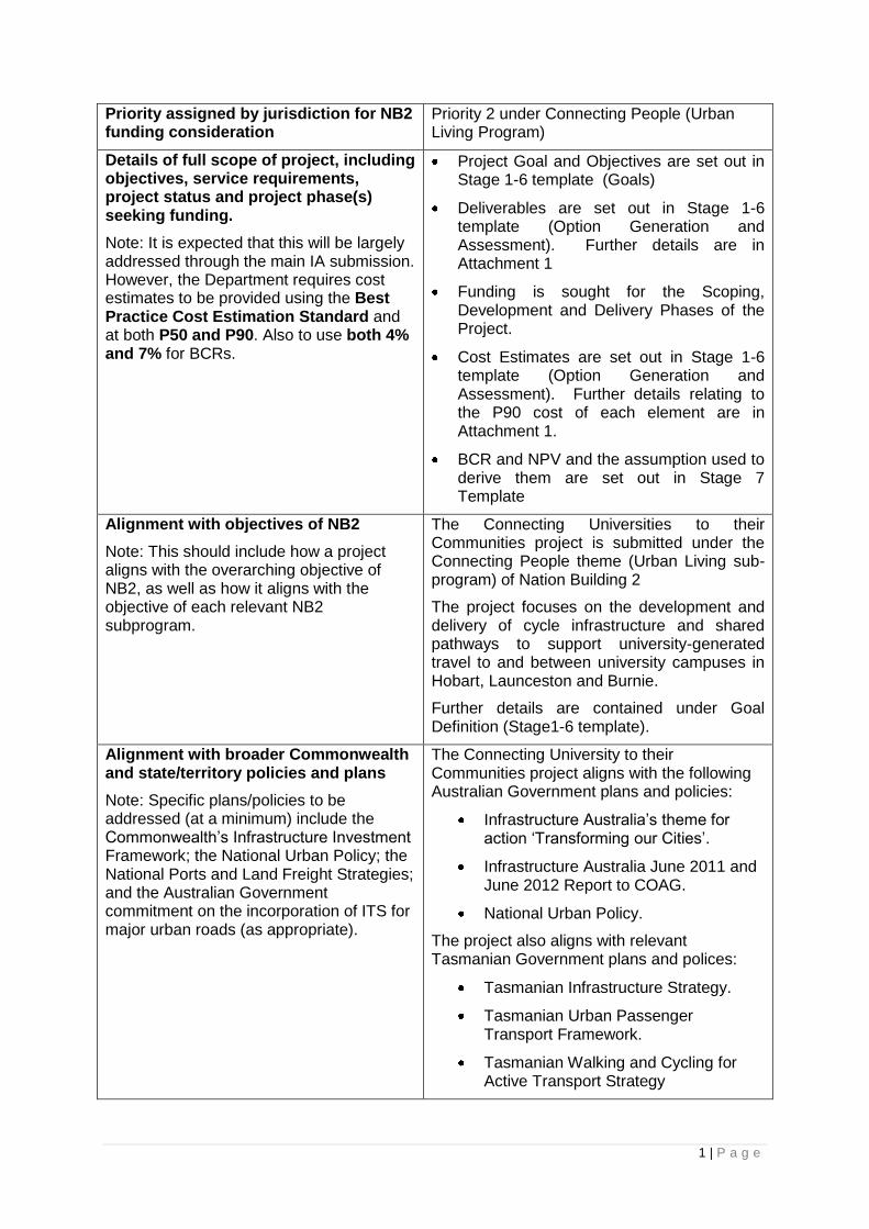
Priority assigned by jurisdiction for NB2 funding consideration
Priority 2 under Connecting People (Urban Living Program)
Details of full scope of project, including objectives, service requirements, project status and project phase(s) seeking funding.
Note: It is expected that this will be largely addressed through the main IA submission. However, the Department requires cost estimates to be provided using the Best Practice Cost Estimation Standard and at both P50 and P90. Also to use both 4% and 7% for BCRs.
Project Goal and Objectives are set out in Stage 1-6 template (Goals)
Deliverables are set out in Stage 1-6 template (Option Generation and Assessment). Further details are in Attachment 1
Funding is sought for the Scoping, Development and Delivery Phases of the Project.
Cost Estimates are set out in Stage 1-6 template (Option Generation and Assessment). Further details relating to the P90 cost of each element are in Attachment 1.
BCR and NPV and the assumption used to derive them are set out in Stage 7 Template
Alignment with objectives of NB2
Note: This should include how a project aligns with the overarching objective of NB2, as well as how it aligns with the objective of each relevant NB2 subprogram.
The Connecting Universities to their Communities project is submitted under the Connecting People theme (Urban Living sub-program) of Nation Building 2
The project focuses on the development and delivery of cycle infrastructure and shared pathways to support university-generated travel to and between university campuses in Hobart, Launceston and Burnie.
Further details are contained under Goal Definition (Stage1-6 template).
Alignment with broader Commonwealth and state/territory policies and plans
Note: Specific plans/policies to be addressed (at a minimum) include the Commonwealth‟s Infrastructure Investment Framework; the National Urban Policy; the National Ports and Land Freight Strategies; and the Australian Government commitment on the incorporation of ITS for major urban roads (as appropriate).
The Connecting University to their Communities project aligns with the following Australian Government plans and policies:
Infrastructure Australia‟s theme for action „Transforming our Cities‟.
Infrastructure Australia June 2011 and June 2012 Report to COAG.
National Urban Policy.
The project also aligns with relevant Tasmanian Government plans and polices:
Tasmanian Infrastructure Strategy.
Tasmanian Urban Passenger Transport Framework.
Tasmanian Walking and Cycling for Active Transport Strategy

2 | P a g e
Southern Integrated Transport Plan.
Southern Regional Land Use Strategy
Draft Capital City Plan.
Further details are contained under Goal Definition (Stage1-6 template).
Overall financial exposure including identification of other partner funding
Note: It is expected that this will be addressed in the main IA submission.
Full details of cost estimates are outlined in the Stage 7 template.
Identification of key strategic risks to the project
Note: It is expected that this will be addressed in the main IA submission.
A Risk Management Register has been developed for the project. Risks are detailed in the submission under Costs, Risks and Funding (Stage 7 template).
Quantification of the expected benefits from the proposal
Note: It is expected that this will be addressed in the main IA submission.
Expected project benefits are outlined in the submission under the Stage 7 template.
Information regarding the extent to which the potential for private sector involvement or investment has been evaluated
Note: It is expected that this will be addressed in the main IA submission.
The need for Government funding is discussed under the Stage 7 template.
Likely impacts from the project proposal on citizens and the market
Note: Detail is needed on how each proposal will impact citizens and the market (as two distinct groups) – positively or negatively, and the extent of the impact
Expected benefits to citizens/the wider community are outlined in Stage 1-6 template (Goals) and Stage 1-6 (Options Generation and Assessment) and in Stage 7 where the assumptions underlying the derivation of the BCR is set out.
Stakeholder consultation will be a key element of the Project. Individuals affected by the implementation of the Project may include landowners and those with jetty licenses and leases in the vicinity of the proposed Battery Point Walkway, and removal of parking to provide on-road cycle infrastructure may affect some individuals.
These considerations are set out in the Key Risks (Option Generation and Assessment) Stage 1-6 and Attachment 1 and Stage 7 template.
Identification of key stakeholders in the project and the complexity of stakeholder relationships
Tasmanian Government, Hobart City Council, Launceston City Council, Burnie City Council, University of Tasmania and the Tasmanian Government are the key stakeholders. Support of these stakeholders will be required to ensure support for delivery of the Project.

3 | P a g e
Hobart, Launceston and Burnie City Councils, along with the Crown (in relation to Battery Point Walkway) are the Planning Approval Authorities.
Community stakeholders, including motoring and cycling advocacy groups, will be involved in consultation around concept and design.
See Stage 7 template for details of relationships.
Extent of multijurisdictional and/or private sector involvement in the proposal
No other jurisdictions or private sector entities are involved in developing this proposal.
Details of the level of innovation and information technology involved in the proposal, including in relation to information technology requirements to successfully manage/implement the proposal
Note: Detail is to include identification of any new/untried methodologies or technologies to be used in the project, as well as IT requirements for the proponent agency to successfully manage or implement the proposal.
An ITS solution is not considered to be applicable to the issues this project addresses.
Details of the proposed procurement methods for the proposal
Note: It is expected that this will be addressed in the main IA submission.
Procurement methods for the proposal are discussed in the Stage 7 template.
Level of complexity in construction, and any known issues in relation to the construction of the project, including environmental and heritage considerations
Note: It is expected that this will be largely addressed through the main IA submission. However, the Department requires sufficient detail to fulfil its probity and accountability requirements, so any additional information not explicitly addressed in the main IA submission should be provided here.
Stage 7 template
Stage 1-6 template
Attachment 1
There are not considered to be any significant inherent construction risks. Specific contingencies relating to construction have been factored into the cost estimate, as have contingencies related to planning, heritage and environmental approvals.
In relation to fauna and flora impacts, field studies will be required for the Battery Point Walkway element and this will be completed during the Development Phase. Permit applications, if required, will be undertaken as part of this Phase. Other elements of the Project will be delivered within the road reserve or in the form of upgrades of existing off-road pathway and no risk is anticipated in relation to flora or fauna on these elements.
There are known European Heritage sites

4 | P a g e
around the slipway in the vicinity of the Battery Point Walkway and these are well documented. There are also known Aboriginal Heritage sites in the vicinity of the proposed walkway. A full assessment of all heritage values and regulatory requirements will be undertaken as part of the Development Phase.
Full field surveys and any permit applications that are required will be undertaken as part of the Development Phase. (See Stage 7 template and Stage 1-6 template including Attachment 1 for detail of identified risks).
Traffic management costs (associated with Brooker Highway Pedestrian/Cycle Overpass) have been factored into the cost estimates.
Any known issues in relation to contractual or service delivery obligations stemming from the proposal
Note: This is to include any issues that are not currently present but could reasonably be foreseen.
There are no foreseen contractual or service delivery issues.
Details of the proposed governance arrangements for the proposal
Note: This should be largely addressed in the main IA submission. However, the Department requires an explicit statement about the experience of the management team in delivering similar proposals and whether there are any expected knowledge gaps or training needs to successfully implement the proposal.
Governance arrangements are detailed in the Stage 7 template.
The Project will be managed through the scoping, development and delivery phases, applying DIER‟s routine governance arrangements and processes.
Details of the proposed delivery timetables and whether there are any known challenges to achieving those timeframes
Note: It is expected that this will be addressed in the main IA submission.
The delivery timetable is outlined in the Stage 7 template.
Details of any significant interdependencies for the project
Note: It is expected that this will be addressed in the main IA submission.
Interdependencies are discussed in the Stage 7 template.
This Project is not dependent on any other project to enable delivery to proceed, however the realisation of full monetised and non-monetised benefits will depend on the delivery of active transport infrastructure on Campbell/Argyle Street in Hobart; the delivery of a crossing point on Sandy Bay Road (minor works); and the creation of improved links to the proposed Brooker Highway Ped/Cycle overpass.

5 | P a g e
Proposal Summary
Initiative Name: Connecting Universities to their Communities
Location (State/Region(or City)/ Locality): Hobart, Launceston and Burnie (Tasmania)
Name of Proponent Entity: Tasmanian Department of Infrastructure, Energy and Resources
Contact (Name, Position, phone/e-mail): David Spence, General Manager Infrastructure Strategy Department of Infrastructure, Energy and Resources Tel: (03) 6233 2089 Email: [email protected]
Executive summary
Funding is sought through Nation Building Two to develop and deliver active transport infrastructure that contributes to the achievement of the Strategic Goal of invigorating and enhancing the liveability of the cities of Hobart, Burnie and Launceston by engaging with and drawing into those cities, the social, cultural, economic and intellectual liveliness associated with university communities.
Specific Objectives of the Project are to:
Stimulate retail activity by increasing pedestrian and cyclist presence in city centres.
Create more sustainable communities by supporting the uptake of active transport through the provision of safe, accessible, well connected cycle and pedestrian routes that facilitate travel to and between University campuses, and between University campuses and city centres.
Support a healthy, active student population, and ensure accessibility by providing an alternative to car based travel for journeys to and between University campuses.
Mitigate the increase in traffic movements and parking pressure that are likely to arise in the Hobart CBD as a consequence of students travelling to and between the newly developed city-based campuses.
The Goals and Objectives of the Project respond to the Tasmanian Infrastructure Strategy Vision for „transport infrastructure to drive economic growth, social inclusion and meet climate change challenges.‟
The development of new University campuses on the Hobart Waterfront and Domain; in the Hobart CBD; and at Inveresk in Launceston, offers an opportunity to invigorate and enhance the liveability of our university-cities and to contribute to the achievement of the Vision of the Tasmanian Infrastructure Strategy.
This opportunity is best realised by encouraging mode shift toward walking, cycling and public transport as there is evidence that these modes increase retail activity in commercial centres, as well as promoting social cohesion and inclusion, improving public and individual health, and supporting better environmental outcomes.
The high level of car dependence for every-day trip making in Tasmania is a significant threat to the achievement of these outcomes. Currently 75% of journeys in Greater Hobart are undertaken by private motor vehicle even though many trips are for distances of less than 3km. Whilst 20% of journeys are made by walking, only 4% are by public transport, and just 1% are undertaken by bike. Car travel does not support the level of retail activity as active transport modes, nor does it deliver the social, environmental or health benefits conferred by active travel. With the University of Tasmania focusing on the development of city-based campuses, car-dependence for university-generated travel is likely to create additional problems in terms of more traffic movements into and through the Hobart CBD (in particular) and increased demands for parking.
Although around 37% of the Hobart university student population live within a very „cycle-able‟ 5km of the Hobart campuses, 47% of those who responded to the UTAS Bicycle Survey 2011 indicated that lack of bike paths, lanes or routes was a factor preventing them from cycling to University more often, and 49% cited motorist behavior as a disincentive for cycling.
Whilst there are footpaths supporting pedestrian travel to and between campuses, there is no cycling infrastructure in the Sandy Bay/Hobart precinct to support travel between residential areas and the University of Tasmania campuses, or between University campuses. Travelling between campuses involves riding in the traffic along busy roads. As the City, Waterfront and Domain campuses are developed and the student population shifts toward those campuses, cycling for university-generated travel is likely to become more

6 | P a g e
challenging as it will involve an increased number of journeys on busy roads.
In Launceston there is a discontinuous on-road and off-road cycle/shared pathway between the Newnham and Inveresk campuses and the city which supports cycling and walking between campuses. In Burnie there are footpaths but there is no cycle infrastructure to support journeys between campuses or into the city.
There is a strong case for providing separated cycle facilities/shared pathways to support transport oriented cycling. For many people, including those responding to the UTAS Bicycle Survey 2011, safety concerns relating to cycling in traffic is the key barrier to cycling for transport.
This Project proposes the development and delivery of cycle infrastructure/shared pathways to support university-generated travel to and between university campuses in Hobart, Launceston and Burnie. In developing the proposal, the focus has been providing:
Separation/segregation as a mechanism for increasing safety (perceived and actual) and amenity.
Direct and connected routes.
Routes that are relatively flat to support efficiency and promote uptake.
Is this a new submission? Yes
Estimated cost of problems? The strategic framework and transport system problems to which this
project responds are outlined in the Goal Definition and Problem
Identification, Assessment and Analysis sections of this document.
Detailed information of Project costs is in the Options Generation and
Assessment Section. A Benefit/Cost Analysis is provided in the Stage
7 Template.
Estimated Capital Cost of Initiative by
Proponent ($M, nominal,
undiscounted):
$29.9 Million across the following 3 projects:
Hobart (full walkway): $23.3M
Launceston: $2.9M
Burnie: $3.7M
Commonwealth contribution sought
by Proponent ($M, nominal,
undiscounted):
$29.9 Million across the following 3 projects:
Hobart (full walkway): $23.3M
Launceston: $2.9M
Burnie: $3.7M
Other funding (source/amount/cash
flow) ($M, nominal, undiscounted):
Nil other funding allocated for expenditure on this Project at this time.
BCR by Proponent excluding Wider
Economic Benefits
1.1
Estimated program Each element of the Project has a separate program with various
amounts of time allowed for the Scoping, Development and Delivery
Phases.
All Scoping Phases will be completed by December 2016
All Development Phases will completed by June 2017
Delivery will be completed by June 2018.
The scoping phase for Burnie and Launceston elements will not
commence until April 2014 at the earliest but the Scoping Phase for
some Hobart elements may commence prior to June 2014.

7 | P a g e
Goal Definition
The Strategic Goal of the „Connecting Universities to their Communities‟ Project is to:
Invigorate and enhance the liveability of the cities of Hobart, Burnie and Launceston by engaging with and drawing into those cities, the social, cultural, economic and intellectual liveliness associated with university communities.
Specific Objectives of the Project are to:
Stimulate retail activity by increasing pedestrian and cyclist presence in city centres.
Create more sustainable communities by supporting the uptake of active transport through the provision of safe, accessible, well connected cycle and pedestrian routes that facilitate travel to and between University campuses, and between University campuses and city centres.
Support a healthy, active student population, and ensure accessibility by providing an alternative to car based travel for journeys to and between University campuses.
Mitigate the increase in traffic movements and parking pressure that are likely to arise in the Hobart CBD as a consequence of students travelling to and between the newly developed city-based campuses.
Positive contribution to Infrastructure Australia and Nation Building 2 strategic
priorities
The „Connecting Universities to their Communities‟ Project reflects strategic collaboration between the Tasmanian Government, the Hobart, Launceston and Burnie City Councils and the University of Tasmania to achieve better outcomes for our major cities. The Goals of the Project respond to the Key Challenges identified by Infrastructure Australia and the themes of the National Urban Policy.
The project is submitted under the Connecting People (Urban Living sub-program) theme of
Nation Building 2, and furthers the objectives of this program area:
Connecting People - the delivery of cycle infrastructure and shared pathways to
support university-generated travel to and between university campuses in Hobart,
Launceston and Burnie will deliver a number of benefits, including supporting the
uptake of active transport; supporting a healthy and active student population; improved
accessibility; and reduced car-based travel.
National Urban Policy
Supporting our Cities: Improving the liveability, sustainability and productivity of
Australia’s major cities. Using active transport infrastructure to link University precincts
with the city centres will help to create more liveable cities by encouraging greater
integration between the University precincts and CBDs. Social, cultural, economic and
intellectual vigour associated with university activity is a feature of many of the world‟s
most liveable cities. Tasmanian communities can be enlivened socially and economically
by creating active transport links that function so as to better integrate University life into
the fabric of our cities.
The trips generated by inter-campus travel will be for distances of less than 5km.
Providing active transport infrastructure to connect University campuses and CBDs will
therefore provide opportunity for increased physical activity, and reduce dependence on

8 | P a g e
private motor vehicles by improving transport options for students, staff and the wider
public accessing adjacent destinations.
Climate Change: Improving the sustainability of our urban environment. The
volume of student and staff movements to and between campuses is predicted to
increase. This is as a result of the University of Tasmania continuing to develop its
campuses and increasing student populations through residential developments at
Inveresk (Launceston) and campuses around the Hobart Waterfront, in the Hobart CBD
and on the Hobart Domain. . Providing safe, well connected and convenient active
transport infrastructure will provide a viable alternative to using motor vehicles for these
short journeys. UTAS, as part of its commitment to 5 Star Green Star developments, will
be including high quality end of trip/bike storage facilities in all developments. This
initiative will support and encourage a shift to active transport for University-generated
travel.
The Project will also facilitate the integration of active transport and public transport by
providing walking and cycling access to public transport hubs.
Better Use of Existing Infrastructure: Increasing productivity Unless more
sustainable transport modes are supported and encouraged, increased motor vehicle
travel between University campuses is likely to result in increased demand for car
parking on and around campuses. Provision of active transport infrastructure may reduce
parking demand, creating opportunity for more productive land uses.
Travel demand is increasing between campuses. Providing for active transport is a
means to mitigate pressure on the more congested roads adjacent to University
precincts. This will avoid the need to provide additional capacity, or implement traffic
management interventions on these routes.
Providing direct, flat, connected, mode separated cycling infrastructure is likely to result
in travel time savings for those cycling to and between University destinations. It may
also provide a more time efficient alternative to public transport and motor vehicle travel
especially when waiting and parking time is taken into account.
Most elements of this Project involve utilising existing road space to make specific
provision for active transport modes. In several instances, this involves utilising „lazy
space‟ on the road to create cycle lanes or shared pathways. At other sites, traffic
calming and other measures will be used to create suitable road conditions for cyclists
and motorists to safely share the existing road space. In some cases, car parking will be
removed to create space in the road corridor for cycle lanes.
Alignment with State/regional strategic plans
Tasmanian Infrastructure Strategy
The „Connecting Universities to their Communities‟ Project responds directly to the Tasmania Infrastructure Strategy Vision for „transport Infrastructure to drive economic growth, social inclusion and meet climate change challenges.‟
The Project contributes to this vision by:
Boosting economic activity in our cities through better integration of the university community into our urban centres.

9 | P a g e
Improving liveability of our cities by injecting the vigour associated with university life into our city centres.
Improving liveability by providing affordable, sustainable alternatives to car-based travel between our university precincts, and between university precincts and city centres.
Within the Tasmanian Infrastructure Strategy, it is the passenger transport goal of “Connected, Liveable and Healthy Communities” that is the focus of the Connecting Universities to their Communities project. Identifying and developing key transport oriented cycle networks are identified as a key focus of the Tasmanian Infrastructure Strategy over the next five years.
The Tasmanian Urban Passenger Transport Framework articulates priorities in terms of implementing the Passenger Transport elements of the Tasmanian Infrastructure Strategy.
At a regional level, initiatives such as the Southern Integrated Transport Plan 2010, and the Northern Integrated Transport Plan (currently under development) include a focus on providing more supportive transport systems for pedestrians and cyclists in order to better manage travel demand, create more liveable communities and meet the challenges of sustainability.
The „Connecting Universities to their Communities‟ Project contributes to the implementation of the Tasmanian Infrastructure Strategy through the:
Tasmanian Urban Passenger
Transport Framework
Reduce greenhouse gas emissions
Create liveable and accessible communities
Increase travel time reliability
Encourage healthy, active communities
Integrate transport and land use planning
Tasmanian Walking and Cycling for Active Transport Strategy 2010
Objectives
Supportive land use systems that encourage walking and cycling.
Improved infrastructure and facilities that support walking and cycling.
Improved safety for pedestrians and cyclists.
Better understanding of walking and cycling needs and patterns.
Better coordination and collaboration with stakeholders
Improved policy and planning processes that ensure walking and cycling needs are considered
Identification of Principal Urban (Transport Oriented) Cycling
Networks in each Urban centre
‘Connecting Universities to
Communities’ Project
Priority Areas

10 | P a g e
As part of the implementation of the Tasmanian Walking and Cycling for Active Transport Plan, a stakeholder consultation process was undertaken to identify and rank Principal Urban (transport oriented) Cycling Networks in each major urban centre. Achieving mode shift by providing accessible, safe active transport alternatives were key considerations in developing criteria for route selection.
The routes that comprise the „Connecting Universities to Communities‟ were considered to be the highest priority routes on the Principal Urban Cycling Networks:
In Hobart, the route from Marieville Esplanade to the CBD was ranked Number 1. Morrison Street, Davey Street, Campbell Street were identified as high priority inner city connector streets and the connection over the Brooker Highway to the domain was listed as a priority link.
In Launceston, the route from the University of Tasmania at Newnham to the CBD was ranked Number 1.
In Burnie, the route from the Cradle Coast Campus on upper Mooreville Road to the Rural Clinical School on Brickport Road and onwards via the Coastal Pathway to the CBD was ranked No. 3 on the Burnie/Devonport Principal Urban Cycling Network. Marine Terrace was identified as a high priority inner city connector route on the Network.
Alignment with Local Government Active Transport Priorities
The routes identified in the „Connecting Universities to Communities‟ Project are part of:
The Hobart Regional Arterial Bicycle Network Plan
The Launceston Cycling Strategy
The North West Coastal Pathway Plan
Alignment with Hobart’s Draft Capital City Plan
The „Connecting Universities to Communities‟ Project aligns with the Draft Capital City Plan developed for Hobart which envisages Hobart as a “...vibrant, dynamic and attractive city, a globally connected place that fosters cultural expression innovation and growth and which provides a liveable sustainable and prosperous lifestyle”.
A focus of the plan is to increase modal choice and improve active transport links to connect key activity centres. The routes that comprise the „Connecting Universities to their Communities‟ Project in Hobart give effect to this focus as the University campuses and city centre are key destinations and trip generators for the city.
Hobart City Council’s Inner City Action Plan
Hobart City Council‟s Inner City Action Plan (ICAP) contains a selection of key recommendations from the Gehl Architect's Report, Hobart 2010 Public Spaces and Public Life - a city with people in mind. It outlines 15 recommended projects designed to attract people and activity into Hobart and to create a vital, dynamic city centre.
ICAP incorporates a focus on creating a pedestrian network that enables smooth movement between city destinations, and an urban environment that encourages cycling as a safe, alternative mode of transport. Providing cycling and pedestrian facilities from Castray

11 | P a g e
Esplanade, along the waterfront through Campbell Street and across the Brooker Highway at Bathurst Street are specific Actions identified in the Plan and these are directly reflected in the „Connecting Universities to their Communities‟ Project.
Launceston City Council – Public Spaces and Public Life 2011
The Northern Suburbs Bike Route is identified as a priority route in the Launceston Bike Plan and in the Cycling Infrastructure Strategy. Supporting and encouraging cycling for transport is an element in the Launceston Parking & Sustainable Transport Strategy and will contribute to the achievement of a number of goals articulated in Launceston‟s Vision 2020.
North West Coastal Pathway Plan
Burnie City Council is a partner in the development of the Northwest Coastal Pathway Plan,
the purpose of which is to deliver 110km of shared walking/cycling pathways between
Latrobe and Wynyard. The aim will benefit communities by improving connections between
them, encouraging healthy lifestyles, providing alternative transport routes, reducing the
environmental and health impacts of motorised transport, improving the environmental
condition of the coastal zone and assisting to address transport disadvantage. The Burnie
element of the „Connecting Universities to Communities‟ Project responds to the Plan.
University of Tasmania’s Sustainable Transport Strategy 2012-2016
The Strategy has been developed to guide investment and actions that deliver more socially,
economically and environmentally sustainable transport outcomes and behaviours within the
University community. The Strategy acknowledges:
the need to reduce the vulnerability of the University and its community to the rising
cost of fuel;
the growing interest of the University community in using active transport;
the effect that lack of infrastructure has on the uptake of walking and cycling for
University generated travel; and
the increasing number of staff and students being located around the Hobart CBD,
and the impact this has on travel and parking demand.
The focus of the Strategy is to reduce car dependence for trips of up to 10km. The Strategy
draws on work undertaken by University of Western Australia, which identified high potential
for dramatically increasing uptake of active travel for trips of up to 2.5km by reducing actual
and perceived cycle time between destinations. For trips of up to 10km, improving
accessibility, convenience and safety of cycling infrastructure was found to be effective in
promoting mode shift.
The „Connecting Universities to their Communities‟ Project responds to issues and
imperatives identified in the UTAS Sustainable Transport Strategy by providing safe,
accessible and connected walking and cycling infrastructure linking University campuses,
and linking campuses to city centres.
Problem identification, assessment and analysis
The development of University campuses on the Hobart Waterfront and Domain and in the
Hobart CBD, and at Inveresk in Launceston offers opportunities for realising the strategic
goal of,
12 | P a g e
Invigorating and enhancing the liveability of the cites of Hobart, Launceston and
Burnie by engaging with and drawing into those cities, the social, cultural, economic
and intellectual liveliness associated with University communities.
This opportunity is best realised by encouraging mode shift toward walking, cycling and
public transport. There is evidence that supporting these travel modes increases retail
activity, and raises private and commercial property values in commercial centres - as well
as promoting social cohesion and inclusion, supporting better health outcomes and fostering
greater sustainability and better environmental outcomes (Heart Foundation 2011)1.
The high level of car dependence for every-day trip making in Tasmania is a threat to the
realisation of the strategic goal. The Greater Hobart Household Travel Survey 2010
indicated that 75 per cent of all trips in greater Hobart are made by private motor vehicle,
even though many car based trips are for journeys of less than 3km.
Given the development and expansion of UTAS campuses at Inveresk (Launceston) and on
the Hobart waterfront, in the Hobart CBD and on the Domain, and assuming a continuing
high level of car dependence for university-generated travel, the problems/opportunity costs
arising are:
Reduced opportunity to fully capitalise on the social, cultural, and economic benefits
that would most likely accrue if students were encouraged to move through our
University cities on foot or by bike.
Diminished opportunity to portray the University of Tasmania as offering an attractive
lifestyle for local, interstate and overseas students.
Increase in traffic movements related to University travel generally, with potential for
increased congestion along upper Sandy Bay Road, across and along the
Davey/Macquarie Street couplet, and within the Hobart CBD. The Department of
Infrastructure, Energy and Resources‟ Congestion in Greater Hobart (July 2011)
report notes that these areas are already considered to be congestion hot spots
during peak travel periods.
Increased demand for parking in the high value retail, tourism and recreational
precincts around the Hobart waterfront, CBD and Domain campuses, and the
potential requirement for new traffic engineering interventions to cater for parking-
related traffic movements in the city and waterfront locations.
Lost opportunity to generate health benefits through increased uptake of active
travel.
Reduced opportunity to create more sustainable travel behaviour.
Potential for increased travel disadvantage due to greater dependence on private
motor vehicles and public transport for University-generated travel.
Potential for increased safety issues with up to 2000 student movements per day
across the Brooker Highway, which is major freight and vehicle route into Hobart.
Available data on demand drivers and mode preference
1 Good for Busine$$ - The benefits of making streets more walking and cycling friendly – Discussion
Paper (Heart Foundation, 2011).

13 | P a g e
The Greater Hobart Household Travel Survey 2010 provides comprehensive data about
how, where and why people travel in Greater Hobart. The survey provides some data on
education-related journey-making in Greater Hobart.
There is, however, a lack of specific data in relation to University of Tasmania staff and student travel behaviour, needs and attitudes, and there is no specific data on mode share or trip generation for university-generated travel. To fill this gap, the University of Tasmania will be undertaking a State-wide survey of staff and students in 2012/13, with a view to obtaining University-wide and campus-specific data. The Survey is being undertaken as part of the implementation of the UTAS Sustainable Transport Strategy 2012-16.
Changing University-Generated Travel Demand
Hobart: In 2011 15,500 people or 7 per cent of greater Hobart‟s total population of 216,000 were studying or working at the University of Tasmania‟s southern campuses, making the University a significant generator of activity and travel in greater Hobart.
Currently, most students and staff are located at the Sandy Bay campus, however with the University of Tasmania continuing to develop its campuses around the Hobart Waterfront, on the Domain and in the Hobart CBD, it is predicted that by 2013, 40 per cent of the University population will be attending University in the city. By 2020, the proportion of students attending campuses in the city will have grown to around 50 per cent.
This represents a significant shift in daytime student population distribution from the year 2000, when 90 per cent of University students were based on the Sandy Bay campus.
Most University housing stock (including residential colleges) reflects historical need and therefore is located in the residential suburbs of Sandy Bay/Mt Nelson, close to the existing campus. Currently 27 per cent of Hobart students reside in Sandy Bay, or the adjacent southern suburbs of Mt Nelson, Tolmans Hill and Taroona, including 523 students living on campus at Sandy Bay/Mt Nelson). Only 10 per cent live in inner city suburbs such as Battery Point, West Hobart, North Hobart or the Domain, (see Fig 1).
The shift in daytime population distribution of students is likely to significantly increase and alter travel demand for University generated trips. It is expected that increasing numbers of students (along with staff) will travel from residential areas such as Sandy Bay, Mount Nelson and Taroona into the city. There is also likely to be an increase in daytime travel between campuses.
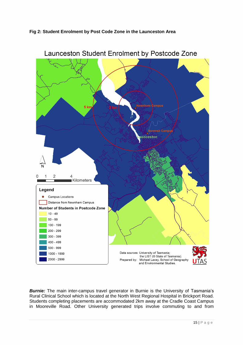
Launceston: The continued development of the Inveresk campus is predicted to generate an increasing need for journeys between Newnham (where student accommodation and the main campuses and student populations are located) and the Inveresk campus. Currently, 18 per cent of the 7057 student and staff attending UTAS in Launceston live between or near to the campuses at Newnham and Inveresk, including 543 students living on campus at Newnham (see Fig 2). In the future, there will be accommodation for 120 students at Inveresk and 723 at Newnham which will increase traffic between these campuses and the CBD.

14 | P a g e
Fig 1 : Student Enrolment by Postcode Zone in the Hobart area.
15 | P a g e
Fig 2: Student Enrolment by Post Code Zone in the Launceston Area
Burnie: The main inter-campus travel generator in Burnie is the University of Tasmania‟s Rural Clinical School which is located at the North West Regional Hospital in Brickport Road. Students completing placements are accommodated 2km away at the Cradle Coast Campus in Mooreville Road. Other University generated trips involve commuting to and from

16 | P a g e
University (from residential locations around Burnie), and commuting from University accommodation in Mooreville Road to the city and other attractors
Currently there are 1050 students attending the UTAS Cradle Coast Campus in Burnie, and 36 medical students living at the Cradle Coast Campus site that are attached to the Rural Clinical School.
Co-located post-secondary colleges: An additional, education-related, demand driver in Hobart, Launceston and Burnie stems from the co-location (or adjacent location) of Polytechnic/Tasmanian Skills Institute campuses and/or Year 11/12 colleges alongside UTAS campuses. Whilst this population is likely to have different travel needs to those of UTAS students, the proximity of the campuses provides opportunities for Polytechnic/Tasmanian Skills Institute staff and College staff and students to utilise infrastructure/services developed as a consequence of the „Connecting Universities to Communities‟ Project.
The issue of car-dependence
Given the development of Hobart CBD, waterfront and Domain campuses, and demonstrated dependence on car travel (75 per cent of all journeys in Greater Hobart), it is likely that unless alternatives modes are made more attractive, a significant proportion of existing and new university-generated travel demand will be undertaken by car. This is likely to increase traffic movements through and into the city, and increase demand for parking in the CBD and on the waterfront.
The development of the Inveresk campus is also likely to create increased traffic movement between Newnham and Inveresk/Launceston CBD. However, the scale of the increase is not as great as in Hobart.
There are high frequency buses servicing all the University campuses in Hobart, Launceston and Burnie. Although the Greater Hobart Household Travel Survey 2010 shows that public transport mode share is just 9 per cent for all education trips, including school bus travel, the University routes are very well patronised by Tasmanian standards.
The high mode share of walking - 30 per cent of all trips in the Hobart municipality and 28 per cent of trips for education purposes overall - provides an opportunity that might be exploited to reduce car-dependence for university related travel. Pedestrian counts, undertaken as part of the Gehl Report, Hobart 2010 – Public Spaces and Public Life - A City with People in Mind2, recorded 3000 pedestrians (per day) along part of the „Connecting Universities to Communities‟ Project route on Campbell Street and across the Brooker Highway to the Domain, and 23,000 pedestrians per day on Morrison Street.
The Greater Hobart Household Travel Survey 2010, found that less than 1 per cent of trips are made by cycling. This is despite 19 per cent of Tasmanian‟s cycling once a week, and 6 per cent cycling for transport once a week (National Cycling Participation Survey 2011).
2 Hobart 2010 – Public Spaces and Public Life - A City with People in Mind, Gehl Architects (2010)
Public Life Data http://www.hobartcity.com.au/Hobart/A_City_with_People_in_Mind/Gehl_Architects_Report

17 | P a g e
Notwithstanding this, Super Tuesday Bike counts conducted in Hobart in 2012 recorded a relatively high number of cyclists on the roads around the Sandy Bay University precinct (60 per hour in one location). The University of Tasmania counts have recorded 80-100 bikes parked on the Hobart campus per day.
In Launceston, Super Tuesday recorded 40 bikes per hour moving on and off the Northern Suburbs Bike Route which services the Inveresk and Newnham route from the CBD. This site recorded among the highest counts in Launceston.
In Burnie, just 2 bikes per hour were counted at the education precinct in Mooreville Road and 7 bikes per hour were counted on the shared path at West Park.
Fig 3 Upper Sandy Bay Road at 3pm: Cycle Route to CBD from Sandy Bay to CBD
Barriers to Active Transport Uptake
Lack of cycling infrastructure
Approximately 37 per cent of the University student population currently reside within a very „cycle-able‟ 5km of the Hobart campuses. However 47 per cent of those who responded to the Hobart UTAS Bike Survey (July 2011) indicated that lack of bike paths, lanes or routes was a factor preventing them from cycling to University more often. 49 per cent indicated that motorists‟ behaviour was a disincentive for cycling.
There is no cycling infrastructure in the Sandy Bay/Hobart precinct to encourage or support travel between residential areas and the University or the CBD. the exception to this is a very short section of sub-standard shared pathway alongside a short section of Davey Street.

18 | P a g e
To cycle between the Sandy Bay campus and the city involves cycling along the upper Sandy Bay Road retail strip. This strip features relatively high traffic volume (25,000 vehicles per weekday average) kerbside parking, multiple intersections and driveways resulting in traffic movement that is not cycle-friendly (see Fig 3). The alternative is taking the lower traffic volume/speed, but hilly and circuitous, route through Battery Point (Fig 2). Regent Street provides another option but traffic conditions are only marginally better than those on Sandy Bay Rd. The same alternatives exist for pedestrian travel although footpaths are provided.
There is no infrastructure within the Hobart CBD to support or encourage cycling between existing or future campuses. Traversing the waterfront area, either as a pedestrian or a cyclist, involves negotiating a busy entertainment/tourism precinct that lacks provision for safe, connected cycling or walking journeys, especially in the evening.
Journeys between CBD and Domain venues in the Medical Science Precinct involve a detour through the underpass at the Railway Roundabout Fountain or an at-grade pedestrian crossing of the multi-lane Brooker Highway which is a major freight and transport route into Hobart.
Fig 2 Marieville Esplanade showing the steep grade up Napoleon Street behind (an alternative more circuitous route is possible at a lesser grade yellow). Battery Point Walkway would deviate right as shown in orange
By way of comparison, counts on the fully separated Inter-City Cycleway (which services the northern suburbs) recorded 138 cyclists per hour during the 2012 Super Tuesday Bike Count. This provides some support for the view that mode-separated, flat, high quality infrastructure supports and encourages transport cycling.
There is no data to indicate cycling mode share for university travel in Launceston. However, the Northern Suburbs Bike Route, provides a segregated active transport route along part of its length and is relatively well patronised. Lack of connectivity between on and off-road

19 | P a g e
sections may compromise the overall efficiency and „identity‟ of the route. There are also connectivity issues at the Mowbray Connector crossing (Figs 4 and 5). Distances between the University campuses/accommodation, and between the campuses and the city are less than 5km, making cycling a viable transport mode.
Fig 4: showing the shared pathway with the informal dirt ‘track’ leading past the power pole and across the Connector to join with the path on the University side.
Fig 5: Mowbray Connector showing location at which cyclists informally cross
There is an active Bicycle Users Group at the Rural Clinical School in Burnie. However, there is no cycle infrastructure between the Clinical School and the student accommodation (Fig 6) or between the student accommodation (Fig 7), and the city centre. There is a (poorly connected) off-road path running through a nature reserve from the vicinity of the campus to the shared coastal pathway at West Park Grove. Distances between the Rural Clinical School, the student accommodation (2km) and Burnie CBD are very cycle-able, at under 5km in each case.

21 | P a g e
Fig 6: Brickport Road (Rural Clinical School) looking downhill toward the Bass Highway and connection to shared path into Burnie CBD.
Super Tuesday 2012 counted 2 bikes per hour at the education precinct in Mooreville Road and 7 bikes per hour were counted on the shared path at West Park. By contrast, around 10 bikes per hour were counted in 2011 on the fully separated shared pathway connecting the town of Ulverstone and the small residential area of Turner‟s Beach. This is an example of where the provision of cycling infrastructure appears to influence levels of cycling for transport.
Fig 7 University Precinct Burnie. Two bikes per hour counted near this site in 2012 Super Tuesday Counts.

22 | P a g e
Is the availability of car parking on campus a barrier to active transport uptake?
The availability of car parking at the Sandy Bay campus (informal free parking in surrounding streets, as well as 1665 parking places on campus) may also act as an impediment to the uptake of active transport by students based on that campus. Studying a University population in Moscow, Idaho, Delmelle and Delmelle (2012, 8), found that the availability of low-cost formal and informal car parking was the greatest factor enabling commuting by car3. Where low cost car parking was available, there was less likelihood of a shift toward active transport or public transport modes. Availability of parking was more influential than distance, topography and safety considerations in determining mode choice.
Assuming these findings are applicable in the Hobart context, the limited free parking opportunities, the low number of University parking places, and relatively high cost of all-day and long term commercial parking around the new Hobart Waterfront and CBD locations may increase demand for alternative travel options for students and staff.
In Launceston and Burnie, UTAS provides 1580 car parking spaces at Newnham campus and 53 at Inveresk campus, whilst in Burnie there are 100 places available across the Mooreville Rd and Rural Clinical School Sites. It could be assumed from this data that car parking is readily available and will continue to be available at these sites, particularly as it is likely that additional free parking exists in surrounding streets.
Option Generation and Assessment
A range of strategies have been identified by Local and State Governments and the University of Tasmania, to address problems and opportunity-costs of car-dependence relating in particular to university-generated travel.
These measures, and the extent to which they are considered to contribute to addressing the problem, are assessed and summarised briefly below:
Increasing student uptake of public transport
The University of Tasmania‟s Sustainable Transport Strategy 2012-2016 incorporates a focus on encouraging bus travel for University generated travel by: i) working with Metro to improve ticketing, network and services; and ii) raising awareness of, and promoting bus travel to students using a range of mechanisms.
Over time, the frequency and number of services have been increased to each campus. The following is the average number of bus services to/from each University during weekday semester times:
Hobart Sandy Bay Campus 183
Launceston Newham 43
Burnie Park Grove 23
Bus services to university campuses in Hobart, Launceston and Burnie attract patronage in excess of across-network averages. A study has been done with respect to services to the Launceston campus which attract patronage per service hour of approximately 37 per cent in
3 „Exploring spatio-temporal commuting patterns in a university environment‟ Eric Delmelle and
Elizabeth Cahill Delmelle Transport Policy 21 (2012) 1-9,

23 | P a g e
excess of other Launceston services. This is indicative of the popularity of bus services to the campuses throughout the state.
Since 1998, services to the Hobart campus have increased on a regular basis in response to high demand, with a service in both direction every 7 or 8 minutes. In addition, comprehensive, but less frequent, off-peak services operate at night times and weekends. Services operate until 11am on most nights. 75 services operate on a Saturday and 34 on a Sunday.
In 2006, services increased to the smaller Burnie campus with a service operating at least every hour. A new service was introduced to the Launceston campus in the late nineties and it is likely that services will be increased in the near future.
For the last five years, tertiary students have been able to buy adult concession tickets. This is a further, and ongoing, stimulus for demand for bus services.
Public transport is a good mechanism for increasing retail and social activity in commercial centres (Heart Foundation 2011), and provides benefits in terms of:
social cohesion, access and inclusion;
supporting good health outcomes by encouraging walking; and
fostering greater sustainability and better environmental outcomes.
Public transport alone is unlikely to provide a complete solution. Although patronage of services on University routes is high compared to network averages, the Greater Hobart Household Travel Survey 2010 indicates that public transport mode share is generally very low (4 per cent for all trips) and only 9.5 per cent (including school bus travel) for education trips. Mode share for car travel is 62 per cent for education trips, reconfirming the dependence on this mode and the need to employ multiple strategies.
Providing disincentives for motor vehicle use through parking pricing
The UTAS Sustainable Transport Strategy 2012-2016 includes strategies for reducing single occupant motor vehicle trips by providing incentives for car pooling and use of small vehicles (scooters etc), and by reform of car park pricing on UTAS campuses.
The risk of relying on the parking pricing strategy is that increasing car parking fees on campus may result in a shift toward use of informal free parking in surrounding streets, reserves and business premises which may have a deleterious impact on public amenity and business (Demelle and Demelle 2012).
If car parking pricing and restriction is effective in reducing use of private motor vehicles for university-generated travel, demand for suitable alternative travel modes (whether in the form of public transport or active transport) will increase. If alternatives to car based travel is not available at a reasonable „cost‟ (financial, time, effort, safety), then parking pricing policies may be ineffective in reducing motor vehicle dependence, or may impose undue hardship on the individual.
Unless viable travel alternatives are available, providing disincentives for private motor vehicle use through parking pricing policy is likely to impact disproportionately on those already likely to experience travel disadvantage. This would include those combining university study with caring responsibilities, and those who for financial reasons live in suburbs some distance from their place of study.

24 | P a g e
Reducing travel need
The University of Tasmania‟s housing stock is concentrated around existing campuses at Sandy Bay (Hobart); Newnham (Launceston) and Cradle Coast Campus in Burnie. In Hobart, there are 523 students living on campus in Sandy Bay/Mt Nelson and the University holds other housing stock in the area. With the shift toward developing campuses in the Hobart CBD, the need to diversify housing stock has been recognised, and there are plans to provide 450 student accommodation places in the city.
By 2014, there will be places for 723 students to live on campus at Newnham. There will also be 120 accommodation places will be provided at Inveresk, in response to the growth of the Newnham Campus.
Housing provision at the Cradle Coast Campus in Burnie will be expanded by 40 units.
The provision of student accommodation in cities and in close proximity to campuses is likely to assist in reducing car dependence. It will also help to draw students into the city centres. However, the risk of relying entirely on this strategy lies in the fact that:
i) not all students will be able to afford to live in university accommodation or inner city locations, and
ii) students will still be required to move between campuses to attend classes.
Supporting and encouraging active travel
The Greater Hobart Household Travel Survey 2010 found walking to have a relatively high mode share at 20 per cent of total trips, and 28 per cent for education related trips.
The National Cycling Participation Survey 2011 found that 6 per cent of Tasmanians cycled at least once a week for transport, but the Greater Hobart Travel Survey 2010 found mode share for cycling to be around 1 per cent. It could be argued that footpaths support walking as a transport mode, whereas cyclists, for the most part, share the road with motor vehicles; a situation that arguably constitutes a barrier to cycling for transport.
Research conducted by the University of Western Australia (2006) found that active travel uptake was higher in their university population than in the general population. The measured potential for shifting staff and students to active transport modes was about 30 per cent4.
4 Shannon T, Giles-Corti B, Pikora T, Bulsara M, Shilton T, Bull F (2006) “Active Commuting in a
university setting: Assessing Commuting habits and potential for modal change”, Transport Policy 13 (204-253).

25 | P a g e
Strategies planned, or in place, to support and encourage cycling for transport include:
1. Providing end of trip (cycling) facilities on UTAS campuses
The UTAS Sustainable Transport Strategy 2012-2016 includes a commitment to providing end of trip cycling facilities on campus. The UTAS Bicycle Survey 2011 identified „lack of adequate bike storage‟ (14 per cent of respondents) as a barrier to using a bike to travel to University. Therefore, it is likely that provision of safe, secure bike parking would support cycling as a transport mode for university generated travel.
UTAS has undertaken to address this through a staged program of providing new and upgraded facilities. For major developments (such as construction of the new Hobart city campuses), Green Building Council of Australia benchmark are used to inform the quantity and type of facilities.
The risk of relying on this strategy alone is that half of the Survey respondents identified „lack of bike paths, bike lanes or bike routes‟ and „unsafe, unlawful motorist behaviour‟ barriers to cycling more often. Unless these issues are addressed, it is unlikely that providing bike parking will increase cycling mode share.
2. Promoting Active Transport to UTAS students and staff
Another strategy articulated in the UTAS Sustainable Transport Strategy 2012-2016 is promotion of active travel. Travel behaviour change programs, awareness and educational campaigns are likely to support mode shift. The risk of relying on this strategy is that, unless safety concerns are addressed (particularly in relation to cycling), and active travel is seen as efficient, car dependence will continue.
3. Creating a better road sharing environments through lower vehicle speeds
In Hobart, the Hobart City Council has been working toward creating a better environment for pedestrians and cyclists, with a recent initiative being to lower traffic speeds in the CBD (including on the arterial routes) to 50km/hr. The Waterfront area and Battery Point have a speed limit of 40km/hr. Consideration is being given to lowering the speed limits on Sandy Bay Road to 50km/hr and, in the central city, to 40km/hr.
In Launceston, there is an off-road path for a significant proportion of the journey between the CBD and the Newnham campus. Consideration is being given to creating an inner-city courtesy zone (shared traffic environment) in the CBD.
Lower vehicle speeds help to create a better road sharing environment. However, other factors, such as traffic volume and conditions and driver behaviour, also contribute to perceptions about the safety of the cycling environment. The risk of relying on lower traffic speed alone as a mechanism to support and encourage cycling as a transport mode is that it does not address these factors. Lower speeds also do not contribute to perceptions about the efficiency of the route (directness, connectedness, travel speed), which is an aspect that is valued by transport cyclists (University of Western Australia 2006).
4. Providing active transport infrastructure
There is currently no active transport infrastructure linking the UTAS Sandy Bay campus to either the Hobart CBD or campuses (existing or under development) on the Hobart waterfront, the CBD or the Domain. Those commuting to University, or between University campuses, must do so on-road, without any separation from traffic.
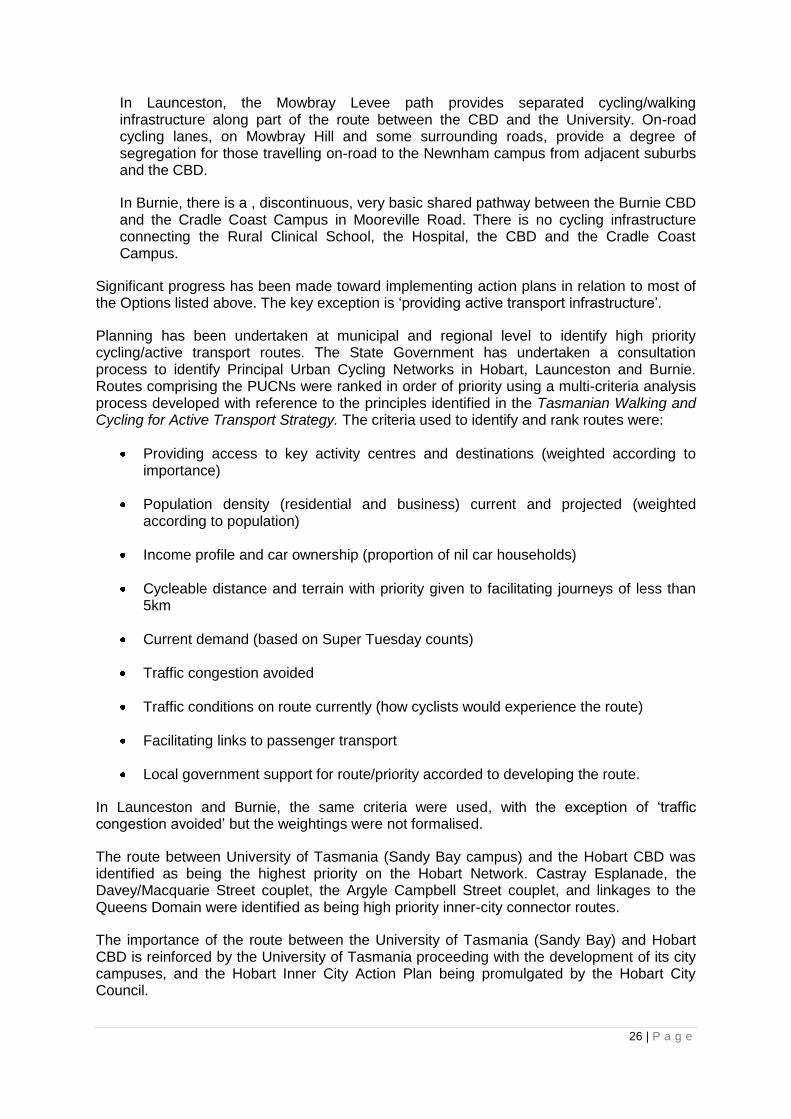
26 | P a g e
In Launceston, the Mowbray Levee path provides separated cycling/walking infrastructure along part of the route between the CBD and the University. On-road cycling lanes, on Mowbray Hill and some surrounding roads, provide a degree of segregation for those travelling on-road to the Newnham campus from adjacent suburbs and the CBD.
In Burnie, there is a , discontinuous, very basic shared pathway between the Burnie CBD and the Cradle Coast Campus in Mooreville Road. There is no cycling infrastructure connecting the Rural Clinical School, the Hospital, the CBD and the Cradle Coast Campus.
Significant progress has been made toward implementing action plans in relation to most of the Options listed above. The key exception is „providing active transport infrastructure‟.
Planning has been undertaken at municipal and regional level to identify high priority cycling/active transport routes. The State Government has undertaken a consultation process to identify Principal Urban Cycling Networks in Hobart, Launceston and Burnie. Routes comprising the PUCNs were ranked in order of priority using a multi-criteria analysis process developed with reference to the principles identified in the Tasmanian Walking and Cycling for Active Transport Strategy. The criteria used to identify and rank routes were:
Providing access to key activity centres and destinations (weighted according to importance)
Population density (residential and business) current and projected (weighted according to population)
Income profile and car ownership (proportion of nil car households)
Cycleable distance and terrain with priority given to facilitating journeys of less than 5km
Current demand (based on Super Tuesday counts)
Traffic congestion avoided
Traffic conditions on route currently (how cyclists would experience the route)
Facilitating links to passenger transport
Local government support for route/priority accorded to developing the route.
In Launceston and Burnie, the same criteria were used, with the exception of „traffic congestion avoided‟ but the weightings were not formalised.
The route between University of Tasmania (Sandy Bay campus) and the Hobart CBD was identified as being the highest priority on the Hobart Network. Castray Esplanade, the Davey/Macquarie Street couplet, the Argyle Campbell Street couplet, and linkages to the Queens Domain were identified as being high priority inner-city connector routes.
The importance of the route between the University of Tasmania (Sandy Bay) and Hobart CBD is reinforced by the University of Tasmania proceeding with the development of its city campuses, and the Hobart Inner City Action Plan being promulgated by the Hobart City Council.

27 | P a g e
The route between the University of Tasmania and the Launceston CBD was identified as the highest priority on the Launceston PUCN. The development of the Inveresk Campus and student accommodation close to the city, together with Launceston City Council‟s desire to draw students into the city centre, highlights the priority of this route.
In the North-West, the route connecting the University of Tasmania (on Mooreville Rd) and the Burnie Waterfront-CBD was identified as the third highest priority route on the Burnie/Devonport PUCN. Marine Terrace was identified as the highest priority inner city connector route for Burnie. These active transport elements provide a link between key education precincts and the CBD. This was considered to be a priority by the stakeholders attending the PUCN consultation. An additional benefit is that the route provides residents of Shorewell (an area with low car ownership and low income) with a low cost transport alternative for accessing schools, the hospital and the CBD.
Infrastructure treatment options
In identifying and assessing options to achieve mode shift to active transport for University generated travel, the key considerations were:
Routes to be adopted for travel between destinations, taking into account considerations such as directness, distance, traffic conditions and terrain.
Infrastructure treatments to be provided, especially given the need to make provision for cyclists of all abilities, and to ensure that pedestrians are also provided for.
Some work was also undertaken to identify specific routes, roads or easements for cycle infrastructure, select preferred routes, and identify treatment options as part of the PUCN process and Hobart‟s Inner City Action Plan (ICAP).
These considerations were also incorporated in the ranking process for the PUCN and have informed the Option Generation process for the „Connecting Universities to Communities‟ Project. As part of the Option Generation and Assessment Process, the „issue of separation‟ was also considered.
There is a strong case, even in relatively low speed, low traffic volume environments, for providing separated cycle facilities/shared pathways for transport oriented cycling. For many people, including those responding the UTAS Bicycle Survey 2011, safety concerns relating to cycling in traffic is the key barrier to cycling for transport (see also The Case for Separation Bike Network Victoria). Bike Network Victoria notes that the numbers of riders on Melbourne‟s car-free routes have increased by 40 per cent whilst the numbers of riders on on-road routes has increased by 20 per cent5.
However, separated cycle/pedestrian infrastructure is generally more expensive to construct than on-road cycle lanes, may not provide for sufficiently direct journeys between destinations. It may and may also not be safer than on-road cycle infrastructure, especially at road crossings (Krizek, Forsyth and Baum 2009, 17-20)6.
5 The Case for Separation, Bike Network Victoria http://www.bicyclenetwork.com.au/general/bike-
futures/40893/ 2 September 2012. 6 Walking and Cycling Infrastructure Review (Final Report) Prepared for Dr Evelyn Legare,
Department of Transport, Victoria, Authored by Dr Kevin Krizek, Dr Ann Forsyth and Laura Baum (2009).

28 | P a g e
Copeland, Chisholm and Robinson (2011)7 note that there are a range of factors that determine what sort of infrastructure will support mode shift:
The differing needs that relate the age, experience and confidence of cyclists and potential cyclists;
Different types of cycling journeys; and
Traffic conditions and volumes
A set of criteria was used to identify and assess options to deliver cycle infrastructure on the links identified in the „Connecting Universities to Communities‟ Project. They focused on the extent to which the options could be expected to support mode shift toward active transport given the target population. In this context, considerations included:
Separation/segregation - as a mechanism for increasing safety and perception of safety where appropriate;
directness (and connectedness); and
grade.
Constructability considerations included cost, risk and ease of implementation.
Criteria Scoring
1 How well does the option aligns with stakeholder priorities.
Rated on a scale of 1-3 where 1 aligns satisfactorily and 3 aligns very well.
2 How well does the option support mode shift by providing a safe, direct, flat active transport route.
Rated on a scale of 1-3 according to how effectively the option provides:
-improved safety (s)
-improved directness (d)
-improved grade (g)
Where 1 satisfactorily addresses the objective poorly and 3 addresses it to a high degree.
3 Risk - how likely is it that the option will either not be delivered, fail to address the problem or cost more than anticipated.
Rated as „low‟ „medium‟ or „high‟
4 Cost Rated as „higher‟ „medium‟ or „lower‟
5 Ease of implementation Rated on a scale of 1-3 where 3 is easy to implement and 1 is very difficult.
7 Developing a Cycling Facility Selection Tool: Some Observations, James Copeland, Greg Chisholm
and John Robinson (2011 Annual Conference of the Transportation Association of Canada 2011.
29 | P a g e
Describe options
The key options for delivering active transport infrastructure on the identified routes are fully described and assessed in Attachment 1.
Key Risks
Risks relating to the achievement of outcomes
The major risk is that the „Connecting Universities to Communities‟ Project will not result in mode shift that is sufficient to contribute to the achievement of the Strategic Goal of invigorating and enhancing the liveability of our cities, or the achievement of the specific Objectives of:
Stimulating retail activity by increasing pedestrian and cyclist presence in city centres.
Creating more sustainable communities by supporting the uptake of active transport through the provision of safe, accessible, well connected cycle and pedestrian routes that facilitate travel to and between University campuses, and between University campuses and city centres.
Supporting a healthy, active student population, and ensure accessibility by providing an alternative to car based travel for journeys to and between University campuses.
Mitigating the increase in traffic movements and parking pressure that are likely to arise in the Hobart CBD as a consequence of students travelling to and between the newly developed city based campuses.
The risk is that students may choose to use private motor vehicles for university-generated travel, rather than using the active transport infrastructure delivered through the „Connecting Universities to their Communities‟ Project. Mitigating this risk is the University of Tasmania‟s commitment, through the Sustainable Transport Strategy 2012-2016, to implement a range of strategies, including:
Raising awareness of sustainable transport options.
Providing incentives and disincentives (including parking pricing) to encourage uptake of sustainable transport options.
Improving sustainable transport infrastructure, facilities and services, including improving the quality, quantity and convenience of end of trip cycle facilities on its campuses.
Risks relating to the achievement of outputs/deliverables
The key risks for the Hobart elements of the „Connecting Universities to their Communities‟ Project, as identified at a stakeholder workshop convened on 14th August 2012, are summarised in Attachment 1. The Battery Point Walkway is the highest risk element of the Project. Key risks are:

30 | P a g e
Public opposition to the construction of the Walkway, primarily from property owners adjacent to the Walkway and from property owners with jetties that will be affected by the project.
Issues that may be raised by Marine and Safety Tasmania about the Walkway, which is likely to be situated in navigable waters.
Environmental issues (marine fauna) that will need to be managed, including the likely presence of the Southern Sea Star and the Spotted Handfish.
European Heritage sites to be managed around the historical slipyard in Marine Terrace.
Risk relating to other elements of the Project are lower and are noted in the Options Assessment Sheet (Attachment 1).
Describe Options
From the Options for delivering the „Connecting Universities to their Communities‟ project identified in Attachment 1, and based on the analysis that is summarised in that document, two Options were shortlisted for further analysis.
Option 1 and Option 2 are identical in all regards with the exception of the route taken and treatment adopted for the Battery Point element (Hobart). The descriptions of Option 1 and Option 2 are as follows:
Option 1
Launceston
1. Shared pathway in Lindsay Street between Hobrook Street and the Inveresk Campus.
2. Median cycle lane in Holbrook Street to Foster Street Intersection.
3. Shared road environment on Holbrook Street between Foster and Lytton Streets (out of scope for funding application).
4. Upgrading of existing shared pathway on Mowbray Levee – to Mowbray Connector.
5. At grade crossing of Mowbray Connector.
6. Upgrading of existing shared pathway to University campus.
Burnie
1. Shared path on Marine Terrace between Wilmot and Spring Streets.
31 | P a g e
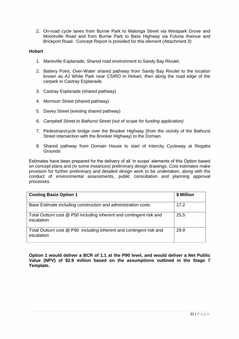
2. On-road cycle lanes from Burnie Park to Malonga Street via Westpark Grove and Mooreville Road and from Burnie Park to Bass Highway via Futuna Avenue and Brickport Road. Concept Report is provided for this element (Attachment 3)
Hobart
1. Marieville Esplanade, Shared road environment to Sandy Bay Rivulet.
2. Battery Point, Over-Water shared pathway from Sandy Bay Rivulet to the location known as AJ White Park near CSIRO in Hobart, then along the road edge of the carpark to Castray Esplanade.
3. Castray Esplanade (shared pathway)
4. Morrison Street (shared pathway)
5. Davey Street (existing shared pathway)
6. Campbell Street to Bathurst Street (out of scope for funding application)
7. Pedestrian/cycle bridge over the Brooker Highway (from the vicinity of the Bathurst Street intersection with the Brooker Highway) to the Domain
8. Shared pathway from Domain House to start of Intercity Cycleway at Regatta Grounds
Estimates have been prepared for the delivery of all „in scope‟ elements of this Option based on concept plans and (in some instances) preliminary design drawings. Cost estimates make provision for further preliminary and detailed design work to be undertaken, along with the conduct of environmental assessments, public consultation and planning approval processes.
Option 1 would deliver a BCR of 1.1 at the P90 level, and would deliver a Net Public Value (NPV) of $2.9 million based on the assumptions outlined in the Stage 7 Template.
Costing Basis Option 1 $ Million
Base Estimate including construction and administration costs 17.2
Total Outturn cost @ P50 including inherent and contingent risk and escalation
25.5
Total Outturn cost @ P90 including inherent and contingent risk and escalation
29.9

32 | P a g e
Option 2
This Option is identical to Option 1 in all regards with the exception of the Battery Point elements. In the Option 2 scenario, the route taken is:
1. Battery Point, Over-Water shared pathway from Sandy Bay Rivulet (as per Option 1) to the Slipyard located near the intersection of Napoleon Street, Trumpeter Street and Marine Terrace; then,
2. On-road cycle infrastructure on Napoleon Street, Marine Terrace, Clarke Avenue and Finlay Street to the CSIRO car park where the route would continue as for Option 1.
The estimated cost of delivering Option 2 is
Option 2 delivers a BCR calculation of 1.1 at the P90 level, and would deliver an NPV of $1.4 million based on the assumptions outlined in the Stage 7 Template.
Preferred Option
Option 1 is preferred as it would deliver a continuous, well connected, flat, mode- separated route from Marieville Esplanade (and hence the University Sandy Bay campus) into the Hobart waterfront precinct, and vice versa.
Based on the available information and research, it can be assumed that mode shift toward active transport within the university population would be supported by the provision of infrastructure that addresses:
Actual and perceived safety concerns (particularly for cyclists).
Active transport efficiency, in terms of time and effort.
Option 1 responds to these needs to a very high degree. It is therefore rated as having the greatest capacity to support mode shift toward active transport, thereby contributing to the achievement of the Strategic Goals and Objectives of the Project.
It is also likely that that the wider public would view Option 1 very favourably, as it delivers a tangible outcome that would have wide public transport and recreational appeal.
The main disadvantage of Option 1 is the higher capital (and marginally higher) operating costs. The higher cost of Option 1 is due to the differential between providing an over-water,
Costing Basis Option 2 $ Million
Base Estimate including construction and administration costs 12.0
P50 including inherent and contingent risk and escalation 17.2
P90 including inherent and contingent risk and escalation 20.3

33 | P a g e
mode-separated walkway for the entire length of the Battery Point foreshore, as compared with the less costly option of providing on-road cycling facilities for part of the journey through Battery Point.
It should be noted, however, that despite the greater cost of Option 1, the NPV is higher for Option 1 than for Option 2.
A disadvantage of Option 1 is the higher risk, due to the likelihood of opposition to the construction of the walkway by residents living in Clarke Avenue. These residents are likely to oppose the construction of the walkway in front of their properties, on the grounds of reduced visual amenity and issues relating to access to private jetties. Other risks remain unchanged.
Option 2 is less preferred for a number of reasons. Option 2 incorporates provision of the over-water walkway from Marieville Esplanade through to the vicinity of the slipyard below Napoleon Street. The route would then proceed up through the side of the slipyard onto Napoleon Street, where on-road cycling infrastructure would be provided along Marine Terrace, Clarke Avenue and Findlay Streets to rejoin the Option 1 route at CSIRO carpark.
This route is not very direct and connectivity is an issue as journey-makers will be required to make their way up through the slipyard, then through various street-turnings and intersections to complete the trip along Marine Terrace, Clarke Avenue and Findlay Street. Comprehensive wayfinding signage would be required to encourage and support use of the route. The route is not entirely flat, as climb is required through the slipyard. The remainder of the route also includes some small hills.
Option 2 does not provide a mode-separated route for cyclists through Battery Point, so cyclists will need to share the route with traffic, albeit in a low speed (40km/hr), low volume environment. On-road infrastructure would be provided to create a degree of segregation. However, the width of the streets, the one-way traffic conditions on Clarke Avenue, intersections with potential to block cyclist and motorists‟ view of one another, and on-street parking issues would create obstacles to the development of good cycling infrastructure solutions.
As a consequence, Option 2 would not be as effective in supporting mode shift to active transport. The indirect nature of the route may also discourage those who currently walk or cycle for transport from using the route. It is likely that they would continue their existing travel habits using Sandy Bay Road, or other routes in Battery Point, to complete journeys from Sandy Bay to Hobart CBD.
Option 2 requires less capital and operating expenditure. In this regard, it would appear to have some advantages over Option 1. However, the BCR for Option 2 assumes that uptake would be around 60 per cent less for pedestrians and 40 per cent less for cyclists, reflecting the added time and effort required for pedestrians to locate and use the route.
Option 2 yields a BCR of 1.1 but with a lower NPV of $1.4 million.
The risk assumed for Option 2 is slightly less than that for Option 1. Environmental risks associated with the walkway construction would remain the same as in Option 1, although there may be a slight increase in risk related to heritage issues in Option 2 due to the route taken through the slipyard. Stakeholder risk would be slightly reduced as the on-road route along Clarke Avenue would not interfere with the water views enjoyed by Clarke Avenue residents, and their jetties would not be affected. However, the on-road cycle route would have an impact on resident and commuter parking availability, and on traffic movement in

34 | P a g e
the vicinity of the cycle infrastructure. This may give rise to opposition. Other risks are the same as for Option 1.
Option 1 is therefore the preferred Option.