connect global mapper with the summit evolution stereo ... · summit evolution is a digital...
TRANSCRIPT

Presented by Alissa OderDAT/EM Support Department
DAT/EM Systems International
Connect Global Mapper™ with the Summit Evolution™ Stereo Photogrammetric Workstation

DAT/EM Systems InternationalProducts, Team, and Network
Connecting Global Mapper to Summit Evolution Activate DAT/EM Capture in two steps
Why Connect to Summit EvolutionOverview of Summit Evolution
Tools of the Global Mapper Extension Industry Examples
Recap
Thank you / Questions
AgendaConnect Global Mapper™ with the
Summit Evolution™ Stereo Photogrammetric Workstation

DAT/EM Systems International
Developing photogrammetric software and hardware since 1987
DAT/EM Photogrammetric Suite

DAT/EM Systems International

The DAT/EM Network
500+ clients in more than 70 countries with resellers throughout the world

Connecting Global Mapper to Summit Evolution

Connect Global Mapper to Summit Evolution
Installed with 32- or 64-bit Global Mapper Version 15.2 or higherand Summit Evolution version 7.1 or higher at no additional cost. You must own both Global Mapper and Summit for the extension to work.
DAT/EM CAPTURE: Interface to Collect 3D Vector Information into Global Mapper

Connect Global Mapper to Summit EvolutionActivate DAT/EM Capture (Step 1 of 2)
Select Module/Extension License Manager from the Help drop down menu in Global Mapper

Check DAT/EM Capture for Global Mapper and Click OK
Connect Global Mapper to Summit EvolutionActivate DAT/EM Capture (Step 2 of 2)

DAT/EM Capture for Global Mapper
Now they are connected! You will see the DAT/EM Capture toolbar in the Global Mapper window.
Being “connected” means:• The Global Mapper view rotates to match the Summit view• Summit controls the Global Mapper cursor in three dimensions• Summit acts as a digitizer for Global Mapper• DAT/EM Capture tools are available

Why Connect Global Mapper to Summit Evolution?

Summit EvolutionPhotogrammetric Software to Extract and
Edit 3D Vector Features from Stereo Imagery
Summit Evolution is a digital stereoplotterused for photogrammetry

Three Levels of Summit Evolution
ProfessionalFull-function, fully capable digital photogrammetric workstation
Feature CollectionDesigned for 3D feature collection for those whose orientation requirements are met elsewhere
LiteLow-cost system for viewing, terrain following, sample measurement and basic editing in existing projects
Use any Summit Evolution edition (Professional, Feature Collection or Lite) to open the prepared project and start the Global Mapper extension

Hardware Needed for Summit Evolution
ProfessionalComputer with stereo display and 3D digitizing device
Feature CollectionComputer with stereo display and 3D digitizing device
LiteComputer with stereo display and 3-to-5-button system mouse with a wheel
Summit Evolution requires a stereo display and other hardware
See recommended and required hardware on our website:
www.datem.com > Support menu > Configurations

Imagery Project Needed for Summit Evolution
Summit Evolution requires a ground-referenced imagery project
Summit Evolution creates or imports the pixel-to-ground orientation.
Typical sources of stereo imagery and/or prepared projects:
• National and local governments
• Private aerial photogrammetry companies
• Satellite imagery vendors
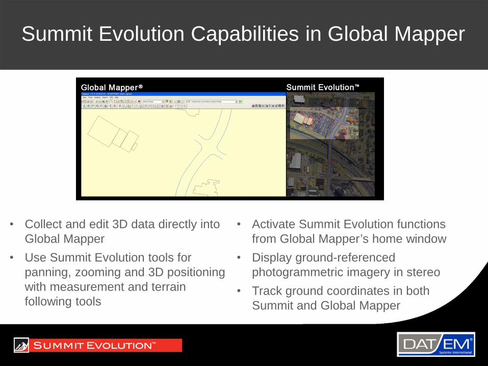
Summit Evolution Capabilities in Global Mapper
• Collect and edit 3D data directly into Global Mapper
• Use Summit Evolution tools for panning, zooming and 3D positioning with measurement and terrain following tools
• Activate Summit Evolution functions from Global Mapper’s home window
• Display ground-referenced photogrammetric imagery in stereo
• Track ground coordinates in both Summit and Global Mapper

1. Capture Settings Dialog2. SuperImposition Settings3. SuperImposition Update 4. Summit Button Manager5. DAT/EM Coordinates 6. DAT/EM Close
7. Fit8. Datpan Settings9. SPOTX10. DAT/EM Extents11. DAT/EM Drawing Tools
Summit Evolution Tools for Global Mapper

DAT/EM Capture for Global Mapper
A few key options:
• Move stereoplotter cursor to snapped point
• Capture items added to Global Mapper’s right click menu

DAT/EM Capture for Global Mapper
Superimposition “SI” options control the display of Global Mapper’s vectors onto Summit’s view

DAT/EM Capture for Global Mapper
Drawing tools:
• 2D line string/area tool – draws 2D features such as lakes, pools, elevation contours, flat roof lines
• 3D line string/area tool – draws 3D features such as rivers, tree area outlines, sloped roof lines
+ 3D line string/area monotonicity setting – sets a rule for vertices to go only uphill or only downhill; usually used for water

DAT/EM Capture for Global Mapper
Drawing tools, continued:
“SpotX” spot elevation tool
DAT/EM Capture for Global Mapper
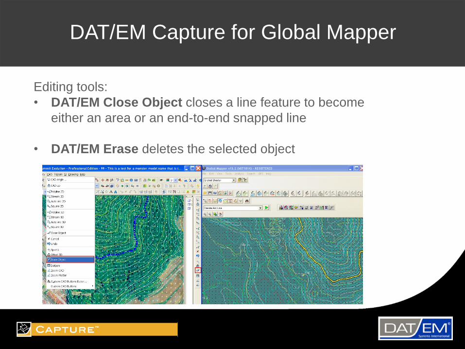
Editing tools:• DAT/EM Close Object closes a line feature to become
either an area or an end-to-end snapped line
• DAT/EM Erase deletes the selected object
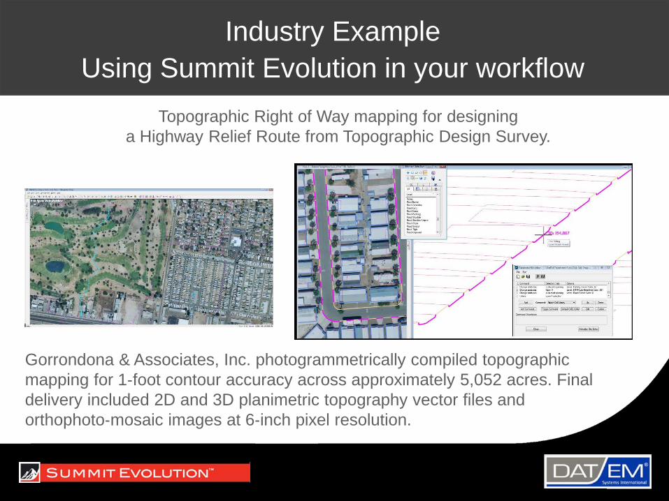
Industry ExampleUsing Summit Evolution in your workflow
Gorrondona & Associates, Inc. photogrammetrically compiled topographic mapping for 1-foot contour accuracy across approximately 5,052 acres. Final delivery included 2D and 3D planimetric topography vector files and orthophoto-mosaic images at 6-inch pixel resolution.
Topographic Right of Way mapping for designing a Highway Relief Route from Topographic Design Survey.

Industry ExampleUsing Summit Evolution in your workflow
Woolpert, Inc. used Summit Evolution to collect andprocess digital multi-spectral aerial imagery and LiDAR data for more than 40,000 square miles that make up the State of Ohio. The imagery was collected at a one-foot pixel resolution and delivered in 5,000 x 5,000 foot tiles along with LiDAR data and derived digital elevation models (DEMs).1
1. Rees, Eric van, “Photogrammetry at Woolpert” GeoInformatics, April/May 2014: p. 10-12

Recap
• Summit Evolution is a photogrammetric stereoplotter with three editions: Professional, Feature Collection, and Lite
• With a Summit purchase or support contract, connect Summit v.7.1 to Global Mapper v.15.2 at no additional cost
• DAT/EM Capture is the interface that collects 3D vector information from Summit Evolution into Global Mapper
• Activate DAT/EM Capture for Global Mapper in two steps
• Connecting Global Mapper to Summit Evolutionallows you to digitize 3D vectors and check existing data for accuracy

Thank You / QuestionsDAT/EM Systems International8240 Sandlewood Place, Suite 101Anchorage, Alaska 99507-3122 ● [email protected] 907.522.3681www.datem.comPresenter, Alissa Oder: [email protected]
DAT/EM Sales and Technical Resources in CanadaKen ByresTechport Services, Vancouver BC778.686.0040www.techportservice.com [email protected] With additional regional representativesAdam Boczek, Thunder Bay ONAndré Verville and Eric L’heureux, Lévis QC