concept report - gtas.dot.ga.gov report/342970-_ cr_dec2008.pdfdepartment of transportation state of...
TRANSCRIPT
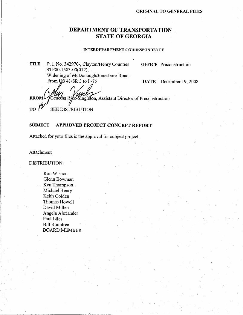


DEPARTMENT
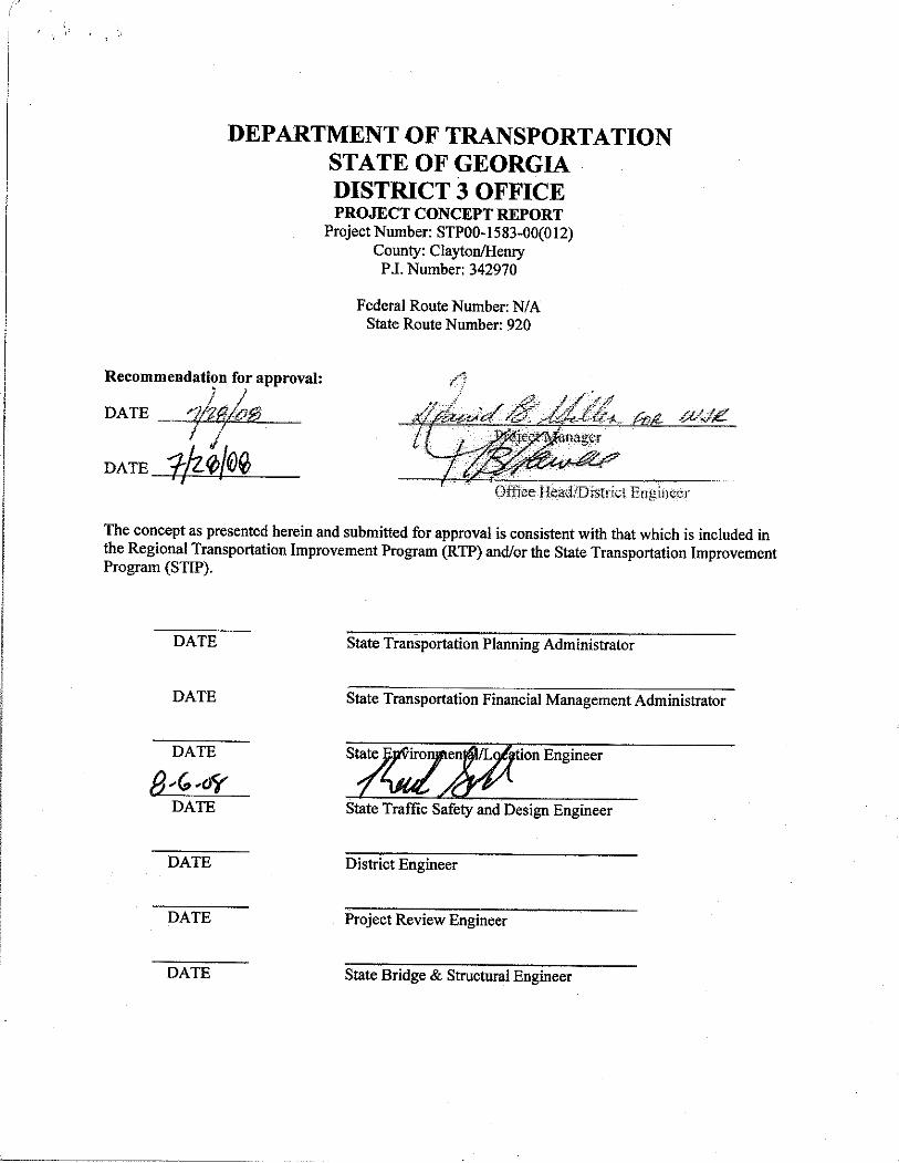
OF TRANSPORTATIONSTATE OF GEORGIADISTRICT 3 OFFICEPROJECT CONCEPT REPORT
Project Number: STPOO-1583-00(O12)County: Clayton/Henry
P ,I. Number: 342970
Federal Route Number: N/AState Route Number: 920
Recommendati?n CO! approval:
DATE
DATE
The concept as presented herein and submitted for approval is consistent with that which is included inthe Regional Transportation Improvement Program (RTP) and/or the State Transportation ImprovementProgram (STIP).
DATE State Transportation Planning Administrator
DATE State Transportation Financial Management Administrator
DATE State Environmental/Location Engineer
DATE State Traffic Safety and Design Engineer
DATE District Engineer
DATE Project Review Engineer
DATE
State
Bridge & Structural Engineer


Page 2 Project Concept Report Project Number: STP00-1583-00(012) P.I. Number 342970 County: Clayton/Henry
END PROJECT STP00-1583-00(012)
BEGIN PROJECT STP00-1583-00(012)
PROJECT LOCATION MAP
Project: STP00-1583-00(012) Clayton/Henry Counties PI Number: 342970
Project Description: Jonesboro Road Widening and Reconstruction from US 19/41 to I-75
JONESBORO ROAD
I-75
US 19/41
LOCATION SKETCH

Page 3 Project Concept Report Project Number: STP00-1583-00(012) P.I. Number 342970 County: Clayton/Henry
Need and Purpose:
Background
The proposed Jonesboro Road project corridor is located in the Atlanta Urban Area Boundary and is under the jurisdiction of the Atlanta Regional Commission (ARC). he proposed project is part of the Atlanta Regional Commission’s TIP/RTP and the Georgia Department of Transportation’s Statewide Transportation Improvement Plan (STIP). The proposed Jonesboro Road project corridor is part of a series of widening projects along SR 920. According to the Clayton County Comprehensive Plan, Clayton County’s population is expected to grow 13.45% between the years 2005 and 2015 and 12.83% between the years 2015 and 2025. According to the Henry County Chamber of Commerce, Henry County is the fastest growing county in Georgia and the sixth fastest growing county in the United States. According to the Joint Henry County/Cities Comprehensive Plan, the county’s population is expected to more than double over the next 20 years from 167,000 to 429,360 people.
The proposed Jonesboro Road project corridor serves as an east-west roadway traveling from Lovejoy to west of McDonough. Jonesboro Road originates just east of Fayetteville at SR 54 in Fayette County, travels east through the town of Lovejoy, and ends in the town of McDonough. The beginning of the proposed project is located at the intersection of Jonesboro Road and US 19/US 41/Tara Boulevard. US 19 is a major north-south roadway, and in Georgia it crosses the major roads of I-85, I-75, I-285 and I-20. The proposed project would end at I-75, a major northwest-southeast roadway that traverses Georgia from the Tennessee and Florida State Lines.
Increased capacity is the primary purpose for the proposed project, while safety and operational improvements are a secondary purpose. The proposed Project STP00-1583-00(012), Clayton and Henry Counties would provide for the widening and reconstruction of Jonesboro Road from the intersection of US 19/US 41/Tara Boulevard to Interstate 75 (I-75), for a length of approximately 7.7 miles.
Environmental Justice
This proposed project does not appear to have a disproportionate effect on the environment for minorities or low income families. According to the 2000 US Census, the Study Area’s minority population (2,331 persons) represents 18.1% of the Study Area’s total population (12,877 persons). The 2000 census data indicate that Clayton County, Henry County, the State of Georgia, and the US have minority populations of 65% (153,736 persons), 19.9% (23,749 persons), 37.3% (3,053,546 persons), and 24.9% (70,068,181 persons), respectively. A person describing themselves as a minority may be Black or African American, American Indian and Alaska Native, Asian, Hispanic, Native Hawaiian and Other Pacific Islander, some other race alone, or as belonging to two or more races.
Page 4 Project Concept Report Project Number: STP00-1583-00(012) P.I. Number 342970 County: Clayton/Henry
According to the 2000 US Census, the percentage of the Study Area below poverty level is 4.1% (527 persons). The year 2000 data indicate that Clayton County, Henry County, the State of Georgia, and the
US have low-income populations of 9.9% (23,493 persons), 4.9% (5,821 persons), 12.6% (1,033,793 persons), and 12.4% (33,899,812 persons) respectively.
A detailed analysis is provided in the Community Impacts/Environmental Justice section of this document.
Land Use
The land use along the proposed project corridor is primarily residential and is in transition from rural residential to higher-density housing and subdivisions. Commercial development exists at each of the proposed project termini. It is anticipated that this region will continue to experience commercial and residential growth based on its metropolitan Atlanta location. Jonesboro Road is a heavily used metro Atlanta east-west transportation corridor with I-75 and the cities of Hampton, McDonough, Stockbridge, and Jonesboro in close proximity. Bike and Pedestrian Facilities The Atlanta Regional Commission’s (ARC) Atlanta Region Bicycle Transportation & Pedestrian Walkways Plan Final Report (2007) identifies Jonesboro Road as part of its Regionally Strategic Transportation System (RSTS) network. The ARC Bicycle Study identifies the corridor as currently having Bicycle Levels of Service (LOS) of D, E, and F within project limits. The Needs Assessment Report states that an accommodation equivalent to a Bicycle LOS of “B” is desired. The Policy and Program Recommendations propose the inclusion of bike lanes and sidewalks along the corridor.
Need and Purpose The need for the widening of Jonesboro Road is that the capacity and crashes will be at an undesirable level by 2033. The purpose is to improve capacity and safety. The proposed construction would improve access, operations, and safety along this facility.

Page 5 Project Concept Report Project Number: STP00-1583-00(012) P.I. Number 342970 County: Clayton/Henry Description of the proposed project: Project STP00-1583-00(012) is proposed to improve 7.7 miles of Jonesboro Road from 0.25 miles west of US 19/41 in Clayton County to I-75 in Henry County. This project proposes widening the existing two-lane Jonesboro Road to a four-lane roadway with turn lanes as needed. The existing typical section consists of two 12-foot lanes with 10-foot grass shoulders. This project proposes an urban typical section consisting of four 12-foot lanes with a 20-foot to 32-foot raised median (grass/concrete), 4-foot bike lanes, and 12-foot to 16-foot shoulders that include curb & gutter and 5-foot sidewalks. The widening of the existing roadway shifts from one side to the other in a number of places to avoid environmental resources and minimize property impacts. Intersection improvements, including turn lane additions and intersection realignments, will also be included for a number of side roads along the project corridor. I-75 interchange improvements consist of roadway restriping, the addition of turn lanes on the exit ramps, and the addition of auxiliary lanes from Mill Road to I-75. Existing roadway signs along the corridor will be replaced. The required right-of-way varies from 108 feet to 168 feet along Jonesboro Road. Is the project located in a Non-attainment area? Yes No. The Atlanta Regional Commission model proposes widening Jonesboro Road from two through lanes to four through lanes from US 19/41 in Clayton County to I-75 in Henry County for a total project length of 7.2 miles. The model proposes an open year of 2020. The proposed project concept proposes widening Jonesboro Road from two through lanes to four through lanes from 0.25 miles west of US 19/41 in Clayton County to Mill Road in Henry County, and proposes additional auxiliary lanes from Mill Road to I-75 in Henry County. The proposed design includes two relocated sections of roadway, and a total project length of 7.7 miles. The project concept proposes an open year of 2013. PDP Classification: Major or Minor and, Full Oversight , Exempt , State Funded , or Other Functional Classification: Urban Minor Arterial in Clayton County and Urban Principal Arterial in Henry County U.S. Route Number(s): N/A State Route Number(s): 920 Traffic (AADT): Current Year: (2013) 18,750 Design Year: (2033) 37,750 Existing Design Features: • Typical section: The existing roadway consists of one 12-foot lane in each direction with 10-foot
grass shoulders. • Posted speed 45 mph Minimum radius of curve: 500 ft. • Maximum super-elevation rate for curve: 6 % • Maximum grade: 6 % mainline • Width of right of way: 60-80 ft.
• Major structures:
o Existing 52’ x 157’ bridge over Central of Georgia Railroad; sufficiency rating: 99.21 o Existing 44’ x 120’ bridge over Walnut Creek; sufficiency rating: 90.36 o Existing 1000’ Retaining Wall at BJ’s in Henry County

Page 6 Project Concept Report Project Number: STP00-1583-00(012) P.I. Number 342970 County: Clayton/Henry
o Existing 300’ Retaining Wall at Truett’s in Henry County
• Major interchanges or intersections along the project: o McDonough Road at US 19/41 o Jonesboro Road at I-75
• Existing length of roadway segment and the beginning mile logs for each county segment
o From milepost 3.29 in Clayton County to milepost 5.52 in Clayton County o From milepost 0 in Henry County to milepost 5.36 in Henry County o Total of 7.7 miles
Proposed Design Features: • Proposed typical section(s): The proposed widening will consist of two 12-foot lanes in each
direction with a 20-foot to 32-foot raised median (grass/concrete), 4-foot bike lanes, and 12-foot to 16-foot shoulders that include curb & gutter, a 2-foot to 6-foot grass strip and 5-foot sidewalks.
• Proposed Design Speed Mainline 45 mph • Proposed Maximum grade Mainline 5.00 % Maximum grade allowable 5.00 %. • Proposed Maximum grade Side Street 11 % Maximum grade allowable 11 %. • Proposed Maximum grade driveway 11/27 % (Commercial/Residential) • Proposed Minimum radius of curve 711 ft. Minimum radius allowable 711 ft. • Right of way
o Width 108 – 168 feet o Easements: Temporary , Permanent , Utility , Other o Type of access control: Full , Partial , By Permit , Other , o Number of parcels: 220 Number of displacements: 5
• Business: 2 • Residences: 3 • Mobile Homes: N/A • Other:
• Structures: ° Bridges
• Proposed 118’-5” x 141’ bridge over Central of Georgia Railroad • Retain existing bridge over Walnut Creek and add 54’ proposed bridge widening
° Gravity walls • Proposed 400’ gravity wall at Town Centre Village in Henry County to protect parking lot and
commercial developments ° Retaining walls
• Proposed 350’ retaining wall at bridge over Central of Georgia Railroad in Clayton County • Proposed 325’ retaining wall at Homebanc in Henry County to protect parking lot and
commercial developments • Proposed 600’ retaining wall at Quizno’s in Henry County to protect parking lot and
commercial developments • Proposed 1000’ retaining wall at BJ’s in Henry County to replace existing wall

Page 7 Project Concept Report Project Number: STP00-1583-00(012) P.I. Number 342970 County: Clayton/Henry
• Proposed 200’ retaining wall extension at Truett’s in Henry County to protect parking lot and commercial developments
• Major intersections and interchanges ° The intersection of McDonough Road at US 19/41 ° The intersection of Jonesboro Road and I-75
• Traffic control during construction: The Jonesboro Road project will be constructed under traffic with no detours anticipated, and traffic will be maintained at all times. Two sections of the project will require a new alignment to avoid environmental impacts. The two bridges on the project will require stage construction. The bridge over Central of Georgia Railroad will be constructed in two stages. Traffic will remain on the existing alignment during construction of the northern half of the bridge during stage one. Traffic will then be redirected to the newly constructed northern half of the bridge while the southern half is being constructed during stage two. The bridge over Walnut Creek will be widened in two stages. Traffic will remain on the existing alignment during construction of the southern half of the bridge during stage one. Traffic will then be redirected to the newly constructed southern half of the bridge while the existing roadway is being reconstructed during stage two.
• Design Exceptions to controlling criteria anticipated: UNDETERMINED YES NO
HORIZONTAL ALIGNMENT: ROADWAY WIDTH: SHOULDER WITH: VERTICAL GRADES: CROSS SLOPES: STOPPING SIGHT DISTANCE: SUPERELEVATION RATES: HORIZONTAL CLEARANCE: SPEED DESIGN: VERTICAL CLEARANCE: BRIDGE WIDTH: BRIDGE STRUCTURAL CAPACITY:
• Design Variances: None anticipated. • Environmental concerns:
o A NEPA document will be prepared o History—Four boundaries:
• H-1 (Civil War Battlefield—approximately 400 properties) • H-2 (Central of Georgia Railroad) • H-10 (Sexton Enterprises, Inc.) • H-18 (Gene & Ouida Morris)
o Archeology— One archeological boundary is located on the project. It encompasses a Civil War battlefield, which covers approximately 400 properties within Clayton and Henry Counties. This boundary was established from Civil War maps and was verified by field surveying, which found several Civil War trenches throughout the project.

Page 8 Project Concept Report Project Number: STP00-1583-00(012) P.I. Number 342970 County: Clayton/Henry
o Old fill station at northwest corner of Jonesboro Road and Chambers Road o Dry cleaners at northeast corner of McDonough Road and US 19/41
• Level of environmental analysis: o Are Time Savings Procedures appropriate? Yes , No o Categorical exclusion , o Environmental Assessment/Finding of No Significant Impact (FONSI) , or o Environmental Impact Statement (EIS) .
• Utility involvements: o Railroad—Central of Georgia Railroad. Bridge over Central of Georgia Railroad to be
reconstructed. o Water/Sewer— Clayton County Water Authority, Henry County Water and Sewage Authority.
To be relocated as necessary. o Power—Georgia Power Company, Central Georgia EMC. Major transmission lines are to be
avoided. o Telephone – BellSouth d/b/a AT & T Georgia o Cable TV – Comcast Entity, Charter Communications, AT&T Corp. o Natural Gas – AGL Resources, Inc.
VE Study Required Yes ( X ) No ( ) Project responsibilities:
o Design Wolverton & Associates/Georgia Department of Transportation o Right of Way Acquisition Wolverton & Associates/Georgia Department of Transportation o Relocation of Utilities Georgia Department of Transportation/utility companies o Letting to contract Georgia Department of Transportation o Supervision of construction Georgia Department of Transportation o Providing material pits Contractor o Providing detours N/A (As stated in MOT)
Coordination • Initial Concept Meeting date and brief summary: 9/25/07 – see attached. • Concept meeting date and brief summary: 5/22/08 – see attached. • P.A.R. – not required • FEMA, USCG, and/or TVA – N/A • Public involvement.
o 4/18/07 – Stakeholder meeting (Local government included); see attached. o 11/15/07 – Stakeholder meeting (Local government included); see attached. o 3/27/08 – Public information open house (PIOH); see attached.

Page 9 Project Concept Report Project Number: STP00-1583-00(012) P.I. Number 342970 County: Clayton/Henry • Other projects in the area:
PROJECT NO.
P.I. No. FACILITY LIMITS DESCRIPTION SCHEDULE
CSNHS-0006-00(333) 0006333
I-75 Fm: Hudson Bridge To: SR 155
ATMS Communication/ Surveillance
Eng.: 2005 Const.: 2011
CSNHS-0008-00(446) 0008446
I-75 Fm: SR 138 To: SR 155
Widening/ Reconstruction
Eng.: 2007 Const.: 2008
MSL-0003-00(436) 0003436 (AR-H-052)
I-75 Fm: Eagles Landing Parkway To: SR 155
Reconstruction/ HOV Lane
Eng:2006 ROW: 2010 Const.: LR
CSSFT-0007-00(998) 0007998
SR 3 Fm: Henry County Line To: DeKalb County Line
Sign Upgrades: Intersection ahead signs and road name plaques
Eng.: 2006 ROW: 2006 Const.: LUMP
STP-2009(4)742870 SR 920 Fm. SR 54 To: SR 3/US 19 (REL SR 81) and Fayette
Widening and Reconstruction
Eng.: LR ROW: LR Const.: LR
STP-163-1(11)321530 SR 920 1-Way Pair Fm: East of Doris Street To: Lemon Street
Reconstruction/ Rehabilitation
Eng.: 1995 ROW: 2008 Const.: 2012
MSL-0004-00(401) 0004401
CR 504/ Tara Road
Fm: SR 920/McDonough Road To: Panhandle Road
Widening and Reconstruction
Eng.: 2003 ROW: 2007 Const.: 2007
CSNHS-0007-00(891) 0007891
I-75 Fm: CR 650/ Bill Gardner Parkway To: SR 920/ Jonesboro Road
Widening and Reconstruction
Eng.: LR ROW: LR Const.: LR
0000561(HE-110) Jodeco Road Widening/ Campground Road Extension
Fm: Meadowbrook To: Peach Drive and Fm: Peach Drive To: Brannan Road to Meadowbrook
0001096(HE-118A) McDonough Parkway
Fm: SR 920 (Jonesboro Road) To: US 23 (Atlanta Street)
Widening and Reconstruction
Eng: AUTH ROW: AUTH CST: AUTH
0006927(HE-132A) Hudson Bridge Road
Fm: Jodeco Road To: I-75
Widening and Reconstruction
Eng: AUTH ROW: AUTH CST: 2009
0002638(HE-132B) Eagle’s Landing Parkway
Fm: Eagle’s Pointe Parkway To: Talon Drive
Widening and Reconstruction
Eng: AUTH ROW: AUTH CST: 2009
312160(HE-AR-216) I-75 South Jodeco Road Interchange Improvements
Eng: AUTH ROW: 2008 CST: 2009

Page 10 Project Concept Report Project Number: STP00-1583-00(012) P.I. Number 342970 County: Clayton/Henry • Railroad
As per Central of Georgia Railroad, provisions are being made for three railroad tracks under the bridge.
• Other coordination to date. o 3/13/07 –Meeting with Local government; see attached. o 6/7/07 – Meeting with OEL, FHWA & SHPO; see attached. o 8/30/07 – Meeting with OEL, FHWA & SHPO; see attached. o 9/6/07 – Meeting with OEL & FHWA; see attached.
Scheduling - Responsible Parties’ Estimate • Time to complete the environmental process: 18 Months. • Time to complete preliminary construction plans: 12 Months. • Time to complete right of way plans: 4 Months. • Time to complete the Section 404 Permit: 12 Months. • Time to complete final construction plans: 8 Months. • Time to complete to purchase right of way: 30 Months. • List other major items that will affect the project schedule: 24 Months (Railroad Coordination). Other alternates considered:
1. Realign the existing roadway around the archeological boundary/entire Civil War battlefield area in order to decrease impacts to historic, archeological and environmental resources. This alternate was not chosen because of increased cost, greater commercial and residential impacts and displacements.
2. No build. This alternate was not chosen because it would not meet the Need and Purpose. Comments: None Attachments:
1. Cost Estimates: a. Construction including E&C b. Right of Way c. Utilities
2. Typical sections 3. Traffic Report 4. Bridge inventory 5. Minutes of Initial Concept and Concept Meetings 6. Additional Meeting Minutes 7. BC Ratio 8. Location & Design Notice 9. Concept Layout
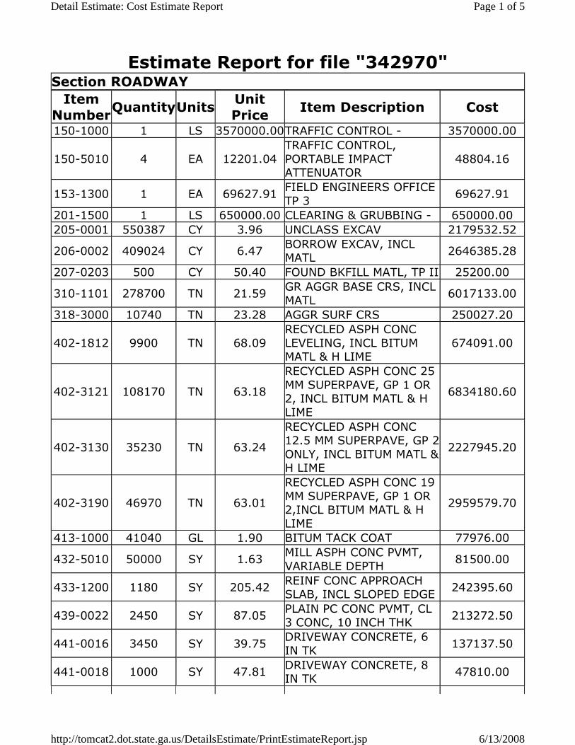
Estimate Report for file "342970" Section ROADWAY
Item
NumberQuantityUnits
Unit
PriceItem Description Cost
150-1000 1 LS 3570000.00TRAFFIC CONTROL - 3570000.00
150-5010 4 EA 12201.04
TRAFFIC CONTROL,
PORTABLE IMPACT ATTENUATOR
48804.16
153-1300 1 EA 69627.91FIELD ENGINEERS OFFICE
TP 3 69627.91
201-1500 1 LS 650000.00 CLEARING & GRUBBING - 650000.00
205-0001 550387 CY 3.96 UNCLASS EXCAV 2179532.52
206-0002 409024 CY 6.47BORROW EXCAV, INCL MATL
2646385.28
207-0203 500 CY 50.40 FOUND BKFILL MATL, TP II 25200.00
310-1101 278700 TN 21.59GR AGGR BASE CRS, INCL
MATL 6017133.00
318-3000 10740 TN 23.28 AGGR SURF CRS 250027.20
402-1812 9900 TN 68.09
RECYCLED ASPH CONC
LEVELING, INCL BITUM MATL & H LIME
674091.00
402-3121 108170 TN 63.18
RECYCLED ASPH CONC 25
MM SUPERPAVE, GP 1 OR 2, INCL BITUM MATL & H
LIME
6834180.60
402-3130 35230 TN 63.24
RECYCLED ASPH CONC 12.5 MM SUPERPAVE, GP 2
ONLY, INCL BITUM MATL & H LIME
2227945.20
402-3190 46970 TN 63.01
RECYCLED ASPH CONC 19
MM SUPERPAVE, GP 1 OR 2,INCL BITUM MATL & H
LIME
2959579.70
413-1000 41040 GL 1.90 BITUM TACK COAT 77976.00
432-5010 50000 SY 1.63MILL ASPH CONC PVMT,
VARIABLE DEPTH 81500.00
433-1200 1180 SY 205.42REINF CONC APPROACH SLAB, INCL SLOPED EDGE
242395.60
439-0022 2450 SY 87.05PLAIN PC CONC PVMT, CL
3 CONC, 10 INCH THK 213272.50
441-0016 3450 SY 39.75DRIVEWAY CONCRETE, 6
IN TK 137137.50
441-0018 1000 SY 47.81DRIVEWAY CONCRETE, 8 IN TK
47810.00
Page 1 of 5Detail Estimate: Cost Estimate Report
6/13/2008http://tomcat2.dot.state.ga.us/DetailsEstimate/PrintEstimateReport.jsp

441-0104 44780 SY 33.24 CONC SIDEWALK, 4 IN 1488487.20
441-0204 2000 SY 36.30PLAIN CONC DITCH
PAVING, 4 IN 72600.00
441-0301 10 EA 2311.63 CONC SPILLWAY, TP 1 23116.30
441-0303 10 EA 2250.55 CONC SPILLWAY, TP 3 22505.50
441-0748 18780 SY 61.51 CONCRETE MEDIAN, 6 IN 1155157.80
441-4020 1890 SY 41.43CONC VALLEY GUTTER, 6 IN
78302.70
441-6222 89000 LF 16.96CONC CURB & GUTTER, 8
IN X 30 IN, TP 2 1509440.00
441-6740 16000 LF 14.58CONC CURB & GUTTER, 8
IN X 30 IN, TP 7 233280.00
444-1000 1120 LF 6.67SAWED JOINTS IN EXIST PAVEMENTS - PCC
7470.40
446-1100 28000 LF 2.44
PVMT REINF FABRIC
STRIPS, TP 2, 18 INCH WIDTH
68320.00
500-3200 680 CY 466.58 CLASS B CONCRETE 317274.40
500-3800 200 CY 721.32CLASS A CONCRETE, INCL REINF STEEL
144264.00
550-1180 39020 LF 40.19STORM DRAIN PIPE, 18
IN, H 1-10 1568213.80
550-1240 11470 LF 46.13STORM DRAIN PIPE, 24 IN, H 1-10
529111.10
550-1300 140 LF 64.57STORM DRAIN PIPE, 30 IN, H 1-10
9039.80
550-1360 4290 LF 80.97STORM DRAIN PIPE, 36
IN, H 1-10 347361.30
550-1420 300 LF 102.43STORM DRAIN PIPE, 42 IN, H 1-10
30729.00
550-1480 2730 LF 115.44STORM DRAIN PIPE, 48
IN, H 1-10 315151.20
550-1540 300 LF 149.16STORM DRAIN PIPE, 54
IN, H 1-10 44748.00
550-2180 300 LF 26.64SIDE DRAIN PIPE, 18 IN, H 1-10
7992.00
550-2240 150 LF 34.41SIDE DRAIN PIPE, 24 IN,
H 1-10 5161.50
550-3418 5 EA 627.03
SAFETY END SECTION 18
IN, SIDE DRAIN, 4:1 SLOPE
3135.15
550-3618 5 EA 623.61
SAFETY END SECTION 18
IN, SIDE DRAIN, 6:1 SLOPE
3118.05
550-4218 10 EA 653.91 FLARED END SECTION 18 6539.10
Page 2 of 5Detail Estimate: Cost Estimate Report
6/13/2008http://tomcat2.dot.state.ga.us/DetailsEstimate/PrintEstimateReport.jsp

IN, STORM DRAIN
550-4224 7 EA 777.77FLARED END SECTION 24
IN, STORM DRAIN 5444.39
550-4230 2 EA 955.24FLARED END SECTION 30
IN, STORM DRAIN 1910.48
550-4236 5 EA 1236.02FLARED END SECTION 36 IN, STORM DRAIN
6180.10
573-2006 500 LF 13.38UNDDR PIPE INCL
DRAINAGE AGGR, 6 IN 6690.00
576-1015 500 LF 30.34 SLOPE DRAIN PIPE, 15 IN 15170.00
603-2181 300 SY 37.91STN DUMPED RIP RAP, TP
3, 18 IN 11373.00
603-7000 300 SY 5.23 PLASTIC FILTER FABRIC 1569.00
620-0100 10000 LF 26.35TEMPORARY BARRIER,
METHOD NO. 1 263500.00
632-0003 4 EA 14154.17CHANGEABLE MESSAGE SIGN, PORTABLE, TYPE 3
56616.68
634-1200 920 EA 101.50 RIGHT OF WAY MARKERS 93380.00
641-1100 1500 LF 42.44 GUARDRAIL, TP T 63660.00
641-1200 5000 LF 15.44 GUARDRAIL, TP W 77200.00
641-5001 8 EA 619.00GUARDRAIL ANCHORAGE,
TP 1 4952.00
641-5012 20 EA 1838.99GUARDRAIL ANCHORAGE, TP 12
36779.80
668-1100 340 EA 2552.53 CATCH BASIN, GP 1 867860.20
668-1110 250 LF 297.51CATCH BASIN, GP 1, ADDL
DEPTH 74377.50
668-2100 30 EA 2402.61 DROP INLET, GP 1 72078.30
668-2110 10 LF 334.44DROP INLET, GP 1, ADDL
DEPTH 3344.40
668-4300 30 EA 2306.54STORM SEWER MANHOLE,
TP 1 69196.20
668-4311 50 LF 321.62STORM SEWER MANHOLE, TP 1, ADDL DEPTH, CL 1
16081.00
668-5000 2 EA 2279.14 JUNCTION BOX 4558.28
668-6000 2 EA 1750.84 SPRING BOX 3501.68
Section Sub Total: $38,698,539.48
Section EROSION CONTROL
Item
NumberQuantityUnits
Unit
PriceItem Description Cost
1 1Lump
Sum396685.67
PERMANENT EROSION
CONTROL396685.67
Lump TEMPORARY EROSION
Page 3 of 5Detail Estimate: Cost Estimate Report
6/13/2008http://tomcat2.dot.state.ga.us/DetailsEstimate/PrintEstimateReport.jsp

2 1 Sum 793371.34CONTROL 793371.34
Section Sub Total: $1,190,057.01
Section SIGNING AND MARKING
Item
NumberQuantityUnits
Unit
PriceItem Description Cost
3 1Lump
Sum1240057.02SIGNING AND MARKING 1240057.02
639-4004 48 EA 7558.86 STRAIN POLE, TP IV 362825.28
647-1000 12 LS 49800.17TRAFFIC SIGNAL
INSTALLATION NO - 597602.04
Section Sub Total: $2,200,484.34
Section LIGHTING
Item
NumberQuantityUnits
Unit
PriceItem Description Cost
4 1Lump Sum
340000.00LIGHTING 340000.00
Section Sub Total: $340,000.00
Section WALL
Item Number
QuantityUnitsUnit Price
Item Description Cost
5 1Lump
Sum396000.00 WALL 1 396000.00
6 1Lump Sum
115500.00 WALL 2 115500.00
7 1Lump
Sum700000.00 WALL 3 700000.00
8 1Lump
Sum1800000.00WALL 4 1800000.00
Section Sub Total: $3,011,500.00
Section BRIDGE
Item
NumberQuantityUnits
Unit
PriceItem Description Cost
10 1Lump
Sum790560.00
BRIDGE 2 (WALNUT
CREEK)790560.00
9 1Lump
Sum1691000.00BRIDGE 1 (RAILROAD) 1691000.00
Section Sub Total: $2,481,560.00
Page 4 of 5Detail Estimate: Cost Estimate Report
6/13/2008http://tomcat2.dot.state.ga.us/DetailsEstimate/PrintEstimateReport.jsp


WOLVERTON & ASSOCIATES, INC.
6745 SUGARLOAF PARKWAY SUITE 100
DULUTH, GA 30097 (770) 447-8999 PHONE
(770) 447-9070 FAX www.wolverton-assoc.com
TRAFFIC ENGINEERING REPORT FOR
PROPOSED ROADWAY IMRPOVEMENTS
MCDONOUGH ROAD/JONESBORO ROAD FROM US 19/41 TO I-75
CLAYTON/HENRY COUNTIES, GEORGIA
GDOT Project No. STP-1583(12) P.I. No. 342970
W & A Project No. 07-900
April 4, 2008

i
TABLE OF CONTENTS
LIST OF FIGURES ....................................................................................................... ii LIST OF TABLES ......................................................................................................... ii
1. INTRODUCTION ...................................................................................................... 1 Methodology .............................................................................................................. 1 Planned Improvements .................................................................................................. 1
2. EXISTING CONDITIONS .......................................................................................... 3 3. TRAFFIC DATA ........................................................................................................ 6
Projected Average Daily Traffic Volumes (ADT) .................................................................. 6 Projected Design Hour Volumes (DHV) ............................................................................. 6
4. DATA ANALYSIS ...................................................................................................... 7 Capacity Analysis Results ............................................................................................... 8 Accident Analysis ....................................................................................................... 15
5. SIGNAL WARRANT ANALYSIS .............................................................................. 16 8th Highest Hour Volume ............................................................................................. 16 Warrant 1 – Eight Hour Vehicular Volume ....................................................................... 18 Warrant 2 – Four Hour Vehicular Volume ........................................................................ 20 Warrant 3 – Peak Hour ............................................................................................... 22 Warrant 4 – Pedestrian Volume ..................................................................................... 24 Warrant 5 – School Crossing ......................................................................................... 24 Warrant 6 – Coordinated Signal System ........................................................................... 24 Warrant 7 – Crash Experience ....................................................................................... 24 Warrant 8 – Roadway Network ..................................................................................... 24 Summary of Warrant Analysis ....................................................................................... 24
6. RECOMMENDATIONS ........................................................................................... 26 REFERENCES…… ......................................................................................................... 32 APPENDICES
APPENDIX A – Turning Movement Counts APPENDIX B – Automatic Traffic Recorder Counts APPENDIX C – Area Photographs APPENDIX D – 2007, 2013 and 2033 ADTs APPENDIX E – 2013 and 2033 DHVs APPENDIX F – Synchro Printouts (Existing Condition) APPENDIX G – Synchro Printouts (No Build Condition) APPENDIX H – Synchro Printouts (Build Condition) APPENDIX I – Synchro Printouts (Mitigated Condition) APPENDIX J – Synchro Printouts (Additional Mitigations US 19/41)

ii
LIST OF FIGURES
Figure 1 – Project Location Map ................................................................................. 2 Figure 2a – Existing Travel Lanes and Traffic Control (1) ................................................... 4 Figure 2b – Existing Travel Lanes and Traffic Control (2) .................................................. 5 Figure 3 – Warrant 2: 2013 Four-Hour Vehicular Volume ............................................... 20 Figure 4 – Warrant 2: 2033 Four-Hour Vehicular Volume ............................................... 21 Figure 5 – Warrant 3: 2013 Peak Hour ....................................................................... 22 Figure 6 – Warrant 3: 2033 Peak Hour ....................................................................... 23 Figure 7a – Recommended Improvements (1) ............................................................... 30 Figure 7b – Recommended Improvements (2) .............................................................. 31
LIST OF TABLES
Table 1 – Level of Service Criteria ............................................................................... 7 Table 2 – Results of Capacity Analysis: No-Build ............................................................. 9 Table 3 – Results of Capacity Analysis: Build ................................................................ 11 Table 4 – Results of Capacity Analysis: Mitigated ........................................................... 13 Table 5 – Results of Capacity Analysis: Additional Mitigations ........................................... 13 Table 6 – 95th Percentile Back of Queue ...................................................................... 14 Table 7 – Accident Rates ........................................................................................ 15 Table 8 – 2013 8th Highest Hour Volume .................................................................... 17 Table 9 – 2033 8th Highest Hour Volume .................................................................... 17 Table 10 – Warrant 1: 2013 Eight Hour Vehicular Volume (100% Volumes) ........................ 18 Table 11 – Warrant 1: 2033 Eight Hour Vehicular Volume (100% Volumes) ........................ 18 Table 12 – Warrant 1: 2013 Eight Hour Vehicular Volume (70% Volumes) .......................... 19 Table 13 – Warrant 1: 2033 Eight Hour Vehicular Volume (70% Volumes) .......................... 19 Table 14 – Summary of Warrant Analysis .................................................................... 25
1
1. INTRODUCTION Jonesboro Road Traffic Engineering Report The purpose of this report is to analyze concept improvements for the 7.35 mile McDonough Road/Jonesboro Road widening in Clayton and Henry Counties. The project will provide for a four-lane median divided roadway, starting at the intersection with US 19/41 in Lovejoy, Clayton County and terminating at the I-75 interchange in McDonough, Henry County. The project is identified as follows:
STP-1583(12), widening the existing two-lane section on Jonesboro Road to a four-lane divided section with a 20 foot raised median from US 19/41 in Clayton County to I-75 in Henry County.
Figure 1 schematically illustrates the existing roadway facility as well as the location of the study intersections on Jonesboro Road. These improvements are part of the Atlanta Regional Commission’s (ARC) Transportation Improvement Plan and The Georgia Department of Transportation (GDOT) work program.
Methodology Initial evaluations were made to assess the current conditions along the corridor. Peak hour turning movement counts (TMCs) were conducted at the study intersections along the corridor and are contained in Appendix A. In addition to the TMCs, automatic traffic recorder (ATR) counts were taken at the intersection of McDonough Road and Hastings Bridge Road and are contained in Appendix B. Traffic projections for the corridor were developed for the build year (2013) and the design year (2033). No build and build models were developed and analyzed for the study intersections along the corridor for the build and design years. Signal warrant analyses were completed for intersections that operated at unacceptable levels of service when under stop control.
Planned Improvements In addition to the proposed project, there are three other known projects that will affect the Jonesboro Road corridor. The first project is proposed in the Henry County Comprehensive Transportation Plan. Henry County has determined a need for an additional north-south corridor. The Western Corridor Study, dated July 2007, identifies two possible routes across Jonesboro Road for the improved corridor. The first possible location is at North Mt. Carmel Road. The second possible location is at McCullough Road. At the time of this report, Henry County had not yet selected a definitive alignment or decided on a two lane of four lane section. Therefore, this project was not included in any analyses in this report. The second project in the Henry County Comprehensive Transportation Plan involves the improvement of Mt. Olive Road to a paved section from Jonesboro Road to Jodeco Road. This project was incorporated into the build and mitigated analyses. The third project, identified as STP00-2009-00(004) in the GDOT STP, is a continuation of the widening project analyzed in this report and involves the improvement of Jonesboro Road to a four lane divided facility, starting at US 19/41 and terminating at SR 54.

2
Figure 1 – Project Location Map @
US
19/4
1
@ H
astin
gs B
ridg
e R
d
@ E
ast L
ovej
oy R
d
@ H
unte
rs L
n
@ B
abbs
Mill
Rd
@ P
ates
Lak
e W
ay
@ M
arsh
a’s V
iney
ard
@ P
ates
Lak
e D
r
@ H
ampt
on S
hore
s Dr
@ D
utch
tow
n R
d
@ M
cCul
loug
h R
d
@ M
itche
ll R
d
@ N
. Mt.
Car
mel
Rd
@ C
ham
bers
Rd
@ I-
75 N
B R
amps
@ I-
75 S
B R
amps
@ M
ill R
d@
Cen
tre
Vill
age D
r
@ M
t. O
live R
oad

3
2. EXISTING CONDITIONS Jonesboro Road Traffic Engineering Report The project involves the widening of Jonesboro Road from a two lane facility to a four lane divided facility with a 20 foot raised median. The project spans 7.7 miles, starting at US 19/41 and ending at I-75. The following are the study intersections along the corridor:
1. McDonough Road & US 19/41 (Signalized) 2. McDonough Road & Hastings Bridge Road (Unsignalized) 3. McDonough Road & East Lovejoy Road/Freeman Road (Signalized) 4. McDonough Road & Hunters Lane (Unsignalized) 5. Jonesboro Road & Babbs Mill Road (Unsignalized) 6. Jonesboro Road & Pates Lake Way (Unsignalized) 7. Jonesboro Road & Marsha’s Vineyard (Unsignalized) 8. Jonesboro Road & Pates Lake Drive (Unsignalized) 9. Jonesboro Road & Hampton Shores Drive (Unsignalized) 10. Jonesboro Road & Dutchtown Road (Unsignalized) 11. Jonesboro Road & McCullough Road (Unsignalized) 12. Jonesboro Road & Mitchell Road (Unsignalized) 13. Jonesboro Road & N. Mt. Carmel Road (Unsignalized) 14. Jonesboro Road & Chambers Road (Signalized) 15. Jonesboro Road & N. Mt. Olive Road/Towne Center Village Drive (Unsignalized) 16. Jonesboro Road & Centre Village Drive (Signalized) 17. Jonesboro Road & Mill Road (Signalized) 18. Jonesboro Road & I-75 SB Ramps (Signalized) 19. Jonesboro Road & I-75 NB Ramps (Signalized)
Figures 2a and 2b illustrate the associated geometry and operation control of the study intersections. As a general assumption for all figures in this report, Jonesboro Road is considered to be east/west at all intersections. Pictures of the main roadways and intersections are contained in Appendix C of this report.
4
Figure 2a – Existing Travel Lanes and Traffic Control (1)
US
19/4
1
STOP STOP STOP
STOP STOP STOP STOP STOP
Has
tings
Bri
dge
Rd
Babb
sMill
Rd
Hun
ters
Lan
e
Free
man
Rd
East
Lov
ejoy
Rd
Jonesboro Rd
HEN
RY
CO
CLA
YT
ON
CO
Pate
s Lak
e W
ay
Mar
sha’
s Vin
eyar
d
Pate
s Lak
e D
r
Ham
pton
Sho
res D
r
Dut
chto
wn
Rd
ASS
UM
ED
Existing Travel LaneStop ControlUnsignalized IntersectionSignalized Intersection
STOP
5
Figure 2b – Existing Travel Lanes and Traffic Control (2)
STOPSTOP STOP STOP
McC
ullo
ugh
Rd
Mitc
hell
Rd
N. M
t. C
arm
el R
d
Cha
mbe
rs R
d
Mt.
Oliv
e R
d
Tow
ne C
ente
r Vill
age
Dr
Cen
tre
Vill
age
Ter
r
Mill
Rd
I-75
SB
Off
Ram
p
I-75
SB
On
Ram
p
I-75
NB
On
Ram
p
I-75
NB
Off
Ram
p
ASS
UM
ED
Existing Travel LaneStop ControlUnsignalized IntersectionSignalized Intersection
STOP

6
3. TRAFFIC DATA Jonesboro Road Traffic Engineering Report Turning movement counts (TMCs) were collected at the study intersections. In addition to the TMCs, 24-hour vehicle classification counts were taken at select locations in the study area. The existing peak hour volumes are illustrated in Appendix A, along with the printouts from the TMCs. The printouts for the ATR counts are contained in Appendix B. Traffic projections were formulated using the Atlanta Regional Commission (ARC) twenty county model data that includes the existing roadways plus the committed improvements.
Projected Average Daily Traffic Volumes (ADT) The TMCs were converted to ADT volumes, using a 9% ‘K’ factor, as recommended by the Office of Environment and Location (OEL). ADTs were recorded from the 2005 and 2030 ARC model along Jonesboro Road. The 25 year ARC model growth was then added to the calculated 2007 ADTs, yielding 2032 ADTs. Growth rates were calculated for each section of the corridor based on the 2007 and 2032 ADTs. The calculated growth rates were applied to the 2032 volumes in order to estimate the 2033 (design year) volumes. The calculated growth rates for each section along Jonesboro Road were used to grow the 2007 ADTs six years out in order to estimate the 2013 (build year) volumes. Diagrams illustrating the 2007, 2013, and 2033 ADTs are contained in Appendix D of this report.
Projected Design Hour Volumes (DHV) The growth factors that were used to obtain the 2013 and 2033 ADTs were applied to the 2007 TMCs in order to estimate the 2013 and 2033 AM and PM design hour volumes (DHV). The diagrams for the 2013 and 2033 DHVs are contained in Appendix E of this report.
7
4. DATA ANALYSIS Jonesboro Road Traffic Engineering Report Capacity analysis was used to evaluate the projected volumes at the study intersections along the corridor. This process was used to determine the geometry and traffic control needed at each intersection to result in acceptable levels of service for the build condition. The Synchro Program Version 6 was used to conduct capacity analysis. Synchro implements the capacity methods of the 2000 Highway Capacity Manual (HCM) (1) Chapters 16 and 17 for performing the industry standard evaluation of intersection performance. Webster delays used in the reports follow the procedure as recommended by the HCM. The Highway Capacity Manual defines level of service (LOS) in terms of the amount of control delay, including initial deceleration delay, queue move-up time, stopped delay and final acceleration delay. The levels of service definitions for both stop controlled and signal controlled intersections are provided in Table 1.
Table 1 – Level of Service Criteria
WITH STOP-SIGN CONTROL WITH SIGNAL CONTROL
A < 10 < 10
B > 10 and < 15 > 10 and < 20C > 15 and < 25 > 20 and < 35D > 25 and < 35 > 35 and < 55E > 35 and < 50 > 55 and < 80F > 50 > 80
LEVEL OF SERVICE
CONTROL DELAY PER VEHICLE (SEC)
Source: Highway Capacity Manual The GDOT has ranges of acceptable Levels of Service based on the area classification. Rural, sparsely developed areas have a minimum LOS requirement of C. This is due to the expectancy of rural residents for relatively uncongested conditions and to design flexibility related to lower right of way costs. The minimum LOS for urban areas is D. This reflects the greater acceptance of delay and congestion by urban residents. Additionally, the increased density of developments makes right of way costs much higher in urban areas. The Jonesboro Road project corridor is in the Atlanta metro area and, therefore, has a minimum LOS requirement of D.

8
Capacity Analysis Results Existing and No Build The study intersections were initially evaluated with the existing geometry, using the existing, build (2013), and design (2033) year volumes. This establishes a baseline for comparing improvements. In the future year (2013 and 2033) analyses, the intersection of Jonesboro Road and Mt. Carmel Road is modeled as signalized due to existing plans to signalize this intersection in the near future. Table 2 contains the results of the capacity analysis with the existing roadway geometry and operational conditions for the existing, build, and design years. The values shown in parenthesis indicate the estimated delay in seconds per vehicle. Asterisks indicate a very high delay that is beyond the limits that can be estimated using the Synchro software. As shown in the table 2, all of the intersections operate at LOS F in the design year. Synchro printouts for the existing and no build conditions are provided in Appendices F and G, respectively.

9
Table 2 – Results of Capacity Analysis: No-Build
NB SB NB SB NB SB NB SB NB SB NB SBJonesboro Rd @ Tara Blvd SignalJonesboro Rd @ Hastings Bridge Rd 1 TWSC - D (25.1) - F (85.1) - F (198.6) - F (*) - F (*) - F (*)Jonesboro Rd @ East Lovejoy Rd SignalJonesboro Rd @ Hunters Ln TWSC C (23.3) - C (19.7) - E (41.8) - D (28.6) - F (*) - F (1072.2) -Jonesboro Rd @ Babbs Mill Rd TWSC B (14.4) - B (14.9) - D (26.5) - D (27.9) - F (*) - F (*) -Jonesboro Rd @ Pates Lake Way TWSC - C (16.2) - B (11.5) - C (23.4) - B (13.1) - F (533.2) - D (33.1)Jonesboro Rd @ Marshas Vineyard TWSC B (15.0) - C (16.2) - C (20.7) - C (22.7) - F (807.2) - F (1032.7) -Jonesboro Rd @ Pates Lake Drive TWSC - C (24.9) - C (22.7) - E (45.4) - D (34.8) - F (*) - F (*)Jonesboro Rd @ Hampton Shores Dr TWSC - C (22.0) - C (18.7) - D (32.1) - D (25.7) - F (1307.4) - F (697.5)Jonesboro Rd @ Dutchtown Rd TWSC C (19.1) - C (18.7) - D (25.3) - C (23.8) - F (*) - F (*) -Jonesboro Rd @ McCullough Rd TWSC - C (16.1) - B (13.7) - E (41.6) - C (18.4) - F (*) - F (*)Jonesboro Rd @ Mitchell Rd TWSC - F (111.1) - E (49.2) - F (263.1) - F (102.6) - F (*) - F (*)Jonesboro Rd @ Mt. Carmel Rd 2 TWSC D (25.7) - C (20.1) -Jonesboro Rd @ Chambers Rd SignalJonesboro Rd @ Mt. Olive Rd TWSC F (*) F (889.1) F (186.4) F (78.8) F (*) F (*) F (*) F (*) F (*) F (*) F (*) F (*)Jonesboro Rd @ Centre Village Terr SignalJonesboro Rd @ Mill Rd SignalJonesboro Rd @ I-75 SB Ramps SignalJonesboro Rd @ I-75 NB Ramps Signal1 The delay is representative of the stop controlled WB approach 2 Intersection is signalized in 2013 and 2033 due to existing proposals
* Not calculated due to excessive delay
C (22.9)E (62.7)B (14.3)B (14.3)
C (24.9)C (28.5)B (12.9)B (12.9)
E (60.5) D (41.0)
B (12.8)A (7.5)
C (27.5)C (32.6)
D (51.5)F (84.7)
F (127.6)F (231.0)F (166.2)F (89.1)
B (19.1)C (20.3)
C (33.4)E (70.4)C (21.9)C (22.7)
A (8.3) B (14.9) E (59.5) F (150.1)
D (43.6)C (30.7)
F (250.9)E (76.3)
D (54.6) F (842.7)
F (226.1) F (181.1)
2013 2033AM Peak PM Peak
F (86.8) E (58.9)
Intersection Control AM Peak PM Peak2007
AM Peak PM Peak
E (63.9) D (36.5) F (361.6) F (262.1)B (16.7) A (8.3)

10
Build The build option consists of constructing a four-lane divided facility with right and left turn lanes at all median breaks. It also proposes to realign Jonesboro Road at its intersection with Hastings Bridge Road, so that Hastings Bridge Road will “tee” into Jonesboro Road and act as the minor approach. Table 3 shows the LOS of the study intersections for the build and design years in the build condition. The Synchro printouts for the Build condition are located in Appendix H of this report.
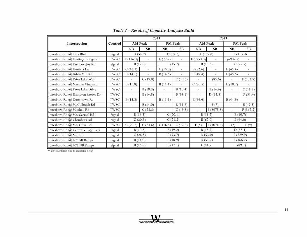
11
Table 3 – Results of Capacity Analysis: Build
NB SB NB SB NB SB NB SBJonesboro Rd @ Tara Blvd SignalJonesboro Rd @ Hastings Bridge Rd TWSC F (116.3) - F (77.2) - F (7253.3) - F (6907.8) -Jonesboro Rd @ East Lovejoy Rd SignalJonesboro Rd @ Hunters Ln TWSC C (16.3) - C (15.3) - F (82.6) - E (45.4) -Jonesboro Rd @ Babbs Mill Rd TWSC B (14.1) - B (14.6) - E (49.4) - E (45.6) -Jonesboro Rd @ Pates Lake Way TWSC - C (17.8) - C (19.5) - F (85.6) - F (133.7)Jonesboro Rd @ Marshas Vineyard TWSC B (11.8) - B (11.1) - C (20.8) - C (18.7) -Jonesboro Rd @ Pates Lake Drive TWSC - B (10.3) - B (10.4) - B (14.6) - C (15.2)Jonesboro Rd @ Hampton Shores Dr TWSC - B (14.8) - B (14.1) - D (33.8) - D (31.4)Jonesboro Rd @ Dutchtown Rd TWSC B (13.8) - B (13.1) - E (44.6) - E (44.9) -Jonesboro Rd @ McCullough Rd TWSC - B (14.0) - B (11.9) - F (*) - E (47.3)Jonesboro Rd @ Mitchell Rd TWSC - C (23.8) - C (19.3) - F (8675.3) - F (367.5)Jonesboro Rd @ Mt. Carmel Rd SignalJonesboro Rd @ Chambers Rd SignalJonesboro Rd @ Mt. Olive Rd TWSC C (20.2) C (23.6) C (16.5) C (17.5) F (*) F (4071.6) F (*) F (*)Jonesboro Rd @ Centre Village Terr SignalJonesboro Rd @ Mill Rd SignalJonesboro Rd @ I-75 SB Ramps SignalJonesboro Rd @ I-75 NB Ramps Signal* Not calculated due to excessive delay
E (62.0) E (64.0)
D (51.2)F (84.7)
D (38.4)F (229.9)F (166.2)F (89.1)
B (13.5)D (53.0)
B (14.0)B (16.8)
B (19.2)E (73.7)B (18.9)B (17.1)
B (10.8)C (26.8)
B (12.8) B (15.7) B (18.3) C (25.5)
C (20.3) C (21.5)B (19.3) C (20.1) B (13.2) B (10.7)
D (54.9) D (39.2) F (159.8) F (113.0)
2013 2033Intersection Control AM Peak PM Peak AM Peak PM Peak

12
Mitigated As can be seen in Table 3, many intersections operate at LOS F in the 2033 build condition. Warrant analysis was performed on several of these intersections to dictate the need for signalization. The details of the warrant analyses are shown in the next section of this report. Based on the analysis, signalization is recommended at the following cross streets: Hastings Bridge Road, Pates Lake Way, McCullough Road, Mitchell Road, and Mt. Olive Road/Towne Center Village Drive. In addition, additional capacity is needed at several of the existing signalized intersections in order to improve the overall levels of service. The resulting levels of service for the mitigated condition are shown in Table 4. The Synchro printouts for the mitigated condition are contained in Appendix I. The intersection of Jonesboro Road & US 19/41 still operates at LOS F in the AM Peak and LOS E in the PM Peak in the design year. The mitigations yield the same levels of service in the design year in respect to the no build condition in the build year. Without additional mitigations, this intersection crosses over from a LOS D to LOS E in approximately 2021. Further mitigations were applied to this intersection in order to return the intersection operation to LOS D in the design year. These mitigations include the widening of US 19/41 from 4 through lanes to 6 through lanes, as well as widening the westbound approach to the intersection on Jonesboro Road from 2 through lanes to 3 through lanes. However, these mitigations may not be feasible due to cost, project scope limitations, or right of way constraints. The LOS of this intersection in the design year with the additional mitigations is presented in Table 5. The Synchro printouts for the additional mitigations on US 19/41 are contained in Appendix J. Table 6 shows the necessary turn bay storage lengths for the 95th percentile queues in the design year, using the mitigated roadway geometry. The values shown in Table 6 represent back of queue only and do not include any necessary deceleration or taper lengths.

13
Table 4 – Results of Capacity Analysis: Mitigated
NB SB NB SB NB SB NB SBJonesboro Rd @ Tara Blvd SignalJonesboro Rd @ Hastings Bridge Rd SignalJonesboro Rd @ East Lovejoy Rd SignalJonesboro Rd @ Hunters Ln TWSC C (16.3) - C (15.3) - F (82.6) - E (45.4) -Jonesboro Rd @ Babbs Mill Rd TWSC C (18.1) - B (14.6) - E (49.4) - E (45.6) -Jonesboro Rd @ Pates Lake Way SignalJonesboro Rd @ Marshas Vineyard SignalJonesboro Rd @ Pates Lake Drive TWSC - B (10.2) - B (10.4) - B (14.2) - B (14.9)Jonesboro Rd @ Hampton Shores Dr TWSC - B (14.1) - B (13.8) - D (31.4) - D (30.4)Jonesboro Rd @ Dutchtown Rd TWSC B (13.8) - B (13.0) - E (44.2) - E (44.2) -Jonesboro Road @ McCullough Rd SignalJonesboro Rd @ Mitchell Rd SignalJonesboro Rd @ Mt. Carmel Rd SignalJonesboro Rd @ Chambers Rd SignalJonesboro Rd @ Mt. Olive Rd SignalJonesboro Rd @ Centre Village Terr SignalJonesboro Rd @ Mill Rd SignalJonesboro Rd @ I-75 SB Ramps SignalJonesboro Rd @ I-75 NB Ramps Signal
C (23.5) D (43.3)
B (19.3) B (19.6) B (13.4) B (15.3)
B (11.7)B (19.4) B (16.9) C (21.0)
B (13.9)
C (21.5) A (5.7)
B (11.9) B (15.4)B (14.7)
B (11.7) C (21.9)
B (15.6)B (19.3) B (13.5)
2033AM Peak PM Peak AM Peak PM Peak
B (13.2) B (10.1) B (18.4) B (16.7)
C (23.2) B (12.8) C (33.8)
C (21.2)
Intersection Control2013
B (12.8) B (15.7) B (17.4)
C (25.2) C (33.2) D (36.0) E (75.1)
C (24.9)
D (43.4) D (37.5) F (100.9) E (76.3)
B (14.3)
C (20.9)
C (21.6) B (19.1) C (33.2) D (37.9)
D (40.7)
A (5.4) A (7.5) A (6.0) B (11.9)
Table 5 – Results of Capacity Analysis: Additional Mitigations
NB SB NB SBJonesboro Rd @ Tara Blvd Signal D (54.3) D (44.2)
Intersection Control2033
AM Peak PM Peak

14
Table 6 – 95th Percentile Back of Queue
EBL EBR WB L WB R NB L NB R SB L SB RUS 19/41 425 x 2 75 225 x 2 0 325 x 2 125 475 x 2 75Hastings Bridge Road - 125 0 - 275 x 2 50 - -East Love Joy/Freeman Road 75 25 150 50 50 50 200 -Hunters Lane - 0 25 - 125 25 - -Babbs Mill Road - 0 25 - 100 25 - -Pates Lake Way/Marshas Vineyard 50 25 25 25 - - - -Pates Lake Drive - - - 0 - - - 25Hampton Shores Drive 25 - - 0 - - - -Dutchtown Road - 0 25 - 75 25 - -McCullough Road 250 x 2 - - 25 - - 75 150Mitchell Road 75 - - 125 - - 150 x 2 50Mt. Carmel Road - 25 50 - 50 25 - -Chambers Road 250 50 225 0 100 100 350 x 2 125Mt. Olive Road 275 75 50 25 175 - 100 -Centre Village Terrace 175 25 225 50 250 - 350 -Mill Road 50 150 675 x 2 0 300 x 2 450 450 x 2 -I-75 SB Ramps - 25 150 - - - 250 x 2 300 x 2I-75 NB Ramps 425 x 2 - - 175 450 x 2 50 - -
Jonesboro Road @Recommended Storage Length (Ft)

15
Accident Analysis The accident analysis examines the accident statistics along Jonesboro Road and compares them to the statewide averages of similar facilities. The statewide averages are calculated using accident data that is collected annually by GDOT. Accident rates are based on the number of crashes, injuries, and fatalities per million vehicle miles traveled. Accident data on the Jonesboro Road corridor was collected for the years of 2003, 2004, and 2005. Count station 223 covers the portion of Jonesboro Road from US 19/41 to the Clayton/Henry County Line. Count station 209 covers the portion of Jonesboro Road from the Clayton/Henry County Line to Chambers Road. Count station 212 covers the portion of Jonesboro Road from Chambers Road to Interstate 75. Table 7 illustrates the differences between the accident rates on Jonesboro Road and the statewide averages. As can be seen in the table, the accident rates on Jonesboro Road greatly exceed the statewide averages.
Table 7 – Accident Rates
Project SWA Project SWA Project SWA209 249 119 5.93212 978 436 0.00223 2086 572 1057 218 0.00 1.48209 273 124 0.00212 900 336 0.00223 1845 490 733 187 0.00 1.41209 385 146 6.64212 1260 679 10.95223 2037 534 642 206 0.00 1.56
Accident Injuries Count Station
YearFatalities
1.21
573 225 1.68
1.27613 243
SWA = Statewide Average
2005
2004
2003
515 203
16
5. SIGNAL WARRANT ANALYSIS Jonesboro Road Traffic Engineering Report The following intersections, also identified in Section 4 of this report, will be evaluated for the installation of traffic signals:
Jonesboro Road & Hastings Bridge Road Jonesboro Road & Pates Lake Way Jonesboro Road & McCullough Road Jonesboro Road & Mitchell Road Jonesboro Road & Mt. Olive Road
The projected volumes of the intersections were evaluated using the guidelines given in the Manual on Uniform Traffic Control Devices, 2003 Edition (MUTCD) (2). The MUTCD establishes the following Warrants:
Warrant 1, Eight-Hour Vehicular Volume Warrant 2, Four-Hour Vehicular Volume Warrant 3, Peak Hour Vehicular Volume Warrant 4, Pedestrian Volume Warrant 5, School Crossing Warrant 6, Coordinated Signal System Warrant 7, Crash Experience Warrant 8, Roadway Network
The applicable warrants will be addressed for each intersection being analyzed. The MUTCD guidelines for warrant studies suggest that a traffic signal should not be installed unless one or more of the warrants are satisfied
8th Highest Hour Volume Signal warrant studies typically study existing intersections/intersection configuration and involve the collection of hourly traffic data, using automatic traffic recorders. However, this study is concerned with the analysis of the projected condition that will occur in the design year. Therefore, projections of the ADT volumes were used. These volumes are contained in Appendix D. Since the eight-hour vehicular volume warrant is the most widely accepted of the signal warrants, it is necessary to estimate the eighth highest hour for use in the signal warrant analysis. If the eighth highest hour of the day meets the minimum warrant thresholds, then the seven higher hours will also meet the minimum required volumes. The Manual of Traffic Signal Design, published by the Institute of Transportation Engineers in 1982, provides a section that discusses warrant analysis of new intersections. This same analysis can be used for

17
existing intersections if major changes occur in geometry or volume, as in the case of the Jonesboro Road corridor. This publication provides the assumption that the eighth highest hour of vehicular volume is approximately 6.25 percent of the ADT. The eighth highest hour for each of the intersections mentioned above was calculated using the 6.25% assumption. These volumes for the build year and design year are shown in Tables 8 and 9, respectively.
Table 8 – 2013 8th Highest Hour Volume
Major Street Minor Street Major Street Minor StreetJonesboro Road Hastings Bridge Road 15600 5700 975 355Jonesboro Road Pates Lake Way 13900 850 870 55Jonesboro Road McCullough Road 13200 3200 825 200Jonesboro Road Mitchell Road 13950 4750 870 295Jonesboro Road Mt. Olive Road 25600 1750 1600 110
Major Street Minor Street2013 ADT 8th Highest Hour
Table 9 – 2033 8th Highest Hour Volume
Major Street Minor Street Major Street Minor StreetJonesboro Road Hastings Bridge Road 30650 13450 1915 840Jonesboro Road Pates Lake Way 32000 850 2000 55Jonesboro Road McCullough Road 27600 6600 1725 415Jonesboro Road Mitchell Road 27900 8800 1745 550Jonesboro Road Mt. Olive Road 47300 5000 2955 315
Major Street Minor Street2033 ADT 8th Highest Hour

18
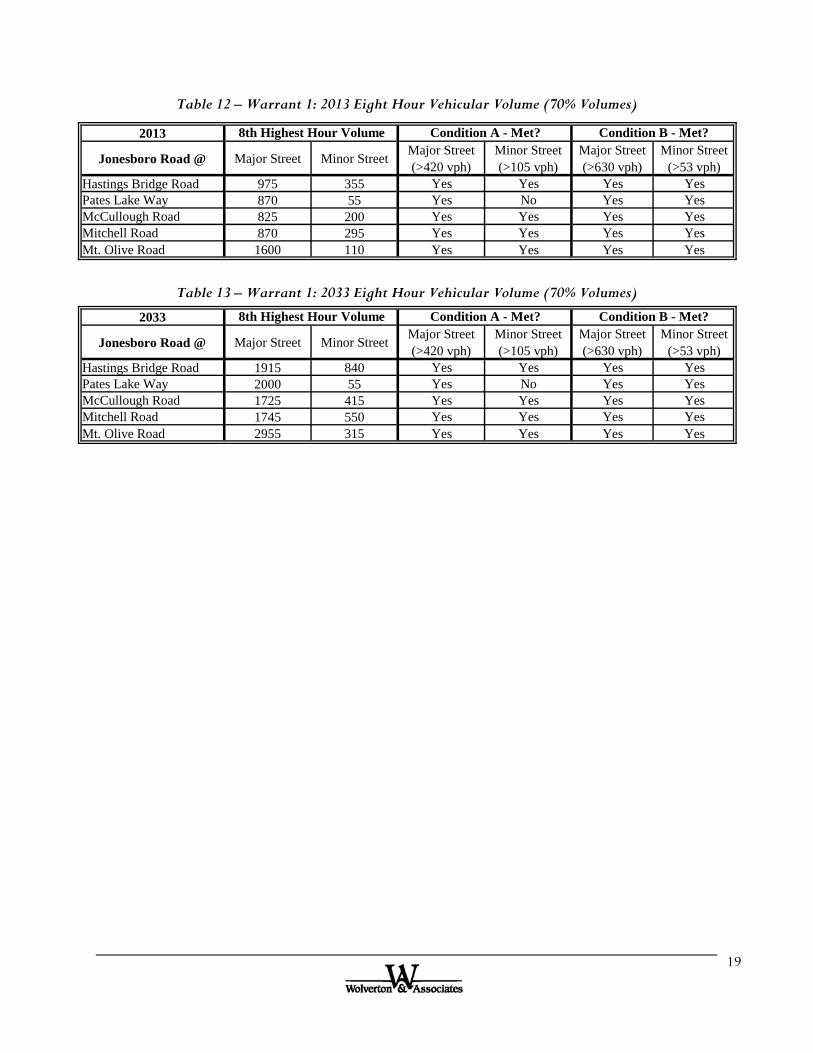
Warrant 1 – Eight Hour Vehicular Volume For Warrant 1 to be satisfied the traffic volume requirements of either Condition A (Minimum Vehicular Volumes) or Condition B (Interruption of Continuous Traffic) must be met for eight hours of an average day. The required volume for the main street is the total approach volume (both directions). The required side street volume is the heavier approach volume (one direction). Tables 10 and 11 provide a comparison of the projected traffic volumes to the requirements of Warrant 1, Condition A and Condition B, for the build and design years, respectively using the 100% threshold volumes. The MUTCD states that the threshold volumes may be reduced by 30% if the speed limit on the roadway exceeds 40 mph. Because the speed limit on Jonesboro Road exceeds the 40 mph threshold, Tables 12 and 13 show the comparison of the projected traffic volumes to the requirements of Warrant 1, when using the 70% threshold volumes, for the build and design years, respectively. Based on the 100% volume thresholds, all intersections except Pates Lake Way are warranted in the design year. All intersections are warranted in build and design years, using the 70% threshold volumes.
Table 10 – Warrant 1: 2013 Eight Hour Vehicular Volume (100% Volumes)
2013
Jonesboro Road @ Major Street Minor Street Major Street (>600 vph)
Minor Street (>150 vph)
Major Street (>900 vph)
Minor Street (>75 vph)
Hastings Bridge Road 975 355 Yes Yes Yes YesPates Lake Way 870 55 Yes No No NoMcCullough Road 825 200 Yes Yes No YesMitchell Road 870 295 Yes Yes No YesMt. Olive Road 1600 110 Yes No Yes Yes
8th Highest Hour Volume Condition A - Met? Condition B - Met?
Table 11 – Warrant 1: 2033 Eight Hour Vehicular Volume (100% Volumes)
2033
Jonesboro Road @ Major Street Minor Street Major Street (>600 vph)
Minor Street (>150 vph)
Major Street (>900 vph)
Minor Street (>75 vph)
Hastings Bridge Road 1915 840 Yes Yes Yes YesPates Lake Way 2000 55 Yes No Yes NoMcCullough Road 1725 415 Yes Yes Yes YesMitchell Road 1745 550 Yes Yes Yes YesMt. Olive Road 2955 315 Yes Yes Yes Yes
8th Highest Hour Volume Condition A - Met? Condition B - Met?
19
Table 12 – Warrant 1: 2013 Eight Hour Vehicular Volume (70% Volumes)
2013
Jonesboro Road @ Major Street Minor Street Major Street (>420 vph)
Minor Street (>105 vph)
Major Street (>630 vph)
Minor Street (>53 vph)
Hastings Bridge Road 975 355 Yes Yes Yes YesPates Lake Way 870 55 Yes No Yes YesMcCullough Road 825 200 Yes Yes Yes YesMitchell Road 870 295 Yes Yes Yes YesMt. Olive Road 1600 110 Yes Yes Yes Yes
8th Highest Hour Volume Condition A - Met? Condition B - Met?
Table 13 – Warrant 1: 2033 Eight Hour Vehicular Volume (70% Volumes)
2033
Jonesboro Road @ Major Street Minor Street Major Street (>420 vph)
Minor Street (>105 vph)
Major Street (>630 vph)
Minor Street (>53 vph)
Hastings Bridge Road 1915 840 Yes Yes Yes YesPates Lake Way 2000 55 Yes No Yes YesMcCullough Road 1725 415 Yes Yes Yes YesMitchell Road 1745 550 Yes Yes Yes YesMt. Olive Road 2955 315 Yes Yes Yes Yes
8th Highest Hour Volume Condition A - Met? Condition B - Met?

20
Warrant 2 – Four Hour Vehicular Volume The Four-Hour Vehicular Volume Warrant is presented in the MUTCD using a graph of required side street volumes versus main street volumes. Figures 3 and 4 are replications of the warrant condition that is applicable to Jonesboro Road for the 2013 and 2033 projected conditions, respectively. The 100% threshold volume curve is illustrated by the blue line and the 70% threshold volume curve is illustrated by the red line. The eighth highest hour of each intersection was compared to the graphs of Warrant 2. The projected volumes for the 8th highest hour of each intersection are superimposed on the chart illustrated by solid shapes in Figures 3 and 4 in order to compare them to the warrant. The 8th highest hour volumes are being examined in the figures. Based on the figures shown below, the 2033 projected volumes 8th highest hour meets the 100% threshold volumes for Warrant 2 at all intersections except Pates Lake Way.
Figure 3 – Warrant 2: 2013 Four-Hour Vehicular Volume
0
50
100
150
200
250
300
350
400
450
300
500
700
900
1100
1300
1500
1700
Min
or S
tree
t V
olum
e
Major Street Volume
Warrant 2: 2013 Volumes
100% Threshold
70% Threshold
Hastings Bridge
Pates Lake
McCullough
Mitchell
Mt. Olive

21
Figure 4 – Warrant 2: 2033 Four-Hour Vehicular Volume
0
100
200
300
400
500
600
700
800
90050
0
700
900
1100
1300
1500
1700
1900
2100
2300
2500
2700
2900
Min
or S
tree
t V
olum
e
Major Street Volume
Warrant 2: 2033 Volumes
100% Threshold
70% Threshold
Hastings Bridge
Pates Lake
McCullough
Mitchell
Mt. Olive
22
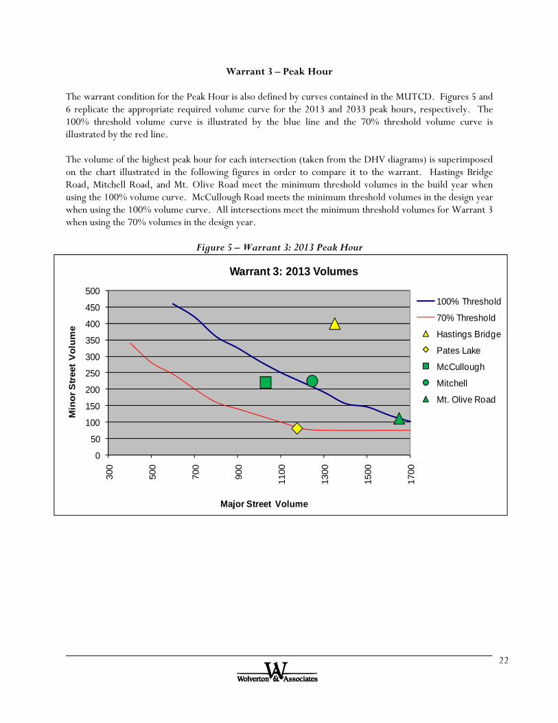
Warrant 3 – Peak Hour The warrant condition for the Peak Hour is also defined by curves contained in the MUTCD. Figures 5 and 6 replicate the appropriate required volume curve for the 2013 and 2033 peak hours, respectively. The 100% threshold volume curve is illustrated by the blue line and the 70% threshold volume curve is illustrated by the red line. The volume of the highest peak hour for each intersection (taken from the DHV diagrams) is superimposed on the chart illustrated in the following figures in order to compare it to the warrant. Hastings Bridge Road, Mitchell Road, and Mt. Olive Road meet the minimum threshold volumes in the build year when using the 100% volume curve. McCullough Road meets the minimum threshold volumes in the design year when using the 100% volume curve. All intersections meet the minimum threshold volumes for Warrant 3 when using the 70% volumes in the design year.
Figure 5 – Warrant 3: 2013 Peak Hour
0
50
100
150
200
250
300
350
400
450
500
300
500
700
900
1100
1300
1500
1700
Min
or S
tree
t V
olum
e
Major Street Volume
Warrant 3: 2013 Volumes
100% Threshold
70% Threshold
Hastings Bridge
Pates Lake
McCullough
Mitchell
Mt. Olive Road

23
Figure 6 – Warrant 3: 2033 Peak Hour
0
100
200
300
400
500
600
700
800
900
100023
00
2500
2700
2900
3100
3300
3500
Min
or S
tree
t V
olum
e
Major Street Volume
Warrant 3: 2033 Volumes
100% Threshold
70% Threshold
Hastings Bridge
Pates Lake
McCullough
Mitchell
Mt. Olive Road

24
Warrant 4 – Pedestrian Volume There is not excessive pedestrian volume along Jonesboro Road. Therefore, Warrant 4 is not applicable.
Warrant 5 – School Crossing While there are schools located on Mitchell Road and Mt. Olive Road, it is not anticipated that they will generate significant pedestrian traffic crossing Jonesboro Road. Therefore, Warrant 5 is not applicable.
Warrant 6 – Coordinated Signal System Signalization is not needed to maintain proper platooning of vehicles. Therefore, Warrant 6 is not applicable.
Warrant 7 – Crash Experience The severity and frequency of crashes are not the principal reasons to consider installing a traffic signal at these intersections. Therefore, Warrant 7 is not applicable.
Warrant 8 – Roadway Network The intersections are part of a principal roadway network, however traffic signals are not needed to organize the traffic flow. Therefore, Warrant 8 is not applicable.
Summary of Warrant Analysis
Table 14 summarizes the signal warrant analysis for the intersections along Jonesboro Road, using the design year volumes. Based on the warrant analysis using 100% threshold volumes, signalization is recommended at Hastings Bridge Road, McCullough Road, and Mitchell Road. Although Pates Lake Way meets Warrants 1 and 3 when only using the 70% threshold volumes, signalization is still recommended at this intersection because the design year LOS is an F in the AM and PM peaks and all other unsignalized mitigation options have failed in improving the side street level of service.

25
Table 14 – Summary of Warrant Analysis
Jonesboro Road @ Threshold Warrant 1 Warrant 2 Warrant 3 Warrant 4 Warrant 5 Warrant 6 Warrant 7 Warrant 8
70 Satisfied Satisfied Satisfied N/A N/A N/A N/A N/A
100 Satisfied Satisfied Satisfied N/A N/A N/A N/A N/A
70 Satisfied NOT Satisfied Satisfied N/A N/A N/A N/A N/A
100 NOT Satisfied NOT Satisfied NOT Satisfied N/A N/A N/A N/A N/A
70 Satisfied Satisfied Satisfied N/A N/A N/A N/A N/A
100 Satisfied Satisfied Satisfied N/A N/A N/A N/A N/A
70 Satisfied Satisfied Satisfied N/A N/A N/A N/A N/A
100 Satisfied Satisfied Satisfied N/A N/A N/A N/A N/A
70 Satisfied Satisfied Satisfied N/A N/A N/A N/A N/A
100 Satisfied Satisfied Satisfied N/A N/A N/A N/A N/A
Pates Lake Way
McCullough Road
Mitchell Road
Hastings Bridge Road
Mt. Olive Road

26
6. RECOMMENDATIONS Jonesboro Road Traffic Engineering Report Based on the analysis documented in this report, Wolverton and Associates, Inc. make the following conclusions and recommendations:
Construct Jonesboro Road to be a four-lane divided facility from US 19/41 to Centre Village Terrace. From Centre Village Terrace to the I-75 SB ramps, a six-lane divided facility is necessary in order to accommodate the commercial traffic.
Construct median breaks at the following cross streets: US 19/41, Hastings Bridge Road, East Lovejoy/Freeman Road, Hunters Lane, Babbs Mill Road, Pates Lake Way, Hampton Shores Drive, Dutchtown Road, McCullough Road, Mitchell Road, North Mt. Carmel Road, Chambers Road, Mt. Olive Road, Centre Village Terrace, Mill Road.
Any additional median breaks should be constructed at least 1000 feet from the recommended median breaks outlined in the previous bullet.
At all median breaks, provide designated left and right turn lanes on Jonesboro Road. Coordinate the traffic signals from I-75 to Mt. Olive Road. All turn bays must exceed the queue lengths (as shown in Table 5, Section 4 of this report) or
meet minimum deceleration criteria as stipulated by the GDOT, whichever is longer, unless geometrically infeasible.
The following intersection improvements are also recommended:
Jonesboro Road & US 19/41 Construct each approach to the intersection to have dual left turn lanes. Construct an additional westbound through lane. Construct an additional eastbound through lane. Modify the northbound right turn lane to be a channelized free flow lane. Continue to allow the westbound right turn lane to operate as free flow.
Jonesboro Road & Hastings Bridge Road Signalize the intersection. Reconstruct the intersection to form a “Tee”-intersection, with Jonesboro Road acting as
the major approach and Hastings Bridge Road as the minor approach. Construct an additional through lane and a right turn lane on the eastbound approach. The
right turn lane will act as a drop lane for the free flow northbound right turn lane at US 19/41.
Construct an additional through lane and a left turn lane on the westbound approach. Construct the Hastings Bridge Road approach to consist of dual left turn lanes and a right
turn lane.

27
Jonesboro Road & East Lovejoy Road Construct an additional through lane and a right turn lane on the eastbound and westbound
approaches. Construct an additional left turn lane on the northbound and southbound approaches.
Jonesboro Road & Hunters Lane Construct an additional eastbound through lane and right turn lane. Construct an additional westbound through lane and left turn lane. Construct a northbound left turn lane.
Jonesboro Road & Babbs Mill Road Construct an additional eastbound through lane and right turn lane. Construct an additional westbound through lane and left turn lane. Construct a northbound left turn lane.
Jonesboro Road & Pates Lake Way Signalize intersection. Construct an additional through lane, a right turn lane and a left turn lane on the eastbound
and westbound approaches. Realign Marsha’s Vineyard to intersect Jonesboro Road opposite of Pates Lake Way.
Jonesboro Road & Pates Lake Drive Construct an additional through lane in the eastbound and westbound directions. Designate Pates Lake Drive as right-in-right-out (RIRO).
Jonesboro Road & Hampton Shores Drive Construct an additional eastbound through lane and a left turn lane. Construct an additional westbound through lane.
Jonesboro Road & Dutchtown Road Construct an additional eastbound through lane and a right turn lane. Construct an additional westbound through lane and a left turn lane. Construct a northbound left turn lane.
Jonesboro Road & McCullough Road Signalize intersection. Construct the eastbound approach to the intersection to consist of dual left turn lanes and
two through lanes. Construct the westbound approach to the intersection to consist of two through lanes and a
right turn lane. Construct the southbound approach to the intersection to consist of separate left and right
turn lanes.

28
Jonesboro Road & Mitchell Road Signalize intersection. Construct the eastbound approach to the intersection to consist of a left turn lane and two
through lanes. Construct the westbound approach to the intersection to consist of two through lanes and a
right turn lane. Construct the southbound approach to the intersection to consist of dual left turn lanes and
a right turn lane.
Jonesboro Road & North Mt. Carmel Road Signalize intersection. Construct the eastbound approach to consist of two through lanes and a right turn lane. Construct the westbound approach to consist of two through lanes and a left turn lane. Construct the northbound approach to consist of a left turn lane and a right turn lane.
Jonesboro Road & Chambers Road Construct an additional eastbound through lane and a right turn lane. Construct an additional westbound turn lane and a free flow right turn lane. Construct the northbound approach to consist of a left turn lane, a through lane, and a
right turn lane. Construct the southbound approach to consist of dual left turn lanes, a through lane, and a
right turn lane.
Jonesboro Road & Mt. Olive Road/Towne Center Village Drive Signalize intersection. Construct an additional eastbound and westbound through lane. Construct a northbound and southbound left turn lane.
Jonesboro Road & Centre Village Terrace Construct an additional eastbound and westbound through lane. Modify the northbound through/right lane to have a channelized free flow right. The westbound right turn lane will act as a drop lane for the southbound free flow right
turn at Mill Road.
Jonesboro Road & Mill Road Modify signal timing from split phasing to protected left turn phasing. Construct the eastbound approach of the intersection to consist of a left turn lane, three
through lanes, and a right turn lane. Construct the westbound approach of the intersection to consist of dual left turn lanes, two
through lanes and a right turn drop lane. Construct the northbound approach of the intersection to consist of dual left turn lanes, a
through lane, and a right turn lane. Construct the southbound approach of the intersection to consist of dual left turn lanes,
and a through/right turn lane, with a channelized free flow right.

29
Jonesboro Road & I-75 SB Ramps Modify the eastbound right turn lane to act as a drop lane. Construct an additional free flow southbound right turn lane. Decrease westbound left turn bay in order to accommodate the additional eastbound left
turn lane at the I-75 NB ramps.
Jonesboro Road & I-75 NB Ramps Construct an additional eastbound left turn lane (dual lefts). Construct an additional northbound left turn lane (dual lefts).
The appendices for this report are provided in electronic format on the included CDs.

30
Figure 7a – Recommended Improvements (1)
US
19/4
1
STOP STOP STOP
Has
tings
Bri
dge
Rd
Babb
sMill
Rd
Hun
ters
Lan
e
Free
man
Rd
East
Lov
ejoy
RdJonesboro Rd
HEN
RY
CO
CLA
YT
ON
CO
Pate
s Lak
e W
ay
Rea
ligne
d M
arsh
a’s V
iney
ard
Pate
s Lak
e D
r
Ham
pton
Sho
res D
r
Dut
chto
wn
Rd
ASS
UM
ED
Existing Travel LaneProposed Travel LaneStop ControlUnsignalized IntersectionExisting Signalized Intersection
Proposed Signalized Intersection
STOP
STOP STOP
Free Flow
Drop Lane

31
Figure 7b – Recommended Improvements (2)
Mitc
hell
Rd
N. M
t. C
arm
el R
d
Cha
mbe
rs R
d
Mt.
Oliv
e R
d
Tow
ne C
ente
r Vill
age
Dr
Cen
tre
Vill
age
Ter
r
Mill
Rd
I-75
SB
Off
Ram
p
I-75
SB
On
Ram
p
I-75
NB
On
Ram
p
I-75
NB
Off
Ram
p
ASS
UM
ED
Existing Travel LaneProposed Travel LaneStop ControlUnsignalized IntersectionExisting Signalized Intersection
Proposed Signalized Intersection
STOP
Drop Lane
Drop Lane
Free Flow
McC
ullo
ugh
Rd
Free Flow
Free Flow
Drop Lane
32
REFERENCES Jonesboro Road Traffic Engineering Study
1. Highway Capacity Manual, HCM 2000, Transportation Research Board, Washington, DC, 2000.
2. Manual on Uniform Traffic Control Devices, 2003 Edition, Federal Highway Administration,
Washington DC 2004.

Clayton063-0001-0
BRIDGE INVENTORY DATA LISTING GEORGIA DEPARTMENT OF TRANSPORTATION
99.21SUFF. RATINGStructure ID:
063-0001-0Structure I.D.No:
07Bridge Information
CENTRAL OF GA RAILROADFeature Int:
16Functional Classification:
Signs & Attachments
Expansion Joint Type:
*
225
242
243
238
239
240
241
230
244
224
233
236
234
235
237
247
248
*
*
Deck Drains:
Parapet Location:
Height:
Width:
Curb:
Handrail:
Median Barrier Rail:
Bridge Median Height:
Width:
Guardrail Loc Dir Rear:
Fwrd:
Oppo Dir Rear:
Fwrd:
Approach Slab:
Retaining Wall:
Posted Speed Limit:
Warning Sign:
Delineator:
Hazard Boards:
Utilities Gas:
Water:
Electric:
Telephone:
Sewer:
Lighting Street:
Naviagtion:
Aerial:
County Continuity No.:
02
0
0
0.00
0.00
0.00 0
9 9
0
0.00
0.00
6
6
0
0
3
0
45
0
0
1
21
00
00
00
00
0
0
0
00
*
200
6A*
*
*
*
6B
7A
7B
* 9
2
207
91
92A
92B
92C
4
5
16
17
98
99
100
12
13A
13B
101
102
264
208
Location I.D. No.:
*
*
*
*
*
*
*
*
*
*
*
Critical Bridge:
Route Number Carried:
Facility Carried:
Location:
DOT District:
Year Photo:
Inspection Frequency:
Fract Crit Insp Freq:
Underwater Insp Freq:
Other Spc. Insp Freq:
Place Code:
Inventory Route (O/U):
Type:
Designation:
Number:
Direction:
Latitude: MMS Prefix:
Longitude: MMS Suffix:
Border Bridge: %Shared:
ID Number:
STRAHNET:
Base Highway Network:
LRS Inventory Route:
Sub Inventory Route:
Parallel Structure:
Direction of Traffic:
Road Inventory Mile Post:
Inspection Area:
Date:
Date:
Date:
Date:
Initials:
0
IN LOVEJOY
MCDONOUGH ROAD
CR06070
7
2003
24 04/21/2005
02/01/1901
00
00
02/01/1901
00 02/01/1901
47616
1
4
1
02009
0
33-26.9
084-19.4 0.00MP:
000 00
000000000000000
0
1
631092000
0
N
2
001.70
03 WBP
063-02009F-001.68N
* 104
26
204
105
110
206
217
218
19
20
21
22
31
37
205
27
106
33
34
35
38
213
267
42
214
203
259
43
45
44
46
226
111
107
108
*
*
*
*
*
*
*
*
*
*
0
S 02009No.:
0
0
1
0000.00
0
01
3
02
Highway System:
Federal Route Type:
Federal Lands Highway:
Truck Route:
School Bus Route:
Benchmark Elevation:
Datum:
Bypass Length:
Toll:
Maintenance:
Owner:
Design Load:
Historical Significance:
Congressional District:
Year Constructed:
Year Reconstructed:
Bridge Median:
Skew:
Structure Flared:
Navigation Control:
Special Steel Design:
Type of Paint:
Type of Service on:
Under:
Movable Bridge:
Type Bridge:
Pile Encasement:
Structure Type Main:
No. Spans Main:
Structure Type Appr:
No. Spans Appr:
Bridge Curve Horz: Vert:
Pier Protection:
Deck Structure Type:
Wearing Surface Type:
Membrance:
Protection:
02
6
5
13
1976
0000
0
30
0
N
0
5
1
2
0
A-O-M-O
3
3 02
003
0 00
0000
1 1
0
1
1
0
0
Location & Geography
Engineer's Initial: jal
1SIA-Report Date: 7/9/2007
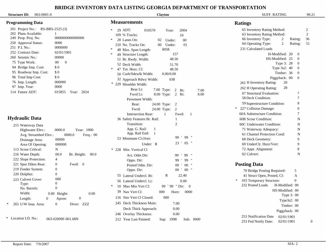
Clayton063-0001-0
BRIDGE INVENTORY DATA LISTING GEORGIA DEPARTMENT OF TRANSPORTATION
99.21SUFF. RATINGStructure ID:
Programming Data
201
202
249
250
251
252
260
75
94
95
96
76
97
114
Project No.:
Plans Available:
Prop. Proj. No.
Approval Status:
P.I. No.:
Contract Date:
Seismic No.:
Type Work:
Bridge Imp. Cost:
Roadway Imp. Cost:
Total Imp Cost:
Imp. Length:
Imp. Year:
Future ADT: Year:
RS-BRS-2525 (3)
1
0000000000000000
0000
0000000
02/01/1901
00000
00 0
$ 0
$ 0
$ 0
000000
0000
015855 2024
Hydraulic Data
*
215
113
216
222
221
219
220
223
265
Waterway Data
Highwater Elev.:
Avg. Streambed Elev.:
Drainage Area:
Area Of Opening:
Year:
Freq.:
Scour Critical:
Water Depth: Br. Height:
Slope Protection:
Spur Dikes Rear: Fwrd:
Fender System:
Dolphin:
Culvert Cover:
Type:
No. Barrels:
Width: Height:
Length: Apron:
U/W Insp. Area: Diver:
0000.0 1900
0000.0 00
00000
000000
N
00.0 00.0
4
0 0
0
0
000
0
0
0.00 0.00
0 0
0 ZZZ
* Location I.D. No.:063-02009F-001.68N
Measurements
* 29
109
28
210
48
49
51
52
47
50
32
229
36
Shoulder Width:
Rear Lt:
Fwrd Lt:
Pavement Width:
Rear:
Fwrd:
Intersection Rear:
Safety Features Br. Rail:
Transition:
App. G. Rail:
App. Rail End:
Minimum Cl.Over:
Under:
53
228
55
56
10
39
116
245
246
212
Min. Vertical Cl
Act. Odm Dir:
Oppo. Dir:
Posted Odm. Dir:
Oppo. Dir:
Lateral Undercl. Rt:
Lateral Undercl. Lt:
Max Min Vert Cl:
Nav Vert Cl:
Nav Vert Cl Closed:
Deck Thickness Main:
Deck Thick Approach:
Overlay Thickness:
Year Last Painted:
*
*
*
*
*
*
*
ADT:
% Trucks:
Lanes On:
No. Tracks On:
Max. Span Length:
Structure Length:
Br. Rwdy. Width:
Deck Width:
Tot. Horz. Cl:
Curb/Sdewlk Width:
Approach Rdwy Width:
Sup: Sub:
Year:010570 2004
10
02 Under: 00
Under:00 01
0058
157
48.50
51.70
48.50
0.00/0.00
038
Type:Rt:
Rt:Type:
7.00 7.002
8.00 8.002
24.00
24.00
Type:
Type:
2
2
1 1Fwrd:
1
2
1
1
99 99
R23 05
99 99
99 99
00 00
00 00
R 22.40
0.00
99 99 Dir: 0
000 Horz: 0000
000
7.00
0.00
0.00
1998 0000
'
'
'
'
'
'
'
"
"
"
"
"
"
"
Ratings
*
63
66
64
231
261
262
67
58
59
227
60A
60B
60C
71
61
68
69
72
62
Inventory Rating Method:
Inventory Type:
Operating Type:
Calculated Loads
H-Modified:
HS-Modified:
Type 3:
Type 3s2:
Timber:
Piggyback:
H Inventory Rating:
H Operating Rating:
Structural Evaluation:
Deck Condition:
Superstructure Condition:
Collision Damage:
Substructure Condition:
Scour Condition:
Underwater Condition:
Waterway Adequacy:
Channel Protection Cond:
Deck Geometry:
UnderClr. Horz/Vert:
Appr. Alignment:
Culvert:
Rating:
Rating:
2
2 36
2 51
20 0
25 0
28 0
40 0
36 0
00 0
20
28
7
7
8
0
7
N
N
N
N
9
9
8
N
65 Inventory Rating Method: 2
Posting Data
*
70
41
103
232
253
253
Bridge Posting Required:
Struct Open, Posted, Cl:
H-Modified:
HS-Modified:
Type 3:
Type3s2:
Timber:
Piggyback:
Temporary Structure:
Notification Date
Fed Notify Date:
Posted Loads
5
A
0
00
00
00
00
00
00
02/01/1901
02/01/1901 0
2SIA-Report Date: 7/9/2007

Henry151-0057-0
BRIDGE INVENTORY DATA LISTING GEORGIA DEPARTMENT OF TRANSPORTATION
90.36SUFF. RATINGStructure ID:
151-0057-0Structure I.D.No:
07Bridge Information
WALNUT CREEKFeature Int:
14Functional Classification:
Signs & Attachments
Expansion Joint Type:
*
225
242
243
238
239
240
241
230
244
224
233
236
234
235
237
247
248
*
*
Deck Drains:
Parapet Location:
Height:
Width:
Curb:
Handrail:
Median Barrier Rail:
Bridge Median Height:
Width:
Guardrail Loc Dir Rear:
Fwrd:
Oppo Dir Rear:
Fwrd:
Approach Slab:
Retaining Wall:
Posted Speed Limit:
Warning Sign:
Delineator:
Hazard Boards:
Utilities Gas:
Water:
Electric:
Telephone:
Sewer:
Lighting Street:
Naviagtion:
Aerial:
County Continuity No.:
02
1
0
0.00
0.00
0.00 0
9 9
0
0.00
0.00
6
6
0
0
3
0
45
0
0
0
00
00
00
00
00
0
0
0
00
*
200
6A*
*
*
*
6B
7A
7B
* 9
2
207
91
92A
92B
92C
4
5
16
17
98
99
100
12
13A
13B
101
102
264
208
Location I.D. No.:
*
*
*
*
*
*
*
*
*
*
*
Critical Bridge:
Route Number Carried:
Facility Carried:
Location:
DOT District:
Year Photo:
Inspection Frequency:
Fract Crit Insp Freq:
Underwater Insp Freq:
Other Spc. Insp Freq:
Place Code:
Inventory Route (O/U):
Type:
Designation:
Number:
Direction:
Latitude: MMS Prefix:
Longitude: MMS Suffix:
Border Bridge: %Shared:
ID Number:
STRAHNET:
Base Highway Network:
LRS Inventory Route:
Sub Inventory Route:
Parallel Structure:
Direction of Traffic:
Road Inventory Mile Post:
Inspection Area:
Date:
Date:
Date:
Date:
Initials:
0
5.5 MI W OF MCDONOUGH
JONESBORO ROAD
SR00920
3
2006
24 11/17/2006
02/01/1901
00
00
02/01/1901
00 02/01/1901
00000
1
3
1
00920
0
33-27.8500
84-15.1920 0.00MP:
000 00
000000000000000
0
1
1511092000
0
N
2
002.87
03 WBP
151-00920D-002.87E
* 104
26
204
105
110
206
217
218
19
20
21
22
31
37
205
27
106
33
34
35
38
213
267
42
214
203
259
43
45
44
46
226
111
107
108
*
*
*
*
*
*
*
*
*
*
0
S 01583No.:
0
0
1
0000.00
0
10
3
01
Highway System:
Federal Route Type:
Federal Lands Highway:
Truck Route:
School Bus Route:
Benchmark Elevation:
Datum:
Bypass Length:
Toll:
Maintenance:
Owner:
Design Load:
Historical Significance:
Congressional District:
Year Constructed:
Year Reconstructed:
Bridge Median:
Skew:
Structure Flared:
Navigation Control:
Special Steel Design:
Type of Paint:
Type of Service on:
Under:
Movable Bridge:
Type Bridge:
Pile Encasement:
Structure Type Main:
No. Spans Main:
Structure Type Appr:
No. Spans Appr:
Bridge Curve Horz: Vert:
Pier Protection:
Deck Structure Type:
Wearing Surface Type:
Membrance:
Protection:
01
6
5
03
1981
0000
0
20
0
0
0
3
1
5
0
E-N-O-O
1
1 04
003
0 00
0000
0 0
0
1
1
8
8
Location & Geography
Engineer's Initial: sgm
1SIA-Report Date: 7/9/2007

Henry151-0057-0
BRIDGE INVENTORY DATA LISTING GEORGIA DEPARTMENT OF TRANSPORTATION
90.36SUFF. RATINGStructure ID:
Programming Data
201
202
249
250
251
252
260
75
94
95
96
76
97
114
Project No.:
Plans Available:
Prop. Proj. No.
Approval Status:
P.I. No.:
Contract Date:
Seismic No.:
Type Work:
Bridge Imp. Cost:
Roadway Imp. Cost:
Total Imp Cost:
Imp. Length:
Imp. Year:
Future ADT: Year:
BRSLB-1583 (8)
4
0000000000000000
0000
0000000
02/01/1901
00000
00 3
$ 0
$ 0
$ 0
000000
0000
015105 2025
Hydraulic Data
*
215
113
216
222
221
219
220
223
265
Waterway Data
Highwater Elev.:
Avg. Streambed Elev.:
Drainage Area:
Area Of Opening:
Year:
Freq.:
Scour Critical:
Water Depth: Br. Height:
Slope Protection:
Spur Dikes Rear: Fwrd:
Fender System:
Dolphin:
Culvert Cover:
Type:
No. Barrels:
Width: Height:
Length: Apron:
U/W Insp. Area: Diver:
0000.0 1900
0000.0 00
8
371
U
02.7 12.0
1
0 0
0
0
000
0
0
0.00 0.00
0 0
0 ZZZ
* Location I.D. No.:151-00920D-002.87E
Measurements
* 29
109
28
210
48
49
51
52
47
50
32
229
36
Shoulder Width:
Rear Lt:
Fwrd Lt:
Pavement Width:
Rear:
Fwrd:
Intersection Rear:
Safety Features Br. Rail:
Transition:
App. G. Rail:
App. Rail End:
Minimum Cl.Over:
Under:
53
228
55
56
10
39
116
245
246
212
Min. Vertical Cl
Act. Odm Dir:
Oppo. Dir:
Posted Odm. Dir:
Oppo. Dir:
Lateral Undercl. Rt:
Lateral Undercl. Lt:
Max Min Vert Cl:
Nav Vert Cl:
Nav Vert Cl Closed:
Deck Thickness Main:
Deck Thick Approach:
Overlay Thickness:
Year Last Painted:
*
*
*
*
*
*
*
ADT:
% Trucks:
Lanes On:
No. Tracks On:
Max. Span Length:
Structure Length:
Br. Rwdy. Width:
Deck Width:
Tot. Horz. Cl:
Curb/Sdewlk Width:
Approach Rdwy Width:
Sup: Sub:
Year:010070 2005
0
02 Under: 00
Under:00 00
0040
120
40.00
43.20
40.00
0.00/0.00
024
Type:Rt:
Rt:Type:
4.00 4.008
4.00 4.008
24.00
24.00
Type:
Type:
2
2
0 0Fwrd:
1
2
2
1
99 99
N00 00
99 99
99 99
00 00
00 00
N 0.00
0.00
99 99 Dir: 0
000 Horz: 0000
000
9.00
0.00
0.00
0000 1981
'
'
'
'
'
'
'
"
"
"
"
"
"
"
Ratings
*
63
66
64
231
261
262
67
58
59
227
60A
60B
60C
71
61
68
69
72
62
Inventory Rating Method:
Inventory Type:
Operating Type:
Calculated Loads
H-Modified:
HS-Modified:
Type 3:
Type 3s2:
Timber:
Piggyback:
H Inventory Rating:
H Operating Rating:
Structural Evaluation:
Deck Condition:
Superstructure Condition:
Collision Damage:
Substructure Condition:
Scour Condition:
Underwater Condition:
Waterway Adequacy:
Channel Protection Cond:
Deck Geometry:
UnderClr. Horz/Vert:
Appr. Alignment:
Culvert:
Rating:
Rating:
2
2 36
2 59
20 0
25 0
28 0
40 0
36 0
40 0
20
33
7
7
7
0
7
7
N
8
8
5
N
6
N
65 Inventory Rating Method: 2
Posting Data
*
70
41
103
232
253
253
Bridge Posting Required:
Struct Open, Posted, Cl:
H-Modified:
HS-Modified:
Type 3:
Type3s2:
Timber:
Piggyback:
Temporary Structure:
Notification Date
Fed Notify Date:
Posted Loads
5
A
0
00
00
00
00
00
00
02/01/1901
02/01/1901 0
2SIA-Report Date: 7/9/2007

MEETING MINUTES
LOCATION: Lovejoy City Hall MEETING DATE: Tuesday, March 13, 2007, 1:30 PM
RE: JONESBORO ROAD EARLY COORDINATION MEETING
ATTENDEES: Joe Macrina - Wolverton and Associates, Inc. Chris Haggard - Wolverton & Associates, Inc. Chad Brady - Southeastern Archeological Services, Inc. Lori Kennedy – KEA Group Jennifer Johnson – Street Smarts Martha Teall – Edwards Pitman David Adair - Edwards Pitman Dan Elliott – Archeologist Terry McMickle – Henry County DOT David Simmons – Henry County DOT Michael Harris – Henry County Cheri Hobson-Matthews – Henry County Roque Romero – Henry County SPLOST Chae H. Yi – Henry County SPLOST Keith Watkins– - Clayton County Water Authority Robin Roberts – Clayton County Jeff Metarko – Clayton County DOT Bill Rountree – GDOT District 3 Mark Whitley – Whitley Engineering
Joe Macrina welcomed everyone and introductions were made.
§ Joe stated that this meeting is being conducted to gather information about the project corridor. § Chris Haggard then reviewed the project limits and issues. § Jennifer Johnson then discussed the public involvement plan for the project. § Chris then reviewed the proposed schedule for the major project milestones. § Lori Kennedy then explained the process used by the environmental sub-consultants to determine historical and
ecological resources. § Dan Elliott was then asked to share his knowledge of the Civil War archeology present on the Nash Farms
Battlefield and surrounding areas. § Dan presented areas along the project corridor where civil war artifacts and battle entrenchments have been
found. He also discussed the Nash Farms Battlefield owned by Henry County. Dan then explained that there were two separate battles which were fought in this area and the limits of each battle had not been clearly identified, so it will be hard to delineate the limits without further study.
§ The meeting was then opened up for information sharing and questions. § Bill Rountree mentioned that Hal Wilson at GDOT was the project manager for the Lovejoy light rail project
and should be contacted to obtain more information on the location of a proposed train station for this area. § Bill also mentioned that there was a church on the south side of Jonesboro Road which is setback from the road
which will need to be avoided. § Lori then asked how much of the battlefield was purchased by Henry County. Dan said the county purchased the
200 acre land lot and the adjacent parcel was currently being negotiated on by a number of possible buyers.

Jonesboro Road Meeting March 13, 2007 Page 2 of 2
§ Dan then stated that the majority of the information he had collected came from local collectors who had walked this area for years looking for artifacts.
§ David Adair said the Dorsey house and cemetery was currently on the national register, but the house had burned down a few years ago. The historic boundary had not been revised.
§ Terry McMickle then said the Henry county commissioner (P.J. Mathis) was very involved with the Nash Farms property and would like to be kept informed on the project. He mentioned that she would like to see the road moved away from the Nash Farms to provide safety. Dan then agreed and stated that there had been 31 fatalities on the substandard horizontal curve adjacent to the battlefield in the last 5 years.
§ Joe asked if it was possible to get development plans along the project for all of the new subdivisions currently being constructed. Terry said to contact Cheri Hobson-Matthews and Jeff Metarko said to contact Tim Gillem.
§ Terry then listed a few projects Henry County currently has planned for the project corridor. One project proposed would realign Mitchell Road and another was to extend Flippen Road to Jonesboro Road at the North Mount Carmel intersection.
§ Terry asked if the section of road from Mill Road to the interstate could be evaluated to determine if additional lanes needed to be provided. Joe stated that evaluation of this area was discussed when the project was being scoped and GDOT requested the project terminate at the existing raised median. Wolverton will try to evaluate this section of roadway during the traffic analysis and the results can be discussed with GDOT and Henry County to determine how to proceed in this area.
§ Terry stated he would send Wolverton the county’s long range project list, so they could be evaluated for impacts to the project.
§ Wolverton agreed to submit any alignment information to Henry County development so they could request RW from any properties that submit for rezoning.
§ The Clayton County Water Authority then said they realized that the project would be impacting their sprayfields and they were willing to work with the GDOT. They also mentioned that they had GIS info for the project which they could provide to Wolverton for SUE analysis.
§ Lori asked if this project was part of a bike plan. Henry County said to contact Cheri for that info. § Terry mentioned that Henry County would probably want to have a landscaped median and highway lighting on
the commercial ends of the project. § Chris mentioned using a 12’ shoulder to minimize impacts on the project and Bill Rountree stated this will
require a design variance. § The location for the Initial Concept Team Meeting was then discussed and Wolverton will contact the
Dutchtown schools to find out if there facilities are available. Bill asked that Kerry Gore be invited to the meeting to discuss utility impacts.
Action Items: 1) Southeastern Archeological Services is going to compile and delineate the information they have gathered on the Civil War Battlefields for further discussion with Dan Elliott, GDOT and the local stakeholders. This stakeholder meeting will be scheduled and conducted by Street Smarts. 2) Wolverton will contact Hal Wilson with GDOT to discuss the Lovejoy light rail line. 3) Wolverton will contact the Clayton and Henry County development offices to obtain development plans for all proposed projects along the project corridor. 4) Terry McMickle will submit Henry County’s long range project list to Wolverton for evaluation. 5) Wolverton will contact the Clayton County Water Authority for GIS information on their waterlines. 6) Wolverton will contact Cheri Hobson-Matthews to find out if the project is on the current bike route. 7) Wolverton will contact the Dutchtown schools to inquire about holding the Initial Concept Team Meeting at their facilities.

Jonesboro Road
Widening Project Stakeholder Meeting
1
Minutes Date: 4-18-07
Location: Nash Farm Battlefield
Attendees:
David Adair EPE
Marsha Anderson Bomar Street Smarts
Dan Brown NPS – Kennesaw Mt. NBP
Jeff Carr GDOT – OEL
Bill Dodd Nash Farm Advisory Comm.
Dan Elliott Archaeologist
Mike Estes Sons of Confederate Veterans
David Evans Historian
Ashleigh Gilbert Henry Co. Parks and Rec.
Scott Gilbert Sons of Confederate Veterans
Tom Gresham Southeastern Archeological Services
Chris Haggard Wolverton & Assoc.
Bill Hall Hunters Creek
Jeremy Head Historian
Jennifer Johnson Street Smarts
Lori Kennedy KEA Group
Joe Macrina Wolverton & Assoc.
Heather Mustonen GDOT – OEL
Mark Pollard Nash Farm Resident Historian
Debra Pruitt GDOT District 3
Bill Rountree GDOT Project Manager
Martha Teall EPE
• Mark Pollard began by welcoming everyone to Nash Farm
• Marsha Anderson Bomar then spoke of the importance of public involvement in
this process and encouraged everyone to let the project team know of any
additional stakeholders that might need to be contacted
• Self Introductions were made
• Chris Haggard gave a brief overview of the project and its issues
• Tom Gresham updated the group on the progress of the archeological review.
He mentioned that there are two ways to go about a project like this. One is to
look at a wide corridor and identify everything in the area, which is a very time-
consuming and labor-intensive method. The other way to conduct the review is
to just concentrate on the project corridor. It has not been determined which
method will be used. Tom mentioned that some data had been collected and

2
the resources that had been identified were illustrated on the map that Chris
brought to the meeting.
• Martha Teall then updated the group on the status of the historical resources
documentation. She stated that many houses had been located and mapped.
Edwards-Pittman will continue to work on this process
• Access to existing Nash Farm was discussed. Those concerned were reassured
that access would be maintained.
• Mark Pollard discussed the fact that Jonesboro Rd had been maintained for
many years and was part of the historical culture of the area. If the road is
realigned, he would like for Nash Farm to be able to incorporate the land
between the new alignment and the existing property line into Nash Farm.
• Traffic near US 19/41 was mentioned and questions were raised about whether it
would be reconstructed. Bill Rountree answered that it would be rebuilt. Plans
include the widening and reconstruction of the railroad bridge as well as the
realignment of Jonesboro Rd behind the water tower in this area.
• Marsha Anderson Bomar asked the participants what problems they saw with the
current design of Jonesboro Rd
• Mark Pollard mentioned the high accident rate at the curves in front of Nash
Farm and at N Mt Carmel. Many agreed with his statements.
• Bill Dodd shared his information on the location of Union Trenchlines and
provided handouts.
• Kilpatrick’s Calvary Trail was discussed.
• Discussion was brought up about the rerouting of SR 81 to Jonesboro Rd.
• David Evans raised the idea of upgrading the existing SR 81 instead of upgrading
Jonesboro Rd, thus avoiding this area of historical importance altogether
• Bill Rountree discussed the traffic demand projected for this area, explaining that
the growth was coming, with or without the improvement of the road. He also
pointed out that Jonesboro Rd, at both ends of the study segment, would be
four lanes in the future, which makes the improvement even more necessary.
• Dan Elliott mentioned connecting the ends of the study corridor by an alignment
that went further south than the existing alignment.
• Bill Rountree and others discussed the cost implications and other concerns with
this idea.
• Mark Pollard stated that the initial study area for the potential realignment looks
good because it eliminates curves and avoids any historical resources of which
he knows.
• It was discussed that safety concerns should be added to the Needs and
Purpose Statement that Lore is writing
• Tom Gresham asked anyone who could help identify historical or archeological
resources on the map to please stay around after the meeting to do so.


MEETING MINUTES
LOCATION: HPD Conference Room MEETING DATE: Thursday, August 30, 2007, 10:00 AM
RE: JONESBORO ROAD ENVIRONMENTAL RESOURCES COORDINATION MEETING
ATTENDEES: Joe Macrina - Wolverton and Associates, Inc. Chris Haggard - Wolverton & Associates, Inc. Tom Gresham - Southeastern Archeological Services, Inc. Dale Youngkin – KEA Group Lori Kennedy – KEA Group Martha Teall – Edwards Pitman David Adair - Edwards Pitman Bob Entorf – HPD/DNR Amanda Schraner – HPD/DNR Richard Cloues – HPD/DNR Keith Hebert – HPD/DNR Heather Mustonen – GDOT (OEL) Jeff Carr – GDOT (OEL)
The meeting started with Introductions and Chris Haggard gave a brief explanation of the project.
§ Tom Gresham described what field work he had completed and how the overall boundary for the battlefield had been established. He stated that they excavated cross sections for a number of potential trenches and Chris Haggard presented a display that showed the civil war trenches which were found to be eligible. Tom also stated that they found a number of features which were found to be agricultural terraces or drainage features and were therefore not eligible.
§ Chris then presented three alignments which avoid impacting the physical archeological features located on the display. Chris also indicated that the alternative which realigns Jonesboro Road to the north of all the trenches was the preferred alignment because it maintained the roadway entirely to one side of the resources instead of dividing them into two locations.
§ Richard Cloues asked if an alternative had been developed which avoided the battlefield boundary completely. Chris stated that no alternative had been prepared since any alternative which forced Jonesboro Road to be realigned in that manner would not meet the Need and Purpose of this project. Richard agreed, but he stated that complete avoidance alternatives may need to be included in the assessment of effects.
§ Richard then agreed that the alternatives presented were acceptable ways to minimize impacts and he stated that he would support a “No Adverse Effect” determination if the project team could prepare a historic resources survey report and an assessment of effects that clearly defends the “No Adverse Effect” determination.
§ Another item of concern for Richard and Bob Entorf were the visual impacts the road would have on the resource. Wolverton stated that the proposed profile could be lowered to help mitigate the visual impacts. Another option discussed would be to provide a line of trees or shrubs to provide visual and audio separation. Richard and Bob agreed that these would be acceptable options for a “No Adverse Effect”.
Action Items: 1) Heather Mustonen/Jeffrey Carr will setup a meeting with Katy Allen of FHWA to discuss the above listed
items.

MEETING MINUTES
LOCATION: GDOT OEL Conference Room MEETING DATE: Thursday, September 6, 2007, 8:30 AM
RE: JONESBORO ROAD ENVIRONMENTAL RESOURCES COORDINATION MEETING
ATTENDEES: Chris Haggard - Wolverton & Associates, Inc. Tom Gresham - Southeastern Archeological Services, Inc. Dale Youngkin – KEA Group Martha Teall – Edwards Pitman David Adair - Edwards Pitman Heather Mustonen – GDOT (OEL) Jeff Carr – GDOT (OEL) Katy Allen – FHWA
§ The meeting started with Chris Haggard explaining the purpose of this meeting and what had transpired at the meeting with SHPO the week prior. Chris explained that Richard Cloues stated he would support the preferred alignment and the determination of “No Adverse Effect” as long as the historical resources survey report and the assessment of effects clearly defended this determination.
§ Chris then asked Katy Allen what else FHWA would need to accept this determination. Katy stated that as long as SHPO and GDOT concurred that there were “No Adverse Effects” then FHWA would also concur.
§ Chris then explained that Richard had mentioned that a completed avoidance alternative might need to be prepared as part of the report. Katy responded by saying that an avoidance alternative would not need to be prepared as long as the assessment of effects indicate there are “No Adverse Effects” to the resource. She said if there were adverse effects that could not be avoided then an alternative had to be prepared and studied to prove there were no other viable options to avoid the impacts.
Action Items: 1) Heather Mustonen will prepare a revised scope for additional archeological studies within the battlefield
boundary and deliver them to Wolverton & Associates, Inc. next week. 2) The project team will prepare the historical and archeological studies defending the “No Adverse Effect”
determination and submit the historical resources survey report and assessment of effects to GDOT for approval upon completion.
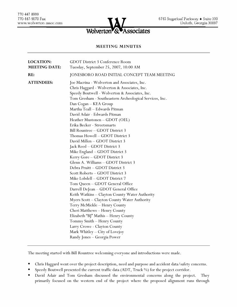
MEETING MINUTES
LOCATION: GDOT District 3 Conference Room MEETING DATE: Tuesday, September 25, 2007, 10:00 AM
RE: JONESBORO ROAD INITIAL CONCEPT TEAM MEETING
ATTENDEES: Joe Macrina - Wolverton and Associates, Inc. Chris Haggard - Wolverton & Associates, Inc. Speedy Boutwell - Wolverton & Associates, Inc. Tom Gresham - Southeastern Archeological Services, Inc. Dan Cogan – KEA Group Martha Teall – Edwards Pitman David Adair - Edwards Pitman Heather Mustonen – GDOT (OEL) Erika Becker - Streetsmarts Bill Rountree – GDOT District 3 Thomas Howell – GDOT District 3 David Millen – GDOT District 3 Jack Reed – GDOT District 3 Mike England – GDOT District 3 Kerry Gore – GDOT District 3 Glenn A. Williams – GDOT District 3 Debra Pruitt – GDOT District 3 Scott Roberts – GDOT District 3 Mike Lobdell – GDOT District 7 Tom Queen – GDOT General Office Darrell DeJean – GDOT General Office Keith Watkins – Clayton County Water Authority Myers Scott – Clayton County Water Authority Terry McMickle – Henry County Cheri Matthews – Henry County Elizabeth “BJ” Mathis – Henry County Tommy Smith – Henry County Larry Crowe - Clayton County Mark Whitley – City of Lovejoy Randy Jones – Georgia Power
The meeting started with Bill Rountree welcoming everyone and introductions were made.
§ Chris Haggard went over the project description, need and purpose and accident data/safety concerns. § Speedy Boutwell presented the current traffic data (ADT, Truck %) for the project corridor. § David Adair and Tom Gresham discussed the environmental concerns along the project. They
primarily focused on the western end of the project where the proposed alignment runs through

Jonesboro Road Meeting September 25, 2007 Page 2 of 4
multiple civil war battlefields. Chris explained that the proposed alignment shown was designed to avoid the civil war trenches which were field verified.
§ Erika Becker discussed the public involvement plan for the project and asked everyone to help enhance her current stakeholder list which she handed out for review.
§ Chris discussed the coordination with other agencies (OEL, SHPO, FHWA), existing structures (bridges, walls), railroad crossings, current project schedule and other projects in the area. Bill stated that the GDOT PM (Harvey Keepler) for the light rail project will need to be invited to the next project meeting.
§ Chris then asked for comments from each of the GDOT offices and local governments represented at the meeting.
§ Heather Mustonen from OEL responded first stating that she had been involved with the archeological process and felt comfortable with the direction of the historical and archeological studies.
§ Debra Pruitt added that the ecologist needed to ensure that they conducted the aquatic survey for mussels and other endangered species that can only be studied during the next few months.
§ Mike England from traffic operations asked if the median spacing would meet GDOT specifications. Chris stated that the proposed median spacing and U-turns would meet GDOT standards.
§ Bill asked about new developments which have been permitted along the corridor and whether they were required to donate right of way or set back their buildings for this project. Thomas Howell responded that GDOT should be permitting these driveways since this is a temporary state route. Mark Whitley stated the City of Lovejoy had permitted a gas station at East Lovejoy Road which was not required to allow for the widening of Jonesboro Road. Bill then asked that this project be considered for all future permits along the project corridor.
§ Keith Watkins spoke next about the impacts to the Clayton County Water Authority’s (CCWA) property and felt the alignment should be revised to reduce impacts to their property. Chris stated that the current alignment will be revised to limit impacts as much as possible.
§ Keith then mentioned that there was a 20 year master plan to convert the spray fields to wetlands. He stated that the currently proposed alignment is impacting an area of the spray fields which would be converted to wetlands in about 10 to 15 years. Chris asked if a copy of this plan could be provided to Wolverton & Associates, Inc. so proposed wetland locations can be concept drawing. Keith stated that he would try to provide that plan in a usable format.
§ Keith mentioned that CCWA had an existing 12” waterline which crosses under the Norfolk railroad and they would like to replace that with a 16” waterline on the new bridge. Kerry Gore asked why they needed to move it to the bridge if they are already under the railroad. Keith stated that they were planning to increase the line size and placing it on the bridge it would be much easier than working with the railroad. Kerry asked Wolverton to take the waterline on the bridge into account in their design.
§ Glenn Williams spoke next about the transmission lines north of Nash Farms and stated that the roadway profile needed to maintain a 30’ clearance below these lines. He also mentioned that an existing AT&T easement is shown between Chambers Road and Mill Road on the Henry County map.
§ Kerry stated that any proposed permanent easements would need to also be utility easements due to the number of proposed utility impacts expected.
§ Kerry also asked that the project work avoid any slick sites if possible.

Jonesboro Road Meeting September 25, 2007 Page 3 of 4
§ Scott Roberts from GDOT right of way commented that Clayton/Henry County needed to try and keep all developments set back from the right of way line, so any future widening would not impact any proposed structures along the corridor.
§ A comment was made asking if early acquisition could be utilized to obtain right of way from any parcel where it is anticipated that right of way will not be donated. The response was that it is possible to get early acquisition, but an individual environmental document would be required for each parcel.
§ Chris then asked if there were any obvious maintenance issues along the project corridor that needed to be addressed. Thomas Howell made the statement that the pavement from the beginning of the project to Mill Road would need to be replaced.
§ Chris then asked the local governments to provide any comments they had on the project. § BJ Mathis stated that Farmer Drive would not require access to Jonesboro Road and could be closed
with a cul-de-sac. § BJ then stated there is a current SPLOST project to extend North Mt. Carmel Road to McCullough
Road on the east side of the Dutchtown schools. Chris asked if a concept alignment and traffic data for this extension could be provided. BJ said the County could provide this information.
§ BJ stated that when any property along the corridor applies for re-zoning she will attempt to make them donate the right of way for this project. She also stated that 4 or 5 properties had recently deeded right of way over to the County.
§ BJ then discussed a four-lane parkway project which would extend Mount Olive Road from Jonesboro Road to Jodeco Road. This project would involve a developer on the north side and the County would extend the road south to Jonesboro Road. Speedy asked if a traffic model had been prepared for the project. BJ stated a model had been prepared and the County would follow-up with that information.
§ BJ questioned how the existing Jonesboro Road would tie into the new roadway near the Nash Farm and Babbs Mill Road. Chris stated that Babbs Mill Road would be extended to the new Jonesboro Road alignment, and that other alternatives are also being considered.
§ Larry Crowe stated that all traffic signal designs and modifications within Clayton County needed to meet County specifications.
§ Larry inquired if the configuration of the Hastings Bridge Road intersection would work. Speedy replied that the intersection had not yet been studied, but the current plan has Jonesboro Road being realigned as the through movement with Hastings Bridge Road being the minor leg.
§ Mike Lobdell then made a comment that a VE study would need to be considered on this project. Chris replied that a VE study would be conducted upon approval of the concept report.
§ David Millen asked if Underground Storage Tank (UST) studies had been performed and who was going to handle them. Chris responded that the UST study had not been done, but they were to be conducted by a sub-consultant.
§ David Millen then asked when a public information open house (PIOH) would be held. It was decided that a PIOH would be held once the concept layout was complete, but prior to holding the concept team meeting. David then stated that an interpreter (Spanish speaking) would need to be present at the PIOH in order to receive local comments.
§ Bill Rountree reiterated that the project limits actually start at the Lovejoy Park entrance and the project imagery would need to be extended on the display for all future meetings.

Jonesboro Road Meeting September 25, 2007 Page 4 of 4
§ Chris then discussed the eastern project limits near I-75. The current traffic volumes indicate the need for a six-lane roadway from Chambers Road to I-75. It was decided that Wolverton would contact FHWA to determine if an Interstate Modification Report (IMR) would be required to do any work on the interstate ramps. Terry McMickle stated that he would contact the Atlanta Regional Commission (ARC) to find out how to include the six-lane widening in the next ARC model. Wolverton will prepare a supplement to the original contract to include the revised project termini in their concept and design.
§ Chris then added that Jonesboro Road would become SR 81 at the completion of the project and all appropriate signage would be included with this project.
Action Items:
1) Edwards Pitman will perform an aquatic survey during October or November to determine if endangered mussels are located on the project.
2) Keith Watkins will provide, if possible, the 20 year plan for the conversion of the CCWA sprayfields to wetlands to Wolverton.
3) Wolverton will contact FHWA to determine whether an IMR will be required for this project. 4) Terry McMickle will contact ARC to have Jonesboro Road from Chambers Road to Mill Road
added to the ARC model. 5) Wolverton will prepare a supplement to the original contract to include the revised project termini
from Mill Road to Interstate 75 in their concept and design.
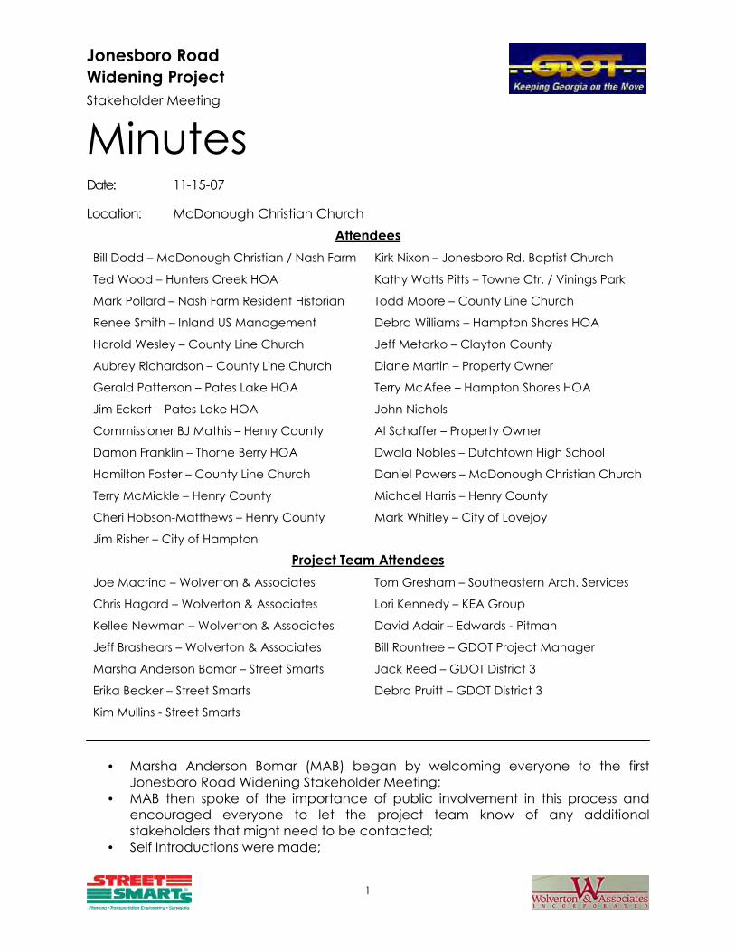
Jonesboro Road
Widening Project
Stakeholder Meeting
1
Minutes Date: 11-15-07
Location: McDonough Christian Church
Attendees
Bill Dodd – McDonough Christian / Nash Farm Kirk Nixon – Jonesboro Rd. Baptist Church
Ted Wood – Hunters Creek HOA Kathy Watts Pitts – Towne Ctr. / Vinings Park
Mark Pollard – Nash Farm Resident Historian Todd Moore – County Line Church
Renee Smith – Inland US Management Debra Williams – Hampton Shores HOA
Harold Wesley – County Line Church Jeff Metarko – Clayton County
Aubrey Richardson – County Line Church Diane Martin – Property Owner
Gerald Patterson – Pates Lake HOA Terry McAfee – Hampton Shores HOA
Jim Eckert – Pates Lake HOA John Nichols
Commissioner BJ Mathis – Henry County Al Schaffer – Property Owner
Damon Franklin – Thorne Berry HOA Dwala Nobles – Dutchtown High School
Hamilton Foster – County Line Church Daniel Powers – McDonough Christian Church
Terry McMickle – Henry County Michael Harris – Henry County
Cheri Hobson-Matthews – Henry County Mark Whitley – City of Lovejoy
Jim Risher – City of Hampton
Project Team Attendees
Joe Macrina – Wolverton & Associates Tom Gresham – Southeastern Arch. Services
Chris Hagard – Wolverton & Associates Lori Kennedy – KEA Group
Kellee Newman – Wolverton & Associates David Adair – Edwards - Pitman
Jeff Brashears – Wolverton & Associates Bill Rountree – GDOT Project Manager
Marsha Anderson Bomar – Street Smarts Jack Reed – GDOT District 3
Erika Becker – Street Smarts Debra Pruitt – GDOT District 3
Kim Mullins - Street Smarts
• Marsha Anderson Bomar (MAB) began by welcoming everyone to the first
Jonesboro Road Widening Stakeholder Meeting;
• MAB then spoke of the importance of public involvement in this process and
encouraged everyone to let the project team know of any additional
stakeholders that might need to be contacted;
• Self Introductions were made;

2
• Joe Macrina (JM) explained the GDOT Plan Development Process;
• Chris Haggard (CH) gave a brief overview of the project and its potential issues;
• JM reminded the group that the project was still in the concept phase;
• CH added that construction wouldn’t begin until 2011;
• Bill Rountree (BR) stated that the project is still considered long range and that he
doesn’t know exactly when the project will be let.
• MAB explained that Input Forms would be used to gauge the group’s level of
concern regarding specific issues related to the project.
• MAB briefly discussed Input Form 1, “What are your issues with the present
transportation system?” and asked if there were issues that should be added to
the form. As a result, “Special Event Traffic” and “Roadway Geometry” were
added to Input Form 1.
• The following presents, in descending order, how the group ranked the concerns
listed on Input Form 1:
1. High Morning Traffic Volumes
2. High Evening Traffic Volumes
3. High Weekend Traffic Volumes
4. Congestion from Local Traffic
5. Safety during the Daylight Hours
6. High Seasonal Traffic Volumes
7. Safety during the Nighttime Hours
8. High Nighttime Traffic Volumes
9. Presence of Large Trucks
10. High Midday Traffic Volumes
11. Special Event Traffic 12. Roadway Geometry
13. Bicyclists Conflicting with Vehicles
14. Pedestrians Conflicting with Vehicles
• MAB briefly discussed Input Form 2, “What are your concerns if Jonesboro Road is
not widened/improved?” and asked if there were issues that should be added to
the form. As a result, “Response Time for Emergency Vehicles”, “Current Speed
Limit Too High” and “Increased County Maintenance Cost” were added to Input
Form 2.
• The following presents, in descending order, how the group ranked the concerns
listed on Input Form 2:
1. Increased Traffic Congestion
2. Increased Accidents
3. Medical Facilities Emergency Access
4. Response Time for Emergency Vehicles
5. Access to Businesses Along the Corridor
6. Residential Access Along the Corridor
7. Increased County Maintenance Cost
8. Increased Vehicular Speeds
9. Current Speed Limit Too High

3
• MAB briefly discussed Input Form 3, “What benefits will result from Jonesboro
Road construction?” and asked if there were issues that should be added to the
form.
• BR stated that the state legislature has already determined that Jonesboro Road
will receive the SR 81 designation.
• As a result, “State Takes Over Maintenance”, “Shorter Travel Time” and
“Pedestrian and Bicycle Lanes” were added to Input Form 3.
• The following presents, in descending order, how the group ranked the concerns
listed on Input Form 3:
1. Safer Vehicular Movement
2. Better Emergency Access
3. Better Access to Existing Businesses
4. State Takes Over Maintenance
5. Shorter Travel Time
6. Better Access to Existing Residences
7. New Business Development Areas
8. Pedestrian and Bicycle Lanes
• MAB briefly discussed Input Form 4, “What are your concerns regarding the
construction on Jonesboro Road?” and asked if there were issues that should be
added to the form. As a result, “Emergency Access”, “Environment, i.e. Dust and
Dirt”, “Utility Outages”, “Detours”, “Access to Churches” and “Construction Time”
were added to Input Form 4.
• The following presents, in descending order, how the group ranked the concerns
listed on Input Form 4:
1. Impact on Local Neighborhoods
2. Additional Congestion
3. Reconstruction of Intersecting Roads
4. Safety During Construction
5. Acquiring ROW
6. Impact on Wetlands / Environment
7. Cost
8. Impact on Existing Small Businesses
9. Impact on Historical Sites
10. Emergency Access
11. Impact on Existing Large Businesses
12. Impact on Pedestrians and Bicyclist
13. Construction Time
14. Utility Outages
15. Environment
16. Detours
17. Access to Churches
• MAB stated that while the project team is working to tally the results of the four
input forms she would like to open the floor to discussion of any and all issues that
4
people are concerned about and would like to express. • A stakeholder expressed concern that Jonesboro Road residents aren’t involved
in public meetings. • MAB informed her that the upcoming Public Information Open House (PIOH) and
Public Hearing Open House (PHOH) will include everyone in the affected area. • A stakeholder asked if any new traffic signals are being proposed. • MAB informed the group that a traffic study is being performed for this project as
a part of the design process to determine if such an improvement is needed. • A stakeholder stated that he felt that a typical section with bike lanes and
sidewalks would necessitate lighting and that crime might increase if no lighting
is integrated into the design. • A stakeholder stated that access to schools and school crossings are an issue. • A stakeholder suggested a pedestrian tunnel or bridge may be warranted to
provide safer access to the Dutchtown schools. Also, stamped concrete and
landscaping should be added to the design; federal money can be used for
elements that will contribute to “character areas” of the County. • A stakeholder stated that McCullough Road has a dangerous skew and that it
needs to be brought in at a 90 degree angle.
• BR reminded the room that intersection improvements require additional Right-
of-Way.
• A stakeholder commented that truck traffic and noise are big issues already. He
commented that further widening would increase truck traffic and suggested
sound barriers to decrease the noise.
• MAB suggested that the improvements would reduce trucks stopping and
starting, which is where most of the noise comes from. She also stated that an
Air/Noise study would be performed as part of the environmental process to
determine the need for sound barriers.
• A stakeholder from Vinings Park asked how access to the property would be
affected.
• MAB stated that a concrete median would limit individual’s access, but that
signals could improve access at median openings.
• A stakeholder stated that she was concerned that the four-lane parkway at
Dutchtown High School will connect to the Flippen Road extension.
• A stakeholder stated that there is a plan to connect Flippen Road to Jonesboro
Road using SPLOST money and the connection of the four-lane parkway will be
part of that project.
• A stakeholder expressed concern about increased truck traffic due to the
widening and the SR designation and congestion on the other side of I-75.
• CH added that the traffic study will include I-75 and the design will incorporate
this; GDOT will determine how to handle this and set the termini.
• MAB asked if the project could be broken down into separate
projects/contracts.
• BR stated that the project might be broken down into separate
projects/contracts for construction funding and congestion issues.
• A stakeholder asked who will rebuild the affected land on private property such
as neighborhood signs, sprinklers, etc.
• BR responded that this cost will be a part of the ROW negotiations and that they
5
will be put back. He also reiterated that many factors will affect how much ROW
is needed.
• A stakeholder asked about Clayton County Water Authority’s involvement and
asked if widening to the other side of the road had been considered to avoid
LaCosta.
• CH replied that we have been in constant contact with Clayton County.
• JM reiterated that there are several features along the road that constitute a
constraint.
• A stakeholder asked if special consideration is given to churches.
• Lori Kennedy (LK) answered yes and discussed that there are trade-offs that must
occur in determining which resources take precedent.
• A stakeholder asked if only churches are considered or if church yards are
considered as well.
• A stakeholder asked what constitutes a historic property.
• David Adair stated that an age of 50 years, types of architecture, important
events that occurred there, association with important persons, etc. contribute
to the determination of a property’s eligibility.
• LK added that only properties eligible for the historic register are avoided and/or
mitigated; temporary resources aren’t determined because the state hasn’t
given final word.
• BR added that justification and documentation are necessary when impacting a
property and that it is a lengthy, sometimes court involved process. Therefore,
the state would rather avoid historic properties.
• A stakeholder asked what will happen west of Tara Boulevard.
• BR stated that there is another project which will widen McDonough Road and it
is on a similar schedule to the Jonesboro Road project.
• MAB discussed tallies of the four input forms. She stated that she will distribute a
summary to all participants.
• BR asked if meeting attendees could add comments later.
• MAB provided an e-mail and mailing address to send comments with a deadline
of November 30, 2007.
• A stakeholder asked when a ROW representative would be involved.
• MAB stated that a ROW representative would be at the PIOH, which will be held
in February or March 2008.
• MAB asked the stakeholders if there was anyone or group missing from the
discussion that should be involved.
• Stakeholder responses included: Marsha’s Vineyard, the proposed church west
of Marsha’s Vineyard, emergency response personnel, Crystal Lake subdivision,
residents along Jonesboro Road that don’t live in a subdivision.
• Tom Gresham gave an overview of the historical / archeological resources
related to the project. He explained that there are several resources along the
project corridor and reiterated that most of the focus is on the battlefield. He
also explained in detail the location of trenches and the number of camps.
• LK reiterated that the battlefield add an additional element to the project.
• BR expressed concern about the large archeological boundary and about
potentially impacting the area due to its large size.
• LK stated that coordination and mitigation will hopefully result in a “No Adverse
Effect” finding.

6
• A stakeholder commented that there are additional trenches not shown on the
display boards and that further investigation of these trenches may be needed.
• JM stated that the state historic preservation office gave indication that a “No
Adverse Effect” finding is likely.
• A stakeholder commented that there are several areas of historic significance
along Jonesboro Road to be considered, i.e. it was a stagecoach route.
• MAB closed the meeting by thanking the group for their participation and stated
that everyone will receive a copy of the meeting minutes.

MEETING MINUTES
LOCATION: GDOT District 3 Conference Room MEETING DATE: Thursday, May 22, 2008, 10:00 AM
RE: JONESBORO ROAD CONCEPT TEAM MEETING
ATTENDEES: Joe Macrina – Wolverton &Associates, Inc. Chris Haggard – Wolverton & Associates, Inc. Mario Macrina – Wolverton & Associates, Inc. Kellee Newman – Wolverton & Associates, Inc Matt Houser – QK4 Dale Youngkin – KEA Group David Adair – Edwards Pitman Bill Rountree – GDOT District 3 Thomas Howell – GDOT District 3 David Millen – GDOT District 3 Jack Reed – GDOT District 3 Tom Queen – GDOT District 3 Glenn Tyson – GDOT District 3 Debra Pruitt – GDOT District 3 Kerry Gore – GDOT District 3 Sue Anne Decker, GDOT District 3 Darrell DeJean – GDOT Road Design Matt Sanders – GDOT Road Design Roque Romero – Henry County SPLOST Chae H. Yi – Henry County SPLOST Cheri Hobson-Matthews – Henry County David Simmons – Henry County Shane Hallford – Henry County WSA Randy Crumbley – Henry County WSA Fritz Jacques – Henry County WSA Mark Whitley – City of Lovejoy Andy Adams – Clayton County Keith Watkins – Clayton County Water Authority Gary Jenkins – at&t Corporation/Byers Engineering Co. Russ Adamson – at&t Corporation
The meeting started with a welcome from Bill Rountree, and meeting attendees introduced themselves. � Chris Haggard gave an overview of the project, highlighting potential issues to be discussed during the meeting. � Chris proceeded to read the concept report. � Bill questioned if a state map should be included on the concept report cover, and it was resolved that the cover is
okay the way it is.

Jonesboro Road Meeting May 22, 2008 Page 2 of 3
� Bill asked if a value engineering (V.E.) study will be required. � Chris stated that a V.E. study had been requested, but Lisa Myers (GDOT Office of Engineering Services) requested
to wait until the concept was approved before one was scheduled. It was decided that the request would be resubmitted to schedule the study.
� David Millen asked about the discrepancy in project length stated in the concept report and the Atlanta Regional Commission (ARC) description. He then noted that Wolverton & Associates (W&A) needed to let Cindy Van Dyke (GDOT Office of Planning) know the project limits have changed due to concept, and the ARC model needs to be updated.
� It was noted that the project open year should be changed from 2014 to 2013 on page 5 of the concept report. � Bill stated that the grade of all driveways be designed to remain under 11%, if possible. � David Adair stated that the history study had been submitted to the State Historic Preservation Office (SHPO), and
the only outstanding issue was the cemetery located behind the County Line Congregational Christian Church. Chris then said the boundary of the cemetery would not be impacted by the project.
� David Simmons indicated that Henry County has plans to realign Mitchell Road to Jonesboro Road at a location further west than the design proposes. He stated that Henry County plans to propose a right-in, right-out intersection at McCullough Road and that the County also has a project to extend Flippen Road to intersect with N. Mt. Carmel Road at Jonesboro Road. W&A will request the proposed layout of these projects from Henry County to include on the project layout.
� Henry County stated that there are several adjacent projects that aren’t included in the concept report, and plan to compile a list that will be sent to W&A for inclusion in the report.
� Matt Sanders noted that the schedule dates listed for the adjacent GDOT project, PI No. 742870, should either be deleted from the concept report or replaced with “long range” because dates for the project aren’t anticipated until project prioritization has been completed.
� Bill stated that 24 months needs to be added to the project schedule for railroad coordination. � Kerry Gore noted that utilities will need 120 days for proposed utility locations, and the project schedule should be
revised to include this. Chris explained that the 120 days would be included in the final plans schedule. � at&t asked if construction times presented in the concept report are concurrent. Bill responded that the
environmental and right-of-way phases will drive the project schedule, and a number of the phases will happen concurrently.
� Bill asked how logical termini issues at US 19/41 will be resolved to ensure adherence of the proposed design to the ARC model. Chris stated a meeting with FHWA will be scheduled to discuss the logical termini issues.
� Bill asked that project contingencies for the cost estimate be coordinated with Genetha Rice-Singleton (GDOT Office of Preconstruction). He stated that Jack Reed will send W&A an e-mail concerning the directives from the office regarding the contingencies.
� Jack requested a construction cost estimate be created using the DETEST program.
� Kerry stated that there is a 30″ water line along the Central of Georgia railroad, and indicated that utility costs will increase once the relocation cost for this line is included in the estimate.
� It was noted that a traffic engineering study will need to be prepared for each proposed signalized intersection along the project.
� Michael Presley suggested that W&A verify if the project should include ITS design in accordance with the GDOT Statewide ITS Deployment Plan.
� It was noted that W&A will verify if P&E cost need to be included in benefit-cost ratio calculations. � Clayton County Water Authority expressed that the spray field land south of the realignment will not be used for
wetland conversion. Chris responded that this land would be discussed further with the County during right-of-way acquisition.
Jonesboro Road Meeting May 22, 2008 Page 3 of 3
� Kerry indicated that approximately ten feet of right-of-way be maintained in back of proposed retaining walls for underground utilities, and that overhead clearance distance must be clarified. Chris stated that right-of-way would be acquired to allow for construction of the retaining walls and adequate room for utilities would be acquired as requested.
� Sue Ann Decker asked if the fatality rate of 10.95 was accurate, and noted that it appeared to be high. Chris responded by stating that 10.95 was a rate per million vehicle miles, and there had actually only been one fatality in the area.
� Kerry requested that test holes should be utilized to determine water line locations on the project. � Bill stated a subsurface utility engineering (SUE) meeting will be held soon. � Chris noted that a utility impact analysis will also be performed to help identify the best locations to use test holes. � Concern was expressed about the proximity of traffic signals at Mt. Olive and Center Village Terrace.
A suggestion was made for W&A to look at proposing a right-in, right-out drive at Center Village Terrace, creating access for the commercial development onto Mt. Olive, and maintaining the signal at Mt. Olive. W&A will evaluate the feasibility of this suggestion.
� Andy Adams stated that a raised median is being installed at an access road approximately 400 feet west of US 19/41 that currently provides an entrance and exit to several commercial facilities. He recommended constructing a “connector” road that would direct traffic from the existing access road to the park entrance where there is a median opening that will likely be signalized in the future. Chris responded that the suggestion will be evaluated with the proposed design.
� It was noted that the design will be coordinated with the park. � Chris stated that right-of-way will be acquired with this project to match the adjacent GDOT project. Additional Comments Received: � Cheri Hobson-Matthews, Henry County Transportation Planning – Page 3: the Joint Comprehensive
Land Use Plan population is estimated at 429,360 over the next 20 years. Adjacent Henry County projects are: Jodeco at I-75; Eagle’s Landing Parkway from Talon Place to SR 42; East Lake Road Extension, Phase II. Additional project information, including project ID numbers, will be emailed.
� Matt Sanders, GDOT Road Design – Look at using joint drives at extreme western part at the southwest quadrant of the intersection of McDonough Road with US 19/41.
Action Items: � Henry County Transportation Planning will compile a list of adjacent projects and send to W&A. � GDOT District 3 will e-mail W&A with directive concerning contingencies as per the GDOT Office of
Preconstruction. � W&A will make revisions to concept report, as discussed in the meeting. � W&A will provide all adjacent projects to KEA for inclusion in the revised Need & Purpose statement. � W&A will evaluate modifications to Mt. Olive Road. � W&A will evaluate inclusion of GDOT Statewide ITS Deployment Plan. � W&A will create a cost estimate using the DETEST program. � W&A will submit an updated V.E. request form to Bill Rountree. � W&A will coordinate the inclusion of an access road for the park. � W&A will contact Cindy Van Dyke to coordinate the revised project limits for the ARC model.


OPEN HOUSE HANDOUT
Georgia Department of Transportation Widening and Reconstruction of Jonesboro Road from
0.25 miles west of US 19/41 to Interstate 75 Project STP-1583(12) – Clayton, Henry Counties
Project STP-1583(12) is proposed to improve 7.7 miles of Jonesboro Road from 0.25 miles west of US 19/41 in Clayton County to I-75 in Henry County. This project proposes widening the existing two-lane Jonesboro Road to a four-lane roadway with turn lanes as needed. The existing typical section consists of two 12-foot lanes with 10-foot grass shoulders. This project proposes an urban typical section consisting of four 12-foot lanes with a 20-foot to 32-foot raised median (grass/concrete), 4-foot bike lanes, curb & gutter and 5-foot sidewalks. The widening of the existing roadway shifts from one side to the other in a number of places to avoid environmental resources and minimize property impacts. Intersection improvements, including turn lanes and intersection realignments, will also be included for a number of side roads along the project corridor. The required right-of-way varies from 108 to 168 feet along Jonesboro Road.
Jonesboro Road Summary of Improvements • Widening Jonesboro Road from two to four 12-foot lanes (2 lanes in each direction) • The addition of a 20-foot to 32-foot raised median (grass/concrete) at locations shown
on displays • The addition of curb & gutter and 5-foot sidewalks • Median openings will be provided at paved side roads and at a minimum spacing of
1000 feet where possible • Left turn deceleration lanes at all median openings (dual left turn lanes as necessary) • Right turn deceleration lanes at all paved side roads • Existing right turn deceleration lanes at driveways will be replaced where possible • Additional pavement for U-turn movements will be provided at median breaks where
possible • New traffic signals at the intersections of Hastings Bridge Road, Mitchell Road,
McCullough Road, and Mt. Olive Road • Realignment of intersections of Hastings Bridge Road, Babbs Mill Road, E. Lovejoy
Road, Marsha’s Vineyard, and McCullough Road • Bike lanes will be provided for the entire length of this project • Bridge replacements over Central of Georgia Railroad and Walnut Creek • The construction of an additional right-turn lane on I-75 SB exit ramp • The construction of an additional left-turn lane on I-75 NB exit ramp • The introduction of an additional eastbound left-turn lane on Jonesboro Road at I-75 NB
entrance ramp

BEGIN PROJECT STP-1583(12)
END PROJECT STP-1583(12)
BEGIN PROJECT STP-1583(12)
Georgia Department of Transportation Widening and Reconstruction of Jonesboro Road from
0.25 miles west of US 19/41 to Interstate 75 Project STP-1583(12), Clayton, Henry Counties
P.I. No. 342970
JONESBORO ROAD
I-75
US 19/41
LOCATION SKETCH
CENTRAL OF GA RR BRIDGE
BRIDGE OVER WALNUT CREEK
NASH FARM

GENA L. ABRAHAM, PhD BUDDY GRATTON, P.E. COMMISSIONER DEPUTY COMMISSIONER
(404) 656-5206 (404) 656-5212
GERALD M. ROSS, P.E. EARL L. MAHFUZ CHIEF ENGINEER TREASURER
(404) 656-5277 (404) 656-5224
June 12, 2008
x x x
Dear : Thank you for your input regarding the proposed widening of Jonesboro Road to a four lane divided roadway from just west of US 19/41 in Clayton County to the I-75 interchange in Henry County, Project STP-1583(12), P.I. #342970. Your interest in this project and your comments are sincerely appreciated. Your comments will be made a part of the official record for the project. Approximately 200 citizens attended the public information open house held on Thursday, March 27, 2008. From the attendees, 51 comment cards were received and 3 oral comments were submitted to the court reporter. After the meeting, 1 comment was sent to GDOT and 6 comments were submitted on the Public Outreach website. Of the comments we received, 30 were in support of the project, 7 were opposed to the project, 13 were conditional, 7 were uncommitted, and 4 did not specify. The attendees at the Public Information Open House and those persons that sent in comments raised the following questions and concerns. The Georgia Department of Transportation (GDOT) has prepared this letter to address these comments so that all interested parties can be aware of the concerns raised and the responses given. Please find the comments, concerns, and questions listed below, along with their responses. Comments and Responses
Comment 1: Sooner is better. Let's get ahead of the congestion. Comment 2: It is much needed. Comment 3: ASAP. Comment 4: Badly need Jonesboro Road widened. Please make the project a priority.

Project STP-1583(12) - Clayton and Henry Counties Page 2 June 12, 2008
Comment 5: I think it looks great. I believe it should move forward ASAP to handle the enormous amount of traffic and improve the road conditions. Comment 6: Agree with widening, increased traffic and road improvements demand a new roadway. There are many dangerous curves along current route. Like the use of raised median with turn lanes. Comment 7: This project is currently a major connector and arterial which serves a large volume of traffic during on and off peak periods. Much needed. Comment 8: The road upgrade will greatly help the increase in traffic volume and improve stretches of the current road that are hazardous due to curves and grade levels. Comment 9: Several positive aspects of proposal. Comment 10: I wish the timeline for this was sooner. Traffic on this major artery is outrageous. Comment 11: I have concerns about the state's ability to fund the project. I hope that the project gets some priority. Comment 12: Should have been done 10 years ago! GDOT should be more proactive to the needs of growing communities. We surely do not get our proportional tax dollars. Response for comments 1-12: The Georgia Department of Transportation appreciates your input. GDOT prioritization, based on the project’s need and funding, will determine the schedule of the project. Comment 13: Support project as long as it does not take any of our property for additional easement. Response: Right-of-way impacts will be further evaluated during the preliminary design phase to minimize property impacts. The roadway alignment is currently being developed to minimize overall impacts. Additional site visits and further evaluation of the proposed alignment will be conducted throughout the design process in order to minimize impacts. Comment 14: I want my property to go commercial. Comment 15: Open the zoning up for some growth, i.e. Henry County jobs. Response for comments 14-15: The Georgia Department of Transportation does not administer property zoning designations. All zoning requests should be made to the appropriate local agency. Comment 16: Need more detail at the Thorne Berry subdivision. Leader lines and labels cover my house. Need owner name labeled. Response: Roadway plans will be developed during the preliminary design phase, and at that time, greater detail about the impacts to all properties will be known. Comment 17: While a much needed project, cars speed in excess of 60 mph on the existing 2 lane road. I cannot imagine how fast they will travel on a wide 4 lane road. Response: The proposed roadway widening is necessary to accommodate projected traffic at an adequate level of service. The posted speed will remain 45 mph, and speed control should be addressed by local law enforcement.

Project STP-1583(12) - Clayton and Henry Counties Page 3 June 12, 2008
Comment 18: Bike lanes on a major thoroughfare are useless and dangerous and should be eliminated. Cost to use ratio is astronomical and the danger to cyclists and motorists make it something to eliminate. Response: The proposed project will facilitate vehicular, pedestrian and bicycle traffic along the corridor. The Atlanta Regional Commission identifies the Jonesboro Road corridor in the Atlanta Region Bicycle Transportation and Pedestrian Walkways Plan, and recommends the inclusion of bike lanes on Jonesboro Road to safely accommodate bike traffic. Comment 19: I plan to develop our property into a commercial or office complex in the next one to two years and would like to have an access through the median for better traffic flow into and out of our property. Response: During the next phases of the design, the location of additional median breaks will be determined, if required. All zoning and permitting requests should be made to the appropriate local agency. Comment 20: Red light at Mt. Olive is past due! It can't wait until 2013. The church was the first development west of I-75. Recent development has trumped our light. What happened to common sense?! Comment 21: I feel that a red light at Mitchell Road and Jonesboro Road is needed now because of student drivers, school buses and parent drivers. Comment 22: The year 2013 is too late for a traffic light at Mitchell Road. School bus and student safety is at risk! Comment 23: Will any traffic signals be installed before the project is begun? Or will they be installed in conjunction with the road widening. Response for comments 20-23: A signal warrant analysis was completed for Jonesboro Road at each public road/intersection. The Manual on Uniform Traffic Control Devices (2003 Edition) establishes eight (8) different warranting conditions that are used to assist in evaluating the need for a traffic signal. The analysis determined that signals are warranted at Hastings Bridge Road, McCullough Road, Mitchell Road and Mt. Olive Road at the proposed build year (2013). Signals at these intersections will be installed during project construction. Any further questions regarding the current need for signals at these locations should be directed to your local agency. If the local agency applies for a traffic signal permit, it is approved prior to the build year for the project and they provide funding, traffic signals could be installed sooner. Comment 24: We need traffic control light at intersection of Pate Lake Way and Jonesboro Road since you all are dumping all traffic to one entrance for Marsha's Vineyard subdivision and Pates Lake subdivision. Thanks Comment 25: Would like a light at Pates Lake subdivision as a safety precaution for our young drivers and to prevent congestion. Comment 26: Need traffic light at Jonesboro Road and Crown Park Drive. Response for comments 24-26: Based on the signal warrant analyses for the intersections of Pates Lake Way and Crown Park Drive, traffic signals are not warranted by the anticipated date of construction and will not be constructed with this project.

Project STP-1583(12) - Clayton and Henry Counties Page 4 June 12, 2008
Comment 27: Should close McCullough Road, cul-de-sac and eliminate the traffic light proposed there. Comment 28: It would make much more sense to make McCullough Road a cul-de-sac. I understand this was discussed instead of rerouting at Jonesboro Road. It would probably prove to be much cheaper and it makes more sense. Response for comments 27, 28: Projected traffic volumes warrant a median opening and traffic signal at this intersection. Comment 29: The cedar trees along the road at 2080 Jonesboro Road are on the ROW and were not planted and are less than 50 years old. Response: This information will be forwarded to the project historian for further evaluation. Thank you for this information. Comment 30: Property lines incorrect. Our property shows just 1 lot, but actually should be 2 lots. Lot marked John Livery, but his property is the lot west of ours. Response: As the project progresses, property lines will be verified and the project information will be revised. Comment 31: At this time, I am not opposed to this project; however, I would like additional information on how this will affect our properties. I do not want Farmer Drive closed because of the Jonesboro Road widening-project. By closing off this road, it affects our access. Based on your proposed renderings, it appears that there will be a solid median in front of our property and extending to Chambers Road, therefore, we would have to make a U-turn with our truck and trailers in order to go west on Jonesboro Road. We have been in discussions with the county; it is unclear as to why this is proposed. Response: The intersection of Farmer Drive was requested to be closed by Henry County. The impacts of the proposed road closure will be further evaluated during the preliminary design phase. Median openings are spaced at a maximum distance of ½ mile and at public roads (where possible) throughout the project corridor. The need for additional median openings will be further evaluated in the preliminary design phase. Comment 32: We live on Jonesboro Road and don't look forward to a larger road, attracting more traffic, taking our front yard. Response: The proposed project corridor is designed to accommodate projected traffic and operate at an adequate level of service in the design year (2033). Right-of-way impacts will be further evaluated during the preliminary design phase to minimize property impacts. The roadway alignment is currently being developed to minimize overall impacts. Additional site visits and further evaluation of the proposed alignment will be conducted throughout the design process in order to minimize impacts.
Project STP-1583(12) - Clayton and Henry Counties Page 5 June 12, 2008
Comment 33: Just wish my husband wouldn't have to pull out of our driveway and drive 1 mile to the west before he could make a u-turn at Babbs Mill so he can drive east to get to work. Wish I didn't have to drive half mile past our house before I can make a legal u-turn and head back to the west to pull in my driveway on the way home from work. Response: Median openings are spaced at a maximum distance of ½ mile and at public roads (where possible) throughout the project corridor. The need for additional median openings will be further evaluated in the preliminary design phase and presented at future meetings.
Comment 34: It will take a lot of my property and with the divided (median) be hard to make a left hand turn. It would be better if a turn lane was down our end so all the home owners can get in and out of their driveways in either direction. Also I feel you can cut the curve by Pates Lake straighter by going more into unbuilt property across from me and into the wetlands. Response: Right-of-way impacts will be further evaluated during the preliminary design phase to minimize property impacts. The roadway alignment is currently being developed to minimize overall impacts. Additional site visits and further evaluation of the proposed alignment will be conducted throughout the design process in order to minimize impacts. Raised medians are required by GDOT policy due to the high projected traffic volumes (37,750 vehicles per day). A raised median reduces conflicts with opposing traffic, reduces collisions, and provides greater vehicle and pedestrian safety. A left-turn/u-turn lane will be provided at each median opening, which will allow for left-turn and u-turn movements. Comment 35: Devalue of our property. Removal of our property by re-routing the road leaving us in a cul-de-sac. Response: Property values over time fluctuate based on a variety of factors such as infrastructure improvements (or lack thereof), school districts, zoning (current and planned), etc., and future values simply cannot be accurately predicted (up or down). Right-of-way impacts will be further evaluated during the preliminary design phase to minimize property impacts. The roadway alignment is currently being developed to minimize overall impacts. Additional site visits and further evaluation of the proposed alignment will be conducted throughout the design process in order to minimize impacts. Comment 36: It will bring more traffic and can't make a left-hand turn. Response: The roadway is being designed to accommodate the projected traffic. Left-turn lanes will be provided at each median opening. Comment 37: I oppose the project and don't agree with the analysis of the traffic on Jonesboro Road. I completely oppose the renaming of Jonesboro Road to SR 81. Once that takes place the traffic will increase exponentially compared to what it is now. Response: The route will be designated as SR 81 after the improvements have been made, as legislated. Any change to the route designation, other than what was dictated, would have to go back through the state legislature.
Project STP-1583(12) - Clayton and Henry Counties Page 6 June 12, 2008
Comment 38: Do not use sound walls; line the road with trees so the houses and businesses are not seen; do not put a median; do the part into McDonough first as it is far more needed; I can get across a 2 lane road, but not a 4 lane road without endangering myself. Response: A noise study will be performed during the environmental phase, and noise abatement will be implemented where feasible and reasonable. Raised medians are required by GDOT policy due to the high projected traffic volumes (37,750 vehicles per day). A raised median reduces conflicts with opposing traffic, reduces collisions, and provides greater vehicle and pedestrian safety. A left-turn/u-turn lane will be provided at each median opening, which will allow for left-turn and u-turn movements. Comment 39: Will there be a sound barrier? Will there be a turning lane into the subdivision off of Jonesboro Road? Will there be road signs indicating entrance into subdivision? Response: A noise study will be performed during the environmental phase and noise abatement will be implemented where feasible and reasonable. Left-turn/U-turn lanes will be designed at all median breaks. At all intersections, right-turn lanes will be evaluated on the basis of need and will be constructed if they are recommended. All existing subdivision signs that will be impacted will be addressed during right-of-way negotiations. Comment 40: The project will cut out church exposure to public and to main road access. Can a direct driveway to new Jonesboro Road be provided? Response: All properties with current access to Jonesboro Road will retain access to the proposed roadway Comment 41: How can state money be committed to a non-state road? How can the State and County spend money on a project when there are projects unfinished from previous SPLOST projects? i.e., Eagle Landing Parkway Extension; McDonough one-way pairs project does not show extension of Flippen Road. Approved by voters in SPLOST 1? Response: Jonesboro Road received temporary state route designation as SR 920 due to legislation mandating the eventual permanent route designation as SR 81. Non-state routes can receive temporary designations as state routes so that federal and state funding can be used to upgrade the facilities. The Jonesboro Road widening project will not use any Henry County SPLOST funding. Comment 42: At the start of this project, the County came in and took a fairly flat piece of property that was very manageable and cut a slope about 20' high out of a 3 to 1 grade that I have to maintain. We need a 4 to 1 slope and probably some kind of wall to come in front of our property. I would appreciate this being done without cutting a 200 year old tree that we managed to save. The County already cut 50+ trees down that I feel didn't need to be. And I would like not to have a concrete median in front of my driveway because I will have to turn right every time I pull out of my driveway, go up the street and turn around and come back. Help! Response: Right-of-way impacts will be further evaluated during the preliminary design phase to minimize property impacts. Raised medians are required by GDOT policy due to the high projected traffic volumes (37,750 vehicles per day). A raised median reduces conflicts with opposing traffic,

Project STP-1583(12) - Clayton and Henry Counties Page 7 June 12, 2008
reduces collisions, and provides greater vehicle and pedestrian safety. It will be determined during the design process where additional median openings can be proposed. Proposed locations of additional median openings will be determined during the design process. Comment 43: Will the DOT install a privacy fence along the right of way and my property line? I'm concerned about getting in and out of my subdivision (Oak Grove) in other words - a traffic light. Response: This intersection does not warrant a traffic signal by the anticipated date of construction and will not be constructed with this project. Median openings will be further evaluated in the preliminary design phase. The replacement of any existing fences impacted by this project will be coordinated during the right-of-way acquisition phase of the project. Any further questions can be directed to the GDOT right-of-way office.
Comment 44: To provide the needed line of sight for safe turns out of the subdivisions, the hill between Thorne Berry Drive and Luke Cove will have to be flattened. I am sure that the speed of traffic on the 4-lane road will increase from the present average of 55 mph. Response: All design will comply with current American Association of State Highway and Transportation Officials (AASHTO) and Georgia Department of Transportation (GDOT) standards. The posted speed will remain 45 mph, and speed control should be addressed by local law enforcement. Comment 45: How is this project going to affect my property? We live right on Jonesboro Rd, across from County Line Church with a four lane and a divider, the noise will increase. With the current two lane we already have the noise is almost unbearable. My concern is how it will affect my property. Will my property value decrease because of this project? Response: A noise study will be performed during the environmental phase and noise abatement will be implemented where feasible and reasonable. Property values over time fluctuate based on a variety of factors such as infrastructure improvements (or lack thereof), school districts, zoning (current and planned), etc., and future values simply cannot be accurately predicted (up or down). Comment 46: My concerns are for families getting in and out of driveways. We already have to wait for traffic. Also for the increase truck traffic. Response: A raised median reduces conflicts with opposing traffic, reduces collisions, and provides greater vehicle and pedestrian safety. Left-turn/U-turn lanes will be designed at all median breaks. Comment 47: RESOLVED: That the membership of County Line Congregational Christian Church, individually and collectively, expresses its objection to any encroachment on its present property for purposes of widening Jonesboro Road. Response: Right-of-way impacts will be further evaluated during the preliminary design phase to minimize property impacts. The roadway alignment is currently being developed to minimize overall impacts. Additional site visits and further evaluation of the proposed alignment will be conducted throughout the design process in order to minimize impacts.

Project STP-1583(12) -Clayton and Henry CountiesPage 8June 12, 2008
If you have questions, please contact Bill Rountree of the GDOT District 3 Office at (706) 646-6990.
Sincerely, ,
~ /tf: f//l..-~(( Glenn Bowman, P .E.
State EnvironmentaIlLocation Engineer

*Db (hrs) 0.187ADT 38,000.00Tb ($s) $244,268,750.00
Db (hrs) 0.187% Truck Traffic 0.05ADT 38,000.00CMb $64,531,362.50
ADT 38,000.00Fb ($s) $85,123,958.33
Total Congestion Benefit $393,924,070.83Total Project Cost $95,485,703.00
B/C Ratio 4.13
Fuel Savings Benefit (Fb)
Person Time Savings Benefit (Tb)
Commercial or Truck Time Savings Benefit (CMb)
PI NO. 342970
Clayton/Henry County
Jonesboro Road
Congestion Benefit = Tb + CMb + Fb
Benefit Cost Analysis Work Sheet CONGESTION Projects
STP00-1583-00(012)

*Reduction in delay or Delay Benefit (Db) can be
defined as the difference between the peak hour
travel time through the corridor without the
proposed improvement and the peak hour travel
time through the corridor with the proposed
improvement.

DEPARTMENT OF TRANSPORTATION STATE OF GEORGIA
__________ INTERDEPARTMENT CORRESPONDENCE
FILE STP00-1583-00(012), Clayton/Henry Counties OFFICE District 3
P.I. Number: 342970 DATE 6/30/08 FROM: Bill Rountree, PE, District 3 Design Engineer TO: Genetha Rice-Singleton, Assistant Director of Preconstruction SUBJECT: Request for Location and Design Approval
Description and Project Proposal: Project STP00-1583-00(012) is proposed to improve 7.7 miles of Jonesboro Road from 0.25 miles west of US 19/41 at milepost 3.29 in Clayton County to I-75 at milepost 5.36 in Henry County. This project proposes widening the existing two-lane Jonesboro Road to a four-lane roadway with turn lanes as needed. This project proposes an urban typical section consisting of four 12-foot lanes with a 20-foot to 32-foot raised median (grass/concrete), 4-foot bike lanes, and 12-foot to 16-foot shoulders that include curb & gutter and 5-foot sidewalks. The widening of the existing roadway shifts from one side to the other in a number of places to avoid environmental resources and minimize property impacts. Intersection improvements, including turn lane additions and intersection realignments, will also be included for a number of side roads along the project corridor. Two bridges will be replaced on this project, and a number of retaining walls will be constructed. Concept Approval Date: TBD Concept Update: N/A Environmental Assessment and Reassessment Approval Date: TBD Public Involvement:
• Hearing Results: TBD • Public Information Open House
o Please see attached PIOH Response Letter Consistency with Approved Planning: The design description as presented herein and submitted for approval is consistent with the approved Concept Report. Recommendations: District 3 Design Office recommends that the project be approved and that the attached Notice be approved for advertising.
RECOMMEND: ____________________________________ Director of Preconstruction APPROVE: ________________________________________ ________________ Chief Engineer Date of Approval
Attachments:
• Sketch Map • Cost Estimate • Notice of Location and Design Approval
• PIOH Response Letter

NOTICE OF LOCATION AND DESIGN APPROVAL
PROJECT STP00-1583-00(012), Clayton/Henry Counties
P. I. NUMBER 342970
Notice is hereby given in compliance with Georgia Code 22-2-109 that the Georgia Department of Transportation has approved the Location and Design of this project. The date of location approval is TBD. Project STP00-1583-00(012) is proposed to improve 7.7 miles of Jonesboro Road from 0.25 miles west of US 19/41 at milepost 3.29 in Clayton County to I-75 at milepost 5.36 in Henry County. This project proposes widening the existing two-lane Jonesboro Road to a four-lane roadway with turn lanes as needed. The existing typical section consists of two 12-foot lanes with 10-foot grass shoulders. This project proposes an urban typical section consisting of four 12-foot lanes with a 20-foot to 32-foot raised median (grass/concrete), 4-foot bike lanes, and 12-foot to 16-foot shoulders that include curb & gutter and 5-foot sidewalks. The widening of the existing roadway shifts from one side to the other in a number of places to avoid environmental resources and minimize property impacts. Intersection improvements, including turn lane additions and intersection realignments, will also be included for a number of side roads along the project corridor. Two bridges will be replaced on this project, and a number of retaining walls will be constructed. A quarter of the project is located in District 7, and three quarters of the project is located in District 3. The project will be constructed under traffic with no detours anticipated. Drawings or maps or plats of the proposed project, as approved, are on file and are available for public inspection at the Georgia Department of Transportation: Ernay Robinson Mark Sanford District 7 Area 3 Engineer District 3 Area 5 Engineer 940 Virginia Avenue 1001 Hwy. 19 South Hapeville, GA 30354 Griffin, GA 30223 (404) 559-6699 (770) 228-7205 Any interested party may obtain a copy of the drawings or maps or plats or portions thereof by paying a nominal fee and requesting in writing to: Bill Rountree, PE District 3 Office 115 Transportation Blvd. Thomaston, GA 30286-7000 (706) 646-6990 Any written request or communication in reference to this project or notice SHOULD include the Project and P. I. Numbers as noted at the top of this notice.

...\07900displaysht alt1a.dgn 7/1/2008 11:06:51 AM

...\07900displaysht alt1b.dgn 7/1/2008 11:12:32 AM