comprehensive plan update (2014) comprehensive plan...
TRANSCRIPT

Comprehensive Plan Update (Draft 2013)e
Regional Location Perkasie Borough is located in Upper Bucks County
and is situated about midway between Center City
Philadelphia, 30 miles to the south, and the
Allentown/Bethlehem urban area, 22 miles to the
north. The 2.4-square-mile borough abuts
Sellersville Borough and the townships of East
Rockhill and Hilltown and a small portion of West
Rockhill.
Perkasie has a significant Town Center/downtown
area with a mix of residential and commercial
uses. Residential neighborhoods are found on the
periphery of the borough. The borough is known
for its exceptional parks and recreation system that has grown into a regional attraction. Local civic and
cultural events, such as the various seasonal events, are popular and well attended. The combination of
Perkasie’s established downtown, its parks and recreation amenities, and local cultural events all
contribute to a distinctive and highly desirable small-town atmosphere.
How to Use the Plan The Perkasie Borough Comprehensive Plan Update is intended to serve as a guide for borough officials,
residents, developers, business owners, and other interested parties. The plan seeks to set forth a
common Community Vision for the future of Perkasie and to coordinate, educate, and guide
development and preservation in appropriate areas of the borough.
To make this Plan more user-friendly, a two-part format is provided. Part 1, Present Conditions, Trends,
and Future Potential contains a detailed description and analysis of a host of important planning topics
affecting the character and quality of life of Perkasie’s residents and businesses.
Part 2, Planning for the Future contains the Land Use Plan, which is the central element, containing
eight Guiding Principles, a Community Vision, and overall planning strategies and policies and providing
key highlights and summaries from Part 1. The Future Land Use Plan and Map provide a blueprint for
planning and development in Perkasie through 2024 and beyond.
Comprehensive Plan Update (2014)
Executive Summary
Plan Purpose This Comprehensive Plan is an update to Perkasie Borough’s previous comprehensive plan prepared in
1993, which was a response to the various issues specific to the borough at that time. Perkasie has seen
important changes since the adoption of the ‘93 comprehensive plan and continues to face issues
similar to other mature communities including: changing economic structures; pressure for infill
development, redevelopment, and adaptive reuse; need for adequate parking; balance of residential
and nonresidential development; future capital investments; and desire for strategically located
commercial uses that satisfy local market demands.
Over the past 25 years, Perkasie Borough has been proactive in planning for a variety of issues that are
important to the community. These planning documents are incorporated into the comprehensive plan
and should be used as guides when making community decisions on particular topics that have been
studied in more detail. These planning documents include:
Market Conditions for the Restoration of Downtown Perkasie (1988)
Perkasie Town Center, Plan for Restoration, Preservation, Development (1989)
Perkasie Borough Comprehensive Plan (1993)
Perkasie Borough Comprehensive Recreation, Park and Open Space Plan (1995)
Perkasie Borough Market Analysis (1999)
Perkasie Borough Open Space Plan (2010)
These planning documents recommend physical improvements and policy and programming strategies
designed to encourage restoration and revitalization of the borough and its Town Center, expand the tax
base, and address park and open space needs. Key components of these planning documents have been
incorporated into this Comprehensive Plan, but borough officials should refer to these documents as
well when making community decisions. This Comprehensive Plan satisfies the requirements of the
Pennsylvania Municipalities Planning Code while providing useful guidance on relevant issues through
the duration of its 10-year planning timeframe, or through 2024.
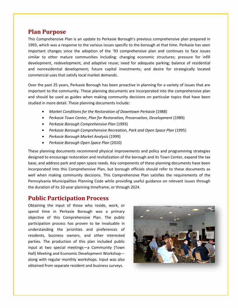
Public Participation Process
Obtaining the input of those who reside, work, or
spend time in Perkasie Borough was a primary
objective of this Comprehensive Plan. The public
participation process has proven to be invaluable in
understanding the priorities and preferences of
residents, business owners, and other interested
parties. The production of this plan included public
input at two special meetings—a Community (Town
Hall) Meeting and Economic Development Workshop—
along with regular monthly workshops. Input was also
obtained from separate resident and business surveys.
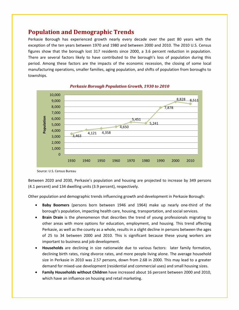
3,4634,121 4,358
4,650
5,4515,241
7,878
8,828 8,511
0
1,000
2,000
3,000
4,000
5,000
6,000
7,000
8,000
9,000
10,000
1930 1940 1950 1960 1970 1980 1990 2000 2010
Po
pu
lati
on
Population and Demographic Trends Perkasie Borough has experienced growth nearly every decade over the past 80 years with the
exception of the ten years between 1970 and 1980 and between 2000 and 2010. The 2010 U.S. Census
figures show that the borough lost 317 residents since 2000, a 3.6 percent reduction in population.
There are several factors likely to have contributed to the borough’s loss of population during this
period. Among these factors are the impacts of the economic recession, the closing of some local
manufacturing operations, smaller families, aging population, and shifts of population from boroughs to
townships.
Perkasie Borough Population Growth, 1930 to 2010
Source: U.S. Census Bureau
Between 2020 and 2030, Perkasie’s population and housing are projected to increase by 349 persons
(4.1 percent) and 134 dwelling units (3.9 percent), respectively.
Other population and demographic trends influencing growth and development in Perkasie Borough:
Baby Boomers (persons born between 1946 and 1964) make up nearly one-third of the
borough’s population, impacting health care, housing, transportation, and social services.
Brain Drain is the phenomenon that describes the trend of young professionals migrating to
other areas with more options for education, employment, and housing. This trend affecting
Perkasie, as well as the county as a whole, results in a slight decline in persons between the ages
of 25 to 34 between 2000 and 2010. This is significant because these young workers are
important to business and job development.
Households are declining in size nationwide due to various factors: later family formation,
declining birth rates, rising divorce rates, and more people living alone. The average household
size in Perkasie in 2010 was 2.57 persons, down from 2.68 in 2000. This may lead to a greater
demand for mixed-use development (residential and commercial uses) and small housing sizes.
Family Households without Children have increased about 16 percent between 2000 and 2010,
which have an influence on housing and retail marketing.

GUIDING PRINCIPLES Based upon extensive public participation and discussion
during the production of this Comprehensive Plan, eight
Guiding Principles were established for Perkasie. All principles
play an important role in the community but each has an
interrelationship with the central overarching principle
of this plan, which is to promote Sound Development
Practices and Sustainability for future development and
activities.
NATURAL, HISTORIC, AND CULTURAL RESOURCES Protect and enhance the natural, historical, architectural, and
cultural resources within Perkasie and deepen public awareness and
appreciation of these resources.
PARK, RECREATION, AND OPEN SPACE RESOURCES Preserve and expand the borough’s park and recreational resources
along the East Branch of the Perkiomen Creek and Pleasant Spring
Creek corridors. Continue to be proactive in the planning and land
acquisition of open space resources to satisfy the future needs of
borough residents.
WATER RESOURCES AND WASTEWATER FACILITIES Protect the borough’s water supply sources by ensuring local
regulations (i.e., zoning regulations, floodplain standards, and stormwater management regulations)
continue to protect water quality and quantity. Ensure that adequate conveyance, treatment, and
disposal facilities are provided for wastewater to satisfy current and future growth and to protect the
quality and health of the natural environment.
COMMUNITY FACILITIES AND SERVICES Provide high-quality community facilities and services that are consistent
with the borough’s land use planning in order to maintain a high-quality of
life for residents.
ENERGY CONSERVATION AND HAZARD MITIGATION Promote the conservation of energy and the movement toward alternative sources of energy, thereby
reducing dependence on non-renewable resources and contributing to a comprehensive approach to a
sustainable energy future. Support proactive mitigation efforts to prevent or reduce the impacts of
natural and man-made disasters.
ECONOMIC VITALITY Promote Perkasie’s Economic Development Vision that focuses on creating
a more dynamic shopping, dining, cultural, and entertainment experience
throughout the borough’s commercial areas. Foster a vibrant, walkable,
mixed-use downtown while maintaining Perkasie’s small town character.

TRANSPORTATION MOBILITY Enhance the borough’s transportation system to accommodate vehicular and pedestrian traffic in a safe
and efficient manner that is consistent with the needs of the general public and individual property
owners, respects the historic character of the borough, and supports the borough’s economic
development efforts. Support for the future reactivation of passenger rail service to Perkasie Borough
may provide various benefits to the community.
SOUND DEVELOPMENT PRACTICES AND SUSTAINABILITY (OVERARCHING PRINCIPLE) Sound Development Practices are coordinated, holistic policies of Sustainability, which in the context of
comprehensive planning, includes thoughtful development that respects its surroundings. Sound
Development Practices promotes a concentration of development
and diversity of uses while preserving the inherent resources (e.g.,
natural, hydrological, historical) that give a community its identity
and sense of place. By focusing on the provision of new residential
and nonresidential development within areas already built up,
public investment expenses for new roads, utilities, and amenities
are greatly reduced providing significant cost-savings to businesses
and residents. Sustainability is a pattern of resource use intended to
meet human needs including economic vitality and healthy
communities while preserving the natural environment, not only for
the present population, but also for generations to come. Source: Google Images
COMMUNITY VISION Community visioning is the process of developing consensus on the future of a community and then
deciding what is necessary to achieve it. A community vision statement captures what residents and
businesses most value about their community and the shared ‘ideal’ image of what they want their
community to become.
PERKASIE’S COMMUNITY VISION STATEMENT (CONDENSED)
Perkasie Borough holds a special place in the hearts of many residents, business owners, and visitors alike. Perkasie’s unique setting along a prominent ridgeline provides scenic views and vistas. The abundance of historic charm will be incorporated within future development, adaptive reuse, and expansion projects. Stream corridors contain a wealth of wetlands, riparian corridors, and natural habitat that will be preserved and enhanced for future generations. The borough will continue to provide high-quality community facilities and services to residents and businesses. The extensive sidewalk, trail, and path network provides connections from most residential neighborhoods to points of interest within the borough and throughout the region. Perkasie emphasizes a full spectrum of housing opportunities, appealing to residents of all ages and providing a life-long community. Through its Economic Development Vision of PlayShopDineUnwind (active/healthy lifestyles), Perkasie will continue expanding economic development opportunities with neighboring Sellersville Borough and East Rockhill Township to benefit the entire region, fostering a thriving business climate that creates dynamic shopping, dining, cultural, and entertainment experience within the Town Center, and extending to all commercial areas in the borough, while preserving Perkasie’s small-town character. Perkasie’s civic-minded nature will continue through the various large-scale community events and activities that attract thousands of visitors from around the region. Perseverance and due diligence from stakeholders, regional partnerships, and strong local officials will result in the realization of Perkasie’s Community Vision for the benefit of existing and future generations.
(For the full version, see Chapter 12, The Land Use Plan, Page 168.)

ECONOMIC DEVELOPMENT VISION Economic development is the manifestation of a community’s fiscal, social, and
physical resources as part of a long-term planning process aimed at preserving
and improving the overall quality of life in the community. Economic
development focuses on important aspects of a community that are provided by
the private sector—employment opportunities, businesses serving residents, a
stable and growing tax base, and business involvement as corporate citizens in a
community’s activities and decision making. Understanding the demographics of
those who live and work in Perkasie as well as the overall local and regional
retail markets helps to identify potential economic development opportunities.
The PlayShopDineUnwind (active/healthy lifestyles) vision capitalizes on one of Perkasie’s greatest
assets—its park and recreational facilities that attract residents and visitors from around the region.
Creating a more dynamic shopping, dining, cultural, and
entertainment experience, not only in Town Center but also
in other commercial areas, is instrumental to this vision.
Efforts toward downtown revitalization are intended to
create a more vibrant, walkable, mixed-use environment
while maintaining Perkasie’s small-town character.
Reducing the size of the Town Center District can provide
optimum utilization and walkability within the district.
Promoting an appropriate mix of retail, residential,
entertainment, and cultural uses with assorted public
spaces is consistent with this vision.
Key elements of this vision are to continue and enhance the borough’s streetscape improvements in and
around the redefined Town Center District to provide aesthetic appeal and continuity along major street
corridors. These improved street corridors may function as conduits, drawing visitors and residents from
the adjacent neighborhoods and the borough’s park and recreation network to the downtown.
Providing strategically located Town Center and wayfinding signage can bolster the identity of Perkasie’s
downtown retail district while guiding motorists to public parking lots (and potential future parking lots).
Photo Simulation at 5th & Chestnut Streets
BEFORE AFTER

DESIGN PRINCIPLES FOR SUCCESSFUL DOWNTOWNS
Architectural Design – Design buildings and building façades to incorporate architectural features that
reflect local architectural styles.
Building Placement & Access – Locate buildings near adjacent streets to provide uniformity of building
setbacks and visual continuity. Provide dual/multiple entrances (front, sides, and rear of buildings when
feasible) to increase accessibility and aesthetic appeal around structure.
Building Scale & Massing – Ensure buildings are not excessive in size and massing (length and width) so that
they fit the context of the downtown.
Building Separation – Provide periodic breaks or physical separation between buildings to incorporate
pedestrian access and landscape materials.
Parking Placement – Locate parking to the side or rear of buildings (whenever possible).
Public/Civic Spaces – Incorporate public spaces/public amenities, pocket parks, and plazas for civic
gatherings, interaction, and relaxation.
Streetscaping – Provide streetscape features such as street trees, planters, period lighting, and benches to
enhance downtown unity and identity.
Pedestrian Access – Pay particular attention to the placement of sidewalks to provide convenient access
and connections to points of interest throughout the downtown.
Landscaping & Buffering – Provide ample parking lot plantings and appropriate landscape
planting/buffering to provide ‘green infrastructure’ in the urban environment.
The Commercial Centers (Perkasie Square Shopping Center and a portion of the Glenwood Shopping
Center) provide a variety of goods and services serving the region. Undertaking various improvements
(e.g., façade, landscaping, signage, outdoor dining) may infuse new life into these Centers and make
them more appealing. Public and private investments in the borough’s other commercial districts may
improve the appearance and function of these areas.
The Industrial areas are extremely valuable to the community, and businesses in these areas provide
taxes and electric fees that help the borough sustain its financial well-being. Fostering an environment
ripe for start-up or incubator businesses to flourish through flexible regulations (mixed-use buildings,
flex spaces, live-work units) may prove beneficial to Perkasie by creating a regional niche while filling
vacancies in these districts.
Perkasie’s trail and sidewalk network is part of a larger network (including
the Liberty Bell Trail) that connects points of interest throughout the
region, including Sellersville, East Rockhill, West Rockhill, and beyond.
Improving and expanding this trail network may have a positive impact on
the local economy by increasing access and improving the user experience
for pedestrians and bicyclists patronizing the borough’s retail shops,
restaurants, and entertainment uses.
As part of Perkasie’s Economic Development Vision, the promotion of Design Principles for Successful Downtowns and Downtown Retail Guidelines have been established for the Town Center.

PLAN ELEMENTS There are eight plan elements within Part 2, Chapter 12 (The Land Use Plan) that examine issues and opportunities on a wide range of planning topics. Each Plan Element contains a summary of the detailed description and analysis found in Part 1. Implementation strategies and recommendations are provided that include various municipal actions such as potential rezoning, ordinance amendments, physical improvements, and marketing, partnering, and coordination efforts.
FUTURE LAND USE PLAN The Future Land Use Plan provides a framework for Perkasie’s Guiding Principles and Community Vision
and establishes a foundation for Perkasie’s land use and planning policies through 2024 and beyond. It
should be used as a means of coordinating and implementing local planning, preservation, and
development initiatives and for evaluating future subdivision and land development proposals.
The Future Land Use map is meant to assist in the coordination and implementation of local and
regional planning efforts. Borough officials will use the map as a guide to land use planning decisions
such as rezoning. Each future land use category attempts to create an overall land use pattern that is
both balanced and diverse with minimal negative impacts upon surrounding areas.
In general, the denser, more intensive land uses in Perkasie are located near the center of the borough
and less intensive land uses are found toward the borough’s periphery. Typically, the older development
near the borough’s interior is denser and more compact, with small lots and shallow yard setbacks.
Newer suburban-style residential development on larger lots is located outside Perkasie’s downtown.
In light of these conditions, Perkasie has been divided into eight future land use categories: Low Density
Residential, Medium/High Density Residential, Town Center, Commercial Center, General Commercial,
Light Industrial, Planned Industrial, and Riparian Buffer as shown in the Future Land Use map, and
described below.
PLAN ELEMENTS
Housing Historic and Cultural Resources Natural Resources
(Includes Air Resources and Energy Conservation) Transportation Park, Recreation, and Open Space Community Facilities and Services
(Includes Borough Administration, Finance and Management, Hazard Mitigation, and Solid Waste and Recycling)
Water-Related Infrastructure and Facilities Economic Development

LOW DENSITY RESIDENTIAL This future land use category comprises traditional, single-family detached dwellings and surrounds the
borough’s central core within the R-1A and R-1B Residential zoning districts. The purpose of this future
land use category is to retain the lower density residential character as it now exists, while providing for
the protection of natural resources and the preservation of permanent open space and minimizing the
amount of impervious surface. The zoning ordinance allows for the development of either single-family
residential areas or single-family clusters subject to performance standards within the R-1A zoning
district. Development of single-family detached dwellings, single-family clusters, and the full range of
residential dwelling types within a performance standard subdivision is permitted within the R-1B zoning
district. No policy changes in zoning district boundaries or zoning district purpose are recommended.
MEDIUM/HIGH DENSITY RESIDENTIAL The Medium/High Density Residential future land use category comprises a variety of housing types,
including single-family detached dwellings, single-family attached dwellings (twin, duplex, townhouses),
and multifamily units. The majority of the high density residential area is adjacent to the Town Center
and the historic center of the borough within the R-2 and R-3 Residential and A Apartment zoning
districts. The purpose of this future land use category is to retain and maintain the character and density
of existing residential areas where a variety of housing types are permitted. Only minor policy changes
are recommended in zoning district boundaries and no changes to the zoning district purpose.
Future Land Use

The borough should continue to encourage development that provides for a variety of housing types
within the areas of this future land use category.
TOWN CENTER Historically, Perkasie’s Town Center has functioned as
the hub of commercial and social activity of the
borough, and this is the future intention as well. The
Town Center future land use category is located
southeast of the rail lines and generally comprises a 3-
to 4-block area. The Town Center future land use
category corresponds to a portion of the current TC—
Town Center Overlay District. The current TC district is
quite large and includes a significant number of
residential and non-retail uses. The Town Center future
land use category is a more refined, compact downtown
as discussed in the Economic Development chapter. While this reconstituted boundary reduces the area
of the Town Center Overlay District, it encompasses the existing concentrations of retail uses and
additional areas for redevelopment of underutilized properties.
The overarching policy of the Town Center is to provide a vibrant, mixed-use, walkable community with
an appropriate mix of uses (e.g., retail, office, residential, dining, cultural, and entertainment) that are in
scale with Perkasie’s small-town character. The future development, redevelopment, and adaptive reuse
of buildings should adhere to Perkasie’s Downtown Retail Guidelines and Design Principles for
Successful Downtowns. When possible, the design and layout of buildings should reflect the local
architecture (Victorian and Queen Anne) and provide for a mixed use (residential/office over retail)
arrangement. Future site plans and improvements within the Town Center area should optimize the
provision for public parking, pedestrian access and safety, and public (civic) spaces.
Various potential regulatory changes are suggested for the Town Center related to appropriate uses,
building scale and massing, building setbacks, building height, parking standards, provision for public
space, and design guidelines.
COMMERCIAL CENTERS The Commercial Centers future land use category
encompasses the two shopping centers within Perkasie:
Perkasie Square and Glenwood Shopping Centers. These
shopping centers function as neighborhood shopping
centers providing for the sale of convenience goods (e.g.,
food, drugs, and sundries) and personal services for the day-
to-day resident needs of the surrounding region and are
typically built around a supermarket as the principal anchor.
The purpose of this future land use category is to provide
areas for office, retail, personal services, and related uses.

The zoning ordinance provides a comprehensive set of design standards to promote the grouping of
retail and service uses in the form of a shopping-center development within the C-1 Business
Professional zoning district.
Various recommendations provided for the Commercial Centers include physical improvements, façade
and landscaping improvements, signage, public access and amenities, rental rates/marketing strategies,
and potential regulatory changes such as accommodating outdoor dining space adjacent to restaurants
and eateries in the shopping centers.
GENERAL COMMERCIAL The General Commercial future land use category
comprises four commercial areas within the borough
zoned C-2 General Commercial District. The largest of
these areas makes up the borough’s central core,
extending south along West Walnut Street, and then
continuing east for one block along South 2nd Street.
The land use composition of this area includes a wide
variety of commercial uses, mixed-use buildings
(residential and commercial uses), and a variety of
residential dwelling types. The other three general
commercial areas are commercial nodes located at
the intersections of Ridge Road and West Market Street, Constitution Avenue and East Walnut Street,
and South Main Street and East Walnut Street.
The purpose of this future land use category is to provide for a wide variety of retail and personal
service business uses that serve residents of adjacent neighborhoods and beyond while complementing,
not competing with, businesses in the Town Center.
Potential improvements to General Commercial areas include the installation of gateway/wayfinding
signage and streetscape improvements (e.g., period lighting, banners, and sidewalk improvements with
brick edging) to signify that they are also part of the borough. Minor changes are suggested for the
zoning district boundaries of the C-2 General Commercial District.
LIGHT INDUSTRIAL The Light Industrial future land use category has a diverse composition of land uses (e.g., commercial,
industrial, single-family and multifamily residential, government, and institutional). The Light Industrial
category is intended to provide for greater variety of industrial development, including office, retail, and
personal service uses while including reasonable and flexible development standards. The Light
Industrial future land use category corresponds to the portion of the I-2 Light Industrial zoning district
that abuts the Town Center to the north and west. Given the diverse mixture of land uses and its
proximity to the Town Center area, borough officials may wish to promote the Light Industrial area as a
‘small business incubator’ that may address the needs for small or start up businesses seeking
reasonably priced and sized leasable space. Providing opportunities to use abandoned or underutilized
buildings through renovation and adaptive reuse in the Light Industrial area may not only aid in filling
current and future vacancies but also provide flexibility in how this area develops in the future.
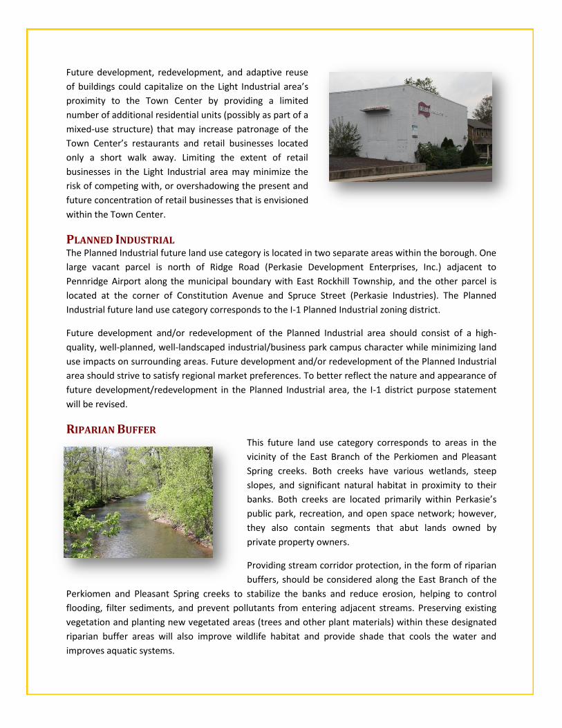
Future development, redevelopment, and adaptive reuse
of buildings could capitalize on the Light Industrial area’s
proximity to the Town Center by providing a limited
number of additional residential units (possibly as part of a
mixed-use structure) that may increase patronage of the
Town Center’s restaurants and retail businesses located
only a short walk away. Limiting the extent of retail
businesses in the Light Industrial area may minimize the
risk of competing with, or overshadowing the present and
future concentration of retail businesses that is envisioned
within the Town Center.
PLANNED INDUSTRIAL The Planned Industrial future land use category is located in two separate areas within the borough. One
large vacant parcel is north of Ridge Road (Perkasie Development Enterprises, Inc.) adjacent to
Pennridge Airport along the municipal boundary with East Rockhill Township, and the other parcel is
located at the corner of Constitution Avenue and Spruce Street (Perkasie Industries). The Planned
Industrial future land use category corresponds to the I-1 Planned Industrial zoning district.
Future development and/or redevelopment of the Planned Industrial area should consist of a high-
quality, well-planned, well-landscaped industrial/business park campus character while minimizing land
use impacts on surrounding areas. Future development and/or redevelopment of the Planned Industrial
area should strive to satisfy regional market preferences. To better reflect the nature and appearance of
future development/redevelopment in the Planned Industrial area, the I-1 district purpose statement
will be revised.
RIPARIAN BUFFER This future land use category corresponds to areas in the
vicinity of the East Branch of the Perkiomen and Pleasant
Spring creeks. Both creeks have various wetlands, steep
slopes, and significant natural habitat in proximity to their
banks. Both creeks are located primarily within Perkasie’s
public park, recreation, and open space network; however,
they also contain segments that abut lands owned by
private property owners.
Providing stream corridor protection, in the form of riparian
buffers, should be considered along the East Branch of the
Perkiomen and Pleasant Spring creeks to stabilize the banks and reduce erosion, helping to control
flooding, filter sediments, and prevent pollutants from entering adjacent streams. Preserving existing
vegetation and planting new vegetated areas (trees and other plant materials) within these designated
riparian buffer areas will also improve wildlife habitat and provide shade that cools the water and
improves aquatic systems.