compliance report - 10.11 -...
TRANSCRIPT

Puranik Megatowns
Add: Puraniks One, Kanchan Pushp, Kavesar, Ghodbunder Road, Thane-15
Date: 10.11.2017 To, The Director & Member Secretary, Expert Appraisal Committee (2) in the Infrastructur e Sector Ministry of Environment Forest & Climate Change Indira Paryavaran Bhavan, Jor Bagh Road, New Delhi - 110003, India. Subject : Submission of compliance report to the observations raised during 24th Expert Appraisal
Committee -2 (EAC-2) meeting in the Infrastructure Sector for the “Puranik Megatowns” at Village Pimploli and Village Talwade, Taluka Karjat, Dist Raigad, Maharashtra.
Reference : • Minutes of meeting (MoM) of 24th EAC-2 (Item no. 24.4.9) • File number: (IA/MH/NCP/69614/2015; F. No. 21-328/2017-IA.III)
Respected Sir, This is with reference to the above mentioned subject. Project specific TOR received from SEAC-2 Maharashtra during 34th SEAC-2 meeting for the total plot area 5, 17,230 Sq.mt. & total construction area 6, 76,491.16 Sq.mt. We would like to mention here that proposal submitted for the Environmental Clearance is for total construction built-up area 5, 65,974.11 sq.mt. i.e. less than approved project specific TOR . Now we are submitting herewith the point wise compliance report to the observations raised by Honorable EAC during the meeting as follows: No. Observations & Compliances
1. Observation: A detailed traffic management and a traffic decongestion plan, to ensure that the current level of service of the roads within a 05 kms radius of the project site is maintained and improved upon, shall be drawn up through an organization of repute and specializing in Transport Planning. This should be based on the cumulative impact of all development and increased inhabitation being carried out or proposed to be carried out by the project or other agencies in this 05 kms radius from the site under different scenarios of space and time and shall be implemented to the satisfaction of the State Urban Development and Transport Departments with the consent of all the concerned implementing agencies. Compliance: We have conducted traffic surveys of project site and all roads within radius of 5 km of project area to capture base traffic Conclusion & Recommendation are as follows: � The project traffic has been forecasted for year 2020 and 2030; this has been superimposed
along with existing projected traffic to arrive at future traffic for year 2020 and 2030. � The forecast traffic on the 5km road network will operate at acceptable level of service in
future. � Swept Path analysis yielded that road geometry was adequate for vehicle turning maneuvers. � A Traffic Management Plan in terms of traffic calming measures and traffic control measures
has been devised and proposed to maintain adequate level of service and safety of vehicles and pedestrian.
Detailed Traffic study report by considering 5 Km cumulative study area is attached as Enclosure-1.
Puranik Megatowns
Add: Puraniks One, Kanchan Pushp, Kavesar, Ghodbunder Road, Thane-15
No. Observations & Compliances 2. Observation:
A certified report on the sources and availability of water from the local body supplying water along with the permission received by them for the same shall be submitted. This report shall specify the total annual water availability with the organization (local body), the quantity of water already committed to other development projects, the quantity of water committed for this project and the balance water available for distribution. This should be specified separately for ground water and surface water sources and ensure that there is no impact on other users. Compliance: We have received NOC for water supply from Irrigation Department, stating assured water supply and same is attached as Enclosure-2.
3. Observation: Impacts of dewatering on study area. Compliance: We would like to bring to your kind notice that basements are not proposed in this project. However following precautions shall be taken for dewatering, if at all occurs, during excavation activities: - Provision of dewatering pumps of adequate capacity as per site conditions - Suction points of the pumps will be equipped with silt screens and appropriate filters to minimize
stile discharge - Collection of Subsoil water/ excess water during excavation. - Disposal of supernatant to the drain. - Guidelines issued by Central Ground Water Authority (CGWA) shall be followed strictly - No withdrawal of ground water for any usage is planned in the project.
4. Observation: Impacts on setting up the STP on the study area both under conditions of normal working and malfunction. Compliance: Predicted impact along with mitigation measures are given below: Activity Impact Mitigation measures Use of blowers, pumps for operation of STP
Increase in noise levels in the area adjacent to the STP plant
Acoustical Enclosures with 30 dB Transmission Loss Ratings are recommended for the Blowers of the STP.
Failure of pumps, blowers and motors
Disturbance to the treatment of sewage
All the pumps, blowers and motors shall be of standard quality and adequate capacities and shall be provided with standby arrangements Back up arrangement for panel shall also be provided
Failure or breakage of diffuser
Disturbance to the treatment of sewage : Odour problem
Aeration shall be provided retrievable type so that damage, if any, can be removed easily without the shutdown.
In case of major failure of STP
Disturbance to the treatment of sewage : This may lead to
There shall be provision of 22 nos. of STPs of different capacities for the treatment of sewage generated from this project. The working
Puranik Megatowns
Add: Puraniks One, Kanchan Pushp, Kavesar, Ghodbunder Road, Thane-15
No. Observations & Compliances odour problem and pollution of water bodies if partially treated/untreated sewage shall be disposed to the nearby areas
calculations of numbers and capacities of STP are done in phase wise manner so that each phase shall be self-sufficient in treatment of its generated sewage. Each STP has a capacity more than of the sewage quantity that it is handling. During major repair works of STP which can be resolved within few days one option is to feed the sewage of that STP to the nearby other STP in this project. But this may be difficult practically as the piping network will increase. Hence it in this project double treatment of sewage is envisaged. First line of treatment is with MBBR Technology in full-fledged STP up to tertiary treatment and this treated sewage shall be recycled for various secondary purposes. The balance sewage then shall be treated by the natural treatment technology i.e. by Phytorid Technology. This will ensure and achieve the discharge standards of sewage as per EP Act. Treatment by MBBR and Phytorid technologies, maximum recycling within the site, storage in the holding ponds and further its reuse outside the site shall be practiced. This will ensure that there will not be possibilities of pollution of water bodies and nuisance to the nearby areas.
We sincerely hope that our reply will satisfy the observations raised by the respected Committee. Please do the needful and oblige. Thanking you, Yours faithfully, For PURANIK MEGATOWNS
AUTHORIZED SIGNATORY En: As above

Proposed Residential Project, Pimpoli Traffic Impact Study
i
Table of Contents
1 INTRODUCTION ...................................................................................................................... 1
1.1 BACKGROUND ........................................................................................................................ 1
1.2 SCOPE ..................................................................................................................................... 1
1.3 ASSUMPTIONS ........................................................................................................................ 1
1.3.1 CODES AND MANUALS ......................................................................................................... 2
1.3.2 DESIGN PARAMETERS .......................................................................................................... 2
1.3.3 ENTRY / EXIT LANE CAPACITIES ......................................................................................... 3
1.4 TRAFFIC STUDY METHODOLOGY ........................................................................................ 3
1.5 TRAFFIC MODEL ..................................................................................................................... 4
1.6 OUTLINE OF THE REPORT .................................................................................................... 5
2 SITE APPRECIATION, EXISTING TRANSPORT NETWORK AND BASE TRAFFIC ........... 6
2.1 PROJECT LOCATION .............................................................................................................. 6
2.2 SURROUNDING ROAD NETWORK ........................................................................................ 7
2.3 TRAFFIC SURVEYS ................................................................................................................ 8
2.4 BASE TRAFFIC ........................................................................................................................ 9
3 PROPOSED DEVELOPMENT ............................................................................................... 12
3.1 AREA/UNIT STATEMENT ...................................................................................................... 16
3.2 PARKING STATEMENT ......................................................................................................... 16
4 TRAFFIC ANALYSIS ............................................................................................................. 17
4.1 TRAFFIC FORECAST ............................................................................................................ 17
4.2 TRAFFIC ASSIGNMENT ........................................................................................................ 18
4.3 VEHICLE CIRCULATION ....................................................................................................... 18
4.4 TRAFFIC IMPACT ANALYSIS ............................................................................................... 19
4.5 INTERSECTION ANALYSIS .................................................................................................. 20
4.6 TRAFFIC MANAGEMENT OF SURROUNDING ROADS ..................................................... 24
En 1 - Traffic Survey Report

Proposed Residential Project, Pimpoli Traffic Impact Study
ii
5 OTHER IMPORTANT ASSESSMENTS ................................................................................ 25
5.1 SWEPT PATH ANALYSIS ...................................................................................................... 25
5.2 OBJECTIVES ......................................................................................................................... 25
5.3 DESIGN VEHICLE .................................................................................................................. 25
5.4 LAYOUT PLAN ....................................................................................................................... 26
6 TRAFFIC MANAGEMENT PLAN .......................................................................................... 28
6.1 TRAFFIC CALMING ............................................................................................................... 28
6.2 TRAFFIC CONTROL MEASURES ......................................................................................... 28
7 CONCLUSIONS & RECOMMENDATIONS ........................................................................... 31
ANNEXURE 1 .......................................................................................................................................... 31

Proposed Residential Project, Pimpoli Traffic Impact Study
iii
List of Figures
Figure 1-1 Traffic Study Methodology ....................................................................................................... 4
Figure 1-2 Traffic Model ............................................................................................................................ 5
Figure 2-1 Project Location ....................................................................................................................... 6
Figure 2-2 Surrounding Road Network and Traffic Survey Location within 5KM Radius ......................... 7
Figure 2-3 9.0M Wide Lodhachiwadi Sugway Pimpoli Road ..................................................................... 7
Figure 2-4 Surrounding Road Network Inventory within 5KM Radius ....................................................... 8
Figure 3-1 Entry/Exit Points – Layout Plan ............................................................................................. 12
Figure 3-2 Phase wise Development Plan ............................................................................................... 13
Figure 3-3 Access Road Network Layout Plan ........................................................................................ 13
Figure 3-4 Proposed Road Cross Sections ............................................................................................. 14
Figure 3-5 Proposed Road Cross Sections ............................................................................................. 15
Figure 4-1 Layout Plan – Traffic Circulation ............................................................................................. 19
Figure 4-2 Existing LOS for the neighboring road network (2017) - 5KM Study Area ............................ 21
Figure 4-3 Projected LOS for the neighboring road network (2030) – Do Nothing Scenario for 5Km Study Area................................................................................................................................................ 22
Figure 4-4 Projected LOS for the neighboring road network (2030) – Traffic Management Scenario for 5Km Study Area ....................................................................................................................................... 23
Figure 5-1 Dimensions of Fire Tender .................................................................................................... 26
Figure 5-2 Fire Tender Movement Plan – Layout plan ............................................................................ 27
Figure 6-1 Illustration of a Speed Hump ................................................................................................. 30
Figure 6-2 Traffic Management Plan ...................................................................................................... 30

Proposed Residential Project, Pimpoli Traffic Impact Study
iv
List of Tables
Table 1-1 Roadway Capacities as per IRC 106: 1990 .............................................................................. 2
Table 1-2 Description of LOS based on V/C Ratio ................................................................................... 3
Table 2-1 Hourly Traffic Volume on Lodhachiwadi Sugway Pimpoli Road ............................................. 10
Table 3-1 Parking Statement ................................................................................................................ 16
Table 4-1 Trip Generation ....................................................................................................................... 17
Table 4-2 Base Traffic Forecast for Project Network Roads .................................................................. 18
Table 4-3 Trip Assignment on Existing Road Network ........................................................................... 18
Table 4-4 Traffic Capacity Analysis of Access Roads – 2020 ................................................................ 20
Table 4-5 Traffic Capacity Analysis of Access Roads – 2030 ................................................................ 20
Table 6-1 Traffic Control Measures ........................................................................................................ 29
Proposed Residential Project, Pimpoli Traffic Impact Study
1
1 INTRODUCTION
1.1 BACKGROUND
Project proponent has proposed to construct Residential Building on land bearing village Pimploli, S. No. 1/1,1/2,1/3, 1/5b, 1/6, 42/4A, 43/1, 43/5, 44/2, 45/1, 45/4b, 45/5a, 45/6, 45/7, 45/8, 45/9, 56, 57, 60/2b, 60/5a, 60/5b, 60/7a, 60/8a, 60/8b, 62, 63/1a, 63/1b, 64/1, 64/2, 64/3, 64/4, 64/5, 64/8, 64/9, 60/7b part, 58, 60/6, 64/6, 64/10, 44/1, 45/4c, 45/5b, 64/7, village Talwade, S.No. 17/10, 17/11a,
17/11b, 17/12, 17/13, 17/14, 17/15, and 19/7b at Tal. Karjat, Dist- Raigad, State -Maharashtra.The project will accommodate 8703 flats and 405 Shops. On completion, the project will provide 1264 car parking spaces within the premises. The project provides easy access to educational, medical and shopping facilities.
GMD Consultants has been commissioned by the project proponent – M/s. Puranik Megatowns to provide a Traffic Impact Study for this project.
1.2 SCOPE
The scope of this study is listed below:
Traffic Surveys: To conduct traffic surveys of area project site in order to capture base traffic:
o Assess current traffic pattern on access road – neighboring road network
o Capture traffic emanating from new developments and from adjacent properties
Traffic Circulation: To review traffic circulation plan considering various types of vehicles users
(cars, 2W, fire tender)
Traffic Surveys: To conduct traffic surveys of all roads within radius of 5 km of project area to
capture base traffic:
Impact Analysis: Analyze the forecast project traffic in conjunction with base traffic. Conduct an
Impact Analysis of project traffic as well as study impacts and suggest mitigation measures.
Swept Path Analysis: Review traffic circulation to ensure proper and efficient traffic movement.
Conduct swept path analysis at critical locations of project entry/exit to ensure safe and efficient
turning maneuvers.
Junction Analysis: Junction analysis for present (2017) and future scenario (2030) using PTV
VISTRO Software
Traffic Control: Address the provision of road signages, markings and traffic calming measures.
Also provide a traffic management plan to address issues of traffic control and safe dispersal.
1.3 ASSUMPTIONS
GMD Consultants follows standard procedures and guidelines to determine the impact of added traffic on proposed facilities. In the following sections, the assumptions considered as well as selected design standards and parameters for the analysis have been discussed.

Proposed Residential Project, Pimpoli Traffic Impact Study
2
1.3.1 CODES AND MANUALS
Design standards are generally followed bottom-up or part to whole. Local bylaws are given highest priority to meet the requirements set by local development control agency. Other standards, although explicitly not mentioned by local development control agency, are referred from national or international design manuals that are accepted and widely referred by other professionals in the industry.
Following Codes and Manuals have been referred in this study:
Codes by Indian Road Congress
A Policy on Geometric Design of Highways and Streets’ by American Association of State Highway and Transportation Officials (AASHTO)
Trip Generation and Parking Generation handbooks by Institute of Transportation Engineers (ITE)
Guidelines for Preparation of Traffic Impact Assessment Reports by LTA, Singapore
Design recommendations for multi-storey and underground car parks 3rd
Edition, IStruct, UK.
1.3.2 DESIGN PARAMETERS
The basic design parameters considered for the study has been illustrated below:
1) The social status as well as economic well-being of the residents plays an important role in determining the parking demand for any residential project.
2) The visitors will expect a safe and efficient circulation with good levels of service, i.e. minimum waiting time at security check, proper traffic control at entry / exits, minimum congestion delays and pleasing aesthetics.
3) A design vehicle is a vehicle whose dimensions and operational characteristics are used to establish layout geometry. Toyota Innova (Big Car) and Maruti Swift (Small Car) and Volvo 400 (Fire Tender) were chosen as the design vehicles.
4) The speed of the vehicle is restricted within the premises as below
a. On the straight sections - 15 kmph
b. On turns and bends - 10 kmph
c. On ramps - 10 kmph
5) The maximum number of traffic a road can carry is referred to as its Capacity or design Service Volume. The service volumes considered for the project is given below.
Table 1-1 Roadway Capacities as per IRC 106: 1990
Type of Roadway Road Capacity* Category
2 Lane 2 Way 1715 (Sub-Arterial)
*Indian Road Congress 106: 1990 Urban Road Capacity
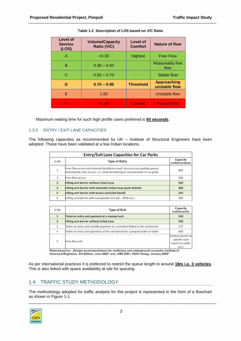
6) Level of Service (LOS) can be defined as a letter designation that describes a range of operating characteristics on a given facility. Six Levels of Service are defined for capacity analysis. They are given letter designations from A to F, with LOS ‘A’ representing best level of operational standards and LOS ‘F’ the worst.
Proposed Residential Project, Pimpoli Traffic Impact Study
3
Table 1-2 Description of LOS based on V/C Ratio
Level of Service (LOS)
Volume/Capacity Ratio (V/C)
Level of Comfort
Nature of flow
A <0.30 Highest Free Flow
B 0.30 – 0.50 Reasonably free
flow
C 0.50 – 0.70 Stable flow
D 0.70 – 0.90 Threshold Approaching unstable flow
E 1.00 Unstable flow
F >1.00 Lowest Forced flow
Maximum waiting time for such high profile users preferred is 60 seconds.
1.3.3 ENTRY / EXIT LANE CAPACITIES
The following capacities as recommended by UK – Institute of Structural Engineers have been adopted. These have been validated at a few Indian locations.
As per international practices it is preferred to restrict the queue length to around 18m i.e. 3 vehicles.
This is also linked with space availability at site for queuing.
1.4 TRAFFIC STUDY METHODOLOGY
The methodology adopted for traffic analysis for this project is represented in the form of a flowchart as shown in Figure 1-1.

Proposed Residential Project, Pimpoli Traffic Impact Study
4
Figure 1-1 Traffic Study Methodology
1.5 TRAFFIC MODEL
Traffic modeling is the process of analyzing the pattern in which an area’s transport network would be used by traffic given the distribution and characteristics of the area’s population, employment and other land uses. The output of traffic analysis is forecast of vehicles using each road segment within the study area. Traffic forecast is best achieved by transportation modeling. The conventional transportation modeling is a four stage process. The most widespread form of model utilized is gravity model and the same is utilized for this project. The broad outline of this four stage gravity model is illustrated in Figure 1-2 below.
STAGE
Design Parameters, Drawing Plans Data AnalysisProcessed Data for Traffic Modelling
Area Statement, Adjoining Road Networ, Entry/Exit Access, Parking
Traffic ModellingTraffic DemandParking Demand
Traffic ModelValidation, Future Traffic Forecast, Efficiency
Peak hour mode wise traffic, Circulation Plan & Road Network
Level of Service Check Traffic Simulation
Check for congestion, waiting time, delay at Entry/ exit and mitigation
Base Parameters: Area, Land Use, Traffic, Variation in horizon years
Sensitivity AnalysisRisk Assessment
Impact on Traffic Circulation, Level of Service, Risk Assessment
Overall circulation , Road Markings and Signages
Safety and Sustainability
Sight Distance Checks, Pedestrian Safety
Conclusions and Recommendations
INPUT OUTPUT

Proposed Residential Project, Pimpoli Traffic Impact Study
5
Figure 1-2 Traffic Model
1.6 OUTLINE OF THE REPORT
The report has been organized in the following order:
Chapter 1 Introduction, scope, assumptions and methodology
Chapter 2 Illustrates the existing road network and the present traffic scenario at the project site as well as details on external road network considered and neighbouring region profile to give an overview of the baseline (existing) traffic conditions.
Chapter 3 Explains the salient features of the proposed development.
Chapter 4 Describes the analysis of traffic survey and road network data for neighbouring roads and gives a better picture of where they stand as far as level of service is concerned. Also, the likely number of trips that would be generated by the project has been forecasted and its likely impact on road traffic was studied.
Chapter 5 Describes the analysis studies conducted to study various other aspects of the project.
This includes swept path analysis.
Chapter 6 Describes the Traffic Management Plan including various traffic calming measures for the
project to ensure safe and secure circulation of pedestrians and vehicles.
Chapter 7 Summarises the conclusions and recommendations of the study.
************
LANDUSE & SOCIO-ECONOMIC DATA
ZONING SYSTEM
TRIP GENERATIONHow many trips by
type ?
What is the pattern of trip making ?
Which mode of transport is used ?
Which route is taken?
TRIP DISTRIBUTION
MODAL SPLIT
TRIP ASSIGNMENT
ROAD & PUBLIC TRANSPORT NETWORK
TRAFFIC MODELLING

Proposed Residential Project, Pimpoli Traffic Impact Study
6
2 SITE APPRECIATION, EXISTING TRANSPORT NETWORK AND BASE TRAFFIC
The existing transport network surrounding the project has been illustrated in the section below.
2.1 PROJECT LOCATION
The project is located in village Pimploli and village Talwade, Karjat Taluka, Raigad dist of Maharashtra. Neral railway station is located at a distance of 4.7 km from site which provides local connectivity. Chhatrapati shivaji international airport is the nearest airport from site which is located at distance of 87.1 km from site. The site is well connected to major landmarks in and around Mumbai City by road as well as rail. The project has direct access to Lodhachiwadi Sugway Pimpoli Road. The project provides easy access to other amenities such as educational, medical and shopping facilities. Figure 2-1 shows an aerial view of the location.
Figure 2-1 Project Location

Proposed Residential Project, Pimpoli Traffic Impact Study
7
2.2 SURROUNDING ROAD NETWORK
The project location is surrounded by a planned road network. The project has direct access to Lodhachiwadi Sugway Pimpoli Road. The location of the proposed development and surrounding road network as discussed above are illustrated in Figure 2-2
Figure 2-2 Surrounding Road Network and Traffic Survey Location within 5KM Radius
Following pictures depict the surrounding road network.
Figure 2-3 9.0M Wide Lodhachiwadi Sugway Pimpoli Road

Proposed Residential Project, Pimpoli Traffic Impact Study
8
Figure 2-4 Surrounding Road Network Inventory within 5KM Radius
The site is well connected to major urban centers around Pimpoli via road and rail. It is connected to all basic services like hospital, police station, fire station, post office and others.
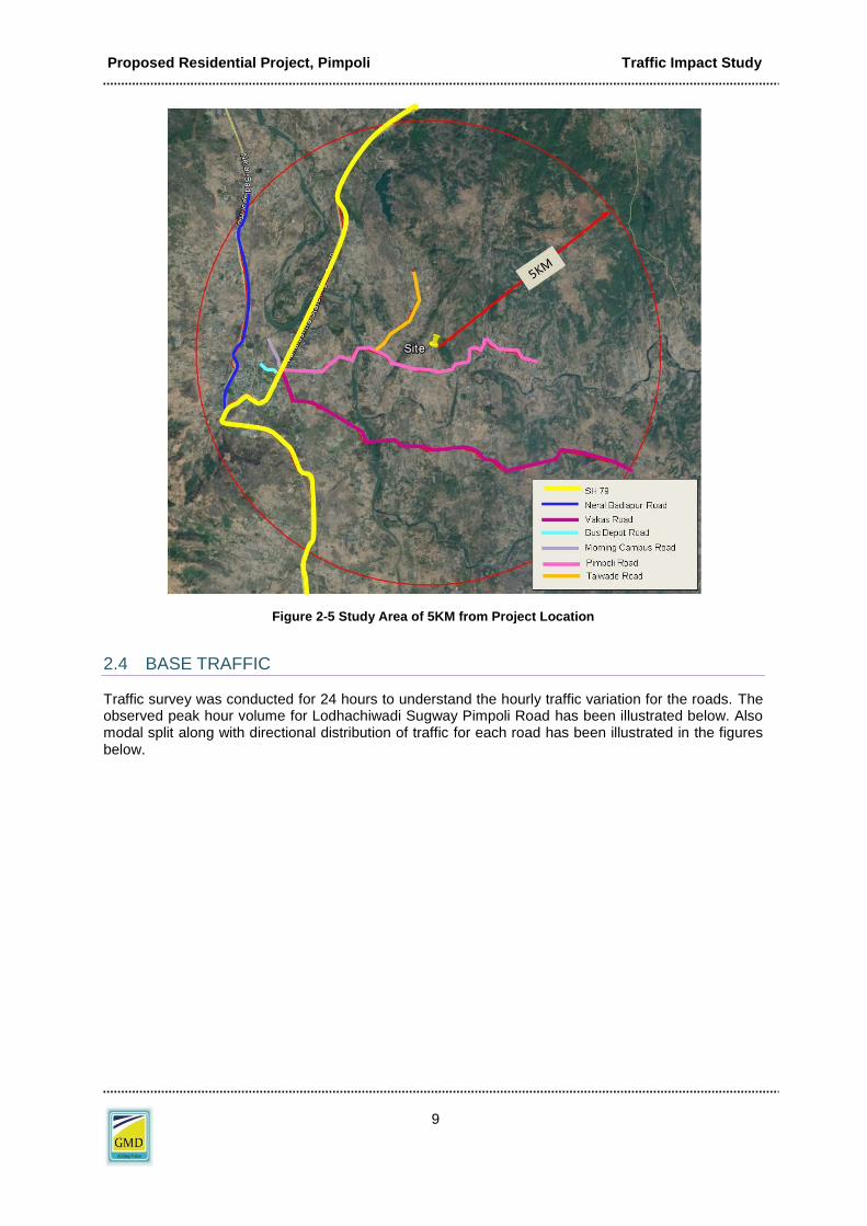
2.3 TRAFFIC SURVEYS
Traffic surveys are necessary to gather base data information about existing traffic and travel pattern on surrounding roads. Road network within 5km radius from the project location is considered for traffic study is shown in below . Network Inventory Survey. Traffic surveys were carried out on 9
th
June, 2017 (Friday) and 10th June, 2017 (Saturday).The traffic surveys included classified traffic
volume counts. Traffic survey was conducted at SH 79, Neral Badlapur Road, Vakas Road, Bus Depot Road, Morning Campus Road, Pimpoli Road, Talwade Road and Kashile Road.
Proposed Residential Project, Pimpoli Traffic Impact Study
9
Figure 2-5 Study Area of 5KM from Project Location
2.4 BASE TRAFFIC
Traffic survey was conducted for 24 hours to understand the hourly traffic variation for the roads. The observed peak hour volume for Lodhachiwadi Sugway Pimpoli Road has been illustrated below. Also modal split along with directional distribution of traffic for each road has been illustrated in the figures below.

Proposed Residential Project, Pimpoli Traffic Impact Study
10
Table 2-1 Hourly Traffic Volume on Lodhachiwadi Sugway Pimpoli Road
Figure 2-6 Hourly Traffic Distribution for Lodhachiwadi Sugway Pimpoli Road
Time Period 2W 3W Cars 2 AxleTotal
Vehicles
Total
PCU
8 to 9 48 19 7 2 75 49
9 to 10 59 23 8 2 93 60
10 to 11 49 20 7 2 77 50
11 to 12 46 19 6 2 73 48
12 to 13 41 16 6 2 65 42
13 to 14 40 16 6 2 64 41
14 to 15 43 17 6 2 69 45
15 to 16 46 19 6 2 73 48
16 to 17 55 22 8 2 87 57
17 to 18 60 24 8 2 95 62
18 to 19 59 24 8 2 93 61
19 to 20 56 22 8 2 88 57
20 to 21 48 19 7 2 76 49
21 to 22 43 17 6 2 68 44
22 to 23 34 14 5 1 54 35
23 to 24 26 10 4 1 41 26
24 to 1 23 9 3 1 37 24
1 to 2 21 8 3 1 33 21
2 to 3 17 7 2 1 27 18
3 to 4 14 6 2 1 22 15
4 to 5 11 4 2 0 17 11
5 to 6 12 5 2 0 20 13
6 to 7 22 9 3 1 35 23
7 to 8 34 14 5 1 54 35
Total 908 363 127 36 1435 933

Proposed Residential Project, Pimpoli Traffic Impact Study
11
Figure 2-7 Modal Split (vehicles) for Lodhachiwadi Sugway Pimpoli Road
Figure 2-8 Directional Distribution for Lodhachiwadi Sugway Pimpoli Road
Based on preliminary analysis it was observed that:
Peak morning traffic was observed between 9 and 10 AM and peak evening traffic was observed between 5 to 6 PM.
The vehicular traffic predominantly consists of Car, two wheelers and three wheelers.
Proposed Residential Project, Pimpoli Traffic Impact Study
12
3 PROPOSED DEVELOPMENT
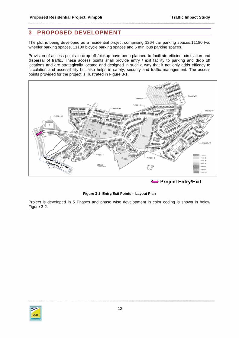
The plot is being developed as a residential project comprising 1264 car parking spaces,11180 two wheeler parking spaces, 11180 bicycle parking spaces and 6 mini bus parking spaces.
Provision of access points to drop off /pickup have been planned to facilitate efficient circulation and dispersal of traffic. These access points shall provide entry / exit facility to parking and drop off locations and are strategically located and designed in such a way that it not only adds efficacy to circulation and accessibility but also helps in safety, security and traffic management. The access points provided for the project is illustrated in Figure 3-1.
Figure 3-1 Entry/Exit Points – Layout Plan
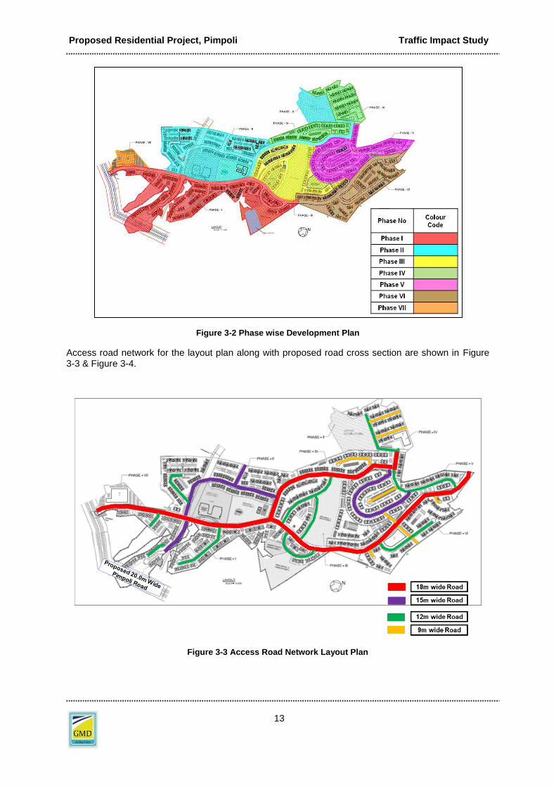
Project is developed in 5 Phases and phase wise development in color coding is shown in below Figure 3-2.
Proposed Residential Project, Pimpoli Traffic Impact Study
13
Figure 3-2 Phase wise Development Plan
Access road network for the layout plan along with proposed road cross section are shown in Figure 3-3 & Figure 3-4.
Figure 3-3 Access Road Network Layout Plan

Proposed Residential Project, Pimpoli Traffic Impact Study
14
Figure 3-4 Proposed Road Cross Sections

Proposed Residential Project, Pimpoli Traffic Impact Study
15
Figure 3-5 Proposed Road Cross Sections

Proposed Residential Project, Pimpoli Traffic Impact Study
16
3.1 AREA/UNIT STATEMENT
The area/unit statement is as given below.
3.2 PARKING STATEMENT
All the parking required for the project is being accommodated within the project premises. The parking statement is given in Table 3-1.
Table 3-1 Parking Statement

Proposed Residential Project, Pimpoli Traffic Impact Study
17
4 TRAFFIC ANALYSIS
The traffic analysis comprises of:
Traffic Forecast
Traffic Impact Analysis
Traffic Circulation
4.1 TRAFFIC FORECAST
Traffic forecasting is the process of estimating the total number of trips generated and attracted by each land-use.
Traffic forecasting is done using trip generation rates which are developed to estimate the number of trips generated from specific household and/or land use. For the purpose of this study, ITE trip generation manual were referred for arriving at basic trip generation rates and these rates were further modified suitably to represent Indian conditions. The no of trips include visitors, services and other trips attracted by residential, educational and commercial land use.
The project is expected to be commissioned by the year 2030. This would generate additional trips during day and peak hours. The trips generated by the project are given in table below:
Table 4-1 Trip Generation
A traffic growth of 5% is considered per year for the surrounding network. Based on this, the traffic has been forecasted and has been summarized in Table 4-4 and Table 4-5.
Trip: A trip is an individual’s one way travel from one point (origin) to other (destination). The trip can be for various reasons such as work, business, education, shopping, recreation, etc

Proposed Residential Project, Pimpoli Traffic Impact Study
18
Table 4-2 Base Traffic Forecast for Project Network Roads
This project being of residential land use, once commissioned will be generating predominantly outgoing and incoming traffic during morning and evening peak hours respectively. There will be various modes of vehicles contributing to the traffic.
4.2 TRAFFIC ASSIGNMENT
Trip distribution essentially describes that how the generated / attracted traffic arrives and departs from the project development site and in which direction. An overall trip distribution was developed for the site after a review of the existing travel patterns in the area. The volume of traffic generated / attracted will have a defined pattern of distribution both for entry and exit. Locations of the residential zones, major roadways and highways that will serve the development have been considered to arrive at trip distribution.
The project site is surrounded by a well planned road network. Existing neighboring roads will carry traffic from and towards the site. The impact of the project traffic would be predominantly on Lodhachiwadi Sugway Pimpoli Road. Following has been assumed for assignment of trips on existing road network.
Table 4-3 Trip Assignment on Existing Road Network
Road Name Project Impact (%)
Lodhachiwadi Sugway Pimpoli Road
100
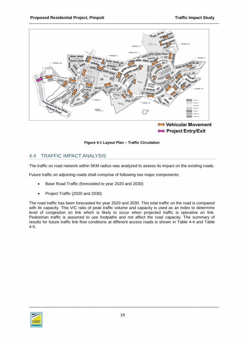
4.3 VEHICLE CIRCULATION
The project is a special township project. Multiple access points for vehicles have been provided in order to ensure smooth vehicle movement. This has been illustrated in Figure 4-1.
Proposed Residential Project, Pimpoli Traffic Impact Study
19
Figure 4-1 Layout Plan – Traffic Circulation
4.4 TRAFFIC IMPACT ANALYSIS
The traffic on road network within 5KM radius was analyzed to assess its impact on the existing roads.
Future traffic on adjoining roads shall comprise of following two major components:
Base Road Traffic (forecasted to year 2020 and 2030)
Project Traffic (2020 and 2030)
The road traffic has been forecasted for year 2020 and 2030. This total traffic on the road is compared with its capacity. This V/C ratio of peak traffic volume and capacity is used as an index to determine level of congestion on link which is likely to occur when projected traffic is operative on link. Pedestrian traffic is assumed to use footpaths and not affect the road capacity. The summary of results for future traffic link flow conditions at different access roads is shown in Table 4-4 and Table 4-5.

Proposed Residential Project, Pimpoli Traffic Impact Study
20
Table 4-4 Traffic Capacity Analysis of Access Roads – 2020
Table 4-5 Traffic Capacity Analysis of Access Roads – 2030
*Note: If V/C ratio <1.0, it indicates acceptable level of service (LOS)
The above results indicated that there are no concerns on account of project traffic and the traffic will continue to run as usual even after commissioning of project.
Under present configuration the roads will operate at V/C ratio of maximum 0.12 and 0.19 for the year 2020 and 2030 respectively during the peak hour after completion of the proposed development, which indicates the traffic will continue to run as usual with appropriate vigil during peak hours after commissioning of project.
4.5 INTERSECTION ANALYSIS
The intersections adjacent to the project site under 5KM radius were studied to understand the impact of project traffic on the roadway. The peak traffic emanating from the site after completion of the project has been tabulated below.
The existing Level of Service (2017) for the neighboring intersections has been illustrated below. Refer Figure 4-2.
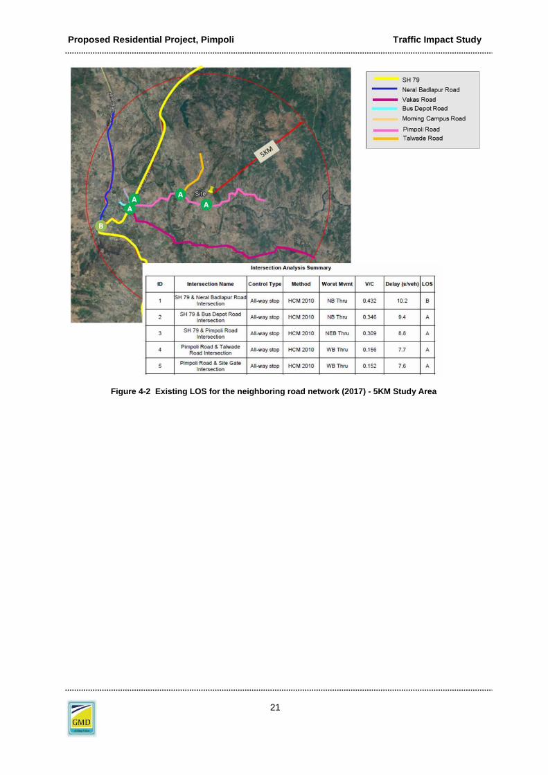
Proposed Residential Project, Pimpoli Traffic Impact Study
21
Figure 4-2 Existing LOS for the neighboring road network (2017) - 5KM Study Area

Proposed Residential Project, Pimpoli Traffic Impact Study
22
Figure 4-3 Projected LOS for the neighboring road network (2030) – Do Nothing Scenario for 5Km Study Area
The projected Level of Service of the year 2030 for the neighboring intersections has been illustrated below. Considering a growth factor of 5 % per year, the road traffic would grow by 65%. However, project traffic would contribute only 710 trips during peak evening hour. Major Infra Projects impact like widening of Lodhachiwadi Sugway Pimpoli Road and SH79 has been considered for Junction analysis 2030 scenario refer Figure 4-4.

Proposed Residential Project, Pimpoli Traffic Impact Study
23
Figure 4-4 Projected LOS for the neighboring road network (2030) – Traffic Management Scenario for 5Km Study Area
As the LOS for 2030 scenario remains within acceptable level, below following traffic management measures for study road network of 5km is proposed.

Proposed Residential Project, Pimpoli Traffic Impact Study
24
4.6 TRAFFIC MANAGEMENT OF SURROUNDING ROADS
By 2030, Traffic management measures will have to be adopted to cater to the increasing traffic. The following measures have been proposed.
Install traffic management measures to regulate the flow of traffic
• Provide adequate traffic signs and signages to notify residents
• Install safety mirrors to aid visibility in conflict points
• Prevent on street parking
• Provide speed humps to regulate speed of vehicles on local streets
• Provide pedestrian crossings and dedicated footpath to cater to the walking population
• Assign traffic wardens to regulate flow of project traffic during peak hours
• Major Infra Projects impact: Lodhachiwadi Sugway Pimpoli Road and SH79 Widening has
been considered
• Roundabout has been proposed at SH79-Neral Badlapur Junction & SH79-Pimpoli Road
Junction

Proposed Residential Project, Pimpoli Traffic Impact Study
25
5 OTHER IMPORTANT ASSESSMENTS
5.1 SWEPT PATH ANALYSIS
It is the analysis of the path of the design vehicle undertaking a movement and/or a turning maneuver. At a basic level this includes calculating the thread of each wheel during the turn and also calculating the maneuvering space needed by the vehicle body (front & rear overhang).
5.2 OBJECTIVES
The objectives of performing swept path analysis are as follows:
To check that the plan layout can accommodate the movement of the design vehicle expected by the development.
To provide solutions to possible geometric congestions on the site.
To provide information of the proposed layout and see if it serves the purpose, especially at turns where head room for vehicle maneuvers is limited.
To provide to local authority and developers precise information and the swept path analysis of vehicles overlaid on the proposed site layout to demonstrate that the vehicles can maneuver safely and efficiently within the site layout.
5.3 DESIGN VEHICLE
A design vehicle is a vehicle whose dimensions and operational characteristics are used to establish layout geometry. From an optimum design perspective it is beneficial to select the design vehicle which is near to 85% percentile, i.e. 85% of vehicles will have smaller dimensions. This helps in optimizing the space requirements. The design vehicles selected for this particular project are as follows:
Fire Tender
Detailed design and dimensions of design vehicle has been illustrated in Figure 5-1.

Proposed Residential Project, Pimpoli Traffic Impact Study
26
Figure 5-1 Dimensions of Fire Tender
5.4 LAYOUT PLAN
Entry/Exit points hold the key to a well efficient circulation plan. A well defined Entry/Exit area eases out traffic movement and reduces unnecessary congestion. Circulation path for Fire Tender travelling through layout is analyzed.

Proposed Residential Project, Pimpoli Traffic Impact Study
27
Figure 5-2 Fire Tender Movement Plan – Layout plan

Proposed Residential Project, Pimpoli Traffic Impact Study
28
6 TRAFFIC MANAGEMENT PLAN
The improvements to maintain the required level of service can be implemented by adopting traffic management measures for efficient traffic operations. Traffic Management Plan (TMP) indicates traffic routes and the measures for traffic regulation. It indicates the roads for use of certain classes of traffic, the location of traffic control i.e. signage and markings and the directions in which traffic should move. These are necessary for safe and efficient movement of vehicles and pedestrians.
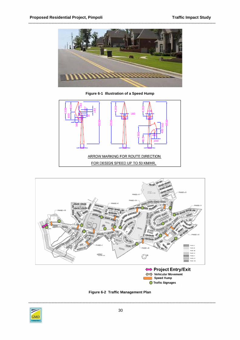
6.1 TRAFFIC CALMING
A Traffic Management plan indicating traffic circulation, traffic calming and traffic control is indicated in Figure 6-2.Traffic calming is intended to slow and control motor-vehicle traffic in order to improve safety for pedestrians and bicyclists. Traffic calming measures are of various types like speed tables, curb extension, chicane etc. These are mitigation measures to ensure safety.
Following are the proposed specific improvements for each street.
6.2 TRAFFIC CONTROL MEASURES
The internal roads are undivided to maintain flexibility of traffic lanes. Minimum 6m wide roadway width has been provided for the movement of vehicles. Recommended design speed on the internal road is 15kmph and on the turns is 10kmph. Speed tables will be provided near the entrance/exit point to control traffic and regulate speed of vehicles.. An illustrative picture is also shown in Figure 6-1. Additionally, the following shall be required to maintain traffic flow at required level of service.
Road Markings and Signages: Proper road markings (edge, median, arrows, turning, Kerb) and signages (direction, turning, speed, and pedestrian crossings) will be installed and maintained on all roads in the vicinity of project premises.
On-street parking will be prohibited on all external and internal streets.
Pick and drop at designated places only.
Preferably no U-Turn on roadway
Traffic calming measures – speed tables, signage
Apart from internal signage – it will be requested to provide necessary signage and traffic control measures, on neighboring roads, – such as Speed limit, Left hand curve, pedestrian crossing etc (Refer Table 6-1).

Proposed Residential Project, Pimpoli Traffic Impact Study
29
Table 6-1 Traffic Control Measures
Sr. No Description Signage
1 Speed Limit
2 Silence Zone
3 Pedestrian Crossing
4 Left Hand Curve
Proposed Residential Project, Pimpoli Traffic Impact Study
30
Figure 6-1 Illustration of a Speed Hump
Figure 6-2 Traffic Management Plan

Proposed Residential Project, Pimpoli Traffic Impact Study
31
7 CONCLUSIONS & RECOMMENDATIONS
The traffic impact analysis was conducted and the results were discussed in earlier section. The conclusions and recommendations are summarized below:
1) The project traffic has been forecasted for year 2020 and 2030; this has been superimposed along with existing projected traffic to arrive at future traffic for year 2020 and 2030.
2) The forecast traffic on the 5km road network will operate at acceptable level of service in future.
3) Swept Path analysis yielded that road geometry was adequate for vehicle turning maneuvers.
4) A Traffic Management Plan in terms of traffic calming measures and traffic control
measures has been devised and proposed to maintain adequate level of service and safety of vehicles and pedestrian.
*********
ANNEXURE 1
Traffic Management Report 2030 for 5KM road network around project location

En 2 - Water Supply NOC
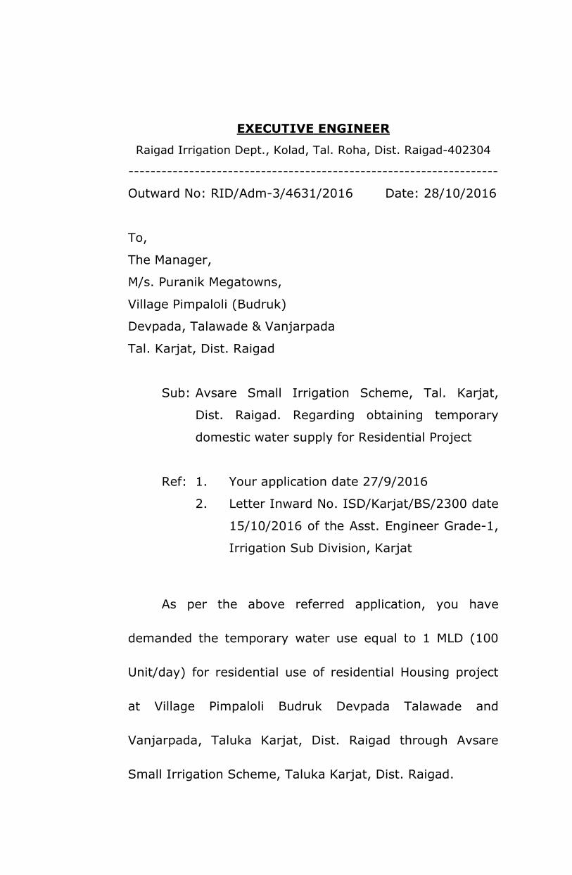
EXECUTIVE ENGINEER
Raigad Irrigation Dept., Kolad, Tal. Roha, Dist. Raigad-402304
-------------------------------------------------------------------
Outward No: RID/Adm-3/4631/2016 Date: 28/10/2016
To,
The Manager,
M/s. Puranik Megatowns,
Village Pimpaloli (Budruk)
Devpada, Talawade & Vanjarpada
Tal. Karjat, Dist. Raigad
Sub: Avsare Small Irrigation Scheme, Tal. Karjat,
Dist. Raigad. Regarding obtaining temporary
domestic water supply for Residential Project
Ref: 1. Your application date 27/9/2016
2. Letter Inward No. ISD/Karjat/BS/2300 date
15/10/2016 of the Asst. Engineer Grade-1,
Irrigation Sub Division, Karjat
As per the above referred application, you have
demanded the temporary water use equal to 1 MLD (100
Unit/day) for residential use of residential Housing project
at Village Pimpaloli Budruk Devpada Talawade and
Vanjarpada, Taluka Karjat, Dist. Raigad through Avsare
Small Irrigation Scheme, Taluka Karjat, Dist. Raigad.

2
Considering your demand of 100 Unit/day for the
residential use, the Asst. Engineer (Class-1) Irrigation Dept.
Sub Division Karjat has recommended for to give the
temporary water use permission. As per that, you are being
given the permission for temporary water use (100 Unit/
day) for residential use for residential Housing Project at
Village Pimpaloli Budruk, Devpada, Talawade and
Vanjarpada, Karjat, Dist. Raigad through Avsare Small
Irrigation Scheme, Taluka Karjat Dist. Raigad.
1. The water usage permission is 100 unit/day for
residential water use on temporary basis, please do
not use the water for any other purposes or more than
approved.
2. The above said permission will be up to 31st October,
2017. If the water will be used without any
permission, then the punishable action will be taken.
3. For to use the water approved you will have to install
a separate system yourself own to lift the water.
3
4. It will be binding for you to install the water
measuring system (water meter) and please inform
the meter Reading as per the records on water meter
on every last day of the month about the total water
lifting with the month to the regional office.
5. Please do not use more water than approved if such
more water usage will be found, then for more water
usage the punishable rate will be charged and it will
be binding on you to pay it.
6. The monthly water charges will be charged subject to
the approved water quota and will be charged for
minimum 90% of the approved water quota.
7. Please pay the advance amount for water charges in
the office of Irrigation Sub Division Karjat.
8. The above said water usage permission is being given
to you as per Maharashtra Irrigation Act 1976 and the
terms and conditions of it will be binding on you.

4
9. The undersigned has reserved the rights to cancel the
above said permission at any time, without any
reason.
10. No assurance for the water supply can be given.
Hence if there will be stoppage in the water supply
due to natural reasons or technically or if the water
supply will be short, then water resources Department
will not be responsible for it and only you will be
responsible for the same.
11. After the expiry of the time period of the above water
usage permission on 31st October, 2017, this office
has reserved the rights to give the permission for the
further period or to deny it. You will not have any pre-
right for the above said permission.
12. If any of the above terms and conditions will be
violated, then the above permission will be cancelled,
please note that.

5
13. There is not any approval to give water for no
irrigation reasons through the above Avsare Small
Irrigation Scheme. But at present the water uses to be
in balance after using the water for irrigation
purposes. Hence the temporary permission is being
given for one year.
14. You will have to give in writing the Affidavit on stamp
paper of Rs. 100/- that you have agreed for the above
terms and conditions.
Sd/-
Executive Engineer
Raigad Irrigation Dept.
Copy for information & necessary action to:
The Asst. Engineer (Class-I) Irrigation Dept. Karjat.
Read: -
1) Application date 25/6/2015 of the Power of Attorney
holder Shri Sudam Tukaram Pemare on behalf of Shri
Shrikant Suhas Padalkar & Others, resident of S.R.T.
Complex, Neral Ambika Bhuvan Naka, Near Pen Bank,
Taluka Karjat, Dist. Raigad.

6
2) Order No. MG/L.N.A.1 (B)/S.R. 275/2013 date
23/9/2014 of this Office.
3) Letter No. MG/C.C. /K. No. 96/2005 date 31/07/2015
of Tahsildar Karjat.
4) Letter O.W. No. ADTP-RA/CC/Village Pimpaloli Budruk/
Tal. Karjat/ S. No. 1/1 & Other/2266 date 28/09/2015
of Asst. Director, Town Planning Raigad Alibaug.
5) Copy of Survey Map of Very Urgent N.A. M.R. No.
370/2014 date 29.04.2014 of Dy. Superintendent
Land Record Karjat.
6) Gazette Date 22/08/2014 of Govt. Revenue & Forest
Dept.
7) Circular No. Misc-2013/06/C. No. 1417/E-1, date
27/08/2014 of Govt., Revenue & Forest Dept.
8) Circular No. MG/L.N.A.1 (A) & (B)/Officer/2014, date
9/12/2014 of this office.
9) Maharashtra Land Revenue (Change in use of Land
and N.A. tax) Rule 1969.
10) Maharashtra Regional & Town Planning Act, 1966 and
Rules thereunder.
11) Approval Note date 21/11/2015 of this office.