compliance offset protocol u.s. forest projects
TRANSCRIPT

Compliance Offset Protocol
U.S. Forest Projects
Adopted: June 25, 2015
California Environmental Protection Agency
AIR RESOURCES BOARD

ii
(This page left intentionally blank)

iii
Table of Contents
Chapter 1. Purpose and Definition .................................................................................. 1
1.1. Purpose ................................................................................................................. 1
1.2. Definitions ............................................................................................................. 1
Chapter 2. Eligible Activities – Quantification Methodology ........................................... 11
2.1. Reforestation ....................................................................................................... 11
2.2. Improved Forest Management ............................................................................ 13
2.3. Avoided Conversion ............................................................................................ 13
Chapter 3. Eligibility....................................................................................................... 15
3.1. General Eligibility Requirements ......................................................................... 15
3.2. Location .............................................................................................................. 25
3.3. Offset Project Operator or Authorized Project Designee ..................................... 26
3.4. Additionality ......................................................................................................... 26
3.4.1. Legal Requirement Test................................................................................ 27
3.4.2. Performance Standard Evaluation ................................................................ 28
3.5. Permanence ........................................................................................................ 30
3.5.1. Project Life and Minimum Time Commitment ............................................... 31
3.5.2. Identifying a Reversal ................................................................................... 31
3.5.3. Compensating for a Reversal ....................................................................... 33
3.6. Offset Project Commencement ........................................................................... 34
3.7. Project Crediting Period ...................................................................................... 35
3.8. Regulatory Compliance ....................................................................................... 36
Chapter 4. Offset Project Boundary – Quantification Methodology ............................... 36
4.1. Reforestation ....................................................................................................... 36
4.2. Improved Forest Management ............................................................................ 39
4.3. Avoided Conversion ............................................................................................ 43
Chapter 5. Quantifying GHG Emission Reductions and GHG Removal Enhancements –
Quantification Methodology ........................................................................................... 46
5.1. Reforestation Projects ......................................................................................... 48
5.1.1. Estimating Baseline Onsite Carbon Stocks................................................... 48
5.1.2. Estimating Baseline Carbon in Harvested Wood Products ........................... 50

iv
5.1.3. Determining Actual Onsite Carbon Stocks .................................................... 51
5.1.4. Determining Actual Carbon in Harvested Wood Products ............................ 51
5.1.5. Calculating Secondary Effects ...................................................................... 52
5.2. Improved Forest Management Projects .............................................................. 54
5.2.1. Estimating Baseline Onsite Carbon Stocks – Private Land .......................... 55
5.2.2. Estimating Baseline Onsite Carbon Stocks – Public Land ............................ 66
5.2.3. Estimating Baseline Carbon in Harvested Wood Products ........................... 67
5.2.4. Determining Actual Onsite Carbon Stocks .................................................... 68
5.2.5. Determining Actual Carbon in Harvested Wood Products ............................ 69
5.2.6. Calculating Secondary Effects ...................................................................... 69
5.3. Avoided Conversion Projects .............................................................................. 70
5.3.1. Estimating Baseline Onsite Carbon Stocks................................................... 70
5.3.2. Estimating Baseline Carbon in Harvested Wood Products ........................... 74
5.3.3. Determining Actual Onsite Carbon Stocks .................................................... 75
5.3.4. Determining Actual Carbon in Harvested Wood Products ............................ 75
5.3.5. Calculating Secondary Effects ...................................................................... 76
Chapter 6. Monitoring – Quantification Methodology .................................................... 76
Chapter 7. Reporting ..................................................................................................... 78
7.1. Listing Requirements .......................................................................................... 78
7.1.1. All Forest Offset Projects .............................................................................. 78
7.1.2. Reforestation Projects .................................................................................. 83
7.1.3. Improved Forest Management Projects on Private Lands ............................ 84
7.1.4. Improved Forest Management Projects on Public Lands ............................. 85
7.1.5. Avoided Conversion Projects ........................................................................ 85
7.2. Offset Project Data Report .................................................................................. 86
7.2.1. Annual Reporting .......................................................................................... 87
7.2.2. Additional Reporting for Verification Years ................................................... 90
Chapter 8. Verification ................................................................................................... 91
8.1. Full Verification ................................................................................................... 92
8.1.1. Sequential Sampling ........................................................................................ 95
8.1.1.1. Paired Plots ............................................................................................. 101

v
8.1.1.2. Unpaired Plots ......................................................................................... 102
8.2. Less-Intensive Verification ................................................................................ 103
8.3. Verification of Multiple Reporting Periods ......................................................... 103
8.4. Verification Team .............................................................................................. 104
Appendix A. Developing an Inventory of Forest Project Carbon Stocks – Quantification
Methodology ................................................................................................................ 105
Appendix B. Modeling Carbon Stocks – Quantification Methodology .......................... 114
Appendix C. Estimating Carbon in Wood Products – Quantification Methodology ...... 117
Appendix D. Determination of a Forest Project’s Reversal Risk Rating ...................... 132
Appendix E. Reforestation Project Eligibility ................................................................ 137
Appendix F. Determining a Value for Common Practice – Quantification Methodology
.................................................................................................................................... 139
Appendix G. References ............................................................................................. 141

1
Chapter 1. Purpose and Definition
1.1. Purpose
(a) The purpose of the Compliance Offset Protocol U.S. Forest Projects (protocol) is
to quantify greenhouse gas emission reductions and greenhouse gas removal
enhancements associated with the sequestration of carbon achieved by
increasing and/or conserving forest carbon stocks.
(b) AB 32 exempts quantification methodologies from the Administrative Procedure
Act (APA);1 however those elements of the protocol are still regulatory. The
exemption allows future updates to the quantification methodologies to be made
through a public review and Board adoption process but without the need for
rulemaking documents. Each protocol identifies sections that are considered
quantification methodologies and exempt from APA requirements. Any changes
to the non-quantification elements of the offset protocols would be considered a
regulatory update subject to the full regulatory development process. Those
sections that are considered to be a quantification methodology are clearly
indicated in the title of the chapter or subchapter if only a portion of that chapter
is considered part of the quantification methodology of the protocol.
1.2. Definitions
(a) For the purposes of this protocol, the following definitions apply:
(1) “Above-Ground Live Biomass” means the total mass of biomass in live trees
including the stem, branches, and leaves or needles, brush and other
woody live plants above ground.
(2) “Accuracy” is defined in section 95102 of the Mandatory Reporting
Regulation.
(3) “Activity-Based Funding” means the budget line items that are dedicated to
agency accomplishments in vegetation management, including pre-
commercial thinning, commercial thinning, harvest, hazard tree removal,
1 Health and Safety Code section 38571.
2
hazardous fuel reductions, and other management activities designed to
achieve forest sustainability health objectives.
(4) “Allometric Equation” means an equation that utilizes the genotypical
relationship among tree components to estimate characteristics of one tree
component from another. Allometric equations allow the below-ground root
volume to be estimated using the above-ground bole volume.
(5) “Assessment Area” means a distinct forest community within geographically
identified ecoregions that consists of common regulatory and political
boundaries that affect forest management. The size of an assessment area
is determined by efforts to achieve optimal statistical confidence across
multiple scales using U.S. Forest Service Forest Inventory and Analysis
Program (FIA) plots for biomass. Maps of the assessment areas and the
associated data may be found on ARB’s website.
(6) “Avoided Conversion Project” means a type of forest project consisting of
specific actions that prevent the conversion of privately owned forestland to
a non-forest land use by dedicating the land to continuous forest cover
through a conservation easement or transfer to public ownership.
(7) “Basal Area” means the cross-sectional area of a tree at breast height
calculated from diameter at breast height.
(8) “Basal Area Retention” means the average basal area per acre remaining in
a harvest unit after a harvest. Basal area within a harvest unit is averaged
on a per acre basis including standing live trees equal to or greater than 1
inch in diameter at breast height within the harvest, regardless of species.
(9) “Best Management Practices” means management practices determined by
a state or designated planning agency to be the most effective and
practicable means (including technological, economic, and institutional
considerations) of protecting the beneficial uses of water, soil stability, forest
productivity, and wildlife.
(10) “Bias” is defined in section 95102 of the Mandatory Reporting Regulation.
(11) “Biological Emissions” means greenhouse gas emissions that are released
directly from forest biomass, both live and dead, including forest soils. For
forest projects, biological emissions are deemed to occur when the reported

3
tonnage of onsite carbon stocks, relative to baseline levels, declines from
one reporting period to the next.
(12) “Bole” means a trunk or main stem of a tree.
(13) “Broadcast Fertilization” means a fertilizer application technique where
fertilizer is spread across the soil surface.
(14) “Cap-and-Trade Regulation” or “Regulation” means ARB’s regulation
establishing the California Cap on Greenhouse Gas Emissions and Market-
Based Compliance Mechanisms as set forth in title 17, California Code of
Regulations, chapter 1, subchapter 10, article 5 (commencing with section
95800).
(15) “Carbon Pool” means a greenhouse gas reservoir.
(16) “Clearcutting” means a regeneration method involving the removal of a
stand in one harvest. Regeneration after harvesting shall be obtained by
direct seeding, planting, sprouting, or by natural seed fall. When practical,
clearcuts shall be irregularly shaped and variable in size to mimic natural
patterns and features found in landscapes.
(17) “Commercially Viable” means profitable, either without subsidies or with
reliable, long-term subsidies. The assessment of commercial viability shall
be determined by analysis of comparable practices within the assessment
area on comparable conditions (slope, soils, access to markets, etc.). For
grazing, if the level of grazing activity has been equal to or less than 0.5
Animal Unit Months (AUMs) per acre, the grazing activity is not
commercially viable.
(18) “Common Practice” means, for the purposes of this protocol, the average
carbon stocks (metric tons) of the above-ground portion of standing live
trees from within the forest project’s assessment area, derived from FIA
plots on all private lands within the defined assessment area.
(19) “Confidence Deduction” means a deduction applied to the project’s onsite
carbon stocks for each reporting period to account for statistical uncertainty
associated with sampling in order to ensure that estimates of GHG emission
reductions and GHG removal enhancements are conservative.
4
(20) “Countable Tree” means a tree that must be in place at least two growing
seasons and must be live and healthy.
(21) “Cropland” means land under cultivation including cropland harvested, crop
failures, cultivated summer fallow, idle cropland, and cropland used only for
pasture as defined by the United States Department of Agriculture.
(22) “Even-Aged Management” means a silvicultural system that includes
clearcutting, seed tree, and shelterwood regeneration methods. Any
harvest activity that does not meet the stocking requirements of subchapter
3.1(a)(4)(D) is also considered even-aged management, unless a state
agency with jurisdiction over the project area identifies the practice as
uneven-aged management. By convention, the spread of ages does not
differ by more than 20 percent of the intended rotation.
(23) “Forest Management” means the commercial or noncommercial growing
and harvesting of forests.
(24) “Forest Owner” means the owner of any interest in the real (as opposed to
personal) property involved in a forest offset project, excluding government
agency third-party beneficiaries of conservation easements. Generally, a
Forest Owner is the owner in fee of the real property involved in a forest
offset project. In some cases, one entity may be the owner in fee while
another entity may have an interest in the trees or the timber on the
property, in which case all entities or individuals with interest in the real
property are collectively considered the Forest Owners, however, a single
Forest Owner must be identified as the Offset Project Operator.
(25) “Forest Project” means a planned set of activities designed to increase
removals of CO2 from the atmosphere, or reduce or prevent emissions of
CO2 to the atmosphere, through increasing and/or conserving forest carbon
stocks.
(26) “Forestland” means land that supports, or can support, at least 10 percent
tree canopy cover and that allows for management of one or more forest
resources, including timber, fish and wildlife, biodiversity, water quality,
recreation, aesthetics and other public benefits.

5
(27) “Harvest Unit” means an area of forest vegetation that has been harvested
as a cohesive unit and generally has uniform distribution of retained
vegetation.
(28) “Improved Forest Management Project” or “IFM Project” means a type of
forest project involving management activities that increase carbon stocks
on forested land relative to baseline levels of carbon stocks.
(29) “Intentional Back Burn” means a controlled burn set by, or at the request of,
a local, state, or federal fire protection agency for the purpose of protecting
forestlands from an advancing wildfire that began on another property
through no negligence, gross negligence, or willful misconduct of the forest
owner.
(30) “Litter” means any piece(s) of dead woody material from a tree, e.g., dead
boles, limbs, leaves, and large root masses, on the ground in forest stands
that is smaller than material identified as lying dead wood.
(31) “Logical Management Unit” or “LMU” means all land that the forest owner(s)
and its affiliate(s) either own in fee or hold timber rights on and that are
within the same assessment area(s) where the project is located. An LMU
may be further defined by its unique biological, geographical, and/or
geological attributes, delimited by watershed boundaries and/or elevational
zones, and/or unique road networks, and/or an area that has experienced
natural disturbance such as wildfire or windstorm, and/or areas designated
as High Conservation Value Forest (HCVF) by a state agency with
jurisdiction over the project area or as identified by the forest owner’s Forest
Stewardship Council (FSC), Sustainable Forestry Initiative (SFI), or Tree
Farm certification.
(32) “Lying Dead Wood” means any piece(s) of dead woody material from a tree,
e.g., dead boles, limbs, and large root masses, on the ground in forest
stands. Lying dead wood is all dead tree material with a minimum average
diameter of five inch and a minimum length of eight feet. Anything not
meeting the measurement criteria for lying dead wood will be considered
litter. Stumps are not considered lying dead wood.
6
(33) “Native Forest” means forests occurring naturally in an area, as neither a
direct nor indirect consequence of human activity post-dating European
settlement.
(34) “Natural Forest Management” means forest management practices that
promote and maintain native forests comprised of multiple ages and mixed
native species at multiple landscape scales. The application of this
definition, its principles, detailed definition, and implementation are
discussed further in subchapter 3.1.
(35) “Non-Forest Cover” means land with a tree canopy cover of less than 10
percent.
(36) “Non-Forest Land Use” means an area managed for uses other than for the
production of timber and other forest products or for the maintenance of
woody vegetation for such indirect benefits as protection of catchment
areas, wildlife habitat, or recreation.
(37) “Non-Harvest Disturbance” means a reduction in forest cover that is not a
direct result of harvest, such as wildfire and insect disturbances.
(38) “Onsite Carbon Stocks” means the quantity of carbon contained in the
following carbon pools, if classified as an included carbon pool per the
project type-specific offset project boundary: carbon stocks in all portions of
standing live and standing dead trees, shrubs and herbaceous understory,
and soil.
(39) “Primary Effect” means the forest project’s intended changes in carbon
stocks, greenhouse gas emissions, or greenhouse gas removals.
(40) “Professional Forester” means a professional engaged in the science and
profession of forestry. For forest projects that occur in a jurisdiction that has
professional forester licensing laws and regulations, a professional forester
must be credentialed in that jurisdiction. Where a jurisdiction does not have
a professional forester law or regulation, then a professional forester is
defined as either having the Certified Forester credentials managed by the
Society of American Foresters, or other valid professional forester license or
credential approved by a government agency in a different jurisdiction. For
forest projects that occur on the categories of land in subchapter 3.2(f) of
7
this protocol, a Professional Forester with credentials managed by the
Society of American Foresters, Tribal Forest Manager, Tribal Timber Sale
Officer, Tribal or BIA Officer in Charge, or BIA Regional Forester is sufficient
(41) “Project Area” means the property associated with the geographic
boundaries of a forest project, as defined following the requirements in
chapter 2 of this protocol.
(42) “Project Life” means the period of time between offset project
commencement and a period of 100 years following the issuance of any
ARB or registry offset credit for GHG emission reductions or GHG removal
enhancements achieved by the offset project.
(43) “Public Lands” means lands that are owned by a public governmental body
such as a municipality, county, state, or country. The lands in subchapter
3.2(f) are not considered public lands for purposes of calculating the project
baseline in chapter 5.
(44) “Qualified Conservation Easement” means a conservation easement that
explicitly refers to the requirements of the regulation and this protocol and
apply to current and all subsequent forest owners for the full duration of the
forest project’s life. To be “qualified” for purposes of ARB’s compliance
offset program, the conservation easement must be granted by the owner in
fee to a qualified holder of a conservation easement in accordance with the
conservation easement enabling statute of the state in which the project is
located; be perpetual in duration; and expressly acknowledge that ARB is a
third-party beneficiary of the conservation easement with the right to enforce
all obligations under the easement and all other rights and remedies,
including standing as an interested party in any proceeding affecting the
easement, conveyed to the holder of the easement.
(45) “Reforestation Project” means a type of forest project involving the
restoration of tree cover on land that currently has no, or minimal, tree
cover.
(46) “Salvage Harvest” means the removal of only those trees which are dead,
dying, or deteriorating, because of damage from fire, wind, insects, disease,
8
flood, or other injurious agent. Salvage provides for the economic recovery
of trees prior to a total loss of their wood product value.
(47) “Secondary Effects” means unintended changes in carbon stocks,
greenhouse gas emissions, or greenhouse gas removals caused by the
forest project.
(48) “Seed Tree” means a regeneration method that involves the removal of a
stand in one harvest except for well-distributed seed trees of desired
species which are left singly or in groups to restock the harvested area. The
seed step is utilized to promote natural reproduction from seed and to
initiate the establishment of an even-aged stand. The removal step may be
utilized to remove the seed trees after a fully stocked stand of reproduction
has become established.
(49) “Shelterwood” means a regeneration method that reproduces a stand via a
series of harvests (preparatory, seed, and removal). The preparatory step
is utilized to improve the crown development, seed production capacity, and
wind firmness of designated seed trees. The seed step is utilized to
promote natural reproduction from seed. The removal step is utilized when
a fully stocked stand of reproduction has become established. The removal
step includes the removal of the protective overstory trees. The
shelterwood regeneration method is normally utilized when some shade
canopy is considered desirable for the establishment of regeneration.
(50) “Significant Disturbance” means any natural impact that results in a loss of
at least 20 percent of the above-ground standing live tree carbon stocks that
is not the result of intentional or grossly negligent acts of the forest owner.
(51) “Sound Cubic-Foot Volume” or “VOLCFSND,” in reference to trees where
the diameter is measured at breast height (DBH), means the volume of
sound wood in the central stem of a sample tree ≥5.0 inches in diameter
from a 1-foot stump to a minimum 4-inch top diameter or to where the
central stem breaks into limbs all of which are <4.0 inches in diameter. For
woodland species VOLCFSND is the net volume of wood and bark from the
diameter at root collar (DRC) measurement point(s) to a minimum 1½ -inch
top diameter; includes branches that are at least 1½ inches in diameter
9
along the length of the branch. This is a per tree value and must be
multiplied by trees per acre of unadjusted growth trees to obtain per acre
information. This is not used for trees with <5.0 inches. Sound Cubic-Foot
Volume does not include rotten and missing cull (volume loss due to rotten
and missing cull defect has been deducted).
(52) “Species Diversity Index” means the maximum amount of any one native
species allowed within a project, by percentage.
(53) “Stand” means an individual unit or polygon that is relatively homogeneous
in terms of the carbon stocking within its borders. For live and dead trees,
the determination of stand boundaries is usually based on forest vegetation
attributes, such as species, size (age), and density characteristics. For
soils, the determination of soil stand boundaries is made on similar soil
types.
(54) “Standing Dead Tree Carbon Stocks” means the carbon in standing dead
trees. Standing dead trees include the stem, branches, roots, or section
thereof, regardless of species, with a minimum diameter at breast height of
five inches and a minimum height of 15 feet. Stumps are not considered
standing dead stocks.
(55) “Standing Live Tree Carbon Stocks” means the carbon in standing live
trees. Live trees include the stem, branches, and roots, regardless of
species, with a minimum diameter at breast height of five inches and a
minimum height of 15 feet.
(56) “Stocks” or “Carbon Stocks” means the quantity of carbon contained in an
identified greenhouse gas reservoir (or carbon pool).
(57) “Strata,” plural of stratum (see below), means the set of different groupings
for a specific attribute, such as vegetation or soil.
(58) “Stratum” means a group of stands that contain a similar attribute, such as
vegetation or soils attributes.
(59) “Tree” means a woody perennial plant, typically large and with a well-
defined stem or stems carrying a more or less definite crown with the
capacity to attain a minimum diameter at breast height of 5 inches and a
10
minimum height of 15 feet with no branches within 3 feet from the ground at
maturity.
(60) “Uneven-Aged Management” means management that leads to forest stand
conditions where the trees differ markedly in their ages, with trees of three
or more distinct age classes either mixed or in small groups.
(b) For terms not defined in subchapter 1.2(a), the definitions in section 95802 of the
Cap-and-Trade Regulation (Regulation) apply.
(c) For purposes of this protocol, the following acronyms apply:
(1) “AB 32” means Assembly Bill 32, the Global Warming Solutions Act of 2006.
(2) “ACD” means avoided conversion project discount factor.
(3) “APA” means the Administrative Procedure Act.
(4) “ARB” means the California Air Resources Board.
(5) “BIA” means the Bureau of Indian Affairs.
(6) “C” means carbon.
(7) “CH4” means methane.
(8) “CO2” means carbon dioxide.
(9) “CO2e” means carbon dioxide equivalent.
(10) “CP” means common practice.
(11) “CRM” means component ratio method.
(12) “DBH” means diameter at breast height.
(13) “FIA” means USDA Forest Service Forest Inventory and Analysis program.
(14) “HSR” means high stocking reference.
(15) “GHG” means greenhouse gas.
(16) “GIS” means geographic information systems.
(17) “HCP” means habitat conservation plan.
(18) “ICS” means initial above-ground standing live tree carbon stocks per acre.
(19) “IFM” means improved forest management.
(20) “lb” means pound.
(21) “LMU” means logical management unit.
(22) “MBL” means minimum baseline level for above-ground standing live tree
carbon stocks.
(23) “MT” means metric ton.
11
(24) “N2O” means nitrous oxide.
(25) “OPDR” means Offset Project Data Report.
(26) “SHA” means safe harbor agreement.
(27) “SSR” means GHG sources, sinks, and reservoirs.
(28) “THP” means timber harvesting plan.
(29) “QA/QC” means quality assurance and quality control.
(30) “USFS” means United States Forest Service.
(31) “VOLCFSND” means sound cubic-foot volume.
(32) “WCS” means weighted average above-ground standing live tree carbon
stocks.
Chapter 2. Eligible Activities – Quantification Methodology
This protocol includes three forest management activities designed to increase
removals of CO2 from the atmosphere or reduce or prevent emissions of CO2 to the
atmosphere through increasing and/or conserving forest carbon stocks. The following
types of forest management activities are eligible:
2.1. Reforestation
This protocol applies to forest offset projects that restore tree cover on land that is not
at optimal stocking levels and has minimal short-term (30-years) commercial
opportunities.
(a) To be eligible under this protocol, a reforestation project must involve tree
planting or removal of impediments to natural reforestation, on land that:
(1) Has had less than 10 percent tree canopy cover for a minimum of 10 years;
or
(2) Has been subject to a significant disturbance that resulted in a loss of at
least 20 percent of the land’s above-ground standing live tree biomass.
(b) To be eligible under this protocol, a reforestation project must not:
(1) Involve rotational harvesting of reforested trees or any harvesting of pre-
existing carbon in live trees during the first 30 years after offset project
commencement unless such harvesting is needed to prevent or reduce an
imminent threat of disease. Such harvesting may only occur if the Offset
12
Project Operator or Authorized Project Designee provides a written
statement from the government agency in charge of forestry regulation in
the state where the project is located stipulating that the harvesting is
necessary to prevent or mitigate disease; and
(2) Undertake tree planting or removal of impediments to natural reforestation if
the tree planting or removal activity follows a commercial harvest of healthy
live trees within the Project Area that has occurred within the past 10 years
or since the occurrence of a significant disturbance, whichever period is
shorter.
(c) The project area for a reforestation project:
(1) May be situated on either private or public lands, excluding federal lands
that are not included in the categories of land listed in subchapter 3.2(f) of
this protocol;
(2) May have boundaries that are not finalized until the completion of its second
full verification. The boundary that is set shall be the Project Area boundary
for the duration of the project, provided that:
(A) All lands included in the project area were initially included in the
project area during listing; and
(B) The project has elected to defer its initial inventory until the second full
verification;
(3) Can be contiguous or separated into tracts;
(4) May extend across multiple assessment areas within an ecosection or
supersection, but may not extend across more than two adjacent
ecosections or supersections as identified in the supersection maps
available from the Forest Offset Protocol Resources section of ARB’s
website; and
(5) May not include land that is subject to a conservation easement with federal
holders.
13
2.2. Improved Forest Management
This protocol applies to forest offset projects that involve management activities that
maintain or increase carbon stocks on forested land relative to baseline levels of
carbon stocks as defined in subchapter 5.2 of this protocol.
(a) Eligible management activities may include, but are not limited to:
(1) Increasing the overall age of the forest by increasing rotation ages;
(2) Increasing the forest productivity by thinning diseased and suppressed
trees;
(3) Managing competing brush and short-lived forest species;
(4) Increasing the stocking of trees on understocked areas; and/or
(5) Maintaining stocks at a high level.
(b) The project area for an improved forest management project:
(1) Must be finalized by the conclusion of the initial verification;
(2) May be situated on either private or public lands, excluding federal lands
that are not included in the categories of land listed in subchapter 3.2(f) of
this protocol;
(3) Must be situated on land that has greater than 10 percent tree canopy
cover;
(4) May define geographic boundaries such that non-forested areas or areas
not under forest management are excluded from the project area;
(5) Can be contiguous or separated into tracts;
(6) May extend across multiple assessment areas within an ecosection or
supersection, but may not extend across more than two adjacent
ecosections or supersections as identified in the supersection maps
available from the Forest Offset Protocol Resources section of ARB’s
website; and
(7) May not include land that is subject to a conservation easement with federal
holders.
2.3. Avoided Conversion
This protocol applies to forest offset projects that involve preventing the conversion of
forestland to a non-forest land use by dedicating the land to continuous forest cover

14
through a qualified conservation easement or transfer to public ownership, excluding
transfer to federal ownership.
(a) To be eligible under this protocol, an avoided conversion project must:
(1) Take place on lands that are privately owned prior to offset project
commencement; and
(2) Demonstrate that there is a significant threat of conversion of project land to
a non-forest land use by following the requirements for establishing the
project’s baseline in subchapter 5.3 of this protocol.
(b) The project area:
(1) Must be finalized by the conclusion of the initial verification;
(2) Must be situated on private land, unless the land is transferred to public
ownership as part of the project;
(3) Must be entirely covered by a qualified conservation easement or entirely
transferred to public ownership;
(4) Must be defined through the required appraisal process;
(5) Must be determined according to the following boundary definitions based
on the type of anticipated conversion:
(A) Residential – The boundary of the parcel or parcels that have been
appraised as having a “higher and better use” in residential
development;
(B) Agricultural production or mining – The boundary of the parcel or
parcels that have been appraised as having a “higher and better use”
in agricultural production or mining;
(C) Recreation – The boundary of the parcel or parcels that have been
appraised as having a “higher and better use” as recreation, including
forested areas within 200 feet of fairways, greens, and buildings where
conversion to a golf course is anticipated; and
(D) Commercial or industrial buildings – The boundary of the parcel or
parcels that have been appraised as having a “higher and better use”
as commercial or industrial buildings, including forested areas within
200 feet of suitable building sites;
(6) Can be contiguous or separated into tracts;
15
(7) May extend across multiple assessment areas within an ecosection or
supersection, but may not extend across more than two adjacent
ecosections or supersections as identified in the supersection maps
available from the Forest Offset Protocol Resources section of ARB’s
website; and
(8) May not include land that is subject to a conservation easement with federal
holders.
Chapter 3. Eligibility
In addition to the offset project eligibility criteria and regulatory program requirements
set forth in subarticle 13 of the Regulation, forest offset projects must adhere to the
eligibility requirements below.
3.1. General Eligibility Requirements
(a) In order to be eligible under this protocol, a forest offset project must:
(1) Meet the natural forest management criteria set forth in table 3.1;
Table 3.1. Natural Forest Management Criteria for Forest Offset Projects
Natural Forest Management Criteria Assessment Timeline for Meeting
Criteria
Native Species
Project consists of at least 95% native species based on the sum of carbon in standing live tree carbon stocks. The assessment must be conducted using estimates of stems per acre for reforestation projects and basal area per acre for improved forest management and avoided conversion projects. Native species are identified under the heading “Associated Species” in the Assessment Area Data File (May 20, 2015, incorporated by reference) associated with this protocol version available on the Forest Offset Protocol Resources section of ARB’s website. If a state/regional reference cannot be obtained or is determined to be inadequate by the registered professional forester on the verification team, documentation from a state botanist or other qualified independent resource, recognized as expert by academic, private and government organizations, must be submitted indicating that the project promotes and maintains native forests.
Assessed at initial and all subsequent verifications from inventory data. Reforestation projects as qualified in subchapter 5.1.1(b)(2) may defer assessment until the submission of the Offset Project Data Report that will undergo the second site-visit verification.
Project must demonstrate continuous progress towards meeting requirement and must meet criterion within 25 reporting periods. Project is not eligible unless it is demonstrated that management activities will enable this goal to be achieved within 25 reporting periods. Projects must continue to meet requirement for the duration of the project life.

16
Composition of Native Species
Reforestation Projects To the extent seed is available, and/or physical site characteristics permit, reforestation projects that involve planting of seedlings must plant a mixture of species such that no single species’ prevalence, measured as the percent of all live tree stems in the project area, exceeds the percentage value shown under the heading ‘Species Diversity Index’ in the Assessment Area Data File associated with this protocol version available on the Forest Offset Protocol Resources section of ARB’s website. Where seed is unavailable, the reforestation project is based on natural regeneration, or physical site characteristics are limiting, a written statement from the government agency in charge of forestry regulation in the state where the project is located stipulating that seed is unavailable, the reforestation project is based on natural regeneration, or physical site characteristics are limiting must be submitted.
Improved Forest Management and Avoided Conversion Projects
Where the project area naturally consists of a mixed species distribution, no single species’ prevalence, measured as the percent of the basal area of all live trees in the project area, exceeds the percentage value of standing live tree carbon shown under the heading “Species Diversity Index” in the Assessment Area Data File associated with this protocol version available on the Forest Offset Protocol Resources section of ARB’s website. Where the project area does not naturally consist of a mixed species distribution, a written statement from the government agency in charge of forestry regulation in the state where the project is located stipulating that the project area does not naturally consist of a mixed species distribution must be submitted.
All Project Types Where supported by scientific peer-reviewed research, the planting of native species outside of their current distribution is allowed as an adaptation strategy due to climate change. Such planting must be done in accordance with a state- or federally-approved adaptation plan, or a local plan that has gone through a transparent public review process. A written statement must be submitted from the government agency in charge of forestry regulation in the state where the project is located stipulating that the planting of native trees outside their current range is appropriate as an adaptation to climate change.
Assessed at initial and all subsequent verifications from inventory data. Reforestation projects as qualified in subchapter 5.1.1(b)(2) may defer assessment until the submission of the Offset Project Data Report that will undergo the second site-visit verification.
Project must demonstrate continuous progress towards meeting requirement and must meet criterion within 25 reporting periods. Project is not eligible unless it is demonstrated that management activities will enable this goal to be achieved within 25 reporting periods. Projects must continue to meet requirement for the duration of the project life.
Distribution of Age Classes/Sustainable Management
All forest landholdings within geographic areas eligible under this protocol (the contiguous United States and
Criterion applies at first
Project must meet requirement at all times
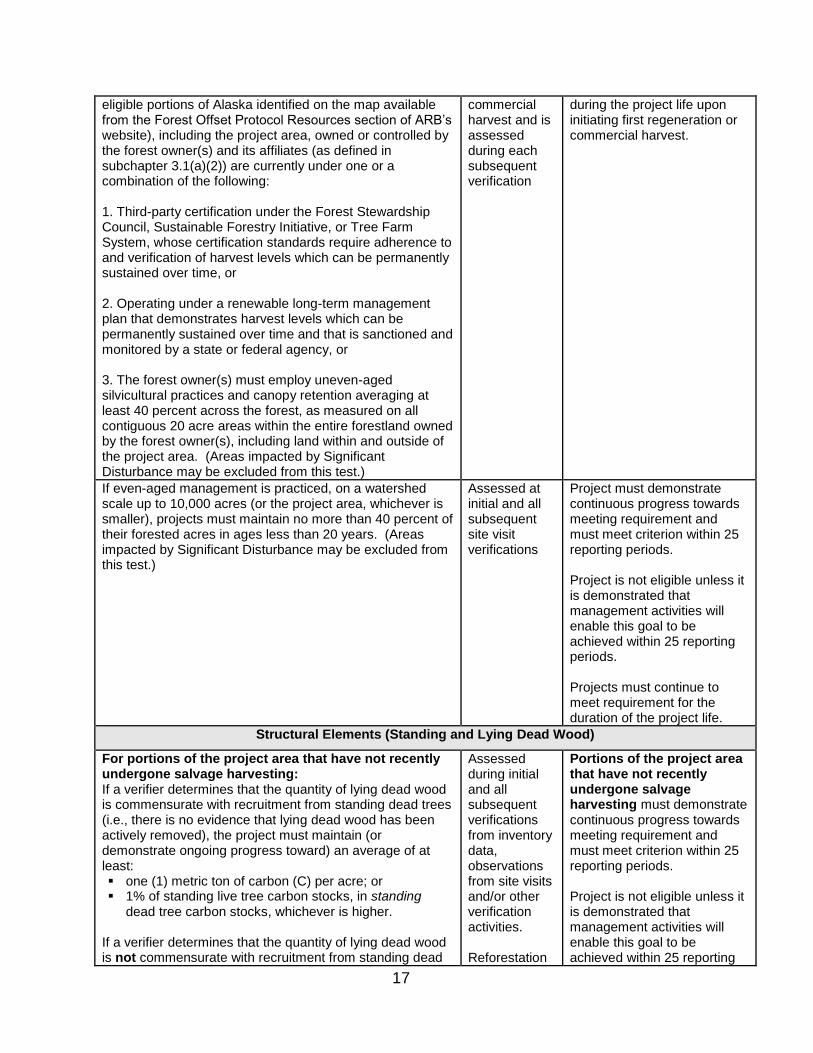
17
eligible portions of Alaska identified on the map available from the Forest Offset Protocol Resources section of ARB’s website), including the project area, owned or controlled by the forest owner(s) and its affiliates (as defined in subchapter 3.1(a)(2)) are currently under one or a combination of the following: 1. Third-party certification under the Forest Stewardship Council, Sustainable Forestry Initiative, or Tree Farm System, whose certification standards require adherence to and verification of harvest levels which can be permanently sustained over time, or 2. Operating under a renewable long-term management plan that demonstrates harvest levels which can be permanently sustained over time and that is sanctioned and monitored by a state or federal agency, or 3. The forest owner(s) must employ uneven-aged silvicultural practices and canopy retention averaging at least 40 percent across the forest, as measured on all contiguous 20 acre areas within the entire forestland owned by the forest owner(s), including land within and outside of the project area. (Areas impacted by Significant Disturbance may be excluded from this test.)
commercial harvest and is assessed during each subsequent verification
during the project life upon initiating first regeneration or commercial harvest.
If even-aged management is practiced, on a watershed scale up to 10,000 acres (or the project area, whichever is smaller), projects must maintain no more than 40 percent of their forested acres in ages less than 20 years. (Areas impacted by Significant Disturbance may be excluded from this test.)
Assessed at initial and all subsequent site visit verifications
Project must demonstrate continuous progress towards meeting requirement and must meet criterion within 25 reporting periods. Project is not eligible unless it is demonstrated that management activities will enable this goal to be achieved within 25 reporting periods. Projects must continue to meet requirement for the duration of the project life.
Structural Elements (Standing and Lying Dead Wood)
For portions of the project area that have not recently undergone salvage harvesting: If a verifier determines that the quantity of lying dead wood is commensurate with recruitment from standing dead trees (i.e., there is no evidence that lying dead wood has been actively removed), the project must maintain (or demonstrate ongoing progress toward) an average of at least: one (1) metric ton of carbon (C) per acre; or 1% of standing live tree carbon stocks, in standing
dead tree carbon stocks, whichever is higher. If a verifier determines that the quantity of lying dead wood is not commensurate with recruitment from standing dead
Assessed during initial and all subsequent verifications from inventory data, observations from site visits and/or other verification activities. Reforestation
Portions of the project area that have not recently undergone salvage harvesting must demonstrate continuous progress towards meeting requirement and must meet criterion within 25 reporting periods. Project is not eligible unless it is demonstrated that management activities will enable this goal to be achieved within 25 reporting

18
trees (i.e., it appears lying dead wood has been actively removed), the project must maintain (or demonstrate ongoing progress toward) an average of at least: two (2) metric tons of carbon (C) per acre; or 1% of standing live tree carbon stocks, in standing
dead tree carbon stocks, whichever is higher. Standing dead tree carbon stocks may be evenly or unevenly distributed throughout the portion of the project area unaffected by salvage harvesting, as long as the appropriate minimum average tonnage per acre requirement is met. For portions of the project area that have undergone salvage harvesting within the previous reporting period: If a verifier determines that the quantity of lying dead wood following salvage harvest is commensurate with recruitment from standing dead trees, the project must maintain (or demonstrate ongoing progress toward) an average of at least two (2) metric tons of carbon (C) per acre in standing dead tree carbon stocks. If a verifier determines that the quantity of lying dead wood following harvest is not commensurate with recruitment from standing dead trees, the project must maintain (or demonstrate ongoing progress toward) an average of at least four (4) metric tons of carbon (C) per acre in standing dead tree carbon stocks. Standing dead tree carbon stocks may be evenly or unevenly distributed throughout the portion of the project area subject to salvage harvesting, as long as the appropriate minimum average tonnage per acre requirement is met.
projects as qualified in subchapter 5.1.1(b)(2) may defer assessment until the submission of the Offset Project Data Report that will undergo the second site-visit verification.
periods. Projects must continue to meet requirement for the duration of the project life. Portions of the project area that have undergone salvage harvesting within the previous reporting period must continue to meet those requirements for a period of 30 reporting periods following the salvage harvest. After 30 reporting periods, the portion of the project area subject to salvage harvesting must meet the requirements for portions that have not recently undergone salvage harvesting. Projects must continue to meet requirement for the duration of the project life.
(2) When a harvest plan is submitted to a state or federal agency or when
commercial harvesting is initiated, the Offset Project Operator or Authorized
Project Designee must demonstrate that sustainable harvesting practices
are employed on all forest landholdings within the geographic areas eligible
under this protocol (the contiguous United States and eligible portions of
Alaska identified on the map available from the Forest Offset Protocol
Resources section of ARB’s website), including the project area, that are
owned or controlled by the forest owner(s) and its affiliates;
(A) For the purposes of the sustainable harvesting practices requirements,
an affiliate means any person or entity that, directly or indirectly
through one or more intermediaries, controls, is controlled by, or is
under common control by the forest owner(s) where the forest

19
owner(s) has greater than 50 percent interest, including any general or
limited partnership in which the forest owner(s) is a partner and any
limited liability company in which the forest owner(s) holds more than
50 percent of the voting ownership. For the purposes of this definition,
"control" means the possession, direct or indirect, of the power to
direct or cause the direction of the management and policies of a
person, whether through the ownership of voting securities, by contract
or otherwise. For the purposes of this definition, “person” means an
individual or a general partnership, limited partnership, corporation,
professional corporation, limited liability company, limited liability
partnership, joint venture, trust, business trust, cooperative or
association or any other legally-recognized entity;
(B) If a forest owner or affiliate acquires new forest landholdings during the
project life, the land must be incorporated under the certification or
management plan within 5 years of acquisition;
(C) Sustainable long-term harvesting practices must be demonstrated
through one or a combination of the following options:
1. The forest owner(s) must be certified under the Forest
Stewardship Council, Sustainable Forestry Initiative, or Tree Farm
System certification programs. The terms of certification must
require adherence to and verification of harvest levels which can
be permanently sustained over time;
2. The forest owner(s) must adhere to a renewable long-term
management plan that demonstrates harvest levels which can be
permanently sustained over time and that is sanctioned and
monitored by a state or federal agency; or
3. The forest owner(s) must employ uneven-aged silvicultural
practices (if harvesting occurs) on all of the forest owner’s
landholdings within the assessment area containing the project
and maintain canopy cover averaging at least 40 percent across
all of the forest owner’s landholdings within the assessment area
containing the project as measured on contiguous 20 acre areas

20
within the forest owner’s landholdings found in any of these
assessment areas, including land within and outside of the project
area (areas impacted by significant disturbance may be excluded
from this test);
(3) Maintain or increase standing live tree carbon stocks within the project area
over any 10 consecutive year period during the project life except as
allowed for in subchapter 3.1(b)(1);
(4) If the project employs even-aged management practices within the project
area, it must meet the following harvest unit size and buffer area
requirements:
(A) Even-aged harvest units must not exceed 40 acres in total area;
(B) Even-aged harvest units shall be separated by an area that is at least
as large as the area being harvested or 20 acres, whichever is less,
and shall be separated by at least 300 ft. in all directions;
(C) Within ownership boundaries, no area contiguous to an even-aged
harvest unit may be harvested using an even-aged harvest method
unless the average of the dominant and codominant trees on an
acceptably stocked prior even-aged harvest unit is at least five feet tall,
or at least five years of age from the time of establishment on the site,
either by the planting or by natural regeneration. If these standards
are to be met with trees that were present at the time of the harvest,
there shall be an interval of not less than five years following the
completion of operations before adjacent even-aged management may
occur;
(D) An area on which even-aged timber operations have taken place shall
be classified as acceptably stocked if either of the standards set forth
in 1. or 2. below are met:
1. An area contains an average point count of 150 per acre that
meets the requirements of subchapter 8.1(b)(2)(E) to be
computed as follows:
a. Each countable tree which is not more than 4 inches DBH
counts 1 point;

21
b. Each countable tree over 4 inches and not more than 12
inches DBH counts 3 points; and
c. Each countable tree over 12 inches DBH counts as 6 points.
2. The average residual basal area measured in stems 1 inch or
larger in diameter is at least 50 square feet per acre; and
(E) Cuts on harvest units that occurred prior to the project commencement
date are exempt from subchapters 3.1(a)(4)(A) and 3.1(a)(4)(B)
provided that no new harvests occur in the previously cut harvest unit
or would-be buffer area until the harvest unit cut prior to project
commencement meets the requirements of subchapter 3.1(a)(4)(A)
and 3.1(a)(4)(B); and
(5) If project lands were included in a carbon offset project in a voluntary offset
program other than one of the approved early action offset quantification
methodologies:
(A) Demonstrate that it has met all legal and contractual requirements to
allow it to terminate its project relationship with the voluntary offset
program and be listed using this compliance offset protocol;
(B) Demonstrate that all credits issued or to be issued under the voluntary
offset program have been actualized prior to the compliance project
start date; and
(C) Determine a baseline per the requirements of the protocol that
incorporates the management practices, constraints and resulting
forest conditions, at the time the offset project transitions to the
Compliance Offset Protocol, as a result of participating in the voluntary
offset program.
(b) To be eligible under this protocol, a forest offset project must not:
(1) Experience a decrease in the standing live tree carbon stocks over any 10
consecutive year period, as evaluated in the first reporting period that is at
least ten years after project commencement and every subsequent
reporting period, by comparing the current reporting period’s 10-year
average carbon stocks to the previous reporting period’s 10-year average
22
carbon stocks, except if the decrease in standing live tree carbon stocks is
due to one of the following causes:2
(A) The decrease is demonstrably necessary to substantially improve the
project area’s resistance to wildfire, insect, and/or disease risks where:
1. The actions that will be taken to reduce the risks are documented;
and
2. The techniques used to improve resistance are supported by
relevant published peer reviewed research;
(B) The decrease is associated with a planned balancing of age classes
(regeneration, sub-merchantable, and merchantable) and is detailed in
a long-term management plan that demonstrates harvest levels can be
permanently sustained over time and that is sanctioned and monitored
by a state or federal agency where:
1. Documentation is submitted at the time of the forest project’s
listing, indicating that a balancing of age classes, resulting in a
decrease in the standing live tree carbon stocks, is planned at the
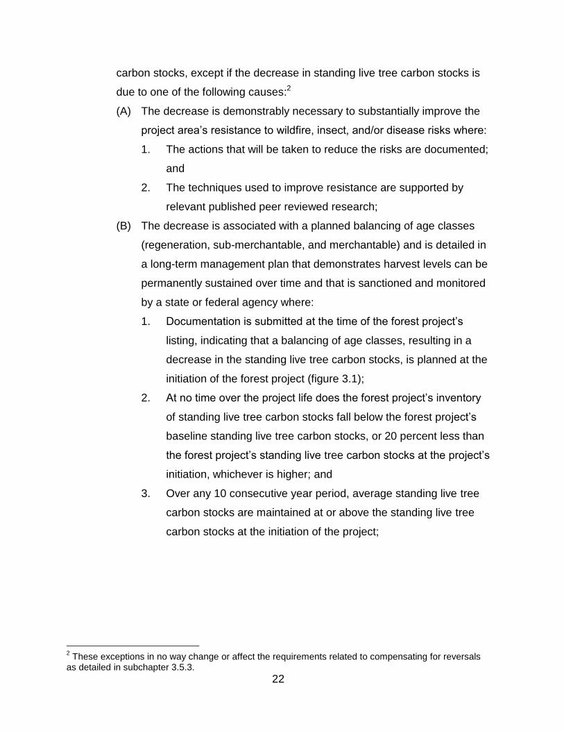
initiation of the forest project (figure 3.1);
2. At no time over the project life does the forest project’s inventory
of standing live tree carbon stocks fall below the forest project’s
baseline standing live tree carbon stocks, or 20 percent less than
the forest project’s standing live tree carbon stocks at the project’s
initiation, whichever is higher; and
3. Over any 10 consecutive year period, average standing live tree
carbon stocks are maintained at or above the standing live tree
carbon stocks at the initiation of the project;
2 These exceptions in no way change or affect the requirements related to compensating for reversals
as detailed in subchapter 3.5.3.
23
Figure 3.1. Example of Reducing Standing Live Tree Carbon Stocks as Part of Balancing Age Classes
(C) The decrease is part of normal silviculture cycles for forest ownerships
less than 1,000 acres where periodic harvests remove more biomass
than the biomass growth over the past several years where:
1. At no time during the project life does the forest project’s
inventory of standing live tree carbon stocks fall below the forest
project’s baseline standing live tree carbon stocks, or 20 percent
less than the forest project’s standing live tree carbon stocks at
the project’s initiation, whichever is higher;
2. Over any 10 consecutive year period, average standing live tree
carbon stocks are maintained at or above the standing live tree
carbon stocks at the initiation of the project; and
3. Documentation submitted at the time the forest project is listed
indicates that fluctuations in the forest project’s standing live tree
carbon stocks are an anticipated silvicultural activity and that the
overall trend will be for standing live tree carbon stocks to
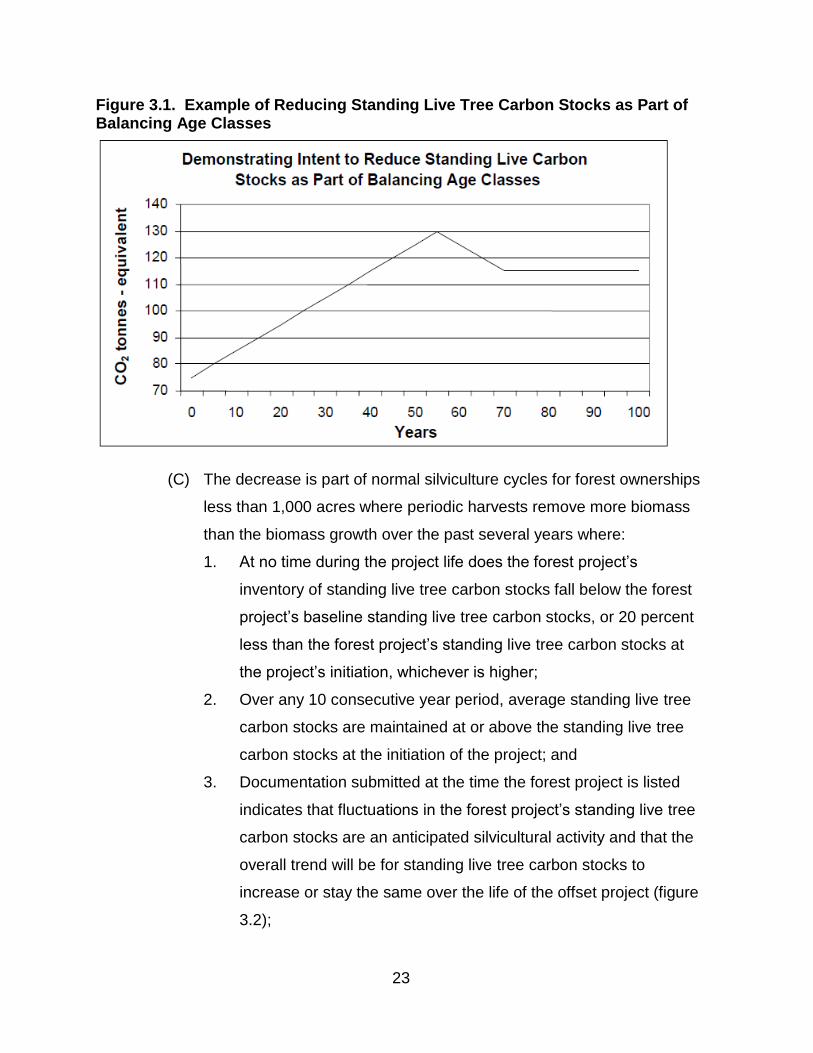
increase or stay the same over the life of the offset project (figure
3.2);
24
Figure 3.2. Example of Allowable Decrease of Standing Live Tree Carbon Stocks due to Normal Silviculture Cycles
(D) The decrease is due to an unintentional reversal; or
(E) The decrease in standing live tree carbon stocks occurs after the final
crediting period (during the required 100 year monitoring period) and
the residual live carbon stocks are maintained at a level that assures
all credited standing live tree carbon stocks are permanently
maintained;
(2) Experience a decrease in standing live tree carbon stocks that results in the
standing live tree carbon stocks falling below the forest project’s baseline
standing live tree carbon stocks or 20 percent less than the forest project’s
standing live tree carbon stocks at the project’s initiation, whichever is
higher;
(3) Employ broadcast fertilization; and
(4) Take place on land that was part of a previously listed compliance offset
forest project, unless the previous forest project was terminated due to an
unintentional reversal or is an early action offset project transitioning to this
protocol according to the provisions of the Regulation and this protocol.
(c) Offset Project Operators or Authorized Project Designees that use this protocol
must:

25
(1) Provide the listing information required by section 95975 of the Regulation
and subchapter 7.1 of this protocol;
(2) Monitor GHG emission sources, sinks, and reservoirs within the offset
project boundary as delineated in chapter 4 per the requirements of chapter
6;
(3) Quantify GHG emission reductions and GHG removal enhancements per
chapter 5;
(4) Prepare and submit OPDRs for each reporting period that include the
information requirements in subchapter 7.2 of this protocol; and
(5) Obtain offset verification services from an ARB-accredited offset verification
body in accordance with section 95977 of the Regulation and chapter 8 of
this protocol.
3.2. Location
(a) Only projects located in the United States are eligible under this protocol.
(b) Forest projects in Alaska are restricted to geographic areas identified on the map
available from the Forest Offset Protocol Resources section of ARB’s website.
(c) Forest projects in Hawaii are not eligible at this time due to lack of region-specific
data.
(d) All forest projects on public lands must be approved by the government agency
or agencies responsible for management activities on the land. This approval
must include an explicit approval of the forest project’s baseline, as determined in
chapter 5, and must involve any public vetting processes necessary to evaluate
management and policy decisions concerning the project activity.
(e) Forest projects on federal lands that are not included in the categories of land
listed in subchapter 3.2(f) are not eligible at this time.
(f) Forest projects situated on the following categories of land are only eligible under
this protocol if they meet the requirements of this protocol and the Regulation,
including the waiver of sovereign immunity requirements of section 95975(l) of
the Regulation:
(1) Land that is owned by, or subject to an ownership or possessory interest of
a Tribe;

26
(2) Land that is “Indian lands” of a Tribe, as defined by 25 U.S.C. §81(a)(1); or
(3) Land that is owned by any person, entity, or Tribe, within the external
borders of such Indian lands.
3.3. Offset Project Operator or Authorized Project Designee
(a) The Offset Project Operator or Authorized Project Designee is responsible for
project listing, monitoring, reporting, and verification.
(b) The Offset Project Operator or Authorized Project Designee must submit the
information required by subarticle 13 of the Regulation and by chapter 7.
(c) The Offset Project Operator must have the legal authority to implement the offset
project.
(d) The Offset Project Operator may identify an Authorized Project Designee
pursuant to section 95974 of the Regulation, to assist or consult with
implementation of the forest project.
(e) A single forest owner must be identified as the Offset Project Operator. If there
are multiple forest owners, all forest owners are ultimately responsible for all
forest project commitments.
(f) All information submitted to ARB or an Offset Project Registry must reference the
Offset Project Operator and all forest owner(s) who are ultimately responsible for
the accuracy and completeness of the information submitted.
3.4. Additionality
Offset projects must meet the additionality requirements of section 95973(a)(2) of the
Regulation, in addition to the requirements in this protocol. Eligible offsets must be
generated by projects that yield additional GHG emission reductions or removal
enhancements that exceed any GHG emission reductions or removal enhancements
otherwise required by law or regulation or any GHG emission reductions or removal
enhancements that would otherwise occur in a conservative business-as-usual
scenario. These requirements are assessed through the Legal Requirement Test in
subchapter 3.4.1 and the Performance Standard Evaluation in subchapter 3.4.2 of this
protocol.
27
3.4.1. Legal Requirement Test
(a) Emission reductions or removals enhancements achieved by a forest project
must exceed those required by any law, regulation, or other legally binding
mandate as required in sections 95973(a)(2)(A) and 95975(k) of the Regulation.
(b) Legally binding mandates may include, but are not limited to:
(1) Management plans such as Timber Harvest Plans that are required for
government agency approval of harvest activities; and
(2) Conservation easements or deed restrictions, except where such
conservation easements have been enacted within one year of offset project
commencement in support of the forest project.
(c) The legal requirement test is satisfied if:
(1) Project activities are not legally required (as defined in subchapter 3.4) at
the time of offset project commencement; and
(2) Modeling of the forest project’s baseline carbon stocks reflects all legal
constraints (as required in subchapter 5 and appendix B).
(3) Avoided conversion projects submit official documentation demonstrating
that the type of anticipated land use conversion is legally permissible. Such
documentation must fall into at least one of the following categories:
(A) Documentation indicating that the current land use policies, including
zoning and general plan ordinances, and other local and state statutes
and regulations, permit the anticipated type of conversion;
(B) Documentation indicating that the forest owner(s) obtained all
necessary approvals from the governing county to convert the project
area to the proposed type of non-forest land use (including, for
instance, certificates of compliance, subdivision approvals, timber
conversion permits, other rezoning, major or minor use permits, etc.);
or
(C) Documentation indicating that similarly situated forestlands within the
project’s assessment area were recently able to obtain all necessary
approvals from the governing county, state, or other governing agency
to convert to a non-forest land use (including, for instance, certificates

28
of compliance, subdivision approvals, timber conversion permits, other
rezoning, major or minor use permits, etc.).
3.4.2. Performance Standard Evaluation
(a) Emission reductions or removals enhancements achieved by a forest project
must exceed those likely to occur in a conservative business-as-usual scenario.
(b) The performance standard evaluation is satisfied if the following requirements
are met, on the basis of project type:
(1) Reforestation projects
(A) A reforestation project that occurs on land that has had less than 10
percent tree canopy cover for at least 10 years automatically satisfies
the performance standard evaluation.
(B) A reforestation project that occurs on land that has undergone a
significant disturbance satisfies the performance standard evaluation if:
1. The forest project corresponds to a scenario in appendix E, table
E.1, indicating that it is “eligible” (as determined by the
requirements and methods in appendix E); or
2. The forest project occurs on a type of land for which the forest
owner(s) has not historically engaged in or allowed timber
harvesting.
(2) Improved forest management projects
(A) An improved forest management project automatically satisfies the
performance standard evaluation.
(B) Improved forest management project activities are considered
additional to the extent they produce GHG emission reductions and
GHG removal enhancements in excess of those that would have
occurred under a conservative business-as-usual scenario, as defined
by the baseline estimation requirements in subchapter 5.2.
(3) Avoided conversion projects
(A) An avoided conversion project satisfies the performance evaluation
standard if a real estate appraisal for the project area is submitted
indicating that the project area is suitable for conversion and that the

29
alternative land use for the project area has a higher market value than
forestland. The appraisal must:
1. Clearly identify the highest value alternative land use for the
project area;
2. Indicate how the physical characteristics of the project area are
suitable for the alternative land use;
a. Where conversion to commercial, industrial, residential, or
agricultural land uses is anticipated, the appraisal must
indicate that the average slope across the entire project area
does not exceed 40 percent;
b. Where conversion to agricultural land use is anticipated, the
appraisal must provide evidence of soil suitability for the type
of expected agricultural land use and evidence of water
availability for the type of expected agricultural land use;
c. Where conversion to mining land use is anticipated, the
appraisal must provide evidence of the extent and amount of
mineral resources existing in the project area, and the
commercial viability of mineral extraction;
3. Identify specific portions of the project area suitable for the
identified alternative land use;
4. Where conversion to residential, commercial, industrial or
recreational land uses is anticipated, the appraisal must also
describe:
a. The proximity of the project area to metropolitan areas;
b. The proximity of the project area to grocery and fuel
services; and accessibility of those services; and
c. The population growth within 180 miles of the project area;
5. Include any and all costs and revenues associated with the
conversion that are necessary to get the property to the higher
and better use condition; these costs and revenues would
therefore already be included in the appraisal value of the
alternative land use;

30
6. Demonstrate that the fair market value of the anticipated
alternative land use for the project area is at least 40 percent
greater than the value of the current forested land use; and
7. Projects with multiple parcels within a project area must meet the
requirement that the alternative land use for each parcel has at
least a 40 percent greater value than the current forested land
use. Individual parcels cannot be averaged for eligibility
purposes. The Offset Project Operator or Authorized Project
Designee must sum the individual appraised values for each
parcel within the project area when calculating the ACD.
(B) The appraisal must be conducted in accordance with the Uniform Standards
of Professional Appraisal Practice3 and the appraiser must meet the
qualification standards outlined in Internal Revenue Code, Section 170
(f)(11)(E)(ii).4
3.5. Permanence
(a) The Regulation requires that credited GHG emission reductions and GHG
removal enhancements be “permanent.” For purposes of this protocol, 100 years
is considered permanent.
(b) Permanence of forest project GHG emission reductions and removal
enhancements is addressed through three mechanisms:
(1) The requirement for all offset projects to monitor onsite carbon stocks,
submit annual Offset Project Data Reports, and undergo third-party
verification of those reports with site visits at least every six years for the
duration of the project life;
3 Uniform Standards of Professional Appraisal Practice. http://www.uspap.org/#/1/.
4 Section 170 (f)(11)(E)(ii) of the Internal Revenue Code defines a qualified appraiser as
“an individual who - (I) has earned an appraisal designation from a recognized professional appraiser organization or has otherwise met minimum education and experience requirements set forth in regulations prescribed by the Secretary, (II) regularly performs appraisals for which the individual receives compensation, and (III) meets such other requirements as may be prescribed by the Secretary in regulations or other guidance.”

31
(2) The regulatory obligation for all intentional reversals of GHG emission
reductions and GHG removal enhancements to be compensated for through
retirement of other compliance instruments; and
(3) The maintenance of a forest buffer account by ARB to provide insurance
against reversals of GHG emission reductions and GHG removal
enhancements due to unintentional causes.
3.5.1. Project Life and Minimum Time Commitment
(a) Forest projects must continue to monitor, report, and verify offset project data for
the duration of the project life.
(b) There are three possible exceptions to this minimum time commitment:
(1) A forest project automatically terminates if an unintentional reversal occurs
that reduces the forest project’s standing live tree carbon stocks below the
forest project’s baseline standing live tree carbon stocks. If this occurs, the
requirements of section 95983 of the Regulation apply;
(2) A forest project automatically terminates if project lands or timber rights are
sold to an entity that does not elect to take over the forest project
responsibilities and commitments. Such a termination will require a quantity
of ARB offset credits to be retired, as specified in subchapter 3.5.3; or
(3) A forest project may be voluntarily terminated prior to the end of its
minimum time commitment if the required quantities of compliance
instruments are retired, as specified as specified in subchapter 3.5.3.
3.5.2. Identifying a Reversal
(a) GHG emission reductions and GHG removal enhancements can be reversed if
the stored carbon associated with them is released (back) to the atmosphere.
(b) Provisions related to the disposition of a forest project after a reversal are set
forth in section 95983 of the Regulation. These provisions dictate under what
circumstances a forest project that undergoes an intentional or unintentional
reversal would be terminated and under what circumstances the forest project
may continue without termination.
(c) To determine if a reversal has occurred, equation 3.1 must be applied.
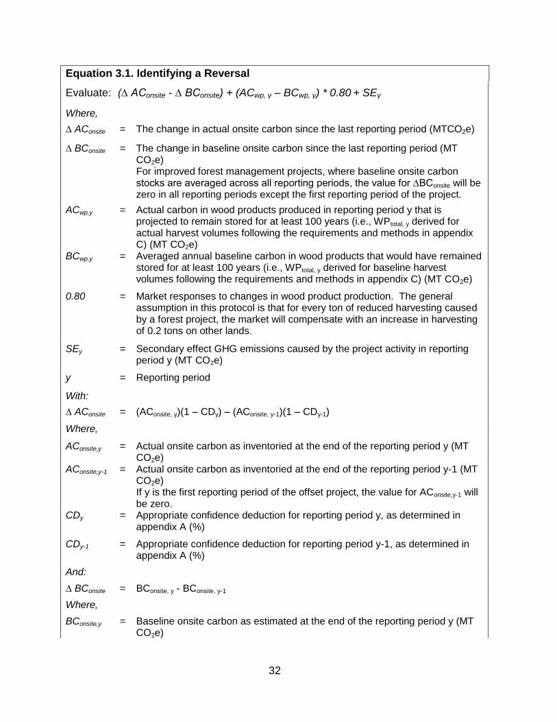
32
Equation 3.1. Identifying a Reversal
Evaluate: (∆ AConsite - ∆ BConsite) + (ACwp, y – BCwp, y) * 0.80 + SEy
Where,
∆ AConsite = The change in actual onsite carbon since the last reporting period (MTCO2e)
∆ BConsite = The change in baseline onsite carbon since the last reporting period (MT CO2e) For improved forest management projects, where baseline onsite carbon stocks are averaged across all reporting periods, the value for ∆BConsite will be zero in all reporting periods except the first reporting period of the project.
ACwp,y = Actual carbon in wood products produced in reporting period y that is projected to remain stored for at least 100 years (i.e., WPtotal, y derived for actual harvest volumes following the requirements and methods in appendix C) (MT CO2e)
BCwp,y = Averaged annual baseline carbon in wood products that would have remained stored for at least 100 years (i.e., WPtotal, y derived for baseline harvest volumes following the requirements and methods in appendix C) (MT CO2e)
0.80 = Market responses to changes in wood product production. The general assumption in this protocol is that for every ton of reduced harvesting caused by a forest project, the market will compensate with an increase in harvesting of 0.2 tons on other lands.
SEy = Secondary effect GHG emissions caused by the project activity in reporting period y (MT CO2e)
y = Reporting period
With:
∆ AConsite
=
(AConsite, y)(1 – CDy) – (AConsite, y-1)(1 – CDy-1)
Where,
AConsite,y = Actual onsite carbon as inventoried at the end of the reporting period y (MT CO2e)
AConsite,y-1 = Actual onsite carbon as inventoried at the end of the reporting period y-1 (MT CO2e) If y is the first reporting period of the offset project, the value for AConsite,y-1 will be zero.
CDy = Appropriate confidence deduction for reporting period y, as determined in appendix A (%)
CDy-1 = Appropriate confidence deduction for reporting period y-1, as determined in appendix A (%)
And:
∆ BConsite = BConsite, y - BConsite, y-1
Where,
BConsite,y = Baseline onsite carbon as estimated at the end of the reporting period y (MT CO2e)

33
BConsite,y-1 = Baseline onsite carbon as estimated at the end of the reporting period y-1 (MT CO2e) If y is the first reporting period of the offset project, the value for BConsite,y-1 will be zero.
If the result is ≥ 0, then the forest project has generated GHG emission reductions and GHG removal enhancements in the reporting period If the result is < 0 and ARB or registry credits have previously been issued to the forest project, then a reversal has occurred, regardless of the cause of the decrease If the result is < 0 and no ARB or registry credits have been issued to the forest project since its commencement date, then the result is treated as a “negative carryover” to GHG emission reduction calculations in subsequent reporting periods (variable Ny-1 within equation 5.1)
3.5.3. Compensating for a Reversal
(a) Requirements for compensating for unintentional reversals are set forth in
section 95983 of the Regulation. Unintentional reversals are insured against by
a forest buffer account, a holding account administered by ARB for ARB offset
credits issued to forest projects.
(1) All forest projects must contribute a percentage of ARB offset credits to the
Forest Buffer Account any time ARB offset credits are issued by ARB for
verified GHG emission reductions and GHG removal enhancements. Each
forest project’s contribution is based on a project-specific risk rating,
determined according to appendix D.
(2) If a forest project experiences an unintentional reversal of credited GHG
emission reductions and GHG removal enhancements, ARB offset credits
from the forest buffer account will be retired in an amount equal to the total
amount of carbon that was reversed (measured in metric tons of CO2e)
according to the process identified in the Regulation.
(b) Requirements for compensating for intentional reversals are set forth in section
95983 of the Regulation. If a forest project is terminated for any reason except
an unintentional reversal, the forest owner(s) must replace any ARB offset credits
that have previously been issued based on the requirements in the Regulation
and the following provisions:
(1) For a reforestation or avoided conversion project, a quantity of compliance
instruments equal to the total number of ARB offset credits issued to the
project over all preceding reporting periods must be retired; and

34
(2) For an improved forest management project, a quantity of compliance
instruments equal to the total number of ARB offset credits issued and,
where applicable, all early action offset credits issued pursuant to section
95990(i) of the Regulation to the project over all preceding reporting
periods, multiplied by the appropriate compensation rate indicated in table
3.2, must be retired.
Table 3.2. Compensation Rate for Terminated Improved Forest Management Projects
3.6. Offset Project Commencement
(a) For this protocol, offset project commencement is defined as the date on which
the earliest activity is first implemented that will lead to increased GHG emission
reductions or GHG removal enhancements relative to the forest project’s
baseline. Only the following actions identify offset project commencement on the
basis of project type:
(1) For a reforestation project, whichever of the following actions occurs first
denotes an offset project commencement date:
(A) Planting trees;
(B) Removing impediments to natural regeneration; or
(C) Initiating site preparation for the planting of trees.
(2) For an improved forest management project, one of the following actions
must denote an offset project commencement date:
(A) Submitting the offset project listing information specified in subchapter
7.1.
(B) Transferring of property ownership to a public or private entity; or
Number of years that have elapsed between offset project commencement and the date of termination
Compensation Rate
0-5 1.40
>5-10 1.20
>10-20 1.15
>20-25 1.10
>25-50 1.05
>50 1.00

35
(C) Recordation of a conservation easement on the project area;
1. The recordation of a conservation easement may be used to
denote the commencement date of pre-existing projects between
December 31, 2006 and December 31, 2010.
2. Any previously recorded conservation easement may only be
considered a Qualified Conservation Easement if it was recorded
within one year prior to the identified project commencement date.
3. Any previously recorded conservation easement must still meet,
or be modified to meet, all of the requirements contained in the
definition in subchapter 1.2 in order to be considered “qualified.”
(3) For an avoided conversion project, the action is committing the project area
to continued forest management and protection through recording a
conservation easement with a provision to maintain the project area in forest
cover or transferring the project area to public ownership.
(b) Adequate documentation denoting the offset project commencement date must
include, where applicable, deeds of trust, title reports, conservation easement
documentation, dated forest management plans, and/or other relevant contracts
or agreements.
(c) Pursuant to section 95973(a)(2)(B) of the Regulation, compliance offset projects
must have an offset project commencement date after December 31, 2006.
3.7. Project Crediting Period
(a) The offset project crediting period is the period of time over which emission
reductions are quantified for the purpose of determining creditable GHG emission
reductions.
(b) The offset project crediting period for this protocol is 25 reporting periods.
(c) For this protocol, the initial crediting period begins on the first day of the first
reporting period as identified in the first verified Offset Project Data Report
received by ARB or an Offset Project Registry approved pursuant to section
95986 of the Regulation.

36
3.8. Regulatory Compliance
(a) An offset project must meet the regulatory compliance requirements set forth in
section 95973(b) of the Regulation.
(b) The Offset Project Operator or Authorized Project Designee is required to
disclose in writing to the verifier any and all instances of non-compliance with any
legal requirement associated with the project lands.
Chapter 4. Offset Project Boundary – Quantification Methodology
The GHG assessment boundary, or offset project boundary, delineates the GHG
emission SSRs that must be included or excluded when quantifying the net changes in
GHG emissions associated with the sequestration of carbon achieved by increasing
and/or conserving forest carbon stocks. The following offset project boundaries apply
to all forest projects on the basis of activity type:
4.1. Reforestation
(a) Table 4.1 lists the SSRs for reforestation projects indicating which gases are
included or excluded from the offset project boundary.
(b) If an SSR is designated as a reservoir, GHG emission reductions and GHG
removal enhancements are accounted for by quantifying changes in carbon stock
levels. If an SSR is designated as a source or sink, GHG emission reductions
and GHG removal enhancements are accounted for by quantifying changes in
GHG emissions or GHG removal enhancement rates, as described in the table.
Table 4.1. List of the Greenhouse Gas Sources, Sinks, and Reservoirs for Reforestation Projects
SSR Description Type Gas Included/ Excluded
Quantification Method
Primary Effect Sources, Sinks, and Reservoirs
RF-1 Standing live tree carbon (carbon in above- and below-ground portions of living trees)
Reservoir CO2 Included Baseline: Modeled based on initial field inventory measurements Project: Measured by field measurements and updating forest carbon inventory

37
RF-2 Shrubs and herbaceous understory carbon
Reservoir CO2 Included/Excluded Baseline: Pre-existing vegetation is modeled based on initial field inventory Project: N/A. Carbon pool is excluded from project scenario. Removal of brush is quantified in secondary emissions
RF-3 Standing dead tree carbon (carbon in all portions of dead, standing trees)
Reservoir CO2 Included Baseline: Modeled based on initial field inventory measurements Project: Measured by updating forest carbon inventory
RF-4 Lying dead wood carbon
Reservoir CO2 Excluded Baseline: N/A Project: N/A
RF-5 Litter and duff carbon (carbon in dead plant material)
Reservoir CO2 Excluded Baseline: N/A Project: N/A
RF-6 Soil carbon Reservoir CO2 Included/excluded: Soil carbon must be included in the Offset Project Boundary if any of the following occur: Site preparation
activities involve deep ripping, furrowing, or plowing where soil disturbance exceeds (or is expected to exceed from the baseline characterization and modeling) 25 percent of the project area over the project life, or
Mechanical site preparation activities are not conducted on contours.
No crediting of increased soil carbon is allowed.
Baseline: Modeled based on initial field inventory measurements Project: Measured by updating forest carbon inventory
RF-7 Carbon in in-use forest products
Reservoir CO2 Included Baseline: Estimated from modeled harvesting volumes Project: Estimated from measured harvesting volumes

38
RF-8 Forest product carbon in landfills
Reservoir CO2 Excluded when project harvesting exceeds baseline. Included when project harvesting is below baseline
Baseline: Estimated from modeled harvesting volumes Project: Estimated from measured harvesting volumes
Secondary Effect Sources, Sinks, and Reservoirs
RF-9 Biological emissions from site preparation activities
Source CO2 Included: Biological emissions from site preparation are not quantified separately, but rather are captured by measuring changes in included carbon reservoirs
Baseline: N/A Project: Quantified based on measured carbon stock changes in included reservoirs (SSRs #RF-2 and #RF-6)
RF-10 Mobile combustion emissions from site preparation activities
Source CO2 Included Baseline: N/A Project: Estimated using default emission factors
CH4 Excluded Baseline: N/A Project: N/A
N2O Excluded Baseline: N/A Project: N/A
RF-11 Mobile combustion emissions from ongoing project operation & maintenance
Source CO2 Excluded Baseline: N/A Project: N/A
CH4 Excluded Baseline: N/A Project: N/A
N2O Excluded Baseline: N/A Project: N/A
RF-12 Stationary combustion emissions from ongoing project operation & maintenance
Source CO2 Excluded Baseline: N/A Project: N/A
CH4 Excluded Baseline: N/A Project: N/A
N2O Excluded Baseline: N/A Project: N/A
RF-13 Biological emissions from clearing of forestland outside the project area
Source CO2 Included Baseline: N/A Project: Estimated using default land-use conversion factors for non-project land
39
RF-14 Biological emissions/ removals from changes in harvesting on forestland outside the project area
Source / Sink
CO2 Excluded Baseline: N/A Project: N/A
RF-15 Combustion emissions from production, transportation, and disposal of forest products
Source CO2 Excluded Baseline: N/A Project: N/A
CH4 Excluded Baseline: N/A Project: N/A
N2O Excluded Baseline: N/A Project: N/A
RF-16 Combustion emissions from production, transportation, and disposal of alternative materials to forest products
Source CO2 Excluded Baseline: N/A Project: N/A
CH4 Excluded Baseline: N/A Project: N/A
N2O Excluded Baseline: N/A Project: N/A
RF-17 Biological emissions from decomposition of forest products
Source CO2 Included Baseline: Quantified as a component of calculating carbon stored for 100 years in wood products (SSR #RF-7) and landfills (SSR #RF-8) Project: Quantified as a component of calculating carbon stored for 100 years in wood products (SSR #RF-7) and landfills (SSR #RF-8)
CH4 Excluded Baseline: N/A Project: N/A
N2O Excluded Baseline: N/A Project: N/A
4.2. Improved Forest Management
(a) Table 4.2 lists the SSRs for improved forest management projects indicating
which gases are included or excluded from the offset project boundary.
(b) If an SSR is designated as a reservoir, GHG emission reductions and GHG
removal enhancements are accounted for by quantifying changes in carbon stock
levels. If an SSR is designated as a source or sink, GHG emission reductions

40
and GHG removal enhancements are accounted for by quantifying changes in
GHG emissions or GHG removal enhancement rates, as described in the table.
Table 4.2. List of the Greenhouse Gas Sources, Sinks, and Reservoirs for Improved Forest Management Projects
SSR Description Type Gas Included/ Excluded Quantification Method
Primary Effect Sources, Sinks, and Reservoirs
IFM-1 Standing live tree carbon (carbon in above- and below-ground portions of living trees)
Reservoir CO2 Included Baseline: Modeled based on initial field inventory measurements Project: Measured by field measurements and updating forest carbon inventory
IFM-2 Shrubs and herbaceous understory carbon
Reservoir CO2 Excluded Baseline: N/A Project: N/A
IFM-3 Standing dead tree carbon (carbon in all portions of dead, standing trees)
Reservoir CO2 Included Baseline: Modeled based on initial field inventory measurements Project: Measured by updating forest carbon inventory
IFM-4 Lying dead wood carbon
Reservoir CO2 Excluded Baseline: N/A Project: N/A
IFM-5 Litter and duff carbon (carbon in dead plant material)
Reservoir CO2 Excluded Baseline: Modeled based on initial field inventory measurements Project: Measured by updating forest carbon inventory
IFM-6 Soil carbon Reservoir CO2 Included/ Excluded Soil carbon must be included in the Offset Project Boundary, if any of the following activities occur: Site preparation
activities involve deep ripping, furrowing, or plowing where soil disturbance exceeds (or is expected to exceed from the baseline characterization and modeling) 25 percent of the project area over the project life, or
Baseline: Modeled based on initial field inventory measurements Project: Measured by updating forest carbon inventory
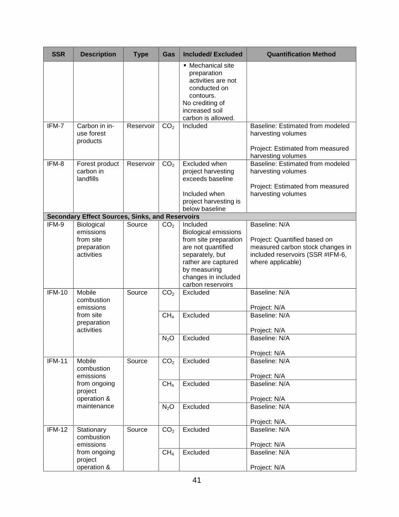
41
SSR Description Type Gas Included/ Excluded Quantification Method
Mechanical site preparation activities are not conducted on contours.
No crediting of increased soil carbon is allowed.
IFM-7 Carbon in in-use forest products
Reservoir CO2 Included Baseline: Estimated from modeled harvesting volumes Project: Estimated from measured harvesting volumes
IFM-8 Forest product carbon in landfills
Reservoir CO2 Excluded when project harvesting exceeds baseline Included when project harvesting is below baseline
Baseline: Estimated from modeled harvesting volumes Project: Estimated from measured harvesting volumes
Secondary Effect Sources, Sinks, and Reservoirs
IFM-9 Biological emissions from site preparation activities
Source CO2 Included Biological emissions from site preparation are not quantified separately, but rather are captured by measuring changes in included carbon reservoirs
Baseline: N/A Project: Quantified based on measured carbon stock changes in included reservoirs (SSR #IFM-6, where applicable)
IFM-10 Mobile combustion emissions from site preparation activities
Source CO2 Excluded Baseline: N/A Project: N/A
CH4 Excluded Baseline: N/A Project: N/A
N2O Excluded Baseline: N/A Project: N/A
IFM-11 Mobile combustion emissions from ongoing project operation & maintenance
Source CO2 Excluded Baseline: N/A Project: N/A
CH4 Excluded Baseline: N/A Project: N/A
N2O Excluded Baseline: N/A Project: N/A.
IFM-12 Stationary combustion emissions from ongoing project operation &
Source CO2 Excluded Baseline: N/A Project: N/A
CH4 Excluded Baseline: N/A Project: N/A
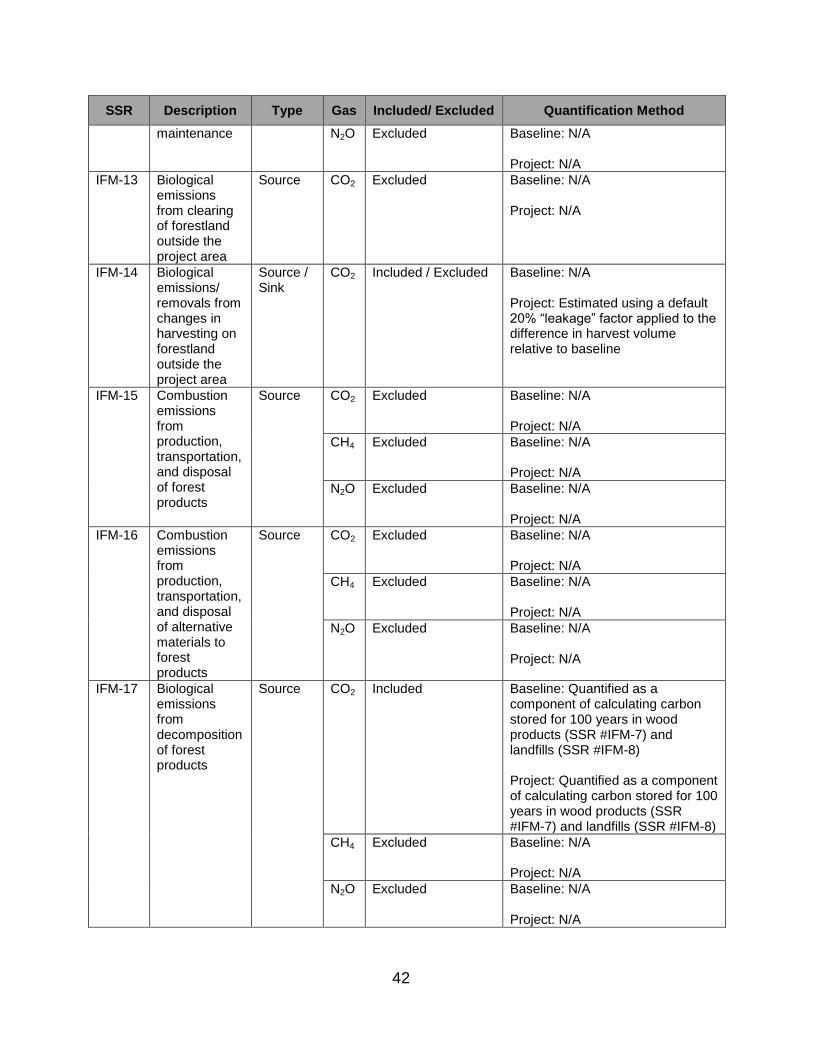
42
SSR Description Type Gas Included/ Excluded Quantification Method
maintenance N2O Excluded Baseline: N/A Project: N/A
IFM-13 Biological emissions from clearing of forestland outside the project area
Source CO2 Excluded Baseline: N/A Project: N/A
IFM-14 Biological emissions/ removals from changes in harvesting on forestland outside the project area
Source / Sink
CO2 Included / Excluded Baseline: N/A Project: Estimated using a default 20% “leakage” factor applied to the difference in harvest volume relative to baseline
IFM-15 Combustion emissions from production, transportation, and disposal of forest products
Source CO2 Excluded Baseline: N/A Project: N/A
CH4 Excluded Baseline: N/A Project: N/A
N2O Excluded Baseline: N/A Project: N/A
IFM-16 Combustion emissions from production, transportation, and disposal of alternative materials to forest products
Source CO2 Excluded Baseline: N/A Project: N/A
CH4 Excluded Baseline: N/A Project: N/A
N2O Excluded Baseline: N/A Project: N/A
IFM-17 Biological emissions from decomposition of forest products
Source CO2 Included Baseline: Quantified as a component of calculating carbon stored for 100 years in wood products (SSR #IFM-7) and landfills (SSR #IFM-8) Project: Quantified as a component of calculating carbon stored for 100 years in wood products (SSR #IFM-7) and landfills (SSR #IFM-8)
CH4 Excluded Baseline: N/A Project: N/A
N2O Excluded Baseline: N/A Project: N/A

43
4.3. Avoided Conversion
(a) Table 4.3 lists the SSRs for avoided conversion projects indicating which gases
are included or excluded from the offset project boundary.
(b) If an SSR is designated as a reservoir, GHG emission reductions and GHG
removal enhancements are accounted for by quantifying changes in carbon stock
levels. If an SSR is designated as a source or sink, GHG emission reductions
and GHG removal enhancements are accounted for by quantifying changes in
GHG emissions or GHG removal enhancement rates, as described in the table.
Table 4.3. List of the Greenhouse Gas Sources, Sinks, and Reservoirs for Avoided Conversion Projects
SSR Description Type Gas Included/ Excluded
Quantification Method
Primary Effect Sources, Sinks, and Reservoirs
AC-1 Standing live tree carbon (carbon in above- and below-ground portions of living trees)
Reservoir CO2 Included Baseline: Modeled based on initial field inventory measurements and expected land-use conversion rates Project: Measured by field measurements and updating forest carbon inventory
AC-2 Shrubs and herbaceous understory carbon
Reservoir CO2 Excluded Baseline: N/A Project: N/A
AC-3 Standing dead tree carbon (carbon in all portions of dead, standing trees)
Reservoir CO2 Included Baseline: Modeled based on initial field inventory measurements and expected land-use conversion rates Project: Measured by updating forest carbon inventory
AC-4 Lying dead wood carbon
Reservoir CO2 Excluded Baseline: N/A Project: N/A
AC-5 Litter and duff carbon (carbon in dead plant material)
Reservoir CO2 Excluded Baseline: N/A Project: N/A
AC-6 Soil carbon Reservoir CO2 Included/ Excluded Soil carbon must be included in the Offset Project Boundary, if any of the following activities occur: Site preparation
activities involve deep ripping, furrowing, or
Baseline: Modeled based on initial field inventory measurements and expected land-use conversion rates Project: Measured by updating forest carbon inventory

44
SSR Description Type Gas Included/ Excluded
Quantification Method
plowing where soil disturbance exceeds (or is expected to exceed from the baseline characterization and modeling) 25 percent of the project area over the project life, or
Mechanical site preparation activities are not conducted on contours
No crediting of increased soil carbon is allowed.
AC-7 Carbon in in-use forest products
Reservoir CO2 Included Baseline: Estimated from modeled harvesting volumes Project: Estimated from measured harvesting volumes
AC-8 Forest product carbon in landfills
Reservoir CO2 Excluded when project harvesting exceeds baseline Included when project harvesting is below baseline
Baseline: Estimated from modeled harvesting volumes Project: Estimated from measured harvesting volumes
Secondary Effect Sources, Sinks, and Reservoirs
AC-9 Biological emissions from site preparation activities
Source CO2 Included Biological emissions from site preparation are not quantified separately, but rather are captured by measuring changes in included carbon reservoirs
Baseline: N/A Project: Quantified based on measured carbon stock changes in included reservoirs (SSR #AC-6, where applicable)
AC-10 Mobile combustion emissions from site preparation activities
Source CO2 Excluded Baseline: N/A Project: N/A
CH4 Excluded Baseline: N/A Project: N/A
N2O Excluded Baseline: N/A Project: N/A
AC-11 Mobile combustion emissions
Source CO2 Excluded Baseline: N/A Project: N/A
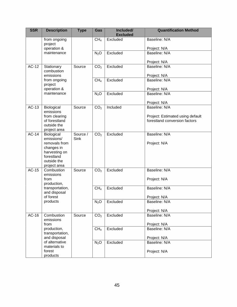
45
SSR Description Type Gas Included/ Excluded
Quantification Method
from ongoing project operation & maintenance
CH4 Excluded Baseline: N/A Project: N/A
N2O Excluded Baseline: N/A Project: N/A
AC-12 Stationary combustion emissions from ongoing project operation & maintenance
Source CO2 Excluded Baseline: N/A Project: N/A
CH4 Excluded Baseline: N/A Project: N/A
N2O Excluded Baseline: N/A Project: N/A
AC-13 Biological emissions from clearing of forestland outside the project area
Source CO2 Included Baseline: N/A Project: Estimated using default forestland conversion factors
AC-14 Biological emissions/ removals from changes in harvesting on forestland outside the project area
Source / Sink
CO2 Excluded Baseline: N/A Project: N/A
AC-15 Combustion emissions from production, transportation, and disposal of forest products
Source CO2 Excluded Baseline: N/A Project: N/A
CH4 Excluded Baseline: N/A Project: N/A
N2O Excluded Baseline: N/A Project: N/A
AC-16 Combustion emissions from production, transportation, and disposal of alternative materials to forest products
Source CO2 Excluded Baseline: N/A Project: N/A
CH4 Excluded Baseline: N/A Project: N/A
N2O Excluded Baseline: N/A Project: N/A
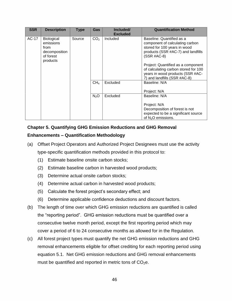
46
SSR Description Type Gas Included/ Excluded
Quantification Method
AC-17 Biological emissions from decomposition of forest products
Source CO2 Included Baseline: Quantified as a component of calculating carbon stored for 100 years in wood products (SSR #AC-7) and landfills (SSR #AC-8) Project: Quantified as a component of calculating carbon stored for 100 years in wood products (SSR #AC-7) and landfills (SSR #AC-8)
CH4 Excluded Baseline: N/A Project: N/A
N2O Excluded Baseline: N/A Project: N/A Decomposition of forest is not expected to be a significant source of N2O emissions.
Chapter 5. Quantifying GHG Emission Reductions and GHG Removal
Enhancements – Quantification Methodology
(a) Offset Project Operators and Authorized Project Designees must use the activity
type-specific quantification methods provided in this protocol to:
(1) Estimate baseline onsite carbon stocks;
(2) Estimate baseline carbon in harvested wood products;
(3) Determine actual onsite carbon stocks;
(4) Determine actual carbon in harvested wood products;
(5) Calculate the forest project’s secondary effect; and
(6) Determine applicable confidence deductions and discount factors.
(b) The length of time over which GHG emission reductions are quantified is called
the “reporting period”. GHG emission reductions must be quantified over a
consecutive twelve month period, except the first reporting period which may
cover a period of 6 to 24 consecutive months as allowed for in the Regulation.
(c) All forest project types must quantify the net GHG emission reductions and GHG
removal enhancements eligible for offset crediting for each reporting period using
equation 5.1. Net GHG emission reductions and GHG removal enhancements
must be quantified and reported in metric tons of CO2e.

47
Equation 5.1. Net GHG Reductions and GHG Removal Enhancements
QRy = [(∆ AConsite - ∆ BConsite) + (ACwp,y – BCwp,y) * 0.80 + SEy] * (1 – ACD) + Ny-1
Where,
QRy = Quantified GHG emission reductions and GHG removal enhancements for reporting period y (MT CO2e)
y = Reporting period
∆ AConsite = The change in actual onsite carbon since the last reporting period (MTCO2e)
∆ BConsite = The change in baseline onsite carbon since the last reporting period (MT CO2e) For improved forest management projects, where baseline onsite carbon stocks are averaged across all reporting periods, the value for ∆BConsite will be zero in all reporting periods except the first reporting period of the project.
ACwp,y = Actual carbon in wood products produced in reporting period y that is projected to remain stored for at least 100 years (i.e., WPtotal, y derived for actual harvest volumes following the requirements and methods in appendix C) (MT CO2e)
BCwp,y = Averaged annual baseline carbon in wood products that would have remained stored for at least 100 years (i.e., WPtotal, y derived for baseline harvest volumes following the requirements and methods in appendix C) (MT CO2e)
0.80 = Market responses to changes in wood product production. The general assumption in this protocol is that for every ton of reduced harvesting caused by a forest project, the market will compensate with an increase in harvesting of 0.2 tons on other lands.
SEy = Secondary effect GHG emissions caused by the project activity in reporting period y (MT CO2e)
ACD = Avoided conversion project discount factor, determined in equation 5.11 (%)
Ny-1 = Any negative carryover from the prior reporting period (MT CO2e) Occurs when total quantified GHG emission reductions are negative prior to the issuance of any ARB offset credits for the project.
With:
∆ AConsite
=
(AConsite, y)(1 – CDy) – (AConsite, y-1)(1 – CDy-1)
Where,
AConsite,y = Actual onsite carbon as inventoried at the end of reporting period y (MT CO2e)
AConsite,y-1 = Actual onsite carbon as inventoried at the end of reporting period y-1 (MT CO2e) If y is the first reporting period of the offset project, the value for AConsite,y-1 will be zero.
CDy = Appropriate confidence deduction for reporting period y, as determined in appendix A (%)
CDy-1 = Appropriate confidence deduction for reporting period y-1, as determined in appendix A (%)
And:

48
∆ BConsite = BConsite,y - BConsite,y-1
Where,
BConsite,y = Baseline onsite carbon as estimated at the end of reporting period y (MT CO2e)
BConsite,y-1 = Baseline onsite carbon as estimated at the end of reporting period y-1 (MT CO2e) If y is the first reporting period of the offset project, the value for BConsite,y-1 will be zero.
5.1. Reforestation Projects
5.1.1. Estimating Baseline Onsite Carbon Stocks
The Offset Project Operator or Authorized Project Designee for a reforestation project
must estimate baseline onsite carbon stocks according to the following methodology:
(a) Provide a qualitative characterization of the likely vegetative conditions and
activities that would have occurred without the project. The qualitative
characterization must:
(1) Take into consideration any laws, statutes, regulations, or other legal
mandates that would require reforestation on the project area;
(2) Include an assessment of the commercial value of trees within the project
area over the next 30 years; and
(3) Be used as the basis for modeling baseline carbon stocks per subchapter
5.1.1(c).
(b) Inventory the carbon stocks in each of the forest project’s required carbon pools
(identified in table 4.1), following the requirements in appendix A.
(1) For carbon pools that will be affected by site preparation, the inventory must
be conducted prior to any site preparation activities. For those carbon pools
that are affected by site preparation, provide an estimate of initial carbon
stocks by:
(A) Measuring carbon stocks using 20 sample plots located in the portion
of the project area containing the greatest amount of biomass in the
pool that will be affected;
(B) Stratifying (classifying) the project area into similar densities and
measuring stocks within the affected carbon pools using 20 sample
plots per density class; or
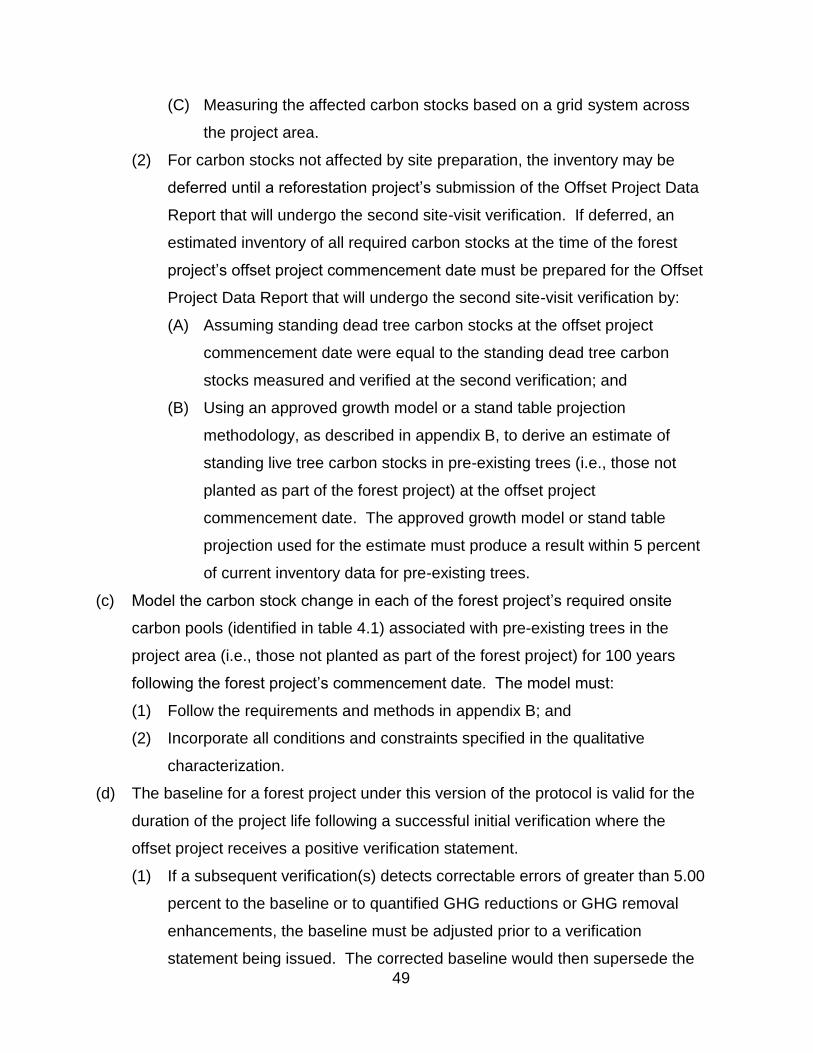
49
(C) Measuring the affected carbon stocks based on a grid system across
the project area.
(2) For carbon stocks not affected by site preparation, the inventory may be
deferred until a reforestation project’s submission of the Offset Project Data
Report that will undergo the second site-visit verification. If deferred, an
estimated inventory of all required carbon stocks at the time of the forest
project’s offset project commencement date must be prepared for the Offset
Project Data Report that will undergo the second site-visit verification by:
(A) Assuming standing dead tree carbon stocks at the offset project
commencement date were equal to the standing dead tree carbon
stocks measured and verified at the second verification; and
(B) Using an approved growth model or a stand table projection
methodology, as described in appendix B, to derive an estimate of
standing live tree carbon stocks in pre-existing trees (i.e., those not
planted as part of the forest project) at the offset project
commencement date. The approved growth model or stand table
projection used for the estimate must produce a result within 5 percent
of current inventory data for pre-existing trees.
(c) Model the carbon stock change in each of the forest project’s required onsite
carbon pools (identified in table 4.1) associated with pre-existing trees in the
project area (i.e., those not planted as part of the forest project) for 100 years
following the forest project’s commencement date. The model must:
(1) Follow the requirements and methods in appendix B; and
(2) Incorporate all conditions and constraints specified in the qualitative
characterization.
(d) The baseline for a forest project under this version of the protocol is valid for the
duration of the project life following a successful initial verification where the
offset project receives a positive verification statement.
(1) If a subsequent verification(s) detects correctable errors of greater than 5.00
percent to the baseline or to quantified GHG reductions or GHG removal
enhancements, the baseline must be adjusted prior to a verification
statement being issued. The corrected baseline would then supersede the
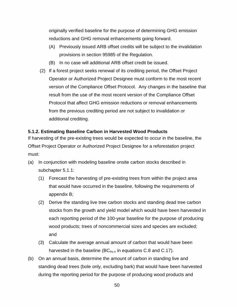
50
originally verified baseline for the purpose of determining GHG emission
reductions and GHG removal enhancements going forward.
(A) Previously issued ARB offset credits will be subject to the invalidation
provisions in section 95985 of the Regulation.
(B) In no case will additional ARB offset credit be issued.
(2) If a forest project seeks renewal of its crediting period, the Offset Project
Operator or Authorized Project Designee must conform to the most recent
version of the Compliance Offset Protocol. Any changes in the baseline that
result from the use of the most recent version of the Compliance Offset
Protocol that affect GHG emission reductions or removal enhancements
from the previous crediting period are not subject to invalidation or
additional crediting.
5.1.2. Estimating Baseline Carbon in Harvested Wood Products
If harvesting of the pre-existing trees would be expected to occur in the baseline, the
Offset Project Operator or Authorized Project Designee for a reforestation project
must:
(a) In conjunction with modeling baseline onsite carbon stocks described in
subchapter 5.1.1:
(1) Forecast the harvesting of pre-existing trees from within the project area
that would have occurred in the baseline, following the requirements of
appendix B;
(2) Derive the standing live tree carbon stocks and standing dead tree carbon
stocks from the growth and yield model which would have been harvested in
each reporting period of the 100-year baseline for the purpose of producing
wood products; trees of noncommercial sizes and species are excluded;
and
(3) Calculate the average annual amount of carbon that would have been
harvested in the baseline (BChv,n in equations C.8 and C.17).
(b) On an annual basis, determine the amount of carbon in standing live and
standing dead trees (bole only, excluding bark) that would have been harvested
during the reporting period for the purpose of producing wood products and
51
would have remained stored in wood products over 100 years, following the
requirements and methods in appendix C; trees of noncommercial sizes and
species are excluded.
5.1.3. Determining Actual Onsite Carbon Stocks
For each reporting period after the completion of an estimated inventory of all required
carbon stocks, the Offset Project Operator or Authorized Project Designee for a
reforestation project must determine the forest project’s actual onsite carbon stocks by
updating the project area’s forest carbon inventory according to the following
methodology:
(a) Incorporate any new forest inventory data obtained during the reporting period
into the inventory estimate. Any plots sampled during the reporting period must
be incorporated into the inventory estimate;
(b) Use an approved model to “grow” (project forward) prior-year data from existing
forest inventory plots to the end of the current reporting period, per the
requirements of appendix B;
(c) Update the forest inventory estimate for harvests and/or disturbances that have
occurred during the reporting period; and
(d) Apply an appropriate confidence deduction for the inventory based on its
statistical uncertainty, following the requirements and methods in appendix A.
5.1.4. Determining Actual Carbon in Harvested Wood Products
For each reporting period after the completion of an estimated inventory of all required
carbon stocks, the Offset Project Operator or Authorized Project Designee for a
reforestation project must determine the forest project’s actual carbon in harvested
wood products according to the following methodology:
(a) Based on harvest volumes determined in subchapter 5.1.3 and using the same
volume and biomass equations used to calculate biomass in live trees and
estimate baseline onsite carbon stocks, determine the standing live tree carbon
stocks and standing dead tree carbon stocks harvested from within the project
area during the reporting period for the purpose of producing wood products;
trees of noncommercial sizes and species are excluded (AChv,n in equations C.8
and C.17).
52
(b) Determine the amount of carbon in standing live and standing dead trees (bole
only, excluding bark) that is harvested during the reporting period for the purpose
of producing wood products and will remain stored in wood products over 100
years, following the requirements and methods in appendix C; trees of
noncommercial sizes and species are excluded.
5.1.5. Calculating Secondary Effects
For each reporting period after the completion of an estimated inventory of all required
carbon stocks, the Offset Project Operator or Authorized Project Designee for a
reforestation project must quantify the secondary effects associated with the project.
(a) Secondary effects will almost always be negative (i.e., they will reflect an
increase in GHG emissions caused by the offset project). For reforestation
projects, significant secondary effects can arise from:
(1) Mobile combustion emissions associated with machinery used in site
preparation; and
(2) The shifting of cropland or grazing activities to forestland outside the project
area (which may be both a market and/or physical response to the project
activity).
(b) If the addition of negative secondary effect emissions results in a negative
amount for total net quantified GHG emission reductions and GHG removal
enhancements in the first reporting period (QR1), the negative amount must be
carried over into future reporting periods (Ny-1 in equation 5.1) until sufficient
GHG emission reductions and GHG removal enhancements are accrued to
achieve a positive balance. Negative GHG emission reductions and GHG
removal enhancements due to site preparation emissions are not considered a
reversal.
(c) Emissions due to mobile combustion from site preparation must be quantified
using equation 5.2 and the appropriate standard emission factor from table 5.1
corresponding to the level of brush cover on the project area.

53
Equation 5.2. Combustion Emissions Associated with Site Preparation
MCy = (-1) x (EFmc x PA)
Where,
MCy = Secondary effect emissions due to mobile combustion from site preparation in reporting period y (MT CO2e)
EFmc = Mobile combustion emission factor from table 5.1 (MT CO2e/acre)
y = Reporting period
PA = The size of the project area (acres)
Table 5.1. Mobile Combustion Emissions for Reforestation Projects
SITE PREP - REFORESTATION PROJECTS Emissions Associated with Mobile Combustion
Average Metric Tons CO2e per Acre
Light Medium Heavy
0-25% Brush Cover >25-50% Dense Brush
Cover >50% Brush Cover,
Stump Removal
0.090 0.202 0.429
(d) Emissions from shifting cropland and grazing activities must be quantified using
equation 5.3 and the appropriate leakage risk percentage for the project by
following the decision tree in figure 5.1.
(e) The leakage risk percentage is determined once, at offset project
commencement, and remains constant for the duration of the project life.
Equation 5.3. Emissions from Shifting Cropland and Grazing Activities
ASy = (-1) x L x (∆ AConsite - ∆ BConsite)
Where,
ASy = Secondary effect emissions due to shifting of cropland or grazing activities in reporting period y (MT CO2e)
L = Leakage risk percentage, as determined from figure 5.1 (%)
y = Reporting period
∆ AConsite = Annual difference in actual onsite carbon as defined in equation 5.1 (MT CO2e)
∆ BConsite = Annual difference in baseline onsite carbon as defined in equation 5.1 (MT CO2e)
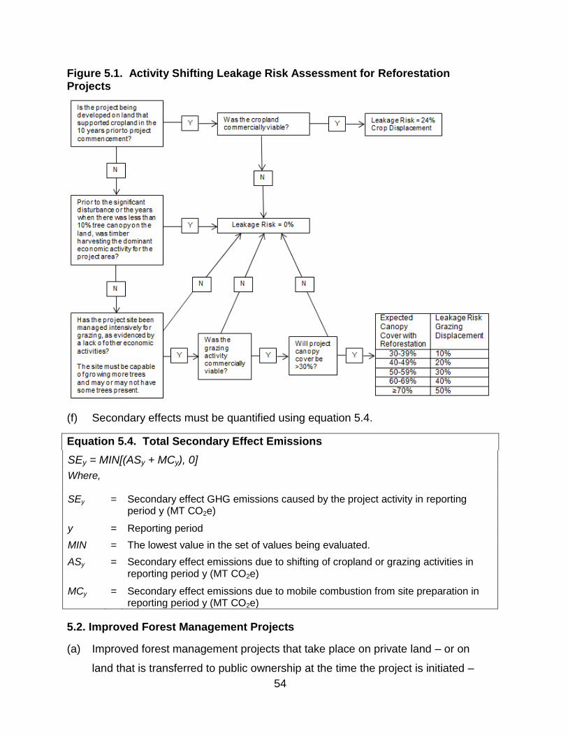
54
Figure 5.1. Activity Shifting Leakage Risk Assessment for Reforestation Projects
(f) Secondary effects must be quantified using equation 5.4.
Equation 5.4. Total Secondary Effect Emissions
SEy = MIN[(ASy + MCy), 0]
Where,
SEy = Secondary effect GHG emissions caused by the project activity in reporting period y (MT CO2e)
y = Reporting period
MIN = The lowest value in the set of values being evaluated.
ASy = Secondary effect emissions due to shifting of cropland or grazing activities in reporting period y (MT CO2e)
MCy = Secondary effect emissions due to mobile combustion from site preparation in reporting period y (MT CO2e)
5.2. Improved Forest Management Projects
(a) Improved forest management projects that take place on private land – or on
land that is transferred to public ownership at the time the project is initiated –
55
must estimate baseline onsite carbon stocks following the requirements and
procedures in subchapter 5.2.1.
(b) Improved forest management projects that take place on land that was publicly
owned prior to the offset project commencement date must estimate baseline
onsite carbon stocks following the requirements and procedures in subchapter
5.2.2.
(c) Requirements for determining baseline carbon in harvested wood products,
determining actual onsite carbon stocks, determining actual carbon in harvested
wood products, and quantifying secondary effects are the same for all improved
forest management projects.
5.2.1. Estimating Baseline Onsite Carbon Stocks – Private Land
The Offset Project Operator or Authorized Project Designee for an improved forest
management project on private land must estimate baseline onsite carbon stocks
according to the following methodology:
(a) Conduct an inventory of the onsite carbon stocks in each of the forest project’s
required onsite carbon pools (identified in table 4.2) following the requirements in
appendix A. Develop distinct inventories for:
(1) Initial above-ground standing live tree carbon stocks;
(2) Initial below-ground standing live tree carbon stocks;
(3) Initial standing dead tree carbon stocks (above-ground and below-ground
standing dead tree carbon may be combined); and
(4) Soil carbon stocks, if soil is an included carbon pool per table 4.2.
(b) Calculate the initial above-ground standing live tree carbon stocks per acre within
the project area expressed in MT CO2e (ICS) by:
(1) Identifying the total metric tons of CO2e contained in the initial above-ground
standing live tree carbon stocks within the project area; and
(2) Dividing this amount by the number of acres in the project area.
(c) Following the requirements of appendix F, identify the common practice (CP)
value for the project area from the Assessment Area Data File associated with
this protocol version available in the Forest Offset Protocol Resources section of
ARB’s website.

56
Figure 5.2. Common Practice as a Reference Point for Baseline Estimation
(d) Determine if the ICS is above or below the CP value and calculate the minimum
baseline level for above-ground standing live tree carbon stocks (MBL)
accordingly.
(1) If ICS is above CP, determine MBL using equation 5.5:
Equation 5.5. Determining the Minimum Baseline Level Where Initial Carbon Stocks Are Above Common Practice
MBL = MAX(CP, MIN(ICS, CP + ICS - WCS))
Where,
MAX = The highest value in the set of values being evaluated
MIN = The lowest value in the set of values being evaluated
MBL = Minimum baseline level for above-ground standing live tree carbon stocks (MT CO2e/acre)
CP = Common Practice (MT CO2e/acre)
ICS = Initial above-ground standing live tree carbon stocks per acre within the project area (MT CO2e/acre)
WCS = The weighted average above-ground standing live tree carbon stocks per acre within the LMU containing the project area (MT CO2e/acre)
(2) If ICS is below or equal to CP, determine MBL using equation 5.6:

57
Equation 5.6. Determining the Minimum Baseline Level Where Initial Carbon Stocks Are Below or Equal to Common Practice
MBL = MAX (MAX (HSR, ICS), MIN (CP, WCS))
Where,
MAX = The highest value in the set of values being evaluated
MIN = The lowest value in the set of values being evaluated
MBL = Minimum baseline level for above-ground standing live tree carbon stocks (MT CO2e/acre)
HSR = The “high stocking reference” for the project area (MT CO2e/acre)
CP = Common practice (MT CO2e/acre)
ICS = Initial above-ground standing live tree carbon stocks per acre within the project area (MT CO2e/acre)
WCS = The weighted average above-ground standing live tree carbon stocks per acre for all forest owner(s) (and affiliate) landholdings within the same logical management unit as the project area (MT CO2e/acre)
(3) Determine the weighted average above-ground standing live tree carbon
stocks per acre (WCS) for all forest owner(s) and affiliate(s) landholdings
within the same logical management unit (LMU) as the project area. For the
purposes of defining the LMU, an affiliate means any person or entity that,
directly or indirectly through one or more intermediaries, controls, is
controlled by, or is under common control by the forest owner(s), including
any general or limited partnership in which the forest owner(s) is a partner
and any limited liability company in which the forest owner(s) is a member.
For the purposes of this definition, “control” means the possession, direct or
indirect, of the power to direct or cause the direction of the management
and polices of a person, whether through the ownership of voting securities,
by contract or otherwise. For the purposes of this definition, “person”
means an individual or a general partnership, limited liability partnership,
joint venture, trust, business trust, cooperative or association or any other
legally-recognized entity. To determine the WCS, the Offset Project
Operator or Authorized Project Designee must:
1. Identify the LMU according to the definition in subchapter 1.2;

58
2. To calculate WCS, estimate the above-ground standing live tree
carbon stocks per acre for the entire LMU containing the project
area, including the project area itself;
3. If sufficient inventory data for LMU lands exist to quantify above-
ground standing live tree carbon stocks for the entire LMU, then
equation 5.7 must be used to calculate WCS; and
4. If sufficient inventory data is not available for the LMU, a stratified
vegetation-type analysis must be used to calculate WCS. To
conduct this analysis, all landholdings within the LMU, including
the project area, must be divided into vegetation types and size
class/canopy cover categories as delimited in table 5.2 with a
resolution for classification no greater than 40 acres. Each
vegetation class has a “carbon rating” provided in table 5.2. WCS
must be calculated using the ratio of average carbon stocking on
LMU lands relative to carbon stocking on project area lands
(referred to as the “stratified carbon weighting factor” or SWF)
using equations 5.7, 5.8, and 5.9; and
Equation 5.7. Formula for WCS Using Inventory Data
𝐼𝑓 |(1 −𝐸𝐶𝑆
𝐼𝐶𝑆)| ≤ 0.2, 𝑡ℎ𝑒𝑛 𝑊𝐶𝑆 = 𝐼𝐶𝑆
𝐼𝑓 |(1 −𝐸𝐶𝑆
𝐼𝐶𝑆)| > 0.2, 𝑡ℎ𝑒𝑛 𝑊𝐶𝑆 =
𝐼𝐶𝑆 ∙ 𝑃𝐴 + 𝐸𝐶𝑆 ∙ 𝐸𝐴
𝑃𝐴 + 𝐸𝐴
Where,
WCS = The weighted average above-ground standing live tree carbon stocks per acre within the LMU containing the project area (MT CO2e/acre)
ICS = Initial above-ground standing live tree carbon stocks per acre within the project area (MT CO2e/acre)
ECS = Above-ground standing live tree carbon stocks per acre within the LMU but excluding the project area, as determined from existing inventory data (MT CO2e/acre)
PA = Size of the project area (acres)
EA = Size of the LMU, excluding the Project Area (acres)
Equation 5.8. Formula for WCS Using Stratified Vegetation-Type Analysis
𝐼𝑓 |(1 − 𝑆𝑊𝐹)| ≤ 0.2, 𝑡ℎ𝑒𝑛 𝑊𝐶𝑆 = 𝐼𝐶𝑆
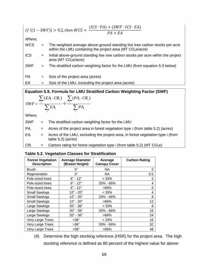
59
𝐼𝑓 |(1 − 𝑆𝑊𝐹)| > 0.2, 𝑡ℎ𝑒𝑛 𝑊𝐶𝑆 = (𝐼𝐶𝑆 ∙ 𝑃𝐴) + (𝑆𝑊𝐹 ∙ 𝐼𝐶𝑆 ∙ 𝐸𝐴)
𝑃𝐴 + 𝐸𝐴
Where,
WCS = The weighted average above-ground standing live tree carbon stocks per acre within the LMU containing the project area (MT CO2e/acre)
ICS = Initial above-ground standing live tree carbon stocks per acre within the project area (MT CO2e/acre)
SWF = The stratified carbon weighting factor for the LMU (from equation 5.9 below)
PA = Size of the project area (acres)
EA = Size of the LMU, excluding the project area (acres)
Equation 5.9. Formula for LMU Stratified Carbon Weighting Factor (SWF)
Where,
SWF = The stratified carbon weighting factor for the LMU
PAi = Acres of the project area in forest vegetation type i (from table 5.2) (acres)
EAi = Acres of the LMU, excluding the project area, in forest vegetation type i (from table 5.2) (acres)
CRi = Carbon rating for forest vegetation type i (from table 5.2) (MT CO2e)
Table 5.2. Vegetation Classes for Stratification
Forest Vegetation Description
Average Diameter (Breast Height)
Average Canopy Cover
Carbon Rating
Brush 0" NA 0
Regeneration 3" NA 0.5
Pole-sized trees 6" - 12" < 33% 2
Pole-sized trees 6" - 12" 33% - 66% 4
Pole-sized trees 6" - 12" >66% 6
Small Sawlogs 12" - 20" < 33% 4
Small Sawlogs 12" - 20" 33% - 66% 8
Small Sawlogs 12" - 20" >66% 12
Large Sawlogs 20" - 36" < 33% 8
Large Sawlogs 20" - 36" 33% - 66% 16
Large Sawlogs 20" - 36" >66% 24
Very Large Trees >36" < 33% 16
Very Large Trees >36" 33% - 66% 32
Very Large Trees >36" >66% 48
(4) Determine the high stocking reference (HSR) for the project area. The high
stocking reference is defined as 80 percent of the highest value for above-
i
i
i
ii
i
i
i
ii
PA
CRPA
EA
CREA
SWF
)()(

60
ground standing live tree carbon stocks per acre within the project area
during the preceding 10-year period;
(A) To determine the high stocking reference, the Offset Project Operator
or Authorized Project Designee must document changes in the project
area’s above-ground standing live tree carbon stocks over the
preceding 10 years; and
(B) Figure 5.3 presents a graphical portrayal of a high stocking reference
determination;
Figure 5.3. Determining a Project Area’s High Stocking Reference
(e) Model the onsite carbon stocks, keeping the carbon pools listed in subchapter
5.2.1(a) distinct, through a series of growth and harvesting scenarios over 100
years beginning with the initial carbon stocks at the time of offset project
commencement. Modeling must follow the requirements and methods in
appendix B, and reflect a financially feasible scenario that includes all legal
constraints.
(1) All legal constraints that could affect baseline growth and harvesting
scenarios must be incorporated into the modeled baseline. Legal
constraints include all laws, regulations, and legally-binding commitments
applicable to the project area at the time of offset project commencement
that could affect standing live tree carbon stocks. Legal constraints include:

61
(A) Federal, state, or local government regulations that are required and
might reasonably be anticipated to influence carbon stocking over time,
including, but not limited to:
1. Zones with harvest restrictions (e.g., buffers, streamside
protection zones, wildlife protection zones);
2. Harvest adjacency restrictions; and
3. Minimum stocking standards;
(B) Forest practice rules, or applicable Best Management Practices
established by federal, state, or local government that relate to forest
management;
(C) Other legally binding requirements affecting carbon stocks, including,
but not limited to, covenants, conditions and restrictions, and other title
restrictions in place prior to or at the time of project initiation, including
pre-existing conservation easements, Habitat Conservation Plans,
Safe Harbor Agreements, and deed restrictions, excepting an
encumbrance that was put in place and/or recorded less than or equal
to one year prior to the offset project commencement date, as defined
in subchapter 3.6;
1. Voluntary agreements that can be rescinded, such as rental
contracts and forest certifications, are not legal constraints;
2. Habitat Conservation Plans (HCPs) and Safe Harbor Agreements
(SHAs) that are in place more than one year prior to the offset
project commencement date must be modeled as legal
constraints; and
3. HCPs and SHAs that are approved after the date one year prior to
the offset project commencement date are not considered legal
constraints for the purpose of baseline modeling and do not need
to be incorporated into baseline modeling; and
(D) For forest projects located in California, the baseline must be modeled
to reflect all silvicultural treatments associated with any submitted,
active, or approved timber harvest plans (THPs) at the time of offset

62
project commencement that would affect harvesting and management
within the project area during the project life.
1. All legally enforceable silvicultural and operational provisions of a
THP – including those operational provisions designed to meet
California Forest Practice Rules requirements for achieving
Maximum Sustained Production of High Quality Wood Products
[14 CCR 913.11 (933.11, 953.11)] – are considered legal
constraints and must be reflected in baseline modeling for as long
as the THP will remain active;
2. For portions of the project area not subject to THPs (or over time
periods for which THPs will not be active), baseline carbon stocks
must be modeled by taking into account any applicable
requirements of the California Forest Practice Rules and all other
applicable laws, regulations, and legally binding commitments that
could affect onsite carbon stocks; and
3. If the California Department of Forestry and Fire Protection (Cal
FIRE) has assisted in identifying minimum carbon stocking levels
that would be effectively required under California Forest Practice
Rules, they must be modeled into the baseline.
(2) All financial constraints that could affect baseline growth and harvesting
scenarios must be incorporated into the modeled baseline. It must be
demonstrated that the growth and harvesting regime assumed for the
baseline is financially feasible through one of the following means:
(A) Conducting a financial analysis of the anticipated growth and
harvesting regime that captures all relevant costs and returns, taking
into consideration all legal, physical, and biological constraints. Cost
and revenue variables in the financial analysis may be based on
regional norms or on documented costs and returns for the project
area or other properties in the forest project’s assessment area; or
(B) Providing evidence that activities similar to the proposed baseline
growth and harvesting regime have taken place within the past 15
years on at least three other properties within the forest project’s
63
assessment area. At least one comparable site must be on land not
owned by the forest owner(s) and/or its affiliates, and no more than
one comparable site may be within the project area. Comparable sites
on land owned by the forest owner(s) and/or its affiliates must not have
had harvest activities within two years before the offset project
commencement date. The evidence must demonstrate that harvesting
activities have taken place on at least three other comparable sites
with:
1. Slopes, as measured by average percent slope, that are not more
than 10.0 percent less than the average slopes in the project area
or that use the same methods (tractor, cable, helicopter, etc.) for
logging;
2. Functionally equivalent zoning class(es) to the project area (if
applicable); and
3. Comparable species composition to the project area which may
be evidenced by the following:
a. Comparable property species composition is within 20 percent
of project species composition based on trees per acre;
b. Identical codominant species; or
c. Identical Forest Type as defined by the USDA Forest
Inventory and Analysis Database Description and User Guide
for Phase 2 (V6.0.1), Appendix D.
(f) For each carbon pool listed in subchapter 5.2.1(a), average the periodic modeled
outputs to achieve a 100-year average annual value (CO2e/acre) for each
modeled carbon pool.
(1) The averaged model results for above-ground standing live tree carbon
stocks (CO2e/acre) must not fall below the MBL. If it does fall below the
MBL, the silvicultural activities must be modified so that the averaged model
results for above-ground standing live tree carbon stocks are equal to or
above the MBL.
(2) Figure 5.4 shows a graphical example of the ICS, CP and the 100-year
modeled above-ground standing live tree carbon stocks when ICS is above
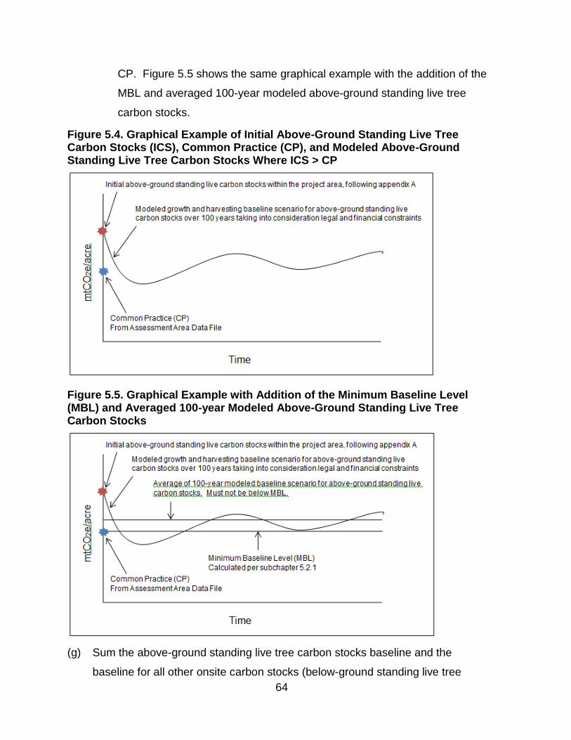
64
CP. Figure 5.5 shows the same graphical example with the addition of the
MBL and averaged 100-year modeled above-ground standing live tree
carbon stocks.
Figure 5.4. Graphical Example of Initial Above-Ground Standing Live Tree Carbon Stocks (ICS), Common Practice (CP), and Modeled Above-Ground Standing Live Tree Carbon Stocks Where ICS > CP
Figure 5.5. Graphical Example with Addition of the Minimum Baseline Level (MBL) and Averaged 100-year Modeled Above-Ground Standing Live Tree Carbon Stocks
(g) Sum the above-ground standing live tree carbon stocks baseline and the
baseline for all other onsite carbon stocks (below-ground standing live tree
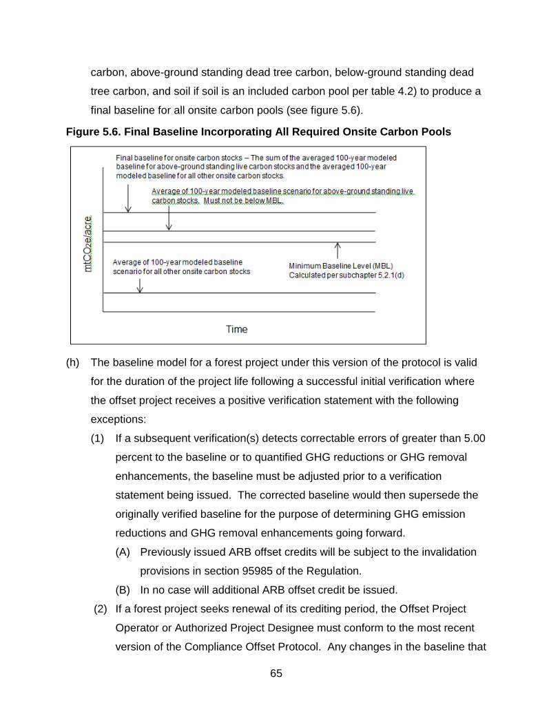
65
carbon, above-ground standing dead tree carbon, below-ground standing dead
tree carbon, and soil if soil is an included carbon pool per table 4.2) to produce a
final baseline for all onsite carbon pools (see figure 5.6).
Figure 5.6. Final Baseline Incorporating All Required Onsite Carbon Pools
(h) The baseline model for a forest project under this version of the protocol is valid
for the duration of the project life following a successful initial verification where
the offset project receives a positive verification statement with the following
exceptions:
(1) If a subsequent verification(s) detects correctable errors of greater than 5.00
percent to the baseline or to quantified GHG reductions or GHG removal
enhancements, the baseline must be adjusted prior to a verification
statement being issued. The corrected baseline would then supersede the
originally verified baseline for the purpose of determining GHG emission
reductions and GHG removal enhancements going forward.
(A) Previously issued ARB offset credits will be subject to the invalidation
provisions in section 95985 of the Regulation.
(B) In no case will additional ARB offset credit be issued.
(2) If a forest project seeks renewal of its crediting period, the Offset Project
Operator or Authorized Project Designee must conform to the most recent
version of the Compliance Offset Protocol. Any changes in the baseline that

66
result from the use of the most recent version of the Compliance Offset
Protocol that affect GHG emission reductions or removal enhancements
from the previous crediting period are not subject to invalidation or
additional crediting.
5.2.2. Estimating Baseline Onsite Carbon Stocks – Public Land
The Offset Project Operator or Authorized Project Designee for an improved forest
management project on lands owned or controlled by public agencies must estimate
baseline onsite carbon stocks according to the following methodology:
(a) Inventory the carbon stocks in each of the forest project’s required carbon pools
(identified in table 4.2), following the requirements in appendix A;
(b) Project future changes to carbon stocks within the project area by:
(1) Extrapolating from historical trends per the following:
(A) For project areas that have a ten-year history of declining carbon
stocks, the baseline must be defined by the average of the carbon
stocks over the past ten years and considered static for the project life
(i.e., the same level of carbon stocks is assumed in every year); or
(B) For project areas that demonstrate an increasing inventory of carbon
stocks over the past ten years, the growth trajectory of the baseline
must continue until the forest (under the baseline stocks) achieves a
stand composition consistent with comparable forested areas that have
been relatively free of harvest over the past 60 years;
1. If comparable forested areas within the project’s assessment area
are unavailable the project area inventory must be modeled using
one of the approved growth models (see appendix B) to represent
a standardized forested area relatively free of harvest for 60 years;
and
(2) Modeling current public policy in the baseline onsite carbon stocks over
100-years following the requirements and methods in appendix B
incorporating constraints imposed by all applicable statutes, regulations,
policies, plans and activity-based funding;
67
(c) The method that results in the highest estimated carbon stock levels must be
used to determine the baseline;
(d) Average the results over the 100-year timeframe so that the baseline is
expressed as a single (average) annual value; and
(e) The baseline for a forest project under this version of the protocol is valid for the
duration of the project life following a successful initial verification where the
offset project receives a positive verification statement.
(1) If a subsequent verification(s) detects correctable errors of greater than 5.00
percent to the baseline or to quantified GHG reductions or GHG removal
enhancements, the baseline must be adjusted prior to a verification
statement being issued. The corrected baseline would then supersede the
originally verified baseline for the purpose of determining GHG emission
reductions and GHG removal enhancements going forward.
(A) Previously issued ARB offset credits will be subject to the invalidation
provisions in section 95985 of the Regulation.
(B) In no case will additional ARB offset credit be issued.
(2) If a forest project seeks renewal of its crediting period, the Offset Project
Operator or Authorized Project Designee must conform to the most recent
version of the Compliance Offset Protocol. Any changes in the baseline that
result from the use of the most recent version of the Compliance Offset
Protocol that affect GHG emission reductions or removal enhancements
from the previous crediting period are not subject to invalidation or
additional crediting.
5.2.3. Estimating Baseline Carbon in Harvested Wood Products
The Offset Project Operator or Authorized Project Designee for an improved forest
management project must:
(a) In conjunction with modeling baseline onsite carbon stocks described in
subchapter 5.2.1 for projects on private land or subchapter 5.2.2 for projects on
public land:
(1) Forecast the harvesting of trees from within the project area that would have
occurred in the baseline, following the requirements of appendix B;
68
(2) Derive the standing live tree carbon stocks and standing dead tree carbon
stocks from the growth and harvesting model, which would have been
harvested in each reporting period of the 100 year baseline for the purpose
of producing wood products; trees of noncommercial sizes and species are
excluded; and
(3) Calculate the average annual amount of carbon that would have been
harvested in the baseline (BChv,n for use in equations C.8 and C.17).
(b) On an annual basis, determine the amount of carbon in standing live and
standing dead trees (bole only, excluding bark) that would have been harvested
during the reporting period for the purpose of producing wood products and
would have remained stored in wood products over 100 years, following the
requirements and methods in appendix C; trees of noncommercial sizes and
species are excluded.
5.2.4. Determining Actual Onsite Carbon Stocks
Each reporting period the Offset Project Operator or Authorized Project Designee for
an improved forest management project must determine the forest project’s actual
onsite carbon stocks by updating the project area’s forest carbon inventory according
to the following methodology:
(a) Incorporate any new forest inventory data obtained during the reporting period
into the inventory estimate. Any plots sampled during the previous reporting
period must be incorporated into the inventory estimate;
(b) Use an approved model to “grow” (project forward) prior-year data from existing
forest inventory plots to the end of the reporting period, per the requirements of
appendix B;
(c) Update the forest inventory estimate for harvests and/or disturbances that have
occurred during the reporting period; and
(d) Apply an appropriate confidence deduction for the inventory based on its
statistical uncertainty, following the requirements and methods in appendix A.
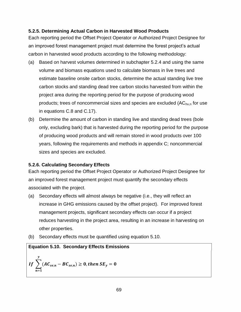
69
5.2.5. Determining Actual Carbon in Harvested Wood Products
Each reporting period the Offset Project Operator or Authorized Project Designee for
an improved forest management project must determine the forest project’s actual
carbon in harvested wood products according to the following methodology:
(a) Based on harvest volumes determined in subchapter 5.2.4 and using the same
volume and biomass equations used to calculate biomass in live trees and
estimate baseline onsite carbon stocks, determine the actual standing live tree
carbon stocks and standing dead tree carbon stocks harvested from within the
project area during the reporting period for the purpose of producing wood
products; trees of noncommercial sizes and species are excluded (AChv,n for use
in equations C.8 and C.17).
(b) Determine the amount of carbon in standing live and standing dead trees (bole
only, excluding bark) that is harvested during the reporting period for the purpose
of producing wood products and will remain stored in wood products over 100
years, following the requirements and methods in appendix C; noncommercial
sizes and species are excluded.
5.2.6. Calculating Secondary Effects
Each reporting period the Offset Project Operator or Authorized Project Designee for
an improved forest management project must quantify the secondary effects
associated with the project.
(a) Secondary effects will almost always be negative (i.e., they will reflect an
increase in GHG emissions caused by the offset project). For improved forest
management projects, significant secondary effects can occur if a project
reduces harvesting in the project area, resulting in an increase in harvesting on
other properties.
(b) Secondary effects must be quantified using equation 5.10.
Equation 5.10. Secondary Effects Emissions
𝑰𝒇 ∑(𝑨𝑪𝒔𝒆,𝒏
𝒚
𝒏=𝟏
− 𝑩𝑪𝒔𝒆,𝒏) ≥ 𝟎, 𝒕𝒉𝒆𝒏 𝑺𝑬𝒚 = 𝟎

70
𝑰𝒇 ∑(𝑨𝑪𝒔𝒆,𝒏 − 𝑩𝑪𝒔𝒆,𝒏) < 0, 𝑡ℎ𝑒𝑛 𝑺𝑬𝒚 = (𝑨𝑪𝒔𝒆,𝒚 − 𝑩𝑪𝒔𝒆,𝒚) × 𝟎. 𝟐𝟎
𝒚
𝒏=𝟏
Where,
SEy = Estimated annual secondary effects (MT CO2e)
y = The reporting period
ACse,n = Actual amount of carbon in standing live and standing dead trees (whole tree including belowground biomass and bark) harvested by reporting period y
BCse,n = Estimated average baseline amount of carbon in standing live and standing dead trees (whole tree including belowground biomass and bark) that would have been harvested by reporting period y
5.3. Avoided Conversion Projects
5.3.1. Estimating Baseline Onsite Carbon Stocks
The baseline for avoided conversion projects is a projection of onsite forest carbon
stock losses that would have occurred over time due to the conversion of the project
area to a non-forest land use. The Offset Project Operator or Authorized Project
Designee for an avoided conversion project must estimate baseline onsite carbon
stocks according to the following methodology:
(a) Characterize the baseline. The project baseline must be characterized by:
(1) Clearly specifying an alternative highest-value land use for the project area,
as identified by an appraisal (required in subchapter 3.4.2); and
(2) Estimating the rate of conversion and removal of onsite carbon stocks,
taking into consideration any laws, statutes, regulations, or other legal
mandates that affect land use conversion or removal of onsite carbon
stocks. The rate of conversion and removal of onsite carbon stocks must be
estimated by either:
(A) Referencing planning documentation for the project area (e.g.,
construction documents or plans) that specifies the timeframe of the
conversion and intended removal of forest cover on the project area; or
(B) In the absence of specific documentation, identifying default total
conversion impact and annual conversion values from table 5.3.

71
Table 5.3. Default Avoided Conversion Values
Type of Conversion Identified in Appraisal
Total Conversion Impact
This is the assumed total effect over time of the conversion activity. (The total conversion impact is amortized over a 10-year period to determine the annual conversion in the next column.)
Annual Conversion
This is the assumed annual conversion activity. The percentages below are multiplied by the initial onsite carbon stocks for the project on an annual basis for the first 10 years of the project.
Residential Estimate using the following formula:
TC = min(100, (P*3 / PA)*100)
Where: TC = % total conversion (TC cannot exceed 100%) PA = the project area (acres) identified in the appraisal P = the number of unique parcels that would be formed on the project area as identified in the appraisal
*Each parcel is assumed to deforest 3 acres of forest vegetation.
Estimate using the following formula:
AC = TC / 10
Where: AC = % annualized conversion TC = % total conversion
Mining and agricultural conversion, including pasture or crops
90% 9.0%
Recreation 80% 8.0%
Commercial and Industrial buildings
95% 9.5%
(b) Model changes in onsite carbon stocks over 100 years, reflecting the rate of
conversion estimated in subchapter 5.3.1(a)(2). The simulation must model
changes in onsite carbon stocks for all required carbon pools identified in table
4.3.
(1) The baseline model must apply the identified rate of conversion over 100-
years to estimate changes in onsite carbon stocks, beginning with the
project area’s initial onsite carbon stocks at the time of offset project
commencement determined following the requirements in appendix A; and
(2) If the projected conversion rate does not result in a complete removal of
onsite forest carbon stocks, the baseline projection must account for any
residual forest carbon value as a steady condition for the balance of a 100-
year projection.
(c) Discount for the uncertainty of conversion probability.
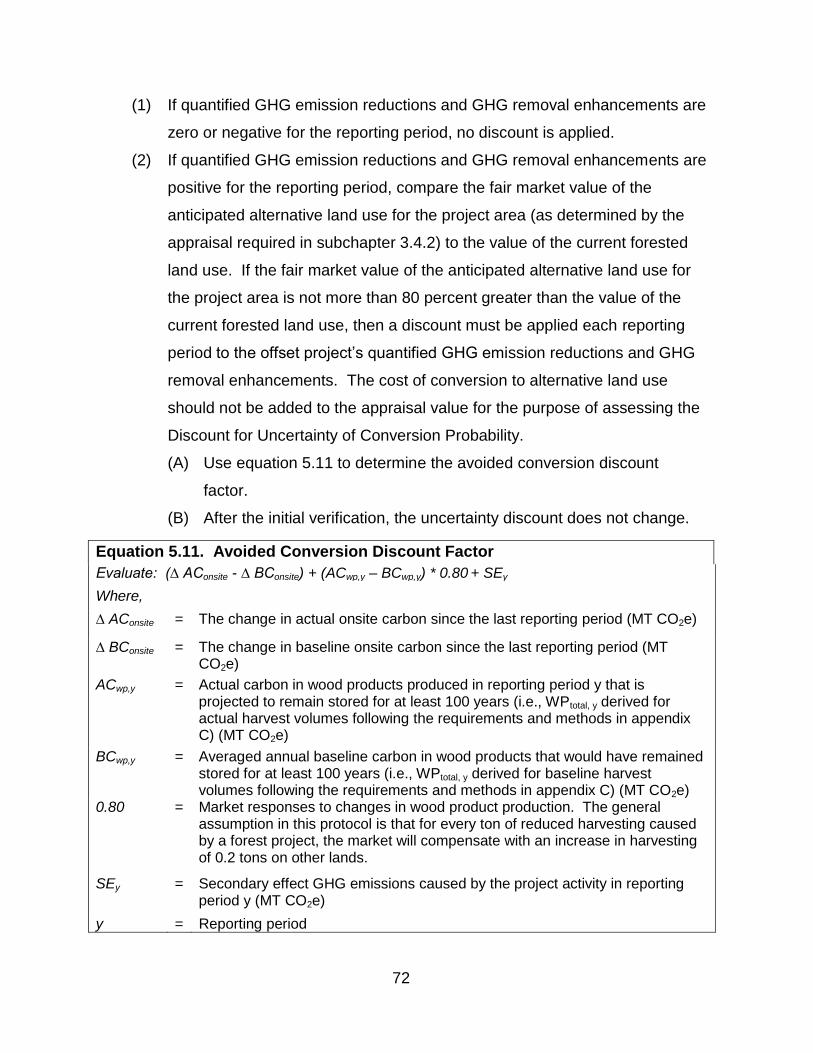
72
(1) If quantified GHG emission reductions and GHG removal enhancements are
zero or negative for the reporting period, no discount is applied.
(2) If quantified GHG emission reductions and GHG removal enhancements are
positive for the reporting period, compare the fair market value of the
anticipated alternative land use for the project area (as determined by the
appraisal required in subchapter 3.4.2) to the value of the current forested
land use. If the fair market value of the anticipated alternative land use for
the project area is not more than 80 percent greater than the value of the
current forested land use, then a discount must be applied each reporting
period to the offset project’s quantified GHG emission reductions and GHG
removal enhancements. The cost of conversion to alternative land use
should not be added to the appraisal value for the purpose of assessing the
Discount for Uncertainty of Conversion Probability.
(A) Use equation 5.11 to determine the avoided conversion discount
factor.
(B) After the initial verification, the uncertainty discount does not change.
Equation 5.11. Avoided Conversion Discount Factor
Evaluate: (∆ AConsite - ∆ BConsite) + (ACwp,y – BCwp,y) * 0.80 + SEy
Where,
∆ AConsite = The change in actual onsite carbon since the last reporting period (MT CO2e)
∆ BConsite = The change in baseline onsite carbon since the last reporting period (MT CO2e)
ACwp,y = Actual carbon in wood products produced in reporting period y that is projected to remain stored for at least 100 years (i.e., WPtotal, y derived for actual harvest volumes following the requirements and methods in appendix C) (MT CO2e)
BCwp,y = Averaged annual baseline carbon in wood products that would have remained stored for at least 100 years (i.e., WPtotal, y derived for baseline harvest volumes following the requirements and methods in appendix C) (MT CO2e)
0.80 = Market responses to changes in wood product production. The general assumption in this protocol is that for every ton of reduced harvesting caused by a forest project, the market will compensate with an increase in harvesting of 0.2 tons on other lands.
SEy = Secondary effect GHG emissions caused by the project activity in reporting period y (MT CO2e)
y = Reporting period

73
With:
∆ AConsite
=
(AConsite, y)(1 – CDy) – (AConsite, y-1)(1 – CDy-1)
Where,
AConsite,y = Actual onsite carbon as inventoried for reporting period y (MT CO2e)
AConsite,y-1 = Actual onsite carbon as inventoried for reporting period y-1 (MT CO2e) If y is the first reporting period of the offset project, the value for AConsite,y-1 will be zero.
CDy = Appropriate confidence deduction for reporting period y, as determined in appendix A (%)
CDy-1 = Appropriate confidence deduction for reporting period y-1, as determined in appendix A (%)
And:
∆ BConsite = BConsite,y - BConsite,y-1
Where,
BConsite,y = Baseline onsite carbon as estimated for reporting period y (MT CO2e)
BConsite,y-1 = Baseline onsite carbon as estimated for reporting period y-1 (MT CO2e) If y is the first reporting period of the offset project, the value for BConsite,y-1 will be zero.
If result < 0, then ACD = 0 If result > 0, then evaluate:
(VA / VP) – 1
Where,
ACD = The avoided conversion project discount factor
VA = The appraised fair market value of the anticipated alternative land use for the project area
VP = The appraised fair market value of the current forested land use for the project area
If result ≤ 0.4, then ACD = 1 If 0.4 < result < 0.8, then ACD = [0.80 – ((VA / VP) – 1)] x 2.5 If result ≥ 0.8, then ACD = 0
(d) The baseline for a forest project under this version of the protocol is valid for the
duration of the project life following a successful initial verification where the
offset project receives a positive verification statement.
(1) If a subsequent verification(s) detects correctable errors of greater than 5.00
percent to the baseline or to quantified GHG reductions or GHG removal
enhancements, the baseline must be adjusted prior to a verification
statement being issued. The corrected baseline would then supersede the

74
originally verified baseline for the purpose of determining GHG emission
reductions and GHG removal enhancements going forward.
(A) Previously issued ARB offset credits will be subject to the invalidation
provisions in section 95985 of the Regulation.
(B) In no case will additional ARB offset credit be issued.
(2) If a forest project seeks renewal of its crediting period, the Offset Project
Operator or Authorized Project Designee must conform to the most recent
version of the Compliance Offset Protocol. Any changes in the baseline that
result from the use of the most recent version of the Compliance Offset
Protocol that affect GHG emission reductions or removal enhancements
from the previous crediting period are not subject to invalidation or
additional crediting.
5.3.2. Estimating Baseline Carbon in Harvested Wood Products
Harvesting is assumed to occur in the baseline over time as the project area is
converted to another land use. The Offset Project Operator or Authorized Project
Designee for an avoided conversion project must:
(a) In conjunction with modeling baseline onsite carbon stocks described in
subchapter 5.3.1:
(1) Forecast the harvesting of trees from within the project area that would have
occurred in the baseline, consistent with the rate of reduction in baseline
standing live and standing dead carbon stocks and following the
requirements of appendix B;
(2) Derive the standing live tree carbon stocks and standing dead tree carbon
stocks from the growth and yield model which would have been harvested in
each reporting period of the 100-year baseline, for the purpose of producing
wood products; trees of noncommercial sizes and species are excluded;
and
(3) Calculate the average annual amount of carbon that would have been
harvested in the baseline (BChv,n in equations C.8 and C.16).
(b) On an annual basis, to determine the amount of carbon in standing live and
standing dead trees (bole only, excluding bark) that would have been harvested

75
during the reporting period for the purpose of producing wood products and
would have remained stored in wood products, averaged over 100 years,
following the requirements and methods in appendix C; trees of noncommercial
sizes and species are excluded.
5.3.3. Determining Actual Onsite Carbon Stocks
Each reporting period the Offset Project Operator or Authorized Project Designee for
an avoided conversion project must determine the forest project’s actual onsite carbon
stocks by updating the project area’s forest carbon inventory according to the following
methodology:
(a) Incorporate any new forest inventory data obtained during the reporting period
into the inventory estimate. Any plots sampled during the previous reporting
period must be incorporated into the inventory estimate;
(b) Use an approved model to “grow” (project forward) prior-year data from existing
forest inventory plots to the end of the reporting period, per the requirements of
appendix B;
(c) Update the forest inventory estimate for harvests and/or disturbances that have
occurred during the reporting period; and
(d) Apply an appropriate confidence deduction for the inventory based on its
statistical uncertainty, following the requirements and methods in appendix A.
5.3.4. Determining Actual Carbon in Harvested Wood Products
Each reporting period the Offset Project Operator or Authorized Project Designee for
an avoided conversion forest management project must determine the forest project’s
actual carbon in harvested wood products according to the following methodology:
(a) Based on harvest volumes determined in subchapter 5.3.3 and using the same
volume and biomass equations used to estimate carbon in standing live trees
and estimate baseline onsite carbon stocks, determine the actual standing live
tree carbon stocks and standing dead tree carbon stocks harvested from within
the project area during the reporting period for the purpose of producing wood
products; trees of noncommercial sizes and species are excluded (AChv,n for use
in equations C.8 and C.17); and
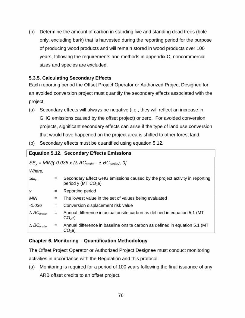
76
(b) Determine the amount of carbon in standing live and standing dead trees (bole
only, excluding bark) that is harvested during the reporting period for the purpose
of producing wood products and will remain stored in wood products over 100
years, following the requirements and methods in appendix C; noncommercial
sizes and species are excluded.
5.3.5. Calculating Secondary Effects
Each reporting period the Offset Project Operator or Authorized Project Designee for
an avoided conversion project must quantify the secondary effects associated with the
project.
(a) Secondary effects will always be negative (i.e., they will reflect an increase in
GHG emissions caused by the offset project) or zero. For avoided conversion
projects, significant secondary effects can arise if the type of land use conversion
that would have happened on the project area is shifted to other forest land.
(b) Secondary effects must be quantified using equation 5.12.
Equation 5.12. Secondary Effects Emissions
SEy = MIN[(-0.036 x (∆ AConsite - ∆ BConsite), 0]
Where,
SEy = Secondary Effect GHG emissions caused by the project activity in reporting period y (MT CO2e)
y = Reporting period
MIN = The lowest value in the set of values being evaluated
-0.036 = Conversion displacement risk value
∆ AConsite = Annual difference in actual onsite carbon as defined in equation 5.1 (MT CO2e)
∆ BConsite = Annual difference in baseline onsite carbon as defined in equation 5.1 (MT CO2e)
Chapter 6. Monitoring – Quantification Methodology
The Offset Project Operator or Authorized Project Designee must conduct monitoring
activities in accordance with the Regulation and this protocol.
(a) Monitoring is required for a period of 100 years following the final issuance of any
ARB offset credits to an offset project.

77
(b) For forest projects, monitoring activities consist primarily of annually updating a
project’s forest carbon inventory. This complete inventory must be maintained
and updated throughout the project life.
(c) At the time of offset project listing, the Offset Project Operator or Authorized
Project Designee for an improved forest management or avoided conversion
project must submit a forest carbon inventory methodology for each of the
included carbon pools, following the requirements of appendix A, and a modeling
plan, following the requirements of appendix B, detailing the specific methods
that will be used to update the project’s forest carbon inventory on an annual
basis. The Offset Project Operator or Authorized Project Designee for a
reforestation project may defer submission of these items until the submission of
the Offset Project Data Report that will undergo the second site-visit verification.
(d) The forest carbon inventory methodology and modeling plan must adhere to the
requirements and methods in appendices A and B, which establish the equations
and models for computing biomass and the limits to which computer models can
be used in the inventory update process.
(e) Specific methods used to update the forest inventory must follow the inventory
methodologies approved at the time the project is initially verified. Modifications
to inventory methodologies must achieve an equal or greater accuracy relative to
the original sampling design and be approved in advance by a third-party
verification body and by ARB, and documented in the change log.
(f) Annual onsite carbon stock estimates are computed from inventory data.
Inventory data must be updated annually by:
(1) Incorporating any new forest inventory data obtained during the reporting
period;
(2) Modeling growth in sample plots using approved growth models and stand
table projection methods (see appendix B regarding growth models and
stand table projections); and
(3) Updating the forest inventory data for harvests and/or disturbances that
have occurred during the reporting period.

78
(g) The Offset Project Operator or Authorized Project Designee is required to keep
all documentation and information outlined in the Regulation and this protocol.
Record retention requirements are set forth in section 95976 of the Regulation.
Chapter 7. Reporting
In addition to the offset project requirements set forth in sections 95975 and 95976 of
the Regulation, forest offset projects must adhere to the project listing and reporting
requirements below.
7.1. Listing Requirements
(a) Listing information must be submitted by the Offset Project Operator or
Authorized Project Designee no later than the date on which the Offset Project
Operator or Authorized Project Designee submits the first Offset Project Data
Report.
(b) The listing information must be submitted by the Offset Project Operator or
Authorized Project Designee again as part of the initial Offset Project Data
Report and is subject to verification at the initial and all subsequent offset project
verifications.
(c) Reforestation projects as qualified in subchapter 5.1.1(b)(2) can defer the items
that are marked with an asterisk until submission of the Offset Project Data
Report that will undergo the second site-visit verification.
(d) All listing information that reference carbon stocks must be submitted with the
oversight of a Professional Forester.
(e) In order for a U.S. forest compliance offset project to be listed, the Offset Project
Operator or Authorized Project Designee must submit the information required by
section 95975 of the Regulation in addition to the following information on the
basis of activity type:
7.1.1. All Forest Offset Projects
(a) All forest projects must provide:
(1) Offset project name;
(2) Offset project type (reforestation, improved forest management, or avoided
conversion);
79
(3) Contact information, including name, phone number, mailing address,
physical address (if different from mailing address) and email address for:
(A) Offset Project Operator;
(B) Authorized Project Designee (if applicable);
(C) The person submitting the information; and
(D) Any technical consultants;
(4) CITSS ID number for the:
(A) Offset Project Operator; and
(B) Authorized Project Designee (if applicable);
(5) Date listing information is completed for submittal;
(6) Indicate whether the Offset Project Operator is the owner in fee for the
project area;
(A) If yes, provide documentation (e.g., deed of trust, title report) showing
the Offset Project Operator’s ownership interest in the property and its
interest in the trees and standing timber on the property;
(B) If no, explain how the entity identified as the Offset Project Operator
has the legal authority to implement the offset project and provide
documentation supporting the explanation;
(7) Description of forestland and resource ownership for the real property within
the project area;
(8) Name and mailing address of all forest owners including in fee as well as
third parties with existing property interests within the project area that may
have an effect on the trees and standing timber located in the project area
(e.g., mineral rights, timber rights, easements, rights of way, leases, etc.);
(9) Name and mailing address of other parties with a material interest in the
real property involved in the forest project;
(10) Physical address of the project site (if available);
(11) Indicate if the offset project occurs on public or private lands, and further
specify if the offset project occurs on any of the following categories of land:
(A) Land that is owned by, or subject to an ownership or possessory
interest of a Tribe;
80
(B) Land that is “Indian lands” of a Tribe, as defined by 25 U.S.C.
§81(a)(1); or
(C) Land that is owned by any person, entity, or Tribe, within the external
borders of such Indian lands;
(12) If the project is located on one of the above categories of land, a description
and copies of documentation demonstrating that the land is owned by (or
subject to an ownership or possessory interest of) a tribe or private entities;
(13) If the forest project is located on public land, describe the approval process
and public vetting processes necessary to evaluate management and policy
decisions concerning the offset project that has or will take place in order to
obtain approval of the offset project’s management activities and baseline;
(14) Identify the assessment area(s) in which the project area is located
including:
(A) How many acres of project lands fall within each assessment area; and
(B) The total project area acreage;
(15) Descriptions and a georeferenced GIS shapefile of the project area
boundary, of adequate resolution to clearly identify the following features:
(A) Governing jurisdictions, and latitude/longitude coordinates;
(B) Public and private roads, distinguished separately (map only);
(C) Towns (map only);
(D) Major watercourses (4th order or greater), water bodies, and watershed
description (map only);
(E) Topography (map only);
(F) Townships, ranges, and sections (map only);
(G) Existing land cover and land use (description with optional map);
(H) Forest vegetation types (description with optional map);
(I) Site classes as described in Appendix F (description with optional
map);
(J) Land pressures and climate zone/classification (description with
optional map); and
(K) Historical land uses, current zoning, and projected land use within
project area and surrounding areas (description with optional map);

81
(16) Offset project commencement date and specification of the action(s) that
identify the offset project commencement date. Explain and justify the
commencement date;
(17) Initial reporting period start and end dates;
(18) Description of the management activities that will lead to increased carbon
stocks in the project area, compared to the baseline;
(19) Description of the forest conditions within the project area, including:
(A) Species (tree) composition;
(B) Age class distribution; and
(C) Management history;
(20) Indicate whether the project will employ a qualified conservation easement.
If yes:
(A) Include the date the qualified conservation easement was or will be
recorded;
(B) Include the terms that affect forest management within the easement;
(C) Indicate whether the project is located in a state that requires third-
party beneficiaries to sign the qualified conservation easement; and
(D) Provide a copy of the qualified conservation easement to ARB;
(21) Declaration that the offset project does not employ broadcast fertilization;
(22) If regeneration cuts or commercial harvesting is either planned or ongoing
within the project area, indicate which option(s) the forest owner(s) and its
affiliates will employ to demonstrate sustainable harvesting practices on all
forest landholdings (refer to subchapter 3.1(a)(2));
(23) Description of how the offset project meets (or will meet) the natural forest
management criteria (refer to table 3.1);
(24) *Description of the inventory methodology for each of the carbon pools
included in the offset project boundary;
(25) Matrix documenting any and all legal constraints affecting forest
management activities in the project area. Matrix must include:
(A) A description of each constraint;
(B) The applicable geographic range for each constraint and the local,
state, or federal agency associated with each constraint;
82
(C) A narrative that describes the effect of the constraint on forest
management, including disclosure of assumptions used for canopy
retention and/or habitat conditions and identification of any required
temporal conditions (e.g., 10% of inventory maintained as spotted owl
habitat by 2030); and
(D) *A description of the modeling techniques used to simulate the effects
of the constraint;
(26) *A general description of the modeling plan, identifying the ARB approved
growth model to be used for the project;
(27) *Summary of the inventory of carbon stocks for each carbon pool;
(28) *Qualitative description and estimate of the forest project’s baseline onsite
carbon stocks;
(29) *Baseline onsite carbon stocks portrayed in a graph depicting time (100
years) in the x-axis and metric tons CO2e in the y-axis. The graph must be
supported with written characterizations that explain any annual changes in
baseline carbon stocks over time. The graph must include:
(A) The project’s baseline;
(B) The project’s common practice value (IFM projects only);
(C) The project’s minimum baseline level (IFM projects only); and
(D) The project’s initial above-ground standing live tree carbon stocks;
(30) *An estimate of carbon that will be stored long-term in harvested wood
products in the baseline;
(31) *Calculation of the offset project’s reversal risk rating;
(32) Declaration that the project is not being implemented and conducted as the
result of any law, statute, regulation, court order, or other legally binding
mandate? If yes, explain;
(33) Disclose if any GHG emission reductions associated with land within the
project area have ever been:
(A) Listed or registered by another registry or program for the purpose of
greenhouse gas mitigation or reduction goals, whether in a voluntary or
regulatory context;

83
(B) Credited or claimed by another registry or program for the purpose of
greenhouse gas mitigation or reduction goals, whether in a voluntary or
regulatory context;
(C) Sold to a third party prior to listing;
(D) If yes to any of the above, identify the registry or program, reporting
period(s), number of credits issued, vintage(s) of credits, and
verification bodies that have performed verification services; and
(34) State whether the project is transitioning to the Compliance Offset Protocol
U.S. Forest Projects, after previously being listed as an early action offset
project.
7.1.2. Reforestation Projects
(a) In addition to the requirements of 7.1.1, reforestation projects must provide:
(1) Explanation of how the project area, at the time of offset project
commencement, meets the eligibility requirements of: a) less than 10
percent tree canopy cover for a minimum of 10 years; or b) subject to a
significant disturbance that has resulted in the loss of at least 20 percent of
the area’s standing above-ground live biomass. The explanation must
include why the forest had been reduced to less than 10 percent tree
canopy cover or a description of the disturbance if a significant disturbance
occurred;
(2) For a reforestation project that occurs on land that has undergone a recent
significant disturbance, indicate the eligibility scenario pertaining to the
project site as identified in appendix E or a provide a description of how the
forest project occurs on a type of land for which the forest owner(s) has not
historically engaged in or allowed timber harvesting; and
(3) Qualitative characterization of baseline conditions, including an assessment
of the likely vegetative conditions and activities that would have occurred in
the absence of the project, taking into consideration any laws, statutes,
regulations, or other legal mandates that would require reforestation on the
project area. The qualitative characterization must include an assessment
84
of the commercial value of trees within the project area over the next 30
years.
7.1.3. Improved Forest Management Projects on Private Lands
(a) In addition to the requirements of 7.1.1, improved forest management projects on
private lands must provide:
(1) Documentation demonstrating that the project area has greater than 10
percent tree canopy cover;
(2) A determination of how the forest project’s initial above-ground standing live
tree carbon stocks compare to common practice, as required in subchapter
5.2.1;
(3) If the forest project’s initial above-ground standing live tree carbon stocks
are below common practice, a determination of the “high stocking reference”
for the project area. To determine the high stocking reference, changes in
the project area’s live-tree carbon stocks over the preceding 10 years must
be documented;
(A) Include an affidavit testifying that the inventory depicted over the past
10 years is reasonably accurate; and
(B) Include a summary of volume harvested over the past 10 years;
(4) A description of how the growth and harvesting regime assumed for the
baseline is financially feasible following the requirements of subchapter
5.2.1; and
(5) Identification of the following factors associated with development of the
project’s baseline:
(A) Weighted common practice value associated with the project area;
(B) Minimum baseline level (MBL) for the project area; and
(C) If initial above-ground standing live tree carbon stocks are below
common practice, the WCS per acre for all forest owner(s) (and
affiliate) landholdings within the same logical management unit as the
project area, calculated per subchapter 5.2.1(d)(3). Indicate whether
WCS was calculated using inventory data or stratified vegetation-type
analysis.

85
7.1.4. Improved Forest Management Projects on Public Lands
(a) In addition to the requirements of 7.1.1, improved forest management projects on
public lands must provide:
(1) Documentation demonstrating that the project area has greater than 10
percent tree canopy cover;
(2) Projection of future changes to project area forest carbon stocks in the
project area by extrapolating from historical trends and anticipating how
current public policy will affect onsite carbon stocks per the requirements of
subchapter 5.2.2; and
(3) Documentation of current public policy, land use plans, and activity-based
funding applicable to the project area. Documentation must include:
(A) A description of each element identified in (a)(3);
(B) A geographic location for each policy item and the local, state or
federal agency associated with each element identified in (a)(3);
(C) A narrative that describes the effect of each element identified in (a)(3)
on forest management, including disclosure of assumptions used for
canopy retention and/or habitat conditions and identification of any
required temporal conditions (e.g., 10% of inventory maintained as
spotted owl habitat by 2030); and
(D) A description of the modeling techniques used to simulate the effects
of each element identified in (a)(3).
7.1.5. Avoided Conversion Projects
(a) In addition to the requirements of 7.1.1, avoided conversion projects must
provide:
(1) Documentation demonstrating the planned or completed dedicating of the
land in the project area to continuous forest cover through a qualified
conservation easement or transfer to public ownership;
(2) Documentation demonstrating that the type of anticipated land use
conversion is legally permissible per the requirements of subchapter 3.4.1;
(3) A description of how the project area was determined, following the
requirements in subchapter 2.3;

86
(4) A full copy of the appraisal that was prepared for the project area per the
requirements of subchapter 3.4.2;
(5) A description of the highest value alternative land use identified in the
appraisal;
(6) An estimate of the rate of conversion and removal of onsite carbon stocks
per the requirements in subchapter 5.3.1;
(7) A comparison of the fair market value of the anticipated alternative land use
for the project area with the value of the current forested land use, and the
calculation of an appropriate avoided conversion discount factor (following
the requirements in subchapter 5.3.1);
(8) Where the anticipated alternative land use is commercial, industrial,
residential, or agricultural use, indicate the maximum slope of the project
area;
(9) Where the anticipated alternative land use is mining, describe the extent of
mineral resources existing in the project area; and
(10) Where the anticipated alternative land use is commercial, industrial,
residential or recreational use, indicate:
(A) The proximity of the project area to metropolitan areas;
(B) The proximity of the project area to grocery and fuel services and
accessibility of those services; and
(C) Population growth (people per year) within 180 miles of the project
area.
7.2. Offset Project Data Report
(a) The Offset Project Operator or Authorized Project Designee must submit Offset
Project Data Reports for each year of the project life according to the reporting
schedule in section 95976 of the Regulation.
(b) A forest project is considered automatically terminated if the Offset Project
Operator or Authorized Project Designee does not report data at required
intervals.

87
(c) The listing information in subchapter 7.1 must be included in the initial Offset
Project Data Report, and is subject to verification at the initial and all subsequent
offset project verifications.
(d) Reforestation projects as qualified in subchapter 5.1.1(b)(2) can defer the items
that are marked with an asterisk until submission of the Offset Project Data
Report that will undergo the second site-visit verification. Reforestation projects
for which an initial inventory is deferred are not eligible to receive ARB or registry
offset credits until after the second verification.
(e) All documents that reference carbon stocks must be submitted with the oversight
of a Professional Forester. If the offset project is located in a jurisdiction without
a Professional Forester law or regulation, then a Professional Forester must
either have the Certified Forester credentials managed by the Society of
American Foresters, or other valid professional forester license or credential
approved by a government agency in a different jurisdiction.
(f) The Offset Project Operator or Authorized Project Designee must provide the
Offset Project Data Report(s) undergoing verification to a verification body at
least ten working days prior to the start of any scheduled verification site visit.
7.2.1. Annual Reporting
(a) The Offset Project Operator or Authorized Project Designee must submit the
information required by section 95976 of the Regulation and the following
information:
(1) Offset project name;
(2) ARB project ID number;
(3) Offset project type (reforestation, improved forest management, or avoided
conversion);
(4) Contact information, including name, phone number, mailing address,
physical address (if different from mailing address) and email address for:
(A) Offset Project Operator;
(B) Authorized Project Designee (if applicable);
(C) The person submitting the information; and
(D) Any technical consultants;

88
(5) CITSS ID number for the:
(A) Offset Project Operator; and
(B) Authorized Project Designee (if applicable);
(6) Date OPDR completed;
(7) Reporting period start and end dates;
(8) Statement as to whether the forest project and associated project lands
have met and been in compliance with all local, state, or federal regulatory
requirements during the reporting period. If not, an explanation of the non-
compliance must be provided;
(9) Statement as to whether all the information submitted for project listing is
still accurate. If not, provide updates to the relevant listing information;
(10) *Updated estimate of the project area’s carbon stocks for each of the
required carbon pools. The estimate must reflect the appropriate
confidence deduction as determined by appendix A;
(11) *The appropriate confidence deduction for the forest carbon inventory
following the requirements and methods in appendix A;
(12) *An explanation of any decrease over any 10 consecutive year period in the
standing live tree carbon pool;
(13) Any changes in the status of the forest owner(s) including, if applicable per
subchapter 3.1, the acquisition of new forest landholdings;
(14) A description of how the project meets, or will meet, the natural forest
management criteria (refer to table 3.1), including progress on criteria that
have not been fully met in previous reporting periods;
(15) *An estimate of reporting period harvest volumes (may be reported in tCO2e
or tCO2e/acre as appropriate) and associated carbon in harvested wood
products;
(16) *Estimated mill efficiency, as determined following the method in appendix
C;
(17) The baseline carbon stock estimates for all required carbon pools for the
reporting period, as determined following the requirements in chapter 5 and
approved at the time of the project’s initial verification;
89
(18) *An estimate of secondary effects, following calculation steps and/or factors
provided in chapter 5;
(19) The avoided conversion discount factor, as determined following the
requirements of subchapter 5.3.1 and approved at offset project’s initial
verification;
(20) A calculation of total net GHG emission reductions and GHG removal
enhancements (QRy in equation 5.1) for the reporting period, following the
requirements in chapter 5;
(21) If a reversal has occurred during the previous reporting period, the report
must include a written description and explanation of the reversal, whether
the reversal has been classified as intentional or unintentional, and the
status of compensation for the reversal;
(22) *The offset project’s reversal risk rating, as determined following the
requirements in appendix D;
(23) *A calculation of the offset project’s forest buffer account contribution; and
(24) *The initial Offset Project Data Report must also include the following as
separate attachments:
(A) Projections of baseline and actual harvesting volumes from the project
area over 100 years (may be reported in tCO2e or tCO2e/acre as
appropriate);
(B) If the forest project is located on public land, provide documentation
demonstrating explicit approval of the offset project’s management
activities and baseline including any public vetting processes
necessary to evaluate management and policy decisions concerning
the offset project;
(C) The complete carbon inventory methodology that meets the
requirements of appendix A (to be submitted as a separate document);
(D) The complete modeling plan methodology that meets the requirements
of appendix B (to be submitted as a separate document); and
(E) The final baseline incorporating all required carbon pools portrayed in
a graph depicting time (100 years) in the x-axis and metric tons CO2e
in the y-axis. The graph must be supported with written

90
characterizations that explain any annual changes in baseline carbon
stocks over time.
7.2.2. Additional Reporting for Verification Years
(a) Forest projects must be verified at least every six years.
(b) If verification is less frequent than annual, Offset Project Data Reports must
include the following additional information:
(1) Annual estimates of the project area’s carbon stocks for each of the
required carbon pools reported during each reporting period since the last
verification. The estimates must reflect the appropriate confidence
deduction as determined by appendix A;
(2) Confidence deduction for the forest carbon inventory applied for each
reporting period since the last verification for the project, if applicable;
(3) Baseline carbon stock estimates for all required carbon pools reported
during each reporting period since the last verification;
(4) Estimate of harvest volumes and associated carbon in harvested wood
products reported during each reporting period since the last verification;
(5) Estimate of secondary effects reported during each reporting period since
the last verification;
(6) If a reversal has occurred it must be reported within 30 calendar days of its
discovery pursuant to Section 95983(b) and 95983(c)(1) of the Regulation.
The report must provide a written description and explanation of the
reversal, whether the reversal has been classified as intentional or
unintentional, and the status of compensation for the reversal;
(7) Calculation of the offset project’s forest buffer account contribution for each
reporting period since the last verification; and
(8) Calculation of total net GHG emission reductions and GHG removal
enhancements (QRy in equation 5.1) reported for each reporting period
since the last verification.

91
Chapter 8. Verification
(a) Offset Project Data Reports must be verified for the duration of the project life in
accordance with the regulatory verification requirements in subarticle 13 of the
Regulation and this protocol.
(b) Except as allowed for the second verification of reforestation projects, ARB
requires that an ARB-accredited third-party verification body review and assess
all reported data and information for a forest project and conduct a site visit at
least once every six years.
(c) The Offset Verification Statement for the initial reporting period must be received
by ARB or an Offset Project Registry within 13 months after the conclusion of the
Reporting Period for which offset verification services were performed. An Offset
Verification Statement for all subsequent reporting periods must conform with the
timing for submittal of Offset Verification Statements found in section 95977 of
the Regulation.
(d) If the inventory for a reforestation project is deferred as allowed for in subchapter
5.1.1(b)(2), the timing of the second verification is at the discretion of the Offset
Project Operator or Authorized Project Designee but must occur within 12 years
of the initial verification. Reforestation projects for which an initial inventory is
deferred are not eligible to receive ARB or registry offset credits until after the
second verification.
(e) Less intensive verification services may be provided in interim years between full
verification at the discretion of the Offset Project Operator or Authorized Project
Designee, subject to the concurrence of the accredited verification body that
conducted the last full verification.
(f) Less intensive verification is not allowed if:
(1) There have been significant changes in methodologies or updates to the
forest carbon inventory program;
(2) There has been a change in verification body since the previous verification;
(3) The forest project is reporting a change to the confidence deduction; or
(4) There has been a change to the forest project’s reversal risk rating as a
result of undertaking fuel treatments to reduce the risk of wildfire.
92
(g) At least a less-intensive verification is required anytime there is a change to the
forest project’s reversal risk rating as a result of employing a qualified
conservation easement.
(h) Forest projects are not eligible to receive a qualified positive offset verification
statement.
(i) Failure to conform to any requirements in this protocol or the Regulation, as
applicable, will result in an adverse verification statement.
(j) A forest project is considered automatically terminated if the project does not
undergo verification at required intervals.
8.1. Full Verification
(a) Once a full verification begins, changes and/or additions may be made to the
inventory, methodology, or modeling in response to the findings of the verifier. A
verifier may determine that a follow-up site visit is required to assess the
appropriateness of these changes. An updated Offset Project Data Report must
be provided to the verification body at least ten working days prior to any follow-
up site visit.
(b) In addition to the offset project verification requirements in the Regulation,
verification of Offset Project Data Reports for forest projects must include:
(1) During the initial full verification, a detailed review of:
(A) All required listing including documentation and maps to verify the
boundaries and acreage of the project area enrolled in a forest project;
(B) The complete inventory methodology; and
(C) The modeling plan, assumptions, and silvicultural prescriptions applied
to produce the project baseline; and
(2) During every full verification, including the initial verification, the following is
required of the offset verifier:
(A) A detailed review of the forest carbon inventory, including:
1. Inventory methodology and sampling design;
2. Inventory update processes;
3. Measurement of sample plots and sample plot locations;
4. Lifetime and updating of sample plots, as applicable;

93
5. Stratification methods, if applicable;
6. Biomass equations and calculations;
7. Incorporation of growth and harvest modeling and data; and
8. Documentation of inventory methods and procedures, including
procedures for data quality assurance and quality control;
(B) Review of application of appropriate confidence deductions, if
applicable;
(C) Review reversal risk rating calculation;
(D) Review of conformance with natural forest management criteria and
sustainable harvesting requirements, if applicable;
(E) Evaluate conformance with harvest unit size and buffer area
requirements found in subchapter 3.1(a)(4), if applicable. The
following procedure shall be used to determine if point count stocking
standards have been met allowing for harvest of adjacent plots:
1. There shall be at least one plot per acre, with a minimum of 20
plots, for each harvest unit area sampled.
2. Plots shall be placed on the area being sampled in a uniform grid.
The grid shall be considered uniform if the distance between lines
does not exceed by two and one half times the distance between
plots on the lines.
3. Roads and landings that will not be regenerated, meadows, wet
areas, rocky areas, and areas not normally bearing timber shall
not be used as plot centers for sampling purposes. Stream
protection zones may be excluded from the sample where
stocking cannot be achieved due to legal restrictions on
regenerating the zone. A random right/left offset from the plot
center may be used. Alternatively the plot may be treated as an
unstocked plot for purposes of determining acceptable stocking.
Offsets shall be in one-half chain (33 ft.) (10.06m) intervals at a
right angle to the plot line with a maximum distance of 1.5 chain.
4. For trees counted as one point each, a plot with a 9.61 foot radius
is used (1/150th of an acre). If a countable tree of a value of at

94
least one point is found in the plot, it is stocked, so recorded, and
the verifier moves on to the next plot center. If no countable tree
is found, the next concentric plot is measured.
5. For trees counted as three points each, a plot with a 16.65 foot
radius is used (1/50th of an acre). If a countable tree of a value of
at least three points is found in the plot, it is stocked, so recorded,
and the verifier moves on to the next plot center. If no countable
tree is found, the next larger concentric plot is measured.
6. For trees counted as six points each, a plot with a 23.55 foot
radius is used (1/25th of an acre). If a countable tree of a value of
at least six points is found in the plot, it is stocked. If no countable
trees of the required sizes are found in the three concentric plots,
the plot center is recorded as being unstocked and the verifier
moves on to the next plot center.
7. No more than five unstocked plots shall be contiguous to each
other. A contiguous unstocked plot is any plot within the
rectangle constructed around the two adjacent plots on the same
line and the three plots adjacent to them on the two nearest lines.
If there are more than five unstocked plots contiguous to each
other, the sample shall be assumed to be understocked except
where application equation 8.1 gives a number of less than six.
Equation 8.1. Contiguous Understocked Plot Analysis
𝐶𝑈𝑃 × 𝑆𝐴
𝑁𝑃𝑆−
𝑆𝐼𝑃 × 0.5 × 𝑆𝐴
𝑁𝑃𝑆< 6
Where,
CUP = Number of contiguous unstocked plots
SA = Acres in sample area
SIP = Number of stocked intermediate plots. An intermediate plot is a plot placed halfway between two unstocked plots in the sample.
NPS = Number of plots in sample, excluding intermediate plots.
8. If less than 55% of the plots are stocked, it is assumed that the
area being sampled is understocked. If the OPO/APD or verifier
95
still believes the area to be stocked, another sample may be run.
The second sample shall be laid out in the same manner as the
first sample with the additional plots lying halfway between the
initial plot lines. For statistical analysis, the two samples shall be
combined and analyzed together.
(F) Projects that fail to meet the size and adjacency requirements during
any full verification cannot receive a positive offset verification
statement for that reporting period until the project is found to be in
compliance with the size and retention requirements described in this
section;
(G) Review documentation and data supporting the information reported in
the Offset Project Data Report; and
(H) Use of sequential sampling methodology to verify forest carbon
inventories following the methods in subchapter 8.1.1.
8.1.1. Sequential Sampling
(a) The offset verifier must re-measure existing monumented sample plots when plot
locations within a project area can be found and it is statistically appropriate. If
more than 10.00% of a project area’s sample plots cannot be located or
measurement of project sample plots is not statistically appropriate, the verifier
must install sample plots independent of the project’s sample plots. If a
monumented sample plot within the allowable 10.00% cannot be located, the
verifier must move to the next sequential randomly selected plot. The verification
approach will determine whether a paired or unpaired test will be used by the
verifier.
(b) The verification procedures described below must be applied independently for
each applicable carbon pool or applicable combination of pools that are included
in the offset project boundary:
(1) Standing live and dead trees;
(A) If the Offset Project Operator or Authorized Project Designee did not
combine sample data for standing live and standing dead trees, the

96
offset verifier must conduct the analysis for standing live and standing
dead trees independently;
(B) If the Offset Project Operator or Authorized Project Designee
combined the measurement of standing live and standing dead trees,
the offset verifier will analyze the combined pools; and
(C) If the Offset Project Operator or Authorized Project Designee
combined standing live and standing dead trees and the offset
verifier’s finding for that combined pool does not trend toward
agreement with the Offset Project Operator’s or Authorized Project
Designee’s data, the carbon pools may not be disaggregated unless
the Offset Project Operator or Authorized Project Designee revises the
inventory to disaggregate the pools and a new set of sampling occurs
by the verifier to determine agreement for each pool independently.;
(2) Shrubs and herbaceous understory (only applicable to reforestation
projects); and
(3) Soil (if the project meets the threshold to include soil carbon due to site
preparation, see tables 4.1, 4.2, and 4.3).
(c) The offset verifier must determine for each applicable pool or combination of
pools if the Offset Project Operator or Authorized Project Designee has stratified
the project area into strata that reflect common characteristics that influence
carbon stocks.
(1) When a carbon pool or combination of pools have been stratified into five or
less strata for the purposes of estimating the forest project’s inventory, the
offset verifier must select three strata, or the maximum number of strata if
less than three, based on the offset verifier’s evaluation of risk.
(2) When a carbon pool or combination of pools have been stratified into six or
more strata for the purposes of estimating the forest project’s inventory, the
offset verifier must select a minimum of three strata, based on the offset
verifier’s evaluation of risk. The strata selected for sampling must represent
a total sum of at least 50% of the total sum of carbon stocks measured in
CO2e. Sampling of more than three strata may be required.
(3) Selection of strata must be based on the following:

97
(A) The offset verifier must weigh risk and efficiency based on appropriate
criteria. The offset verifier may presume risk exists in the highest
stocked stratum, strata that are unique or difficult to access due to
topographical, vegetative, or other physical barrier, strata where health
and disease could impact the project’s inventory, strata that represent
a large portion of the project’s inventory due to the area they represent,
the vegetation heterogeneity of strata, or any other risk perceived by
the offset verifier;
(B) The determination of risk must be applied to the stratum as a unit and
not individual stands of a given stratum; and
(C) Consideration of risk must be based on the overall importance of a
given stratum to the project’s total stocks and the presumption that any
given stratum is inaccurately measured.
(4) If the project area has not been stratified or there are less than 3 strata, the
offset verifier must locate the plots or clusters using a process of their own
design consistent with the objectives of a random, risk-based, and efficient
approach.
(d) Selection of stands for both paired and unpaired tests must be based on the
following:
(1) The offset verifier will query, or request that the Offset Project Operator or
Authorized Project Designee query, the set of stands that are associated
with the strata selected;
(2) The queried stands must have an identifier which can be based on the
Offset Project Operator or Authorized Project Designee’s identification
convention or one assigned by the offset verifier;
(3) Stands within a given stratum must be independently selected using a
random selection design; and
(4) The selected stands must be mapped and labeled with the random number
to assist in developing a strategy to perform field sampling activities.
(e) Selection of verification plots must be based on the following:
(1) The offset verifier will sample plots consistent with the objectives of a
random, risk-based and efficient approach;
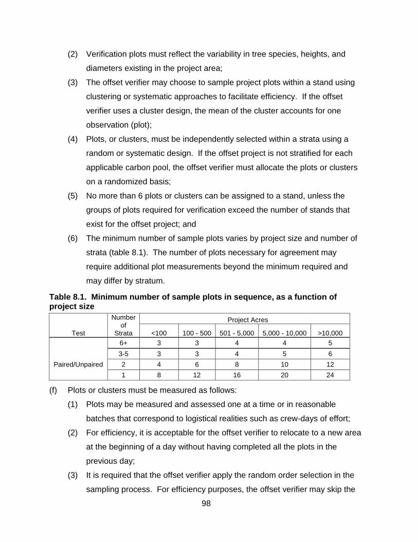
98
(2) Verification plots must reflect the variability in tree species, heights, and
diameters existing in the project area;
(3) The offset verifier may choose to sample project plots within a stand using
clustering or systematic approaches to facilitate efficiency. If the offset
verifier uses a cluster design, the mean of the cluster accounts for one
observation (plot);
(4) Plots, or clusters, must be independently selected within a strata using a
random or systematic design. If the offset project is not stratified for each
applicable carbon pool, the offset verifier must allocate the plots or clusters
on a randomized basis;
(5) No more than 6 plots or clusters can be assigned to a stand, unless the
groups of plots required for verification exceed the number of stands that
exist for the offset project; and
(6) The minimum number of sample plots varies by project size and number of
strata (table 8.1). The number of plots necessary for agreement may
require additional plot measurements beyond the minimum required and
may differ by stratum.
Table 8.1. Minimum number of sample plots in sequence, as a function of project size
Test
Number of
Strata
Project Acres
<100 100 - 500 501 - 5,000 5,000 - 10,000 >10,000
6+ 3 3 4 4 5
Paired/Unpaired
3-5 3 3 4 5 6
2 4 6 8 10 12
1 8 12 16 20 24
(f) Plots or clusters must be measured as follows:
(1) Plots may be measured and assessed one at a time or in reasonable
batches that correspond to logistical realities such as crew-days of effort;
(2) For efficiency, it is acceptable for the offset verifier to relocate to a new area
at the beginning of a day without having completed all the plots in the
previous day;
(3) It is required that the offset verifier apply the random order selection in the
sampling process. For efficiency purposes, the offset verifier may skip the
99
random order on a temporal basis as long as the sequential analysis
includes the ordered set of stands. This may provide significant efficiencies
when selected stands and/or plots are in close geographic proximity and it is
hypothesized that the stopping rules will require the full number of plots; and
(4) All tree heights in plots selected for sequential sampling must be measured.
Verifiers may not use regression estimators nor estimate heights in place of
plot-based field measurements of heights.
(g) Sequential approaches have stopping rules rather than fixed sample sizes to
indicate a successful agreement. With each successive plot or series of plots
analyzed by the offset verifier, the stopping rules indicate to the offset verifier to:
(1) Continue to the next plot(s) since the results do not indicate either a bias or
an agreement and further testing is required;
(2) Stop as the testing indicates bias; or
(3) Stop as the testing indicates agreement.
(h) For effective application of the sequential statistics in the field, the offset verifier
must use their discretion to determine if the stopping rules have been met for
each stratum:
(1) After the measurement of each plot;
(2) After the minimum number of plots per stratum are collected;
(3) After sampling additional plots, as determined to be necessary by the offset
verifier and agreed upon with the Offset Project Operator or Authorized
Project Designee; or
(4) The verifier may defer the determination until no later than the end of each
day of sampling, which will include the full set of plots measured in that day.
(i) When a stopping rule is met then the result is evaluated.
(1) Verification is successful after a minimum number of successive plots in a
sequence indicate agreement within the specified tolerance bounds
described in subchapter 8.1(k) and no bias is detected.
(2) Where the stopping rules indicate the presence of a bias, additional
verification plots may be collected after that time if it is felt that random
chance may have caused the test to fail and a convergence towards
agreement is expected with additional samples.
100
(j) There are two possible statistical procedures that can be applied to the
sequential sampling data. A paired test must be used when existing
monumented sample plots were re-measured. An unpaired test must be applied
when plots installed by the verifier were measured.
(k) The range of acceptable error (δ, delta) is fixed at 10 percent. If, through
repeated verification effort, the carbon estimate does not pass the sequential
sampling methodology with an acceptable range of error, the verifier must
provide an opportunity for the Offset Project Operator to correct the error through
an amendment to the Offset Project Data Report and/or inventory prior to issuing
an adverse verification statement.
(l) Because each stratum is tested independently, it is possible for a project with
multiple strata to partially pass the paired or unpaired test (i.e., one or more
stratum passes the sequential sampling test while one or more stratum does
not). In this case:
(1) A verification body must allow the Offset Project Operator or Authorized
Project Designee to correct errors in the strata that do not pass the
sequential sampling test; and
(2) If the Offset Project Operator or Authorized Project Designee chooses to re-
inventory the strata that did not pass or take similar action in order to correct
the issue, the verifier must conduct a follow-up site visit to:
(A) Re-sample the strata with new plots selected using the methodology of
subchapter 8.1.1; and
(B) Apply the sequential sampling technique per subchapter 8.1.1;
(3) If randomization results in the inclusion of plots that have already been
sampled during a previous site visit and that information has been shared
with the Offset Project Operator, Authorized Project Designee, forest
owner(s) or its affiliates during that site visit, the offset verifier must indicate
they have tested for bias; and
(4) If any changes are made to the inventory of strata that previously passed
sequential sampling, the appropriateness of those changes must be
evaluated by the verifier prior to completion of verification services and may
warrant a subsequent site visit.

101
8.1.1.1. Paired Plots
(a) The statistical test for paired plots is based on a comparison of the verifier’s
measurements of plots within a selected stratum, calculated as CO2e compared
to the Offset Project Operator’s or Authorized Project Designee’s measurements
of plots, which may include any adjustments for growth.
(b) The verifier must use alpha (α) = 0.05 and beta (β) = 0.20.
(c) The null hypothesis (H0) is that the verifier’s plots and project plots are equal.
(d) The following procedure is appropriate for the paired test and must be utilized by
verifiers:
(1) Sample and measure at least the minimum number of plots required in table
8.1;
(2) Use equation 8.2 to determine if stopping rule has been met;
Equation 8.2. Stopping Rule for Paired Plots
Evaluate: [(Zα + Zβ)2 × Sn
2] / D2
Where,
Zα = α/2% N(0,1) = 1.645
Zβ = β/2% N(0,1) = 0.8416
Sn2 = Sample variance of the differences
D = δ × stratum average estimate
δ = 0.10
n = Number of verification plots measured
If result ≤ n, then stop and evaluate results using equation 8.3 If result > n, then take another sample
(3) If stopping rule is met, evaluate results using equation 8.3;
Equation 8.3. Evaluation of Null Hypothesis for Paired Plots
Evaluate: (Zα × D) / (Zα + Zβ) And: │X̄N│
Where,
Zα = α/2% N(0,1) = 1.645
Zβ = β/2% N(0,1) = 0.8416
D = δ × stratum average estimate
δ = 0.10
│X̄N│ = Absolute value of sample mean of the differences
If │X̄N│≤ (Zα × D) / (Zα + Zβ), then accept H0
If │X̄N│> (Zα × D) / (Zα + Zβ), then reject H0
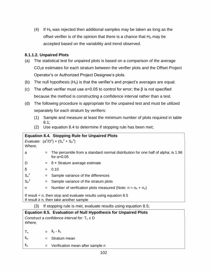
102
(4) If H0 was rejected then additional samples may be taken as long as the
offset verifier is of the opinion that there is a chance that H0 may be
accepted based on the variability and trend observed.
8.1.1.2. Unpaired Plots
(a) The statistical test for unpaired plots is based on a comparison of the average
CO2e estimates for each stratum between the verifier plots and the Offset Project
Operator’s or Authorized Project Designee’s plots.
(b) The null hypothesis (H0) is that the verifier’s and project’s averages are equal.
(c) The offset verifier must use α=0.05 to control for error; the β is not specified
because the method is constructing a confidence interval rather than a test.
(d) The following procedure is appropriate for the unpaired test and must be utilized
separately for each stratum by verifiers:
(1) Sample and measure at least the minimum number of plots required in table 8.1;
(2) Use equation 8.4 to determine if stopping rule has been met;
Equation 8.4. Stopping Rule for Unpaired Plots
Evaluate: (a2/D2) × (Sn2 + SP
2)
Where,
a = The percentile from a standard normal distribution for one half of alpha; is 1.96 for α=0.05
D = δ × Stratum average estimate
δ = 0.10
Sn2 = Sample variance of the differences
SP2 = Sample variance of the stratum plots
n = Number of verification plots measured (Note: n = nP + nV)
If result < n, then stop and evaluate results using equation 8.5 If result ≥ n, then take another sample
(3) If stopping rule is met, evaluate results using equation 8.5;
Equation 8.5. Evaluation of Null Hypothesis for Unpaired Plots
Construct a confidence interval for: Tn ± D
Where,
Tn
= x̄p - x̄n
x̄p
=
Stratum mean
x̄n
=
Verification mean after sample n
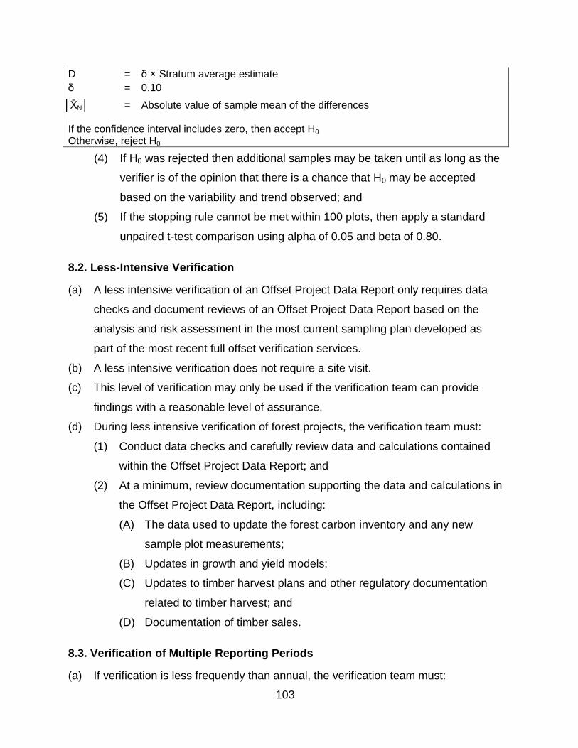
103
D = δ × Stratum average estimate
δ = 0.10
│X̄N│ = Absolute value of sample mean of the differences
If the confidence interval includes zero, then accept H0
Otherwise, reject H0
(4) If H0 was rejected then additional samples may be taken until as long as the
verifier is of the opinion that there is a chance that H0 may be accepted
based on the variability and trend observed; and
(5) If the stopping rule cannot be met within 100 plots, then apply a standard
unpaired t-test comparison using alpha of 0.05 and beta of 0.80.
8.2. Less-Intensive Verification
(a) A less intensive verification of an Offset Project Data Report only requires data
checks and document reviews of an Offset Project Data Report based on the
analysis and risk assessment in the most current sampling plan developed as
part of the most recent full offset verification services.
(b) A less intensive verification does not require a site visit.
(c) This level of verification may only be used if the verification team can provide
findings with a reasonable level of assurance.
(d) During less intensive verification of forest projects, the verification team must:
(1) Conduct data checks and carefully review data and calculations contained
within the Offset Project Data Report; and
(2) At a minimum, review documentation supporting the data and calculations in
the Offset Project Data Report, including:
(A) The data used to update the forest carbon inventory and any new
sample plot measurements;
(B) Updates in growth and yield models;
(C) Updates to timber harvest plans and other regulatory documentation
related to timber harvest; and
(D) Documentation of timber sales.
8.3. Verification of Multiple Reporting Periods
(a) If verification is less frequently than annual, the verification team must:

104
(1) Review and evaluate reported data specified in subchapter 7.2.2 separately
for each reporting period; and
(2) Issue individual Offset Verification Statements for each reporting period.
8.4. Verification Team
(a) Each verification team must include the following:
(1) At least one professional forester that takes an active role in reviewing the
forest carbon inventory program and conducting the site visit;
(2) At least one individual with demonstrated competence in forest biometrics
through:
(A) A master’s degree in statistics or forest biometrics, or another closely
related science that includes 12 semester or 16 quarter hours of forest
biometrics, sampling design and/or statistics coursework; or
(B) University coursework that includes 12 semester or 16 quarter hours of
forest biometrics, sampling design and/or statistics coursework, and at
least two years of experience sampling, developing, implementing and
analyzing forest biomass or carbon inventories;
(3) At least one individual with demonstrated knowledge of and competence in
the use of forest growth and yield models, and demonstrated experience
working with the model used in the forest carbon inventory being verified.
Such experience must include at least two years of university or other
professional coursework and/or project experience demonstrating
competency in the use of the model; and
(4) An ARB-accredited Forest Offset Project Specialist.
(b) An explanation demonstrating that the verification team includes individuals with
the required experience and expertise must be included in the Notice of
Verification Services.
(c) The required experience and expertise may be demonstrated by a single
individual, or by a combination of individuals.

105
Appendix A. Developing an Inventory of Forest Project Carbon Stocks –
Quantification Methodology
A forest project’s carbon inventory is used as the basis for modeling and estimating
carbon stocks in a forest project’s baseline (following the requirements of chapter 5
and appendix B) and used to quantify actual carbon stocks during the project life
(following the requirements of chapter 5). Offset Project Operators or Authorized
Project Designees must perform the following steps when developing the forest
project’s carbon inventory:
(a) Describe and document the activities and land use patterns that influence carbon
stocks in the project area. This information will be reviewed during verification
and should be used to help inform the initial design of the forest inventory and
the estimations of carbon stocks. Include descriptions of:
(1) Species composition;
(2) Vegetation types;
(3) Age class distribution;
(4) Topography;
(5) Land pressures;
(6) Climate;
(7) Harvesting practices employed;
(8) Management history and planned management activities;
(9) Known or potential disease(s) that may affect the health of the trees in the
project’s inventory, specifically above-ground standing live and dead trees;
(10) Legal and financial constraints;
(11) Ownership structure; and
(12) Existence of conservation easement(s).
(b) Develop and document a carbon inventory methodology. The Offset Project
Operators or Authorized Project Designee is responsible for determining
appropriate sampling methodologies for each required carbon pool. Inventory
methods must be capable of quantifying carbon stocks for required onsite carbon
pools to a high degree of accuracy. All sampling methods and measurement
standards must be statistically sound and must be reviewed for statistical validity
106
and conformance during verification. A complete carbon inventory methodology
must include:
(1) A description of the Offset Project Boundary and a list of all onsite carbon
pools included in the Offset Project Boundary (see tables 4.1, 4.2, and 4.3
to determine which onsite carbon pools are included and quantified from
inventory measurements);
(2) Stratification rules (pre- and post-sampling), if applicable, that include a map
of vegetation strata, results of stratification (area by strata), tools for
application (such as GIS, aerial photos, etc.), and a description of how
boundaries were determined (stratification is not required, but it may simplify
verification);
(3) The types of sample plots, plot layout, and location of plots and description
of monumenting procedures;
(A) Temporary flagging of plot center, as is customary to allow for check
cruising, is required to ensure ongoing inventory quality and allow for
offset verifiers to visit plots when verifying inventory procedures;
(B) If permanent plots are used, which are statistically efficient for stock
change estimates, permanent plot monumenting must be sufficient for
relocation; and
(C) Plot centers must be referenced on maps, preferably with GPS
coordinates;
(4) Standards for tree and plot size;
(5) Forest carbon inventory methodology and sampling procedures for each
required onsite carbon pool, with references clearly documented. These
procedures must be detailed enough so that any qualified forester would be
able to accurately repeat the previous measurements and must include
descriptions of:
(A) Tools used for height measurement, diameter measurement, and plot
measurement;
(B) Where and how to measure parameters used in volume and biomass
equations, models, and associated calculations such as DBH and

107
height (including for irregular trees). These procedures must be
consistent with the requirements in table A.1;
(C) How structural loss is assessed when standing live and standing dead
trees are missing biomass (cavities, broken tops, or other deformities
that reduce biomass in trees);
(D) How to classify dead wood; and
(E) Any other aspects of sampling where a consistent method needs to be
documented;
(6) The frequency for updating or replacing sample plots and the forest carbon
inventory as a whole;
(A) Any plot data used for deriving the forest carbon inventory estimates
have been sampled within the last 12 years;
(B) The scheduling of plot sampling may occur in one time period or be
distributed over several time periods;
(C) Either approach is acceptable so long as an inventory of the entire
project area (its required carbon pools and corresponding sample
plots) is completed within 12-year intervals;
(7) Description of data management systems and processes, all analytic
methods, calculation methodologies, volume and biomass equations and
models used to translate field measurements into volume and/or biomass
and carbon estimates for each of the carbon pools included in the offset
boundary;
(8) A documented quality assurance/quality control (QA/QC) plan including
procedures for internal review to ensure that standard operating procedures
are being followed. The QA/QC plan must include procedures for:
(A) Assessing and ensuring the quality of data collection;
(B) Transfer and archiving of field data;
(C) Procedures for data entry and analysis and data maintenance and
archiving; and
(D) Any other relevant procedures to ensure quality and consistency in the
collection and maintenance of data used to compile Offset Project Data
Reports;

108
(9) A change log documenting any changes in the inventory methods or volume
and biomass equations used to calculate carbon stocks; and
(10) Standard procedures for updating the forest carbon inventory, including
documented procedures to account for:
(A) Harvest;
(B) Growth;
(C) Mortality;
(D) Disturbance;
(E) Incorporating new inventory and plot data;
(F) Retiring older sample plots;
(G) Changes in modeling, as allowed under appendix B; and
(H) Application of appropriate confidence deduction.
Table A.1. Minimum Requirements for Field Measurements
Carbon Pool
Requirement Description of Requirement
Standing Live Tree Carbon Stocks
Tree Selection All tree species within the project area must be measured regardless of the merchantability of the trees.
Diameter at Breast Height
The minimum diameter at breast height must be stated in the methodology and must not be greater than 5 inches.
Height Measurements
Heights must be measured as per the inputs required by the volume models and/or biomass equations for each species and re-measured during subsequent updates to the inventory. If the project’s growth and yield model imputes heights utilizing the model’s own data points (but accepts measured height), height measurements collected in the field or derived from field inventory must be used in the model. In interim years when inventory data is modeled, DBH and height estimate outputs from the model may be used as the basis for carbon calculations. A portion of heights may be estimated as long as the height estimate methodology and overall inventory method employed results in an inventory that is capable of being quantified at the plot level to a high degree of accuracy, designed such that any qualified forester would be able to accurately repeat the previous measurements, whereby the verifier reviews the inventory sampling methodology and agrees that all sampling methodology and measurement standards are statistically sound. All field measurements within a project area are subject to passing sequential sampling and verification.
Missing Biomass
Standing live trees may have cavities, broken tops, or other deformities that reduce biomass in the trees. Inventory methodology must include a standardized approach and description of how deductions are estimated to account for missing biomass. Parameters required to adjust biomass accordingly must be collected during field measurements.
Standing Dead Tree
Carbon Stocks
Merchantability of Trees
All tree species within the project area must be measured regardless of the merchantability of the trees.
Diameter at Breast Height and Top Diameter
The minimum diameter at breast height must be stated in the methodology and must not be greater than 5 inches. The minimum height of standing dead trees is 15’. The method must include how volume is derived where a total height does not exist (i.e., where the tree is broken).
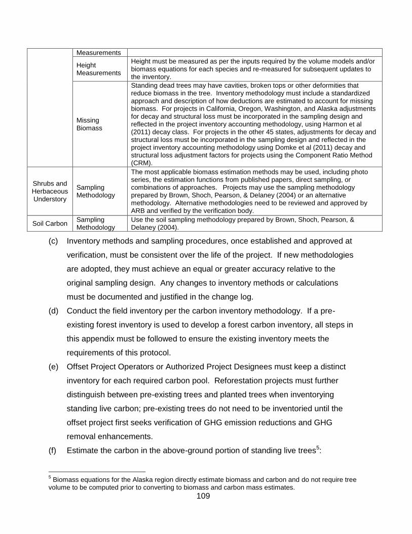
109
Measurements
Height Measurements
Height must be measured as per the inputs required by the volume models and/or biomass equations for each species and re-measured for subsequent updates to the inventory.
Missing Biomass
Standing dead trees may have cavities, broken tops or other deformities that reduce biomass in the tree. Inventory methodology must include a standardized approach and description of how deductions are estimated to account for missing biomass. For projects in California, Oregon, Washington, and Alaska adjustments for decay and structural loss must be incorporated in the sampling design and reflected in the project inventory accounting methodology, using Harmon et al (2011) decay class. For projects in the other 45 states, adjustments for decay and structural loss must be incorporated in the sampling design and reflected in the project inventory accounting methodology using Domke et al (2011) decay and structural loss adjustment factors for projects using the Component Ratio Method (CRM).
Shrubs and Herbaceous Understory
Sampling Methodology
The most applicable biomass estimation methods may be used, including photo series, the estimation functions from published papers, direct sampling, or combinations of approaches. Projects may use the sampling methodology prepared by Brown, Shoch, Pearson, & Delaney (2004) or an alternative methodology. Alternative methodologies need to be reviewed and approved by ARB and verified by the verification body.
Soil Carbon Sampling Methodology
Use the soil sampling methodology prepared by Brown, Shoch, Pearson, & Delaney (2004).
(c) Inventory methods and sampling procedures, once established and approved at
verification, must be consistent over the life of the project. If new methodologies
are adopted, they must achieve an equal or greater accuracy relative to the
original sampling design. Any changes to inventory methods or calculations
must be documented and justified in the change log.
(d) Conduct the field inventory per the carbon inventory methodology. If a pre-
existing forest inventory is used to develop a forest carbon inventory, all steps in
this appendix must be followed to ensure the existing inventory meets the
requirements of this protocol.
(e) Offset Project Operators or Authorized Project Designees must keep a distinct
inventory for each required carbon pool. Reforestation projects must further
distinguish between pre-existing trees and planted trees when inventorying
standing live carbon; pre-existing trees do not need to be inventoried until the
offset project first seeks verification of GHG emission reductions and GHG
removal enhancements.
(f) Estimate the carbon in the above-ground portion of standing live trees5:
5 Biomass equations for the Alaska region directly estimate biomass and carbon and do not require tree
volume to be computed prior to converting to biomass and carbon mass estimates.
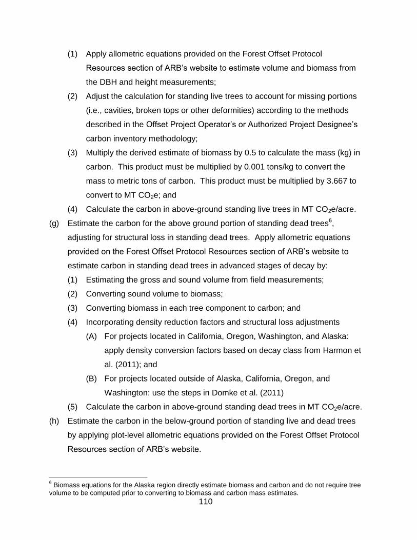
110
(1) Apply allometric equations provided on the Forest Offset Protocol
Resources section of ARB’s website to estimate volume and biomass from
the DBH and height measurements;
(2) Adjust the calculation for standing live trees to account for missing portions
(i.e., cavities, broken tops or other deformities) according to the methods
described in the Offset Project Operator’s or Authorized Project Designee’s
carbon inventory methodology;
(3) Multiply the derived estimate of biomass by 0.5 to calculate the mass (kg) in
carbon. This product must be multiplied by 0.001 tons/kg to convert the
mass to metric tons of carbon. This product must be multiplied by 3.667 to
convert to MT CO2e; and
(4) Calculate the carbon in above-ground standing live trees in MT CO2e/acre.
(g) Estimate the carbon for the above ground portion of standing dead trees6,
adjusting for structural loss in standing dead trees. Apply allometric equations
provided on the Forest Offset Protocol Resources section of ARB’s website to
estimate carbon in standing dead trees in advanced stages of decay by:
(1) Estimating the gross and sound volume from field measurements;
(2) Converting sound volume to biomass;
(3) Converting biomass in each tree component to carbon; and
(4) Incorporating density reduction factors and structural loss adjustments
(A) For projects located in California, Oregon, Washington, and Alaska:
apply density conversion factors based on decay class from Harmon et
al. (2011); and
(B) For projects located outside of Alaska, California, Oregon, and
Washington: use the steps in Domke et al. (2011)
(5) Calculate the carbon in above-ground standing dead trees in MT CO2e/acre.
(h) Estimate the carbon in the below-ground portion of standing live and dead trees
by applying plot-level allometric equations provided on the Forest Offset Protocol
Resources section of ARB’s website.
6 Biomass equations for the Alaska region directly estimate biomass and carbon and do not require tree
volume to be computed prior to converting to biomass and carbon mass estimates.
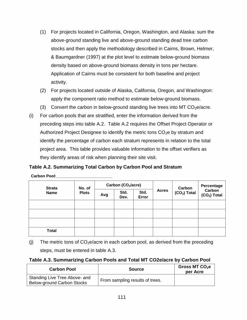
111
(1) For projects located in California, Oregon, Washington, and Alaska: sum the
above-ground standing live and above-ground standing dead tree carbon
stocks and then apply the methodology described in Cairns, Brown, Helmer,
& Baumgardner (1997) at the plot level to estimate below-ground biomass
density based on above-ground biomass density in tons per hectare.
Application of Cairns must be consistent for both baseline and project
activity.
(2) For projects located outside of Alaska, California, Oregon, and Washington:
apply the component ratio method to estimate below-ground biomass.
(3) Convert the carbon in below-ground standing live trees into MT CO2e/acre.
(i) For carbon pools that are stratified, enter the information derived from the
preceding steps into table A.2. Table A.2 requires the Offset Project Operator or
Authorized Project Designee to identify the metric tons CO2e by stratum and
identify the percentage of carbon each stratum represents in relation to the total
project area. This table provides valuable information to the offset verifiers as
they identify areas of risk when planning their site visit.
Table A.2. Summarizing Total Carbon by Carbon Pool and Stratum
Carbon Pool:_________________________
Strata Name
No. of Plots
Carbon (CO2/acre)
Acres Carbon
(CO2) Total
Percentage Carbon
(CO2) Total Avg Std. Dev.
Std. Error
Total
(j) The metric tons of CO2e/acre in each carbon pool, as derived from the preceding
steps, must be entered in table A.3.
Table A.3. Summarizing Carbon Pools and Total MT CO2e/acre by Carbon Pool
Carbon Pool Source Gross MT CO2e
per Acre
Standing Live Tree Above- and Below-ground Carbon Stocks
From sampling results of trees.
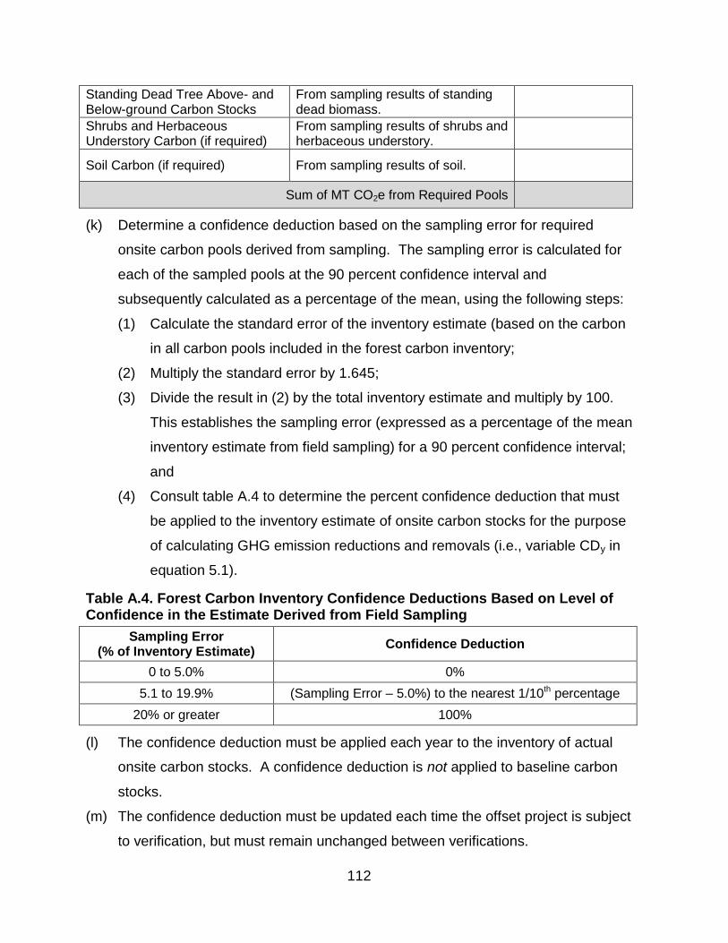
112
Standing Dead Tree Above- and Below-ground Carbon Stocks
From sampling results of standing dead biomass.
Shrubs and Herbaceous Understory Carbon (if required)
From sampling results of shrubs and herbaceous understory.
Soil Carbon (if required) From sampling results of soil.
Sum of MT CO2e from Required Pools
(k) Determine a confidence deduction based on the sampling error for required
onsite carbon pools derived from sampling. The sampling error is calculated for
each of the sampled pools at the 90 percent confidence interval and
subsequently calculated as a percentage of the mean, using the following steps:
(1) Calculate the standard error of the inventory estimate (based on the carbon
in all carbon pools included in the forest carbon inventory;
(2) Multiply the standard error by 1.645;
(3) Divide the result in (2) by the total inventory estimate and multiply by 100.
This establishes the sampling error (expressed as a percentage of the mean
inventory estimate from field sampling) for a 90 percent confidence interval;
and
(4) Consult table A.4 to determine the percent confidence deduction that must
be applied to the inventory estimate of onsite carbon stocks for the purpose
of calculating GHG emission reductions and removals (i.e., variable CDy in
equation 5.1).
Table A.4. Forest Carbon Inventory Confidence Deductions Based on Level of Confidence in the Estimate Derived from Field Sampling
Sampling Error (% of Inventory Estimate)
Confidence Deduction
0 to 5.0% 0%
5.1 to 19.9% (Sampling Error – 5.0%) to the nearest 1/10th percentage
20% or greater 100%
(l) The confidence deduction must be applied each year to the inventory of actual
onsite carbon stocks. A confidence deduction is not applied to baseline carbon
stocks.
(m) The confidence deduction must be updated each time the offset project is subject
to verification, but must remain unchanged between verifications.
113
(n) If increased sampling over time results in a lower confidence deduction at the
time of verification, the lower deduction must be applied to inventory estimates in
the most recent reporting period subject to verification at that time. ARB or
registry offset credits may be issued in the most recent reporting period for any
verified increase in quantified GHG emission reductions and GHG removal
enhancements associated with the new (lower) confidence deduction.
(o) If a loss of qualified sampling plots results in a higher confidence deduction, this
higher deduction is applied to the inventory estimates in the most recent
reporting period subject to verification at that time. Any resulting decrease in
quantified GHG emission reductions and GHG removal enhancements from prior
years as a result of the increased confidence deduction will be treated as an
intentional reversal, and must be compensated pursuant to the Regulation.

114
Appendix B. Modeling Carbon Stocks – Quantification Methodology
This protocol requires the use of approved empirical-based models to estimate the
baseline carbon stocks and project stocks of selected carbon pools within the project
area. Field measurements provide the basis for inferring value through the use of these
models.
(a) The following growth models have been approved for use (versions publicly
available prior to January 1, 2015):
(1) CACTOS: California Conifer Timber Output Simulator;
(2) CRYPTOS Emulator;
(3) FVS: Forest Vegetation Simulator;
(4) SPS: Stand Projection System;
(5) FPS: Forest Projection System; and
(6) FORSEE: FORest and Stand Evaluation Environment.
(b) Under this protocol, these models are used to:
(1) Estimate a forest project’s baseline carbon stocks; and
(2) Forecast actual carbon stocks expected under the forest project to determine
expected harvesting volumes or updating forest carbon inventories. The limit
to the use of models for updating plot data is described in appendix A.
(c) Inventory data from appendix A must be incorporated into the simulation models to
project carbon stocks over time.
(d) Baseline carbon stocks must be projected forward from the date of the forest
project’s offset project commencement.
(e) Inventory plot data may be updated by simulating the diameter and height
increment of sampled trees for the length of time between their sampled date and
the reporting year. To qualify for this method:
(1) The project area must be stratified into even-age management and uneven-
age management;
(2) Diameter increment must be based on the average annual increment of a
minimum of 20 samples of radial growth for diameter increment for each 8”
DBH (diameter at breast height) class, beginning at 0 – 8” DBH for each

115
management (even-age or uneven-age) type. The average annual increment
must be added for each year according to the plot’s sample date; and
(3) Height increment must be based on regression curves for each management
type (even-age or uneven-age) developed from height measurements from
the same trees from which the diameter increment data was obtained. The
estimated height must be determined using the regression estimators for the
‘grown’ diameters as described above.
(f) If a model has the ability to convert biomass to carbon, it must include all the
carbon pools required by this protocol.
(g) For all versions of ARB-approved models, the formulas, equations, and data
embedded within each model must be transparent, such that the reported
emissions reductions/removal enhancements are readily and easily traceable and
verifiable by the offset verification team.
(h) The Offset Project Operators or Authorized Project Designee is responsible for
developing a modeling plan that addresses all required forecasting or updating of
baseline and actual carbon stocks for the forest project. The modeling plan must
be approved during verification and must include:
(1) A description of all silviculture methods modeled. The description of each
silviculture method will include:
(A) A description of the trees retained (by species groups if appropriate) at
harvest;
(B) The harvest frequency (years between harvests); and
(C) Regeneration assumptions;
(2) A matrix documenting any and all legal constraints that affect forest
management activities in the project area. The matrix must include:
(A) A description of each constraint;
(B) The geographic location for each constraint and the local, state, or
federal agency associated with each constraint;
(C) A narrative that describes the effect of the constraint on forest
management, including disclosure of assumptions used for canopy
retention and/or habitat conditions and identification of any required

116
temporal conditions (e.g., 10% of inventory maintained as spotted owl
habitat by 2030); and
(D) *A description of the silviculture methods that will be modeled to ensure
the constraint is respected;
(3) A description of the site indexes used for each species and an explanation of
the source of the site index values used; and
(4) A description of the model used and an explanation of how the model was
calibrated for local use, if applicable.
(i) Modeling outputs must include:
(1) Periodic harvest, inventory, and growth estimates for the entire project area
presented as total carbon tons and carbon tons per acre; and
(2) Harvest yield streams on modeled stands, averaged by silviculture method
and constraints, which must include the period over which the harvest
occurred and the estimated volume of wood removed.
(j) Projected baseline and actual carbon stocks must be portrayed in a graph
depicting time (starting from offset project commencement) in the x-axis and
carbon tons in the y-axis. A reference point depicting the initial above-ground
standing live tree carbon stocks must be included in the graph. The graph must be
supported with written characterizations that explain any annual changes in
baseline carbon stocks over time. These characterizations must be consistent with
the baseline analysis required in chapter 5.

117
Appendix C. Estimating Carbon in Wood Products – Quantification Methodology
The carbon stored in wood products over 100 years is included within the offset project
boundary of all forest offset projects. Offset Project Operators or Authorized Project
Designees must use this appendix to quantify the amount of carbon in harvested wood
products for both the baseline and project scenarios.
(a) Determine the baseline amount of carbon in standing live trees that would have
been harvested during the reporting period and stored in wood products over 100
years (BCwp,y to be used in equation 5.1) by doing the following:
(1) Derive the amount of carbon in standing live trees that would have been
harvested and delivered to a mill during the reporting period.
(A) If the growth and harvesting model used to develop the baseline for
onsite carbon stocks in chapter 5 provides metric tons carbon in the
bole, without bark, for each species that would have been harvested,
equations C.1 and C.2 may be skipped and that output data may be
used for the amount of carbon in standing live trees that would have
been harvested and delivered to a mill during the reporting period
(BCdm,i,y) in equation C.3; and
(B) If the growth and harvesting model used to develop the baseline for
onsite carbon stocks in chapter 5 does not provide metric tons carbon in
the bole, without bark, for each species that would have been harvested,
determine the amount of carbon in standing live trees that would have
been harvested and delivered to a mill during the reporting period
(BCdm,i,y) using equation C.1 if based on harvest volume (ft3) or equation
C.2 if based green weight (lb.).
Equation C.1. Baseline Carbon Delivered to Mill Using Wood Volume
𝐵𝐶𝑑𝑚,𝑖,𝑦 =𝐻𝑊𝑣𝑜𝑙,𝑖,𝑦 𝑥 𝑊𝐷𝐹𝑖 𝑥 0.5
2,204.6
Where,
BCdm,i,y
= Baseline carbon in standing live trees that would have been harvested and delivered to a mill during the reporting period; calculated separately for each species (MT C)
i = Species that would have been harvested in reporting period
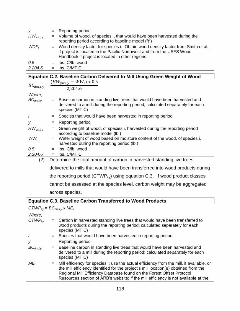
118
y = Reporting period
HWvol,i, y = Volume of wood, of species i, that would have been harvested during the reporting period according to baseline model (ft3)
WDFi = Wood density factor for species i. Obtain wood density factor from Smith et al. if project is located in the Pacific Northwest and from the USFS Wood Handbook if project is located in other regions.
0.5 = lbs. C/lb. wood
2,204.6 = lbs. C/MT C
Equation C.2. Baseline Carbon Delivered to Mill Using Green Weight of Wood
𝐵𝐶𝑑𝑚,𝑖,𝑦 =(𝐻𝑊𝑔𝑤,𝑖,𝑦 − 𝑊𝑊𝑖) 𝑥 0.5
2,204.6
Where, BCdm,i,y
= Baseline carbon in standing live trees that would have been harvested and delivered to a mill during the reporting period; calculated separately for each species (MT C)
i = Species that would have been harvested in reporting period
y = Reporting period
HWgw,i, y = Green weight of wood, of species i, harvested during the reporting period according to baseline model (lb.)
WWi = Water weight of wood based on moisture content of the wood, of species i, harvested during the reporting period (lb.)
0.5 = lbs. C/lb. wood
2,204.6 = lbs. C/MT C
(2) Determine the total amount of carbon in harvested standing live trees
delivered to mills that would have been transferred into wood products during
the reporting period (CTWPi,y) using equation C.3. If wood product classes
cannot be assessed at the species level, carbon weight may be aggregated
across species.
Equation C.3. Baseline Carbon Transferred to Wood Products
CTWPi,y = BCdm,i,y x MEi
Where,
CTWPi,y = Carbon in harvested standing live trees that would have been transferred to wood products during the reporting period; calculated separately for each species (MT C)
i = Species that would have been harvested in reporting period
y = Reporting period
BCdm,i,y
= Baseline carbon in standing live trees that would have been harvested and delivered to a mill during the reporting period; calculated separately for each species (MT C)
MEi = Mill efficiency for species i; use the actual efficiency from the mill, if available, or the mill efficiency identified for the project’s mill location(s) obtained from the Regional Mill Efficiency Database found on the Forest Offset Protocol Resources section of ARB’s website; if the mill efficiency is not available at the

119
species level, an aggregate mill efficiency may be used (%)
0.5 = lbs. C/lb. wood
2,204.6 = lbs. C/MT C
(3) Determine the average amount of carbon transferred to wood products that
would have remained stored in in-use wood products over 100 years (WPin-
use,y) by completing the following steps:
(A) Determine the percentage of a harvest that would end up in each wood
product class during the reporting period, determined separately for each
species if data is broken down by species (PCi,y), by:
1. Obtaining a verified report from the mill(s) where the project area’s
logs are sold indicating the product class categories the mill(s) sold
that year;
2. If a verified report cannot be obtained, looking up default wood
product classes for the project’s assessment area, as given in the
Assessment Area Data File associated with this protocol version
available in the Forest Offset Protocol Resources section of ARB’s
website; or
3. If breakdowns for wood product classes are not available from
either of these sources, classify all wood products as
“miscellaneous;”
(B) Enter the percentages into row 1 of table C.1 (PCi,y). Complete a
separate table for each species that would have been harvested during
the reporting period;
(C) Determine the amount of carbon that would have been transferred to
each product class, determined separately for each species if wood
product classes are broken down by species (CTPCi,y), using equation
C.4;
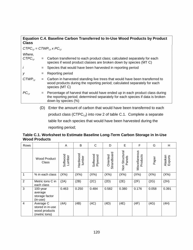
120
Equation C.4. Baseline Carbon Transferred to In-Use Wood Products by Product Class
CTPCi,y = CTWPi,y x PCi,y
Where, CTPCi,y = Carbon transferred to each product class; calculated separately for each
species if wood product classes are broken down by species (MT C)
i = Species that would have been harvested in reporting period
y = Reporting period
CTWPi,y = Carbon in harvested standing live trees that would have been transferred to wood products during the reporting period; calculated separately for each species (MT C)
PCi,y = Percentage of harvest that would have ended up in each product class during the reporting period; determined separately for each species if data is broken down by species (%)
(D) Enter the amount of carbon that would have been transferred to each
product class (CTPCi,y) into row 2 of table C.1. Complete a separate
table for each species that would have been harvested during the
reporting period;
Table C.1. Worksheet to Estimate Baseline Long-Term Carbon Storage in In-Use Wood Products
Rows A B C D E F G H
Wood Product Class
Softw
ood
Lum
ber
Hard
wo
od
lum
ber
Softw
ood
Ply
wo
od
Oriente
d
Str
an
dbo
ard
Non S
tructu
ral
Pan
els
Mis
cella
neous
Pro
ducts
Pap
er
Ala
skan
Export
s
1 % in each class (X%) (X%) (X%) (X%) (X%) (X%) (X%) (X%)
2 Metric tons C in each class
(2A) (2B) (2C) (2D) (2E) (2F) (2G) (2H)
3 100-year average storage factor (in-use)
0.463 0.250 0.484 0.582 0.380 0.176 0.058 0.391
4 Average C stored in in-use wood products (metric tons)
(4A) (4B) (4C) (4D) (4E) (4F) (4G) (4H)
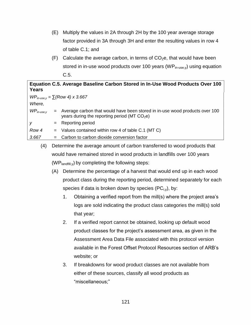
121
(E) Multiply the values in 2A through 2H by the 100 year average storage
factor provided in 3A through 3H and enter the resulting values in row 4
of table C.1; and
(F) Calculate the average carbon, in terms of CO2e, that would have been
stored in in-use wood products over 100 years (WPin-use,y) using equation
C.5.
Equation C.5. Average Baseline Carbon Stored in In-Use Wood Products Over 100 Years
WPin-use,y = ∑(Row 4) x 3.667
Where,
WPin-use,y = Average carbon that would have been stored in in-use wood products over 100 years during the reporting period (MT CO2e)
y = Reporting period
Row 4 = Values contained within row 4 of table C.1 (MT C)
3.667 = Carbon to carbon dioxide conversion factor
(4) Determine the average amount of carbon transferred to wood products that
would have remained stored in wood products in landfills over 100 years
(WPlandfill,y) by completing the following steps:
(A) Determine the percentage of a harvest that would end up in each wood
product class during the reporting period, determined separately for each
species if data is broken down by species (PCi,y), by:
1. Obtaining a verified report from the mill(s) where the project area’s
logs are sold indicating the product class categories the mill(s) sold
that year;
2. If a verified report cannot be obtained, looking up default wood
product classes for the project’s assessment area, as given in the
Assessment Area Data File associated with this protocol version
available in the Forest Offset Protocol Resources section of ARB’s
website; or
3. If breakdowns for wood product classes are not available from
either of these sources, classify all wood products as
“miscellaneous;”

122
(B) Enter the percentages into row 1 of table C.2 (PCi,y). Complete a
separate table for each species that would have been harvested during
the reporting period;
(C) Determine the amount of carbon transferred to each product class,
determined separately for each species if wood product classes are
broken down by species (CTPCi,y), using equation C.6;
Equation C.6. Baseline Carbon Transferred to Wood Products in Landfills by Product Class
CTPCi,y = CTWPi,y x PCi,y
Where,
CTPCi,y = Carbon transferred to each product class; calculated separately for each species if wood product classes are broken down by species (MT C)
i = Species that would have been harvested in reporting period
y = Reporting period
CTWPi,y = Carbon in harvested standing live trees that would have been transferred to wood products during the reporting period; calculated separately for each species (MT C)
PCi,y = Percentage of harvest that would have ended up in each product class during the reporting period; determined separately for each species if data is broken down by species (%)
(D) Enter the amount of carbon that would have been transferred to each
product class (CTPCi,y) into row 2 of table C.2. Complete a separate
table for each species that would have been harvested during the
reporting period;
Table C.2. Worksheet to Estimate Baseline Long-Term Carbon Storage in Wood Products in Landfills
Rows A B C D E F G H
Wood Product Class
Softw
ood
Lum
ber
Hard
wo
od
lum
ber
Softw
ood
Ply
wo
od
Oriente
d
Str
an
dbo
ard
Non S
tructu
ral
Pan
els
Mis
cella
neous
Pro
ducts
Pap
er
Ala
skan
Export
s
1 % in each class (X%) (X%) (X%) (X%) (X%) (X%) (X%) (X%)
2 Metric tons C in each class
(2A) (2B) (2C) (2D) (2E) (2F) (2G) (2H)
3 100-year average storage factor
0.298 0.414 0.287 0.233 0.344 0.454 0.178 0.284
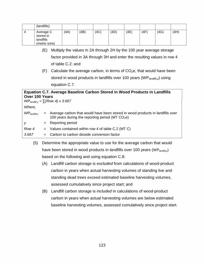
123
(landfills)
4 Average C stored in landfills (metric tons)
(4A) (4B) (4C) (4D) (4E) (4F) (4G) (4H)
(E) Multiply the values in 2A through 2H by the 100 year average storage
factor provided in 3A through 3H and enter the resulting values in row 4
of table C.2; and
(F) Calculate the average carbon, in terms of CO2e, that would have been
stored in wood products in landfills over 100 years (WPlandfill,y) using
equation C.7.
Equation C.7. Average Baseline Carbon Stored in Wood Products in Landfills Over 100 Years WPlandfill,y = ∑(Row 4) x 3.667
Where,
WPlandfill,y = Average carbon that would have been stored in wood products in landfills over 100 years during the reporting period (MT CO2e)
y = Reporting period
Row 4 = Values contained within row 4 of table C.2 (MT C)
3.667 = Carbon to carbon dioxide conversion factor
(5) Determine the appropriate value to use for the average carbon that would
have been stored in wood products in landfills over 100 years (WPlandfill,y)
based on the following and using equation C.8:
(A) Landfill carbon storage is excluded from calculations of wood-product
carbon in years when actual harvesting volumes of standing live and
standing dead trees exceed estimated baseline harvesting volumes,
assessed cumulatively since project start; and
(B) Landfill carbon storage is included in calculations of wood-product
carbon in years when actual harvesting volumes are below estimated
baseline harvesting volumes, assessed cumulatively since project start.

124
Equation C.8. Average Baseline Carbon Stored in Wood Products in Landfills Over 100 Years for Use in Equation C.9
𝐼𝑓 ∑(𝐴𝐶ℎ𝑣,𝑛 − 𝐵𝐶ℎ𝑣,𝑛)
𝑦
𝑛=1
< 0, 𝑡ℎ𝑒𝑛 𝑊𝑃𝑙𝑎𝑛𝑑𝑓𝑖𝑙𝑙,𝑦 = ∑(𝑅𝑜𝑤4) × 3.667
𝐼𝑓 ∑(𝐴𝐶ℎ𝑣,𝑛 − 𝐵𝐶ℎ𝑣) > 0, 𝑡ℎ𝑒𝑛 𝑊𝑃𝑙𝑎𝑛𝑑𝑓𝑖𝑙𝑙,𝑦 = 0
𝑦
𝑛=1
Where,
WPlandfill,y = Average carbon that would have been stored in wood products in landfills over 100 years from wood harvested during the reporting period
AChv n = Actual amount of carbon in standing live and standing dead trees (whole bole only, no bark) harvested in reporting period n (MT CO2e)
BChv,n = Estimated average amount of carbon in standing live and standing dead trees (bole only, no bark) that would have been harvested in reporting period n (MT CO2e)
y = Reporting period
Row 4 = Values contained within row 4 of table C.2; sum values for all species (MT C)
(6) Determine the average annual baseline carbon in wood products that would
have remained stored for at least 100 years (BCwp,y to be used in equation
5.1) using equation C.9.
Equation C.9. Total Average Baseline Carbon Stored in Wood Products
Where,
BCwp,y = Average carbon stored over 100 years from wood that would have been harvested during the reporting period (MT CO2e)
WPin-use,y = Average carbon stored in in-use wood products over 100 years from wood that would have been harvested during the reporting period (MT CO2e)
WPlandfill y
= Average carbon stored in wood products in landfills over 100 years from wood
that would have been harvested during the reporting period (MT CO2e)
i = Species that would have been harvested in reporting period
y = Reporting period
(b) Determine the actual amount of carbon in standing live trees harvested during the
reporting period and stored in wood products over 100 years (ACwp,y to be used in
equation 5.1) by doing the following:
i
ylandfill
i
yuseinywp WPWPBC ,,,

125
(1) Determine the amount of carbon in standing live trees harvested and
delivered to a mill during the reporting period (ACdm,i,y) using equation C.10 if
based on harvest volume (ft3) or equation C.11 if based green weight (lb.);
Equation C.10. Actual Carbon Delivered to Mill Using Wood Volume
𝐴𝐶𝑑𝑚,𝑖,𝑦 =𝐻𝑊𝑣𝑜𝑙,𝑖,𝑦 𝑥 𝑊𝐷𝐹𝑖 𝑥 0.5
2,204.6
Where, ACdm,i,y = Actual carbon in standing live trees harvested and delivered to a mill during the
reporting period; calculated separately for each species (MT C)
i = Species harvested in reporting period
y = Reporting period
HWvol,i, y = Volume of wood, of species i, harvested during the reporting period (ft3)
WDFi = Wood density factor for species i. Obtain wood density factor from Smith et al. if project is located in the Pacific Northwest and from the USFS Wood Handbook if project is located in other regions.
0.5 = lbs. C/lb. wood
2,204.6 = lbs. C/MT C
Equation C.11. Actual Carbon Delivered to Mill Using Green Weight of Wood
𝐴𝐶𝑑𝑚,𝑖,𝑦 =(𝐻𝑊𝑔𝑤,𝑖,𝑦 − 𝑊𝑊𝑖) 𝑥 0.5
2,204.6
Where, ACdm,i,y = Actual carbon in standing live trees harvested and delivered to a mill during the
reporting period; calculated separately for each species (MT C)
i = Species harvested in reporting period
y = Reporting period
HWgw,i, y = Green weight of wood, of species i, harvested during the reporting period (lb.)
WWi = Water weight of wood based on moisture content of the wood, of species i, harvested during the reporting period (lb.)
0.5 = lbs. C/lb. wood
2,204.6 = lbs. C/MT C
(2) Determine the total amount of carbon in harvested standing live trees
delivered to mills transferred into wood products during the reporting period
(CTWPi,y) using equation C.12;
Equation C.12. Actual Carbon Transferred to Wood Products CTWPi,y = ACdm,i,y x MEi
Where,
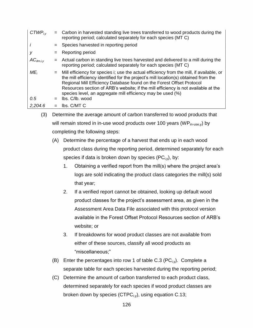
126
CTWPi,y = Carbon in harvested standing live trees transferred to wood products during the reporting period; calculated separately for each species (MT C)
i = Species harvested in reporting period
y = Reporting period
ACdm,i,y = Actual carbon in standing live trees harvested and delivered to a mill during the reporting period; calculated separately for each species (MT C)
MEi = Mill efficiency for species i; use the actual efficiency from the mill, if available, or the mill efficiency identified for the project’s mill location(s) obtained from the Regional Mill Efficiency Database found on the Forest Offset Protocol Resources section of ARB’s website; if the mill efficiency is not available at the species level, an aggregate mill efficiency may be used (%)
0.5 = lbs. C/lb. wood
2,204.6 = lbs. C/MT C
(3) Determine the average amount of carbon transferred to wood products that
will remain stored in in-use wood products over 100 years (WPin-use,y) by
completing the following steps:
(A) Determine the percentage of a harvest that ends up in each wood
product class during the reporting period, determined separately for each
species if data is broken down by species (PCi,y), by:
1. Obtaining a verified report from the mill(s) where the project area’s
logs are sold indicating the product class categories the mill(s) sold
that year;
2. If a verified report cannot be obtained, looking up default wood
product classes for the project’s assessment area, as given in the
Assessment Area Data File associated with this protocol version
available in the Forest Offset Protocol Resources section of ARB’s
website; or
3. If breakdowns for wood product classes are not available from
either of these sources, classify all wood products as
“miscellaneous;”
(B) Enter the percentages into row 1 of table C.3 (PCi,y). Complete a
separate table for each species harvested during the reporting period;
(C) Determine the amount of carbon transferred to each product class,
determined separately for each species if wood product classes are
broken down by species (CTPCi,y), using equation C.13;
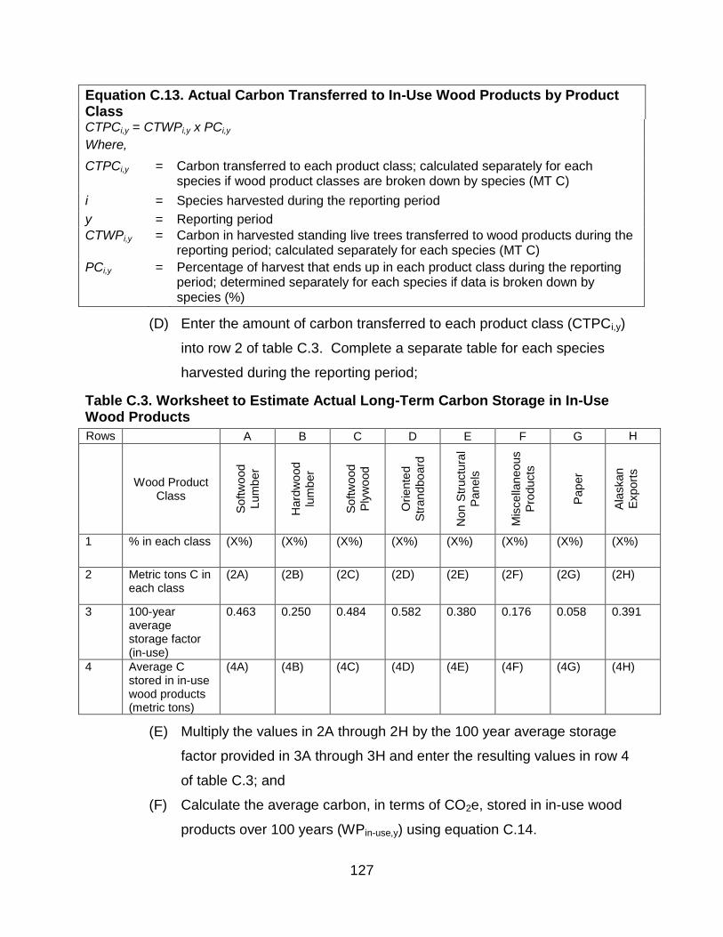
127
Equation C.13. Actual Carbon Transferred to In-Use Wood Products by Product Class CTPCi,y = CTWPi,y x PCi,y
Where,
CTPCi,y = Carbon transferred to each product class; calculated separately for each species if wood product classes are broken down by species (MT C)
i = Species harvested during the reporting period
y = Reporting period
CTWPi,y = Carbon in harvested standing live trees transferred to wood products during the reporting period; calculated separately for each species (MT C)
PCi,y = Percentage of harvest that ends up in each product class during the reporting period; determined separately for each species if data is broken down by species (%)
(D) Enter the amount of carbon transferred to each product class (CTPCi,y)
into row 2 of table C.3. Complete a separate table for each species
harvested during the reporting period;
Table C.3. Worksheet to Estimate Actual Long-Term Carbon Storage in In-Use Wood Products
Rows A B C D E F G H
Wood Product Class
Softw
ood
Lum
ber
Hard
wo
od
lum
ber
Softw
ood
Ply
wo
od
Oriente
d
Str
an
dbo
ard
Non S
tructu
ral
Pan
els
Mis
cella
neous
Pro
ducts
Pap
er
Ala
skan
Export
s
1 % in each class (X%) (X%) (X%) (X%) (X%) (X%) (X%) (X%)
2 Metric tons C in each class
(2A) (2B) (2C) (2D) (2E) (2F) (2G) (2H)
3 100-year average storage factor (in-use)
0.463 0.250 0.484 0.582 0.380 0.176 0.058 0.391
4 Average C stored in in-use wood products (metric tons)
(4A) (4B) (4C) (4D) (4E) (4F) (4G) (4H)
(E) Multiply the values in 2A through 2H by the 100 year average storage
factor provided in 3A through 3H and enter the resulting values in row 4
of table C.3; and
(F) Calculate the average carbon, in terms of CO2e, stored in in-use wood
products over 100 years (WPin-use,y) using equation C.14.

128
Equation C.14. Average Actual Carbon Stored in In-Use Wood Products Over 100 Years
WPin-use,y = ∑(Row 4) x 3.667
Where,
WPin-use,y = Average carbon stored in in-use wood products over 100 years during the reporting period (MT CO2e)
y = Reporting period
Row 4 = Values contained within row 4 of table C.3 (MT C)
3.667 = Carbon to carbon dioxide conversion factor
(4) Determine the average amount of carbon transferred to wood products that
will remain stored in wood products in landfills over 100 years (WPlandfill,y) by
completing the following steps:
(A) Determine the percentage of a harvest that ends up in each wood
product class during the reporting period, determined separately for each
species if data is broken down by species (PCi,y), by:
1. Obtaining a verified report from the mill(s) where the project area’s
logs are sold indicating the product class categories the mill(s) sold
that year;
2. If a verified report cannot be obtained, looking up default wood
product classes for the project’s assessment area, as given in the
Assessment Area Data File associated with this protocol version
available in the Forest Offset Protocol Resources section of ARB’s
website; or
3. If breakdowns for wood product classes are not available from
either of these sources, classify all wood products as
“miscellaneous;”
(B) Enter the percentages into row 1 of table C.4 (PCi,y). Complete a
separate table for each species harvested during the reporting period;
(C) Determine the amount of carbon transferred to each product class,
determined separately for each species if wood product classes are
broken down by species (CTPCi,y), using equation C.15;

129
Equation C.15. Actual Carbon Transferred to Wood Products in Landfills by Product Class CTPCi,y = CTWPi,y x PCi,y
Where, CTPCi,y = Carbon transferred to each product class; calculated separately for each
species if wood product classes are broken down by species (MT C)
i = Species harvested during the reporting period
y = Reporting period
CTWPi,y = Carbon in harvested standing live trees transferred to wood products during the reporting period; calculated separately for each species (MT C)
PCi,y = Percentage of harvest that ends up in each product class during the reporting period; determined separately for each species if data is broken down by species (%)
(D) Enter the amount of carbon transferred to each product class (CTPCi,y)
into row 2 of table C.4. Complete a separate table for each species
harvested during the reporting period;
Table C.4. Worksheet to Estimate Actual Long-Term Carbon Storage in Wood Products in Landfills
Rows A B C D E F G H
Wood Product Class
Softw
ood
Lum
ber
Hard
wo
od
lum
ber
Softw
ood
Ply
wo
od
Oriente
d
Str
an
dbo
ard
Non S
tructu
ral
Pan
els
Mis
cella
neous
Pro
ducts
Pap
er
Ala
skan
Export
s
1 % in each class (X%) (X%) (X%) (X%) (X%) (X%) (X%) (X%)
2 Metric tons C in each class
(2A) (2B) (2C) (2D) (2E) (2F) (2G) (2H)
3 100-year average storage factor (landfills)
0.298 0.414 0.287 0.233 0.344 0.454 0.178 0.284
4 Average C stored in landfills (metric tons)
(4A) (4B) (4C) (4D) (4E) (4F) (4G) (4H)
(E) Multiply the values in 2A through 2H by the 100 year average storage
factor provided in 3A through 3H and enter the resulting values in row 4
of table C.4; and
(F) Calculate the average carbon, in terms of CO2e, stored in wood products
in landfills over 100 years (WPlandfill,y) using equation C.16.
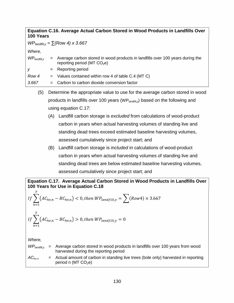
130
Equation C.16. Average Actual Carbon Stored in Wood Products in Landfills Over 100 Years
WPlandfill,y = ∑(Row 4) x 3.667
Where,
WPlandfill,y = Average carbon stored in wood products in landfills over 100 years during the reporting period (MT CO2e)
y = Reporting period
Row 4 = Values contained within row 4 of table C.4 (MT C)
3.667 = Carbon to carbon dioxide conversion factor
(5) Determine the appropriate value to use for the average carbon stored in wood
products in landfills over 100 years (WPlandfill,y) based on the following and
using equation C.17:
(A) Landfill carbon storage is excluded from calculations of wood-product
carbon in years when actual harvesting volumes of standing live and
standing dead trees exceed estimated baseline harvesting volumes,
assessed cumulatively since project start; and
(B) Landfill carbon storage is included in calculations of wood-product
carbon in years when actual harvesting volumes of standing live and
standing dead trees are below estimated baseline harvesting volumes,
assessed cumulatively since project start; and
Equation C.17. Average Actual Carbon Stored in Wood Products in Landfills Over 100 Years for Use in Equation C.18
𝐼𝑓 ∑(𝐴𝐶ℎ𝑣,𝑛 − 𝐵𝐶ℎ𝑣,𝑛)
𝑦
𝑛=1
< 0, 𝑡ℎ𝑒𝑛 𝑊𝑃𝑙𝑎𝑛𝑑𝑓𝑖𝑙𝑙,𝑦 = ∑(𝑅𝑜𝑤4) × 3.667
𝐼𝑓 ∑(𝐴𝐶ℎ𝑣,𝑛 − 𝐵𝐶ℎ𝑣,𝑛) > 0, 𝑡ℎ𝑒𝑛 𝑊𝑃𝑙𝑎𝑛𝑑𝑓𝑖𝑙𝑙,𝑦 = 0
𝑦
𝑛=1
Where,
WPlandfill,y = Average carbon stored in wood products in landfills over 100 years from wood harvested during the reporting period
AChv n = Actual amount of carbon in standing live trees (bole only) harvested in reporting period n (MT CO2e)

131
BChv,n = Estimated average amount of carbon in standing live and standing dead trees (bole only) that would have been harvested in reporting period n (MT CO2e)
y = Reporting period
Row 4 = Values contained within row 4 of table C.4; sum values for all species (MT C)
(6) Determine the actual carbon in wood products produced during the reporting
period that is projected to remain stored for at least 100 years (ACwp,y to be
used in equation 5.1) using equation C.18.
Equation C.18. Total Carbon Stored in Wood Products
Where,
ACwp,y = Actual carbon in wood products produced during the reporting period that is projected to remain stored for at least 100 years (MT CO2e)
WPin-use,y = Average carbon stored in in-use wood products over 100 years from wood harvested during the reporting period (MT CO2e)
WPlandfill y
= Average carbon stored in wood products in landfills over 100 years from wood
harvested during the reporting period (MT CO2e)
i = Species harvested in reporting period
y = Reporting period
i
ylandfill
i
yuseinywp WPWPAC ,,,

132
Appendix D. Determination of a Forest Project’s Reversal Risk Rating
ARB maintains a Forest Buffer Account to insure against unintentional reversals. ARB
offset credits will be contributed to the Forest Buffer Account pursuant to the Regulation.
The quantity of the contribution is determined by a project’s reversal risk rating based
on the potential for reversals associated with different types of risks and project-specific
circumstances.
(a) The Offset Project Operator or Authorized Project Designee is required to
determine the project’s reversal risk rating prior to listing, and recalculate it every
time the forest project undergoes verification.
(b) If estimated risk values and associated mitigation measures are updated as
improvements in quantifying risks or changes in risks are determined, any
adjustments to the reversal risk ratings will affect only current and future year
contributions to the Forest Buffer Account.
(c) For a Qualified Conservation Easement to be considered for a reporting period it
must be in place prior to the end of the reporting period.
(d) Risks that may lead to reversals are classified into the categories identified in table
D.1.
Table D.1. Forest Project Risk Types
Risk Category
Risk Type Description
Financial Financial Failure
Leading to Bankruptcy
Financial failure can lead to bankruptcy and/or alternative management decisions to generate income that result in reversals through over-harvesting or conversion
Management
Illegal Harvesting Loss of project stocks due to timber theft
Conversion to Non-Forest Uses
Alternative land uses are exercised at project carbon expense
Over-Harvesting Exercising timber value at expense of project carbon
Social Social Risks Changing government policies, regulations, and general economic conditions
Natural Disturbance
Wildfire Loss of project carbon through wildfire
Disease/Insects Loss of project carbon through disease and/or insects
Other Episodic Catastrophic Events
Loss of project carbon from wind, snow and ice, or flooding events

133
(e) The project reversal risk rating must be determined using the tables in this
appendix which are designed to identify and quantify the specific types of risks that
may lead to a reversal, based on project-specific factors. The Offset Project
Operator or Authorized Project Designee must determine the contribution to the
reversal risk rating for each risk type below.
(1) Financial Risk: Financial failure of an organization resulting in bankruptcy can
lead to dissolution of agreements and forest management activities to recover
losses that result in reversals. Forest projects that employ a qualified
conservation easement or that occur on public or tribal lands have lower risk.
Table D.2. Financial Risk
Project Specific Circumstances Contribution to Reversal Risk Rating
Forest project with a qualified conservation easement 1%
Forest project on public or tribal lands 1%
Forest project without a qualified conservation easement and not on public or tribal lands
5%
(2) Management Risk: Management failure is the risk of management activities
that directly or indirectly could lead to a reversal
(A) Management Risk I – Illegal Removals of Forest Biomass: Illegal logging
occurs when biomass is removed either by trespass or outside of a
planned set of management activities that are controlled by regulation.
Illegal logging is exacerbated by lack of controls and enforcement
activities.
Table D.3. Risk of Illegal Removals of Forest Biomass
Project Specific Circumstances Contribution to Reversal Risk Rating
Forest project within the United States 0%
(B) Management Risk II – Conversion of Project Area to Alternative Land
Uses: High values for development of housing and/or agriculture may
compete with timber and carbon values and lead to a change in land use
that affects carbon stocks. The risk of conversion of any project area to

134
other non-forest uses is related to the probability of alternative uses,
which are affected by many variables, including population growth,
topography, proximity to provisions and metropolitan areas, availability of
water and power, and quality of access to the project area.
Table D.4. Risk of Conversion to Alternative Land Use
Project Specific Circumstances Contribution to Reversal Risk Rating
Forest project with a qualified conservation easement that explicitly encumbers all development rights
0%
Forest project on public or tribal lands 0%
Forest project without a qualified conservation easement that explicitly encumbers all development rights and not on public or tribal lands
2%
(C) Management Risk III – Over-Harvesting: Favorable timber values,
among other reasons, may motivate an Offset Project Operator or
Authorized Project Designee to realize timber values at the expense of
managing carbon stocks for which ARB or registry offset credits have
been issued. Additionally, reversals can occur as the result of harvest
associated with fuels treatments.
Table D.5. Risk of Over-Harvesting
Project Specific Circumstances Contribution to Reversal Risk Rating
Forest project with a qualified conservation easement that explicitly encumbers all timber harvesting associated with project stocks
0%
Forest project on public or tribal lands 0%
Forest project without a qualified conservation easement that explicitly encumbers all timber harvesting associated with project stocks and not on public or tribal lands
2%
(3) Social Risk: Social risks exist due to changing government policies,
regulations, and general economic conditions. The risks of social or political
actions leading to reversals are low, but could be significant.
Table D.6. Social Risk
Project Specific Circumstances Contribution to Reversal Risk Rating
Forest project within the United States 0%

135
(4) Natural Disturbance Risk: Natural disturbances can pose a significant risk to
the permanence of the GHG emission reductions and GHG removal
enhancements. Natural disturbance risks are only partially controllable by
management activities. Management activities that improve resiliency to
wildfire, insects, and disease can reduce these risks. Management activities
that shift harvesting practices from live sequestering trees to trees that have
succumbed to natural disturbances reduce or negate the reversal depending
on the size and location of the disturbance.
(A) Natural Disturbance Risk I – Wildfire: A wildfire has the potential to
cause significant reversals, especially in certain carbon pools. These
risks can be reduced by certain techniques including reducing surface
fuel loads, removing ladder fuels, adding fuel breaks, and reducing stand
density. However, these techniques cannot reduce emission risk to zero
because all landowners will not undertake fuel treatments, nor can they
prevent wildfire from occurring.
Table D.7. Natural Disturbance Risk I – Wildfire
Project Specific Circumstances Contribution to Reversal Risk Rating
Forest project that has conducted fire risk reduction work on the project area that contributed to lowering the fire risk for the entire project area as confirmed in the form of written communication from either the local or state fire protection agency who has direct responsibility for fire protection over the project area. The methodology for how the project-specific assessment is being applied must be submitted as part of the OPDR.
2%
Forest project that has not conducted fire risk reduction work on the project area
4%
(B) Natural Disturbance Risk II - Disease or Insect Outbreak: A disease or
insect outbreak has the potential to cause a reversal, especially in
certain carbon pools.
Table D.8. Natural Disturbance Risk II – Disease or Insect Outbreak
Project Specific Circumstances Contribution to Reversal Risk Rating
Forest project within the United States 3%

136
(C) Natural Disturbance Risk III - Other Episodic Catastrophic Events: A
major wind-throw event (hurricane, tornado, high wind event) has the
potential to cause a reversal, especially in certain carbon pools.
Table D.9. Natural Disturbance Risk III – Other Episodic Catastrophic Events
Project Specific Circumstances Contribution to Reversal Risk Rating
Forest project within the United States 3%
(f) Use table D.10 to summarize the forest project’s reversal risk rating. As indicated
above, projects that employ a qualified conservation easement, or that occur on
public lands, are exempt from certain risk categories. Such qualified conservation
easements must clearly identify the goals and objectives of the forest project
according to the terms of this protocol.
Table D.10. Project Contribution to the Buffer Account Based on Risk.
Risk Type Risk Category Contribution to
Reversal Risk Rating From Tables D.2-D.9
Financial Financial Failure
Management
Illegal Forest Biomass Removal
Conversion
Over-Harvesting
Social Social
Natural Disturbance
Wildfire
Disease or Insect Outbreak
Other Catastrophic Events
(g) The forest project’s reversal risk rating is calculated using equation D.1.
Equation D.1. Reversal Risk Rating
%%100%%100
%%100%%100%%100
%%100%%100%%100
%100
ntstrophicEveOtherCatasaksectOutbreDisease/In
WildfireSocialRisktingOverHarves
ConversionRemovalestBiomassIllegalForailureFinancialF
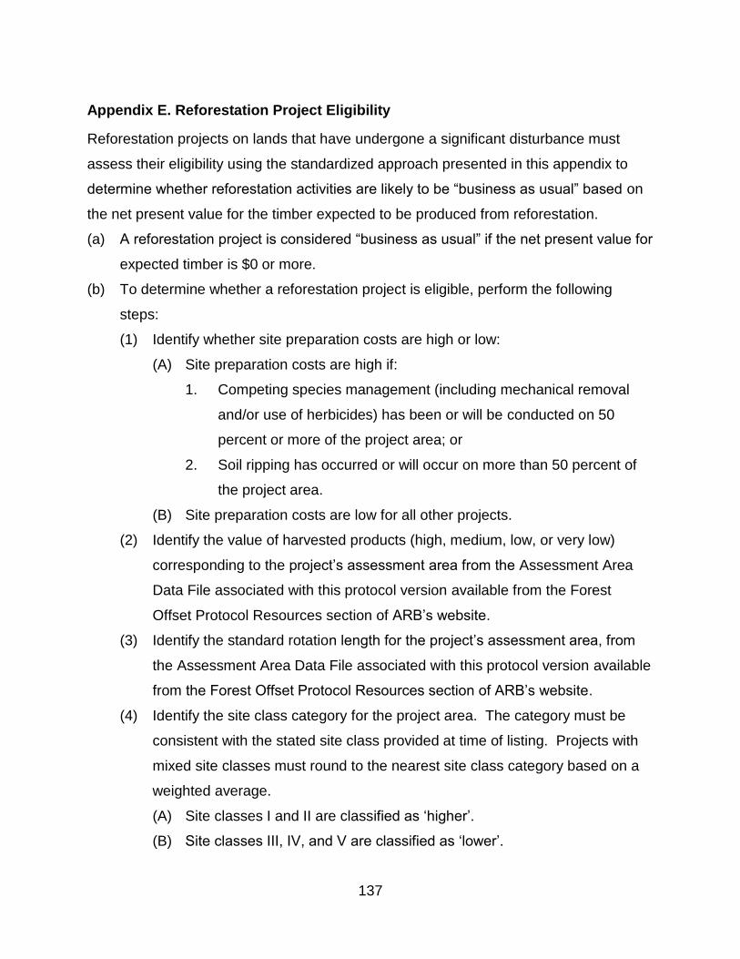
137
Appendix E. Reforestation Project Eligibility
Reforestation projects on lands that have undergone a significant disturbance must
assess their eligibility using the standardized approach presented in this appendix to
determine whether reforestation activities are likely to be “business as usual” based on
the net present value for the timber expected to be produced from reforestation.
(a) A reforestation project is considered “business as usual” if the net present value for
expected timber is $0 or more.
(b) To determine whether a reforestation project is eligible, perform the following
steps:
(1) Identify whether site preparation costs are high or low:
(A) Site preparation costs are high if:
1. Competing species management (including mechanical removal
and/or use of herbicides) has been or will be conducted on 50
percent or more of the project area; or
2. Soil ripping has occurred or will occur on more than 50 percent of
the project area.
(B) Site preparation costs are low for all other projects.
(2) Identify the value of harvested products (high, medium, low, or very low)
corresponding to the project’s assessment area from the Assessment Area
Data File associated with this protocol version available from the Forest
Offset Protocol Resources section of ARB’s website.
(3) Identify the standard rotation length for the project’s assessment area, from
the Assessment Area Data File associated with this protocol version available
from the Forest Offset Protocol Resources section of ARB’s website.
(4) Identify the site class category for the project area. The category must be
consistent with the stated site class provided at time of listing. Projects with
mixed site classes must round to the nearest site class category based on a
weighted average.
(A) Site classes I and II are classified as ‘higher’.
(B) Site classes III, IV, and V are classified as ‘lower’.
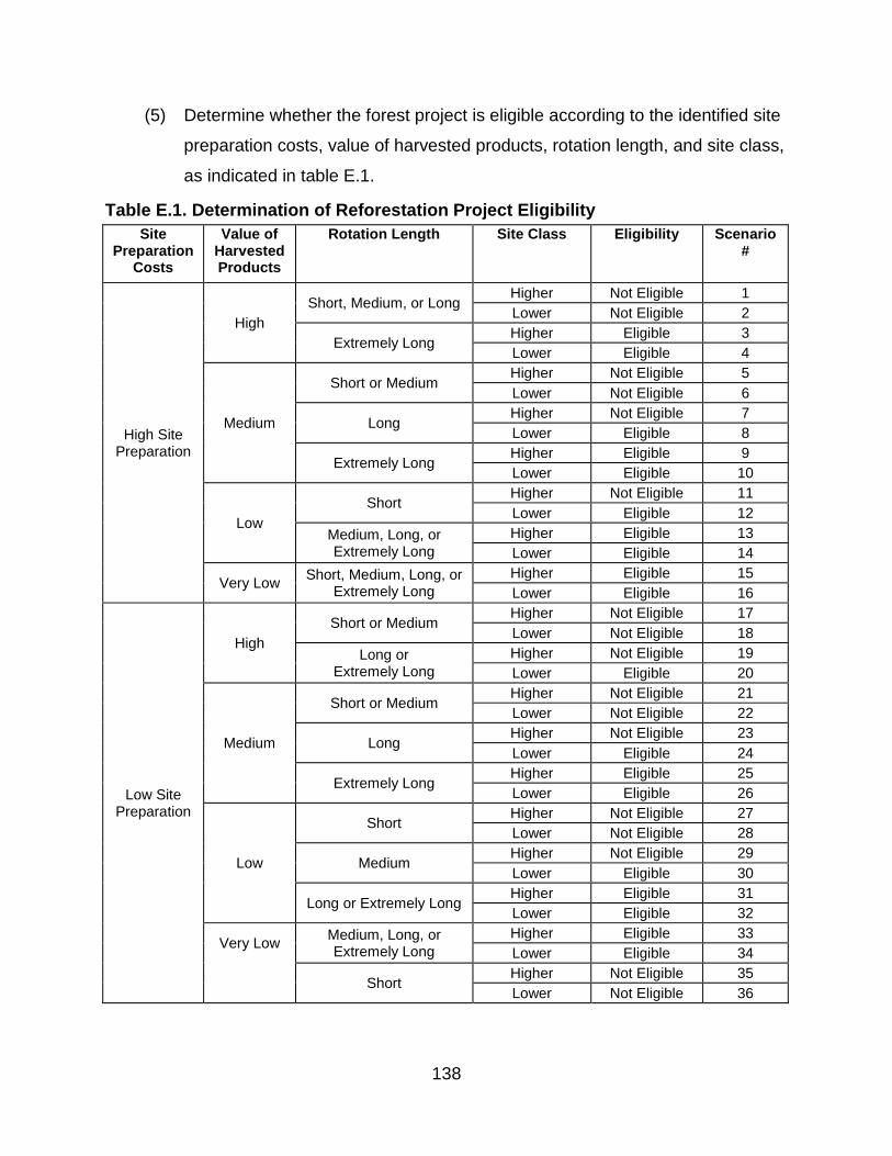
138
(5) Determine whether the forest project is eligible according to the identified site
preparation costs, value of harvested products, rotation length, and site class,
as indicated in table E.1.
Table E.1. Determination of Reforestation Project Eligibility
Site Preparation
Costs
Value of Harvested Products
Rotation Length Site Class Eligibility Scenario #
High Site Preparation
High
Short, Medium, or Long Higher Not Eligible 1
Lower Not Eligible 2
Extremely Long Higher Eligible 3
Lower Eligible 4
Medium
Short or Medium Higher Not Eligible 5
Lower Not Eligible 6
Long Higher Not Eligible 7
Lower Eligible 8
Extremely Long Higher Eligible 9
Lower Eligible 10
Low
Short Higher Not Eligible 11
Lower Eligible 12
Medium, Long, or Extremely Long
Higher Eligible 13
Lower Eligible 14
Very Low Short, Medium, Long, or
Extremely Long
Higher Eligible 15
Lower Eligible 16
Low Site Preparation
High
Short or Medium Higher Not Eligible 17
Lower Not Eligible 18
Long or Extremely Long
Higher Not Eligible 19
Lower Eligible 20
Medium
Short or Medium Higher Not Eligible 21
Lower Not Eligible 22
Long Higher Not Eligible 23
Lower Eligible 24
Extremely Long Higher Eligible 25
Lower Eligible 26
Low
Short Higher Not Eligible 27
Lower Not Eligible 28
Medium Higher Not Eligible 29
Lower Eligible 30
Long or Extremely Long Higher Eligible 31
Lower Eligible 32
Very Low Medium, Long, or Extremely Long
Higher Eligible 33
Lower Eligible 34
Short Higher Not Eligible 35
Lower Not Eligible 36

139
Appendix F. Determining a Value for Common Practice – Quantification
Methodology
Improved forest management projects on private lands must determine the common
practice value for the project area from FIA data, based on its geographic location and
boundaries. Offset Project Operators or Authorized Project Designees for improved
forest management projects must perform the following steps to determine the
appropriate common practice value:
(a) Determine the geographic ecosection(s) or supersection(s) within which the project
area is located by consulting the supersection maps available from the Forest
Offset Protocol Resources section of ARB’s website;
(b) Determine which assessment area(s) are included within the project area,
reference the Assessment Area Data File associated with this protocol version
available from the Forest Offset Protocol Resources section of ARB’s website and
compare the tree species in the project area to the species list associated with
each assessment area in the project’s ecosection(s) or supersection(s) identified in
the previous step;
(c) Determine the acreage of the project area that falls within each assessment area
contained in the ecosection(s) or supersection(s). Any contiguous area 20 acres
or greater within the project area that consists of a separate vegetation community
must be independently mapped;
(d) For assessment areas where data are disaggregated by high and low site classes
in the Assessment Area Data File associated with this protocol version available
from the Forest Offset Protocol Resources section of ARB’s website, the Offset
Project Operator or Authorized Project Designee must further stratify the project
area and identify the acreage that falls within each site class;
(1) A “high” site class means the average of site class productivity codes I-IV
(growth of ≥85 cubic feet/acre/year).
(2) A “low” site class means the average of site class productivity codes V-VII
(growth of <85 cubic feet/acre/year).

140
(e) Determine the portion of the project area that is in each site class for each
assessment area using soils data from a state or federal agency, direct site class
data from a state or federal agency, attestation from a state forester, or through
field analysis. The Offset Project Operator or Authorized Project Designee must
demonstrate that it has identified and assigned site trees for each strata or forest
type grouping based upon the methodology described in the FIA Database
National Core Field Guide Version 6 (October 2012), Section 7 to determine high
or low site class for its project area. Whatever method is used, documentation of
the analysis must be provided to the verifier at the project’s initial verification;
(f) If data for an assessment area are provided for both high and low site classes, and
an Offset Project Operator or Authorized Project Designee is unable or unwilling to
stratify the project area into site classes using an acceptable method described
above, then the high site-class common practice statistic must be used for all acres
within the assessment area;
(g) For each assessment area and site class stratum within the project area, identify
the appropriate common practice statistic from the Assessment Area Data File
associated with this protocol version available from the Forest Offset Protocol
Resources section of ARB’s website. The value displayed in the Assessment Area
Data File associated with this protocol version indicates CO2e metric tons per acre
in the above ground portion (bole, bark, top and branches) of live trees; and
(h) Determine a single common practice value for the entire project area by calculating
the average of the common practice statistics for each assessment area and site
class, weighted by the number of acres of each assessment area and site class
within the project area.
141
Appendix G. References
Brown, S., D. Shoch, T. Pearson, and M. Delaney. 2004. Methods for Measuring and Monitoring Forestry Carbon Projects in California. Winrock International, for the California Energy Commission, PIER Energy-Related Environmental Research. 500-04-072F. Cairns M.A., S. Brown, E.H. Helmer, and G.A. Baumgardner. 1997. Root biomass allocation in the world’s upland forest. Oecologia, 111, 1-11. Domke et al. 2011. Accounting for density reduction and structural loss in standing dead trees: Implications for forest biomass and carbon stock estimates in the United States. Carbon Balance and Management 2011 6:14. Available: http://www.treesearch.fs.fed.us/
Harmon, Mark E.; Woodall, Christopher W.; Fasth, Becky; Sexton, Jay; Yatkov, Misha. 2011. Differences between standing and downed dead tree wood density reduction factors: A comparison across decay classes and tree species. Res. Pap. NRS-15. Newtown Square, PA: U.S. Department of Agriculture, Forest Service, Northern Research Station. 40 p. Miles, Patrick D; Smith, W. Brad. 2009. Specific gravity and other properties of wood and bark for 156 tree species found in North America. Res. Note NRS-38. Newtown Square, PA: U.S. Department of Agriculture, Forest Service, Northern Research Station. 35 p. Smith, James E.; Heath, Linda S.; Skog, Kenneth E.; Birdsey, Richard A. 2006. Methods for calculating forest ecosystem and harvested carbon with standard estimates for forest types of the United States. Gen. Tech. Rep. NE-343. Newtown Square, PA: U.S. Department of Agriculture, Forest Service, Northeastern Research Station. 216 p. Technical Guidelines, Voluntary Reporting of Greenhouse Gases (1605(b)) Program. January 2007. Office of Policy and International Affairs. United States Department of Energy. Woodall, Christopher W.; Heath, Linda S.; Domke, Grant M.; Nichols, Michael C. 2011. Methods and equations for estimating aboveground volume, biomass, and carbon for trees in the U.S. forest inventory, 2010. Gen. Tech. Rep. NRS-88. Newtown Square, PA: U.S. Department of Agriculture, Forest Service, Northern Research Station. 30 p and appendices.