complete streets - new york state department of transportation€¦ · new york bicycling coalition...
TRANSCRIPT

Complete StreetsPlanning Safer Communities for
Pedestrians and Bicyclists
Complete StreetsPlanning Safer Communities for
Pedestrians and Bicyclists
by
Lois E. Chaplin
Cornell Local Roads Program416 Riley-Robb Hall
Ithaca, New York 14853-5701Tel: 607-255-8033
Fax: 607-255-4080Email: [email protected]
Website: www.clrp.cornell.edu
CLRP No. 07-03Revised February 2012
AcknowledgementsThe Cornell Local Roads Program would like to acknowledge the support and assistance of many people who helped put this manual together. An advisory committee provided guidance from the beginning by recommending topics, providing resources, and reviewing drafts for content and flow. The advisory committee includes:
Lori Budd Program Coordinator Cornell Local Roads Program
Lois Chaplin (course instructor) Bicycle/Pedestrian Program Specialist Cornell Local Roads Program
Linda Cook Superintendent of Highways Town of Hurley
Jim Ercolano, M.S. Bicycle / Pedestrian NYSDOT
Paul Evans Bicycle and Pedestrian Coordinator NYSDOT Region 2
Sharon Heyboer Senior Planner Herkimer-Oneida Transportation Study (HOCTS)
Lynne H. Irwin P.E. Director Cornell Local Roads Program
Steve Miko Commissioner of Public Works City of Poughkeepsie
Eric Ophardt, P.E. Bicycle / Pedestrian NYSDOT
David P. Orr P.E. Senior Engineer Cornell Local Roads Program
Scott Reigle Senior Transportation Planner Binghamton Metropolitan Transportation Study (BMTS)
Nicole Tedesco Planner Town of Ithaca
Thanks to Jeff Olson, Initiative for Healthy Infrastructure, SUNY Albany, for guidance and supporting materials pertaining to planning, and to Robin Dropkin, Executive Director of Parks and Trails New York for reviewing the multi-use trail chapter. Thanks also to Ray Snyder, Superintendent of Public Works, Village of Chittenango and Donna Lynch from the Chittenango Creek Walk Committee for their time and guidance. Thanks to the many others who provided photographs and materials.
A special thanks to Victor Pollaci Jr. for an excellent job at editing, layout and suggestions for focus and flow.
Cornell Local Roads Program i

Table of Contents
Acknowledgements .......................................................................................................................... i
1 – Completing the Streets .............................................................................................................. 1
What is a Complete Street? ........................................................................................................1Walkability Attracts Tourists ......................................................................................................2Americans Want Walkable Neighborhoods ...............................................................................2Capturing the “Lifestyle” Market ..............................................................................................3Bicycles Bring Business ............................................................................................................4
2 – What’s the Problem? ................................................................................................................. 5
Inactivity ....................................................................................................................................5Crash Data ..................................................................................................................................6
Pedestrians ...........................................................................................................................8Bicyclists ............................................................................................................................10
3 – Making the Connection ........................................................................................................... 15
Guidance at the National and State Levels ..............................................................................15Community planning in New York State .................................................................................15
The Comprehensive Plan ...................................................................................................15Subdivision Regulations ....................................................................................................17Zoning Ordinances .............................................................................................................17
Smart Growth and Land Use Planning ....................................................................................18Site Plan Review ......................................................................................................................18Connectivity and Intermunicipal Cooperation .........................................................................19
4 – Legal Aspects .......................................................................................................................... 21
Traffic Laws .............................................................................................................................21Bicyclists and In-Line Skaters ...........................................................................................22Bike Helmets ......................................................................................................................23Electric Personal Assistive Mobility Devices (EPAMDs) .................................................23Skateboards ........................................................................................................................23ADA – The Americans with Disabilities Act .....................................................................23Liability ..............................................................................................................................24
Complete Streets ......................................................................................................................24
5 – The Engineering Toolbox ........................................................................................................ 25
Guidance ..................................................................................................................................25
Cornell Local Roads Programii

Table of Contents
Managing Traffic ......................................................................................................................26Signage ...............................................................................................................................26Traffic Signals ....................................................................................................................27Pedestrian Signal Timing ...................................................................................................28
Design Basics ...........................................................................................................................30Parallel Travel ....................................................................................................................31Crossing the Street .............................................................................................................38
Curb ramps ...................................................................................................................42Other Aspects of Safety .....................................................................................................43
Lighting ........................................................................................................................43Work zones ...................................................................................................................44
Maintenance .............................................................................................................................45Sidewalks ...........................................................................................................................45Road Shoulders ..................................................................................................................46Drain Grates .......................................................................................................................47
6 – Know Your Neighbors ............................................................................................................ 49
Persons with Disabilities ..........................................................................................................49Pedestrians ...............................................................................................................................49Bicyclists ..................................................................................................................................49Youth ........................................................................................................................................50The Elderly ...............................................................................................................................51
7 – Multi-Use Facilities ................................................................................................................ 53
Vision and Planning .................................................................................................................53Design and Construction ..........................................................................................................54
Width ..................................................................................................................................54Surface ...............................................................................................................................54Alignment ..........................................................................................................................55Grade ..................................................................................................................................55Structures ...........................................................................................................................55Intersections .......................................................................................................................56Roadway Separation ..........................................................................................................57
Maintenance .............................................................................................................................57Trail Signs as Education ..........................................................................................................58Trailheads and Parking .............................................................................................................58People Parking .........................................................................................................................58
8 – A Well Rounded Approach ...................................................................................................... 61
Municipality-Sponsored Publicity or Endorsed Events ...........................................................61Finding Champions .................................................................................................................61Public Education Campaigns ...................................................................................................63Safe Routes to School ..............................................................................................................64
Complete Streets iii
Table of Contents
Teaching Bicycle Safety ..........................................................................................................64Vehicle and Traffic Law Enforcement .....................................................................................65Maps .........................................................................................................................................66Educated Law Enforcement .....................................................................................................67Enforcement is Education ........................................................................................................67Funding ....................................................................................................................................68
9 – Next Steps ............................................................................................................................... 69
An audit ....................................................................................................................................69Neighborhood Assessment .......................................................................................................71Planning ...................................................................................................................................72Engineering ..............................................................................................................................73Education, Enforcement, and Outreach ..................................................................................73Measuring Your Success ..........................................................................................................74
Appendix I – National Policy Guidelines ..................................................................................... 75
USDOT, AASHTO, and “Complete Streets” ...........................................................................75FHWA Bicycle and Pedestrian Program Policy Statement Purpose– March 2010 ...........75AASHTO Guidelines ........................................................................................................76Complete Streets ...............................................................................................................77
Appendix II – National and State Legislation .............................................................................. 78
Federal Transportation Legislation: ISTEA, TEA-21, SAFETEA-LU....................................78NYSDOT Bicycle and Pedestrian Policy.................................................................................79Complete Streets in New York State ........................................................................................79Smart Growth ...........................................................................................................................79
Appendix III – Sample Policy and Ordinances ............................................................................. 81
Town, Village, or City Bicyclist and Pedestrian Policy ..........................................................81Sample Pedestrian Ordinances .................................................................................................82Sample Bicycle Parking Ordinance .........................................................................................83
Appendix IV – Neighborhood Checklists .................................................................................... 86
Appendix V – Resources ............................................................................................................... 97
State and National Organizations .............................................................................................97American Association of State and Highway Transportation Officials (AASHTO) .........97Association of Bicycle and Pedestrian Professionals ........................................................97Cornell Local Roads Program ............................................................................................97
Cornell Bicycle and Pedestrian Homepage ..................................................................97Federal Highway Administration (FHWA) ........................................................................97
Cornell Local Roads Programiv
Table of Contents
National Highway Traffic Safety Administration (NHTSA) .............................................98New York State Department of Motor Vehicles (NYSDMV) ............................................98
Governor’s Traffic Safety Committee ..........................................................................98New York State Department of Transportation (NYSDOT) ..............................................98
Highway Design Manual .............................................................................................98Engineering Instruction Documents ............................................................................99
Pedestrian and Bicycle Information Center (PBIC) ...........................................................99United States Access Board ..............................................................................................99
Advocacy Organizations ........................................................................................................100Center for Community Economic Development, University of Wisconsin-Extension ...100Complete the Streets ........................................................................................................100League of American Bicyclists .......................................................................................100Maine Bicycle Coalition ..................................................................................................100New York Bicycling Coalition .........................................................................................100Parks and Trails New York...............................................................................................100Rails-to-Trails Conservancy ............................................................................................100Safe Routes to School ......................................................................................................100The Alliance for Biking and Walking ..............................................................................100
About the Author ......................................................................................................................... 101
Complete Streets v
List of Figures & TablesFigures
Figure 1 - Cyclists taking a break for ice cream. .......................................................................3
Figure 2 - Broadway in Saratoga Springs, NY. ..........................................................................4
Figure 3 - Intersection dash. .......................................................................................................9
Figure 4 - Midblock dash. ..........................................................................................................9
Figure 5 - Walking along the road. ..........................................................................................10
Figure 6 - Mid-block ride out. ..................................................................................................11
Figure 7 - Wrong way bicycling. .............................................................................................11
Figure 8 - Motorist going straight. ...........................................................................................12
Figure 9 - Motorist making a left turn. ....................................................................................12
Figure 10 - Motorist making a right turn. ................................................................................13
Figure 11 - Pedestrian in crosswalk. ........................................................................................21
Figure 12 – Fluorescent yellow-green pedestrian warning sign. .............................................26
Figure 13 - Stop signs ..............................................................................................................27
Figure 14 - A traffic signal. ......................................................................................................28
Figure 15 - Pedestrian hybrid beacon ......................................................................................29
Figure 16 - Countdown signal. .................................................................................................30
Figure 17 - Shared roadway sign. ............................................................................................31
Figure 18 - Example of shared lane marking. ..........................................................................32
Figure 19 - A beaten path. ........................................................................................................33
Figure 20 - A well-designed sidewalk. .....................................................................................33
Figure 21 - Zones within the sidewalk corridor. ......................................................................34
Figure 22 - Reduced curb radii. ...............................................................................................36
Figure 23 - A five-way modern roundabout. ............................................................................37
Figure 24 - A mini-circle in Ithaca, NY. ...................................................................................37
Figure 25 - Example of a choker. .............................................................................................38
Figure 26 - A well-marked crosswalk. .....................................................................................39
Figure 27 - A raised crosswalk. ................................................................................................40
Figure 28 - A center crossing island. ........................................................................................41
Cornell Local Roads Programvi
List of Figures & Tables
Figure 29 - Curb extension in Ft. Plain, NY. ...........................................................................42
Figure 30 - A well-designed curb ramp. ...................................................................................43
Figure 31 - A well lit bus stop. .................................................................................................44
Figure 31 - A poor shoulder. ....................................................................................................46
Figure 32 - A good shoulder. ....................................................................................................47
Figure 33 - Drain grate in damaged pavement. ........................................................................47
Figure 34- An ornately designed bench in Rochester, NY. ......................................................50
Figure 35 - A converted rail bridge on separate facility. ..........................................................53
Figure 36 - Bridge over a highway in Marcy, NY. ...................................................................56
Figure 37 - This trail sign provides helpful directions and guidance.......................................58
Figure 38 - Parking at a trailhead. ............................................................................................59
Figure 39 - Combination bench and bike rack. ........................................................................59
Figure 40 - A bench and map kiosk. ........................................................................................60
Figure 41 - Benches and bike racks in Ithaca, NY. ..................................................................60
Figure 42 - Sidewalk in Whitestown, NY. ...............................................................................62
Figure 43 - A bicycle rodeo. .....................................................................................................64
Figure 44 - A regional bike map. .............................................................................................65
Tables
Table 1 - 2008 Accident Summary Totals for New York State ..................................................7
Complete Streets vii

Cornell Local Roads Program Streets 1
1 – Completing the StreetsPeople report that they would walk and bike more if there were safe and convenient places to do so. Space for walking and bicycling encompasses a wide range of options such as good road surfaces and shoulders, bike lanes, paved sidewalks, safe crosswalks and separate recreational facilities.
This manual is about helping you make a positive contribution to your community by providing an environment that will enable people to add more physical activity to their lifestyle. It is not about getting rid of cars and roads; they are, after all, essential aspects of life as we know it. We can, however, make improvements to our streets that will encourage and enable people to add more movement to their lives. Doing so with safety as our guide will provide results that everyone will enjoy.
First and foremost, sound planning is the basis of any successful project. It is not a matter of “build it and they will come” so much as “plan wisely, then build it and then they will come.” Visionary planning will serve a community well over the years. Subsequent facilities that are built and properly maintained will attract users and will be easy to promote.
Present roadway design, construction, and planning practices have left our streets incomplete by falling short of providing necessary facilities and services to non-motorized and transit users. Focusing solely on accommodating high-speed traffic undermines the safety of our towns and the well-being of the individuals living in them. For these and so many other reasons, we need to complete our streets.
WhAT iS A CompLeTe STreeT?
Much of what encourages people to walk, bicycle and use transit is the variety of destinations within a reasonable distance. Without land-use changes, sprawl will continue to erode the ability to walk and bicycle. Complete streets are a part of this mix because they offer a way to make common cause with other organizations working for healthier communities that give residents more choices and better access.
A good complete streets policy:
Specifies that “all users” includes pedestrians, bicyclists, transit vehicles and users, • and motorists of all ages and abilities.
Aims to create a comprehensive, integrated, connected network.•
Recognizes the need for flexibility: that all streets are different and assures that user • needs will be well balanced.
Is adoptable by all agencies to cover all roads.•
Cornell Local Roads Program2
Complete Streets
Applies to both new and retrofit projects, including design, planning, maintenance, • and operations for the entire right-of-way.
Makes any exceptions specific and sets a clear procedure that requires high-level • approval of those exceptions.
Uses the latest and best design standards.•
Directs that complete streets solutions fit within the context of the community.•
Establishes performance standards with measurable outcomes.•
Example: Chicago’s Complete Streets Policy is part of the city’s Safe Streets for Chicago program.
The safety and convenience of all users of the transportation system including pedestrians, bicyclists, transit users, freight, and motor vehicle drivers shall be accommodated and balanced in all types of transportation and development projects and through all phases of a project so that even the most vulnerable – children, the elderly, and persons with disabilities – can travel safely within the public right-of-way.
WALkAbiLiTy ATTrACTS TouriSTS
Walkable towns and villages are capturing a greater share of tourist dollars from visitors interested in experiencing community life. Places where both visitors and residents feel community pride and activity are more likely to be strong economically. Tourists visiting Vermont to walk and bicycle in the scenic, human-scale towns and compact, pedestrian-friendly town centers have proven an economic boon. The Vermont Department of Tourism & Marketing’s official website (www.vermontvacation.com) promotes the state’s walkable downtowns.
AmeriCAnS WAnT WALkAbLe neighborhoodS
A survey by the National Association of REALTORS® shows that more people want less time in the car. The Community Preference Survey highlights that 56% of Americans prefer more walkable neighborhoods with a mix of nearby destinations to those that require more driving. Half of the respondents wanted improvements to existing public transportation rather than new roads and development, and nearly three out of five would trade square footage for short commute.

Cornell Local Roads Program Streets 3
1 – Completing the Streets
Walkable neighborhoods are attractive to prospective buyers. “In a 2002 survey of recent home buyers, sponsored by the National Association of Realtors and the National Association of Homebuilders, trails ranked as the second most important community amenity out of a list of 18 choices (http://www.americantrails.org/resources/economics/businessoftrails.html)
CApTuring The “LiFeSTyLe” mArkeT
Developers have recently recognized opportunities in walkable shopping centers that offer a “sense of place.” Lifestyle and “New Town” centers are being developed to replicate many of the community or neighborhood shopping experiences offered by downtowns. These new centers try to recreate the downtown sense of place with small building footprints, multi-story buildings, and an open-air environment. They are built to be pedestrian friendly, convenient, and safe. Traditional downtown areas that are walkable already possess what many developers are trying to duplicate, and the economic potential of increased sales from the lifestyle segment can be realized with business expansion and recruitment to create an appropriate mix of retail, entertainment, and service businesses.
Figure 1 - Cyclists taking a break for ice cream.
Cornell Local Roads Program4
Complete Streets
biCyCLeS bring buSineSS
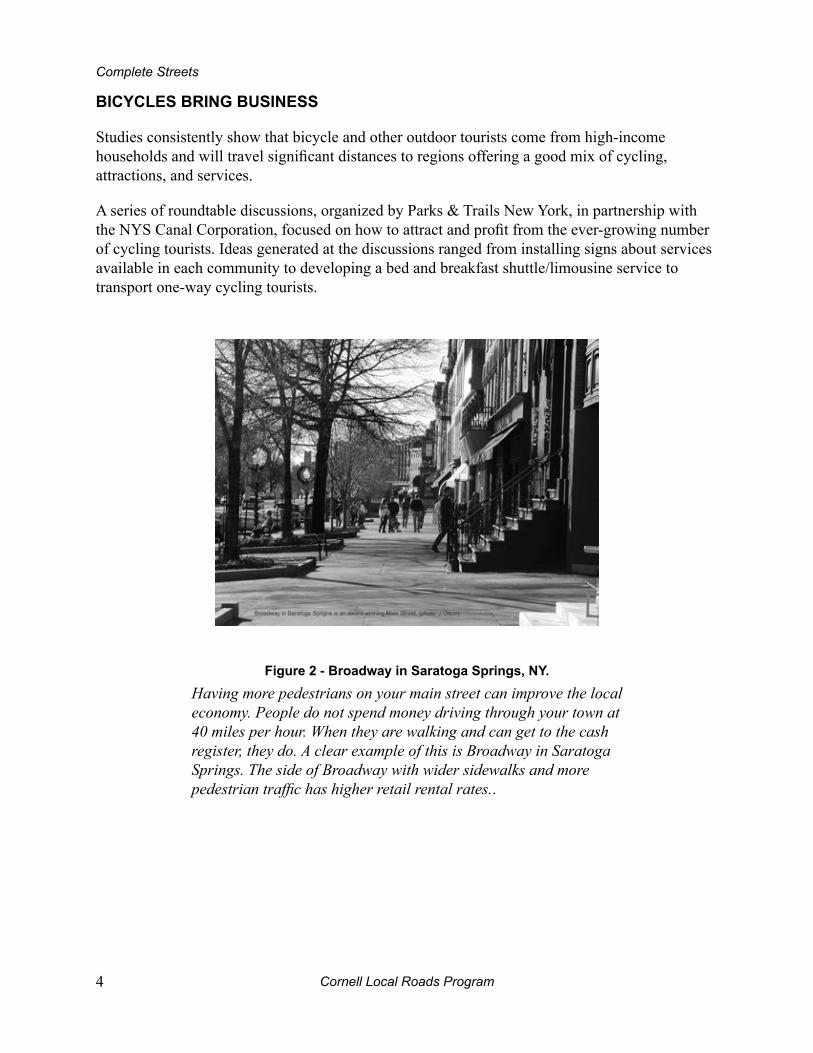
Studies consistently show that bicycle and other outdoor tourists come from high-income households and will travel significant distances to regions offering a good mix of cycling, attractions, and services.
A series of roundtable discussions, organized by Parks & Trails New York, in partnership with the NYS Canal Corporation, focused on how to attract and profit from the ever-growing number of cycling tourists. Ideas generated at the discussions ranged from installing signs about services available in each community to developing a bed and breakfast shuttle/limousine service to transport one-way cycling tourists.
Figure 2 - broadway in Saratoga Springs, ny.
Having more pedestrians on your main street can improve the local economy. People do not spend money driving through your town at 40 miles per hour. When they are walking and can get to the cash register, they do. A clear example of this is Broadway in Saratoga Springs. The side of Broadway with wider sidewalks and more pedestrian traffic has higher retail rental rates..
Cornell Local Roads Program Streets 5
2 – What’s the problem?By not having a vision of our streets serving the needs of all users – pedestrians, bicyclists, transit users, motorists and travelers of all ages and abilities – we have ended up with streets that are incomplete. When roadways are built to accommodate high-speed traffic, we discourage and often prohibit many of our most vulnerable users. We have compromised the health, well-being and safety of our towns.
inACTiviTy
The results of over thirty years of medical research are clear and consistent – a physically inactive population is at increased risk of losing years of healthy life to obesity, diabetes, heart disease, stroke, and cancer. New York State residents are not immune from the trend. According to a study conducted by the Center for Disease Control and Prevention, over half of adults in New York are at an unhealthy weight. About 20 percent, at the more extreme end of the spectrum, are obese; while 37 percent who are moderately overweight still run an elevated risk for disease.
One reason we are overweight is simply that we eat too much and move too little. Regarding physical activity, 58 percent of NY adults are in the “move too little” category and do not meet the current recommendations for physical activity. Similarly, we are now seeing the same trend among our children.
Significant health benefits can be achieved by being moderately active for at least 30 minutes a day, 5 days of the week. Moderate activity includes walking at a brisk pace (3 miles per hour), bicycling on level ground, yard work, etc. It is not necessary to do the entire 30 minutes all at once; 10 minutes at a time, 3 times a day is just fine. Vigorous activity, like jogging, requires only 20 minutes, 3 times a week.
Integrating physical activity into your life is easier than you might think. Try taking a walk on your lunch break or parking farther away from the store when you shop. If walking is too slow, get out and ride your bike. Both walking and biking are great opportunities to include your family in your efforts to increase personal well-being, and afford them the same positive results.
Also consider setting goals outside of time. Get a pedometer and strive for 10,000 steps per day, or choose a target mileage for your bicycle rides. If you find yourself still looking for more, start training for a local race.
What enables us to be active? There is convincing evidence that our “built environments” have a powerful influence on how physically active we are. Our built environment consists of the man-made components of our environment – in contrast to what nature provides – and includes streets, highways, houses, apartments, businesses, churches, parks, and playgrounds.
Cornell Local Roads Program6
Complete Streets
Complete Streets is one strategy which can provide a framework for New York State to build communities that are more livable for residents and more attractive for tourists and homebuyers. If employed with other strategies, Complete Streets will help us achieve increased physical activity and improvement to the physical, mental, and overall quality of people’s lives.
CrASh dATA
Do you know the most common type of crashes involving cars, pedestrians and bicyclists? Crash, roadway, traffic and other data are essential in identifying pedestrian and bicycle safety deficiencies and selecting the appropriate improvements to make conditions safe for all users.
There are studies and analyses that look at national statistics as well as state, county and local reports. NYSDOT’s Bicycle and Pedestrian Program compiled a summary of the Department of Motor Vehicles’ pedestrian and bicycle crash data for the years 1991-2000. ALIS (Accident Location Information System) is a new, efficient and accurate system using modern Geographical Information System (GIS) technology to locate and analyze accidents. Contact your local Metropolitan Planning Organization (MPO) or Department of Transportation for more information.
Having more, higher-quality data will typically give you better tools to identify and address safety problems. Since it is not practical or possible to collect and analyze all of the data available, it is important to prioritize your needs. This will depend on what is available locally. If local data is difficult to access, county and state-level data may have to serve as your base.
To give you a general idea of the types of risks and incidents involving pedestrians and bicyclists on the roadway, this section highlights the most common crash types involving pedestrians and bicyclists.
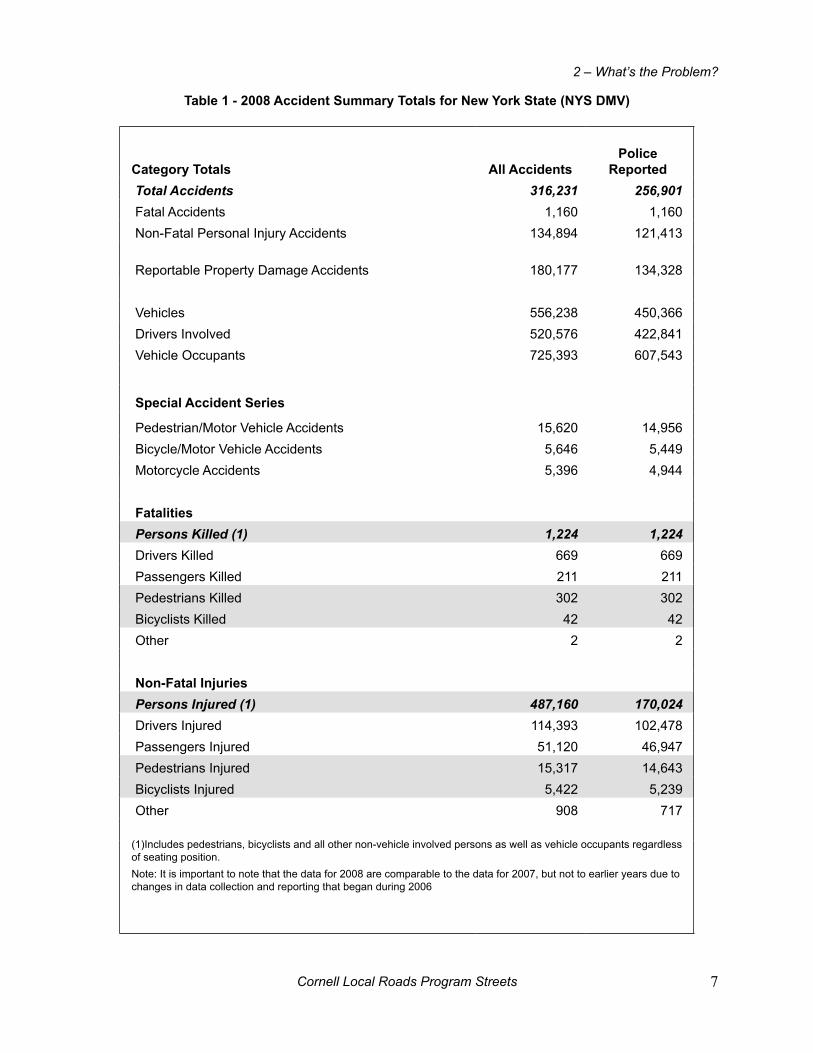
Table 1 shows accident summary totals for 2008 as compiled by the New York State Department of Motor Vehicles (NYS DMV). A few especially pertinent figures have been highlighted.
Cornell Local Roads Program Streets 7
2 – What’s the Problem?
Table 1 - 2008 Accident Summary Totals for new york State (nyS dmv)
Category Totals All Accidentspolice
reported Total Accidents 316,231 256,901 Fatal Accidents 1,160 1,160 Non-Fatal Personal Injury Accidents 134,894 121,413
Reportable Property Damage Accidents 180,177 134,328
Vehicles 556,238 450,366 Drivers Involved 520,576 422,841 Vehicle Occupants 725,393 607,543
Special Accident Series
Pedestrian/Motor Vehicle Accidents 15,620 14,956 Bicycle/Motor Vehicle Accidents 5,646 5,449 Motorcycle Accidents 5,396 4,944
Fatalities Persons Killed (1) 1,224 1,224 Drivers Killed 669 669 Passengers Killed 211 211 Pedestrians Killed 302 302 Bicyclists Killed 42 42 Other 2 2
non-Fatal injuries Persons Injured (1) 487,160 170,024 Drivers Injured 114,393 102,478 Passengers Injured 51,120 46,947 Pedestrians Injured 15,317 14,643 Bicyclists Injured 5,422 5,239 Other 908 717
(1)Includes pedestrians, bicyclists and all other non-vehicle involved persons as well as vehicle occupants regardless of seating position.Note: It is important to note that the data for 2008 are comparable to the data for 2007, but not to earlier years due to changes in data collection and reporting that began during 2006
Cornell Local Roads Program8
Complete Streets
pedestrians
Pedestrians are over-represented in the crash data, accounting for more than 12 percent of fatalities but only 9 percent of trips. However, there is no reliable source of exposure data.Transportation professionals do not have an accurate sense of how many miles people walk each year, or how many minutes or hours people spend walking or crossing the street (and thus how long they are exposed to motor vehicle traffic, for example). Walking remains a healthful, inherently safe activity for tens of millions of people. However, as with every mode of travel, there is clearly some risk associated with walking.
There were 4,378 pedestrians killed and 69,000 pedestrians injured in the United States in 2008. An estimated 16,000 pedestrian injuries, as well as 300 deaths, occur annually in New York State.
Trends nationwide:
More than two-thirds of pedestrian crashes occur in urban areas where pedestrian activity • is concentrated. There is a higher ratio of deaths to injuries in rural areas because of higher impact speeds on rural roads.
Seventy-one percent of all pedestrian deaths in 2007 occurred on major roads, including • interstates and freeways. A substantial proportion of pedestrian deaths occur at intersections — 24 percent in 2007.
The majority of pedestrian crashes occur at locations other than intersections, where • vehicle speeds may be higher and where drivers do not expect to have to stop.
A greater percentage of older pedestrian deaths occurred at intersections when compared • to deaths of pedestrians under age 70 (40 percent compared to 21 percent). This is partly because older pedestrians generally cross intersections more slowly. Diminished vision, hearing, and reaction time also contribute.
Nationally, over 60 percent of all pedestrians involved in crashes were children and • young pedestrians under 14 years old.
Three common crash-types for pedestrians include crossing the street at intersections or • mid-block, and walking along the roadway.
Cornell Local Roads Program Streets 9
2 – What’s the Problem?
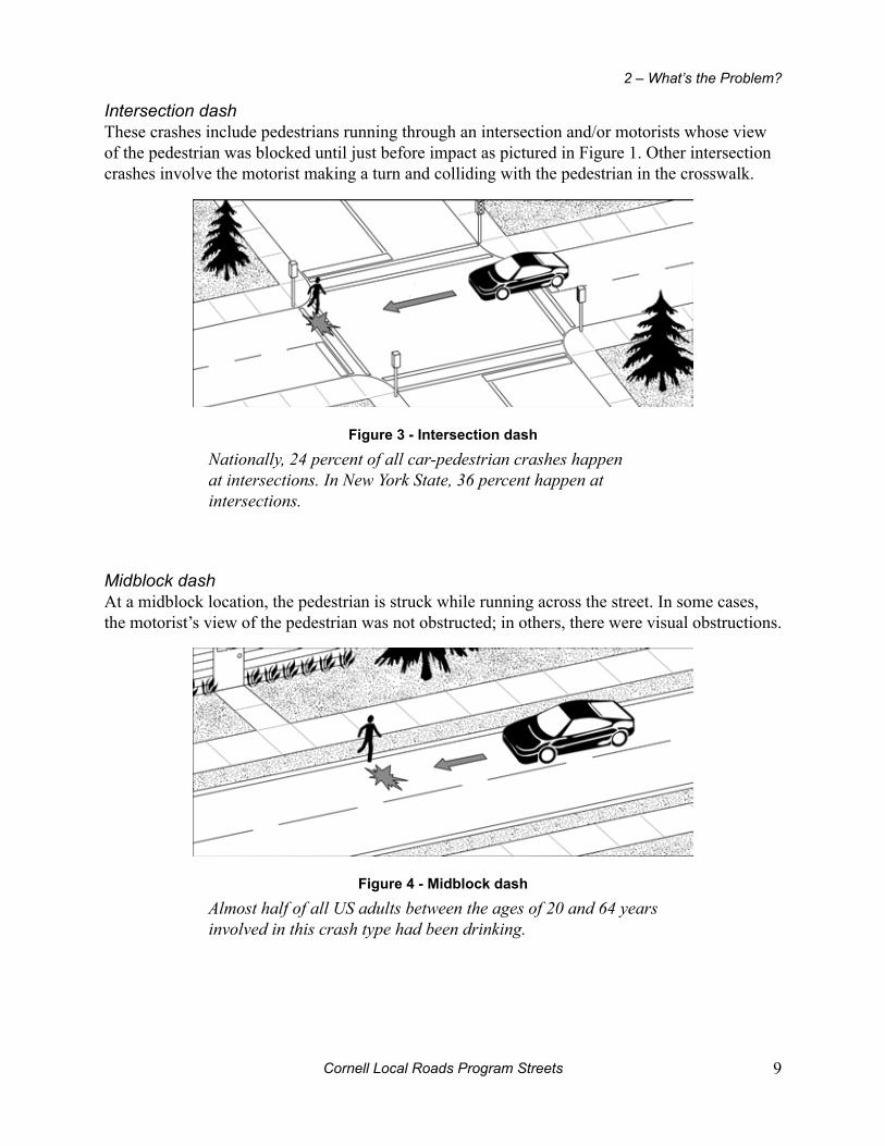
Intersection dashThese crashes include pedestrians running through an intersection and/or motorists whose view of the pedestrian was blocked until just before impact as pictured in Figure 1. Other intersection crashes involve the motorist making a turn and colliding with the pedestrian in the crosswalk.
Figure 3 - intersection dash
Nationally, 24 percent of all car-pedestrian crashes happen at intersections. In New York State, 36 percent happen at intersections.
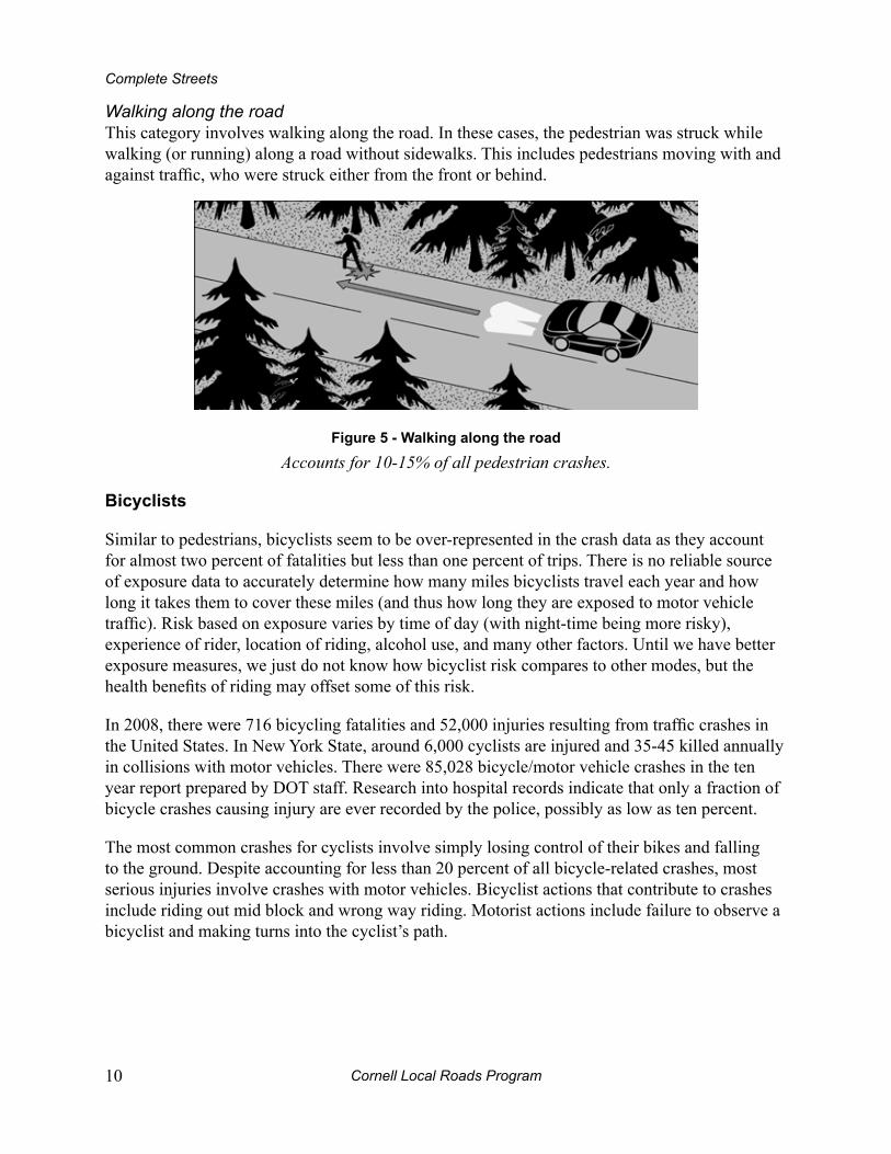
Midblock dashAt a midblock location, the pedestrian is struck while running across the street. In some cases, the motorist’s view of the pedestrian was not obstructed; in others, there were visual obstructions.
Figure 4 - midblock dash
Almost half of all US adults between the ages of 20 and 64 years involved in this crash type had been drinking.
Cornell Local Roads Program10
Complete Streets
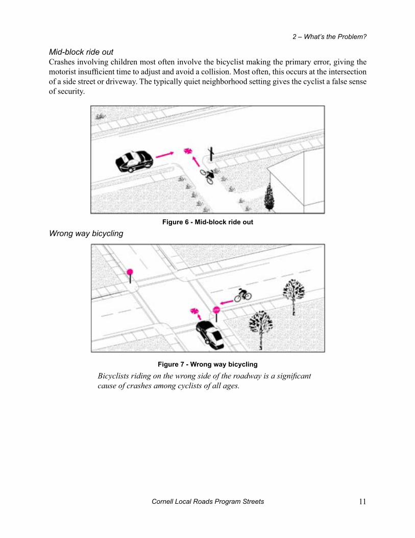
Walking along the roadThis category involves walking along the road. In these cases, the pedestrian was struck while walking (or running) along a road without sidewalks. This includes pedestrians moving with and against traffic, who were struck either from the front or behind.
Figure 5 - Walking along the road
Accounts for 10-15% of all pedestrian crashes.
bicyclists
Similar to pedestrians, bicyclists seem to be over-represented in the crash data as they account for almost two percent of fatalities but less than one percent of trips. There is no reliable source of exposure data to accurately determine how many miles bicyclists travel each year and how long it takes them to cover these miles (and thus how long they are exposed to motor vehicle traffic). Risk based on exposure varies by time of day (with night-time being more risky), experience of rider, location of riding, alcohol use, and many other factors. Until we have better exposure measures, we just do not know how bicyclist risk compares to other modes, but the health benefits of riding may offset some of this risk.
In 2008, there were 716 bicycling fatalities and 52,000 injuries resulting from traffic crashes in the United States. In New York State, around 6,000 cyclists are injured and 35-45 killed annually in collisions with motor vehicles. There were 85,028 bicycle/motor vehicle crashes in the ten year report prepared by DOT staff. Research into hospital records indicate that only a fraction of bicycle crashes causing injury are ever recorded by the police, possibly as low as ten percent.
The most common crashes for cyclists involve simply losing control of their bikes and falling to the ground. Despite accounting for less than 20 percent of all bicycle-related crashes, most serious injuries involve crashes with motor vehicles. Bicyclist actions that contribute to crashes include riding out mid block and wrong way riding. Motorist actions include failure to observe a bicyclist and making turns into the cyclist’s path.
Cornell Local Roads Program Streets 11
2 – What’s the Problem?
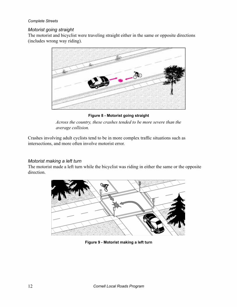
Mid-block ride outCrashes involving children most often involve the bicyclist making the primary error, giving the motorist insufficient time to adjust and avoid a collision. Most often, this occurs at the intersection of a side street or driveway. The typically quiet neighborhood setting gives the cyclist a false sense of security.
Figure 6 - mid-block ride out
Wrong way bicycling
Figure 7 - Wrong way bicycling
Bicyclists riding on the wrong side of the roadway is a significant cause of crashes among cyclists of all ages.
Cornell Local Roads Program12
Complete Streets
Motorist going straightThe motorist and bicyclist were traveling straight either in the same or opposite directions (includes wrong way riding).
Figure 8 - motorist going straight
Across the country, these crashes tended to be more severe than the average collision.
Crashes involving adult cyclists tend to be in more complex traffic situations such as intersections, and more often involve motorist error.
Motorist making a left turnThe motorist made a left turn while the bicyclist was riding in either the same or the opposite direction.
Figure 9 - motorist making a left turn

Cornell Local Roads Program Streets 13
2 – What’s the Problem?
Motorist making a right turnThe motorist made a right turn while the bicyclist was riding in either the same or the opposite direction.
Figure 10 - motorist making a right turn
In 74 percent of cases like this one reported across the country, the motorist was overtaking the cyclist.

Cornell Local Roads Program Streets 15
3 – making the Connection
guidAnCe AT The nATionAL And STATe LeveLS
With the passage of the Intermodal Surface Transportation Efficiency Act (ISTEA) in 1991, the Transportation Equity Act (TEA-21) in 1998, and the Safe, Accountable, Flexible, Efficient Transportation Equity Act (SAFETEA) in August 2005, a national trend has emerged for encouraging improved systems of non-motorized transportation.
In 2011, the New York State Legislature passed a Complete Streets Law, effective in 2012. The recently passed statewide Complete Streets law provides a window of opportunity for action at the local level. The law affects the practices at the State Agency level (and those agencies receiving Federal money). Local complete streets policies must continue to be developed and passed.
In New York State, guidance at the national level serves as a basis for developing local policy tools. Since New York codes and policies related to land use are generally based on a “home rule” approach, it is essential to provide a flexible approach that can be adopted by a variety of different agencies and governments.
CommuniTy pLAnning in neW york STATe
The “big three” documents for community planning in New York are:
The Comprehensive Plan•
Subdivision and Site Plan Regulations•
Zoning Ordinances/Codes•
The Comprehensive plan
A comprehensive plan typically outlines the characteristics of the community, articulates its goals, and explores alternative plans for the future. Additionally, a thorough comprehensive plan addresses all aspects of a community; including transportation and environmental planning, storm water management, economic development, and housing. Special attention and planning should go into developing the goals and objectives of transportation planning. These sample goals are a good place to start:
Transportation planning and programs will address a balanced program including the • Four E’s - Engineering, Education, Enforcement and Encouragement.
Cornell Local Roads Program16
Complete Streets
Infrastructure investments will be based on the concept of “complete streets” that • integrate the needs of all modes of travel, including walking, bicycling, transit and motor vehicles as well as the disabled.
The connectivity of bicycle and pedestrian facilities throughout the community is a • priority and will be given equal consideration to other infrastructure investments.
Communities that have stated a vision regarding support for alternate transportation in their planning documents find that the planning process is much easier and more productive. It is important to include background information such as the importance of walking and bicycling, legal mandates and current conditions. A sample follows from the Town of Trenton in Oneida County:
“…plan describes existing trails and a vision for extensions and enhancements to those existing trails. The plan postulates a linked trail system that incorporates existing trail segments and greenways into a complete network that would ultimately connect the town’s three villages and three hamlets. This plan is a vision for the future.”
Goals, actions and implementation strategies are the hallmarks of a successful plan. Design standards ensure that a safe, attractive and convenient network of walkways and bikeways is established. Recognizing the value of a safe network will enable law enforcement agencies, educators and others to develop programs to improve safety for all roadway users. Here are sample goal and action steps from the State of Oregon’s Transportation Plan:
Goal:
To provide safe, accessible and convenient bicycling and walking facilities and to support and encourage increased levels of bicycling and walking.
Action steps:
Provide bikeway and walking systems that are integrated with other transportation • systems.
Create a safe, convenient and attractive bicycling and walking environment.•
Develop education programs that improve bicycle and pedestrian safety.•
It is also helpful to establish measurable goals for both increasing bicycle and pedestrian travel and reducing crashes. Many state and local bicycle plans have incorporated the dual goals of doubling the percentage of bicycle and walking trips, while simultaneously reducing the number of crashes for these modes by ten percent, as concluded in the FHWA’s National Bicycling and Walking Study.
Cornell Local Roads Program Streets 17
3 – Making the Connection
Subdivision regulations
Ensuring that local site plan regulations adequately address pedestrian and bicyclist needs, as well as issues raised by proposed development, is paramount. Some policy issues that should be stated in a community’s subdivision regulations and review process to address bicycle and pedestrian connectivity are as follows:
Subdivisions must provide and maintain bicycle and pedestrian connectivity through • facilities integrated into roadway design as well as stand-alone facilities.
Subdivisions require an internal circulation plan for traffic, and “traffic” is defined • according to Section 152 of NYS Vehicle and Traffic Law, which includes pedestrians and bicyclists in the definition. Therefore, subdivision reviews should include an analysis of bicycle and pedestrian facilities as part of the traffic impact analysis process.
Subdivision plans should demonstrate connectivity between developments for • pedestrians and bicyclists to minimize short-distance trips by motor vehicles. These can be provided as “cut through” easements in suburban cul-de-sac developments, and as part of connected street grids in traditional neighborhood developments.
Zoning ordinances
Conventional zoning in New York State is grounded in health-based codes that evolved from the squalid conditions of many large American cities in the late 1800’s. The concept of zoning was to separate uses of land, so that manufacturing was set apart from housing, which was set apart from retail, etc. This resulted in a more homogenous landscape, and had the additional impact of creating the automobile-dependent suburbia of today. Communities have implemented a number of innovative planning tools to begin moving away from conventional zoning in favor of more compact, mixed use communities. In mixed use communities, it is once again possible to live, work and go to school within walkable neighborhoods and town centers.
Key elements for creating zoning and planning codes that support walking and bicycling include:
Mixed Use Development:• creating zones where retail, office, residential and other uses are combined
Town Center Planning• : encouraging development into compact centers, either in new communities or existing developed areas
Design Guidelines:• establishing clearly defined roadway, streetscape and public space criteria to ensure that new projects provide for walking, bicycling and trails.
Main Streets:• redevelopment of historic central business district streets.

Cornell Local Roads Program18
Complete Streets
SmArT groWTh And LAnd uSe pLAnning
Smart growth is an urban planning and transportation theory that concentrates growth in compact walkable urban centers to avoid sprawl and advocates compact, transit-oriented, walkable, bicycle-friendly land use, including neighborhood schools, complete streets, and mixed-use development with a range of housing choices. Its goals are to achieve a unique sense of community and place; expand the range of transportation, employment, and housing choices; equitably distribute the costs and benefits of development; preserve and enhance natural and cultural resources; and promote public health.
The NYS Smart Growth Public Infrastructure Policy Act was signed into law on September 29, 2010. One of the most significant impacts of the Act is that ALL NYS funding agencies must now, formally, meet ten Smart Growth goals. A goal related to Complete Streets is: Provide a goal for mobility through a variety of transportation choices.
A checklist (appendix page 86) has been developed to guide the user through the key principles of the smart growth planning process:
Locate near existing development and infrastructure.•
Increase the range of housing opportunities.•
Protect open space and critical resources.•
Create a vibrant mix of uses.•
Create or enhance choices for getting around.•
Design for personal interaction and walkability.•
Respect the desired character of the community.•
Be sustainable in the context of the community.•
SiTe pLAn revieW
As an engaged member of the community, you can have a positive influence on the decisions made during the site plan review process. It’s essential to bring the questions to the forefront early in the planning process.
Adequate provisions should be made for bicycle and pedestrian circulation between buildings and related uses on development sites. The Americans with Disabilities Act (ADA) also contains regulations for onsite circulation.
For developments with multiple buildings and/or out parcels, all building entrances on the site should be connected by walkways to encourage walking between buildings and to provide a safe means of travel for pedestrians. Sidewalks between the building edge and parking lots should
Cornell Local Roads Program Streets 19
3 – Making the Connection
allow pedestrians safe and convenient access to building entrances without having to walk within driving aisles of parking lots.
Many communities feel that they do not have the power to require a development to install sidewalks and to provide safe pedestrian circulation, but they do; that is, if they having zoning to back them up. National chains, etc. have already invested a lot when they decide to locate in a particular community. Putting in sidewalks and some landscaping will not deter them from going ahead with their plans. Many of these developers if they think about it, will realize the benefits of making things safer for pedestrians.
Think in terms of cumulative development. A lot of development occurs piecemeal, but communities should be thinking about how each of these development projects can contribute to an overall pedestrian/bicycle connectivity plan.
ConneCTiviTy And inTermuniCipAL CooperATion
Streets serve many functions that include connecting parts of cities, towns, activities and places to each other. An effective, interconnected system of bicycle and pedestrian facilities is essential to extending that connectivity to non-motorized users and requires planning at a variety of levels in order to realize that goal. This may require a municipality to look beyond its own borders and collaborate with neighboring communities.
A county-level policy can provide useful guidelines for local municipalities. Since county planning commissions are responsible for reviewing projects which cross municipal boundaries or have multi-jurisdictional impacts, a county “complete streets” policy would ensure consistency of design and operational characteristics of community pedestrian and bicycle transportation systems. A sample policy follows:
The County will support local communities in the development of a complete system of bikeways, pedestrian facilities and shared use paths, bicycle parking and safe crossings connecting the region’s residences, businesses and public places. The County will promote bicycling and walking for health, exercise, transportation and recreation.
Bicycle and pedestrian facilities shall be provided in new construction, reconstruction and maintenance projects in the County unless one of the following conditions are met:
Bicyclists and pedestrians are prohibited by law from using the roadway. In this instance, bicyclists and pedestrians will be accommodated elsewhere within the right-of-way or within the same transportation corridor.
The cost of establishing bikeways or walkways would be excessively • disproportionate to the need or probable use. Disproportionate is defined as exceeding twenty percent of the cost of the larger project.
Where sparse population or other factors indicate an absence of need.•
Cornell Local Roads Program20
Complete Streets
Bicycle and Pedestrian facilities will be provided and maintained in accordance with guidelines adopted by the USDOT, NYSDOT and AASHTO. Site plan and subdivision reviews conducted by the county will incorporate these facilities. On county-maintained roadways, bicycle and pedestrian facilities will be provided in accordance with this policy. County offices and public buildings will provide bicycle parking, lockers and showers in accordance with local zoning and planning regulations.
Cornell Local Roads Program Streets 21
4 – Legal AspectsDo you know what the law says about bicyclists, pedestrians and their rights and responsibilities as a part of traffic? What about accommodating the disabled?
TrAFFiC LAWS
Bicyclists and pedestrians are traffic. New York’s vehicle and traffic laws have numerous references to bicyclists, pedestrians and even in-line skaters, outlining their rights and responsibilities as members of the traffic community.
New York State has a long tradition of protecting pedestrians with legislation. In fact, “pedestrians” is the first word in the State Vehicle and Traffic Law’s definition of “traffic”.
§ 152. Traffic. Pedestrians…vehicle, bicycles and other conveyances either singly or together while using any highway for purposes of travel.
While motorists are required to yield to pedestrians in crosswalks, the law is often violated. It was amended a few years ago to require a motorist to yield or stop when a pedestrian is in any portion of a crosswalk, not just that which is closest to the motorist.
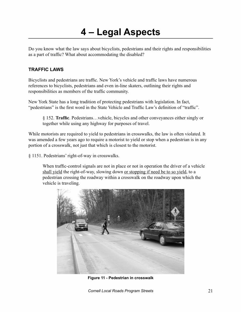
§ 1151. Pedestrians’ right-of-way in crosswalks.
When traffic-control signals are not in place or not in operation the driver of a vehicle shall yield the right-of-way, slowing down or stopping if need be to so yield, to a pedestrian crossing the roadway within a crosswalk on the roadway upon which the vehicle is traveling.
Figure 11 - pedestrian in crosswalk
Cornell Local Roads Program22
Complete Streets
The law is also clear with respect to a pedestrian’s responsibility to follow the law.
§ 1151. Pedestrians must obey traffic control signals, signs and pavement markings when they are crossing a street.
§ 1152. Crossing at other than crosswalks.
Every pedestrian crossing a roadway at any point other than within a marked crosswalk or within an unmarked crosswalk at an intersection shall yield the right-of-way to all vehicles upon the roadway.
Any pedestrian crossing a roadway at a point where a pedestrian tunnel or overhead A.) pedestrian crossing has been provided shall yield the right-of-way to all vehicles upon the roadway.
No pedestrian shall cross a roadway intersection diagonally unless authorized by B.) official traffic-control devices; and, when authorized to cross diagonally, pedestrians shall cross only in accordance with the official traffic-control devices pertaining to such crossing movements.
1156. It is not legal for a person to walk in the road when a sidewalk is present. If C.) there is no sidewalk, a pedestrian shall walk only on the left side of the roadway or the shoulder, facing traffic.
bicyclists and in-Line Skaters
Bicyclists have the legal right to share the road on most public roadways. (They are prohibited on interstate highways and expressways in New York State.)
The same laws that apply to a motorist, with some obvious exceptions and special rules, apply to bicyclists and in-line skaters who must obey all traffic signals, signs and pavement markings and also signal for turns. Bicyclists and skaters must observe, and are also protected by the rules of the road.
§ 1231. Traffic laws apply to persons riding bicycles or skating or gliding on in-line skates. This includes that bicyclists must ride with traffic.
§ 1230. Bicyclists and in-line skaters who violate the law are subject to traffic tickets. Parents can be held responsible for violations by their minor children.
§ 1234. Bicyclists and in-line skaters shall travel on the right with the flow of traffic in either a useable bike lane, on the right edge of the road, or the shoulder. Exceptions include when preparing for a left turn, there are roadway hazards, or the traffic lane is too narrow for a bicycle and vehicle to travel safely side-by-side within the lane.
Cornell Local Roads Program Streets 23
4 – Legal Aspects
§ 1236. Lights are required when traveling during the period from one-half hour after sunset to one-half hour before sunrise.
§ 1237. Describes the hand signals that bicyclists shall use for turn signals.
bike helmets
§ 1230. Young people less than 14 years old are required to wear safety certified bicycle helmets when they are operating or riding a bicycle. Children 1 to 4 years old must wear certified bicycle helmets and ride in specially designed child safety seats. Children less than 1 year old are prohibited from being transported on a bicycle. Bicyclists and in-line skaters and children on non-motorized scooters who violate the law are subject to traffic tickets. Parents can be held responsible for violations by their minor children and any parent or guardian whose child violates the helmet law is subject to a fine of up to $50.00.
Although the law is not all inclusive, it is recommended that all bicyclists wear helmets.
electric personal Assistive mobility devices (epAmds)
More commonly known by their commercial name – Segways – these devices have caused a stir in some communities and have caused a great deal of discussion amongst lawmakers as to where to best place them in the law books. Article 34-C governs them in NYS Vehicle and Traffic Law:
§ 1271 addresses EPAMD users’ rights and responsibilities on the roadway. They may be operated on highways with a posted speed of 30 mph or less. This includes public and private roads open to motor vehicle traffic and bicycle lanes. The exception is when the operator is making a left hand turn or crossing an intersection. At that point, the crosswalk shall be used.
Skateboards
The State Legislature has not enacted any law prohibiting the operation of skateboards on public highways. It is possible, of course, that localities may enact local ordinances regulating such operation.
AdA – The Americans with disabilities Act
Passed in 1990 by the federal government, the Americans with Disabilities Act “prohibits discrimination on the basis of disability by public accommodations and requires places of public accommodation and commercial facilities to be designed, constructed, and altered in compliance with the accessibility standards” outlined in the complete document.
Without accessible pedestrian facilities, people with disabilities have fewer opportunities to engage in employment, school, shopping, recreation, and other everyday activities. New or altered facilities must provide access for all pedestrians. Street designs that accommodate people with disabilities create a better walking environment for all.

Cornell Local Roads Program24
Complete Streets
Liability
The issue of risk management is becoming a major factor in decisions about the implementation of capital projects and programs. The high costs associated with risk management have, in some cases, meant that things just do not get built or programs do not get funded. Decision-makers are getting gun-shy, but ignoring the problem will not make it go away. Governments are sued just as often for what they do not do as for the actions they take.
Property owners may worry about the potential for lawsuits arising from injuries to trail users that may occur on their land when, for example, a runner slips on wet leaves while taking a short cut through a back yard. In almost all states, however, recreational use statutes protect landowners from such claims, as is the case in New York State.
The best approach is to develop a strong, pro-active program to plan, design, build, maintain, and operate a fully balanced transportation system that responds to the needs of all potential users. The program must be based on a diligently applied set of defensible standards and a public process that allows involvement by all affected parties. An agency’s ability to demonstrate that it is aware of potential problems and is taking systematic steps to address them is very important.
CompLeTe STreeTS
§ 331, Highway Law states that “Complete Street Designs [must be considered] for all state, county, and local transportation projects that are undertaken by the Department [of Transportation] or receive both federal and state funding and are subject to Department of Transportation oversight…” Most road projects that receive federal funding also receive state funding. The law therefore will not apply to many projects on roads owned by villages, towns and counties. For this reason, local complete streets policies are still necessary because such policies help to knit together a robust network of complete streets. The law does not apply retroactively to previously approved designed projects that have not yet been constructed.
The law addresses road design, construction, rehabilitation and resurfacing, resurfacing, maintenance, or pavement recycling projects on otherwise eligible roads are not impacted by the law and need not include complete street design features.
The law provides for “exceptions” to its provisions. Specific exemptions are provided to the application of the Complete Streets Law. It does not apply to 1) roads where bicyclists and pedestrians are prohibited (e.g. most interstate highways). 2) When the “cost would be disproportionate to the need or [there is] a demonstrated lack of need” and, 3) where installing complete street design features would create a hazard.
Cornell Local Roads Program Streets 25
5 – The engineering ToolboxMost of us probably do not require an engineer’s intimate knowledge of the tools described in this chapter. It does help, however, to have a little background on what options are available so that you can engage in more meaningful dialog with others. This section introduces guiding documents and provides an overview of basic treatments and maintenance guidelines that support complete streets.
guidAnCe
There are numerous tools to guide you through the process of making changes and improvements. Below is a list of some commonly used resources. Ordering information for all of these documents can be found in Appendix V.
The Manual on Uniform Traffic Control Devices (MUTCD)• Governs the use and placement of all traffic control devices including signs, traffic signals, and median barriers. This manual is the document used by most Departments of Transportation across the country. In New York State, the National MUTCD is supplemented by additional guidance from NYSDOT. The current MUTCD in New York State consists of the following two documents:
National Manual on Uniform Traffic Control Devices◊ , 2009 Edition, effective January 15, 2010
17 ◊ NYCRR Chapter V, New York State Supplement to the National Manual on Uniform Traffic Control Devices - 2010 Edition, effective March 16, 2011
A • Traffic Sign Handbook for Local Roads produced by the Cornell Local Roads program is a helpful cross reference for those trying to solve many traffic problems found on local roads.
NYSDOT Highway Design Manual (HDM)• Provides requirements and guidance on highway design methods and policy. The National equivalent is the AASHTO “Greenbook” – A Policy for Geometric Design of Highways and Streets. The HDM covers the materials in the Greenbook as well as additional information related to complete streets. Chapters 17 and 18 provide information on bicycle and pedestrian facilities, respectively, and Chapter 25 covers traffic calming.
AASHTO Guide for the Development of Bicycle Facilities • Provides information on the development of new facilities to enhance and encourage safe bicycle travel. Planning considerations, design and construction guidelines, as well as operation and maintenance recommendations are included.
Cornell Local Roads Program26
Complete Streets
AASHTO Guide for the Planning, Design and Operation of Pedestrian Facilities• Provides information on the development of new facilities to enhance and encourage safe pedestrian travel. Planning considerations, design and construction guidelines, as well as operation and maintenance recommendations are included.
Americans with Disabilities Act Accessibility Guidelines (ADAAG)• The Americans with Disabilities Act (ADA) was enacted in 1990 to ensure people with disabilities have equal opportunities and access to public spaces as those who do not have disabilities. The guidelines document assists planners and designers in compliance.
mAnAging TrAFFiC
Traffic management includes the use of traditional traffic control devices such as signs and traffic signals to manage the flow of traffic. This section will familiarize you with some of the basics. Remember, there is only so much that can be done with engineering controls; other techniques such as education and enforcement may be more effective. Bad engineering can actually make a problem worse.
Signage
Signs provide important information that can improve road safety. By letting people know what to expect, there is a greater chance that they will react and behave appropriately. However, excessive signage breeds noncompliance and disrespect. Having too many signs may also cause important messages to get lost in the visual clutter.
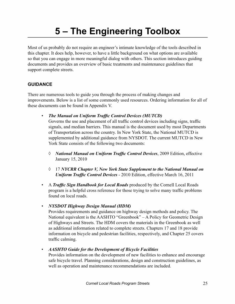
Figure 12 – Fluorescent yellow-green pedestrian warning sign
Regulatory signs, such as STOP, YIELD, or turn restrictions require certain driver actions and can be enforced. Warning signs alert users to hazards and other locations where users need to
Cornell Local Roads Program Streets 27
5 – The Engineering Toolbox
be cautious, especially motorists and pedestrians unfamiliar with an area. Guide signs provide information to help direct traffic and provide helpful information. Some examples of signs that affect pedestrians include pedestrian warning signs, motorist warning signs, NO TURN ON RED signs, and street name signs.
Advance pedestrian warning signs should be used where motorists may not expect pedestrian crossings, especially if there are many motorists who are unfamiliar with the area. Fluorescent yellow-green backgrounds are approved for pedestrian and bicycle signs. This newer color is required for any new school warning signs. This bright color attracts the attention of drivers because it is unique.
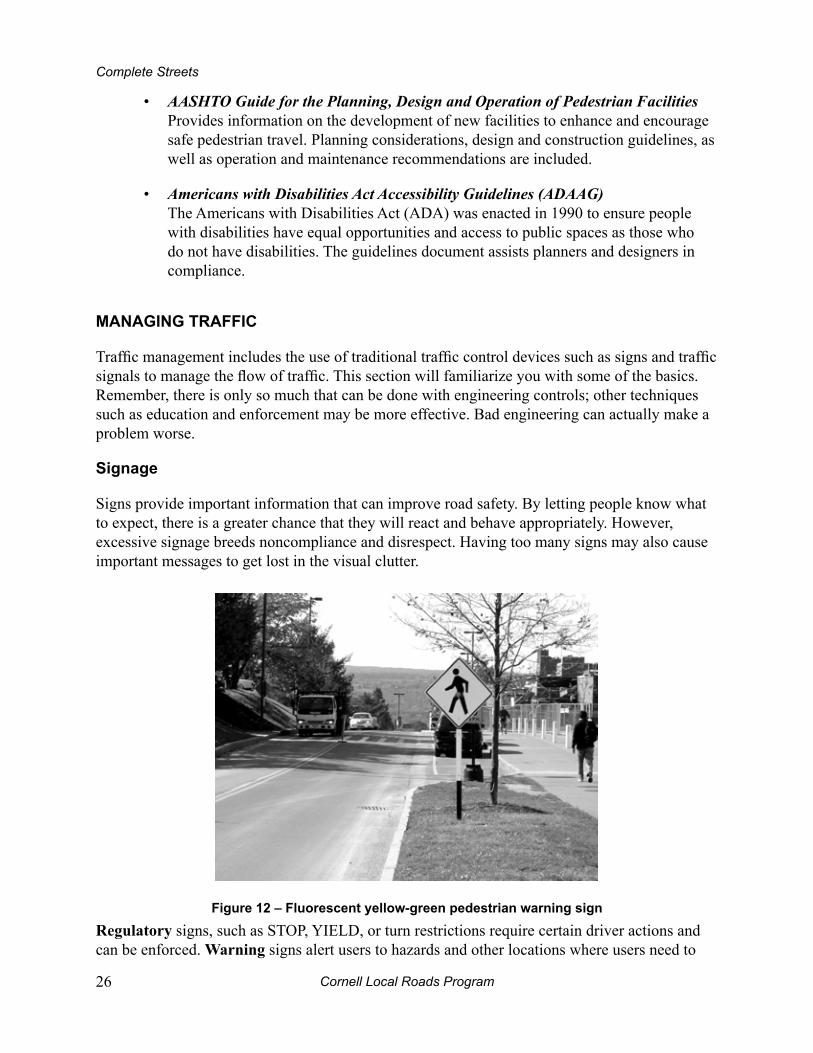
Figure 13 - Stop signs
Poor quality signs actually encourage disobedience and may not have the desired effect. Stop signs are one of many signs used for uniformity to traffic movement. However, stop signs are not good at slowing vehicular speeds. In fact, they can have the opposite affect – causing motorists to speed even more in between stop signs. All signs should be placed in accordance to the MUTCD.
In unusual cases, signs may be used to prohibit pedestrian crossings at an undesirable location and reroute them to a safer crossing location or to warn pedestrians of unexpected driver maneuvers. It is preferable to create safe crossings where there are clearly marked pedestrian destinations. All signs should be periodically checked to make sure that they are in good condition, free from graffiti, are reflective at night, and continue to serve a purpose.
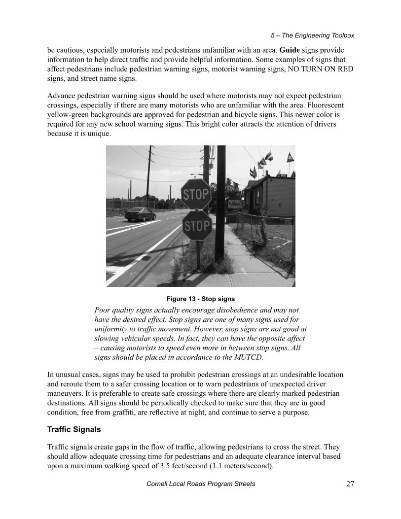
Traffic Signals
Traffic signals create gaps in the flow of traffic, allowing pedestrians to cross the street. They should allow adequate crossing time for pedestrians and an adequate clearance interval based upon a maximum walking speed of 3.5 feet/second (1.1 meters/second).
Cornell Local Roads Program28
Complete Streets
Signals are particularly important at heavily used mid-block crossings on higher speed roads, multi-lane roads or at highly congested intersections. National warrants from the Manual on Uniform Traffic Control Devices are based on, among other factors, the number of pedestrians and vehicles crossing the intersection. Judgment must also be exercised on a case-by-case basis. Installation of a traffic signal, for example, requires that there are a certain number of pedestrians present. If a new facility is being built, such as a park or recreational path, there will be a new demand, and the signal could be installed in conjunction with the new facility based on projected crossing demand. There may also be latent demand if a destination is not currently accessible, but would become so with the addition of new facilities, or the redesign of old ones.
Figure 14 - A traffic signal.
In downtown areas, signals are often closely spaced sometimes every block. Timed sequencing of signals may reduce the amount of time allotted per cycle for pedestrian crossing to unsafe lengths. Signals are usually spaced farther apart in suburban or outlying areas, but similar considerations for pedestrian phasing should be made.
pedestrian Signal Timing
When high pedestrian traffic exists during a majority of the day, fixed-time signals should be used to consistently allow crossing opportunities. Pedestrian actuation – where the pedestrian hits a button to activate the walk phase – should only be used when pedestrian crossings are intermittent. The buttons must be made accessible to all pedestrians, including those with disabilities.
Configuring signals at an intersection to manage both vehicular and pedestrian traffic is rather complex. In general, shorter cycle lengths for motorists and longer walk intervals provide better service to pedestrians and encourage better signal compliance. However, if the traffic is delayed too much and long queues form, there may be more violations by traffic resulting in decreased safety.
Two techniques to manage pedestrian signal timing are concurrent, and exclusive. Concurrent pedestrian signal timing gives pedestrians the walk signal in the same direction that traffic
Cornell Local Roads Program Streets 29
5 – The Engineering Toolbox
gets the green signal and vice versa. Motorists turn left or right across pedestrians’ paths after yielding. With concurrent signals, pedestrians usually have more crossing opportunities and have shorter waiting times.
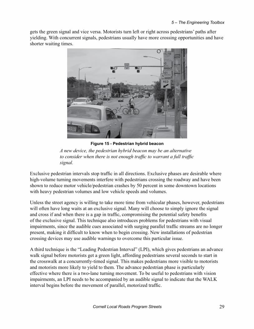
Figure 15 - pedestrian hybrid beacon
A new device, the pedestrian hybrid beacon may be an alternative to consider when there is not enough traffic to warrant a full traffic signal.
Exclusive pedestrian intervals stop traffic in all directions. Exclusive phases are desirable where high-volume turning movements interfere with pedestrians crossing the roadway and have been shown to reduce motor vehicle/pedestrian crashes by 50 percent in some downtown locations with heavy pedestrian volumes and low vehicle speeds and volumes.
Unless the street agency is willing to take more time from vehicular phases, however, pedestrians will often have long waits at an exclusive signal. Many will choose to simply ignore the signal and cross if and when there is a gap in traffic, compromising the potential safety benefits of the exclusive signal. This technique also introduces problems for pedestrians with visual impairments, since the audible cues associated with surging parallel traffic streams are no longer present, making it difficult to know when to begin crossing. New installations of pedestrian crossing devices may use audible warnings to overcome this particular issue.
A third technique is the “Leading Pedestrian Interval” (LPI), which gives pedestrians an advance walk signal before motorists get a green light, affording pedestrians several seconds to start in the crosswalk at a concurrently-timed signal. This makes pedestrians more visible to motorists and motorists more likely to yield to them. The advance pedestrian phase is particularly effective where there is a two-lane turning movement. To be useful to pedestrians with vision impairments, an LPI needs to be accompanied by an audible signal to indicate that the WALK interval begins before the movement of parallel, motorized traffic.
Cornell Local Roads Program30
Complete Streets
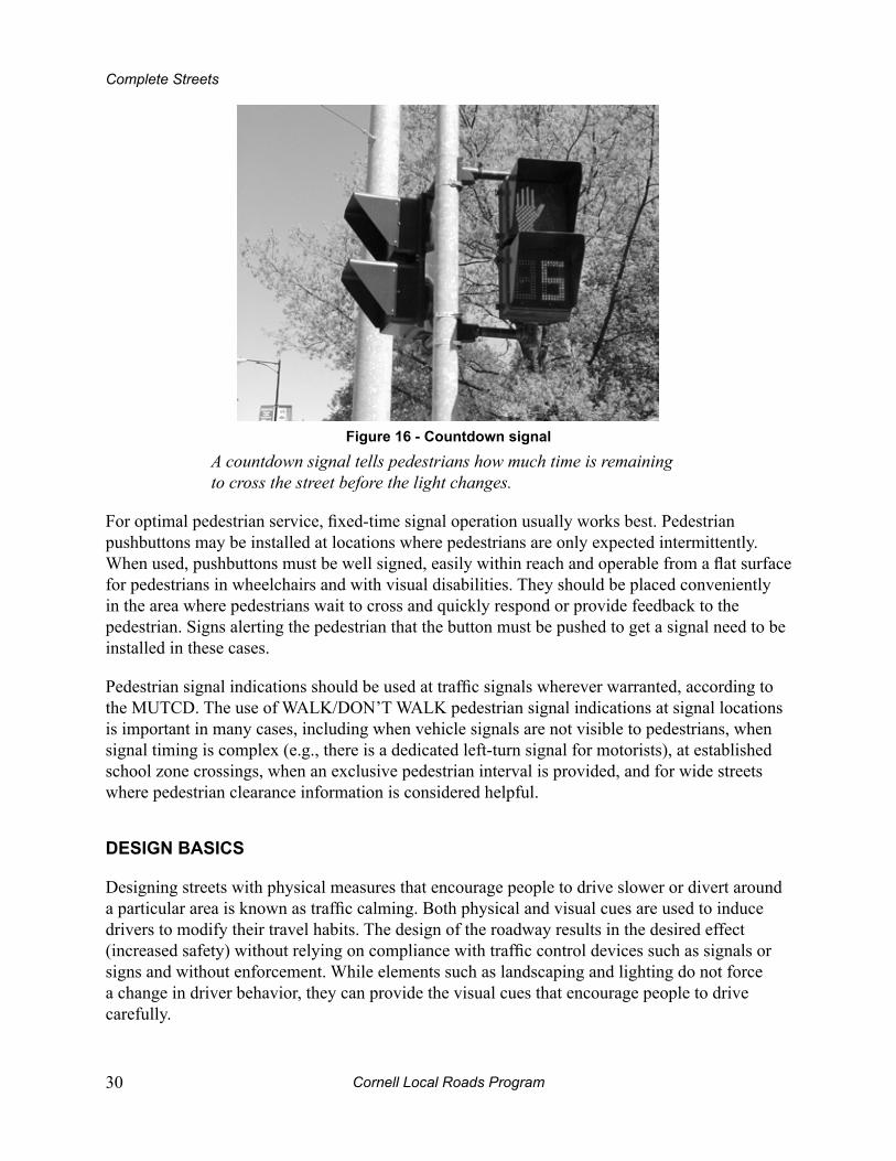
Figure 16 - Countdown signal
A countdown signal tells pedestrians how much time is remaining to cross the street before the light changes.
For optimal pedestrian service, fixed-time signal operation usually works best. Pedestrian pushbuttons may be installed at locations where pedestrians are only expected intermittently. When used, pushbuttons must be well signed, easily within reach and operable from a flat surface for pedestrians in wheelchairs and with visual disabilities. They should be placed conveniently in the area where pedestrians wait to cross and quickly respond or provide feedback to the pedestrian. Signs alerting the pedestrian that the button must be pushed to get a signal need to be installed in these cases.
Pedestrian signal indications should be used at traffic signals wherever warranted, according to the MUTCD. The use of WALK/DON’T WALK pedestrian signal indications at signal locations is important in many cases, including when vehicle signals are not visible to pedestrians, when signal timing is complex (e.g., there is a dedicated left-turn signal for motorists), at established school zone crossings, when an exclusive pedestrian interval is provided, and for wide streets where pedestrian clearance information is considered helpful.
deSign bASiCS
Designing streets with physical measures that encourage people to drive slower or divert around a particular area is known as traffic calming. Both physical and visual cues are used to induce drivers to modify their travel habits. The design of the roadway results in the desired effect (increased safety) without relying on compliance with traffic control devices such as signals or signs and without enforcement. While elements such as landscaping and lighting do not force a change in driver behavior, they can provide the visual cues that encourage people to drive carefully.
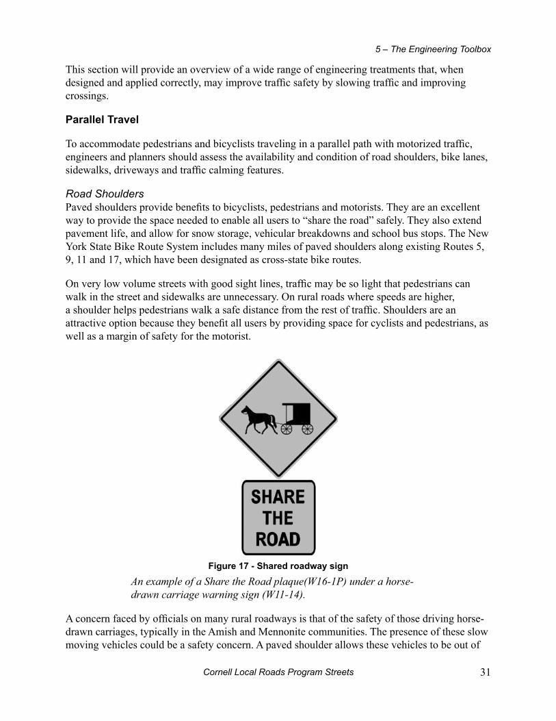
Cornell Local Roads Program Streets 31
5 – The Engineering Toolbox
This section will provide an overview of a wide range of engineering treatments that, when designed and applied correctly, may improve traffic safety by slowing traffic and improving crossings.
parallel Travel
To accommodate pedestrians and bicyclists traveling in a parallel path with motorized traffic, engineers and planners should assess the availability and condition of road shoulders, bike lanes, sidewalks, driveways and traffic calming features.
Road ShouldersPaved shoulders provide benefits to bicyclists, pedestrians and motorists. They are an excellent way to provide the space needed to enable all users to “share the road” safely. They also extend pavement life, and allow for snow storage, vehicular breakdowns and school bus stops. The New York State Bike Route System includes many miles of paved shoulders along existing Routes 5, 9, 11 and 17, which have been designated as cross-state bike routes.
On very low volume streets with good sight lines, traffic may be so light that pedestrians can walk in the street and sidewalks are unnecessary. On rural roads where speeds are higher, a shoulder helps pedestrians walk a safe distance from the rest of traffic. Shoulders are an attractive option because they benefit all users by providing space for cyclists and pedestrians, as well as a margin of safety for the motorist.
Figure 17 - Shared roadway sign
An example of a Share the Road plaque(W16-1P) under a horse-drawn carriage warning sign (W11-14).
A concern faced by officials on many rural roadways is that of the safety of those driving horse-drawn carriages, typically in the Amish and Mennonite communities. The presence of these slow moving vehicles could be a safety concern. A paved shoulder allows these vehicles to be out of

Cornell Local Roads Program32
Complete Streets
the way of traffic. An unpaved shoulder can be used most of the year, but during wet seasons the carriages may need to be in the main travelled way, thereby decreasing safety.
Simply placing a series of signs along roads they frequent will not be effective in making the roads safer for everyone. You’ll end up with sign clutter at a price with no ultimate benefit as people will come to ignore them. Try to identify a few key main roads leading into the area where buggies are common that would be good candidates for Share the Road signs. The locals already know there’s buggy traffic; it’s the visitor traveling through who needs to be alerted. There may be some potential for bringing in someone with a tourism/economic development perspective to think about looking at the development of a “region” that would help all parties involved.
Slow moving vehicles, such as the buggies, are required to have a slow moving vehicle triangle in place. And, if they are out at dark or dusk, lights are required.
Bike lanesOn low speed, medium to low volume roadways, bicyclists can safely share the roadway travel lanes with motorists. Wide curb (outside) lanes, 12-14 feet (approximately 4 meters), allow motorists and bicyclists to co-exist under these conditions.
In urban areas with higher volumes of traffic, bike lanes should be considered. Bike lanes provide a dedicated, marked space on the road that helps bring awareness to drivers that bicyclists are to be expected as part of the traffic mix.
Shared lane markings
Figure 18 - example of shared lane marking
A newer tool added to the toolbox is that of the shared lane marking. The cyclist’s proper lane position is guided from the shared lane marking on a street that is not wide enough to accommodate bike lanes.

Cornell Local Roads Program Streets 33
5 – The Engineering Toolbox
SidewalksSidewalks and walkways are “pedestrian lanes” that provide people with space to travel within the public right-of-way while separated from roadway vehicles. Sidewalks are associated with significant reductions in pedestrian collisions with motor vehicles. As volume increases, sidewalks become necessary to safely accommodate pedestrian traffic.
Figure 19 - A beaten path
Beaten paths in the grass, dirt or snow are signs of pedestrian movements and evidence that sidewalks are needed.
Figure 20 - A well-designed sidewalk
This sidewalk is of proper width, clear of obstacles, separated from traffic and has smooth and level surfaces.
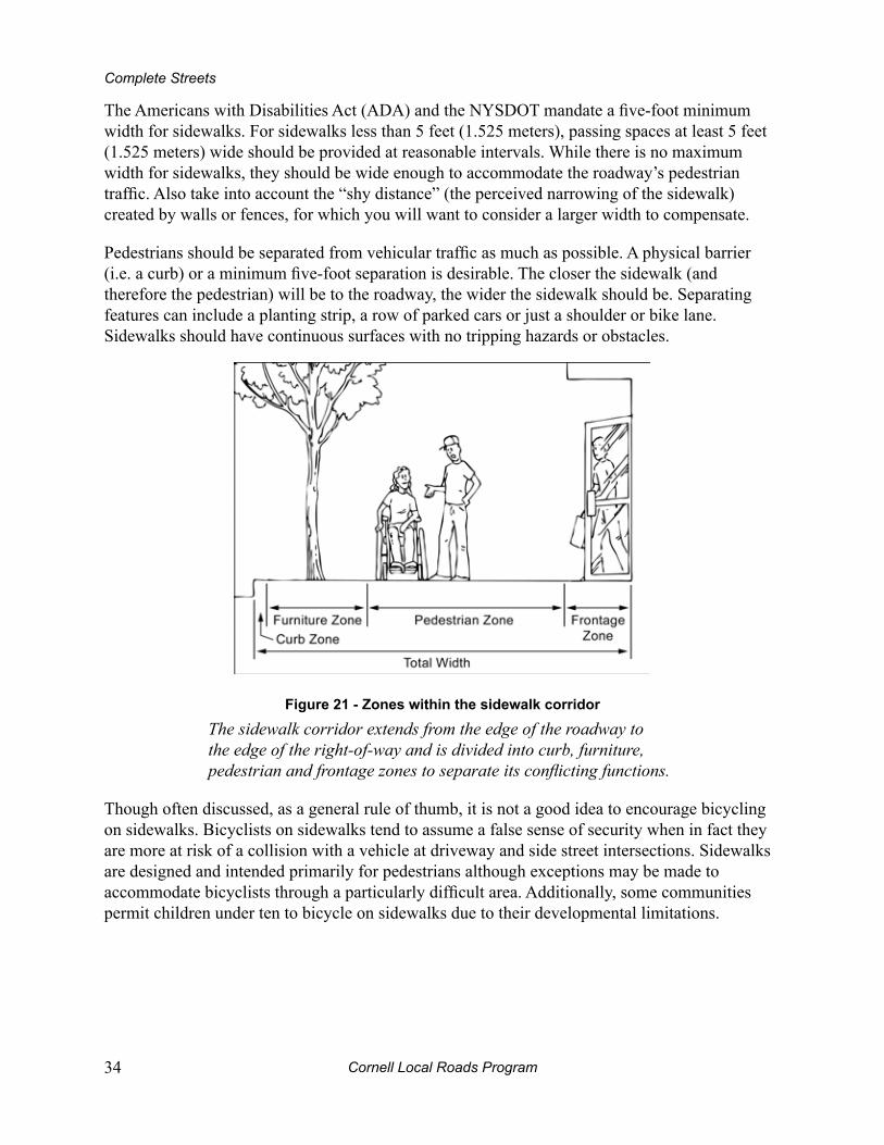
Cornell Local Roads Program34
Complete Streets
The Americans with Disabilities Act (ADA) and the NYSDOT mandate a five-foot minimum width for sidewalks. For sidewalks less than 5 feet (1.525 meters), passing spaces at least 5 feet (1.525 meters) wide should be provided at reasonable intervals. While there is no maximum width for sidewalks, they should be wide enough to accommodate the roadway’s pedestrian traffic. Also take into account the “shy distance” (the perceived narrowing of the sidewalk) created by walls or fences, for which you will want to consider a larger width to compensate.
Pedestrians should be separated from vehicular traffic as much as possible. A physical barrier (i.e. a curb) or a minimum five-foot separation is desirable. The closer the sidewalk (and therefore the pedestrian) will be to the roadway, the wider the sidewalk should be. Separating features can include a planting strip, a row of parked cars or just a shoulder or bike lane. Sidewalks should have continuous surfaces with no tripping hazards or obstacles.
Figure 21 - Zones within the sidewalk corridor
The sidewalk corridor extends from the edge of the roadway to the edge of the right-of-way and is divided into curb, furniture, pedestrian and frontage zones to separate its conflicting functions.
Though often discussed, as a general rule of thumb, it is not a good idea to encourage bicycling on sidewalks. Bicyclists on sidewalks tend to assume a false sense of security when in fact they are more at risk of a collision with a vehicle at driveway and side street intersections. Sidewalks are designed and intended primarily for pedestrians although exceptions may be made to accommodate bicyclists through a particularly difficult area. Additionally, some communities permit children under ten to bicycle on sidewalks due to their developmental limitations.
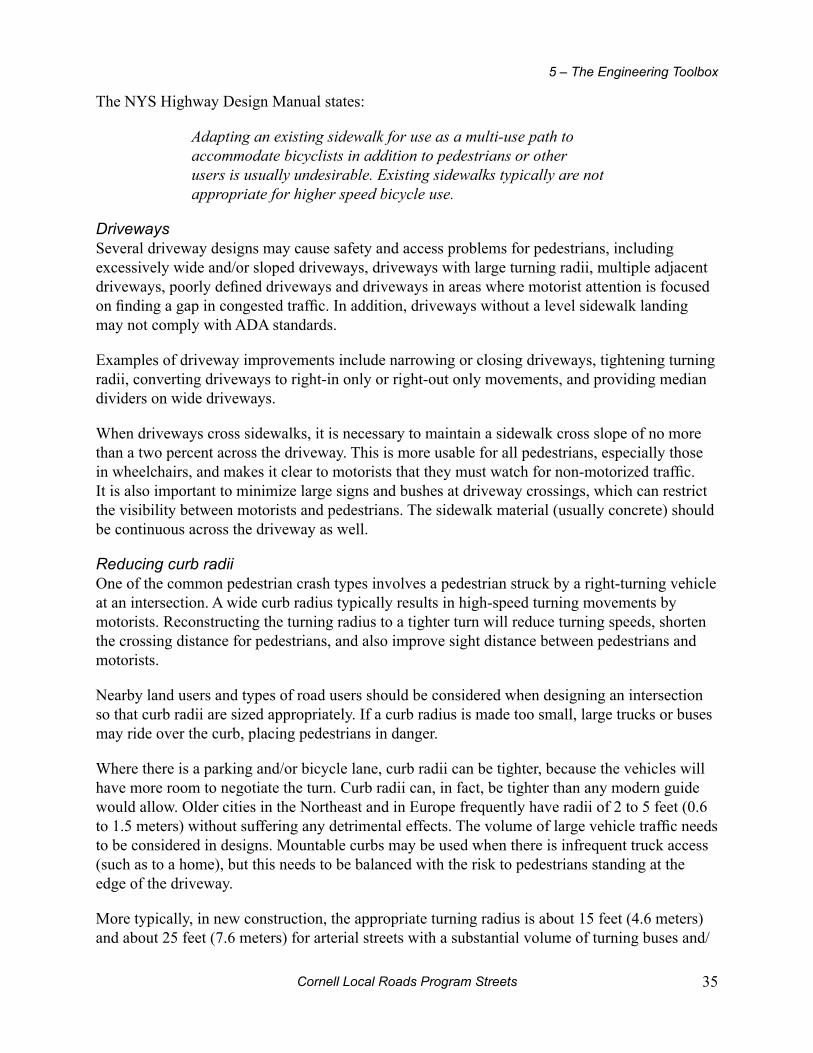
Cornell Local Roads Program Streets 35
5 – The Engineering Toolbox
The NYS Highway Design Manual states:
Adapting an existing sidewalk for use as a multi-use path to accommodate bicyclists in addition to pedestrians or other users is usually undesirable. Existing sidewalks typically are not appropriate for higher speed bicycle use.
DrivewaysSeveral driveway designs may cause safety and access problems for pedestrians, including excessively wide and/or sloped driveways, driveways with large turning radii, multiple adjacent driveways, poorly defined driveways and driveways in areas where motorist attention is focused on finding a gap in congested traffic. In addition, driveways without a level sidewalk landing may not comply with ADA standards.
Examples of driveway improvements include narrowing or closing driveways, tightening turning radii, converting driveways to right-in only or right-out only movements, and providing median dividers on wide driveways.
When driveways cross sidewalks, it is necessary to maintain a sidewalk cross slope of no more than a two percent across the driveway. This is more usable for all pedestrians, especially those in wheelchairs, and makes it clear to motorists that they must watch for non-motorized traffic. It is also important to minimize large signs and bushes at driveway crossings, which can restrict the visibility between motorists and pedestrians. The sidewalk material (usually concrete) should be continuous across the driveway as well.
Reducing curb radiiOne of the common pedestrian crash types involves a pedestrian struck by a right-turning vehicle at an intersection. A wide curb radius typically results in high-speed turning movements by motorists. Reconstructing the turning radius to a tighter turn will reduce turning speeds, shorten the crossing distance for pedestrians, and also improve sight distance between pedestrians and motorists.
Nearby land users and types of road users should be considered when designing an intersection so that curb radii are sized appropriately. If a curb radius is made too small, large trucks or buses may ride over the curb, placing pedestrians in danger.
Where there is a parking and/or bicycle lane, curb radii can be tighter, because the vehicles will have more room to negotiate the turn. Curb radii can, in fact, be tighter than any modern guide would allow. Older cities in the Northeast and in Europe frequently have radii of 2 to 5 feet (0.6 to 1.5 meters) without suffering any detrimental effects. The volume of large vehicle traffic needs to be considered in designs. Mountable curbs may be used when there is infrequent truck access (such as to a home), but this needs to be balanced with the risk to pedestrians standing at the edge of the driveway.
More typically, in new construction, the appropriate turning radius is about 15 feet (4.6 meters) and about 25 feet (7.6 meters) for arterial streets with a substantial volume of turning buses and/

Cornell Local Roads Program36
Complete Streets
or trucks. Tighter turning radii are particularly important where streets intersect at a skew. There are curve templates that can be used as part of the design process to see how trucks and buses will be able to handle a particular turning situation.
Figure 22 - reduced curb radii
Tight corner radii keep turning vehicle speeds down and minimize crossing distances for pedestrians.
RoundaboutsA roundabout is a type of road junction at which traffic streams around a central island after first yielding to the already circulating traffic. In the United States, it is technically called a “modern roundabout,” to emphasize the distinction from the older, larger type of traffic circle. Roundabouts can replace some signalized intersections without compromising Level of Service (traffic flow), and often serve to improve it.
Roundabouts make pedestrian crossing easier by:Slowing traffic.•
Providing a pedestrian refuge to shorten crossing distances.•
Allowing the pedestrian to cross vehicle traffic moving one direction each leg of the • crossing.
Smaller neighborhood roundabouts, called mini-circles, can be used in place of 4-way stop signs at intersections. These work better at truly calming the traffic, rather than the stop-speed-stop-speed-stop action that is common with 4-way stop intersections. Both types of roundabouts also drastically reduce the number of right-angle crashes, which are the most serious type of crash often created by vehicles running through a red light or stop sign. One concern with roundabouts is that visually impaired pedestrians will need special training for crossing.
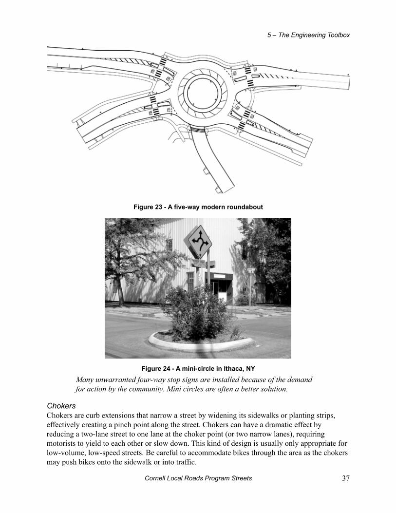
Cornell Local Roads Program Streets 37
5 – The Engineering Toolbox
Figure 23 - A five-way modern roundabout
Figure 24 - A mini-circle in ithaca, ny
Many unwarranted four-way stop signs are installed because of the demand for action by the community. Mini circles are often a better solution.
ChokersChokers are curb extensions that narrow a street by widening its sidewalks or planting strips, effectively creating a pinch point along the street. Chokers can have a dramatic effect by reducing a two-lane street to one lane at the choker point (or two narrow lanes), requiring motorists to yield to each other or slow down. This kind of design is usually only appropriate for low-volume, low-speed streets. Be careful to accommodate bikes through the area as the chokers may push bikes onto the sidewalk or into traffic.

Cornell Local Roads Program38
Complete Streets
Figure 25 - example of a choker
Chokers calm traffic by narrowing the roadway.
Crossing the Street
The pedestrian is at greatest risk when crossing a street. To ensure the pedestrians’ ability to safely cross the street, medians, mid-block crossings, curb extensions, crosswalks and curb ramps may be considered as treatment options.
CrosswalksBy definition a crosswalk is the natural extension of opposing sidewalks and does not need to be marked to be considered as such. In New York State, motor vehicles are required to yield to pedestrians in the crosswalk whether or not it is marked on the roadway. However, many motorists are not aware of this.
Marked crosswalks indicate optimal or preferred locations for pedestrians to cross, and help designate right-of-way for motorists to yield to pedestrians. Crosswalks are often installed at signalized intersections and other selected locations. Various crosswalk-marking patterns are provided in the MUTCD. Marked crosswalks are desirable at some high pedestrian volume locations (often in conjunction with other measures) to guide pedestrians along a preferred walking path. In some cases, they can be raised and installed in conjunction with other enhancements that physically reinforce crosswalks and reduce vehicle speeds. It is also sometimes useful to supplement crosswalk markings with warning signs for motorists. At some locations, signs can get “lost” in visual clutter, so care must be taken in their placement. Pedestrians are sensitive to out-of-the-way travel, and reasonable accommodations should be made to make crossings both convenient and at safe locations with adequate visibility.
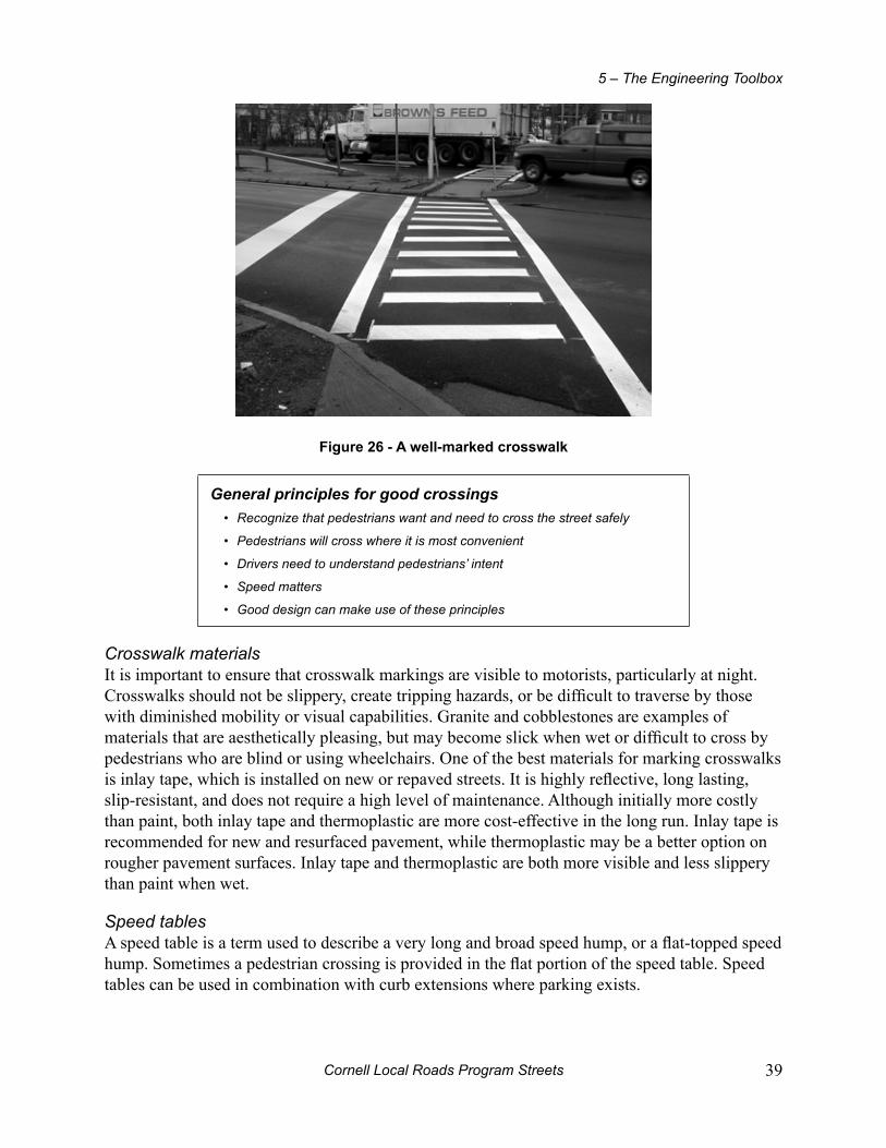
Cornell Local Roads Program Streets 39
5 – The Engineering Toolbox
Figure 26 - A well-marked crosswalk
General principles for good crossingsRecognize that pedestrians want and need to cross the street safely•
Pedestrians will cross where it is most convenient•
Drivers need to understand pedestrians’ intent•
Speed matters•
Good design can make use of these principles•
Crosswalk materialsIt is important to ensure that crosswalk markings are visible to motorists, particularly at night. Crosswalks should not be slippery, create tripping hazards, or be difficult to traverse by those with diminished mobility or visual capabilities. Granite and cobblestones are examples of materials that are aesthetically pleasing, but may become slick when wet or difficult to cross by pedestrians who are blind or using wheelchairs. One of the best materials for marking crosswalks is inlay tape, which is installed on new or repaved streets. It is highly reflective, long lasting, slip-resistant, and does not require a high level of maintenance. Although initially more costly than paint, both inlay tape and thermoplastic are more cost-effective in the long run. Inlay tape is recommended for new and resurfaced pavement, while thermoplastic may be a better option on rougher pavement surfaces. Inlay tape and thermoplastic are both more visible and less slippery than paint when wet.
Speed tablesA speed table is a term used to describe a very long and broad speed hump, or a flat-topped speed hump. Sometimes a pedestrian crossing is provided in the flat portion of the speed table. Speed tables can be used in combination with curb extensions where parking exists.
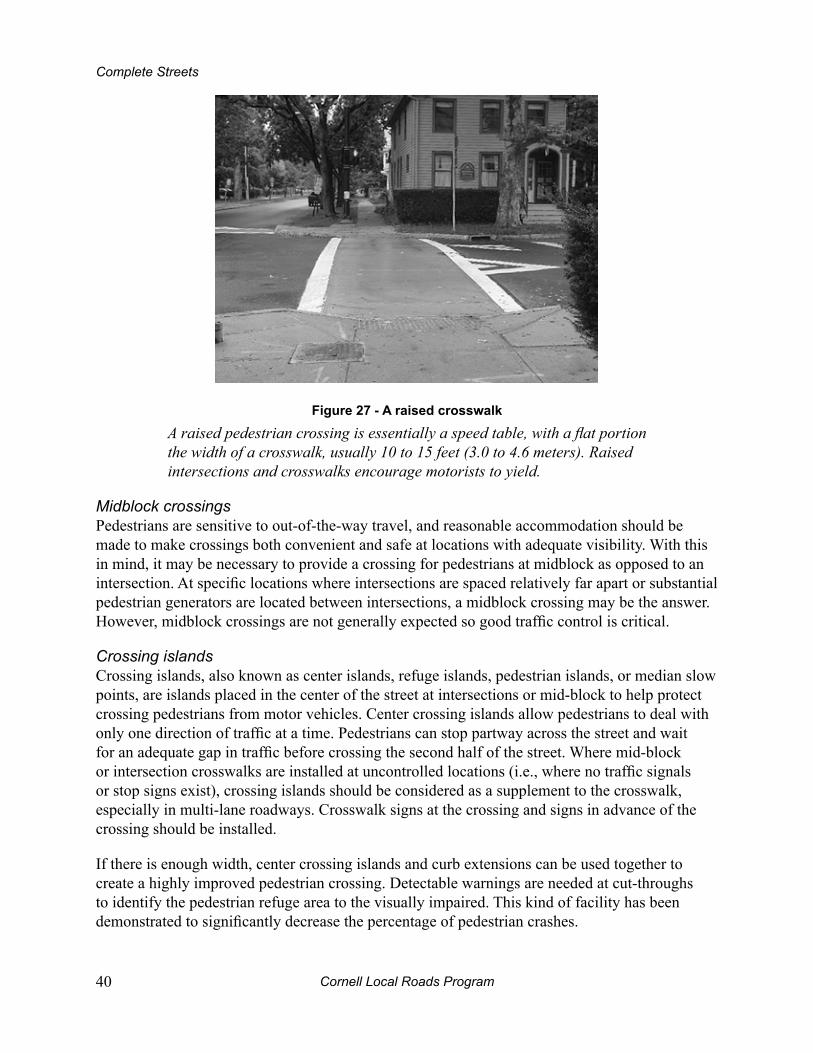
Cornell Local Roads Program40
Complete Streets
Figure 27 - A raised crosswalk
A raised pedestrian crossing is essentially a speed table, with a flat portion the width of a crosswalk, usually 10 to 15 feet (3.0 to 4.6 meters). Raised intersections and crosswalks encourage motorists to yield.
Midblock crossingsPedestrians are sensitive to out-of-the-way travel, and reasonable accommodation should be made to make crossings both convenient and safe at locations with adequate visibility. With this in mind, it may be necessary to provide a crossing for pedestrians at midblock as opposed to an intersection. At specific locations where intersections are spaced relatively far apart or substantial pedestrian generators are located between intersections, a midblock crossing may be the answer. However, midblock crossings are not generally expected so good traffic control is critical.
Crossing islandsCrossing islands, also known as center islands, refuge islands, pedestrian islands, or median slow points, are islands placed in the center of the street at intersections or mid-block to help protect crossing pedestrians from motor vehicles. Center crossing islands allow pedestrians to deal with only one direction of traffic at a time. Pedestrians can stop partway across the street and wait for an adequate gap in traffic before crossing the second half of the street. Where mid-block or intersection crosswalks are installed at uncontrolled locations (i.e., where no traffic signals or stop signs exist), crossing islands should be considered as a supplement to the crosswalk, especially in multi-lane roadways. Crosswalk signs at the crossing and signs in advance of the crossing should be installed.
If there is enough width, center crossing islands and curb extensions can be used together to create a highly improved pedestrian crossing. Detectable warnings are needed at cut-throughs to identify the pedestrian refuge area to the visually impaired. This kind of facility has been demonstrated to significantly decrease the percentage of pedestrian crashes.

Cornell Local Roads Program Streets 41
5 – The Engineering Toolbox
Figure 28 - A center crossing island
These devices allow pedestrians to deal with only one direction of traffic at a time.
Factors contributing to pedestrian safety include:Reduced conflicts•
Reduced vehicle speeds approaching the island (the approach • can be designed to force a greater slowing of cars, depending on how dramatic the curvature is)
Greater attention called to the existence of a pedestrian • crossing
Opportunities for additional signs in the middle of the road•
Reduced exposure time for pedestrians•
Curb extensionsCurb extensions, also known as bulb-outs or neck-downs, extend the sidewalk or curb line out into the parking lane, reducing the effective street width. They significantly improve pedestrian crossings by reducing the crossing distance, visually and physically narrowing the roadway, improving the ability of pedestrians and motorists to see each other and reducing the time that pedestrians are in the street.
Curb extensions placed at an intersection essentially prevent motorists from parking in or too close to a crosswalk or from blocking a curb ramp or crosswalk. Motor vehicles parked too close to corners present a threat to safety by blocking sightlines, obscuring visibility of pedestrians and other vehicles, and making turns particularly difficult for emergency vehicles and trucks. Motorists are encouraged to travel more slowly at intersections or mid-block locations with curb extensions, as the restricted street width serves as a visual cue. Turning speeds at intersections can be reduced by curb extensions with tight curb radii. These extensions also provide additional space for curb ramps and for level sidewalks where existing space is limited.

Cornell Local Roads Program42
Complete Streets
Figure 29 - Curb extension in Ft. plain, ny
Region 2, NYSDOT
Curb extensions are only appropriate where there is an on-street parking lane and must not extend into travel lanes, bicycle lanes, or shoulders. The turning needs of larger vehicles, such as school buses, must be considered in their design.
Curb rampsCurb ramps provide access between the sidewalk and roadway for people using wheelchairs, strollers, walkers, crutches, handcarts, bicycles, and also for seniors and other pedestrians with mobility impairments who have trouble stepping up and down high curbs. Curb ramps must be installed at all intersections and mid-block locations where pedestrian crossings exist, as mandated by Federal legislation (1973 Rehabilitation Act and the ADA1990).
The Americans with Disabilities Act Accessibility Guidelines state that, outside of particular circumstances, separate curb ramps for each crosswalk should be provided at an intersection, rather than a single ramp per corner. Ramps should be constructed in the direction of the primary path of travel to improve orientation for visually impaired pedestrians. Similarly, tactile or “detectable” warnings alert pedestrians to the sidewalk/street edge. All newly constructed and altered roadway projects must include curb ramps in addition to all existing facilities.
While curb ramps are needed for use on all types of streets, priority locations are in downtown areas and on streets near transit stops, schools, parks, medical facilities, shopping areas and near residences with people who use wheelchairs.
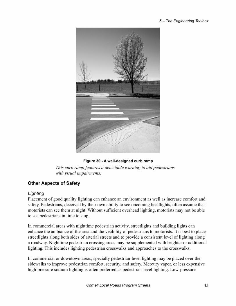
Cornell Local Roads Program Streets 43
5 – The Engineering Toolbox
Figure 30 - A well-designed curb ramp
This curb ramp features a detectable warning to aid pedestrians with visual impairments.
other Aspects of Safety
LightingPlacement of good quality lighting can enhance an environment as well as increase comfort and safety. Pedestrians, deceived by their own ability to see oncoming headlights, often assume that motorists can see them at night. Without sufficient overhead lighting, motorists may not be able to see pedestrians in time to stop.
In commercial areas with nighttime pedestrian activity, streetlights and building lights can enhance the ambiance of the area and the visibility of pedestrians to motorists. It is best to place streetlights along both sides of arterial streets and to provide a consistent level of lighting along a roadway. Nighttime pedestrian crossing areas may be supplemented with brighter or additional lighting. This includes lighting pedestrian crosswalks and approaches to the crosswalks.
In commercial or downtown areas, specialty pedestrian-level lighting may be placed over the sidewalks to improve pedestrian comfort, security, and safety. Mercury vapor, or less expensive high-pressure sodium lighting is often preferred as pedestrian-level lighting. Low-pressure
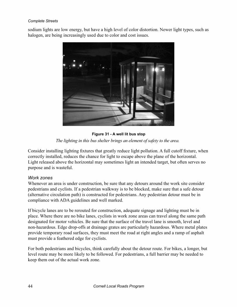
Cornell Local Roads Program44
Complete Streets
sodium lights are low energy, but have a high level of color distortion. Newer light types, such as halogen, are being increasingly used due to color and cost issues.
Figure 31 - A well lit bus stop
The lighting in this bus shelter brings an element of safety to the area.
Consider installing lighting fixtures that greatly reduce light pollution. A full cutoff fixture, when correctly installed, reduces the chance for light to escape above the plane of the horizontal. Light released above the horizontal may sometimes light an intended target, but often serves no purpose and is wasteful.
Work zonesWhenever an area is under construction, be sure that any detours around the work site consider pedestrians and cyclists. If a pedestrian walkway is to be blocked, make sure that a safe detour (alternative circulation path) is constructed for pedestrians. Any pedestrian detour must be in compliance with ADA guidelines and well marked.
If bicycle lanes are to be rerouted for construction, adequate signage and lighting must be in place. Where there are no bike lanes, cyclists in work zone areas can travel along the same path designated for motor vehicles. Be sure that the surface of the travel lane is smooth, level and non-hazardous. Edge drop-offs at drainage grates are particularly hazardous. Where metal plates provide temporary road surfaces, they must meet the road at right angles and a ramp of asphalt must provide a feathered edge for cyclists.
For both pedestrians and bicycles, think carefully about the detour route. For bikes, a longer, but level route may be more likely to be followed. For pedestrians, a full barrier may be needed to keep them out of the actual work zone.
Cornell Local Roads Program Streets 45
5 – The Engineering Toolbox
mAinTenAnCe
Pedestrians and cyclists are more acutely affected by sub-standard, dirty, or snowy surface conditions than motorists. What may hardly be a distraction to the motorist can prove extremely hazardous to cyclists on the roadway or pedestrians on a sidewalk. Debris on road shoulders, longitudinal cracks at a road’s edge, uneven sidewalk surfaces and low hanging, encroaching shrubbery all pose hazards. Well maintained facilities will also serve the public longer and more economically.
Sidewalks
The bottom of signs placed in or right next to a sidewalk need to be at least 7 feet (2 meters) above the sidewalk surface to avoid injury to pedestrians. Bushes, trees, and other landscaping should be trimmed to prevent encroachment into the sidewalk. Jurisdictions should adopt ordinances requiring local property owners to trim the landscaping they place along their road frontage to maintain clear and unobstructed sidewalks. The jurisdictions should provide an inspection procedure or a system of responding to sidewalk encroachment and maintenance complaints.
Guy wires and utility tie-downs should not be located in or across sidewalks at heights below 7 feet (2 meters). When placed adjacent to sidewalks or pedestrian walkways, the guy wires should be covered with a bright yellow (or other high-visibility) plastic guard to make the wire more visible to pedestrians. Guy wires of any color will not be visible to blind pedestrians and must not be located within the pedestrian route. Other obstacles include signal controller boxes, awnings, temporary signs, newspaper racks and fire hydrants.
You can maintain roadways to a relatively hazard free standard by:Sweeping pavement edges and paved shoulders.•
Patching surfaces as smoothly as possible and requiring other agencies or private • companies to do likewise whenever they dig up a road or trail.
Making sure pavement overlay projects feather the new surface into the existing • one and do not create new linear joints.
Replacing hazards such as dangerous grates or utility covers when the opportunity • arises.
Repairing potholes in an expeditious manner.•
Maintaining existing striping on roads to clearly distinguish between road shoulder • and auto lane.
Repairing and maintaining vehicular stop lines and crosswalk stripes.•
Routinely cutting back all encroaching vegetation, especially on trails or popular • bike routes.
Municipalities that do not remove snow on sidewalks should have an ordinance requiring property owners to clear the snow and keep the sidewalks accessible to pedestrians. When the latter is the case, municipalities should educate property owners as to why this is important and have enforcement efforts in place to ensure compliance.

Cornell Local Roads Program46
Complete Streets
road Shoulders
Bicycles and their riders tend to be particularly sensitive to roadway maintenance. Potholes that motorists might ignore can cause serious problems for bicycles and their riders. In addition, since cyclists often ride near the right margin of the road, sometimes as required by traffic law, they use areas that are generally not as well maintained as the main lanes. On higher speed roads, the passage of motor vehicle traffic tends to sweep debris to the outside, where most bicyclists travel; while ridges, like those found where a new asphalt overlay does not quite cover the width of the old roadway surface, can catch a wheel and throw a bicyclist to the ground.
Aside from these general problems, special bicycle facilities often need more maintenance than they receive. For the most part, satisfying bicycling maintenance requirements is a matter of slightly modifying current procedures. For example, if street sweeping crews pay a bit more attention to the right edge of the road, it can greatly benefit cyclists.
In addition, using maintenance-friendly design and construction techniques can reduce the need for special and sometimes costly treatments later. For instance, when paving a street bordered by unpaved alleys and driveways, paving into those alleys and driveways 10 feet to 20 feet (3 meters to 6.1 meters), depending on grades and other features, can keep entering traffic from dragging gravel and other debris onto the paved surface.
Finally, special bicycle facilities like bike lanes may require extra attention in terms of upkeep. This cost, along with a clear understanding of who has responsibility for maintenance, should be part of every project budget. It should be noted that the reasonable care used in maintaining the travel lanes for motor vehicles on highways is the same care necessary for bikes and pedestrians using them as well.
Figure 31 - A poor shoulder

Cornell Local Roads Program Streets 47
5 – The Engineering Toolbox
Figure 32 - A good shoulder
drain grates
Drainage grates and utility covers can cause serious problems for bicyclists. Raised or sunken grates and covers can stop or divert a cyclist’s front wheel, causing wheel damage and/or a serious crash. A related problem involves old-style parallel bar drainage grates, which can trap the front wheel of a bicycle, causing the bicyclist to be pitched over the handlebars.
Figure 33 - drain grate in damaged pavement
Although this honeycomb-style grate is bicycle safe by its design, the damaged pavement and pothole make it downright nasty for a bicyclist.
Cornell Local Roads Program48
Complete Streets
Grates or covers that are not level with the roadway surface can be brought to the proper grade by raising or lowering, depending on the situation. During new construction the problem can be avoided through judicious placement of utilities outside of the cyclist’s most common path of travel (i.e., away from the right side of the roadway). By taking these steps, the frequency of problems can be reduced, if not their severity.
Parallel bar drain grates can be replaced with modern bicycle-safe and hydraulically efficient models, like vane or honeycomb grates. When it is possible, installing curb face inlets can move the inlet out of the roadway entirely. These must be designed carefully to minimize cross slopes, which, if excessive, can throw bicyclists toward the curb.
There are two primary approaches necessary when addressing drainage grate and utility cover problems. First, existing problem locations must be identified and corrected according to a well-developed and prioritized plan of action. Second, design standards must be modified, as needed, to keep similar problems from recurring. It is far more cost effective to design with bicyclists in mind than to retrofit solutions later.
You can eliminate drainage grate and utility cover hazards for bicyclists by:Replacing parallel bar drainage grates with bicycle safe models.•
Adjusting grates or utility covers that are above or below the level of the surrounding • roadway.
Adopting bicycle safe design standards for drainage grates on all new construction.•
Adopting bicycle safe standards for leveling utility covers and drainage grates.•
Placing utilities away from the normal path for bicyclists.•
Cornell Local Roads Program Streets 49
6 – know your neighborsIt is important to know as much as possible about your community before recommending any changes. This chapter will describe the unique characteristics of different non-motorized users.
perSonS WiTh diSAbiLiTieS
People with disabilities may have diminished mobility, limited vision, or reduced cognitive skills experienced on a permanent or temporary basis. In some instances, individuals may experience a combination of disabilities. This may be due to the aging process, the result of an injury, or military combat.
Many of us take for granted the seemingly simple ability to move quickly while staying aware of what is going on around us. When planning for those differently-abled, however, it behooves us to “walk a mile in their shoes.” Better yet, take a wheelchair ride or a walk with a stroller to discover what barriers exist that you may never have thought about.
pedeSTriAnS
Pedestrians travel at an average of 2-3 miles per hour. A 4-6 foot lateral space is comfortable for two people to walk side-by-side or for an individual to pass by an oncoming person.
Pedestrians and vehicles should be separated from each other wherever possible, except in very low speed environments. Medians, refuge islands, landscape strips and well-marked crossings can achieve this separation.
Pedestrians are vulnerable to potholes, ice, snow, cracked and uneven sidewalks, as well as other obstructions. When one is pushing a child’s stroller or a grocery cart, smooth surfaces and connectivity are important. Keeping a smooth, well maintained surface is the shared responsibility of both public and private sectors. Pedestrian signals and signage must be properly located, easy to understand and provide the proper safety message to both motorists and pedestrians.
biCyCLiSTS
Although they are about the same size as a pedestrian, bicyclists move much faster than a pedestrian. The average bicyclist can consistently travel 8-25 miles per hour. Bicyclists require more distance to stop than the slower moving pedestrian and they need 3 to 5 feet (1 to 1.7 meters) laterally to operate safely.
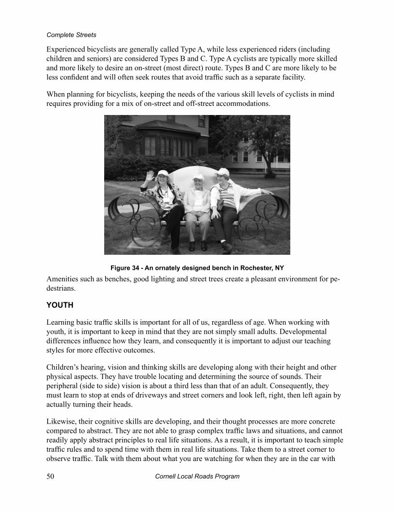
Cornell Local Roads Program50
Complete Streets
Experienced bicyclists are generally called Type A, while less experienced riders (including children and seniors) are considered Types B and C. Type A cyclists are typically more skilled and more likely to desire an on-street (most direct) route. Types B and C are more likely to be less confident and will often seek routes that avoid traffic such as a separate facility.
When planning for bicyclists, keeping the needs of the various skill levels of cyclists in mind requires providing for a mix of on-street and off-street accommodations.
Figure 34 - An ornately designed bench in rochester, ny
Amenities such as benches, good lighting and street trees create a pleasant environment for pe-destrians.
youTh
Learning basic traffic skills is important for all of us, regardless of age. When working with youth, it is important to keep in mind that they are not simply small adults. Developmental differences influence how they learn, and consequently it is important to adjust our teaching styles for more effective outcomes.
Children’s hearing, vision and thinking skills are developing along with their height and other physical aspects. They have trouble locating and determining the source of sounds. Their peripheral (side to side) vision is about a third less than that of an adult. Consequently, they must learn to stop at ends of driveways and street corners and look left, right, then left again by actually turning their heads.
Likewise, their cognitive skills are developing, and their thought processes are more concrete compared to abstract. They are not able to grasp complex traffic laws and situations, and cannot readily apply abstract principles to real life situations. As a result, it is important to teach simple traffic rules and to spend time with them in real life situations. Take them to a street corner to observe traffic. Talk with them about what you are watching for when they are in the car with

Cornell Local Roads Program Streets 51
6 – Know Your Neighbors
you. If you organize a bicycle skills event in a parking lot, be sure the street scenarios you create are to scale. Make sure there are no confusing pavement markings, that street signs are lifelike and that the “roadway” is at least 10 feet (approximately 3 meters) wide. Lastly, remember that children are like strawberries – they all do not ripen at the same time.
The eLderLy
One of the most significant social trends of the new century will be the graying of the population as the number of older Americans rises, a fact that raises serious questions for everyone concerned with traffic safety and education.
Older drivers tend to become more conservative on the road, driving less often at night, avoiding busy highways, and taking fewer long-distance trips to unfamiliar areas. However, older drivers are more likely than younger ones to be involved in multi-vehicle crashes, particularly at intersections. They are also more likely than younger drivers to be seriously injured in a crash, since their bodies are simply less able to withstand an impact.
As peripheral vision diminishes with age, reflexes slow and the ability to move quickly and in an agile manner decreases. It can take longer to cross the road, and can become harder to deal with situations that require prompt evasive action. Also, because eyesight and hearing often become less acute, the judgment of traffic distance (depth perception) and speed can become less accurate. Therefore, intersection design must afford the elderly plenty of time to cross the road safely.

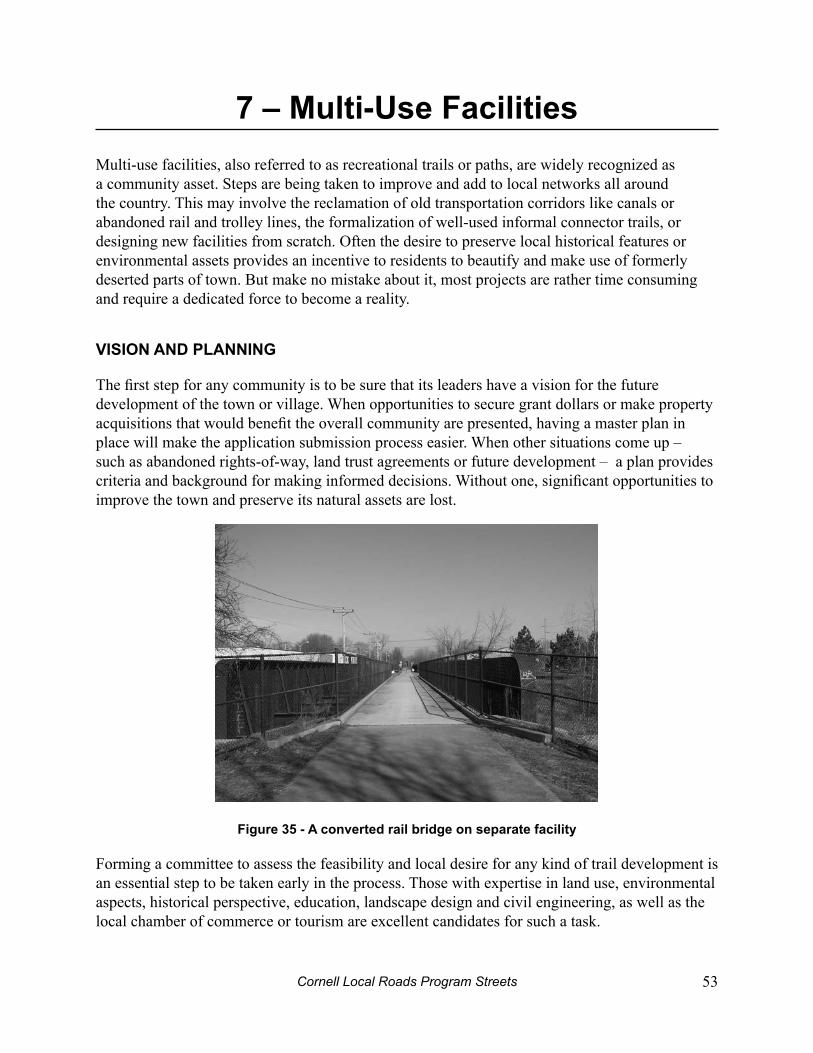
Cornell Local Roads Program Streets 53
7 – multi-use FacilitiesMulti-use facilities, also referred to as recreational trails or paths, are widely recognized as a community asset. Steps are being taken to improve and add to local networks all around the country. This may involve the reclamation of old transportation corridors like canals or abandoned rail and trolley lines, the formalization of well-used informal connector trails, or designing new facilities from scratch. Often the desire to preserve local historical features or environmental assets provides an incentive to residents to beautify and make use of formerly deserted parts of town. But make no mistake about it, most projects are rather time consuming and require a dedicated force to become a reality.
viSion And pLAnning
The first step for any community is to be sure that its leaders have a vision for the future development of the town or village. When opportunities to secure grant dollars or make property acquisitions that would benefit the overall community are presented, having a master plan in place will make the application submission process easier. When other situations come up – such as abandoned rights-of-way, land trust agreements or future development – a plan provides criteria and background for making informed decisions. Without one, significant opportunities to improve the town and preserve its natural assets are lost.
Figure 35 - A converted rail bridge on separate facility
Forming a committee to assess the feasibility and local desire for any kind of trail development is an essential step to be taken early in the process. Those with expertise in land use, environmental aspects, historical perspective, education, landscape design and civil engineering, as well as the local chamber of commerce or tourism are excellent candidates for such a task.
Cornell Local Roads Program54
Complete Streets
Identification of the natural and historically significant resources, corridor features, plants, and animals will help you paint a more accurate picture and aid the decision making process. Do not forget utility rights of way, abandoned rail beds, canal paths, trolley lines or old roads that link to neighboring towns.
Other important tasks include identifying costs, securing funding, identifying land acquisition and easements issues, and establishing a time frame for completion.
deSign And ConSTruCTion
The detailed design of a shared use path or trail must include all factors that affect the safety, convenience and comfort of users. Railroad corridors are typically quite straight and have gentle grades; two excellent qualities for a bicycling and walking trail. Publications such as the AASHTO Guide for the Development of Bicycle Facilities and Trails for the 21st Century have extensive information on many of the issues that are highlighted below. Some states also have their own design manuals which match or exceed the guidelines provided in national publications.
Accessibility is another aspect of design that should be considered paramount. Compliance with the Americans with Disabilities Act requires that the facility be continuous and have safe connections between the off and on-street facilities in order to provide full access and mobility. In general, accessible design requires the elimination of all obstacles along the route.
As of this writing, the United States Access Board (the Federal body overseeing ADA design standards) has proposed a series of design standards.
Width
Shared use paths (or trails) should be a minimum of 10 feet (approximately 3 meters) wide to accommodate multiple users traveling in both directions. Trails in urban areas are likely to require at least 12 feet (3.7 meters) of width and those with heavy use, or large numbers of in-line skaters, may need to go to 14 feet or wider. Vertical clearances for horseback riders should be at least 10 feet (approximately 3 meters). In rare circumstances (e.g. very rural areas and/or trails with no walkers or joggers) trail width may be reduced to 8 feet (2.4 meters).
In addition to the width of the surfaced portion of the trail, 2 feet (0.6 feet) of clear space (like a shoulder) is recommended on both sides of the trail so that users can avoid signs, shrubs, walls, etc. The total width of the trail and clear space should be maintained through any tunnels, underpasses, bridges or overpasses.
Surface
The trail experience is greatly affected by the choice of surface. Urban trails usually have asphalt or concrete surfaces to withstand heavy trail use and the impact of maintenance vehicles. Hard or sealed surfaces such as these also provide in-line skaters with a place to skate. However, the initial cost of an asphalt or concrete surface will often be significantly more expensive ($125,000
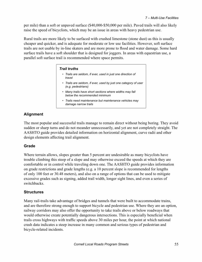
Cornell Local Roads Program Streets 55
7 – Multi-Use Facilities
per mile) than a soft or unpaved surface ($40,000-$50,000 per mile). Paved trails will also likely raise the speed of bicyclists, which may be an issue in areas with heavy pedestrian use.
Rural trails are more likely to be surfaced with crushed limestone (stone dust) as this is usually cheaper and quicker, and is adequate for moderate or low use facilities. However, soft surface trails are not usable by in-line skaters and are more prone to flood and water damage. Some hard surface trails have a soft shoulder that is designed for joggers. In areas with equestrian use, a parallel soft surface trail is recommended where space permits.
Trail truthsTrails are seldom, if ever, used in just one direction of • travel
Trails are seldom, if ever, used by just one category of user • (e.g. pedestrians)
Many trails have short sections where widths may fall • below the recommended minimum
Trails need maintenance but maintenance vehicles may • damage narrow trails
Alignment
The most popular and successful trails manage to remain direct without being boring. They avoid sudden or sharp turns and do not meander unnecessarily, and yet are not completely straight. The AASHTO guide provides detailed information on horizontal alignment, curve radii and other design elements affecting trail alignment.
grade
Where terrain allows, slopes greater than 5 percent are undesirable as many bicyclists have trouble climbing this steep of a slope and may otherwise exceed the speeds at which they are comfortable or in control while traveling down one. The AASHTO guide provides information on grade restrictions and grade lengths (e.g. a 10 percent slope is recommended for lengths of only 100 feet or 30.48 meters), and also on a range of options that can be used to mitigate excessive grades such as signing, added trail width, longer sight lines, and even a series of switchbacks.
Structures
Many rail-trails take advantage of bridges and tunnels that were built to accommodate trains, and are therefore strong enough to support bicycle and pedestrian use. Where they are an option, railway corridors may also offer the opportunity to take trails above or below roadways that would otherwise create potentially dangerous intersections. This is especially beneficial when trails cross highways with traffic speeds above 30 miles per hour, the point at which national crash data indicates a steep increase in many common and serious types of pedestrian and bicycle-related incidents.
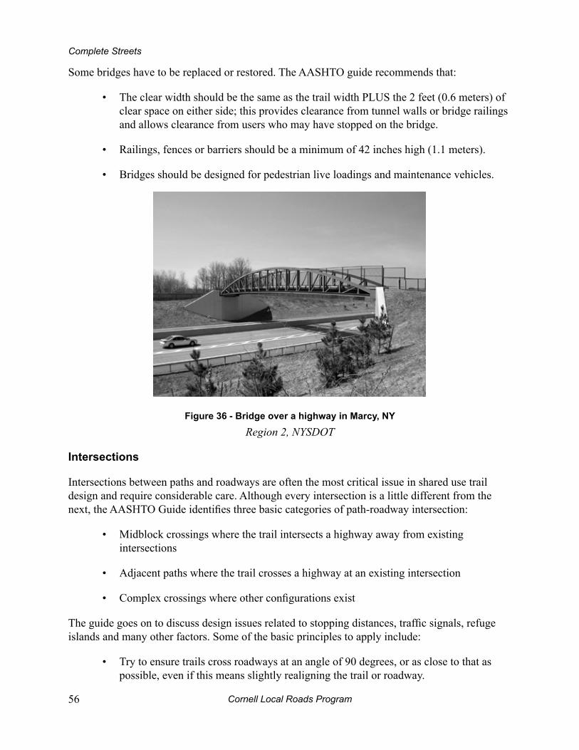
Cornell Local Roads Program56
Complete Streets
Some bridges have to be replaced or restored. The AASHTO guide recommends that:
The clear width should be the same as the trail width PLUS the 2 feet (0.6 meters) of • clear space on either side; this provides clearance from tunnel walls or bridge railings and allows clearance from users who may have stopped on the bridge.
Railings, fences or barriers should be a minimum of 42 inches high (1.1 meters).•
Bridges should be designed for pedestrian live loadings and maintenance vehicles.•
Figure 36 - bridge over a highway in marcy, ny
Region 2, NYSDOT
intersections
Intersections between paths and roadways are often the most critical issue in shared use trail design and require considerable care. Although every intersection is a little different from the next, the AASHTO Guide identifies three basic categories of path-roadway intersection:
Midblock crossings where the trail intersects a highway away from existing • intersections
Adjacent paths where the trail crosses a highway at an existing intersection•
Complex crossings where other configurations exist•
The guide goes on to discuss design issues related to stopping distances, traffic signals, refuge islands and many other factors. Some of the basic principles to apply include:
Try to ensure trails cross roadways at an angle of 90 degrees, or as close to that as • possible, even if this means slightly realigning the trail or roadway.

Cornell Local Roads Program Streets 57
7 – Multi-Use Facilities
Treat intersections consistently so that users can readily identify them as they • approach.
Use sound engineering judgment and follow the MUTCD to determine the type of • traffic control devices to use.
Make trail users visible and their movements as predictable as possible.•
roadway Separation
The AASHTO guide strongly cautions against the development of trails that are immediately adjacent to roadways. This type of facility, often little more than a wide sidewalk, encourages wrong-way riding (a leading cause of bicycle-motor vehicle crashes) and makes trail users much less visible to motorists at intersections. Sidewalk trails can also set up conflicts at driveways and intersections along a roadway.
However, a rail corridor running adjacent to a highway may not suffer from as many negatives, as there are likely to be fewer intersections to negotiate and there may already be greater separation between the trail and roadway. The minimum amount of separation recommended is 5 feet (1.5 meters) of horizontal separation, or 42 inches of vertical separation provided by a barrier or railing.
mAinTenAnCe
It is important to plan and budget for maintenance needs on multi-use facilities. Start with a checklist of all possible maintenance activities. You will have to maintain whatever you build. Next to each item, note frequency and cost. Figure out whether each item is routine or major. From there, the next step is to prioritize and keep track of your work. Involving the community in this process will help on all fronts.
Many communities have developed volunteer networks to assist in trail maintenance projects. Adopt-A-Trail programs enable citizens to become involved while providing valuable support in a cost-effective way.
Trail user truthsTrail users (especially bicyclists) have a low tolerance for delay.•
Bicyclists have a strong desire to maintain momentum.•
Younger trail users may not be experienced in dealing with traffic.•
Trail users sometimes feel as if traffic regulations do not apply to • them.
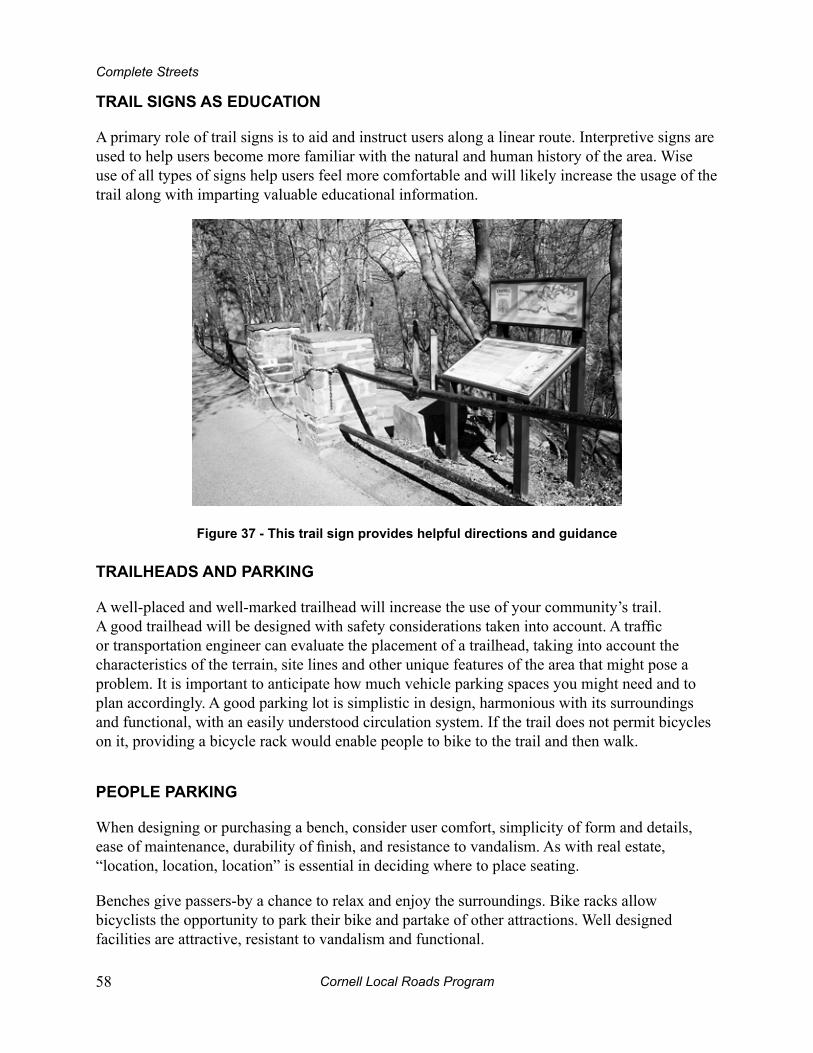
Cornell Local Roads Program58
Complete Streets
TrAiL SignS AS eduCATion
A primary role of trail signs is to aid and instruct users along a linear route. Interpretive signs are used to help users become more familiar with the natural and human history of the area. Wise use of all types of signs help users feel more comfortable and will likely increase the usage of the trail along with imparting valuable educational information.
Figure 37 - This trail sign provides helpful directions and guidance
TrAiLheAdS And pArking
A well-placed and well-marked trailhead will increase the use of your community’s trail. A good trailhead will be designed with safety considerations taken into account. A traffic or transportation engineer can evaluate the placement of a trailhead, taking into account the characteristics of the terrain, site lines and other unique features of the area that might pose a problem. It is important to anticipate how much vehicle parking spaces you might need and to plan accordingly. A good parking lot is simplistic in design, harmonious with its surroundings and functional, with an easily understood circulation system. If the trail does not permit bicycles on it, providing a bicycle rack would enable people to bike to the trail and then walk.
peopLe pArking
When designing or purchasing a bench, consider user comfort, simplicity of form and details, ease of maintenance, durability of finish, and resistance to vandalism. As with real estate, “location, location, location” is essential in deciding where to place seating.
Benches give passers-by a chance to relax and enjoy the surroundings. Bike racks allow bicyclists the opportunity to park their bike and partake of other attractions. Well designed facilities are attractive, resistant to vandalism and functional.
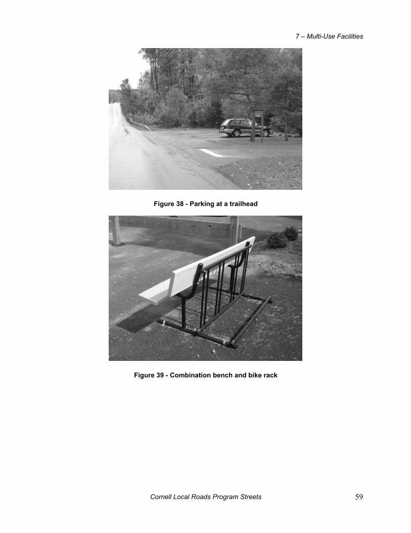
Cornell Local Roads Program Streets 59
7 – Multi-Use Facilities
Figure 38 - parking at a trailhead
Figure 39 - Combination bench and bike rack

Cornell Local Roads Program60
Complete Streets
Figure 40 - A bench and map kiosk
Figure 41 - benches and bike racks in ithaca, ny
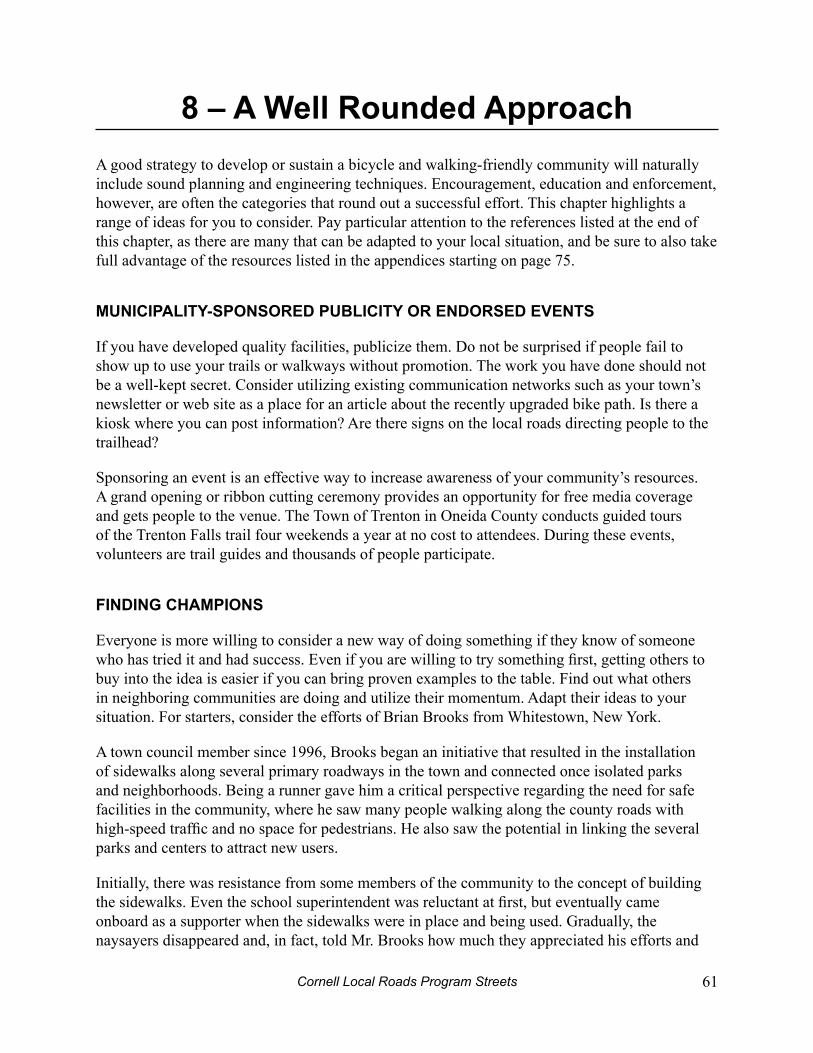
Cornell Local Roads Program Streets 61
8 – A Well rounded ApproachA good strategy to develop or sustain a bicycle and walking-friendly community will naturally include sound planning and engineering techniques. Encouragement, education and enforcement, however, are often the categories that round out a successful effort. This chapter highlights a range of ideas for you to consider. Pay particular attention to the references listed at the end of this chapter, as there are many that can be adapted to your local situation, and be sure to also take full advantage of the resources listed in the appendices starting on page 75.
muniCipALiTy-SponSored pubLiCiTy or endorSed evenTS
If you have developed quality facilities, publicize them. Do not be surprised if people fail to show up to use your trails or walkways without promotion. The work you have done should not be a well-kept secret. Consider utilizing existing communication networks such as your town’s newsletter or web site as a place for an article about the recently upgraded bike path. Is there a kiosk where you can post information? Are there signs on the local roads directing people to the trailhead?
Sponsoring an event is an effective way to increase awareness of your community’s resources. A grand opening or ribbon cutting ceremony provides an opportunity for free media coverage and gets people to the venue. The Town of Trenton in Oneida County conducts guided tours of the Trenton Falls trail four weekends a year at no cost to attendees. During these events, volunteers are trail guides and thousands of people participate.
Finding ChAmpionS
Everyone is more willing to consider a new way of doing something if they know of someone who has tried it and had success. Even if you are willing to try something first, getting others to buy into the idea is easier if you can bring proven examples to the table. Find out what others in neighboring communities are doing and utilize their momentum. Adapt their ideas to your situation. For starters, consider the efforts of Brian Brooks from Whitestown, New York.
A town council member since 1996, Brooks began an initiative that resulted in the installation of sidewalks along several primary roadways in the town and connected once isolated parks and neighborhoods. Being a runner gave him a critical perspective regarding the need for safe facilities in the community, where he saw many people walking along the county roads with high-speed traffic and no space for pedestrians. He also saw the potential in linking the several parks and centers to attract new users.
Initially, there was resistance from some members of the community to the concept of building the sidewalks. Even the school superintendent was reluctant at first, but eventually came onboard as a supporter when the sidewalks were in place and being used. Gradually, the naysayers disappeared and, in fact, told Mr. Brooks how much they appreciated his efforts and
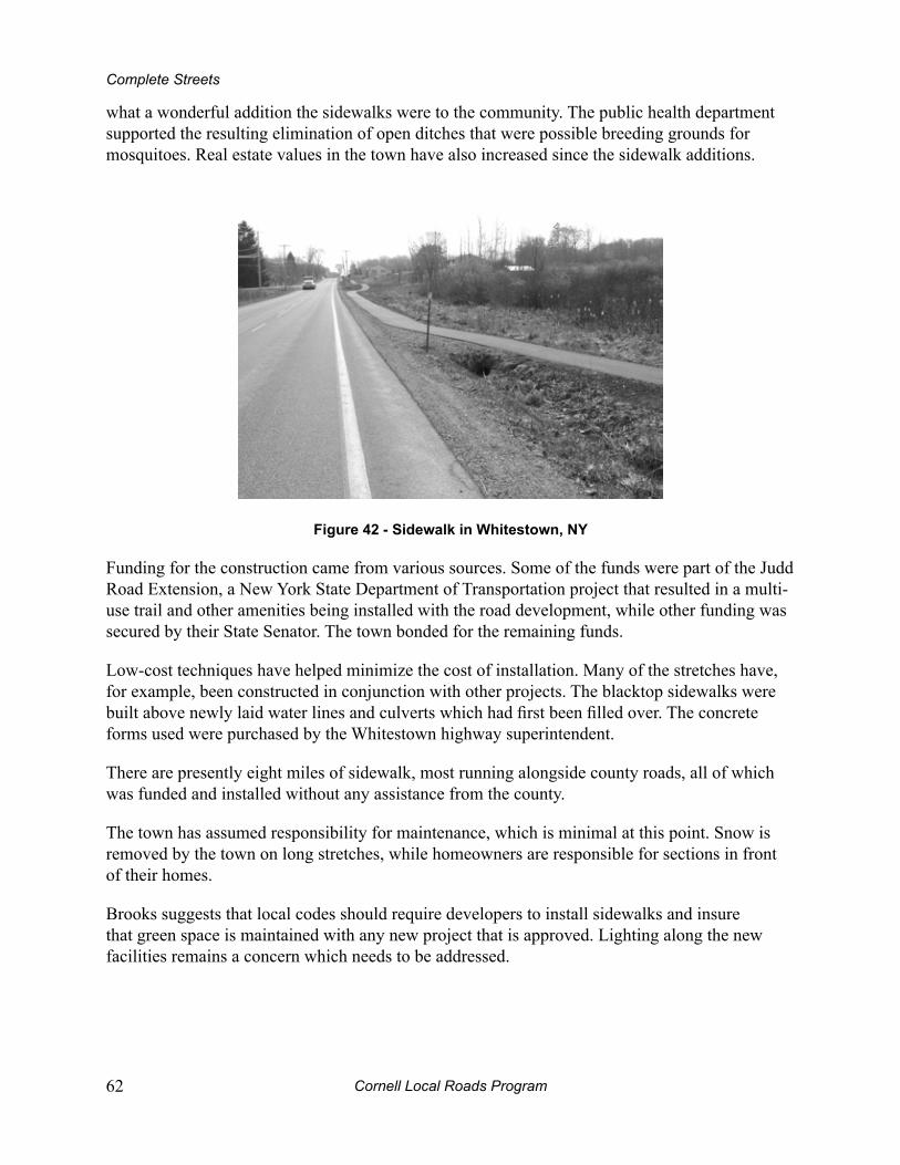
Cornell Local Roads Program62
Complete Streets
what a wonderful addition the sidewalks were to the community. The public health department supported the resulting elimination of open ditches that were possible breeding grounds for mosquitoes. Real estate values in the town have also increased since the sidewalk additions.
Figure 42 - Sidewalk in Whitestown, ny
Funding for the construction came from various sources. Some of the funds were part of the Judd Road Extension, a New York State Department of Transportation project that resulted in a multi-use trail and other amenities being installed with the road development, while other funding was secured by their State Senator. The town bonded for the remaining funds.
Low-cost techniques have helped minimize the cost of installation. Many of the stretches have, for example, been constructed in conjunction with other projects. The blacktop sidewalks were built above newly laid water lines and culverts which had first been filled over. The concrete forms used were purchased by the Whitestown highway superintendent.
There are presently eight miles of sidewalk, most running alongside county roads, all of which was funded and installed without any assistance from the county.
The town has assumed responsibility for maintenance, which is minimal at this point. Snow is removed by the town on long stretches, while homeowners are responsible for sections in front of their homes.
Brooks suggests that local codes should require developers to install sidewalks and insure that green space is maintained with any new project that is approved. Lighting along the new facilities remains a concern which needs to be addressed.

Cornell Local Roads Program Streets 63
8 – A Well Rounded Approach
pubLiC eduCATion CAmpAignS
Public education and strategies, along with sound engineering treatments, contribute to a safer community. Pay particular attention to the references listed in this chapter, as there are many you can adapt to your local situation to increase public awareness, and be sure to take full advantage of the resources listed in the appendices beginning on page 75.
To keep a campaign focused, it is important to develop goals and strategies specific to your community’s needs and local media opportunities. When strategizing your outreach, take into account web sites, blogs, Facebook pages, and smartphone apps as they may be the best way to reach your target audience.
“Share the Road” is a theme that campaigns all over the country are using. It asserts that bicyclists, pedestrians and motorists are equally responsible for safety on the roadway. With some research, you may find public service announcements, posters, bumper stickers and other campaign components to utilize in your program.
Festival-like events, some are called Sunday Parkways, provide an opportunity for families to get out and be active right in their own neighborhood. Entertainment, biking, running, rolling, meeting neighbors and just having fun are key elements of these community-based events.
Your campaign goals should be based on the individual concerns of your community. Examine your local crash data, hold focus groups or town hall meetings. Are there particular issues that are outstanding? Physical activity? What new issues emerge?
Based upon the concerns you identify, goals could include:
Increasing awareness about pedestrian or bicycle safety issues.•
Increasing awareness about pedestrian traffic control devices (signs, signals, etc.).•
Motivating pedestrians to obey pedestrian traffic signals.•
Motivating bicyclists to follow the rules of the road.•
Encouraging drivers to pay attention to other road users.•
Encouraging the public to participate in “active transportation” •
Develop creative strategies by tapping into your local resources. Your efforts will go further if you form a local coalition, or approach an existing group with similar concerns. Be sure to involve key people from law enforcement, health, education, engineering and the media. Develop a step by step plan with specific tasks in support of your goals.
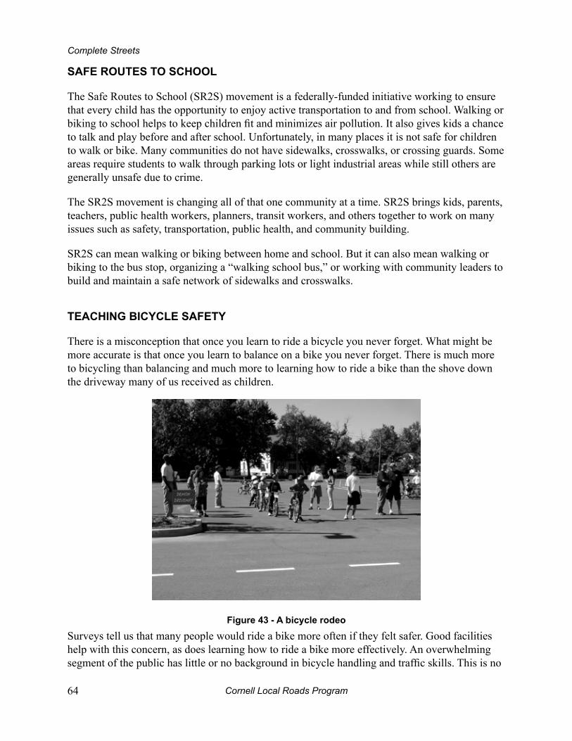
Cornell Local Roads Program64
Complete Streets
SAFe rouTeS To SChooL
The Safe Routes to School (SR2S) movement is a federally-funded initiative working to ensure that every child has the opportunity to enjoy active transportation to and from school. Walking or biking to school helps to keep children fit and minimizes air pollution. It also gives kids a chance to talk and play before and after school. Unfortunately, in many places it is not safe for children to walk or bike. Many communities do not have sidewalks, crosswalks, or crossing guards. Some areas require students to walk through parking lots or light industrial areas while still others are generally unsafe due to crime.
The SR2S movement is changing all of that one community at a time. SR2S brings kids, parents, teachers, public health workers, planners, transit workers, and others together to work on many issues such as safety, transportation, public health, and community building.
SR2S can mean walking or biking between home and school. But it can also mean walking or biking to the bus stop, organizing a “walking school bus,” or working with community leaders to build and maintain a safe network of sidewalks and crosswalks.
TeAChing biCyCLe SAFeTy
There is a misconception that once you learn to ride a bicycle you never forget. What might be more accurate is that once you learn to balance on a bike you never forget. There is much more to bicycling than balancing and much more to learning how to ride a bike than the shove down the driveway many of us received as children.
Figure 43 - A bicycle rodeo
Surveys tell us that many people would ride a bike more often if they felt safer. Good facilities help with this concern, as does learning how to ride a bike more effectively. An overwhelming segment of the public has little or no background in bicycle handling and traffic skills. This is no

Cornell Local Roads Program Streets 65
8 – A Well Rounded Approach
surprise, due to the fact that we have placed little emphasis on providing skills training to adults or children in the United States.
Safety movies, brochures and handouts can be an effective method of distributing factual information about traffic laws and safety tips. The best way to increase one’s ability to be an effective bicyclist though, is by participating in an on-bike educational program.
A common on-bike program format involves conducting bicycle rodeos where children are provided a series of “stations” in a parking lot that help them develop their bike handling skills. It is very easy to organize and conduct an ineffective rodeo, while much more difficult and time consuming to put on a quality one. Too often, people who organize rodeos do not have an adequate understanding of the basic principles of how to teach bicycle riding, nor do many have the personal experience of bicycling to draw upon. A meaningful event will guide the participants through bike sizing, basic bike handling skills and traffic rules. It will be taught in an environment that is as close to real life as possible, will be age appropriate and will involve adults who are familiar with bicycling. An Organizer’s Guide to Bicycle Rodeos provides the reader with an overview of these principles. The Guide is available online at: www.bikecornell.edu
People of all ages can benefit from taking the time to learn the principles of bicycle handling and traffic skills. Some of it can be learned from reading. The rest can only be learned with practice in a parking lot and on the road. The League of American Bicyclists (www.bikeleague.org) is the nation’s leader in cyclist education. Their certified instructors teach from a curriculum that covers it all.
vehiCLe And TrAFFiC LAW enForCemenT
Police enforcement is a primary component in maintaining a safe environment for all modes of travel. Well publicized enforcement campaigns, when combined with strategically installed traffic control devices and public education programs, are often effective in deterring careless and reckless driving and in encouraging drivers to share the roadway with pedestrians and bicyclists. Most importantly, by enforcing the traffic code, police forces implant a sense of right and wrong in the general public and lend credibility to traffic safety educational programs and traffic control devices.
Over the years, police departments around the country have consistently enforced traffic laws pertaining to driving under the influence, speeding, and running red lights. They have developed effective and socially accepted methods for measuring this behavior and apprehending offenders. Responsible enforcement requires looking beyond traditional traffic laws, and ensuring equal protection for drivers as well as pedestrians and bicyclists.
The first step in developing an enforcement component to a community campaign is to build a better understanding of the problem that you hope to address. Local crash data can tell a lot about where you may have problem areas or behaviors. This information helps the police target their
Cornell Local Roads Program66
Complete Streets
enforcement efforts and can be used as compelling evidence to gain greater public support for your initiatives.
Communities with a cyclist unit in their police department have learned that it is a public relations success. The public likes to see police on bikes and their presence provides an opening for outreach in the community. It is also important for a police department to ensure that the entire force, and not just the bike unit, is well aware of the laws that pertain to cyclists and pedestrians. An accurate understanding of the law leads naturally to better enforcement.
mApS
Maps can serve many purposes and can range from simple line drawings and black and white reprints to more complex, multi-colored productions. Web based versions are common as well. Maps raise public awareness of facilities, share details about the area, and can increase the usage of your facilities just by letting people know where to go.
Figure 44 - A regional bike map
This regional bicycle map was produced by the Adirondack/Glens Falls Transportation Council. It highlights separate facilities, designated on-street bike routes and proposed on-street connectors.
Cornell Local Roads Program Streets 67
8 – A Well Rounded Approach
eduCATed LAW enForCemenT
Law enforcement officers are in a unique position to assist with and add credibility to community efforts to encourage bicycling and walking, and to improve safety. However, many officers have never received any bicycle or pedestrian-specific training.
Police officers with knowledge of common crash types understand how to recognize unsafe situations on the road. They are familiar with the kinds of actions that lead to them and are therefore better able to apply the law in a manner which promotes the safety of everyone involved. By increasing knowledge of the rules of the road for bicyclists, pedestrians and motorists, law enforcement officials can better serve the community and potentially save lives.
There are numerous opportunities for police and other agencies to participate in continuing education. Training programs are a start, and provide opportunities that allow law enforcement officers to better represent the best interests of the communities they serve. The National Highway Traffic Safety Administration (NHTSA) has worked with law enforcement to design many such programs.
The New York Highway Safety Conference attracts more than 300 professionals from local, state, federal and private agencies involved in the effort to reduce deaths and injuries related to traffic crashes. Professionals attend the conference to exchange information on current activities and new developments in the promotion of injury prevention programs. Past topics have included STOP-DWI activities dealing with prevention, enforcement, prosecution, treatment, education and probation. Other presentations have addressed such topics as aggressive driving, child passenger safety and bicycle and pedestrian safety
enForCemenT iS eduCATion
There are a number of actions that municipalities can take to implement enforcement campaigns designed to protect non-motorized users.
These include:
Increased police presence around school zones, residential neighborhoods, and other • areas with high pedestrian activity.
“Pedestrian stings” involving plainclothes officers.•
High profile, hard hitting mass media campaigns to signpost change and help set the • public agenda.
Some efforts will require special legislation to provide a legal basis for stricter crosswalk codes or right-of-way changes, while others may operate under existing ordinances.
An analysis of the motor vehicle accident reports in the city of Ithaca revealed that a high proportion of the crashes involving bicyclists happened at night when the bicycle had either
Cornell Local Roads Program68
Complete Streets
inadequate lighting or none at all. Based upon this information, subsequent actions on the part of Cornell University Police included a public education campaign that emphasized the need to have lights if biking at night, and stepped up warning efforts by the police to talk to bicyclists about lighting.
Funding
Bicycle and pedestrian projects and programs can be funded by Federal, State, local, private sources or a combination of the above. Successful projects typically have one or more “can do” people in the right place at the right time, who provide the energy and vision to see a project through. Many successful “can do” politicians get their start as successful neighborhood activists.
Funds, once secured, should always be used to leverage additional funds. For example, a grant from a local foundation could be used as the required match for a Federal Transportation Enhancements grant.
Community efforts that are most successful at securing funds usually have the following:
Consensus on priorities: Community consensus on what should be accomplished • increases the likelihood of successfully funding a project. A divided or uninvolved community will find it more difficult to raise funds than a community that gives broad support to safety improvement programs.
Dedication: Funding a project is hard work; typically, there are no shortcuts. It usually • takes a great amount of effort by many people using multiple funding sources to complete a project successfully. Be aggressive; apply for many different community grants.
Cornell Local Roads Program Streets 69
9 – next StepsHave you ever found yourself passing by something and just not seeing it? How about a new chair in the kitchen, or a new piece of equipment in the garage? Sometimes we can look right past things in our environment that are a part of our daily lives. Although it may not be important to pay attention to the color of someone’s shirt or the extra car in the driveway, sometimes details are very important. Did the thief have dark hair or was it covered with a hat?
An AudiT
A neighborhood audit is a good way to assess the relative friendliness of the area for the non-motorized user. There are many things to be on the lookout for. To get you started, here is a series of questions to answer as you take a walk, bike ride or wheelchair tour through your neighborhood:
Examine the overall environment:
What kinds of buildings are in the area? Are there stores, schools, housing • developments or other establishments that could be called traffic generators? What about gas stations, banks, playgrounds, and bus stops? Is there a post office or community center?
What kind of street is it? A busy state highway or a quiet local street?•
Is the area well lit, so that motorists can see you and does the area feel comfortable?•
Consider what kinds of people you see:
Do you see people out and about? Are they engaging in active behaviors like walking • or jogging or playing a sport?
Are there children, elderly people, or others using wheelchairs or canes to get around?•
Think about walkability and your experience as a pedestrian:
Did you have room to walk? If no, what were some problems you encountered?•
Was it easy to cross the streets? •
Did drivers behave well? •
Was it easy to follow safety rules? •
Was your walk pleasant? •
Cornell Local Roads Program70
Complete Streets
Go out on your bike and evaluate your ride:
Did you have a place to bicycle safely on the street? If no, what were some problems • you encountered?
Did you have a place to bicycle on a path or trail where motor vehicles are not • allowed?
How was the surface you rode on? Good, or were there some problems?•
How were the intersections you rode through? Did drivers behave well? •
Was it easy for you to use your bike, and find a place to park it? •
What did you do to make your ride safer? Your behavior contributes to the bikeability • of your community.
Consider the perspective of someone using a wheelchair:
Was it possible to go from one place to another without encountering major • obstacles?
If there were pushbutton signals at traffic lights, could you reach them?•
Were the curb cuts satisfactory, and were the surfaces level and smooth?•
Cornell Local Roads Program Streets 71
9 – Next Steps
neighborhood ASSeSSmenT
As a way of summarizing the concepts presented in this manual, this section is a chance for you to plan steps you will take to make your community safer, and its streets complete.
Involving decision makers and other key people in the audit process will likely make your efforts more successful. For instance, if your best contacts are school administrators, think about conducting an audit along routes to a school and remember to discuss the Safe Routes to School initiative. Invite your mayor or town supervisor to participate in a walking tour to inventory local sidewalks, and look for a local youth group, service organization or senior citizen’s group who would take an interest in getting involved. Be creative and resourceful. A local audit can start the ball rolling, generating awareness and enthusiasm.
Check off the steps your community has already taken, and circle ones you would like to take in the future:
Working with local law enforcement to find out more about area crash data.
Arranging traffic counts along stretches of roadway that are a safety concern.
Starting a photo file of local conditions to include before and after pictures to evaluate/demonstrate changes in conditions.
Creating a bicycle helmet initiative and conducting an observation study to determine its effectiveness.
Adapting or designing an audit tool for use in the community, and recruiting people to participate in the audit and present its results to the proper board or council.
Are there other steps, not listed here, that your town has taken? Can you think of any new ones? List them here:
__________________________________________________________________
__________________________________________________________________
__________________________________________________________________

Cornell Local Roads Program72
Complete Streets
pLAnning
List two ideas about planning that you like and will consider implementing in your local community:
1.
2.
Name two goals that your community should set for itself:
1.
3.
Write down one item you would recommend adding to each of the following documents. If your town does not have one of these yet, give an important reason to include it in your plan.
Comprehensive planning document:
__________________________________________________________________
Site plan regulations:
__________________________________________________________________
Zoning ordinances/codes:
__________________________________________________________________
Standards for new roads:
__________________________________________________________________
Name three key people from your town to involve in the process:
1.
4.
5.
Complete Street Policy
__________________________________________________________________

Cornell Local Roads Program Streets 73
9 – Next Steps
engineering
Engineers and other highway officials will play an enormous role in the realization of your proposed improvements. Getting them involved early on will help avoid delays as things progress. Familiarize yourself with measures that have already been taken, their deficiencies, options for improvements, as well as new ideas, so that you can make the most of time spent collaborating.
Check off items you have done, and circle the ones you plan to do to familiarize yourself with, and get moving on, the engineering and technical side of things:
Meeting the local highway superintendent.
Recruiting a committee and developing a plan for installing sidewalks.
Reviewing roadway maintenance procedures and assessing what improvements can be made.
Designing treatments that have potential for application in my town.
Reading Chapter 5 of this manual.
Anything else that comes to mind?
__________________________________________________________________
__________________________________________________________________
eduCATion, enForCemenT, And ouTreACh
Education and enforcement are important and often inexpensive measures can be taken to improve conditions in your community and raise awareness about present efforts.
Check off the ways you have already started to educate your community, and circle ones that you will consider implementing:
Meeting local law enforcement.
Reviewing local crash data pertinent to cyclists and pedestrians.
Incorporating pedestrian safety messages into public relations efforts.
Arranging for local law enforcement officials to provide brochures or other adapted materials to the public at health fairs or other community safety events.
Researching options for a Safe Routes to School initiative.
Cornell Local Roads Program74
Complete Streets
Identifying a community organization to teach bicycle and pedestrian safety.
Conducting a bicycle rodeo and helmet education campaign.
Promoting walking and bicycling by designing and distributing a local map.
Identifying a group of interested people to organize a Sunday Parkways-type of event.
Conducting internal campaigns within an organization to build staff support for pedestrian safety programs.
Developing relationships with sister state agencies and statewide consumer groups.
Identifying a local non-profit organization to assume leadership for the development of continued support for non-motorized transportation advocacy.
Other efforts on the part of your community?
__________________________________________________________________
__________________________________________________________________
meASuring your SuCCeSS
If you think in terms of evaluation when you are writing your goals, objectives and activities, you will have a much more effective evaluation process and more meaningful results. Ask yourself about the kinds of questions you want to have good answers for in the future, and keep asking them each step of the way there.
Things to keep in mind include:
How and to what extent bicycle and pedestrian safety, or “complete streets,” has been • incorporated into or addressed by your community’s comprehensive and land-use planning?
Has more bike and pedestrian infrastructure been developed?•
Has existing infrastructure been improved?•
Are more people walking or bicycling?•
What changes, if any, are there in your local crash data?•
Cornell Local Roads Program Streets 75
Appendix i – national policy guidelines
uSdoT, AAShTo, And “CompLeTe STreeTS”
At the national level, the US Department of Transportation (USDOT) has developed a model policy framework. This policy is based on the principle that bicyclists and pedestrians have the right to move along or across all roadways unless specifically prohibited from doing so. This policy has served as guidance for State DOT’s and public works agencies throughout the U.S. It has recently evolved into the concept of “Complete Streets” – the idea that streets are only complete when they address the needs of all modes of transportation, including walking and bicycling. The USDOT guidance, issued by the Federal Highway Administration in 2010, is provided below:
FhWA bicycle and pedestrian program policy Statement purpose– march 2010The United States Department of Transportation (DOT) is providing this Policy Statement to reflect the Department’s support for the development of fully integrated active transportation networks. The establishment of well-connected walking and bicycling networks is an important component for livable communities, and their design should be a part of Federal-aid project developments. Walking and bicycling foster safer, more livable, family-friendly communities; promote physical activity and health; and reduce vehicle emissions and fuel use. Legislation and regulations exist that require inclusion of bicycle and pedestrian policies and projects into transportation plans and project development. Accordingly, transportation agencies should plan, fund, and implement improvements to their walking and bicycling networks, including linkages to transit. In addition, DOT encourages transportation agencies to go beyond the minimum requirements, and proactively provide convenient, safe, and context-sensitive facilities that foster increased use by bicyclists and pedestrians of all ages and abilities, and utilize universal design characteristics when appropriate. Transportation programs and facilities should accommodate people of all ages and abilities, including people too young to drive, people who cannot drive, and people who choose not to drive.
Policy Statement The DOT policy is to incorporate safe and convenient walking and bicycling facilities into transportation projects. Every transportation agency, including DOT, has the responsibility to improve conditions and opportunities for walking and bicycling and to integrate walking and bicycling into their transportation systems. Because of the numerous individual and community benefits that walking and bicycling provide — including health, safety, environmental, transportation, and quality of life — transportation agencies are encouraged to go beyond minimum standards to provide safe and convenient facilities for these modes.

Cornell Local Roads Program76
Complete Streets
More Information
More information about the policy statement can be found at:http://www.fhwa.dot.gov/environment/bikeped/policy_accom.htm
AAShTo guidelines The American Association of Highway and Transportation Officials (AASHTO) provides guidelines for State Departments of Transportation which are widely accepted for use throughout the U.S. The AASHTO 1999 “Guide for the Development of Bicycle Facilities” includes the following policy guidance:
“All highways except those where cyclists are legally prohibited, should be designed and constructed under the assumption that they will be used by cyclists. Therefore, bicycles should be considered in all phases of transportation planning, new roadway design, roadway reconstruction, and capacity improvements and highway projects.”
AASHTO’s “Policy on the Geometric Design of Highways and Streets”, also known as “The Green Book” is considered the “bible” of the highway design profession. The Green Book contains the following statement about including pedestrians in the design of highways:
“Pedestrians are a part of every roadway environment and attention must be paid to their presence in urban and rural areas…Because of the demands of vehicular traffic in congested urban areas, it is often extremely difficult to make adequate provisions for pedestrians. Yet this must be done, because pedestrians are the lifeblood of our urban areas, especially in the downtown and other retail shopping areas.”
The 2004 AASHTO “Guide for the Planning, Design, and Operation of Pedestrian Facilities” includes the following policy guidance:
“Safety is a key consideration in the planning, design, and operation of pedestrian facilities. Because pedestrians are the most vulnerable of all transportation facility users, particular attention to pedestrian safety is needed. Accessibility and usability are also key considerations for pedestrian facilities, which should accommodate pedestrians of all abilities.”
Cornell Local Roads Program Streets 77
Appendix I – National Policy Guidelines
Complete Streets The idea of complete streets is based on the premise that quality transportation facilities “are designed and operated to enable safe access for all users. Pedestrians, bicyclists, motorists and bus riders of all ages and abilities are able to safely move along and across a complete street.” A national coalition of organizations supporting this policy concept has formed to encourage adoption of Complete Streets policies. More information about the National Complete Streets Coalition can be found at: http://www.completestreets.org/
Cornell Local Roads Program78
Appendix ii – national and State Legislation
At the national level, the Federal Highway Administration, the United States Access Board, and the American Association of State Highway and Transportation Officials (AASHTO) provide policy guidelines for use at the state and local level. In New York State, the Department of Transportation (NYSDOT) develops statewide policies which are in turn implemented by regional and local agencies including NYSDOT regional offices, metropolitan planning organizations, counties and local government. The policy process is not linear and concurrence is not mandatory, and since New York is a “home rule” state, a significant amount of decision-making takes place at the local level. The following summarizes key legislation and policies at the national, state and local levels.
FederAL TrAnSporTATion LegiSLATion: iSTeA, TeA-21, SAFeTeA-Lu
Federal transportation legislation provides a legal basis for the expenditure of federal aid transportation funding. Specific requirements for non-motorized transportation in ISTEA and TEA-21 include the following sections.
“Subject to Section 134 of this title, the State shall develop transportation plans and programs for all areas of the state. Such plans and programs shall provide for the development of transportation facilities (including pedestrian walkways and bicycle transportation facilities) which will function as an intermodal transportation system.”
1991 ISTEA: The Intermodal Surface Transportation Efficiency Act
“The Secretary shall not approve any project or take any regulatory action under this title that results in the severance of an existing major route or have significant adverse impact on the safety for non-motorized transportation traffic…unless such a project or regulatory action provides for a reasonable alternate route if such a route exists.”
1998 TEA-21: The Transportation Equity Act for the 21st Century (continued and extended the provisions of ISTEA)
2005 SAFETEA-LU: The Safe, Accountable, Flexible and Efficient Transportation Equity Act, a Legacy for Users (continued and extended the provisions of TEA-21).
Cornell Local Roads Program Streets 79
Appendix II – National and State Legislation
AmeriCAnS WiTh diSAbiLiTieS ACT
Passed in 1990 by the federal government, its purpose “prohibits discrimination on the basis of disability by public accommodations and requires places of public accommodation and commercial facilities to be designed, constructed, and altered in compliance with the accessibility standards” outlined in the complete document.
nySdoT biCyCLe And pedeSTriAn poLiCy
After the passage of ISTEA in 1991, New York State developed a Bicycle and Pedestrian Transportation Program. A Commissioner’s Bicycle and Pedestrian Policy Statement was issued by the Department in 1993, and it was updated and re-issued in October, 1996, as follows:
“As part of our mission as an intermodal transportation agency, NYSDOT must make bicyclists and pedestrians an integrated element of our intermodal transportation system. Bicyclists and pedestrians are significant partners in NYSDOT’s efforts, providing cost-effective solutions to our State’s mobility, safety and environmental goals. The 1990 Census shows that more than 7% of New York State Commuters bicycle or walk to work, so it is important for us to take the lead in making these modes safer and more “user friendly.”
In March of 2010, the above policy was superseded by the following:
“The New York State Department of Transportation (Department) will promote pedestrian and bicycle travel for all persons on the state transportation system.”
As we move forward into the 21st century, we have the ability to make our State’s highways,
structures and public transportation systems into one of the most efficient, intermodal transportation systems in the nation. To accomplish this, facilities for pedestrians and bicyclists must be considered for incorporation into highway, bridge and transit projects and integrated throughout NYSDOT’s policy, planning, implementation and operations efforts.”
CompLeTe STreeTS in neW york STATe
In 2011, the New York State Legislature passed a Complete Streets Law, effective in 2012. The recently passed statewide Complete Streets law provides a window of opportunity for action at the local level. The law affects the practices at the State Agency level (and those agencies receiving Federal money).
SmArT groWTh
The NYS Smart Growth Public Infrastructure Policy Act was signed into law on September 29, 2010. One of the most significant impacts of the Act is that ALL NYS funding agencies must now, formally, meet ten Smart Growth goals.
Cornell Local Roads Program80
Complete Streets
For more information:http://public.leginfo.state.ny.us/LAWSSEAF.cgi?QUERYTYPE=LAWS+&QUERYDATA=@SLENV0A6
Both the Federal Highway Administration (FHWA) and the New York State Department of Transportation (NYSDOT) require the routine consideration of bicyclists in all new roadway construction, reconstruction and maintenance projects except where prohibited by law. The resources on the following pages provide uniform minimum standards and criteria for the design and construction of bicycle facilities. It is recommended that the formal planning and design of a bicycle facility be conducted by or in consultation with persons who have a specialized knowledge of these facilities.
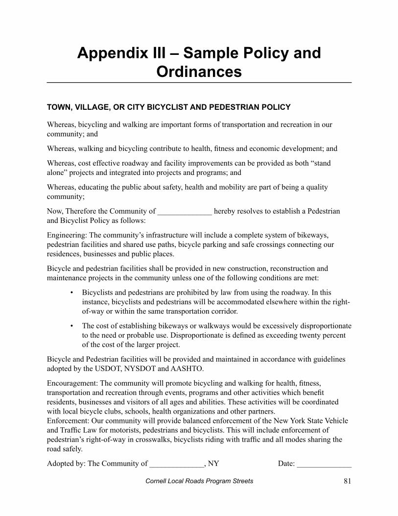
Cornell Local Roads Program Streets 81
Appendix iii – Sample policy and ordinances
ToWn, viLLAge, or CiTy biCyCLiST And pedeSTriAn poLiCy
Whereas, bicycling and walking are important forms of transportation and recreation in our community; and
Whereas, walking and bicycling contribute to health, fitness and economic development; and
Whereas, cost effective roadway and facility improvements can be provided as both “stand alone” projects and integrated into projects and programs; and
Whereas, educating the public about safety, health and mobility are part of being a quality community;
Now, Therefore the Community of ______________ hereby resolves to establish a Pedestrian and Bicyclist Policy as follows:
Engineering: The community’s infrastructure will include a complete system of bikeways, pedestrian facilities and shared use paths, bicycle parking and safe crossings connecting our residences, businesses and public places.
Bicycle and pedestrian facilities shall be provided in new construction, reconstruction and maintenance projects in the community unless one of the following conditions are met:
Bicyclists and pedestrians are prohibited by law from using the roadway. In this • instance, bicyclists and pedestrians will be accommodated elsewhere within the right-of-way or within the same transportation corridor.
The cost of establishing bikeways or walkways would be excessively disproportionate • to the need or probable use. Disproportionate is defined as exceeding twenty percent of the cost of the larger project.
Bicycle and Pedestrian facilities will be provided and maintained in accordance with guidelines adopted by the USDOT, NYSDOT and AASHTO.
Encouragement: The community will promote bicycling and walking for health, fitness, transportation and recreation through events, programs and other activities which benefit residents, businesses and visitors of all ages and abilities. These activities will be coordinated with local bicycle clubs, schools, health organizations and other partners. Enforcement: Our community will provide balanced enforcement of the New York State Vehicle and Traffic Law for motorists, pedestrians and bicyclists. This will include enforcement of pedestrian’s right-of-way in crosswalks, bicyclists riding with traffic and all modes sharing the road safely.
Adopted by: The Community of ______________, NY Date: ______________
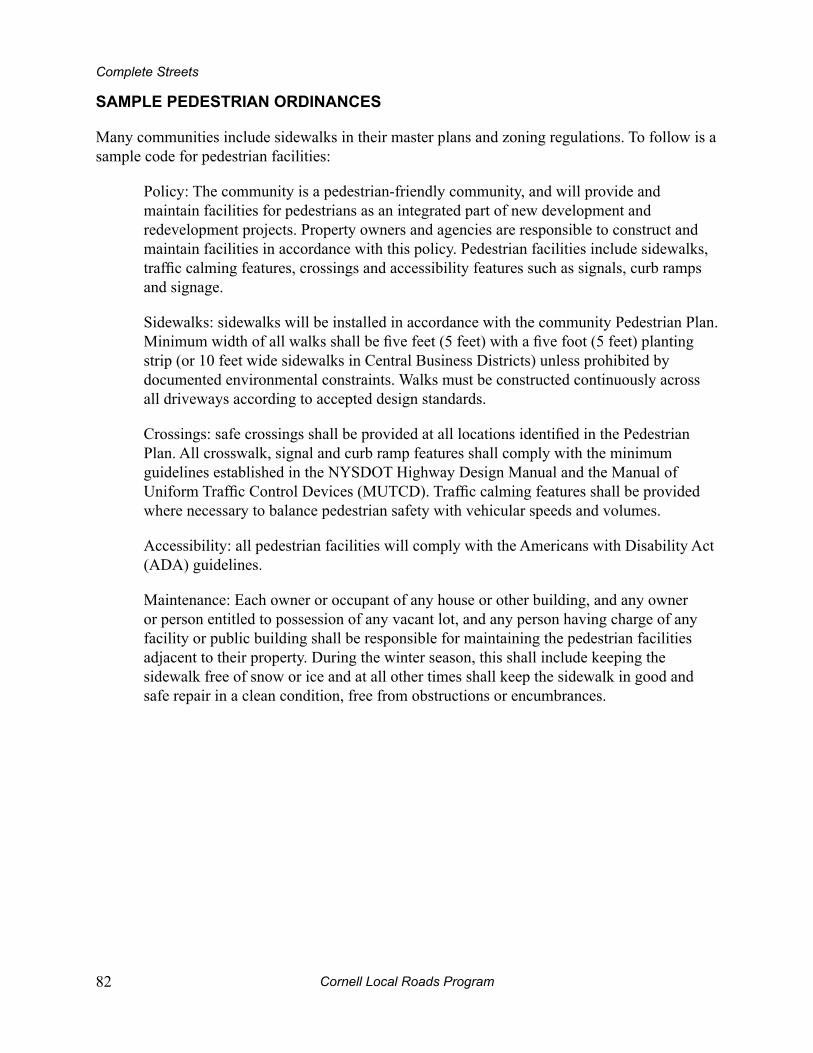
Cornell Local Roads Program82
Complete Streets
SAmpLe pedeSTriAn ordinAnCeS
Many communities include sidewalks in their master plans and zoning regulations. To follow is a sample code for pedestrian facilities:
Policy: The community is a pedestrian-friendly community, and will provide and maintain facilities for pedestrians as an integrated part of new development and redevelopment projects. Property owners and agencies are responsible to construct and maintain facilities in accordance with this policy. Pedestrian facilities include sidewalks, traffic calming features, crossings and accessibility features such as signals, curb ramps and signage.
Sidewalks: sidewalks will be installed in accordance with the community Pedestrian Plan. Minimum width of all walks shall be five feet (5 feet) with a five foot (5 feet) planting strip (or 10 feet wide sidewalks in Central Business Districts) unless prohibited by documented environmental constraints. Walks must be constructed continuously across all driveways according to accepted design standards.
Crossings: safe crossings shall be provided at all locations identified in the Pedestrian Plan. All crosswalk, signal and curb ramp features shall comply with the minimum guidelines established in the NYSDOT Highway Design Manual and the Manual of Uniform Traffic Control Devices (MUTCD). Traffic calming features shall be provided where necessary to balance pedestrian safety with vehicular speeds and volumes.
Accessibility: all pedestrian facilities will comply with the Americans with Disability Act (ADA) guidelines.
Maintenance: Each owner or occupant of any house or other building, and any owner or person entitled to possession of any vacant lot, and any person having charge of any facility or public building shall be responsible for maintaining the pedestrian facilities adjacent to their property. During the winter season, this shall include keeping the sidewalk free of snow or ice and at all other times shall keep the sidewalk in good and safe repair in a clean condition, free from obstructions or encumbrances.

Cornell Local Roads Program Streets 83
Appendix III – Sample Policy and Ordinances
SAmpLe biCyCLe pArking ordinAnCe
____ Bicycle parking facilities shall, typically, be required for all new structures and uses § subject to site plan review as provided in Sec. ____.
Statement of purpose. It is the intent of this section to provide for the regulation A.) and requirement of safe, secure, convenient, and appropriate bicycle parking facilities. The ____ Board shall use the following guidelines in its consideration of the number of bicycle parking spaces required, the location of such spaces, and the type/design of bicycle parking facilities.
Definitions. The term ‘bicycle parking facility’ includes the bicycle parking spaces, B.) one or more bicycle racks, and, when applicable, the access aisle(s) between groups of bicycle racks. A ‘bicycle parking space’ refers to a location for which the parking of one (1) bicycle is intended. A ‘bicycle rack’ is the element of the bicycle parking facility that supports one or more bicycles and to which one or more bicycles may be locked.
Number of bicycle parking spaces required. Unless stated otherwise, one (1) bicycle C.) parking space per ten (10) automobile parking spaces OR one (1) bicycle parking space per ten (10) employees, whichever is GREATER, shall be required. In ALL cases where bicycle parking is required, no fewer than two (2) bicycle parking spaces shall be required.
Bicycle Parking Guidelines: 1.) Multi-family residential - one (1) bicycle parking space per dwelling unit OR one (1) bicycle parking space per three (3) bedrooms, whichever is GREATER (Note: It is recommended that 50-90% of these spaces be located in garages and/or other secure indoor areas). Commercial/Retail - one (1) bicycle parking space per twenty (20) automobile parking spaces. Industrial/Manufacturing - one (1) bicycle parking space per forty (40) automobile parking spaces. Schools and educational facilities - one (1) bicycle parking space per ten (10) students. Bicycle parking facilities should be clustered in small lots of twenty (20) spaces or less.
Location of bicycle parking. D.)
Bicycle parking facilities typically should be located close to building 1.) entrances and, generally, be clustered in small lots of ten (10) spaces or less (Schools and educational facilities excepted). Depending on site conditions, bicycle parking facilities may be located with motor vehicles in parking lots (e.g.

Cornell Local Roads Program84
Complete Streets
a converted automobile parking space can accommodate six or more bicycles), between the roadway and building entrance, and/or within a building. Bicycle parking facilities to be in a public right-of-way shall receive approval by the Office of the City Engineer.
Bicycle parking facilities, not located within a building, shall be located in 2.) highly visible and well-lighted areas to minimize theft and vandalism.
Bicycle parking facilities shall not intrude into pedestrian or vehicular 3.) circulation paths.
Bicycle parking facilities intended primarily for residential uses should 4.) generally be located within garages and other secure indoor areas.
In all cases, bicycle parking facilities should be protected from the elements 5.) whenever practical.
A minimum clear area of 24 inches shall be between bicycle racks and walls, 6.) other obstructions, and/or any unpaved surface. Vertical clearance of 7 feet is, generally, required for all bicycle parking facilities.
Type/design of bicycle parking facilities.E.)
Bicycle parking facilities shall be designed in such a way as to accommodate 1.) a six (6) foot long “design bicycle,” though bicycles longer than six (6) feet in length (such as a tandem bicycle or a bicycle with a trailer) should be accommodated if practical.
Bicycle parking facilities shall be securely anchored into concrete (anchoring 2.) to brick or asphalt materials is generally NOT acceptable). The entire footprint of the bicycle parking facility shall be constructed of concrete (asphalt, brick, or other durable surface may be acceptable at the discretion of the Board). The footprint shall be as level as practical.
Standard inverted “U” bicycle racks are highly recommended. Such racks shall 3.) be 36 inches high and shall be 20 to 30 inches wide. When multiple inverted “U” racks are combined together, they shall be oriented parallel to one another and should be spaced 30 inches on center (spacing as low as 24 inches on center and as high as 36 inches on center may be acceptable in some cases).
Bicycle parking facilities shall be designed to support the frame of each 4.) bicycle in TWO or more places. Designs that support bicycles by one wheel are NOT acceptable.
All rack designs shall permit the use of standard U-locks.5.)
F.)

Cornell Local Roads Program Streets 85
Appendix III – Sample Policy and Ordinances
Variations and exemptions to bicycle parking requirements.G.)
The following uses are exempt from the above bicycle parking requirements: 1.) Funeral parlor and car wash.
Other uses may be exempted at the discretion of the Board.2.)
Any property owner required to provide bicycle parking may propose to 3.) establish a shared bicycle parking facility with an adjacent property owner to meet the combined requirements. Such a proposal requires approval by the Board.
Though standard inverted “U” bicycle racks are highly recommended, other 4.) innovative and creative rack designs may be allowed at the discretion of the Board.
Cornell Local Roads Program86
Appendix iv – neighborhood ChecklistsThese checklists have been developed by the Pedestrian and Bicycle Information Center (PBIC) at the University of North Carolina Highway Safety Research Center, with funding from the National Highway Traffic Safety Administration (NHTSA). The checklists help identify walking and bicycling problems in the community and offer suggestions about how to rectify them.
These guides are available electronically in PDF format from the PBIC website at pedbikeinfo.org and may be reproduced and distributed freely. For specific information on bicycling and pedestrian issues, be sure to visit the PBIC’s other sites at bicyclinginfo.org and walkinginfo.org, respectively.
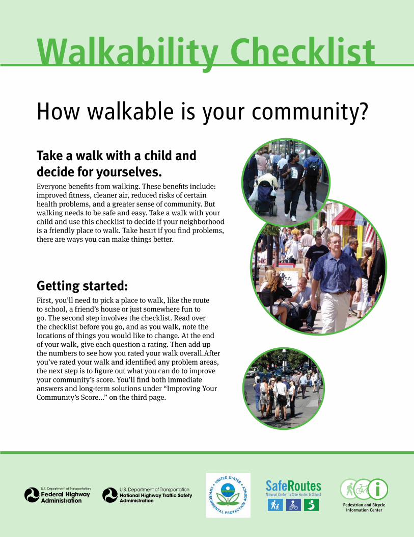
Walkability ChecklistHow walkable is your community?
Take a walk with a child and decide for yourselves.Everyone benefits from walking. These benefits include: improved fitness, cleaner air, reduced risks of certain health problems, and a greater sense of community. But walking needs to be safe and easy. Take a walk with your child and use this checklist to decide if your neighborhood is a friendly place to walk. Take heart if you find problems, there are ways you can make things better.
Getting started:First, you’ll need to pick a place to walk, like the route to school, a friend’s house or just somewhere fun to go. The second step involves the checklist. Read over the checklist before you go, and as you walk, note the locations of things you would like to change. At the end of your walk, give each question a rating. Then add up the numbers to see how you rated your walk overall.After you’ve rated your walk and identified any problem areas, the next step is to figure out what you can do to improve your community’s score. You’ll find both immediate answers and long-term solutions under “Improving Your Community’s Score...” on the third page.
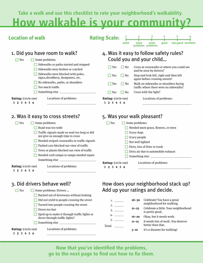
Take a walk and use this checklist to rate your neighborhood’s walkability.
How walkable is your community?Location of walk Rating Scale: 1
awful
2
manyproblems
3
someproblems
4
good
5
very good
6
excellent
1. Did you have room to walk?
Locations of problems:
Yes Some problems:
Sidewalks or paths started and stopped
Sidewalks were broken or cracked
Sidewalks were blocked with poles, signs,shrubbery, dumpsters, etc.
No sidewalks, paths, or shoulders
Too much traffic
Something else
Rating: (circle one )
1 2 3 4 5 6
2. Was it easy to cross streets?
Locations of problems:
Yes Some problems:
Road was too wide
Traffic signals made us wait too long or did not give us enough time to cross
Needed striped crosswalks or traffic signals
Parked cars blocked our view of traffic
Trees or plants blocked our view of traffic
Needed curb ramps or ramps needed repair
Something else
Rating: (circle one ) 1 2 3 4 5 6
3. Did drivers behave well?
Locations of problems:
Yes Some problems: Drivers …
Backed out of driveways without looking
Did not yield to people crossing the street
Turned into people crossing the street
Drove too fastp
Sped up to make it through traffic lights or drove through traffic lights?
Something else
Rating: (circle one )
1 2 3 4 5 6
4. Was it easy to follow safety rules? Could you and your child…
Locations of problems:
Yes No Cross at crosswalks or where you could see and be seen by drivers?
Yes No Stop and look left, right and then left again before crossing streets?
Yes No Walk on sidewalks or shoulders facing traffic where there were no sidewalks?
Yes No Cross with the light?
Rating: (circle one) 1 2 3 4 5 6
5. Was your walk pleasant?
Locations of problems:
Yes Some problems:
Needed more grass, flowers, or trees
Scary dogs
Scary people
Not well lighted
Dirty, lots of litter or trash
Dirty air due to automobile exhaust
Something else
Rating: (circle one )
1 2 3 4 5 6
How does your neighborhood stack up? Add up your ratings and decide.
1. 26–30 Celebrate! You have a great neighborhood for walking.2. 21–25 Celebrate a little. Your neighborhood 3. is pretty good.
4. 16–20 Okay, but it needs work.
5. 11–15 It needs lots of work. You deserve better than that. Total: 5–10 It's a disaster for walking!
Now that you've identified the problems, go to the next page to find out how to fix them.
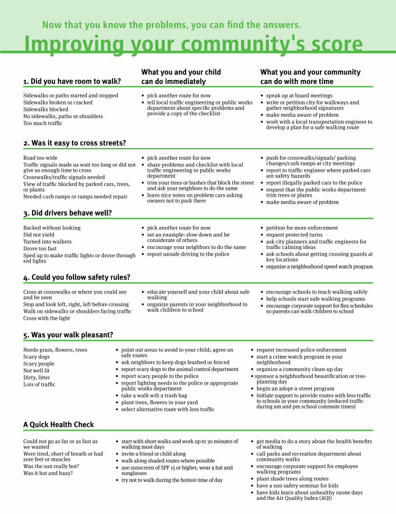
Now that you know the problems, you can find the answers.
Improving your community's score1. Did you have room to walk?
What you and your child can do immediately
What you and your community can do with more time
Sidewalks or paths started and stoppedSidewalks broken or crackedSidewalks blockedNo sidewalks, paths or shouldersToo much traffic
• pick another route for now• tell local traffic engineering or public works
department about specific problems and provide a copy of the checklist
• speak up at board meetings• write or petition city for walkways and
gather neighborhood signatures• make media aware of problem• work with a local transportation engineer to
develop a plan for a safe walking route
2. Was it easy to cross streets?
Road too wideTraffic signals made us wait too long or did nogive us enough time to crossCrosswalks/traffic signals neededView of traffic blocked by parked cars, trees, or plantsNeeded curb ramps or ramps needed repair
• pick another route for now• share problems and checklist with local
traffic engineering or public works department
• trim your trees or bushes that block the street and ask your neighbors to do the same
• leave nice notes on problem cars asking owners not to park there
• push for crosswalks/signals/ parking changes/curb ramps at city meetings
• report to traffic engineer where parked cars are safety hazards
• report illegally parked cars to the police• request that the public works department
trim trees or plants• make media aware of problem
3. Did drivers behave well?
Backed without lookingDid not yieldTurned into walkersDrove too fastSped up to make traffic lights or drove throughred lights
• pick another route for now• set an example: slow down and be
considerate of others• encourage your neighbors to do the same
• report unsafe driving to the police
• petition for more enforcement• request protected turns• ask city planners and traffic engineers for
traffic calming ideas• ask schools about getting crossing guards at
key locations• organize a neighborhood speed watch program
4. Could you follow safety rules?
Cross at crosswalks or where you could see and be seenStop and look left, right, left before crossingWalk on sidewalks or shoulders facing trafficCross with the light
• educate yourself and your child about safe walking
• organize parents in your neighborhood to walk children to school
• encourage schools to teach walking safely• help schools start safe walking programs• encourage corporate support for flex schedules
so parents can walk children to school
5. Was your walk pleasant?
t
Needs grass, flowers, treesScary dogsScary peopleNot well litDirty, litterLots of traffic
• point out areas to avoid to your child; agree on safe routes
• ask neighbors to keep dogs leashed or fenced• report scary dogs to the animal control department• report scary people to the police• report lighting needs to the police or appropriate
public works department• take a walk wih a trash bag• plant trees, flowers in your yard• select alternative route with less traffic
• request increased police enforcement• start a crime watch program in your
neighborhood• organize a community clean-up day• sponsor a neighborhood beautification or tree-
planting day• begin an adopt-a-street program• initiate support to provide routes with less traffic
to schools in your community (reduced traffic during am and pm school commute times)
A Quick Health Check
Could not go as far or as fast as we wantedWere tired, short of breath or had sore feet or musclesWas the sun really hot?Was it hot and hazy?
• start with short walks and work up to 30 minutes of walking most days
• invite a friend or child along• walk along shaded routes where possible• use sunscreen of SPF 15 or higher, wear a hat and
sunglasses• try not to walk during the hottest time of day
• get media to do a story about the health benefits of walking
• call parks and recreation department about community walks
• encourage corporate support for employee walking programs
• plant shade trees along routes• have a sun safety seminar for kids• have kids learn about unhealthy ozone days
and the Air Quality Index (AQI)

Need some guidance? These resources might help…
Great ResourcesWAlking informAtionPedestrian and Bicycle Information Center (PBIC) UNC Highway Safety Research Center Chapel Hill, NC www.pedbikeinfo.org www.walkinginfo.org
National Center for Safe Routes to School Chapel Hill, NC www.saferoutesinfo.org
For More Information about Who Can Help Address Community Problems www.walkinginfo.org/problems/help.cfm
State Bicycle & Pedestrian Coordinators http://www.walkinginfo.org/assistance/contacts.cfm
feDerAl PoliCy, guiDAnCe AnD funDing sourCes for WAlking fACilitiesFederal Highway Administration Bicycle and Pedestrian Program Office of Natural and Human Environment Washington, DC www.fhwa.dot.gov/environment/bikeped/index.htm
PeDestriAn sAfetyFederal Highway Administration Pedestrian and Bicycle Safety Team Office Of Safety Washington, DC http://safety.fhwa.dot.gov/ped_bike/
National Highway Traffic Safety Administration Traffic Safety Programs Washington, DC www.nhtsa.dot.gov/people/injury/pedbimot/pedSAFE
siDeWAlk ACCessibility informAtionUS Access Board Washington, DC Phone: (800) 872-2253; (800) 993-2822 (TTY) www.access-board.gov
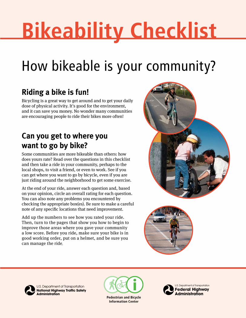
Bikeability ChecklistHow bikeable is your community?
Riding a bike is fun!Bicycling is a great way to get around and to get your daily dose of physical activity. It's good for the environment, and it can save you money. No wonder many communities are encouraging people to ride their bikes more often!
Can you get to where you want to go by bike?Some communities are more bikeable than others: how does yours rate? Read over the questions in this checklist and then take a ride in your community, perhaps to the local shops, to visit a friend, or even to work. See if you can get where you want to go by bicycle, even if you are just riding around the neighborhood to get some exercise.
At the end of your ride, answer each question and, based on your opinion, circle an overall rating for each question. You can also note any problems you encountered by checking the appropriate box(es). Be sure to make a carefulnote of any specific locations that need improvement.
Add up the numbers to see how you rated your ride. Then, turn to the pages that show you how to begin to improve those areas where you gave your community a low score. Before you ride, make sure your bike is in good working order, put on a helmet, and be sure you can manage the ride
.
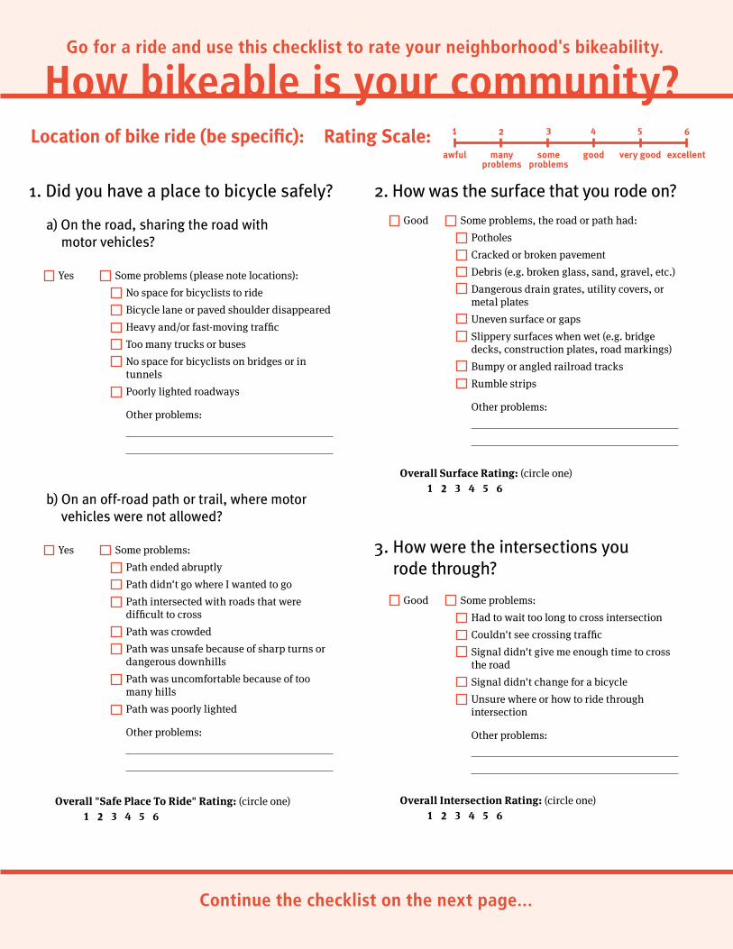
Go for a ride and use this checklist to rate your neighborhood's bikeability.
How bikeable is your community?Location of bike ride (be specific): Rating Scale: 1
awful
2
manyproblems
3
someproblems
4
good
5
very good
6
excellent
1. Did you have a place to bicycle safely?
a) On the road, sharing the road with motor vehicles?
Some problems (please note locations):
No space for bicyclists to ride
Bicycle lane or paved shoulder disappeared
Heavy and/or fast-moving traffic
Too many trucks or buses
No space for bicyclists on bridges or in tunnels
Poorly lighted roadways
Other problems:
Yes
Some problems:
Path ended abruptly
Path didn't go where I wanted to go
Path intersected with roads that were difficult to cross
Path was crowded
Path was unsafe because of sharp turns or dangerous downhills
Path was uncomfortable because of too many hills
Path was poorly lighted
Other problems:
b) On an off-road path or trail, where motor vehicles were not allowed?
Overall "Safe Place To Ride" Rating: (circle one)1 2 3 4 5 6
2. How was the surface that you rode on?
Good Some problems, the road or path had:
Potholes
Cracked or broken pavement
Debris (e.g. broken glass, sand, gravel, etc.)
Dangerous drain grates, utility covers, or metal plates
Uneven surface or gaps
Slippery surfaces when wet (e.g. bridge decks, construction plates, road markings)
Bumpy or angled railroad tracks
Rumble strips
Other problems:
Overall Surface Rating: (circle one)1 2 3 4 5 6
3. How were the intersections you rode through?
Good Some problems:
Had to wait too long to cross intersection
Couldn't see crossing traffic
Signal didn't give me enough time to cross the road
Signal didn't change for a bicycle
Unsure where or how to ride through intersection
Other problems:
Overall Intersection Rating: (circle one)1 2 3 4 5 6
Continue the checklist on the next page…
Yes
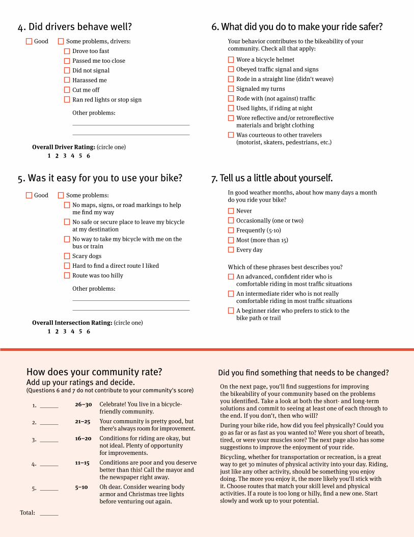
4. Did drivers behave well?Good Some problems, drivers:
Drove too fast
Passed me too close
Did not signal
Harassed me
Cut me off
Ran red lights or stop sign
Other problems:
Overall Driver Rating: (circle one)1 2 3 4 5 6
5. Was it easy for you to use your bike?
Good Some problems:
No maps, signs, or road markings to help me find my way
No safe or secure place to leave my bicycle at my destination
No way to take my bicycle with me on the bus or train
Scary dogs
Hard to find a direct route I liked
Route was too hilly
Other problems:
Overall Intersection Rating: (circle one)1 2 3 4 5 6
6. What did you do to make your ride safer?
Wore a bicycle helmet
Obeyed traffic signal and signs
Rode in a straight line (didn't weave)
Signaled my turns
Rode with (not against) traffic
Used lights, if riding at night
Wore reflective and/or retroreflective materials and bright clothing
Was courteous to other travelers (motorist, skaters, pedestrians, etc.)
Your behavior contributes to the bikeability of your community. Check all that apply:
7. Tell us a little about yourself.
Never
Occasionally (one or two)
Frequently (5-10)
Most (more than 15)
Every day
In good weather months, about how many days a month do you ride your bike?
An advanced, confident rider who is comfortable riding in most traffic situations
An intermediate rider who is not really comfortable riding in most traffic situations
A beginner rider who prefers to stick to the bike path or trail
Which of these phrases best describes you?
How does your community rate? Add up your ratings and decide. (Questions 6 and 7 do not contribute to your community's score)
1. 26–30 Celebrate! You live in a bicycle- friendly community.
2. 21–25 Your community is pretty good, but there's always room for improvement.
3. 16–20 Conditions for riding are okay, but not ideal. Plenty of opportunity
for improvements.
4. 11–15 Conditions are poor and you deserve better than this! Call the mayor and
the newspaper right away.
5. 5–10 Oh dear. Consider wearing body armor and Christmas tree lights before venturing out again.
Total:
Did you find something that needs to be changed?
On the next page, you'll find suggestions for improving the bikeability of your community based on the problems you identified. Take a look at both the short- and long-term solutions and commit to seeing at least one of each through to the end. If you don't, then who will?
During your bike ride, how did you feel physically? Could you go as far or as fast as you wanted to? Were you short of breath, tired, or were your muscles sore? The next page also has some suggestions to improve the enjoyment of your ride.
Bicycling, whether for transportation or recreation, is a great way to get 30 minutes of physical activity into your day. Riding, just like any other activity, should be something you enjoy doing. The more you enjoy it, the more likely you'll stick with it. Choose routes that match your skill level and physical activities. If a route is too long or hilly, find a new one. Start slowly and work up to your potential.
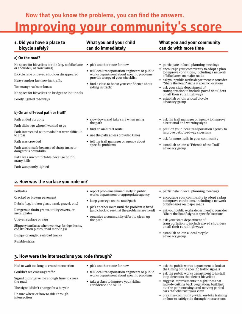
Now that you know the problems, you can find the answers.
Improving your community's score1. Did you have a place to bicycle safely?
What you and your child can do immediately
What you and your community can do with more time
a) On the road?
No space for bicyclists to ride (e.g. no bike lane or shoulder; narrow lanes)
Bicycle lane or paved shoulder disappeared
Heavy and/or fast-moving traffic
Too many trucks or buses
No space for bicyclists on bridges or in tunnels
Poorly lighted roadways
• pick another route for now
• tell local transportation engineers or publicworks department about specific problems; provide a copy of your checklist
• find a class to boost your confidence about riding in traffic
• participate in local planning meetings• encourage your community to adopt a plan
to improve conditions, including a network of bike lanes on major roads
• ask your public works department to consider "Share the Road" signs at specific locations
• ask your state department of transportation to include paved shoulders on all their rural highways
• establish or join a local bicycle advocacy group
b) On an off-road path or trail?
Path ended abruptly
Path didn't go where I wanted to go
Path intersected with roads that were difficult to cross
Path was crowded
Path was unsafe because of sharp turns or dangerous downhills
Path was uncomfortable because of too many hills
Path was poorly lighted
• slow down and take care when using the path
• find an on-street route
• use the path at less crowded times
• tell the trail manager or agency about specific problems
• ask the trail manager or agency to improve directional and warning signs
• petition your local transportation agency to improve path/roadway crossings
• ask for more trails in your community
• establish or join a "Friends of the Trail" advocacy group
2. How was the surface you rode on?
Potholes
Cracked or broken pavement
Debris (e.g. broken glass, sand, gravel, etc.)
Dangerous drain grates, utility covers, or metal plates
Uneven surface or gaps
Slippery surfaces when wet (e.g. bridge decks, construction plates, road markings)
Bumpy or angled railroad tracks
Rumble strips
• report problems immediately to public works department or appropriate agency
• keep your eye on the road/path
• pick another route until the problem is fixed (and check to see that the problems are fixed)
• organize a community effort to clean up the path
• participate in local planning meetings
• encourage your community to adopt a plan to improve conditions, including a network of bike lanes on major roads
• ask your public works department to consider "Share the Road" signs at specific locations
• ask your state department of transportation to include paved shoulders on all their rural highways
• establish or join a local bicycle advocacy group
3. How were the intersections you rode through?
Had to wait too long to cross intersection
Couldn't see crossing traffic
Signal didn't give me enough time to cross the road
The signal didn't change for a bicycle
Unsure where or how to ride through intersection
• pick another route for now
• tell local transportation engineers or public works department about specific problems
• take a class to improve your riding confidence and skills
• ask the public works department to look at the timing of the specific traffic signals
• ask the public works department to install loop-detectors that detect bicyclists
• suggest improvements to sightlines that include cutting back vegetation; building out the path crossing; and moving parked cars that obstruct your view
• organize community-wide, on-bike training on how to safely ride through intersections
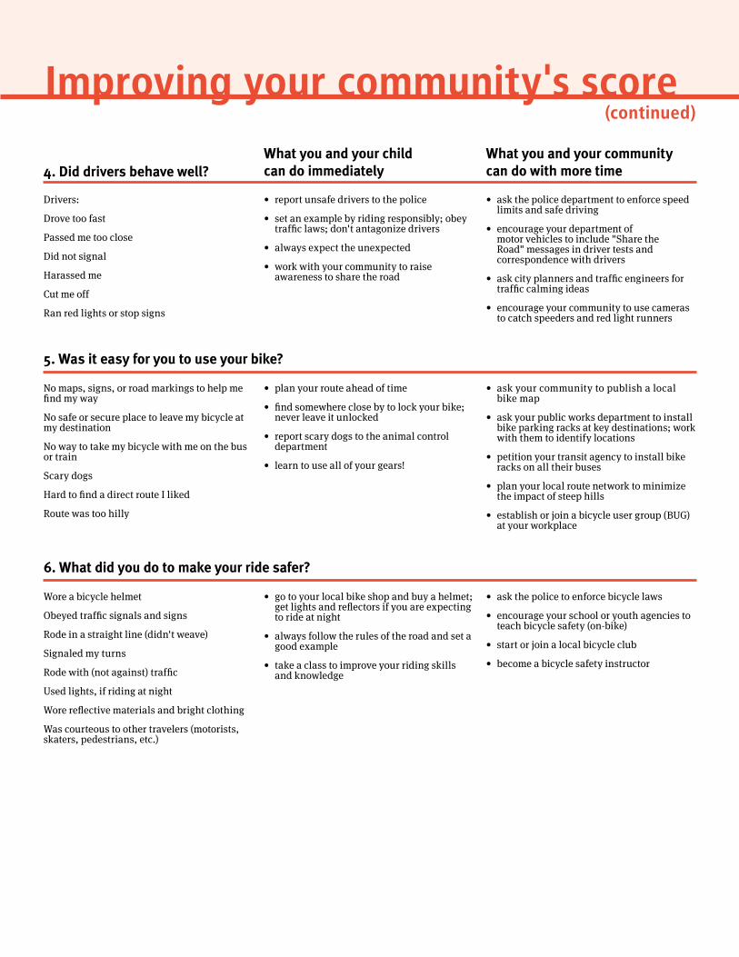
Improving your community's score(continued)
4. Did drivers behave well?What you and your child can do immediately
What you and your community can do with more time
Drivers:
Drove too fast
Passed me too close
Did not signal
Harassed me
Cut me off
Ran red lights or stop signs
• report unsafe drivers to the police
• set an example by riding responsibly; obey traffic laws; don't antagonize drivers
• always expect the unexpected
• work with your community to raise awareness to share the road
• ask the police department to enforce speed limits and safe driving
• encourage your department of motor vehicles to include "Share the Road" messages in driver tests and correspondence with drivers
• ask city planners and traffic engineers for traffic calming ideas
• encourage your community to use cameras to catch speeders and red light runners
5. Was it easy for you to use your bike?
No maps, signs, or road markings to help me find my way
No safe or secure place to leave my bicycle at my destination
No way to take my bicycle with me on the bus or train
Scary dogs
Hard to find a direct route I liked
Route was too hilly
• plan your route ahead of time
• find somewhere close by to lock your bike; never leave it unlocked
• report scary dogs to the animal control department
• learn to use all of your gears!
• ask your community to publish a local bike map
• ask your public works department to install bike parking racks at key destinations; work with them to identify locations
• petition your transit agency to install bike racks on all their buses
• plan your local route network to minimize the impact of steep hills
• establish or join a bicycle user group (BUG) at your workplace
6. What did you do to make your ride safer?
Wore a bicycle helmet
Obeyed traffic signals and signs
Rode in a straight line (didn't weave)
Signaled my turns
Rode with (not against) traffic
Used lights, if riding at night
Wore reflective materials and bright clothing
Was courteous to other travelers (motorists, skaters, pedestrians, etc.)
• go to your local bike shop and buy a helmet; get lights and reflectors if you are expecting to ride at night
• always follow the rules of the road and set a good example
• take a class to improve your riding skills and knowledge
• ask the police to enforce bicycle laws
• encourage your school or youth agencies to teach bicycle safety (on-bike)
• start or join a local bicycle club
• become a bicycle safety instructor
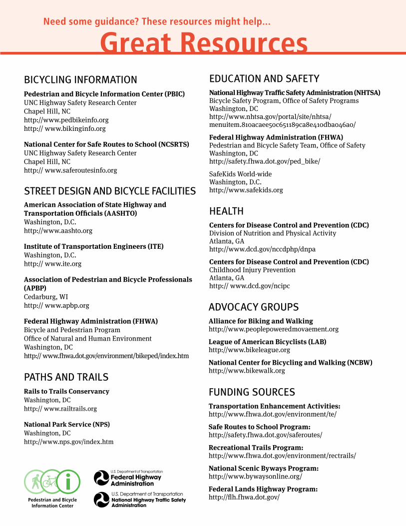
Need some guidance? These resources might help…
Great ResourcesBicycling infOrmATiOnPedestrian and Bicycle Information Center (PBIC) UNC Highway Safety Research Center Chapel Hill, NC http://www.pedbikeinfo.org http:// www.bikinginfo.org
National Center for Safe Routes to School (NCSRTS) UNC Highway Safety Research Center Chapel Hill, NC http:// www.saferoutesinfo.org
STrEET DESign AnD BicyclE fAciliTiESAmerican Association of State Highway and Transportation Officials (AASHTO) Washington, D.C. http://www.aashto.org
Institute of Transportation Engineers (ITE) Washington, D.C. http:// www.ite.org
Association of Pedestrian and Bicycle Professionals(APBP) Cedarburg, WI http:// www.apbp.org
Federal Highway Administration (FHWA) Bicycle and Pedestrian Program Office of Natural and Human Environment Washington, DC http:// www.fhwa.dot.gov/environment/bikeped/index.htm
PATHS AnD TrAilSRails to Trails Conservancy Washington, DC http:// www.railtrails.org
National Park Service (NPS) Washington, DC http://www.nps.gov/index.htm
EDucATiOn AnD SAfETyNational Highway Traffic Safety Administration (NHTSA) Bicycle Safety Program, Office of Safety Programs Washington, DC http://www.nhtsa.gov/portal/site/nhtsa/ menuitem.810acaee50c651189ca8e410dba046a0/
Federal Highway Administration (FHWA) Pedestrian and Bicycle Safety Team, Office of Safety Washington, DC http://safety.fhwa.dot.gov/ped_bike/
SafeKids World-wide Washington, D.C. http://www.safekids.org
HEAlTHCenters for Disease Control and Prevention (CDC) Division of Nutrition and Physical Activity Atlanta, GA http://www.dcd.gov/nccdphp/dnpa
Centers for Disease Control and Prevention (CDC) Childhood Injury Prevention Atlanta, GA http:// www.dcd.gov/ncipc
ADvOcAcy grOuPSAlliance for Biking and Walking http://www.peoplepoweredmovaement.org
League of American Bicyclists (LAB) http://www.bikeleague.org
National Center for Bicycling and Walking (NCBW) http://www.bikewalk.org
funDing SOurcESTransportation Enhancement Activities: http://www.fhwa.dot.gov/environment/te/
Safe Routes to School Program: http://safety.fhwa.dot.gov/saferoutes/
Recreational Trails Program: http://www.fhwa.dot.gov/environment/rectrails/
National Scenic Byways Program: http://www.bywaysonline.org/
Federal Lands Highway Program: http://flh.fhwa.dot.gov/
Cornell Local Roads Program Streets 97
Appendix v – resourcesEntries listed alphabetically by organization.
STATe And nATionAL orgAniZATionS
American Association of State and Highway Transportation Officials (AASHTO)www.transportation.org
Guide for the Development of Bicycle Facilities. American Association of State Highway and Transportation Officials: Washington D.C. 1999. Note that a new edition is forthcoming.
Guide for the Planning, Design, and Operation of Pedestrian Facilities. American Association of State Highway and Transportation Officials: Washington D.C. July 2004
AASHTO Statewide Comprehensive Outdoor Recreation Plan
Association of bicycle and pedestrian professionalswww.apbp.org
Cornell Local roads programwww.clrp.cornell.edu
Cornell Bicycle and Pedestrian Homepagewww.bike.cornell.edu
An Organizer’s Guide to Bicycle Rodeos, Lois Chaplin. Publication No. L-2-19 Version
www.bike.cornell.edu/pdfs/Bike_Rodeo_404.2.pdf
Federal highway Administration (FhWA)www.fhwa.dot.gov
Accommodating Bicycle and Pedestrian Traffic: A Recommended Approachwww.fhwa.dot.gov/environment/bikeped/design.htm
Designing Sidewalks and Trails for Access Best Practices Design Guide. Federal Highway Administration: Washington, D.C. September 2001
Pedestrian and Bicycle Crash Types of the Early 1990’s, W.H. Hunter, J.C. Stutts, W.E. Pein, and C.L. Cox. Publication No. FHWA-RD-95-163. Federal Highway Administration: Washington, DC. June 1996
Cornell Local Roads Program98
Complete Streets
Pedestrian Safety Guide and Countermeasure Selection Systemwww.walkinginfo.org/pedsafe
Safe Routes to Schoolsafety.fhwa.dot.gov/saferoutes
Good Practices Guide for Bicycle Safety Educationhttp://www.bicyclinginfo.org/library/details.cfm?id=2066
Course on Bicycle and Pedestrian Transportationhttp://safety.fhwa.dot.gov/ped_bike/univcourse/instrtoc.cfm#toc
National Highway Traffic Safety Administration (NHTSA)http://www.nhtsa.gov/
A Study of Bicycle/Motor Vehicle Accidents: Identification of Problem Types and Countermeasure Approaches, Volume I, K.D. Cross and G Fisher. Publication No. DOT HS-803 315. National Highway Traffic Safety Administration: Washington, DC. 1977
“Traffic Safety Facts 2004” A Compilation of Motor Vehicle Crash Data from the Fatality Analysis Reporting System and the General Estimates Systemwww-nrd.nhtsa.dot.gov/pdf/nrd-30/NCSA/TSFAnn/TSF2004.pdf
new york State department of motor vehicles (nySdmv)www.nydmv.state.ny.us
Governor’s Traffic Safety Committeewww.nysgtsc.state.ny.us
Ticket and Crash Data Reportswww.nysgtsc.state.ny.us/hsdata.htm
NYS Vehicle & Traffic Law Excerptswww.nysgtsc.state.ny.us/bike-vt.htm
new york State department of Transportation (nySdoT)https://www.dot.ny.gov/index?nd=nysdot
NYSDOT Bicycling in NYShttps://www.dot.ny.gov/divisions/operating/opdm/local-programs-bureau/biking?nd=nysdot
Pedestrian Informationhttps://www.dot.ny.gov/modal/pedestrian
Highway Design Manualhttps://www.dot.ny.gov/portal/page/portal/divisions/engineering/design/dqab/hdm?nd=nysdot
Cornell Local Roads Program Streets 99
Appendix V – Resources
Highway Design Manual, Chapter 17: Bicycle Facility Design, Revision 49. March 30, 2006
Highway Design Manual, Chapter 18: Pedestrian Facility Design, Revision 49. March 30, 2006
Highway Design Manual, Chapter 25: Traffic Calming, Revision 36. February 5, 2009 “Sharing the Road - New York State Bicycle and Pedestrian Laws”www.dot.state.ny.us/pubtrans/share.html
Engineering Instruction Documentshttps://www.dot.ny.gov/main/business-center/consultants/forms-publications-and-instructions/engineering-information-issuance-system
Engineering Instruction (EI) 02-015 – “Minimum Sidewalk Width on NYSDOT Highways and Bridges.”
Engineering Instruction (EI) 97-002 “Sidewalk Construction and Maintenance Policy for Projects and Highway Work Permits on State Highways.
Engineering Instruction (EI) 04-011 Procedural Requirements for Pedestrian Accommodation (also contains the official NYSDOT “Bicycle and Pedestrian Policy” and the “Pedestrian Generator Checklist” which is to be completed for all DOT projects prior to final design.)
Engineering Instruction document (EI) 04-038 “Design Guidance for Detectable Warnings at Curb Ramps and Other Pedestrian Crossings.”
A Smart Growth Checklisthttps://www.nysdot.gov/programs/smart-planning/repository/SGCheck_Development_Print.pdf
pedestrian and bicycle information Center (pbiC)www.pedbikeinfo.org
National Bicycling and Walking Study:http://www.bicyclinginfo.org/library/details.cfm?id=4541
Bicycle Parking Guidelineshttp://www.bicyclinginfo.org/engineering/parking.cfm
Bicycle Laws and Enforcementhttp://www.bicyclinginfo.org/enforcement/role.cfm
united States Access board A federal agency committed to accessible designwww.access-board.gov

Cornell Local Roads Program100
Complete Streets
AdvoCACy orgAniZATionS
Center for Community economic development, university of Wisconsin-extensionwww.uwex.edu/ces/cced/dma
Complete the Streetswww.completestreets.org
League of American bicyclists www.bikeleague.org
The League’s Bicycle Friendly Communities Program:https://www.bikeleague.org/programs/communities
maine bicycle Coalitionwww.bikemaine.org
new york bicycling Coalitionwww.nybc.net
parks and Trails new yorkwww.ptny.org
Getting Started: A Guide to Planning Trails in New York Statewww.ptny.org/publications/index.shtml#gsagtptnys
rails-to-Trails Conservancywww.railtrails.org
Trails for the Twenty-First Century, Ed. Karen-Lee Ryan. Rails-to-Trails Conservancy. Island Press: Washington, D.C. 1993
Safe routes to SchoolInternational Walk to Schoolwww.iwalktoschool.org
National Center for Safe Routes to Schoolwww.saferoutesinfo.orgwww.walktoschool.org
The Alliance for biking and Walkinghttp://www.peoplepoweredmovement.org/site/
Cornell Local Roads Program Streets 101
About the AuthorLois E. Chaplin is currently the Bicycle and Pedestrian Specialist for the Cornell Local Roads Program (CLRP) and for Cornell University. Prior to coming to CLRP in 2004, Lois was a state specialist for the Cornell Cooperative Extension 4-H Youth Development Program, where she conducted workshops and authored numerous publications pertaining to bicycle and pedestrian safety.
Her interest is in encouraging and enabling others to help make their communities more walkable and bikeable through education, enforcement, engineering and encouragement initiatives.
She holds a bachelor’s degree in elementary education from the State University College at Oswego, N.Y., and a master’s degree in communications from Cornell.
For more information about the topics covered in this manual, Lois may be contacted at the Cornell Local Roads Program:
Address: 416 Riley-Robb Hall Cornell University Ithaca, NY 15853
Phone: (607) 255-2498
Fax: (607) 255-8033
Email: [email protected]