comparing africa’s shared river basins – the limpopo ...749906/fulltext01.pdf · comparing...
TRANSCRIPT

Universal Journal of Geoscience 2(7): 200-211, 2014 http://www.hrpub.org DOI: 10.13189/ujg.2014.020703
Comparing Africa’s Shared River Basins – The Limpopo, Orange, Juba and Shabelle Basins
Abdullahi Elmi Mohamed
Department of Land and Water Resources Engineering, Royal Institute of Technology, Teknikringen 76, SE 100 44 Stockholm, Sweden *Corresponding Author: [email protected]
Copyright © 2014 Horizon Research Publishing All rights reserved.
Abstract The paper compares the Limpopo and Orange Rivers in Southern African Development Community (SADC), and the Juba and Shabelle Rivers in the Horn of Africa (HoA), which all are internationally shared basins. The aim is to identify differences and similarities between the river basins in the two regions in order to increase our knowledge and understanding of the issue of shared rivers. Relevant data were mainly collected and methods applied include document and literature review, text analysis, interviews with key professional persons during several study visits to the regions. Both the physical geography and the sectoral water uses of the rivers were presented and analyzed. Climatic similarities stand out when comparing the basins, as they are characterized by unevenly distributed rainfall patterns with great seasonal and annual variations, and the regions are water scarce. In both regions, the population is increasing, while the available water resource is decreasing. In all of the four basins, the regions are facing inevitable crisis of water scarcity. The river basins differ however primarily in terms of physical development of rivers’ water resources. The rivers in SADC have been developed for varieties of uses while the rivers in HoA are under-developed and under-utilized. The SADC rivers have established joint institutions for cross-border river cooperation while the HoA rivers have never had any type of river cooperation. Since the rivers have almost similar climatic and physical conditions, the legitimate research question in the future could be: what caused the differences in resource development and cooperation?
Keywords Limpopo River, Orange River, Juba River, Shabelle River, SADC, Horn of Africa, Water Resources
1. Introduction
Globally, there are 263 rivers that either cross or demarcate international political boundaries of two or more nations [1, 2]. Of these, 63 are in Africa, which has the largest number of shared rivers in the world [3]. The continent’s 63 shared river basins contain 65% of the area, 75% of the people and 93% of the surface water [3, 4]. Management of these common rivers presents a great challenge [5]. Southern Africa Development Community (SADC), an arid to semi-arid region [6], has 15 international rivers [7, 8]. Similarly, the Horn of Africa (HoA), another arid to semi-arid region, has also at least 15 shared watercourses [9]. The two regions’ most available water resources exist in these shared river systems. In both regions, there are growing water scarcity and water crises [10, 11, 12, 13, 14]. The major issue facing the management of those shared waters in the regions is access to and control over water resources.
Although there exists some literature on trends in international water management [15, 16, 17] and a growing body of research on conditions in Africa’s transboundary waters [5, 18, 19, 20, 21, 22, 23, 24], there is as yet no work examining differences and similarities between the rivers in the SADC and HoA regions.
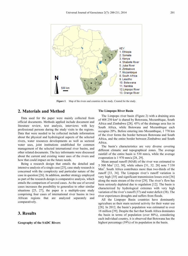
The overall purpose of the paper is to analyze the issue of international river basins by comparing shared river basins within Africa. The Limpopo and Orange Rivers in the SADC region and the Juba and Shabelle Rivers in the HoA region (see Figure 1) were selected as case studies as they are not compared before. As this comparison could increase our knowledge in the field and generate more understandings in issues relating to the management of freshwater resources in shared rivers, the paper will identify the most important differences and similarities between the selected river basins. Comparing the rivers could also shed some light on what lessons that could be learned as practice in one basin could be informative and useful example by the other basin particularly when planning resource development.
Universal Journal of Geoscience 2(7): 200-211, 2014 201
Figure 1. Map of the rivers and countries in the study. Created for the study.
2. Materials and Method
Data used for the paper were mainly collected from official documents. Methods applied include document and literature review, text analysis, interviews with key professional persons during the study visits to the regions. Data that were needed to be collected include information about the physical and hydrological aspects of the selected rivers, water resources developments as well as sectoral water uses, joint institutions established for common management of the selected international river basins, and other related documents. The key informants were discussed about the current and existing water uses of the rivers and how that could impact on the future needs.
Being a research design that entails the detailed and intensive analysis of a single case [25], case study research is concerned with the complexity and particular nature of the case in question [26]. In addition, another strategy employed as part of the research design is comparative analysis, which entails the comparison of several cases. As the use of several cases increases the possibility to generalize to other similar situations [25, 27], the paper is a multiple-case study comprising four cases of international river basins in two African regions that are analyzed separately and comparatively.
3. Results
Geography of the SADC Rivers
The Limpopo River Basin The Limpopo river basin (Figure 2) with a draining area
of 408 250 km² is shared by Botswana, Mozambique, South Africa and Zimbabwe [28]. 45% of the drainage area lies in South Africa, while Botswana and Mozambique each occupies 20%. Before entering into Mozambique, 1 770 km of the river forms the border between Botswana and South Africa, and the entire border between Zimbabwe and South Africa.
The basin’s characteristics are very diverse covering different climatic and topographical zones. The average rainfall of the entire basin is 530 mm/a, while the average evaporation is 1 970 mm/a [28, 29].
Mean annual runoff (MAR) of the river was estimated to 5 500 Mm3 [12, 30], while others [31, 32. 28] note 7 330 Mm3. South Africa contributes more than two-thirds of the runoff [33, 34]. The Limpopo river’s runoff variation is very high [35] and significant transmission losses exist [36] along the main stream of the river [29]. The river’s flow has been seriously depleted due to regulation [12]. The basin is characterized by hydrological extremes with very high variation of the river’s runoff (37) and water deficit (38). The river experiences droughts and suffers from floods.
All the Limpopo Basin countries have dominantly agriculture as their main sectoral activity for their water use [28]. In 2012, the basin’s population was estimated to over 18 million [39]. Despite the fact that South Africa dominates the basin in terms of population (over 80%), considering each individual country, it is observed that Botswana has the highest percentage (59%) of its population in the basin.

202 Comparing Africa’s Shared River Basins – The Limpopo, Orange, Juba and Shabelle Basins
Figure 2. Map of the Limpopo River Basin.
The Limpopo water resources have been developed for variety of uses including irrigation, domestic water supply and hydropower generation [8, 40]. In contrary to the Limpopo main stream, where no dams have been built [29], many major dam projects have been implemented on the tributaries [8, 40]. In the basin, 47 large dams with a storage capacity of more than 12 Mm3 have been build; 6 in Botswana, 1 in Mozambique, 29 in South Africa and 11 in Zimbabwe, with a total storage capacity of 7 000 Mm3. Of these, 17 have a storage capacity of more than 100 Mm3 (3 in Botswana, 1 in Mozambique, 11 in South Africa and 2 in Zimbabwe). The largest is the Massingir Dam (2 840 Mm3) on the Olifants tributary in Mozambique, although never fulfilled its potential as storage for irrigation or hydropower due to the civil war.
Irrigation is the greatest water user in the four Limpopo countries [28]. Potential irrigated areas in the basin is estimated to 295 400 ha [41]. Total estimated present demand is about 4 700 Mm3. Of which, 62% is in South Africa, 30% in Zimbabwe, 6% in Mozambique and 2% in Botswana. Although concentrated largely in South Africa, Zimbabwe and Mozambique have also large irrigated areas in the basin (ibid.). Mozambique is planning to put large agricultural lands in downstream areas of the basin under irrigation [28]. In parallel with the intentions to develop 30 000 ha on the banks of the Olifants tributary for sugar cane production [28], the country is planning to use the whole lower Limpopo for rice production.
There are several Inter-Basin Water Transfers Schemes (IBWTS) into the Limpopo River basin. The major transfers are from the Vaal River system (Orange) to the Crocodile tributary (Limpopo) and from the Incomati river to the Olifants river tributary of the Limpopo. A total volume of 695 Mm3 per annum is transferred into the basin from other basins, i.e. the Vaal, Usuthu and Komati basins. There are
also extensive plans for transferring water to the Bulawayo city of Zimbabwe from the Gwaai/Shangani River system. Within the Limpopo River basin inter-basin transfers also occurs from the Marico tributary in South Africa to Gaborone in Botswana as well as the transfer from the Shashe tributary via the Botswana’s North-South Carrier to Gaborone.
The Orange-Senqu River Basin
The Orange-Senqu river originates in the highlands of Lesotho, where it is known as Senqu. Running a distance of 2 300 km [42, 43], the river drains an area of about 1 000 000 km2 in Botswana, Lesotho, Namibia and South Africa (Figure 3). South Africa occupies 64% of the basin area while Botswana and Namibia occupy 8% and 24.5% respectively [44, 8, 40]. Before emptying into the Atlantic Ocean at Alexander Bay, the main stream of the Orange River forms the border between Namibia and South Africa.
The average annual rainfall of the entire basin is 330 mm [31, 38]. As the rainfall decreases dramatically as the river flows downstream towards the west [45], large amount of water (800 Mm3) is lost annually along the stretch (1 400 km) between the Vanderkloof dam and the river mouth. The Mean annual runoff (MAR) of the river is 11 600 Mm3 [46]. With its highly variable runoff, the river has it highest value (93%) of maximum yield in Lesotho [45]. Although South Africa dominates the basin both in terms of land area and runoff [8, 40], Lesotho, the most upstream country which falls entirely within the basin and occupies only 3.4% of the basin area, contributes 43% of the average natural annual runoff of the basin [45]. South African runoff contribution is about 50%, Namibia 5% while runoff from Botswana is negligible [45].

Universal Journal of Geoscience 2(7): 200-211, 2014 203
Figure 3. The Orange-Senqu River Basin
The Orange-Senqu water resources have been developed for variety of uses including irrigation, industry, hydropower and domestic supply [8]. In the Orange basin, 31 large dams with a storage capacity of more than 12 Mm3 have been build; 3 in Lesotho, 5 in Namibia and 23 in South Africa [8] and many of them are in a network of major IBWTS. As the river plays a major role in supporting agriculture, industry and mining in South Africa, development of the river was implemented under three massive projects – the Orange River Project, the Vaal River Development and the Lesotho Highlands Water project (LHWP) [40].
The basin’s population was in 2004 estimated to 19 million [47], with 81.7% in South Africa, 15.4% in Lesotho, 2.6% in Namibia and 0.3% in Botswana [48].
Geography of the HoA Rivers
The Juba River Basin The Juba River originates in the Bale Mountain in the
Ethiopian Highlands. Near the border with Somalia the three main tributaries of the river, the Genale, the Dawa and the Weyb meet to form what is known the Juba River inside Somalia. Including the Laag Dheera sub-basin, which drains mainly territories in Kenya, the Juba river basin has a drainage area of 452 000 km2 [49], see Figure 4. The Juba, which enters the Indian Ocean at Kismayo town in southern Somalia, has a total length of 1 808 km, of which 840 km lies in Ethiopia and 1 004 km in Somalia [49].
The average annual rainfall of the entire basin is about 500 mm [50]. The MAR of the river in Ethiopia is 6 600 Mm3 [50] and 6 200 Mm3 in Somalia [51]. Ethiopia contributes over 95% of the river’s total runoff [51, 52]. From over 1 500 mm of rainfall at higher altitudes in the mountains to less than 200 mm near the border, the the flow of the Juba river has
large annual variability [52, 53] and biannual flooding period [54]. Having an annual runoff which is almost three times higher than the Shabelle River, the river’s average flow is 200 m3/s [52].
Agriculture, which is the backbone of the Ethiopian economy, is also by far the most important sector in the basin, predominantly based on small scale, rain-fed subsistence agriculture [50]. Despite having an exploitable potential irrigation of 423 000 ha [55], there is no currently significant water use in the Genale-Dawa basin in Ethiopia. No storage reservoirs for hydropower generation or irrigation have been constructed in upstream areas of Ethiopia [56]. Ethiopia is, however, in a process of implementing unprecedented large scale water resources development projects in the basin [56]. As an outcome from the country’s Genale-Dawa River Basin Master Plan Study [50], 93 medium and large scale irrigation schemes with over one million hectares of potential irrigable land areas were proposed for irrigation, consuming a large amount of water available in the basin. The master plan has also identified 9 large dam projects for hydropower development to be implemented in different periods, from 2013 to 2035. As the hydropower potential of these dams is estimated to 1 300 MW, Ethiopia is planning to export hydropower to its neighboring countries to earn much needed foreign currency [50].
Like Ethiopia, agriculture is the most important sector in Somalia. Before the civil war and state-collapse in 1991, Somalia has succeeded to implement several schemes, irrigating 27 850 ha [56, 57]. These irrigation schemes, not currently in operation, demanded 2 838 Mm3 of water from the river [57]. In 1977, after many years of construction, Somali concluded the Fanole, the only dam on the Juba, for flood mitigation, hydropower production and irrigation. The civil war destroyed the dam.

204 Comparing Africa’s Shared River Basins – The Limpopo, Orange, Juba and Shabelle Basins
Figure 4. Map of the Juba and Shabelle basins [49].
Despite of these major projects, plans to make further water resources developments based on the Juba were in hand before Somalia became stateless in 1991. Being the country’s largest ever planned development project [57], the Juba Valley Development Master Plan was completed in 1989. The most important component was the Baardheere Dam Project, 75 m high, regulating the entire flow of the Juba River for flood. Regarded as a vital step towards food self-sufficiency and energy production, which received priority in development planning of Somalia, the Baardheere Dam Project, with its 5 700 Mm3 reservoir, would irrigate 120 000 ha, generate 140 MW hydroelectric power and mitigate floods [57]. The BDP, which applied funds from the World Bank, did not materialize for many reasons [56].
The Shabelle River Basin
Originating in the Ethiopian Highlands, the Shabelle river meanders in deep valleys with high hydropower potentials in Ethiopia. The Shabelle passes through an arid land in the eastern province of Ethiopia, the Ogaden, cutting wide valleys in southern Somalia. The river dries up near the mouth of the Juba River and it reaches the Juba River only in times of exceptional heavy rains and floods and thus discharging into the Indian Ocean. With a drainage area of 297 000 km2, the length of the river is about 2 526 km, of which half is in Somalia [49]. Nearly two-third (63.5%) of the basin area lies in Ethiopia.
With an average annual rainfall of 425 mm, the river’s MAR in Ethiopia is 3 387 Mm3 [58]. The figure decreases to 2 384 Mm3 at the Somali town of Belet-Weyne, near the border [52]. About 1 000 Mm3 is lost in evaporation and natural seepage in eastern desert of Ethiopia. The river’s
runoffs are entirely generated by catchments within Ethiopia [52, 58, 59], while Somalia’s portion of the basin has a negative net impact on the two rivers’ water budget [3]. With biannual flooding period [47], the river has an annual average flow of 75 m3/s [52].
The basin is predominantly rural in character with an economy dominated by rain-fed subsistence agriculture. Within the Shabelle basin, the current water use in Ethiopia is confined to one major dam and irrigation scheme [56]. The Melka Wakana dam with a storage capacity of 763 Mm3
generates 153 MW of hydropower electricity. The Gode irrigation project with a 17 km long canal has the capacity to irrigate 17 000 ha and diverge 46 m3/s of water in the semi-desert Ethiopian province of Ogaden.
In upstream Ethiopia, with potential irrigation estimated at 204 000 ha [55], 141 irrigation schemes with net irrigable areas of 209 310 ha were identified for irrigation development [55, 58]. The irrigation development plans with three phases from 2005 to 2035 were outcomes from the Wabi Shabelle River Basin Master Plan [58]. 6 large dams for hydropower together generating 1 000 MW and having combined storage capacities of over 10 000 Mm3 were selected for their capacity of water exploitation. The Master Plan includes also water supply for increasing and urbanized population of 15 million in Ethiopia.
In downstream areas in Somalia, large amount of the Shabelle water resources have been extensively utilized mainly for irrigation [56]. Before 1991, nine barrages were built in Somalia to regulate the Shabelle for irrigating nearly 200 000 hectares of land mainly along the river banks [60]. An off-stream facility with storage capacity of 200 Mm3 was also built in 1980 for flow regulation for downstream irrigation uses. These water infrastructures have been totally
Universal Journal of Geoscience 2(7): 200-211, 2014 205
destroyed during the country’s ongoing civil war and none of the schemes are operating. In Somalia, the Shabelle has no dams due to its topography and no suitable site for dam. In addition to the substantial use of the Shabelle waters in Somalia, the country had, before the civil war in 1991, plans to further increase utilization of the rivers’ water resources [56]. As the capacity to expand irrigation schemes remained high, development of over 250 000 ha of controlled irrigation were presented [61]. In the Shabelle basin, irrigation schemes totaling 88 282 ha were planned to be implemented. The planned irrigation development demanded 1 175 Mm3 of water available in the river [60].
Both rivers lose discharge as they progress downstream, due to a lack of rainfall in downstream areas, high evaporation and significant infiltration and withdrawals [62]. Despite being the largest basin of the Ethiopia’s twelve basins, covering one-fifth of country’s territory, the Shabelle has the least runoff [58, 55] and this meagre resource in Ethiopia is a major source of water for Somalia and one of the limiting factors for its development [56]. Due to its climate conditions, the basin is frequently affected by recurrent droughts and floods causing major problems to downstream communities in Somalia.
The two river basins could be considered as one large drainage basin with three sub-basins – the Shabelle, Juba and Laag Dheera. Somali is the furthest downstream to each of these. The country’s runoff contributions are usualy minimal. Ethiopia dominates the river basins in terms of basin area, river runoff as well as geographic position and population (ibid.). The Juba is the third largest basin in Ethiopia with less runoff compared to other basins in Ethiopia, but in Somalia it is the largest river in terms of runoff.
The two basins’ population is estimated to 30 million, with annual growth rate of over 3% [50, 51, 58]. Despite living in the three basin countries, majority of the basins’ population are ethnically Somalis, although they do not occupy upstream areas with the highest rainfalls [56]. Majority of the basins’ population is however in the Ethiopian part of the basins.
4. Discussion
Differences and Similarities between the River Basins
The Geographical Aspects
Climatologically, the river basins (all four) have similar characteristics in terms of climate and rainfall, and water availability, as their climates are determined by the north-easterly and south-easterly winds of the Inter-tropical Convergence Zone (ITCZ). With large variations in climate along their courses, the river basins have distinct dry and wet parts of their respective regions [45, 53, 58]. More importantly, their climate is characterized by a high variation between relatively wet and dry seasons of the years. In addition, overall evaporative capacity in the basins is considerably high. Hydrologically, this makes the basins water deficit. The middle reaches of the Limpopo and Juba-Shabelle similarly receive the lowest rainfall over the basins. In general, the SADC and HoA regions, and the basins in particular, are water scarce areas, and the all four basins are experiencing similar challenges in terms of water scarcity. Climatological similarities stand therefore out when comparing the regions of the four river basins.
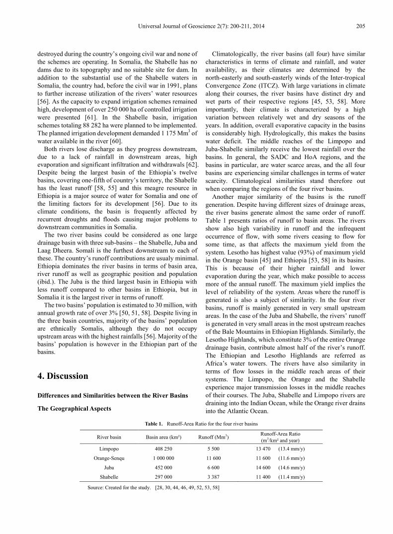
Another major similarity of the basins is the runoff generation. Despite having different sizes of drainage areas, the river basins generate almost the same order of runoff. Table 1 presents ratios of runoff to basin areas. The rivers show also high variability in runoff and the infrequent occurrence of flow, with some rivers ceasing to flow for some time, as that affects the maximum yield from the system. Lesotho has highest value (93%) of maximum yield in the Orange basin [45] and Ethiopia [53, 58] in its basins. This is because of their higher rainfall and lower evaporation during the year, which make possible to access more of the annual runoff. The maximum yield implies the level of reliability of the system. Areas where the runoff is generated is also a subject of similarity. In the four river basins, runoff is mainly generated in very small upstream areas. In the case of the Juba and Shabelle, the rivers’ runoff is generated in very small areas in the most upstream reaches of the Bale Mountains in Ethiopian Highlands. Similarly, the Lesotho Highlands, which constitute 3% of the entire Orange drainage basin, contribute almost half of the river’s runoff. The Ethiopian and Lesotho Highlands are referred as Africa’s water towers. The rivers have also similarity in terms of flow losses in the middle reach areas of their systems. The Limpopo, the Orange and the Shabelle experience major transmission losses in the middle reaches of their courses. The Juba, Shabelle and Limpopo rivers are draining into the Indian Ocean, while the Orange river drains into the Atlantic Ocean.
Table 1. Runoff-Area Ratio for the four river basins
River basin Basin area (km²) Runoff (Mm3) Runoff-Area Ratio (m3/km² and year)
Limpopo 408 250 5 500 13 470 (13.4 mm/y)
Orange-Senqu 1 000 000 11 600 11 600 (11.6 mm/y)
Juba 452 000 6 600 14 600 (14.6 mm/y)
Shabelle 297 000 3 387 11 400 (11.4 mm/y)
Source: Created for the study. [28, 30, 44, 46, 49, 52, 53, 58]

206 Comparing Africa’s Shared River Basins – The Limpopo, Orange, Juba and Shabelle Basins
In addition, the basins experience severe and prolonged drought conditions interrupted by devastating floods, which are increasingly becoming frequent and evident in the two regions [41, 52, 53, 58, 61, 63].
Botswana and Kenya are geographically part of the Orange and the Juba basins respectively but have no significant runoff contribution to the rivers. The most important condition for being a part of a transboundary basin is to be geographically part of the drainage basin, irrespective of having runoff contribution, human settlement, economic activities, etc. [8, 56]. Kenya did not, however, show interest when Somalia tried to undertake major water development projects in the basin in 1980s [64]. Kenya is however part of the basin and has, like Botswana in the Orange, a natural and legitimate right.
In geographical terms, the two sets of river basins in the two regions differ mainly how the rivers are formed. The Limpopo and Orange rivers are in many cases forming borders between the riparian states sharing them. The entire border (225 km) between South Africa and Zimbabwe is formed by the Limpopo. Part of the Botswana-Zimbabwe is formed by the Shashe tributary of the Limpopo. More than 90% of the border (1 840 km) between Botswana and South Africa follows rivers, including the Limpopo, Marico, Nossob and Molopo. The Caledon tributary of the Orange forms western border (200 km) between Lesotho and South Africa. Again, almost half of the border (450 km) between Namibia and South Africa is formed by the Orange river. These make the Limpopo and Orange mainly border rivers. In contrary, the Juba and Shabelle river are crossing border between Ethiopia and Somalia, except the Dawa tributary which forms small part of the border between Ethiopia and Kenya, creating significant upstream and downstream positions. Border rivers are more problematic to development, as they require high levels of cooperation.
In addition, the Orange river has two upstream states, Lesotho and South Africa and two downstream states, Namibia and South Africa, making South Africa both upstream and downstream riparian. In the case of the Limpopo, despite the fact that South Africa is the most upstream state, Botswana could also be regarded as upstream country. Zimbabwe is in a unique position as the country is not affected by the river’s developments in other riparian countries. Mozambique is the only downstream state of the Limpopo, a position which Somalia holds in its river basins. In the Juba and Shabelle basins, where Somalia is the only downstream state, Ethiopia is the only upstream state.
Because of their geographical positions in their respective basins, Mozambique and Somalia experience similar situations particularly in times of droughts and floods.
Being the upstream countries in their respective basins, Ethiopia and South Africa dominate in many decisive terms. Despite their similar geographical positions and dominances, the countries differ in terms of dependence on their respective rivers. Unlike Ethiopia, South Africa is very much dependent on the Limpopo and Orange rivers. In most of the countries, the river basins are, however, the largest watercourses either in terms of land areas or runoff.
Developmental and Water Use Aspects
Although water is a key and one of the limiting factors for the two regions’ development, and despite the fact they are almost similar in terms of physical characteristics, the rivers differ very much in terms of development. The major difference is that the rivers in the HoA are not utilized and developed to the same extent and level as the SADC rivers which are the most utilized and extensively developed rivers of Africa, as shown in Table 2. The Limpopo and Orange Rivers are highly developed, with many dams and transfer schemes. IBWTS in the southern African basins are evident economic features which do not exist in HoA. The LHWP, which is the world’s largest IBWTS, is in the Orange basin. Both the Shabelle and the Limpopo have no dams on their mainstream channels, but the difference is that the Limpopo’s intensive developments occurred on its major tributaries in all countries, except in Mozambique, which has the largest dam. The Limpopo and Orange rivers are close to their full development capacity [20, 31, 40]. Being the most regulated river of Africa, the Orange is at present nearly fully exploited for variety purposes. Despite of that, further developments for future uses are considered. Unlike the Limpopo and Orange, the Juba and Shabelle have mainly previous uses as there are no current water utilizations, mainly due to the Somali civil war, which destroyed the previously established infrastructures and water uses. There are no major water uses in Ethiopian. In all the rivers, there are plans to develop more water resources for variety of uses. In the cases of the Limpopo and Orange, most of the suitable sites for dams and irrigation schemes have already been developed, while the Juba and Shabelle seem to have a plenty of sites where potential resource development could take place, which are shown in Table 2.
Table 2. Dam development in the rivers
River basin No. of large dams Main Purposes Planned large dams
Limpopo 47 Irrigation, domestic and hydropower -
Orange-Senqu 31 Irrigation, domestic and hydropower -
Juba 1 Non-functioning (in Somalia) 10 (9 in Ethiopia)
Shabelle 1 Hydropower (not-fully functioning) 6 (all in Ethiopia)
Source: Created for the study. [8, 40, 56]

Universal Journal of Geoscience 2(7): 200-211, 2014 207
In all the river basins, agriculture is a primary consumer of water and major contributor to the basin countries’ economy. As agriculture is the main economy of the four basins, the waters of the basins are mainly used for irrigation. While the agricultural economy in the Juba and Shabelle is predominately based on rain-fed subsidence farming, the Limpopo and Orange basins have large scale irrigation schemes. In addition to the agricultural uses in the form of irrigation, the Limpopo and Orange waters are also used for hydropower production, industries and urban supplies, which the Juba and Shabelle are currently lacking.
Although all the four river basins are having similar challenges in terms of increasing population growth, the HoA basins do not have any major human settlements, like those in the SADC such as Johannesburg, Pretoria, Gaborone, Bloemfontein, Maseru, Pietersburg, Francistown and Xai Xai, which all fall within the drainage areas of the Limpopo and the Orange basins. As majority of the basins’ population are in rural areas, the HoA basins are therefore much less urbanized and this means that there are no major urban consumption in the Juba and Shabelle basins.
One of the issues that affect water planning and development is the existences and availability of relevant water-related data, such as hydrological data. In the SADC basins, there exist wide ranges of water-related data while the HoA basins lack primarily important data that could contribute to common planning of the shared resources.
Considering restoration of the previous but non-existing uses in Somalia and taking into account the proposed uses by the basin countries, the sum of the resources utilizations of the Juba and Shabelle is likely to exceed the rivers’ available supplies [56]. Although the rivers are currently under-utilized due to their low level of physical developments, the Juba and Shabelle countries are making over-planning of the common resources far beyond the capacity of existing supplies. Before the Somali state collapse, the Shabelle River intensively used much of its available water resources for irrigation developments along the river banks. Despite the fact that there are proposals to make intensive increases of water utilization in the HoA basins, still no such plans have been implemented. The Ethiopian plans to undertake major development projects in the Shabelle during 1950s, 1970s and now 2005 have not yet materialized due to economic and political reasons. Similarly, the plans of the Somali government during 1980s to increase the utilization of the Juba and Shabelle waters were hampered mainly by the country’s political crisis. The rivers’ previous uses in downstream Somalia and proposed uses in upstream Ethiopia need to be examined in the context of the equitable utilization of the common resources without causing significant harms.
Due to its upstream geographical location, South Africa is the country that links the other countries in the Limpopo and Orange basins. Ethiopia can play similar role in the HoA. Lesotho used water as one of its strongest resources to leverage and empower itself and also establish strong cooperation with its neighbours. Ethiopia with its similar
geographical position could supply regulated water to its downstream neighbours for their mutual benefits.
Somalia’s heavy reliance on the Juba and Shabelle Rivers [56, 57] makes water development plan in Ethiopia of great concern to Somalia. The Ethiopian plans will be challenged when Somalia attempts to restore its previous uses of the two rivers by rehabilitating the destroyed water infrastructures on the two rivers and launch previous plans for more development of the rivers’ waters. It is only then the two countries face real challenges of their river water management. Unlike the Juba and Shabelle, which are important mainly for downstream Somalia, the Limpopo and Orange have almost equal importance for their riparian states. In cases of the Limpopo and Orange, the rivers carry South Africa’s most important water resources. The Juba and Shabelle are not in similar position in their upstream riparian, Ethiopia. Despite the fact that the basins have Ethiopia’s least water resources, they yet occupy the country’s largest part containing the largest potential irrigable land. The rivers are very far from areas of human concentrations and economic growth. With its 12 rivers crossing borders to its neighboring countries, Ethiopia possesses considerable water resources potential for hydropower and large-scale irrigation. Mozambique and Somalia, with their potential irrigation areas in the lower reaches of their respective basins, are in critical need for access to continued flows of the rivers’ waters for their economic and ecological survivals.
Institutional Development for River Cooperation
The SADC Basins
The waters in the Limpopo and Orange rivers are regulated by a number of bilateral and multilateral agreements signed in different periods of time, before and after the South African apartheid regime’s fall [8, 40]. Two multilateral river commissions; one for each basin, have been established and operationalized [10]. The Limpopo basin has two bilateral river commissions and two multilaterals, while the Orange obtained two bilateral and one multilateral commission. Having a Revised Protocol on Shared Watercourses, the need for cooperation is widely recognized in the SADC region. Establishing the bilateral and multilateral river cooperation over the Limpopo and Orange basins improved the countries’ communication channels, and built trust between basin countries and common understanding of their shared water resources. Joint river studies and water development projects have been implemented in the basins [10, 40].
The HoA Basins
Unlike the SADC basins, the HoA rivers lack not only agreed principles for sharing waters but also platforms where the countries could present their concerns [56]. The Juba and Shabelle rivers have neither had bilateral nor multilateral

208 Comparing Africa’s Shared River Basins – The Limpopo, Orange, Juba and Shabelle Basins
cooperation of any form [57]. In contrary, the countries engaged in war and conflict since the colonial powers left the region in 1960s. These unresolved conflicts have hampered the region’s development potentials.
5. Conclusions Table 3 summarizes major similarities and differences
between the four river basins in the two African regions. Climatic similarities stand out when comparing the basins in the two regions. Both regions are characterized by numerous transboundary rivers, unevenly distributed rainfall patterns which are subject to great seasonal and annual variations, and scarcity of water resources. These characteristics present serious challenges for common and integrated management of the shared water resources. While the most significant similarities are found in physical and natural aspects of the river basins, the rivers differ primarily in terms of physical development of the water resources and institutional building for cross-border river cooperation.
Despite of their similar challenges in water resources,
states of the Limpopo and Orange basins established appropriate platforms, frameworks and forums for addressing issues of the common rivers. Taking advantages of the geographical interdependences, the inter-basin water transfer schemes in the SADC basins created conditions of regional economic complementarities and integration. Unlike the Limpopo and Orange, where large irrigation schemes and large dams for hydropower have been developed, the Juba and Shabelle contain large exploitable land for irrigation and potential sites for hydropower development, which could integrate the HoA region. As the water resources in the Juba and Shabelle rivers are draining out into the Indian Ocean, they provide more water resources development opportunities than those in the Limpopo and Orange. In the SADC region, there is a history of cooperation, as well as political will to mutually share the benefits of the common water resources in its international basins. The HoA basins are, in opposite to that, lacking not only physical development of the resources but also collaboration and commonly agreed principles of sharing and developing the rivers.
Table 3. Comparing key factors for the shared river basins in the study.
Parameter Limpopo Basin Orange Basin Juba Basin Shabelle Basin
Region Southern Africa Southern Africa Horn of Africa Horn of Africa
Form of river Forming and crossing borders Forming borders Crossing border Crossing border
Rainfall
Low and variable (average 530 mm)
(minimum 250 mm, maximum 1050 mm)
Low and variable (330 mm)
(minimum 50 mm, maximum 2000 mm)
Low and variable (500 mm)
(minimum 200 mm, maximum 1 500 mm)
Low and variable (425 mm)
(minimum 200 mm, maximum 1 300 mm)
Evaporation
Very high
(ranges from 1 600 mm – 2 600 mm)
Very high
(ranges from 1 400 mm – 2 200 mm)
Very high
(ranges from 1 300 mm – 2 300 mm)
Very high
(ranges from 1 300 mm – 2 300 mm)
Runoff Low with high variability
Low and variable
Low and variable
Low with high
variability
Water resources Scarce
Scarce
Scarce
Scarce
Population
Growing (18 million)
Growing
(19 million)
Growing
(17 million)
Growing
(13 million)
Water uses type
Irrigation, industry hydropower, domestic
Irrigation, industry
hydropower, domestic
Irrigation
Irrigation
Future demands/
planned uses
Domestic, industries and
irrigation
Domestic and industries
Hydropower, irrigation,
domestic
Irrigation and domestic
Level of water developments
Large scale water projects implemented
Large scale water projects implemented
Under-developed and under-utilized
Under-developed and under-utilized
Agreement
Bilateral and multi-lateral
Bilateral and multi-lateral
None
None
Joint river institutions
2 bilateral and 2
multilateral
3 bilateral and 1
multilateral
None
None

Universal Journal of Geoscience 2(7): 200-211, 2014 209
In both regions, the population is increasing, while the available water resource is decreasing. In all of the four basins, the regions are facing crisis due to water scarcity. The basins are in arid to semi-arid region, where water is of critical strategic importance and limiting factor for development.
It is evident that water management of any of the basin states is transboundary requiring cooperation, in order to reduce the risk for conflict and contribute to the development of the resources. For this reason, development on the upper parts of the Juba and Shabelle river basins cannot be made without considering effects further downstream. Being two upstream countries in their respective basins, Ethiopia and South Africa dominate the basins in many important terms. The two countries employed however two different approaches for securing water from their shared rivers, with two different outcomes. Evidently, one of the main differences between the river basins in the two regions of the same continent is lack of cooperation in the HoA region and existence of advanced cooperation in the SADC region. Contributing to understand other shared river basins, how similarities could minimize differences need to be studied. Relevant research question in this respect is therefore why there is river cooperation in SADC, and not in the HoA and what made that the water resources of the Limpopo and Orange are much more developed and utilized than the Juba and Shabelle waters. Another research question is how cooperation strategies could be transferred from the SADC rivers to the HoA rivers.
REFERENCES [1] Wolf, A., Natharius, J., Danielsson, J., Ward, B. & Pender, J.,
1999. International River Basins of the World. International Journal of Water Resources Development. 15, 4, 387-427.
[2] UNEP, 2002. Atlas of International Freshwater Agreements. United Nations Environment Program, Nairobi; Corvaliis, Oregon State University. p.7, 27.
[3] UNEP, 2010. Africa Water Atlas. p.38, 45.
[4] UNEP, 2005. Hydropolitical Vulnerability and Resilience along International Waters – Africa.
[5] Sadoff, Claudia, W.; Whittington, Dale; Grey, David, 2002. Africa’s International Rivers – An Economic Perspective. Washington, DC: World Bank. p. 3.
[6] Ashton, P., 2000 . Southern African Water Conflicts: Are they Inevitable or Preventable? In Solomon, H. and Turton, A. R. (Eds.) “Water Wars: Enduring Myth or Impending Reality?”. p. 67.
[7] Moyo, S. and Tevera, D. (Eds.), 2000. “Environmental Security in Southern Africa”. Environmental Policy Series, Southern Africa Regional Institute for Policy Studies (SARIPS), Harare. p.120.
[8] Elmi, Mohamed, A., 2001. Management of International Water Resources – A case study of legal and Institutional
Aspects of the Limpopo and Orange River Basins in southern Africa. KTH. p. 33.
[9] Elmi, Mohamed, A., 2013a. Water Scarcity in the Horn of Africa - A Threat to Security or an Incentive to Cooperation for Development. A paper presented at the Horn of African Conference in Lund, Sweden. 23 – 25 August, 2013.
[10] Elmi, Mohamed, A., 2014. Trans-boundary Water Management in the Limpopo and the Orange-Senqu River Basins of SADC – Bilateral Cooperation in Multilateral Frameworks. Water Alternatives, submitted.
[11] Turton A., Earle, A., Malzbender, D., Ashton, P., 2005. Hydropolitical Vulnerable and Resilience Along Africa’s International Waters. In UNEP (2005). Hydropolitical Vulnerability and Resilience along International Waters – Africa.
[12] Pallett, J., 1997. Sharing Water in Southern Africa. p. 60, 82-83, 84.
[13] Gleick, Peter, H., 1993. Water Water in crisis: A guide to the world's fresh water resources. Oxford UP.
[14] Engelman, R., & LeRoy, P., 1993. Sustainable water; population and the future of renewable water supplies. In Population and environment programme. Washington, DC: Population Action International.
[15] WCD (World Commission on Dams), 2000. Dams and Development a New Framework for Decision-Making. Earthscan, London.
[16] Hajer, M. 1996. The politics of environmental discourse: ecological modernization and the policy process. Oxford: Clarendon Press.
[17] Saleth, R. M. and Dinar, A., 2000. Institutional Changes in global water sector: trends, patterns, and implications. Water Policy 2: 175-199.
[18] Godana, B., 1985. Africa’s Shared Water Resources: Legal and Institutional Aspects of the Nile, Niger, and Senegal River Systems.
[19] Hirji, R. and Grey, D., 1998. Managing International Waters in Africa: Process and Progress. In: S.M. Salman and L.B.D. Chazournes (Editors), International Watercourses: Enhancing cooperation and managing conflict. Proceedings from a World Bank Seminar. Washington.
[20] Turton, A. R., 2003 . The political aspects of institutional development in the water sector: South Africa and its international river basins. Pretoria. p. 215.
[21] Kitissou, Marcel; Ndulo, Muna; Nagel, Mechthild; and Grieco, Margaret (eds.), 2007. The Hydropolitics of Africa. A Comtemporary Challenge.
[22] Okaru-Bisant, V., 1998. Institutional and Legal Frameworks for Preventing and Resolving Disputes Concerning the Development and Management of Africa’s Shared River Basins. Colorado Journal of International Environmental Policy.
[23] Rangeley, Robert, Bocar M. Thiam, Randolf A. Andersen and Colin A. Lyle., 1994. International River Basin Organizations in Sub-Saharan Africa. World Bank, Washington.
[24] UNECA, 2000. Transboundary River; Lake Basin Water Development in Africa: Prospects, Problems and

210 Comparing Africa’s Shared River Basins – The Limpopo, Orange, Juba and Shabelle Basins
Achievements. Addis Ababa.
[25] Bryman, Alan, 2012. Social research methods. Oxford University Press. 4th Edition. p. 46, 74, 76 709, 710.
[26] Stake, R. E., 1995. The art of the case study research. Thousand Oaks, CA: Stage.
[27] Merriam, S., B., 1994. Case Study Research in Education (Swedish title: Fallstudien som forskningsmetod). Studentlitteratur, Lund, Sweden. p.164-165
[28] DNA, 2010. Joint Limpopo River Basin Study Scoring Phase. Final Main Report. National Directorate of Water Affairs, Mozambique. On behave of LBPTC. p. 2.
[29] Boroto, R., A., Jean, and Görgens, Andreas, HM, 1999. Hydrological Modelling of the Limpopo River Main Stem. Limpopo River Hydrometric Study. p. 16-19.
[30] SADC, 2010. Transboundary River basins in SADC. Visited 18th February, 2014. http://www.limpoporak.com/en/river/geography/basins+of+southern+africa.aspx
[31] Conley, Alan H., 1995. “A synoptic view of water resources in Southern Africa.” of Southern Africa Foundation for Economic Research on Integrated Development of Regional Water Resources, Zimbabwe.
[32] Heyns, P., 1995. Existing and planned water development projects on international rivers within the SADC region. Paper at the Conference of SADC Ministers Responsible for Water, ‘Water Resources Management in Southern Africa. A Vision for the Future. 23-24 November, Pretoria.
[33] Water Research Commission, 1994. Surface Water Resources of South Africa 1990. (Authors) Midgley, D.C., Pitman, W.,V., and Middleton, B., J., Pretoria. Volumes I. Appendices and Book of Maps. Pretoria.
[34] Boroto, R., A., Jean, and Görgens, Andreas, HM, 1997. Limpopo River: Flow Balance Anomalies, Surprise and Implications for IWRM. National Hydrology Symposium.
[35] Mhizha, A., Musariri, M., Madamombe, E., and Tererai, 2011. Preliminary Water Resources Assessment for the Limpopo River Basin. University of Zimbabwe and National Water Authority. http://www.waternetonline.org/challengeprogram/IR29%20Mhizha%20prelim%20water%20res.pdf
[36] JPTC ‘Joint Permanent Technical Committee on Water Affairs’, 1991. Joint Upper Limpopo Basin Study. Stage I. Main Report. Joint Permanent Technical Committee on Water Affairs. Botswana and South Africa. p.14, 21.
[37] Conley, Alan H., 1994. The Water Resources of South Africa. In: Large Dams and Water Systems in South Africa. SANCOLD.
[38] Pitman, W., V., J Hudson, 1994. Report Prepared for the Development Banl of Southern Africa. “A Broad Overview of Present and Potential Water Resources Linkage in Southern Africa”.
[39] LIMCOM, 2013. The Limpopo River Basin Monograph Study. Executive Summary. Draft Final. Maputo.
[40] Elmi, Mohamed, A., 2003. Joint development and cooperation in international water resources, in: Nakayama, M. (Ed.), International Waters in Southern Africa. UNU. p.
237, 240.
[41] UN-HABITAT/UNEP, 2007. Limpopo Basin Strategic Plan for Reducing Vulnerability to Floods and Droughts. Draft for Discussion with Riparian Governments.
[42] WRP ‘Water Resources Planning’, 1999. Orange River Web Site. McKenzi, Ronnie. http://www-dwaf.pwv.gov.za/orange/default.htm
[43] Conley, A., and van Niekerk, P., 1998. Sustainable Management of international Waters: The orange River Case.
[44] ORESACOM, 2009. The River basin geography- Orange-Senque River Awareness Kit. http://www.orangesenqurak.com/river/Geography.aspx 4th November, 2013.
[45] DWAF ‘Dept of Water Affairs and Forestry of South Africa’, 1999. Orange River Development Project Replanning Study, Main Report. Pretoria.
[46] ORESACOM, 2007. Summary of Water Requirements from the Orange River. The Orange-Senqu River Commission (ORASECOM).70 pp.
[47] Earle, A., Malzbender, D., Turton, A. & Manzungu, E., 2005. A preliminary basin profile of the Orange-Senqu River. Pretoria.
[48] ORESACOM, 2011. Joint Baseline Survey-1: Baseline Water Resources Quality State of the Orange-Senqu River System in 2010. First Joint Basin Survey.
[49] SWALIM, 2010a. Atlas of the Juba and Shabelle Rivers in Somalia. SWALIM, Nairobi. p. 2, 3.
[50] MWR, 2007a. Genale-Dawa river basin integrated resource development master plan study. Volume II.1 Hydrology and Climate. p. 8, 64, 171, 173.
[51] MJVD “Ministry of Juba Valley Development, Somalia”, 1990. Master plan for Juba Valley Development. Annex 1 Water. p. 33, 50.
[52] FAO, 1989. A Brief Description Major Drainage Basins Affecting Somalia. National Water Centre, Mogadishu.
[53] MWR, 2007b. Genale-Dawa river basin integrated resource development master plan study. Final Report. Volume I.1 Main Report. p. 90, 128, 132.
[54] Artan, G., Gadain, H., Muthusi, F., Muchiri, P., 2007. Improving flood forecasting and early warning in Somalia – a feasibility study. FAO-SWALIM.
[55] WAPCOS (Water & Power Consultancy Services), 1990. Preliminary Water Resources Development Master Plan for Ethiopia. Addis Abeba.
[56] Elmi, Mohamed, A., 2013b. Managing Shared Basins in the Horn of Africa – Ethiopian Projects on the Juba and Shabelle Rivers and Downstream Effects in Somalia. Natural Resources and Conservation 1(2): 35-49.
[57] Elmi, Mohamed, A., and Iman, M., Hussien, 2010. Hydropolitics in the Horn of Africa – Conflict and required cooperation in the Jubba and Shabelle Rivers. In: Bernard, Calas & C. A. Mumma Martinon (eds.). Shared waters, shared opportunities: Hydropolitics in East Africa. p. 37–52.
[58] MWR, (Ministry of water resources, Ethiopia), 2004. Wabi Shabelle River Basin Integrated Development Master Plan

Universal Journal of Geoscience 2(7): 200-211, 2014 211
Study Project. Volume I. Main Report. p. 27, 114, 122.
[59] Basnyat, D. B., 2007. Water resources of Somalia. FAO- SWALIM, Nairobi.
[60] SWALIM, 2010b. Somali water and land resources – Calling for attention. Nairobi. p. 57-67.
[61] Somalia, 1979. Present and Future Irrigated Agriculture in the Shabelle and Juba River Basins. Rome. p. 29, 30.
[62] Thiemig, V., 2009. Early Flood Warning in Africa: Are the
Methodologies of the European flood Alert System (EFAS) Transferable to African Basins? – A Feasibility Study in the Juba-Shabelle River Basin.
[63] INGC, (2003). Atlas for Disaster Preparedness and Response in the Limpopo Basin. Instituto Nacional DE Gestao de Calamidades, Mozambique. Cape Town. p.10, 11.
[64] Salman, M., Salman, 2011. The Baardhere Dam and Water Infrastructure Project in Somalia—Ethiopia's objection and the World Bank response. Hydrological