comparative places · winning the gigatown competition in 2014 - giving it the fastest internet in...
TRANSCRIPT
0
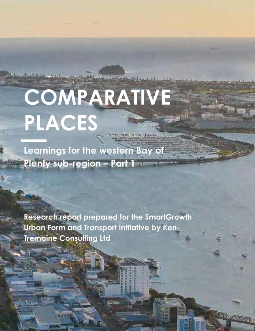
Learnings for the western Bay of
Plenty sub-region – Part 1
COMPARATIVE
PLACES
Research report prepared for the SmartGrowth
Urban Form and Transport Initiative by Ken
Tremaine Consulting Ltd

1
Comparative Places
Introduction
PURPOSE
The purpose of this report is to identify comparable places to the western Bay of Plenty sub-region (Tauranga
City and Western Bay of Plenty District Council) that have undergone growth and intensification over the last
15 to 20 years. This work considers the planning tools, levers and decisions that were used and made to
achieve the current urban form.
Ken Tremaine Consulting has been asked to undertake this work for the SmartGrowth Urban Form and
Transport Initiative (UFTI).
TWO PHASES
This project has two phases. The first phase involves identifying eight key comparable places based on the
criteria outlined in the methodology below. This phase will identify at a high level what the key success factors
were for these places. Recommendations are then made on three areas to investigate further in more detail.
This will form phase 2 of the project.
WHAT IS MEANT BY PLACE?
Place can refer to a sub-region, city, locality, suburb or neighbourhood area. The intention is to consider places
that have similarities to the western Bay of Plenty sub-region and can provide insights in terms of how growth
has been managed.
Ph
ase
1 Eight comparable places - high level success factors & learnings
Ph
ase
2 Three comparable places -detailed analysis

2
Methodology This work is a desktop analysis and involves making use of information that already exists as well as contacting key individuals and organisations who can provide insights into the areas. In order to identify the initial eight places, the following general methodology or filter has been used.
Choosing the Eight Places The following places have been selected for a high-level analysis:
▪ Dunedin City, New Zealand ▪ Porirua City, New Zealand ▪ Hobsonville Point, Auckland, New Zealand ▪ Maroochydore, Sunshine Coast, Queensland, Australia ▪ Springfield, Queensland, Australia ▪ Parramatta City, New South Wales, Australia ▪ Newcastle City, New South Wales, Australia ▪ Cardiff, Wales, United Kingdom
Learnings
Does the area offer learnings in terms of place-making, growth management, achieving a quality urban form, addressing transport challenges etc
Relevance to Sub-region
Is the area comparable on some factors to the sub-region? (population, growth rates, demographics, geography, urban form, features/facilites, similar challenges)
Information
Is the information easy to find and access?

3
All of the places listed above have information that is easy to find and access in order to inform a high level
overview.
REASONS FOR CHOOSING THE EIGHT PLACES
There are many places that could have been selected for comparison with the western Bay of Plenty. We have
attempted to provide a range of areas that will provide a picture if taken together of the various success
factors and learnings.
There is a very heavy emphasis on New Zealand and Australia given the similar jurisdictions, planning and legal
frameworks among other things.
Some of the places chosen are still under development so the analysis has been undertaken in terms of what is
there now and what is proposed or planned for along with what has worked well to date.
Place Reasons
Dunedin City, New Zealand ▪ Similar population to the western Bay of Plenty at 129,000
▪ Recent population growth ▪ Growing public transport use ▪ Infrastructure challenges ▪ Has some similar geographic constraints to the
western Bay of Plenty ▪ University and hospital
Porirua City, New Zealand ▪ Similar geography / urban form with harbours and hilly terrain
▪ Cannons Creek redevelopment – an example of regeneration with the provision of state housing and affordable housing
▪ Includes a lower socio-economic demographic
Hobsonville Point, Auckland, New Zealand ▪ New comprehensive development example (planned community)
▪ Example of higher density greenfield development ▪ High growth rates ▪ Similar urban form components such as the harbour
Maroochydore, Sunshine Coast, Queensland, Australia
▪ Strong growth ▪ Sun belt area ▪ Ageing population ▪ Major commercial area for the Sunshine coast ▪ Location of a major bus interchange ▪ Relocation of golf course has allowed the
development of a new city centre ▪ Has a new sustainable residential and commercial
development that has revitalised the town centre ▪ Has an independent Board of Directors to drive the
development - SunCentral Maroochydore Pty Ltd (owned by the Council)
Springfield, Queensland, Australia ▪ Strong growth – one of the fastest growing developments in Australia
4
▪ Private development example (first privately built city in Australia and the country’s largest master planned community)
▪ Significant public transport planned (eg new passenger rail line to Ipswich)
▪ Involved lead rail public transport infrastructure (between Brisbane and Springfield)
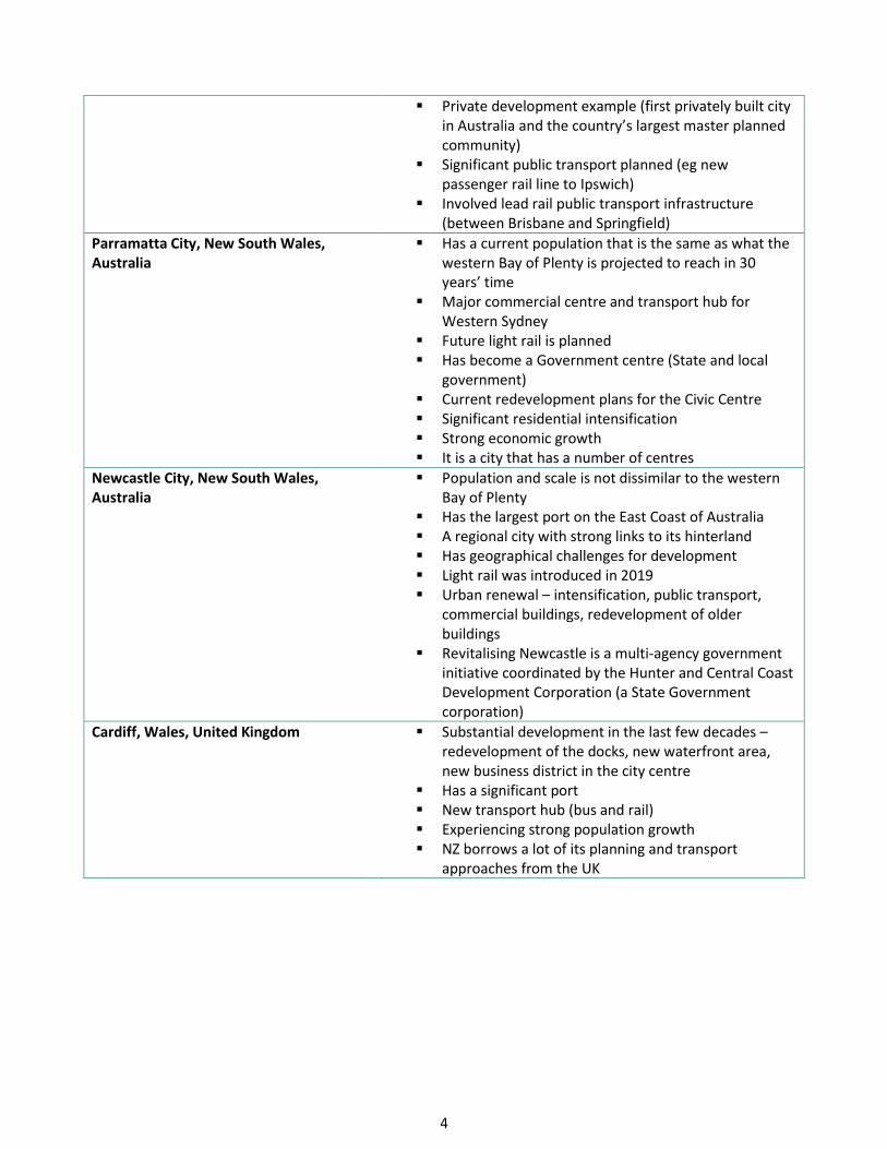
Parramatta City, New South Wales, Australia
▪ Has a current population that is the same as what the western Bay of Plenty is projected to reach in 30 years’ time
▪ Major commercial centre and transport hub for Western Sydney
▪ Future light rail is planned ▪ Has become a Government centre (State and local
government) ▪ Current redevelopment plans for the Civic Centre ▪ Significant residential intensification ▪ Strong economic growth ▪ It is a city that has a number of centres
Newcastle City, New South Wales, Australia
▪ Population and scale is not dissimilar to the western Bay of Plenty
▪ Has the largest port on the East Coast of Australia ▪ A regional city with strong links to its hinterland ▪ Has geographical challenges for development ▪ Light rail was introduced in 2019 ▪ Urban renewal – intensification, public transport,
commercial buildings, redevelopment of older buildings
▪ Revitalising Newcastle is a multi-agency government initiative coordinated by the Hunter and Central Coast Development Corporation (a State Government corporation)
Cardiff, Wales, United Kingdom ▪ Substantial development in the last few decades – redevelopment of the docks, new waterfront area, new business district in the city centre
▪ Has a significant port ▪ New transport hub (bus and rail) ▪ Experiencing strong population growth ▪ NZ borrows a lot of its planning and transport
approaches from the UK

5
The Eight Places – High Level Summary
The following tables provide a high level summary of the eight areas selected. The summary includes
what has happened or is planned for, what has worked / success factors and what are some of the key
learnings.
6
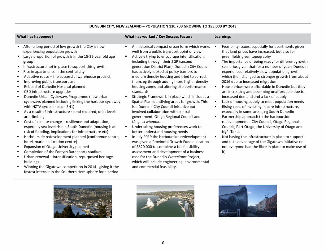
DUNEDIN CITY, NEW ZEALAND – POPULATION 130,700 GROWING TO 155,000 BY 2043
What has happened? What has worked / Key Success Factors Learnings
▪ After a long period of low growth the City is now experiencing population growth
▪ Large proportion of growth is in the 15-39 year old age group
▪ Infrastructure not in place to support this growth ▪ Rise in apartments in the central city ▪ Adaptive reuse – the successful warehouse precinct ▪ Improving public transport use ▪ Rebuild of Dunedin Hospital planned ▪ CBD infrastructure upgrades ▪ Dunedin Urban Cycleways Programme (new urban
cycleways planned including linking the harbour cycleway with NZTA cycle lanes on SH1)
▪ As a result of infrastructure spend required, debt levels are climbing
▪ Cost of climate change – resilience and adaptation, especially sea level rise in South Dunedin (housing is at risk of flooding, implications for infrastructure etc)
▪ Harbourside redevelopment planned (conference centre, hotel, marine education centre)
▪ Expansion of Otago University planned ▪ Completion of the Forsyth Barr sports stadium ▪ Urban renewal – intensification, repurposed heritage
buildings ▪ Winning the Gigatown competition in 2014 - giving it the
fastest internet in the Southern Hemisphere for a period
▪ An historical compact urban form which works well from a public transport point of view
▪ Actively trying to encourage intensification, including through their 2GP (second generation District Plan). Dunedin City Council has actively looked at policy barriers to medium density housing and tried to correct them, eg through adding more higher density housing zones and altering site performance standards.
▪ Strategic Framework in place which includes a Spatial Plan identifying areas for growth. This is a Dunedin City Council initiative but involved collaboration with central government, Otago Regional Council and tāngata whenua.
▪ Undertaking housing preferences work to better understand housing needs
▪ In July 2019 the harbourside redevelopment was given a Provincial Growth Fund allocation of $820,000 to complete a full feasibility assessment and development of a business case for the Dunedin Waterfront Project, which will include engineering, environmental and commercial feasibility.
▪ Feasibility issues, especially for apartments given that land prices have increased, but also for greenfields given topography
▪ The importance of being ready for different growth scenarios given that for a number of years Dunedin experienced relatively slow population growth which then changed to stronger growth from about 2016 due to increased migration
▪ House prices were affordable in Dunedin but they are increasing and becoming unaffordable due to increased demand and a lack of supply
▪ Lack of housing supply to meet population needs ▪ Rising costs of investing in core infrastructure,
especially in some areas, eg South Dunedin ▪ Partnership approach to the harbourside
redevelopment – City Council, Otago Regional Council, Port Otago, the University of Otago and Ngāi Tahu.
▪ Not having the infrastructure in place to support and take advantage of the Gigatown initiative (ie not everyone had the fibre in place to make use of it)

7
PORIRUA CITY, NEW ZEALAND – POPULATION 56,800 GROWING TO 80,800 BY 2048
What has happened? What has worked / Success Factors Learnings
▪ In 2018 the Government announced a $1.5 billion investment (housing and infrastructure) over the next 25 years to work with the community on revitalising eastern Porirua.
▪ Improved public housing also proposed for western Porirua
▪ Canons Creek residential redevelopment underway – major state housing redevelopment
▪ Older state homes to be replaced with warm, dry modern homes
▪ Opportunities for home ownership by building affordable homes (including KiwiBuild) and housing for sale on the open market through the redevelopment of Government owned land
▪ Plan is to design better neighbourhoods, including improving parks and streets, to make them safer, easier to get around and do business in.
▪ Redevelopment being led by Kāinga Ora in partnership with Porirua City Council
▪ Partnership approach - HLC (now Kāinga Ora) led in partnership with Porirua City Council, local iwi Ngāti Toa and the community (other Government agencies have also been involved)
▪ Good attempts at community involvement (across all sectors) after initial concerns about the lack of engagement
▪ Housing needs research undertaken ▪ Range of housing types proposed to suit all needs
including for intergenerational and large families. This will be achieved through Kainga Ora acting as the lead and through District Plan changes.
▪ The importance of early engagement and being clear about what redevelopment means for the existing community
▪ Streamlined planning process proposed for Eastern Porirua area
▪ The redevelopment of areas like Cannons Creek is not underway yet so it is too early to assess learnings

8
HOBSONVILLE POINT, AUCKLAND, NEW ZEALAND – POPULATION 3,200 GROWING TO 12,400 (at development completion)
What has happened? What has worked / Success Factors Learnings
▪ Master planned community on the site of a former Airforce Base
▪ Led by Central government through Homes Land Community (now part of Kainga Ora)
▪ 4,500 homes and 11,000 residents once completed (about 5 years to go)
▪ Housing is at a higher density than has been normal for Auckland subdivisions (2-3 times the density of a typical suburb). The densest residential blocks have about 100 dwellings per hectare. On average gross density is approximately 65 persons/hectare or around 30 dwellings per hectare.
▪ Held up as an example of integrated residential development due to housing and place-making
▪ Coastal walkway developed ▪ Ferry service recently started ▪ All homes within 800m of a bus stop ▪ Schools incorporated into the development at an
early stage. Schools built through Public-Private partnerships.
▪ Compact urban form / range of housing types achieved through an enabling plan change, being led by HLC, following a design-led and comprehensive masterplanning process that involved extensive international research in terms of what worked elsewhere
▪ Development strategy put in place which sees the tender of ‘super-blocks’ to preferred building partners, who submit their home designs to the Design Review Panel (made up of reps from Auckland Council, HLC, masterplanner, an architect and a representative of HLC. Allows for a variety of housing types with quality design.
▪ Strong focus on placemaking and community building (playgrounds, farmers market, community events etc)
▪ High quality public spaces and amenity ▪ 67% of children walk or bike to school ▪ Over half of residents take public transport,
walk or cycle to work ▪ High level of community satisfaction with
where they live evidenced in recent research ▪ Promoting a ‘shared backyard’ through the
Hobsonville Play Strategy
▪ The importance of having an overall masterplan, led by one group (in this case HLC)
▪ Development guided by a Sustainable Development Framework with annual sustainability reporting (undertaken by HLC)
▪ Transport-oriented design and Integrating transport early on in a project
▪ Lack of truly affordable housing. It was originally planned to have much more affordable housing than what has been offered. 30% of houses have been in the ‘affordable’ category but that currently sits at $650,000 which is not affordable for many people.
▪ Having a quality public realm is key ▪ Putting in place public transport early in order to
influence behaviour (eg buses to Westgate and into the CBD, ferry services)
▪ Making adequate provision for future growth in demand for services (eg ferry services at capacity)
▪ Having critical commercial mass (for local jobs and wider employment)

9
MAROOCHYDORE, SUNSHINE COAST, QUEENSLAND, AUSTRALIA – POPULATION 16,800 GROWING TO 24,600 BY 2026
What has happened? What has worked / Key Success Factors Learnings
▪ State Government Priority Development Area ▪ New CBD (Central City) planned to service whole of
the Sunshine Coast ▪ The new Central City will include apartments,
offices, retail, hotels, waterways and parks, public spaces – some construction is underway
▪ International submarine broadband cable to be in place by 2020 – positioning Maroochydore as Australia’s fastest telecommunications and data connection to Asia
▪ Australia’s first underground automated waste collection system
▪ Passenger rail and light rail are being investigated ▪ Pedestrians, cyclists and public transport are to
have priority over private vehicles in the new Maroochydore City Centre
▪ Designed as a walkable city
▪ Acquisition of the Horton Park Golf Club (bought by the Sunshine Coast Council for $42 million in 2015) provided the land for the new CBD
▪ New council building planned for the central city has helped to kickstart development
▪ Infrastructure agreement with State Government (covers all infrastructure – all transport, three waters, community infrastructure, telecommunications, waste)
▪ Activation Strategy – focuses on promoting, positioning and activating the Central City (arts, culture, events etc)
▪ SunCentral established as an independent board to oversee the development
▪ Partnerships with the private sector (investment and development) for large scale projects so that precinct-wide approaches can be taken
▪ Importance / flow on effects of nearby developments, eg solar farm, Sunshine Coast University Hospital
▪ The council has established its own company, SunCentral Maroochydore, to carry out the City Centre development
▪ Significant upfront investment required from the Council even with a co-investment programme with State Government
▪ Some led public transport services provided by the State Government
▪ Long-term project – will take 20-40 years to complete

10
SPRINGFIELD, IPSWICH, QUEENSLAND, AUSTRALIA – POPULATION 41,000 GROWING TO 105,000 BY 2030
What has happened? What has worked / Success Factors Learnings
▪ Master planned city located 34km out of Brisbane – some development completed, some still underway/planned – 41,000 residents already there, 138,000 total planned by 2030
▪ Includes a Town Centre with apartments, parkland, commercial, retail, educational, health and technology facilities.
▪ Has six suburbs ▪ Has passenger rail in place – there are two train
stations for Springfield ▪ Private hospital ▪ University of Southern Queensland ▪ Sports complex
▪ 1 job planned for every 3 residents ▪ 30% dedicated to green space ▪ Located on an urban growth corridor ▪ Ability to offer relatively affordable housing,
achieved through the lower cost of land and being located outside of Brisbane City
▪ Designed and led by Springfield City Group – a private developer
▪ Partnerships with federal, state and local government as well as education, healthcare and other private sector organisations and industry
▪ Estimated cost on completion of $85bn ▪ Mix of private, local, State and Federal Government
funding ▪ Lead transport investment through extension of
passenger rail (between Brisbane and Springfield) ▪ Health and education are the essential pillars of the
development ▪ Springfield had its own development legislation
(introduced by Queensland State Government – appears to have had backing at all levels)
▪ The land was purchased very cheaply ▪ Habitat loss through the original development –
there is no clear view on whether they have been able to remediate this

11
PARRAMATTA CITY, NEW SOUTH WALES, AUSTRALIA – POPULATION 251,000 GROWING TO 393,000 BY 2031
What has happened? What has worked / Key Success Factors Learnings
▪ Urban transformation of the CBD planned over the next 5 years
▪ Major apartment developments in central Parramatta
▪ New Riverbank precinct planned including a museum
▪ Mix of residential, commercial and entertainment areas proposed – some underway
▪ Light rail planned (early and enabling works in progress)
▪ Parramatta Metro Line rail planned for fast access to the Sydney CBD
▪ Cycleway along the river from Parramatta CBD to Sydney Olympic Park
▪ Key Government offices relocating to Parramatta since 2000
▪ Health and medical research precinct proposed at Westmead (neighbouring area), linked to Westemead Hospital
▪ Liveable centres planned around the main rail stations
▪ A focus on connecting open space/parks and providing walking trails between precincts
▪ $1 billion spend on infrastructure required in the CBD
▪ Will become a second CBD to Sydney intensification, public
▪ High levels of public and private investment ▪ City of Parramatta has a Property Development
Group which oversees, leverages value and city-shaping opportunities for a range of council owned sites
▪ A clear Metro Strategy which sets the direction for all development
▪ A network of centres connected by transport corridors
▪ Providing employment (particularly knowledge and professional service jobs) and housing together
▪ Lead Government (both State and local) investment eg funding for a museum, the light rail project
▪ The importance of transport as an enabler ▪ Special levy proposed for new apartments to help
fund the light rail project but this has not yet been put in place meaning the State Government has missed out on critical funding for the project
▪ The importance and flow on effects of attracting Government offices, healthcare and education
▪ Comprehensive approach taken to the redevelopment (ie not just housing and jobs) including community facilities (Civic Centre, new library, new swimming pool, new schools), flood mitigation, street works and key transport connections.
▪ Sustaining strategy implementation through investment over time
▪ Bold vision and strong leadership
12
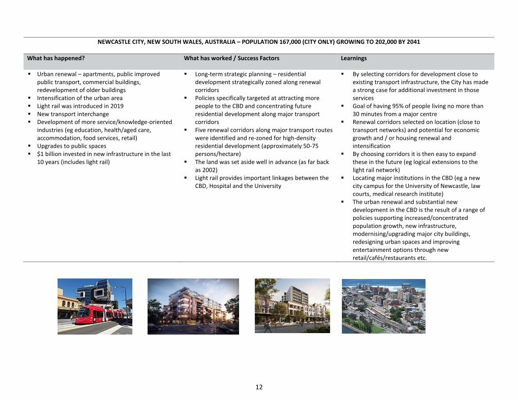
NEWCASTLE CITY, NEW SOUTH WALES, AUSTRALIA – POPULATION 167,000 (CITY ONLY) GROWING TO 202,000 BY 2041
What has happened? What has worked / Success Factors Learnings
▪ Urban renewal – apartments, public improved public transport, commercial buildings, redevelopment of older buildings
▪ Intensification of the urban area ▪ Light rail was introduced in 2019 ▪ New transport interchange ▪ Development of more service/knowledge-oriented
industries (eg education, health/aged care, accommodation, food services, retail)
▪ Upgrades to public spaces ▪ $1 billion invested in new infrastructure in the last
10 years (includes light rail) renewal – intensification, public transport, commercial buildings, redevelopment of older buildings
▪ Long-term strategic planning – residential development strategically zoned along renewal corridors
▪ Policies specifically targeted at attracting more people to the CBD and concentrating future residential development along major transport corridors
▪ Five renewal corridors along major transport routes were identified and re-zoned for high-density residential development (approximately 50-75 persons/hectare)
▪ The land was set aside well in advance (as far back as 2002)
▪ Light rail provides important linkages between the CBD, Hospital and the University
▪ By selecting corridors for development close to existing transport infrastructure, the City has made a strong case for additional investment in those services
▪ Goal of having 95% of people living no more than 30 minutes from a major centre
▪ Renewal corridors selected on location (close to transport networks) and potential for economic growth and / or housing renewal and intensification
▪ By choosing corridors it is then easy to expand these in the future (eg logical extensions to the light rail network)
▪ Locating major institutions in the CBD (eg a new city campus for the University of Newcastle, law courts, medical research institute)
▪ The urban renewal and substantial new development in the CBD is the result of a range of policies supporting increased/concentrated population growth, new infrastructure, modernising/upgrading major city buildings, redesigning urban spaces and improving entertainment options through new retail/cafés/restaurants etc.

13
CARDIFF CITY, WALES, UNITED KINGDOM – POPULATION 357,000 GROWING TO 444,700 BY 2039
What has happened? What has worked / Success Factors Learnings
▪ City Centre redevelopment over the last 10 years
▪ Central Square redevelopment underway ▪ New offices, retail, apartments and
connected outdoor spaces ▪ New transport hub proposed (bus and rail) ▪ New headquarters for BBC Wales which has
acted as a catalyst for other development ▪ Linking the train station, CBD and
Millennium Stadium ▪ $1bn Cardiff Crossrail project (integrating
bike, bus and rail services) – will use tram-train technology
▪ Major developments planned to the north west of the city (greenfields)
▪ Major new park and rides planned in strategic locations around the city perimeter with fast routes into Cardiff Central City
▪ Strong focus on integrated transport (especially public transport) which benefits not just the Central City but the wider region
▪ Development and community regeneration. The potential for greenway projects – repurposing older industrial areas to form new community spaces and regeneration developments. Cross Rail project can be a catalyst for this.
▪ City Deal - £1.2bn for the Cardiff Capital Region (funding from the UK & Welsh Governments as well as using the borrowing power of the 10 local authorities that make up the region)
▪ Plans to improve connectivity and accessibility for parts of Cardiff suffering economic challenges – this is cross all modes but with a particular focus on public transport
▪ Urban parks proposed along key rail lines ▪ The planned transport improvements will
provide a widened employment catchment
▪ Affordable housing requirements for apartments (often these are funded by investors and then rented out – ‘build to rent’)
▪ Build-to-rent housing in the central city ▪ Importance of strong urban design ▪ Importance of an ‘anchor tenant’ ▪ Getting the balance right between housing and other city
uses, some argue that the Cardiff Central area has too many apartments
▪ Importance of having a collaborative approach – City Council, Welsh Government and landowners)
▪ The difficulties with dealing with the legacy of a transport network designed for a city of less than 300,000 people but needing a network for 400,000 people +
▪ Decision to cancel a significant motorway project (due to cost and environmental impact) means that the need to provide viable alternatives to the car is essential
▪ Crossrail project needed to support new development areas
▪ The key role of Transport for Wales in getting significant projects underway

14
Conclusions and Recommendations
All of the places used in this phase 1 work offer learnings for the western Bay of Plenty sub-region in terms of planning for growth. Common elements across all eight areas include, among others:
▪ Vision, leadership and sustained implementation commitment ▪ Integrating infrastructure, especially transport as this is a key urban form driver and shaper ▪ The need for a range of housing types and the provision of affordable housing ▪ Public and private investment ▪ Having ‘anchor’ projects which act as a catalyst for further development (usually based off a
government(s) agencies or social infrastructure / building) ▪ Brining people into a city or place by putting major attractors there (eg hospitals and universities) ▪ Comprehensive approaches to development that include social and physical infrastructure and place
making / city shaping initiatives ▪ Importance of partnerships, cross government collaboration, aligned planning and investment
implementation
In looking across all of the eight areas, three sites will be selected for more detailed analysis. These have been
narrowed down to:
▪ Dunedin City ▪ Hobsonville Point ▪ Maroochydore ▪ Springfield ▪ Parramatta ▪ Newcastle
These will be discussed with the UFTI Project Leadership Team and from there the three sites will be
confirmed.