community profile information governor’s...
TRANSCRIPT
Community profile information Governor’s Bay (Census area unit: Governor’s Bay)
Community profile
Governor's Bay
Census area unit: Governor's Bay
The Governor's Bay area encompasses the western slopes of the Lyttelton Harbour basin and includes the bay communities of Governor's Bay, Allandale and Teddington. A main road links the communities. Access to Christchurch by road is via Dyers Pass to the north. More circuitous routes are through Teddington via Gebbies Pass, or through Lyttelton via the road tunnel. This area is characterised by significant tracts of reserves and farmland on steep terrain with basaltic outcrops. Governor's Bay provides a focal point for the western bay communities, with some local services and businesses centrally located. Further services are available in Christchurch or through the northern bays in Lyttelton, which is 10 kilometres away. Governor's Bay School is a full primary (Years 1-8) and caters for children in the Governor's Bay area. There are no secondary schools in the Lyttelton Harbour Basin. Zoning is for Cashmere High School, however, secondary students attend many schools across Christchurch.
Key demographics
Home ownership (%) Data from Statistics New Zealand Family type (%)
Data from 2006 Census, Statistics New Zealand
Dwell ing Owned or PartlyOwned by UsualResident(s)
Dwell ing Not Owned byUsual Resident(s)
Family Trust
Not Stated
Couple without Children
Couple with Child(ren)
One Parent withChild(ren)
Ethnic groups in the area (%) Data from 2006 Census, Statistics New Zealand
Usually resident population count Data from Statistics New Zealand
0
200
400
600
800
1000
1200
1400
1600
1800
2000
1996 2001 2006 2011 2016 2021 2026 2031
84.9
3.5
2.5
1.4
0.4
14.8
European
Mäori
Pacific Island
Asian
MELAA (Middle Eastern, LatinAmerican and African)
Other
%Governors Bay Christchurch City
Median personal income compared to Christchurch City Data from Statistics New Zealand
Employment status (%) Data from 2006 Census, Statistics New Zealand
0
5000
10000
15000
20000
25000
30000
35000
1996 2001 2006
Governors Bay Christchurch City 52.4
19.8
1.3
23.8
2.2
0.0 10.0 20.0 30.0 40.0 50.0 60.0
Employed Full-time
Employed Part-time
Unemployed
Not in theLabour Force
Unidentifiable
Social infrastructure mapping
The greater the size of the circle, the greater the impact and reach the organisation has within the community. There are eight organisations operating within Governor’s Bay that have significant reach and impact. They are well spread amongst most sectors. The lack of sports organisations based in the area means that residents need to travel in order to participate in sporting pursuits. Similarly, there is only one faith-based organisation in Governor's Bay.
Within the Governor’s Bay area there are 42 organisations identified, consisting of 11 community organisations, 1 sports group, 20 recreational/leisure groups, 1 faith-based organisation, 1 residents’ group, 3 business associations and 6 community meeting venues operating within the community.
Governor’s Bay
Governor’s Bay
Social capital mapping
1a
1b
1c
2a
2b
2c
3a
3b3c
4a
4b
4c
5a
5b
5c
Community development organisations rating
1a Number of organisations (4) 1b Strength of organisations (3) 1c Community development principles (4)
Volunteering rating
2a Investment in volunteers (4) 2b Number of volunteer hours from Fundforce (1) 2c Number of volunteer hours from Census (3)
Connectedness rating
3a Number of neighbourhood support groups (2) 3b Number of residents' associations (5) 3c Access to networking groups/forums (4)
Participation rating
4a Community events (3) 4b Fundforce participation rates (3) 4c Club membership numbers (3)
Resilience rating
5a Preparedness/response plan in place (5) 5b Identified groups to lead local response (5) 5c Capability of groups to lead local response (4)
Post-earthquake land map Department of Building Housing (DBH) technical classifications as at 28 October 2011
Land condition in Governor's Bay
Governor's Bay straddles parts of both the Port Hills and Banks Peninsula areas. These areas did not suffer the same type of area-wide damage (liquefaction and subsequent lateral spreading) as the Canterbury Plains. The concerns in the area were around cliff collapse, land movement and land inundation, potential rock fall and retaining wall failure. This whole area initially had a 'white' zone designation, which meant more mapping and assessment was required, but in early September 2011, some residential parts of the Port Hills were rezoned as 'green', meaning that the repair and rebuild process for these properties could begin. In Governor's Bay, 427 (56%) of the non-rural residential properties were in this category. Non-residential properties are not included in the mapping work. In mid-October 2011, those properties in the Banks Peninsula area were rezoned 'green'. The October 2011 rezoning announcement saw much of the land in the area keeps its 'green' or 'white' zone status, but with the additional DBH design classifications. In this area the 'Port Hills
and Banks Peninsula' technical classification is applied. This means that normal building consent conditions are in place. Some properties which have been issued Section 124 notices, prohibiting entry due to localised geotechnical hazards, lie within this area. These notices still apply.
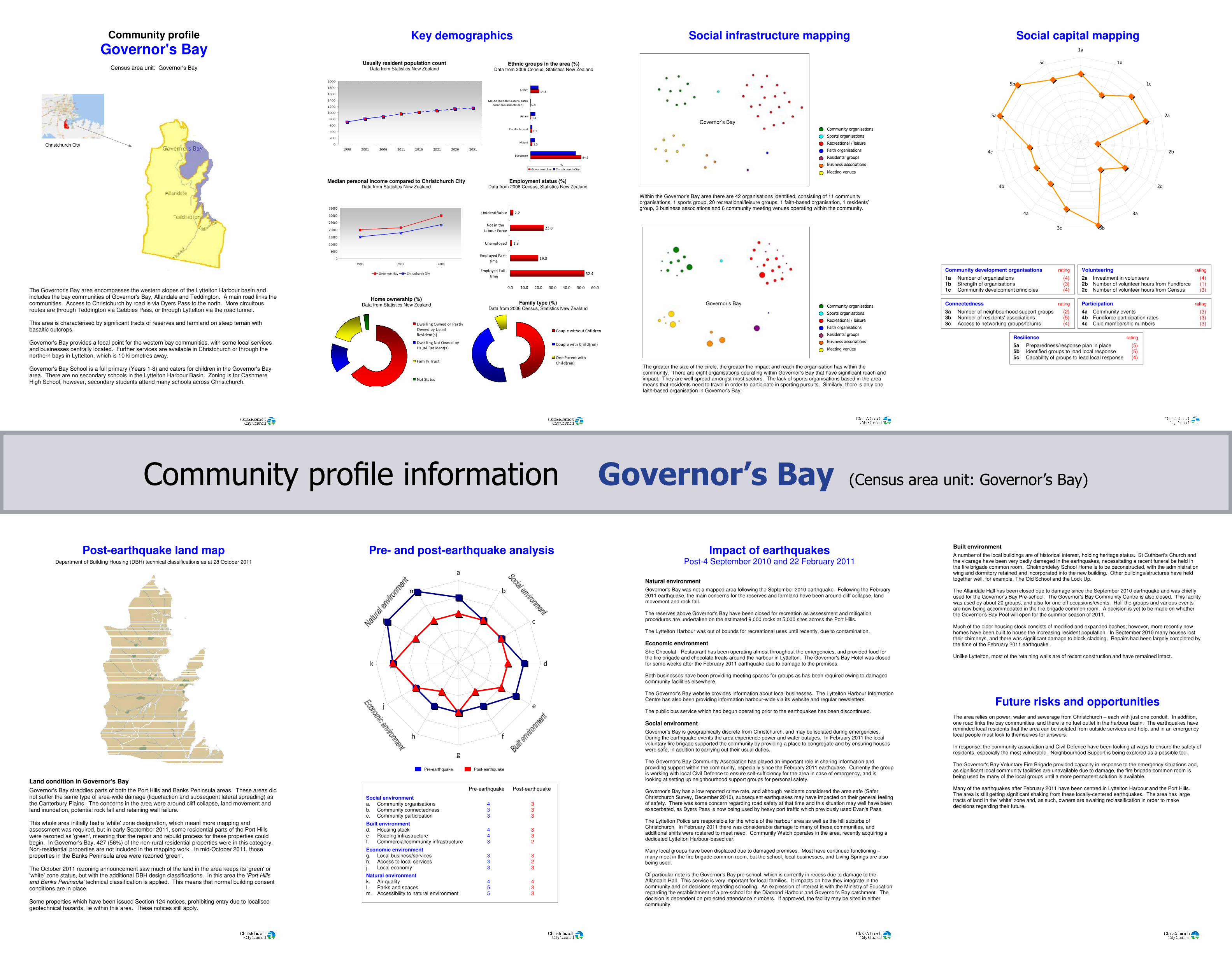
Pre- and post-earthquake analysis
a
b
c
d
e
f
g
h
j
k
l
m
Pre-earthquake Post-earthquake
Social environment a. Community organisations 4 3 b. Community connectedness 3 3 c. Community participation 3 3
Built environment d. Housing stock 4 3 e Roading infrastructure 4 3 f. Commercial/community infrastructure 3 2
Economic environment g. Local business/services 3 3 h. Access to local services 3 2 j. Local economy 3 3
Natural environment k. Air quality 4 4 l. Parks and spaces 5 3 m. Accessibility to natural environment 5 3
Pre-earthquake Post-earthquake
Impact of earthquakes Post-4 September 2010 and 22 February 2011
Natural environment
Governor's Bay was not a mapped area following the September 2010 earthquake. Following the February 2011 earthquake, the main concerns for the reserves and farmland have been around cliff collapse, land movement and rock fall. The reserves above Governor's Bay have been closed for recreation as assessment and mitigation procedures are undertaken on the estimated 9,000 rocks at 5,000 sites across the Port Hills. The Lyttelton Harbour was out of bounds for recreational uses until recently, due to contamination.
Economic environment
She Chocolat - Restaurant has been operating almost throughout the emergencies, and provided food for the fire brigade and chocolate treats around the harbour in Lyttelton. The Governor's Bay Hotel was closed for some weeks after the February 2011 earthquake due to damage to the premises. Both businesses have been providing meeting spaces for groups as has been required owing to damaged community facilities elsewhere. The Governor's Bay website provides information about local businesses. The Lyttelton Harbour Information Centre has also been providing information harbour-wide via its website and regular newsletters. The public bus service which had begun operating prior to the earthquakes has been discontinued.
Social environment
Governor's Bay is geographically discrete from Christchurch, and may be isolated during emergencies. During the earthquake events the area experience power and water outages. In February 2011 the local voluntary fire brigade supported the community by providing a place to congregate and by ensuring houses were safe, in addition to carrying out their usual duties. The Governor's Bay Community Association has played an important role in sharing information and providing support within the community, especially since the February 2011 earthquake. Currently the group is working with local Civil Defence to ensure self-sufficiency for the area in case of emergency, and is looking at setting up neighbourhood support groups for personal safety. Governor's Bay has a low reported crime rate, and although residents considered the area safe (Safer Christchurch Survey, December 2010), subsequent earthquakes may have impacted on their general feeling of safety. There was some concern regarding road safety at that time and this situation may well have been exacerbated, as Dyers Pass is now being used by heavy port traffic which previously used Evan's Pass. The Lyttelton Police are responsible for the whole of the harbour area as well as the hill suburbs of Christchurch. In February 2011 there was considerable damage to many of these communities, and additional shifts were rostered to meet need. Community Watch operates in the area, recently acquiring a dedicated Lyttelton Harbour-based car. Many local groups have been displaced due to damaged premises. Most have continued functioning – many meet in the fire brigade common room, but the school, local businesses, and Living Springs are also being used. Of particular note is the Governor's Bay pre-school, which is currently in recess due to damage to the Allandale Hall. This service is very important for local families. It impacts on how they integrate in the community and on decisions regarding schooling. An expression of interest is with the Ministry of Education regarding the establishment of a pre-school for the Diamond Harbour and Governor's Bay catchment. The decision is dependent on projected attendance numbers. If approved, the facility may be sited in either community.
Built environment
A number of the local buildings are of historical interest, holding heritage status. St Cuthbert's Church and the vicarage have been very badly damaged in the earthquakes, necessitating a recent funeral be held in the fire brigade common room. Cholmondeley School Home is to be deconstructed, with the administration wing and dormitory retained and incorporated into the new building. Other buildings/structures have held together well, for example, The Old School and the Lock Up. The Allandale Hall has been closed due to damage since the September 2010 earthquake and was chiefly used for the Governor's Bay Pre-school. The Governor's Bay Community Centre is also closed. This facility was used by about 20 groups, and also for one-off occasions/events. Half the groups and various events are now being accommodated in the fire brigade common room. A decision is yet to be made on whether the Governor's Bay Pool will open for the summer season of 2011. Much of the older housing stock consists of modified and expanded baches; however, more recently new homes have been built to house the increasing resident population. In September 2010 many houses lost their chimneys, and there was significant damage to block cladding. Repairs had been largely completed by the time of the February 2011 earthquake. Unlike Lyttelton, most of the retaining walls are of recent construction and have remained intact.
Future risks and opportunities The area relies on power, water and sewerage from Christchurch – each with just one conduit. In addition, one road links the bay communities, and there is no fuel outlet in the harbour basin. The earthquakes have reminded local residents that the area can be isolated from outside services and help, and in an emergency local people must look to themselves for answers. In response, the community association and Civil Defence have been looking at ways to ensure the safety of residents, especially the most vulnerable. Neighbourhood Support is being explored as a possible tool. The Governor's Bay Voluntary Fire Brigade provided capacity in response to the emergency situations and, as significant local community facilities are unavailable due to damage, the fire brigade common room is being used by many of the local groups until a more permanent solution is available. Many of the earthquakes after February 2011 have been centred in Lyttelton Harbour and the Port Hills. The area is still getting significant shaking from these locally-centered earthquakes. The area has large tracts of land in the' white' zone and, as such, owners are awaiting reclassification in order to make decisions regarding their future.