community characteristics report stip project i 4400 i
TRANSCRIPT

STIP I‐4400/I‐4700 CCR – Henderson and Buncombe Counties 1
COMMUNITY CHARACTERISTICS REPORT
STIP Project I‐4400 / I‐4700
Widening of I‐26 from NC 225 to I‐40
Henderson and Buncombe Counties
Submitted by: HNTB North Carolina, P.C.
Date: November 2013
EXECUTIVE SUMMARY
Project Description North Carolina Department of Transportation (NCDOT) State Transportation Improvement Program (STIP) Project I‐4400 / I‐4700 proposes improvements to a 22.2‐mile segment of the Interstate 26 corridor in Henderson and Buncombe Counties. The proposed improvement project would extend from US 25 south of Hendersonville in Henderson County to I‐40 near Asheville in Buncombe County. I‐26 serves an important function for western North Carolina and the southeastern United States for the movement of both people and goods. In addition, it provides a connection to I‐40, which is the major east‐west corridor for the region as well as North Carolina. As a freight corridor, I‐26 connects the southeastern United States with the northeast via the connection with I‐81 near Kingsport, Tennessee. With its current traffic demand, I‐26 is approaching its ultimate capacity. The purpose of the proposed improvements to I‐26 is to reduce congestion, with a goal of achieving an overall LOS D in the design year (2040), and improve the pavement structure. Community Context & Direction Buncombe and Henderson Counties are located in western North Carolina in the Blue Ridge Mountains. Western North Carolina contains very few major urban centers. Asheville is the seat of Buncombe County’s government, and is western North Carolina’s largest city and most prominent commercial area with a population of 83,393 in 2010. Population data from the US Census Bureau indicate that both Buncombe and Henderson Counties have experienced moderate growth from 2000 to 2010 (15.5 and 19.7 percent, respectively) similar to the State (18.5 percent). Much of the growth in these counties can be attributed to their proximity to the North Carolina mountains, a desirable location for retirees, and the service, business, and cultural options in and around Asheville. According to information contained in the French Broad River Metropolitan Planning Organization’s (FBRMPO) 2035 Long Range Transportation Plan (LRTP), growth and development patterns within the area generally reflect growth in both residential areas and service businesses to support this growth. The majority of residential and commercial growth in both counties has occurred, and continues to occur, in the southern portion of Buncombe County and in the northern portion of Henderson County, particularly in the Arden (Buncombe County), Fletcher (Henderson County), and Balfour (Henderson County) areas. This growth can be attributed to the reasonable pricing for land and housing, topography suitable for development, and attractive property tax rates. In addition, the Henderson County planner indicated that Fletcher is growing due to its accessibility to both Asheville and Hendersonville. Furthermore, it was noted that the eastern and southeastern areas of Henderson County have also experienced some residential growth recently, which is predominantly due to this area’s relatively gentle terrain which is more easily converted from forest and farmland to residential development. The eastern portion of Henderson County also has the most interconnected road networks. According to population projections provided by the North Carolina Office of State Budget and Management (www.osbm.state.nc.us), the population in Buncombe and Henderson Counties grew at an annual rate of 1.6 percent and 1.7 percent, respectively, between 2003 and 2013, which was similar to the State (1.6 percent) during the same time period. Although the annual population growth rate in Buncombe and Henderson Counties is
STIP I‐4400/I‐4700 CCR – Henderson and Buncombe Counties 2
expected to decrease over the next 20 years, Buncombe County (1.1 percent) is anticipated to continue to grow between 2013 and 2033 at an annual rate similar to the State (1.0 percent), while Henderson County may experience a lesser annual growth rate (0.3 percent). The region has experienced a unique economic transition over the past several decades as its traditional focus on the service and tourism industry has been accompanied by a focus on niche businesses in the region as well a growing influx of retirees drawn to the region’s high quality of life and natural and cultural amenities. The region is a popular tourist destination, as it is home to many points of interest including the 8,000‐acre Biltmore Estate that attracts approximately one million visitors a year (www.biltmore.com), Pisgah National Forest, Blue Ridge Parkway, the North Carolina Arboretum, and Great Smoky Mountains National Park. The region’s close ties to agriculture have also supported its prosperity. Henderson County is the State’s largest apple producer and is the home of the annual North Carolina Apple Festival.
Notable Features The overall Demographic Study Area population grew by approximately 21.8 percent between 2000 and
2010, which is slightly higher than Buncombe and Henderson Counties (15.5 and 19.7 percent, respectively) as well as the State’s population growth during the same time period (18.5 percent).
Carolina Village Retirement Community is located just north of the I‐26 and US 64 interchange in Hendersonville, which consists of approximately 265 apartments and 81 detached cottages. There appears to be community cohesion among the residents of Carolina Village, as the community often hosts activities and gatherings on the property for their residents (www.carolinavillage.com). Given that it is a retirement community, Carolina Village may contain a potential Title VI population.
A NCDOT truck weigh station is located on both sides of I‐26 just northwest of Brookside Drive.
Census data indicates a notable presence of minority and low income populations meeting the criteria for Environmental Justice within the Demographic Study Area (DSA) and minority and low income communities were noted within the Direct Community Impact Area (DCIA) by local planners. Based on 2010 US Census data, four block groups within the Demographic Study Area had a non‐white population percentage of more than ten percentage points higher than their respective County. In addition, four block groups within the Demographic Study Area had a Hispanic or Latino population percentage of more than ten percentage points higher than their respective County. Based on this demographic assessment, it appears that there are notable minority populations meeting the criteria for Environmental Justice present in the Demographic Study Area at the block group level. Furthermore, Henderson County planners indicated that some minority communities may be located east of I‐26 in proximity to the corridor, particularly in the Brickton residential community within the DCIA. Brickton is located just north of Butler Bridge Road, and it was noted that Brickton was previously split during the original construction of I‐26.
Broadmoor Golf Links and the Rugby Grange house and property are located on the west and east side of I‐26, respectively, north of Cane Creek. Broadmoor is a public golf course and therefore, may be a potential 4(f) resource. The Rugby Grange house and property are listed on the National Register of Historic Places.
A state‐owned rest area is located on both sides of I‐26 at the Buncombe/Henderson County line (Milepost 10).
The Western North Carolina Agricultural Center, owned and operated by the North Carolina Department of Agriculture and Consumer Services, is the home of the North Carolina Mountain State Fair, numerous horse and livestock events, large scale conferences, and trade shows. The grounds and buildings for the center are located along the western side of the I‐26 corridor at Fanning Bridge Road.
Boiling Springs Baptist Church is located on the south side of Fanning Bridge Road and adjacent to the eastern side of I‐26.
Although the overall Buncombe County portion of the Demographic Study Area living below the poverty level in 2010 (8.3 percent) was less than the County (14.7 percent), two block groups in the Buncombe County portion have notable low‐income populations that meet the criteria for Environmental Justice.

STIP I‐4400/I‐4700 CCR – Henderson and Buncombe Counties 3
Similarly, the overall Henderson County portion of the Demographic Study Area living below poverty level in 2010 (12.0 percent) was slightly less than the County (12.7 percent), but two block groups in the Henderson County portion also have notable low‐income populations meeting the criteria for Environmental Justice. The Buncombe County planner indicated that the Hidden Creek Village residential neighborhood located on the north side of the Asheville Regional Airport consists of predominantly low income residents.
The Blue Ridge Parkway traverses through the northern portion of the DCIA in Buncombe County and crosses I‐26 north of NC 146 / Long Shoals Road. Outstanding scenery and recreational opportunities make the Blue Ridge Parkway one of the most visited sections of the National Park System. The Parkway consists of 469 miles connecting the Great Smoky Mountains National Park in North Carolina to the Shenandoah National Park in Virginia.
According to the Buncombe County Greenways & Trails Master Plan (Buncombe County, August 2012), a portion of the statewide Mountains to Sea Trail, located along the Blue Ridge Parkway, is the only existing trail within the DCIA. The Buncombe County Greenways & Trails Master Plan identifies several proposed greenway corridors that traverse the DCIA. These proposed greenway corridors include Bent Creek Greenway, Hominy Creek Greenway, and Lake Julian Greenway, which are all designated as “Priority Corridors” by the Plan.
A portion of the Biltmore Estate property is located adjacent to the east side of I‐26 and occupies the eastern part of the DCIA from the Blue Ridge Parkway to NC 191/Brevard Road. Biltmore Estate is listed on the National Register of Historic Places. In addition, the Buncombe County planner indicated that large agricultural operations are located on the Biltmore Estate Property and some of these crops are located within the DCIA.
Census data indicates a Spanish‐speaking population that meets or exceeds the US Department of Justice Limited English Proficiency (LEP) Safe Harbor threshold within the Demographic Study Area.
Census data also indicates another Indo‐European language‐speaking population that exceeds 50 persons within the Demographic Study Area that may require language assistance.
Potential Community Impacts Depending on the footprint of the proposed project, some community facilities and neighborhoods
located adjacent to the I‐26 corridor may potentially be impacted due to right‐of‐way acquisition. In particular, the Biltmore Estate property may potentially experience right‐of‐way impacts, as it runs adjacent to the I‐26 corridor for approximately three miles. In addition, Hidden Creek Village and Brickton neighborhoods, as well as Western Carolina Agricultural Center, a rest area, Boiling Springs Baptist Church, Broadmoor Golf Links (potential 4(f) resource), Rugby Grange, a weigh station, and Carolina Village Retirement Community (potential Title VI population) are all located in proximity to the STIP Project I‐4400/I‐4700 project corridor and may potentially experience right‐of‐way impacts.
Residents, businesses, and other community facilities located in proximity to the project corridor may experience an increase in traffic noise due to the increased capacity along the I‐26 corridor as a result of the project. However, a traffic noise study will be completed as part of this project which will determine potential noise impacts and appropriate mitigation measures.
According to the 2001 Environmental Assessment for STIP Project I‐4400, the predominantly African American Brickton community was apparently split when the original I‐26 corridor was constructed in the late 1960’s/1970’s. It notes that Brickton remains a functional community and has grown around the interstate over the years. The Henderson County planner is not aware of any residents west of I‐26 that identify with Brickton today, and indicated that the community is only located east of the corridor. In addition, the Buncombe County planner indicated that the Hidden Creek Village was recently impacted by stormwater runoff due to construction of retail development near Asheville Regional Airport. Depending on the footprint of the project, Brickton and Hidden Creek Village may potentially experience recurring impacts as a result of STIP Project I‐4400/I‐4700.

STIP I‐4400/I‐4700 CCR – Henderson and Buncombe Counties 4
Notably adverse community impacts are anticipated with this project but appear to affect all populations equivalently; thus, impacts to minority and low income populations do not appear to be disproportionately high and adverse. Benefits and burdens resulting from the project are anticipated to be equitably distributed throughout the community.
Given that I‐26 is an essential north‐south route in the region, there may be short term impacts to emergency response times due to delays on I‐26 during construction. However, the project may slightly improve response times in the long term due to decreased congestion on I‐26.
Recommendations & Next Steps Because LEP populations within the DSA exceed the Department of Justice’s Safe Harbor thresholds,
written translations of vital documents should be provided for Spanish‐speaking populations, in addition to other measures assuring meaningful language access, as determined by NCDOT Public Involvement to satisfy the requirements of Executive Order 13166.
Because notable other Indo‐European language‐speaking populations requiring language assistance are located within the DCIA, the Bridge Project Planning Engineer should consult with NCDOT Public Involvement to determine appropriate measures assuring meaningful public involvement to satisfy the requirements of Executive Order 12898.
Local emergency management staff should be contacted during the development of the Community Impact Assessment (CIA) in order to further assess potential impacts.
The Biltmore Estate should be contacted during the development of the CIA in order to further assess potential impacts to the project as a result of the project.
The Project Planning Engineer should coordinate with NCDOT Public Involvement to ensure that the project’s public involvement provides guidelines to outreach to all special groups, including potentially impacted minority, low‐income, and LEP populations in the DCIA, particularly in the Hidden Creek Village and Brickton neighborhoods, as well as along Dana Road, Crest Road, and Tracy Grove Road in Henderson County. Public involvement and outreach activities must ensure full and fair participation of all potentially affected communities in the transportation decision‐making process.
The Project Planning Engineer should coordinate with NCDOT Public Involvement to organize a small group meeting with the Brickton community to discuss previous impacts to the community as a result of the original construction of I‐26 and to identify the current neighborhood boundaries.
PROJECT OVERVIEW
Pursuant to the National Environmental Policy Act (NEPA), an Environmental Impact Statement (EIS) will be prepared for this project. This level of study can generally be classified as a “high” level environmental analysis for the documentation required under NEPA. Conducting this level of analysis and documentation for I‐4400/I‐4700 was determined following the past history of the project. An Environmental Assessment was completed for STIP I‐4400 (the 13.6 mile segment between US 25 and NC 280) in May 2001. A Finding of No Significant Impact (FONSI) was completed in January 2002 and, subsequently, the project was advertised as a Design‐Build project by NCDOT. A lawsuit and resulting judgment in 2003 found that NCDOT should conduct a broader analysis and more regional approach of the cumulative impacts and logical termini, or project limits, of the overall expansion of the I‐26 corridor. The project was subsequently placed on hold due to financial constraints. However, the growing need for improvements to the I‐26 corridor was recognized and the project was reinitiated and included in the Draft NCDOT 2013‐2023 STIP. In order to address the 2003 judgment, the NCDOT concluded to combine the analysis of STIP I‐4400 with STIP I‐4700 (the 8.6‐mile segment between NC 280 and I‐40) into one comprehensive EIS in order to take a more regional view. The EIS will address logical termini and cumulative effects in accordance with NEPA.

STIP I‐4400/I‐4700 CCR – Henderson and Buncombe Counties 5
Existing Conditions I‐26 is a NCDOT designated Strategic Highway Corridor. In a regional sense, the roadway is important to western North Carolina and the southeastern United States for the movement of both people and goods. Locally, it serves as the main south‐north facility for residents and businesses as well as providing direct access to the region’s airport, Asheville Regional Airport. At the northern end of the project, I‐26 provides a connection to I‐40, which is the major east‐west corridor for the region as well as North Carolina. As a freight corridor, I‐26 originates at the nation’s fourth busiest container port of Charleston, South Carolina and connects the southeastern United States with the northeast via the connection with I‐81 near Kingsport, Tennessee. A project vicinity map is shown on Figure 1 in Appendix A. Within the project study area, I‐26 runs south‐north through Henderson and Buncombe Counties as a four‐lane, median‐divided, full control‐of‐access facility between US 25 (Exit 54) in Henderson County and I‐26/I‐40/I‐240 (Exit 31) in Buncombe County. This section of I‐26 also carries the US 74 designation. The project area includes eleven existing grade‐separated crossings and eight existing interchanges. In Henderson County, I‐26 has interchanges with US 25, Upward Road (SR 1722), US 64, US 25 (Asheville Highway), and NC 280 (Airport Road). In Buncombe County, I‐26 has interchanges with NC 280 (Airport Road), NC 146 (Long Shoals Road), NC 191 (Brevard Road), I‐40 and I‐240. The Blue Ridge Parkway has a grade‐separated crossing, but no direct access. The speed limit of I‐26 varies from 65 miles per hour (mph) in southern Henderson County to 60 mph in northern Henderson County up to I‐40 in Buncombe County. With limited alternative south‐north routes, automobile and truck‐freight through traffic utilizing I‐26 are forced to share the facility with local traffic, creating several areas of congestion during peak travel periods on I‐26. The I‐26 corridor in the study area experiences a seasonal increase in traffic volume during the summer and fall months as tourists visit the region for recreational activities and fall foliage viewing. Congestion along the corridor is high, with sections of I‐26 in the project study area currently operating at an unacceptable Level of Service (LOS) F. As projected traffic volumes increase, more sections of I‐26 within the project study are projected to degrade to LOS F. The purpose of the proposed project is to reduce congestion, with a goal of achieving an overall LOS D in the design year (2040), and improve the pavement structure.
Proposed Modifications Four alternatives are currently under consideration for STIP Project I‐4400/I‐4700, which include a No‐Build Alternative and three Build Alternatives. The No‐Build Alternative would not provide any extensive improvements to the I‐26 corridor in the study area, and only typical maintenance activities would be provided along this section of I‐26. Although the No‐Build Alternative would not increase capacity nor reduce congestion, and thereby not meet the project’s purpose and need, this alternative is being assessed so as to provide a basis for comparing the adverse impacts and benefits of the detailed study alternatives. The three Build Alternatives under consideration include “Best Fit” 6‐Lane Widening (Build Alternative 1), “Best Fit” 8‐Lane Widening (Build Alternative 2), and “Best Fit” Traffic Report Recommendations Widening (Build Alternative 3). Descriptions of these alternatives are as follows:
Build Alternative 1: “Best Fit” 6‐Lane Widening Alternative Alternative 1 would widen I‐26 along the full project corridor to a 6‐lane facility asymmetrically at locations that “best fit” the current roadway location and surrounding land uses. “Best Fit” locations would be evaluated and selected to improve the existing highway alignment, minimize impacts, and accommodate maintenance of traffic during construction. The additional traffic lanes would increase capacity and reduce congestion.
Build Alternative 2: “Best Fit” 8‐Lane Widening Alternative Alternative 2 would widen I‐26 along the full project corridor to an 8‐lane facility asymmetrically at locations that “best fit” the current roadway location and surrounding land uses. “Best Fit” locations

STIP I‐4400/I‐4700 CCR – Henderson and Buncombe Counties 6
would be evaluated and selected to improve the existing highway alignment, minimize impacts, and accommodate maintenance of traffic during construction. The additional traffic lanes would increase capacity and reduce congestion.
Build Alternative 3: “Best Fit” Traffic Report Recommendations Widening Alternative Alternative 3 would widen I‐26 as a hybrid of 6‐ or 8‐lane segments at different locations along the project corridor. Widening to 6‐ or 8‐lanes would be asymmetrical at locations that “best fit” the current roadway location and surrounding land uses and as outlined in the traffic report recommendations in specific areas. “Best Fit” locations would be evaluated and selected to improve the existing highway alignment, minimize impacts, and accommodate maintenance of traffic during construction. The additional traffic lanes would increase capacity and reduce congestion.
The 2013‐2023 Draft NCDOT STIP indicates that right‐of‐way acquisition is funded for the I‐4400 section and scheduled to being in Fiscal Year 2018, with construction partially funded and scheduled to begin in Fiscal Year 2020. The I‐4400 section extends from US 25 near Flat Rock in Henderson County to NC 280 at the Henderson/Buncombe County line. The 2013‐2023 Draft STIP indicates that right‐of‐way acquisition and construction for the I‐4700 section of the project are partially funded and scheduled to begin in Fiscal Years 2018 and 2020, respectively. This section extends from NC 280 at the Henderson/Buncombe County line to I‐40 near Asheville in Buncombe County. METHODOLOGY
This report outlines the existing conditions and trends of the area around the proposed project. It inventories community resources, issues, and concerns that the project may affect or impact. The report includes data gathered from the US Census merged with data from local plans, policies, maps, and regulations. It further includes observations from field visits and interviews with NCDOT staff, local planners, leaders, and citizens in an effort to document resources as well as community visions, values, and goals. Wherever possible this report will map community attributes and areas geographically to assist in project decision‐making.
COMMUNITY STUDY AREAS
Direct Community Impact Area The DCIA is the area surrounding a transportation project that is likely to be directly affected in any way during, throughout, and after project completion. This study area encompasses all of the areas examined for potential community impacts as a result of STIP Project I‐4400/I‐4700. The area outlined in purple on Figures 2A, 2B, and 2C in Appendix A has been identified as the DCIA. The DCIA chosen for this project was primarily delineated using parcel boundaries; parcels which are adjacent to the proposed corridor, or which may experience access‐related effects as a result of the project were included. In some cases, the boundary was extended in sections to include entire neighborhoods. Some natural and/or man‐made boundaries are also used to a certain extent, and include water bodies (e.g., French Broad River and Mud Creek) and roads.
Demographic Study Area The Demographic Study Area (shown on Figure 3 in Appendix A) is used to provide demographic characteristics for the community surrounding the project. The Demographic Study Area is comprised of 2010 Census Block Groups encompassing the Direct Community Impact Area. The Demographic Study Area for this project includes:
Buncombe County
Census Tract 12, Block Group 5;
Census Tract 21.01, Block Group 1;
Census Tract 22.03, Block Group 2;
Census Tract 22.04, Block Group 1; and
Census Tract 23.02, Block Groups 1 and 4.

STIP I‐4400/I‐4700 CCR – Henderson and Buncombe Counties 7
Henderson County
Census Tract 9302, Block Group 3;
Census Tract 9303, Block Groups 2 and 3;
Census Tract 9305.01, Block Groups 1 and 2;
Census Tract 9306, Block Groups 1 and 2;
Census Tract 9310, Block Groups 1, 2, 3, 4, and 5; and
Census Tract 9314, Block Groups 2 and 3.
REGIONAL / COMMUNITY CONTEXT
STIP Project I‐4400/I‐4700 is located in Henderson and Buncombe Counties in western North Carolina. The project begins in southeastern Henderson County, just south of Hendersonville, and continues north to southern Buncombe County, just south of Asheville. Figure 1 shows the general project vicinity. The project passes through the Town of Fletcher and the City of Hendersonville in Henderson County, as well as the southern portion of the City of Asheville in Buncombe County. Buncombe and Henderson Counties are located in western North Carolina in the Blue Ridge Mountains. Western North Carolina contains very few major urban centers. Asheville is the seat of Buncombe County’s government, and is western North Carolina’s largest city and most prominent economic engine with a population of 83,393 in 2010. Henderson County is bound by Buncombe County to the north, Polk and Rutherford Counties to the east, Transylvania County to the west, and by South Carolina to the south. Buncombe County is bound by Madison County to the north, Yancey and McDowell Counties to the east, Haywood County to the west, and Henderson and Rutherford Counties to the south. Population data from the US Census Bureau indicate that both Buncombe and Henderson Counties have experienced moderate growth from 2000 to 2010 (15.5 and 19.7 percent, respectively) similar to the State (18.5 percent). Growth and development patterns within the area generally reflect growth in both residential and service businesses to support this growth. Henderson County’s 2020 Comprehensive Plan indicates that the introduction of the railroad through Henderson County in the late 1800’s brought a degree of urbanization and industrialization to the once rural and sparsely populated County by making it easier to travel and to ship products (Henderson County, September 2009). The railroad also brought seasonal visitors, which was the beginning of a long‐lasting travel and tourism industry. Henderson County continues to be recognized as a summer community, and this reputation has expanded such that the county has become a retirement haven. The county’s close ties to agriculture have also supported its prosperity. Henderson County continues to be the State’s largest apple producer and is the home of the annual North Carolina Apple Festival. The City of Hendersonville, the county seat, encompasses 5.7 square miles in central Henderson County. Downtown Hendersonville is registered in the National Register of Historic Places for its historical significance and its efforts in restoring historic homes. Numerous events are held throughout the year in Hendersonville, including the Apple Festival, many of which are sponsored by the County’s Travel & Tourism Department (2020 Comprehensive Plan, Henderson County, September 2009). Located in northern Henderson County just south of the Buncombe County line, the Town of Fletcher encompasses 5.7 square miles in land. Many of the County’s manufacturing companies are located within its municipal boundaries. Because of its accessibility to both Asheville and Hendersonville, much of Henderson County’s recent growth in housing is attributed to Fletcher (2020 Comprehensive Plan, Henderson County, September 2009). The region has experienced a unique economic transition over the past several decades as its traditional focus on the service and tourism industry has been accompanied by a focus on niche businesses in the region as well a growing influx of retirees drawn to the region’s high quality of life and natural and cultural amenities. The region is a popular tourist destination, as it is home to many points of interest including the 8,000‐acre Biltmore Estate that

STIP I‐4400/I‐4700 CCR – Henderson and Buncombe Counties 8
attracts approximately one million visitors a year (www.biltmore.com), Pisgah National Forest, Blue Ridge Parkway, the North Carolina Arboretum, and Great Smoky Mountains National Park.
COMMUNITY CONTEXT, DIRECTION AND NOTABLE FEATURES INVENTORY
Site visits, interviews with local officials, Buncombe and Henderson County GIS data, NCDOT GIS data, and NC OneMap GIS data were used to inventory community facilities within the DCIA. These features are shown geographically on Figures 2A, 2B, and 2C in Appendix A. The principal north‐south routes in the region are I‐26, US 25 and US 176, and NC 191. The major east‐west highways are I‐40, US 64, and NC 280. Land use throughout the DCIA is mixed, consisting of large sections of residential areas, commercial and industrial stretches, and agricultural tracts. Residential areas generally consist of single family homes on individual tracts or within subdivisions. Commercial development is largely concentrated near the I‐26 interchanges with US 64, NC 280 (Airport Road), NC 146 (Long Shoals Road), and NC 191 (Brevard Road). Notable agricultural uses in Buncombe County include hay production (24th in the state); vegetables, fruits, nuts, and berries (25th in the state); and livestock including milk cows (11th in the state) and beef cows (17th in the state). Notable agricultural uses in Henderson County include nursery, greenhouse, floriculture, and Christmas trees (2nd in the state); vegetables, fruits, nuts, and berries (3rd in the state); and livestock including milk cows (8th in the state) (www.ncagr.gov/stats/codata/). Following is a description of the notable features within the DCIA from south to north. The following notable features are located within the DCIA between US 25 (southern terminus) and US 64 (Figure 2A):
There is a commercial node at the I‐26 and Upward Road interchange with hotels, gas stations, fast food restaurants, and some industrial facilities.
Land that is actively cultivated for agricultural crops is located on both sides of I‐26 from just north of Upward Road to just south of Dana Road. Furthermore, a Henderson County Voluntary Agricultural District (VAD) property is located adjacent to the east side of I‐26 just south of Tracy Grove Road. Although the type of crop is unknown at the time, the Henderson County planner indicated that the majority crops in the area include apples, berries, and corn.
According to data from NCDOT, there are designated Henderson County specific bicycle routes present along Crest Road (Route 1‐ Perimeter Route) and Tracy Grove Road (Route 3‐ East/West Route) as well as an unsigned connector on Brookside Camp Road and Howard Gap Road along the proposed project corridor.
Blue Ridge Community College (Flat Rock Campus) is located on the east side of I‐26 between Upward Road and Tracy Grove Road.
Byers Precision Fabricators is located on the northeast quadrant of I‐26 and Dana Road.
Camp Pinewood, located adjacent to the west side of I‐26 and just south of US 64, is a private summer camp for kids in grades one through ten. The camp includes cabins for the camper as well as many activities ranging from arts and crafts, to water skiing, tubing, swimming, tennis, golf, horseback riding, go‐karts, and archery (www.camppinewood.net). Camp Pinewood is accessed via Orrs Camp Road off of US 64.
There is a commercial node at the I‐26 and US 64 interchange that includes hotels, gas stations, fast food restaurants, and shopping centers. In addition, multifamily uses (apartments and townhomes) are located on the northwest quadrant of the interchange, as well as a large retirement community (Carolina Village).
The I‐26 corridor crosses three streams between the southern DCIA boundary and US 64, which include Beck Creek, Dunn Creek, and Devils Fork. Beck Creek, which is located south of US 25 along the southern DCIA boundary, has the North Carolina Division of Water Resources (NCDWR) supplemental classification of Trout Waters. In addition, Devils Fork is listed on NCDWR’s 2012 list of 303(d) impaired water bodies for Ecological/Biological Integrity Benthos.

STIP I‐4400/I‐4700 CCR – Henderson and Buncombe Counties 9
The following community features are located within the DCIA between US 64 and US 25/Asheville Highway (Figure 2B):
Clear Creek Automotive is located east of I‐26 just north of Clear Creek Road’s crossing over I‐26.
Henderson County VAD properties are located adjacent to both sides of I‐26 just north of Clear Creek Road. Additionally, based on Google Maps satellite imagery, agricultural operations are located just southwest of I‐26 from the VAD property to Byers Creek.
Three single family residential subdivisions are located adjacent to the northeast side of I‐26: Kingswood Hills, Carolina Hills, and Whispering Hills.
A currently unnamed entertainment family fun park is located on the southwest quadrant of I‐26 and Brookside Camp Road. According to local real estate websites, the property is currently for sale and contains batting cages, mini golf, and a driving range. Wolverine Paintball currently leases a portion of the property, and the paintball course is currently the only operating entertainment facility on the property.
Just northwest of Brookside Drive, an NCDOT truck weigh station is located on I‐26 on both sides of the facility.
Park Ridge Hospital is located adjacent to the northeast side of I‐26 just north of Byers Creek.
Just north of Park Ridge Hospital, a large parcel on the northeast side of I‐26 contains several medical offices, Fletcher Valley Natural Foods, and Fletcher Park Inn Retirement Community. Since Fletcher Park Inn is a retirement community, it may contain a potential Title VI population.
A few commercial uses are located just southwest of the Naples Road overpass at I‐26, which include Mountain Inn and Suites and Hendersonville/Fletcher Storage. In addition, several commercial and industrial uses are scattered along the northeast side of I‐26 just northwest of the Naples Road overpass.
A commercial node is located at the I‐26 and US 25/Asheville Highway interchange with fast food restaurants, gas stations, an auto dealership, a stone supply company, and a few single family homes.
Just north of the I‐26 and US 25/Asheville Highway interchange, a residential community (Brickton) is located east of I‐26 and along the west side of US 25 from Butler Bridge Road to Talley Drive. Brickton appear to consist of mostly single family homes with some scattered mobile homes. It was noted by a Henderson County planner that Brickton is a predominantly minority neighborhood (Appendix B), and therefore, contains a potential Environmental Justice population.
The I‐26 corridor crosses three streams between US 64 and US 25/Asheville Highway, which include Clear Creek, Featherstone Creek, and Byers Creek. In addition, Mud Creek runs along a portion of the southwestern DCIA boundary and is listed on NCDWR’s 2012 list of 303(d) impaired water bodies for Ecological/Biological Integrity Benthos and Fishcom.
The following community features are located within the DCIA between US 25/Asheville Highway and NC 280/Airport Road (Figure 2B):
Just north of the I‐26 and US 25/Asheville Highway interchange, Camping World of Asheville (recreational vehicle sales and service) is located just west of I‐26 and south of Butler Bridge Road.
Based on Google Maps satellite imagery, a mobile home park, Clayton Homes sales lot, and a U‐Haul rental facility are located adjacent to the northeast side of I‐26 between US 25/Asheville Highway and Butler Bridge Road.
A commercial strip center is located on the northwest quadrant of US 25/Hendersonville Road and Butler Bridge Road, and some commercial and industrial uses are located along Butler Bridge Road just southwest of I‐26.
Land that is currently cultivated for agricultural crops is located adjacent to both sides of I‐26 from just north of Butler Bridge Road to Cane Creek.
A large industrial facility, ArvinMeritor, is located off of US 25/Hendersonville Road just south of Cane Creek and east of I‐26.
STIP I‐4400/I‐4700 CCR – Henderson and Buncombe Counties 10
Just north of Cane Creek, Broadmoor Golf Links is located on the west side of I‐26. Given that Broadmoor is a public golf course, it may be a potential 4(f) resource.
North of Cane Creek, the Rugby Grange house and property, listed on the National Register of Historic Places, are located adjacent to the northeast side of I‐26.
A state‐owned rest area is located on both sides of I‐26 at the Buncombe/Henderson County line (Milepost 10).
The Western North Carolina Agricultural Center, owned and operated by the North Carolina Department of Agriculture and Consumer Services, is the home of the North Carolina Mountain State Fair, numerous horse and livestock events, large scale conferences, and trade shows. The grounds and buildings for the center are along the western side of the I‐26 corridor, and just south of Fanning Bridge Road.
Boiling Springs Baptist Church is located on the south side of Fanning Bridge Road, adjacent to the eastern side of I‐26.
Several single‐family residential subdivisions, including Wildwood and Fletcher Hills, are located along Fanning Bridge Road just east of I‐26. Given their proximity to I‐26, residents in the Wildwood neighborhood (southeast quadrant of I‐26 and Fanning Bridge Road) expressed concern at the January 2013 Citizens Informational Workshop regarding physical impacts to the neighborhood as a result of the project.
Asheville Regional Airport is located on the west side of I‐26 on NC 280/Airport Road between Fanning Bridge Road and I‐26. The airport contains a single 8,000‐foot runway with a full parallel taxiway, with future plans to construct a new runway and taxiway, and 163 acres reserved for terminal use. Currently, the airport is updating its master plan to add retail and commercial land uses to its growing property. Direct access to the airport from I‐26 is provided at Exit 40, NC 280 (Airport Road). Ancillary access to the airport is possible by utilizing Fanning Bridge Road; however there is no direct access to I‐26.
North of Fanning Bridge Road, a storage facility and several industrial uses are located adjacent to the east side of I‐26 along Underwood Road, and an industrial warehouse (Electrolux) is located adjacent to the west side of I‐26.
A commercial node is located at the NC 280/Airport Road and I‐26 interchange with several hotels, gas stations, and restaurants, as well as a BMW car dealership, a retail shopping center anchored by box stores (i.e., Target, Lowe’s, and Best Buy), and a multifamily residential development.
The I‐26 corridor crosses two streams between US 25/Asheville Highway and NC 280/Airport Road: Cane Creek and Kimsey Creek. In addition, the French Broad River runs along a portion of the western DCIA boundary and is listed on NCDWR’s 2012 list of 303(d) impaired water bodies for Turbidity, Fecal Coliform, Ecological/Biological Integrity Benthos and Fishcom.
The following community features are located within the DCIA between NC 280/Airport Road and the Blue Ridge Parkway (Figures 2B and 2C):
North of Asheville Regional Airport, a small residential subdivision (Hidden Creek Village) is located adjacent to the west side of I‐26. Based on Google Maps satellite imagery, Hidden Creek Village is a mix of single‐family homes and mobile homes.
Just north of Glenn Bridge Road (SR 3495), a single‐family residential subdivision (Rockwood Hills) and a multifamily residential development (Lake Julian Trails) are located adjacent to the east side of I‐26.
Asheville Plant, a Duke Energy coal‐fired power plant, is located on the east side of I‐26 just south of NC 146/Long Shoals Road on Lake Julian.
Based on Buncombe County GIS data, VAD properties are located adjacent to both side of I‐26 between Powell Creek and NC 146/Long Shoals Road.
A commercial node is located at the I‐26 and NC 146/Long Shoals Road interchange and includes a large retail shopping center (Biltmore Park Town Square), hotels, gas stations, and fast food restaurants.

STIP I‐4400/I‐4700 CCR – Henderson and Buncombe Counties 11
The Blue Ridge Parkway crosses over I‐26 north of NC 146/Long Shoals Road, but does not have direct access with I‐26. At this crossing point, the Mountains to Sea Trail traverses the Parkway bridge. Outstanding scenery and recreational opportunities make the Blue Ridge Parkway one of the most visited sections of the National Park System. The Parkway consists of 469 miles connecting the Great Smoky Mountains National Park in North Carolina to the Shenandoah National Park in Virginia. All along its route, the Parkway incorporates numerous campgrounds, picnic areas, campsites, exhibits, and hiking trails.
The I‐26 corridor crosses two streams between NC 280/Airport Road and the Blue Ridge Parkway: Powell Creek and Ducker Creek. In addition, the French Broad River parallels I‐26 from north of Glenn Bridge Road to just south of the Blue Ridge Parkway and runs along a portion of the western DCIA boundary. The French Broad River is listed on NCDWR’s 2012 list of 303(d) impaired water bodies (for Turbidity, Fecal Coliform, Ecological/Biological Integrity Benthos and Fishcom) and is also NC Wildlife Resource Commission (NCWRC) Designated Public Mountain Trout Waters north of Glenn Bridge Road.
The following community features are located within the DCIA between the Blue Ridge Parkway and I‐40 / the northern DCIA boundary (Figure 2C):
A portion of the Biltmore Estate property is located adjacent to the east side of I‐26 and occupies the eastern part of the DCIA from the Blue Ridge Parkway to NC 191/Brevard Road. Biltmore Estate is listed on the National Register of Historic Places and therefore qualifies as a Section 4(f) resource. In addition, the Buncombe County planner indicated that large agricultural operations are located on the Biltmore Estate Property and some of these crops are located within the DCIA. Agricultural operations on the Biltmore property include a field‐to‐table program supplying Biltmore’s six restaurants with estate‐raised produce, beef and lamb, as well as over 94 acres of vineyards (www.biltmore.com).
A large commercial node is located at the I‐26 and NC 191/Brevard Road interchange, which is predominantly located along the west side of I‐26 and includes Biltmore Square Mall, hotels, medical offices, fast food restaurants, and gas stations.
A car dealership and some single family homes are located on the northwest side of NC 191/Brevard Road adjacent to the east side of I‐26.
Just south of Pond Road’s crossing of I‐26, Dogwood Business Center is located on the east side of I‐26 and consists predominantly of industrial uses. In addition, several businesses are located along Pond Road on both sides of I‐26 and include Southern Concrete Materials, Tri State Scrap Metal, Hensons’ Inc. Mulch & More, and Great Eastern Sun.
Two hazardous substance disposal sites are located on the east side of I‐26 within the DCIA. Pond Road Landfill #2 is located along Pond Road at I‐26 and Highway 29 Dump Site is located just north of Pond Road.
A large industrial/business park is located east of I‐26 near the NC 191/Brevard Road and Pond Road intersection. Although most of the businesses are located outside of the DCIA, a few of the businesses are located adjacent to I‐26 and within the DCIA.
A small single family residential subdivision (Oakview) is located on the southeast quadrant of the I‐26/I‐40 interchange immediately adjacent to the corridors, which is zoned as both High and Medium Density Single Family (City of Asheville Zoning Map, City of Asheville, March 2011). Single family homes are also scattered on the southwest quadrant of the interchange within the DCIA, and this area is zoned as Medium Density Single Family.
The I‐26 corridor crosses three water bodies between the Blue Ridge Parkway and I‐40, which include French Broad River, Dellwood Lake, Long Valley Branch, and Hominy Creek. French Broad River (Turbidity, Fecal Coliform, Ecological/Biological Integrity Benthos and Fishcom) and Hominy Creek (Ecological/Biological Integrity Benthos) are listed on NCDWR’s 2012 list of 303(d) impaired water bodies.

STIP I‐4400/I‐4700 CCR – Henderson and Buncombe Counties 12
Additionally, French Broad River is NCWRC Designated Public Mountain Trout Waters throughout this portion of the DCIA.
Other Nearby Features / Influences There are several key community facilities just outside the DCIA. The Pisgah National Forest is located west of the DCIA, and is comprised of over 500,000 acres of primarily hardwood forest with whitewater rivers, waterfalls, and hundreds of miles of trails. The following features are also located near the DCIA:
Lakewood RV Resort is located east of the DCIA approximately 1,000‐feet north of Upward Road in Henderson County, and is an adult‐only RV park for guests aged 55 and older (www.lakewoodrvresort.com).
Two schools are located outside of the DCIA in proximity to the I‐26 and Upward Road interchange. Upward Road Elementary School is located east of the interchange and East Henderson High School is located west of the interchange.
Hendersonville Airport is located just west of the DCIA between US 176 and I‐26, southeast of Hendersonville’s municipal limits (Figure 2A). Hendersonville Airport is privately owned with a 3,075‐foot paved runway and offers rental aircraft (www.hendersonvilleairport).
Fletcher Academy, an independent college preparatory high school, is located on Howard Gap Road at Naples Road (SR 1534) just northeast of I‐26.
Lake Julian Park is located just east of the DCIA on the south side of Long Shoals Road and on the banks of 300 acre Lake Julian in Arden. The park is a family recreational facility offering picnicking, boating, fishing, a playground, outdoor games and special events (www.buncombecounty.org). Based on the National Park Service’s online database (waso‐lwcf.ncrc.nps.gov/public/index.cfm), portions of Lake Julian Park were constructed with funds from the Land and Water Conservation Fund (LWCF), which therefore qualifies the park as a Section 6(f) Property.
Pedestrian / Bicycle Activity and Facilities Given that I‐26 is an interstate facility, there are no pedestrian or bicycle facilities along the corridor, nor was pedestrian / bicycle activity observed along I‐26 during the site visits. Based on Google Maps satellite imagery, sidewalks are located along US 64, Long Shoals Road (NC 146), and a small portion of Brevard Road (NC 191) within the DCIA. According to data from NCDOT, designated bike routes are present on the following facilities that cross the I‐26 corridor: Brevard Road (NC 191), Blue Ridge Parkway (the Mountains to Sea Trail also utilizes this crossing), Long Shoals Road (NC 146), Glen Bridge Road, Fanning Bridge Road, Butler Bridge Road, Brookside Camp Road, Tracy Grove Road, and Crest Road. The Draft 2013 Blue Ridge Bike Plan (Land of Sky Regional Council, July 2013) indicates that existing bike lanes in Buncombe County are located inside the City of Asheville. The Plan notes that many cyclists take advantage of the Blue Ridge Parkway, although the Parkway lacks safe shoulders and the section through Asheville has a fair amount of traffic. Although bicycle and pedestrian activity was not observed along the Y‐lines during previous site visits, activity will be noted during the site visit for the CIA.
Transit, Freight & Airport
Transit Asheville Redefines Transit (ART) provides bus service throughout the City of Asheville and other local areas with 16 bus routes running Monday through Saturday (www.ashevillenc.gov/Departments/Transit.aspx, accessed July 2013). ART contracts with Mountain Mobility of Buncombe County to provide paratransit service along its routes. Two ART routes provide service within the DCIA. Route West 2 (W2) services Brevard Road and the Biltmore Square Mall in the northern portion of the DCIA, and route South 3 (S3) services Asheville Regional Airport in the central portion of the DCIA via Airport Road and US 25 (Hendersonville Road).
STIP I‐4400/I‐4700 CCR – Henderson and Buncombe Counties 13
Mountain Mobility, Buncombe County’s community transportation system, is a rural community transportation program, as it does not operate a fixed route service. As a demand‐responsive transportation provider, Mountain Mobility works with ART to coordinate a feeder service to ART’s fixed‐route services that serves Asheville and Black Mountain, as well as paratransit service to the Swannanoa and Weaverville communities. Apple Country Public Transit provides limited fixed route transit and paratransit services throughout Henderson County. Henderson County receives support for the public transit system from the City of Hendersonville and Town of Fletcher. Apple Country Transit currently offers three fixed routes (www.hendersoncountync.org/planning/actransit/index.html, accessed October 2013), which provide transit services through portions of the DCIA between the Asheville Regional Airport (Airport Road) and Upward Road in Henderson County. Riders are able to transfer between Apple Country Transit Blue Route and ART Route S3 at Asheville Regional Airport. ART Route S3 provides transit service between the Airport and downtown Asheville via NC 280/Airport Road, US 25/Hendersonville Road, and McDowell Street, which has a transit stop at Mission St. Joseph Hospital in Asheville. Henderson County contracts with Western Carolina Community Action (WCCA) to provide paratransit services. Greyhound Lines, Inc. also provides passenger bus and package express service to the areas of Asheville and Hendersonville. Rail Service The Norfolk Southern Corporation controls three major rail corridors that pass through the region to Tennessee, South Carolina, and eastern North Carolina with several short lines of connecting track. Two tracks of Norfolk Southern’s 21,300‐mile network intersect in Asheville. Passenger rail service is available through Amtrak in Greenville, South Carolina. NCDOT has adopted a phased plan, with no specified time frame, to extend passenger rail service from Salisbury, North Carolina along the Norfolk Southern track to Old Fort and on to Black Mountain and Asheville. Motor Freight Service The movement of goods is essential to fueling regional and domestic economic economies. According to information contained in the FBRMPO 2035 LRTP, trucks are the primary freight mode represented in the region. The LRTP notes that the FBRMPO planning area exhibits a unique challenge in regards to freight due to geographical constraints that limit the number of routes available for the transport of truck freight traffic. The LRTP also cites a Traffic Survey report conducted by NCDOT in 2009 that reported Buncombe, Haywood, and Henderson County Interstate Freight Traffic Volume in the region. According to the report, estimated daily truck traffic accounted for up to 17.5 percent of the volume of the I‐26 corridor in the project study area within Henderson County and 13.5 percent of the volume of the I‐26 corridor in the project study area within Buncombe County. The presence of these trucks in the traffic mix greatly increases congestion and travel times along the I‐26 corridor within the study area. Airport The Asheville Regional Airport is located nine miles south of Asheville at the I‐26 and NC 280/Airport Road interchange within the DCIA. Asheville Regional Airport is a class C‐3 airport that contains a single 8,000‐foot runway with a full parallel taxiway, with future plans to construct a new runway and taxiway, and 163 acres reserved for terminal use. According to the Asheville Regional Airport Annual Report for FY 2011‐2012, this airport served over 709,000 commercial passengers with a significant amount of general aviation passengers (http://flyavl.com/pages/about‐the‐airport.php). In 2012, the airport attained the status of the Greater Asheville Regional Airport Authority; allowing it to operate more as a self‐sustaining business. Currently, the airport is updating its master plan to add retail and commercial land uses to its growing property. The airport is performing a massive fill‐project to significant sections of land adjacent to the southwest corner of the airfield, and is expecting that by 2014 this land will be available for development. Direct access to the airport from I‐26 is provided at Exit 40, NC 280 (Airport Road). Ancillary access to the airport is possible by utilizing Fanning Bridge Road; however there is no direct access to I‐26.

STIP I‐4400/I‐4700 CCR – Henderson and Buncombe Counties 14
Community Cohesion As previously noted, there are several residential neighborhoods located within the DCIA, which include Carolina Village Retirement Community, Kingwood Hills, Carolina Hills, Whispering Hills, Hidden Creek Village, Brickton, Rockwood Hills, and Lake Julian Trails. Carolina Village consists of approximately 265 apartments and 81 detached cottages near the I‐26 and US 64 interchange in Hendersonville. There appears to be community cohesion among the residents of Carolina Village, as the community often hosts activities and gatherings on the property for their residents (www.carolinavillage.com). According to a Henderson County planner, the Brickton neighborhood located on US 25/Asheville Highway east of I‐26 is a very cohesive and active community (Appendix B). The community is more than 50 years old and was developed prior to the original construction of I‐26. According to the 2001 EA for STIP Project I‐4400, this predominantly African American community was split when the original I‐26 corridor was constructed in the late 1960’s/1970’s. It notes that Brickton remains a functional community and has grown around the interstate over the years. A Henderson County planner also noted that Brickton currently contains many relatives and close friends of the community’s original families. Based on Google Maps Satellite imagery, Kingwood Hills, Carolina Hills, Whispering Hills, Hidden Creek Village, Brickton, and Rockwood Hills appear to be well‐established neighborhoods, and Lake Julian Trails appears to be a newer multifamily development with portions still under construction.
Local Area Plans / Goals There are several local area plans establishing development goals for the project area, which are summarized in this section.
Transportation Plans Six NCDOT STIP projects are located in proximity to the DCIA. STIP Project I‐2513 (I‐26 Connector) would tie into the northern terminus of STIP Project I‐4700 in Asheville at the I‐26/I‐40/I‐240 interchange. The Asheville Connector is a proposed widening and new location multilane interstate highway project to connect I‐26 from the I‐26/I‐40/I‐240 interchange southwest of Asheville to US 19‐23‐70 north of Asheville. This new interstate will connect I‐26 with I‐81 south of Kingsport, Tennessee. Although the project is currently unfunded, the project website indicates that right‐of‐way acquisition and construction are scheduled to begin in 2018 and 2020, respectively (www.ncdot.gov/projects/search/details.html#id=1495). STIP Project B‐5178 is the replacement of Bridge Nos. 235 and 238 on I‐26 over Pond Road (SR 3431) and Hominy Creek. This project is located in Buncombe County just south of the I‐26 interchange with I‐40/I‐240 in the DCIA and is currently under construction. According to NCDOT’s website for STIP Project B‐5178, the project is scheduled to be complete in 2016 (www.ncdot.gov/projects/search/details.html#id=519). STIP Project I‐5501 proposes to retrofit the existing I‐26/NC 280 interchange in Buncombe County within the DCIA to a diverging diamond interchange configuration. The project website indicates that the project is funded with right‐of‐way acquisition currently in progress and construction scheduled to begin in September 2013 (www.ncdot.gov/projects/search/details.html#id=1721). STIP Project I‐5504 is the proposed modification to the I‐26/NC 191 (Brevard Road) interchange in Buncombe County within the DCIA, which includes improvements to the traffic operations and access control along NC 191. NCDOT’s Draft 2013‐2023 STIP indicates that this project is currently programmed for planning and environmental study only, and right of way acquisition and construction are currently unscheduled. Just outside the eastern DCIA boundary and parallel to I‐26, STIP Project R‐5207 is the proposed upgrade to approximately seven mile of Howard Gap Road (SR 1006) in Henderson County from Jackson Road (SR 1539) in Fletcher to US 64 near Hendersonville. The project will widen the existing two‐lanes to 12‐foot lanes, add bike lanes, improve the road geometry (curves and vertical changes), replace four bridges, and add turn lanes at several

STIP I‐4400/I‐4700 CCR – Henderson and Buncombe Counties 15
key intersections. According to NCDOT’s project website, STIP Project R‐5207 is currently under construction and scheduled to be complete in 2015. STIP Project B‐5409 is the proposed replacement of Bridge No. 58 on Mid Allen Road (SR 1893) over Devils Fork Creek near Hendersonville. This project is located just east of the I‐26 corridor along the eastern DCIA boundary. Based on the project website, right‐of‐way acquisition and construction are scheduled to begin in 2017 and 2018, respectively (www.ncdot.gov/projects/search/details.html#id=624). Located in the southern portion of the DCIA near Flat Rock, STIP Project R‐4430 is the widening and improvement of Upward Road (SR 1783) from US 176 to Howard Gap Road (SR 1006). Upward Road currently has an interchange with I‐26 in the DCIA. STIP Project R‐4430 is currently under construction and scheduled to be complete by August 2013. French Broad River MPO 2035 Long Range Transportation Plan The FBRMPO, serving the urbanized areas of Buncombe, Haywood, and Henderson Counties, is the federally required transportation planning agency charged with conducting a Comprehensive, Continuing, and Cooperative transportation planning process for the region. The 2035 LRTP was adopted by the FBRMPO in September 2010 and addresses all surface transportation modes, including highways, railways, public transportation, bicycle and pedestrian infrastructure, as well as connections to aviation. The time horizon for this LRTP is 2010 to 2035. The LRTP anticipates the I‐26 corridor south of I‐40 in Buncombe and Henderson Counties to have significant capacity deficiencies in the year 2030. The FBRMPO is evaluating alternatives to single‐occupancy vehicle travel, including $12 million identified in the LRTP to establish regional express bus‐type service in combination with the I‐26 corridor. The LRTP’s transportation project recommendations are prioritized into three tiers – Tier I (2011 to 2015), Tier II (2016 to 2025), and Tier III (2026 to 2035). These projects within or in proximity to the DCIA include (projects within each Tier are not listed in priority order): Tier I (2011 to 2015)
STIP Project R‐4430 – see description above;
STIP Project R‐5207 – see description above;
I‐26 Asheville to Hendersonville – Comprehensive, multi‐modal corridor study for I‐26 (area covered by I‐4400/I‐4700), planning funding only;
STIP Project I‐2513 – Non‐loop portion (see description above).
Tier II (2016 to 2025)
STIP Project I‐2513 – Local equity formula funds to supplement loop funding;
STIP Project I‐4400 – From NC 280 to US 25, widen to six lanes or other appropriate treatment as determined by corridor study;
STIP Project A‐10AA – Future I‐26 (US 19/23), upgrade to Interstate standards north of I‐240 in Asheville to US 25;
STIP Project R‐2813A (Buncombe County) – Long Shoals Road, widening from NC 191 (Brevard Rd) to west of Clayton Road (SR 3501);
Express Bus to Hendersonville (Buncombe and Henderson Counties) – Purchase commuter bus for express service between Hendersonville and Asheville.
Tier III (2026 to 2035)
STIP Project I‐4700 – I‐26 from I‐40 to NC 280, widen to six lanes or other appropriate treatment as determined by corridor study;
STIP Projects A‐10AB and A‐10BC (Buncombe and Madison Counties) – Future I‐26, upgrade to interstate standards from US 25 to SR 2148 (Stockton Branch Road);

STIP I‐4400/I‐4700 CCR – Henderson and Buncombe Counties 16
STIP Project U‐3403 (Buncombe County) – NC 191, widening and improvements from NC 280 to the Blue Ridge Parkway;
FS 1214‐B Proposed Balfour Parkway (Henderson County) – Construct a new four‐lane expressway (6.7 miles) from NC 191 (Brevard Road) north of Stony Mountain Road (SR 1383) to US 64, north of Nix Road (SR 1513) in Hendersonville. This project proposes a new interchange along I‐26 in Henderson County north of US 64.
Pedestrian, Bicycle, and Greenway Plans The Draft 2013 Blue Ridge Bike Plan recommends bicycle corridors across the region, several of which are located within, or in proximity to, the DCIA. Two recommended “Priority Regional Corridors” traverse the DCIA and include US 25/225 in Henderson County from Fletcher to Flat Rock, and NC 191/Brevard Road from Asheville in Buncombe County to Mills River in Hendersonville. Recommended “Priority County Corridors” within, or in proximity to, the DCIA include Sand Hill Road in Buncombe County from US 19/23 to Haywood Road, US 64 from downtown Hendersonville to Howard Gap Road in Henderson County, and Fanning Bridge Road in Henderson County from NC 280 to US 25.
According to the Buncombe County Greenways & Trails Master Plan (Buncombe County, August 2012), regional portion of the statewide Mountains to Sea Trail, located along the Blue Ridge Parkway, is the only existing trail within the DCIA. The Buncombe County Greenways & Trails Master Plan identifies several proposed greenway corridors that traverse the DCIA. These proposed greenway corridors include Bent Creek Greenway, Hominy Creek Greenway, and Lake Julian Greenway, which are all designated as “Priority Corridors” by the Plan. The eight “Priority Corridors” identified by the Plan represent the highest priority for Buncombe County to pursue detailed planning, design, land acquisition and construction over the next ten to 20 years. Maps of the three proposed greenway corridors within the DCIA are included in Appendix C.
Hendersonville’s Pedestrian Plan (City of Hendersonville, February 2007) recommends constructing new sidewalks on US 64 within the DCIA between Dana Road (SR 1525) and Howard Gap Road (SR 1006). The Plan also recommends safe crossing improvements at intersections along this 1.7‐mile segment of US 64, which include new signal design and construction to accommodate crosswalks and pedestrian signal operations. This sidewalk project on US 64 is one of fifteen “short‐term pedestrian projects” identified by the plan, which are the highest priority projects that should be implemented as funding opportunities arise.
Land Use Plans According to Buncombe County’s 2013 Draft Comprehensive Land Use Plan, the number of residential and commercial new construction permits issued per year has decreased since 2009. Though development has slowed due to the economic downturn, the Plan indicated that development continues to be concentrated in lower‐lying areas in closer proximity to transportation corridors. The 2013 Draft Comprehensive Land Use Plan also notes that the availability of affordable housing is a struggle in Buncombe County, though substantial efforts have been undertaken to address this need. The County has seen increased infill development, especially within the incorporated and more densely developed unincorporated areas. In addition, Buncombe County notes its desire to adopt zoning for the county that coincides with the land use areas depicted on the Proposed Land Use Map (Appendix D) included in Buncombe County’s Comprehensive Land Use Plan Update (June 2006). The County desires to establish land use regulations which allow for a flexible range of development options while still accounting for the needs of Buncombe County, though at the same time expand existing land use policies and regulations to adjust for changes in land use patterns and demands. Within the specific DCIA area of Buncombe County, future land use is generally constricted due to the Biltmore Estate property, French Broad River, Blue Ridge Parkway, Duke Energy’s Asheville Plant, and Asheville Regional Airport. However, within the northern section of the DCIA in the vicinity of I‐26, I‐40, and NC 191, the Plan and local planners indicate a desire to maintain and attract a mix of residential, commercial, and light industrial land uses. Within the southern section of Buncombe County, the Plan and local planners note the anticipated continuing growth of the Arden area (just east of the DCIA and south of Lake Julian) both in terms of residential land uses as well as commercial land uses in support of the area’s increasing population.

STIP I‐4400/I‐4700 CCR – Henderson and Buncombe Counties 17
Buncombe County’s Comprehensive Land Use Plan Update (June 2006) identifies the “I‐26 Widening” project as a 2011‐2020 proposed transportation improvement project. Henderson County’s 2020 Comprehensive Plan (Henderson County, Amended September 2009) is an expression of the County’s goals and objectives for growth management, and serves as a guide for the County’s government and appointed bodies in the development and management of growth and related public services and infrastructure. According to this plan, general land use in proximity to I‐26 through Henderson County is predominantly residential and undeveloped, with some scattered commercial, industrial, and community‐cultural uses. The 2020 Comprehensive Plan identifies most of the properties on either side of the I‐26 corridor as part of the Urban Services Area, which is proposed for high density residential, commercial, and industrial development. Henderson County’s Dana Community Plan (Henderson County, March 2011) is a small area plan that identifies future goals for the Dana Community, which is predominantly located east of I‐26 from Green River (south of STIP Project I‐4400’s southern terminus) to just south of US 64. The community extends just west of I‐26 at Upward Road and at Tracy Grove Road. A map of the Dana Community Planning Area is located in Appendix F. Based on the Dana Community Plan’s demographic trends and projections, the Dana Community is likely to experience a “97.3 percent increase in population” during the 25‐year period from 2000 to 2025. The predominant existing land uses within the Dana Community Planning Area are residential, vacant land, and agriculture, and approximately 94 percent of the Planning Area is zoned residential. The Dana Community Plan notes that protected mountain ridges and steeply sloping lands are primarily located in the eastern portion of the Planning Area near the Polk County line. According to the plan, residential lots in the Dana Community average approximately 2.8 acres in size, indicating a low‐density development pattern. Recommended land uses in proximity to the I‐26 corridor other than residential include industrial, regional commercial, and office/institutional along both sides of the corridor between US 25 and north of Upward Road. The Dana Community Plan identifies STIP Project I‐4400/I‐4700 as a recommended highway project to widening I‐26 to six lanes from US 25 to I‐40 with associated interchange improvements as warranted. It recommends that this project should be coordinated with the widening of Upward Road (SR 1783) from US 176 to Howard Gap Road (STIP Project R‐4430). The plan notes that the Planning Area’s I‐26 interchange and interconnected local road network accommodate and encourage continued residential, commercial, and industrial growth. The Community Plan’s support of the proposed improvements to I‐26, Howard Gap Road, and Sugarloaf Road, combined with the improvements to Upward Road which are underway, will continue to support development in the Planning Area. Furthermore, the plan states that the availability of public water and sewer within the Planning Area will also make the area more appealing to development. Henderson County’s Farmland Preservation Program was established though the Henderson County Voluntary Farmland Preservation Program Ordinance adopted in 1991. The purpose of the Program is to encourage the voluntary preservation and protection of farmland from non‐farm development, recognizing the importance of agriculture to the economic and cultural life of the county (2020 Comprehensive Plan, Henderson County, September 2009). The Farmland Preservation Program allows landowners with farms meeting certain criteria to join legally designated agricultural districts. The Program does not regulate development within Agricultural Districts in any way. However, the Program does serve to provide notice to the community that active farming takes place in certain area of the county by requiring notations on subdivisions and planned unit development plats regarding the proximity of such a district. As previously noted and shown on Figures 2A and 2B, several Henderson County Agricultural Districts are located within the DCIA. The 2030 Hendersonville Comprehensive Plan (City of Hendersonville, April 2009) articulates the City’s vision for future growth and development with vision statements, goals, strategies and implementation actions. With respect to transportation and circulation, a goal identified by the plan includes: “Provide a safe and efficient roadway system that meets adequate vehicular level of service requirements in order to support business activity and residential quality of life.” According to the Plan’s Future Land Use Map, the City proposes to expand its Extra

STIP I‐4400/I‐4700 CCR – Henderson and Buncombe Counties 18
Territorial Jurisdiction (ETJ) east of the I‐26 corridor between Upward Road and just north of Clear Creek Road. In addition, the Future Land Use Map identifies the Upward Road and I‐26 interchange area as a future activity node with much of the area designated as Regional Activity Center. Proposed future land use north of Upward Road and just south of US 64 is predominantly Business Center adjacent to the I‐26 corridor, with some Medium Intensity Neighborhood and Natural Resource/Agricultural designations scattered along the northeast side of I‐26. Just northeast and southwest of the I‐26 interchange, the Future Land Use Map indicates future activity nodes on US 64 with proposed Regional Activity Center future land use designations. North of US 64, future land use categories adjacent to I‐26 include High Intensity Neighborhood on the southwest side (Carolina Village), with Business Center designations on both sides of the corridor to north of Clear Creek Road. According to the 2030 Hendersonville Comprehensive Plan, the primary recommended land uses for the aforementioned future land use categories are as follows:
Regional Activity Center – community/regional retail sales and services, restaurants
Business Center – Offices, research facilities, educational centers
Medium Intensity Neighborhood – Single family attached and detached residential, open space
Natural Resource/Agricultural – open space, recreational amenities, low‐impact stormwater management facilities, flood storage, agricultural
High Intensity Neighborhood – Single family attached and multifamily residential, planned residential developments, open space
The 2030 Hendersonville Comprehensive Plan also includes development guidelines for each future land use category. The Asheville City Development Plan 2025 (City of Asheville, 2002) notes that although the City’s transportation system has played a major role in determining the land use pattern, other factors have also influenced development. The sprawling pattern that has served as the dominant template for Asheville’s development during the past 50 years has been partially codified by zoning and other land use regulations. As Asheville develops goals and strategies for guiding the City’s future development, the Plan indicates that development in the City over the next 20 years should incorporate mixed uses that provide citizens with the opportunity to live and work in the same area. It is also noted that future development must be located in those areas where infrastructure exists or can be easily provided; residents and visitors must be offered viable transportation options for moving around the City; existing road systems must be used more efficiently due to the constraints on building new roads and widening existing ones; and nodes located at intersections of interstate highways and major arterials provide easily accessible locations for large commercial, office, and employment developments.
Known Plans for Development According to the Buncombe County planner (Appendix B), there are no known plans for development within the Buncombe County portion of the DCIA. However, it was noted that site plans were recently approved by the County for a retail center on NC 280/Airport Road (outside of the DCIA) just over 0.5 miles northeast of the I‐26 interchange. According to the site plans, this future retail center would be anchored by an approximately 50,000‐square foot sporting goods store and also include a restaurant and three smaller retail shops. The site plans for this future retail development are included in Appendix B. The Henderson County planner is not aware of any plans for development within the DCIA. However, the planner indicated that a Sierra Nevada Brewing Company facility is currently under construction in Mills River on NC 280 / Boylston Highway, which is approximately four miles west of I‐26.
Water and Sewer Infrastructure Residents of the Buncombe County portion of the DCIA receive water from the City of Asheville or by private or shared wells. Residents of the Buncombe County portion of the DCIA receive sewage treatment and disposal from the non‐profit, publicly‐owned Metropolitan Sewerage District (MSD) of Buncombe County, or by private septic system. The MSD owns, operates, and maintains a 40‐million gallon‐per‐day (gpd) wastewater treatment plant to

STIP I‐4400/I‐4700 CCR – Henderson and Buncombe Counties 19
treat raw sewage and industrial wastewaters collected in an extensive network (approximately 900 miles) of collector sewers currently owned, operated, and maintained by the MSD. The MSD also owns, operates, and maintains approximately 60 miles of interceptor sewers that connect such sewers to the treatment plant. Buncombe County notes in its Draft Comprehensive Land Use Plan 2013 Update the desire to expand the MSD and adopted sewer service extension policies that support the direction and pattern of development recommended in the Comprehensive Land Use Plan. Residents of the Henderson County portion of the DCIA receive water from City of Hendersonville Water and Sewer, City of Asheville, or by private or shared wells. Hendersonville Water and Sewer is responsible for providing water service to more than 62,000 residents and businesses of Hendersonville and Henderson County and sewer service to more than 19,000 residents and businesses. The department is also responsible for the operation and maintenance of over 580 miles of water mains, 57 water pumping stations, 24 water storage tanks (ranging in size from 100,000‐gallons to 5,000,000‐gallons), over 185 miles of sewer mains, and 37 sewer pumping stations. The Cane Creek Water & Sewer District (CCWSD) operates and maintains a public sewer collection system that was established by the Henderson County Board of Commissioners in 1981 for the purpose of providing public sewer to Fletcher, Hoopers Creek, and surrounding areas. The CCWSD currently operates and maintains 62.6 miles of sewer collection lines with 11 pump stations serving 3,013 residential customers, 254 commercial customers, and 6 industrial customers in the Fletcher and Mills River areas.
Area / Community Controversy A Citizens Informational Workshop was held on January 31, 2013, at the Western NC Agricultural Center – Virginia C. Boone Building in Fletcher, NC. The purpose of the workshop was to update the public on the status of the project and to provide citizens and stakeholders an opportunity to ask questions and provide feedback regarding STIP Project I‐4400/I‐4700 (I‐26 widening). The workshop was an informal format with no formal presentation. The consensus of the comments was in favor of the project and the expectation that the improvements and widening of I‐26 would facilitate improved traffic flow in the area. However, several citizens were concerned about noise resulting from construction as well as the potential for greater noise from increased traffic after project completion. According to a July 2012 interview, the French Broad River MPO director indicated that the City of Asheville cannot annex any land, and therefore is concerned about the potential loss of any tax base at the I‐26 and NC 191/Brevard Road interchange as a result of STIP Project I‐4400/I‐4700. In addition, the MPO director noted that some residents have requested that a transit alternative be studied as part of this project due to their concerns of potential sprawl as a result of widening the I‐26 corridor. All interview records are located in Appendix B.
Water Supply / Watershed STIP Project I‐4700 and the majority of STIP Project I‐4400 are in the French Broad River Basin. The southern tip of the DCIA (south of Crest Road) is in the Broad River Basin. The DCIA is not in a water supply watershed; however, it is located partially within six NCDENR Ecosystem Enhancement Program designated targeted local watersheds. A targeted local watershed is one that exhibits both the need and opportunity for wetland, stream and riparian buffer restoration, and receives priority for planning and restoration project funds. The NCDWR 303(d) list is a product of the Clean Water Act that requires States to identify those waters that do not meet water quality standards or which have impaired uses. According to NC OneMap GIS data, STIP Project I‐4400/I‐4700 crosses twelve streams and one river – Dunn Creek, Devils Fork, Clear Creek, Featherstone Creek, Byers Creek, Cane Creek, Kimsey Creek, Powell Creek, Ducker Creek, French Broad River, Dellwood Lake, Long Valley Branch and Hominy Creek. These streams are classified by the NCDWR as Class C. Accordingly, they are designated for secondary recreation, fishing, wildlife, fish consumption, aquatic life propagation, survival and maintenance of biological integrity, and agriculture. Secondary recreation includes wading, boating, and other uses involving human body contact with water where such activities take place

STIP I‐4400/I‐4700 CCR – Henderson and Buncombe Counties 20
in an infrequent, unorganized, or incidental manner. Of the twelve water bodies crossed by the project corridor, three of these are listed on NCDWR’s 2012 list of 303(d) impaired water bodies: Devils Fork (Ecological/Biological Integrity Benthos), French Broad River (Turbidity), and Hominy Creek (Ecological/Biological Integrity Benthos). Furthermore, French Broad River is NCWRC Designated Public Mountain Trout Waters in the Buncombe County portion of the DCIA. One High Quality Outstanding Resource Water Zone is located within the DCIA. This zone is east of the I‐26 corridor and runs along the Blue Ridge Parkway to east of the DCIA boundary. There are no Wild and Scenic Rivers within the DCIA.
Community Demographics
Population Trends and Composition Demographic data is shown in tabular form in Appendix E. According to the US Census Bureau, the population in Buncombe County and Henderson County grew by 15.5 percent and 19.7 percent between 2000 and 2010, respectively, compared to 18.5 percent in North Carolina. Furthermore, the Buncombe County portion of the Demographic Study Area (DSA) grew by 18.3 percent between 2000 and 2010, and the Henderson County portion grew by approximately 23.6 percent during the same time period, which are both slightly higher than their respective county. The overall DSA population grew by approximately 21.8 percent between 2000 and 2010, which is slightly higher than Buncombe and Henderson Counties (15.5 and 19.7 percent, respectively) as well as the State’s population growth during the same time period (18.5 percent). The Henderson County planner noted that much of the County’s growth between 2000 and 2010 occurred in Fletcher, eastern Henderson County, and southern Henderson County. These areas were among the less developed areas of the County. Furthermore, it was noted that Fletcher is growing because of its accessibility and proximity to both Asheville and Hendersonville. The eastern area of the county has relatively gentle terrain which is easily converted from forest and farmland to residential development. In addition, the eastern portion of Henderson County also has the most interconnected road networks. According to population projections provided by the North Carolina Office of State Budget and Management (www.osbm.state.nc.us), the population in Buncombe and Henderson Counties grew at an annual rate of 1.6 percent and 1.7 percent, respectively, between 2003 and 2013, which was similar to the State (1.6 percent) during the same time period. Although the annual population growth rate in Buncombe and Henderson Counties is expected to decrease over the next 20 years, Buncombe County (1.1 percent) is anticipated to continue to grow between 2013 and 2033 at an annual rate similar to the State (1.0 percent), while Henderson County may experience a lesser annual growth rate (0.3 percent).
Race & Ethnicity In 2010, 14.2 percent of the DSA was non‐white, while the non‐white percentages of the population in Buncombe and Henderson Counties were 12.6 percent and 11.1 percent, respectively. No minority populations exceed 50 percent of the total Demographic Study Area population. The largest minority group in the DSA was “some other race”, making up 5.6 percent of the total population. The comparable population in Buncombe and Henderson Counties was 2.6 percent and 4.6 percent, respectively. Four block groups within the DSA had a non‐white population percentage of more than 10 percentage points higher than their respective County: Census Tract 12, Block Group 5 (27.5 percent) in Buncombe County; and Census Tract 9310, Block Groups 1 and 2 (21.2 percent and 22.4 percent, respectively), and Census Tract 9314, Block Group 2 (26.9 percent) in Henderson County. As of the 2010 Census, the proportion of residents in the DSA who described themselves as Hispanic or Latino was 11.6 percent. This figure is higher than those recorded in both Buncombe and Henderson Counties (6.0 percent and 9.8 percent, respectively). Four block groups within the DSA had a Hispanic or Latino population percentage of more than 10 percentage points higher than their respective County, which include Census Tract 12, Block Group 5 (22.6 percent) and Census Tract 22.03, Block Group 2 (16.8 percent) in Buncombe County, and Census Tract 9303, Block Group 3 (20.7 percent) and Census Tract 9310, Block Group 2 (35.6 percent) in Henderson County.

STIP I‐4400/I‐4700 CCR – Henderson and Buncombe Counties 21
Based on this demographic assessment, it appears that there are notable minority populations meeting the criteria for Environmental Justice present in the DSA at the block group level. However, the Buncombe County planner is not aware of any clusters or concentrations of minority populations within the DCIA. Henderson County planners noted that the majority of the county’s minority populations are located east of I‐26 and potential minority populations may be located along Crest Road, Dana Road, and Tracy Grove Road. Furthermore, a Henderson County planner indicated that a predominantly African American community, Brickton, is located in proximity to the I‐26 corridor at US 25/Asheville Highway. Brickton is located east of I‐26 and along the west side US 25/Asheville Highway from Butler Bridge Road to Talley Drive. According to the 2001 Environmental Assessment (EA) for STIP Project I‐4400, Brickton was impacted during the original construction of I‐26 in the late 1960’s/1970’s.
Limited English Proficiency Based on the US Census Bureau American Community Survey 5‐year Estimates (2006‐2010) (Appendix E), a Spanish‐speaking population is located within the Demographic Study Area that meets or exceeds the US Department of Justice LEP Safe Harbor threshold of more than five percent of the Demographic Study Area adult population, or more than 1,000 adults that speak English less than “very well”.
Economics/Low‐Income The North Carolina Department of Commerce annually ranks the State’s 100 counties base on economic well‐being and assigns each a tier designations (Tier 1: Most distressed to Tier 3: Least distressed) to determine which counties’ eligible businesses qualify for larger tax credits (www.nccommerce.com, accessed July 2013). According to this source, Buncombe and Henderson Counties have been ranked in the category of the 20 least distressed counties in the State (Tier 3) consecutively from 2007 to 2013. As shown in Appendix E, the US Census American Community Survey 5‐year Estimates (2006‐2010) reveal that the Demographic Study Area performed slightly better than Buncombe and Henderson Counties with respect to poverty status. In 2010, 10.8 percent of the Demographic Study Area population earned incomes below the poverty level, as compared to 14.7 percent and 12.7 percent in Buncombe and Henderson Counties, respectively. In addition, 3.5 percent of the Demographic Study Area population was considered “very poor” (under 50 percent of poverty level), which is lower than the comparable population in Buncombe County (6.0 percent) and Henderson County (4.7 percent). Although the overall Buncombe County portion of the Demographic Study Area living below the poverty level in 2010 (8.3 percent) was less than the County (14.7 percent), two block groups in the Buncombe County portion have notable low‐income populations that meet the criteria for Environmental Justice. Similarly, the overall Henderson County portion of the Demographic Study Area living below poverty level in 2010 (12.0 percent) was slightly less than the County (12.7 percent), but two block groups in the Henderson County portion also have notable low‐income populations meeting the criteria for Environmental Justice. The Buncombe County planner indicated that the Hidden Creek Village residential neighborhood located on the north side of the Asheville Regional Airport consists of predominantly low income residents. Furthermore, it was noted that this neighborhood was impacted several years ago by the construction of retail development near the airport. Several mobile homes are scattered throughout the Brickton neighborhood, and a cluster of mobile homes are located at Butler Bridge Road/US 25 adjacent to the I‐26 right of way. Although the Henderson County planner is not aware of any low‐income populations located within the DCIA, these mobile home may be potential indicators of low‐income populations. According to the North Carolina Department of Commerce, and as of the 4th quarter of 2012, the largest employers in Buncombe County were Memorial Mission Hospital, Buncombe County Board of Education, Ingles Markets, Inc., Veterans Administration, and Buncombe County, all with more than 1,000 employees. During the same time period, the largest employers in Henderson County were Henderson County Board of Public Education, Margaret Pardee Memorial Hospital, and Park Ridge Health, all with more than 1,000 employees. According to Buncombe County’s 2013 Draft Comprehensive Land Use Plan, the County has seen a decrease in employment within the construction industry since 2006 (Buncombe County, 2013). The County’s main industries continue to be Education & Health Services; Trade, Transportation & Utilities; and Leisure & Hospitality.

STIP I‐4400/I‐4700 CCR – Henderson and Buncombe Counties 22
Commuting Most jobs in the region are located in either Asheville or Hendersonville, and the I‐26 corridor in the area provides the main link for commuting patterns. The Henderson County planner noted that major employment centers within the County are located along US 64, US 25, US 176, and in Fletcher and Hendersonville. The Buncombe County planner stated that many residents opt to use US 25 and US 25A to commute between Asheville and Hendersonville in order to avoid traveling on I‐26 and to avoid congestion at the I‐26/I‐40/I‐240 interchange. The Henderson County planner indicated that many residents travel from Henderson County to Buncombe County for work along I‐26. In addition, the planner noted that I‐26 is also used as a commuter route through Henderson County for purposes of reaching work in Polk and Haywood Counties. Commuting data available from the US Census Bureau for Buncombe County shows that approximately 110,365 of workers 16 years and older commute to work. Of those workers, it is estimated that 98,673 (89 percent) utilized roadway facilities by driving alone or carpooling by car, truck, or van. US Census data indicates that approximately 44,124 of workers 16 years and older in Henderson County commute to work. Of those workers, it is estimated that 40,993 (93 percent) utilized roadway facilities by driving alone or carpooling by car, truck, or van. According to Table 8 in Appendix E, workers in the Demographic Study Area have slightly shorter commute times than those in Buncombe and Henderson Counties. Approximately 81 percent of the residents in the DSA travel less than 30 minutes to work, compared to 78 percent and 76 percent in Buncombe and Henderson Counties, respectively. For commute times over an hour, the DSA has the smallest percentage of residents commuting that far. In general, the population within the Henderson County portion of the DSA has longer commute times than the population within the Buncombe County portion of the DSA. Approximately 21 percent of the workers in the Henderson County portion of the DSA commute over 30 minutes, while only 13 percent of the workers in the Buncombe County portion commute more than 30 minutes. Buncombe County’s Comprehensive Land Use Plan Update (June 2006) indicates that with increased housing costs and the rise in the tourism, hospitality and service sectors, more people are commuting into Buncombe County from neighboring counties for work, and inter‐county commuting is estimated to increase in the near future. The Plan states that that 4,374 Henderson County workers commuted to Buncombe County in 1990, which increased to 6,775 commuters in 2000.
Housing Land use throughout the DCIA is mixed, consisting of large sections of residential areas, commercial and industrial stretches, and agricultural tracts. Residential areas generally consist of single family homes on individual tracts or within subdivisions with some multifamily developments and mobile home parks interspersed. According to the US Census American Community Survey 5‐year Estimates (2006‐2010), the median home value in the DSA in 2010 was $191,410, which was slightly higher than the comparable values in both Buncombe and Henderson Counties ($188,300 and $184,200, respectively). The median home value in the DSA was approximately 1.7 percent higher than Buncombe County as a whole and was approximately 3.9 percent higher than Henderson County.
POTENTIAL COMMUNITY IMPACTS
As previously noted, STIP Project I‐4400/I‐4700 proposes to widen the existing I‐26 four‐lane, divided highway for a distance of approximately 22.2 miles using “Best Fit” widening. Build Alternatives currently under study include “Best Fit” 6‐Lane Widening (Build Alternative 1), “Best Fit” 8‐Lane Widening (Build Alternative 2), and “Best Fit” Traffic Report Recommendations Widening (Build Alternative 3). The No‐Build Alternative means no actions would be implemented under this project. The No‐Build Alternative would not incur any right‐of‐way or construction costs, there would be no short‐term disruptions along existing roadways during construction, and there would be no impacts to the human or natural environment. However, the No‐Build Alternative would not meet any of the purposes identified for this project, nor would it meet any needs previously described in the Project Overview section of this report. In order to provide baseline conditions with which to compare the improvements and

STIP I‐4400/I‐4700 CCR – Henderson and Buncombe Counties 23
consequences associated with the Build Alternative, the No‐Build Alternative is also discussed in this section when applicable.
Potential Physical Impacts The nature and extent of physical impacts resulting from the project will depend upon the final design. A Community Impact Assessment (CIA) will be completed for this project once functional designs are available, which will identify potential physical impacts in more detail based on these designs. It is anticipated that the project would be constructed within the existing right‐of‐way and median as much as possible. However, depending on the footprint of the project, some widening outside of the existing right‐of‐way may be necessary in locations where the width of the existing right‐of‐way is insufficient to accommodate widening the roadway.. Therefore, some community facilities and neighborhoods located adjacent to the I‐26 corridor may potentially be impacted due to right‐of‐way acquisition. In particular, the Biltmore Estate property may potentially experience right‐of‐way impacts, as it runs adjacent to the I‐26 corridor for approximately three miles. In addition, portions of Hidden Creek Village subdivision and the Brickton community, as well as Western Carolina Agricultural Center, a rest area, Boiling Springs Baptist Church, Broadmoor Golf Links, Rugby Grange, a weigh station, and Carolina Village Retirement Community are all located in proximity to the STIP Project I‐4400/I‐4700 project corridor and may potentially experience right‐of‐way impacts depending on the project’s footprint. Residents, businesses, and other community facilities located in proximity to the project corridor may experience an increase in traffic noise due to the increased capacity along the I‐26 corridor as a result of the project. However, a traffic noise study will be completed as part of this project which will determine potential noise impacts and appropriate mitigation measures. Given that several agricultural operations are located adjacent to the I‐26 corridor, some may potentially experience encroachment impacts due to right‐of‐way acquisition. Furthermore, Farmland Protection Policy Act (FPPA) eligible soils are located on both sides of I‐26 throughout the DCIA in Buncombe and Henderson Counties which may be impacted by the project due to right‐of‐way acquisition.
Potential Community Cohesion and Stability Impacts Permanent negative impacts to community cohesion and stability are not anticipated as a result of STIP Project I‐4400/I‐4700. Since the project proposes to widen an existing interstate facility mostly within existing right‐of‐way using “best fit” widening, it would not bisect any existing communities or create any new barriers, and minimal residential relocations are anticipated as a result of the project. It is anticipated that the project would be constructed in phases with partial lane closures and would not require total closure of I‐26. However, temporary closure of some interchange ramps may be necessary during construction, and there is potential for neighborhoods adjacent to I‐26 to experience increased exposure to local traffic due to people using local streets to avoid detour routes. This may result in temporary noise and air quality impacts as well as increased travel times. It is expected, however, that regional travelers using I‐26 are likely to stay on signed detour routes because they are unfamiliar with the local street network.
Potential Economic and Business Resource Impacts It is expected that widening the I‐26 corridor will improve mobility between Hendersonville and Asheville, allowing easier access to commercial and industrial nodes and corridors. Direct effects to businesses along the proposed project are expected to be minimal since it is anticipated that STIP Project I‐4400/I‐4700 would be constructed within the existing right‐of‐way and median as much as possible. However, as previously noted, some outside widening may be required. Therefore, depending on the project footprint, some businesses located adjacent to the corridor may potentially experience right‐of‐way encroachment impacts or displacement. However, most economic and business impacts will likely be in the form of indirect and cumulative impacts, specifically, new/infill development and growth along those roads which are accessed by the existing interchange on I‐26. However, as indicated in the Draft Final Indirect Screening Report (HNTB, November 2013), the majority of this new/infill development and growth is expected to occur with or without the future widening of I‐26.

STIP I‐4400/I‐4700 CCR – Henderson and Buncombe Counties 24
As previously mentioned, several agricultural operations are located adjacent to the project corridor. Depending on the footprint of the project, these farms may experience impacts due to right‐of‐way acquisition.
Potential Impacts to Local Land Use, Character, and Development Plans STIP Project I‐4400/I‐4700 is consistent with the goals and plans for the area as expressed in local land use, transportation, and character and development plans. As previously noted, this project is included in local land use and transportation plans and is consistent with local planning goals for improved mobility along the I‐26 corridor and infill development near interstate interchanges with major arterials. The proposed improvements of this controlled access facility do not include additional interchanges, but may require improvements to some interchanges not being improved under separate STIP projects. Consequently, while the proposed improvements would change the local transportation infrastructure, it is unlikely to create direct changes in land use that would be incompatible with existing plans and ordinances.
Potential Mobility and Access Impacts Mobility and access impacts that may be experienced by commuters, local traffic, and regional traffic within the DCIA would be limited in duration by the project construction. STIP Project I‐4400/I‐4700 would improve long term regional mobility between Hendersonville and Asheville. It is anticipated that the project would be constructed in phases with partial lane closures and would not require total closure of I‐26. However, temporary closure of some interchange ramps may be necessary during construction, and there is potential for increased travel time due to detour routes. Although there are several residential neighborhoods within the DCIA, none of these have access points along I‐26. Access to neighborhoods within the DCIA would not be interrupted during or after construction. Impacts to vehicular access, parking, local businesses, or institutions are not anticipated. No businesses or institutions have access points along I‐26, and access is not anticipated to be interrupted during or after construction. As previously indicated, ART and Apple Country Public Transit both provide transit service within the DCIA. Other than temporary increased travel time due to construction delays, notable impacts to transit service are not anticipated as a result of the project. Potential Community Safety and Emergency Response Impacts Given that I‐26 is an essential north‐south route in the region, there may be short term impacts to emergency response times due to delays on I‐26 during construction. However, the project may slightly improve response times in the long term due to decreased congestion on I‐26.
Potential Environmental Justice Impacts Based on this project’s demographic assessment, there are notable minority and low‐income populations in the DSA at the block group level. In addition, a Spanish‐speaking population is located within the DSA that meets or exceeds the US Department of Justice LEP Safe Harbor threshold of more than five percent of the DSA adult population, or more than 1,000 adults that speak English less than “very well”. The Buncombe County planner is not aware of any minority or LEP concentrations or populations within the DCIA. However, it was noted that the Hidden Creek Village residential neighborhood located on the north side of the Asheville Regional Airport and adjacent to I‐26 consists of predominantly low‐income residents. Furthermore, it was noted that this neighborhood was impacted by stormwater runoff due to the construction of retail development near the airport several years ago. Depending on the footprint of the project, portions of Hidden Creek Village may potentially be impacted by STIP Project I‐4400/I‐4700 due to right‐of‐way acquisition and increased traffic noise.

STIP I‐4400/I‐4700 CCR – Henderson and Buncombe Counties 25
As previously stated, Henderson County planners indicated that the majority of the county’s minority populations are located east of I‐26 and potential minority populations may be located along Crest Road, Dana Road, and Tracy Grove Road. Furthermore, the Brickton community was identified by a Henderson County planner as a predominantly minority neighborhood located near I‐26 and US 25/Asheville Highway within the DCIA. A portion of Brickton is located adjacent to the I‐26 corridor and may potentially be impacted as a result of STIP Project I‐4400/I‐4700 due to right‐of‐way acquisition and increased traffic noise. The Project Planning Engineer should coordinate with NCDOT Public Involvement to ensure that the project’s public involvement provides guidelines to outreach to all special groups, including potentially impacted minority, low‐income, and LEP populations in the DCIA, particularly in the Hidden Creek Village and Brickton neighborhoods, as well as and along Crest Road, Dana Road, and Tracy Grove Road in Henderson County. Public involvement and outreach activities must ensure full and fair participation of all potentially affected communities in the transportation decision‐making process.
Potential Recurring Community / Neighborhood Impacts According to the 2001 EA for STIP Project I‐4400, the predominantly African American Brickton community was apparently split when the original I‐26 corridor was constructed in the late 1960’s/1970’s. It notes that Brickton remains a functional community and has grown around the interstate over the years. The Henderson County planner is not aware of any residents west of I‐26 that identify with Brickton today, and indicated that the community is only located east of the corridor. In addition and as previously mentioned, the Buncombe County planner indicated that the Hidden Creek Village was recently impacted by construction of retail development near Asheville Regional Airport. Although this retail development is located on the opposite side of I‐26 (east side) as Hidden Creek Village, the Buncombe County planner noted that Hidden Creek Village is taking on stormwater from the development. Depending on the footprint of the project, Brickton and Hidden Creek Village may potentially experience recurring impacts as a result of STIP Project I‐4400/I‐4700 due to right‐of‐way acquisition and increased traffic noise.
Potential Impacts to Natural Features, Open Space and Parkland Based on NC OneMap GIS data, National Wetlands Inventory (NWI) wetlands are located immediately adjacent to the I‐26 corridor in the vicinity of the French Broad River and Mud Creek. Depending on the footprint of the project, these wetlands may potentially be impacted during construction of the project. As previously noted, the columns supporting the bridge deck of the Blue Ridge Parkway over I‐26 are spaced in such a way that they will not accommodate any widening of the I‐26 facility. As a result, the bridge has been proposed for replacement by NCDOT, FHWA, and the National Park Service (who will utilize Eastern Federal Lands to design and construct the bridge). The design and methods utilized for the bridge replacement will be discussed in more detail in subsequent technical reports for STIP Project I‐4400/I‐4700.
FINDINGS & NEXT STEPS
Depending on the footprint of the proposed project, some community facilities and neighborhoods located adjacent to the I‐26 corridor may potentially be impacted due to right‐of‐way acquisition. In particular, the Biltmore Estate property may potentially experience right‐of‐way impacts, as it runs adjacent to the I‐26 corridor for approximately three miles. In addition, the Hidden Creek Village and Brickton neighborhoods, as well as Western Carolina Agricultural Center, a rest area, Boiling Springs Baptist Church, Broadmoor Golf Links, Rugby Grange, a weigh station, and Carolina Village Retirement Community are all located in proximity to the STIP Project I‐4400/I‐4700 project corridor and may potentially experience right‐of‐way impacts.
Residents, businesses, and other community facilities located in proximity to the project corridor may experience an increase in traffic noise due to the increased capacity along the I‐26 corridor as a result of the project. However, a traffic noise study will be completed as part of this project which will determine potential noise impacts and appropriate mitigation measures.

STIP I‐4400/I‐4700 CCR – Henderson and Buncombe Counties 26
Some notably adverse community impacts are anticipated with this project but appear to affect all populations equivalently; thus, impacts to minority and low income populations do not appear to be disproportionately high and adverse. Benefits and burdens resulting from the project are anticipated to be equitably distributed throughout the community.
Because LEP populations within the DSA exceed the Department of Justice’s Safe Harbor thresholds, written translations of vital documents should be provided for Spanish‐speaking populations, in addition to other measures assuring meaningful language access, as determined by NCDOT Public Involvement to satisfy the requirements of Executive Order 13166.
Because notable other Indo‐European language‐speaking populations requiring language assistance are located within the DCIA, the Bridge Project Planning Engineer should consult with NCDOT Public Involvement to determine appropriate measures assuring meaningful public involvement to satisfy the requirements of Executive Order 12898.
Given that several agricultural operations and FPPA eligible soils are located adjacent to the I‐26 corridor, some may potentially experience encroachment impacts due to right‐of‐way acquisition. It is recommended that an NRCS Farmland Conversion Form be completed for the project as part of the CIA once the project’s preliminary designs are available.
Given that I‐26 is an essential north‐south route in the region, there may be short term impacts to emergency response times due to delays on I‐26 during construction. However, the project may slightly improve response times in the long term due to decreased congestion on I‐26. Local emergency management staff should be contacted during the development of the Community Impact Assessment (CIA) in order to further assess potential impacts.
The Biltmore Estate should be contacted during the development of the CIA in order to further assess potential impacts to the project as a result of the project.
The Project Planning Engineer should coordinate with NCDOT Public Involvement to ensure that the project’s public involvement provides guidelines to outreach to all special groups, including potentially impacted minority, low‐income, and LEP populations in the DCIA, particularly in the Hidden Creek Village and Brickton neighborhoods, as well as along Crest Road, Dana Road, and Tracy Grove Road in Henderson County. Public Involvement and outreach activities must ensure full and fair participation of all potentially affected communities in the transportation decision‐making process.
The Project Planning Engineer should coordinate with NCDOT Public Involvement to organize a small group meeting with the Brickton community to discuss previous impacts to the community as a result of the original construction of I‐26 and to identify the current neighborhood boundaries.
The Project Planning Engineer should coordinate with NCDOT Public Involvement to organize a small group meeting with the Brickton community to discuss previous impacts to the community as a result of the original construction of I‐26 and to identify the current neighborhood boundaries.

STIP I‐4400/I‐4700 CCR – Henderson and Buncombe Counties 27
SOURCES
Apple Country Transit, www.hendersoncountync.org/planning/actransit/index.html, accessed October 2013.
Asheville Regional Airport Annual Report 2012, Asheville Regional Airport Authority, http://flyavl.com/media/PDFs/annual%20report%202012%20web.pdf.
Biltmore, www.biltmore.com, accessed July/August 2013.
Black, Paul. French Broad River MPO Director, telephone interview on July 12, 2013.
Buncombe County, www.buncombecounty.org.
Cable, Matthew. Henderson County Transportation Planner, e‐mail/interview responses dated August 19, 2013.
Camp Pinewood, www.camppinewood.net, accessed August 2013.
Carolina Village, www.carolinavillage.com, accessed August 2013.
Draft 2013 Blue Ridge Bike Plan, Land of Sky Regional Council, July 2013.
Draft French Broad River MPO Area Interstate System Study: Study Approach, URS Corporation and HNTB North Carolina, P.C., May 28, 2013.
French Broad River MPO, www.fbrmpo.org.
Henderson County, www.hendersoncountync.org.
Henderson County 2020 Comprehensive Plan, Henderson County, Amended September 16, 2009.
National Park Service, http://waso‐lwcf.ncrc.nps.gov/public/index.cfm, accessed June 2013.
North Carolina Department of Transportation, www.ncdot.gov, accessed June 2013.
North Carolina Division of Water Resources, http://portal.ncdenr.org/web/wq, accessed July 2013.
North Carolina Division of Employment Security, www.ncesc.com, accessed June 2013.
North Carolina Office of State Budget and Management, www.osbm.state.nc.us, accessed July 2013.
North Carolina OneMap, www.nconemap.com.
O’Conner, Josh. Buncombe County Planner III, telephone interview on July 25, 2013 and e‐mail dated November 4, 2013.
Pedestrian Plan, City of Hendersonville, February 2007.
Radcliff, Autumn. Henderson County Planning Department Interim Director, telephone call on August 27, 2013.
Western NC Visitor Center 2013, www.ashevillenative.com/wnc_facts.html, accessed August 2013.
US Census Bureau, www.census.gov, accessed June 2013.
APPENDICES
A‐Figures
B‐ Interview Records
C‐ Buncombe County Greenways & Trails Master Plan Maps
D‐ Proposed Land Use Map (Comprehensive Land Use Plan Update, Buncombe County, June 2006)
E‐ Demographic Data in Tabular Form
F‐ Dana Community Planning Area Map (Dana Community Plan, Henderson County, March 2011)

STIP I‐4400/I‐4700 CCR – Henderson and Buncombe Counties 28
Appendix A: Figures

0 21 Miles
LegendSTIP Project I-4400STIP Project I-4700 ¯
Figure 1Project Vicinity
STIP Project I-4400/I-4700
End Project
Asheville
Hendersonville
Fletcher
North Carolina
South CarolinaGeorgia
Tennessee
VirginiaKentucky
Project Area
STIP I-4400
STIP I-4700
Data Sources: NCDOT, NC OneMap, Bing Maps, HNTB
§̈¦40§̈¦40
§̈¦26
£¤74
§̈¦26
£¤74
£¤25
§̈¦26£¤74
£¤25
Begin Project
£¤25
Brickton
Z
£¤25
£¤25
£¤176
£¤64
£¤64
ALT
§̈¦240§̈¦240
£¤74
£¤23£¤19
£¤74
BUS
112
112
19181
146
191
280

o#*
#*#*#*#*#*#*#*#*
#*
#*
#*#*#*
#*
#*
#*
#*
#*
#*
#*
#*
#*
#*
#*
#*
#*
#*
#*
#*
#*
n
n
n
n n
n
n
n
n
n
n
n
n
n
nn
n
n
G
G
G
G
G
G
G
G
G
G
G
G
G
G
G
G
G
G
G
G
G
G
G
G
G
G
G
G
G
G
G
G
G
G
G
G
G
G
G
G
G
G
G
G
G
G
G
G
G
G
G
G
G
G
G
G
G
G
G
G
G
G
G
G
G
G
G
G
G
G
G
G
G
G
G
G
G
G
G
G
G
G
G
G
G
G
G
G
G
G
G
G
G
G
G
G
G
G
G
G
G
G
G
G
G
G
G
G
G
G
G
G
G
G
G
G
G
G
G
G
G
G
G
G
G
G
G
GG
G
G
G
G
G
G
G
G
G
G
G
G
G
G
G
G
G
G
G
G
G
G
G
G
G
G
G
G
G
G
G
G
G
G
G
G
G
G
G
G
G
G
G
G
G
G
G
G
G
G
G
G
G
G
G
G
G
G
G
G
G
G
G
G
G
G
G
G
G
G
G
G
G
G
G
G
G
G
G
G
G
G
G
G
G
G
G
G
G
G
G
G
G
G
G
G
G
G
G
G
G
G
G
G
G
G
G
G
G
G
G
G
G
G
G
G
G
G
G
G
G
G
G
G
G
G
G
G G
G
G
G
G
G
G
G
G
G
G
G
G
G
G
G
G
G
G
G
G
G
G
G
G
G
G
G
G
G
G
G
G
G
G
G
G
G
G
G
G
G
G
G
G
G
G
G
G
G
G
G
G
G
G
G
G
G
G
G
G
G
G
G
G
G
G
G
G
G
G
G
G
G
G
G
G
G
G
G
G
G
G
G
G
G
G
G
G
G
G
G
G
G
G
G
G
G
G
G
G
G
G
G G
G
G
G
G
G
G
G
G
G
G
G
G
G
G
G
G
G
G
G
G
G
GG
G
G
G
G
G
G
G
G
G
G
G
G
G
G
G
G
G
G
G
G
G
G
G
G
G
G
G
G
G
G
G
G
G
G
G
G
G
G
G
G
G
G
G
G
G
G
G
G
G
G
G
G
G
G
G
G
G
G
G
G
G
G
G
G
G
G
G
G
G
G
G
G
G
G
G
G
G
G
G
G
G
G
G
G
G
G
G
G
G
G
G
G
G
G
G
G
G
G
G
G
G
G
G
G
G
G
G
G
G
G
G
G
G
G
G
G
G
G
G
G
G
G
G
G
G
G
G
G
G
G
G
G
G
G
G
G
G
G
G
G
G
G
G
G
G
G
G
G
G
G
G
G
G
G
G
G
G
G
G
G
G
G
G
G
G
G
G
G
G
G
G
G
G
G
G
G
G
G
G
G
G
G
G
G
G
G
G
G
G
G
G
G
G
G
G
G
G
G
G
G
G
G
G
G
G
G
G
G
G
G
G
G
G
G
G
G
G
G
G
G
G
G
G
G
G
G
G
G
G
G
G
G
G
G
G
G
G
G
G
G
G
G
G
G
G
G
G
G
G
G
G
G
G
G
G
G
G
G
G
G
G
G
G
G
G
G
G
G
G
G
G
G
G
G
G
G
G
G
G
G
G
G
G
G
G
G
G
G
G
G
G
G
G
G
G
G
G
G
G
G
G
G
G
G
G
G
G
G
G
G
G
G
G
G
G
G
G
G
G
G
G
G
G
G
G
G
G
G
G
G
G
G
G
G
G
G
G
G
G
G
G
G
G
G
G
G
G
G
G
G
G
G
G
G
G
G
G
G
G
G
G
G
G
G
G
G
G
G
G
G
G
G
G
G
G
G
G
G
G
G
G
G
G
G
GG
G
G
G
G
G
G
G
G
G
G
G
G
G
G
G
G
G
G
G
G
G
G
G
G
G
G
G
G
G
G
G
G
G
G
G
G
G
G
G
G
G
G
G
G
G
G
G
G
G
G
G
G
GG
G
G
G
G
G
G
G
G
G
G
G
G
G
G
G
G
G
G
G
G
G
G
G
G
G
G
G
G
G
G
G
G
G
G
G
G
G
G
G
G
G
G
G
G
G
G
G
G
G
G
G
G
G
G
G
G
G
G
G
G
G
G
G
G
G
G
G
G
G
G
G
G
G
G
G
G
G
G
G
G
G
G
G
G
G
G
G
G
G
G
G
G
G
G
GG
G
G
G
G
G
G
G
G
G
G
G
G
G
G
G
G
G
G
G
G
G
G
G
G
G
G
G
G
G
G
G
G
G
G
G
G
G
G
G
G
G
G
G
G
G
G
G
G
G
G
G
G
G
G
G
G
G
G
G
G
G
G
G
G
G
G
G
G
G
G
G
G
G
G
G
G
G
G
G
G
G
G
G
G
G
G
G
G
G
G
G
G
G
G
G
G
G
G
G
G
G
G
G
G
G
G
G
G
G
G
G
G
G
G
G
G
G
G
G
G
G
G
G
G
G
G
G
G
G
G
G
G
G
G
G
G
G
G
G
G
G
G
G
G
G
G
G
G
G
G
G
G
G
G
G
G
G
G
G
G
G
G
G
G
G
G
G
G
G
G
G
G
G
G
G
G
G
G
G
G
G
G
G
G
G
G
G
G
G
G
G
G
G
G
G
G
G
G
G
G
G
G
G
G
G
G
G
G
G
G
G
G
G
G
G
G
G
G
G
G
G
G
G
G
G
G
G
G
G
G
G
G
G
G
G
G
G
G
G
G
G
G
G
G
G
G
G
GG
G
G
G
G
G
G
G
G
G
G
G
G
G
G
G
G
G
G
G
G
G
G
G
G
G
G
G
G
G
G
G
G
G
G
G
G
G
G
G
G
G
GG
G
G
G
G
G
G
G
G
G
G
G
G
G
G
G
G
G
G
G
G
G
G
G
G
G
G
G
G
G
G
G
G
G
G
G
G
G
G
G
G
G
G
G
G
G
G
G
G
G
G
G
G
G
G
G
G
G
G
G
G
G
G
G
G
G
G
G
G
G
G
G
G
G
G
G
G
G
G
G
G
G
G
G
G
G
G
G
G
G
G
G
G
G
G
G
G
G
G
G
G
G
G
G
G
G
G
G
G
G
G
G
G
G
G
G
G
G
G
G
G
G
G
G
G
G
G
G
G
G
G
G
G
G
G
G
G
G
G
G
G
G
G
G
G
G
G
G
G
G
G
G
G
G
G
G
G
G
G
G
G
G
G
G
G
G
G
G
G
G
G
G
G
G
G
G
G
G
G
G
G
G
G
G
G
G
G
G
G
G
G
G
G
G
G
G
G
G
G
G
G
G
G
G
G
G
G
G
G
G
G
G
G
G
G
G
G
G
G
G
G
G
G
G
G
G
G
G
G
G
G
G
G
G
G
G
G
G
G
G
G
G
G
G
G
G
G
G
G
G
G
G
G
G
G
G
G
G
G
G
G
G
G
G
G
G
G
G
G
G
G
G
G
G
G
G
G
G
G
G
G
G
G
G
G
G
G
G
G
G
G
G
G
G
G
G
G
G
G
G
G
G
G
G
G
G
G
G
G
G
G
G
G
G
G
G
G
G
G
G
G
G
G
G
G
G
G
G
G
G
G
G
G
G
G
G
G
G
G
G
G
G
G
G
G
G
G
G
G
G
G
G
G
G
G
G
G
G
G
G
G
G
G
G
G
G
G
G
G
G
G
G
G
G
G
G
G
G
G
G
G
G
G
G
G
G
G
G
G
G
G
G
G
G
G
G
G
G
G
G
G
G
G
G
G
G
G
G
G
G
G
G
G
G
GG
G
G
G
G
G
G
G
G
G
G
G
G
G
G
G
G
G
G
G
G
G
G
G
G
G
G
G
G
G
G
GG
G
G
G
G
G
G
G
G
G
G
G
G
G
G
G
G
G
G
G
G
G
G
G
G
G
G
G
G
G
G
G
G
G
G
G
G
G
G
G
G
G
G
G
G
G
G
G
G
G
G
G
G
G
G
GG
G
G
G
G
G
G
G
G
G
G
G
G
G
G
G
G
G
î
î
î
î
î
î
î
î
î
î
î
î
î
î
î
î
î
î
î
î
î
î
î
î
î
î
î
îî
î
î
î
î
SR 1783
SR1893
£¤25
Blue RidgeCommunity College(Flat Rock Campus)
Byers PrecisionFabricators
CarolinaVillage
Begin Project
Jackson Park
Beck Creek
Hendersonville
CampPinewood
FLAT ROCKHISTORIC DISTRICT
GREEN RIVERGAMELAND
East Flat Rock Park
""225
Saluda
Hendersonville
FlatRock
KIMBERLY-CLARKCORPORATION
OLD WESTERNNC FAIRGROUNDS
GENERAL ELEC CO
FEDERAL PAPERBOARD CO
Clear Creek
Green River
Gree
n River
Dunn Creek
Bat Fork
Devils Fork
Clear Creek
Allen Branch
Featherston
e Creek
Byers Creek
Cherry Branch
CampB
r.
Clear
Cree
kRd
Dana Rd
Tracy Grove Rd
Upward Rd
Crest Rd
§̈¦26
SR 1783
""191
£¤176
£¤64
£¤74
SR 1793
SR 1525
S R15
03
Broo
ksi
de Camp Rd
BAT FORKBOG SITE
NATIONAL GUARDARMORY
GREEN RIVERGAMELAND
HENDERSONVILLEAIRPORT
FLAT ROCKHISTORIC DISTRICT
STIP ProjectR-4430
0 21 Miles
Direct Community Impact AreaSTIP Project I-4400Other STIP ProjectsInterstateUS HighwayNC HighwaySecondary Road
RailroadsStreams & CreeksWater Bodies303(d) Water Body
#* National Register StructureNational Register Boundaries
G Fire Stations
n Public Schools
o Airport
Henderson Co. Voluntary Ag DistrictHenderson Co. ParksState-Owned ComplexesGreen River Game LandsHazardous Substance SiteMunicipal Boundaries
î Church
¯
Legend Figure 2A - Notable FeaturesSTIP Project I-4400/I-4700
November 2013
POLK
COU
NTY
HEND
ERSO
N CO
UNTY

o
o#*
#*#*#*#*#*#*#*#*
#*
#*
#*
#*
#*#*
#*
#*
#*
#*
#*
#*
#*
#*
#*
#*
#*
#*
#*
#*
#*#*
n
n
n
n
n
n
n n
n
nn
n
n
n
n
n
n
nn
n
n
n
n
n
n
n
"u
"u
"u
"u
"u
"u
"u
"u
"u
"u
"u
"u
"u
"u
"u
"u
"u
"u
"u
"u
"u
"u
"u
"u
"u
"u
"u
"u
"u
"u
"u
"u
"u
"u
"u
"u
"u
"u
"u
"u
"u
"u
"u
"u
"u
"u
"u
"u
"u
"u
"u
"u
"u
"u
"u
"u
"u
"u
"u
"u
"u
"u
"u
"u
"u
"u
"u
"u
"u
"u
"u
"u
"u
"u
"u
"u
"u
"u
"u
"u
"u
"u
"u
"u
"u
"u
"u
"u
"u
"u
"u
"u
"u
"u
"u
"u
"u
"u
"u
"u
"u
"u
"u
"u
"u
"u
"u"u
"u
"u
"u
"u
"u
"u
"u
"u
"u
"u
"u
"u
"u
"u
"u
"u
"u
"u
"u
"u
"u
"u
"u
"u
"u
"u
"u
"u
"u
"u
"u
"u
"u
"u
"u
"u
"u
"u
"u
"u
"u
"u"u
"u
"u
"u
"u"u
"u
"u
"u
G
G
G
G
G
G
G
G
G
G
G
G
G
G
G
G
G
G
G
G
G
G
G
G
G
G
G
G
G
G
G
G
G
G
G
G
G
G
G
G
G
G
G
G
G
G
G
G
G
G
G
G
G
G
G
G
G
G
G
G
G
G
G
G
G
G
G
G
G
G
G
G
G
G
G
G
G
G
G
G
G
G
G
G
G
G
G
G
G
G
G
G
G
G
G
G
G
G
G
G
G
G
G
G
G
G
G
G
G
G
G
G
G
G
G
G
G
G
G
G
G
G
G
G
G
G
G
GG
G
G
G
G
G
G
G
G
G
G
G
G
G
G
G
G
G
G
G
G
G
G
G
G
G
G
G
G
G
G
G
G
G
G
G
G
G
G
G
G
G
G
G
G
G
G
G
G
G
G
G
G
G
G
G
G
G
G
G
G
G
G
G
G
G
G
G
G
G
G
G
G
G
G
G
G
G
G
G
G
G
G
G
G
G
G
G
G
G
G
G
G
G
G
G
G
G
G
G
G
G
G
G
G
G
G
G
G
G
G
G
G
G
G
G
G
G
G
G
G
G
G
G
G
G
G
G
G G
G
G
G
G
G
G
G
G
G
G
G
G
G
G
G
G
G
G
G
G
G
G
G
G
G
G
G
G
G
G
G
G
G
G
G
G
G
G
G
G
G
G
G
G
G
G
G
G
G
G
G
G
G
G
G
G
G
G
G
G
G
G
G
G
G
G
G
G
G
G
G
G
G
G
G
G
G
G
G
G
G
G
G
G
G
G
G
G
G
G
G
G
G
G
G
G
G
G
G
G
G
G
G G
G
G
G
G
G
G
G
G
G
G
G
G
G
G
G
G
G
G
G
G
G
GG
G
G
G
G
G
G
G
G
G
G
G
G
G
G
G
G
G
G
G
G
G
G
G
G
G
G
G
G
G
G
G
G
G
G
G
G
G
G
G
G
G
G
G
G
G
G
G
G
G
G
G
G
G
G
G
G
G
G
G
G
G
G
G
G
G
G
G
G
G
G
G
G
G
G
G
G
G
G
G
G
G
G
G
G
G
G
G
G
G
G
G
G
G
G
G
G
G
G
G
G
G
G
G
G
G
G
G
G
G
G
G
G
G
G
G
G
G
G
G
G
G
G
G
G
G
G
G
G
G
G
G
G
G
G
G
G
G
G
G
G
G
G
G
G
G
G
G
G
G
G
G
G
G
G
G
G
G
G
G
G
G
G
G
G
G
G
G
G
G
G
G
G
G
G
G
G
G
G
G
G
G
G
G
G
G
G
G
G
G
G
G
G
G
G
G
G
G
G
G
G
G
G
G
G
G
G
G
G
G
G
G
G
G
G
G
G
G
G
G
G
G
G
G
G
G
G
G
G
G
G
G
G
G
G
G
G
G
G
G
G
G
G
G
G
G
G
G
G
G
G
G
G
G
G
G
G
G
G
G
G
G
G
G
G
G
G
G
G
G
G
G
G
G
G
G
G
G
G
G
G
G
G
G
G
G
G
G
G
G
G
G
G
G
G
G
G
G
G
G
G
G
G
G
G
G
G
G
G
G
G
G
G
G
G
G
G
G
G
G
G
G
G
G
G
G
G
G
G
G
G
G
G
G
G
G
G
G
G
G
G
G
G
G
G
G
G
G
G
G
G
G
G
G
G
G
G
G
G
G
G
G
G
G
G
G
G
G
G
G
G
G
G
G
G
G
G
G
G
G
G
G
G
G
G
GG
G
G
G
G
G
G
G
G
G
G
G
G
G
G
G
G
G
G
G
G
G
G
G
G
G
G
G
G
G
G
G
G
G
G
G
G
G
G
G
G
G
G
G
G
G
G
G
G
G
G
G
G
GG
G
G
G
G
G
G
G
G
G
G
G
G
G
G
G
G
G
G
G
G
G
G
G
G
G
G
G
G
G
G
G
G
G
G
G
G
G
G
G
G
G
G
G
G
G
G
G
G
G
G
G
G
G
G
G
G
G
G
G
G
G
G
G
G
G
G
G
G
G
G
G
G
G
G
G
G
G
G
G
G
G
G
G
G
G
G
G
G
G
G
G
G
G
G
GG
G
G
G
G
G
G
G
G
G
G
G
G
G
G
G
G
G
G
G
G
G
G
G
G
G
G
G
G
G
G
G
G
G
G
G
G
G
G
G
G
G
G
G
G
G
G
G
G
G
G
G
G
G
G
G
G
G
G
G
G
G
G
G
G
G
G
G
G
G
G
G
G
G
G
G
G
G
G
G
G
G
G
G
G
G
G
G
G
G
G
G
G
G
G
G
G
G
G
G
G
G
G
G
G
G
G
G
G
G
G
G
G
G
G
G
G
G
G
G
G
G
G
G
G
G
G
G
G
G
G
G
G
G
G
G
G
G
G
G
G
G
G
G
G
G
G
G
G
G
G
G
G
G
G
G
G
G
G
G
G
G
G
G
G
G
G
G
G
G
G
G
G
G
G
G
G
G
G
G
G
G
G
G
G
G
G
G
G
G
G
G
G
G
G
G
G
G
G
G
G
G
G
G
G
G
G
G
G
G
G
G
G
G
G
G
G
G
G
G
G
G
G
G
G
G
G
G
G
G
G
G
G
G
G
G
G
G
G
G
G
G
G
G
G
G
G
G
GG
G
G
G
G
G
G
G
G
G
G
G
G
G
G
G
G
G
G
G
G
G
G
G
G
G
G
G
G
G
G
G
G
G
G
G
G
G
G
G
G
G
GG
G
G
G
G
G
G
G
G
G
G
G
G
G
G
G
G
G
G
G
G
G
G
G
G
G
G
G
G
G
G
G
G
G
G
G
G
G
G
G
G
G
G
G
G
G
G
G
G
G
G
G
G
G
G
G
G
G
G
G
G
G
G
G
G
G
G
G
G
G
G
G
G
G
G
G
G
G
G
G
G
G
G
G
G
G
G
G
G
G
G
G
G
G
G
G
G
G
G
G
G
G
G
G
G
G
G
G
G
G
G
G
G
G
G
G
G
G
G
G
G
G
G
G
G
G
G
G
G
G
G
G
G
G
G
G
G
G
G
G
G
G
G
G
G
G
G
G
G
G
G
G
G
G
G
G
G
G
G
G
G
G
G
G
G
G
G
G
G
G
G
G
G
G
G
G
G
G
G
G
G
G
G
G
G
G
G
G
G
G
G
G
G
G
G
G
G
G
G
G
G
G
G
G
G
G
G
G
G
G
G
G
G
G
G
G
G
G
G
G
G
G
G
G
G
G
G
G
G
G
G
G
G
G
G
G
G
G
G
G
G
G
G
G
G
G
G
G
G
G
G
G
G
G
G
G
G
G
G
G
G
G
G
G
G
G
G
G
G
G
G
G
G
G
G
G
G
G
G
G
G
G
G
G
G
G
G
G
G
G
G
G
G
G
G
G
G
G
G
G
G
G
G
G
G
G
G
G
G
G
G
G
G
G
G
G
G
G
G
G
G
G
G
G
G
G
G
G
G
G
G
G
G
G
G
G
G
G
G
G
G
G
G
G
G
G
G
G
G
G
G
G
G
G
G
G
G
G
G
G
G
G
G
G
G
G
G
G
G
G
G
G
G
G
G
G
G
G
G
G
G
G
G
G
G
G
G
G
G
G
G
G
G
G
G
G
G
G
G
G
G
G
G
G
G
G
G
G
G
G
G
G
G
G
GG
G
G
G
G
G
G
G
G
G
G
G
G
G
G
G
G
G
G
G
G
G
G
G
G
G
G
G
G
G
G
GG
G
G
G
G
G
G
G
G
G
G
G
G
G
G
G
G
G
G
G
G
G
G
G
G
G
G
G
G
G
G
G
G
G
G
G
G
G
G
G
G
G
G
G
G
G
G
G
G
G
G
G
G
G
G
GG
G
G
G
G
G
G
G
G
G
G
G
G
G
G
G
G
G
s
ð
fg
î
î
î
î
î
î
î
î
î
î
î
î
î
î
î
î
î
î
î
î
î
î
î
î
î
î
î
î
î
î
î
î
î
î
î
î
î
î
î
î
î
î
î
î î
î
î
î
î
î î
î
î
î
î
î
î
CarolinaVillage
Clear CreekAutomotive
WeighStation Kingswood
Hills
Whispering Hills
Carolina Hills
Byers Cr
eek
Park RidgeHospital
Fletcher Academy
Howard Gap Rd
Camping Worldof Asheville
Hidden CreekVillage
Mills River
BUNCOMBE COUNTYHENDERSON COUNTY
STIP ProjectI-5501
Brickton
JacksonPark
PattonPark
JH Sullivan &William H KingMemorial Park
FletcherCommunity
ParkKunzPark
NCSU MTN HORTICULTURECROPS RESEARCH STATION
NCSU MTN HORTICULTURECROPS RESEARCH STATION
Kate'sPark
Boiling SpringsBaptist Church
£¤25
Unnamed FamilyFun Park (For Sale)
£¤64
£¤64
£¤25£¤25
""225 £¤176
Mobile home park;Clayton Homes sales lot;U-Haul rental facility
ArvinMeritor
BUS
Fletcher
Hendersonville
LaurelPark
Mills River
CAROLINA P&L CO
FISHBURNELANDFILL
CRANSTON PRINTWORKS CO
KIMBERLY-CLARKCORPORATION
OLD WESTERNNC FAIRGROUNDS
HENDERSON COUNTYLANDFILL
LakeJulian
LakeJulian
LakeComa
RobertsLake
FradyLake
LakeDavid
Mud Creek
Cane Creek
French Broad River
Devils Fork
Clear Creek
Allen Branch
Featherston
e Creek
Higgins Bran ch
Kimsey Creek
Powell Creek
Ducker
Cree
k
Cherry Branch
CampB
r.
Rockwood Rd
Glenn Bridge R d
Fanning Bridge Rd
Butler Bridge R d
Naples Rd
Clear
Cree
kRd
Dana Rd
Tracy Grove Rd
Upward Rd
§̈¦26
§̈¦26
SR 1803
""191
£¤64
£¤74
SR 1525
S R150
3
£¤25
SR15
28
SR 1345
SR 1358
SR 3568
""280
SR 3495
Long Shoals Rd
""146
""191
Broo
kside Camp Rd
S R 1 534
WESTERN CAROLINAAGRICULTURAL CTR
RESTAREA
BAT FORKBOG SITE
NATIONAL GUARDARMORY
ASHEVILLE REGIONALAIRPORT
HENDERSONVILLEAIRPORT
ASHEVILLE PENTACOSTALHOLINESS CHURCH
OAK GROVECHRISTIAN CHURCHLONG SHOALS
BAPTIST CHURCH
BROADMOORGOLF LINKS
RUGBYGRANGE
FLAT ROCKHISTORIC DISTRICT
TIP ProjectR-2813
0 21 Miles
Direct Community Impact AreaSTIP Project I-4400STIP Project I-4700Other TIP ProjectsUS HighwayNC HighwaySecondary RoadRamp
RailroadsStreams & Creeks303(d) Water BodyWater BodiesDesignated Trout Waters
#* National Register StructureNational Register BoundariesState-Owned Complexes
_̂ Biltmore Square Mall
s Broadmoor Golf Links
fg Corcoran Page Park
ð Asheville Plant
") North Carolina Arboretum
GF Post Office
G Fire Stations
"u Hospital
n Public Schools
î Church
o Airport
VAD PropertyHazardous Substance SiteHenderson Co. ParksMunicipal Boundaries
¯
Figure 2B - Notable FeaturesSTIP Project I-4400/I-4700
November 2013
Legend

n
n
"u
"u
"u
"u
"u
"u
"u
"u
"u
"u
"u
"u
"u
"u
"u
"u
"u
"u
"u
"u
"u
"u
"u
"u
"u
"u
"u
"u
"u
"u
"u
"u
"u
"u
"u
"u
"u
"u
"u
"u
"u
"u
"u
"u
"u
"u
"u
"u
"u
"u
"u
"u
"u
"u
"u
"u
"u
"u
"u
"u
"u
"u
"u
"u
"u
"u
"u
"u
"u
"u
"u
"u
"u
"u
"u
"u
"u
"u
"u
"u
"u
"u
"u
"u
"u
"u
"u
"u
"u
"u
"u
"u
"u
"u
"u
"u
"u
"u
"u
"u
"u
"u
"u
"u
"u
"u
"u"u
"u
"u
"u
"u
"u
"u
"u
"u
"u
"u
"u
"u
"u
"u
"u
"u
"u
"u
"u
"u
"u
"u
"u
"u
"u
"u
"u
"u
"u
"u
"u
"u
"u
"u
"u
"u
"u
"u
"u
"u
"u
"u"u
"u
"u
"u
"u"u
"u
"u
"u
G
G
G
G
G
G
G
G
G
G
G
G
G
G
G
G
G
G
G
G
G
G
G
G
G
G
G
G
G
G
G
G
G
G
G
G
G
G
G
G
G
G
G
G
G
G
G
G
G
G
G
G
G
G
G
G
G
G
G
G
G
G
G
G
G
G
G
G
G
G
G
G
G
G
G
G
G
G
G
G
G
G
G
G
G
G
G
G
G
G
G
G
G
G
G
G
G
G
G
G
G
G
G
G
G
G
G
G
G
G
G
G
G
G
G
G
G
G
G
G
G
G
G
G
G
G
G
GG
G
G
G
G
G
G
G
G
G
G
G
G
G
G
G
G
G
G
G
G
G
G
G
G
G
G
G
G
G
G
G
G
G
G
G
G
G
G
G
G
G
G
G
G
G
G
G
G
G
G
G
G
G
G
G
G
G
G
G
G
G
G
G
G
G
G
G
G
G
G
G
G
G
G
G
G
G
G
G
G
G
G
G
G
G
G
G
G
G
G
G
G
G
G
G
G
G
G
G
G
G
G
G
G
G
G
G
G
G
G
G
G
G
G
G
G
G
G
G
G
G
G
G
G
G
G
G
G G
G
G
G
G
G
G
G
G
G
G
G
G
G
G
G
G
G
G
G
G
G
G
G
G
G
G
G
G
G
G
G
G
G
G
G
G
G
G
G
G
G
G
G
G
G
G
G
G
G
G
G
G
G
G
G
G
G
G
G
G
G
G
G
G
G
G
G
G
G
G
G
G
G
G
G
G
G
G
G
G
G
G
G
G
G
G
G
G
G
G
G
G
G
G
G
G
G
G
G
G
G
G
G G
G
G
G
G
G
G
G
G
G
G
G
G
G
G
G
G
G
G
G
G
G
GG
G
G
G
G
G
G
G
G
G
G
G
G
G
G
G
G
G
G
G
G
G
G
G
G
G
G
G
G
G
G
G
G
G
G
G
G
G
G
G
G
G
G
G
G
G
G
G
G
G
G
G
G
G
G
G
G
G
G
G
G
G
G
G
G
G
G
G
G
G
G
G
G
G
G
G
G
G
G
G
G
G
G
G
G
G
G
G
G
G
G
G
G
G
G
G
G
G
G
G
G
G
G
G
G
G
G
G
G
G
G
G
G
G
G
G
G
G
G
G
G
G
G
G
G
G
G
G
G
G
G
G
G
G
G
G
G
G
G
G
G
G
G
G
G
G
G
G
G
G
G
G
G
G
G
G
G
G
G
G
G
G
G
G
G
G
G
G
G
G
G
G
G
G
G
G
G
G
G
G
G
G
G
G
G
G
G
G
G
G
G
G
G
G
G
G
G
G
G
G
G
G
G
G
G
G
G
G
G
G
G
G
G
G
G
G
G
G
G
G
G
G
G
G
G
G
G
G
G
G
G
G
G
G
G
G
G
G
G
G
G
G
G
G
G
G
G
G
G
G
G
G
G
G
G
G
G
G
G
G
G
G
G
G
G
G
G
G
G
G
G
G
G
G
G
G
G
G
G
G
G
G
G
G
G
G
G
G
G
G
G
G
G
G
G
G
G
G
G
G
G
G
G
G
G
G
G
G
G
G
G
G
G
G
G
G
G
G
G
G
G
G
G
G
G
G
G
G
G
G
G
G
G
G
G
G
G
G
G
G
G
G
G
G
G
G
G
G
G
G
G
G
G
G
G
G
G
G
G
G
G
G
G
G
G
G
G
G
G
G
G
G
G
G
G
G
G
G
G
G
G
G
G
G
G
GG
G
G
G
G
G
G
G
G
G
G
G
G
G
G
G
G
G
G
G
G
G
G
G
G
G
G
G
G
G
G
G
G
G
G
G
G
G
G
G
G
G
G
G
G
G
G
G
G
G
G
G
G
GG
G
G
G
G
G
G
G
G
G
G
G
G
G
G
G
G
G
G
G
G
G
G
G
G
G
G
G
G
G
G
G
G
G
G
G
G
G
G
G
G
G
G
G
G
G
G
G
G
G
G
G
G
G
G
G
G
G
G
G
G
G
G
G
G
G
G
G
G
G
G
G
G
G
G
G
G
G
G
G
G
G
G
G
G
G
G
G
G
G
G
G
G
G
G
GG
G
G
G
G
G
G
G
G
G
G
G
G
G
G
G
G
G
G
G
G
G
G
G
G
G
G
G
G
G
G
G
G
G
G
G
G
G
G
G
G
G
G
G
G
G
G
G
G
G
G
G
G
G
G
G
G
G
G
G
G
G
G
G
G
G
G
G
G
G
G
G
G
G
G
G
G
G
G
G
G
G
G
G
G
G
G
G
G
G
G
G
G
G
G
G
G
G
G
G
G
G
G
G
G
G
G
G
G
G
G
G
G
G
G
G
G
G
G
G
G
G
G
G
G
G
G
G
G
G
G
G
G
G
G
G
G
G
G
G
G
G
G
G
G
G
G
G
G
G
G
G
G
G
G
G
G
G
G
G
G
G
G
G
G
G
G
G
G
G
G
G
G
G
G
G
G
G
G
G
G
G
G
G
G
G
G
G
G
G
G
G
G
G
G
G
G
G
G
G
G
G
G
G
G
G
G
G
G
G
G
G
G
G
G
G
G
G
G
G
G
G
G
G
G
G
G
G
G
G
G
G
G
G
G
G
G
G
G
G
G
G
G
G
G
G
G
G
GG
G
G
G
G
G
G
G
G
G
G
G
G
G
G
G
G
G
G
G
G
G
G
G
G
G
G
G
G
G
G
G
G
G
G
G
G
G
G
G
G
G
GG
G
G
G
G
G
G
G
G
G
G
G
G
G
G
G
G
G
G
G
G
G
G
G
G
G
G
G
G
G
G
G
G
G
G
G
G
G
G
G
G
G
G
G
G
G
G
G
G
G
G
G
G
G
G
G
G
G
G
G
G
G
G
G
G
G
G
G
G
G
G
G
G
G
G
G
G
G
G
G
G
G
G
G
G
G
G
G
G
G
G
G
G
G
G
G
G
G
G
G
G
G
G
G
G
G
G
G
G
G
G
G
G
G
G
G
G
G
G
G
G
G
G
G
G
G
G
G
G
G
G
G
G
G
G
G
G
G
G
G
G
G
G
G
G
G
G
G
G
G
G
G
G
G
G
G
G
G
G
G
G
G
G
G
G
G
G
G
G
G
G
G
G
G
G
G
G
G
G
G
G
G
G
G
G
G
G
G
G
G
G
G
G
G
G
G
G
G
G
G
G
G
G
G
G
G
G
G
G
G
G
G
G
G
G
G
G
G
G
G
G
G
G
G
G
G
G
G
G
G
G
G
G
G
G
G
G
G
G
G
G
G
G
G
G
G
G
G
G
G
G
G
G
G
G
G
G
G
G
G
G
G
G
G
G
G
G
G
G
G
G
G
G
G
G
G
G
G
G
G
G
G
G
G
G
G
G
G
G
G
G
G
G
G
G
G
G
G
G
G
G
G
G
G
G
G
G
G
G
G
G
G
G
G
G
G
G
G
G
G
G
G
G
G
G
G
G
G
G
G
G
G
G
G
G
G
G
G
G
G
G
G
G
G
G
G
G
G
G
G
G
G
G
G
G
G
G
G
G
G
G
G
G
G
G
G
G
G
G
G
G
G
G
G
G
G
G
G
G
G
G
G
G
G
G
G
G
G
G
G
G
G
G
G
G
G
G
G
G
G
G
G
G
G
G
G
G
G
G
G
G
G
G
G
GG
G
G
G
G
G
G
G
G
G
G
G
G
G
G
G
G
G
G
G
G
G
G
G
G
G
G
G
G
G
G
GG
G
G
G
G
G
G
G
G
G
G
G
G
G
G
G
G
G
G
G
G
G
G
G
G
G
G
G
G
G
G
G
G
G
G
G
G
G
G
G
G
G
G
G
G
G
G
G
G
G
G
G
G
G
G
GG
G
G
G
G
G
G
G
G
G
G
G
G
G
G
G
G
G
ð
")
_̂
fg
GF
î
î
î
î
î
î
#*
#*#*#*
#*#*
#*#*#*#*#*#*
#*#*#*
#*
#*
#*
#*
#*
#*
#*
#*
#*
#*
#*
#*
#*
#*
#*#*
#*
#*
#*
#*#*
#*
#*#*
#*
#*
#*
#*
#*
#*
#*
#*
#*
#*
#*
#*
#*
#*
#*
#*#*
#*
#*#*#*#*
#*
#*
#*#*
#*#*#*
#*
#*
#*
#*
#*
#*
#*
#*
#*
#*
#*
#*#*
#*
#*
#*
#*
#*#*
#*#*
#*
#*
#*
#*
#*#*
Hidden CreekVillage
Rockwood Hills
Lake JulianTrails
Hominy Creek
STIP ProjectI-5504
Asheville
Fletcher
Biltmore Forest
Po
nd Rd
Sand Hill Rd
£¤19£¤23
HOMINY CREEKLANDFILL
POND RDLANDFILL #2
HWY. 29DUMP SITE
ASHEVILLE PLANT
FISHBURNELANDFILL
KenilworthLake
LakeAshnoca
EnkaLake
WesterlyLake
LakeJulian
LakeComa
RobertsLake
FradyLake
French Broad River
French Broad RiverHom
iny Creek
Higgins Branch
KimseyCree
k
Powell Creek
Ducker
Cree
k
Long Valley Branch
DellwoodLake
Ferry Rd
Hidden Creek Rd
Glenn Bridge R d
Fanning Bridge Rd
§̈¦26
§̈¦40
SR 1358
SR 3568
""280
SR 3495
Long Shoals Rd
""146
SR 3482
""191
Brev
ardRd
Sardis Rd
""112
§̈¦240
Blue Ridge Parkway
VALLEYSPRINGS MS
AVERY'S CREEKELEM
Blue RidgeParkway Bridge
WESTERN CAROLINAAGRICULTURAL CTR
RESTAREA
WESTERN NCFARMERS MARKET
NORTH CAROLINAARBORETUM
ASHEVILLE REGIONALAIRPORT
BILTMORE SQUAREMALL
ASHEVILLE PENTACOSTALHOLINESS CHURCH
OAK GROVECHRISTIAN CHURCHLONG SHOALS
BAPTIST CHURCH
SARDISUMC
INANDA BAPTIST CHURCH
BENT CREEKBAPTIST
BENT CREEK FORESTEXPERIMENT STATION
BUNCOMBEBUNCOMBE
BILTMOREESTATE
ASHEVILLESCHOOL
PISGAH NATIONALFOREST
RUGBYGRANGE
STIP ProjectI-4401
STIP ProjectI-2513
STIP ProjectR-2813
0 21 Miles
Direct Community Impact AreaSTIP Project I-4700Other STIP ProjectsInterstateUS RouteState RouteSecondary RoadBlue Ridge Parkway
RailroadsStreams & CreeksWater BodiesDesignated Trout Waters
#* National Register StructureNational Register Boundaries303(d) Water Body
î Churches
_̂ Biltmore Square Mall
fg Corcoran Page Park
ð Asheville Plant
") North Carolina ArboretumGF Post Office
G Fire Stations"u Hospital
o Airport
Hazardous Substance SitePisgah National ForestState-Owned ComplexesVAD PropertyMunicipal Boundaries
¯
Figure 2C - Notable FeaturesSTIP Project I-4400/I-4700
November 2013
Legend

o
o
Asheville
French
Broad
River
Buncombe CountyHenderson County
Asheville
Fletcher
Black Mountain
Saluda
Hendersonville
LaurelPark
Biltmore Forest
Mills River
FlatRock
NORTH CAROLINA
SOUTH CAROLINA
HENDERSO NCO UNTY
TRANSYLVANIACOUNTY
Pond Rd
Sand Hill Rd£¤19£¤23
KenilworthLake
Swannanoa River
LakeAshnoca
EnkaLake
Clear Creek
Mud Creek
French Broad R iver
Lake S ummit
Green River
WesterlyLake
LakeJulian
Green
River
Mud Creek
Cane Creek
French Broad River
Hominy Creek
Dunn Creek
Bat Fork
Devils Fork
Clear Creek
Allen Branch
FeatherstoneCree
k
Byers Creek
Higgins BranchKimsey
Creek
DuckerC
reek
Ch erry Branch
C amp B
r.
Ferr
y Rd
Upward Rd
§̈¦26
§̈¦40
§̈¦26
§̈¦26
SR 1803
SR 1783
""191
£¤25
£¤176
£¤64
£¤74
""225
SR 1793
SR 1525
SR1 5
03
£¤25
SR15
28
SR 1345
SR 1358
SR 3568
""280
SR 3495
Long Shoals Rd
""146
""191Br
evar
dRd
Sardis Rd""112
§̈¦240
Blue Ridge Parkway
""191
S R 1534
GREEN RIVERGAMELAND
ASHEVILLE REGIONALAIRPORT
HENDERSONVILLEAIRPORT
BUNCOMBEBUNCOMBE
BILTMOREESTATE
PISGAH NATIONALFOREST
End Project
Begin Project
Direct Community Impact AreaSTIP Project I-4400STIP Project I-4700InterstateUS RouteState RouteSecondary RoadBlue Ridge ParkwayRailroads
Streams & CreeksWater Bodies
o Airport
Municipal BoundariesDemographic Study Area
CT 12, BG 5CT 21.01, BG 1CT 22.03, BG 2
CT 22.04, BG 1CT 23.02, BG 1CT 23.02, BG 4CT 9302, BG 3CT 9303, BG 2CT 9303, BG 3CT 9305.01, BG 1CT 9305.01, BG 2CT 9306, BG 1
CT 9306, BG 2CT 9310, BG 1CT 9310, BG 2CT 9310, BG 3CT 9310, BG 4CT 9310, BG 5CT 9314, BG 2CT 9314, BG 3
¯
Demographic Study Area Figure 3STIP Project I-4400/I-4700
November 2013
Legend
0 2.5 51.25Miles

STIP I‐4400/I‐4700 CCR – Henderson and Buncombe Counties 34
Appendix B: Interview Records


1
Paige Hunter
From: Jonathan WilliamsonSent: Tuesday, August 13, 2013 2:53 PMTo: Paige HunterSubject: FW: Quick question-any pending or approved major devleopment in I-4400/4700
corridorAttachments: C-4.0 Site Plan.pdf
Jonathan Williamson, AICP Transportation Planner
HNTB North Carolina, P.C.
From: Paul Black [mailto:[email protected]] Sent: Tuesday, August 13, 2013 2:45 PM To: Jonathan Williamson Subject: FW: Quick question-any pending or approved major devleopment in I-4400/4700 corridor
Jonathan,
We heard back from everyone except the City of Asheville. Only Buncombe County had any major developments in the hopper.
I should see folks from the City this afternoon. I don't expect there to be anything in the corridor in their jurisdiction, but I'll follow up if there is something major. Otherwise, this should be it.
-Paul Black
From: Joshua OConner [[email protected]] Sent: Friday, August 09, 2013 9:25 AM To: Paul Black Subject: RE: Quick question-any pending or approved major devleopment in I-4400/4700 corridor
Hi Paul,
Here’s the only plan set that I have approved at the moment. This is for a big box complex at the intersection of Loop Road and Airport Road.
We have also approved two recent residential developments in the area.
65 units, 67 Baldwin Road. 112, 1130 Glenn Bridge Road.
Thanks!
Josh
Josh O'Conner, AICP, CNU-A, CFM, CZO Planner III/Zoning Administrator

2
Buncombe County, Planning and Development (828)250-4843 [email protected] Customer Service Comment Card
From: Paul Black [mailto:[email protected]] Sent: Thursday, August 08, 2013 1:58 PM To: Joshua OConner; Barb Mee; Matt Cable ([email protected]) Subject: Quick question-any pending or approved major devleopment in I-4400/4700 corridor
Hi folks,
I already checked with Fletcher, but I am looking for any major developments in the I‐26 corridor between I‐40 and the US 25 split in Flat Rock. Something big enough to impact traffic or travel patterns, e.g. a really big subdivision, new connections, big box retailer or major employers.
I suppose when defining “in the corridor” it varies by the scale of the development—a grocery store up close to an interchange would probably count, but a half‐mile away…maybe. A big box at a half mile would probably still count.
Thanks,
Paul


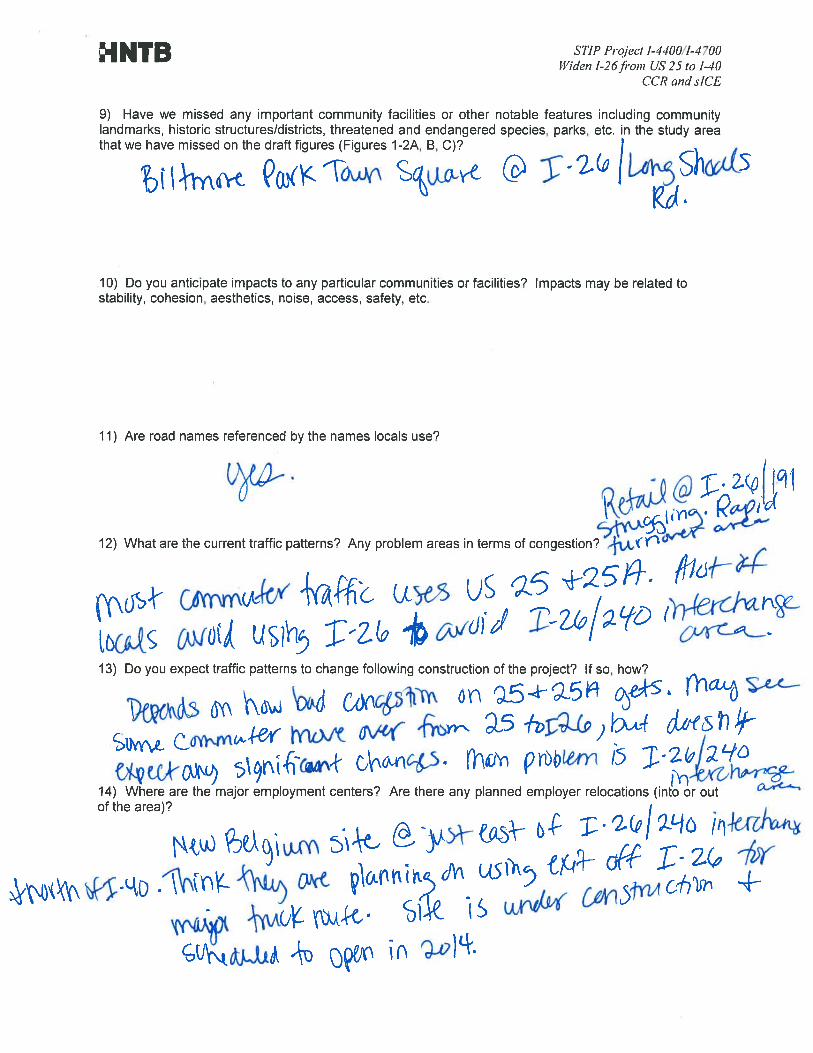


STIP Project I-4400/I-4700 Widen I-26 from US 25 to I-40
CCR and sICE
STIP Project I-4400/I-4700 I-26 from US 25 to I-40
Buncombe County and Henderson County
Community Characteristics Report (CCR) & Indirect and Cumulative Effects Screening Report (sICE)
INTERVIEWEE: Matt Cable, Transportation Planner DATE/TIME: 8/13/13 / PLACE:
1) How familiar are you with the project study area? (Figure 1-1)Very
2) We have collected several County plans and ordinances available on-line:
Henderson County: • Henderson County 2020 Comprehensive Plan (amended September 16, 2009)• Henderson County Land Development Code (amended February 20, 2013)
Are there any relevant plans/ordinances we are missing, or are any of the plans/ordinances listed above currently being updated? Yes
• Dana Community Plan• Green River, Tuxedo, Zirconia Community Plan
3) Currently, we are using NC One Map and NCDOT GIS data for the assessment. Is there any newermapping or local GIS data available? (We are particularly interested in land use, zoning, protected areas, community facilities, etc.)
Yes, All pertinent local layers are available through our website. Visit http://www.hendersoncountync.org/gis/gisdownload.html
4) Does the County have a Voluntary Agricultural District (VAD) program? If so, are there any VADs orEVADs located in the study area?
Yes, there is a VAD program. Yes, there are VADs in the study area.
5) What kinds of farms / agricultural operations are located in the project area? What types of crops aregrown?
Unknown. Ground verification would be required. A large majority of our farms are involved in apples, berries, corn, etc.
6) Are there any FEMA buyout properties in the study area? If so, where are these properties located?Who owns the properties (e.g. city, county, state, etc.)? Do you have mapping or GIS data that shows their location?

STIP Project I-4400/I-4700 Widen I-26 from US 25 to I-40
CCR and sICE
Not to my knowledge.
7) Are there any proposed local transportation projects in (or near) the study area?
Please contact the City of Hendersonville and Town of Fletcher who maintain their own road networks. The County does not manage any transportation projects outside of public transit. Public transit routes do not utilize the I-26 corridor but do travel across it on US Highways 64 and 25.
8) Are there any adopted plans for either pedestrian, greenway, bicycle, or transit facilities in the area?Please provide a description of how the plan applies to the project area, the title of the plan, its year of adoption, and the current status of its implementation.
Please contact the City of Hendersonville and Town of Fletcher who maintain their own pedestrian, greenway, and bicycle plans/infrastructure. The County is constructing a new transit center not within the project area in the year 2015. The County does not have a pedestrian, greenway, or bicycle plan. The Land of Sky Regional Council of Governments is working on the Blue Ridge Bike Plan which is a regional bicycle plan project.
9) Have we missed any important community facilities or other notable features including communitylandmarks, historic structures/districts, threatened and endangered species, parks, etc. in the study area that we have missed on the draft figures (Figures 1-2A, B, C)?
Please refer to the City of Hendersonville, Town of Fletcher, and pertinent County Community Plans to identify this information.
10) Do you anticipate impacts to any particular communities or facilities? Impacts may be related tostability, cohesion, aesthetics, noise, access, safety, etc.
No particular impacts,
11) Are road names referenced by the names locals use?
Yes.
12) What are the current traffic patterns? Any problem areas in terms of congestion?
Constrained because of limited lanes. Constrained at US Highway 64 intersection. Short and high ramp with limited visibility at US Highway 25 entering north bound I-26.
13) Do you expect traffic patterns to change following construction of the project? If so, how?
Overall increase in access and use of interstate to move between Henderson County interchanges.
14) Where are the major employment centers? Are there any planned employer relocations (into or outof the area)?
Major employment centers are along US Highway 64, US Highway 25, US Highway 176, and in Fletcher and Hendersonville. No relocations into or out of the area are known.

STIP Project I-4400/I-4700 Widen I-26 from US 25 to I-40
CCR and sICE
15) What are the commuting patterns? Do most residents work within the County or commute outside ofthe County?
Many residents travel from Henderson County to Buncombe County for work along I-26. To a lesser extent, Buncombe County residents travel to Henderson County for work. Some also utilize the I-26 corridor through Henderson County for purposes of reaching work in Polk and Haywood Counties (from any of the four counties).
16) US Census data indicate that Henderson County’s population grew by 19.7% between 2000 and2010 (more than the State at 18.5%). Could you describe the nature of this growth between 2000 and 2010, and where the growth is occurring more specifically? Are there reasons for growth in a particular area? Is the growth concentrated in any portion of the project study area?
Much of the growth (in terms of rate) occurred in Fletcher, eastern Henderson and southern Henderson County. These areas were among the less developed areas of the County. Fletcher is growing because of its accessibility and proximity to both Asheville and Hendersonville. The eastern area of the county is among the most gentle in terrain and most easily converted from forest and farmland to residential development. The eastern portion of the county also has the most interconnected road networks.
17) Where is growth (residential and non-residential) occurring in your jurisdiction as well as regionally?Are any major developments under construction near to project (within 1 – 2 miles)?
Henderson County is the fastest growing county in the region. Other than the construction of the Sierra Nevada Brewery on Boylston Highway (NC 280), I am not aware of any major developments under construction near to the project. You may wish to contact the City of Hendersonville and Town of Fletcher to identify any known development within their jurisdiction.
18) Are there any known plans for development in the vicinity of the project?
Not known, refer to City of Hendersonville and Town of Fletcher.
19) Is any redevelopment taking place? If so, where?
Not known, refer to City of Hendersonville and Town of Fletcher.
20) How would you characterize the residential market? Commercial market? Industrial market?
Please clarify.
21) How would you describe the local commitment to development (pro-growth vs. anti-growth)? Is thepolitical climate stable or unstable?
Pro-growth and politically stable.
22) What are the general development goals for this area? How does the County envision this area andthe I-26 corridor?
The Henderson County 2020 Comprehensive Plan identifies most of the properties on either side of the I-26 corridor as part of the Urban Services Area which is proposed for high density residential, commercial and industrial development.
23) Are there any development moratoria? What about development incentives?

STIP Project I-4400/I-4700 Widen I-26 from US 25 to I-40
CCR and sICE
There are no development moratoria in Henderson County. Henderson County does offer density increases where public water and sewer are available. You may wish to contact the City of Hendersonville and Town of Fletcher to verify moratoria and development incentives in their jurisdictions.
24) What are the major constraints to development in the area?
Topographical constraints are key to confining development in the area.
25) Are you aware of any minority communities/populations within or near the study area? Do youanticipate impacts to these communities/populations?
I am not aware of minority communities/populations within the study area. The majority of our minority population are focused east of Interstate 26. It is possible that communities along Crest Road, Dana Rd, and Tracy Grove Road have communities of minorities which may be impacted.
26) Are you aware of any other special populations / communities (e.g. low-income, Limited EnglishProficiency) existing in the study area?
I am not aware of special communities/populations within the study area. Much of our LEP population are east of Interstate 26. It is possible that communities along Crest Road, Dana Rd, and Tracy Grove Road have communities of special populations (including LEP) which may be impacted.
27) What areas are served by water and sewer services? Who are the sewer and water serviceproviders?
The City of Hendersonville provides water and sewer service in the area. The City of Asheville also provides water and sewer service. You may wish to contact the City of Hendersonville and City of Asheville to verify the extent of their service area. Water and sewer is available along Upward Rd, US Highway 64 and US Highway 25 in the vicinity of I-26.
28) What is the existing capacity of the water and sewer systems? How much of the capacity is beingused currently? When would you anticipate reaching full capacity for both the water and sewer systems?
You may wish to contact the City of Hendersonville and City of Asheville to verify this information.
29) Are there any planned upgrades to capacity (plant or conveyance capacity) for water and/or sewerservices? If so, are the upgrades funded?
You may wish to contact the City of Hendersonville and City of Asheville to verify this information.
30) Are there any planned water or sewer line extensions? If so, where would the new lines be? Is therefunding for these extensions?
You may wish to contact the City of Hendersonville and City of Asheville to verify this information.
31) Are there any riparian buffer regulations or other land use controls (other than zoning)?
All land use regulations for Henderson County are contained within the Land Development Code. Henderson County combined multiple land use regulations into this document. Please clarify which types of land use controls are pertinent and we will provide additional information regarding those land use controls. You may wish to contact the City of Hendersonville and Town of Fletcher regarding their land use controls.

STIP Project I-4400/I-4700 Widen I-26 from US 25 to I-40
CCR and sICE
32) Are there any local stormwater runoff management programs? Phase II stormwater regulations?
The Henderson County Land Development Code contains adopted WSWS regulations and stormwater regulations. I believe the City of Hendersonville enforces Phase II regulations. You may wish to contact the City of Hendersonville and Town of Fletcher regarding their stormwater management programs.
33) Is any land protected from development?
The Green River Gamelands are protected by Fish and Wildlife. What other “protected lands” are of interest.
34) Based on North Carolina Division of Employment Security data, it is anticipated that the 4-CountyWestern Area Workforce Development Board (Buncombe County, Henderson County, Madison County, and Transylvania County) will experience an annual employment growth rate of approximately 0.9% per year between 2008 and 2018. Is this estimate satisfactory in your opinion? Would you expect the annual employment growth in the project area to be less, the same, or more than the Western Area WDB as a whole?
Given the existing economic situation, and the dramatic loss in jobs between 2007 and 2010. I would anticipate no to minimal employment growth over the period for Henderson County. I cannot guess as to the impacts in the other Counties in the region.
35) Based on data published by the North Carolina Office of Budget and Management, it is anticipatedthat Henderson County will experience an annual population growth rate of approximately 0.3% through 2033. Is this estimate accurate in your opinion? Would you expect the annual population growth in the Henderson County portion of the study area to be lower than, the same as, or higher than the County as a whole?
I would estimate this growth rate to be accurate. Growth within the study area will likely be similar to that experienced across the County. The proximity to I-26 will generate more growth than elsewhere, but likely not within the constrained study area.
36) Do you anticipate this project (STIP Project I-4400/I-4700) will affect land use or developmentpatterns in the area? If yes, what kinds of effects are expected and where do you anticipate they would occur?
The project will increase nonresidential and residential development in the areas immediately surrounding I-26 and along the major 4-lane corridors which extent from these interchanges.
37) Are you aware of any community concerns or controversy relative to this project?
I am not ware of concerns beyond the need for additional capacity to improve safety.
38) Are there any additional comments you would like to make?
None.

RECORD OF TELEPHONE CALL
Job # Date
Call From Of
Call To Of
By
Subject Discussed Action to be Taken

Page 2 of 2

STIP I‐4400/I‐4700 CCR – Henderson and Buncombe Counties 62
Appendix C: Buncombe County Greenways & Trails Master Plan Maps

3 - 12 Buncombe County Greenways & Trails Master Plan
Draft Plan for Public Review—August 2012
Bent Creek Greenway
The French Broad River Floodplain (left) offer opportunity for greenway corridor development. Terrain near the Farmers Market (right) will likely require special considerations and partnerships for trail construction.
Influences: The planned greenway would begin at the current terminus of the
greenway at the confluence of Hominy Creek and the French Broad River that is
part of the Wilma Dykeman RiverWay. Influences along the route include:
West Asheville & Bent Creek Bent Creek / Arboretum Trails
Biltmore Square Mall / Business Park WNC Farmers Market
I-26, Brevard Road interchange MSD Easement along I-26
Wilma Dykeman RiverWay Blue Ridge Parkway
There is an existing walking trail within the Ridgefield Business Park between
Brevard Road and I-26 south of Biltmore Square Mall. The southern terminus at
the Arboretum links to the planned Arden/Lake Julian corridor to provide a con-
nection from central Buncombe County to communities in southern Buncombe
County. The project would also cross near the Mountains to Sea Trail.
West Asheville, the NC Arboretum and Bent
Creek were some of the top destinations iden-
tified through the public process. This pro-
posed route makes those connections from
mountain bike and hiking trails at Bent Creek
and the Arboretum as well as greenways in
West Asheville. The 8-mile route requires
careful consideration of the area around the
Farmers Market and Brevard Road.
Major Challenges
The interchange at I-26 and Brevard Road (NC 191) is a major con-
straint depending on how the interchange re-build can be config-
ured. There is potential to follow I-26 right-of-way between I-26 and
the Biltmore properties to a culvert and MSD lift station south of the
interchange near the business park. Connections to Bent Creek trails
will offer other challenges if users are expected to travel on existing
streets, which are narrow and have sight distance issues. Complete
Streets applications may need to be pursued, if possible within exist-
ing right-of-way.
Potential Partners:
The User Experience: A greenway linking Bent Creek to Hominy
Creek could provide exceptional opportunities for connectivity,
tourism, Blue Ridge Parkway connection and West Asheville linkag-
es. Extensive discussions have occurred about greenway potential
in this corridor for many years. Initially, it is possible the route will
link Bent Creek to the Mission Hospital Satellite offices campus in
Broadpointe Business Park.
City of Asheville
NC Arboretum
RiverLink
NCDOT, MSD & Utilities
Business Association
WNC Farmers Market
Blue Ridge Parkway
Typology: This corridor has the potential
to serve both as a utilitarian connection by
providing access from the City limits to
Bent Creek Recreational Area, and lunch
time exercise users within the business
park. Mountain bikers prefer unpaved
trails, but that may not be as practical or
desired north of the I-26/Brevard Road
interchange.
Likely
Users

3 - 13 Buncombe County Greenways & Trails Master Plan
Draft Plan for Public Review—August 2012
Bent Creek Greenway Corridor

3 - 14 Buncombe County Greenways & Trails Master Plan
Draft Plan for Public Review—August 2012
Hominy Creek Greenway
This proposed 7-mile corridor could serve as
a utilitarian connection by providing access
from the Hominy Creek Greenway/Park to
Buncombe County Sports Park. Initially, this
focus area begins in West Asheville near Sand
Hill Road and terminates near the AB Tech
Enka Campus with a spur to Enka High School
and nearby public use areas.
Influences: The planned corridor connects urbanized areas of unincorporated
Buncombe County to existing greenways in West Asheville and the Wilma Dyk-
man RiverWay. A new development is proposed with the old BASF plant site
near AB Tech, which will construct a segment of greenway through the property.
Communities and influences along the route include:
West Asheville Enka, Candler & Biltmore Lake
AB Tech Enka Campus Buncombe County Sports Park
Enka-Candler Library Sand Hill-Venable Elem. School
I-40 / Sand Hill Road Asheville School
Enka High School Hominy Valley Elementary School
National Forest
Beyond the terminus of the mainline at AB Tech, a long-range greenway corridor
is identified paralleling Hominy Creek to the Haywood County line.
Major Challenges
The constraints of built out areas, I-40, I-26/I-240 and topogra-
phy presents limited options for this corridor. The meandering
nature of Hominy Creek also requires considerable evaluation as
to the best placement of the greenway. The value of the connec-
tions it provides however should not be underestimated when
considering how these constraints need to be addressed when
design commences.
Potential Partners:
The User Experience: The proposed corridor connects heavily
utilized sections of existing greenways in West Asheville and has
the potential to be a commuter corridor to and from this area
and for AB Tech students. The Hominy Valley area is popular for
long-distance recreational cyclists who start their trips in the
Enka community or West Asheville.
City of Asheville
AB Tech
RiverLink
NCDOT
MSD & Utilities
Buncombe County Schools
Typology: Greenway design should be
consistent throughout much of this corri-
dor in off-street segments, with a 10-foot
asphalt greenway. On-street section or
stream crossings will require Complete
Streets applications. The spur to Enka
High School could be considered as a
natural surface 10-foot trail.
Likely
Users
Interstate crossings (left) and filling gaps in Complete Street applica-tions (right) will help make connections to off-street trail near Enka .

3 - 15 Buncombe County Greenways & Trails Master Plan
Draft Plan for Public Review—August 2012
Hominy Creek Greenway Corridor

3 - 16 Buncombe County Greenways & Trails Master Plan
Draft Plan for Public Review—August 2012
Lake Julian Greenway
Planned greenways linking Mills Gap Road to
Bent Creek provide exceptional opportunities
for connectivity, tourism, retail support, and
the 6-mile French Broad River corridor in this
area. Biltmore Park and Lake Julian are pri-
mary destinations with linkages planned to
the Bent Creek Greenway and long-term trails
along Cane Creek.
Typology: The route will likely have high
usage connecting development to recrea-
tional areas and the National Forest. A combi-
nation of 10’ hardened surface in addition to
a section of Complete Street improvements
along Long Shoals Road is likely. From Lake
Julian to Mills Gap Road the typology may
range from improved neighborhood streets
to 4’ wide trail systems along the powerline
corridor through Rosscraggon Park.
Influences: West of the French Broad River, the trail follows the alignment of river and roadways. Long Shoals Road will require upgrades for Complete Streets features. A powerline easement east of Lake Julian provides the primary route linking Royal Pines. Influences include:
NC Arboretum & Bent Creek Biltmore Park Town Square
Lake Julian Arden Community
Small parks throughout the study area Royal Pine Community
Several schools
Biltmore Park can be easily accessed via existing sidewalks located along Long
Shoals or the construction of an off-road trail near the road. Utilization of the
newly improved I-26 interchange has been identified as an alternate route. In
both cases, sidewalk connectivity via the newly constructed bridge can be used
to span the French Broad River. RiverLink also holds conservations easements in
the area.
Likely
Users
Major Challenges
It is preferred that the floodplain be utilized to connect to the Bent
Creek Recreational Area. Multiple private properties will need to
be traversed if this route is followed, however, large tracts, specifi-
cally Biltmore Baptist Church, Biltmore Farms, Asheville Firefight-
ers Association, and the UNCA property could be linked together
to create this opportunity. Topographic challenges exist from are-
as between Hwy 191 and the French Broad River. Topographic
challenges also exist along the powerline corridor east of Lake
Julian.
Potential Partners:
The User Experience: The proposed route bisects a variety of
development types and there are several properties along the
west side of the river that could be poised for development. Us-
ers will have to navigate a corridor where the character and de-
sign changes in order to make necessary connections and pro-
vide access to schools, shopping areas and natural features. The
powerline easement will also be a factor in the user experience.
City of Asheville
NC Arboretum
NCDOT
RiverLink
MSD, Utilities & Railroad
Homeowners Associations
Major Property Owners
The Royal Pines area (left) has shown interest in greenways; proximity of the corridor the French Broad River (right) is a notable constraint.

3 - 17 Buncombe County Greenways & Trails Master Plan
Draft Plan for Public Review—August 2012
Lake Julian Greenway Corridor

STIP I‐4400/I‐4700 CCR – Henderson and Buncombe Counties 69
Appendix D ‐ Proposed Land Use Map (2013 Draft Comprehensive Land Use Plan, Buncombe County, June 2006)


STIP I‐4400/I‐4700 CCR – Henderson and Buncombe Counties 71
Appendix E: Demographic Data in Tabular Form
Table 1: Population Change, 2000‐2010
Population 2000 2010 Difference % Change
Census Tract 12, Block Group 5 608 862 254 41.8%
Census Tract 21.01, Block Group 1 1,473 1,375 ‐98 ‐6.7%
Census Tract 22.03, Block Group 2 1,139 1,721 582 51.1%
Census Tract 22.04, Block Group 1 3,342 3,497 155 4.6%
Census Tract 23.02, Block Group 1 2,262
Census Tract 23.02, Block Group 4 873
Census Tract 9302, Block Group 3 1,458 1,797 339 23.3%
Census Tract 9303, Block Group 2 1,905 2,131 226 11.9%
Census Tract 9303, Block Group 3 959 1,273 314 32.7%
Census Tract 9305.01, Block Group 1 2,330
Census Tract 9305.01, Block Group 2 1,704
Census Tract 9306, Block Group 1 2,530
Census Tract 9306, Block Group 2 2,429
Census Tract 9310, Block Group 1 1,186
Census Tract 9310, Block Group 2 818
Census Tract 9310, Block Group 4 1,537
Census Tract 9310, Block Group 5 695
Census Tract 9310, Block Group 3 1,163 1,296 133 11.4%
Census Tract 9314, Block Group 2 N/A 1,351 N/A N/A
Census Tract 9314, Block Group 3 1,601 1,787 186 11.6%
Buncombe County 206,330 238,318 31,988 15.5%
Henderson County 89,173 106,740 17,567 19.7%
North Carolina 8,049,313 9,535,483 1,486,170 18.5%
DSA Aggregate* 26,354 32,103 5,749 21.8%
Source: US Census Bureau, Census 2010 and Census 2000, Summary File 1 100% data, Table P1 and P001 "Total Population"
*Note: DSA Aggregates exclude CT 9314, BG 2 due to significant changes in this block group's boundaries between 2000 and2010. Therefore, the DSA Aggregates are only approximate values used to give a general indication of population trends.
3,609 627 17.4%
Henderson County Block Groups
3,163 871 27.5%
3,544 1,415 39.9%
2,390 745 31.2%
Buncombe County
Block Groups
Table 2: Population Projections, 2013‐2033
Census Geography 2013 2023 2033
% Change from
2013‐2033
% Annual
Change from
2013‐2033
Buncombe County 248,578 279,008 309,439 24.48% 1.10%
Henderson County 108,630 112,223 114,628 5.52% 0.27%
North Carolina 9,873,948 10,953,951 12,036,225 21.90% 1.00%
Source: North Carol ina Office of State Budget and Management
(www.osbm.state.nc.us , Accessed 7/09/13)
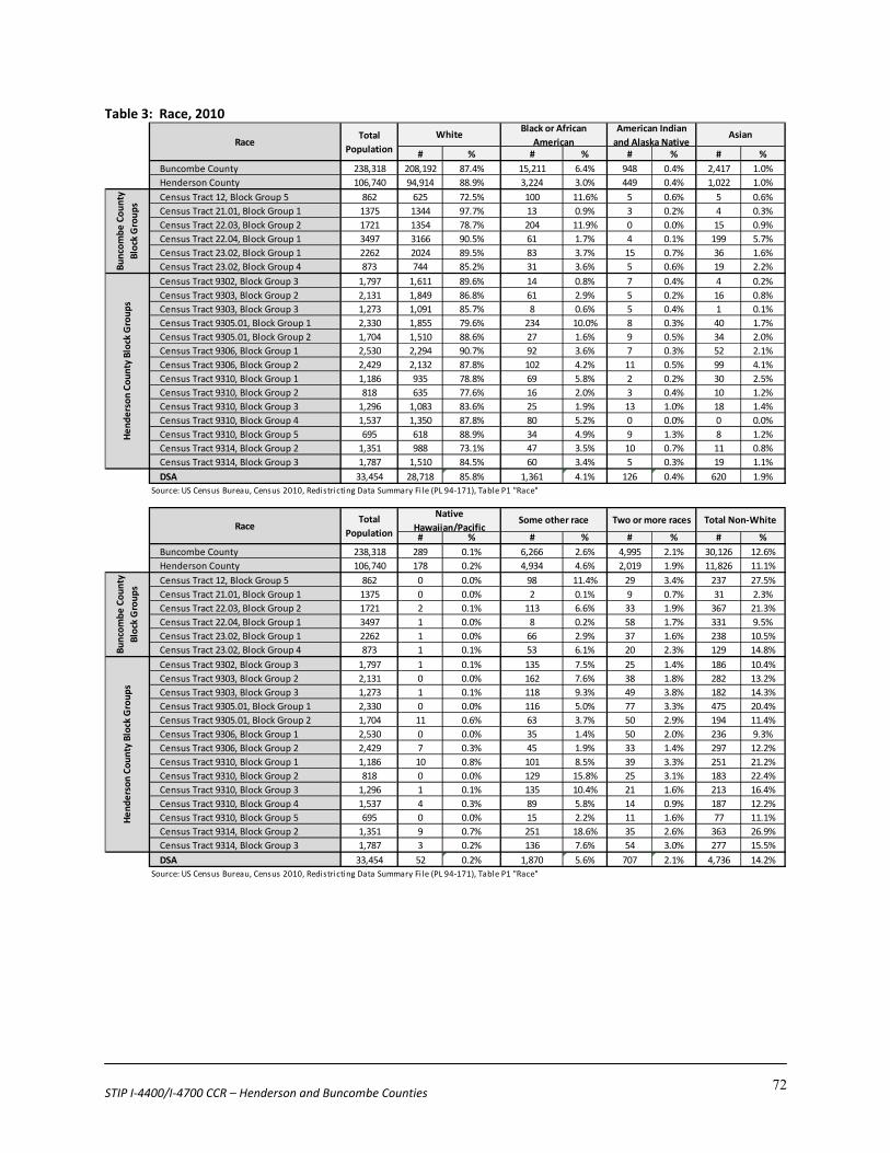
STIP I‐4400/I‐4700 CCR – Henderson and Buncombe Counties 72
Table 3: Race, 2010
# % # % # % # %
Buncombe County 238,318 208,192 87.4% 15,211 6.4% 948 0.4% 2,417 1.0%
Henderson County 106,740 94,914 88.9% 3,224 3.0% 449 0.4% 1,022 1.0%
Census Tract 12, Block Group 5 862 625 72.5% 100 11.6% 5 0.6% 5 0.6%
Census Tract 21.01, Block Group 1 1375 1344 97.7% 13 0.9% 3 0.2% 4 0.3%
Census Tract 22.03, Block Group 2 1721 1354 78.7% 204 11.9% 0 0.0% 15 0.9%
Census Tract 22.04, Block Group 1 3497 3166 90.5% 61 1.7% 4 0.1% 199 5.7%
Census Tract 23.02, Block Group 1 2262 2024 89.5% 83 3.7% 15 0.7% 36 1.6%
Census Tract 23.02, Block Group 4 873 744 85.2% 31 3.6% 5 0.6% 19 2.2%
Census Tract 9302, Block Group 3 1,797 1,611 89.6% 14 0.8% 7 0.4% 4 0.2%
Census Tract 9303, Block Group 2 2,131 1,849 86.8% 61 2.9% 5 0.2% 16 0.8%
Census Tract 9303, Block Group 3 1,273 1,091 85.7% 8 0.6% 5 0.4% 1 0.1%
Census Tract 9305.01, Block Group 1 2,330 1,855 79.6% 234 10.0% 8 0.3% 40 1.7%
Census Tract 9305.01, Block Group 2 1,704 1,510 88.6% 27 1.6% 9 0.5% 34 2.0%
Census Tract 9306, Block Group 1 2,530 2,294 90.7% 92 3.6% 7 0.3% 52 2.1%
Census Tract 9306, Block Group 2 2,429 2,132 87.8% 102 4.2% 11 0.5% 99 4.1%
Census Tract 9310, Block Group 1 1,186 935 78.8% 69 5.8% 2 0.2% 30 2.5%
Census Tract 9310, Block Group 2 818 635 77.6% 16 2.0% 3 0.4% 10 1.2%
Census Tract 9310, Block Group 3 1,296 1,083 83.6% 25 1.9% 13 1.0% 18 1.4%
Census Tract 9310, Block Group 4 1,537 1,350 87.8% 80 5.2% 0 0.0% 0 0.0%
Census Tract 9310, Block Group 5 695 618 88.9% 34 4.9% 9 1.3% 8 1.2%
Census Tract 9314, Block Group 2 1,351 988 73.1% 47 3.5% 10 0.7% 11 0.8%
Census Tract 9314, Block Group 3 1,787 1,510 84.5% 60 3.4% 5 0.3% 19 1.1%
DSA 33,454 28,718 85.8% 1,361 4.1% 126 0.4% 620 1.9%
Source: US Census Bureau, Census 2010, Redistricting Data Summary File (PL 94‐171), Table P1 "Race"
# % # % # % # %
Buncombe County 238,318 289 0.1% 6,266 2.6% 4,995 2.1% 30,126 12.6%
Henderson County 106,740 178 0.2% 4,934 4.6% 2,019 1.9% 11,826 11.1%
Census Tract 12, Block Group 5 862 0 0.0% 98 11.4% 29 3.4% 237 27.5%
Census Tract 21.01, Block Group 1 1375 0 0.0% 2 0.1% 9 0.7% 31 2.3%
Census Tract 22.03, Block Group 2 1721 2 0.1% 113 6.6% 33 1.9% 367 21.3%
Census Tract 22.04, Block Group 1 3497 1 0.0% 8 0.2% 58 1.7% 331 9.5%
Census Tract 23.02, Block Group 1 2262 1 0.0% 66 2.9% 37 1.6% 238 10.5%
Census Tract 23.02, Block Group 4 873 1 0.1% 53 6.1% 20 2.3% 129 14.8%
Census Tract 9302, Block Group 3 1,797 1 0.1% 135 7.5% 25 1.4% 186 10.4%
Census Tract 9303, Block Group 2 2,131 0 0.0% 162 7.6% 38 1.8% 282 13.2%
Census Tract 9303, Block Group 3 1,273 1 0.1% 118 9.3% 49 3.8% 182 14.3%
Census Tract 9305.01, Block Group 1 2,330 0 0.0% 116 5.0% 77 3.3% 475 20.4%
Census Tract 9305.01, Block Group 2 1,704 11 0.6% 63 3.7% 50 2.9% 194 11.4%
Census Tract 9306, Block Group 1 2,530 0 0.0% 35 1.4% 50 2.0% 236 9.3%
Census Tract 9306, Block Group 2 2,429 7 0.3% 45 1.9% 33 1.4% 297 12.2%
Census Tract 9310, Block Group 1 1,186 10 0.8% 101 8.5% 39 3.3% 251 21.2%
Census Tract 9310, Block Group 2 818 0 0.0% 129 15.8% 25 3.1% 183 22.4%
Census Tract 9310, Block Group 3 1,296 1 0.1% 135 10.4% 21 1.6% 213 16.4%
Census Tract 9310, Block Group 4 1,537 4 0.3% 89 5.8% 14 0.9% 187 12.2%
Census Tract 9310, Block Group 5 695 0 0.0% 15 2.2% 11 1.6% 77 11.1%
Census Tract 9314, Block Group 2 1,351 9 0.7% 251 18.6% 35 2.6% 363 26.9%
Census Tract 9314, Block Group 3 1,787 3 0.2% 136 7.6% 54 3.0% 277 15.5%
DSA 33,454 52 0.2% 1,870 5.6% 707 2.1% 4,736 14.2%
Source: US Census Bureau, Census 2010, Redistricting Data Summary File (PL 94‐171), Table P1 "Race"
Buncombe County
Block Groups
Henderson County Block Groups
Total
PopulationRace
Buncombe County
Block Groups
Henderson County Block Groups
American Indian
and Alaska Native Asian
Native
Hawaiian/Pacific Some other race Two or more races Total Non‐White
RaceTotal
Population
WhiteBlack or African
American

STIP I‐4400/I‐4700 CCR – Henderson and Buncombe Counties 73
Table 4: Hispanic or Latino by Origin, 2010
# % # %
Buncombe County 238,318 14,254 6.0% 224,064 94.0%
Henderson County 106,740 10,424 9.8% 96,316 90.2%
Census Tract 12, Block Group 5 862 195 22.6% 667 77.4%
Census Tract 21.01, Block Group 1 1375 13 0.9% 1362 99.1%
Census Tract 22.03, Block Group 2 1721 289 16.8% 1432 83.2%
Census Tract 22.04, Block Group 1 3497 89 2.5% 3408 97.5%
Census Tract 23.02, Block Group 1 2262 128 5.7% 2134 94.3%
Census Tract 23.02, Block Group 4 873 73 8.4% 800 91.6%
Census Tract 9302, Block Group 3 1,797 254 14.1% 1,543 85.9%
Census Tract 9303, Block Group 2 2,131 285 13.4% 1,846 86.6%
Census Tract 9303, Block Group 3 1,273 264 20.7% 1,009 79.3%
Census Tract 9305.01, Block Group 1 2,330 268 11.5% 2,062 88.5%
Census Tract 9305.01, Block Group 2 1,704 144 8.5% 1,560 91.5%
Census Tract 9306, Block Group 1 2,530 103 4.1% 2,427 95.9%
Census Tract 9306, Block Group 2 2,429 99 4.1% 2,330 95.9%
Census Tract 9310, Block Group 1 1,186 178 15.0% 1,008 85.0%
Census Tract 9310, Block Group 2 818 291 35.6% 527 64.4%
Census Tract 9310, Block Group 3 1,296 237 18.3% 1,059 81.7%
Census Tract 9310, Block Group 4 1,537 127 8.3% 1,410 91.7%
Census Tract 9310, Block Group 5 695 45 6.5% 650 93.5%
Census Tract 9314, Block Group 2 1,351 453 33.5% 898 66.5%
Census Tract 9314, Block Group 3 1,787 337 18.9% 1,450 81.1%
DSA 33,454 3872 11.6% 29,582 88.4%
Source: US Census Bureau, Census 2010, Summary File 1 100% Data, Table P4 "Hispanic or Latino Origin"
Hispanic or Latino OriginTotal
Population
Hispanic Not HispanicBuncombe County
Block Groups
Henderson County Block Groups

STIP I‐4400/I‐4700 CCR – Henderson and Buncombe Counties 74
Table 5: Limited English Proficiency, 2010
Spanish Other Indo‐Euro Asian / Pacific Other
# % # % # % # %
Census Tract 12, Block Group 5 542 0 0% 0 0% 0 0% 0 0%
Census Tract 21.01, Block Group 1 1,207 0 0% 6 0.50% 0 0% 0 0%
Census Tract 22.03, Block Group 2 914 37 4.0% 0 0% 0 0% 0 0%
Census Tract 22.04, Block Group 1 2,512 20 0.80% 43 1.71% 0 0% 0 0%
Census Tract 23.02, Block Group 1 1,784 13 0.73% 172 9.64% 0 0% 0 0%
Census Tract 23.02, Block Group 4 477 0 0% 12 2.52% 0 0% 0 0%
Census Tract 9302, Block Group 3 1,275 51 4.0% 0 0% 0 0% 0 0%
Census Tract 9303, Block Group 2 1,929 126 6.53% 12 0.62% 0 0% 0 0%
Census Tract 9303, Block Group 3 1,040 266 25.58% 0 0% 0 0% 14 1.35%
Census Tract 9305.01, Block Group 1 1,388 0 0% 0 0% 10 0.72% 0 0%
Census Tract 9305.01, Block Group 2 1,667 81 4.86% 7 0.42% 22 1.32% 0 0%
Census Tract 9306, Block Group 1 2,053 20 0.97% 0 0% 0 0% 0 0%
Census Tract 9306, Block Group 2 1,521 91 5.98% 1 0% 16 1.05% 0 0%
Census Tract 9310, Block Group 1 760 35 4.61% 2 0% 0 0% 0 0%
Census Tract 9310, Block Group 2 566 145 25.62% 3 0% 0 0% 0 0%
Census Tract 9310, Block Group 3 1,669 70 4.19% 4 0% 0 0% 0 0%
Census Tract 9310, Block Group 4 872 0 0% 5 0% 0 0% 0 0%
Census Tract 9310, Block Group 5 599 0 0% 6 0% 0 0% 0 0%
Census Tract 9314, Block Group 2 1,042 405 38.87% 7 0% 0 0% 0 0%
Census Tract 9314, Block Group 3 1,127 0 0% 8 0% 0 0% 0 0%
DSA Aggregate 24,944 1,360 5.45% 252 1.01% 48 0.19% 14 0.06%Source: US Census Bureau, American Community Survey 5-year Estimates (2006-2010), Table B16004, "Age by Language Spoken at Home forthe Population 5+ Yrs"
LEPTotal Adult
Population
Primary Language Group of Persons Who Speak English Less than Very
Well
Buncombe County
Block Groups
Henderson County Block Groups
Table 6: Poverty, 2010
Below Poverty Level
# % # % # %Buncombe County 22,7047 33,356 14.69% 13570 5.98% 23,680 10.43%
Henderson County 101,898 12,979 12.74% 4821 4.73% 10,106 9.92%
Census Tract 12, Block Group 5 736 181 24.59% 15 2.04% 59 8.02%
Census Tract 21.01, Block Group 1 1547 38 2.46% 13 0.84% 46 2.97%
Census Tract 22.03, Block Group 2 1041 32 3.07% 19 1.83% 139 13.35%
Census Tract 22.04, Block Group 1 3542 187 5.28% 131 3.70% 62 1.75%
Census Tract 23.02, Block Group 1 2,086 132 6.33% 86 4.12% 133 6.38%
Census Tract 23.02, Block Group 4 885 244 27.57% 214 24.18% 92 10.40%
Census Tract 9302, Block Group 3 1773 79 4.46% 0 0.00% 541 30.51%
Census Tract 9303, Block Group 2 2454 359 14.63% 95 3.87% 238 9.70%
Census Tract 9303, Block Group 3 1609 376 23.37% 60 3.73% 398 24.74%
Census Tract 9305.01, Block Group 1 1695 238 14.04% 90 5.31% 275 16.22%
Census Tract 9305.01, Block Group 2 2113 89 4.21% 12 0.57% 58 2.74%
Census Tract 9306, Block Group 1 2609 265 10.16% 17 0.65% 111 4.25%
Census Tract 9306, Block Group 2 2039 219 10.74% 86 4.22% 212 10.40%
Census Tract 9310, Block Group 1 1065 130 12.21% 14 1.31% 82 7.70%
Census Tract 9310, Block Group 2 627 42 6.70% 23 3.67% 179 28.55%
Census Tract 9310, Block Group 3 1030 40 3.88% 10 0.97% 45 4.37%
Census Tract 9310, Block Group 4 930 144 15.48% 84 9.03% 193 20.75%
Census Tract 9310, Block Group 5 812 32 3.94% 12 1.48% 149 18.35%
Census Tract 9314, Block Group 2 1391 322 23.15% 83 5.97% 137 9.85%
Census Tract 9314, Block Group 3 1450 252 17.38% 38 2.62% 304 20.97%
DSA Aggregate 31,434 3,401 10.82% 1,102 3.51% 3,453 10.98%
Source: US Census Bureau, American Community Survey 5‐year Estimates (2006‐2010), Table C17002 "Ratio of Income to Poverty Level in the
Past 12 Months"
Near Poor: Between 100%
and 150% of
Buncombe County
Block Groups
Henderson County Block Groups
PovertyTotal
Population
Very Poor: Under 50% of Poverty Level

STIP I‐4400/I‐4700 CCR – Henderson and Buncombe Counties 75
Table 7: Median Home Value, 2010
Buncombe County 188,300
Henderson County 184,200
Census Tract 12, Block Group 5 28,200
Census Tract 21.01, Block Group 1 802,100
Census Tract 22.03, Block Group 2 160,200
Census Tract 22.04, Block Group 1 459,600
Census Tract 23.02, Block Group 1 147,800
Census Tract 23.02, Block Group 4 121,200
Census Tract 9302, Block Group 3 124,000
Census Tract 9303, Block Group 2 161,900
Census Tract 9303, Block Group 3 123,300
Census Tract 9305.01, Block Group 1 158,300
Census Tract 9305.01, Block Group 2 208,000
Census Tract 9306, Block Group 1 171,500
Census Tract 9306, Block Group 2 179,900
Census Tract 9310, Block Group 1 161,100
Census Tract 9310, Block Group 2 162,500
Census Tract 9310, Block Group 3 140,600
Census Tract 9310, Block Group 4 190,300
Census Tract 9310, Block Group 5 140,600
Census Tract 9314, Block Group 2 43,400
Census Tract 9314, Block Group 3 143,700
DSA Average 191,410Source: US Census Bureau, American Community Survey 5‐year
Estimates (2006‐2010), Table B25077 "Median Value (Dollars)"
Henderson County Block Groups
Housing Characteristics Median Home
Buncombe County
Block Groups

STIP I‐4400/I‐4700 CCR – Henderson and Buncombe Counties 76
Table 8: Travel Time to Work, 2010
Number 15,575 37,227 28,186 16,019 3439 3,520 103,966
Percent 15.0% 35.8% 27.1% 15.4% 3.3% 3.4% 100.0%
Number 5,912 14,538 11,762 6,765 1779 1,382 42,138
Percent 14.0% 34.5% 27.9% 16.1% 4.2% 3.3% 100.0%
Number 59 164 88 54 0 0 365
Percent 16.2% 44.9% 24.1% 14.8% 0.0% 0.0% 100.0%
Number 111 228 68 23 3 18 451
Percent 24.6% 50.6% 15.1% 5.1% 0.7% 4.0% 100.0%
Number 36 228 148 81 30 0 523
Percent 6.9% 43.6% 28.3% 15.5% 5.7% 0.0% 100.0%
Number 248 524 547 201 0 16 1,536
Percent 16.1% 34.1% 35.6% 13.1% 0.0% 1.0% 100.0%
Number 105 415 547 76 0 39 1,182
Percent 8.9% 35.1% 46.3% 6.4% 0.0% 3.3% 100.0%
Number 83 107 131 31 0 0 352
Percent 23.6% 30.4% 37.2% 8.8% 0.0% 0.0% 100.0%
Number 47 398 229 167 39 0 880
Percent 5.3% 45.2% 26.0% 19.0% 4.4% 0.0% 100.0%
Number 42 540 345 137 71 27 1,162
Percent 3.6% 46.5% 29.7% 11.8% 6.1% 2.3% 100.0%
Number 153 431 130 44 0 0 758
Percent 20.2% 56.9% 17.2% 5.8% 0.0% 0.0% 100.0%
Number 172 331 198 36 78 0 815
Percent 21.1% 40.6% 24.3% 4.4% 9.6% 0.0% 100.0%
Number 78 187 204 103 17 33 622
Percent 12.5% 30.1% 32.8% 16.6% 2.7% 5.3% 100.0%
Number 178 369 455 274 118 0 1,394
Percent 12.8% 26.5% 32.6% 19.7% 8.5% 0.0% 100.0%
Number 181 432 210 123 6 51 1003
Percent 18.0% 43.1% 20.9% 12.3% 0.6% 5.1% 100.0%
Number 71 133 49 69 40 0 362
Percent 19.6% 36.7% 13.5% 19.1% 11.0% 0.0% 100.0%
Number 15 183 63 15 13 15 304
Percent 4.9% 60.2% 20.7% 4.9% 4.3% 4.9% 100.0%
Number 203 96 136 155 0 19 609
Percent 33.3% 15.8% 22.3% 25.5% 0.0% 3.1% 100.0%
Number 57 19 34 43 0 0 153
Percent 37.3% 12.4% 22.2% 28.1% 0.0% 0.0% 100.0%
Number 33 107 70 35 0 61 306
Percent 10.8% 35.0% 22.9% 11.4% 0.0% 19.9% 100.0%
Number 136 202 53 146 0 0 537
Percent 25.3% 37.6% 9.9% 27.2% 0.0% 0.0% 100.0%
Number 47 266 259 23 58 0 653
Percent 7.2% 40.7% 39.7% 3.5% 8.9% 0.0% 100.0%
Number 2,055 5,360 3,964 1,836 473 279 13,967
Percent 14.71% 38.38% 28.38% 13.15% 3.39% 2.00% 100%
Source: US Census Bureau, American Community Survey 5‐year Estimates (2006‐2010), Table B08303 "Travel Time to Work"
Census Tract 9314, Block Group 3
DSA Aggregate
Buncombe County Block Groups
Henderson County Block Groups
Census Tract 9310, Block Group 2
Census Tract 9310, Block Group 3
Census Tract 9310, Block Group 4
Census Tract 9310, Block Group 5
Census Tract 9314, Block Group 2
Census Tract 9305.01, Block Group 1
Census Tract 9305.01, Block Group 2
Census Tract 9306, Block Group 1
Census Tract 9306, Block Group 2
Census Tract 9310, Block Group 1
Census Tract 23.02, Block Group 1
Census Tract 23.02, Block Group 4
Census Tract 9302, Block Group 3
Census Tract 9303, Block Group 2
Census Tract 9303, Block Group 3
Henderson County
Census Tract 12, Block Group 5
Census Tract 21.01, Block Group 1
Census Tract 22.03, Block Group 2
Census Tract 22.04, Block Group 1
30 to 44
Minutes
45 to 59
Minutes
60 or
More Total
Buncombe County
CommutersLess Than
10
10 to 19
Minutes
20 to 29
Minutes

STIP I‐4400/I‐4700 CCR – Henderson and Buncombe Counties 77
Appendix F – Dana Community Planning Area Map (Dana Community Plan, Henderson County, March 2011)

DANA RD
SUGARLOAF RD
HO
WA
RD
GA
P RD
DEEP GAP RD
UPW
AR
D R
D
OLETA RD
PACE RD
STEPP MILL R
D
STAT
ON
RD
TRACY GROVE RD
RAMP
S ALLEN
RD
UN
ION
HIL
L RD
ORCHARD RD
OLD DANA RD
LYTLE RD
KIN
G R
D
RIDGE RD
LANE RD
CREST RD
MC
MU
RR
AY R
D
BAL
LEN
GE
R R
D
Q P L
N
FEL
MET
RD
TAY
LO
R R
D
N A
LL
EN R
D
S ORCHARD R
D
MID
ALL
EN
RD
BLUE HOUSE RD BIG O
AK
RD
AC
AD
EMY
RD
OWENSBY RD
DU
NC
AN
RD
BIG HUNGRY RD
RID
GEW
AY D
R
JET ST
CH
ESTN
UT
GA
P R
D
NEW HOPE RD
BYE
RS
DR
UN
ION
HIL
L CH
UR
CH
RD
LOW GAP RD
DUDLEY DR
OLE
TA M
ILL
TRL
HYDER ALLEN LN
PEACE
DR
ASH
TON
LN
GIBBS R
D
E TRACY GROVE RD
SUTTLES RD
RUBY DR
CA
RLISLE D
R
CHINABERRY LN
HOOTS DR
HU
NG
RY
RIV
ER
RD
E PRINCE RD
OLD SUNSET HILL RD
GY
PSY L
N
FRANK HILL RD
LESL
IE W
AY
DEEP GAP LOOP RD
MC
CR
AW H
ILL D
R
BLACKW
ELL DR
KINCAID
PL
NA
GEL C
IR
ALB
EA D
R
MER
RI D
R
HERBERT DR
HILLS RIDGE RD
LOC
UST
CR
EEK
LN
BILLS WAY
FRA
NK
IE L
NATLAS L
N
MO
NT
RO
SE S
T
SOPHIA LN
KAT
IE D
R
RILE
Y LN
LARGO LN
RANDOLPH AVE
DREAMW
ORKS CT
RIV
ER
CR
EST
DR
J R MATTHEWS DR
WAYNE LAMB DR
ANCESTOR LN
MC
CA
LL
ST
SUG
AR
LOA
F LN
EDN
A O
AK
S R
D
SUL
O D
R
OLD
CA
GLE R
D
HAWKE TER
CO
NA
RD
DRPIN
E TREE L
N
NASH LN
J H HYDER RD
DRY CREEK LNDE W
ITT LN
PATS PL
BIG HUNGRY RD
RA
MP
I-26
US 64E
US 176
How
ard Gap R
d
Rid
ge R
d
Upwa
rd R
d
NC
225
Pilo
t Mtn
. Rd
US 25S
Hun
gr
y River
Clea
r Cre
ek
Gr
een Rive
r (Lake Summit b
elow elevation 2011)
Henderson County Planning Department 03-16-11
.
Map 1: Planning A
rea Boun dary
Major Roads
Streets
Major Streams
Community Plan Boundary
City of Hendersonville
Village of Flat Rock
Municipal ETJ
Parcels
Dana CommunityPlanning Area
Planning Area Boundary
Hendersonville
0 10.5 Miles
1 inch = 0.72 miles
This map is prepared from the inventory of real property foundwithin this jurisdiction, and is compiled from recorded deeds, plats, and other public records and data. Users of this map, are hereby notified that the aforementioned public primary information sourcesshould be consulted for verification of the information contained on this map. The County and mapping company assume no legalresponsibility for the information contained on this map.
60
Flat Rock