communicating residual risk in krems, austria budapest, 06. november 2012 dr. yvonne spira...
TRANSCRIPT

Communicating Residual Risk in Krems, Austria
Budapest, 06. November 2012
Dr. Yvonne Spira [email protected]. Therese Stickler [email protected]. Robert Konecny [email protected]


DANUBE FLOODRISK - Objectives
Overall:• Improvement of the socio-economic conditions of
the population in the Danube floodplain by flood risk mapping
Long-term:• Reducing the flood damage in the Danube
floodplain• Improving the long-term strategic planning
framework for flood risk management

DANUBE FLOODRISK - Facts• 03/09-10/12• Budget 5,3 M€ • 14 ERDF Partners
from 6 MS (AT, BG, HU, IT, RO, SK)
• 6 IPA Partners from 2 countries (HR, RS)
• 5 observers from 3 MS (AT, IT, DE)
• LP: Mary-Jeanne AdlerMinistry of Environment, RO

DANUBE FLOODRISK – Main Results
• Common methodology for hazard and risk assessment
• Common database with hazard and risk maps• Danube Atlas with Hazard and Risk maps• 8 Pilot Projects in AT, BG, IT, RO

Location of Austrian Pilot Area
Krems: - Long-standing flood
experience- Inside APSFR- Receptors:
- 25,000 inhabitants- Economy- IPPC installations- Cultural world
heritage

The Story of Making Krems a Pilot Area
• 11/09-02/10 environment ministry and province Lower Austria: discussion about suitable and potentially willing pilot municipalities Krems?
• 04/2010 1st meeting with Krems municipality for getting their OK to pilot
- no cooperation between UBA-A and Krems so far
+ known and trusted province representative
+ support of administration- political reservations, strong skepticism trust building: experiences from other stakeholder involvement projects, rules for
cooperation agreement on flood scenarios & support of municipality

Investigated Scenarios
HQ1000HQ100HQ100 mobileHQ100 tributary
Failure of mobile defense wall in settlement area, adverse consequences to population, economy, culture
Failure of harbor gate,adverse consequences to economy, environment (3 IPPC companies)
Existing flood protection

Start of Stakeholder Workshops10/2011Presentation of hazard results to municipality
Agreement on harbor stakeholder involvement Agreement on risk mapping for settlement area and on stakeholder and broad public involvement positive atmosphere
11/2011 1st Stakeholder Workshop at VOEST+ municipality as door opener+ one strong company supporter (“Local champion”)
companies decided to meet internally to define suggestions for risk assessment

Further Harbor Stakeholder Workshops
01/2012 2nd Stakeholder Workshop at DYNEA Presentation of results of company meeting Presentations of risk assessment trial (€/m2)
Agreement on other risk assessment method02/2012 Follow up meeting
with Local Champion and risk scientists decision on detailed risk assessment method and data delivery
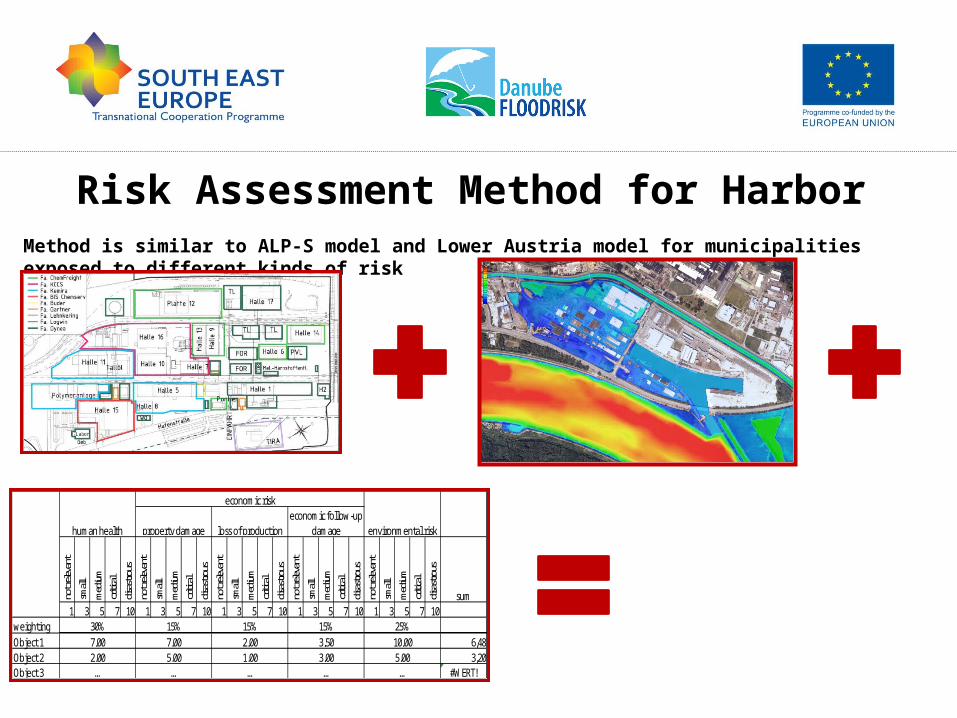
Risk Assessment Method for Harbor
not r
eleva
ntsm
allm
edium
critic
aldis
astro
usno
t rele
vant
small
med
iumcri
tical
disas
trous
not r
eleva
ntsm
allm
edium
critic
aldis
astro
usno
t rele
vant
small
med
iumcri
tical
disas
trous
not r
eleva
ntsm
allm
edium
critic
aldis
astro
us
sum1 3 5 7 10 1 3 5 7 10 1 3 5 7 10 1 3 5 7 10 1 3 5 7 10
weightingObject 1 6,48Object 2 3,20Object 3 #WERT!
2,00 5,00 1,00 3,00 5,00… … … … …
30% 15% 15% 15% 25%7,00 7,00 2,00 3,50 10,00
human health
economic risk
environmental riskproperty damage loss of productioneconomic follow-up
damage
Method is similar to ALP-S model and Lower Austria model for municipalities exposed to different kinds of risk

Harbor Hazard and Risk Map

Settlement Area Stakeholder Workshop
• 03/2012 civil protection staff workshop: presentation of settlement hazard and risk
map proposals and asking feedback open and constructive discussion and
feedback

• 04/2012 Presentation of final FHM & FRM to broad public (incl. press release) in cooperation with municipality
open dialogue
• 06/2012 final meeting with municipality and harbor stakeholders regarding further use of pilot
results positive closure of pilot project
Public Participation Event and Final Meeting
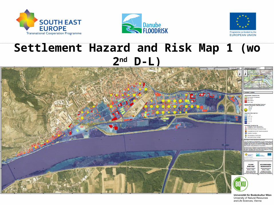
Settlement Hazard and Risk Map 1 (wo 2nd D-L)

Settlement Hazard and Risk Map 2 (w 2nd D-L)

Conclusions from Pilot• Effort for Stakeholder involvement was severely
underestimated (e.g. more than 2.5 years and more than 10 meetings in Krems, lots of „social“ telephone calls to stay in contact)
• Trust-building with stakeholders is essential to overcome fear of negative spin by political opponents/media
• Locally known door-opener and own communication person help a lot
• Be open for creating win-win situations• No pressure• Learning was not one-way, but mutual - a real dialogue
Communication of residual risk is possible and in this case positive

Conclusions from DANUBE FLOODRISK
for Danube Region Strategy• Good example of successful international cooperation
• Harmonisation of data and methods was possible• Joint atlas helps setting flood risk management
priorities for Danube river basin

Thanks for the excellent support to our pilot project
Companies in harbor area: Mierka, Eybl, VOEST, Biodiesel, Dynea
Civil Protection Units: Police and Fire Brigade Krems

• 2D-model based on LIDAR (floodplain) and multibeam echosounding (river bed) survey data
• modelling software: HYDRO_AS-2D• unsteady flow simulation of
Q100 flood wave• Failure of mobile defense wall in Stein
– Before the peak discharge– At peak discharge– With/without upright second defense wall
• Failure of harbor gate closure– Before peak discharge
Hydrodynamic Modelling

Risk Assessment Method for Settlement Area
Municipal register data
Damage functions
Statistical datare property values