common data formats for re-identification and high
TRANSCRIPT

Stanley E. Young, Darcy M. Bullock, Dennis So Ting Fong
Common Data Formats for Re-Identifi cation and
High-Resolution Data

Common Data Formats for
Re-Identification and High-Resolution Data Stanley E. Young
Traffax, Inc.
Darcy M. Bullock Purdue University
Dennis So Ting Fong
Traffax, Inc.
SBIR Phase 3 Joint Transportation Research Project Traffax, Inc.
Purdue University
June 30, 2015
Deliverable Reference: D2.2 Common Data Format Report
Project Name: Sensor Fusion and MOE Development for Off-Line Traffic Analysis of Real Time Data
Contractor: Traffax, Inc.
Contract Number: DTFH61-14-C-00035
Contract Term Start 9/4/2014
Contract Term End 9/4/2017
Key Personnel Stan Young, Darcy Bullock, Dennis So Ting Fong

Recommended CitationYoung, S. E., D. M. Bullock, and D. S. T. Fong. Common Data Formats for Re-Identification and High-Resolution Data. Purdue University, West Lafayette, Indiana, 2017. https://doi.org/10.5703/1288284316566
AcknowledgmentsThis work was supported by Traffax/USDOT SBIR DTFH6114C00035. The contents of this paper reflect the views of the authors, who are responsible for the facts and the accuracy of the data presented herein, and do not necessarily reflect the official views or policies of the sponsoring organizations. These contents do not constitute a standard, specification, or regulation.

Common Data Formats Report 1 Contract #: DTFH61-14-C-00035
Table of Contents
Introduction ................................................................................................................................................... 2
Re-Identification Technology Standards ...................................................................................................... 3
Purpose ...................................................................................................................................................... 3
Definitions................................................................................................................................................. 3
Acronyms .................................................................................................................................................. 4
Data Structure ........................................................................................................................................... 5
Re-identification Structure Elements ........................................................................................................ 6
High Resolution Controller Data Technology Standards.............................................................................. 9
Introduction ............................................................................................................................................... 9

Common Data Formats Report 2 Contract #: DTFH61-14-C-00035
Introduction
This report targets the delivery of common data formats to facilitate adoption and uniformity in the use of performance measures from re-identification and high-resolution probe data. The traffic data industry is typically segregated by data collection activities performed separately from data analysis activities. A common format for re-identification data allows data collection activities to be performed separate from analysis without having to build custom data interfaces based on the equipment, vendor, or data collection service provider.
Similarly, controller data differs in format and content by vendor, and sometimes by model. A common high-resolution data format minimizes the variability of implementation from vendor to vendor. Much of this work was completed by a team lead by Purdue in 2012, in a document named INDIANA TRAFFIC SIGNAL HI RESOLUTION DATA LOGGER ENUMERATIONS. These enumerations, or numbered codes, have been used effectively to combine data from multiple signal control vendors in early implementations.
Common data formats enable use of any performance measures software without the concern and cost of extra integration effort needed to transform or port data. The re-identification format specified below was developed in conjunction with the University of Maryland Center for Advanced Transportation Technology, and tested in software used to evaluate probe data quality, and to calculate performance metrics from probe and re-identification data.

Common Data Formats Report 3 Contract #: DTFH61-14-C-00035
Re-Identification Technology Standards
Standard Name: CATTWORKS STANDARD 5200 RE-IDENTIFICATION DATA SET Last edited: 2015 June 06 Stan Young, Initial Creation
Purpose This document establishes standardized terms and data structures to convey traffic data derived from re-identification data. It was first authored to encourage standard performance measure use for signalized arterials based on data collected with Bluetooth traffic monitoring equipment. The traffic data industry is typically segregated by data collection activities performed separately from data analysis activities. Thus a common re-identification data set to support many common data analysis activities is described such that data collection activities can be performed separate from analysis without having to build custom data interfaces based on the equipment, vendor, or data collection service provider. This standard format is intended to support various forms of re-identification technologies such as Bluetooth, Wi-Fi, automated license plates readers, and toll tag readers to name a few. This probe data set standard (CWS5200) is intended to provide a uniform method of conveying observed travel times collected along corridors using some form of re-identification technology.
Definitions Bluetooth Traffic Monitoring: A form of re-identification technology in which the MAC address
of Bluetooth enabled electronic devices in vehicles are recorded at upstream and downstream stations for the purpose of collecting a travel time sample.
Detection Range: A measurement of length, specific to re-identification technology, that describes the detection zone around a sensor. For example, for BTM technology, the detection range is roughly 300 feet before and after the sensor.
Filtering: Any method of identifying data points within a data set that meets criterion for exclusion. For example, outliers that are not reflective of the central tendency of the data may be identified by statistical tests and excluded.
Gapout: As this term relates to re-identification technology, this is a period of time after which an event is determined to have ended during which no additional data is obtained. For example, if a Bluetooth sensor detects an electronic device within a vehicle and then does not detect that same device for more than 30 seconds (the gapout threshold), then it is determined that the vehicle has left the detection zone of the sensor.
Link: See discussion under Node.
MAC ID / Address: A unique identifier programmed into Bluetooth and Wi-Fi enabled electronic communication devices to facilitate electronic data exchange.
Matched pair: A record, including corresponding time information, which signifies that a device at the upstream station was re-identified at the downstream station.
Node: The ‘node’ and ‘link’ terminology used to describe physical networks such as roadway systems is often used in place of ‘station’ and ‘segment’ with respect to re-identification data. As many times sensors are placed at the intersection of roadways, use of the terminology is often apt. Note however that sensors may be located at mid-block and other places that do not reflect junctions on a physical network. For this reason the terms ‘sensor’, ‘station’ and ‘segment’ are

Common Data Formats Report 4 Contract #: DTFH61-14-C-00035
used in this document to avoid confusion, and remain explicit to any re-identification deployment.
Re-identification data: A form of traffic data collection in which a vehicle is observed at an upstream and downstream station. A characteristic of the vehicle such as a license plate number, toll tag identifier, Bluetooth MAC ID, or Wi-Fi MAC ID is used to uniquely identify the vehicle at both the upstream and downstream stations. The difference in time between the upstream and downstream observations provides a travel time sample.
Re-identification technology: Any form of technology used to collect re-identification data. This includes automated license plate recognition, toll tag RFID, Bluetooth traffic monitoring, or Wi-Fi traffic monitoring.
Segment: The route that connects the upstream and downstream stations - sometimes referred to as a link.
Sensor: The device used to automatically record re-identification data. One or more sensors are placed at stations to record unique identifiers. Many times the term ‘sensor’ and ‘station’ are used interchangeably in casual discussion as it is typical for a single sensor to be used at a single station. However, at times, multiple sensors, of either the same or different technology, may be employed at a station.
Station: The location/s where vehicles are observed, either upstream or downstream, in order to record a unique identifier for the purpose of re-identification data. One or more sensors may be located at a station to record unique identifiers that are detected.
Unique Identifier: An alpha-numeric sequence that uniquely identifies an object (applicable for Bluetooth, WiFi, license plate and toll tag re-identification technologies).
Wi-Fi Traffic Monitoring: A form of re-identification technology in which the MAC address of Wi-Fi enabled electronic devices in vehicles are recorded at upstream and downstream stations for the purpose of collecting a travel time sample.
Acronyms ALPR: Automated License Plate Reader
BTM: Bluetooth Traffic Monitoring
GMT: Greenwich Mean Time
MAC ID: Media Access Control Identification
TMC: Traffic Message Channel
UID: Unique Identifier
UTC: Coordinated Universal Time

Common Data Formats Report 5 Contract #: DTFH61-14-C-00035
Data Structure The description of the re-identification data sets is given using a classical structured array format. The format is derived from Matlab ™ syntax (also Octave), but is also similar to the structured formats in many programming languages. The data format is first described using this structured format description, and then various packaging examples, such as XML and CSV, are provided.
The re-identification DATASET contains descriptors and three primary sub-elements: STATIONS, SEGMENTS, and MATCHED_PAIRS, as well as attributes specific only to the dataset. STATION attributes provide information on the upstream and downstream locations where re-identification data is collected. SEGMENT attributes provide information specific to the roadway or path connecting the upstream and downstream stations, and MATCHED_PAIR provides the travel time data specific to a segment. In a structured array format, DATASET elements are prepended by ‘ds’, STATION elements are prepended by ‘station’, SEGMENT elements are prepended by ‘segment’, and MATCHED_PAIR elements are prepended by ‘mp’. As STATIONS, SEGMENTS, and MATCHED_PAIR data are sub-elements of a DATASET, each will also be prepended by ‘ds’. As an example, a STATION attribute such as its latitude will be designated as ‘ds.station.lat’.
Mandatory elements must appear in the definition of any dataset, whereas optional elements may be omitted or left blank.
The dataset definition allows for multiple sensors, stations, segments, and matched pairs data sets within a single structure or data file.

Common Data Formats Report 6 Contract #: DTFH61-14-C-00035
Re-identification Structure Elements Element Mandatory /
Optional Description
Dataset attributes (abbreviated ds) ds.dataformat Mandatory ‘CATTWORKS STANDARD 5200 REIDENTIFICATION DATASET’ or ‘CWS5200’ ds.datasetname Optional Text field with a descriptive name of the data set ds.local_datetime.begin Mandatory The beginning date and time, in the local time reference of the entire data set. The begin
date-time is preferred to the nearest minute. In the format of yyyy-mm-dd HH:MM:SS For example, if the data set spans a two week period from January 14 to January 28 of 2015, the local_datetime.begin would be ‘2015-01-14 00:00:00’ reflecting the beginning of Jan 14, 2015. Local time implies that any adjustment for Daylight Savings Time has been applied.
ds.local_datetime.end Mandatory The end date and time, in the local time reference of the data set. The end date-time is preferred to the nearest minute. In the format of yyyy-mm-dd HH:MM:SS For example, if the data set spans a two week period from January 14 to January 28 of 2015, the local_datetime.end would be ‘2015-01-28 23:59:59’ reflecting the end of the day of Jan 28, 2015, or alternatively it could be ‘2015-01-29 00:00:00’ The intent is to bracket the timeframe of the dataset. Local time implies that any adjustment for Daylight Savings Time has been applied.
ds.lengthunits Mandatory Text field containing one of the following ‘miles’ or ‘km’ ds.local_datetime.timezone Optional A text field indicating the local time zone. Useful if data may be combined with other
data sets that span time zones, or are specified in UTC or GMT date-time formats ds.middefinition Optional If a mid-point, (or intermediate point) time offset is provided in the matched pair data,
this text field describes how the mid-point is defined or derived. Examples include such things as ‘highest RSSI reading’ or ‘median observation’. The method for a mid-point or intermediate point is often times technology dependent.
ds.datecreated Optional The date the data set was created in ‘yyyy-mm-dd’ format.
ds.contact.name Optional Text field with name of contact person in case of questions. ds.contact.number Optional Text field with phone number of contact in case of questions. ds.contact.email Optional Text field with email address of contact in case of questions. ds.filename Optional Text field with original filename of dataset

Common Data Formats Report 7 Contract #: DTFH61-14-C-00035
Station Elements Station elements provide a description of the upstream and downstream stations that comprise the segment. At least two stations must be defined in the dataset. ds.station.name Mandatory Name of the station. This is a mandatory text field, and is intended to contain the
identifying name of the station as determined or needed by the application, such as a sequential naming scheme. It is a text field. Any combinations of characters are allowed except quotes, brackets, braces, ampersand, or parentheses. Station name must be unique.
ds.station.uid Mandatory Unique identifier of the station. This is a mandatory field. It is intended to be populated with a machine code or other automatically assigned identifier. Station UID must be unique. The station uid and name may be the same.
ds.station.lat Mandatory Latitude of the station location in decimal degrees ds.station.lon Mandatory Longitude of the station location in decimal degrees ds.station.roadway Optional Text field indicating roadway on which station is located. Ex. ‘US-40’. ds.station.crossroad Optional Text field indicating nearest crossroad to the station. Ex. ‘Bell Rd.’ ds.station.notes Optional Freeform text field for additional information about the station Segment Elements Segment elements provide a description of the corridor or path connecting the upstream station the downstream station. ds.segment.name Mandatory Name of the segment. This is a mandatory field, and is intended to contain the
identifying name of the segment as determined or needed by the application. It is a text field. Any combinations of characters are allowed except quotes, brackets, braces, ampersand, or parentheses. Segment name must be unique.
ds.segment.name2 Optional Alternate name of the segment. This is an optional field to facilitate a secondary naming scheme. It is a text field. Any combinations of characters are allowed except quotes, brackets, braces or parentheses. Segment secondary name must be unique.
ds.segment.upstreamstation Mandatory Unique name of the upstream station. ds.segment.downstreamstation Mandatory Unique name of the downstream station. ds.segment.length Mandatory Length of segment, used to convert travel time to speed. Units are in ds.lengthunits ds.segment.roadname1 Optional Primary road designation (such as I-70) ds.segment.roadname2 Optional Secondary road designation (such as PA Tollway) ds.segment.direction Optional Direction given as a text field. Examples include ‘northbound’, ’NB’, or ’ccw’ (for
counter-clockwise, as in a beltway). ds.segment.description Optional Freeform text field for additional information about the segment
Common Data Formats Report 8 Contract #: DTFH61-14-C-00035
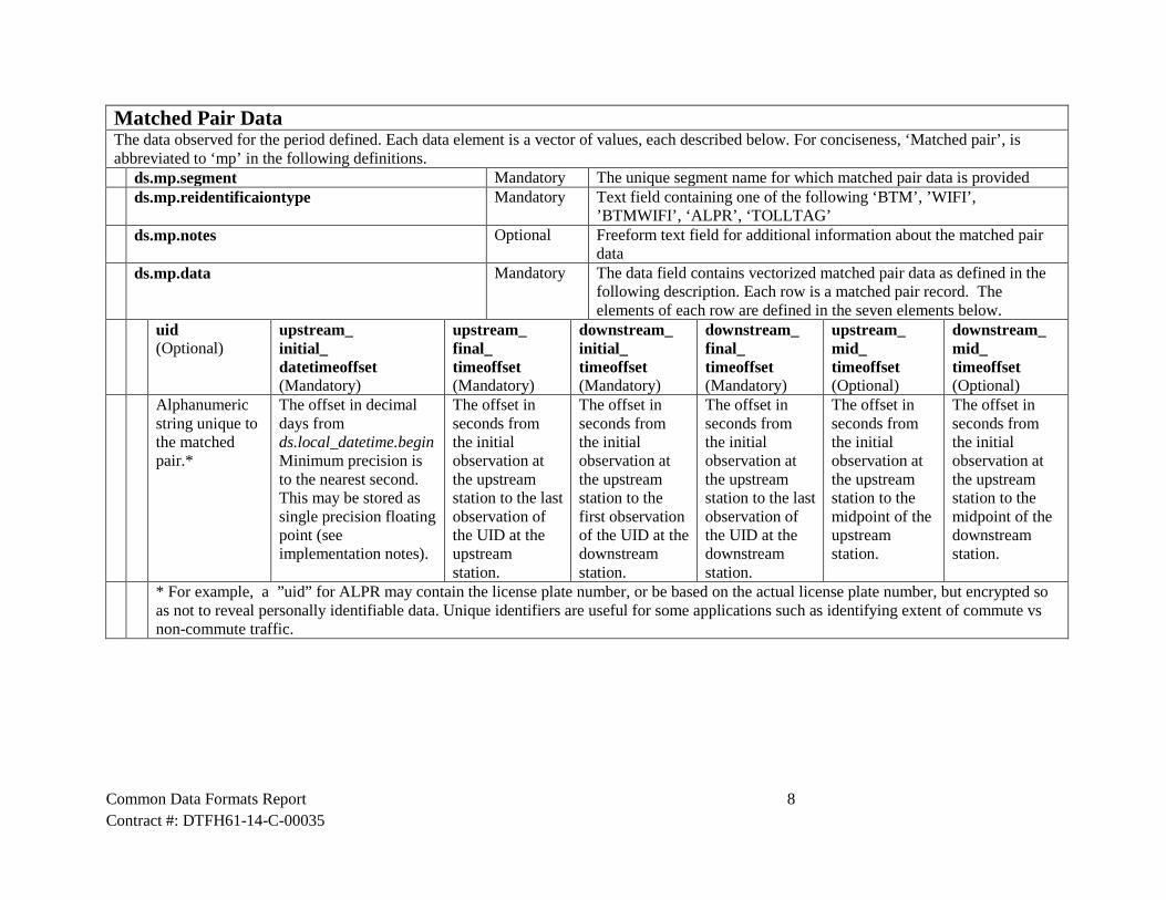
Matched Pair Data The data observed for the period defined. Each data element is a vector of values, each described below. For conciseness, ‘Matched pair’, is abbreviated to ‘mp’ in the following definitions. ds.mp.segment Mandatory The unique segment name for which matched pair data is provided ds.mp.reidentificaiontype Mandatory Text field containing one of the following ‘BTM’, ’WIFI’,
’BTMWIFI’, ‘ALPR’, ‘TOLLTAG’ ds.mp.notes Optional Freeform text field for additional information about the matched pair
data ds.mp.data Mandatory The data field contains vectorized matched pair data as defined in the
following description. Each row is a matched pair record. The elements of each row are defined in the seven elements below.
uid (Optional)
upstream_ initial_ datetimeoffset (Mandatory)
upstream_ final_ timeoffset (Mandatory)
downstream_ initial_ timeoffset (Mandatory)
downstream_ final_ timeoffset (Mandatory)
upstream_ mid_ timeoffset (Optional)
downstream_ mid_ timeoffset (Optional)
Alphanumeric string unique to the matched pair.*
The offset in decimal days from ds.local_datetime.begin Minimum precision is to the nearest second. This may be stored as single precision floating point (see implementation notes).
The offset in seconds from the initial observation at the upstream station to the last observation of the UID at the upstream station.
The offset in seconds from the initial observation at the upstream station to the first observation of the UID at the downstream station.
The offset in seconds from the initial observation at the upstream station to the last observation of the UID at the downstream station.
The offset in seconds from the initial observation at the upstream station to the midpoint of the upstream station.
The offset in seconds from the initial observation at the upstream station to the midpoint of the downstream station.
* For example, a ”uid” for ALPR may contain the license plate number, or be based on the actual license plate number, but encrypted so as not to reveal personally identifiable data. Unique identifiers are useful for some applications such as identifying extent of commute vs non-commute traffic.
Common Data Formats Report 9 Contract #: DTFH61-14-C-00035
High Resolution Controller Data Technology Standards
Standard Name: INDIANA TRAFFIC SIGNAL HI RESOLUTION DATA LOGGER ENUMERATIONS Last edited: 2012 November
Introduction High resolution traffic signal controller data is used to record the times when certain events occur at a signalized intersection, such as the state changes of signal outputs, vehicle detectors, and other elements relevant to the signal control. The “high resolution” term indicates that the events are recorded as they occur, at a fine time resolution (0.1 seconds in current signal controllers). This contrasts with legacy data formats for volume and occupancy that were reported in aggregate values in fixed, 1-15 minute intervals. A specification for the format of this data was previously established by a working group initially led by the Indiana Department of Transportation and a consortium of controller vendors. A document that fully describes the data format is available at the following link:
• Sturdevant, J. R., T. Overman, E. Raamot, R. Deer, D. Miller, D. M. Bullock, C. M. Day, T. M. Brennan, H. Li, A. Hainen, and S. M. Remias. Indiana Traffic Signal Hi Resolution Data Logger Enumerations. Publication . , Indiana Department of Transportation and Purdue University, West Lafayette, Indiana, 2012. Available online at http://docs.lib.purdue.edu/jtrpdata/3/.
In addition, a monograph has been produced that documents a portfolio of performance measures that can be derived from the hjgh resolution controller Data. That document is available at:
• Day, C. M., D. M. Bullock, H. Li, S. M. Remias, A. M. Hainen, R. S. Freije, A. L. Stevens, J. R. Sturdevant, and T. M. Brennan. Performance Measures for Traffic Signal Systems: An Outcome-Oriented Approach. Purdue University, West Lafayette, Indiana, 2014. http://dx.doi.org/10.5703/1288284315333

Report Sponsor� e “Small Business Innovation Development Act of 1982” (Pub. L. No. 97-219), along with reau-thorizing legislation (Pub. L. No. 99-443 and Pub. L. No. 102-564, the “Small Business Research and Development Enhancement Act of 1992”), seeks to encourage the initiative of the private sector and to use small business e� ectively to meet federal research and development objectives. To comply with statutory obligations of the Act, the U.S. Department of Transportation established the Small Business Innovation Research (SBIR) Program, which conforms to the guidelines and regulations provided by the Small Business Administration. Annually, small businesses are solicited to submit innovative research proposals that address the high-priority requirements of the U.S. Department of Transportation and that have potential for commercialization.
� is report was developed through a partnership between Tra� ax, Inc., and Purdue University with funding from a Phase III SBIR contract (DTFH6114C00035) with the Federal Highway Admin-istration. � e project, entitled “Sensor Fusion and MOE Development for O� -Line Tra� c Analysis of Real Time Data,” created and re� ned methods and tools for the characterization of performance along arterial corridors.
Publication� is report is part of a series of reports published in collaboration with USDOT, Tra� ax, Inc., and Purdue University. � e full report series is available for download at http://docs.lib.purdue.edu/apmtp/.
Open Access and Collaboration with Purdue University� e Indiana legislature established the Joint Highway Research Project in 1937. In 1997, this col-laborative venture between the Indiana Department of Transportation and Purdue University was renamed as the Joint Transportation Research Program (JTRP) to re� ect state and national e� orts to integrate the management and operation of various transportation modes. Since 1937, the JTRP program has published over 1,600 technical reports. In 2010, the JTRP partnered with the Purdue University Libraries to incorporate these technical reports in the University’s open access digital repository and to develop production processes for rapidly disseminating new research reports via this repository. A� liated publications have also recently been added to the collection. As of 2017, the JTRP collection had over 1.5 million downloads, with some particularly popular reports having over 20,000 downloads.