committee report planning committee on 12 …democracy.brent.gov.uk/documents/s13319/3- alpine house...
TRANSCRIPT

Committee Report Item No. 03
Planning Committee on 12 December,2012
Case No. 12/2612
Planning Committee Map
Site address: Alpine House, Honeypot Lane, London, NW9 9RU
© Crown copyright and database rights 2011 Ordnance Survey 100025260
This map is indicative only.

RECEIVED: 10 October, 2012
WARD: Queensbury
PLANNING AREA: Kingsbury & Kenton Consultative Forum
LOCATION: Alpine House, Honeypot Lane, London, NW9 9RU
PROPOSAL: Redevelopment of the site with erection of mixed-use scheme to provide 144residential units (Class C3), 1800sq/m of employment workspace (Class B1),5 live/work units (Sui generis) and associated parking, amenity space,landscaping and access.
APPLICANT: Jaysam
CONTACT: Design ACB Ltd
PLAN NO'S:See Condition 2__________________________________________________________RECOMMENDATIONTo:
(a) Resolve to Grant Planning Permission, subject to an appropriate form of Agreement in order to securethe measures set out in the Section 106 Details section of this report and referral to the Mayor, or
(b) If within a reasonable period the applicant fails to enter into an appropriate agreement in order to meetthe policies of the Unitary Development Plan, Core Strategy and Section 106 Planning ObligationsSupplementary Planning Document, to delegate authority to the Head of Area Planning, or other dulyauthorised person, to refuse planning permission
SECTION 106 DETAILSThe application requires a Section 106 Agreement, in order to secure the following benefits:-
a) Payment of the Councils legal and other professional costs in (i) preparing and completing theagreement; and (ii) monitoring and enforcing its performance
a) Affordable Housing - 25% based on habitable rooms comprising 19 x 2bed; 6 x 3bed; 6 x 4bed; 5 xlive/work;
a) A contribution of £275,000 due on material start, index-linked from the date of committee forEducation, Sustainable Transportation and Open Space & Sports in the local area. Payment of£700K should private sales values of £345 per square foot be achieved; and a pro-rata mechanismfor part payment of 700K to be agreed if private sales values are between £325 and £345psf
a) Five Affordable work-live units to be managed by Association for Cultural Advancement throughVisual Art or a similar provider named by the council to be delivered at the price set out in applicantsfinancial viability submission;
a) Sustainability - submission and compliance with the Sustainability check-list ensuring a minimum of50% score is achieved and BREEAM rating 'Very Good' and minimum Sustainable Homes CodeLevel 4 (with compensation should it not be delivered) and a further £750K towards further carbonreduction measures beyond CSH4 to be agreed with the council;
a) Notify Brent 2 Work of forthcoming job and training opportunities associated with the development.a) Join and adhere to the Considerate Contractors scheme.b) Enter into a S38/S278 Agreement to incorporate (i) the widening of the public highway around the site
to accommodate the provision of new adoptable parallel parking bays and 2m footways along theHoneypot Lane and Westmoreland Road perimeters of the site; (ii) the provision of improvedpedestrian crossing facilities on Westmoreland Road at the junction with Honeypot Lane and in thevicinity of the Morrison’s service yard entrance, including tightening of the junction of WestmorelandRoad in the north-eastern corner of the site with an overrun strip; (iii) the provision of speed tables ateither end of Honeypot Lane service road, midway along this service road and at the two entrancesof the ‘home-zone’; (iv) a review of on-street waiting and loading restrictions in the vicinity of the site

(including the introduction of a Controlled Parking Zone if deemed necessary by Brent Council), inaccordance with revised site layout plans to be submitted for approval; (v) lighting columns alongWestmoreland Road and Honeypot Lane service road.
c) Provision of a Travel Plan for the site, to include the establishment of a City Car Club with subsidisedmembership for new residents;
d) Provision of a Delivery Servicing Plan and Construction Logistic Plan for the developmente) Provision of a Car Parking Management Plan for the site.
EXISTINGThis application relates to a 1.47-hectare industrial site located in Honeypot Lane.
The majority of the site area was covered in buildings with a floorspace of approximately 10,365sqm, mainlya combination of large one- and two-storey industrial/ warehouses with ancillary office accommodation datingfrom the 1930s and 1950s. The majority of the office accommodation was located in a two-storey buildingsituated along the Honeypot Lane frontage. The site has been vacant since 8th May 2012 and the buildingson site have recently been demolished. A service road runs along the front of the office block parallel toHoneypot Lane.
To the north and north-west of the site, on the other side of Westmoreland Road, is a Morrison’s superstore.To the north-east is an industrial premises currently occupied by a vehicle-repair centre. To the south-east isthe former Kingsbury Hospital site which has now been redeveloped to provide a healthcare centre,residential units and a nature reserve, identified as a Site of Nature Conservation Protection. The Willows, aresidential care home for the elderly, is located next to the site on Honeypot Lane. The opposite side ofHoneypot Lane lies within the London Borough of Harrow and is predominantly residential.
The site is identified as a Site Specific Allocation within the Proposal Map that forms part of the adopted CoreStrategy and is also located within the Honeypot Lane Locally Significant Industrial Site. The site is borderedon the south by a Site of Local Nature Conservation Importance.
DEVELOPMENT SCHEDULEThe table(s) below indicate the existing and proposed uses at the site and their respective floorspace and abreakdown of any dwellings proposed at the site.
Floorspace Breakdown
USENumber Primary Use Sub Use1 dwelling houses
FLOORSPACE in sqmNumber Existing Retained Lost New Net gain1 0 0 0 14381 14381
TOTALS in sqmTotals Existing Retained Lost New Net gain
0 0 0 14381 14381
Mayoril CIL multiplier is £35 per SQM of total net gain floorspace, therefore Amount Payable is £503,335.00.
PROPOSALRedevelopment of the site with erection of mixed-use scheme to provide 144 residential units (Class C3),1800sq/m of employment workspace (Class B1), 5 live/work units (Sui generis), associated landscaping,access and provision of 105 parking spaces. The development is divided up into four linear blocks labelled Ato D.
A summary of the key aspects of the development is set out below:

Block A is five storeys in height (with the top floor recessed) containing 31 social housing residential units(comprising 19 x 3-bed, 6 x 3-bed and 6 x 4- bed units) and a 1-bed work live unit. It also contains abasement running across the whole footprint of this block that will contain underground parking, the studioaccommodation for the work live unit and plant and metre equipment for the block.
Block B is five storeys in height (with the top floor recessed) containing 33 private residential units(comprising 21 x 2-bed and 12 x 3-bed units) and 2 x 1-bed work live units. It also contains a smallbasement area to accommodate the studio accommodation for the work live units and associated plant andmetre equipment for the block.
Block C is five storeys in height (with the top floor recessed) containing 33 private residential units(comprising 21 x 2-bed and 12 x 3-bed units) and 2 x 1-bed work live units. It also contains a smallbasement area to accommodate the studio accommodation for the work live unit and living space for one ofthe 2-bed flats and associated plant and metre equipment for the block.
Block D reads as a five storey building when viewed from the west within the site and as a four storeybuilding when viewed from the east on Westmoreland Road. This is due to the employment space at groundand first floor level located within the eastern end of this block. Block D will also contain 47 private residentialunits (comprising 40 x 2-bed and 7 x 3 bed units). It also contains a small basement area to accommodatethe CHP unit for the site and associated plant and metre equipment for the block.
HISTORYPlanning permission was granted on 13th August 2008 (LPA Ref: 08/1427) for the redevelopment of AlpineHouse. The proposal included demolition of existing commercial units and erection of 3 x four-storey blocksand 1 x five-storey block, comprising 120 self-contained flats, 1,823m² of commercial floorspace (Use ClassB1) and 5 live/work units, with 86 car-parking spaces, bicycle and bin storage and associated landscaping(accompanied by Design and Access Statement, Energy Assessment, Noise Assessment, Flood RiskAssessment, Arboricultural Report, Transportation Assessment and Planning Statement), subject to a Deedof Agreement dated 13/08/2008 under Section 106 of the Town and Country Planning Act 1990 (asamended).
Planning permission was subsequently granted for an extension to time limit of full planning permission ref:08/1427 on 27th May 2011 (LPA Ref: 11/0156) [nb. Members visited the site in 2008 when the firstapplication was submitted and in 2011 for the renewal application]
A number of applications have since been submitted in relation to the discharge of condition of planningapplication ref: 11/0156 which are summarised below:
12/0280: Details pursuant to condition 10ii (digital TV cabling), 10vii (pedestrian and vehicle entry points) and10xi (lighting) - Refused, 29/03/2012.
12/0278: Details pursuant to condition 8 (roof plan) - Refused, 29/03/2012.
12/0277: Details pursuant to condition 16 (surface water drainage system) - Refused, 29/03/2012.
12/0276: Details pursuant to condition 13 (site investigation) - Refused, 29/03/2012.
12/0634: Details pursuant to condition 14 (wheel wash facilities), 15 (access and egress points) and 19(drainage strategy) - withdrawn, 24/05/2012.
12/0782: Details pursuant to condition 11i (details of water quality and resource mitigation measures) and 11ii(details of ecology and nature conservation mitigation measures) - under consideration.
12/0781: Details pursuant to condition 10 (i) (elevations of buildings showing advertising signage), 10 (iii)(parking spaces for car-club use), 10 (iv) (vehicular and pedestrian access) 10 (v) (finished levels ofbuildings, roads, landscape works and boundaries relative to adjoining properties), 10 (viii) (loading,unloading and parking of service vehicles), 10 (x) (refuse storage and disposal), 10 (xii) (waste storage forbusiness part of development) and condition 12 (waste management strategy) - Granted, 11/06/2012.
12/1675: Details pursuant to condition 14 (fixed wheel washing facility) and 15 (access) - Granted,10/08/2012.

POLICY CONSIDERATIONSCentral Government Guidance
National Planning Policy Framework
The National Planning Policy Framework (NPPF) was adopted in March 2012. The NPPF sets out theGovernment’s requirements for the planning system only to the extent that it is relevant, proportionate andnecessary to do so. It provides a framework within which local people and their accountable councils canproduce their own distinctive local and neighbourhood plans, which reflect the needs and priorities of theircommunities.
It establishes a presumption in favour of sustainable development: local planning authorities should planpositively for new development, and approve all individual proposals wherever possible. Saved policies fromthe adopted UDP will have increasingly less weight unless they are in conformity with the NPPF and can bedemonstrated to be still relevant. Core Strategy policies will also need to be in conformity with both theLondon Plan and the NPPF and have considerable weight.
Sections 1 (Building a strong, competitive economy), 4 (promoting sustainable transport), 6 (Delivering a widechoice of high quality homes) and 7 (requiring good design) are of particular relevance to this application: TheGovernment recognises that good design is a key aspect of sustainable development.
Regional Policy Guidance
London Plan 2011
The London Plan 2011 forms the spatial development strategy for London and was adopted in July 2011. Thefollowing policies are considered relevant to this application:
Chapter 3 - London's People
Policy 3.3 - Increasing Housing SupplyPolicy 3.4 - Optimising Housing PotentialPolicy 3.5 - Quality and Design of Housing DevelopmentPolicy 3.6 - Children & Young People's Play & Informal Recreation FacilitiesPolicy 3.8 - Housing ChoicePolicy 3.9 - Mixed and Balanced CommunitiesPolicy 3.10 - Definition of Affordable HousingPolicy 3.11 - Affordable Housing TargetsPolicy 3.12 - Negotiating Affordable Housing on Individual Private Residential and Mixed Use SchemesPolicy 3.13 - Affordable Housing Thresholds
Chapter 5 - London's Response to Climate Change
Policy 5.1 - Climate Change MitigationPolicy 5.2 - Minimising Carbon Dioxide EmissionsPolicy 5.3 - Sustainable Design and ConstructionPolicy 5.5 - Decentralised Energy NetworkingPolicy 5.6 - Decentralised Energy in Development ProposalsPolicy 5.7 - Renewable EnergyPolicy 5.8 - Innovative Energy TechnologyPolicy 5.9 - Overheating and CoolingPolicy 5.10 - Urban GreeneryPolicy 5.11 - Green Roofs and Development Site EnvironsPolicy 5.12 - Flood Risk ManagementPolicy 5.13 - Sustainable DrainagePolicy 5.16 - Waste Self SufficiencyPolicy 5.21 - Contaminated Land
Chapter 6 - London's Transport
Policy 6.1 - Strategic ApproachPolicy 6.3 - Assessing Effects of Development on Transport Capacity

Policy 6.9 - CyclingPolicy 6.10 - WalkingPolicy 6.13 - ParkingPolicy 6.14 - Freight
Chapter 7 - London's Living Places and Spaces
Policy 7.2 - An Inclusive EnvironmentPolicy 7.3 - Designing out CrimePolicy 7.4 - Local CharacterPolicy 7.5 - Public RealmPolicy 7.6 - ArchitecturePolicy 7.14 - Improving Air QualityPolicy 7.15 - Reducing Noise and Enhancing SoundscapePolicy 7.21 - Trees and Woodlands
Chapter 8 - Implementation, Monitoring and Review
Policy 8.2 - Planning ObligationsPolicy 8.3 - Community Infrastructure Levy
Other regional guidance
The Mayor's Housing Supplementary Planning Guidance (adopted November 2012)
This guidance relates to the housing policies within the London Plan and covers policies on housing provisionand policies on affordable housing. It gives detailed guidance for boroughs on how to develop sites forhousing and how to determine housing mix and density for any individual site.
The Mayor's Shaping Neighbourhoods: Play and Informal Recreation Supplementary Planning Guidance(adopted September 2012)
This guidance supports the implementation of the London Plan Policy 3.6 on ‘Children and Young PeoplesPlay and Informal Recreation Facilities,’ and other policies on shaping neighbourhoods (Chapter 7 of theLondon Plan). Amongst other considerations, it gives detailed guidance on promoting an approach thatsupports the presence of children and young people in the built environment/public realm and encourages thecreation of ‘shared public and communal space used by adults and children at the same time; and providesbenchmark standards on play requirements that can be used as a reference to secure places to play in newhousing developments and provides updated child yield figures to assess child occupancy and play spacerequirements.
Sustainable Design and Construction – Supplementary Planning Guidance (2006)
The SPG provides guidance on the way that the seven measures for sustainable development can beimplemented. These objectives are set out below:
Re-use land and buildingsConserve energy, materials, water and other resourcesEnsure designs make the most of natural systems both within, in and around the buildingReduce the impacts of noise, pollution, flooding and micro-climatic effectsEnsure developments are comfortable and secure for usersConserve and enhance the natural environment, particularly in relation to biodiversityPromote sustainable waste behaviour in new and existing developments, including support for localintegrated recycling schemes, CHP schemes and other treatment options
Local
Brent's Core Strategy 2010
The Council's Core Strategy was adopted by the Council on 12th July 2010. As such the policies within theCore Strategy hold considerable weight. The following policies are considered to be relevant for thisapplication:
CP 1: Spatial development strategy

CP2: Population and Housing GrowthCP6: Design & Density in Place MakingCP17: Protecting and Enhancing the Suburban Character of BrentCP 16: Infrastructure to support developmentCP18: Protection and Enhancement of Open Space, Sports & BiodiversityCP19: Brent Strategic Climate Mitigation and Adoption MeasuresCP 20: Strategic industrial locations and locally significant industrial sitesCP 21: A balanced housing stock
Brent Unitary Development Plan 2004.
In addition to the Core Strategy, there are a number of policies which have been saved within the UnitaryDevelopment Plan (UDP), which was formally adopted on 15 January 2004. The saved policies will continueto be relevant until new policy in the Local Development Framework is adopted and, therefore, supersedes it.The relevant policies for this application include:
BE2: Townscape - Local Context & CharacterBE3: Urban Structure - Space & MovementBE4 : Access for Disabled PeopleBE5: Urban Clarity & SafetyBE6: Public Realm - Landscape DesignBE7: Public Realm - StreetscapeBE8: Lighting and Light PollutionBE9: Architectural QualityBE11: Intensive and Mixed-Use DevelopmentsBE12: Sustainable Design PrinciplesBE13:Areas of Low Townscape QualityEP2: Noise & VibrationEP3: Local Air Quality ManagementEP6: Contaminated LandEP10: Protection of Surface WaterH12: Residential Quality - Layout ConsiderationsH13: Residential DensityH22: Protection of Residential AmenityTRN1: Transport AssessmentTRN3: Environmental Impact of TrafficTRN10: Walkable EnvironmentTRN11: The London Cycle NetworkTRN15: Forming an access onto a roadTRN22: Parking Standards - Non Residential DevelopmentsTRN23: Parking Standards - Residential DevelopmentsTRN34: Servicing in New DevelopmentTRN35: Transport Access for Disabled People & Others with Mobility Difficulties
Brent Supplementary Planning Guidance
SPG17 – “Design Guide for New Development” adopted October 2001Provides comprehensive and detailed design guidance for new development within the Borough. Theguidance specifically sets out advice relating to siting, landscaping, parking, design, scale, density and layout.
SPD “Section 106 planning obligations” October 2007Provision for a standard charge for planning obligation contributions.
SUSTAINABILITY ASSESSMENTIn terms of sustainability, there is a requirement to achieve an exemplar scheme that incorporates a highstandard of energy efficiency with inclusion of reduced CO2 emissions. To assess this high standard ofenergy compliance, the following are required:
Achievement of Code for Sustainable Homes Level 4 (CSH Level 4)Achievement of BREEAM ‘Excellent’ for non-residential units (Core Strategy policy CP19)Compliance with London Plan policies for sustainability: policies 5.2 (energy)A 50% score on the council’s Sustainability Checklist (TP6 form, SPG19, UDP policy BE12)
Energy The development proposes the use of Combined Heat & Power boiler (CHP) for heating through a heatnetwork, and photovoltaic panels to the roof of the 4 blocks to provide electricity. Following assessment of theviability, revisions to the sustainability measures are proposed; this will mean that the reduction in carbonemissions will not be as significant as proposed (£750,000 toward carbon reduction measures as opposed to£1.5m budgeted to achieve an 80% reduction comparable with the previous scheme).
Further details of the CHP plant room is required by condition as it is unclear where the plant room is to belocated; this is reflected in the GLA comments which have cited that the plant room will be in Building B,where as your officers have inferred from the submitted documents that it will be in the basement of BuildingD. Further information including confirmation that all apartments and non-domestic building uses will beconnected to the CHP heat network with a drawing to show the route of the heat network linking all buildingon the site has also been requested. Comments from the GLA with regard to the submitted energy statementhave been forwarded to the applicant to provide further details as necessary.
Code for Sustainable Homes (CSH) It is proposed that all the residential units, including the work-live units, will achieve a Code Level 4. This isabove the requirements of Core Strategy policy CP19 as the site is not within a growth area; but is compliantwith the Council’s Site Specific Allocation (SSA) for Alpine House.
In relation to the London Plan, policy 5.2 requires all new developments to achieve a 25% reduction of CO2emissions above the requirements of the adopted Part-L for buildings regulations. In relation to the existingPart-L (2010), the achievement of CSH level 4 will encompass the 25% improvement required by LondonPlan policy 5.2. As such, the residential units will be compliant.
BREEAM The non-residential units of the scheme will achieve a BREEAM rating of ‘very good’. This is contrary to Corestrategy policy CP19 which requires all new non-residential developments to achieve BREEAM ‘excellent’.The applicant has reasoned that BREEAM ‘excellent’ is unachievable because of site constraints relating tosite location and specific BREEAM credits including management and well being. However, it is noted thatthe submitted BREEAM pre-assessment states the B1 units will utilise a gas fired heating system and assuch will not be connected to the proposed heat network. If the B1 units were to be connected to theproposed heat network and have use of electricity from the PV panels, this would increase the BREEAMscore closer to ‘excellent’. Nevertheless, given the proposed B1 will have to comply with Part-L and achievea 25% improvement on CO2 emissions in line with London Plan policy 5.2, the current rating of ‘very good’ isconsidered acceptable; and with clarification of the proposed heat network for the site, it maybe feasible forthe B1 units to connect to this. This information will be provided in the Supplementary Report.
Council’s Sustainability checklist (TP6 form)In compliance with UDP(2004) policy BE12 and SPG19, all major developments should achieve a scorerating of at least 50% of the checklist (TP6 form). The applicants have submitted a completed TP6 form withan overall score of 54%. There are some discrepancies in the calculations provided by the applicant andthose carried out by the officer; this will be clarified. The Section 106 agreement will ensure a score of 50% isachieved.
CONSULTATIONConsultation Period: 11/10/2012 - 01/11/2012Additional consultation period: 12/10/2012 - 02/11/2012Site Notice Displayed on 17/10/2012Advertised in Press on 18/10/2012
Public Consultation
149 neighbours consulted both within LB Brent and properties located in LB Harrow which are located closeto the border between the two boroughs and in proximity to the application site - no responses received fromneighbouring properties
Internal Consultation
Transportation - Proposal can be supported on transportation grounds subject to a Section 106 Agreementto secure the following:(a) enter into a S38/278 Agreement to incorporate (i) the widening of the public highway around the site to

accommodate the provision of new adoptable parallel parking bays and 2m footway along the Honeypot Laneand Westmoreland Road perimeters of the site; (ii) the provision of improved pedestrian crossing facilities onWestmoreland Road at the junction with Honeypot Lane and in the vicinity of the Morrison's service yardentrance, including tightening of the junction of Westmoreland Road in the northeastern corner of the sitewith an overrun strip; (iii) the provision of speed tables at either end of Honeypot Lane service road, midwayalong this service road and at the two entrances of the 'home-zone'; (iv) a review of on-street waiting andloading restrictions in the vicinity of the site (including the introduction of a Controlled Parking Zone if deemednecessary by Brent Council), in accordance with revised site layout plans to be submitted for approval; and(b) provision of a sum of £115,000 towards non-car access/highway safety improvements and/or parkingcontrols in the area [secured as part of standard charge];(c) provision of a Travel Plan for the site, to include the establishment of a City Car Club with subsidisedmembership for new residents;(d) a Delivery and Servicing Plan for the development(e) a Car Parking Management Plan for the site.
Officers in Transportation also requested conditions for details of external lighting for the site and of theproposed basement access ramp. They also recommended that an informative is attached to anyforthcoming planning consent advising the applicant of the need to obtain a highway oversailing licence underS177 of the Highway Act for the overhanging terrace to Building D.
Safer Streets - The following conditions/information is requested:
(i) Air Quality - Recommended a condition requiring details of measure to mitigate the impacts of dust andfine particles generated by the development during the construction works as the site is located within an AirQuality Management Area. A condition is also recommended requiring the CHP unit to meet the emissionsstandards and technical details as set out in the Air Quality Impact Assessment.(ii) Soil investigation - Recommended that a condition is secured for details of a site investigation todetermine the nature and extent of any soil contamination present on site and if contamination is found, thenfor any remediation measures to be carried out in full and confirmed through a verification report.(iii) Noise - Requires conditions to ensure that internal noise levels are acceptable for residential use.(iv) External lighting - required further details to ensure that the external lighting does not cause nuisance tothe residential properties.
Landscape - Generally the scheme is acceptable in landscape terms. However, concerns are raised with theuse of gabions as retaining structures in the private residential gardens. It is recommended that an alternativemethod of retaining the land is used.
Tree Protection Officer - The substantial shelterbelt on the south east boundary of the site made up ofmature Hybrid Black Poplars, early mature Limes and Norway Maples has suffered through lack ofmanagement resulting in an overcrowded appearance with many of the intermediate canopy limes andmaples being suppressed by larger more dominant trees. The proposal to remove seven black poplars thathave come to the end of their safe life expectancy and thin out the remaining Lime and maples, will lead to amuch more attractive woodland setting with the remaining trees able to fulfill their potential. The removal ofthe large black poplars is essential primarily on safety grounds, particularly where the site meets HoneypotLane.
Below the canopy, Plans show a range of native shrubs typically found along a woodland edge. These willenhance biodiversity as well fulfilling a screening roll for residents with private gardens in block A. Thethinning of the woodland will no doubt aid establishment of this new and welcome shrub layer.
Elsewhere on the site, tree planting is adequate for a development of this size. Tree species selection is safe,if a little predictable. Space for a larger forest type tree in locations such as the shared surface to the northeast of Building C, among the play space in the south east or as part of the linear group which boundsHoneypot Lane, where fewer but potentially larger species could reach their full potential.
The only reservations regarding the placement of trees on this site are the closeness of the first three trees inproximity to the south of Buildings B and C. These should perhaps be relocated along with one of the outerrow of four which would allow a significantly more light into adjacent windows. Trees could be relocated withinthe paved surfaces to the north west of blocks A,B and C.
Urban Design - Proposal has been designed to a relatively high standard and the Design Team is generallysupportive of the architectural approach.
External Consultation
Transport for London - Proposed development unlikely to result in significant adverse impact to thetransport network. However the following issues need to be resolved to fully comply with the London Plan:(a) Review of trip generation assessment the undertaking of modal split assessment in line with the TfLTransport Assessment Best Practice Guidance;(b) Undertaking of a PRES audit and investigation of safe pedestrian routes to/from the site to improveaccessibility to local bus stops and amenities;(c) The securing of CLP, DSP and Travel Plan;(d) Confirmation of cycle parking, disabled parking provision and electric vehicle charging points of the site.
Environment Agency - No objections raised subject to the following conditions:(i) Development to be carried out in accordance with the submitted Flood Risk Assessment.(ii) Details of drainage design to be submitted prior to commencement of development.
Greater London AuthorityLondon Plan policies on principle of development, housing, residential quality and density, children's playspace, urban design, inclusive access, sustainable development and transport are relevant to this application.The application complies with some of these policies but not with others and on balance does not comply withthe London Plan; the reasons and the potential remedies to issues of non compliance are set out below:
• Principle of development: The principle of a residential led mixed use development in this location isacceptable and in accordance with the London Plan.
• Housing: The application would make a reasonable contribution to affordable housing provision; however,an independent assessment of the applicants viability assessment will need to be carried out and justificationis needed from the application with regards to the social rented unit provision before the scheme can beacceptable and in line with polices 3.11 and 3.12. Further information and clarification is also sought withrespect to the mix of the affordable element, residential quality (single aspect units) and residential densitybefore the scheme can be in full compliant with London Plan policies 3.8 3.5 and 3.4 respectively.
• Children's playspace: The applicant will need to provide clarification of child yield calculations and theirplay space strategy to ensure accordance with London Plan policies 3.6.
• Urban design: The proposed design is generally supported in line with London Plan policies 7.1, 7.3, 7.4,7.6 and 7.7 however, the applicant is requested to provide further information in relation of how animation hasbeen applied throughout the scheme as well as confirmation of the primary entrances as set out inparagraphs 38 to 40 of this report.
• Inclusive access: In order for the scheme to comply to London Plan policies 3.8 and 7.2, the applicant isrequested to provide further information relating to inclusive design. In doing so, the applicant will need toclarify that the 10% of wheelchair accessible units and ensure is provided across unit types and tenures.
• Sustainable development: For clarity the applicant should provide further detail in relation to regulatedcarbon dioxide emission reductions in tonnes per annum after each stage of the energy hierarchy in Line withLondon Plan policy 5.2.
• Transport: The scheme in generally acceptable; however further information is required from the applicantin relation to the quantum and accommodation of cycle parking numbers and how shower/changing facilitiesare to be provided for the commercial units. In addition the applicant will need to provide updated informationin relation to the transport assessment and Tfl welcomes further discussion about this matter.
Officer Comment: These matters are discussed in further detail in the Remarks section of the report. Furtherinformation will be provided on some of these matters in the Supplementary Report to be presented toMembers prior to Planning Committee.
REMARKSIntroduction
This application is for the redevelopment of Alpine House with a mixed use development comprisingcommercial floorspace (use class B1), work live units and residential units (use class C3). This report willconsider the principle of the development; the design, scale and massing; density and unit mix; affordable

housing provision; standard of proposed accommodation; impact upon surrounding properties; parking andtransportation; landscape features; and environmental health considerations. It will also provide a comparisonwith the previous planning permission on the site from 2008 which was subsequently renewed in 2011 - seeplanning history above for further details.
Principle of Development
As referred to in the planning history, there is an extant planning permission for a mixed use development onthe site comprising 120 self-contained flats, 1,823m² of commercial floorspace (Use Class B1) and 5live/work units, with 86 car-parking spaces, bicycle and bin storage and associated landscaping.
The National Planning Policy Framework sets out that there should be 'a presumption in favour of sustainabledevelopment' (para 14, NPPF). In terms of the current policy status, the site is identified in the adopted SiteSpecific Allocation adopted 2011 (SSA) as “Industrial and business office unit occupied by a number of smallbusinesses...” suitable for “mixed use development [in line with the 2008 planning permission] including lowcarbon or zero emission housing and new light industrial managed affordable workspace. The configurationshould use the workspace along the north eastern and north western edge to mitigate any conflict betweennew residential development and existing employment premises, with family housing generally located alongthe southern edge. Proposals should include the re-provision of existing business where appropriate.Development must conserve and enhance the adjacent Wildlife Corridor”.
The allocation goes on to identify and discuss the need for a Flood Risk Assessment and requiresapplications to be accompanied by a Flood Risk Assessment; it also states that “flood zones are subject tochange and modelling and re-modelling is carried out on a quarterly basis by the Environment Agency,therefore any assessment must ensure that the most up to date data is used as part of the Flood RiskAssessment.” A Flood Risk Assessment has been submitted with this application and reviewed by theEnvironment Agency who raise no objection to the proposal subject to conditions.
The justification for redevelopment is explained in the SSA as “the industrial building appears to be reachingthe limits of modern employment uses. A mixed use development that also delivers modern commercialspace will help to safeguard the site for employment uses, as well as delivering environmentally sustainableresidential development." The provision of residential accommodation is supported by London Plan policy 3.3which seeks to increase London's housing supply. Overall the development is considered to accord with thethe SSA and NPPF by providing a sustainable development balancing social, economic and environmentalbenefits; this is considered in more detail below.
Comparison of current proposal with extant planning permission
The extant planning permission on the site is for the demolition of the existing commercial buildings anderection of 3x four storey blocks and 1 x five storey block comprising 120 self contained flats, 1823 sq mcommercial floorspace (Use Class B1) and 5 live/work units with 86 car parking spaces.
Comparing the scheme with the extant planning permission, the block layouts and general massing aresimilar however changes have been made to the numbers and mix of residential units. This scheme provides1800 sqm of B1 floorspace which is comparable to the extant permission. In terms of the quantum ofdevelopment, the most significant difference is the additional number of residential units proposed;previously, the 08/1427 application gave approval for 120 self-contained flats, whereas 144 are nowproposed.
In terms of layout, the development follows a similar form of 4 linear blocks, with a ‘U-shaped’ central‘home-zone’/shared surface service road at the heart of the development. All 4 blocks within the revisedproposal are 5 storeys in height whereas within the previously approved scheme comprised 3 residentialblocks of 4 storeys in height and the employment block of 5 storeys. There is little variation between theheights of the buildings in the two schemes; the roof height of the previously approved scheme wasapproximately 16.6 metres and the proposed scheme is up to 16.5 metres. The massing of the currentproposal sees the 5th storey element of the three residential blocks recessed.
The level of proposed parking has been increased from 87 parking to 107 spaces and the layout of parkingprovision has been altered, with a new two-way vehicular access included in the current proposal to serve aramped entrance to a basement car park within the Block C at the northern end of the site. The previouslyapproved scheme was an exemplar scheme in terms of sustainable development and was a ‘Zero carbon’development. The proposed scheme is to be Code for Sustainable Homes Level 4, BREEAM 'Very Good'alongside CO2 reductions as set out in the Sustainability Assessment.

Urban Design
The proposal comprises 4 linear buildings, 5 storeys in height. Three of the buildings are principallyresidential and are located perpendicular to Honeypot Lane (Buildings A, B & C); the fourth building (BuildingD) is located on the eastern side of the site fronting Westmoreland Road and comprises a mix of commercialand residential units. The vehicular and pedestrian access to the commercial floorspace is fromWestmoreland Road. Pedestrian and cycle access to the residential units is from the service road adjacent toHoneypot Lane. It is proposed that cars and service vehicles access the site via the service road (proposedto be one way), exiting from the southern access point onto Honeypot Lane.
The amenity spaces are designed with shared surface streets giving priority to pedestrians; this provides amore traditional street frontage with front doors to residential units accessed from this space to the residentialunits to provide activity and natural surveillance of the amenity areas. The setting of the blocks in a linear andparallel form has presented an opportunity for dwellings to open up onto the 'landscaped streets', creating asense of place and identity. This is reinforced by the use of a common palette of materials and a coherentarchitectural language, which in turn has shaped the form of proposed development.
All 3 residential buildings follow a similar design being 5 storeys with the upper floor recessed to reduce thevisual bulk. Block D which comprises commercial and residential uses takes a different approach; thebuilding is 5 storeys and no set back proposed on the upper storey. The design approach to this building isconsidered acceptable as it creates a more visible distinction between the commercial and residentialelements of the scheme. The scheme will use a simple palette of materials comprising buff brick, metalcladding and render.
Building A: Positioned on the southern perimeter. It is principally residential comprising 2, 3 and 4bedroom apartments with a single live/work unit. The southeast facing ground floor four bedroom unitshave dedicated private gardens.
Building B: Centrally located and contains 33 residential units and 2 live/work units. There is a largearea of communal amenity space to the southeast of the block proposed. All units have either northwestor southeast facing balconies or terraces.
Building C: Located parallel to the northern section of Westmoreland Road. The building will contain 33residential units and 2 live/work units. It is a repetition of Building B with the exception that the groundfloor units take advantage of the topography of the site to allow the units to be raised above street level toprovide privacy and defensible space. This is particularly important on this elevation due to therelationship of the building to Westmoreland Road. There is also a single storey basement car parklocated underneath this building providing 25 car parking spaces.
Building D: Located on the eastern boundary of the site and accommodates 2 storeys of single aspectB1 employment space facing Westmoreland Road. There are four storeys of residential units facingwestwards into the site and eastwards externally.
The GLA have provided comments on the proposal and consider that the scheme is generally acceptable indesign terms; however, some observations regarding the design remain. They include the need for furtherconsideration to be given to the space between Honeypot Lane and the proposed development; in addition itis advised that the edge of the scheme facing Honeypot Lane should be designed appropriately as the 'front'of the development. Further detail in line with the GLA's comments will be provided in the SupplementaryReport. The GLA raise no concerns in relation to the schemes overall height and massing which areconsidered to be compliant compliant with the London Plan.
Housing
Density and MixThe site has a public transport accessibility level of 3 (PTAL 3) and located in an area that would be classedas an urban setting; a density of 200-450 habitable rooms per hectare (hrh) would be acceptable in this typeof setting. The applicant has indicated that the density would be 453 (hrh). Your officers have calculateddensity as being 435 hrh which is below the figure provided by the applicant (nb. the discrepancy may be as aresult of a different approach taken to the classification of living rooms and kitchen as habitable rooms). Thiswill be clarified in the Supplementary Report.
Notwithstanding this, even if the scheme marginally exceeds the suggested density range as set out in the

London Plan and SPG17, increased densities are promoted in the London Plan and the UDP where publictransport accessibility is good due to the need to use land more efficiently, increase housing delivery and inpart due to the sustainability advantages increased density can confer. This is a specific objective of the UDPas stated in policy STR3, which states that development of previously developed urban land will bemaximised.
Policy H13 in the UDP relates to density and states that the primary consideration in determining theappropriate density of new development will be achieving an appropriate urban design which makes efficientuse of land and meets the amenity needs of future residents. It goes on to say that density should haveregard to context and nature of the proposal, the constraints and opportunities of the site and the type ofhousing proposed. Your Officers are of the view that the proposed scheme meets Policy H13 (UDP 2004) asthe proposal is considered to respect the context of the surrounding buildings, provides a satisfactorystandard of accommodation and as such meets the design led approach.
The housing mix overall will provide 29.5% family sized units comprising 3 bedrooms or more. Within theaffordable housing component, the provision family sized accommodation will be 33% which is alsoconsidered acceptable. In particular the provision of 6 x 4 bedroom units will accord with Policy CP21 in theCore Strategy which seeks an appropriate mix of units on the site, including family sized accommodation, tomeet housing need in the Borough.
Affordable HousingThe application proposes to provide 36 of the 149 residential units for affordable housing, accounting for 25%of the total units. Brent's Core Strategy and the London Plan Policy 3.12 seeks to deliver 50% affordablehousing on new housing sites of ten units of greater.
Unit Type Unit NumbersPrivate Affordable
Total Units
1 bedroom 0 0 02 bedroom 82 19 1013 bedroom 31 6 374 bedroom 0 6 6Live/Work - 5 5Total 113 36 149
This scheme falls short of this target, and in response to this shortfall the applicant has submitted a viabilitytoolkit to justify this provision. A review of the toolkit has confirmed that the level of affordable housingprovided is reasonable however to ensure that this can be delivered, the Section 106 package has beennegotiated to make changes to the level of carbon reduction as set out in the Sustainability Assessmentabove.
The applicant has stated that Network Housing Design Group is the RSL who is acting as partners in thedevelopment. In terms tenure, it has been confirmed that affordable units will comprise 22 social rented unitsand 9 shared ownership units however the final proposed mix of the affordable element has not beenprovided; this will be confirmed in the Supplementary Report. With the introduction of 'affordable rent' as anadditional affordable housing product along with social rent and intermediate housing, it is also necessary forthe applicant to assess whether the introduction of 'affordable rent' units in the scheme could significantlyincrease the quantum of affordable housing provided and make changes to the scheme as required. Thisinformation has not been provided by the applicant however is a requirement of the GLA. This will be clarifiedin the Supplementary Report to confirm that the on site affordable housing provision is maximised.
Quality of AccommodationAll units meet or exceed the minimum standards for internal floor areas as outlined in SPG 17 and theLondon Housing Design Guide. The standard of amenity provided is in general compliance with therequirements of SPG17. Buildings A, B & C are 20m apart from one another to ensure acceptable levels ofprivacy between habitable rooms. Whilst the top floor of the development does marginally breach the 30degree line measured from the ground floor habitable room window of the adjacent block, given that thebreach is not considered significant (2 degrees) and the overall standard of accommodation within thescheme is good, this relationship can be accepted. The ends of the 3 residential buildings which contain thestaircores are located 9m from at the closest point to the rear elevation of Block D which contains residentialaccommodation. This separation is considered to provide an acceptable level of amenity to prospectiveoccupiers given that there are no habitable room windows in the residential blocks facing the units in Block Dand that oblique outlook is also provided.

The majority of the proposed units are dual aspect; there are no single aspect north facing units whichaccords with the standards set out in the Mayors Housing SPG 2012. A total of 64 units in the developmentare single aspect however none of these units are north facing or comprise 3 bedrooms or more.
The London Plan requires 10% of new housing to be designed to be wheelchair accessible or easilyadaptable for residents who are wheelchair adaptable. It also requires all new homes to be built to 'LifetimeHome' standards. Policy H26 of Brent's Unitary Development Plan advocates a similar approach. Theproposed wheelchair usits are distributed between the 4 blocks as set out in the Accommodation Schedule.
General guidance suggests amenity space should usually be provided at a rate of 50sqm per family unit, and20sqm for others. All of the residents units have private amenity space in the form of balconies, terraces andaccess to shared amenity of site. All four bedroom family units have private rear gardens. Whilst some of theunits do not meet the private amenity size standard, the scheme has been designed to maximize the sharedamenity space encouraging a community feeling to the development. The total private amenity areas for theproject is 3136 sqm (this includes all private balconies, terraces and gardens) The dedicated communalamenity spaces remains at 1290 sqm Two large sunken communal gardens are at the heart of the scheme,identical in design containing raised planters and grass areas. The play-space is located in the south eastcorner, and will be passively overlooked and readily accessible to all the residents.
Using the methodology within the Mayors SPG 'Providing for Children and Young People's Play and InformalRecreation' it is anticipated that there will be approximately 62 children within the development. In line withSPG guidance, in total the scheme should deliver 620 sq m of children’s play space (300 sq m on site forunder 5's provision); it should be noted that this is approximate as the final mixes within the affordablehousing tenure has not been provided. The application proposed 629 sq m of playspace; in addition the site islocated c.300m from a recreation ground which provides play facilities for older children.
Commercial Floorspace
There is 1800sm of B1 light industrial/office accommodation arranged over two floors in building D. Theaccommodation has been planned as two units with the main access from Westmoreland Road. The 5 xlive/work units are each arranged over two floors with double height work spaces. These managed affordableunits are proposed to be operated by Association for Cultural Advancement through Visual Art (ACAVA). It isthe intention to ensure the long-term viability of the affordable live/work units that this management byACAVA or a similar named provider is secured through the Section 106 agreement. The units are accessedvia the gable ends of Buildings A, B & C which face onto Honeypot Lane.
Neighbouring Amenity
SPG17 sets out general guidance for the massing of new buildings, to ensure they do not have anoverbearing impact on the neighbouring properties and avoid unnecessary overshadowing. In general, thebuilding envelope should be set below a line of 30 degrees from the nearest rear habitable-room window ofadjoining existing properties, measured from height of 2m above floor level. SPG17 goes onto say that whereproposed development adjoins private amenity/garden area, then the height of the new development shouldnormally be set below a line of 45 degrees at the garden edge, measured from a height of 2m.
There is considered to be no significant impact on adjoining properties. This is further enhanced by ensuringthat the proposals address the existing patterns of occupation such that the employment section within theBlock D faces the existing employment site. The Willows Care Home is located to the south of the site; theproposal complies with SPG17 in terms of its relationship to the proposed development and is conisderedacceptable.
Highways
The site is located on the north eastern corner of the junction of Honeypot Lane (a London Distributor Road)and Westmoreland Road (a local commercial access road). Westmoreland Road is a one-way roadnortheastwards, but with a short spur road along the northeastern boundary of the site. Access to the site iscurrently provided via an adopted service road from Honeypot Lane.
The site is not located within a Controlled Parking Zone but there are waiting restrictions along WestmorelandRoad generally prohibiting parking between 8am and midnight. The site has fair access to public transport(PTAL 3), with a bus stop which serves Bus routes 79 and 324 located adjacent to the site and QueensburyUnderground Station located within 800m of the site.

Access to the site will be of a similar arrangement to the previous approval through the use of an internal‘U-shaped’ central ‘home-zone’/shared surface road , surfaced in block paving, with entrance and exit pointsfrom the existing Honeypot Lane service road. This application also proposes a basement car park withaccess from Westmoreland Road.
Car Parking provisionCar-parking allowances for the proposed development are set out in standards PS6 and PS14 of the adoptedUDP 2004 and Policy of the London Plan 2011. The development originally proposed a total of 105 carparking spaces but due to the need to provide footway widths along the boundaries of the site, the totalnumber of parking spaces have been reduced to 102 spaces. Further details are discussed under ‘proposedhighway works’ below. Of the 102 spaces, 86 spaces are for the residential element of the proposal and 16spaces for the commercial element of the proposal. The residential spaces are located in the basement carpark (a total of 25 spaces) with the remaining spaces provided at surface level both within the site andon-street along Honeypot Lane and Westmoreland Road, facilitated by the widening of the public highwayinto the site; and the provision of integral garages for the 6 no. 4-bed duplex units located within Block A. Thecommercial spaces are all provided at surface level through the use of on street parking along WestmorelandRoad, which is also facilitated by the widening of the public highway into the site, and a separate car park withnine car parking spaces accessed off Westmoreland Road. In addition, two car club parking spaces areproposed within the site. The overall parking provision is consistent with the London Plan standards and thestandards set out in Brent’s UDP 2004.
As part of the parking provision provided above, 21 of the residential spaces are dedicated as disabled baysand one of the commercial spaces is dedicated as a disabled bay. The residential disabled parking bays areproposed within the basement car park and at surface level within the site. The commercial disabled parkingbay is also located at surface level within the dedicated car park. This is sufficient to provide an allocateddisabled space to each wheelchair unit in accordance with standard PS15 of Brent’s UDP 2004, with theprovision of one wide, marked bay within the commercial car park also complying with standard PS15 ofBrent’s UDP 2004. This provision also complies with London Plan Standards. It is recommended that the carpark layout shown within the site and in the basement car park is secured as part of a planning condition.
Proposed highway workThe highway is proposed to be widened into the site along all three highway boundaries in order to providesufficient additional width to allow parallel on-street parking. Officers in the Transportation Unit raised anumber of concerns with the original layout and revisions have been made in response to these concerns.These amendments include:
Deletion of three of the proposed parking spaces along the Honeypot Lane service roadProvision of a continuous 2m wide footway along Westmoreland Road frontage;Removal of the protruding wall from the northern end of Building D and amendments to the doors ofBuilding D to open into the site rather than out over the highway – it is recommended that aninformative is attached to any forthcoming planning consent to advise the applicant that theoversailing terrace from Building D will require a licence from Brent Council’s Transportation Unitunder S177 of the Highways Act 1980.
A number of other amendments have also been provided which are discussed in further detail below. All ofthe works to the highway will be secured through a S38/S278 Agreement as part of the S106 Agreement.
Impact of development on highway networkWhilst the overall parking provision is consistent with the London Plan Standards and the standards set outwithin Brent’s UDP 2004, consideration does need to be given to the impact of any overspill parking from thesite on traffic flow and road safety in the area. In this respect, the parking demand for the larger businessunits is now estimated to total about 42 spaces (approx. 25% of employees), which would lead to an overspillof about 33 parked cars onto the surrounding public highway during the day. To provide an estimate ofresidential parking demand at night, it is generally assumed that private housing will create demand at 75% ofthe maximum allowance, with a figure of 50% in the case of social rented housing. On this basis, 136 carscould be expected to be generated by the residential element of this proposal, leaving 77 cars that could notbe accommodated within the site. This figure is comparable with the previously approved scheme.
As before though, the development is proposed to be a low-carbon emission scheme, with a number ofmitigating measures proposed to manage car ownership and ensure overspill parking problems areaddressed. These includes:

The provision of the highway being widened into the site along all three highway boundaries in orderto provide sufficient additional width to allow parallel on-street parking spaces to be accommodatedalong the site frontages and along the southwestern side of the Honeypot Lane service road. A totalof 44 such spaces are now proposed, with eight spaces annotated as doubling up for loading atcertain times. Such works will need to be secured through a s278/s38 agreement as part of theSection 106 Agreement and this is discussed in further detail above.As referred to above, there are existing waiting restrictions along the main carriageway ofWestmoreland Road currently prohibiting waiting between 8am and midnight. It is recommended thatthese are amended/revoked through the S278 Agreement to allow the new area of on street parkingto be used by staff and/or residents. It is also recommended that the review of waiting restrictionsaround the site be extended to include the remainder of Westmoreland Road and the maincarriageway of Honeypot Lane to prevent parking between 8am and midnight.In addition to reviewing and extended the existing waiting restrictions around the site, it is alsosuggested that consideration should be given to an extension of the existing CPZ aroundQueensbury Underground Station. Such details shall be secured as part of the S278 Agreement. The provision of a Travel Plan which involves the setting up of a Car Club with two dedicated spaceson the site, which will be made available by staff, residents and the wider community. The TravelPlan will also include the appointment of a site-wide Travel Plan Co-ordinator, with measuresincluding the setting up of a car sharing scheme, flexible working hours and the provision ofalternative transport information. It is recommended that the Travel Plan is secured as part of theSection 106 Agreement with the requirement for it to score a PASS rating using TfL’s ATTrBuTEprogramme prior to first occupation.
The measures proposed above have sought to significantly reduce overspill parking from the site onto thesurrounding road network. Subject to the above measures being secured through the Section 106Agreement, it is considered that the proposed development is unlikely to result in significant impact upon thesurrounding transport network.
Cycle parkingBicycle storage for the residential units is provided via a secure bike storage area within all four blocks,accessed off the ‘home-zone’. Blocks A, B and C will each have a bicycle store which can accommodate 70cycles through the use of the Josta Double Stack System. Block D will also have a bicycle store which canaccommodate 48 cycles through the use of the Josta Double Stack System. In addition, the ground floorduplex units within Block A have private gardens with a garden shed that could accommodate cycle parkingfor each of these six units. Therefore the total cycle parking provision for the residential element of thescheme is 264 cycle spaces. This provision significantly exceeds the cycle parking standards set out in PS16of Brent’s UDP 2004 which requires one space per unit and Table 6.3 of the London Plan which requires atotal provision of 192 spaces (one space per 1 and 2 bed units and 2 spaces for three bed plus units).
16 bicycle parking spaces are proposed for the commercial units, located on the private footway areabeneath the terrace overhang on the eastern side of Building D. The location of the bicycle spaces isconsidered acceptable by officers in the Transportation Unit. The proposed provision exceeds the minimumrequirements set out in standard PS16 of Brent’s UDP 2004 and Table 6.3 of the London Plan.
It is recommended that the provision of cycle facilities mentioned above is secured by condition. Furthermore,it is recommended that a condition is imposed to secure a shower and changing facility to be provide for thecommercial unit to encourage staff to cycle to/from work.
Vehicular Access ArrangementsVehicular access controls will be provided to most of the parking within the site, using rising bollards at theentrance to the ‘home-zone’, a roller shutter door at the entrance of the basement car park and a barrier atthe entrance to the commercial car park. Further information on how access into these spaces will bemanaged (e.g. security cards, key pads etc) and how spaces will be allocated, particularly in terms of allowingevening and weekend use of the commercial parking spaces by residents, will be sought through a car-parkmanagement for the site, secured through the Section 106 Agreement.
Officers in Transportation have advised that access to the basement car park is generally fine, with sufficientwidth shown along the ramp to allow two cars to pass with ease and adequate margins proposed to thebuilding structure. They have however advised that the proposed gradient of the access has not beendetailed. It must not exceed 5% for a distance of 4 metres from the back of the new highway boundary andshould not exceed a gradient of 10% along its length as a whole. Further details of the gradient arerecommended to be sought by a planning condition.

Pedestrian Access around and within the siteThe development includes a number of improvements to the pedestrian realm. This includes reducing theexisting crossing point width of Westmoreland Road at its junction with Honeypot Lane from 12.2m to 6.7m.This junction is on the key pedestrian route to the north including the Morrisons Store and the nearest BusStops. The improvements also include the provision of speed tables across the bellmouth of the junctions ateither end of the service road to act as entry treatments; and works to improve pedestrian crossing facilitiesin the vicinity of the Morrison’s service yard entrance. Officers in Transportation Unit have also requested thatdropped kerbs and tactile paving be provided just west of the proposed basement access and that an overrunstrip with a 4m kerb radius be provided in place of the existing hatch markings between the proposedbasement access and the stub road of Westmoreland Road, with dropped kerbs and tactile paving across thestub road. It is also noted that all existing redundant accessed will be naturally reinstated to footway, which iswelcomed, and the improvements reduce the overall width of Westmoreland Road (which is currently a oneway street east bound with an industrial nature with high kerbs and a wide carriageway) and which willprovide a much better pedestrian environment for new residents of the site and all those currently using thisroute. All of the improvements to the pedestrian realm will be secured as part of a joint S38/S278 Agreementas part of the Section 106 Agreement.
As part of the consultation response, TfL requested the undertaking of a Pedestrian Environment ReviewSystem (PRES) audit or similar assessment to assess the quality of the routes between the site and local busstops, the adjacent Morrisons Supermarket and Queensbury Underground Station. Following on fromdiscussions with the applicant’s transport consultants, they have since advised that no further investigationwork would be required if the local borough consider that the previously agreed improvement formed as partof the previous planning consent would be sufficient to mitigate the likely highway impact and will bring theneeded improvement to the local area in the vicinity of the site under the current situation.
A pedestrian bridge link over the basement access ramp is welcomed in helping to improve the permeabilityof the site, although the use of steps will not facilitate use by wheelchair users. However, adequate access isprovided elsewhere to the site for wheelchair users.
With regards to the internal layout of the site, the proposed ‘home-zone’ layout is generally consideredacceptable, with the use of concrete block paving for the carriageway surface and rising bollards for control ofaccess helping to reduce traffic volumes, speeds and parking, thereby providing a safe environment. Somefootways with paving flag surfacing are also proposed within this area, but these are fairly intermittent. Whilstthis is generally fine for the main ‘home-zone’/shared surface area, it is noted that the entrances to the‘home-zone’ area are shown surfaced in tarmacadam and as such, separate footways are required for theinitial 20m lengths of the accesses, in particular to provide a segregated pedestrian route to the entrance toBuilding A. Officers in Transportation Unit have recommended that entry tables be provided at each entrypoint with tactile paving, and for the kerb radii at the entrances to the home-zone area be reduced wherepossible. A revised layout has been provided showing these amendments.
It should be noted that the ‘home-zone’ does not meet standards for adoption as public highway, so would beexpected to remain private. Siting of statutory undertaker’s equipment beneath the road should also beconsidered carefully so that it does not cause disruption during maintenance.
Refuse FacilitiesA refuse store for seven Eurobins is shown at the northern end of Building D for the commercial floorspace,within 9m of the highway boundary to allow easy access.
Ground floor storage rooms are proposed for each of the residential blocks, accommodating a total of 42Eurobins and 18 wheeled bins plus bulk item storage areas, which is sufficient to meet Brent Council’s refusestorage requirements. The stores are shown with access onto the ‘home-zone’ and tracking has beenprovided in the accompanying Transport Assessment addendum to show that a 10m refuse vehicle would beable to access this area. As such, refuse carrying distances for collection staff are complied with, although itis noted that carrying distanced for some of the residents exceed the recommended maximum distance of30m set out in Schedule 1, Part H of the Building Regulations (2000). It is recommended that bin stores aresecured as part of a planning condition.
Servicing for the Work Live Units and Commercial FloorspaceStandard PS19 of Brent’s UDP 2004 requires work/live units to be provided with transit sized loading bays,with the larger employment units requiring 8m loading bays. The development does not provide off streetservicing provision, but eight of the on street parking spaces around the site have been indicated for dial useas loading bays. A similar arrangement was proposed as part of the previous planning consent, and isconsidered acceptable in principle, but will require suitable waiting restrictions to be applied to these spaces,

reserving them for loading only during the day (e.g. 8.3am to 6.30pm Mon-Fri), with parking allowed in thesebays outside of these hours. The waiting restrictions will also need to be secured through the S278Agreement that forms part of the S106 Agreement.
To ensure that servicing and deliveries are adequately managed once the development is occupied, it isrecommended that a Delivery Servicing Plan is secured through the S106 Agreement. It is alsorecommended that during the construction stage that a Construction Logistic Plan is secured through theS106 Agreement.
External LightingLighting proposals for the site include 24 no. 45W lanterns mounted on 5m columns around the home zoneand external boundaries of the site, together with 34 no. 35W lanterns mounted on the buildings. These havebeen calculated to provide average horizontal illuminance levels of 12-15 lux for the home zone and 11 lux forthe commercial car park, with uniformity ratios of 0.25. From a highways perspective, the value for the carpark is considered acceptable, but as a shared surface ‘home zone’ area, a higher value of 30lux for this areais considered more appropriate. Consideration also need to be given to the amenity of future residents toensure that they do not experience light nuisance. As such it is recommended that further details of thelighting are conditioned to provide an adequate level of lighting for the ‘home zone’ area but with measures toensure that residential amenity is not compromised.
It is also noted that four of the lighting columns (three columns along Westmoreland Road and one columnon Honeypot Lane service road) is located on publicly adopted highway. Such lighting is required to be vettedseparately as part of the S38/S278 highway works process and a separate lighting design for these areas willtherefore need to be developed and approved by Brent’s street lighting contractors. It is thereforerecommended that the condition also requires the removal of these lighting columns from the plans.
Conclusions
Whilst it is acknowledged that the scheme proposed on site will not be zero carbon, taking account of thecurrent economic situation it is considered that the scheme provides an acceptable balance betweendelivering a development that exceeds the levels of sustainability generally achieved and also delivering aviable mixed used development on site incorporating residential and commercial uses.
REASONS FOR CONDITIONS
RECOMMENDATION: Grant Consent subject to Legal agreement
(1) The proposed development is in general accordance with policies contained in:-
Central Government GuidanceGreater Flexibility for Planning Permissions (2010)The London Plan 2011, Brent's Unitary Development Plan 2004Brent's Core Strategy 2010Brent's Site Specific Allocations DPDCouncil's Supplementary Planning Guidance
Relevant policies in Brent's Adopted Unitary Development Plan are those in the followingchapters:-Built Environment: in terms of the protection and enhancement of the environmentEnvironmental Protection: in terms of sustainability, protecting specific features of theenvironment and protecting the publicHousing: in terms of protecting residential amenities and guiding new developmentEmployment: in terms of maintaining and sustaining a range of employment opportunitiesTransport: in terms of sustainability, safety and servicing needsWaste: in terms of the development of waste management facilitiesDesign and Regeneration: in terms of guiding new development and extensions.
CONDITIONS/REASONS:

(1) The development to which this permission relates must be begun not later than the expirationof three years beginning on the date of this permission.
Reason: To conform with the requirements of Section 91 of the Town and Country PlanningAct 1990.
(2) The development hereby permitted shall be carried out in accordance with the followingapproved drawing(s) and/or document(s):
ACAVA – Aims Activities & Studio DemandACAVA Profile (July 2012)Accommodation Schedule – Design ACBAir Quality Assessment – WSP 28/09/2012Arboricultural Method Statement – Andrew ColebroojBREEAM Pre- Assessment Estimate – Issue 1 Rev B (27/09/2012)Code for Sustainable Homes Pre Assessment Estimate – Version 1 Rev CConstruction Method Statement – ADSS/CJK/JC/TMP/B1Design and Access Statement - 102_REF_100CHP Performance Calculation – Helec LtdDetailed Specification for CHP – Helec Ltd (LT2709201202 Rev 01)Aerial Shack – Antiference XG8 A Extra GainAerial Shack - Blake Astrabeam ABM8 8 Element VHF/DAB AerialAerial Shack - Triax TD78 78cm Pole Mount Solid DishEvora – LightingMark Hinsley Arboricultural Consultants – 9 August 2012Mark Hinsley Tree Survey – 9 August 2012Sharp – PV PanelsDavid Unerman Associates- Method of supplying digital TV cabling to all residentialVertica lightingDavid Unerman Associates – Door and Vehicle Access StatementDavid Unerman Associates - ENERGY ASSESSMENT REPORT, ALPINE HOUSE, 26thSeptember 2012Arrowebrook - Fire Strategy ReportHerrington Consulting Ltd – FRA September 2012Arbtech – Habitat SurveyLandscape Perspective – 26 Sept 2012KP Acoustics – Noise Impact Assessment 9117.NIA.01SCHEDULE OF COMPLIANCE: London Housing Design GuideEAS Transport Assessment Addendum - 298/2012SRE Outline Sustainability Statement Issue 1 Rev APINDORIA ASSOCIATES LTD – Structural StrategyPINDORIA ASSOCIATES LTD – Strategy for Site InvestigationBeattie Associates – Statement of Community InvolvementSurface Water Drainage – 47/SITE 5100ATopographical Survey - L 5342/1Site Rood Aerial Detail - 47/SITE 6050A
Site Location Plan 102_PLN_001 DSite / Block Plan 102_PLN_002 BExisting Elevations 102_PLN_004 BExisting Elevations 102_PLN_005 BExisting Site Section 102_PLN_006 BGround Floor Site Plan 102_PLN_1100 LFirst Floor Site Plan 102_PLN_1101 LSecond Floor Site Plan 102_PLN_1102 JThird Floor Site Plan 102_PLN_1103 KFourth Floor Site Plan 102_PLN_1104 JRoof Site Plan 102_PLN_1105 JBasement Site Plan 102_PLN_1110 KContext Roof Plan 102_PLN_1130 FSite Section G-G 102_PLN_1303 B

Site Elevations A-A / B-B 102_PLN_1400 ESite Elevations C-C / D-D 102_PLN_1401 BSite Elevations E-E / F-F 102_PLN_1402 DSite Elevations G-G / H-H 102_PLN_1403 CSite Elevations J-J / K-K 102_PLN_1404 B
Unit Types:Unit Type Drawing 102_PLN_6000 CUnit Type Drawing 102_PLN_6001 BUnit Type Drawing 102_PLN_6002 DUnit Type Drawing 102_PLN_6003 CUnit Type Drawing 102_PLN_6004 CUnit Type Drawing 102_PLN_6005 BUnit Type Drawing 102_PLN_6006 BUnit Type Drawing 102_PLN_6008 BUnit Type Drawing 102_PLN_6009 BUnit Type Drawing 102_PLN_6010 CUnit Type Drawing 102_PLN_6011 CUnit Type Drawing 102_PLN_6012 CUnit Type Drawing 102_PLN_6013 CUnit Type Drawing 102_PLN_6014 CUnit Type Drawing 102_PLN_6015 D
Detailed Bay Elevations:Detailed Bay Elevation 102_PLN_8000 BDetailed Bay Elevation 102_PLN_8001 BDetailed Bay Elevation 102_PLN_8002 BDetailed Bay Elevation 102_PLN_8003 BDetailed Bay Elevation 102_PLN_8004 BDetailed Bay Elevation 102_PLN_8005 BDesign & access statement 102_REF_100 A
Visualisations:3-D Visualisations 1 102_PLN_7000 A3-D Visualisations 2 102_PLN_7001 A3-D Visualisations 3 102_PLN_7002 A
Conditions:Conditions - Site Setup - Existing 102_PLN_150 BConditions - Site Setup - Proposed 102_PLN_151 CConditions - Block D Commercial Elevations 102_PLN_152 BConditions - Block D Commercial Bay Ele 102_PLN_153 BConditions - Block C Live/Work Elevations 102_PLN_154 BConditions - Block D Commercial Section 102_PLN_155 BConditions - Refuse Collection 102_PLN_157 BConditions - Pedestrian Access 102_PLN_159 BConditions - Dedicated car club bays 102_PLN_160 BConditions - Proposed finished levels 102_PLN_161 BConditions - Commercial Waste Strategy 102_PLN_162 BConditions - Residential Waste Strategy 102_PLN_163 BConditions - Loading Bay positions 102_PLN_164 BConditions - Indicative PhotoVoltaics 102_PLN_168 AConditions - Indicative PhotoVoltaics 102_PLN_169 A
Reason: For the avoidance of doubt and in the interests of proper planning.
(3) Prior to first occupation of any part of the development hereby approved, no goods,equipment, waste products, pallets or materials shall be stored or deposited in any open areawithin the completed streets.
Reason: To safeguard the visual amenities of the area and the efficient operation of activitieswithin the site.

(4) During demolition and construction on site:
(i) the best practical means available in accordance with British Standard Code of PracticeBS5228: 1997 shall be employed at all times to minimise the emission of noise from thesite;
(ii) vehicular accesses to adjoining and opposite premises shall not be impeded at any time;(iii) no waste or other material shall be burnt on the application site;(iv) a suitable and efficient means of suppressing dust must be provided and maintained,
including the adequate containment of stored or accumulated material, so as to prevent itbecoming airborne at any time and giving rise to nuisance.
Reason: To protect the amenity of the occupiers of adjoining premises
(5) All parking spaces (including disabled bays), cycle parking, refuse storage, turning areas,loading bays, access roads and footways shall be constructed/provided and permanentlymarked out prior to occupation of any part of the approved development, or upon furtherapplication within such longer period as may be approved by the Local Planning Authority.Such works shall be carried out in accordance with the approved plan(s).
Reason: To ensure that the proposed development does not prejudice the free flow of traffic,or the conditions of general safety within the site and along the neighbouring highway &amenity.
(6) Notwithstanding the provisions of Schedule 2, Part 1 (Class H), Part 24 and Part 25 (ClassesA to B) of the Town and Country Planning (General Permitted Development) Order 1995 (asamended), or any future enactment of that Order, no development bytelecommunications-code systems operators carried out on the building(s) hereby approved,in the form of telecommunications, satellite antenna installation development shall be carriedout, unless a formal planning application is first submitted to and approved in writing by theLocal Planning Authority other than that approved as part of this planning application.
Reason: To prevent installations that are prejudicial to the visual amenity.
(7) During construction on site:-(i) The operation of site equipment generating noise and other nuisance causing activities,
audible at the site boundaries or in nearby residential properties, shall only be carried outbetween the hours of 0800 - 1700 Mondays - Fridays, 0800 - 1300 Saturdays and at notime on Sundays or Bank Holidays;
(ii) The hours of demolition and construction limited to 0800 - 1830 Mondays - Fridays,0800-1300 Saturdays and at no other times on Sundays or Bank Holidays.
Reason: To limit the detrimental effect of demolition and construction works on adjoiningresidential occupiers by reason of noise and disturbance.
(8) Details of the roof plan, showing the areas of the proposed photovoltaic panels in accordancewith the sustainability measures secured as part of this development, shall be submitted toand approved in writing by the Local Planning Authority, prior to completion of constructionwork and shall be installed prior to occupation of the development hereby approved.
Reason: To demonstrate these are adequate and suitable to provide the level of carbon offsetsought.
(9) The remainder of the undeveloped land within the curtilage of the site shall be suitably treatedwith hard and soft landscaping, including trees/shrubs/grass, in accordance with a scheme tobe submitted to and approved in writing by the Local Planning Authority within 3 months ofcommencement of any construction work on the site; such landscaping work shall becompleted prior to occupation of the building(s) or within six weeks of the commencement ofthe next planting season, if the commencement of construction of the development takesplace outside the planting season, in accordance with a program to be first agreed in writing bythe local planning authority.

The approved scheme shall be fully implemented during the first available planting seasonfollowing completion of the development hereby approved and any trees or shrubs whichwithin 5 years of planting die, are removed or become seriously damaged or diseased shall bereplaced with others of the same species and size and in the same locations unless otherwiseagreed in writing with the local planning authority.
Such a scheme shall also indicate:-
a) any moundings and contours;b) other appropriate matters within the context of a landscaping scheme, such as details ofsignboards, seating, footways and other paved pedestrian areas;c) details of the proposed arrangements for maintenance of the landscaping;d) details of childrens play equipment
Reason: To ensure a satisfactory standard of appearance and to ensure that the proposeddevelopment enhances the visual amenity of the locality.
(10) Further details of the proposed development shall be submitted to and approved in writing bythe Local Planning Authority within 3 months of commencement of development and thedevelopment shall be carried out and completed in all respects in accordance with the detailsso approved before the building(s) are occupied. Such details shall comprise:-
a) elevations of buildings showing location of advertising signageb) the provision and safeguarding of dedicated parking spaces for car-club use & electric
charging points;c) the design of the means of vehicular and pedestrian access to and movement within the
site;d) the finished levels of all buildings, roads (indicating gradients), landscape works and
boundaries relative to adjoining properties;e) controls at pedestrian and vehicular entry points to provide safe and secure access;f) the proposed boundary treatment including all fences, walls and gateways;g) the provision of lighting to ensure safety and convenience on roads, footpaths and
accesses to buildings;h)details of surface treatment through the shared landscaped streets identifying vehicle
access routes
Reason: These details are required to ensure a satisfactory development is achieved.
(11) Details of materials for all external work, including samples, shall be submitted to andapproved in writing by the Local Planning Authority before any work is commenced. The workshall be carried out in accordance with the approved details.
Reason: To ensure a satisfactory development which does not prejudice the amenity of thelocality.
(12) A fixed wheel-washing facility shall be provided before commencement and be operationalduring development, in accordance with the approved details.
Reason: In the interest of the environment.
(13) The development is within an Air Quality Management Area and construction and works arelikely to contribute to background air pollution levels. Prior to commencement of development,measures to mitigate the impacts of dust and fine particles generated by the operation shall besubmitted to and approved in writing by the Local Planning Authority for approval. Works shallbe carried out in full accordance with the approved details.
Reason: To minimise dust arising from the operation.
(14) The Combined Heat and Power units installed shall meet or improve upon the emissionsstandards and technical details described in the Air Quality Assessment. Prior to the
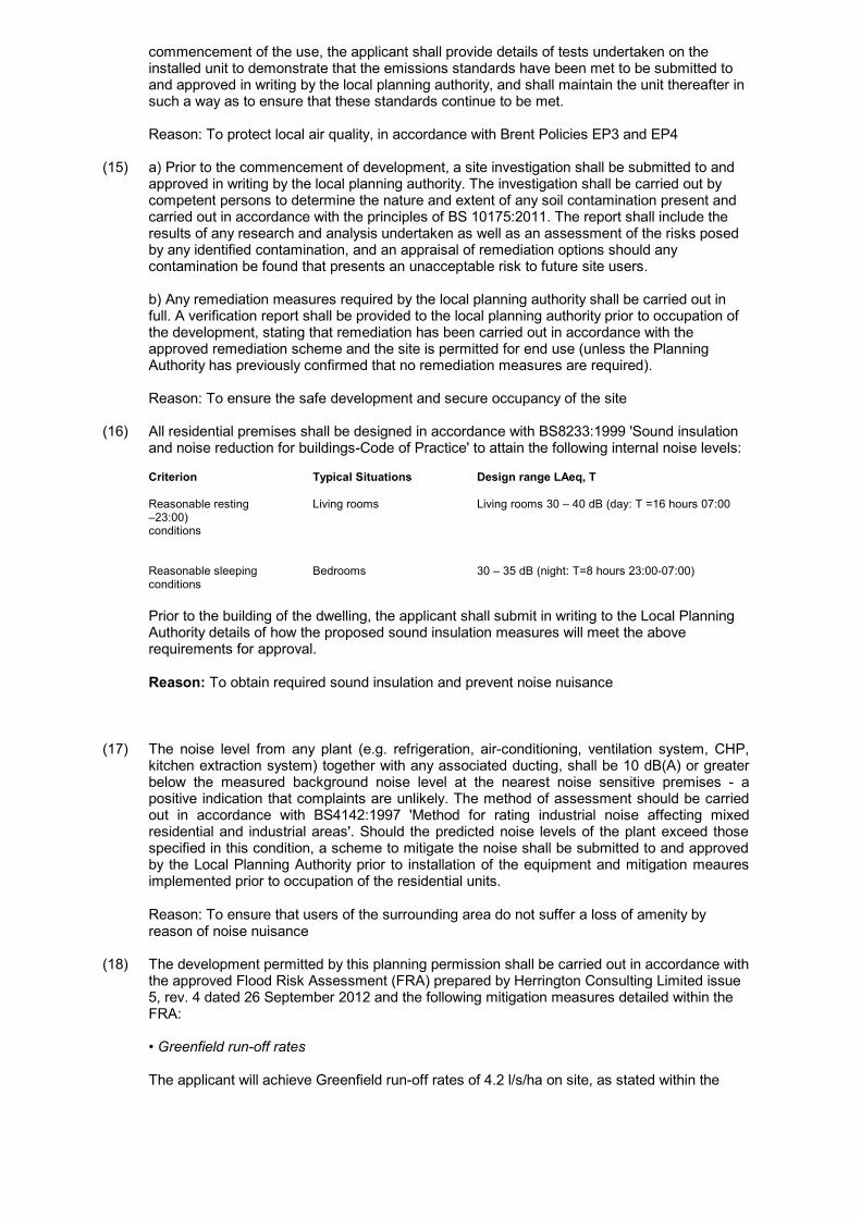
commencement of the use, the applicant shall provide details of tests undertaken on theinstalled unit to demonstrate that the emissions standards have been met to be submitted toand approved in writing by the local planning authority, and shall maintain the unit thereafter insuch a way as to ensure that these standards continue to be met.
Reason: To protect local air quality, in accordance with Brent Policies EP3 and EP4
(15) a) Prior to the commencement of development, a site investigation shall be submitted to andapproved in writing by the local planning authority. The investigation shall be carried out bycompetent persons to determine the nature and extent of any soil contamination present andcarried out in accordance with the principles of BS 10175:2011. The report shall include theresults of any research and analysis undertaken as well as an assessment of the risks posedby any identified contamination, and an appraisal of remediation options should anycontamination be found that presents an unacceptable risk to future site users.
b) Any remediation measures required by the local planning authority shall be carried out infull. A verification report shall be provided to the local planning authority prior to occupation ofthe development, stating that remediation has been carried out in accordance with theapproved remediation scheme and the site is permitted for end use (unless the PlanningAuthority has previously confirmed that no remediation measures are required).
Reason: To ensure the safe development and secure occupancy of the site
(16) All residential premises shall be designed in accordance with BS8233:1999 'Sound insulationand noise reduction for buildings-Code of Practice' to attain the following internal noise levels:
Criterion Typical Situations Design range LAeq, T
Reasonable resting Living rooms Living rooms 30 – 40 dB (day: T =16 hours 07:00–23:00)conditions
Reasonable sleeping Bedrooms 30 – 35 dB (night: T=8 hours 23:00-07:00)conditions
Prior to the building of the dwelling, the applicant shall submit in writing to the Local PlanningAuthority details of how the proposed sound insulation measures will meet the aboverequirements for approval.
Reason: To obtain required sound insulation and prevent noise nuisance
(17) The noise level from any plant (e.g. refrigeration, air-conditioning, ventilation system, CHP,kitchen extraction system) together with any associated ducting, shall be 10 dB(A) or greaterbelow the measured background noise level at the nearest noise sensitive premises - apositive indication that complaints are unlikely. The method of assessment should be carriedout in accordance with BS4142:1997 'Method for rating industrial noise affecting mixedresidential and industrial areas'. Should the predicted noise levels of the plant exceed thosespecified in this condition, a scheme to mitigate the noise shall be submitted to and approvedby the Local Planning Authority prior to installation of the equipment and mitigation meauresimplemented prior to occupation of the residential units.
Reason: To ensure that users of the surrounding area do not suffer a loss of amenity byreason of noise nuisance
(18) The development permitted by this planning permission shall be carried out in accordance withthe approved Flood Risk Assessment (FRA) prepared by Herrington Consulting Limited issue5, rev. 4 dated 26 September 2012 and the following mitigation measures detailed within theFRA:
• Greenfield run-off rates
The applicant will achieve Greenfield run-off rates of 4.2 l/s/ha on site, as stated within the

FRA.
Reason: To ensure there is no increase in risk of surface water flooding in the area, in linewith the London Plan (July 2011).
(19) The development hereby permitted shall not be commenced until a detailed drainage designfor the site has been submitted to, and approved in writing by the local planning authority. Inorder for the scheme to meet the Agency’s requirements the following information must beprovided: In order to ensure that the proposed stormwater system meets the Agency'srequirements, we require that the following information be provided prior todevelopment on site:
a) The applicant will demonstrate that they have fully applied the SuDS hierarchy, as statedwithin the London Plan (July 2011).a) A clearly labelled drainage layout plan showing pipe networks and any attenuation ponds,soakaways and other SUDS features. This plan should show any pipe 'node numbers' thathave been referred to in network calculations and it should also show invert and cover levelsof manholes.b) Confirmation of the critical storm duration.c) Where infiltration forms part of the proposed stormwater system such as infiltrationtrenches and soakaways, soakage test results and test locations are to be submitted inaccordance with BRE digest 365.d) Where on site attenuation is achieve through attenuation ponds or similar, calculationsshowing the volume of these are also required.e) Where an outfall discharge control device is to be used such as a hydrobrake or twin orifice,this should be shown on the plan with the rate of discharge stated.f) Calculations should demonstrate how the system operates during a 1 in 100 year criticalduration storm event, with an appropriate allowance for climate change. If overland floodingoccurs in this event, a plan should also be submitted detailing the location of overland flowpaths.
Reason: To prevent flooding by ensuring the satisfactory storage of/disposal of surface waterfrom the site. In addition to reducing the risk of flooding to the proposed development
INFORMATIVES:
None SpecifiedREFERENCE DOCUMENTS:
Any person wishing to inspect the above papers should contact Victoria McDonagh, The Planning Service,Brent House, 349 High Road, Wembley, Middlesex, HA9 6BZ, Tel. No. 020 8937 5337