committee report application reference … of the existing settlement pattern, and it is envisaged...
TRANSCRIPT
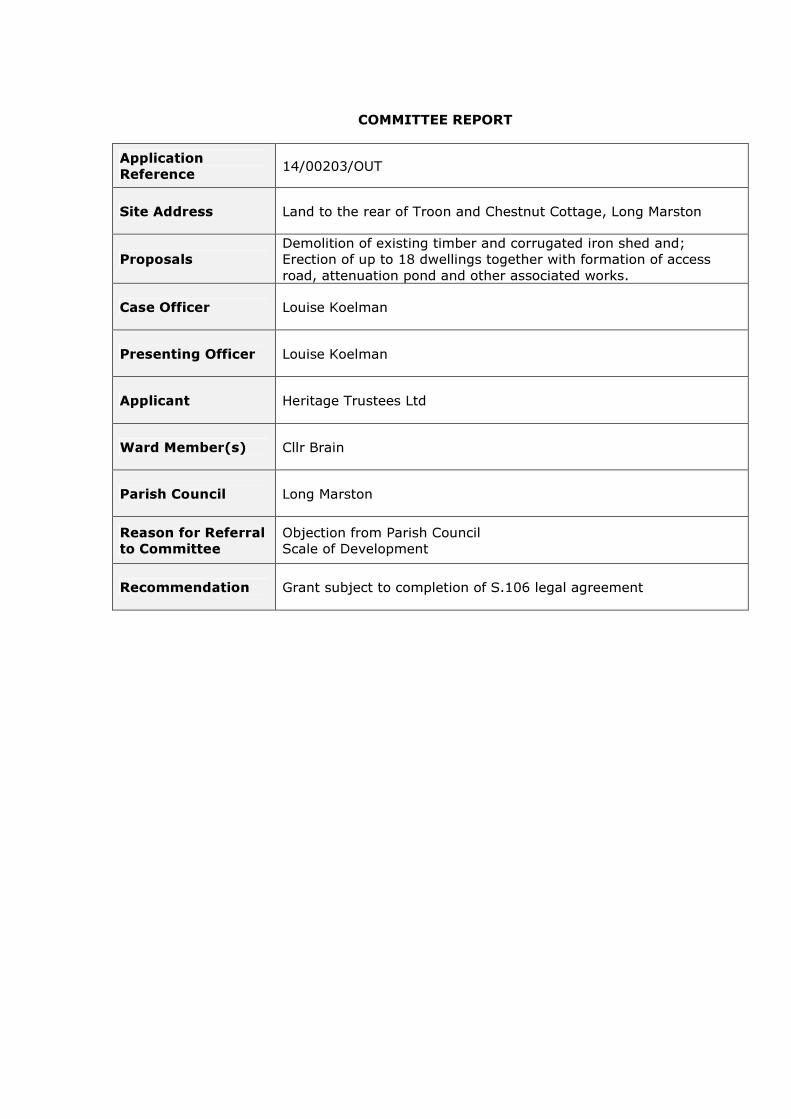
COMMITTEE REPORT
Application Reference 14/00203/OUT
Site Address Land to the rear of Troon and Chestnut Cottage, Long Marston
Proposals Demolition of existing timber and corrugated iron shed and; Erection of up to 18 dwellings together with formation of access road, attenuation pond and other associated works.
Case Officer Louise Koelman
Presenting Officer Louise Koelman
Applicant Heritage Trustees Ltd
Ward Member(s) Cllr Brain
Parish Council Long Marston
Reason for Referral to Committee
Objection from Parish Council Scale of Development
Recommendation Grant subject to completion of S.106 legal agreement

1. DESCRIPTION OF PROPOSAL Outline planning permission is sought for a residential development of up to 18 dwellings together with means of access on this site. All matters except for access are reserved and comprise appearance, layout, scale and landscaping. The proposed development consists of the following:
• The application site area (red line) comprises 0.9ha. • Potential density of 20 dwellings per hectare. • One vehicular access point proposed off Welford Road (which currently
serves Troon and Chestnut Cottages, a substation and the existing agricultural field known as ‘Brewery Field’).
• Provision to be made for on site formal and informal public open space. • Additional planting is proposed within the site to enhance biodiversity. • Retention and enhancement of the existing hedgerows along the periphery
of the site. • Affordable housing provision would comprise 35% of units on site (6 units
in total). • Indicative details suggest the dwellings would be a maximum of two-
storey in height. • Surface water would be disposed of by SUDS in the form of a water
attenuation pond with an outfall into a drainage ditch on adjacent land. 2. DESCRIPTION OF SITE AND SURROUNDINGS (INCLUDING
RELEVANT PLANNING CONSTRAINTS) The site comprises of an agricultural field lying on the eastern side of the Welford Road within the settlement of Long Marston. The site lies in the centre of the village and is in close proximity to the public house, village hall and community shop. The broadly rectangular site is currently used for grazing purposes. The northern, eastern and southern boundaries of the site are largely formed by hedgerows with some trees. The western boundary is contained with post and rail fencing and abuts onto the rear gardens of Troon Cottage, The Haven and a substation. The northern boundary of the site abuts the gardens to 1- 4 Box Bush Cottages and also an area land used for private amenity. To the south is a small estate known as Jacksons Orchard and finally agricultural land to the east. The land is generally flat with a slight fall towards Welford Road. Topography ranges between 43.0m AOD in the north west corner, to 44.0m AOD in the south east corner. There are no environmental designations on the land. 3. HISTORY/BACKGROUND None

4. RELEVANT POLICY CONTEXT The Development Plan Stratford–on-Avon District Local Plan Review 1996-2011 STR.1 Settlement Hierarchy STR.4 Previously Developed Land PR.1 Landscape and Settlement Character PR.7 Flood Defence PR.8 Pollution Control EF.6/7 Nature Conservation and Geology EF.9 & EF.10 Trees, woodland and hedgerows EF.14 Listed Buildings EF.11 Archaeology DEV.1 Layout and Design DEV.2 Landscaping DEV.3 Amenity Space DEV.4 Access DEV.5 Car Parking DEV.6 Services DEV.7 Drainage DEV.8 Energy Conservation DEV.10 Crime Prevention COM.1 Local Choice COM.4/5 Open Space COM.7 Bus Service Support COM.9 Walking and Cycling COM.11A Vale of Evesham COM.13 Affordable Housing COM.14 Mix of Dwelling Types COM.15 Accessible Housing CTY.1 Control of Development IMP.1 Supporting Information IMP.2 Supplementary Planning Guidance IMP.4 & 5 Infrastructure Provision IMP.6 Transport Assessments Other Material Considerations Central Government Guidance National Planning Policy Framework 2012 Planning Policy Guidance 2014 Circular 06/05: Biodiversity and Geological Conservation PPS5 – Historic Environment Planning Practice Guide (2010) Supplementary Planning Guidance and Supplementary Planning Documents Meeting Housing Needs 2008 Car and Cycle Parking Standards 2007 Sustainable Low Carbon Buildings 2007 Provision of Open Space 2005 Stratford on Avon District Design Guide 2001 Other Documents Recent appeal decisions and high court judgements

Coventry & Warwickshire Joint Strategic Housing Market Assessment (SHMA) (November 2013) Strategic Housing Land Availability Assessment (SHLAA) review (2012) PPG17 Open Space, Sport and Recreation Assessment and Playing Pitch Strategy (Arup, April 2011) Corporate Strategy 2011-2015 Landscape Sensitivity Study (July 2011) Historical Environmental Assessment (2008) Warwickshire Landscape Guidelines 1993 Water Cycle Study Extending Your Home: Planning Advice Note Proposed Submission Core Strategy 2014 Long Marston Parish Plan and Village Design Statement 2007 Marston Sicca Housing Needs Survey 2010 English Heritage – The Setting of Heritage Assets (2011) Other Legislation Human Rights Act 1998 Equality Act 2010 Section 17 of the Crime and Disorder Act 1998 Natural Environment and Rural Communities (NERC) Act 2006 The Conservation of Habitats and Species Regulations 2010 Community and Infrastructure Levy (CIL) Legislation Localism Act 2011 Planning (Listed Buildings and Conservation Areas) Act 1990 5. APPLICANT’S COMMENTS The application is supported by the following documentation:
• Planning Statement • Design and access statement • Statement of community involvement • Transport Assessment • Ecology report • Tree survey • Phase One Ground Investigation • Flood risk assessment • Archaeological desk based assessment • S106 Heads of Terms
The applicant has submitted the following supporting statement; The proposed development would help meet the Council’s need to deliver a continuing supply of housing land, as required by the NPPF, as well as making a contribution to meeting the shortfall arising from the undersupply in previous years. The scheme would provide for a mix of dwelling types to meet market and affordable housing needs, and add to the choice available in the local housing stock. The proposed housing would be on land within the centre of the village, with existing housing to the north and south. It is very close to local services including the village hall, shop and public house, and bus services pass the front of the site. In all respects the site is a sustainable location for the scale of development proposed in the application.
As recognised by the Council’s landscape sensitivity study the site is visually contained and it is considered for housing (within the report). The development of the site would not extend the built form of the settlement into the surrounding countryside and would not be harmful to the amenities of the area or adjoining residents. The site has an area of approximately 0.9 hectares so the gross density would be in the order of 16 dwellings per hectare, which is below the average density normally applied by the District Council (25 dwellings per hectare), and which is comparable with other housing developments in the village. The illustrative site layout shows a linear from of development to reflect the characteristics of the existing settlement pattern, and it is envisaged the dwellings would be of traditional two-storey scale and massing. Each dwelling would have private amenity space, in excess of the guidelines applied by the District Council and have off-street garaging and/or parking. An area of open space, including a children’s play area would be provided within the site and the applicants are prepared to make a financial contribution towards the provision further open space elsewhere in the village. The scheme incorporates a sustainable drainage system including a storm water attenuation pond and the proposed drainage strategy would take water to new drains on adjacent land to avoid surcharging existing sewers. There would also be improvements to existing land drainage systems to help deal with existing localised flooding. Severn Trent Water has confirmed that there is adequate capacity in the public foul water sewer to accommodate the proposed development. The vehicular access to the site has been carefully assessed by the applicants’ transport consultants and the County Highway Authority. A traffic speed has been carried out to confirm that the visibility which can be achieved from the access is satisfactory for the number of dwellings proposed, and the details of the entrance have been revised during the course of the application to meet the requirements of the County Highway Authority. The site is of some archaeological interest and as a consequence evaluation including trial trenching has been carried out in accordance with a brief agreed by the County Archaeologist. The findings show that there is no need to prevent development on the site for archaeological reasons. The applicants are willing to make financial contributions to the provision of community facilities and services, where they are shown to be CIL compliant, including education and open space. The scheme would help boost housing supply and deliver economic, social and environmental benefits and make a positive contribution to the evolution of the village. There would be no adverse impacts which would significantly and demonstrably outweigh the benefits of granting planning permission. 6. PARISH COUNCIL Object to the application for the following reasons; We have serious concerns relating to the lack of clarity of information upon which we, as a very small Parish Council, have to base our decisions. In conjunction

with the number of recent local applications (see below), we feel that this has placed the Parish Council in an iniquitous position over planning in the last few months. There are several items of legislation/ local guidelines such as:- A. The remainder of the Local Plan. B. The emerging Draft Core Strategy under which we are classed as a Local Service Village (expected to provide 10 - 25 dwellings in the next 20 years). C. Government directives under the NPPF in which presumption of development is favoured if it proves to be sustainable. Sustainability is inadequately defined. We would ask that all planning applications local to Long Marston be included in a review of the cumulative effect that they will all have on our local area. We are a settlement of some 180 houses being swamped by proposed development, and dependant upon facilities outside our own village – e.g. schools and medical facilities, and therefore in our opinion impacting sustainability. As regards to the above application, this Council makes an objection for the following reasons; 1. Overdevelopment of the site. The outline application is for 18 houses. We feel that this is far too many on this site if it is to maintain the integrity of the existing settlement ( see our Parish Plan and Village Design Statement dated October 2007 which was approved and accepted by the District Council and should form part of any decision making.) 2. Access. If permission for this number of dwellings were granted then the amount of vehicles exiting the site would be untenable because of poor visibility, particularly from the North. The entrance to the site is narrow, opposite a bus stop and together with the number of vehicles generated would compromise road safety in this busy central area of the village. We also understand that a grass verge will be replaced with a pedestrian walkway along the front of Troon - we would certainly resist this urbanisation of the centre of our village and are concerned that Warwickshire County Council may not be involved in any decision concerning this grass verge. The changes proposed to improve the splay will have an adverse effect on properties Troon and Chestnut Corner. 3. Flooding Concerns. As you are all aware we have had serious problems in the recent past with surface water flooding. Contrary to the drainage proposal accompanying the plan, Long Marston Flood Team is of the opinion that the removal of storm water to the North ditch would be inappropriate due to the limited capacity of that ditch in its current state. 4. Sewage Removal. Tied in with the above flooding issues we have continually had problems with the capacity and efficacy of the sewage system put in the late 1970's. We would challenge the statement made by Severn Trent in relation to the adequacy of the sewerage system with reference to this application. We are currently in touch with Severn Trent concerning this issue but can get no clear answer from them. The Sewage treatment plant in the village is not coping at this moment in time. Tankers are being used to remove effluent on an almost daily basis. These tankers are damaging a very narrow local road which is yet another issue. We understand that this treatment plant also takes effluent from the St Modwen's site so is bound to be further compromised due to the lack of capacity in the holding tanks. 5. Lack of local services.
• Schools capacity. The local Primary school at Welford is already full, and likely to come under additional pressure from Welford's own development.

Quinton School is also expected to be at capacity from the St Modwen development. All local secondary schools are already at capacity.
• Medical facilities. Quinton Surgery will be at capacity following habitation of the St Modwen houses, and the situation at Bidford, although expanding, is under its own local pressure.
We have recently been asked to respond to :- 1. Codex site in Wychavon abutting our parish. 2. Gypsy Site in Welford on Avon 3. Large housing proposal in Welford on Avon. 4. Scoping request in relation to the extra 550 houses proposed under the dispersal option of the Draft Core Strategy. 5. Response to inclusion of Long Marston Airfield as a possible strategic site for up to 3300 homes in the Draft Core Strategy. 6. Two applications within the curtilage of Long Marston one of 18 and one of20 homes of which the above is one. We are also aware of a further proposal for some 40 houses also within the village. (08.04.2014) 7. WARD MEMBER No comments received. 8. THIRD PARTY REPRESENTATIONS A total of 17 letters of objection have been received including an objection from the CPRE, raising the following material planning considerations;
• Site is known to flood and prevents surrounding houses from flood damage, housing on the site will exacerbate existing problems
• Sewage problems within the village and site can’t be dealt with in isolation excluding impact of other development proposals in the village
• Overdevelopment of the site • Cumulative impact of other developments needs to be taken into account • Large scale housing developments proposed at Meon Valley Estate, 20
dwellings also proposed under 14/00251/OUT, possible development at Long Marston Airfield need to be taken into account when assessing the proposed impact of the development
• Density is too great for size of settlement • Use of a dangerous access due to insufficient visibility splays • Not a sustainable location • Existing schools in Welford and Quinton are full and no spare capacity • Access Road is too narrow and has an unsafe exit with poor visibility • No footpath to the shop is shown • No community gain offered i.e. open space, village hall site • Site is an important open space • Lack of consideration to the additional traffic generation on the road
network • Development contravenes the recommendations of the 2007 Welford
Parish Plan • Character of the settlement would be eroded • Contrary to Policy DEV.1 and PR.1 of the Local Plan • Contrary to the policies within the NPPF – paragraphs 17, 58 • Development would undermine the Long Marston Neighbourhood Plan
which has been started • Lack of car parking provision
• Neighbours existing access and vehicular car parking arrangement will result in an unsafe access and danger to safety of existing residents
• Removal of the hedgerow fronting Troon Cottage would contradict conditions of planning permission for Troon Cottage which requires its retention
• Development will result in noise and light pollution • Large tankers use the existing access site road to access the Severn Trent
substation and block the road due to insufficient turning area within the substation
• Traffic speeds within the village exceed the speed limit, proven with speed survey’s and additional traffic from the site combined with the poor access will significantly reduce highway and pedestrian safety
• Capacity of Quinton Surgery will be at capacity following completion of the Long Marston Army Camp development
The following none-material planning consideration was also raised:
• De-valuation of adjoining properties 9. CONSULTATIONS WCC Ecology Require a bio-diversity off-setting calculation to be provided and a Great Crested Newt Survey prior to determination. (04.04.2014) Following submission of additional information, no objection, subject to conditions requiring the submission of a schedule of Great Crested Newt mitigation/compensation measures being submitted; tree and hedge protection measures being utilised and bird and bat box provision. Notes also recommended regarding requirement to obtain a licence from Natural England and nesting bird note. (16.07.2014) WCC Highways Raise objections on the grounds of lack of information to demonstrate that the proposed visibility splays at the access are acceptable, traffic survey required. Insufficient width of both the radii turnouts and internal access road and require additional information to demonstrate the full extent of the proposed new footpath link to the south of the access. (24.04.2014) Following submission of additional details and survey work, no objection stated verbally. Formal written response will be submitted prior to the Committee and the content will be reported on the update sheet, together with any contributions and conditions required. WCC Fire and Rescue No objection subject to imposition of a condition to secure fire hydrants/water supplies for fire fighting purposes. (02.04.2014) WCC Archaeology The proposed development lies within an area of significant archaeological potential, within the probable extent of medieval settlement at Long Marston (Warwickshire Historic Environment Record MWA 6459). The shrinkage of the

settlement in the late medieval/post-medieval period is indicated by the earthwork remains of settlement to the south of the current village (MWA 6450). There is a potential for the proposed development to disturb archaeological deposits, including structural remains, associated with the medieval and later occupation of this area. Require a pre-determination archaeological evaluation to be undertaken. The work requires an initial geophysical survey followed by archaeological trial trenching. (07.05.2014) Additional comments Following receipt of a report detailing the fieldwork undertaken on site including an archaeological evaluation, comprising geophysical survey and archaeological trial trenching, raise no objections subject to a condition requiring a programme of archaeological works. (06.08.2014) WCC Drainage No objection subject to a condition. (16.07.2014) WCC Education Based on a formula, contribution of £64,279 is required towards Primary and Secondary education provision within the area. (19.07.2014) WCC Libraries Do not require a contribution towards Library provision. (21.07.2014). South Warwickshire NHS Foundation Trust – Acute and Community Healthcare Request a contribution to enhance services of £30,204, as based on formulae (07.04.2014) Severn Trent Water No objection subject to drainage details being secured by condition (03.04.2014) Environment Agency No response. Warwickshire Police No objection. Request the development to be built to Secured by Design Levels 1 and 2. Will comment further when details submitted. (03.04.2014) Building Regulations No objection. Confirm that solar panels could be used to provide the 10% on site renewables subject to the provision of further details/calculations at a later stage. This should achieve the 10% requirement. (24.03.2014) English Heritage No comment. (29.07.2014) Natural England Made comments; No objection to statutory nature conservation sites, request referral to their standing advice for protected species and local sites. Request incorporation of features such as bat boxes and bird nesting boxes, landscape enhancements where possible.(23.07.2014)

10. ASSESSMENT OF THE KEY ISSUES Principle of Development When determining a planning application the Council is required to make the determination in accordance with the Development Plan unless material considerations indicate otherwise (Section 38(6) PCPA 2004 and Section 70(2) TCPA 1990). The National Planning Policy Framework (NPPF) is a key material planning consideration. The Development Plan and Housing Supply At the time of writing this report, the formal development plan comprises only the saved policies of the Stratford on Avon District Local Plan Review. Paragraph 215 of the National Planning Policy Framework (NPPF) advises that “due weight should be given to relevant policies in existing plans according to their degree of consistency with this framework”. Under paragraph 215 of the NPPF, the saved polices of the District Council's local plan need to be considered, but have little weight when compared to the policy provisions within the NPPF itself, if they are not consistent with the NPPF. An updated assessment of the District’s position in terms of the Council’s 5 year housing land supply has been calculated, with an additional 5% as required by the National Planning Policy Framework (NPPF) to ensure choice and competition in the market for land (see Appendix 1). The latest assessment of the District’s position in terms of 5 year housing land supply plus 5% buffer, demonstrates that the District does have a 5.4 years supply of housing land (as at 5 August 2014). In light of the revised housing land supply figures, I have considered the degree of consistency of Saved Policies STR.1 (Settlement Hierarchy) and CTY.1 (Development in Open Countryside), with the NPPF in relation to this proposed development. In my view the NPPF is less restrictive to development than STR.1 and CTY.1 and I therefore consider that these policies are not consistent with the NPPF in this particular case and significant weight should therefore be attached to the NPPF. Material considerations The National Planning Policy Framework
Paragraph 14 of the NPPF states ‘inter alia’ that there is a presumption in favour of sustainable development and that planning permission should be granted where development accords with the development plan. Where the development plan is absent, silent or relevant policies are out-of-date, planning permission should be granted unless:
- any adverse impacts of doing so would significantly and demonstrably outweigh the benefits, when assessed against the policies of the Framework taken as a whole; or
- specific policies in the Framework indicate development should be restricted.

The NPPF sets out at paragraph 17 twelve core principles that planning should underpin. Of these core principles, a number apply in relation to this application. These include: Bullet points 5 and 7 seek ‘inter-alia’ to recognise the intrinsic beauty and character of the countryside, and to contribute to and enhance the natural environment. This is developed further under section 11 ‘conserving and enhancing the natural environment’. Bullet point 8 encourages the effective use of land by reusing land that has been previously developed, provided that it is not of high environmental value. Paragraph 111 of the NPPF also seeks to encourage the effective use of previously developed land. However, the NPPF is clear in that it does not preclude the use of ‘greenfield’ sites for development. Bullet point 10 seeks to conserve heritage assets in a manner appropriate to their significance, so they can be enjoyed for their contribution to the quality of life of this an future generations. Section 12 of the Framework, develops this further in particular paragraphs 129 to 134. Bullet point 11 seeks to actively manage patterns of growth to make the fullest possible use of public transport, walking and cycling, and focus significant development in locations which are or can be made sustainable. This is developed further under section 4 ‘Promoting sustainable transport’ of the Framework. Bullet point 12 seeks to take account of and support local strategies to improve health, social and cultural wellbeing for all, and deliver sufficient community and cultural facilities and services to meet local needs. This is developed further under section 7 ‘Requiring Good Design’ and section 8 ‘Promoting Healthy Communities’ of the Framework. Planning Practice Guidance (PPG) The PPG runs alongside the NPPF and provides a web based streamlined guide which has replaced the majority of former guidance documents. It is therefore a material consideration to be taken into account in the determination of planning applications. Emerging core strategy The Council on the 12th May 2014 approved its Proposed Submission Core Strategy 2014. The document follows a ‘Focused Consultation’ into a Housing Requirement of 10,800 for the plan period 2011 – 2031 and Strategic Site Options. This document was published on 5th June 2014 in compliance with Regulations 19, 20 and 35 of the ‘Local Planning Regulations 2012’ to invite representations concerning soundness and due legal process, including compliance with the Duty to Co-operate. It is anticipated that the document will be submitted to the Secretary of State in September 2014, with the examination proceeding through the latter part of the year/early 2015. Policy CS15 ‘Distribution of Development’ is based on a pattern of balanced dispersal, in accordance with the distinctive character and function of the wide range of settlements across the District, as reflected in the following hierarchy:
• Stratford Main Town; • Main rural centres; • A new settlement;
• Local Service villages; and • All other settlements.
Policy CS16 ‘Housing Development’ gives a breakdown on new housing requirements (approx figures) by settlement, with the Local Service Villages (LSVs) taking approximately 1,950 new homes. With specific regard to Long Marston, defined as a Category 4 LSV settlement, the provision of approximately 10 - 25 homes is anticipated over the plan period. Paragraph 216 of the NPPF allows for weight to be given to relevant policies in emerging plans, unless other material considerations indicate otherwise, and only subject to the stage of preparation of the plan, the extent of unresolved objections and the degree of consistency of the relevant emerging policies to the NPPF policies. To date, it is officers’ opinion that the Proposed Submission Core Strategy (May 2014) carries limited weight for decision making purposes. Parish Council Documents Long Marston has a number of Parish documents, which are material considerations and carry some weight in the assessment of this application. The Parish Plan and Village Design Statement is a combined document and was prepared in 2007. It identifies key issues for the village and a range of possible actions. In particular, the Parish Plan makes reference to housing need, and the need to introduce smaller homes that local people can afford and a need for affordable housing in the village. It also refers to the lack of open space/playing fields and play facilities in the village for children of all ages. It states that the need for open space was identified as a top priority issue in the 2001 Village Appraisal and the 2007 Parish Plan Survey. Residents identified that their priorities were a football pitch, a new village hall, tennis and/or basketball courts and a nature reserve. The Village Design Statement section of the above document provides guidance on, inter alia, the characteristics of new buildings; the retention of open spaces and the creation of new; the protection of existing orchards and ridge and furrow and new tree planting requirements; building form and orientation; boundary treatments. A housing needs survey (2010) identified a need for 4 new homes in Long Marston Parish for people with a local connection. (Affordable housing) Prematurity The National Planning Policy Guidance states that Annex 1 of the National Planning Policy Framework explains how weight may be given to policies in emerging plans. Notwithstanding the size, scale and location of this scheme in relation to Long Itchington, taking into account the current stage of the core strategy, as well as recent high court judgements and the advice set out in the NPPF, it is officers’ opinion that no objection can be raised on grounds of prematurity. New Homes Bonus The creation of new homes would in economic terms provide money to support local communities under the Governments ‘New Homes Bonus’ and is a material

consideration and one that gives some support to the consideration of the application. The 2012 Strategic Housing Land Availability Assessment (SHLAA) review The SHLAA review (2012) does not identify the application site as being a site outside the settlement boundary with potential for future development or a broad location for development. Impact on the character of the area and rural landscape The NPPF requires as part of its core principles (paragraph 17 (5)), that, inter alia, planning should take account of the different roles and character of different areas and recognise the intrinsic character and beauty of the countryside. Saved policy PR.1 of the Local Plan Review is consistent with this as it states that proposals should respect, and where possible, enhance the quality and character of the area. Paragraph 109 of the NPPF also states that the planning system should contribute to and enhance the natural and local environment by protecting and enhancing valued landscapes. Landscape character The Warwickshire Landscape Guidelines identifies the site as lying within the Avon Valley Vale Farmlands which is characterised by open, hedged, agricultural landscape lying in a broad clay vale along the foot of the Cotswold escarpment. The site also lies within the Avon and Stour Valleys, further defined as the Avon Vale, as designated in the Character Map that forms part of the District Design Guide. The site was also included within the Landscape Sensitivity Study (LSS) as part of a larger parcel of land that extends southwards until Wyre Lane and then also includes a parcel of land north of the site, although this is intersected with the rear gardens of some residential properties, and 2 areas to the west and south on the opposite side of the Welford Road. All of these areas are referred to as Site LM02 which as a whole was considered to be of medium sensitivity to housing development. The study identifies that for the north eastern site which incorporates the application site ‘….the northernmost field in this area may offer possibilities for housing development as it is screened from public view and would be closely integrated with this area of the settlement; it is unimproved pasture however should be surveyed before consideration for development. The area should include a buffer zone of at least 8m from the south eastern boundary which should be planted with a native hedgerow, and the existing hedgerow to the eastern boundary maintained, both to be outside the curtilage of private dwellings and protected by planning condition to allow them to mature.’ This document provides the latest evidence base for the development of the Core Strategy and is therefore afforded some weight by officers in the determination of this application. The application site lies within the heart of Long Marston on the north-eastern side of the settlement. The site is currently an agricultural field comprising of rough grassland and enclosed on 3 sides by existing hedgerow/tree vegetation, with the western boundary forming the edge of property Troon Cottage, and a substation. The site is contained on most sides by mature vegetation has a relatively flat topography.

The proposed indicative layout plan submitted by the applicants identifies a linear form of development with space around the periphery of the site for planting and the eastern side of the site given over to public open space, and sustainable urban drainage. Whilst the Council’s LSS suggests that an 8m buffer zone should be provided along the south eastern boundary of the application site, I consider that this would be excessive and un-necessary. There would be scope to provide at robust planting belt along this boundary within the proposed indicative layout that would adequately screen the site from local views. Officers accept that development on this site would fundamentally change the character of the area, however it is well screened and due to its position, it would link into the existing settlement boundary within this part of the village. Visual Impact Views of the site are largely restricted. The primary public view point will be obtained from Welford Road, when standing directly in front of the site entrance. No views of the site would be able to be achieved from the Welford Road otherwise. Limited views of the site may also be obtained from a public footpath lies 50m north east of the site. This footpath extends in a north easterly direction. However due to the presence of an existing mature hedgerow and some tree planting along the eastern boundary of the site, any views would be largely obstructed by this planting. Furthermore the indicative layout plan submitted by the applicant’s, identifies the eastern corner of the site to be enhanced with additional planting. Other views of the site would be able to be achieved by the residential properties within the immediately vicinity of the site. However due to the topography of the surrounding landscape I consider that no long distance views will be able to be achieved. Overall I recognise that residential development of this site would result in substantial change to limited localised views. Conclusion on impact on the character of the area and rural landscape I take account of the LSS findings and note that this land is considered to be less sensitive to development than the other areas within the village. Taking into account the landscape character of the area and the visual impact resulting from the proposed development, I consider that subject to detailed landscape issues being addressed via planning condition for further approval, that the proposed development is acceptable in landscape terms, in line with the requirements of the NPPF and policy PR.1 of the Local Plan Review. Whilst officers have concluded that, in terms of impact on the landscape character and views, this site is in principle suitable for residential development, it is for the Committee, as decision-taker, to weigh all of the material considerations and draw its own conclusions. Impact on Heritage Assets - Setting of Listed Buildings and Archaeology Section 66 of the Planning (Listed Buildings and Conservation Areas) Act 1990 imposes a "General duty as respects listed buildings in exercise of planning

functions." Subsection (1) provides: "In considering whether to grant planning permission for development which affects a listed building or its setting, the local planning authority or, as the case may be, the Secretary of State shall have special regard to the desirability of preserving the building or its setting or any features of special architectural or historic interest which it possesses." Saved policy EF.14 of the Local Plan seeks to preserve listed buildings and their settings through ensuring that proposed extensions and alterations would not have an adverse impact on the building or its setting. Saved policy EF.13 states that development proposals which do not preserve or enhance the character or appearance of a conservation area or its setting will not be permitted as a minimum. Saved policies EF.11 and 11A seek to protect, enhance and preserve sites of archaeological importance and their settings. Paragraphs 131-134 of the NPPF seek to protect heritage assets. In particular paragraph 131 states that in determining planning applications, local planning authorities should take account of the desirability of sustaining and enhancing the significance of heritage assets. Paragraph 134 states that where a proposed development will lead to less than substantial harm this harm should be weighed against the public benefits of the proposals. I do not consider that policies EF.11, EF.11A, EF.13 and EF.14 are fully consistent with the Framework and as such should be afforded less weight. Archaeology The site forms part of an area designated in the Historic Environment Assessment for Local Service Villages (part of the LDF evidence base) as high sensitivity to development. The County Archaeologist has assessed the proposals and states that site lies within an area of significant archaeological potential, within the probable extent of medieval settlement at Long Marston (Warwickshire Historic Environment Record MWA 6459). The County Archaeologist has assessed the proposals and due to the sensitivity of the site, requested a full archaeological evaluation. The applicant has submitted a geophysical survey and has undertaken archaeological trial trenching. Whilst the proposed development would have a major impact upon the site, the County Archaeologist does not consider that it would cause substantial harm to the overall significance of the medieval settlement / landscape. A condition can be imposed, as requested by the County Council Archaeologist, to secure further archaeological investigation of the site prior to any reserved matters application if granted. Listed Buildings There are two listed dwellings on the Welford Road, to the north west of the application site, comprising the Grade II ‘Little Thatch’ and ‘Jasmine Cottage’. Due to the separation distance between the application site, together with the intervening residential dwellings, the Conservation Officer is satisfied that the development will not have an adverse impact upon the setting of these heritage assets, and I concur with this. Conclusion on Heritage Assets Overall, taking into account the assessments above, I accept that the significance of the heritage assets in archaeological terms is high. However, the assessments and consultation responses from the County Archaeologist have also informed my conclusion that the development would lead to ‘less than substantial harm’ to the significance of the heritage asset. I consider that this identified harm would be

outweighed by the wider public benefits of meeting the ongoing requirement to secure a continuous provision of a 5 year housing land supply. However, it is for the Committee, as decision-taker, to weigh all of the material considerations and draw its own conclusions. Scale of development The National Planning Policy Framework, in paragraph 7, makes it clear that a key dimension of sustainable development is the social role of supporting strong, vibrant and healthy communities, with the expectation that housing development should reflect the community's needs and support its health, social and cultural well-being. In particular, paragraphs 66 and 69 of the Framework state that developers should seek to achieve a shared vision with the local community of the residential environment and facilities they wish to see developed. Policy COM.1 of the Local Plan Review sets out similar considerations. I acknowledge the concern among local residents and the Parish Council in respect of the number of dwellings being proposed i.e. the scale of the development when viewed in the context of the overall size of the existing settlement of Long Marston. Up to 18 dwellings would equate to a 10% of the number of houses in the village. (Using a base figure of 175 houses) I am of the view that a development of this scale would have an acceptable impact upon the social structure of the village would allow for successful integration of the new population. I acknowledge that the Proposed Submission Core Strategy identifies Long Marston as a Local Service Village, suitable to accommodate 10 – 25 dwellings over the plan period, and this level of development has been accepted as ensuring that such villages remain sustainable communities. I acknowledge that planning application 14/00251/OUT, for the erection of 20 dwellings has been resolved to be granted by Members at the East APC (6 August 2014), subject to a S.106 agreement. I do not consider that the cumulative impact of granting of this permission will result in a scale of development within the village that will result in significant and demonstrable planning harm. As stated above, it has been concluded that the proposal, will not have an adverse impact upon this part of the settlement in visual terms, or upon the character of the area and rural landscape in wider terms. There is also no technical objection to the proposal from any statutory consultee, as will be referred to below, and where potential deficiencies in services (notably Education, Libraries and Play/Open Space facilities) have been identified, contributions are sought to remedy this. I am therefore satisfied that the development will not place undue pressure upon the local infrastructure. The site is located within the centre of the village and is located within the immediate vicinity of the village’s facilities and services. Despite this, I recognise that the environmental and social sustainability of the proposal is undermined to a limited degree by the probability that the majority of trips associated with employment, shopping, education and leisure pursuits made by incoming residents would involve the use of the car. To conclude, whilst the developers have not been able to work with the local community to achieve a development which the local people wish to see, in accordance with the guidance set out in the NPPF, I have reached the view that providing the relevant S106 contributions are made, it would not be possible to

evidence significant and demonstrable planning harm due to the number of dwellings proposed. Overall, I therefore do not consider the scale of development to be inappropriate in this instance. Conclusion on the Principle of Development In light of the revised housing land supply figures, I have considered the degree of consistency of Saved Policies STR.1 and CTY.1 with the NPPF in relation to this proposed development. In my view the NPPF is less restrictive to development than STR.1 and CTY.1 and I therefore consider that these policies are not consistent with the NPPF in this particular case. I consider that no weight can now be given to the ‘benefit’ of meeting the shortfall of the Council’s 5 year housing land supply, however weight can still be given to the ‘benefit’ of meeting the ongoing requirement to secure a continuous provision of a 5 year housing land supply (i.e. 729 dwellings being needed per year for the next 5 years and 540 dwellings per year needed thereafter). I have concluded that the harm to heritage assets and landscape is less than substantial. There are no overriding technical objections to the proposal from any statutory consultee that I consider cannot be dealt with via planning conditions, as will be referred to below, and where potential deficiencies in services have been identified, contributions are sought to remedy this. I am therefore satisfied that the development will not place undue pressure upon the local infrastructure. For these reasons, I consider that the development for residential development is acceptable in principle, subject to assessment of the material considerations set out below and whether any adverse impacts resulting from the scheme would significantly and demonstrably outweigh the benefits, when assessed against the policies of the Framework taken as a whole or whether any specific policies in the Framework indicate development should be restricted. Highways Matters Access and Highway Safety Paragraph 32 of the NPPF states ‘inter alia’ that decisions should take account of whether opportunities for sustainable transport modes have been taken up; safe and suitable access to the site can be achieved for all people and whether improvements can be undertaken effectively limiting the impacts of the development. Development should only be prevented or refused on transport grounds where the residual cumulative impacts of development are severe. Paragraph 34 of the NPPF also states that developments that generate significant movements are located where the need to travel will be minimised, albeit, this needs to take into account policies throughout the framework relating to rural areas. Saved policies DEV.4, COM.7 and COM.9 of the Local Plan Review remain generally consistent with this approach. A Transport Statement has been submitted with the planning application. The Transport Statement concludes that there are no sustainable highway or transportation reasons why permission should not be granted for the proposal. However, the development has been considered by the County Highways Authority and initially objections were raised, primarily on technical grounds such as insufficient information being provided to demonstrate whether the proposed visibility splays are adequate. In addition concerns were raised in relation to the
indicative layout plan which displayed an insufficient width for both the radii turnouts and internal access road. The Highway Authority also commented that the applicant’s proposal to create an addition pedestrian footpath to the south of the access required additional information to demonstrate the full extent of the new footpath link. Subsequently discussions have been undertaken between the applicants and the Highway Authority, and the pedestrian footpath to the south of the access has been omitted and replaced this with improvements to the existing footpath to the north of the access and inclusion of an informal pedestrian crossing. Further survey work has also been undertaken and the proposed visibility splays extended. The Highway Authority has verbally confirmed that these revisions overcome all their previous concerns. Whilst their formal written response is awaited, it is likely to include a requirement for contributions towards sustainable travel packs and for the applicant to enter into 278 Works Agreement. Their response will be included on the update sheet at Committee. On this basis I am therefore now satisfied that the proposal would be in line with the provisions of paragraphs 32 and 34 of the NPPF and saved policies DEV.4, COM.7 and COM.9 of the Local Plan Review. Parking Provision Paragraph 39 of the NPPF states that if setting local parking standards, authorities should take into account the accessibility of the development, the type, mix and use of the development, availability of public transport; local car ownership levels and the overall need to reduce the use of high emission vehicles. Saved policy DEV.5 of the Local Plan and the car and cycle parking SPD use maximum standards and are not consistent with the framework and are therefore afforded less weight. The layout demonstrates that the site has capacity to accommodate parking provision for on average around 2 spaces per dwelling (36 spaces in total). Parking provision is a mix of on site garaging and on site driveways. I am satisfied that appropriate levels of parking are provided for the types and sizes of dwellings proposed. I therefore consider parking proposals are acceptable, in accordance with the provisions of paragraph 39 of the NPPF. Accessibility
The site is located in the centre of Long Marston village, a Local Service Village where a range of services are provided. The site is within the immediate vicinity of all main services and facilities within the village. There is a regular bus service with a stop 160m south of the proposed access on Welford Rd. In addition, S278 works will be funded by the developer to extend a pedestrian footpath to the south of the access and link it with the existing footpath. This will improve accessibility to the site. I therefore consider that the proposals provide appropriate levels of accessibility to and from the site and that such new highway works will have benefits to the wider public. I consider that future occupiers of the site would have the ability to
walk, cycle and use public transport and would not be wholly dependent on car borne travel. Conclusion on Highway Matters
Taking into account all of the above, I consider that the proposed development would not have an adverse impact on highway safety in relation to access, and pedestrian movements, traffic generation or parking and provides access to local services, without the need to rely on the use of a private car, in accordance with the guidance contained in paragraphs 32 and 39 of the NPPF and saved policy DEV.4 of the Local Plan Review, which remain generally consistent with the NPPF. Layout, scale, appearance and landscaping (Reserved Matters) Matters relating to the layout, scale, appearance and landscaping are all reserved. However, the applicants have, as part of their submission, provided an indicative layout plan. The NPPF requires as part of its core principles (paragraph 17), the delivery of a wide choice of high quality homes of good design and a good standard of amenity. This is reinforced by the guidance contained in paragraphs 56, 57, 58, 61 and 64. Saved policies PR.1 and DEV.1 of the Local Plan Review state that proposals should respect and enhance the quality and character of the area through the layout and design of new buildings and should have regard to the effect of development on the surrounding area in terms of its position, shape, size and height. In officers’ opinion these policies have a high degree of consistency with the guidance contained in the NPPF. Further guidance is also provided in the District Design Guide. Housing mix and affordable housing Paragraph 50 of the NPPF refers to the need to deliver a wide choice of high quality homes to create sustainable, inclusive and mixed communities, and to include appropriate provision of affordable housing. Saved policies COM.13 and COM.14, whilst now quite old, seek to secure affordable housing and a mix of housing types and therefore still have some consistency with the NPPF. Whilst the Council has an adopted SPD Meeting Housing Needs, the most recent evidence base is now the Coventry & Warwickshire SHMA published in November 2013. The scheme is in outline form with details to be secured through reserved matters. The details provided indicate that the following house type is proposed:- 3 x terraced 6 x semi-detached 9 x detached Of these 35% dwellings would be affordable. The housing mix has not been specified however I am satisfied that should outline permission be granted, at reserved matters stage there would be sufficient opportunity for the applicants to produce a housing mix in line with the SHMA.
The Council’s current position in securing affordable housing is in a state of transition, given the age of the saved policies (COM.13) and in light of the new evidence coming forward. The developer in this case is proposing to provide affordable housing at 35% by units. Officers consider that the affordable housing provision, which would be secured by way of S.106 agreement, is acceptable until the Council’s evidence base has been assessed in greater detail. Residential amenity As previously stated, the application is in outline form with the detailed layout and design being secured at reserved matters. However, the submitted layout, taking into account the relatively flat topography, demonstrates satisfactory separation distances between the proposed properties and those located on neighbouring land. These separation distances, when coupled with appropriate new landscaping and retention of existing landscape buffers would ensure the site has capacity to accommodate the proposed development without having a materially adverse impact on neighbouring residential amenity by way of loss of light, outlook, privacy and without creating an overbearing or dominating impact. The plans also clearly demonstrate that the site can accommodate the 17 dwellings with appropriate levels of internal and external amenity space ensuring the creation of high quality and sustainable living environments. For these reasons, I consider that the proposed development would not have an adverse impact on neighbouring residential amenity and would ensure the creation of a high quality living environment for future occupiers. Provision of Public Open Space The NPPF, at paragraphs 58 and 73, encourages access to high quality open spaces and opportunities for sport and recreation. Saved policies COM.4 and COM.5 also seek to secure appropriate standards of open space provision and therefore remain broadly consistent with the provisions of the NPPF. It must be recognised, however, that the Open Space SPG applies only to Stratford Town and the main rural centres. Having regard to the above, where there is a deficiency in public open space, new development proposals should seek to make new provision available. The PPG17 Addendum Report June 2012, which is the latest evidence base available to the District, indicates that for Long Marston there is a deficiency in Parks, Gardens and Amenity Greenspace of 0.46ha. There is also a deficiency of 0.1ha of Children’s and Young People’s facilities. As stated, above the Parish Plan refers to the lack of open space/playing fields and play facilities in the village for children of all ages, and the need for open space was identified as a main issue in the 2001 Village Appraisal and the 2007 Parish Plan Survey. In particular the priorities identified were the need for a football pitch, a new village hall, tennis and/or basketball courts and a nature reserve. The scheme would provide informal on-site open space and a Local Area of Play (LAP) of 100 sq m. I acknowledge that the LAP is in excess of the size requirement for an equipped play area as a result of the proposed development. However, there is no other play area for small children in the vicinity of the site and I consider that it is therefore reasonable to require the provision of one on site. Officers are satisfied that this level of open space could be incorporated into the development in association with a reserved matters scheme. Public open

space provision could therefore be secured by way of condition, and the details agreed at reserved matters stage. If the developer does not set up a management company for the maintenance of the on-site amenity/incidental open space, the LAP and the attenuation pond, and the Parish Council/District Council agrees to take on responsibility for these areas, a financial contribution towards future maintenance will be sought by way of the S106 agreement. An off-site contribution is also sought for youth and adult active play provision of £5,175. This would be secured by way of S.106 agreement, together with details relating to the long term management of the on-site POS and directed to the Parish Council to address the wider need identified in the PPG17 Audit. The scheme is therefore considered acceptable in officers’ opinion in respect of open space provision, subject to the completion of a S.106 agreement in accordance with paragraphs 58, 73 of the NPPF and saved policies COM.4 and COM.5 and the tests set out in paragraph 122 of the CIL regulations. Landscaping and Trees Paragraphs 58 and 109 of the NPPF seek to ensure development is visually attractive as a result of appropriate landscaping and to protect and enhance valued landscapes. Saved policies PR.1 and DEV.2 reflect these policies and therefore remain generally consistent with the NPPF. The application, although in outline form, identifies that where possible all boundary vegetation would be retained, managed and further enhanced. A Tree Survey, including tree constraints, and tree retention and protection methods has been submitted as part of the application. The survey identifies that only trees with defects, low quality or identified tree decline would be removed, however native replacement planting would be carried out and the indicative layout provides sufficient scope to allow a more substantial landscape buffer along the southern and eastern edges of the site, which can be sought at reserved matters stage. Consequently, I have reached the view that overall, the scheme is acceptable having regard to the provisions of paragraphs 58 and 109 of the NPPF and saved policies PR.1 and DEV.2. Tree and hedgerow protection measures can be secured by condition. Other matters Matters relating to parking, crime prevention, refuse and bin storage and lighting would be addressed at reserved matters stage in accordance with the NPPF and those saved policies which remain consistent. Bin provision could be secured by condition at this stage in accordance with saved policy IMP.4 of the Local Plan Review. Conclusion on indicative layout, scale, appearance and landscape (Reserved Matters) Taking into account all of the above, I consider the application site has sufficient capacity to accommodate a form of development that would be acceptable in terms of layout, scale and appearance, having regard to the provisions of the NPPF and those saved policies which remain consistent with the NPPF.

Drainage and Flood risk Paragraphs 100 to 104 of the NPPF seek to ensure that development considers impact of flood risk. Saved policies PR.7 and DEV.7 remain generally consistent with the NPPF. The site is located within Flood Zone 1 (lowest risk of flooding) where residential development is considered acceptable in principle. The application is supported by a Flood Risk Assessment which concludes that the vulnerability of the development to flooding from all sources, such as pluvial, sewage, groundwater and artificial water bodies, is low risk subject to mitigation measures being carried out. In order to provide relief to the drainage ditch system in Welford Road, surface water discharges are proposed to be made to the ditch course to the east of the site which is proposed to be opened up and re-instated northwards as far as the ‘North Ditch’ to the north of the village. This will also mitigate the pluvial flood risk to the site and adjoining properties. Drainage within the site will be designed in accordance with sustainable principles and an attenuation basin in the east of the site will store flows up to the 1 in 100 year (+30% climate change allowance) return period event and limited outflows to greenfield discharge rates. With respect to foul drainage, it is proposed to be discharged to the existing Severn Trent Water public combined sewer in Welford Road. The applicants have state that Severn Trent have confirmed that foul water flows generated by the development can be accommodated within the existing combined sewer network. It is noted that considerable concern/objection has been raised by local residents and the Parish Council in respect of flooding and drainage issues. Despite this, no technical objections have been raised to the proposal by Severn Trent Water or WCC Drainage Officer, subject to conditions requiring the submission of a detailed drainage scheme at reserved matters stage. The site, given its site area (less than 1Ha) does not require consultation with the Environment Agency and their standing advice applies, which seeks to secure sustainable urban drainage measures which are being proposed as part of this application. Hence, despite local concerns I must conclude that none of the technical consultees have raised any objection to the proposal, and the development is therefore acceptable in respect of drainage/flood risk matters, subject to the imposition of conditions. The proposal is therefore in line with the provisions of the NPPF and saved policies PR.7 and DEV.7 of the Local Plan Review. Ecology One of the core planning principles of the NPPF is to conserve and enhance the natural environment, as expanded upon by paragraph 118. Saved policies EF.6 and EF.7 of the Local Plan Review generally accord with the NPPF as they relate to the retention, protection, management and, where appropriate, creation of wildlife habitats, albeit, the NPPF is less restrictive. An extended Phase 1 Habitat Survey of the site was submitted with the application. It concluded that the development is unlikely to impact on wildlife and will not lead to a significant loss of habitat in the area.

Initially the County Council Ecologist assessed the development requested that the development undertake a Biodiversity Impact Assessment and an additional Great Crested Newt Survey. The biodiversity assessment indicates that the proposed development would have a small biodiversity loss of 2.18 units. The County Ecologist therefore considers that this would not have any significant harm to biodiversity within the village and recommends that further biodiversity enhancement measures be incorporated into the proposals including the retention and enhancement of the existing hedgerow network within the site, in accordance with the NPPF. The Ecologist also requires conditions to be imposed on any permission in respect of a Great Crested Newt mitigation/compensation scheme and bat and bird boxes to be provided. In addition, notes are recommended regarding obtaining a licence from Natural England to undertake works and nesting bird note. In view of the County Ecologist’s recommendations I conclude that the proposal is acceptable in ecological terms, in line with the provisions of paragraph 118 of the NPPF, and saved conditions EF.6 and EF.7 of the Local Plan Review. I have also had regard to the provisions of the NERC Act in assessing this development. Loss of Agricultural Land Paragraph 112 of the NPPF identifies that Local Authorities should seek to use areas of poorer quality land in preference to that of higher quality. The site comprises 0.9ha and is currently used for grazing. The site is shown on the agricultural land classification map as being with predominantly urban use and does not have a land quality grade. Agricultural land to the east of the site is identified as 3b and therefore it is reasonable to assume that its underlying quality will be no higher than that land (grade 3b), and may be lower. The site is not the best and most versatile agricultural land and I do not consider that the loss of 0.9ha is significant. No objection is therefore raised on grounds of loss of this agricultural land. Energy Conservation Paragraphs 95 and 98 of the NPPF require schemes to incorporate renewable saving measures. Saved policy DEV.8 and the Council’s Low Carbon Buildings SPD remain generally consistent with the NPPF, as they also seek to improve energy conservation and promote use of renewable technologies. The submitted Design and Access Statement advises that as the application is in outline only a detailed analysis of the most appropriate methods of achieving 10% on site renewable energy generation has not yet been carried out. However, it is anticipated that this would achieved through the use of solar panels. As the development is only in outline form, I am satisfied that the details of the final strategy can be secured by way of condition. Land Contamination The applicants have carried out a phase 1 Environmental risk assessment which concludes that the site a low potential risk of contamination. The study identifies
that the site has been continuously used as rough grassland and/or grazing since the late C19th. I consider that subject to the imposition of planning conditions to mitigate any potential harm to other land uses, health or the natural environment, the proposed development is not considered to give rise to any land contamination issues in accordance the provisions of saved policy PR.8 and the principles of the NPPF. Other Developer contributions Education Warwickshire County Council Education are seeking a contribution of £64,279 towards primary and secondary education provision. I am satisfied that this is CIL compliant. Highways Contributions requested to be included on the update sheet. Healthcare South Warwickshire NHS Foundation Trust is seeking a contribution of £30,204 towards existing acute and community healthcare facilities. At the Cattle Market inquiry the Inspector concluded that the requested contribution, which would benefit an independent autonomous provider would not comply with the 3 CIL tests. Unless further information is submitted by the Trust which convinces me otherwise, I cannot support this request. Assessment of sustainable development The ‘golden thread’ running through the NPPF is the presumption in favour of sustainable development (para.14). The NPPF states that there are three dimensions to sustainable development: social, economic and environmental. These roles should not be undertaken in isolation, because they are mutually dependant (paras.7-8). Taking into account the assessments detailed in the report, together with the additional benefits created in terms of, inter alia, the creation of short term construction jobs, and longer term support for the local economy from new residents, I have reached the conclusion that the proposal constitutes a sustainable form of development. Conclusion At the heart of the NPPF there is a presumption in favour of sustainable development (Paragraph 14). Having taken into account all the above, I have concluded that this development constitutes a sustainable form of development.
In light of the revised housing land supply figures, I have considered the degree of consistency of Saved Policies STR.1 and CTY.1 with the NPPF in relation to this proposed development. In my view the NPPF is less restrictive to development than STR.1 and CTY.1 and I therefore consider that these policies are not consistent with the NPPF in this particular case. I have also reconsidered the balance of the harm and benefits of the proposals in light of the revised housing land supply figures. I consider that no weight can now be given to the ‘benefit’ of meeting the shortfall of the Council’s 5 year housing land supply, however weight can still be given to the ‘benefit’ of meeting the ongoing requirement to secure a continuous provision of a 5 year housing land supply (i.e. 729 dwellings being
needed per year for the next 5 years and 540 dwellings per year needed thereafter). Taking this into account I consider that the balance of harm and benefits still results in a sustainable form of development. I have concluded that the development would be acceptable in visual/character terms, including in the wider landscape, subject to enhanced landscaping being put in place and a suitable layout at reserved matters stage. The scheme is also appropriate in terms of the scale of the proposal and, as such, the development is acceptable in principle in this location. No objection is raised to the scheme in respect of impact on heritage assets, housing mix and affordable housing, residential amenity, the provision of public open space, landscaping and trees, energy conservation, and the loss of agricultural land. The scheme is also acceptable on technical highway, ecology, flood risk and drainage grounds. The public benefits of the scheme can be identified as followed: � Provision of up to 18 houses towards meeting the ongoing requirement to
secure a continuous provision of a 5 year housing land supply. � Provision of 35% of all units to be affordable, contributing to the
significant District shortfall in affordable housing provision. � Provision of on-site public open space to serve the needs of the residents,
and contributions towards off site enhancement/provision. � Provision of contributions towards enhanced services and facilities
associated with the increase in the number of residents in the village, where deficiencies have been provided.
� Pedestrian footway improvements. � Socio economic benefits e.g. construction jobs and investment in
construction; increased expenditure in the local shops (household spending) and new homes bonus.
For all of the reasons set out above, I have concluded that the scheme is acceptable and overall, I consider that the development would not cause significant or demonstrable harm that outweighs the benefits of this scheme. In conclusion, I recommend that the application be approved. 11. RECOMMENDATION That, subject to the signing of a legal agreement to secure the following:
� Affordable housing (35% units) � Highway contributions (if requested) � Public open space - on-site provision and a contribution towards off-site
provision for youth and adult active use. � Education � Provision, management and maintenance of incidental landscaping, on-site
public open space, Local Area for Play (LAP) feature and SUDS area. (N.B Healthcare contributions are unlikely to be required unless the NHS Foundation Trust provides more evidence that their request is CIL compliant prior to the completion of the S106).

the Planning Manager be authorised to issue the formal Notice of Decision GRANTING planning permission, subject to the following conditions and notes, the detailed wording of which is delegated to officers:
1. Plans to which decision relates for the avoidance of doubt. 2. Details of the layout, scale, appearance and landscaping (‘hereinafter
called “the reserved matters”) submitted to LPA.
3. Approval of reserved matters shall be made no later than 3 years from date of permission.
4. Development not begun later than 2 years from the date of approval of
last reserved matters to be approved.
5. Maximum number of dwellings to be erected on site of 18.
6. Submit schedule of Great Crested Newts mitigation/compensation measures for approval and implementation.
7. Submit and implement Tree/hedgerow Protection scheme.
9. Details of all external light fittings and light columns. 10. 10% energy saving measures
11. Water butts for each dwelling with a down-pipe
12. Provision of 3 waste/re-cycling bins per dwelling
13. Foul water sewage scheme.
14. No development should take place until a surface water scheme for the
site based on sustainable drainage principles and an assessment of a hydrological and hydrogeological context of the site have been approved.
17. Programme of archaeological work in accordance with a written scheme of
investigation before any works commence. 18. A detailed scheme for the provision, specification and siting of a Local Area
of Play(LAP) in the location approved as part of the reserved matters approval shall be submitted to and approved in writing by the District Planning Authority and installed in accordance with the details approved prior to the occupation of 50% of the dwellings
19. Scheme for adequate water supplies and fire hydrants
20. All new dwellings to achieve a minimum rating of Level 3 of the Code for
Sustainable Homes
21. Minimum of 50% of all new dwellings shall be designed and built to meet all relevant specifications of the Joseph Rowntree Foundation’s ‘Lifetime Homes’ standards.
22. In connection with submission of reserved matters submit existing and proposed site levels (including cross sections) and finished floor levels.
23. Submission of Contamination assessment.
24. Implementation of remediation scheme and submission of validation report.
25. Submission of Construction Management Plan. 26. Erection of 2 bat and 2 bird nesting boxes prior to first occupation
27. Notwithstanding the provisions of Part 4 of Schedule 2 of the Town and
Country Planning (General Permitted Development) Order 1995 (or any order revoking or re-enacting that Order with or without modification), no buildings, compounds, structures or enclosures which are required temporarily in connection with the development hereby permitted shall be placed or erected on the site or adjacent land until details have been submitted to and approved.
28. Conditions as deemed necessary following final comments of WCC Highways
Notes: 1. Protected species licence required from Natural England. 2. Nesting birds. 3. Highway Note S278 works 4. Para 187/188 Note
ROBERT WEEKS HEAD OF ENVIRONMENT & PLANNING
Appendix 1 - Considerations arising in relation to housing land supply When determining a planning application the Council is required to make the determination in accordance with the Development Plan unless material considerations indicate otherwise (Section 38(6) PCPA 2004 and Section 70(2) TCPA 1990). The National Planning Policy Framework (NPPF) is a material consideration in planning decisions (paragraph 196). NPPF paragraph 14 sets out the presumption in favour of sustainable development. This is described as the golden thread running through both plan-making and decision taking. For decision taking, this means approving development proposals that accord with the development plan without delay. Where the development plan is absent, silent or relevant policies are out of date, permission should be granted unless ‘any adverse impacts of doing so would significantly and demonstrably outweigh the benefits, when assessed against the policies in this Framework taken as a whole’ or ‘specific policies in this Framework (such as Green Belt, or AONB) indicate that development should be restricted’. The NPPF conveys a strong imperative in favour of housing delivery. To that end, in order “to boost significantly the supply of housing” (paragraph 47), local planning authorities should identify a supply of "specific deliverable sites sufficient to provide five years’ worth of housing against their housing requirements with an additional buffer of 5% (moved forward from the later in the plan period)." Like many districts, Stratford-on-Avon is currently in a transitional period as it seeks to replace the Local Plan Review (2006) with an up-to-date Core Strategy. Submission of the Core Strategy to the Secretary of State for independent examination is expected for September 2014. The Proposed Submission Core Strategy (June 2014) seeks to deliver 10,800 homes for the period 2011 to 2031. This figure is based on an up-to-date objective assessment of housing need as required by the NPPF. Using this approach, the Council considers that the housing land supply available in the District as at 31 March 2014 equates to 5.4 years. The Council is thus able to demonstrate a five year housing land supply as required by the NPPF. It follows that relevant housing policies in the development plan may be considered as up-to-date. In considering applications for housing development, decision makers should give due weight to all relevant saved local plan policies according to their degree of consistency with the NPPF (see paragraph 215). The ability to demonstrate a five year supply of deliverable sites does change the planning balance. Where due weight can be given to saved policies, the so-called “additional presumption” in favour of sustainable development – namely that the adverse impacts of a development would need to “significantly and demonstrably outweigh the benefits” if permission were to be resisted - is no longer engaged. This judgement will need to be made on a case by case basis. Whilst in some instances this will revise the balancing exercise that must be carried out, decision makers must continue to recognise the NPPF’s presumption in favour of sustainable development, which remains an underlying consideration for development proposals. In order to judge whether a proposal is sustainable it must be assessed against the economic, social and environmental roles as set out in paragraph 7 of the NPPF. Whilst the Council now considers that it is achieving the equivalent of a 5.4 year supply, it must be stressed that the objective is not just to achieve a 5 year supply of housing, but to maintain it on an on-going basis. Thus, Stratford-on-Avon District needs to continually deliver some 540 homes on average every year

over the plan period. In the shorter term it needs to deliver a minimum of 729 homes in each of the next 5 years to meet the backlog of provision relating to the period 2011 to 2014. Decision makers must continue to recognise that the government’s intention is to “boost significantly the supply of housing”.