committee classification: agenda item number b1 enterprise / d1 training floorspace, provision of...
TRANSCRIPT
Committee:Development Committee
Date: 23 November 2016
Classification: Unrestricted
Agenda Item Number:
Report of: Director of Development and Renewal
Case Officer: Hannah Connell
Title: Full Planning Application
Ref: PA/16/01832
Ward: Spitalfields and Banglatown
1 Application Details
Location
Site at corner of Buxton Street and Spital Street, London
Existing Use: Former brewery – storage buildings (B8), Industrial building, electricity substations, small commercial enterprise and surface level car parking in yard area.
Proposal: PA/16/01832 – application for Full Planning PermissionDemolition of the existing store building, substation and workshop and boundary wall to Buxton Street and Spital Street up to the Cooperage Building and erection of a 3 storey high Data Centre with basement accommodation (Use Class B8) including provision of Use Class B1 enterprise / D1 training floorspace, provision of rooftop satellite dishes, roof mounted mechanical plant, security fencing and bollards, cycle parking and provision of two electric charging car parking spaces.
Drawing Nos. PL16-120-001PL16-120-002PL-16-120-003PL-16-120-004PL-16-120-005PL16-120-006PL16-120-007PL16-120-008PL16-120-009PL16-120-010PL16-120-011
PL16-120-012
PL16-120-013PL16-120-014PL16-120-015
PL-16-120-016PL-16-120-018
Site Location PlanProposed Site PlanProposed Basement Level PlanProposed Ground Floor PlanProposed First Floor PlanProposed Second Floor PlanProposed Plant Deck PlanProposed Roof LevelProposed Sections A-A and B-BProposed ElevationsStreet Scenes Existing and Proposed Buxton Street and Brick LaneStreet Scenes Existing and Proposed Woodseer and Spital StreetProposed Demolition PlanExisting Site SectionsProposed Photomontage View LocationsPermitted Access way PlanBuxton Street Elevation
Materials - London Stock brickwork including soldier courses and brick cills. - Metal framed windows and doors (Dark Bronze)- Dark bronze roof cladding
- Dark Bronze Acoustic louvre
Documents - Acoustic Assessment - Energy Assessment- Site Investigation Report - Statement of public consultation - Sustainability report - Tree report - Ecological Scoping Phase 1 Habitat Survey - Archaeological Desk Based Assessment- Design and Access Statement - Planning and Impact Statement - BREEAM Pre-assessment Report - Television and Radio Reception Survey and Development Impact Assessment -Tree Report
Applicant: Interixon Carrier Hotel Limited (91-95 Brick lane)
Ownership: Truman Estates Limited
Historic Buildings: Within the development: Former barrel-washing shed Courtyard (cobbles and stone paving slabs)
Adjacent/close to the site: Cooperage Building, Spital Street 37 Buxton Street Former All Saints Vicarage 35 Buxton Street (Listed Grade II) Brickhouse building, Brick lane (Listed Grade II) Engineer’s House, Brick Lane (Listed Grade II) Vat House, Brick Lane (Listed Grade II)
Conservation Area: Whole site within Brick Lane and Fournier Street Conservation Area.
2. EXECUTIVE SUMMARY
2.1 The local planning authority has considered the particular circumstances of this application against the Council's approved planning policies contained in the Core Strategy 2010, the Council's Managing Development Document MDD (adopted 2013), the London Plan 2016 (as amended since 2011), City Fringe OAPF and the National Planning Policy Framework and has found that:
2.2 The scheme will facilitate the future economic role of the area through the expansion of utility infrastructure, the provision of a Training and Enterprise Centre, the relocation of an existing business and the provision of an active frontage along Buxton Street. The scheme therefore accords with policy 4.11 of the London Plan 2016 (as amended since 2011), policies SP01, SP06 and SP07 of the Core Strategy 2010 and policy DM15 of the Managing Development Document (adopted 2013), which seek to develop appropriate sites for employment/infrastructure use within the borough, maintain a vibrant mix of uses in the Tower Hamlets Activity Area and promote local enterprise and training.

2.3 The proposed demolition would not harm the character or appearance of Brick Lane and Fournier Street Conservation Area or the setting of the nearby Listed Buildings and the design of the proposed replacement building is of sufficiently high quality to preserve and enhance the character and appearance of the Area. The proposal therefore accords with the requirements of policy 7.8 of the London Plan 2016 (as amended since 2011), policy SP10 of the Core Strategy 2010, policy DM27 of the Managing Development Document MDD (adopted 2013), which seek to ensure high quality development that preserves and enhances the character of conservation areas and does not harm the setting and special architectural or historic interest of surrounding Listed Buildings.
2.4 The scale, bulk and design of the proposed development respond satisfactorily to the context of the existing site and surrounding buildings and sits comfortably within the local streetscape. As such, the scheme is in line with policies 7.4, 7.5 and 7.6 of the London Plan 2016 (as amended since 2011), policy SP10 of the Core Strategy 2010 and policies DM24 and DM26 of the Managing Development Document MDD (adopted 2013), which seek to ensure buildings are of a high quality design and suitably located.
2.5 Subject to conditions requiring the submission of further external material samples, the proposed development is considered to preserve and enhance the appearance of the Brick Lane and Fournier Street Conservation Area and the setting of the nearby Listed Buildings through the provision of an appropriately located building of acceptable scale and massing and architectural design. The proposal therefore accords with the requirements of policy 7.8 of the London Plan 2016 (as amended since 2011), policy SP10 of the Core Strategy 2010 and policies DM23, DM24 and DM27 of the Managing Development Document MDD (adopted 2013), which seek to ensure high quality development that preserves and enhances the character of conservation areas without harming the setting of or architectural or historic interest of surrounding listed buildings.
2.6 The proposal would not give rise to any unduly detrimental impacts in terms of sunlight, daylight or over shadowing, and subject to appropriate conditions, noise upon the occupiers of existing nearby residential properties. As such, the proposal is considered to satisfy the relevant criteria of policy SP10 of the of the Core Strategy 2010 and policy DM25 of the Managing Development MDD (adopted 2013), which seek to protect residential amenity
2.7 Transport matters, including pedestrian movement, parking, access and servicing, are acceptable and in line with the requirements of London Plan policies 6.9, 6.11 and 6.13, policies SP08 and SP09 of the Core Strategy 2010, policies DM20 and DM22 of the Managing Development Document (adopted 2013), which seek to ensure that developments encourage walking, cycling and use of public transport and manage car parking provision to promote sustainable transport options.
2.8 Subject to a planning obligation securing the energy and sustainability proposals and the CO2 emission reduction shortfall being met through a carbon offsetting contribution (£90,000), the proposals would be considered in accordance with adopted policies for sustainability and CO2 emission reductions in accordance with the energy hierarchy within London Plan policies 5.2 and 5.7, policy SP11 of the Core Strategy and policy DM29 of the Managing Development Document (2013), which seek to reduce carbon emissions from developments by using sustainable construction techniques and renewable energy measures.
2.9 Planning obligations have secured the provision and management of an on-site Training and Enterprise Centre and financial contributions towards training, sustainable transport initiatives, and community facilities in line with Regulation 122 of Community Infrastructure Levy 2010; Policy SP02 and SP13 of the Core Strategy 2010, which seek to secure
contributions toward infrastructure and services required to facilitate proposed development.
3. RECOMMENDATION
3.1 That the Committee resolve to GRANT planning permission subject to:
3.2 The prior completion of a legal agreement to secure the following planning obligations:
3.3 Financial contributions
a) £41,640 towards employment initiatives for the construction phase. b) £60,675 towards employment training initiatives for the operational phase. c) £90,000 Carbon offsetting
Total Contribution financial contributions £192,315 (excluding monitoring fee of £500 per head of term)
3.4 Non-financial contributions and obligations
a) Delivery of a Training and Enterprise Centre summarised in paras. 8.9 and 8.10 of this report and the implementation of a Training and Enterprise Centre Management Plan (to be approved in writing by the Council prior to first occupation of the data centre).b) Access to employment initiatives for construction through 20% of non-technical total construction jobs to be advertised through the Council’s job brokerage service.c) A target of 20% of total value of contracts which procure goods and services are to be to be achieved using firms located within the borough.d) Relocation strategy for existing business to be submitted to and approved in writing by the Council before commencement of developmente) Public access to be provided over the private pavement area along the Buxton Street frontagef) Any other planning obligation(s) considered necessary by the Corporate Director Development & Renewal.
3.5 That the Corporate Director Development & Renewal is delegated authority to negotiate the legal agreement indicated above.
3.6 That if, within three months of the date of this committee meeting the legal agreement has not been completed, the Corporate Director of Development & Renewal has delegated authority to refuse planning permission.
3.7 Conditions – Planning Permission
That the Corporate Director Development & Renewal is delegated power to impose conditions and informatives on the planning permission to secure the following matters:
1. Three Year time limit for full planning permission2. Development to be carried out in accordance with approved plans, external materials and submitted documents.3. Restriction of use of the Business Enterprise Space to B1 and/or an education training centre and for no other purposes (including any other use within Class D1 of the Use Classes Order).4. No development shall take place until samples and full particulars of the following have been submitted to and approved in writing by the local planning authority :
i. Surfacing materials and drainage and lighting details of the pavement area adjacent to Buxton Street;
ii. External brick and coping details of the walls along Buxton Street and Spital Street;iii. External weathered stone coping;iv. External materials of the roof flues;v. Green walls as shown on drawing PL16-120-010; andvi. Rainwater harvesting system
5. Implementation of an approved archaeological investigation6. Implementation of an approved programme of archaeological recording of standing buildings7. No occupation until provision of approved car parking (incorporating Electric Vehicle Charging Points and a space wide enough to serve as a parking space for a wheelchair) and retention thereafter.8. No occupation until provision of approved cycle parking and retention thereafter (on-going review of number needed and location).9. (i) The new plant hereby approved and any associated equipment shall be designed to a level of 10db below the lowest measured background noise (LA90, 15 minutes) as measured one metre from the nearest affected window of the nearest affected residential property (ii) Before the approved data centre is first brought into use detailed results of a noise survey measuring the operation of the plant working at full capacity shall be submitted to and approved in writing by the LPA(ii) The plant shall not create an audible tonal noise nor cause perceptible vibration to be transmitted through the structure of the building. 10. The approved plant screen shall be erected before the plant is brought into use and retained thereafter.11. No commencement until a Contaminated Land Scheme has been submitted to and approved in writing by the LPA12. Construction Management Plan including tree protection plan and Highways Construction Logistics plan13. No demolition until contract is let for permitted replacement building14. Prior to demolition a Material Reclamation Plan shall be submitted to and approved by LPA and an approved Plan implemented.15. Cooperage Building. Following the demolition of the ‘Existing Building’ on Spital Street and before the permitted building is first occupied, the exposed northern boundary to the Cooperage Building and existing chimneys stack shall be made good in accordance with a schedule of remedial works that have been first submitted to and approved in writing by the LPA.16. Service Management Plan
3.8 Informatives – Planning Permission
1. This decision notice is to be read in conjunction with the associated s106 agreement
3. Developer to contact Council’s Building Control service.
5. The drainage for the permitted Buxton Street pavement area should be designed and implemented to ensure that surface water does not drain on to the adjacent public highway
7. Any other informatives(s) considered necessary by the Corporate Director Development & Renewal.
4. PROPOSAL AND LOCATION DETAILS
Background

4.1 The applicant is one of Europe’s leading providers of data centres and managed ITC services and has its UK Office Headquarters in Block Z of Truman’s Brewery. It has an operational data centre in the undercroft of Block Z and in Block B.
4.2
4.3
4.4
4.5
4.6
4.7
Data centres house servers which facilitate data transactions for major companies in the City and City-fringe areas. The physical proximity of such centres to these companies is important as this enables faster electronic transactions to be made.
The application site has a complex and extensive planning history. There are two previous planning permissions that are particularly pertinent to this site. These include applications for data centres which were originally refused under (PA/10/01958), and following negotiations and design and public realm enhancements then approved under (PA/12/00090). The particulars of each application are listed in the planning history of this report.
The proposals represent a resubmission of a previously approved scheme for a Data Centre on the same site (full planning permission granted 3rd July 2013, PA/12/00090) which has now expired. No significant changes have been made to the approved scheme in the current proposals.
Officers acknowledge that the principle of development has been established under the previous permission (PA/12/00090) and is therefore a material consideration along with issues such as design, land use and transport having had regard to the NPPF, London Plan and Local Plan policies.
The policy context has altered with the adoption of the Managing Development Document in 2013 which removed saved policies in the Unitary Development Plan. Furthermore the introduction of Supplementary Planning Guidance, in particular the OAPF (City fringe/tech city) has weight in the determination of planning applications in this area.
Similarly changes to the Borough’s CIL, have resulted in some of the previous financial obligations now being captured by CIL and therefore no longer secured by Section 106. Nevertheless the proposal will seek to incorporate non-financial and financial planning obligations to make the scheme acceptable.
Proposal
4.8 In essence, the application brought to committee is for a resubmission of the application approved for a data centre under the (PA/12/00090) permission. The application seeks permission for a data centre including a new electricity sub-station and 235sqm of office (Class B1) enterprise training space (Class D1) along the Buxton Street frontage. The building would be approximately 65m long, as viewed from Buxton Street and approximately 30m along the Spital Street frontage. Due to its L-shaped foot print the depth of the building along the western side would be approximately 49m. The building would include a 5m deep basement, with the main bulk of the building rising to approximately 18.5m above ground level, although the proposed photovoltaic panels would rise to approximately 19m, the satellite dishes on the southern elevation (overlooking the courtyard) to about 19.5m and seven slim flues would rise to about 21.5m.
4.9 The building would provide a total of 10,410sqm Gross Internal Area (GIA) and be set out as follows: Basement - data halls (housing banks of servers), electrical plant room, diesel

storage tanks, grey water storage and pumping area Ground floor – security and reception area on the corner of Buxton Street and Spital
Street, office/training space, with access from Buxton Street, sub-station, generators ,electrical and mechanical plant rooms and a recycling and waste store.
First floor – ‘break-out’ meeting space overlooking the corner of Buxton Street and Spital Street, data halls, electrical and mechanical plant areas, and gas bottle storage.
Second Floor – ‘break-out’ meeting space overlooking the corner of Buxton Street and Spital Street, data halls, office
Roof Level – generator radiators and air cooling equipment set behind an acoustic attenuated louver screen with an open grate deck/walkway above. Three satellite dishes would be located on south side of building overlooking the yard and photovoltaic panels would sit on top of the deck/walkway
4.10 Data centres use a lot of energy (discussed in detail in section 8 of this report) and the applicant needs to ensure continuity of power supply for commercial reasons. The proposed generators are part of ensuring this continuity. If electricity supply fails, batteries would automatically kick in for 15-30 minutes to provide power and the generators would then come on line to provide power until electricity supply from the national grid is restored. Consequently, other than testing, the generators would not be in use as a matter of course and would constitute emergency back-up.
4.11 The main pedestrian access would be from Buxton Street. Vehicular access would be via the existing vehicle access on Spital Street and the existing yard. A 2.5m high security fence would be erected along the western and southern boundaries, incorporating a secondary pedestrian access in the southern boundary (from the yard). A covered cycle parking area would be located within the southern boundary next to this entrance and two electric vehicle charging car parking spaces (one wide enough to serve as a parking space for a wheelchair user), and a waste collection area would be located in the existing yard area, outside of the perimeter fence but within the application site.
4.12 The existing wall along Buxton Street and on the Buxton Street/Spital Street corner would be demolished and the building set back 2m from this line; enabling a pavement to be provided along this part of Buxton Street, where at present only a narrow 1 to 1.4m wide pavement exists for only part of the length of the site. A short section of new wall at the western end of the Buxton Street frontage (approximately 5m high) would link the set-back building with the existing wall to the west. The building would step back from Buxton Street, with the ground and first floors rising up sheer, before being set back about 2.1m at second floor and a further 2.1m at plant level.
4.13 The existing wall along Spital Street would be demolished and a new 3.0m high wall would be built at the back edge of pavement between the existing Cooperage building and the corner with Spital Street. The building would step back from Spital Street in a similar way as it would from Buxton Street, with the ground and first floors rising up sheer, before being set back about 2.1m at second floor and a further 2.1m at plant level.
4.14 The Buxton Street, Spital Street and western elevations would be built in brick, with dark bronze metal framed windows, doors, rainwater goods, louver plant screen and roof cladding and chrome finish flues. The new walls would use reclaimed bricks from the existing walls. The southern (courtyard) elevation would be similar, but include two large (7.8m x 10.8m) green walls.
Site and Surroundings
4.15 The site is located at the junction of Spital Street and Buxton Street in the north eastern

corner of the Truman’s Brewery site, opposite Allen Gardens open space. It measures approximately 0.36 hectares. The site is within the Tower Hamlets Activity Area and is within close proximity of Brick Lane which is identified as a District Centre in the Core Strategy. The brewery complex itself is home to a number of Small/ Medium enterprises (SMEs). The site is generally represented by creative industries, media industries and leisure uses, including cafes/restaurants and clubs.
4.16 The site is located within the Brick Lane/ Fournier Street conservation area and the buildings which make up the Brewery site form an important part of the conservation area. The majority of buildings within the conservation area are relatively low rise, on a domestic scale, however the buildings in the brewery are much taller with an industrial character. A brewhouse was established on the site in the mid seventeen century and a number of the remaining buildings which formed the brewery are listed. The Directors House on the west side of Brick Lane is Listed Grade II* and 95 Brick Lane (the Brewmaster’s House), also on the west side of Brick Lane is Listed Grade II. On the east side of Brick Lane and between about 18 and 25m away from the site is the Black Eagle Brewery, Nos. 114-12, 125 and 148 Brick Lane (Vat House) (Listed Grade II) and 150 Brick Lane (Engineer’s House) (Listed Grade II). No. 35 Buxton Street is another Listed (Listed Grade II) building to note and the Cooperage building immediately the south of the site along Spital Street is also of some architectural and historic interest (although not listed).
4.17 The existing wall along Buxton Street is between 5 and 6 metres high. Within this sits a redundant electricity sub-station and immediately behind it sits a small garden and a single-storey brick workshop. A large modern industrial building occupies the majority of the site, with the rest comprising a temporary electricity sub-station, an open yard area, surfaced in a mixture of cobbles and tarmac. The yard is currently used for car parking.
4.18 To the north of the site is Allen Gardens open space. To the east, across Spital Street is Stuttle House, a seven storey block of flats. Further to the east is McGlashon House, a five to seven-storey block of flats and to the south on the corner of Spital Street and Woodseer Street is a relatively new block of flats. To the north and west of the site on the corner of Code Street is Daniel Gilbert House which provide temporary accommodation for single homeless people.
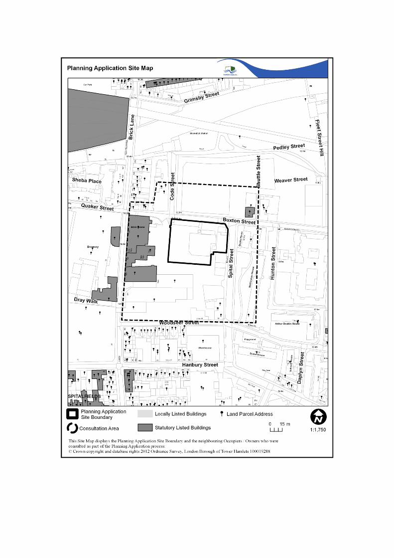
4.19 The map at end of the report shows the location of the application site in relation to three heritage assets and other buildings.
Planning History
4.20 The following planning decisions are relevant to the application:
PA/12/00090(Full Planning) Planning permission was granted on the 3rd July 2013 for the
Demolition of the existing store building, sub-station, workshops and boundary wall to Buxton Street and Spital Street up to the Cooperage Building and erection of a 3 storey high data centre with basement accommodation including provision of Use Class B1 enterprise / D1 training floorspace, provision of rooftop satellite dishes, roof mounted mechanical plant, security fencing, cycle parking and provision of two electric charging car parking spaces.
PA/12/00091 (Conservation Area Consent)
Conservation Area Consent was granted on the 23rd August 2013 for

the demolition of the existing store building, substation, workshops and boundary wall to Buxton Street and Spital Street up to the Cooperage Building.
PA/10/01940 (Planning)
Demolition of existing store building and workshop and erection of a 3 storey building to accommodate a Data Centre was refused in November 2010 for the following 6 reasons (summary only):1. The proposed bulk, height, footprint and elevational treatment is of poor design quality which does not preserve or enhance the character and appearance of the conservation area, fails to respect the local context and townscape and does not relate satisfactorily to Buxton Street, Spital Street or Allen Gardens.2. The inactive nature of the use and position of the building inside the high boundary walls would fail to contribute to the vibrant mix of uses expected in the THAA and would also fail to provide a mix of uses at the edge of the Brick Lane district centre detrimental to the future development of the Brewery site3. Insufficient information has been provided to assess the daylight/sunlight impact on homes in Shuttle House.4. Insufficient information has been provided in relation to energy efficient design, minimising carbon emissions and on-site renewable energy5. Inadequate acoustic attenuation is likely to result in an unacceptable level of noise disturbance6. Lack of financial contributions towards public realm enhancements, local training, employment and enterprise initiatives in the area
PA/10/01958 (CAC)
Refused in November 2010 for the following reason (summary):1. In the absence of an approved planning permission for the re-development of the site, the demolition of the buildings would leave an undeveloped site which would represent a blight on the character and appearance of the Brick Lane and Fournier Street Conservation Area
PA/11/01814 (Planning)
Temporary planning permission granted in September 2011 for a temporary sub-station and LV switch room (up to end February 2013)
PA/11/01877 (Planning)
Planning permission granted in October 2011 for the erection of a permanent substation and LV switch room. (N.B. The approved substation would be integrated into the proposed datacentre building).
PA/11/01878 (CAC)
CAC granted in October 2011 for demolition of existing buildings in connection with the erection of a permanent substation and LV switch room
5. POLICY FRAMEWORK
5.1
5.2
Section 38(6) of the Planning and Compulsory Purchase Act (2004) requires that the determination of these applications must be made in accordance with the development plan unless material considerations indicate otherwise.
For details of the status of relevant policies see the front sheet for “Planning Applications for Determination” agenda items. The following policies are relevant to the application:

Government Planning Policy Guidance/Statements
National Planning Policy Framework (March 2012) (NPPF)National Planning Practice Guidance (March 2014)
5.3 Core Strategy Development Plan Document 2025 (adopted September 2010)Policies SO5 Mixed use at the edge of Town centres
SP01 Town Centre activitySO15 Support City FringeSO16 Support growth of businessesSP06 Industrial landSO20 Safe streetsSP09 StreetsSO22 Protect heritage assetsSO23 High quality new buildingsSP10 Heritage assets and designSO24 Zero carbonSP11 Low carbon energySO25 Delivering placemakingSP12 Securing well designed placesSP13 Planning obligations
5.4 Managing development Document MDD (Adopted April 2013)Policies DM1 Development within the town centre hierarchy
DM11 Living buildings and biodiversityDM13 Sustainable drainageDM14 Managing wasteDM15 Local job creation and investmentDM20 Supporting a sustainable transport networkDM22 ParkingDM23 Streets and public realmDM24 Place-sensitive designDM25 AmenityDM27 Heritage and the historic environmentDM29 Achieving a zero carbon borough and addressing climate
change
5.5 London Plan 2016 (consolidated with alterations since 2011)(Spatial Development Strategy for Greater London)
2.13 Opportunity areas and intensification areas4.1 Developing London’s economy4.10 New and emerging economic sectors4.11 Encouraging a connected economy4.12 Improving opportunities for all5.1 Climate change mitigation5.2 Minimising carbon dioxide emissions5.3 Sustainable design and construction5.5 Decentralised energy networks5.6 Decentralised energy in development proposals5.7 Renewable energy5.10 Urban Greening5.13 Sustainable drainage5.17 Waste capacity

5.21 Contaminated land6.9 Cycling6.11 Walking6.13 Parking7.1 Building London’s neighbourhoods and communities7.2 An inclusive environment7.4 Local character7.5 Public realm7.8 Heritage assets and archaeology7.15 Reducing noise and enhancing soundscapes7.19 Biodiversity and access to nature7.21 Trees and Woodland8.2 Planning obligations
5.6 Planning Obligations Supplementary Planning Document (September 2016)
5.7
5.8
City Fringe Opportunity Area Framework OAPF (Adopted December 2015)
Brick Lane Fournier Street Conservation area Appraisal Document
6. CONSULTATION RESPONSE
6.1 The views of the Directorate of Development & Renewal are expressed in the MATERIAL PLANNING CONSIDERATIONS section below.
6.2
The following were consulted regarding the application:
LBTH Design Officer (11/10/2016)The application was taken to the Councils internal design drop in session for comment, given the history of the site and the Conservation area status. In general principle there were no principle objections to the development, given that the issues were addressed under the previous planning application. The Conservation Officer has requested a sample for materials to be provided, as there were some concerns raised about the colour of the bricks.
Environmental Health - Contaminated Land (30/08/2016)6.3 Development of the site shall not begin until a scheme has been submitted to the local
planning authority and written approval has been granted for the scheme. The scheme will identify the extent of the contamination and the measures to be taken to avoid risk to the public, buildings and environment when the site is developed.
6.4Environmental Health- Noise & Vibration No comments received, although the following comments were received on the previous permission PA/12/00090:
6.5
The following residential facades will experience its impact; i) Stuttle House; ii) New residential building on Woodseer Street and iii) Buxton Street/Code Street. Although the assessment in the report meets BS4142 - L90- 10 dB(A), because the data is based on prediction and assumptions this application will require a condition for post completion testing so as to satisfy EH that there will be no noise nuisance impact on local residents, No objections to permission being granted provided that post completion testing condition which has to be discharged at a later date with EH consultation.
Environmental Health – Air Quality (17/08/2016)

Air Quality assessment not required. Mitigation measures for dust and air pollution during construction and demolition should be included in a CEMP to be submitted prior to commencement. All Non Road Mobile Machinery (NRMM) used in demolition and construction must meet the GLA*s NRMM Low Emission Zone emission limits. Any heating plant installed must meet the GLA's NOx emission limits as specified in the 'Sustainable Design and Construction' SPG Please include the above as conditions should the development be approved.
6.6Communities, Localities & Culture StrategyNo comments received.
Transportation & Highways (05/09/2016)6.7 Transport and Highways welcome the proposal to have no parking facility on site and
the provision of one EV charging space and one disabled parking space provided on site. We recommend a condition be placed to ensure disabled bay is retained and maintained. In addition, another condition requiring exclusive use of the spaces for plug in vehicles and details of the electric charging equipment is submitted to Highways for approval.
The applicant has set out their anticipated demand for cycle parking. As this is based on existing trip patterns for the site Highways are content with the methodology and the results and find the amount of cycle parking acceptable. However, this should be placed under review with additional provision made should the 10 spaces become unable to meet demand.
The applicant is required to provide information on how the infrastructure to support the proposed data centre is to be installed and the extent of such works. Are there likely to be major highway works in order to install the required cabling and electrical supplies for example?
The applicant has demonstrated that the service vehicles will service the site are able to enter and exit the site in a forward gear from the existing access on Spital Street. However, given the constrained nature of Spital Street and the routes leading to the side vehicle access point from the TLRN, Highways recommend a condition is attached requiring approval from Highways of a Service Management Plan prior to operations commencing at the site.
Highways also recommend a condition is placed on any planning permission requiring the applicant to submit to Highways a Construction Logistics Plan which must be approved prior to commencement of construction of the development. Subject to the requested addition of onsite disabled parking, and the recommended conditions described above being attached to any planning permission, Highways does not object to the application.
Crossrail Limited (05/08/2016)6.8 The site of this planning application is identified outside the limits of land subject to
consultation under the Safeguarding Direction. The implications of the Crossrail proposals for the application have been considered and I write to inform you that Crossrail Limited do not wish to make any comments on this application as submitted. Historic England (25/08/2016)
6.9 We have reviewed the information submitted in this current application, and note that the proposals are very similar to those that have been approved. We therefore have

no further substantial comments to make on the scheme.
However, we would like to draw your Council’s attention to a discrepancy in thephotomontages of the proposed development provided as part of the submission.View 7A shows the proposed Data Centre from the corner of Buxton Street and SpitalStreet, and clearly indicates that the 19th century workshops would be retained as partof the scheme. However, there is no indication that the workshops would be retainedany of the other visualisations such as View 3A.
In our view, the workshops contribute to the character of the Conservation Area and so(whist acknowledging that their demolition has already been approved) our preferencewould be to see these building, or at least their facades, retained and incorporated into the scheme.
Further comments received on the 27/09/2016Thank you for clarifying the discrepancy in the visual information for the proposed DataCentre building. I do think it’s a shame that the workshops will go, particularly as theymake a positive contribution to the character of the Brick Lane and Fournier StreetConservation Area in my opinion. However, I recognise that they may already beapproved for demolition under the previous scheme for the site. I would rest on theview set out in our previous advice letter that our preference would be to see thesebuildings, or at least their facades, retained and incorporated in the scheme
English Heritage Archaeology 8/08/20166.10 The Greater London Archaeological Advisory Service (GLAAS) provides
archaeological advice to boroughs in accordance with the National Planning PolicyFramework and GLAAS Charter.
Having considered the proposals with reference to information held in the GreaterLondon Historic Environment Record and/or made available in connection with thisapplication, I conclude that the proposal is unlikely to have a significant effect onheritage assets of archaeological interest.
Environment Agency6.11 No comments received
6.12London Fire and Emergency Planning Authority No comments received, although the following comments were received on the previous permission PA/12/00090
The application appears not to give cause for concerns regarding fire authority access or water supplies.
Thames Water6.13 No comments received
Transport for London6.14 Comments received on the 19/08/2016
TfL welcomes the restrained approach to parking proposed, in line with London Plan Standards
TfL welcomes the blue badge parking space proposed, in line with London Plan standards, however the applicant should clarify that blue badge parking

spaces will be at least 2.4m wide, 4.8m long with a zone 1.2m wide between designated spaces. TfL are content the council will secure full details of blue badge parking with reference to the Accessible London SPG, in consultation with TfL.
The applicant proposes 10 long stay cycle spaces in a covered shelter. TfL deem the overall quantum of cycle spaces unacceptable in line with London Plan standards. As the applicant states, based on the proposed floor space, there should be a minimum of 20 long stay and 10 short stay cycle spaces. TfL therefore request the applicant provide cycle parking compliant with London Plan standards.
TfL welcomes complimentary cycle facilities, such as showers for staff. In addition to measuring suitability of cycle parking against the London Plan standards TfL assess storage and design of cycle facilities against the standards set out in the London Cycle Design Standards (LCDS). The LCDS requires cycle parking to be fit for purpose, secure and well located. TfL finds the access for cycle parking to be acceptable, however the applicant should provide full details of the type of stand to be used for cycle parking. Furthermore the applicant should ensure that cycle parking can accommodate larger cycles (minimum 5%). The council should secure full details of cycle parking, with reference to LCDS, by condition in consultation with TfL.
TfL finds details of refuse collection acceptable.
City of London Corporation 6.15 No comments received.
The Spitalfields Trust6.16 No comments received.
6.17Employment Enterprise (05/09/2016)Please see below updated S106 employment contributions, in line with the planning obligations SPD 2016.
Construction phase = £41,640End-user phase = £60,675.43Total = £102,315.43
The usual non-financial obligations apply during both phases:
Construction phase20% local jobs20% use of local suppliersThe Developer has confirmed that the construction project will cost approx. £50m. According to this cost we will expect 11 apprenticeships with a minimum NVQ L2 to be provided during the construction phase. These apprenticeship placements should be offered exclusively for local residents and they could be on specialist construction trades as well as office administration, facilities, or any other related activities required during the construction phase.
End-user phaseAdvertisement of job opportunities through the council’s job brokerageJobs for local people during operational phase
6.18
6.19
1 apprenticeship to be delivered within the first 3 years of full occupation (calculated based on expected FTE).
Sustainability/Energy Officer (01/11/2016)The current proposals have sought to implement energy efficiency measures and renewable energy technologies to deliver a 43% reduction in CO2 emission reductions. The current proposals for CO2 emission reductions fall short of the 45% requirements of policy DM29.
However, subject to Conditions securing the energy and sustainability proposals and the CO2 emission reduction shortfall being met through a carbon offsetting contribution, the proposals would be considered in accordance with adopted policies for sustainability and CO2 emission reductions. It is recommended that the proposals are secured through appropriate conditions and planning contributions to deliver:
Delivery of CO2 savings to at least 43% against the baseline and submission of as built calculations to demonstrate delivery
Carbon offsetting contribution secured through S106 contribution (£90,000) Submission of BREEAM final Certificate demonstrating achievement of an
Excellent rating
LBTH Tree Officer The tree report submitted with the application does not comply with BS 5837 (2012).
It is required that the tree report is brought in line with BS 5837 (2012) and Tree Protection Plan is provided for the three trees located in the public highway.
7.0 LOCAL REPRESENTATION
7.1 Two site notices were displayed around the site on the 1st September 2016 and it was advertised in the local press. A total of 292 planning notification letters were sent to nearby properties as detailed on the attached site plan. One written objection was received against the development and is summarised below:
The proposal will obstruct the view and light/air will be materially diminished;the height should subsequently be reduced to lessen impacts
8.0 MATERIAL PLANNING CONSIDERATIONS
8.1 The main planning issues raised by the application that the committee must consider are:
1. Principle of the proposed Land Uses 2. Loss of built fabric and trees in the Fournier Street and Brick Lane Conservation Area3. Scale, design, appearance and impact on heritage assets 4. Buxton Street frontage and relationship with Allen Gardens5. Transport, Highways and Parking6. Impact on Amenity7. Energy and environmental sustainability8. Planning obligations9. Equalities

10. Local Finance Considerations
Principle of the proposed land uses
Data Centre and Sub-station8.2 The NPPF (para. 42) states that advanced, high quality communications infrastructure
is essential for sustainable economic growth and that the development of high speed broadband technology and other communications networks play a vital role in enhancing the provision of local community facilities and services.
8.3 London Plan Policy 4.11 (Encouraging a connected economy) calls on authorities to “facilitate the provision and delivery of the information and communications technology (ICT) infrastructure a modern and developing economy needs, particularly to ensure: adequate and suitable network connectivity across London (including well designed and located street-based apparatus); data centre capability; suitable electrical power supplies and security and resilience; and affordable, competitive broadband access meeting the needs of enterprises and individuals.”
8.4
8.5
Core Strategy Strategic Objective 1 supports the growth of thriving and accessible global economic centres of Canary Wharf and the Central Activities Zone (CAZ) which benefit the regional and local economies. The site is within the Tower Hamlets Activity Area (THAA) (a transitional area between the City Fringe and the rest of the borough). Core Strategy policy SP01 seeks to ensure that these transitional areas are complementary, yet different, to the distinct designations of the CAZ by promoting a vibrant mix of uses that are economically competitive and based on the adopted town centre spatial strategy which is also set out in Strategic Objective 1.
The site is also located within the City Fringe Opportunity area. The Mayor of London sets out objectives for this area, detailed in the Opportunity Area Planning Framework (OAPF). The document supports the enhanced growth of digital and creative clusters and the wider promotion of technology, creative and knowledge intensive businesses as part of their strategy to rebalance the economy and strengthen the UK’s competitive position internationally.
8.6 Officers acknowledge that data centres are an important use which complement the functions of the City and the nearby CAZ and that they are required to be located within close proximity of financial institutions in order to transfer data without delay. They can be seen as part of utility infrastructure that supports business. This is very much in line with the Objectives of the OAPF, which encourages the promotion of competitive businesses as part of its strategy to strengthen the UK’s economy. It is considered, therefore, that data centres in the THAA, together with electricity sub-stations that provide power to them, are acceptable in principle. However, whilst Policy SP01 states the uses within the THAA should be complementary to the City functions, they should also include a vibrant mix of uses. The need for provision of mix of uses is also recognised in the Core Strategy Vision for Trumans Brewery.
8.7 The site is currently surrounded by high walls and has little pedestrian footfall. The area lacks natural surveillance and, partly as a result of this, the amenity value of Allen Gardens is not fully realised currently. The previous application (PA/12/00090) therefore secured several amendments to ensure that the development would contribute to the vibrant mix of uses expected in the THAA and edge of the Brick Lane District Centre.
8.8 Therefore the following measures were secured and therefore have been applied to this scheme: Demolishing the existing high wall along Buxton Street;

Setting the building back from the current line of the wall to create a useable pavement along the whole length of the site
Locating a building immediately next to a newly created pavement area and incorporating windows in this location at all levels of the building;
Locating the main pedestrian access on Buxton Street; Incorporating the security and reception area on the ground floor corner of Buxton
Street and Spital Street and locating breakout/meeting rooms and balconies in this location on the first and second floors; and
Incorporating a ‘business enterprise space’ at the ground floor (this use is discussed in more detail below).
Training and Enterprise Centre8.9 Strategic Objective 15 of the Core Strategy is to support the thriving and accessible
global economic centre of the City Fringe which benefits the regional and local economies and Strategic Objective 17 is to improve education, skills and training. Core Strategy Policy SP07 seeks, amongst other things, to support developments that promote local enterprise and the employment and skills training of local residents.
8.10 The proposed business enterprise space (B1/D1) (235sqm) would be located along the ground floor of the Buxton Street frontage. The intended use of this space as a Training and Enterprise Centre. The Centre would comprise: A managed workspace flexibly arranged with hot desks and with full connectivity for
new ICT start-up companies; A locally managed and ICT supported venue for the delivery of business support
services to new start-ups; and Venue also to provide ICT skills training for local people aiming to achieve NQF
level 3 and 4 qualifications for careers in the local ICT industry.
8.11 The applicant would (in summary): Appoint a local agent to manage the marketing and day-to-day management of the
Centre(such as Tech Hub, a local university or the Council); Provide professional information, advice and guidance to start-up firms as part of a
structured programme of business seminars and mentoring; Work in partnership with public sector agencies to assist trainees by promoting
opportunities for jobs, apprenticeships and internships amongst its suppliers, customers and wider IT community;
Cover the costs of fittings and overheads for a period of 3 years and make a financial contribution towards the revenue costs of managing the centre (estimated to be £100,000 per annum);
Make the centre available rent free to an appointed managing agent for 5 years, with the expectation that the Centre becomes self-sustaining after this period; and
Develop with the appointed managing agent a business plan for the future use of the Centre.
8.12 The proposed Centre has the potential to deliver real benefits to help small start-up businesses to grow and to help local people learn skills and training that would help them access employment. Such a use would also help activate the Buxton Street frontage. There is a risk that such a Centre would not become self-sustaining and fall out of use. However, officers consider that it represents a credible use of the Buxton Street frontage that should be pursued. It is recommended that, should permission be granted, a planning obligation secures the delivery and management of the proposed Business Enterprise Space in accordance with the above principles and that these principles are developed into a Future Business Enterprise Space Strategy that is approved by the Council prior to first occupation of the data centre and/or the Centre.
8.13 The application seeks permission for Business (B1) and/or enterprise training space (D1). In addition to non-residential education and training centres, the D1 use class also includes crèches, nurseries, day centres, places of worship and church halls. These uses would not necessarily contribute to the mixture of uses required by policy in this location. It is therefore recommended that a planning condition be attached to any permission which restricts the use of the proposed space to B1 and/or an education training centre, so that the acceptability of any other uses can be assessed. Displacement of existing businesses/uses
8.14 Policy DM15 of the Development Management DPD makes clear that development which is likely to displace an existing business must find suitable replacement accommodation within the borough unless it can be shown that the needs of the business are better met elsewhere.
8.15 The majority of the existing buildings on the site are vacant or used for ‘dead storage’. The proposal would displace one permanent business; a small coffee grinding and distribution company that is currently based in the former barrel-washing shed (accessed from the yard). The applicant states that Zeloof intends to re-locate this business within the wider Brewery complex and it is recommended that a relocation strategy for this business is secured by way of a planning obligation.
Loss of built fabric and trees in the Fournier Street and Brick Lane Conservation Area
Loss of buildings, walls and courtyard
8.16
8.17
8.18
8.19
In accordance with Section 72 of the Planning (Listed Buildings and Conservation Areas) Act 1990, special attention shall also be paid to the desirability of preserving or enhancing the character and appearance of the designated conservation area. As a statutory requirement the desirability of preserving or enhancing the character and appearance of a conservation area is a consideration to which a decision maker should give considerable weight.
NPPF Paragraph 131 states that in determining planning applications, local planning authorities should take account of:
The desirability of sustaining and enhancing the significance of heritage assets and putting them to viable uses consistent with their conservation;
The positive contribution that conservation of heritage assets can make to sustainable communities including their economic vitality; and,
The desirability of new development making a positive contribution to local character and distinctiveness.
NPPF Paragraph 132 notes that when considering the impact of a Proposed Development on the significance of a designated heritage asset, great weight should be given to the asset’s conservation. The more important the asset, the greater the weight should be.
Paragraph 133 advises that where a development proposal will lead to less than substantial harm to the significance of a designated heritage asset, this harm should be weighed against the public benefits of the proposal, including securing its optimum

8.20
viable use.
Policy SP10 in the Core Strategy seeks to protect and enhance heritage assets. Policy DM27 of the Development Management Document MDD sets out similar criteria - making clear that proposals for the demolition of a such assets will only be considered under exceptional circumstances where the public benefit of demolition outweighs the case for retention against the following criteria:a. the significance of the asset, architecturally, historically and contextually;b. the condition of the asset and estimated costs of its repair and maintenance in relation to its significance and demolition, and to the value derived from its continued use;c. the adequacy of efforts made to retain the asset in use; andd. the merits of any alternative proposal for the site.
8.21
8.22
The principle of demolition/design was covered under the previous planning application (PA/12/0090). Comments were received from Historic England in regards to the loss of the existing warehouse buildings on site and their preference for it to be retained or at least their facades, retained and incorporated into the scheme. In this instance, the warehouses were not able to be retained and the wider merits of the proposed replacement building are discussed in further detail below (public realm improvements- includes a footpath). Notwithstanding the above, the existing warehouse bricks will be reclaimed and used throughout the proposal, which will seek to incorporate the warehouse/utilitarian feel into the proposal and therefore contribute to the existing merits of the Fournier Street and Brick Lane Conservation Area. This expanded on the paragraphs below:
The proposals would result in the loss of the former barrel-washing shed and electricity sub-station (which form part of the high brick wall that runs along this part of Buxton Street), a utilitarian two-storey flat-roofed brick workshop building dating from the 1950’s or 60’s on the Spital Street frontage and an industrial ‘shed’ probably dating from the 1970’s. They would also result in the loss of a large part of the existing yard, which is surfaced in a mixture of cobbles, tarmac and stone paving slabs. The proposed demolition of the workshop building on Spital Street would also expose the northern wall of the existing Cooperage Building, which abuts the site to the south.
8.23 The former barrel-washing shed and northern wall is the oldest surviving structure on the site and probably dates from the mid-19th century. It is a substantial structure of brown brick built right up to the frontage of Buxton Street, leaving a very narrow footway. To the street, the building presents a rather forbidding boundary wall (5.5 to 6m high) incorporating three window openings. It includes a boundary marker which reads “Four feet six inches east is the boundary of St. M.B.G. WS Clark Church John Kelday Wardens 1815.” The structure also includes an electricity sub-station at the western (Brick Lane) end. On the yard side, the central part of what was once an open structure has been bricked-up with Fletton brick work and is currently occupied by a small coffee grinding/distribution company.
8.24 The barrel-washing shed and boundary wall is of some historical and architectural interest and the previously proposed scheme did propose retaining the wall. However, this resulted in an inactive frontage to Buxton Street, which was one reason why the previous application was amended. Therefore the previous planning application PA/12/00090 and this proposal address this reason by proposing to demolish the existing walls and locating a building along the Buxton Street frontage. This enables an active frontage to be created along this stretch of Buxton Street and the creation of a 2m wide pavement area where none exists at present. The wider merits of the proposed replacement building are discussed further below, but it should be noted at this stage
that the existing boundary marker would be incorporated in to the northern elevation of the proposed building, at the same location as existing.
8.25 The 1950’s/60’s workshop building and wall that front Spital Street are of very little historical or architectural interest. However, the demolition of the building would expose the northern wall of the existing Cooperage Building and chimney stack, which abuts the site to the south. Whilst not listed, the Cooperage Building (built between 1876 and 1896) makes a positive contribution to the character and appearance of the Conservation Area. Given this, it is recommended that a condition be attached to any permission requiring the making good of the exposed brick wall of this building and stack.
8.26 The industrial ‘shed’ towards the centre of the site is unattractive and is considered to have a neutral/negative effect on the character and appearance of the area and there is no objection to its loss. The courtyard space is of some historic significance as a reminder of a past phase of commercial activity in the area. Nevertheless, the focus of brewery activity at least from the 1830’s onwards was Brick Lane, with the Head Office and the main buildings that front it, and there are no known specific historic associations with particular events or individuals of note. However, it is recommended that a condition be attached to any permission requiring the reclamation of existing cobbles and stone paving slabs from the courtyard area for use on and off-site.
8.27 The buildings which make up the former Truman’s Brewery site form an important part of the Fournier Street and Brick Lane Conservation Area. The character of the Area as a whole is outlined in the Council’s Character Appraisal and Management Guidelines (November 2009) and the applicant has submitted a character appraisal for the Brewery complex. None of the buildings on site that would be demolished are identified in either of these documents as being particularly significant. Overall, taking account of the significance of the structures that would be lost and efforts to retain/incorporate them, the merits of the proposed development, discussed in detail below, are considered to outweigh any harm to the character and appearance of the Conservation Area caused by the proposed loss of built fabric. It should be noted that the reason for refusing the previous CAC application (PA/10/01958) related to the lack of an approved replacement scheme and the harm this would cause; not to the loss of the structures themselves..
Biodiversity
8.28 London Plan Policy 7.21 seeks to retain trees and the planting of replacement/new trees wherever possible. Local plan policy DM11 seeks living buildings and biodiversity enhancements.
8.29 Biodiversity issues relating to their proposed loss are addressed below. Three street trees along Spital Street would not be affected by the proposals. The proposed large green wall areas on the south (courtyard) elevation would provide replacement greenery The application was consulted with LBTH’s Tree Officer who has required that the tree report is brought in line with BS 5837 (2012) and Tree Protection Plan is provided for the three trees located in the public highway. This will be secured by condition.
Scale, design, appearance and impact on heritage assets
Scale, design and appearance
8.30 Policy SP10 of the Core Strategy seeks to ensure buildings are of a high quality design. Policy DM24 in Managing Development Document (2013) calls for place-sensitive design and requires new development to be high quality and responds positively to its
context and Policy DM26 seeks to ensure that taller buildings respond positively to their context and address various criteria. London Plan policies 7.5 and 7.6 call for new development to respect local character and be of the highest architectural quality.
8.31 The scale and design of the proposed development is identical to what was submitted and approved under the previous planning application (PA/12/00090). The design was subject of significant discussion under the previous applications and in 2010, (PA/10/01940) planning permission was refused partly on the grounds that the proposed bulk, height, footprint and elevational treatment was of poor design quality which would not preserve or enhance the character and appearance of the conservation area, failed to respect the local context and townscape and did not relate satisfactorily to Buxton Street, Spital Street or Allen Gardens. Therefore the scheme now before members has seen significant revisions since the first submission back in 2010 and as mentioned earlier is identical to that was approved under the 2012 planning consent. For clarity, the current proposals have sought to address the reasons of the 2010 refusal as follows:
The proposed building has been set back approximately 2m from the Buxton Street frontage to allow for a pavement area to be created along the south side of the street and the introduction of an active frontage (discussed further below);
The proposed main entrance of the building has been moved from the Buxton Street/Spital Street corner to Buxton Street;
The overall height of proposed building has been reduced by approximately 2.7m (partly as a result of a basement level);
The previously proposed stair core has been relocated further away from Buxton Street so as to reduce its impact;
The mass of the proposed building would step back further from Spital Street; and The proposed elevational treatment of the building has been completely revised.
8.32 The proposed building would be approximately 65m long, as viewed from Buxton Street and approximately 30m along the Spital Street frontage. It would appear as a part three/part four storey brick building when viewed from these streets and Allen Gardens, with the Spital Street elevation being set behind a high brick wall. The building would have a two-storey lower section, a single storey upper section set back from the main facade line and a top storey set back still further (with this storey comprising a screen hiding rooftop plant). The main bulk of the building would rise to approximately 18.5m above ground level, although the proposed photovoltaic panels would rise to approximately 19m, the satellite dishes on the southern elevation (overlooking the courtyard) to about 19.5m and seven slim flues would rise to about 21.5m.
8.33 The proposed Buxton Street and Spital Street elevations are divided vertically into wide bays, with each bay separated by recessed columns containing rainwater pipes, and in each bay is a pair of sunken vertical panels with square heads. The panels would rise through two floors on the lower part of the front, with separate shorter panels on the upper part, within which are set the small-paned window openings these are required. The fenestration would not be regular because it reflects the internal functions of the proposed building and some of the panels would be completely ‘blind’. Nevertheless, the front as a whole would be given a unity by the appearance of the sunken panels, which would be a strong motif. Towards the eastern end of Buxton Street (near Spital Street) there would be the main entrance, set in a single wider panel which would continue up the full height of the building in a triple tier of straight-headed window openings. The proposed elevations clearly take their inspiration from 19th and 20th century industrial buildings, including examples from within the former brewery site.
8.34 The proposed western elevation would not face a public street, but would face the listed Brickhouse, Engineer’s House and Vat House on Brick Lane. The industrial aesthetic would be repeated here. The northern section would have four ‘blind’ sunken panels; whereas the larger southern section would have a row of seven tall square-headed openings with small-paned glazing rising up from first floor level upwards. The southern elevation would face the reduced courtyard space and would contain two large green wall panels and three satellite dishes at roof level.
8.35 The proposed siting and scale of the proposed building are considered acceptable from a design perspective. The proposed elevations are simple and straight forward and the quality of the proposed building would be heavily dependent on the quality of the detailing and materials. Given the importance of these details, officers have sought to ensure that external materials are, as much as reasonably possible, considered at this stage The predominant material would be brick, with dark bronze metal window surrounds and plant screen at roof level and samples of the these materials have been submitted for approval. In addition, 1:50 strip elevations /sections of the Buxton Street elevation have been submitted, showing the intended depth of window reveals and other recessed features. The proposed materials and building details are considered acceptable and, subject to a condition requiring further external material samples to be submitted and approved, should ensure that delivery of a building of acceptable quality. As such, the proposals are considered acceptable and accord with the policies referred to above.
Impact on setting of Listed Buildings
8.36 Core Strategy policy SP10 and Policy DM27 of the Managing Development Document requires development to protect and enhance the borough’s heritage assets (including Listed Buildings), their setting and their significance as key elements of developing the sense of place of the borough’s distinctive ‘Places’. Similar policy objectives are included in London Plan policy 7.8.
8.37 The proposed building would be sited approximately 29m to the east of the rear of the Grade II Listed Brickhouse building, approximately 20m to the east of the rear of the Grade II Listed Engineer’s House and approximately 17m north of the rear of the Grade II Listed Vat House. The proposed building would also sit across the street from the Grade II Listed former All Saint’s Vicarage at 35 Buxton Street. Other listed buildings sit further away on the west side of Brick lane. These include the Directors House (Grade II*) and the Brewmaster’s House at No. 95 Brick Lane (Grade II).
8.38 The relationship between the proposed building and the listed buildings immediately to the west of it is considered acceptable, and whilst the proposed building would be seen in context with the rear of the Brickhouse and the Engineer’s House and Vat buildings, it is not considered that the setting of these buildings would be harmed. Perhaps more importantly, the proposed building would be seen in context with the existing Brickhouse building in views along Buxton Street and across Allen Gardens. However, it is not considered that the proposed building would harm the setting of this building. Likewise, the proposed building would be seen in context with the former All Saint’s Vicarage building in views along Buxton Street and across Allen gardens, but again, it is not considered that the setting of this building would be harmed.
8.39 The narrow width of Brick Lane means that the proposed building would not be visible from the western footway of this street or from the courtyard to the main brewery building. Whilst it would be visible across the top of the Listed Brick House building from upper floors of buildings on the west side of Brick Lane, the planning system is primarily concerned with impacts on views from the public realm.

8.40 Subject to conditions requiring the submission of further external material samples, the proposed development is considered to preserve the setting of the nearby Listed Buildings and their special architectural and historic interest. As such, the proposals accord with the policies referred to above.
Impact on character and appearance of the Conservation Area
8.41 Core Strategy policy SP10 and policy DM27 of the Managing Development Document requires development to protect and enhance the borough’s heritage assets (including Conservation Areas), their setting and their significance as key elements of developing the sense of place of the borough’s distinctive ‘Places’. Similar policy objectives are included in London Plan policy 7.8.
8.42 The acceptability of the proposed loss of existing built fabric and trees are discussed in detail above. The proposed building would undoubtedly change the character and appearance of this part of the Area when viewed from Woodseer Street to the south, Allen Gardens to the north and Buxton Street to the north and east. However, officers consider that, whilst the building would be relatively large and prominent, drawings and views submitted in support of the application demonstrate that the visual impact on the Area would be acceptable. Subject to conditions requiring the submission of further external material samples and details relating to the external treatment of the proposed paved area along Buxton Street and the treatment of the exposed wall of the Cooperage building, the proposed replacement development is considered to preserve and enhance the appearance of the Conservation Area. As such, the proposals accord with the policies referred to above.
Impact on archaeology
8.43 Core Strategy policy SP10 and policy DM27 of the Managing Development Document makes clear that the Council wishes to safeguard archaeological heritage and require an archaeological evaluation report for proposed development that lies in or adjacent to Archaeological Priority Areas.
8.44 Whilst the site is not in an Archaeological Priority Area, it is situated in an area where archaeological remains may be anticipated and the applicant has submitted an Archaeological Desk Based Assessment to support the application. The Assessment identifies a low potential for Prehistoric remains, but a moderate potential for Roman remains. In addition, historic map regression suggests a high potential of late 17th century and possibly 18th century housing, with the existing garden area in the north-east corner of the site holding the greatest potential. It was recommended on the previous application that sub-surface archaeological investigation and a programme of archaeological recording of the standing buildings (to be demolished) are carried forward and secured by planning condition. Officers agree and it is recommended that such conditions are attached to any planning approval.
Buxton Street frontage and impact on Allen Gardens
8.45 Policy SP01 in the Core Strategy states the uses within the THAA should be complementary to the City functions, they should also include a vibrant mix of uses. Policy DM23 in the Managing Development Document calls, amongst other things, for development to be well-connected with the surrounding area and inclusive for everyone and to improve safety and security without compromising design. London Plan policy 6.10 supports measures that encourage walking and policy 7.13 calls for development to minimise potential physical risks and include measures to design out crime and deter

terrorism.
8.46
8.47
The proposed siting of the building approximately 2m back from the line of the existing wall would enable the creation of a pavement area along this section of Buxton Street, where at present only a narrow 1 to 1.4m pavement exists for only part of the site frontage. The terms of proposed lease with the freeholder of the land means that applicant is unable to dedicate this land as public highway. The proposed pavement area would therefore remain as private land over which the public would have right of access and it is recommended that this is secured by way of a planning obligation (which both the leaseholder and freeholder would need to be party to). The applicant is concerned about the security of the proposed building and would ideally like to see vehicle impact resistant bollards provided on the edge of the private pavement area. However, officers raised concerns over the appearance of such bollards and their potential to act as obstacles to the convenient and comfortable movement along the pavement/adjoining public footway. As a result, these have been omitted from the proposals.
It is recommended that a planning obligation be used to secure public access and that the drainage, surfacing and lighting details of this area are reserved by condition Subject to such an obligation and condition, the proposed pavement area would improve pedestrian facilities in accordance with Policies DM23 and London Plan policy 6.10 and is to be welcomed.
8.48 The incorporation of a Training and Enterprise Centre along the Buxton Street frontage would result in approximately 71% (44m of the 62m) of this ground floor frontage being in active use. Whilst most of the windows on the first and second floors fronting Buxton Street and Spital Street would serve relatively inactive space (including data halls, corridors and mechanical plant areas), some active use is proposed for the corner of the building and the windows serving inactive space would at least give the perception of overlooking. Officers consider that the revised proposals do enough to activate these frontages and are acceptable.
8.49 The setting back of the proposed building from Buxton Street and the reduction in overall height means that the proposed building would overshadow Allen Gardens less than the scheme that was refused planning permission (PA/10/0190). The Daylight, Sunlight and Overshadowing Assessment considers the likely overshadowing of Allen Gardens on 21 March (the Spring Equinox) at hourly intervals between 08.00 and 17.00 (10 separate calculations). This shows that the proposed building would result in some limited additional overshadowing of the southern edge of Allen Gardens. However, the area of the public open space that would be prevented from receiving direct sunlight for at least two hours on 21 March would be less than 5%. The level of overshadowing is therefore considered acceptable. The relevant BRE Guidelines allow up to 49% of a public space to be in permanent shadow on the 21 March before they consider there to be a significant impact. Transport, Highways and Parking
Accessibility and trip generation
8.50 London Plan policies 6.9, 6.11 and 6.13 encourage cycling and walking and seek to manage the provision of car parking spaces. Core Strategy SP09 seeks to ensure new development has no adverse impact on the safety and capacity of the road network and promotes schemes that minimise on-site and off-site car parking provision, particularly in areas with good access to public transport. Policy DM20 in Managing Development Document makes clear that development needs to be located appropriately,

demonstrate that it is properly integrated with the transport network and has no unacceptable impacts on the capacity and safety of the network.
8.51 The site is well served by bus and rail connections and as a consequence has a PTAL of 6a (Excellent). Given likely trip generation and modal split assumptions based on a survey of staff working at existing data centres in the area and the proposed 2 car parking spaces, the submitted Transport Statement anticipates the number of trips to the data centre during peak periods (07.00 to 09.00 and 16.00 to 18.00) would be 64 arrivals and 57 departures, with only 2 car movements. The proposed Business Enterprise Space is not expected to add significantly to these peak period movements. This would represent a relatively low number of trips for such a well-connected part of the borough and officers do not anticipate any undue pressure on the surrounding streets.
Vehicular access and servicing
8.52 Vehicular access would be via the existing access on Spital Street and across the retained yard area to a loading entrance adjacent to the south side of the proposed building. The submitted Transport Statement estimates that day-to-day servicing requirements would be for approximately 10 trips in and out of a 7.5 tonne van and that a 10,000 litre tanker lorry would need to fill the proposed on-site fuel tanks with generator fuel around 3 times per year. There would also be occasional collection of commercial waste. Swept path analysis has been submitted that demonstrates that a large tanker (and refuse vehicle) could satisfactorily manoeuvre in the yard area and enter and leave the existing Spital Street entrance in forward gear.
8.53 The proposed rear servicing arrangements are acceptable.
Car parking
8.54 London Plan Policy 6.13 (Parking) sets out maximum car parking standards, requires at least one ‘blue badge’ parking space for workplaces and seeks to ensure that 1 in 5 spaces provide an electrical charging point to encourage the uptake of electric vehicles. Policy DM22 of the Managing Development Document requires development to comply with specific car parking standards and to prioritise spaces for car clubs/pool cars and electric charging points.
8.55 The proposals provide for one ‘blue badge’ parking space for a disabled employee/visitor (which would be served by an electric charging point) and one further electric charging parking space, for use by employees of the proposed scheme and by occupiers of other buildings served by the retained yard area. This proposed provision is welcome. Cycle parking
8.56 Policy DM22 in the Managing Development Document MDD requires development to comply with minimum cycle parking requirements (minimum of 1 space per 120sqm B1 office and 1 space per 250sqm of space for B8).
8.57 The proposal incorporates the provision of 10 covered cycle parking spaces for employees and none for visitors. This is below the level required by the emerging standards and whilst it is appreciated that TFL have raised concerns regarding the number of spaces, given that the number of spaces have been based on existing trip patterns for the site, LBTH Highways are content with the methodology and the results and find the amount of cycle parking acceptable.

However, this should be placed under review with additional provision made should the 10 spaces become unable to meet demand. If the Committee is minded to approve the development, a condition appended to the consent will ensure that this requirement is adhered to
Construction
8.58 Policy DM 21 of the Managing Development Document seeks to mitigate impacts during the construction phase of developments and it is recommended that a Construction Management Plan be secured by way of planning condition.
Impact on amenity
Daylight and Sunlight
8.59 Policy SP10 and Policy DM25 of the Managing Development Document seek to protect and where possible enhance residential amenity (including not allowing an unacceptable material deterioration of the sunlighting and daylighting conditions). The previous proposal for the site (PA/10/0190) was refused permission partly on the grounds that insufficient information had been provided to fully assess the daylight/sunlight impact on homes in Shuttle House.
8.60 The previous report has addressed the impacts upon all neighbouring residential properties and the finding are stipulated below: The submitted Daylight, Sunlight and Overshadowing Assessment assesses the impact of the proposed building on the daylight received at homes on the ground and upper floors of Daniel Gilbert House (around 14m to the north west), 35 Buxton Street (around 27m to the north east) and Shuttle House and McGlashan House (about 19m and 42m to the west respectively). This found that all tested windows would receive at least 27% Vertical Sky Component (VSC) in all but one case. The exception is the ground floor window at 35 Buxton Street, where the VSC would be 25.7%. However, the proposed level of daylight here would be more than 80% of its existing value, meaning that the reduction in daylight is unlikely to be noticeable. As such, all tested windows would meet the relevant BRE Guidelines.
8.61 The Assessment also assesses the impact that the proposal would have on the sunlight received by homes on the ground and upper floors of Daniel Gilbert House and 35 Buxton Street, which sit to the north of the proposed building. The assessment of Annual Probable Sunlight Hours (APSHs) finds that all tested windows would continue to receive levels of sunlight that are above the minimum recommended levels for both the full year and for winter time (when the sun is lower in the sky).
8.62 Given the above, officers consider that the proposal would not give rise to any unduly detrimental impacts in terms of daylight or sunlight. Overshadowing of Allen Gardens is addressed under the Buxton Street frontage and impact on Allen Gardens above.
Noise
8.63 Core Strategy policy SP10 and policy DM25 of the Managing Development Document seek to protect and where possible enhance residential amenity (including not allowing unacceptable levels of noise during construction or operation). London Plan policy 7.15 seeks to minimise potential adverse noise impacts arising from new development.
8.64 The proposals incorporate a large amount of plant located primarily at roof level, using

most of the space available for 27 dry-air coolers for the proposed data halls and generators below. In addition, 7 generators would be located at ground floor on the western (Brick Lane) side of the building (although it expected that no more than 6 would operate at any one time). A chiller plant room would also be located at ground floor level on the east (Spital Street) side of the building, although this would not include any significant outlets to the outside.
8.65 To mitigate potential noise impacts, the proposed building incorporates a 1.5m high upstand at plant deck level and set back from this would be 4.1m high acoustic louvered screen, which would rise to the top of the dry-air coolers. The submitted Noise Assessment sets out the findings of a 24 hour noise survey on site and at Code Street and Spital Street. This indicated a minimum night-time noise level of 40dB LA90 between approximately 2 to 3AM. The Council require cumulative plant noise to be 10dB below this noise level, therefore setting a noise limit of 30 dBA Leq. The Assessment predicts that, with the proposed acoustic screen and other proposed attenuation measures in place, noise levels would be 28.7 dBA at the flats at Spital Street/Woodseer Street, 29.5 dBA at the flats on the 7th floor of Stuttle House (the worst affected level) and 30.4 dBA at the homes on the 4th floor of in Daniel Gilbert House (the worst affected level). The Acoustic Assessment Addendum Report confirms these predictions.
8.66 The Assessment predicts noise levels just below and, in the case of Daniel Gilbert House, just above the 30 dBA level normally required. Environmental Health officers accept that the predictions are reasonable, but recommend that should permission be granted, a planning condition ensures that there is post-completion testing of the noise impacts of the development before the plant is first brought into use. It is therefore recommended that a condition requires that before an approved data centre is first brought into use, detailed results of a noise survey measuring the operation of the plant working at full capacity are approved in writing by the Council. It is also recommended that a condition requires the installation and retention of the proposed acoustic screen. Subject to these conditions, the likely noise impacts of the proposed development are considered acceptable. If measures taken don’t bring noise below this level further mitigation would be required
TV and radio reception8.67 Policy DM26 of the Managing Development Document requires proposed tall buildings
not to interfere, to an unacceptable degree, with telecommunication, television and radio transmission networks.
8.68 The planning application is supported by a report into a desktop study and field survey to assess possible effects and impacts from the proposed development on the reception of broadcast services. This concludes that the proposals are not expected to have an effect upon the reception of Digital Terrestrial TV (DTT), digital satellite TV services such as Freesat and Sky or on VHF (FM) radio and that, therefore, no mitigation is necessary. Officers accept the findings of this report.
Air Quality8.69 Core Strategy policy SP10 and policy DM25 of the Managing Development Document
seek to protect and where possible enhance residential amenity (including not allowing unacceptable levels of odour or fumes). London Plan policy 7.14 calls for development to ensure that it does not lead to further deterioration of existing poor air quality in Air Quality Management Areas.
8.70 As discussed in section 4 of this report and below, data centres use a lot of energy and the applicant needs to ensure continuity of power supply for commercial reasons. The

proposed generators are part of ensuring this continuity. If electricity supply fails, batteries would automatically kick in for 15-30 minutes to provide power and the generators would then come on line to provide power until electricity supply from the national grid is restored. Consequently, other than testing, the generators would not be in use as a matter of course and would constitute emergency back-up. They should not, therefore, give rise to any significant impacts with regards to air quality.
Energy Efficiency and Sustainability Policy Requirements
8.71
8.72
8.73
8.74
8.75
8.76
At a national level, the National Planning Policy Framework sets out that planning plays a key role in delivering reductions to greenhouse gas emissions, minimising vulnerability and providing resilience to climate change. The NPPF also notes that planning supports the delivery of renewable and low carbon energy and associated infrastructure. At a strategic level, the climate change policies as set out in Chapter 5 of the London Plan 2016 (as amended since 2011), London Borough of Tower Hamlets Core Strategy (SO24 and SP11) and the Managing Development Document Policy DM29 collectively require developments to make the fullest contribution to the mitigation and adaptation to climate change and to minimise carbon dioxide emissions.
The London Plan sets out the Mayor’s energy hierarchy which is to:
• Use Less Energy (Be Lean);• Supply Energy Efficiently (Be Clean); and• Use Renewable Energy (Be Green).
The Managing Development Document Policy DM29 includes the target to achieve a minimum 50% reduction in CO2 emissions above the Building Regulations 2010 through the cumulative steps of the Energy Hierarchy. From April 2014 the London Borough of Tower Hamlets have applied a 45 per cent carbon reduction target beyond Part L 2013 of the Building Regulations, as this is deemed to be broadly equivalent to the 50 per cent target beyond Part L 2010 of the Building Regulations.
Policy DM29 - Proposed Carbon Emission Reductions
The submitted Energy Statement (June 2016) has followed the principles of the Mayor’s energy hierarchy, and seeks to focus on reducing energy demand and integration of renewable energy technologies to minimse CO2 emissions. As with the nature of the development (Data Centre) the primary loads are electrical for power and cooling. The energy efficiency measures are anticipated to reduce CO2 emissions by 42.7% and the proposed PV array (131m2) will take the cumulative reduction up to 43% which is in accordance with policy London Plan requirements at 37%. However, the proposals fall short of the LBTH policy requirements to achieve a 45% reduction in CO2 emissions.
The CO2 emissions are:
Baseline – 2,548 Tonnes/CO2/yr Proposed design – 1,451 Tonnes/CO2/yr LBTH policy requirement – 1,401 Tonnes/CO2/yr Annual Shortfall – 50 Tonnes/CO2/yr
Carbon Offsetting
As noted previously, the current proposals fall short of the LBTH policy requirements to achieve a 45% reduction in CO2 emissions.

8.77
8.78
8.79
In order for the scheme to be supported by the sustainable development it is recommended that the shortfall in CO2 emission reduction is met through a carbon offsetting payment. The planning obligations SPD contains the mechanism for any shortfall to be met through a carbon offsetting contribution, in the absence of the CO2 emission reduction not being delivered on site. In addition, the council has an adopted carbon offsetting solutions study (adopted at Cabinet in January 2016) to enable the delivery of carbon offsetting projects. Based on the current energy strategy a carbon offsetting contribution of £90,000 would be appropriate for carbon offset projects. The calculation for this figure is as follows:
Shortfall to meet DM29 requirements = 50 tonnes/CO2 x £1,800 = £90,000 offset payment to meet current policy requirements.In order to support the proposed scheme carbon reduction proposals, appropriately worded Conditions and a S106 agreement for £90,000 to be payable prior to commencement of development, should be incorporated to deliver carbon savings off-site.
Sustainability
Policy DM 29 also requires sustainable design assessment tools to be used to ensure the development has maximised use of climate change mitigation measures. At present the current interpretation of this policy is to require all non-residential uses to achieve BREEAM Excellent. The applicant has submitted a BREEAM pre-assessment which shows the scheme is designed to achieve a BREEAM Excellent rating with a score of 74.56%. The delivery of BREEAM excellent should be secured via Condition to ensure the scheme is compliant with Policy DM29.
Biodiversity and Proposed Green wall
8.80 London Plan policy 5.10 (Urban greening) encourages the incorporation of green walls into proposed buildings. Policy DM11 in the Managing Development Document requires developments to provide elements of ‘living buildings’. It also states that existing elements of biodiversity value should be protected or replaced within the development and additional habitat provision made to increase biodiversity value.
8.81 The existing site contains a small garden with 3 trees which provides some habitat for common birds and other wildlife. The submitted Ecological Scoping Phase 1 Habitat Survey Report notes that the loss of this would have a very small negative impact on biodiversity and officers agree. However, it is recommended that an informative be included as part of any planning permission stating that these trees should be felled outside of the bird breeding season (March to August).
8.82 The proposals incorporate two separate but adjacent green walls on the southern (courtyard) elevation of the building, both measuring approximately 7.8m x 10.4m (about 162sqm in total). The proposed substantial areas of green wall could help to mitigate the small loss of existing habitat. To maximise biodiversity benefits, plants used in green walls should provide nectar for bees and other insects and/or berries or seeds for birds. There is a lack of detail of the green wall areas in the application and it is recommended that the details (including planting) are reserved by condition for subsequent approval.
Water usage

8.83 London Plan policy 5.13 (sustainable drainage) encourages Sustainable Urban Drainage Systems (SUDS) that store rainwater for later use and policy 5.15 (Water use and supplies) promotes the use of rainwater harvesting. Policy DM13 of the Managing Development Document makes clear that development will be required to show how it reduces the amount of water usage, runoff and discharge from the site, through the use of appropriate water reuse and SUDS techniques.
8.84 Achieving a BREEAM ‘Excellent’ rating would require the use of water efficient appliances. It is also proposed to incorporate a rainwater harvesting scheme to gather and store rainwater from the roof areas to be used the water the green wall areas. Provision has been made in the basement for grey water storage and pumping area and it is expected that the system would be powered by the proposed PVs at roof level. However, there is a lack of detail and it is recommended that the details are reserved by condition for subsequent approval.
Contamination
8.85 Policy DM30 of the Managing Development Document makes clear that where development is proposed on contaminated land or potentially contaminated land, a site investigation will be required and remediation proposals agreed to deal with any contamination before planning permission is granted.
8.86 The submitted Site Investigation Report concludes that in view of the proposed commercial (non-residential) use, contamination results indicate that the site can be considered uncontaminated with regard to human health. Having said this, it considers that excess material generated during site preparation works should be considered contaminated with regard to disposal. The report goes on to note that the elevated levels of metals and fuels encountered within the leachable soil and groundwater may present a risk to Controlled Waters and recommends borehole testing and further quantitative risk assessment. It is recommended that conditions are included as part of any planning approval to ensure that suitable further investigation is carried out prior to works commencing on the site.
Waste
8.87 Policy DM14 of the Managing Development Document (2013) makes clear that development should demonstrate how it will provide appropriate storage facilities for residual waste and recycling.
8.88 The proposals incorporate waste and recycling area of approximately 6.5 x 4.5m (29sqm) to the rear of the proposed building, in the retained courtyard area, with suitable vehicular access. This is considered acceptable.
Planning Obligations
8.89 Regulation 122 of the Community Infrastructure Levy Regulations 2010, brings into law policy tests for planning obligations which can only constitute a reason for granting planning permission where they meet the following tests:
(a) The obligation is necessary to make the development acceptable in planning terms;
(b) The obligation is directly related to the development; and (c) The obligation is fairly and reasonably related in scale and kind to the

development.
8.90 Policy SP13 of the adopted Core Strategy say that the Council will seek to enter into planning obligations with developers where appropriate and where necessary for a development to proceed.
8.91 The amounts have been negotiated taking account of the planning obligations SPD and heads of terms are set out below.
Non-financial Contributions and Obligations8.92 Officers have negotiated the following non-financial contributions and obligations:
a) Delivery of a Training and Enterprise Centre summarised in paras. 8.9 and 8.10 of this report and the implementation of a Training and Enterprise Centre Management Plan (to be approved in writing by the Council prior to first occupation of the data centre).b) Access to employment initiatives for construction through 20% of non-technical total construction jobs to be advertised through the Council’s job brokerage service.c) A target of 20% of total value of contracts which procure goods and services are to be to be achieved using firms located within the borough.d) Relocation strategy for existing business to be submitted to and approved in writing by the Council before commencement of developmente) Public access to be provided over the private pavement area along the Buxton Street frontagef) Any other planning obligation(s) considered necessary by the Corporate Director Development & Renewal.
Employment and skills training8.93 Core Strategy Policy SP07 seeks, amongst other things, to support developments that
promote local enterprise and the employment and skills training of local residents. The applicant has identified the following employment estimates: 83 Full Time Equivalent (FTE) construction jobs during 12-18 month period; 29 FTE full-time jobs across a range of skills and qualifications (technical and
operational, sales and marketing and security); An additional 11 FTE full-time jobs from the proposed Business Enterprise Space.
8.94 The Council’s Planning Obligations SPD includes employment densities for IT/Data centres and ‘business park’ light industrial space of 1 job per 47sqm (NIA/GIA). Using these employment densities suggests that up to 223 FTE full-time jobs could be created from the development. Based on this higher potential figure and the formula set out in the SPD, it is recommended that a financial contribution of £60,675 is secured to help train and develop unemployed residents in Tower Hamlets.
8.95 Based on the provisions of the Planning Obligations SPD, it is recommended that a financial contribution of £41,640 be secured to help support and provide training for local residents in accessing job opportunities during the construction phase.
8.96 In accordance with CS Policy SP07 and the Planning Obligations SPD, it is recommended that planning obligations secure the use of best endeavours to ensure that 20% of the construction phase workforce are Tower Hamlets residents and that a target of 20% of goods and services procured during the construction phase are from businesses within the borough (noting that this may prove difficult to achieve for such a specialist building).
8.97 In order to support the proposed scheme carbon reduction proposals, appropriately
worded Conditions and a S106 agreement for £90,000 to be payable prior to commencement of development, should be incorporated to deliver carbon savings off-site.The calculation for this figure is as follows:
Shortfall to meet DM29 requirements = 50 tonnes/CO2 x £1,800 = £90,000 offset payment to meet current policy requirements.
8.98 Officers consider that the proposed overall package of non-financial and financial contributions outlined above would satisfactorily mitigate likely adverse impacts associated with the proposals and help to secure the Council’s policy objectives. Given this, the lack of financial contributions towards leisure facilities is considered acceptable in this case.
Monitoring fee8.99 A monitoring fee of £500 per head of term.
9.0
9.1
9.2
9.0 HUMAN RIGHTS CONSIDERATIONS
In determining this application the Council is required to have regard to the provisions of the Human Rights Act 1998. In the determination of a planning application the following are particularly highlighted to Members:
Section 6 of the Human Rights Act 1998 prohibits authorities (including the Council as local planning authority) from acting in a way which is incompatible with the European Convention on Human Rights. "Convention" here means the European Convention on Human Rights, certain parts of which were incorporated into English law under the Human Rights Act 1998. Various Convention rights are likely to be relevant, including:-
Entitlement to a fair and public hearing within a reasonable time by an independent and impartial tribunal established by law in the determination of a person's civil and political rights (Convention Article 6). This includes property rights and can include opportunities to be heard in the consultation process;
Rights to respect for private and family life and home. Such rights may be restricted if the infringement is legitimate and fair and proportionate in the public interest (Convention Article 8); and
Peaceful enjoyment of possessions (including property). This does not impair the right to enforce such laws as the State deems necessary to control the use of property in accordance with the general interest (First Protocol, Article
The European Court has recognised that "regard must be had to the fair balance that has to be struck between the competing interests of the individual and of the community as a whole".
9.3
9.4
This report has outlined the consultation that has been undertaken on the planning application and the opportunities for people to make representations to the Council as local planning authority.
Both public and private interests are to be taken into account in the exercise of the Council's planning authority's powers and duties. Any interference with a Convention right must be necessary and proportionate.

9.5
9.6
10.0
10.1
11.0
11.1
11.2
11.3
11.4
Members must, therefore, carefully consider the balance to be struck between individual rights and the wider public interest.
As set out above, it is necessary, having regard to the Human Rights Act 1998, to take into account any interference with private property rights protected by the European Convention on Human Rights and ensure that the interference is proportionate and in the public interest.
EQUALITIES ACT CONSIDERATIONS
The proposed training and enterprise centre is considered to make a positive contribution to social cohesion and local residents. The Equality Act 2010 provides protection from discrimination in respect of certain protected characteristics, namely: age, disability, gender reassignment, pregnancy and maternity, race, religion or beliefs, gender and sexual orientation. It places the Council under a legal duty to have due regard to the advancement of equality in the exercise of its powers including planning powers. Officers have taken this into account in the assessment of the application and the Committee must be mindful of this duty inter alia when determining all planning applications. In particular the Committee must pay due regard to the need to:
eliminate discrimination, harassment, victimisation and any other conduct that is prohibited by or under the Act;
advance equality of opportunity between persons who share a relevant protected characteristic and persons who do not share it; and
foster good relations between persons who share a relevant protected characteristic and persons who do not share it.
FINANCIAL CONSIDERATION
Localism Act (amendment to S70(2) of the TCPA 1990)
Section 70(1) of the Town and Country Planning Act 1990 (as amended) entitles the relevant authority to grant planning permission on application to it. Section 70(2)requires that the authority shall have regard to:
The provisions of the development plan, so far as material to the application; Any local finance considerations, so far as material to the application; and, Any other material consideration.
Section 70(4) defines “local finance consideration” as:
A grant or other financial assistance that has been, or will or could be,provided to a relevant authority by a Minister of the Crown; or Sums that a relevant authority has received, or will or could receive, inpayment of Community Infrastructure Levy.
In this context “grants” might include New Homes Bonus. This is not applicable to thisapplication.
As regards Community Infrastructure Levy considerations, Members are remindedthat that the London mayoral CIL became operational from 1 April 2012
11.5
11.6
11.7
11.8
The Borough’s Community Infrastructure Levy came into force from 1st April 2015.
When dealing with data centres, Officers take the view that if the floorspace of the ‘plant / data storage component’ areas of a building exceed 50% of the total floorspace of that building, then we are happy to discount this floorspace from the CIL calculation
With this in mind, and based on the floorspace information above, the CIL chargeable floorspace would be 235sqm for a B1 use (we always take the higher use rate if shared, hence the shared D1 is not included here). If the applicant can show that the existing floorspace has been used for 6 months within the last 36 months of when the new planning permission is granted, then the existing 800sqm can be netted off. On this basis then, the net CIL charge would be zero regardless of the introduction of the Local CIL since the granting of the original permission.
The CIL Rate Per sqm (GIA) of development is £90.
12.0 Conclusions
12.1 Subject to the recommended planning obligations and conditions, officers consider that the proposal would meet policy objectives and satisfactorily mitigate any adverse impacts, as outlined in detail in this report.
12.2 All other relevant policies and considerations have been taken into account. Planning permission should be granted for the reasons set out in the EXECUTIVE SUMMARY and the details of the decision as set out in the RECOMMENDATION at the beginning of this report.