commercial remote sensing: an historical...
TRANSCRIPT

4/9/2010 DigitalGlobe Proprietary 1
1990 1995 2000
Jan. 1992WorldView Imaging Corporationestablished
Mar. 1994President Clinton signs Presidential Decision Directive 23 (PDD-23)
Jan. 1995WorldView merges with Ball Aerospace to become EarthWatch Inc.
Jan. 1993WorldView receives 1st
license to operate high resolution imaging satellite from U.S. Govt
Dec. 1997Earthwatch launches EarlyBird 1 (3m pan; 15m msi resolution) from Svobodny, Russia
Four days later, on- orbit power problems terminate EarlyBird’s operations
Commercial Remote Sensing: An Historical Chronology
Nov. 2000Earthwatch launches QuickBird 1 from Plesetsk, Russia but suffers a launch failure. Satellite fails to achieve orbit
Oct. 1992Following President Bush’s National Space Policy Directive 5, Congress signs Land Remote Sensing Policy Act
Act authorizes US Dept of Commerce to license private remote sensing space systems
Sept. 1993CNES launches SPOT-3
Nov. 1995RADARSAT-1 launched(8-100m resolution)
Dec. 1995India launches IRS-1C (5.8m resolution)
April, 1999Space Imaging launches IKONOS-1 (1m pan; 4m msi resolution).
Satellite fails to achieve orbit.
Sept. 1999Space Imaging successfully launches IKONOS-2.
World’s first commercial 1-m resolution satellite

4/9/2010 DigitalGlobe Proprietary 2
2006
Jan. 2003NIMA awards ClearView contracts to DigitalGlobe and Space Imaging
Apr. 2003President Bush authorizes U.S. Commercial Remote Sensing Space Policy
Spring, 2003NIMA announces intent to have NextView program.
Jun. 2002DCI Tenet issues directive requiring US Intelligence Community to rely on commercial satellite imagery to the greatest extent possible
Oct. 2001DigitalGlobe successfully launches QuickBird 2 on a Delta 2 rocket from Vandenberg AFB
World’s highest resolution commercial imaging satellite (60-cm pan; 2.4m msi)
Commercial Remote Sensing: Historical Chronology
2000
Dec. 2000Israel’s ImageSat Intl launches EROS-A (1.8m pan resolution)
Sept. 2001OrbImage launches OrbView-4 satellite (1m pan: 4m msi).
Launch fails.
2002
May, 2002CNES launches SPOT-5 (2.5m pan; 10m msi resolution)
Jun. 2003OrbImage successfully launches OrbView-3 (1m pan; 4m msi)
Sept. 2003DigitalGlobe awarded NextView contract
2007
Dec. 2007GeoEye building GeoEye-1 (41-cm pan; 1.6m msi)Scheduled for Summer 2008 launch.
Sept, 2007DigitalGlobe successfully launches WorldView-1 (50-cm pan) on a Delta 2 rocket from VAFB.
Apr. 2006Israel’s ImageSat Intl succesfully launches EROS-B (70-cm pan)

US Space Policy Specifics – Governing Documents
• 1992 Land Remote Sensing Policy Act– Mainly a law regarding Landsat operations and procurement but….– “The National interest of the US lies in maintaining international leadership in
satellite land remote sensing”– “Development of the remote sensing market…should remain exclusively the
function of the private sector”– Subchapter II details how to license private remote sensing space systems
• Secretary of Commerce is the licensing authority• “Operate the system in such manner as to preserve the national security of the
United States”
4/9/2010 DigitalGlobe Proprietary 3

US Space Policy Specifics – Governing Documents
• 2003 US Commercial Remote Sensing Policy– Policy document -> no legally enforceable actions are created or intended– Policy goal is to advance US national security interests by maintaining
leadership in remote sensing space activities– Provides guidance in four key areas:
• 1. Licensing and operation of remote sensing satellites• 2. USG use of commercial remote sensing capabilities• 3. Foreign access to US commercial remote sensing satellites• 4. Intelligence and defense relationships involving US commercial remote sensing
capabilities
4/9/2010 DigitalGlobe Proprietary 4

US Space Policy Specifics – Governing Documents
• 2003 US Commercial Remote Sensing Policy– USG will…
• Focus USG imagery systems on needs that cannot be met by commercial entities• Rely on commercial capabilities for filling military, intel, civil, imagery needs• Enable US industry to compete as provider of imagery for foreign govt’s and users• Develop long-term relationship between USG and the US commercial remote
sensing industry– SECDEF and DCI shall communicate current and projected needs to industry– Establishes NGA as agency responsible for disseminating commercial
imagery for national security and foreign policy requirements
4/9/2010 DigitalGlobe Proprietary 5

USG Space Policy Specifics
• To operate a commercial remote sensing satellite NOAA must issue a license – the license is the ‘authority to operate’– License applications are reviewed by DoD (national security purposes), DoS
(foreign policy), DoI (remote sensing data storage archive), and any other appropriate agencies
– License is valid for life of system or until DoC determines non-compliance with terms of Remote Sensing Policy Act or the terms of the license
• License has a number of restrictions– Resolution, Shutter control, Contract information, Denied Parties screening,
Data Availability to USG, Spacecraft Operations
4/9/2010 DigitalGlobe Proprietary 6

US Space Policy Specifics
• Resolution– Ground Sample Distance must be consistent with license– Applies to panchromatic, multi-spectral, synthetic aperture radar, and
hyperspectral systems
• Shutter Control– USG reserves the right to make DG “go black” in certain areas OR to provide
imagery exclusively to the USG– Implemented with Space Imaging during early phases of Afghanistan war
• Contract Information– DG must provide contract information with other customers to the USG
• Data Availability– USG access to use data on reasonable terms and conditions when required
for national security or foreign policy purposes (data may be ‘unenhanced’)4/9/2010 DigitalGlobe Proprietary 7

US Space Policy Specifics
• Denied Parties list– DigitalGlobe must avoid selling imagery to certain individuals and entities– DigitalGlobe receives a list of Denied Parties from the State Dept
• List is updated at least weekly• DG has no insight into how the list gets created or updated
– If an order is received and flags against the Denied Parties list DG has certain obligations for reporting
• Required to check once/order, but actually happens three times (order receipt, image acquisition, order delivery)
• Spacecraft Operations– Maintain positive control of spacecraft operations– Maintain tasking record– Preserve national security and international obligations
4/9/2010 DigitalGlobe Proprietary 8

99
Imagery Uses and ApplicationsImagery Uses and ApplicationsImagery Uses and Applications
1010
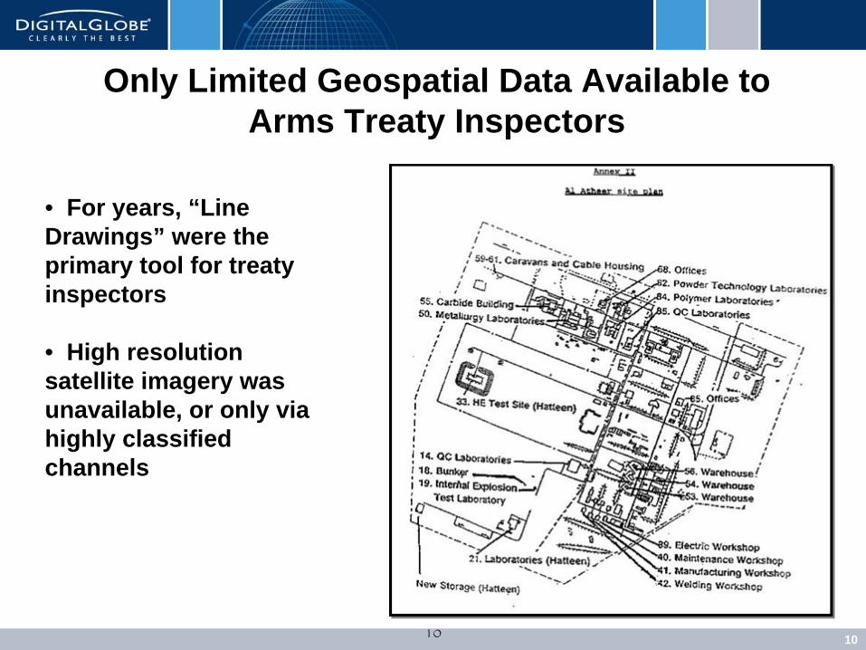
• For years, “Line Drawings” were the primary tool for treaty inspectors
• High resolution satellite imagery was unavailable, or only via highly classified channels
Only Limited Geospatial Data Available to Arms Treaty Inspectors

USG Uses of Commercial Satellite Imagery
• Benefits– Does not give away any National Asset capabilities– Data may be shared with allied countries, civilian agencies, non-governmental
agencies– Unclassified way for USG to show data it wants others to know about
• Uses– Change detection, large mapping projects, specific operations
• Integration into overall NGA architecture• Pre-emptive, emphasis-based tasking• Recently used for Haitian relief efforts
– Augments existing assets• Buildup coverage of an area• Change detection, mapping ,etc.
4/9/2010 DigitalGlobe Proprietary 11

Military Use Is Changing
• Rapid delivery of imagery to warfighter for mission planning is being implemented– Allows commercial imagery to assist tactical, operational, strategic planning
• Commercial imagery may be used in the field– Unclassified– May be shared with local populace, local NGOs, local government
4/9/2010 DigitalGlobe Proprietary 12

1313
NY Times Photograph
Satellite Imagery Used in the Field Today

4/9/2010 DigitalGlobe Proprietary 14
NY Times Photograph

Civilian Applications for Satellite Imagery
4/9/2010 DigitalGlobe Proprietary 15
• Civil
• Business
• Consumer

16
Commercial - Civil Agencies
Significant growth in developing countries – monitor, analyze, plan and manage change on ground
– Asia - Eastern Europe - South America
Expanding use of imagery for national mapping activities
Broader use across civil agencies –beyond GIS experts
Economics of content solutions vs tasking projects
Expanding global reseller network - 42 today
Planning Urban Development
Environmental Monitoring
Key Drivers Example Applications

17
Commercial - Enterprise Applications
Integration of location-based imagery into business planning, processes and software
Greater accessibility of web-based geospatial solutions
Economics of content solutions vs tasking
Expanded availability ready-to-go industry-specific solutions
– World oil basins
– World cities
– Rich mineral sites
– Asset infrastructure
Retail and Development Site Selection
Oil & Gas Facilities Management
Select Customers
Key Drivers Example Applications
18
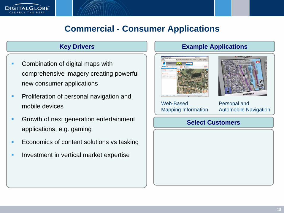
Commercial - Consumer Applications
Combination of digital maps with comprehensive imagery creating powerful new consumer applications
Proliferation of personal navigation and mobile devices
Growth of next generation entertainment applications, e.g. gaming
Economics of content solutions vs tasking
Investment in vertical market expertise
Personal and Automobile Navigation
Web-Based Mapping Information
Select Customers
Key Drivers Example Applications

Crisis Response
• Two methods for DigitalGlobe to make our imagery available following a natural disaster– USG will post our images on their portals– DigitalGlobe will make our imagery available on our web service and ftp sites
• USG use of our imagery– USG grants access to first responders, NGOs, local governments, etc– Often done when there are USG personnel deploying to the area– Commercial entities normally not given access– DG approves requests to use our imagery in this manner
• DigitalGlobe hosted imagery– DigitalGlobe makes a limited set of our imagery available for unique events– Preference to search and rescue operations– Commercial entities must sign up to have access– Company gets many requests from a variety of sources
4/9/2010 DigitalGlobe Proprietary 19

Web Services: Haiti Response• January 12, 2010: Magnitude 7.0 earthquake strikes
Port au Prince, Haiti
• Within hours, DG activates Crisis Event Service for Haiti• Provides free web-based access of archive and
newly collected DG imagery to first responders• Supports WMS, web plug-ins for GIS software
• By January 25, 2010, more than 4,460 registered users had online access to more than 130,000 sqnmi of satellite imagery of the affected region
Boston University Remote Sensing Team Briefing Haitian President Rene Preval
BU Today Photo

Trees
WV2 for Urban Forestry

2203/09/2008 DigitalGlobe Proprietary
Hollywood’s Version of Satellite Imagery & 3D!

2323
International CompetitionInternational CompetitionInternational Competition
2424
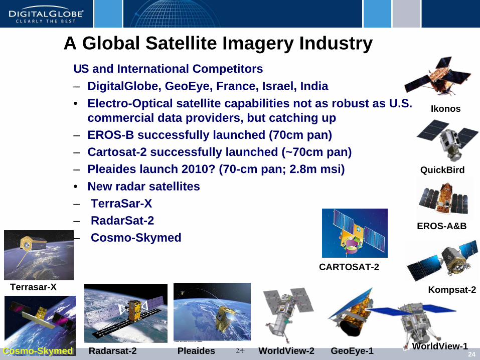
US and International Competitors – DigitalGlobe, GeoEye, France, Israel, India• Electro-Optical satellite capabilities not as robust as U.S.
commercial data providers, but catching up– EROS-B successfully launched (70cm pan)– Cartosat-2 successfully launched (~70cm pan)– Pleaides launch 2010? (70-cm pan; 2.8m msi)• New radar satellites– TerraSar-X– RadarSat-2– Cosmo-Skymed
QuickBird
Ikonos
GeoEye-1 WorldView-1WorldView-2
Kompsat-2Terrasar-X
Cosmo-SkymedCosmo-Skymed Radarsat-2 Pleaides
EROS-A&B
CARTOSAT-2
A Global Satellite Imagery Industry
2525
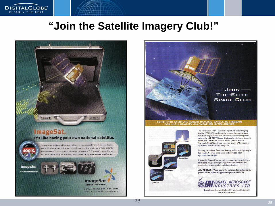
“Join the Satellite Imagery Club!”

2626
ImageSat EROS B70 cm resolutionMay 2006
ImageSat EROS B70 cm resolutionMay 2006
An Increasingly Capable Industry

2727
Terrasar First Radar Image

4/9/2010 DigitalGlobe Proprietary 28
Radarsat-2 Imagery of Paris, France

2929
What’s Coming Next?WhatWhat’’s Coming Next?s Coming Next?

3030
Instant Access – Online, Offline, On the Go
Where Will Satellite Imagery & 3D Modeling Show Up Next?
3131
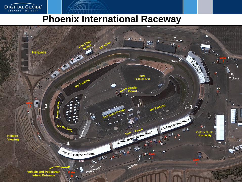
HelipadsHelipads
Leader Board Leader Board
Bobby Allison
Grandstand
HillsideViewingHillsideViewing
80
70
6050
Dick Beaty Garage
Jimmy Bryan Grandstand
BGN Paddock Area
Team
Par
king
Richard Petty Grandstand
A.J. Foyt Grandstand
TV
Compound Tickets
40
30
Fuel
Tunn
el A
cces
s
20
Fan Club
SuitesRV Vista
RV Parking
RV Parking
RV Parking
Start Finish
Gate3
Gate7
Gate8
Gate11
Victory CircleHospitality
Tickets
Turn 133
22
44
Turn
Turn
Turn
Gate6
Vehicle and PedestrianInfield Entrance
Phoenix International Raceway

3232
Athena Technologies Commercial UAVBlimps
What’s Coming Next?