combining simultaneously measured uv and ir radiances from omi and tes to improve tropospheric ozone...
TRANSCRIPT

Combining Simultaneously Measured UV and IR Radiances from OMI and TES to
Improve Tropospheric Ozone Profile Retrievals
Dejian Fu1, John Worden1, Susan Kulawik1, Kevin Bowman1, Stanley P. Sander1
1Jet Propulsion Laboratory, California Institute of Technology, 4800 Oak Grove Drive, Pasadena, CA 91109, USA
Xiong Liu2
2Harvard-Smithsonian Center for Astrophysics, 60 Garden Street, Cambridge, MA 02138, USA

Introduction
Worden J., X. Liu, K. Bowman, K. Chance, R. Beer, A. Eldering, M. Gunson, and H. Worden, Improved tropospheric ozone profile retrievals using OMI and TES radiances, GRL, 34, 2007.
Landgraf, J., and O. P. Hasekamp, Retrieval of tropospheric ozone: The synergistic use of thermal infrared emission and ultraviolet reflectivity measurements from space, JGR, 112, 2007.
Data Source Vertical Resolution
GEOS – CHEM True profile
TIR + UV 3.6 – 4.8 km
TIR 6 km
UV 12 km
X_ret = Xa + A (X_true - Xa)

Tropospheric Emission Spectrometry and Ozone Monitoring Instrument
TES is a Fourier transform spectrometer Spectral Range: 650 – 3050 cm-1 (or 15.38 to 3.28 micron) Spectral Resolution: 0.06 cm-1
Ground Pixel Size: 8.3 by 5.3 km2 (along track by cross track)
OMI is an imaging grating spectrometer Spectral Range 270 – 500 nm (37,037 – 20,000 cm-1)
UV1 module (264 – 311 nm): 30 pixels UV2 module (307 – 383 nm): 60 pixels Visible module (349 – 504 nm): 60 pixels
Spectral Resolution: 0.42–0.63 nm Ground Pixel Size:
UV1: 13 by 48 km2 (along track by cross track) UV2: 13 by 24 km2 (along track by cross track) Visible: 13 by 24 km2 (along track by cross track)

OMI and TES Measurements Over Houston, Texas On May 9th, 2009
23.1 km
16.4 km11.2 km9.5 km
Criteria of Coincident Measurements Cloud optical depth: <= 0.005 Ozone sonde measurements are available for comparisons Time difference of OMI and TES measurements to ozone sonde: 0.5 hours Distances of OMI and TES measurements to ozone sonde site: 25 km

Spectral Regions Used in Joint Retrievals
TES
OMIUsed in this work

TES and OMI Normalized Radiances Measured Over Houston, on May 9th, 2009

ConvergenceYes
Output Retrieved Parameters [O3]
Update [O3] and Other Parameters
to be Retrieved
OMI FM Model
No
UV Simulated Radiances
TIR Measured Radiances UV Measured Radiances
TIR Simulated Radiances
Call Forward
Model
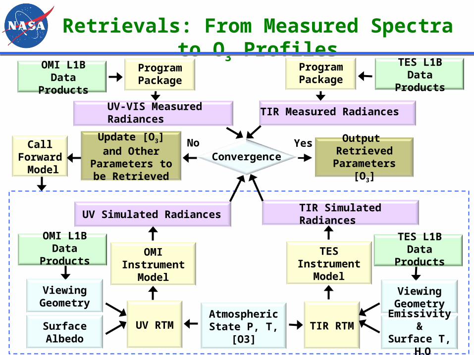
Retrievals: From Measured Spectra to O3 Profiles
TES FM Model

Retrievals: From Measured Spectra to O3 Profiles
Radiative Transfer Models OMI
Uses the linearized vector radiative transfer model VLIDORT [Spurr, 2006] for the numerical computation of the Stokes vector in a multiply-scattering multilayer medium
TES Simulates Earth radiances in the TIR spectral region, has been
developed and validated by the TES retrieval team
Retrieval Methodology Follows the optimal estimation method [Rodgers 2000]. Levenberg-Marquardt algorithm [Rodgers 2000; Bowman et al, 2006] was
applied to the combined TES/OMI radiances

Instrument
Fitting VariablesNumber
VariablesA Priori
A Priori Error
TES + OMI O3 at each layer 25 MOZART-3 MOZART-3
TES
H2O at each layer 16 GEOS4 NCEP ~30%
Surface temperature 1 GEOS4 0.5K
Surface emissivity 32
ASTER and
landuse map
~0.006
Cloud extinction 10Initial BT difference
300%
Cloud top pressure 1 500 mbar 100%
OMI
UV1 Surface Albedo 1 climatology 0.05
UV2 Surface Albedo 2 climatology 0.05
first-order wavelength-dependent term for UV2 Surface Albedo
1 0.0 0.01
Ring scaling parameters 2 1.9 1.0
Radiance/irradiance wavelength shifts 2 0.0 0.02 nm
Radiance/O3 cross section wavelength shifts (zero order)
2 0.0 0.02 nm
Radiance/O3 cross section wavelength shifts (first order)
2 1.0 0.004

Radiance Residuals (Measured – Modeled) /Noise Estimate
First Iteration RMS: 6.52Last Iteration RMS: 1.33
First Iteration
Last Iteration

Vertical Sensitivity and Resolution of O3 Observations
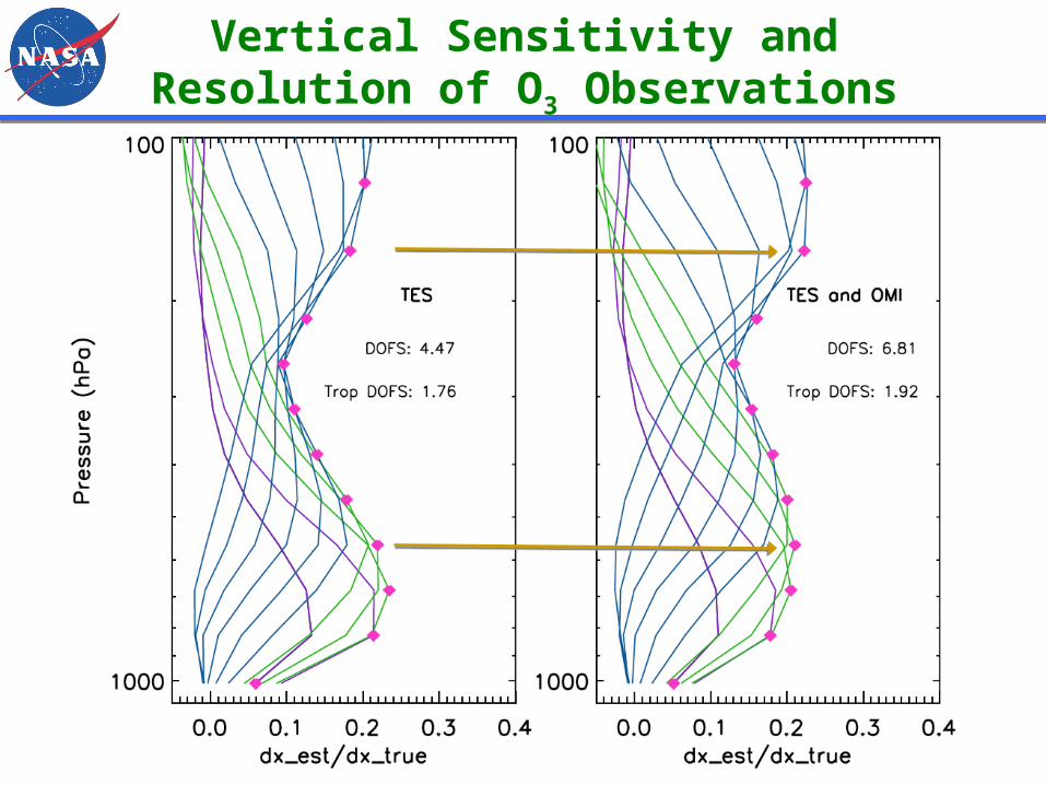
Vertical Sensitivity and Resolution of O3 Observations

Temperature Profile over Houston, Texas, USA on May 9th, 2009
High Surface Temperature High Thermal Contrast

O3 Profiles Over Houston On May 9th, 2009
8:35 AM

Error Analysis and Characterization
Summary and Future Work
Summary This work demonstrates that ozone profiles can be estimated from
combined OMI and TES radiances Combined OMI/TES retrieval converges with chi 1.3; and ozone profile
consistent with co-located sonde measurement Vertical resolution increases: averaging kernels are more separated in
altitude for combined retrieval Sensitivity (DOFS) to tropospheric variability improves from 1.76 to 1.92
Future work To further improve the program package in order to do large volume of
data processing Compare PBL ozone estimates using combined OMI/TES retrieval to in
situ measurements for spring / fall conditions (lower thermal contrast / higher albedo). Under these conditions we expect larger improvements in vertical resolution for combined retrieval.

Acknowledgements
Drs. Quitus L. Kleipool and Maarten Sneep at Royal Netherlands Meteorological Institute (KNMI)
Drs. Alyn Lambert and Robert Herman, Vijay Natraj at JPL
Your Attention
Program Package
UV RTM
ConvergenceYes
Output Retrieved Parameters [O3]
Update [O3] and Other Parameters
to be Retrieved
OMI Instrument
Model
No
UV Simulated Radiances
TIR Measured Radiances UV-VIS Measured Radiances
OMI L1B Data Products
TIR Simulated Radiances
Call Forward
Model
TIR RTMAtmospheric State P, T, [O3]
Viewing Geometry
Surface Albedo
Retrievals: From Measured Spectra to O3 Profiles
OMI L1B Data Products
TES L1B Data Products
Viewing Geometry
Emissivity &Surface T,
H2O
TES Instrument
Model
Program Package
TES L1B Data Products

Retrievals Using TES and OMI Measurements over Egbert Canada on July 5th, 2008
35.7 km
12.1 km22.0 km
3.0 km
Criteria of Coincident Measurements Cloud optical depth: <= 0.005 Ozone sonde measurements are available for comparisons Time difference of OMI and TES measurements to ozone sonde: 3 hours Distances of OMI and TES measurements to ozone sonde site: 50 km Surface albedo was near zero over water surface