combined site and architecture design guidelines 2001...
TRANSCRIPT

Combined Site and Architectural
Design Guidelines
Sierra Point Brisbane, California
OPUS West Corporation
March 12, 2001

Table of Contents
Introduction 1
Objectives 3
Conceptual Master Plan 5
Open Space/Landscape
Matrix 7
Circulation 11 Roadway Landscape 12 Parking 16 Water's Edge 20 Public Access and View Corridors 23
Architecture 29
Design Elements 34
Use of Guidelines 42

Introduction

Introduction
Location
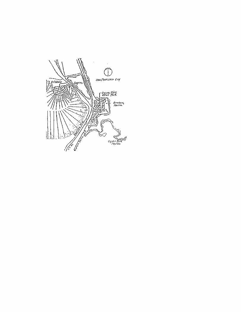
Sierra Point is located on the Sierra Point Peninsula in the cities of Brisbane and South San Francisco, The peninsula is a diked landfill of 130 acres, three miles south of the San Francisco City/County boundary. Sierra Point shares the peninsula with the Brisbane Marina, which forms the project's eastern limits. On the west the project is bounded by U. S. 101. On the north and south, the project is bounded by San Francisco Bay. U. S. 101 provides the link to San Francisco and the Greater San Francisco Bay Area. Freeway connections to and from Sierra Point provide access to this important link to the Bay Area market.
General Description
The Sierra Point Peninsula is a parcel of land presently at elevation +15 above sea level. Settlement over the next 100 years will decrease the elevation to +12, The perimeter of the peninsula is the dike and rip-rap, with approximately 3:1 slopes on the Bay edge, flatter at the corners within the Brisbane Marina development. A drainage channel lies northwest of the site with a floodgate controlling water movement. Highest Expected Water Level is 5.85 elevation line from which Bay Conservation Development Commission (BCDC) jurisdiction extends for 100 feet.
Climate
Climatic conditions at Sierra Point are characteristic of conditions prevailing around the Bay Area. Summers are mild with coastal fog; winters are cool with rain; falls often offer the warmest days of the year. Winds on the site are fairly constant, occurring approximately 85% of the time and from the northwest. Wind velocities tend to increase in the afternoon hours, especially during summer when thermal activity increases in the inland valleys. However, since Sierra Point is sheltered slightly by the San Bruno Mountains and not directly
1

within the path of winds passing through Visitacion Valley, the site does not experience the velocities associated with other wind passages around the Bay.
Soils
The site is a former solid waste disposal site. The surface is presently composed of soi l material and rubble varying in depth from a maximum of 10 feet to a minimum of 1 foot. Settlement is predicted from consolidation of the underlying bay mud and compression of the garbage till.
2

Objectives

Objectives
It is the objective of these Guidelines to create a pleasant and functional working environment for Sierra Point. A high quality environment at Sierra Point will be an asset to the Cities of Brisbane and South San Francisco. It provides an attraction to possible tenants thereby making Sierra Point competitive with other developments in the area. The Guidelines represent only a portion of the process whereby such an objective is achieved, but it is the foundation on which later design decisions should be based. In addition, the success of the product requires a commitment by all involved of implementing the standards as outlined in these Guidelines.
The Guidelines provide design standards on a conceptual level which are to be implemented in the final design. These occur as prototypical treatments for a variety of situations and address (1) minimums/maximums, (2) f o r m / s t r u c t u r e , ( 3 ) m a t e r i a l s , a n d ( 4 ) color/texture. The design standards are the means of achieving the following objectives:
1. Creation of an identity for Sierra Point.
2. Resolution of problems associated with siting on a waste disposal site, including problems of differential settlement and drainage.
3. Provision for public access to and from the Bay edge in accordance with the San Francisco Bay Plan and the Public Access Design Guidelines.
4. Creation of functional and efficient circulation systems for pedestrians, autos, and bicycles.
5. Provide guidance for building design compatible with the site and the objectives of the owner and the City.
6. Provision for a landscape matrix unifying the various portions of Sierra Point.
7. Provision for an overall framework of design within which phased development may occur.
3

Specific design standards related to the difficult subsurface condition of the site set a direction for landscape treatment in Sierra Point and influence the methods whereby the other issues are addressed. These specific standards are:
1. Use of asphalt-extruded curbs and/or headers instead of concrete curbs and gutters to accommodate the problem of differential settlement, except as determined otherwise by the Public Works Director.
2. Use of paving materials that can be easily replaced, i.e., asphalt, modular pavers, decomposed granite, except as determined otherwise by the Public Works Director.
3. Use of low volume irrigation systems.
4. Planting of trees in groves and on mounds to alleviate problems of poor soils and wind.
5. Use of shallow-rooted plant materials to avoid problems associated with the limited depth of soil.
Design standards addressing other aspects of the development of Sierra Point arc:
1. Use of steel, glass, concrete, and timber for architectural materials to achieve a sophisticated and contemporary image, which conveys a natural, character conducive to the Bay edge.
2. Siting of buildings and use of landscape development to maintain and enhance view corridors to the Bay.
3. Use of a continuous pathway throughout Sierra Point for pedestrian and bicycle access and circulation.
4

Conceptual Master Plan

Conceptual Master Plan
The Brisbane portion of the conceptual master plan incorporates ten mid-rise office buildings and three hotels. In developing the current Master Plan, the buildings have been carefully sited to produce a compatible mix of building heights that will produce a properly scaled, attractive profile within the project limits and from adjacent land and bay perspectives. In positioning the structures, views are to be maximized from the buildings and through the wide corridors to the bay's edge.
The maximum heights allowed for the office buildings and hotels will vary from five to twelve stories (exclusive of mechanical penthouses), with sites being permitted the tallest buildings being located in the center portion of the site. Buildings no taller than 8 stories would be allowed along the Freeway, and buildings no taller than 6 stories would be allowed along the shoreline. Office buildings along the shoreline will be sited to preserve views from the more interior buildings and to preserve the adjoining bay vistas. The mid-rise concept offers the great advantage of leaving a large portion of the site in landscaped open space while seemingly reducing the project's density.
See figure on following page.
The seven hundred room convention hotel will be located on the northeast shore and will feature a twelve story guestroom tower and full convention facilities for three thousand visitors. This hotel has been sited to take full advantage of the marina and bay views from the guestrooms. The buildings are widely separated from each other to preserve marina views to the east from the other buildings on site. The hotel building bulk and mass will be limited by utilizing a slender guest room tower. The southwest corner of the site within Brisbane is the proposed location for two hotels containing 179 and 210 rooms. These hotels will be conveniently located near freeway access. They will be no more than nine stories in height.
5


Open Space/Landscape Matrix

Open Space/Landscape Matrix
A system of open spaces should be established at Sierra Point to unite the various parts of the development, to screen parking areas, to mitigate noise and wind, and to meet the recreation needs of both Sierra Point tenants and the general public. This system, defined as the landscape matrix, would form the infrastructure of landscape development within Sierra Point. The landscape matrix can influence and contribute to the roadway rights-of-way, public access corridors and utility locations.
Public access considerations are important in treatment of the open space at the Bay's edge. The landscape forms should be modulated so as to provide a variety of passive recreation spaces. Direct access to the water should be developed. In addition, connections should be provided to the active recreation areas at the Marina and Fisherman's Park.
Buildings may be clustered to provide outdoor courtyard areas. In addition, linear connectors should be used to tie these interior open spaces to those on the periphery. These linear connectors could also serve as utility corridors for the development.
The public access corridors, interior courts, and road rights-of-way provide the basis for a landscape matrix within Sierra Point. It rests upon the private developer, however, to fulfill, complete, and maintain the overall landscape quality as proposed by the development. Where private development abuts the landscape matrix, planting and earthform treatments should be extended into the private parcel to create a gradual transition. Within each parcel a minimum of 25% of the site should be devoted to landscaping. This figure could include land devoted to public access corridors, bayfront development, buffers for parking and roads, as well as specific design treatments around the buildings.
7

Large formal spaces are created at walkway intersections and building clusters, which are highlighted with plazas treated with special pavements. Mounding, low walls and seating also delineate and enclose these mini-plazas whose forms will be designed to accommodate a variety of activities: sitting, lunching, conversation, people watching, etc.
To reinforce the sense of openness at the Bay's edge, minimum distances should be maintained between buildings located near the water,
8

Open Space / Landscape Matrix
Guidelines:
I. Incorporate roadway rights-of-way, private land reserves, public access, and utility considerations into an overall open space/landscape matrix for Sierra Point.
2. Utilize the landscape matrix to provide linear and peripheral pedestrian and bicycle circulation and public access to the Bay Edge.
3. Utilize the landscape matrix to collect and carry storm water and to place other utility lines.
4. Vary width of landscape areas not only within the road rights-of-way, but also within private parcels.
5. Maintain a minimum distance of 80 feet between buildings located within 150 feet of the Bay's edge.
9


Circulation

����� ����
A hierarchy of vehicular roadways and pedestrian pathways has been established to provide circulation routes throughout the project. Sierra Point Parkway, the major roadway will carry the main vehicular load. Within the right-of-way on the bayward side of the parkway is pedestrian and bicycle paths which continue for the full length of this road.
See figure on following page. Within the individual parcels, the vehicular roadway and pedestrian pathways will be developed to minimize conflict between pedestrians and automobiles. Sierra Point Parkway, the major roadway, carries the main vehicular load and will have pedestrian/bicycle paths on both sides for its full length. Marina Boulevard loops off of Sierra Point Parkway and has a pedestrian/bicycle path on its bayward side. At these intersections the pedestrian pathway will be emphasized by use of interlocking concrete pavers.
11

11A
Roadway Landscape
Roadway Landscape
Landscape development should be provided along the entire length of roadways within Sierra Point. The parkway character of roadways resulting from such development reinforces the pleasant atmosphere envisioned for the office buildings located in this development and provides a continuous greenspace, which is incorporated into the landscape matrix
Roadway landscape should be developed both within the road rights-of-way and within landscape reserves, which abut both sides of the rights-of-way. The landscape reserves would be private lands dedicated to landscape development by the individual parcel developers. A minimum of 20 feet of reserve should be required along each side of roadways within Sierra Point to be developed and maintained by the individual developer. At intersections within Sierra Point, the landscape reserve should expand, offering greater opportunities for landscape treatment of these important nodes. The landscape reserves would also allow room for screening expansive parking lots and room for providing mounds for a high quality planting medium in an area of poor and shallow soil.
Roadway landscape within the road right-of-way should be placed within a 16-foot strip devoted to a public access path and landscape, and within t h e 1 6 - f o o t w i d e r o a d w a y m e d i a n . A cross-section of the roadway is illustrated below. The roadway would be 64 feet in width and placed to one side of the 80-foot right-of-way. Offset of the roadway to one side of the right-of-way allows consolidation of two 8-foot strips into one 16-footband that incorporates landscape and an 8-foot pedestrian and bicycle path. The 20-foot landscape reserve, which abuts the right-of-way, in conjunction with the 16 feet within the right-of-way, could produce a 36-foot landscaped area on one side of the roadway. The additional width would provide the opportunity to use landforms to help screen adjacent parking.
12

12A


The proto typical treatment suggested for planting along the roadway is a simple turf groundplane. Groups of trees, vertical in form, could be planted on mounds at intersections. Between intersections, groups of evergreen tree plantings would be used in an informal arrangement along the roadway, with a maximum of 100 feet between plantings. With the roadway at +1 in elevation, the reserves on both sides of the roadway would be mounded to 3 feet with swales placed along the roadway curb edge. On the side of the roadway where the 36 -foo t landscape area occurs , an 8 -foo t pathway would be set into the mound and cross-sloped at 2%. Asphalt-extruded curbs or headers should be used to define the edges of the roadway, except where the Public Works Director determines that concrete shall be used instead.
Drainage within the roadway could be directed toward the median by sheet-draining across the roadway. Runoff could be collected in a rock/pipe drainage facility extending the length of the roadway medians. At strategic points, the runoff could be directed under the roadway and along public access connectors to the Bayfront. A proto-typical treatment for this drainage facility is with cobbles, varying in width and in its location within the median. Placement of the perforated pipe first a long one side of the median and then along the other, would allow collection of runoff from both roadways. The cobble element also would define planting areas within the median. These planting areas should be mounded to provide a better planting medium and to discourage traffic from crossing over the median. Groundcover and broadleaf evergreen tree plantings in masses would provide the vegetative element within the medians. Where the median is narrowed for a turning lane, the remaining 4 feet would be landscaped with cobbles.
An alternate approach to roadway drainage would be to slope away from the median, collecting water in swales along both sides of the roadway. This approach would negate the use of curbs/asphalt-extruded headers along the edges of the roadway, utilizing a grassed shoulder/swale in its place. Asphalt curbs and/or headers would be used to define the median planting areas with runoff water
13

13A

collection internal to the planting areas, except where the Public Works Director determines that concrete shall be used instead.
The entry to Sierra Point is an important aspect of the arrival sequence to the office park. Roadway landscape treatment at that critical node requires special emphasis to provide the necessary impact to announce Sierra Point. The entry to Sierra Point offers the opportunity to utilize a sequence of spatial experiences with the presence of the freeway overpass and the higher elevation of Sierra Point in relation to the road entering under the overpass. The latter gives the arrival sequence the added dimension of change in elevation and is to be accentuated.
Existing slopes should be reinforced with berming and tree plantings to increase the perception of height differential and make the participant in the arrival sequence aware of climbing to reach a destination.
The overpass is a spatial constriction to the arrival sequence and represents the gate to Sierra Point. Use of paint on the overpass to brighten this portion of the sequence is recommended to lighten the foreboding quality, which it now exhibits.
14

14A
Roadway Landscape
Guidelines:
1. Dedicate a minimum of 20 feet of private lands along both sides of the road rights-of-way to landscape development.
2. Offset the roadway to one side of the road right-of-way.
3. Incorporate an 8 foot pathway into the 80 foot road right-of-way.
4. Utilize a planting concept with tall vertical trees at intersections; between intersections, groups of non-deciduous tree planting would be used in an informal arrangement along the roadway spaced a maximum of 100 feet apart between intersections.
5. Utilize landforms to partially screen adjacent parking.
6. Utilize a rock/pipe drainage facility to collect runoff.
7. Provide special emphasis on landscape development at the entry to Sierra Point, utilizing and accentuating the spatial sequence of arrival.
15

Parking

Parking
Parcelization within Sierra Point requires that each development provide parking for i ts facilities as required and approved by the City. The layout of internal organization of surface parking lots in Sierra Point is designed to maximize the ease of parking and reaching a destination on foot. This will be accomplished by organizing vehicle circulation and directional signing to minimize the number of driver decisions. Pedestr ian flow from a lo t to a building is maximized by orientation of parking bays perpendicular to buildings. Parking at Sierra Point should be designed to be efficient, cost-effective and environmentally sensitive.
The requirements for parking, in terms of the number of spaces and their design, are established in the City of Brisbane Zoning Ordinance. However, significant areas of landscaping are provided at on-grade lots, and space for this landscape development is increased by maximizing the use of small car spaces.
The Master Plan incorporates three approaches to parking: conventional on-grade parking lots, parking structures and subterranean lots under buildings. The landscape treatment of these three approaches should generate a pleasant setting for each building, which is consistent with the overall character of Sierra Point.
The subterranean lots could be created by partially depressing the lots and partially raising the buildings. Landscape treatment would be essential to screen the "garage" and to create a sense of contact between the groundplane and the building. A foundation planting concept involving tree planting and landforms is one method for achieving this objective. In addition, the growth of the plant material and the height offered by landforms would help to counter the settlement that is predicted to occur.
16

�

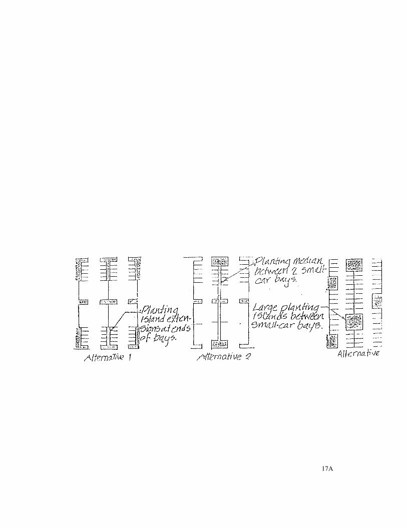
Landscape treatment of parking lots will be twofold. First, the lots will be screened from the roadways by mounds and trees. Secondly, planting islands at each end of a parking bay and the random introduction of planting islands throughout parking areas are utilized to relieve the expanse of asphalt, both visually and physically.
Significant areas of landscaping should be p rovided a t o n -grade lo t s a nd sho uld be consistent with the overall character of Sierra Point. Space for this landscape development could be increased by using small car stalls. The result would be a 12% increase of land otherwise used for parking, which is then available for landscape development. While utilization of this land is possible in a number of ways, three approaches are illustrated below. The use of compact spaces is encouraged to gain additional landscape spaces and to improve the circulation system.
Use of planting islands within the parking lots at Sierra Point is recommended for providing a planting medium for parking lot plantings. The islands would allow tree massing, negating the detrimental effects of wind on the site. Massing of trees, as opposed to single tree planting, allows the trees to support and protect one another. Additionally, massing provides greater visual impact of vegetation within the parking lots.
Ease of access by the automobile and by foot is a c r i t e r i o n f o r t h e l a yo u t a n d i n t e r n a l organization of the lots. Prototypical design treatments, therefore, would minimize the number of driver decisions in reaching a parking stall and maximize pedestrian flow towards buildings.
Ease of accessibility for the disabled should also be addressed by provision of handicapped-accessible stalls and ramps designed and located per State Title 24 standards. Facilities should also be provided for bicycle parking within each parcel.
17
17A

������������������ ��������������
�
� ������ ��� �
��������������������� ����������
� ������ ��� �
�
��������������������������������
� ������ ��� �
�
� ��� ���� � �� ��������� ������ ���
17B
Public access infers public parking within Sierra Point. At present, the link to Fisherman's Pier to the north is projected to generate parking needs within Sierra Point, Adequate parking spaces, at the northern point of connection to the Sierra Point bayfront pathway will be reserved to meet the weekday needs of those using Fisherman's Pier. In addition, adequate parking stalls shall be reserved at the southern public access focal point. On weekends, parking within the empty lots of Sierra Point and the public parking within Brisbane Marina is expected to more than fill the public parking need for adjacent recreational facilities. Weekday shared use of the public parking by the adjacent office and/or hotel develop ment ma y be for mal ly recognized through Planning Commission approval of modifications to the parking regulations, as provided by the Brisbane Municipal Code.
Definition of parking lot entries is important to the sequence of arrival. Progression from a parkway-like roadway to an asphalt parking lot with planting islands necessitates a transition, which accommodates landscape development and pulls the character of the roadway into the parking area. At major entries to parking lots, the recommended prototypical design treatment calls for a roadway cross-section as depicted below. Two 12-foot lanes should be separated by a median and flanked by 15 feet of space devoted to landscaping. Where a public access route occurs along the entry drive, 20 feet should be devoted to the 8-foot wide path and landscaping. This treatment should occur for a minimum of 60 feet into the parking area, allowing stack-up space for 3 cars both in the ingress and egress to the lot. Curbs or headers should be utilized to define the sides of the entry drive and the median.
At entries of minor importance (i.e., where there is not the full turning freedom offered by median breaks) the recommended design treatment calls for 40 feet of entry drive landscaping within 15
feet on both sides of the 24-foot drive with no median. Forty feet would allow stack-up space for 2 cars, sufficient for a right-turn-only entry and exit. Curbs or headers are again suggested to define the drive.
Refer to the following section for parking within the 100 foot shoreline band.
18

������-�
Guidelines:
1. Provide landscape development around the subterranean garages to visually screen as well as to establish contact between the groundplane and the building.
2. Take advantage of the maximum ratio of small car stalls to standard size car stalls.
3. Introduce planting in the on-grade lots in planting islands, massing where possible.
4. Provide parking for the disabled in accordance with State regulations.
5. Provide parking for bicycles.
6. Designate adequate parking spaces for public use within Sierra Point, at both the northern and southern public access focal points and at the northwest inner corner providing public access to Fisherman's Pier.
7. Encourage use of public parking within the
Brisbane Marina.
8. Screen cars through use of planted earth helms, shrubs and walls,
9. Provide a minimum 15-foot strip of landscape along both sides of major entries as well as a median into the parking area.
10 . Provide a minimu m 15 -foo t s t r ip o f landscape along both sides of minor entries extending a minimum of 40 feet into the parking area.
19

19A

4�$ �5%��2- �
4�$ �5%��2- �
The Bay edge is an important aspect of Sierra Point. The Bayfront provides an attraction, both physical and mental to those working in and visiting Sierra Point. This attraction is reinforced by a continuous landscape matrix, which allows movement to and from the Bay Edge. Landscape treatment of this area is of primary importance to the overall effect generated by the landscape matrix.
The spatial quality of the Bayfront is related to the proximity of the buildings fronting the Bay. These buildings determine the limit of Sierra Point. Modulation of this building edge by careful placement and varying setbacks from the Bay is recommended to establish a sense of interplay between the Bay and Sierra Point. In addition, the varying building setbacks, along with planting, would create a variety of spatial sequences along the Bayfront, providing more interesting views to visitors and passers-by than would be provided by a straight building edge.
This interplay between the Bay and Sierra Point should be further developed by placing buildings within the 100-foot band of BCDC jurisdiction. The monotony of building edges held to an arbitrary line would thereby be broken, allowing Sierra Point to modulate into and out of the 100 foot zone. This modulation, in an organized fashion, would establish a variety of spatial sequences at the human scale and would
generate greater interest at the building edge.
If a portion of a structure is sited within the 100-foot zone, there must be an equal siting of another portion of its structure behind the 100-foot BCDC jurisdiction line. Forty feet should be the maximum limit to which a building is allowed to penetrate the 100-foot zone - 60 feet from the highest tidal influence line of 5.85 feet.
At this maximum penetration, the structure should not exceed a height limit of three stories The use of setbacks and height limits would reduce the apparent mass of a structure penetrating the BCDC zone and maintain a sense of openness along the Bayfront.
20

The purpose of landscape in the Bayfront area is fivefold; first, to soften the edges created by adjacent structures; second, to define spaces creating a sequence of spatial experiences along the Bayfront ; th ird , to provide a gradual transition between spaces; fourth, to screen obtrusive elements in the Bayfront area and finally to frame views from the roadway of the Bay.
A prototypical treatment for the Bayfront should utilize landforms and tree plantings to soften the building edge while preserving and framing views. Landforms and tree plantings should also be used to define spaces. A 10-foot wide pedestrian and bicycle path, which casually winds along the Bay would pass through these spaces, bringing a human dimension to the B ayfront.
At several places along the waterfront, areas of higher use activity should be developed at the terminus of axis or intersections of major public access routes. A prototypical treatment for such an area would provide an expanded area for people interaction in contrast to that offered by the linear path. Site furnishings such as benches, bike racks and trash receptacles should be carefully placed along the path at these focal points to maximize the user potential (see Public Access Plan).
Where parking areas penetrate the 100-foot zone, a 15-foot minimum planting area for trees and shrubs should be provided on all sides of the parking, still allowing a corridor of 15 feet for the 10-foot pedestrian and bicycle path. Additionally, where parking occurs adjacent to a structure held back from the Bay, landscape should be used to create a gradual transition from the building edge to the one created by the planting screen surrounding the parking area. Landforms and tree plantings could be utilized to generate this transition while at the same time providing a larger buffer and screen of the parking. As it is equally important to maintain view corridors from the interior of Sierra Point, planting will be held back at public access connectors to allow unobstructed views of the Bay.
21


21B

4�$ �5%��2- �
Guidelines:
1. Allow buildings to penetrate an appropriate amount into the 100-foot band of BCDC jurisdiction.
2. Limit the height of buildings penetrating the 100-foot jurisdiction line to three stories.
3. Utilize plantings and landforms to soften the building edge, screen parking areas, yet preserve and frame view corridors.
4. Provide activity nodes at focal points, providing expanded areas for interaction.
5. Allow parking to penetrate an appropriate amount into the 100-foot band of BCDC jurisdiction.
6. Provide a minimum 15 feet of planting area on all sides of parking penetrating the 100-foot band of BCDC jurisdiction, where views are not obstructed.
22
See figure on following page.

22A

22B

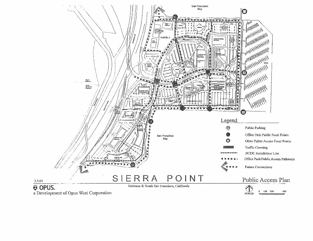
Public Access and View Corridors

�06������� %%���2�7� .������2��%�
Provisions of public access to bodies of water is felt to be so necessary that it is required to be included in all subdivisions that front on water. Public access along the periphery of Sierra Point i s required to be consistent with the San Francisco Bay Plan and with the goal of the City of Brisbane to achieve public access along its entire shoreline.
Vehicular public access should be provided by the road system within Sierra Point. Physical access to the Bay can be provided by designating public parking areas, turnaround and overlook areas, and pathway connections to the Bayfront landscaped areas. The road system would also allow direct public access to the recreation areas at the Marina.
Visual access to the Bay can be provided by designated view corridors. These corridors can also serve to direct pedestrians and drivers from the inland area toward the public access provided at the Bayfront. No portion of any building or ancillary structure (excluding utility boxes no more than 6 feet in height) shall intrude into the view corridors, so as to maintain Bay sightlines down the bayward lanes of specific streets and driveways, as well as pathways.Tall shrubs and trees will be held back from the corridors to allow unobstructed views of the Bay and possibly to frame or direct the views.
Public access also is an important aspect in making Sierra Point a pleasant and efficient environment. Access is important in two respects: first, as a means of providing pedestrian and bicycle movement within Sierra Point; and second, as a means of connecting the interior circulation system to adjacent development.
Throughout Sierra Point an 8-foot wide path could be utilized as a pedestrian route, except along the Bayfront where 10 feet would be the minimum standard. This greater width could accommodate emergency access and maintenance vehicles.
23

As detailed in the Roadway Landscape section, pathways could be located within the 16-foot r i g h t - o f - w a y p r o p o s e d f o r l a n d s c a p e development. Connecting pathways could tie the street pathways to those along the Bayfront to complete the circulation system. The entire system could provide continuous pedestrian and bicycle circulation throughout the development.
Along the loop road, the path should be placed on the outer side of the roadway and adjacent to the landscape reserve. This placement would direct pedestrian movement outward and ultimately to the Bayfront pathway. Crosswalks to connecting pathways should be located to minimize pedestrian-automobile conflict. Use of the pathway along one side of the roadway would allow greater flexibility for use of the 16 feet of road right-of-way.
Public access connections to adjacent developments are equally important to Sierra Point as the public access routes within the development. Sierra Point provides a link in the overall framework of public access pathways a long the Bay. To the nor th, the Bayfront pathway should tie into the existing path along Fisherman's Park allowing access from Sierra Point on the south and Candlestick Park on the north. To the south, the Bayfront pathway should offer connections to, at some future date, Oyster Point Marina. To the west, the Bayfront pathway should connect with a pathway from the City of Brisbane. This pathway and its link to the Sierra Point park system would be the key to Bayfront access from areas west of U.S. 101. This route would be one of the few along the northern San Mateo County shoreline allowing access across the freeway.
24
Materials suggested for the pathways include asphalt pavers and compacted gravel. Selection of material would depend upon the context in which the pathway is placed. At intersections, interlocking pavers should be used for strength and resilience to traffic as well as offering a treatment, which defines the path and ties it across the roadway, In most situations within Sierra Point, the pathway should be asphalt, a material allowing safety for bicyclists and the plasticity necessary to compensate for settlement problems, except where the Public Works Director determines that concrete shall be used instead.
25

Public Access and View Corridors
Guidelines:
1 . U t i l iz e a co n t inuo us 8 - fo o t p a thwa y throughout the site for public access, widening it to 10 feet along the Bayfront.
2 . Provide connections to existing public access pathways in adjacent developments.
3 . Use asphalt, modular pavers and compacted gravel for pathway materials, except as deteiniined otherwise by the Public Works Director.
4 . Provide parking for the public at key connections to the Bayfront.
5 . Locate parking stalls, structures and landscaping to maintain visual access to the Bay as much as possible.
6 . Align major view corridors where possible at the turning points of the primary street loop system to continue visual and physical access to the Bay from the public thoroughfare.
26

���,�$ �$0� �

���7�� ��5� �
The purpose of these architectural guidelines is to assist in the creation of an integrated development, which will have a strong identity. These general guidelines are meant to ensure design continuity, but not to restrict creativity. Departure from the guidelines should be made only after careful evaluation.
Sierra. Point must be a development for both the public and private users; it must create the ambience of both an office park and a public/recreational area, and should be
developed with careful planning through the use of an integrated conceptual plan.
:� �8##�3 ��'&�<�&� �&��
Sierra Point is planned as a harmonious, comfortable and inviting work environment, The landscaping, graphics and lighting will be unifying elements for the site and the appearance of the buildings and their architecture will make an overall contribution to the public's perception of Sierra Point.
The buildings will take on a variety of configurations but in all cases, each building will be compatible with others within the development. The architecture will reflect a balance of diversity in form and materials and uniformity in function, scale and style, with exceptions as appropriate for buildings designed for uses other than offices. The buildings within the development will be interrelated by the repeated use of several design features.
The architectural design should be creative with an approach that juxtaposes elements while creating a well composed design. The location of buildings as well as the building type and function should require different design
concerns for each structure, This differential treatment must be purposeful, but within a certain range of choices. For example, proximity to the Bay requires particular sensitivity to the water's edge, while buildings near the entrance could be distinctive. Yet, continuity among all elements is also necessary, and will be provided
29

29A

by repetition of certain design elements, style, use of materials, etc. The following criteria should be adhered to:
Differential Treatment in Different Areas:
Buildings should be clustered, yet the individual identity of each building maintained. Buildings closest to the Bay should provide public space and open plazas related to the shoreband.
Building setback lines which undulate towards and away from the Bay around the 100' shoreband, are more aesthetically pleasing than a continuous setback line. This undulation allows for a varying landscape treatment and a distribution of parking so that parking does not come between the buildings and the shoreband.
The design should provide for a mix of building heights, styles, and planning that conveys an inviting and attractive profile to passing traffic from both land and bay perspectives.
Mass and Scale The maximum allowed heights of the buildings will vary from five to twelve stories and floor areas from fifteen thousand to thirty thousand square feet. To reduce the mass of each exterior elevation to human scale, several harmonious geometric features will be used. The mass of the buildings will be compressed, chamfered, notched, and sculptured to minimize the buildings' effect on existing views and to maximize views from the buildings,
Form The style of architecture will be very contemporary with the design stressing grandeur of simple forms. These simple forms, articulated to reduce mass, will be a strong, unifying element of Sierra Point. These same forms should be further articulated by creating exterior balconies, terraces and many corner office spaces, which increase the tenants' contact with the Bay and the Brisbane Marina.
Balconies may step back from floor to floor to reduce the apparent height and mass of the building and to provide more light to the lower balcony surfaces.
30

Repetition of Elements – Continuity:
A rhythmic repetition of certain design elements is essential to maintain continuity and the dual office/recreational theme. This repetition will occur in design, landscaping, signing and lighting:
1. Open plazas near the buildings along the Bay should be contiguous to public open space. Design of plazas should provide a transitional zone at the building's edge thereby delineating private space from public space. Transitional elements include arcades, colonnades, steps, benches, or planting.
2. Brick, concrete pavers and wooden decks at the base of the buildings and within plaza areas should serve as an integrating feature throughout the site.
3. Balconies are recommended as a repetitive unifying element on a number of buildings.
4. The clustering and locating of masses should be planned in accordance with the designated view corridors and, in addition, to maintain a minimum distance of 80 feet between buildings located within 150 feet of the Bay's edge.
5. Buildings should be grouped to create substantial plaza areas and to provide opportunities for office users to enjoy the outdoors, as well as to provide places for people to congregate.
6. Groundplane and building mass should be integrated. Berms, mounds, foundation plantings or other screening methods should. surround buildings and allow a vertical transition from building form to earth form.
7. A vertical transition should be created from higher buildings in the center of the site to lower heights adjacent to the shoreband.
8. The repetition of materials and colors will foster continuity. The colors will be determined by the type of materials.
31

�
31A

31B

9. Signing will be utilized to encourage dual use of plaza and parking areas as well as to guide the public to different routes to views, open space areas, plaza areas and to the Marina.
10. Service areas should be screened from walkways, parking areas, plazas, and views from buildings.
32

Summary of Architectural Guidelines
1. The building architecture will reflect a carefully controlled balance of diversity with a repetition of design features and details, which will foster continuity.
2. The buildings will be articulated to reduce their mass and effect on existing views while maximizing views from the buildings.
3. Major unifying elements in the building design will be featured by simple, sculptured forms with chamfered and notched elevations and exterior balconies and terraces, where appropriate.
4. Continuous horizontal fenestration with tinted or low reflected energy efficient glass must be utilized to take advantage of the spectacular views from the office buildings.
5. The exterior panels forming the building skin will be made of precast concrete, brick, metal or tile veneer utilizing warm earth tones, neutral colors and some pastels. The use of shiny, highly metallic or reflective materials will be avoided.
6. Concrete entry bridges connecting the building entrance stairs with on-grade entry walks must be incorporated to span the landscaped areas.
7. All mechanical equipment and exposed ductwork, utility equipment and trash receptacles must be concealed and screened.
33

3 ��'&�2# � &���

Design Elements
The unique character of Sierra Point and its associated design problems require special attention to details, many of which have been especially developed for this project.
A. Materials The materials utilized should promote a warm and inviting ambience and insure that Sierra Point will not be formidable to the public. The modern office and accompanying recreational motif can be fostered through the selection of certain materials. The transition to the lower-key scale of buildings near the Bay should also be emphasized by the choice of materials.
Traditional building materials will be used throughout the project. Each of the buildings would have a steel frame structure with a panelized curtain wall system for the exterior. With the steel frames, it is anticipated that office floor to floor heights of approximately thirteen feet will prevail. Therefore, the extent of glass areas will be constant from office building to office building. Continuous horizontal
fenestration will be featured to take advantage of the spectacular views. Tinted or low reflectance, energy efficient glass will be utilized. Alternating bands of glass and warm panels are appropriate for this site, and their use will unify the various office buildings. These exterior panels would be of precast concrete, brick, metal or tile veneer. Specific criteria to be considered with respect to materials are:
1. Buildings should use glass in combination with either brick, wood or concrete. Near the Bay, warmer materials such as brick or wood are preferable.
2. Grey lite 14 or solar-cool grey glass, which coordinates well with these materials, could be utilized.
3. The use of reflective glass should be considered within the context of the development. Its use should be limited and near the shoreband. Exterior glass should not create significant glare.
34

4. The use of materials must consider the parks adjacency to the Marina and should therefore be coordinated with that parcel. However, as most of the Marina structures will be very small, they will be of a different building type than that of Sierra Point,
5. Durable materials, which require minimum maintenance, are considered appropriate and the range of materials discussed fit this criterion.
B. Building Colors The buildings will be interrelated by the common use of traditional building exterior colors. Although the various buildings may be encased with different skin materials, the colors and visual perception of all buildings will harmonize with each other.
Building colors will be drawn from a common palette of colors, which are complementary. Warm earth tones, neutral colors and some pastels will be utilized. The use of shiny, highly metallic or reflected materials would be minimized. Accent colors at balcony railings, metal soffits and aluminum windowalls would be j ud ic ious ly used to fur the r de f ine the geometry of and add character to each individual building.
C. Building Entrances Because of unique site soil conditions, all buildings will incorporate similar concrete entry bridges connecting the building entrance stairs with the on-grade interlocking concrete paved entry walks. Entrances, designed to maximize pedestrian flow towards the building, will feature attractive, spacious planters fully integrated into the overall building architecture.
Definition of the entries is important to the arrival sequence. Major building entrances will be articulated to create an inviting, exciting space, which will attract people without confusion.
35

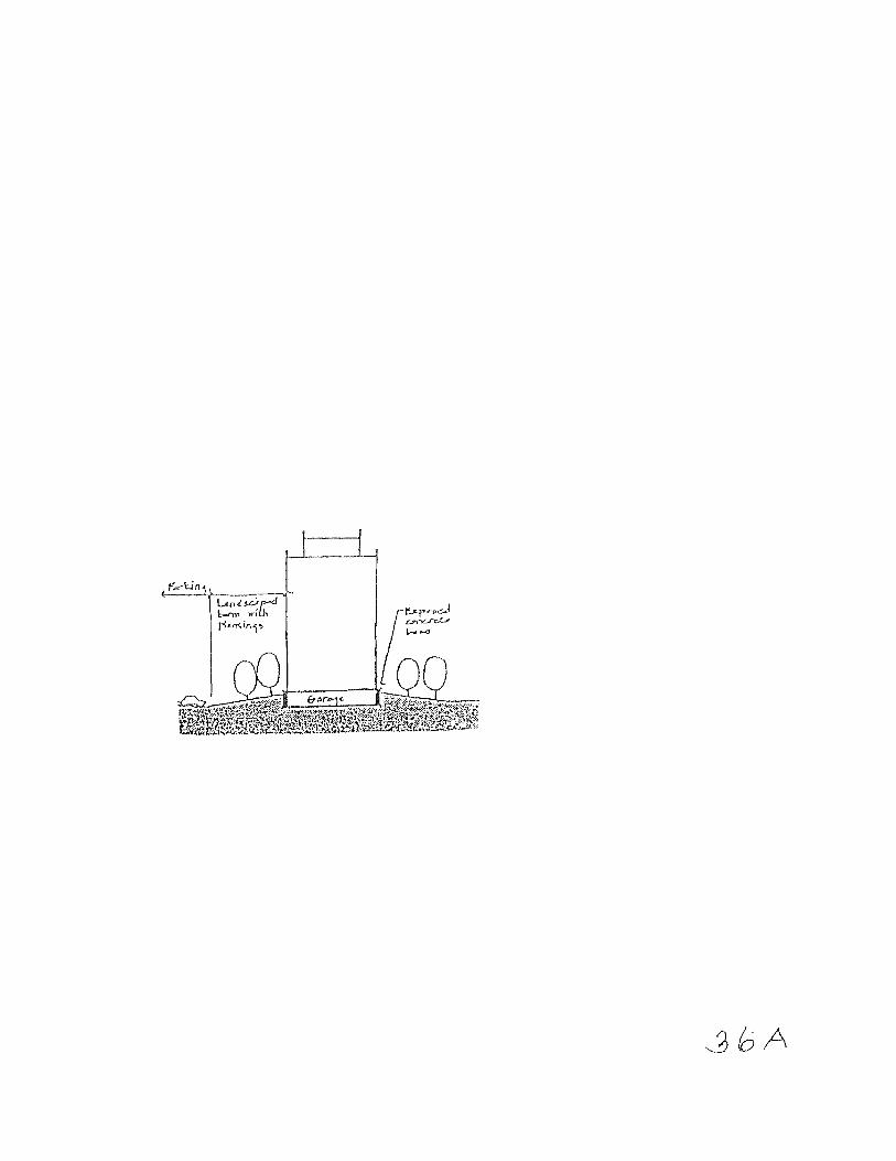
D. Bui ld ing Base Office buildings may incorporate one level of subterranean parking. In such cases, the topmost portion (+30 inches) of the exterior face of the concrete garage will be exposed above grade. This exposed concrete garage wall wil l be visually interpreted as a base or pedestal from which the building rises. The repeated use of this base with horizontal reveals, creates light and shadow effects which will act as a unifying architectural element. A gradually sloping, landscape area will surround the building and act as a transition space between the parking area and the building face. E. Equipment The buildings and surrounding site improvements are highly visible from within the site and from U.S. 101 and Old Bayshore Highway. This visibility due to the openness of the project will require special treatment of mechanical equipment and service areas. Mechanical equipment, exposed ductwork and rooftop equipment, regardless of building height, must be concealed. Trash enclosures, utility meters and other service devices must be located away from building entrances. Utility equipment can be screened by the use of landscaping and trash receptacles enclosed by attractive masonry or wooden enclosures.
3 �Lighting Lighting should be chosen to fit the context of this development. Specific materials are encouraged, but variations can occur if necessary to insure compatibility with the design development. In addition, the selected fixtures, if maintained by Pacific Gas and Electric, must be acceptable to their maintenance division.
Color corrected high-pressure sodium lamps are recommended for the roads and parking lots. In the pedestrian areas, especially along the Bay edge, a metal halide lamp is recommended.
Light ing must be adequate for night -t ime activity, with sufficient wattage to provide adequate illumination to make clearly visible the presence of any person on or about the property.
36
Guidelines:
I. Generally, the light %�0�� �should be a "cut-off' type fixture, i.e., one that reflects light downward and out, rather than upward.
2. The fixture should be in proportion to the standard to which it is attached.
3. The shape of the fixture should have simple, clean lines.
4. The fixtures should be compatible with the various styles of architecture.
5, Street lighting standards should be 30 feet in height, tapered round steel, painted black in color.
6. Light standards in parking lots should be 1630 feet in height and consistent throughout the entire Office Park. Poles should be square, painted brown or black in surface parking areas and white in parking structures,
7. Pathway lighting can vary from simple step lights, bollard lighting and pathway standards to a maximum height of 15 feet.
8. Appropriate lights such as up-lighting should be incorporated to accent planting and other landscape or architectural features without casting glare or creating a safety hazard to passing pedestrians.
G. Signage Signage shall be consistent with the sign programs adopted by the City of Brisbane for Sierra Point.
���Plant Materials Following BCDC's recommendations, native plant species will be utilized from the Bayfront path to the shoreline with a transition zone from the Bayfront path to the 100-foot shoreline band boundary.
37

The following plant list has been compiled, for recommended use as ornamental landscaping inland from the 100-foot shoreline band. .A major concern in the selection of plant material has been the adaptability of plants to the bayfront wind and fog conditions. A second consideration is the tolerance of the plants for the poor soils and drainage associated with landfill sites. Emphasis has been placed on plant materials, which have done, well in similar conditions around the Bay. This plant list is meant to 6 �representative rather than all inclusive. Depending on the conditions and desired landscape effect, additional plant materials, especially "native" materials, should be carefully considered.
For any plant to survive, adequate soil depths must be provided over landfill, to act as a buffer between plant roots and refuse. Turf and ground cover areas require a minimum depth of 2 feet of soil on top of the sealant layer, Shrub and tree areas should have a minimum depth of 3 feet of soil.
38

Trees:
Botanical Name
A e s c u l u s c a t i f o r n i a A g o n i s f l e x l u o s a Alnus rhombifolia Casuarina cunninghamiana
Ceratonia siliqua Cupaniopsis anacardiodes Eucalyptus (excluding camaldulensis, globulus and pulverulenta) Koelreuteria paniculata Liquidambar styraciflua Mains baccata mandschurica Melaleuca atruillaris M.elaleuca leucodendron Melaleuca nesophilia Melaleuca stypheliodes Meterosideros excelsus Nyssa sylvatica Pinus canariensis Pinus eldarica Pinus halepensis Pinus muricata. Pinus pinea Popuhig nigra 5�$�����5�Salix babylonica Ulmus parvifolia Ulmus purnila Washington robusta Washingtonia filifera
S h r u b s :
Botanical Name
Abelia species Agapanthus africanus Arbutus unedo Aretostaphylos species Baccharis emmerri C a l l i s t e m o n c i t r i n u s Cassia coquiembensis C i s t u s p u r p u r e u s Dodonea vicosa 1purpureat
Escallonia °Jubilee' Escallonia rubra Griselinia littoralis Hakea species
Common Name
Common Name
California Buckeye Peppermint Tree White Alder River She Oak Carob Tree Carrot Wood
�����
Goldenrain Tree Sweet Gum Siberian Crabapple Drooping Melaleuca �����
Pink Melaleuca N.C.N. New Zealand Christmas Tree Sour Gum Canary Island Pine Mundell Pine Aleppo Pine Bishop Pine Italian Stone Pine Lombardy Poplar Weeping Willow Chinese Elm Siberian Elm Mexican Fan Palm California Fan Palm
Common Name
Abelia Lily of the Nile Strawberry Tree Manzanita Broom Lemon Bottlebrush Senna Orchid Rochose Hop Bush ��������������������
Hebe species Juniperus species Melaleuca species
39

1\rforaea iridiodes Myoporum insularc Myrica californica Nerium oleander Pittosporum crassitollurn Raph.iolepis Rhanirus californica Rosmarinus officinalis 'Collingwood Ingram' Weigela 'Bristol Ruby' Xylosma congestum
Groundcover: A c h i l l e a t o m e n t o s a Agapanthus 'Peter Pan' A r c t o s t a p h y l o s s p e c i e s Baceharis pilularis 'Twin Peaks' Coprosma kirkii Drosanthemum floribundurn E u o n y m u s f o r t u n e i Gazania Hypericurn calycinurn Jun iperus species
Lampranthus spectabilis Myoporum parvifolium Osteospermum fruticostun Rosmarinus officinalus 'Prostrata' Trachelospermum jasminoides
40
N.C.N. Juniper N.C.N. African Iris N.C.N. Pacific Wax Myrtle Oleander N.C.N. Pink India Hawthorne C o f f e e b e r r y Rosemary
N.C.N. Shiny xylosma
Woolly Yarrow Dwarf Agapanthus Manzanita Dwarf Coyote Bush N.C.N. R.osea Ice Plant N.C.N. N.C.N. Creeping St. John's-Wort Juniper ���Plant N.C.N. African Daisy Dwarf Rosemary Star Jasmine

����-�$����
Within Sierra Point, irrigation systems should be designed to recognize the problems of settlement associated with landfill sites. Plastic pipes, which are relatively flexible and noncorroding, are recommended. Flexible fittings, such as ‘accordian-type’ couplings, can be utilized to compensate for movement. Irrigation pipes should be laid in trenches that are backfilled with sand or gravel and covered with a soil layer.
The use of a drip irrigation system is recommended for shrub and tree areas. The problems of wind and soil dehydration associated with coastal conditions are reduced by an emitter system. The deep watering provided by this type of system can help leach toxic salts from the soil.
41

Use of Guidelines

Use of Guidelines
These Guidelines have established standards of quality for development at Sierra. Point, Adherence to these standards by implementation of the treatments outlined in these Guidelines will ensure a development, which will be an asset to the City of Brisbane. A high quality environment will provide an attraction to potential tenants, making Sierra Point competitive with other developments in the area.
The Guidelines are meant to be used as a tool to ensure that Sierra Point meets the requirements of various public and private bodies involved in its development. These bodies include:
1. BCDC - which will hold the Guidelines as standards by which to judge compliance with permits and the Bay Plan. 2. City of Brisbane - which, in addition to utilizing its municipal code and other applicable regulations, will use the Guidelines as a basis for reviewing subdivision and building plans in achieving coordinated development within Sierra Point.
3. Lenders - which will use the Guidelines as a measure of quality and, therefore, marketability of the development. 4. The Developer - which will use the Guidelines to attract tenants who understand the need to contribute to a unified development increasing its level of quality. 5. The Consultants - who will use the Guidelines as a basis for implementation of specific plans ensuring a quality development.
The Design Guidelines, because they are guidelines, only set direction for an integrated and cohesive development and are not themselves regulations. However, for a successful and high quality product, it is imperative that a commitment be made by all involved not only to comply fully with all applicable regulations, but to follow the standards and treatments outlined in these Guidelines. Departure from these Guidelines should be made only after careful evaluation.
42
