cold sprin3 heron colony ocieni'ific and na'iural area · 612 .c64 c65 "1979 cold...
TRANSCRIPT

612 .C64 C65 "1979
COLD SPRIN3 HERON COLONY OCIENI'IFIC AND NA'IURAL AREA
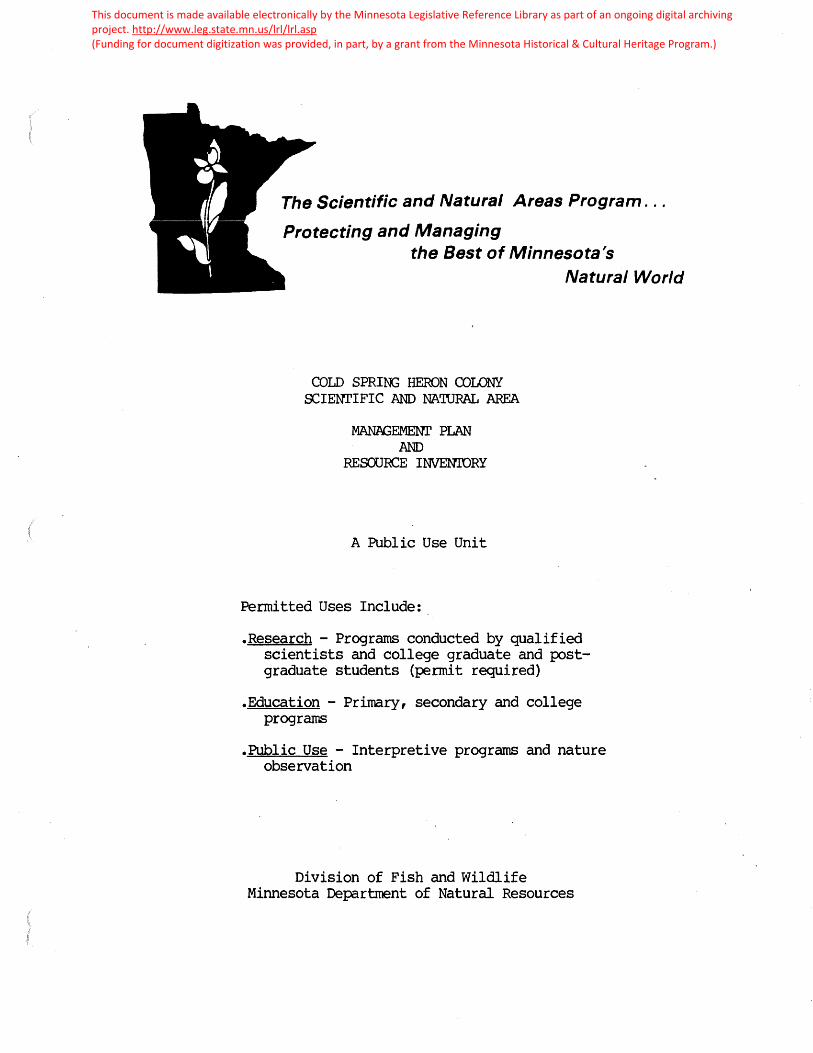
The Scientific and Natural Areas Program . ..
Protecting and Managing the Best of Minnesota's
COLD SPRI~ HERON COLONY OCIENrIFIC AND NA'IURAL AREA
MAN.AGEMENr PLAN AND
RESOURCE INVENIDRY
A Public Use Unit
Permitted Uses Include:
Natural World
.Research - Programs conducted by qualified scientists and college graduate and postgraduate students (permit required)
.Education - Primary, secondary and college programs
.Public Use - Interpretive programs and nature observation
Division of Fish and Wildlife Minnesota Department of Natural Resources
This document is made available electronically by the Minnesota Legislative Reference Library as part of an ongoing digital archiving project. http://www.leg.state.mn.us/lrl/lrl.asp (Funding for document digitization was provided, in part, by a grant from the Minnesota Historical & Cultural Heritage Program.)


COLD SFRING .HEROl~ COLONY
1".ANAGEiv&iN'l' PLA.N
iv,INNES C/l'A CliAf'l'ER (JF'
'J:h.E l'iA'l·URE COL'iSErlVANCY
DKCEMBER,. 1979
draft copy


Q)LD SPRING HERON <DLONY SNA JUNE 1987
General Managerrent Guidelines
Management of this SNA will be a coop:rative effort of the SNA Program and 'Ihe Nature Conservancy ('INC). TNC will have the prinary responsibility for implementation of the management plan.
Structures and Facilities
The lx>W1daries of the site will be posted with SNA signs and rules and regulations signs, which will be oontinuously maintained. A registration box will be erected on the hill. Fencing around the hill should be maintained. 'Ihe stairway up the hillsice should be extenced and improved. A site J?arking plan should be develop:d and implemented. A sign should be erected and maintained on Higllvay 23 indicating the location of the i;:arking area.
Managern::nt of N:ttural Features
A prescribed burning program will be corrlucted on the prairie portion of the Observation Hill and oonsid=ration should l:e given to implementing a prescribed burning program form the op:n sedg: marsh north of the river. Sunac on the hill area should l:e a:mtrolled by cutting.
survey and lt>nitorinq of Natural Features
An inventory of the sand bar, subnerged and emergent aquatic canmunities should be oorrlucted. Additional ca.ta on the p:-eserve' s flora should be collected. Further inventory work should be initiaterl for the bird i;x:>pulation and the heron colon.y should be rronitored for popilation changes. A survey of butterfly SP=cies which use the observation hill should also be initiated. Dr. Max Partch has utilized a monitoring system since 1954 and therefore this system should be oontinued.

MANPGE~NT IMPLEMENTATION
Act Ions recommended In th f s p I an have been separated f nto two categories:· ( 1) admf nf stratfve and (2·» operational. The costs of administration actions are dlff lcult to Itemize because they are Included In a·n SNA staff member's salary.
Operational actions ere on-site activities. These often have both capital and labor costs. Capital costs have been I lsted. Estimates of labor needs are provided where possible.
Administrative and operational actions are often funded out of different budget sources. This makes ft dlff lcult to present en Implementation schedule that equates both types of actions. To acconvnodate budget planning, separate Implementation schedules are outl fned for each category.
It f s Important, however, to have a mechan Ism that does a 11 ow canparlson between al I actions In this plan and between actions from different plans. The system outlined below distinguishes between actions needed to Improve or maintain the Integrity of a site's most Important features ca 11 ed e I ements, I ega I or mora 1 ob I I gat Ions of owner sh Ip or I and manegement by the Department and a I I other act Ions Important for reasons other than above.
Groyp I Actions: Actions that prevent or -c.educe The vulnerebtl tty of the element to destruction or serious degradatton: That Is, In the absence of these actions the preservation of the element Is threatened on this site. Research, ecological survey and monitoring may be Included here If, without such Information, It ls not known what actions are necessary to maintain the element.
Group I I Act Ions: Act Ions necessary because they con st I tute an obi lgatlon of land management/ownership by the Department. These may be legal obi lgatlons, departmental, or SNA program standard requirements.
Group I I I Act Ions: Actions taken for a 11 other reasons. For example, actions taken to provide for publ Jc use, acquire supplementary resource Information, administrative coordination, etc.
The follow Ing chart fl lustrates the schedul Ing of actions described In the text, and the Immediate on-going capital costs of lmplementatfon. The scope of th Is p I an covers a ten year per f od. The p I an shou Id be reviewed every f Ive years to evaluate progress, reassess priorities, and ref fne management techniques. Actions I fsted under the category "Begin lrnnedfately" need Immediate attention or are a continuation of en existing program. "Phase I" Is the f lrst five year period. "Phase I I" Is the second f Ive year per·fod. lmplanentatton of many actions depend on av a f I ab I I tty of mater I a I s, equ 1 pment and I abor. An act Ion may be Initiated sooner than scheduled If circumstances so dictate •nd earlier scheduled actions w ti I not suffer es a result. Under tbe·.~ents" column, the DNR unit with the primary responslbtl tty for cllrr.ylng out the action Is noted. The SNA program wlll secure development funds and prepare annual work plans to schedule end coordinate management act Iv ftles described In th·ls plan •
.. i:


,,,,
AI11INISTRATION ACTIONS
Action l Implement Wildfire supp:-ession plan Action 3 study the p:>ssibili ty aE burning areas
in addition to the observation hill Action 15 Expmd and uprate brochure
OIERATIONAL ACTIONS
Action 2 Prescril::ed burn - hill
Action 4 Inventory ampi.ibians and reptiles Action 5 ·Inventory river communities
·Action 6 Collect additional ve~tation dlta Action 8 Inventory area south of Sauk River for
butterflies Action 21 Maintain a:mtact with volunteer manager Action 26 Monitor vegetation Action 28 lt>nitor heron p:>pulation Action 29 Request MPCA to sample Sauk River water Action 31 Aa:iuire land east aE tract (area 1)
OOLD SIRIN3 HEROO CDLONY SN?\ SUMMARY OF ~EMENT ACTIONS - 1987
STBVARIEHIP BEGIN HIASE GRQJJ? JMMEDIATa.X _J
I x II
III x
I x
I x I x I x
I I x I x I x I x I x
Action 34 Cut sunac along txrnndaries of hill and on I hill
Action 10 Determine east and west l::ounda.ries II south of river x
Action 11 Maintain fence around hill II x Action 13 R>st b:>undlr,ies II x
Action 20 Clean up litter II x Action 27 Moni tqr area for illegal use II x Action 32 Remove old TNC signs II x Action 33 Post rules & regulations signs II x Action 14 Erect registration b:>x on hill III x Action 14a Erect inf orrnational sign III x Action 16 De.relop & implerrent a puking plan III x Action 17 Erect sign directing visitors to use
c,lllvert highway crossing III Action 18 Irnprwe and extend stairs u:Ef1ill III x
HIASE RESP. II <DMMENTS UNIT
TNC/ SNl\/FOR
Two fire units pre May 1 to main-tain prairie TNC
N3 NHP 'OC/NHP
TNC/N; 'INC
N3 SNA/MPCA 'OC/SNA
Recanmerrl in 1986 TNC
TNC Walk & p:>st north unit TNC
no permit TNC
'INC TNC 'IN:/SNl-\/IDT
TNC/SN1\ 'INC


'l'AELE OF CONT EN TS
INTRODUCTION . . . . . . . . . . . . . 1
I. l\u\NAGEIViENT CONSIDERA'l1IONS • . . . . . . . . . • • • Introduction . . . . . . . . . . . . . . . . . . . Nature Conservancy Guidelines • . . . . . . . . Ivdnnesota Scientific & Natural Area 1-'rogram • . . .
2
2
4 8
Other Management Considerations • • . . . . . . . . 15
II. Nu\NAGEI'f.EN'l' ACTIONS FOR COLD SPRING HERON COLONY •• 17 Introduction . . . . . . . . . . . . . . . • 17 Resource ~anagemerit Actions • . . • . . ~ • • • • . 18 Use ~anagement Actions • • • • • • • • • • • • • • 24
~onitoring Actions • • • • • • • • • • 29 Ownership lv!odifications • • • • • • • • • • • • • • JJ
I I I. REVIE~J OF THE PLAN . . . . . . . 36

-1-
11\'l' i{ UDVCrl' I CN
·cold Sfring heron riookery was acquired by 1.ihe bature
Conservancy ( r.L'I'iC) because knowled_geable individuals reported
that the heron rookery .was an important element of i .. innesota' s
natural heritage. ·~he 1977 inventory has documented the
occurrence of this element and .Provided the basis for develop
ing a site management plan.
~he purrose of this part of the master plan is to des
cribe the specific management actions which will be taken
in managing Cold Spring ~eron ~ookery. ~ection I. describes
general considerations which affect the mana6ement of Gold
Spring heron Rookery. First, manabement imflementation stra
tecies are addressed. 1.l. hen L.l';G management cuidelines are
outlined followed by a description of the 1 .. innesota ~cientific
~ Katural Area (GNA) Fro~ram, its policies, objectives, rules
·a.nd reculations. Gtate laws and ·.i.he Laturc Conservanc:/-De
rartment of Latural :~~esources Cii·:C-Dl\ ... {) lease are also out
lined. Section II. describes the site-specific actions to
be implemented on Cold Sprinb rteron ~ookery, ~inally, ~~ide
lines fer modifyin~ and reviewinb the Ilan are noted in
3ection III.

-2-
Introduction
rresently Cold J.f,rint:; r~8ron Colony is bein0 ma:nabed by
ihe Lature Conservancy staff and volunteers. 'i'i'i.G 's stratetS;y
for ,Cold Spring ~·ieron Colony is to explore mechanisms by
which :public a6encies and institutions can be included in
mana~ement implementation. ~ur ~oal here is not to relinqui~h
active 1~C stewardshi~, but rather to develQp a coo~erative
alliance consistinf; of :iLG, local citizens, and one or more . . rublic acencies or ins ti tutior .. s for preserve stevvarc.lship.
lj_'his c·o-mbination, vre .beliGve, r_,rovid.es maximum assurance
that proper stewardship 0ill be ;rovided in rerpetuity for
Cold ~~rin~ ~eron Colo~y.
The 3cientific and J.»atural i-irea (...; .... f~) l-robram of the
:·.innesota Je~:artment of i;atural r\.esources (DJ."l.ri) v;as created
·by lebislative statute in 1969. ~t's ~oal is to:
f reserve and perfetuate the ecological diversity of ... innesota' s natural heri ta6e, inclt.'Ld.ini; laridforms, fossil remains, rlant and anireal communities, rare and endan6ere1 srecics, or other biotic features and beolobical formations for the scientific study and fUblic edification as com;onents·of a healthy environment.
(Ji·~;~ folicy or. .:JCientific u: i.iatural ~-ireas 7 /6/79)
( ·:he 3 ~";A r r o gram is described in de ta i 1 be 1 ow . )
3i~;,ce the 0cie1~tific ~ ~iatural Areas :.f'robram objecti veG and
;i1iloso_phy so closely :f,arallel ~hose of the i;ature Conservancy,
j t is a1)pro1:ria te to in vol vc the ~ cientific ~ i·.a t'Ll.ral Area
Frogram as one' menfo8r of ·~he coof.erative alliance in the steward-
shi; of Cold ::3J:.rin£ fi.eron Colony. _n order to er~able state

-3-
and federal funds to be expended for evaluating and managing
Cold Spring Heron Colony a ten year renewable lease was signed
by 'Ihe Nature Conservancy on 25 July 1979 and by the iJepartment
of Natural Resources on 9 August 1979. This lease calls for
the review of Cold Spring Heron Colony by the Iv.1.innesota ~atural
Heritage Frogram for possible designation as a Scientific "
Natural Area. If Cold Spring Heron Colony is not designated a
Scientific & Natural Area within two years of the signing of the
lease either party may terminate the agreement. If Cold S~ring
Heron Coloni is designated a aScientific ~ Natural Area it will
be managed in accordance with ~cientific ~ ~atural Area rules
and regulations. lhe lease also specifies ~rocedures for the
review and approval of a management plan and describes other
aspects of administering the prope'rty.
·i·resently the i·~innesota hatural h.eri tage 1-rogram is in
.the preliminary stages of reviewing Cold Spring Heron Colony
as a possible Jcientific " Natural Area. A decision will
not be made on the site· until at least J·une, 1980.
Since it is not presently known whether.Cold Spring rieron
Colony will be designated a Scientific ~ Natural rtrea, and
since implementation concerns are dependent on this decision,
this plan does not examine the means of implementing spec
ific management actions. Until such time as public resources
are made available, management actions will be undertaken
by 1.J..he i\ature 'Conservancy staff and volunteers and funded
out of the i.vi.lnnesota Chapter's preserve management account.
All annual reports, survey data, research proposals, regi
stration sheets, information requests, etc., should be

directed to:
-4-
f;~r. Iv~ark Hei tlinger l\iinnesota Coordinator of Preserve 1vLanagement The Nature Conservancy 328 East Hennepin Ave. IVanneapolis, lViN 55414 ( 612-379-2134)
If Cold Spring Heron·Colony is designated a Scientific
& Natural Area, implementation.responsibilities will be speci
fied in a letter of agreement between The Nature Conservancy
and the Department of Natural Resources, as· called for in
the lease .. If the preserve is not designated a Scientific
& Natural Area then other disposition and management .options
must be explored by The Nature Conservancy.
The Nature Conservancy• s iVJ.anagement Guidelines
The Nature Conservancy's management guidelines govern
what management actions will be implemented on Gold S~ring
Heron Colony.
The two primary Nature Conservancy ·stewardship objectives
are as follows:
The primary objective is to maintain areas. so that they sustain species, communities, and natural features that. make significant contributions to the preservation of natural diversity. The secondary objective is to determine and promote land uses compatible with the preservation of natural diversity on the p~eserve, in order to foster local support for individual preserves and recognition by the general public of the values of natural diversity preservation.
(Stewardship guide for preserve committee, . 1978) .
The primary or ecological objective is closely tied to
determining which of the preserve's resources are most signi
ficant for pre.servation. 'i'he i~.innesota heritage Program will
play a major role in identifying which elements are most

-5-
significant. This assessment in turn determines how the
preserve will be managed. ·For example, if an endangered species
is the most significant element on the tract and that species
requires a successional plant community, then management might
be directed at perpetuating the successional stage in order
to preserve the endangered species. if ,on the other hand, a
~lima~cpla.nt-co~munity is the· most s~gnifiqa~t element on the
··tract then a different management program ~s necessary e
!~anagement may be directed at species, communities,
natural features, etc. In January 1978 the Iv.innesota Chapter
of The Nature Conservancy developed a manual for stewardship
of· Nature Conservancy lands in tv1innesota. 'l'he following
guidelines are taken from this document.
If the occurrence of one or more species is determined
to be significant on a preserve The Nature Conservancy will:
1. kAINT·A} N FOPULA':i' ION LEVELS SO THA'l' '.i:HE SPECIES' CHANCES OF LONG-TER!v .. SURVIVAL ON T.HE 'liRAC'l' REl'v,AIN S'.rABLE OR ARE IIV~PROVED.
~anagement to increase the.population of any species
should be integrated with perpetuating othe~ native species
and maintaining the tract as a diverse and naturally function
ing system. There may be important ecological· factors regu
lating the population size of significant species and it
may not be desirable in all cases to attempt to increase
populations.
2. Iv:ANAGEfv.EN'I OF SPECIES' POFULN~IONS uHLL b.iL ACC0~1-PLISHED FRINCIPALLY '.L1HROUGH lv.ANAGE!vi.ENT G:B' '11HE S}ECIES' i\A'i'URAL HA.b 'l'AfJ.' AND 'dih0UG·h PRG'lEC'L ON JF '£HE SF~CIES I- ROiv~ VANDALISiv., FOACHING AND SllV.ILAR 'rtiRENtS. .
Thus managers generally will not use artificial means, such

/ -o-
as direct control of natural predation, manipulation of food
supply through food plots; or improvement of nesting habitat
through plantings or artificial shelters to manage populations.
Exceptions to this policy should only be made in certain
circumstances when special actions are necessary for the sur
vival of a species (e.g., endangered or threatened species)
or to redress an imbalance due to a factor such as preditor
extinction.
Management of plant communities should also be guided
by an assessment of the preserve's communities. Where manage
ment is directed toward plant communities 'rhe Nature Conserv-
ancy will:
J. lV.AINTAIN OR REST ORB SELEG'l'ED PLAN'l1 UOl\Jv.UNl 1l 1IES AS NEAR AS POSSI.b~ 'l'O '11.HE COND.L'rlONS 1l 1MY ~JCJULlJ BE IN TODAY hAD NA'l'URAL ECOLOGICAL FROCESSES N01I' BEEN DISRUP'r~D. THIS G UID.ELINE WILL BE AChiEV.b.:D, T 0 'rliE EXTEN'l' F.CAS IBLE BY :
A) l-'i!;RFc'l'UA'l'lM..i AND AS I~.i:!:CESSARY RE-~S'l1A.bLIShING NATURAL ECOLCGICAL PROCESSES; AND
B) iv~lNIIv,.IZING DhPAC'I'S OF CHEiv~ICAL·, lviliCHNICAL AND Sll'HLAR ARTIFICIAL PROCESS ASSOCIATED WITH Hm •• AN INFLU~NCES.
Some preserves will be protected because they contain
significant geological, hydrological or other natural features.
The same Heritage Program methodology used to evaluate species
and plant communities should be used to assess the importance
of these features. The Nature Conservancy will:
4. lv!AINTAIN NATURAL FEA'rURES IN FRI STINE CONDI'I·ION AND PROTECT THEN. FROJ.V~ UNNA'rURAL CORROSION AND DETERIORATION. THIS WILL BE ACC01v • .FLISHED FRH~RILY 'l'HROUGH REGULA'l'ING 'l'HE LEVELS AND TYPES OF HU1v~~ USE AND IkPAC'rS THAT ACCELERATE CORROSION AND DETER I ORA'r I ON.
In special instances steps may be takeri to prevent or diminish
even natural processes of deterioration in order to perpetuate

-7-
significant natural features and other natural elements.
The secondary or social objective of Nature Conservancy
stewardship is to foster local support for preserves and
recognition by the general public of the value of natural
diversity preservation. The future preservation of natural
areas depends upon a constitue~cy of users and supporters. fhe
Nature Conservancy should foster the development of such a
constituency by encouraging the appropriate.use of preserves
by educators, students, researchers and other members of the
general public. The management plan should identify appro
priate types and levels of use, and specify programs to faci-
litate such use.
To achieve the above stewardship objective The Nature
Conservancy will:
5. INVOLVE LOCAL RESIDEN'l'S, USERS, AND O'l'hER INT.EllliS'l:.ED lhElv.BERS OF 11'1iE PUBLIC IN DISCUSSIONS ABOU'I1 STl!.VJARDSHIP PLANNING AND IfoFLEIY£NTATION.
6. FROVIDE INPORlv.tA1'I ON ABOU'l1 T& PURPOSE Ai~D Na'J:1URAL QUALITIES OF THE PPJ£SERVE 110 ThE LOCAL C u1vjV;.Ul~I'.I1 IES AND PRESERVE' USERS.
7 . KEEP THE PRESERVE AS FREE FR Olii HAZARDS 'l10 USBRS AS POSSIBLE.
8. CONDUCIJ.1 s·rEWARDSHIF ACTIVI'.I:IES IN A WAY 'l'rlAT IhINIIv~IZES UNNECESSARY ANNOYANCES AND HAZARDS TO RESIDENTS NEAR THE PRESERVE.
9. UTILIZE PRESERVE DESIGN, SUCH AS 1.rH.E PLAC:ElVi.EN'l'
-
OF TRAILS' SIGNS' AND PARKING AREAS ,·ro bOTH OP'I'IIv~IZE ACCESSIBILITY OF THE PRES~RV.B; AND kINHdZE UNDESIRABLE HUfoAN Il't~PACTS TO THE EXTENT 1I1HA'r SUCH DESIGN N:.EASURES DO NOT CONFLICT uHTH O'l1HER PRESERVE OBJECTIVES.
10. PROKOTE APPROFRIA'l1E RESEARCH A.ND EDUCATIOI"AL us~ . OF '11HE PRESERVE .
The two major stewardship goals--ecological and social--
("\ -o-
may at times conflict with each other. People.crush vegetation,
erode and compact soil, alter the behavior of wildlife and
transport onto preserves the seeds of unwanted plants that
stick to shoes and clothing. lt is the Nature Conservancy·~·
position that:
11. ECOLOGICAL CONSIDERATION~ SHOULD BE WEIGHED Iv.ORE HEAVILY 'I'HAN HU1\:~N c·oNSIDERA':fiONS ~JhEN THERE IS A THREAT .THAT SIGNIFICANT NATURAL ELE~.ENTS ON A PRESERVE WILL BE ALTERED OR SIGNIFICANTLY DAltAGED.
The r•Jinnesota Scientific & .Natural Area ( SNA) Progr~
Since ·the Scientific & Natural Area frogram may also
be involved in the stewardship of Cold.Spring Heron Colony
a description of the Scientific & Natural Area Program manage
ment policies, rules and regulations and pertinent legislation
is included here. If and when Cold Spring heron Colony is
designated a Scientific & Natural Area it will be managed
in accordance with these statutes, policies and rules and
regulations.
The Scientific & Natural Area Program is located in the
. ~innesota Department of Natural Resource's (DNR) Division of
Parks... _ The Scientific & Natural Areas Act
(I'LS .A. 84·, 033) of 1969 .created the Program. It authorized
the Commissioner of the Department of Natural Resources to
acquire, de.signate and maintain Scientific & Natural Areas,
and to adopt pertinent rules and regulations governing the
·USe of the areas.
The Department of Natural Resources issued rules and
regulations governing the Scientific " Natural Areas (~inne~
sota Reg NR.300-303) in 1973. The rules and regulations,
-9-
still in.effect, cover permitted and restricted uses of
Scientific & Natural Areas, provide for environmental protect
ion, prohibit certain uses and acts, and establish legal
penalties for violations. The rules and regulations also
state that the Commission~r of the Department of Natural
Resources can restrict: 1) travel within the unit; 2) the
hours of visitationi and J) the number of visitors within the
area at any given time.
In 1975 the Scientific and Natural Areas Act was ammended
by the Outdoor Recreation Act (ORA: lV!.S.A. 86A.05). This
statute further defined and more adequately funded the pro
gram. It included Scientific & Natural Areas within the
~innesota· Outdoor Recreation System, delineated resource
and site qualifications, provided for administration of the
units, and classified Scientific & Natural Areas into one
·of three "use designations": Research, .Education and Public
Use. The law states that only scientific,.educational 9r
public· uses which do not impair.or threaten the preservation
objectives are to be allowed. Physical deve.lopment is limited·
to facilities ·absolutely necessary for protection, research
and education projects,and when appropriate for interpretive
se~vices. Finally, the Outdoor Recreation Act requires p1ans
be drawn up· for each Scientific & Natural Area. No develop
ment funds can be spent by the Department of Natural Resources
until these plans have been approved.
In order to be designated as a Scientific & )'iatural
Area a site must: 1) contain elements of "exceptional scienti
fic and educational value," and 2). "be large enough to preserve

-10-
their inherent natural values and permit effective research
or educational functions,·~ 1.J.'he Scientific ~ j\iatural Area
designation process begins when an individual or broup nomi
nates an area. The SNA staff notifies the Department of
Natural J.esources Commissioner's Advisory Committee (CAC)
on SNA 's and the i;.innesota Heritage Program of all new nomi.
nations. The S~A staff then is responsible for conducting
a field. survey of. the site to determine the site's qualities,
vulnerability, extent of man-made disturbances and manage
ment :practices which may be needed. r.i.he results. of this
field .survey are forwarded to the ~-~eri tage l·rogram which
then evaluates the si~nificance of the site's elements.
Using the field survey data and the :r~eri tage 1 rogram evalua-·
ti on, . the Commissioner's .Advisory. Gorruni ttee assesses the site
and sends a recommendation to the 3r-.A .Fro~ram. i:;ased on
.the Crl.C recommendation, the priori ties for protection as es
tablished by the iieri tat;e Program, and on other considerations,
suc·h a8 the opportunity. to acquire the area, the JN.A l rogram
sets a rriori ty for desiGnating the area as '.a 5f'-.A. Recommended pro
posals ~re next serit to the Direc~or of the Division of farks
for approval. Finally the proposal is fass~d on to the Com
missioner of the DLJ.. If the Commissioner approves the site
the land is· acquired either by fee simple purchase, lease
(as is the case with Cold. Spring l~eron Rookery· tract), d_onation,. or
·_conservation eacement. Cnce the Commissioner determines suffi
cient land ribhts have been acquired to administer the area

-11-
as a SNA .it is formally designated. 'l'he formal designation
includes the classifica tio·n of the site as either a fie search,
~ducational or Public Use unit.
:f and when Cold Sp.ring Heron Colony is designated a
Scientific & Natural Area .the Outdoor Recreation Act requires
that a master plan for the area be completed and approved.
1l1he Scientific ~ I'iat.ural Area Frobram is responsible for
completing this plan. After the Scientific .u.. I'iatural Area
draft plan is completed the Commissioner's Advisory Committee
and the De:partment of r;a tural :i{e $Ources reviev1 and a:PIJrove
it. An announcement is then made to the public and other
state agencies regarding the existence of the plan. Inter
ested persons and agencies are invited to review and comment
on the· i:lan v!.i thin thirty days of· the announcement.· Comments
received by the Department of i\atural riesources ar·e reviewed
and appropriate changes are made in the ~lan. · Finally the
revined plan is submitted to the ~tate l-'lanning Agency for
review. After the Depa~tment of ~atural Resources reviews
·this agency's recommendations, and makes the·necessary changes,
the plan is officially approved.
In J"uly 1979 the Department of I\atural Resources issued
·a policy statement on Scientific~ ~atural Areas. These
policies will affect the management of Cold ~pring heron
Colon;{ if and. when it is designated. 'Ihe policies are divided into
Designation, Resource k.anagement and .r.1.uman 'use 1·:~anagement. 'lo ensure

-12-
the preservation of the Scientific & Natural Area's elements
of natural diversity it is the Department of N~tural Resources'
policy to:
1. IDENTIFY AND CATALOG THE NATURAL FEATURES OF THE. AREA. .
2. ENSURE THAT RE3 OURCE ~~NAGEiv&ENT IS DIRECTED 'J: OWARD PRESERVATION AND 11/u\INTENANCE OF ALL SIGNIFICANT ELE!i£NTS OF THE AREA •
. J. NJ\NAGE THE AREA IN SO FAR AS POSSIBLE, TO FERFETUATE OR ESTABLISH NATURAL PROCESSES ~D Lii'dT THE EFFECTS OF HUlV.iAN ACrrrVITIES.
4 .. PROlv!OTE VHSE STEWARDSHIP wn:H USERS, LOCAL ~SIDENTS AND SPECIAL INTEREST GROUPS.
To fulfill these general policies the Department of Natural
Resources will:
5. lV:ONITOR AND EVALUA1rE SCIENTIFIC & NATURAL AREA Iv~NAGEiv:ENT PERIODICALLY T 0 DETERiv,INE IF Lvi.ANAGEI~iENT OBJECTIVES ARE BEING ACliIEV~D.
6. USE i'/i.ANAGEN.ENT IV~ 1.rHOD(S) CONSIDERED l\10S'I' NATURAL AND APPROPRIATE TO THE 'I'OTAL ENVIRONivlENT OF 1HiE AREA AND: A. NO'i' USE COS11' ALONE '11 0 DIC'I1A'I'E SELECTIO~ OF'
THE APPROPRIATE i\i.ANAGEN£NT ME1J:HODS. B •. DESIGN foANAGEIV.EN'l' PLANS TO ADDRESS THE. ECCJLOGI
CAL IN~rnGRI TY OF 'l·HE AREA 11'0 FREVEN'l1 Iv.ISfviANAGEIV£NT.
C. REU10VE EXISTING. DEVELOPIV£NTS OR UNNATURAL ObJECTS UNLESS THEY ARE 11.N.O~TRUSIVE. AND NOT DE'I'RIIv.i.EN'l'AL
'TO THE PURPOSES FOR WHICH THE A.REA WAS DESIGNA'l'ED OR OF HISTORIC VALUE.
7. PROHIBIT THE FOLLOWING: A. CUTTING OF GRASS, BRUSH, OR OTHER VEGETATION,
THINNING OF 'I'REES, REihOVAL OF DEAD iJJOOD AND WINDFALLS, OPE~ING OF SCENIC VISTAS, OR FLANTING EXCEPT AS PROVIDED FOR IN 1rHE foANAGEU.1ENT PLAN •.
B .• IN'liRUSIONS OF DEVELOFlVlENT ON, THROUGH OR OVER SCIENTIFIC & NATURAL AREAS UNLESS ESSENTIAL TO 'l:HE IV~NAGEN,ENT OF THE UNl T.
C. IUNERAL EXTRAC'I'ION, PEAT HARVESTl NG AND WA1i~R INUNDATION OR APPROPRIATION.
D. COLLECTION, OF PLANT, ANUlAL, HIS'l'ORIC OR GEOLOGICAL SFECI!v:ENS (EXCEPT BY PERM.IT} UR ANY CONSUI~PTIVE USE OF NATURAL RESOURCES.

-13-
. E. IN'fRODUCTI ON OF PLANT, ANIIV~L OR OTHER OBJECTS, INCLUDING LIV~ SEEDS OR DISEASE ORGANIS~iS, UNLESS EXPRESSLY PROVIDED FOR IN THE foANACiEl~£NT PLAN.
8. PROVIDE THE FOLLOWING: A. SPECIAL IviANAGEMENT TO 'l'RANSIENT SPECIES ONLY
vHIEN ThERE IS A WELL DEFINED NEED. B. SPECIAL IV~NAGEii£NT F·OR BALD EAGLE NESTS AND
COLONIAL WATER BIRD NESTING SITES WHERE Af PROPRIATE.
C. REVIEW OF DEPART~lENT OF NATURAL RESOURCES FERIv~ITS AND ACTIONS T 0 l~.iIN IIV~IZE ADVERSE EFFECTS ON A DESIGNATED SCIENTIFIC & NATURAL AREA.
9, INVOLVE USERS, LOCAL RESIDENTS, AND.SP~CIAL ,~NTEREST ·GROUPS IN ThE fv!ANAGE.fv£NT OF THE SCIENTIFIC ·& NATURAL AREA AND ENFORCEiv£NT OF RULES.
• 10. ESTABLISH A ~'IJ.ORKING RELATIONSHIP WITH ADJACENT
LANDO~'JNERS S 0 AS T 0 fwiINiiViIZE OR ELINiINATE THOSE LAND USE PRAC'l:ICES HAVING AN ADVERSE IlViFACT ON 'J.·HE SCIENTIFIC & NATURAL AREA.
To ensure the preservation of Scientific 1& Natural Area re
sources and provide for use of the area it is the Department
of Natural Resources' policy to:
11. LIIV~IT HUfoAN USE ON SCIENTIFIC & NA'liURAL AREAS TO 'l'HE AfoOUNT 'I'liE RESOURCE CAN TOLERAT.k!: Wl1l'hQU1.1: DAlvJ\G£ TO SPECIAL FEATURES.
12. PROVIDE FOR THE IN'i.1ERFRE1rATIO~ OF 'rHE SPECIAL FEATUR£S AND THEIR Iwi.ANAGEIV~NT.
13. SEEK INPUT FROlV~ USERS, LOCAL RESIDENTS AND SPECIAL INTEREST GROUPS IN DECISIONS REGARDING l'1~0ST SUITABLE USE (S).
14.· REQUIRE USERS ENGAGED IN SCIENTIFIC STUDY TO IV~KE INFOIDhATION OBTAINED ON THE SCIENTIFIC & NA'I'URAL .AREA AVAILABLE 'i10 DEPAR'l'lV.ENT OF NA'fURAL RESOURCES AND ENCOURAGE USERS TO IVJ\KE THEIR STUDIES AVAILABLE TO THE SCIENTIFIC .COM.MUNITY THROUGH REPOR~S OR PUBLISHED ARTICLES. . .
To fulfill the'se general policies the Department of Natural
Resources will:
15. ENCOURAGE: A. ACTIVITIES WHICl-i CAN OCCUR EQUALLY vJELL ON
LESS VULNERABLE our.rD.OOR AREAS TO BE CONDUCTED

-14-
ELSEWHERE. B. SCIENTIFIC.STUDIES, PHOTOGRAPHY, AND KEEPING
OF PHENOLOGICAL RECORDS AND FAUNAL AND FLORAL LISTS FOR LONG rrERrJi RESEARCH AND EDUCATIONAL BENEFITS. . -
C. APPROPRIATE USERS AND PUBLIC SUPPORT RATHER THAN UNRESTRICTED PUBLIC USE.
16. PROHIBIT THE FOLLOli~ING ACTIVITIES UNLESS NECESSARY FOR MANAGEMENT PURPOSES OR SPECIFICALLY AUTHORIZED BY THE IV:ANAGEI•·i.ENT PLAN: . COLLECTING PLANTS & ANUv-LALS, HUNTING, FISHING, CM1.LPING; PICNICKING, HORSEBACK RIDING, Iv.lOTORIZED VEHICLE USE VHTH THE EXCEPTION OF PARKING FACILI'l'IES AND SIIv~ILAR AC'rIVITIES.
17. ASSUHE STRUCTURES, TRAILS AND SIGNS ARE .AS SPECIFIED IN THE Iv.ANAGE1V£N'I' PLAN AND IN K£EPING WITH 'fliE NATURAL SURR.OUNDINGS AND PRESENT ONLY SO FAR AS REQUIRED FOR RESOURCE PROTECT I ON AND PROV lSION OF .BASIC USER NEEDS.
18. ADAPT INTERPRETIVE 'l'ECHNIQUES AND Iv1AifERIALS 1110 'i:HE USER.
19. LIN~IT OR EXCLUDE USE FROiv. AN AREA FOR AN AP:E'ROPRIATE .PERIOD OF 'I'Irvili liJlillN IMPORTANT NATUHAL I-'EA1i'URES ARE THREATENED AS A RESULT OF SUCH USE.
20. CLEARLY POST THE PROCESS F'OR OBTAINING A VISITOR USE PERrf.IT, WHEN REQUIRED, AT THE ENTRANCE TO THE SCIENTI'FIC & NATURAL AREA.
21. NOTIFY ADJACENT LANDOWNERS AND INTERESTED PARTIES PRIOR TO Ifv~PLEI\£NTING l\i.AJOR iVJ\NAGEM~N 1.r ACTIONS.
22. ERECT ·BOUNDARY SIGNS AS SPECIFIED. IN THE IV.LANAGEIV£NT FLAN TO DISCOURAGE ENCROAC1Ili'£NT AND TR.tl:SfASS ONTCJ 'l'liE SCIENTIFIC & NATURAL AREA AND ONTO ADJACENT PROPER11Y BY SCIENTIFIC & NATURAL AR.BA USERS •.
2.3. REQUIRE A "PACK OUT WHAT YOU BRING.. IN" LI'J:TER PHILOSCJfhY AND ENFORCE LI~TER PJ.!:GULATIONS.
24. FENCE ONLY WHEN NECESSARY TO CORRECT PERSISTENT £NCROACHrv£NT OH TRESPASS PROBLElV,S TO SCIENTIFIC & NATURAL AREA OR ADJACENT PROPERTY.
25. REGULATE USE BY Eh~FLOYING, SINGLY OR IN C01iBINA'I'lON, . Iv~THODS 1I'l-IAT INCLUDE BUT ARE NOT Lirv.IIJ.1ED 1.l:O r.rhE FOLLOWING: A. NO ACCESS RESTRICTIONS. B. ACCESS BY PERl'~IT ONLY. C. ACCESS ON DESIGNATED rrRAIL ONLY. D. TEN~PORAL OR .SPATIAL ZOJ'HNG.

•
-1.5-
REQUIRE: A. REVIEW OF ALL RESEARCH PROPOSALS FOR 'l'HE SCIENrl'IFIC
& NNJ:URAL AREA WI1l'H Eiv.FHASIS ON THE PRO:f'OSED RE.SEARCH IV£THODOLOGY.
B. IF NECESSARY• BONDING OF RESEARCHERS 'I' 0 G UARAN'I'EE CLEAN UP FOLLOl.iHNG COlv.lPLE~'ION OF 'I:HE FROJEC'l: (S).
Other ~anagement Considerations
The Cold Spring Heron.Colony lease will also affect manage
ment while· the lease .is in effe·ct (for at least th~ next· two
·years) .. ··. -.· ; · ·under t!le -provisions of- 'l'.he Na txir~ :.Cgnservancy-
Depa~tment of Natural Resources lease:
1. ·r .... anagement planning is a joint and cooperative responsibility of the Department of r~atural Resourc.es and the Nature Conservancy.
2. 'i'he Department of Natural Resources will notify the Na.ture Conservancy thirty days prior to any proposed change in the rules and regulations. The Gonservancy will then notify the Department of Natural Resources within thirty days if the · change is acceptable or not.
3. The Department of Natural Resources will not cause or permit to be caused any act constituting waste or destruc.tion of the unit.
4. The Department of Natural Resources shall not apply or permit application of any chemicals, including he·rbicide anQ. insecticide, unless it has- been provided for in the management plan or unless written permission has be~n first obtained from.the Conservancy.
,5. If consistent with the management plan a permanent recognition sign shall be erected by the Department of Natural Resources on the unit.
6_. Upon request the Department of Natural Resources shall provide 'I'he Nature Conservancy with an annual report on use and management of the unit.
7. The Conservancy .shall have access to the unit at any· time.
8. 11.1he Nature Conservancy may, with the consent of the Department of Natural Resources, lease all or any portion of the unit for purposes consistent with the management plan.

-16-
9. Both The Nature Conservancy and the Department of Natural Resources can terminate the lease when there is a breach of the lease contents or if there is an irreconcilable difference regarding management of the area.
Finally,severa1Minnesotastatutes may affect the management.
They include: 1. Collecting and.taking of wild animals:
Under state law (M.S. 98.48) special permits are required from the Division of Fish & Wildlife for the ·collection or taking of protected wild animals.
2. Endangered species: . . 'l'he Endangered Species Act (rLS. 97 .488) states that no endangered wild animal may be taken except
·under special circumstances. ~he Division of Fish & Wildlife may undertake program· or promulgate rules. and regulations.which also affect the· management of endangered or threatened species.
3. Conservation of certain flowers: Under state law Oh. S. 17. 23 )no member of the Orchid or ~trillium families, or any species of Lotus (Nelumbo lutea) Gentian (Gentiana), Arbutus (Epigaea repens), or lily (Lilium) .can be taken or gathered in any manner from public land without the permission of the Commissioner of Agriculture -and then only for scientific and herbarium purposes.
4. Control of noxious weeds: . It is the duty of all land owners, according to state law (Iv.L.S. 18.181), to eradicate or otherwise destroy all noxious weeds. Section 18.315 also states that towns and cities may take steps to control noxious weeds on state lands within the territorial limits of the towns or cities pro
vided that the managing agency fails to take action · within fourteen days of receiving notice to cut or control the weeds. 'l·he following plants are considered noxious weeds statewide: Field bindweed; Hemp; Poison Ivy; Leafy :::>purge; Perennial S owthi·stle; Bull Thistle; Canada 1.J.'histle; rv.usk ~·histle; and Flumeless '1:histle. in addition, about thirty plants are considered noxious weeds~ in partiqu~ar· counties. In Stearns· County· Cockle burr,. wi.ld lV.l.ustard, Sunflower and Velvet Leaf are all classified as noxious weeds.

-17-
II. MANAGEif.ENT ACTIONS FOR COLD SPRING HERON COLONY
Introduction
This section described the specific actions to be imple
mented on Cold Spring H~ron Colony. 11'he actions are· grouped
into three broad categori~s: resource management actions,
use management actions ·and moni~oring actions.1 The resource
manageme~t actions, in general, are primarily directed at
preserving, perpetuating and restoring the tract's natural
resources. Use management actions are directed primarily
at the problems caused by, and ne.eds of, the visitors. l\ioni
toring· actions are directed at insuring that both resource
and use management actions are being effectively implemented,
identifying unforeseen chang~s occurring on the. site, and
recording the results of management implementation.· Under
each'management acti~n there is a brief statement 'expanding
on the action and the need for the action. In parentheses
there is a numerical reference to the vario·us Nature .Conser-
vancy guidelines and Scientific & Natur~l Area policie.s each
action is designed to carry out. Since the actions usually
implement more· than one guideline or policy there are usually
several numbers in parentheses .
. Within each of the resourc.e, us·e and moni taring action
categories the actions are subgrouped when possible according
to function .. The actions are not listed in order of priority.
1. It should be noied that these categories are artificial: user management acti.ons affect resource management actions ·and vice versa. However,. for the purposes of discussion it is convenient to follow this convention.

-18-
Ownership modifications are of special concern to adjacent
land owners, managing agen·cies, users and interested parties.
Ownership modifications, including fee title purchase and
conservation easements are therefore noted separately after
the management actions have been outlines. The purpose of
these ownership modifications i.s either to protect resources,
facilitate manageme~t, enhance use on the tract, or protect
'new' resource(s) outside the tract.
Resource !·!.~agement actions
Action 1. Develop and implement a wild fire suppression_plan (Nature Conservancy guidelines 4 and 8; Scientific & Natural Area policies 3 and 4).
Local fire authorities, the fire chief of the nearest fire
department (Cold Spring) and the Department of Natural Resources
area forester, should be contacted annually about control met
hods· to use should a wild· fire start on or spread into the
area. Fire control should be to prevent the spread of the
fire outside of the tract's boundaries and· be designed to
minimize the damage produced by fire auppressio~activities
the practices used to suppress the fire are generally ·more
damaging than.the fire to the natural resources. During ex
treme fire danger periods visitors and neighbors should be
alerted to prevent man-caused fires. In the event a fire does
occur natural fire breaks or backfires should be used to keep
the fire from spreading outside of the tract. Heavy equip-
ment and fire 'plows should not be used on the tract.
Action 2. Periodically burn Observation Hill (Nature Con-servancy guidelines J and 4; Scientific ~ ~atural Area policies 2, J, and 6).

-19-
Areas like Observation Hill arerthought to have burned regu
larly prior to European settlement.! After settlement, how~
ever, f'ire was suppressed. Prescription burning is necessary
on Observation Hill's prairie to:. reinstate a natural ecologi
cal process and regulate plant succession; maintain the open
character of the prairie;suppre~s brush; restore disturbed
areas; remove built~up fuel and thereby reduce the wild fire
hazard;suppress alien (non-native) species; .perpetuate fire
dependent plants;and improve the habitat for animals. The
hill should be treated as one burn unit.2 It should be burned
for three successive .years around kay 1 and then once every
four years as soon after snowmelt as possible.
Nature Conservancy procedures for prescription burning
should be followed for all planned burns: 1) a prescribed
burning proposal must be prepared and approved by authorized
i·fature Conservancy personnel; 2) all conditions described in
the proposal, including the crew, fire boss, equipment, weather,
fire breaks, Department.of Natural Resources permits, notifi
cations and publicity, must·be in effect for· the burn to occur.
Following the burn a prescribed burning report must be sub
mitted to the Nature Conservancy office (See Appendix III.,
Pro-cedures for prescription burning, in the foan~al for steward-
ship of Nature t;onservancy lands in IV.innesota, for more information) .
. 1. See J.T; Curtis, The Vegetation of Wisconsin (~adison: University of Wisconsin Press, 1959)·
2. The following prescription burn plan was developed by i1 .. ark Hei tlinger, i'<..innesota Coordinator of Preserve f\.anagement, The
-Nature Conservancy, ·and was based on: 1) his knowledge and experience in burning similar areas; 2) an assessment of the tract's vegetation and species composition; and J) the conditions required to safely burn the area.

-20-
Action J. Study the possibility of burning other areas on · the tract (Nature Conservancy guidelines J and 4;
.Scientific " I~atural Area policies 2 ,J • and 6).
The large open Sedge r •• arsh, north of the river• lies behind
a natural levee and gives way to the forest as the land rises
to the north. this vvas a natural open area and in 1977 .was
noted to be quite weedy (mostly Urtica d.ioica and Cirsium
arvens e ) • the result of past grazing and mowing. · .burning
would probably help keep this open by reducing the -.J illows
and the weeds, allowing the Sedges and grasses to recover
their former condition. 'lhis would have to be done when the
herons are not present, in the fall. Closer to the river,
on the back slope of the levee• ~~· illows, Ash and .bur uak. are
invading what once was a ~~·et 1,i.eadow. .Cuming could be instl:
tuted here to maintain the ~rea as a meadow. Doth the feasi~
bili.ty of burning t~ese areas• and the effects of the burns,
ehould be examined in this study.
Action 4. Erect several artificial platforms in the woods for the herons to nest on (Nature Cohservancy guidelines 1 and 2 ; S cie.n tif ic & I~a tural Area policies 2 and 8 ( B) ) •
This action should initially be taken on a limited experimental
basis. In th~ past trees have been observed dying where the
herons nested. If enough of the trees die the herons will
no longer nest in their present location. Flacing the .artifi
cial platforms in the forest will hopefully encourage the
herons to continue nesting at their present location.1 unly
a few platforms should be initially erected when the herons
aren't there (in the fall). If the herons do nest on the
1. n1is procedure has been used successfully for colonial nesting birds· according to Carrol henderson, Department of Natural
· Resources f'~ on-game ~<J ilulife 3upervisior.

-21-
platforms, and if the nesting trees continue to die, then
more platforms might be erected. 'l'he Department of Natural·
Resources regional wildlife biologist, Dr. hiax Partch, St.
Cloud State University,. and Carrol Henderson, Supervisior
of the Department of Natural Resources Non-game Wildlife 1-ro
gram, should be consulted prio~ to taking this action, and
be involved in impl~menting the action.
Action 5. Inventory Cold Spring Heron Colony's amphibians and reptiles (Scientific & Natural Area policy 1).
Actions 5-10 are necessary in order to identify significant
and sensitive resources, obtain baseline data and identify
opportunities, problems and trends for management. ~he data
are also valuable for research purposes. The 1977 inventory.
did not examine the tract's ·amphibians and reptiles. 'l'his
information will result in a more complete resource baseline
for the site. The inventory should follow the methodology
and procedures outline4 in·the 1977 Scientific & Natural
Area inventories.
Action 6. Inventory the sandbar, submerged and· emergent aquatic communities of the river (Scientific & Natural Are~ policy 1) .·
These communities were not analyzed in the 1977 inventory,
although their presence was noted. They should be described
and their dominant species noted.
Action 7. Collect additional information on Cold Spring Heron Colony's flora (Scientific & Natural Area policy 1).
The 1977 inventory did not thoroughly survey all of the tract's
vegetation. ~ost of t~e spring vascular plants had finished
flowering and were inconspicuous when sampling began; some
plants were probably overlooked; other species were observed

-22-
prior to .1977, but not in 1977. Thus another survey of the
tract's vascular flora should be conducted, with an emphasi·s
on the spring flora. Also the tract's early spring phenology
should be recorded, anq the site's non-vascular plants, such
as lichens and mosses, and aquatic plants should be noted.
Any plants not recorded in the .tract's 1977 annotated plant
list should be added to the list.
Action 8. Collect additional information on.the tract's bird population (Scientific & Natural Area policy 1).
The 1977 inventory did not adequately distinguish between
which bird species pass through the area and which species
actually reside on the tract. It also may have missed some
birds due to a limited field season. ~his supplementary
inventory will provide a more complete resource baseline f'or
the tract. The inventory shall follow the methodology and
~rocedures outlined in the 1979 Scientific ~ Natural Area
inventories.
Action 9. Inventory the south side of the Sauk River· (i.e., Observation H111) for butterflies. (Scientific & Natural Area Policy 1).
'11his area was not inventoried in 1977. it should be surveyed
to determine what butterflies reside here. An additional
three to five species, not recorded in 1977, may occur south
of the river due to differences in habitat.
Action 10. Survey Cold Spring .tieron Colony's water quality and hydrology (Scientific & Natural Area policy 1).
Presently ther'e is no information on the site's water quality
and hydrology. The de~th of the groundwater can.be measure4

-23-
using the method described by Turnock & Lawrence (195J).1
Water quality data can be ·obtained using the Hach Chemical
Company's DR-EL/1 and DR-EL/la Environmental Laboratory water
Test Kits, or similar.~quipment. It would also be desirable
to test the wat.er periodiqally for pesticides and other pol
lutants. Data obtained from t~is research will provide a
more complete resource baseline and will alert managers on
whether upstream pollution is affecting the.site's resources.
Action 11. Determine the tract's east and west boundaries· ·south of the river (Nature Conservancy guidelines 4 and 8; Scientific & Natural Area policies 1, 2, J, and 4). · .
These boundaries need to be defined in order to prevent en
croachment by adjacent land owners and to prevent stewardship
and user activities ·from impacting on adjacent.property.
The above ~oundary lines should be walked with adjacent-land
owners to be sure all parties agree on the boundary location.
~Unor disagreements sh~uld be resolved on the spot t.o avoid
antagonizing .preserve neighbors over insignificant issues ..
The county surveyor may also be asked to help .resolve· boundary
questions. A professional survey is expensive, but if neces-
sary should be done.
Action 12. h.aintain the tract's boundary fences. (Nature Conservancy guidelines J, 4, and 9; Scientific & Natural Area policies 2,J, 7(E), 17 and 24).
A four-strand barbed wire. fence must be maintained around
· Observation H~ll to prevent grazing by livestock. Fences should
be inspected monthly to determine that no objects are leaning
1. William Turnock &. Donald B. Lawrence, I'vieasurement of the· level of the groundwater at the Cedar Creek Forest {lv:imeo, 1953). For more information contact the Sherburne National Wildlife Refuge
·where this method was also used.

-24-
on the f~nces, brush is not covering the f€nces, posts are
firm and wires are adequat·ely strung.
Action 13. No effort should be made to control or remove diseased plants from the tract (l;ature Conservancy 6Uidelines 3,4, and 11; 3cientific ~ ~atural Area policies J, o·, and 7 (rl.)) •
There is possibly some Dutch .L:..lm disease on the tract. however,
some of the techniques used to ·remove or control trees with
this disease are more disruptive to the vegetative community
than allowing the trees to die and rot. 1J:heref ore no action
should be taken to control trees infected.
Use ~.:anagement ~~ctions
Action 14. Post all boundaries of the tract, except for the river, and maintain the posts and signs (r-;ature Conservancy cuidelines 4,7,8, and 9; Scientific ~ ~atural Area ~olicies 3,7,16 and 22).
S:he east and west boundaries south of the river and the Cb-
servation rtill boundary need to be posted to prevent inad
·vertent encroachment by adjacent land owners,. minimize unauth
orized activities, (e.b. hunting) and to identify the area's
boundaries to ir.anagers. · 1ihe i'~ature Conservancy posts and
signs must meet the .state of : .. innesota' s legal requirements
for poGtinc. ·1Iv10 inch letters must· be on the signs. rests
sho~ld be set no more than one-tenth mile apart; if visability
is .obstructed they should be set closer together. At corners
posts should be set so that the signs are nearly touching
and at the same ant:;le as the boundary lines. ·rf and when
Cold Spring Ee'r:on Colon:y- is desibnated a iScientific ~ l"iatural
Area, official Scientific ~ Natural Area signs should be
placed on all the boundaries; all ri~ture Conservancy signs
will be phased out. ~he siGns an~ fosts should be checked

-25-
annually. and replaced or re1-:aired when necessary. 'I'he river
should not le pos~ed because it is felt this would invite
use from rec~eational boaters that would disturb the nesting
herons.
Action 15. ::aintain the main recognition sign, the registration box, and the registration box's supplies (lfature Conservancy guidelines 4,6,7,9 and 10; 3cientific ~ Natural Area ~olicies J,4,7,9,12.13, 15 , 16 , a~1d 2 6 ) .
Eoth of these structures are already prese~t on the tract.
If and when Cold Sprin€;; heron Colony is designated a Scientific
& Natural Area, the main recognition sign should be replaced
with a De:i;:artment of. i~atural :i.i.esources sie;n v1hich states that
the land v!as acquired by '~he I\ature Conservancy and managed
by the De?artrnent of 0atural Resources as a Scientific ~
rratural .. \rea.. 1.i1he sign should be annually touched up with
Olympic wood stain and the sign's letters should be repainted.
·Other maintainence actions should be taken as required.
The registration b~x should be checked weekly d~ring
the spring, summer.and·iall to see that adequate co~ies of
brochures, registration she.ets and other re,:Levent information
notes (including notes on upcoming special.events, the near-
est Department of I'~atural rtesources or volunteer information
soµrce, the Scientific~ riatural Area rules and reguiations
( if appropriate) and/ or !' .. a ture Conservancy rules and rebula
ti ons) are ~resent. It is particularly impo~tant that re-
gistration sheets be collected and kept for analysis. The
registration box should also be an.viually touched. u:p with
Olympic v1ood stai:n, and rei:aired when necessary.

-26-
Action 16 . .2.:xpand and update the Cold Spring Heron Colony brochure. (i'~ature Conservancy guidelines 4, 6, 7, 9, and 10; Scientific & Natural Area policies, 3,4,7,9,12,1.5,16, and 23).
Several additional informational items should be added to
the present brochure, including: a discussion of the impacts
caused by people, a description of the Nature Conservancy
Scientific & Natural Area program (if appropriate), and a
listing· of the Nature Conservancy and/or Scientific c:.:; l~atural
Area rules and regulations governing use, including the re
quirement t'hat all researchers obtain a permit prior to con-•
ducting ~research on the area. 'lihe brochure should also identi
fy people to contact for more information about the site,
encourage visitors to register, provide comments and become
involved in mana[;ing the area, and promote a "pack out what ) .
you bring in" litter philos:ophy. The map in the brochure
should be revised if the tract's boundaries change (See Owner
ship r.·~odifications). F.eriodically the information on the
growth of the-heron col?ny should also be updated.
Action 17. Develop and implement a parking plan for Cold Spring Heron Colony (Nature Conservancy guidelines 9 and 10; Scientific & ~atural Area policies 12, 1.5 ( G ) and 2 .5) •
The p~esent parking arrangement on the tract is unsatisfactory:
access to the parking area from the east is difficult and
hazardous to the public safety. A sign should be erected
and maintained on highway 23 indicating the location of the
parking area. The present parking area should also be posted,
surfaced with gravel and surrounded by a barrier .(either
gates or fenc.es). 'I'he .~x:r:~ 's .Dureau of ... m~ineerinf=> and -che
~v.innesota D.epartment of 'lranspor"tation s.hould oe

-27-
consulted about the parking area location, design, surfacing
and access.
Action 18. Erect and maintain a sign near the parking area directing visitors to use the culvert to cross the highway (Nature Conservancy guideline 7; Scientific (A Natural Area policy 25(C)).
This action is necessary to prevent visitors from crossing
1Iighway 2J, causing a :possible -.public safety hazard. All
visitors crossing the highway should use the culvert to get
to and from the Observation hill. ~he sign· should be annually
touched up.with Olympic wood stain and repaired as necessary.
Action 19. Build and maintain steps and water bars along the path to the observation hilltop (Nature Conservancy guidelines 4 and 9; Scientific " .l~atural Area policies 3 and 17).
·~r steps and water bars are not installed erosion along the .
present path may become a problem. ri:he Department of Natural
Resources regional trails coordinator should be consulted
-on the type of steps to be installed, and the specific con
struction and maintenance practices to be _followed. ·
Action 20. Conduct litter ciean-up operations (Nature Conservancy guidelines 4 & 7; ·Scientific & Natural Area policies J, 6(C) and 23).
Litter is unsightly and detrimental to the purposes the area
serves. Presently there is not a litter problem on Cold Spring
Heron Colony. However, users and managers will be encouraged
to look for and dispose of litter pro~erly.
Action 21. Inform local,middle,and secondary schools about the site (Nature Conservancy guidelines 6 &; 10; Scientific & r·~atural Area policies 4, 9, 12 and 15).
All secondary schools in the vicinity of the tract should
at least know of the existence of the heron rookery and its
educational potential for teaching such topics as ornithology,
-28-
prairie flora and fauna, ecology and geology. An effort
should be made to annually meet with all teachers who express
an interest and encourage them to visit the Observation
Hill. The sensitivity.of the resource and teacher responsi
bility in caring for the land must be stressed in these meet-
ings. Before a school group comes to the site teacher work-
shops should be held so that the teachers are trained and well
informed about the area. 1·Jhen the class comes to the site
managers o~ scientists should, if possible, also be present
to assist the teachers.
Action 22. Consult with and inform regional higher educational institutions and researchers on the site's resources and management (r~ature Conservancy f;Uidelines 4, 6, and 10; Scientific u; I·~atural Area policies 1,2,3,4,5,12,13,i4,15 and 26).
St. Cloud ~State and St. John's Universities, the College of
St. Benedict, Uillmar Community College, and other scientific
research groups or individuals who express a research interest
should be annually contacted. 1he purpose· of these meetings
is to inform the researchers about the area (including i .. ~ature
Conservancy's rules and regulations; all researchers should
lcnow that a permit is required f·or all research conducted
on the tract), and to promote education and research possibi
lities such as the effect of the herons on vegetation and soils.
However, only research pertinent to the tract, causing no
siGnificant disturbance to the .herons should be allowed;
no researchers should be allowed in the colony during the
nesting season (l.Larch-J-uly 15) unless it is related to the
herons. Data gathered from scientific studies are also im-
portant for monitoring the site. Thus all researchers conduct-

-29-
ing studies are to be consulted about their data and conclu
sions. Researchers should. inform managers immediately of
important natural changes and human impacts they discovered.
Researchers should furthermore be consulted and encouraged
to offer input into managing the tract. Finally, research
information should be accumulated, stored in a site file,
and shared with interested researchers.
Action 23. Conduct field trips to the Observation liill (Nature Conservancy guidelines 5,6, and 10; Scientific fa Natural A~ea policies 4,12,13 and 15(C)).
·rhiG action will help acquaint and involve people with the
area and its manageme·nt. ;1;he number of conducted tours de-
per.ds on time and money limitations, and the impact of the
tours on the area. An effort should be made to lead trips
in r-•. ay and June ·when the herons are present. hews releases
shouid be sent to the local media to publicize the walks,
and a reporter(s) should be periodically asked to participate
in the field trips. in addition to educating visitors about
Cold Spring Heron Coloni's resources, guides should make a
special effort to answer questions, inform visitors about
the Nature Conservancy-Scientific & Natural Area frogram
(if appropriate) , obtain feedback on management, and malce
visitors feel lil~e land stewards -- involved in managing
the site and responsible for its well-being.
konitorinG Actions
Action 24. fiecruit a local volunteer manager preferably living Tiithin three to four miles of the tract (~ature Conservancy.~uidelines 4,5,6,7,8, and 10; Scientific ~ ~atural.Area policies 1,2,J,4,5,7,9,10,13,15, 16, and 21).
r.rhe volunteer manager must have the time, interest and commitment

-JO-
to become intimately involved with the protection and manage
ment of the site. His/her job is primarily to: 1) maintain
the registration box supplies and collect registration sheets;
2) periodically monitor the tract for signs of misuse or manage
ment problems and communicate them to managers (a"watchdog"
function); J) facilitate communications between managers,
local residents and other parties; 4) aid managers when re-
quested; and 5) orient
local community.
new managers to the site and the
Action 25. Periodic meetings will be held by managers for local residents (Natu~e Conservancy guidelines 5,6,7,8, and 10; Scientific ~ Natural Area policies J,4,5,9, 10,1J and 21).
·~eetings ~ill be publicized through news releases sent to
the local media (a reporter might also be asked to attend).
They will be held at least once per year at a time and place
convenient for local residents, perhaps in conjunction with
a field trip or other activity; special circumstances, such
as· the implementation ~f a major management actio~, may war
rant more than one meeting. ~hese meetings can be used to
enlist support for·project work (e.g., monitorinc), as a
forum to discuss management actions, decisions and problems,
or to encourage land owners to adopt various practices. :=t
is particularly important that adjacent land ovmers and fre-
quent users be present at these meetings since their activi-
· ties can have .a large impact on the tract and vice versa.
All comments regarding manae;ement should be recorded.
Action 26. Develop ahd. implement a vegetation monitoring pro~ram for Cold Spring rieron Colony (~ature Conservancy GUidelineo 1,2,J and 4; Scientific~ ~atural Area policies 1,2,J,5 and 11).

-Jl-
A monitoring program should be developed to record changes
occurring on the tract, such as changes in plant succession
or species diversity. Permanent releves and photopoints
should be set up in each of the tract's vegetative communities
following the guidelines and procedures described in the
1979 Scientific & Natural Area inventories. Dr. kax Partch,
St. Cloud State University, should be consulted about using
his quadrats in this regard. Color Ht aerial photographs
should also be taken of the site once every five years.
Action 27. f·eriodically inspect .the site (Nature Conservancy guidelines 1,2,3,4,7 and 8; Scientific & ~atural Arca policies 1,2,3,5,6(C), 7,11,16 and 23).
The tract shall be thoroughly inspected at least once per
month for human impacts (e.g., vandalism, trail widening,
new unauthorized trails, trampline; of plants, litterin~,
erosion), signs of violations in rules and regulations (e.g.,
·bunting, snowmobiling, horseback riding), natural changes
in the tract (e.g. , tree blow-dovms, insec·t infestations) ,
and the need for an effect of management actions (e.g., burning,
erosion control). ihis is also an opportunity to gather feed-
back from users in the area concerning the site and management
actions. On randomly selected days of high use the number
of visitors in the area could be counted for a comparison
with the number that registered. Visitors observed violating
rules and regulations should be tactfully asked to correct ~
their behavioi, e.g., remove rubbish dumped on the site.
2crious problems requirin~ immediate attention should be
referred to the Department of l1atural Resources Conservation
Officer or County ~herrif. A report should be submitted to

I I
I
-32-
The Nature Conservancy if further action is advisable.
Action 28. koni tor the Gre·at Blue heron population (r~ature Conservancy guidelines 1 and 4; Scientific & I~atural Area policies · . 2, 3, and 5) .
The heron colony is the_ major reason this area is a Nature
Conservancy preserve and is the probably the most significant
element on the site. ':thus it warrants special attention.
The colony's population should be carefully monitored to
determine whether the population size is changing and if so
vrhat factors are related to the population change (e.g., dying
trees, pollutants in the water, ~oss of solitude). ~Jhenever
managers, student workers or researchers are on the site they
should be on the lookout for the herons (and other colonial
nesting birds on the site, such as egrets). An annual record
should be kept of the tract's population, its ~size, 1sttucturP-,
and trendS. Since Dr. t· .• ax Partch has been keeping such
·a record since 1954, his monitoring system should be continued.
Dr. Partch's monitoring system should be recorded, and managers
should work with him so they will be familiar with the system.
Action 29. Contact the local Department of r~atural Resources Conservation Officer (C.O.) and request his assistance in managing the site (~ature Conservancy guidelines 2, J, and 4; 3cientific. uc f~atural Area policies 3,4,7,16, and 23).
This action should be taken at least once per year. Since
the C.O. is the primary natural resource enforcement officer
it is important to bring the site to his attention and famili-
arize him with its resources and problems. ihis action is
also.necessary to obtain advice on management, such as posting,
and on enforcement activities.

Action 30.
-33-
Submit an annual written report to The Nature Conservancy and the Scientific Co; hatural Area program (if appropriate) (Nature Conservancy guidelines 1,2,3 and 4; Scientific & I~atural Area policies 1,2,3,5,11,13,14,15 and 26).
~he annual report shall note completed resource and use man
agement actions, progress made in implementing other actions,
number of users and violations .(compared against preceeding
years), solicited and unsolicited comments regarding manage-
ment, research proposals and studies underway, changes in
the resources, problems identified by managers, local resi-
dents and researchers, and recommendations for changes in
the plan •. Actions which are taken but which are-not included
in this plan should be described in detail in the report.
Cvmership i'..odifications
I 1he Cold S:pring Heron Colony ·management plan calls for
the fee title acquisition of two parcels and the acquisition
·of several conservation easements. figure l outlines the
areas of concern.1 ~he area to the east of the tract, north
of the river should receive top priority for fee title ac
quisition. Area )1 is an extension of the flood plain meadow
that borders the colony on the south. ~his area is used
extensively by large numbers (JOO+) of herons during i.arch
and April to escape inclement weather. ~hey usually congre-
gate below the levee that marks the northern border of this
area. Area ;;:·2 has a moderate priority for fee title acquisition.
1. ~he following proposals are based on an assessment made by Dr. Richard :r~ei~er, University of L•~innesota.

-34-
2
N CO. RD.140
I 1/4 MILE
PROPOSED ADDITIONS
Area 1 - Highest priority for fee title acquisition
Area 2 - Second priority for fee title acquisition
Area 3 - Conservation easement
Area 4 - Conservation easement
Figure 1. Proposed ownership modifications at Cold Spring Heron Colony. Area 2 includes a few acres of woods extending east off the map.

-35-
This area will provide more habitat for the herons, and provide
a buffer zone for the colony. Acquiring fee title here will
also prevent any developments from occurring.
Probably the great~st potential threat to the· colony
is residential development. The area shown north of the
river in Figure _1_ is a possi~le area which could be developed;
the area enclosed in black shows the most likely place houses
would be erected. Although the likelihood .of residential
development is presently remote, due to the value of.this
area as agricultural land, a co~servation easement should
neverthe·less be acquired to insure that the present agricultural
land use continues.
Another conservation easement should be acquired for the
area ·bordering. the Sauk River in· the south. ~lthough this
area is part of the flood plain, and probably will not see
·residential development the easement should be sought to pro
vide additional buffer area for the colony.

-36~.
III. REVIEiv OF TM PLAN
The actfons outlined in this plan must be considered pro
visional, not definitive; and should be reviewed periodically
to see that ·they are s~ill relevant in light of current condi
tions. Changes in the site's resources, users and other manage-
ment considerations are bound to occur. If warranted, the
plan's management actions can and should be modified so that
they more effectively and/or efficiently implement The Nature
Conservancy guidelines and Scientific & Natural Area policies . .
(if the site is designated). All proposed actions should
be primarily directed at protecting and preserving elements
that are a significant part of foinnesota•s natural div~rsity.
In any event the plan should be thoroughly reviewed and up
dated· at a minimum of every ten years.

Management Plan Summary for Cold Spring Heron Colony
TNC's strategy for Cold Spring Heron Colony is to develop a cooperative management alliance, consisting of TNC, local citizens, and the DNR's Scientific & Natural Area (SNA) Program (See the Ripley Esker management summary). The following 30 actions have been proposed for Cold Spring Heron Colony. The actions are listed in outline form and ~re not listed in order of priority.
Resource Management Actions:
L Develop and implement a wildfire suppression plan.
2. Periodically burn Observation Hill.
3. Study the possibility of burning the open sedge marsh, north of the river '(in the fall), and the former-wet meadow on the back slope of the levee.
4. On an experimental basis, erect several artifical platforms in the woods for the herons to nest on.
5. Inventory the tract's amphibians and reptiles.
6. Inventory the sandbar, submerged and emergent aquatic communities on the river.
7. Collect additional information on the tract's spring flora and nonvascular -plants (not done in 1977).
8. Collect additional information on the site's bird population.
9. Inventory Observation Hill for its butterflies (not done in 1977).
10. Survey the tract's wateT quality and hydrology (not done in 1977).
11. Accurately determine the tract's east and west boundaries south of the river. _These boundaries are not presently accurately known.
12. Maintain the tract's boundary fences.
13. No effort should be made to control or remove diseased plants from the site. (There is possibly some Dutch Elm disease on the tract.)
Use Management Actions:
14. Post new signs on all the tract's boundaries, except for the river, and maintain the signs. These new signs will be more attractive and less negative than the old TNC signs they replace. (the signs have not yet been designed)
15. Maintain the main recognition sign, the registration box and its supplies. The box should contain adequate copies of maps,brochures,comment cards, etc.
16. Expand and update the site brochure.
17. Develop and implement a parking plan. Parking sign~ should be erected on Highway 23,and the parking area should be posted,surfaced with gravel and surrounded by a barrier. Additional work will be needed (to be developed).

-2- Cold Spring cont.
18. Erect and maintain a sign near t~e parking area to direct visitors to use the culvert to cross the highway.
19. Build and maintain steps and water bars along the path to the Observation Hill top. This is necessary to prevent erosion from occurring.
20. Encourage local secondary schools,regional education institutions and researchers to use the site_if appropriate.
21. Conduct field trips to the Observation Hill.
Monitoring Actions:
22. Recruit a local volunteer manager preferably living within 4 miles of the site.
23. Develop and maintain a close relationship with local and regional govern-mental officals,natural resource professionals and other appropriate individuals.
24. Maintain close contact with all scientists who are using the site.
25. Maintain close contact with the DNR Conservation Officer.
26. Hold periodic meetings for local residents.
27. Develop and implement a vegetative monitoring program which includes setting up permanent releves and photopoints,and taking color IR aerial photographs.
28. Periodically inspect the site for human impacts,signs of .violations in rules,natural changes in the tract,and to evaluate management actions.
29. Monitor the Great Blue Heron population. An annual record should be kept of the site's population,its size,structure and trend.s.
30. Submit an annual written report to TNC and the SNA Program (if appropriate).
Ownership Modifications:
The fee title to two parcels and several conservation easements should be
acquired. The area to, the east of the tract,no_rth o_f the. river, shoulc;l receive
top priority for fee title acquisition. The other area,a·small triang1e" east of
area #1, has moderate priority for fee title acquisition. The conservation
easements to the northwest and southeast of the tract are to prevent develop
ment and provide more buffer for the colony.

COLD SPRING HERON COLONY PRESERVE
INVENTORY ERRATA SHEET
I. Substantive Changes
June, 1980
The name of the tract should be changed to Cold Spring Heron Colony Preserve.
Page 20, Par. 2, lines 8-11 should read: " ••• material swept downstream by
floodwaters and deposited on the tract.
Pages 23 and 24, table:- The Collegeville soil series should go before the
Alluvial Soils~ • There is some question as to whether the Collegeville
and Brocton soils are correctiy identified. The present vegetation
of the Estherville soil series should read grasses and woody vegetation.
· Page 34, line 8: · Add Footnote 2: "Black Ash (Fraxinus nigra) is reported here
by Dr. Max Partch~' .
Page 35, Par. 2 lines 3-4: "Black Ash (Fraxinus nigra) is less common."
Par. 3 lines 2-4 should read: " ••• mineral soil where Hackberry
(Celtis occidentalis) and Ironwood (Ostrya virginiana) are found;"
line 7: Add footnote 1, stating: Dr. Max Pa+tch agrees
that the community on the levee is distinctive. The trees, shrubs, and herbs
all differ from the bog forest and floodplain forest. He has identified
Euonymus, Staphylea and Ellisia on the levee.
Par. 4: Strike "Floodplain!'
line 2: should read: "woods. It occurs on •.• ''
Page 36, Par. 1, lines 2-3 should read: " ••• shrub observed here in fairly
open wooded areas. Dr. Max Partch reports it on the levee as well."
Page 56, Footnote 1. Add at the end: "Richard Peifer has also seen Bald
Eagle, Great Horned Owl, Kestral and Pheasant on the tract."

Page two
Page 58, Par. 1, line 7: Add· Footnote 1 ~ Great .Egrets, Chickadees,
House Wrens, and Robins have been observed by Dr. Max Partch to nest
on the tract.
Page 64: Add to the Footnote: Dr. Max Partch also has a photograph of a
mink coming out of a hole at the base of a l~rge Elm on the levee.
Page 69 ll Par. lll line 2: Cha.nge "spring" to· fall.
Par. 4, lines 4-5 should read: Now the herons fly to the Mississippi
RiverJ Little Rock Lake and Wright County (Peifer; 1975; reference on
page 62 of this report.)
lines 8-9 should read: " ••• emery and shot steel (used for
grinding)."
Page 7lll Par. 2, line 3: change 11fourteen" to twenty-six. Add: The last
few years have seen a significant increase "in use due to organized field
trip~ and .publicity (iJ:»artch; ."pers •. comm.)_.
PLEASE NOTE: Additional_ grammatical, typographical, and miscellaneous errors
have been compiled for this inventory. A list of these errors can be
obtained by contacting The Nature Conservancy's Minnesota Chapter Office.

June, 1980
·COLD SPRING HERON COLONY PRESERVE MANAGEMENT PLAN ERRATA
The title of the preserve has been changed from Cold Spring Heron Colony
to Cold Spring Heron Colony Preserve. All references to the tract in the
text should therefore be changed.
Pages 2-3, Pai. 3, line 5+ should read: " •.• Colony Preserve. A ten year
renewable lease was therefore signed by TNC on 25 July 1979 and by the
DNR on 9 August 1979. This lease calls for .••• "
Page 15, Par. 2 should read:
If Cold Spring Heron Colony Preserve is designated an SNA the Nature
Conservancy-DNR lease will affect management ~f the site. Under the
provisions of the lease:"
Pa.ge 18, Par. 2: replace:.Action 1 with the following: -
Action 1. Implement a wildfire suppression plan (TNC guideline 8; SNA policy 4) •
Wildfires may threaten human health and property adjacent to the tract.
However, the practices used to suppress wildfires may be more damaging
to the site than the fire itself. Fire control should be to safely
prevent the spread/of the fire outside of the tract's boundaries, and
be designed to minimize the damage produced by fire suppression activities.·
Several steps will be taken to achieve this goal •.
Local fire authorities, the fire chief of the local fire department and
the DNR area forester, should be annually contacted about control
methods to use should a wildfire start on or spread into the tract.
These authorities should be made aware of the nature of the tract and
TNC's concern about what suppression methods are used on the site.
They shou~d be a~k~d to. conside.r using na.tural fire breaks· and back
fires, rather than heavy equipment and fire plows, to contain the
fire. The fire authorities should have the names and telephone numbers
of the local volunteer manager and TNC preserve management coordinator
to contact for assistance in the event of a fire. A map should be
provided showing the tract's boundaries, accese. point~, and· fire
breaks.
Adjacent landowners should also be provided with the names and phone

Cold Spring Heron Colony Preserve Management Plan Errata (Page 2)
numbers of the local fire department, volunteer manager, and TNC
preserve management coordinator to·contact in case of a fire. If a
wildfire does occur on the tract the neighbors can serve as an "early
warning network", alerting the proper individuals. During extreme fire
danger periods neighbors, and visitors, should be alerted to prevent
man-caused fires and to be on the lookout for fires.
Page 20, Par. 2: delete Action 4. (NOTE: all subsequent actions should
be renumbered.) •
Page 23, Par. 1: omit lines 4-8 starting with "It would also be desirable
•••• ";insert (See also Action 29) after the period on line 4.
Par. 3: change Action 12 to read:"Action 11. Maintain the boundary
fences around Observation Hill •••• "
Page 24, Par. 3: replace Action· 14 with the following:
Action 13. Post new signs on all the tract's boundaries, except for the river, and maintain the signs (TNC guidelines 3,4,7,8,9, and 10; SNA policies 3,7,15,16, and 22).
The tract's boundaries should be posted to prevent inadvertent encroach
ment by adjacent landowners, to minimize unauthorized activities (e.g.,
hunting), and to identify the area's boundaries to users and managers.
If the tract is not designated an SNA in the near future, new signs will
be posted on an experimental basis on all the tract's boundaries
except for the river. These new signs will be more attractive and less
negative than the old TNC signs they replace. (TNC's present signs
emphasize what activities are prohibited on the tract.). The new signs
will help promote TNC's cause to the local community and help form a
positive image of the tract and its managers 7 The signs should be set
no mor.e. than .. o~e-~enth mile apa~t; if .. visibility.~~ obstructed they.
should be set closer together. At corners posts should be set so that
signs are nearly touching and at the same angle as the boundary line.
All signs and posts should be checked annually and repaired when
necessary.
As noted above, the new signs are an experiment: if problems develop
on the tract then the signs may have to be changed. No signs should
be posted on the river because it is felt this woula invite use from
recreational boaters that would disturb the nesting herons.
•

Cold Spring Heron Colony Preserve Management Plan Errata (Page 3)
Page 25, Par. 3, line 1: change "weekly" to biweekly._
Page 25, Par. 3: delete lines 8-11 starting with "It is particularly
important.~ •• " Insert the following new paragraph.:
Two sets of 5x7 standardized comment cards will also be kept in the
box. One set of cards will be available for users to write comments
on management and use of the tract (e.g., problems observ:ed on the
site, proposals for management, evaluation of the managers). The other
set of cards will be available for visitors to write observations on
the site's natural features. These cards will ask: the observer's
name and address; what species were observed; the number'of individuals
seen; where the species were observed (space can be left for a sketch);
and other remarks (e.g., presence of nesting activity, territorial
behavior, identifying marks of unknown species). The back of the cards
will have instructions and note the purpose of the cards. A list of
those species which are of particular interest to managers and
scientists could also be included here. The registration sheets and
the comment/observation cards can provide valuable monitoring data to
managers. It is therefore important to collect the cards and the
registration sheets, and keep them for analysis.
Finally, the registration box should be annually touched up with Olympic
wood stain. Other maintenance actions should be taken as required.
Page 26, Par. 2: Action 17 should be changed to read:
Action 16. Develop and implement a parking plan for the tract (Nature Conservancy guidelines 7,9, and lO;Scientific & Natural Area policies 15(C) and 25).
The present parking arrangement on the tract is unsatisfactory: access
to the p~r~~n~ area from the east is difficu~~ and hazardous to the
public safety because of the sharp angle of approach. Before any action
is taken on parking, however, the Minnesota Department of Transportation
and the DNR's Bureau of Engineering should be consulted on various
options (and costs) which TNC could pursue to rectify the situation.
The analysis should cover parking area location, design, and t:
surf acing.
If the above analysis shows that parking could continue on the north
side of Highway 23 (with various alterations in the approach), then TNC

Cold Spring Heron Colony Preserve Management Plan Errata (Page 4)
should post the parking area and surface the area with gravel where
necessary. A barrier or bumper posts should be erected and maintained
on the road beyond the parking area to prevent vehicle ·access to the
river from the parking area. Signs indicating the location of the
parking area should also be erected and maintained on Highway 23.
If the analysis shows that parking should occur on the south side of
Highway 23 then a new parking area will have to be developed. (It
would then be desirable to close off the north access from the highway.)
This option would eliminate the hazardous approach as well as the need
to cross the highway. It would, however, entail the cooperation of the
adjacent landowner--the fee title or an easement would have to be
purchased so parking could occur here (See Ownership Modifications).
The parking area should be big enough to ac.commodate twelve cars. It
probably will have to be fenced and posted to control access. Further
details will have to be worked out concerning parking area design,
surfacing, etc.
Page 27, ~ar. 2: change Action 18 to read:
Action 17. Erect and maintain signs near the parking area and on both sides of the railroad tracks warning visitors of the possible safety hazards (Nature Conservancy guideline 7; Scientific & Natural Area policy 25(C)).
I
Action i 7 will not be necessary if the parking are.a is moved (see Action
16). The signs are otherwise necessary to prevent visitors from crossing
Highway 23, and to use caution when crossing the railroad tracks. Both
of these transportation corridors present possible public safety
hazards. All visitors going from the parking area to the Observation -Hill should be encouraged to use the culvert. Before the signs are
. erected c;>n the. railroad. tracks ·.·the. permission·· of the. Burlington· Northern·
Railroad should be obtained. All of the signs should be annually
touched up with Olympic wood stain and repaired as necessary.
Page 27, Par. 3, line 1: omit "and water bars".
line 5: omit "and water bars".
line 6: insert the following sentence: " ••. may become a
problem. Railroad ties could be used here as steps. The Department .... "

Cold Spring Heron Colony Preserve Management Plan Errata (Page 5)
Page 27, Par. 4: delete Action 20. (NOTE: all subsequent actions should
be renumbered.)
Pages 27-28: replace Action 21 with the following:
Action 19. Encourage local middle and secondary schools, regional education institutions and researchers to use the site if appropriate (Nature Conservancy guidelines 6 and 10; Scientific & Natural Area policies 4,12, and 15).
All local secondary schools, the Minnesota Environmental Education
Board's regional coordinator, St. Cloud State University, St.
Johnts.University, the College of Saint Benedict,
Willmar Community College, and other scientific research groups should
at least know of the site's existence and its potential for teaching
such topics as native flora and fauna, ecology, and geology, and whom
to contact for more information (e.g., the local volunteer manager, TNC
preserve management coordinator, DNR regional naturalist). An effort
should be made to meet annually with all teachers and researchers who
epxress an interest in the site. Educational and research opportunities
can be promoted at these meetings. (One possible research project
would be to observe how the herons adapt to the loss of nesting trees.
This information will be useful for managing· heron colonies throughout
the state.) However, the sensitivity of the resources and user respons
ibility in caring for the land must be stressed at these meetings.
Educational use should only be encouraged on the Observation Hill, and
then only if appropriate, i.e., if such use cannot occur equally well
on less vulnerable areas. Only authorized research use will be allowed
in the floodplain woods. All teachers an_d researchers should be aware
of the site rules & regulations, such as the need to obtain a permit
pr~~.~ t~ ~~llec~~ng o~. ~oi:idu~t~;n~ .~est:;ar_c~ .~!1 the .. ~re.a~ .b~fore_ t~ey. enter the site. Before a ciass comes to the tract teacher workshops
should be held so that the teachers are trained and well-informed about
the area. When the class comes to the site managers or scientists should,
if possible, also be present to assist the teachers.
Pages 28-29: delete Action 22 (NOTE: all subsequent actions should be
renumbered.)
Page 29, Par. 3: change Action 24 to read as· follows:

Cold Spring Heron Colony Preserve Management Plan Errata (Page 6)
Action 21. Maintain contact with John Brewer, the local volunteer manager (Nature Conservancy guidelines 1,2,3, ..• )
Mr. Brewer lives on a farm near Cold Spring. Volunteer managers must
must' have ••••
Page 30, Par. 1, line 9: add to the end of the paragraph:
·" ••• local community. If and when Mr. Brewer feels he cannot adequately
serve in this role then another volunteer manager should be recruited.
The new manager will preferably live within 3-4 miles of the site.
Page 30: add the following action after Par. 1 {Action 21):
Action 22. Develop and maintain a close relationship with local and regional government officials, natural resource professionals, and other appropriate individuals (Nature Conservancy guidelines 5, 6, and 8; Scientific & Natural Area policies 4, 5, 9·, 13, and 21).
Local and regional governmental officials (e.g., the mayor, county
assessor, county board members) and resource management professionals
(e.g., the county extension agent, DNR area wildlife managers, Soil
Conservation district conservationist, U.S. Fish & Wildlife Service
managers) should be contacted annually and informed about the site.
These individuals are all concerned with natu~al resources in their
respective capacities. They should. be aware of the site, its importance,
and major management actions which are planned for or being implemented
on the tract. This action can help eliminate public suspicions and
misconceptions, build trust and rapport, and increase community support.
It is also another way of monitoring what the public feels about
the site and the managers.
Keeping in close contact with local and regional professional resource
managers is also important. These individuals, if they are .. aware of
the site· and. intere~ted'. in: its j;res~rv~t·i~~·, . c·a~ provide vaiuable ....
expertise and manpower, and lend equipment if needed for management.
As local residents they can help generate community support for the
tract. Cooperative management efforts can also sometimes be used to
solve problems which affect (or could affect) several sites in the area,
including the preserve.
Pages 30-33: The actions listed on these pages are incorrectly numbered
and are out of order. Several new actions have also been added. The

Cold Spring Heron Colony Preserve Management Plan Errata (Page 7)
correct order is as follows:
Action 23. Maintain close contact with all scientists who are using the site for educational and research purposes (Nature Conservancy guidelines 4,5, and 6; Scientific & Natural Area policies 1, 2,3,4,5,9,12,13, and 15).
Scientists, as trained observers, can provide valuable information and
insights for managing the site. Data gathered from scientific studies
are also important for monitoring the site. Thus all scientists using
the site will be contacted annually. Researchers conducting studies
will be consulted about their data and conclusions. Researchers should
inform TNC and the DNR {if appropriate) immediately of important natural
changes and human impacts they discover. Researchers should further
more be consulted and encouraged to offer input into managing the tract.
Finally, research information should be accumulated, stored in a site
file, and shared with interested researchers.
Action 24. Contact the local DNR conservation officer •••• _{See page 32).
Action 25. Hold periodic meetings for local residents •••• {See page 30).
Action 26. Develop and implement a vegetation monitoring program ••• (See
pages 30-31).
Add the following sentence to line 8 on page 31: " ••• in this regard.
Records should be kept of tree growth and mortality since changes in
the trees will affect the heron colony (See also Action 28).
Action 27. Periodically inspect the site •••• (See pages 31-32).
Change line 7 to read:"If urgent action is required on the site ·TNc
should be contacted immediately. Otherwise, records should be kept of
observations for the annual status report.
The inspections· are aiso an ·opportunity.~.'."··
Action 28. Monitor the Great Blue Heron population (See page 32).
Add footnote 1 to the period on line 13:
1. Dr. :.'Max ·Partch should also be consulted about the forest population
dynamics (i.e., regeneration of nesting trees), and how the herons
are adapting to the loss of nesting trees.
Action 29. Request the Minnesota Pollution Congrol Agency to periodically sample the Sauk River on the tract and analyze the tract's

Cold Spring Heron Colony Preserve Management Plan Errata (Page 8)
water quality (Nature Conservancy guidelines 1 and 4; Scientific and Natural Area policies 2,3,5, and 8(B)).
The Sauk River is probably carrying pollutants through the tract (the
Cold Spring sewage plant discharges into the river upstream of the
colony). These pollutants may affect the herons. Thus it would be
desirable to periodically test the water for pesticides and other pol
lutants. Data gathered from the state will alert managers if upstream
pollution is affecting the site's resources. (See also Action 9.)
Action 30. Submit an annual written report •••• (See Page 33).
lines 13-14: delete the sentence beginning "Actions which are not •••• "
Page 34: Figure 1 has several errors. First, Dr. Partch notes the road
in Area 3 does not end as is shown. Second, a dotted line is missing
south of the road in Area 3. This area is most likely to be developed.
The dotted line runs roughly parallel to the road. Finally, Area 3
should be labeled:"Conservation easement (and an easement for foot
access)"in the key.
Page 35, Par. 2 should be changed to read:
Probably the greatest potential threat to the colony is residential
development. Area 3, north of the river in Figure 1, is an area which
could be developed for residential housing. A conservation easement
should be acquired here to insure that the present. agricultural land
use continues.
TNC presently does not have legal access to the tract from the north.
An easement for foot access in Area 3 should therefore be sought. The
easement should run from the road, through the field, and end at the
site's boundary.
Page'. 35, Par. 3·, line . 2 . should read£ ,, .... in the south (Area 4) • "
Add a new paragraph to the end of page 35:
Finally, it may be desirable to work out an arrangement with the
adjacent landowner so visitors could park on the south side of Highway
23. Either an easement or fee title could be purchased for parking
purposes.
PLEASE NOTE: Additional editorial, grammatical, spelling and miscellaneous
changes have been compiled for this Flan. A list of these errors
can be obtained by contacting The Nature Conservancy's Minnesota Chapter
Office.

ERRATA & ADDITIONS
Action 1 . .Implement a wild.fire suppression plan (TNC guideline:S; SNA policy 4)~ ·.
Wildfires may t~reaten human health and property adjacent to the tract. How-
ever, the practices used to suppress w~l.dfires may be more damaging to the
site than the fire itself. Fire control should be to safely prevent the
spread·of the fire outside of the tract's boundaries~ and be designed to
minimize ·the damage produced by fire suppression activities. Several steps
will be taken to achieve this goal. •
Local fire authorities, the fire chief of the local fire department and the
DNR area forester, should be contacted annually about control methods to use
should. a wildfire start on or spread into the tract. These authorities
should be made aware of the nature of the tract and TNC's concern about what
suppression methods are used on the site. They should· be asked to consider
using natural fire breaks and backfires, rather than heavy equipment and
fire plows, to contain the fire. The fire authorities should have the
names and telephone numbe.rs of the local volunter manager and TNC Preserve
Management Coordinator to contact for assistance in the event of a fire. A
map should be .provided showing the tract's boundaries, access points, and
fire breaks.
Adjacent landowners should also be provided with the names and phone numbers
of the local fire department, volunter manager, and TNC·Preserve Management
Coordinator to contact in case of a fire. If a wildfire does occur on the
tract the neighbors can serve as an "early warning network", alerting the
proper individuals. During extreme fire danger periods neighbors, and
visitors, should be alerted to prevent man-caused fires and to be on the
lookout for fires.
Action 14. Post new signs on all the tract's boundaries, except for the river, and maintain· the signs (TNC guidelines 3,4,7,8,9, and 10; SNA policies 3,7,15,16, and 22).
The tract's boundaries should be posted to prevent inadvertent encroachment
by adjacent landowners, to minimize unauthorized activities (e.g., hunting),
and to identify the area's boundaries to users and managers. TNC's present
signs only state what activities are prohibited on the tract; they do not.
state what activities are allowed or encouraged. Therefore, if the tract is
not designated a SNA in the near future, new signs will be posted on an
experimentalbasison all the tract's boundaries except for the river. These
new signs will be more attractive and less negative than the old TNC signs
they replace, helping to promote TNC's cause to the local community and
forming a po~itive image of the tract and its managers. The signs should be
set no more than one-tenth mile apart; if visability is obstructed they should
be set closer together. At corners posts should be set so that signs are
nearly touching and at the same angle as the boundary line. All signs and
posts should be checked annually and repaired when necessary.
As noted above, the new signs are an experiment: if problems develop on the
tract then the signs may have to be changed. No signs should be posted on the
river because it is felt this would invite use from recreational boaters that
would disturb the nesting herons.

•
Actions 21-2.Encourage local middle and secondary schools, regional higher education institutions and researchers to use the site if appropriate (TNC guidelines 6 and 10; SNA policies 4,12,14,15 & 26) .•
All local secondary schools, St. Cloud State and St. John's Universities,
the.College of St. Benedict, Brainerd CotmDunity College, Willmar Community
College, and other scientific research groups should at least know of the
site's existence, its potential for teaching such topics as native flora
and fauna, eco~ogy and geology, and who to contact for more information (e.g.,
the local volunter manager, TNC preserve management coordinator, DNR
regio~al naturalist). An effort should be made to meet annually with all
teac.hers and researchers who express an interest in the site. Educational
and research opportunities can be promoted at these meetings. However, the
sensitivity of the resources and user responsibility in caring for the land
must be stressed at these meetings. Use should only be encouraged if
appropriate, i.e., if such use cannot occur equally well on less vulnerable
areas. All teachers and researchers should be aware of the site rules &
regulations, such as the need to obtain a permit prior to collecting or
conducting research in .the area before they ent~r the site. Before a class
comes to the tract teacher workshops should be held so that the teachers
are trained and well-informed about the area. When the class comes to the
site managers or scientists should, if possible, also be p~esent to assist
the teachers.

(
~
Action31. ·Develop and maintain a close relationship with local and regional government officals, natural resource professionals and other appropriate individuals (TNC guidelines 5,6, and 8; SNA policies 4,5,9,13, and 21).
Local and regional governmental officals (e.g., the mayor, county assessor,
county board members) and resource management professionals (e.g., the county
extension agent, DNR area wildlife manager, Soil Conservation Service district
conservationist, U.S. Fish & Wildlife managers) should be annually
contacted and informed about the site. These individuals are all concerned
with natural resources in their respective capacities. They should be
aware of the' site, its importance, and major management actions which are
planned for or being implemented on the tract. This action can help
eliminate public suspicions and misconceptions, build trust and rapport,
and increase community support. It is also another way of monitoring ~hat
the public feels about the site and the managers.
Local and regional resource management professionals are another important
group to keep in close contact with. These individuals, if they are aware
of the site and interested. in its preservation, can provide valuable
expertise and.manpower, and lend equipment if needed for management. As
local residents they can help generate collDllunity support for the tract.
Cooperative management efforts can also sometimes be used to solve problems
which affect (or could affect) several sites in the area, including the
preserve.

Action 32 .. Maintaiµ close cantact with all'scientists who are using the site for educational and research purposes (TNC guidelines 4, 5, and 6;: SNA policies 1,2,3,4,5,9,12,13, and 15).
Scientists, as trained observers, can provide valuable information and
insights for managing the site. Data gathered from scientific studies are
also important for monitoring the site •. Thus all scientists using the site
will be annually contacted. Researchers conducting studies will be consulted
about their data and conclusions. Researchers should inform TNC and the DNR
(if appropriate) immediately of importaat natural.changes and human impacts
they discover. Researchers should furthermore be consulted and encouraged
to offer input into managing·the tract. Finally, research information should
be accumulated, stored in a site file, and shar~d with interested researchers.


1he 1977 Inventory of
Cold Spring heron Rookery Stearns County• f'dnnesota
•
Portions· of: the. m'J 1/4 .SE 1/4, and the sk·J 1/4 l'iE 1/4, and
the S~ 1/4 all in Section lJ, ~ownship 12J ~orth,
Hange JO 111iest Gold Sprinb ~uadrangle
· 1-'repared by 'lihe i~iinnesota Chapter of 1l:he I~ature Conservancy
and 11he Scientific and i~atural Area Section
Division of Farks and Recreation Kinnesota Department of Natural he~ources
December, 1979
Draft Copy


Aerial photograph of Cold Spring Heron Colony, taken in 1965. Scale: approximately 8": 1 Mile. Source: USDA-ACSC.

TABLE OF CONTENTS
INTRODUCTION ••••••••••••••••••••••••••••••••••••••••••• • •••• ·l
Scope and Organization •• .. 1
Unit Ov'erview ••••••••••••••••••••••••••••••••••••• • • .3
CL Ii.!A.TE ••••••••••••••••••••••••••••••••••••••••••••••••••••• 5
GEOLOGY' ••••••••••••••••••••••••••••••••••••••••••••••••••••• B
SOILS •••.••••••••••••••••••••••••••••••••••.•••••••••••••••• l8
WATER RESOURCES ••••••••••••••••••••••••••••••••••••••••••• _ •• 27
VEGETATIVE COMMUNITIES •••••••••••••••••••••••••••••••••••••• 29
FLORA •••••••••••••••••••••••••••••••••••••••••.•••••.••••••• 40
· · BUTTERFLIES ••••••••••••••••••••••••••••••••••••••••••••••••• 51
BIRDS •••••••••••••••••••••••••••••••••••••••••••••••••••••• ;s6
~s •••••.••..•.•••••• .63
LAND USE HISTORY ••• • ••••••••••••••••••••••••••••••••• ~ 6
NATURAL AREA VISITORS •• . •...•..••.•.•.••..•.•••.•...•. 71
APPENDIX I: LEGAL DESCRIPTION OF COLD SPRING HERON COLONY •••••••••••••••••••••••••.• : •.•••• ;72

-1-
INTRODUCTION
Scope and Organization
The primary purpose of this document is to provide data
necessary for the Heritage Program to evaluate the signifi
cance of the Cold Spring Heron Rookery. This evaluation will
be used to determine if the tract qualifies as a Scientific
& Natural Area (SNA). In addition, the inventory provides infer-
ma ti on on the site's viability, notes man-made .disturbances,
identifies fragile, sensitive resources, and provides a tern-
poral baseline from which changes in the area can be identi
fied. This information is useful to the Heritage Program
evaluators, to scientists who may study the area, and to
SNA managers should the site be designated a Scientific &
Natural Area.
The Cold Spring Heron Rookery inventory is divided into
eleven sections covering climate, the unit's physical resources
(geology, soils, water resources), plant communities and the
various biological subdivisions (flora, butterflies, birds
and mammals).1 In addition to identifying and cataloging
the tract's natural features each section describes the inven-
tory methods used, highlights elements which researchers have
labled "significant", and points out additional inventory
data which could be collected on the site.
The final two sections of the inventory are concerned
with human activities on and adjacent to the site. 1rhe land
use history section describes how the tract has been changed
1. No information was collected by the 1977 inventory team on the site's amphibians and reptiles. 1'hus no information is presented in this document on these animals.

-2-
through ·human activities, where known, and identifies adjacent
land uses. The natural area visitor section points out region-
al population centers, educational and research centers and
groups which may be sources of users.
The Cold Spring Heron Rookery inventory represents the
culmination of many individual efforts. The inventory was
completed in the summer of 1977 by six Nature Conservancy (TNC)
student interns: Kathryn Bolin, Robert Dana, Erik Englebretson,
Steve Hansen, Ross Siemers and Hagdis Tschunko. ~hese indi-•
viduals did all the research and preliminary writing. Each
member of the team was responsible for completing a part of
the inventory in which they had expertise. Approximately
153 hours were spent on the unit by the researchers. At·
least two to three times that amount of time was spent in
preparation of s~ecimens, researching_ the literature, process
.ing and analyzing data and writing. ~r. Mark Heitlinger,
TNC Coordinator of Preserve ~ianagement, ~iinnesota Chapter,
helped supervise and edit the inventories. Michael Rees,
SNA Research Writer, prepared the final document. Other
individuals who assisted in the preparation of the inventory
are noted in the appropriate sections. Their help is grate-·
fully acknowledged.

-3-
Overview of Cold Spring Heron Colony
Cold Spring Heron Colony is a sixty-two acre natural
area in a predominately agricultural area. It is located
in Stearns County, eighty-three miles north of the '11win Ci ties
and 11. 7 miles west of St. Cloud on lvdnnesota State highway
23 in central kinnesota. 'l·he tract, shaped by glaciers, and
the Sauk River, includes a flat river floodplain, a gently
sloping river terrace, and a sharply rising moranic hill.
The site's elevation ranges from approximately 1060 feet at
the water's edge on the Sauk River to about 1155 feet at the
top o{ moranic hill. Thus the maximum relief of the tract is
approximately ninety-five feet. Except for the Sauk River
there are no permanent bodies of water on the site.
Six distinct vegetative communities were distinguished
and surveyed in the 1977 inventory: Elm-Ash Bog Forest;
E°Im-Ash Floodplain Forest; Oak-Basswood Floodplain Vu oods;
Sedge lV,eadow (or Slough); Wet IViixed !vieadow; and Dry-1V1esic
Grassland. ~he Elm-Ash Bog Forest is the largest vegetative
community on the tract. A total of 156 plant species have
been identified·growing in these vegetative communities, of
which ninety-one species were identified in 1977. Of the
ninety-one species observed twelve were not native to h'i.inne
sota • Thirty-two butterfly, forty-five bird and ten mammal
species were also observed in the area.
Cold Spring Heron Colony's biotic communities have all
been disturbed in varying degrees by past human activities.
Parts of the tract have been grazed, mowed and logged.

-4-
The· Great Blue Heron rookery located in the Elm-Ash .oog Forest
is probably the most significant feature of the tract.
Cold Spring Heron Colony is one of the largest of approxi-
mately 115-125 ac~ive Great Blue Heron rookeries in the state.
In 1974 this colony supported 1584 nests, but since then
the colony size has been gradually dropping. Rookeries like
the Cold Spring colony are significant because conditions
suitable for such large concentrations of bird~ in a rela
tively small area are relatively rare in the state, and they
are susceptible to disturbance. Also, the Cold Spring Heron
Colony is one of the most intensively studied colonies in
the state. It has been monitored and researched since 1954.
Finally, the site offers an excellent opportunity for visitors
to observe a heron rookery at close range without disturbing
the colony, unlike other rookeries in the state.

-5-
CLIIVlNrE
Climate has a major influence on the biotic and physical
resources of the Cold Spring heron Rookery. Species diversity,
density and distribution, soil type, erosion, hydrology and
land use are all affected by temperature, precipitation and
wind.
Methods
Climatological data were gathered by researching ~ational
Oceanic and Atmospheric Administration and ~.innesota Agricult
ural Experimental Station reports. Since Cold ~pring heron
Rookery doesn't have a weather station, data were gathered
from the St. Cloud NOAA weather station.
Regional Climate!
Cold Spring heron's climate is subject to marked changes
in temperature which characterize all of 1v.innesota. '.!:he area
experiences frequent periods of cold Arctic air during the
winter months. A typical winter has five to ten days with
temperatures.:ranging from -20 to -JO degrees F'ahrenhei t.
Although winters a~e cold, strong winds and high humidities
are generaliy absent on the coldest days.
The region's growing season is fairly short, extending from
mid-r~~ay to the end of September, averaging 140 days per year.
Since the Gulf of ~exico air masses seldom reach this far north-
ward, prolonged periods of hot and humid weather are infrequent
in this area. Only once in every five to ten years does the
temperature exceed 100 degrees Fahrenheit, and then usually
for only one day.
1.The_following information is taken from ~UAA 1976 local climatological data: Annual summary . . . .

-6-
Approximately 60~ of the region's average 26.8 inches
of precipitation (water equivalent) falls during the months
of Niay through September; June is the wettest month of the
year. The principal source of rain during this season is
thunderstorms. Average annual snowfall is 43.1 inches, with
the heaviest snow falls occurring in fuarch.
Damaging storms such as severe blizzards, tornados and
ice storms, occur infrequently in the region .. ~he occurrence
of ice storms, causing extensive damage to trees, averages
less than once per year. However, heavy rains, winds and
hail associated with.thunderstorm line squalls occurs each
year in the region.
Table I is a summary of selected temperature and pre-
cipitation data for the St. Cloud area.
Sources of Information
·Baker, D.G., and J .H. Strub, Jr. 1963a. Climate of ihinnesota: Fart I. Frobability of occurrence in spring and fall of selected low temperatures. ~innesota Agr. Exp. Sta. Tech. Bull. 243, 40p.
___ 1963b. Climate of lV.innesota: :t-iart II. 'lhe agricultural and minimum-temperature-free seasons. 1vdnnesota Agr . .l:!.xp. Sta .. tech. bull. 245. 32.f>.
___ 1965. Climate of 111t.innesota: I-art IIl. 'l'emperature and its applications: lV1n. Agr. Exp. Sta. '.L'ech. bull. 248. 64p. ,
National Oceanic and Atmospheric Administration, environmental Data Service. 1976. Local climatological data: Annual summary with comparative data, St. Cloud, l\!innesota. National Climatic Center, Asheville, ~.u.

'-7-
Table 1. Selected Weather Data for St. Cloud.a
TEMPERATURE
Mean annual temperature: Mean annual daily maximum temperature: Mean annual daily minimum temperature:
Highe~t temperature recorded (July, 1940, Aug., 1947): Lowest temperature recorded (Jan., 1951): Average temperature warmest mdnth (July):
Average daily maximum--July: Average daily m.inimum--July:
Average temperature coldest month (January): Average daily ma~:iJDum--January: Average daily m.inimum--January:
0 0 Average date last occurrence 32 F (0 C) or less (spring): Average date first occurrence 32°F (0°c) or less (fall): Avera§e number days in growing season (period free of 32°F
(0 C) or less): . Average growing degre.~ days, T • 40°F (4.4°C): Average growing degree days, T~ • 50°F (lo.o0 c):
PRECIPITATION
Average annual precipitation (water equivalent): Average annual snowfall: Average precipitation wettest month (June): Average precipitation (water equivalent) driest month (Jan.) Average snowfall heaviest month (March):
41. 7 52.4 31.0
103.0 -40.0
70.2 81.8 58.6 8.9
19.2 -1.4
oc
5.4 11.3 -0.6 39.4
-40.0 21. 2 27.7 14. 8
-12.8 -7.1
-18.6
5 Ma b
c. y c c. 1 Oct.
d c. 140
4102e 2377e
in.
26.84 43.10
4.64 0.76 9.9
cm.
68.17 109.47
11. 78 1. 93
25.15
a All data except that noted otherwise is from National Oceanic and Atmos-
pheric Administration, Environmental Data Service. 1976. Local Climatological Data: Annual Swmnary with Comparative Data, St. Cloud, Minnesota. National Climatic Center, Ash~ville, N. C.
b Based on Figure 3. Baker, D. G., and J. H. Strub, Jr. 1963a. Climate of Minnesota: Part I. Probability of Occurrence in Spring and Fall of Selected Low Temperatures. Minnesota Agr. Exp. Sta. Tech. Bull. 243.
cBased on Figure 4. Baker and Strub, 1963a.
dBased on Figure 16. Baker, D. G., and J. H. Strub, Jr. 1963b. Clima~e of Minnesota: Part II. The Agricultural and Minimum-Temperature-Free Seasons. Minnesota Agr. Exp. Sta. Tech. Bull. 245.
eFrom Appe~dix Table 2. Baker, D. G., and J.B. Strub, Jr. 1965. Climate of Minnesota: Part III. Temperature and Its Applications. Minnesota Agr. Exp. Sta. Tech. Bull. 248. -
Growing degree days = 2'.:(T - Tb) where T = mean daily temperature and Tb =- selected baseline temperature { 4cf F or scf F).

(
-8-
GEOLOGY
'11he earth's rocks, minerals and topography form the
physical landscape we see today. The type of bedrock and
glacial drift affects the soil and groundwater, which in turn
influence the vegetation. The ~and's relief, slope and aspect
affect hydrology, microclimate, soil formation and the biotic
community. ·Some geological formations are visually striking,
illustrating geological processes; other features are more
subtle, such as fossils showing how life has developed on the
earth. Protecting examples of geological features is one
important part of preserving natural diversity in ~1innesota.
Geologic information was primarily obtained through a
literature search. Field surv~ys using topographic maps
aided in interpretation.1
'Historical Geology
Cold Spring Heron Colony is situated in the St. Croix
~oraine Complex (See Figure ~1_). However, the colony in
fact is partly on the Sauk River floodplain, partly on a
higher glacial river terrace, and partly on the hills of the
St. Croix N~oraine (See Figures _2_ and _2_).
The hilly upland areas on the south side of the Sauk
River, including Observation Hill, are part of the St. Croix
1V1oraine. Approximately 20, 500 years ago the Rainy and Superior
glacial lobes 'descended from Canada and covered much of east
central Minnesota. One sublobe of these ice sheets, the
1. Professor· George Shurr, geologist at St. Cloud State University, was consulted during the course of this research.

-9-
GEOMORPHIC REGIONS
Scale: 1:500,000
IE Drumlin Area IObDarlinq IOc Brainerd- Pierz
r ~:: J Outwash Plain 8 Park Rapids-Staples 13 CrowWing 29 Mississippi Valley
f· .. ·.:.:.::.·.::.·.:.:} 63 Belgrade-Glenwood Moraine Complex
3 Alexandria 9 St.Croix
Im Till Plain 55 Osakis ·* Potential SNA
Source: University of Minnesota Department of Soil Science
Soil Landscapes and Geomorphic Regions Map
1' N
Figure 1. Cold Spring Heron Rookery and nearby potential Scientific & Natural Areas in relation to geomorphic regions in central Minnesota (Benton, Morrison and Stearns Counties).

PLAIN SAUK RIVER
Figure 3. Geologic profile of Cold Spring Heron Colony. The figure is not drawn to scale. Source: Dr. Max Partch, TNC's Cold_Spring Heron_ Colony Natural Area brochure, 1972.
I ........ 0 I

Figure 2. Terraces in the vicinity of the Sauk River near Cold Spring, Minnesota. 'C' is Cold Spring Heron Colony, while 'T' is Rockville Tamarack Bog. The terrace locations are based on information supplied by G.R. Ahlquist, 1955.
I ..... ..... I
N
I

-12-
Pierz Sublobe, reached its terminus in the Cold Spring area.
As this ice sheet began to retreat it formed part of the
St. Croix terminal moraine, a series of high hills and ridges
of glacial drift marking the furthest point to which the ice
advanced.
On the north side of the Sauk River, there are a number
of terraces which formed as a result of another more recent
ice sheet. (See Figure __ 3_). Approximately 16,000 years ago
the Grantsburg Sublobe of the Des l\1oines Lobe flowed into
the vicinity of Cold Spring. This ice sheet broke through
approx~rnately three kilometers of the St. Croix Complex near
Cold Spring. Sediments carried by meltwaters from the ice
sheet were deposited and mixed in varying degrees with the
older glacial sediments, forming an outwash plain on which
the tract partly sits. As the volume of meltwaters flowing
·through the gap in the St. Croix ~oraine decreased and the
amount of sediments carried by the waters decreased a series
of ri·ver terraces were ·scoured and/or deposited by the ancient
river (See F'igure _J_).
The oldest and highest of these terraces, Jacobs Prairie
Terrace, is north of the tract; County Highway 2 follows the
lower rim of this terrace for part of its lengih. The second
terrace, the Upper Cold Spring Terrace, formed more recently
as the meltwaters cut through the Jacobs Prairie Terrace.
The gravel road just north of the tract follows the lower
edge of the Upper Cold Spring Terrace. Cold Spring Heron
Colony sits partly on a third river terrace, the Lower Cold
Spring Terrace. There is an old levee at the lower edge

-13-
of this terrace which was formed as the glacial waters diminish
ed. Seepage from the higher terraces and hills flowed into
the terrace behind this levee and turned the marshy lowland
into an extensive bog (Partch, 1972). Most of the bog
outside the tract, however, has now been drained and cleared
for cultivation.
The Sauk River has continued to shape the tract's land
scape. It has cut into the Lower Cold Spring 1rerrace and formed
its present riverbed and floodplain. Thus both the Wisconsin
glaciers of the Pleistocene Epoch and the Sauk River are
responsible for the present configuration of Cold Spring
Heron Colony.
Topography & Bedrock of Cold Spring Heron Colony
Figure 4 shows the topography of the site. The site
can be divided into three distinct topographic areas: the
river floodplain, the Lower Cold Spring Terrace, and the
Observation Hill area·on the south side of the river. The
floodplain is fairly flat. '11he elevation at the w~ter' s edge
in the Sauk River is about 1060 feet above mean sea level,
the lowest point on the site. The floodplain elevations
vary slightly, about 1070 feet on the slight levee along the
river's edge and dropping a bit north of this (forming the
sedge slough) before rising to about 1080 feet at the lower
boundary of the Lower Cold Spring 1rerrace. This terrace
rises gently ·to about 1090 feet at the tract's northern border.
Thus the elevation increases twenty feet from the top of the
river bank to the tract's northern boundary.
South of the river the land slopes up to lV1innesota Highway

-1~-
KEY N
D WOODS
[TI] WATER (SAUK RIVER)
I ·'" I WETLAND SCALE: 8": 1 MILE
Figure 4. Cold Spring Heron Colony's topography. Elevations are in feet above mean sea level. Adapted from the U.S. Geological Survey, Cold Spring Quadrangle, 1:24,000, 1967.

-15-
23 at about 1100 feet and then rises sharply to form a hilly
highland above the river. The summit of Observation Hill,
the highest point on the site, is between 1150 and 1160 feet,
some sixty to ninety feet above the flood plain and terrace
across the river.
Cold Spring Heron Colony is underlined by the Stearns
IV~agma Series (See Figure j__) . This is a group of granites
including St. Cloud Gray Granite at Rockvil+e, .the St. Cloud
Reds and various combinations of the two all dated at approxi
mately 1.6 to 1.8 billion years old (Goldich et al., 1961).
Depth ·to bedrock on the tract ranges from O to 100 feet with
the greatest depth being south of the river beneath Obser
vation Hill.
Sources of Information
Ahlquist, G.R. 1955. Tamaracks and their relation to glacial geology -- a study of the Rockville-Cold Spring area. Proc. ~inn. Acad. Sci. 23: 68-74.
Allison 1. S. 1932. The Geology and water resources· of northwestern l\i.innesota. lvi.inn. Geol. Survey Bull. 22, 245p.
Bray, Edmund C. 1977, Billions of Years in lVi.innesota. North Central Publishing Co., St. Paul.
Cooper, W .s. 1935. The history of the upper l\'dssissippi River in .late ~~isconsin and postglacial times. foinn. Geol. Survey Bull. 26, 116 p.
Goldich, S.S., A.O. Nier, H. Baadsgaard, J.H. Hoffman, and H.W. Krueger. 1961. The Precambrian ~eology and geochronology of Iviinnesota. lviinn. Geol. Survey Bull. 41, 193 pp. , 4 pl.
· Partch, fv'.i. 1962. Cold Spring Heron Colony Natural Area. Brochure 'prepared for The Nature Conservancy, ~innesota Chapter, Minneapolis, 11 p.p.
Schneider, A.F. 1961. Pleistocene geology of the Randall region, central f1'.innesota. fv.inn. Geol. Survey Bull.40, 151 p., 1 pl.

D ~ ffi] . .
Scale: 1:500,000
Cuyuna Series
Freedhem Tonalite
Hillman Tonalite
[:/:/::J Thomson Formation
I~~~~ ~I Keweenawan Sediments
~:1:1::::~ Stearns Magma Series
• St.Cloud Gray Granodiorite * Potential SNA
Source: Margaret Woyski ( 1949)
-16-
BEDROCK
1' N
Figure 5. Bedrock formations in the area of Cold Spring Heron Colony and nearby potential Scientific & Natural Areas in central Minnesota (Benton, Morrison and Stearns Counties).

-17-I
Schwartz,- G.twL, and G.A. rl;hiel, 1954. Iv~innesota's rlocks and Waters. lhinn. lfeol. Survey .bull. 37, J66 p.
U.S. Department of the Interior, ueological Survey. 1967. Cold Spring Quadrangle, lVdnnesota: 7. 5 ivdnute Series (Topographic), 1:24,ooo. Denver, cu.
University of ivJ.innesota, Department of Soil Science, in cooperation with the lv1innesota Geological Survey and the U.S. Soil Conservation Service. 1978. lvl.innesota Soil Atlas: Soil Landscapes and Geomorphic Regions--St. Cloud Sheet, 1:250,000. .
Wright,. H.E., Jr. 1972. Physiography of ivdnnesota. In: Geology of Ivlinnesota: A Centen1al Volume in Honor of George IV~. Schwartz. Edited by F .K. Sims and G . .b. r~.orey. OCinnesota G~ological Survey. St. Faul.
1972. Quaternary history of i'~dnnesota. Ibid.
Woyski, fo. S. 1949. Intrusives of Central lv.1innesota. lieol. Soc. Am. Bull. 60: 999-1016.

-18-
SOILS
Soils are one of the earth's most important resources.
The decomposition of organic material, recycling of nutrients,
ground water recharge, erosion and drainage are all affected
by the soils. flants depend on the- soils for their anchoring
medium, water, minerals and nutrients. Soils are also an
indicator of past and present climate, bedrock, topogra~hy
and vegetation. ~oil inventories are necessary to help ·deter
mine the above information, to identify rare soils, and to
establish a baseline so changes occurring in the soil over
time can be monitored.
kethods
Soil information for this inventory was obtained from
the literature and. from a de tailed soil survey .1 rl'he U.:::;.
Soil Conservation Service surveyed and mapped the tract in
·early J·une, 1977. A soil map of the site was then enlarged
from the s.c.s. map (scale of J.2 inches: 1 mile or 1:20,000)
using an opaque projector.
All of the tract's soils north of the river were tested
for pH. (degree of acidity or alkalinity). 1est sites were
selected to include areas of high and low heron nesting density
on both soils in.the nesting area. Soil pl1 tests were done
1. The following individuals were consulted and gave valuable help during the course of the inventory: Kevin Adleman (U.S. Soil Conservation Service, Foley), Ur. narold Arneman (Def,t. of Soil Scienc'e, University of ~».innesota, St. 1-'aul), !t.H . .t'·inney C.innesota State 3oil Coordinator, St. Paul), Dr. Clifton hal-
. sey (Dept. of Soil Science and ~xtension Conservationist, university of ~-.. innesota, St. Faul), Lynn ulson (Douglas Co . .t..ngineer, Alexandria), vJarren 11J. ;:>outhward (Civil J::.,ngineer, Schoell &:
i. adsen ~nc., Hopkins) and Charles K. Sutton (Soil Scientist, U.S. Soil Conservation Service~ St. Cloud).

-19-
in the field using a Truog Soil 'l'esting Kit which generally
has an accuracy within . 5. 'rests were performed twice at
various depths at each site.
Cold Spring Heron Colony's Soils
Cold Spr.ing Heron Colony lies near the north boundary
of a broad area of outwash gaps in the western St. Croix
fv;oraine Complex. 'l1his location is a zone of transition between
the dark colored soils further west where prairie was the
dominant vegetative influence in soil formation, and lighter
colored soils to the east and north where forest predominated.
In this transitional area dark soils which formed under prairie
are primarily found on the level to gently undulating areas
of glacial outwash. ~he soils of the rolling, hilly moranic
areas are predominantly lighter colored soils which formed
under forests,although some soils are indicative of open
savanna (Arneman, 196.3; Univ. of i'1tinnesota, 1975).
~he tract is included in the area of Stearns County ·
mapped as the Estherville-Hubbard soil association (USDA-~CS,
1973), or the Estherville-Hubbard-Pickman association (~utton,
pers. comm.). The soil series included in this association
are generally dark, well drained soils which formed in level
to undulating loamy and sandy Des l'11oines Lobe outwash. 'l'hey
are found along terraces bordering the Sauk, lv.ississippi and
Clearwater Rivers, (USDA-SGS, 197.3) . 'l'here are small areas
of organic soils on the Lower Cold Spring Terrace. ubservation
Hill soils are classified in the Collegeville Series, a minor
soil series formed in non-calcareous H.ainy Lobe till (USDA
SCS, 197.3) .
-20-
Figure . _6_ and 1l 1able _2_ show the site's soils
and soil characteristics.1 Five soil series are present on
the tract. The ve!"J poorly.drained alluvial soils which border
the Sauk River are subject to frequent spring floods. Flooding
results in the deposition of fine sands, silts and clays in
bands or seams making it difficult to classify these soils
by texture.
The moderately well-drained to well-drained Becker soils
are also found bordering the Sauk River, but they are on some
what higher ground than the alluvial soils. Becker soils
typically have a black, very fine to fine sandy loam A horizon.
However, the A horizon of a small area of the becker soils
on the tract had a bright reddish or brown color to a depth
ranging from five to seven or ei~ht inches. This unusual
color was probably due to material discharged by the Cold
Spring Granite Company, approximately 1-J/4 miles upstream,
which was swept downstream by floodwaters and deposited on
the tract (Partch, pers. comm.). ~he B Horizon of the Becker
soils is a dark brown, fine sandy loam over a fine sand to
sandy C Horizon.
rhe Brooten soils are in an old levee extending in a
northeasterly direction across the tract. ~hese soils are
moderately well-drained and have a black loamy surface layer
over dark, grayish-brown generally loamy sand which in turn
overlies gravelly coarse sand. Surface pH values for this
soil series were markedly lower (i.e., the surface was more
1. A table listing the soil characteristics of nine potential Scientific~ Na~ural.Areas, including Cold Spring heron Colony, is on file, 'l'he ~ature Conservancy ,rwdnnesota Chapter.

SYMBOL
'.20('
ltIJ 25 -41 83
html 245E
560
SOIL SERIES
Alluvial
Becker
Estherville
Markney
Collegeville
Brooten
-21-
N
1
KEY
LOCATION
River floodplain (2-6% slope)
River floodplain
River floodplain
Old river terrace
Moranic hill (6-25% slope)
Old levee
SCALE: 8": 1 MILE
Figure 6. Cold Spring Heron Colony's soils. The figure is based on information supplied by the USDA; Soil Conservation Service.

-22-':L able _L. Soil Characteristics of Gold :::;pring heron Colony.
Key to Table __.;;;;2~--
TEXTURE:
Topsoil:
Subsoil:
Relative proportions of various soil separate (silt, sand, clay) in a soil.
"surface soil"; in uncultivated soils, a depth of J or 4 to 8 or 10 inches; in agriculture, refers to the layer of soil moved in cultivation.
soil below the topsoil, from 8 or 10 to 60 inches.
DRAINAGE CLASS: Soil drainage refers to natural frequency and duration of saturation which exists during soil development. Soil drainage classes are those used in making detailed soil maps (Arneman & Rust, 1975; USDA-SCS & ~n. Agr. Expt. Sta., 1977).
VPD - Very Poorly Drained--water table remains at or ne~r surface (above 18 inches) greater part of the time. Soils wet nearly all the time, with or without mottling.
PD - Foorly Drained--water table seasonally near sur-face for prolonged intervals. Water table from 18 to J6 inches. Soils wet for long periods, generally with mottles.
rv:wD - l.V~oderately Well Drained--water table usually below 5 feet. Soils are wet for small but significant part of time. fv~ottling in lower B horizon.
WD - Well Drained--water is removed from soil readily but not rapidly. Soils are nearly free of mottling.
SWED Somewhat Excessively Drained--water is removed rapidly and soils are without mottles.
COMPONENT IN STATE: Extent of acreage in state.
~ - ~ajar: 100,000 acres or more m - ~inor: 10,000 acres or less

I (") N
I
'able 2 . ·Soil Characteristics of Cold "ing heron Colony
I
"""' '.l'EX'l' U lili +> ·rl
1 ·) ~:: ;.~ ·l ' ) , ·~ 1:.~ •. ~
.~ .,o .:.1 O·-:C: 1-l 1~0 -~ ~ ·_'.) ~-I l-1 ·:t: <t: H rl rl
I ) •r-l ~ C/l :-1 ~ ·:.:> .::-t ·rl ·rl µ. :.::; Ul ,C: ,·~ .:~ 1.C:: (fl I ·I 0 0 ....:! W.. I ·1 -::t! :_-4 : r ~ ~~J I rl n r.n Ul Ul
-i rn <!!....:! ~ c·-i ~1 ... _·-i ~o Pt. ,0 ·~ -: ,:~ '_) \r 1 <t: <i: <t: ;'.:§ J'l-t 0 ;:s U1 ..__., Cl ~ ~:~ .~. ~ ,,-4 Ul
ESTHERVILLE S~vED 6• Des stream ter- sandy sand (41) h;oines races & out- loam & Ul
lobe wash plains gra-1--=l H glacial 0-25Jo elopes vel 0 Ul alluvium J.r-1 H BROOrl'EN k\rJD 4-8' Rainy a level to con- loamy sandy 0:: 1--1 (560) Des cave areas of sand loam ~ i~,oiries outwash µ. lobe plains
till ) -27~ slopes
;;::::; BECKER WD 4- alluvium bottomlands fine fine 0 (25) 10' over a: river flats sandy. sandy IH sands 1-4/;;; slopes loam loam ~-:z;
~~ I 8H 0 I
~:ii r/l H cc:
I H <t: 0:: ·~
ALLUVIAL P- 0-J' alluviumlbottomlands too too VFD adjacent to vari- vari·
rivers able able
1o-J1~ slopes to to
rate rate
V ~Li£'l'A 1l1 I ON
ci rl ~ii::! .~ 4 ro +> r:::.l t-t 0 1:-t s:::: ~ z:; <i: H·~
•rl Cl> o~ L.:; :~-4 QO Ul llt (/) <i: rn •rl Q) ....... 0 H H d:~ C> '~ 0 ti. OH ~~ ~--i
tall willow- lv1 ~outh grass sedge, Gen-prairie t;rasses tral,
:.:>outh-east
mixed ash, m Cen-prairie elm tral
oak ash, m ~en-savanna elm, tral,
I willow c,ast
~en-tral
-
sedges, sedge- m all ~ water willow, over tolerant nettle grasses, shrubs

~ N
I
'
Table 2 . Soil Characteristics of Cold Spring Heron Col~ny.
I I I
--- 1l'EX'l1 U fill Vt:U£1'A'l'I ON +> ·rl
r1) S::: ~~ : ; 1 . ::>
.I ~1 1:.:i~ '-~ :,0 iq 0-~ ,_:i ~.l.t 0 rl -~ s::: . ...., ·.:--. L:-t ·::i: -::X:H rl rl ro +> r) ·rl <t: :n .:-t . -i 08 ·rl ·rl s::: s::: ~:i.. :..:::; (f} ~ 1t: •.. ::; l~ (fl H 0 0 •rl Q)
H ~--~ ; ·i -:t, l:°:-1 i I~ !:-:'] ! rl ~ IJl U} U} 0..0 Ul , ro <!! r-=I µ... c: .. l.C.. .:-i .2; 0 ~ ..0 ·rl Q) ·:":> -; ,-r:; ~_) \:11 <r. :::S.:~ <1! Cl.. 0 ~ H H ll1 ...._,, r~ r-:l •;.• ~.l.t . ~. 1--l 0 ~a ~--t (fl I~
COLLEGE- WD 6' Rainy side slopes sandy loamy mixed oak, VILLE lobe of ground loam ~oarse·. decid- grasses1
E-t (245) till moraines sand uous prairie (/)(/)
gJ~ (glacial) 2-4or~ slope~ conif- species 00 20-40% usual erous i::n. Ul forest
MARKEY VPD 0-2' organic outwash sap-· sand shrub, elm, (Mu) plain ric marsh, ash,
0 (83, depressions peat water grass H ZUl 543) 2% slopes tolerant -::X:H I grasses OH IZO 0(1) I
! I I I
I I
I \ I
ci ~ .. ::;.1 .~LI rr.::i 8 0 C:.-t ~~ ·:( H·::-t: 0 ~~ L:-t ~-I
i4 U1 <t: [fl a ::.
o.~ ~-=> ::; OH I--~ '· i
m Gen-tral
Ivi horth-west, ~ast Cen-tr al

-25-
acidic) where there were heron nests in the trees above. How
ever, this effect was greatly diminished at six inches depth
and disappeared at the greater depths tested. I
'l:he i.\.arkey soils occur northwest of the levee on the site.
'1 hey are organic soils with a very dark brown sapric (organic
matter 'at least two-thirds decomposed) layer about thirty to
thirty-two inches deep over gray sand. '.f'he Iv!arkey soils.
like the Brooten soils, display markedly lower surface ph
values where there are heron nests.
Estherville soils occur in a narrow strip parallel to
the river on its south side. These soils are somewhat excess-
ively drained with a dark brown to brownish-black sandy loam
surface layer over a brown sandy loam. 'l'he unusual reddish
color discovered in the Becker soils was also present in the
Estherville soils. The embankment on this side of. the river
is higher, however; and these soils are probably not flooded
as often as the becker soils on the river's north side.
'l'he Observation Hill soils are in the Collegeville .:::)eries.
'l'hey have a dark brown fine sandy loam surface layer over
light brown very fine sandy loam. Underlying these two layers
is a coarse, sandy loam filled with numerous cobbles, stones
and rocks.
Additional Inventory/Research Needs
One possible research project would be to study and
monitor the effects of the heron droppings on the soil and
the vegetation.
-26-
Sources of Information
Arneman, H.R. 1963. Soils of lv!innesota. University of Itinnesota Ext. Bull. 278. lviinneapolis.
U.S. Department of the Agriculture, Soil Conservation Service (USDA-SCS). 1970, 1971, 1972, 1976. Soil series descriptions, loose leaf. Lincoln, Nebraska •
. 1971, 1972. Soil survey interpretations. ,---=---Lincoln, Nebraska .
. 1973. General Soil i\.ap of Stearns County, ---....-----1 {inn es o ta. Lincoln, 1fobraska.
----------' with i\·.innesota Agricultural £xperiment Station. 197 5. Key to soil series of i\iinnesota.
-----........... and f977. Soil survey of Stearns County. Preliminary data, unpublished.
University of Kinnesota, Department of Soil Science, in cooperation with the ~innesota Geological Survey and the U.S. Soil Conservation Service. 1975. rdnnesota Soil Atlas: soil landscapes and geomorphic regions - St. Cloud Sheet 1:250,000.

-27-
\ilfATER RESOURCES
W~ter is another of the key resources which affects
the landscape. Besides adding diversity to the physical land
scape water nourishes plants and animals, provides habitat
for aquatic organisms, and af'fects soils and erosion. Possi
ble changes in water chemistry, water table depth and drain
age can drastically modify the biotic community. Water re
sources are also studied to identify significant and fragile
wet areas, and to help classify the areas.
fv:ethods
The major source of information on water resources was
the literature. Field surveys using a topographic map were
also conducted on the area.1
Cold Spring Heron Colony's Water Resources
The tract is located in the Sauk River watershed, part
·of the Mississippi Watershed Unit (Helgesen, 1975). All
drainage from the area flows directly into the Sauk River.
There are no permanent 'bodies of water on the tract although
the low areas on the floodplain between the levee along the
river's edge and the Lower Cold Spring ferrace may contain
standing wa~er during part or all of the year (depending on
precipitation). Water draining into the low area behind the
levee and below the first terrace (the Sedge Slough) appears
to be impounded there, but it may flow east through the meadow
beyond the tract's boundaries to reach the river. Some runoff
from the cultivated land west of the tract flows eastward
1. H.J. Hopwood, St. Cloud State University, provided information on water pollutants to the researchers.

-28-
along the inner slope of the levee along the river and enters
the tract, crossing through some woods and emptying into the
Sedge Slough.
Additional Inventory/Research Needs
The 1977 inventory did'not measure the site's surface
and subsurface water flow rates or the site's water quality.
Data from gauging stations up an4 downstream indicate there
is considerable pollution,especially· nitrate, from agriculture
and from the towns along the river. Data could be collected
on. these variables to obtain a more complete hydrologic base
line, a~d to determine what effect, if any, these pollutants
are having on the site's water resources and the herons.
Sources of Information
Helgesen, J.O., D.W. Ericson and G.F. Lindholm. 1969-1975. Water Resources of the OCississippi - Sauk Rivers Watershed--Central ~innesota. Hydrologic Investigations Atlas. hA-534. U.S. Geological Survey. Heston, Virginia.
Partch, ~ax. 1972. Cold Spring Heron Colony Natural Area. Brochure prepared for the ~innesota Chapter of The Nature Conservancy, Iv.iinneapolis. 11pp.
Pfeifer, R.W. 1977. Capturing, tagging and radio telemetry monitoring Great Blue herons (Ardea herodias) in central Lviinnesota. Unpubl. l.V1.A. '11hesis, St. Cloud State University, St. Cloud. 65pp.
U.S. Dept. of the Interior, Geological Survey (USGS). 1967, Cold Sprin~ Quadrangle, ~innesota: 7,5 ~inute Series (Topographic), 1:24,ooo. Denver, co.

-29-
VEGETATIVE cmdv1UNn.;n .. s
Vegetative communities are often one of the primary
reasons for designating an area as a ~cientific & ~atural
Area, '11he most significant plant communities are those that
provide exceptional examples of the state's plant communities
or natural processes, are relict communities persisting from
an earlier period, and/or harbor significant species. In
deed, all significant biotic elements are dependent on the
vegetative communities' characteristics: plant communities
a_ffect soils, hydrology, microcli.ma te and individual plant
species. They also provide food, cover, and shelter habitat
for the area's animal populations. 'l·he primary means of
holistically viewing and classifying an area's biotic elements
is through the plant communities.
l\!ethods
Cold Spring heron Colony's vegetative communities were
catagorized according to their cover type. Color infrared
1976 aerial photographs were used to delineate the boundaries
of each community. Each plant community was checked in the
field by walking through the community and recording the
dominant sp~cies present. Dominant species were determined
by noting which species appeared to be most numerous. histori
cal vegetative changes were determined through a literature
review.
Cverview of Regional }lant Gommunities
Cold Spring heron Colony is located at the juncture of
four landscape regions: Big woods, blue rlills, Leaf Hills
and the iviississippi River Sand Plains (See Figure _7_).

-30-
Pine Moraine
Minnesota's Landscape Regions
__..... . .............,~ ___ ,,____.__COLD SPRING HERON COLONY Stearns County
Cold Spring Quadrangle
Upper Minnesota
River Country Southern
Oak
Coteau des Prairies Barren•
Figure 7. Cold Spring Heron Colony in relation to Minnesota's landscape regions. Adapted from T. Kratz and G.L. Jensen, An ecological geographic division of Minnesota (Unpublished, 1977).

-31-
11he prairie, deciduous and coniferous forests, all come to-
gether in this general area. Figure 8 shows the vegetation
of central lv.innesota prior to .i1.uropean settlement. .based on
~arshner's (1930) map and on analysis of the soils, a general
picture of the tract's pre-European vegetative communities
can be inferred. The higher river terraces in the vicinity
of the tract originally supported tall-grass prairie, while
the moranic hills supported a mixture of hardwood forest,
savanna and prairie openings. jrhe Lower Cold Spring terrace,
well-supplied with water from seepage and runoff which was
partially impounded by the old levee along its lower margin,
support~d a bog community of open sedge and tamaracks. }eat
accumulation mixed with alluvial deposits near the levee's
lower marein. 1his led to successional development of mixed
hardwood forest similar to that found below the terrace on
the floodplain.
11he floodplainwas. a mosaic of open sedge-dominated mea-
dews and floodplain forest. ~~ith European settlement, however,
these communities have been altered in varying deGrees.
Cold 3princ Heron Colony's Vegetative Communitiesl
Cold Spring heron Colony's vegetative communities are
displayed in Pigure --2._. Six vegetative communities-were
1. The 1977 inventory team also conducted detailed vebetative analysis of the grassland communities on the Observation 11ill portion of ·the tract. ~he results of this analysis are not included in this report but are on file, ihe ~ature Conser-vancy ..... innesota Chapter. ,

-32-
ORIGINAL VEGETATION
•''''··
Scale: 1:500,000
1::2.J Grassland
EI] Brushland
~2,j Hardwood Forest
[] Pineries
fm Bogs and Swamps
* Potential SNA
Source: Francis J. Mars.chner
The Original Vegetation of Minnesota
.• 11.
·"'''· 111/1.,
111 "11, ,\I
·''-. .. If.
.1\1, .. ''·
• ,1111 .. 11.
,If 1 ·''· ·'''· .di, .Ill. ·'''· "''· .. 111 ,,\/1
,1\l 1
·''''· ,d1, ,,, ''''· . 111.
.111,
"'· ,111.
'· ··'''· ·'''' Ill. .1\,,. ,\(1 \\/,
1.,
'"· ·'''· '\'''· ,-\I,,
\'"'' ·'" >'"'c ·''' \t ·"''
'''· .::·::. '!Roscoe Prai~iel*' ' ·''' ·''''· ·"'·· ----------------, \ ,1\11,
•If \I,
1' N
Figure 8. The original vegetation of Cold Spring Heron Colony and nearby potential Scientific & Natural Areas in central Minnesota (Benton, Morrison and Stearns Counties). Scale: 1: 500,000.
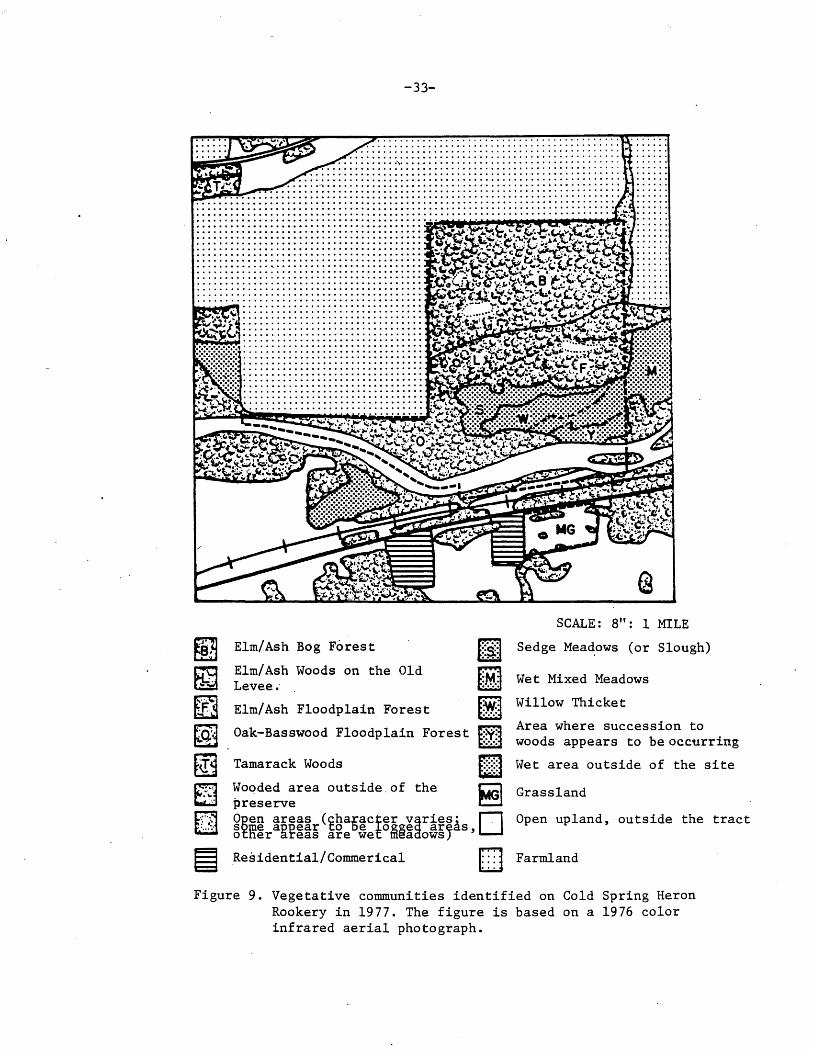
-33-
........................................ ~~~~"""~~~~~ ········································ ......... ············ ........... ········· .................... ····················
................... ····················· ...................... ·················· ......................................... ..... .... ...... ... ..................... . . . . . ..... ....... ... ...... .............. . . .. ... .. . . ... . . . . . .. ............ ....... . ... .. . ..... .. . . ... . ... ................. .
Elm/Ash Bog Forest
Elm/Ash Woods on the Old Levee.·
Elm/Ash Floodplain Forest
Oak-Basswood Floodplain Forest
Tamarack Woods
Woqded area outside.of the preserve
SCALE: 8": 1 MILE
Sedge Mea~ows (or Slough)
Wet Mixed Meadows
Willow Thicket
Area where succession to woods appears to be occurring
Wet area outside of the site
Grassland
~Eig ~~~~~r(~g~~ct5~g~~rif~As,D Open upland, outside the tract otner areas are Wef meaaOWS)
Residential/Commerical D Farmland
Figure 9. Vegetative communities identified on Cold Spring Heron Rookery in 1977. The figure is based on a 1976 color infrared aerial photograph.

-34-
distinguished and studied in the 1977 inventory: Llm/Ash
Bog Forest; Elm-Ash Floodplain Forest; Oak-~asswood Floodplain
vJoods; Sedge fi.eadow or Slough; ~~et f'..ixed ii,eadow; and Dry
I'i,esic Grassland.1 r.i·he i:.lm-Ash .Log Forest is the largest
vegetative community present and occurs on the peat soil on
the terrace. Tree species include American ~lm (Ulmus americana)
and Green Ash (Fraxinus pensylvanicus), which are common,
and Dasswood(tilia americana) which is less so. ~wo trees,
Paper iJirch (.betula paµyrifera) and t·amarack (Larix laricina) . .
occur only in this unit. i1owever, no re~roduction of either
of these species was observed; only old Birch and just a
few famarack were noted (although there were many stum~s
accordin~~ to Dr. 1·,.ax l-artch). .oig-toothed Aspen (1-opulus g,randi
dentata)and 1:i:rembling Aspen (l·opulus tremuloides) also appear
to be confined to this area. ~agoda Dogwood (Cornus alterni-
· folia), an understory shrub or small tree, appears to occur
only in.this area. Common ~ettle (Urtica dioica) i~ a common ~
1. ihe division of the vebetation into these units and the descriptions of them are based on field observation during 1977 supplement.ed by information from Dr. kax i-artch, ~t. Cloud State University. Dr. fartch has conducted extensive investigations on this tract beginning in the early 1950's. Although the herons have been the focus of this work.Dr. Fartch has done quadrat studies of ~he vegetation in the colony. his assistance in preparing this inventory is eratefully acknowledged. In addition to the above communities several other communities could be distinguished on the tract, but none of these were studied in the 1977 inventory. ~hese communities include the submerged and emergent aquatic communities of the river,· and species found along the sandy margins of the river and on emergent sandbars (e.g. Sandbar ~illow, Salix interior).

-35-
herb species here, especially in open areas where trees have
died or been cut. Gther herbs which seem to be confined to
this community include J·ack-in-the-Pulpit (Arisaema triphyllum),
Wild Sarsaparilla (Aralia Nudicaulis), Starflower (~rientalis
borealis), v~Jild Lily-of-the-Valley (i-... aianthemum canadense),
and Lesser Lnchanter's ~ightshade (Circaea alpina).
The Elm-Ash F'loodplain community is found north of the
river. American ~lm and ureen Ash are clearly the· dominant
canopy species here. ~lack Ash (Fraxinus nigra), which is less
common, appears to be confined to this community. Red ~lder
berry (Sambucus pubens) is a common shrub species especially
under nesting trees of the heron colony. ~Jood Nettle (Laportea
canadensis) is a common herb species, but no other information
is available on understory elements.
Between the floodplain and the higher terrace there is
· an old levee of better-drained mineral soil where several
distinctive species are found, including hackberry (Celtis
occidentalis) and.Ironwood (Ostrya virginiana); Ironwood is
restricted to this levee .. Further study may justify segregat
ing the assemblage of plants on this levee as a distinctive
community.
rl'he Oak-Basswood r loodplain ~J oods is a second-growth
woods on the better-drained sandy levee along the present
river channel, inter6rading at its eastern end with the ~lm
Ash community'. Common tree species include basswood, Green
Ash, and Bur Oak (Quercus macrocarpa). bur Oak occurs mainly
as young trees although there are a few larger individuals.

-36-
Hackberry· is also present but it is not common. vJahoo (Euony
™ atropurureus), an understory shrub observed nowhere else
on the site, occurs in a fairly open area in this woods. herba
ceous species which appeared to be confined to this community
i~cluded Long-beaked Sedge (Carex sprengellii; clearly a
dominant), Virginia ~~aterleaf (Hydrophyllum virginianum;
also common), ~loodroot (Sanguinaria canadensis), ~ottle-
brush Grass (liystrix patula), r •• ountain Rice ( uryzopsis ~
!!!.Q.fil!) , and False Iv.elic ( Schizachne purpurascens) . ~~ ood r·~ettle
is common in places near the east. end of this community.
~he Sedge ~eadow or Slough is a low area.adjacent to
the floodplain woods where in normal years there is probably
standing water during part of the season. Sedges (Carex s~p.)
dominate this community, with tussock-forming species predomi-
nating in places and non-cespitose ones in others. Grasses
'include what was identified as Bluejoint (Calamagrostis ~
densis; no specimen was verified), and Reed Canary Grass
(Fhalaris arundinacea) ~hich formed pure stands in places.
'rhere were scattered u.ooseberry shrubs (Ribes sp.) and some
Red Osier Dogwood (Cornus stolonifera). Forbs include Common
Nettle, (which was common perhaps as a result of the unusually
dry conditions), Vetchling (Lathyrus palustris), ~arsh bell
flower (Campanula aparinoides), 3wamp ~ilkweed (Asclepias
incarnata), Fanicled Aster (Aster simplex), Joe-f-ye-vveed
(Eupatorium -maculatum), boneset (bupatorium perfoliatum),
Late Goldenrod (Solidago gigantea), and lronweed (Vernonia
fasciculata). All of these forbs,except the ~ettle,appeared
to be confined to this community. there was also a large
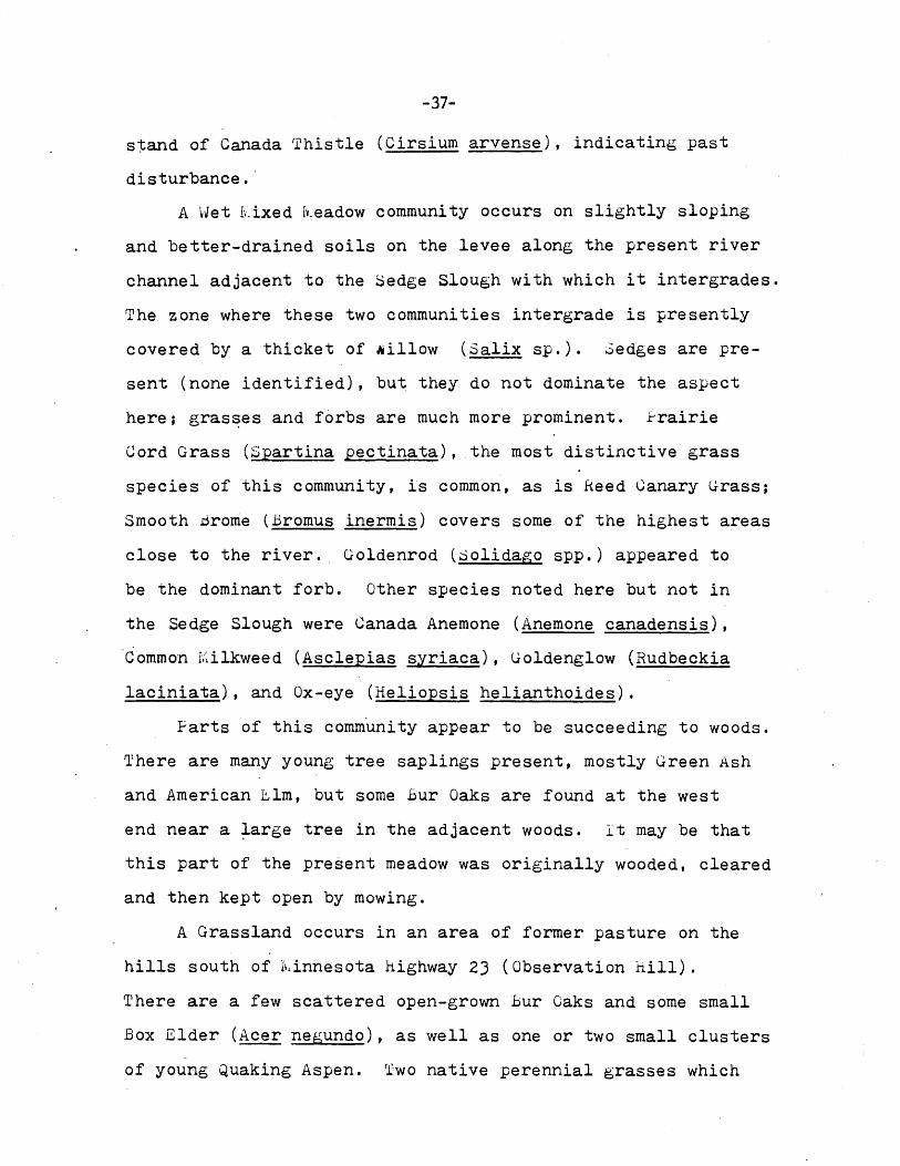
-37-
stand of Canada Thistle (Cirsium arvense), indicating past
disturbance.·
A ~vet kixed i~"eadow community occurs on slightly sloping
and better-drained soils on the levee along the present river
channel adjacent to the ~edge Slough with which it intergrades.
The zone where these two communities intergrade is presently
covered by a thicket of Nillow (Salix sp.). Sedges are pre
sent (none identified), but they do not dominate the aspect
here; gras~es and forbs are much more prominent. frairie
Gord Grass (Spartina pectinata), the most distinctive grass
species of this community, is common, as is .Keed Canary lTrass;
Smooth Brome (Bromus inermis) covers some of the highest areas
close to the river .. Goldenrod (dolidago spp.) appeared to
be the dominant forb. Other species noted here but not in
the Sedge Slough were Canada Anemone (Anemone canadensis),
Common r.alkweed (Asclepias syriaca), Goldenglow (Rudbeckia
laciniata), and Ox-eye (Heliopsis helianthoides).
Farts of this community appear to be succeeding to woods.
There are many young tree saplings present, mostly Green Ash
and American Elm, but some bur Oaks are found at the west
end near a ~arge tree in the adjacent woods. lt may be that
this part of the present meadow was originally wooded, cleared
and then kept open by mowing.
A Grassland occurs in an area of former pasture on the
hills south of l\!innesota highway 23 (Observation hill).
There are a few scattered open-grown bur Oaks and some small
Box Elder (Acer negundo), as well as one or two small clusters
of young Quaking Aspen. Two native perennial grasses which

-38-
are major elements of dry-mesic prairie communities, big
Bluestem (Andropogon gerardi) and Needlegrass (Stipa comata
or spartea), are common in some parts of this area. ~he
grasses which dominate most of the community are non-native
pasture grasses including Kentucky Bluegrass (loa pratensis),
Smooth .Grome, and 'I'imothy (fhleum pratense). 'i·he weedy intro
duced annual grass, Foxtail (Setaria glauca), is also ~resent,
along with 'l'hre.e-awn Grass (Aristida basiramea).
A number of species characteristic of native prairie
and savanna communities are present, mostly found to~ether
in a restricted portion towards the hill's west end.
One of these is Leadplant (Amorpha canescens), a low shrub;
New J·ersey rl'ea (Ceanothus americanus), another shrub found
frequently in prairie and oak savanna communities is present
although it is rare. Prairie forbs include }urple }rairie
Clover (I-etalostemum purpureum) and vJhi te f·rairie Glover
(l-etalostemum candid~), tall Cinquefoil (Fotentilla arguta),
Alum Root (iieuchera ric·hardsonii), Veiny fea (:Lathyrus venosus),
and Showy Tick-trefoil (Desmodium canadense). :Some shrubs
found on this part of the preserve are ~mooth Sumac (hhus glabra),
and Wolfb~rry (Slmphoricarpos occidentalis). Common Dogbane
( :~pocynum androsaemifolium) is a common forb in the "prairie"
area. A number of weedy forbs are found throughout this
community, including Fepper-grass (Lepidium densiflorum),
and the introd'uced hoary Alys sum ( berteroa incana) , .butter-
and Eggs (Linaria vulgaris), and Goat's .oeard ('i-ragopogon
du bi us).

-39-
The ·open grassy area between the Sauk Hiver and the rail
road is also included under the Gras_sland community al though
the species diversity ·here is somewhat less than on the slopes
south of the highway.
All of the plant communities on this tract are degraded
to some extent. Similar examples of these communities can
be found throughout this part of l'vdnnesota. rrhere may be
a possibility for restoration of something like the original
Oak Savanna on the Observation Hill.
Additional Inventory Research Needs
T.he sandbar and .aquatic communities could be inventoried
since they weren't studied in the 1977 survey.
Sources of Information
Curtis, J.T. 1959. The Vegetation of Wisconsin. Univ. of vHsconsin Press, 1~1adison. 657pp.
Kratz,"T. and G.L. Jensen.1977. An ecological geographic division of fuinnesota. Unpublished.
Iv;arschner, F. J. 19JO. 'l1he Original Vegetation of foinnesota (~ap). USDA. North Central Forest Exp. ~tation, St. Paul.

-40-
FLORA
Plant species are one of the primary components of the
state's natural heritage. flants indicate the diversity of
an area, the type of biotic community present, and changes
occurring in the area including the degree of human distur
bance. Rare plant species may be one reason for designating
a site as a Scientific ~ Natural Area.
Niethods
Cold Spring Heron Colony was visited on a weekly basis,
when weather conditions permitted, from 1 June to 29 August
1977. ~ach major vegetative community was randomly sampled
during these visits. 1-'lants that were encountered in frui.t
or flower were collected, identified and pressed. Usually
whole specimens were collected, but with some large plants
only flowers and leaves were collected. Rootstocks of uncommon
·species were left undisturbed. After the plants had been
positively identified they were given a catalog numb~r and
deposited in both the S-t. John's university Herbarium, College
ville, and in the University of lv1innesota herbarium, Depart
ment of Botany, St. faul.
A phenological record of the site's flowering plants
was also kept. 'l'he phenological record began on the first
visit and ended on the last visit to the area. the first
time a species was encountered in flower was taken to be the
start of the flowering period. These dates were then extended
on subsequent visits until floral senescence was noted.
Plants were identified through several sources (cited
at the end of this section). Dr. John W. ~oore, retired

-41-
botanist, University of Minnesota verified seventy-two specimens.
Sixteen specimens were lost and could not be verified. Several
species were observed but not collected.
Cold Spring Heron Colony's Vascular Flora
Table _J_ is an annotated list of the vascular plants
i~entified on the tract.1 A total of 156 species, representing
fifty-seven families, have been identified on the tract, of
which ninety-one species, (forty-three families) were observed
in 1977. The majority of plants identified in 1977 were
forbs: ninety-nine species, accounting for 65.1% of the total
number· of species present, were recorded. Shrubs, including
woody vines, were the next most frequent group observed with
twenty species (1J.2% of the total), followed by the grasses
with fourteen species (9.2%) and thirteen species of trees
(8.6%). There were only four sedge species (2.6~) positively
'identified in 1977 due to the difficulty of identifyin5 these
species; there are probably more than four sedge species
on the tract. 1I'wo species of ferns and their allies ( 1. J'.fo)
were also identified. Nine of the species collected in 1977
had not been previously collected from Stearns County and
deposited in the University of ~innesota Herbarium. Twelve
1. Table _j_ incorporates the plants identified in the 1977 inventory with several other plants lists. Entries credited to Dr. fv.ax Partch, St. Cloud State University, are taken from species lists prepared by him on file in 'Iihe Nature Conservancy, .~innesota Chapter, office. 0ther entries are based on sight records reported by Robert Dana, an intern studying insects in the 1977 inventory. Fifty-nine species and thirteen families were added based on these lists. However, the analysis which follows is only concerned with those species identified in the formal 1977 plant inventory. Nomenclature in Table ..1. is according to Gleason & Cronquist (1963). Additional plant lists alphabetically organized by common names, scientific name and family are on file, '.J.'he i'4ature Conservancy ~innesota Chapter.

I (
-42-
Table 3. Annotated Flora List of Cold Spring Heron Colony.
Format: Scientific name. Common name. Collection number of voucher specimen. Parentheses around collection number indicates specimen was lost prior to verification. A (+) indicates species was noted but not collected. "Introduced" if not native to Minnesota. Community in Cold Spring Heron Colony in which 'specimen collected. Asterisk (*) if first collection of the species from Stearns County in the University of Minnesota Herbarium. Entries entirely enclosed in parentheses are interpolations from the source noted (see text).
I. PTERIDOPHYTA - Spore-bearing Plants
(EQUISETACEAE - Horsetail Family) (Equisetum spp. - Horsetail. Partch.)
OPHIOGLOSSACEAE - Adder's To.ngue Family Botrychium virginianum - Rattlesnake Fern. #43. Basswood-Oak Woods.
II. SPERMATOPHYTA - Seed Plants
A. GYMNOSPERMAE - Gymnosperms
PINACEAE - Pine Family (Larix laricina - Tamarack. Dana. Elm-Ash Bog Woods.)
B. ANGIOSPERMAE - Angiosperms
1. MONOCOTYLEDONEAE·- Monocots
ALISMATACEAE - Water-Plantain Family Sagittaria latifolia - Arrowhead. #66. River Shoreline. * CYPERACEAE - Sedge Family Carex ·brevior - Fescue Sedge. 1123. Sedge Meadow. Carex pensylvanica - Pennsylvania Sedge. #97. Elm-Ash Woods. Carex sprengelii - Long-beaked Sedge. Ill 9. Sedge Meadow. Carex sychnocephala - Many-headed Sedge. #37A. Sedge Meadow.
GRAMINEAE - Grass Family Andropogon gerardi - Big Bluestem. #88. Observation Hill. Aristida basiramea ...lfhree -awn Grass. #84. Observation Hill. Bromus inermisi - Smooth Bro.me Grass. #8 7. Introduced. Observation Hill.
(Elymus canadensis - Canada Wild Rye. Dana. Elm-Ash Woods edge.) (Elymus villosus - Villous Wild-Rye. Dana. Elm-Ash Floodplain Woods.) (Elymus virginicus - Terrell Grass. Dana. Elm-Ash Floodplain Woods.) (Hystrix patula - Bottle-Brush Grass. Partch, Dana. Basswood-Oak Woods.) (Oryzopsis racemosa - Mountain-Rice. Dana. Basswood-Oak Woods.) Phalaris arundinacea - Reed Canary Grass. #17. Sedge Meadow. Phleum pratense - Timothy. #59. Introduced. Observation Hill. Poa pratensis - Kentucky Blue Grass. #89. Introduced. Observation Hill.
(Schizachne purpurascens - False Melic. Dana, Partch. Basswood-Oak Woods. Setaria glauca - Foxtail Grass. #58. Introduced. Observation Hill.
(Spartina pectinata - Prairie Cord Grass. Dana. Mixed Wet Meadow.

-43-
LILIACEAE - Lily Family Allium stellat~ - Prairie Onion. #90. Observation Hill.
(Allium tricoccum - Wild Leek. Partch. Woods.) (Maianthemum canadense - Wild Lily-of-the-Valley. Partch. Woods.) Polygonatum biflorum - Solomon's Seal. #3. Elm-Ash Woods.
(Polygonatum pubescens - Solomon's Seal. Partch.) ·Smilacina racemosa - False Solomon's Seal. (#18) Elm-Ash Woods. Smiliacina stellata - Starry False Solomon's Seal. #13. Elm-Ash Woods.
(Smilax ecirrhata - Greenbriar. Partch. Woods.) Smilax herbacea - Carrion Flower. #5. Elm-Ash Woods. Trillium cernuum - Nodding Trillium. #9. Elm-Ash Woods. Uvularia grandifloria - Large-flowered Bellwort. #4. Elm-Ash Woods.
2. DICOTYLEDONEAE - Dicots
ACERACEAE - Maple Family Acer negWldo - Boxelder. #31. Elm-Ash Woods. * ANACARDIACEAE - Cashew Family Rhus glabra - Smooth Sumac. #44. Rhus radicans - Poison Ivy. (+).
APOCYNACEAE - Dogbane Family
Grassy River Bank. Grassy River Bank.
Apocynum androsaemifolium - Common Dogbane. (#30). Basswood-Oak Woods. Apocynum cannabinum - Indian Hemp. (#39). Basswood-Oak Woods.
ARACEAE - Arum Family (Arisaema triphyllum - Jack-in-the-Pulpit. #92. Elm-Ash Woods.)
(ARALIACEAE - Ginseng Family) (Aralia nudicaulis - Wild Sarsaparilla. (Aralia racemosa - Spikenard. Partch.
ASCLEPIADACEAE - Milkweed Family (Asclepias incarnata - Swamp Milkweed. Asclepias syriaca - Common Milkweed.
BALSAMINACEAE - Touch-me-not Family Impatiens biflora - Jewel Weed. #77.
BERBERIDACEAE - Barberry Family
Partch. Woods.) Woods.)
Dana. Sedge Meadow.) #65. Mixed Wet Meadow.
Elm-Ash Woods.
Caulophyllum thalictroides - Blue Cohosh. #10. Elm-Ash Woods.
BETULACEAE - Birch Family (Betula lutea - Yellow Birch. Partch. Woods.) Betula papyrifera - Paper Birch. #33. Elm-Ash Woods. Corylus cornuta - Beaked Hazel-nut. (#37). Elm-Ash Woods. *
(Ostrya virginiana - Ironwood. Partch. Woods.)
CAMPANULACEAE - Harebell Family
#57. Observation Hill.
(Campanula aparinoides (C. uliginosa in Fernald, 1950) - Marsh Bellflower. Dana. Sedge Meadow.)
Campanula rotundifolia - Harebell. (#24). Observation Hill.
CAPRIFOLIACEAE - Honeysuckle Family Sambucus pubens - Red-berried Elder. #12. Elm-Ash Woods. Symphoricarpos occidentalis - Wolfberry. #53. Observation Hill. Viburnum rafinesquianum - Downy Arrow-wood. #40. Elm-Ash Woods.
CARYOPHYLIACEAE - Pink Family Stellaria longifolia - Long-leaved Chickweed. #15. River shoreline.

-44-
(CELASTRACEAE - Staff-tree Family) (Celastrus scandeus - Bittersweet. Partch. Woods.) (Euonymus atropurpureus - Wahoo. Dana. Basswood-Oak Wopds.)
(CHENOPODIACEAE - Goosefoot Family) (Chenopodium album - Lamb's Quarters. Partch.) (Chenopodium hybridum - Maple-leaved Goosefoot. Partch.)
COMPOSITAE - Composite Family Achillea millefolium ssp. lanulosa - Yarrow. #25. Observation Hill. #64.
Sedge Meadow. Aster sagittifolius - Arrow-leaved Aster. #86. Observation Hill.
(Aster simplex - Panicled Aster. Dana. Sedge Meadow.) Cirsium arvense - Canada Thistle. (#90). Introduced. Observation Hill. Cirsium discolor - Field Thistle. #48. Sedge Meadow.
(Cirsium vulgare - Bull Thistle. Partch.) Eupatorium maculatum - Joe-Pye-Weed. #76. Sedge Meadow. Eupatorium rugosum·- White Snakeroot. #81. Elm-Ash Woods. Erigeron strigosus - Daisy Fleabane. #46. Observation .Hill. Heliopsis helianthoides - Ox-Eye. #63. Mixed Wet Meadow.
(Prenanthes alba - Rattlesnake-root. Partch.) Rudbeckia laciniata - Goldenglow. #75. Mixed Wet Meadow. Solidago flexicaulis - Zig-zag Goldenrod. #71. Elm-Ash Woods. Solidago gigantea - Late Goldenrod. #70. Elm-Ash Woods. Tragopogon dubius - Goat's Beard. (+). Introduced. Observation Hill. Vernonia fasciculata - Ironweed. #74. Sedge Meadow. * CONVOVULACEAE - Morning-glory Family · Convovulus sepium - Hedge-Bindweed. #60. Sedge Meadow.
CORNACEAE - Dogwood Family (Camus alternifolia - Pagoda Dogwood. Cornus stolonifera - Red Osier. #14.
CRUCIFERAE - Mustard Family
Partch. Woods.) Elm-Ash Woods.
Berteroa incana - Hoary Alyssum. ·#52. Introduced. Observation Hill. (Cardamine bulbosa - Spring Cress. Partch.) Lepidium densiflorum - Pepper-grass. #50. Observation Hill. * CUCURBITACEAE - Gourd Family Echinocystis lobata - Wild Cucumber. #78. Elm-Ash Woods.
FABACEAE - Bean Family Am.orpha canescens - Leadplant. #54. Observation Hill. Desmodium canadense - Showy Tick-trefoil. #56. Observation Hill.
(Lathyrus palustris - Vetchling. Dana. Sedge Meadow.) Lathyrus venosus - Veiny Pea. #27. Observation Hill. Melilotus officinalis - Yellow Sweet Clover. #45. Introduced. Observation Hill. Petalostemum candidum - White Prairie Clover. (+). Observation Hill. Petalostemum purpureum - Purple Prairie Clover. #49. Observation Hill. Trifolium pratense - Red Clover. #85. Introduced. Observation Hill.
FAGACEAE - Beech Family Quercus macrocarpa - Bur Oak. #83. Basswood-Oak Woods.

-45-
FUMARTACEAE - Fumitory Family Curydalis zurea - Golden Curydalis. #98. Elm-Ash Woods.
(GERANIACEAE - Geranium Family) (Geranium maculatum - Wild Geranium. Partch.)
(HYDROPHYLIACEAE - Waterleaf Family) (liydrophyllum virginianum - Virginia Waterleaf. Dana. Basswood-Oak Woods.)
LAB IATAE - Mint Family (Nepeta cataria - Catnip. Partch. Introduced.) Stachys palustris - Woundwort. #61. Elm-Ash Woods.
MALVACEAE - Mallow Family Callirhoe triangulata - Poppy-Mallow. #29. Observation Hill.
(MENISPERMACEAE - Moonseed Family) (Menispermum canadense - Moonseed. Partch.)
(MORACEAE - Mulberry Family) (Humulus lupulus - Hops. Partch.)
NYCTAGINACEAE - Four-O'Clock Family Oxybaphus nyctagineus - Umbrella-wort. tl41. (Mirabilis nyctaginea in Fernald,
1950.) Basswood-Oak Woods.
OLEACEAE - Olive Family Fraxinus nigra - Black Ash. #34. Fraxinus pennsylvanica - Green Ash.
Elm-Ash Woods. (*). Elm-Ash Woods.
ONAGRACEAE - Evening-Primrose Family (Circeae alpina - Lesser Enchanter's Nightshade. Partch. Woods.) Circeae quadrisulcata var. canadensis - Enchanter's Ntghtshade. #82. Elm-Ash
Woods.
PAPAVERACEAE - Poppy Family Sanguinaria canadensis - Bloodroot. #6. Elm-Ash Woods.
PHRYMACEAE - Lopseed Family Phryma leptostachya -.Lopseed. #72.
POLYGONACEAE - Smartweed Family Rumex acetosella - Red Sorrel. #51. Rumex orbiculatus - Great Water Dock.
PRIMULACEAE - Primrose Family
Elm-Ash Woods.
Observation Hill. #68. Sedge Meadow.
Lysimachia ciliata - Fringed Loosestrif e. (Trientalis borealis - Starflower. Partch.
#62. Elm-Ash Woods. Woods.)
RANUNCULACEAE - Crowfoot Family (Actea sp. - Baneberry. Partch.) Anemone cylindrica - Long-headed Thimbleweed. (#26). Elm-Ash Woods. Anemone quinquefol:!-~ Wood Anoemone. #99. Elm-Ash Woods. Caltha palustris - Mar~h Marigold. #92. Open wet areas in Elm-Ash Woods. Ranunculus abortivus - Small-flowered Crowfoot. #95. Elm-Ash Woods. Thalictrum dasycarpum - Tall Meadow Rue. #8. Elm-Ash Woods.
RHAMNACEAE - Buckthorn Family Ceanothus americanus - New Jersey Tea. #55. Observation Hill.

-46-
ROSACEAE - Rose Family (Fragaria sp. - Strawberry. Partch.) (Geum canadense - White Avens. Partch. Woods.) Potentilla argentia - Silvery Cinquefoil. #47. Introduced. Observation Hill. Potentilla arguta - Tall Cinquefoil. (*) Observation Hill. Prenus virginiana - Choke Cherry. #35. Elm-Ash Woods.
(Rubus pubescens - Dwarf Blackberry. Partch.)
RUBIACEAE - Madder Family (Galium aparine - Cleavers. Partch.) Galium boreale - Northern Bedstraw. (#22). Observation Hill. Galium triflorum - Sweet-scented Bedstraw. (#2). Elm-Ash Woods.
TUTACEAE - Rue Family Zanthoxylum americanum - Prickly-Ash. #20. Elm-Ash Woods.
(SALICACEAE - Willow Family) (Populus grandidentata - Big-toothed Aspen. Partch.· Woods.) (Populus tremuloides - Trembling Aspen. Partch. Woods.) (Salix ssp. - Willow. Dana. Sedge Meadow. (Salix interior Sandbar Willow. Dana. Sandbar in river.)
SAXIFRAGACEAE - Saxifrage Family Heuchera richardsonii var. hispidior - Alum-root. #21. Observation Hill.
(Mitella nuda - Bishop's Cap. Partch. Woods.) (Ribes americana - Wild Black Currant. Partch.) (Ribes cynosbati - Dogberry. · Partch.) (Ribes triste - Red G_urrant. Partch.) (Saxifraga pensylvanica - Swamp Saxifrage. Partch.)
S~ROPHULARIACEAE - Figwort Family Linaria vulgaris - Butter-and-Eggs. (#28). Introduced. Observation Hill. Mimulus ringens - Monkey Flower. #69. River shoreline.
TILIACEAE - Linden Family Tilia americana - Basswood. #42. Basswood-Oak Woods.
ULMACEAE - Elm Family Celtis occidentalis - Hackberry. Ulmus americana - American Elm.
#30. #73.
Elm-Ash Woods. * Elm-Ash Woods.
(UMBELLIFERAE - Parsley Family) (Cryptotaenia canadensis - Honewort. Partch Woods. ) (Osmorhiza claytoni - Sweet Cicely. Partch. Woods.) (Osmorhiza longistylis - Anise-root. Partch. Woods.)
URTICACEAE - Nettle Family Laportea canadensis - Wood-Nettle. #80. Elm-Ash Woods.
(Parietaria pensylvanica - Pellitory. Partch. Woods.) Urtica dioica - Stinging Nettle. (*) Elm-Ash Woods.
VERBENACEAE - Vervain Family Verbena hastata - Blue'verbain. #67. River shoreline.

-47-
(VIOLACEAE - Violet Family) (Viola conspersa - American Dog-Violet. Partch.) (Viola pubescens - Downy Yellow Violet. Partch.) (Viola sp. (pallens?) - Violet. Partch.)
(VITACEAE - Grape Family (Parthenocissus sp. - Virginia-Creeper. Partch. Woods.) (Vitis riparia - Frost Grape. Partch.)

-48-
of the species were introduced, and not native to the area.
Figure 10 records when Cold Spring Heron Colony's plants
flowered in 1977 .1 'l'he peak number of species in bloom during
a single week was twenty-two, occurring the week of 10-16
July 1977.
Additional Inventory/Research Needs
The 1977 inventory did not provide an exhaustive account
ing of the tract's vascular flora: most spring species had
finished flowering and were inconspicuous when sampling began,
and many others were overlooked. Although data from other sources
were incorporated into the flora list to make it more complete
some species may have still been missed. thus another survey
of the 'tract's vascular flora could be conducted. Also, the
.tract's early spring flora and spring phenology should be
recorded. Finally, the 1977 inventory did not survey the site's
nonvascular plants, such as lichens and mosses, or aquatic
plants. A survey of these plants could be done in the future.
Sources of Information
Fernald, IV,. L. 1950. Gray's rv·.anual of Botany. American book Company. New York.
Gleason, Harry A. 1952. New brittan and Brown illustrated Flora of Northeastern United States and Adjacent Canada, Lancaster Press. Lancaster, PA.
Gleason, H.A. and A. Cronquist.. 1963. iv,anual of Vascular Plants of Northeastern United States and Adjacent Canada. Van Nostrand Hheinhold Co. , l~. Y.. 810 pp.
Heitlinger, ~.ark. 1977. Checklist of selected vascular plants of ~innesota including uncommon species. Unpublished. '11he Nature Conservancy, iv,innesota Chapter.
·1. A list of the flowering periods of species found on the site is on file, 'the Nature Conservancy ••1innesota Chapter.

Cf.l ~ H u ~ ll-1 Cf.l
~ 0
P::l ~
~ z
-49-
24
.... - ~
" l
I 20 ' •
l , • ' ' ,
l • 16 '
' j
• r , ... 1 "Ill
... -12 .. ..
l " ' I ..
I , ' r..
J ., • •
s , I
r.. I j ' I
• • , • ..
-4 ...
~ ' I I 0
JUNE JULY AUGUST
Figure 10. Numbers of plant species observed in bloom at Cold Spring Heron Colony. Observations were recorded from 1 June to 1 September 1977.
(
-50-
House, homer D. 1935. ~~ild Flowers. Iv.ac rhillan, New York.
fvi.orley, T. 1972. Rare or endangered plants of i~·.innesota with the counties in which· they have been found. Unpublished mimeo. 1Jpp.

-51-
BUTTERFLIES!
Butterflies are found· in virtually all of Iv,innesota' s
natural areas. 'lihey are insect herbivores which feed on and
pollinate plants and affect plant distribution and abundance.
Butterflies as primary consumers provide sustenance for animals
higher up on the food chains. A butterfly inventory is neces-
sary to document an area's natural diversity, to identify
rare species needing special protection, and to gain a better
understanding of many species which are poorly known. Finally,
some butterflies are sensitive ecological indicators, provid-
ing useful information on changes occurring in the area.
r~~e thods
In 1977 a detailed inventory of Cold Spring Heron Colony's
butterflies was carried out.2 biweekly visits were made to
the site from the second week in ~ay through the third week
-in September. The first intensive butterfly sampling, however,
was begun during the second week in J·une. Visits were made,
when feasible, during hours and weather conditions favorable
for butterfly activity. Sampling was guided principally by
the researcher's expectation of where significant butterfly
activity ·was likely to be. Sampling was concentrated in the
meadow areas in the floodplain and the immediately adjoining
1. 1l'he term butterflies in this document refers both to the true butterflies (Fapilionoidea) and the Skippers (Hesperiodea).
2. 'l'he assistance of iv.r. hon Huber, ~oology Assistant, Science Iv.use um of r .. innesota, St. I-aul, is gratefully acknowledged.

-52-
woods. ~he portion of the tract south of the Sauk River
("Observation Hill") was not sampled during this study.
Observations of adult and immature butterflies were re-
corded together with the location, habitat type and associated
plant species. A rough estimate of each species' frequency
was also made.1 butterflies were usually identified by sight,
but a standard butterfly net was employed to capture the
insects for identification when necessary. All captured
insects we~e released except when reliable identification
required a prepared specimen, or when a voucher specimen was
desired. All specimens were deposited in the Department of
Entomology, Fisheries~ v~ildlife collection, University of
lt.innesota, St . .Paul.
Scientific and common names used here are taken from
huber (1975),with the addition of some subspecific names based
on Howe (1975). Subspecific names are given only when the
populations could clearly be assigned to a subspecies other 1:.
than the nominate. In 'unclear classes the subspecific name
is followed by ·"ssp" ("subspecies").
Butterflies of Cold Spring Heron Rookery
Table 4 lists in alphabetical order the butterflies
observed on the tract. Thirty-two butterflies species were
recorded including eight skipper species. Uf these, one is
a more southern butterfly which rarely occurs in ll1innesota
(Huber, unpubl. data), one probably wandered onto the site
1. For information on abundance, adult behavior, larval food plants· and other relevant comments, see Robert Dana, Department of Entomology, Fisheries & Wildlife, University of ~innesota, St. faul.

-53-
Table 4 . butterflies identified on Cold Spring heron Colony in 1977.
Ancyloxypha numitor (Least Skipper) Atrytone delaware (Delaware Skipper) Celastrina argiolus pseudargiolus (Spring Azure) Cercyonis pegala ssp. (Wood Nymph) Chlosyne harrisii ssp. (Harris' Checkerspqt) Chlosyne nycteis (Silvery Checkerspot) Coenonympha tullia inornata (Inornate Ringlet) Golias eurytheme (Alfalfa Butterfly) Dana us plexippus ( N.i onarch) Euphyes cons icua ssp. (Black Dash) Euphyes dion Dion Skipper) Euphyes vestris metacomet (Dun Skip~er) Euptychia cymela (Little Wood Satyr) Lethe anthedon (Pearly Eye) Lethe appalachia leeuwi (Appalachian Brown) Lethe. eurydice ·ssp. (Eyed Brown) Libytheana bachmanii· (Snout Butter.fly) Limenitis archippus (Viceroy) Limenitis arthemis ssp. (Banded Purple) Lycaena thoe (Bronze Copper) Nymphalis antiopa Ov1ourning Cloak) Nymphalis milberti (lviilbert' s 11:ortoiseshell) Phyciodes tharos (Pearl Crescent) Pieris rapae (European Cabbage Butterfly) Poanes hobomok (Hobomok Skipper)
.Polites coras (Peck's Skipper) Polites mystic (Broken Dash) Polygonia comma (Comma.) Satyrium acadica (Acadian Hairstreak) Satyrium calanus falacer (Banded Hairstreak) Speyria cybele (Great Spangled Fritillary) Vanessa atalanta rubria (Red Admiral)

-54-
from suitable breeding habitat elsewhere in the area, and two
breed · in agriculture areas in the vicinity from which they
range widely. The remaining twenty-eight species are all
breeding residents of the site and are typical for this part
of the state. None of the butterflies identified is dependent
on this tract for its survival in the area.
The Dion Skipper and the Black Dash are related skippers
of similar habits and distribution in ~innesota. Both occur
locally and usually in small numbers in sedge meadow habitats
(Dana, pers. obs.). A fairly good colony of the Dion Skipper
was observed here, but only a single male of the Black Dash
was seen.
The Harris' Checkerspot is another butterfly which is
generally uncommon and found locally in moist to wet meadows.
However, this butterfly is probably not a breeding resident
·of the site -- only one very flight-worn individual was en
countered and the obligate larval host plant was not seen
on the tract. The butt~rfly's breeding habitat probably occurs
east of the tract on the terrace just above the floodplain
in boggy meadows. This location is on the extreme southwestern
limit of the insect's range (Huber, unpub. date).
'I'he Snout .Butterf,J.y is reported to periodically "migrate"
northward, but rarely reaches Minnesota on the evidence of
the infrequency of its collection here (Huber, unpubl. data).
One of the two' adults seen here was freshly emerged from the
pupal state indicating that migrants arrived early enough
to reproduce locally. This is probably a rare occurrence
in this part of the state.

-55-
The Appalachian ~rown, a butterfly of shady swampy habitats,
was found in the floodplain woods adjacent to the open sedge
meadows where its congener, the Eyed Brown, was fairly common.
These two butterflies are "sibling species", so close in ap-
pearance that they were not recognized as distinct species
until a few years ago. Very little is yet known of the extent
of the Appalachian :Brown's range in lv.innesota or its abundance.
The abundance of Nettles (Utrica dioica) makes this area
excellent habitat for several species that feed as larvae
on it, including Kilbert's Tortoiseshell, the Comma, ·and the
Red Admiral. The Red Admiral does not appear to overwinter
in this area, but migrates in from further south every year
(Clench, 1975, and Dana, pers. observ.). In 1977 a quite
abnormally large immigration of rted Admirals was evident with
great numbers of the insect congregating at this site.
·Additional Inventory/Research ~eeds
The south side of the ~auk River (i.e., Observation
Hill) should be surveyad to determine what butterflies resid~
here ~- an additional three to five species may occur south
of the river due to differences in habitat.
Sources of Information
Clench, H.K. 1975. Genus VANESSA Fabricius, pp. 202-207 . In: W.H. Howe (co-ord. ed.), The Butterflies of ~orth America. Doubleday, Garden City, N.Y.
Howe, W.H. (co-ord. ed.). 1975. Doubleda~, Garden City, N.Y.
Butterflies of North America. 633 p.
Huber, R.L. 1975. No title. (Revision of Huber, R.L., J.S. Nordin & O.R. Taylor, Jr. 1966. A systematic checklist of ~innesota Rhopalocera (butterflies & skippers). Science fv~useum of l't.inn., St. Faul. Unpub. mimeo. 10 p.
Klots, A.B. 1957. A field Guide to the butterflies of North America ~ast of the Great ~lains, houghton-~ifflin Go., Boston. J49p.

-56-
BIRDS
Birds are another biotic component which add to the
natural diversity of an area and the state. Indeed, there
are more bird species than all other vertebrates on Cold
Spring Heron Colony. An inventory is needed to record. species
diversity, identified endangered, rare or sensitive species,
and recognize changes in species composition.
A bird census was made by walking through the area on
four occasions: 24 Iv!ay, 9 June, 22 June and 12 July 1977.
Birds were identifie~ by sight, sound, or a combination thereof.
Identification was aided by the use of a pair of binoculars
and a bird field'guide.
Cold Spring Heron Colony's Birds
Table _.2_ lists the birds identified on the tract in
.1977 in phylogenetic order. Forty-five birds were identified
at least once on, over· or near Cold Spring Heron Col6ny.1
~~ost of these species are common residents of the state's
wetlands, fresh water, open deciduous woods, fields, brush
areas, a.~d deciduous and mixed wood habitats. The absence
of many birds typical of dry prairie communities from the
dry-mesic grassland on Observation hill is probably due to
its small size. The Red-eyed Vireo was heard along the river
but not seen,while the Indigo bunting was observed at the
northern edge of the woods just off the tract. Furple h.artins,
1. 'I'he location and dates the birds were observed ar_e on file, The Nature Conservancy Iv.innesota Chapter. iJ.1he Eastern Kingbird was not seen on the tract, but an unoccupied nest was found on Observation Hill. It is not included in the above total.

-57-
Table --2._. Birds identified at Cold Spring Heron Colony in 1977,
Ardea herodias (Great .blue heron) Butorides virescens (Green Heron) Casmerodius albus (Great Egret) Buteo Jamaicensis (Red-tailed Hawk) Charadrius vociferus (Killdeer)
· _Acti ~is macularia ( Spot~ed ~and:piper) Zenaida macroura (kourning Dove) Archilochus colubris (Huby-throated Hummingbird r1.egaceryle alcyon. (Belted Kingfisher) Colaptes auratus (Common Flicker) rv~elanerpes erythrocephalus (Red-headed livoodpecker) Dendrocopos villosus (hairy vj oodpecker) Dendrocopos ubescens (Downy ~~oodpecker) Tyra~ tyrannus Eastern Kingbird)* ~yiarchus crinitus (Great Urested Flycatcher) Sayornis phoebe (Eastern fhoebe) C ontopus virens (.L;;astern v~ ood rewee) . Riparia riparia -(bank Swallow) Stelgidopteryx ruficollis (Rough-winged Swallow) Hirundo rustica (barn Swallow) Frogne subis (Purple kartin) Cyanocitta cristata (blue Jay) Corvus branchrhynchos (Common Crow) Parus atricapillus (black-capped Chickadee) Sitta carolinensis (White-breasted ~uthatch) Troglodytes aedon (House Wren) Dumetella carolinensis (Gray Catbird) '11 oxostoma rufum (brown 1rhrasher) Turdus migratorius (American Robin) Bombycilla cedrorum (Cedar \1vaxwing) Sturnus vulgaris ($tarling) Vireo olivaceus (Red-eyed Vireo) Dendroica petechia (Yellow ~arbler) O;porornis philadelp~ia (1 .... ourning warbler) ~eotl}_J:y_.pJs !richas Common Yellowthroat) Agelaius hoeniceus (Red-winged Blackbird) Icterus galbula ~orthern uriole) Quiscalus guiscula (Common Grackle) h.olothrus ater (.drown-headed Cowbird) firanga ludoviciana (Scarlet Tanager) Cardinalis cardinalis (Cardinal) Peucticus ludovicianus (Rose-breasted Grosbeak) fasserina cyanea (Indigo bunting)* S"pinus tristis (American Goldfinch) Spizella pallida (Clay-colored Sparrow) OCelospiza melodia (Song Sparrow)
*Not observed on the tract.

-58-
Killdeer, Barn Swallows an~ a Red-tailed Hawk were all observed
in flight over the site. Six birds were observed nesting on
the tract, including Great Blue Herons, l\!ourning Doves, Eastern
Phoebes, Starlings, Red-winged Blackbirds (which attempted
to nest on the island on the Sauk River), and Northern Orioles.
Bank and Rough-winged Swallows were observed nesting in a
bank off the site just west of Observation Hill.
Significance of Cold Spring Heron Rookery Birds
The Great Blue Heron rookery present in the Elm/Ash
Forest north of the open meadows is the primary reason this
tract was acquired by the Nature Conservancy and nominated
as a potential state Scientific & ~atural Area. Great Blue
Herons have nested in the Cold Spring vicinity since at least
the 1800's according to area residents. About 1905-1906
they· started nesting to the north of the present site. When
·the Tamaracks died, due to the area being tiled and drained,
the herons moved south to the present location. About fifty
five pairs of herons were reported in this colony in 1933
(Partch, 1972) . Since 19 54, when Dr. h.ax Partch, St. Cloud
State University, first began keeping detailed records of the
area, the number of nests has more than tripled as has the
area occupied by the nesting colony (See Figures 11 and
.J.2_). In 1954 there were J86 nests in 102 trees occupying
an area equal to about 5-1/2 acres (the entire Nature Conservancy
property north of the Sauk River is fifty-seven acres). by
1970 there were 1317 nests in 367 trees occupying an area
equal to about 13-1/2 acres (Fartch, 1972). ~he largest
number of herons recorded on the tract in one season was in
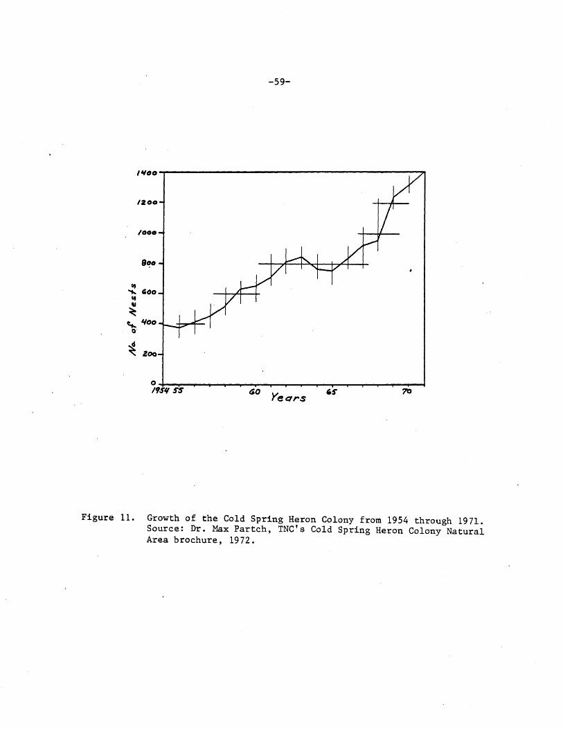
-59-
1¥00--------------------------------------------~-.,,
1200
/000
d ~ Zoo
Figure 11. Growth of the Cold Spring Heron Colony from 1954 through 1971. Source: Dr. Max Partch, TNC's Cold Spring Heron Colony Natural Area brochure, 1972.

.'19611 J' ....... J11IY I i J au" Yi I ,,,.
• -•
·~I l~a ~'iTlll 11 '·'I~ NUMBER OF NESTS --r: I 1-9 ~19s9 ·I c::o::IJ )O-J9
\ ttt--1111 ~1;1;1!1 I - • 10-19 EJillEJ llJ-49
20-29 11811111 61
~igure 12. Expansion of the Cold Spring Heron Colony from 1954-1968. Source: Dr. Max Partch, TNC's Cold Spring Heron Colony Natural Area brochure, 1972.
I
°' 0 I

-61-
1974 wh;ri 1584 nests were recorded by Dr. ~1ax Partch. Indica
tions are that this is one of the largest Great Blue Heron
rookeries in the state. Since 1974, however, the number of
herons nesting in the rookery has dropped.1
Great Blue Herons are protected birds. Rookeries like
the. Cold Spring Colony are significant because such large
concentrations of birds in a relatively small area are suscep
tible to disturbance and nesting areas are limited. '.l1here
are presently an estimated 115-125 active Great ~lue heron
rookeries in the state.2
Cold Spring Heron Colony is also significant because
it has been studied and monitored for many years. As noted
above, Dr. fvlax Partch has studied the· colony since 1954.
He has published reports periodically in The Loon. beginning
in 1974 Rick Peifer studied this heron colony as part of
his ~.A. thesis research. He also published an article on
the herons in 1975 in ~he Loon (Peifer, 19j5).·
Additional Inventory/R~rch Needs
The herons ne~ting on the tract could be monitored yearly
to determine any changes occurring in the population. Also,
due to a limited field season the 1977 bird inventory may be
incomplete for the spring birds. Thus another inventory
could be conducted to record these birds.
1. In 1979 Dr. Partch recorded 1125 nests in the rookery.
2. This information is from the records of Carrol Henderson, DNR, Non-game Wildlife Program Supervisor.

-62-
Sources of Information
Green, Janet C. and Robert B. Janssen. 1975. lv .. irmesota Birds. University of Iv.innesota Press. l'vdnneapolis.
Partch, Il/~ax. 1971. The 1971 spring migration at the Cold Spring Heron Colony. The Loon. 4J(J): 75-77.
1972. Cold Spring Heron Colony Natural Area. Brochure prepared for The Nature Conservancy, ~1innesota Chapter, ~inneapolis. 11pp.
Peifer, Richard W. 1975. The Loon 47(4): 156-159.
. 1977. Capturing, tagging and radio telemetry ------m---on--!""itoring Great Blue Herons (Ardea herodias L.) in
central foinnesota. Unpub. l~ •. A. rl'hesis, St. Cloud State University, St. Cloud, l~.innesota. 65 pp.

-63-
rv:i Aiv.1.MALS
Iviammals must be inventoried to: 1) record the unit's
natural diversity; 2) to obtain baseline data so changes in
species composition can be discerned; and J) to identify rare
or sensitive species.
N:ethods
Small mammals on the north side of' the river were censused
using eighty live traps placed on two parallel lines set
fifty feet apart. £ach line consisted of twenty stations
set at intervals of fifty. feet. .Gach station contained a
2x2x6 Sherman live tra~ and a Longworth live trap. A peanut
butter-oatmeal mixture was used to bait the traps. 1he trap
lines ran from the Sauk River north into the woods. '.i'he
end stations on the western line of traps were permanently'
marked with metal conduit. 'l'he other stations on the same
·line were temporarily marked with bambo~ stakes during the
trapping period.
An additional east'-west line of fl ve sta:ti·ons, two traps
per station, was set on Observation hill. 'l1his line used
2x2x6 homemade traps.
The traps were all set on 12 August 1977 and were checked
at 8: 50 Al~~ on 13 August and at d: 20 Alh on 14 August, at which
time they were pulled. Specimens were deposited in the j·ames
Ford Bell 1v.1.useum of 1'4atural History, University of lV.innesota,
Iv~inneapolis.
Large mammals were censused only through direct or in- .
direct observation during the bird census.

-64-
cold Spring Heron colony Is r~.ammals
Ten mammals were identified visually, by trap, or by
other signs on the site in 1977 (See 'I!able _&.....) .1 In addition,
Raco on and IJJhi tetail De.er tracks were observed in the cornfield
just to the west of the colony. Virtually all of the mammals
are widespread in ~innesota. however, ~oyle (1975) lists
the Shorttail ~Jeasel as a species of concern in the state.
The presence of Plains Pocket Gophers was indicated by mounds
observed 011 the Observation Hill. 1'he .i:£astern Chipmunk,
Red Squirrel, and hieadow Jumping ·i\iouse were not observed
during the formal mammal inventory.
Sources of Information
Gunderson, Harvey L. and James R. beer. 1953. ~he ~ammals _of iV.i_rmesota. 1l'he University of 1dnnesota 1-'re:::ss. L~~innea.J::;olis.
r·:.oyle, John. 1975, 1.1..he uncommon ones. 1v.innesota Uept. o:f ~atural Resources. St. raul.
1. 'l'he location, dates and numbers of mammals recorded are on file, 'l'he Nature Conservancy 1,!innesota Ghapter.

-65-
Table _6_·. it.ammals observed at Cold S.:prine; rieron Golony in 1977.
Blarina brevicauda (Shorttail Shrew) Clethrionomys c·a eri (Fled-backed Vole) Geomys bursarius flains Focket Gopher) kicrotus enns lvanicus (~eadow Vole) _i1.ustela erminea Shorttail ~Jeasel) Odocileus virginianus (Whitetail Deer)* Peromyscus leucopus (i/iJhi te-fotted l~4ouse) Procyon lotor (Racoon)* r1iamias striatus (£astern Chipmunk) 'l'amiascirus hudsonicus (Red Squirrel)
*Tracks observed on the cornfield just to the west of the colony.

-66-
LAND USE ·HIS'l'ORY
Virtually all "natural areas" have been affected to some
degree by the past activities of people. Farming, grazing,
logging, hunting, drainage of wetlands and the prevention
of fire are some of the ways people have affected the land.
Knowledge of historical land use practices helps explain the
present condition of the land and its resources, and the origin
of human impacts on the area. Surrounding land use practices
also affect the viability of all natural areas.
N,ethods
r~~ost of the land use information presented here is based
on interviews with former owners, neighbors and local residents
who are familiar with the area.
Recent La:1d Use History
The St. Cloud region was first settled by ~uropeans in
the middle of the nineteenth century. ~ost of the land was
cleared for farming and grazinb or used for timber production.
Today Cold Spring heron.Colony is virtually surrounded by
cultivated fields and pastures. Figures .li. and _.l4_ show
the owners and the land uses adjacent to the Nature Conservancy
land.
The colony itself has been affected in many ways by the
activities of people. Although none of the tract was ever
cultivated the lowland north of the river was grazed by cattle
before 1940. '.Che land between the river and tv,innesota Highway
2J, and the hill was grazed as far back as the 1920s. Approxi
mately between 1911-1940 a farmer mowed the slough north of
the river whenever it was not flooded. A 19Jb aerial photograph

-67-
FU CULTIVATED
FU CULTIVATED
STATE HWY. 23
BA
CO. RD.140 so
KEY BA John Bauer, Cold Spring, MN 56320
BE David Bell, 1233 S. 1st St., Cold Spring, MN 56320
BR Roman F. & Bertha Braegelmann, Rt. 1, Cold Spring, MN 56320
D Donald & Erma Denn, Rt. 1, Cold Spring, MN 56320
FR Froehle Brothers, Box 388, Cold Spring, MN 56320
FU Valerian N. & Alvera Fuchs, Cold Spring, MN 56320
BR Cll.TIVATED
BA
so
N
, 1/4 MILE
SO Small owners (no more than 20 acres, generally less than 10)
Cpld Spring Heron Colony
Road
I I I I Railroad
Figure 13. Land uses and landowners adjacent to Cold Spring Heron Colony. Names and addresses are from the Stearns County Auditor's Office, Register of Deeds, and John Bauer.

-68-
SCALE: 8": 1 MILE
Drainage ditch. Arrows indicate direction of flow.
N
Figure 14. 1965 aerial photograph showing recent land uses adjacent to Cold Spring Heron Colony.

-69-
showed hay stacks there. At first this area was mowed twice
a year. Later it was mowed only in the spring. The haying
stopped because of the decrease in farm horses. ~etween the
river and Highway 2J hay was cut twice a year until 1968.
'l'he lowland north of the river was burned frequently
by the former owners. ~Jhenever a summer proved to be too
wet to hay there it was burned the following spring to elimi
nate the heavy vegetation. After haying stopped around 1940,
the lowlan~ was burned every fall. In August 1969 some of'
the area between the railroad and the Sauk River was burned.
~he land north of the river has also been logged. Kost
of the timber was cut in the floodplain below the bog on the
terrace. Dead trees and underbrush were also taken out for
fuel. 'i'he fallowing are examples of some of the big trees
cut for lumber: 'l'amaracks were made into barn beams measuring
·io inches x 10 inches x 40 feet; one Rock ~lm provided boards
twenty-two inches wide; another tree provided 760 square feet
of lumber. Trees were 'last cut in the area in 1947-1948.
~he heron colony has also been affected by actions of
people outside the area. Effluents from the.Cold S~ring Gra
nite Company are apparent]y responsible.for the herons no
longer feeding on the Sauk Kiver. ~ow the herons fly as far
as horseshoe and .Gig Fish Lakes above Richmond. 'l'he granite
company started in 1920 at a location J/4 mile upstream of
the colony. 'l1he rurioff from the company's operations contained
rouge (a red-colored polishing compound), emory and shot
(used for cuttin5). Some of the slud~e was carried as far
as 3t. Cloud. the company was discharging sixteen tons per

-70-
day of effluent, including water, when this practice was
discontinued in 1969. In that year the worst flood in seventy
five years occurred, and the Nature Conservancy land was
flooded. Since then there have been no flooding problems.
According to the local historian flooding seems to have de
creased on the river since 1930.
In 197 O the '11 amarack pasture north of the tract was
bulldozed up to the boundary of the colony. the following
year the h~rons used some of the pranches for nesting material.
History of Preservation Efforts
Dr. i'v;ax Partch,. 3t. Cloud State University, had been
studying the herons for fourteen years when he saw a news
paper advertisement which listed the heron colony land for
sale. he informed·the Nature Conservancy about the land~and
its value, and on JO September 1968 the land north of the
·river was sold to 'l'he Nature Conservancy. 'I·he next year,
on 6 August 1969, the land to the south of the river, including
Observation Hill, was ~old to ~he ~ature Conservancy.

-71-
NATURAL ARLA VISI~OfiS
Knowledge of the number of visitors and visitor charac
teristics is necessary to determine who is using the natural
area and what problems· (if any) are being caused by various
user groups. Potential users should be identified to help
predict future trends and problems.
Visitors were not surveyed in the 1977 inventory. rtow
ever, the colony has been used by researchers from St. Cloud
State Univ~rsity for over fourteen years.
kany potential users exist for Gold Spring heron Colony.
The site offers an excellent opportunity for visitors to see
a heron rookery at close range without disturbing the herons,
unlike other colonies in the state. Due to its close proxi
mity to St. Cloud a large increase in use could occur when
certain segments of the population become av.;are of the area.
In addition to St. Cloud State University, St. John's uni
versity in Collegeville and the College of St. venedict in
St. Joseph, are within.half an hour's drive of the area and
could use the site for educational and research purposes.
jzighteen public middle and secondary schools in Stearns County
plus schools in 1enton and i ... orrison counties could utilize
the area for environmental education purposes. Some users
might also come up from the ~win Cities area which is approxi
mately 1-1/2 hours driving time from the site.

-72-
Appendix I. Legal Description of Cold Spring neron Colony
A. North of the River:
'l'he Southwest Quarter of the Northeast ~uarter (S~H/4 NE 1/4) of Section 1'hirteen ( 13); containing Forty Acres; ALSU 'l'hat part of the I'rnrthwest Quarter of the Southeast Quarter (foil 1/4 SE 1/4) of Section 'l1hirteen (1J), lying North of the middle line of the Sauk River, containing Eleven Acres; ALSO ~hat part of the Northeast Quarter of the Southwest Quarter (NE 1/4 SW 1/4) of Section 'l1hirteen ( 13) , lying I'~ ortherly of
. the middle line of the Sauk River, containing 4.62 Acres; ALL .Being in 'i:ownship Gne llUndred 11·wentythree (12J), North of Range thirty (JO) West of the Fifth f'rincipal fv.eridian; all in Stearns County, l\.innesota; a:nd hereby conveying 55.62 Acres.
b. South of the River:
'iihat part of· the Southeast quarter (SL 1/4) of ~ection 1J, 'J.'ownship 123 horth, rlange JO ~Jest, Stearns County, kinnesota, described as follows: Llommencing at the Southwest corner of Section 13, '.rownship 123 i'lorth, Hange JO ~Jest; '.i.'hence i~orth ooo 01' East on the vJest line of said Section 13 a distance of 1137.0 feet to its intersection with the centerline of ~tate 'i.runk Highway .:·23; 1.l.'hence North 720 47' i:iast on said centerline 1,440.0 feet; ~hence ~ortheasterly on said centerline on a curve to the riGht the central angle of which is 07° 17' and whose radius is 11,459.19 feet a distance of 1,456.7 feet; ~hence ~orth GOO 04' iast on said centerline a distance of J0.5 feet; ~hence ~orth 152.28 feet to the ~ortherly ri~ht-of-way line of the Great i"iorthern hailway Co. for !Joint of beginning; '1'hence North 00° 04' J:.ast on said rie:,htof-way line a distance of 1,096.dO feet; ~hence ~orth to the thread of the stream of the Sauk rtiver; ~hence ~Jesterly on said thread of stream to a f 1oint due North of the ~oint of beginning; 1hence South to the point of beginning.
'l\hat past of the l\;orthwest quarter of the ~outheast quarter (1\;1rJ 1/4 S.6 1/4) of Section 1J, 'i· ownship 123 North, Hange JO vJest, Stearns County, lY.innesota, described as follows: Commencing at the Southwest corner of Section 1J, 'l'ownship 12J i"rnrth, han~e JO vJest; .'l'hence North ooo 01' £.ast on the ~·Jest line of said Section 1J a distance of 11J7.0 feet to its intersection with the centerline of State trunk highway #2J; ~hence North 720 47' ~ast on said centerline 1,440.0 feet; thence Northeasterly on said centerline on a curve to the right the central angle ·of which

-73-
is 07° 17' and whose radius is 11,459.19 feet a distance of 1,456.7 feet; 'l'hence horth aoo 04' £ast on said centerline a distance of 423. 79 feet; '1·hence South 01° 26' East a distance of 60.67 feet to the Southerly right-of-way line of State 'l'runk Highway fr2J for point of beginning; 'l'hence continue South 010 26• Eas~ 260.0 feet; Thence ~orth soo 04' ~ast parallel to said State '1-runk highway ir23 a distance of 537.29 feet; thence ~orth 07° 36~ ~est 207.32 feet to said Southerly right-of-way line of State· 'l'runk · highway N2J; Thence South BOO 04' West on said rightof-way line 27.78 feet; ~hence North 990 56• West on said right-of-way line 50.0 feet; ~hence South soc 04' ~Jest on said right-of-way line 479. 53 feet to the point of beginning.
