colchester archaeological groupcaguk.net/wp-content/uploads/2013/01/bulletin-29.pdf · colchester...
TRANSCRIPT

Colchester Archaeological GroupRegistered Charity No. 1028434
ANNUAL BULLETIN VOL. 29 1986
R H FARRANDSMEMORIAL ISSUE
CAG Officers 1 (1)Editorial 1-2 (1-2)The Excavations and Field-Work of
R H Farrands 1950 – 1985 P M Barford 2-12 (3-15)An Example of Pargetting in 1666
North Hill, Colchester A B Doncaster 13-14 (16-18)A Bronze Head Effigy from Messing K P & P C Adkins 15 (19)A Colchester Made Cast-Iron Water Tank E J Russell 16-17 (20-22)A Cast Iron Grave Monument
– Additional Information E J Russell 18 (22)A Pargetted Gable in Colchester R Shackle 18-19 (23-24)Combretovium Again P M Barford 20-21 (25-26)Three Late Bronze Age Smiths’ Hoards K P & P C Adkins 22 (27)The Work of R H Farrands in Aerial Archaeology I McMaster 23-25 (28-30)The Technology of Salt Making and the Red Hills. A J Fawn 26-37 (31-48)Winter Meetings 1985 – 1986 38-47 (49-63)Minutes of CAG AGM 1986 48-50 (64-66)Obituary: H J Edwards 51 (67)Additions to the Library 51 (67)Winter Meetings 1986 - 1987 52 (68)
This copy has been scanned from the original, first published in Courier New, and has beenreformatted in Arial. Page numbers in brackets refer to the original edition, and shouldcorrespond to pagination given in the Bulletin Index.
No part of this publication may be reproduced, stored or transmittedwithout the prior permission of CAG.
Please apply in writing to the Honorary Secretary at the following address:
Honorary SecretaryColchester Archaeological Groupc/o 27 Alexandra RoadColchesterEssex C03 3DF

Colchester Archaeological Group Bulletin Vol. 29 1986
1
COLCHESTER ARCHAEOLOGICAL GROUP
President: Mr. David T-D. Clarke
Committee 1987
Mr. A.B. Doncaster Chairman,Abberton Cottage, Layer de la Haye.TN 34 204
Mr. D. P. Tripp Honorary Secretary,60, Lexden Road, Colchester.TN 579059
Mr. A.J. Fawn Honorary Treasurer,2, Silvanus Close, Colchester.TN 45887
Mr. P.C. AdkinsMr. K.H. CobbettMiss M. DaleMr. G.M.R. DaviesMrs. N. GibsonMr. J.A. GreenwoodMrs. I. McMaster Winter Meetings Secretary,
Fen Farm, Mount Bures.Mr. V. Scott Vice-ChairmanMr. R. ShackleMrs. S. Wade
Bulletin Editor: Mrs. K.A. Evans, 43, Yorick Road, West Mersea.TN 384714
Editorial
Capt. R. H. Farrands, D.S.C., R.N.R.
This issue of the Bulletin is special in that we have dedicated it to Dick Farrands, a member of the Group formany years, serving several spells on the Committee until his death in December, 1984. An obituary for Dickappeared in Volume 27 but, in this Volume, we have tried to summarise his archaeological work and toassess the contribution he has made to knowledge in Essex.
Dick was a prodigious worker, energetic and enthusiastic, always ready for a challenge and, in keeping withhis profession as a Merchant Navy Officer and a Trinity House Pilot, precise in all his map work andrecording. Fie was ever alert to what was going on around him as the proximity of his own home to the siteswhich he dug demonstrates. But, although working so often alone, he was always ready to help others. Hiswork is a fine example of what an amateur can achieve. (He was a particular boon to editors as he alwaysproduced his article typewritten and perfect to the last comma well before the deadline).
In this Volume Paul Barford has written an account of Dick's field work and Ida McMaster of his aerialphotography.
David Buckley, the County Archaeologist, has kindly sent us an expert's appreciation of Dick's contribution toknowledge in Essex, and a delightful photograph of him is included. Here he and Ida McMaster can be seenreceiving the County Amenity Award for their album of aerial photography.
Although Dick's cancer was well advanced by the early 1980s few people were aware of it. He continued towork energetically and, knowing what the future held in store for him, made great efforts to get his records inorder. Undaunted, he even took a skiing holiday which resulted in a badly fractured leg, only a couple ofyears earlier. For many of us our last memories of him will be at the Group Christmas Party in January, 1984.Dick was to be admitted to hospital next day for investigations for which he was fasting, but he cheerfullymanned the bar for the whole evening, driving from Dovercourt and back in the snow. Then followed almost

Colchester Archaeological Group Bulletin Vol. 29 1986
2
a year of complete hospitalisation, though he was able to spend a few weeks at home before the end. TheGroup is proud of his achievements and we shall go on missing him for a long time yet.
Amongst other contributions to this issue James Fawn has contributed a long article on ancient salt making,challenging some of the earlier held theories and suggesting new interpretations of some of the evidence.We see here the value of re-assessing long held ideas contributed by several workers over a period of some70 years.
In 1985/6 we enjoyed another series of excellent lectures in our Winter programme. For these we thank IdaMcMaster who planned them and made all the arrangements with the lecturers, and Harry Palmer who has,once again, produced for us notes of every single talk.
Congratulations to Pat Adkins: Last year, 1985, Pat won the Lloyds Bank Award to Amateur Archaeologists.He received £100 for equipment and the cost of radio carbon dating on a sample from a possible Saxonsmelting works.
This year, 1986, he has won the same award, this time for a remote control mechanism for a ballooncontrolled camera. Both awards given in recognition of his work at Site 2, Rook Farm, Little Totham.
This note provides an opportunity to thank Pat most sincerely for his regular and dependable operation of theslide projector at our weekly Winter meetings.
Again this year I am very glad to thank Jenny Knowles for all her help in the production of the Bulletin.
Editor
THE EXCAVATIONS AND FIELDWORK OF R.H. FARRANDS 1950-1985
P.M. Barford
I first met Dick Farrands in summer 1975 at the start of the 1975-1978 excavations of the Roman villa atSeaview Avenue, Little Oakley, directed by M.J. Corbishley. Dick had earlier dug the site alone in the 1950s.It was the first of many such meetings when Dick and I discussed local archaeology in general - and his ownwork in particular. He would show me his finds, loan them to me for further study and discuss his recordswith me. At the time I was to write the Pottery and Later Finds reports for the Corbishley excavation whichwas often complemented by material from Dick's earlier work there. It was clear that the one report wouldmake most sense only if published with the other. Dick and I discussed this possibility several times but,unfortunately, his failing health and other commitments prevented our starting this work. After his untimelydeath it was clear that his Little Oakley excavation would never be reported as it deserved to be, unless Icould take it on myself.
Fortunately Dave Buckley, the County Archaeologist, shared my view of the importance of the site - thoughneither his section nor the Colchester and Essex Museum staff could fit the writing up of Dick's excavationinto their forthcoming work programme. It was finally agreed that reports of both the Farrands and theCorbishley excavations should appear together as an East Anglian Archaeology Monograph.
I have written up Dick's excavation and, to enable me to do so, Dave Buckley has provided funds andfacilities. I am most grateful for this help and should, particularly, like to mention the assistance of theexcellent draughtspersons in the Section, though I should add that the provisional plans in this paper are mywork.
As I went through Dick's field notes, draft reports and finds - which went en masse to the Colchester andEssex Museum in accordance with his wishes upon his death - it became clear that his work embraced muchmore than just this one site, and that his field work between the years 1951 - 1960 was truly remarkable. Itmust be remembered, and I need not point this out to long-standing members of CAG, that professional fieldarchaeology was all but dead in this area at that time, there being only J.G.S. Brinson, Rex Hull and BryanBlake at work in virtually the whole county. Dick's work thus fills a large gap in our knowledge. It was,therefore, necessary to write up other sites in addition to Little Oakley and it is proposed to publish these asa series of notes in a forthcoming volume of the Transactions of the Essex Archaeological Society along withsome complementary work of mine; for example, that on the Red Hills. Again, the County ° ArchaeologySection has lent its full support to this scheme.

Colchester Archaeological Group Bulletin Vol. 29 1986
3
Dick's introduction to Archaeology
Dick was born in Southend but, in the 1920s, his father moved to Hove in Sussex. Dick remembered - as aschoolboy - being driven around the Sussex Downs and hearing from his father about the history of themonuments there (he later realised that this was somewhat romanticised). He went off to sea at the age of16 and it was while on shore leave in 1948 that he recalled developing his first real interest in archaeology.In the library he read up the ancient sites of the area to impress a young lady-friend whom he took strollingon the Downs. I think it went deeper than that, for one of the sites he visited was a series of earthworks inTruleigh Hill near Thundersbarrow which was being ploughed up in 1948 for the first time since theabandonment of its fields. Within three years, the earthworks were totally destroyed. Dick realised he had torecord the site. He surveyed it properly, collected a large amount of late Roman pottery and enlisted the helpof a school master, Mr. Sheppard Frere, a classics teacher at nearby Lancing College. Frere brought a teamof boys and began excavating a feature which turned out to be a Middle Bronze Age barrow. Those few dayswith Frere were, until 1956, the only practical training Dick had in excavating. Frere went on to become aprofessor at the London Institute of Archaeology and then a professor of Archaeology at Oxford. In 1950Dick moved to Essex.
Dick told a good story referring to his time at Truleigh in 1948. He enlisted the help of a pretty German girl totake photographs. She was, in Dick's words, a one hundred per cent Nazi, who had worked for the GermanNaval High Command in the war and fled what is now the East German border, in advance of the Russians.Although she busily photographed Dick and his helpers with her Leica, he noticed that she frequentlydisappeared to the top of the hill where there was an RAF station. When Dick finally got the prints he sawthat they had been processed by a firm in Kiel, Germany, and when he last met the girl in 1951 she wassocial secretary to a high ranking German Government official! The finds and records of this excavation arenow in Brighton Museum and will be published in the near future.
It is for his excavations in Essex and, particularly, at Seaview Avenue, Little Oakley however, that DickFarrands will probably be remembered. The final publication of this important site will be a substantialMonograph (Barford and Corbishley forthcoming). Dick had always intended to publish his part of the sitefully and the beginning of the 1975-8 excavations under Mike Corbishley added new impetus to hisintentions; but, for various reasons, he was not able to undertake this time-consuming and detailed work.After his death the finds and notes passed to the Colchester and Essex Museum where I began to work onthem in April 1985 and, at the time of writing - July 1985 - the report on his part of the excavation is completeand ready for editing. As mentioned previously, publication will be as an East Anglian ArchaeologyMonograph (one of the first for Essex) with a projected publication date of 1987 or 1988. Publication is,however, now dependent on the receipt of the contribution by Mike Corbishley on his part of the excavationcompleted in 1978. He informs me it should be ready early in 1987. During the course of my work on Dick'spart of the excavation at Little Oakley it became clear what an immense task Dick had had in front of him tocomplete the full report. In fact, it took me about ten months of almost full-time work to finish the project. Aninterim report, which appeared in the first volume of this Bulletin (Farrands 1958) is still substantially validbut, since it was written, new evidence has come to light which affects Dick's first conclusions. Since thepublication of the full report is still some way off, the site, as it is currently understood, is now discussed atsome length.
Descriptions of other sites Dick excavated follow and they are all shown on the map (Fig.1) by the numbergiven them in the text.

Colchester Archaeological Group Bulletin Vol. 29 1986
4
Figure 1. Map showing sites of the fieldwork of R.H. Farrands in North-East Essex.
1. Little Oakley, The Roman Villa.
The site was discovered by Hazzledine Warren in a sewer trench in summer 1939 when he observed thesubstantial masonry foundations (Fig.2) of Building 1. In 1946-47 a 'pre-fab' estate was constructed and thesite was visited by M.R. Hull and J.G.S. Brinson, but no excavation took place. In 1952, soon after he arrivedin the area, Dick dug a trial trench in the allotments south of the area where Hull and Brinson had seenbuilding remains and pottery. Dick's first finds were so promising that he hired a vacant allotment andreceived permission from Tendring District Council to excavate it. At the time the excavations began the areawas under threat of redevelopment for garages, so work was in the nature of 'rescue' excavation. Dickworked almost single-handed at weekends, making a series of small overlapping trenches. These trenchesrevealed a remarkable sequence of features. As he worked on his allotment at site I (Figs. 2 and 3) hebecame more aware that he was investigating part of a larger site. Deeper ploughing in adjacent fields wasbringing fresh material to the surface and, in 1953, he began work in a field to the south-east, site IV (Fig.2),which revealed Roman field ditches and Saxon pits containing important fifth century pottery (Farrands,1975, Myres, 1969). In 1958 he was at work on a timber building, site II (Fig.2) to the west of the allotment,and a remarkable deep sequence of stratified deposits, site III (Fig.2) was found to the south of theallotments.
In 1961 human bones were ploughed up near site IV and a further excavation at site V was begun - butinterrupted by the summary removal of the bones by the police due to a breakdown in communications withinthe police force. The first Dick knew of this was when the local police turned up one evening on his doorstepwith a cardboard box containing the loose bones. No records were apparently kept by the police and onemight remark that police exhumations of this nature could benefit from a more archaeological technique.
The opening of a single trench in 1973 on site IV to give local school children a chance to experiencearchaeological excavation, (and post excavation) brings Dick's field work at Little Oakley to a close. Probablymost of the evidence sampled on sites II to V has now been damaged by deeper ploughing.

Colchester Archaeological Group Bulletin Vol. 29 1986
5
Figure 2. General plan (provisional) of Little Oakley Villa, showing all excavated areas

Colchester Archaeological Group Bulletin Vol. 29 1986
6
Figure 3. Detailed plan (provisional) of the Little Oakley Villa Buildings 2 and 3 and related features.
The site notes are not as full as would be expected from a modern excavation but this was by no meansuncommon with excavations in the fifties and early sixties. This has made interpretation difficult and thereare uncertainties and gaps which, had he lived, Dick could doubtless have filled from memory. The plans andsections are, however, very good and there is a good coverage by photography. Dick had made a start byordering the notes and typing them up which made the early part of the work much easier than it wouldotherwise have been.
In 1974 the 'pre-fab' estate was scheduled for redevelopment and, as Dick was unable to devote enoughtime for a full excavation, he notified the County Archaeologist who then initiated the 1975-78 excavationunder the direction of Mike Corbishley. Corbishley excavated large open areas which revealed more detailsof the site, but could not have been understood without the 1952-73 excavations (and vice versa). Theresults of all the excavations are summarised below, interim reports are detailed in the bibliography.
Little Oakley: Findings
The site has produced evidence for early Neolithic occupation (flintwork) but the earliest pottery dates fromthe Late Bronze Age and large assemblages of this period and the Early Iron Age were recovered. The sitehas also produced a little Middle and Late Iron Age pottery. One item was of particular interest, a bodysherdof Dressel 1 Italian wine amphora of the 1st century B.C. All of this pre-Roman material forms Period 1 of thesite. There is Claudio-Neronian pottery from Building 1, but the main feature of the first villa is the Flavianaisled timber Building 2 which may have been an agricultural building. It overlay a sunken-floored hut(probably an animal pen). To the south of this building on site III a large steep sided feature almost 2 metresdeep is interpreted as a fish pond (Fig.2). This first villa (Period 2) was clearly both sizeable and opulent.Since there is no evidence of pre-conquest occupation on the site of the villa, it may have been financed byforeign investment, in contrast to some other villas where it seems a native family 'got rich quickly' and builtthemselves a Roman villa.
In the mid second century, Period 3, the timber aisled building was replaced by a stone aisled building(Building 3A) which was later divided by cross walls to form a corridor villa (Building 3B). This included the

Colchester Archaeological Group Bulletin Vol. 29 1986
7
insertion of a bath suite, including a hypocausted room with an adjacent plunge bath with a piped watersupply. The structure had mosaic and tesselated floors, walls with painted plaster imitating marble sheet andfragments of Purbeck marble veneer were also found. The animal bones found indicate a slight increase incattle towards the end of Period 3. The field boundaries on site IV were changed several times in this periodand the fish pond was infilled.
In the late fourth or early fifth century the villa was dismantled and some of the rubble used to formfoundations for framed timber buildings as at Wroxeter (Barker 1986, fig.90B). Dick's record of these rubblespreads on sites I and II constitute one of the earliest British uses of the technique of drawing every stone asexposed by excavation (1958). This technique is now considered standard on many sites of various types,but it is interesting that Dick seems to have hit upon the idea himself long before the majority of professionalarchaeologists. On site 1 and in spread A3 the 'latest Roman' pottery was accompanied by handmade grass-tempered sherds, and it is argued that some form of 'sub-Roman' occupation of the villa site continued.Although grass-tempered pottery is normally regarded as a Saxon trait, the suggestion of 'sub-Roman'occupation is not now as novel as when Dick was excavating; our hypotheses about the Roman/Saxontransition have changed in the last few decades and Little Oakley may have a contribution to make to thecontinuing debate.
The site of the villa continued occupied until eventually abandoned. Then a series of large pits with unusuallyblack rubble fills were dug there, followed by an inhumation cut through the robber trench of the corridor wall.The inhumation was probably part of a small cemetery, similar to Roman sites known both in this Countryand on the Continent. The upper fills of two large pits (wells?) on site IV contained substantial quantities ofEarly Saxon pottery and the uppermost fill of the site III fishpond contained a Saxon oven. This early Saxonpottery forms an important assemblage, the only sizeable group to be reported from north-east Essex; itseems to date from the early fifth century as does a 'small-long' brooch found nearby. The focus ofsettlement seems to have shifted, perhaps towards the mediaeval church, and only a little Middle Saxonpottery (shell-tempered) has been found. A pit on site IV contained Saxo-Norman pottery of the 11th century.This may be something to do with the Domesday Manor of Foulton Hall.
The villa is clearly a site of major importance. It is still one of the few in the county which have beenexcavated (Alresford, Ridgewell, Rivenhall, Chigwell and Gestingthorpe). Some older excavations do notprovide the sort of information required. What is needed is the full excavation of a site and a full study of itsenvirons. Such a project is a long way off and, meanwhile, sites like Little Oakley must fill the gap. Ofparticular note are the later phases of the villa's history in its transition to an early Saxon site.
Dick's major work was the Little Oakley villa but his interests took him to many areas to excavate forresearch, but more often to salvage information from sites being destroyed by commercial operations. Mostwere near his home at Dovercourt, marked by a 'star' on the map showing his sites (Fig.1). However, sites 2and 3, described next, brought him into the territory of Colchester and Essex Museum and, according to RexHull's notes now, this caused a little annoyance but the apparent rift soon healed.
2. Colchester: Everett's Brickyard TM 000257
Dick and Felix Erith excavated a wood-lined well in September 1955 during brick-earth quarrying. Thisprobably relates to a northern suburb of Colchester outside Duncan's gate. The pottery in the well wasmostly third century - including a large quantity of mortarium sherds (perhaps from a nearby kiln). A graffiti"IIII" was found on the rim of a storage jar.
3. Colchester: St. Mary's Rectory
In 1955 building works here revealed a number of features and produced much pottery including a quantityof burnt Neronian Samian.
4. Dovercourt: Catholic Church TM 24583090
In 1955 first century pottery was found in a service trench (VCH III, 144).
5. Dovercourt: Gant's Pit TM 241313
A watch was kept during building in this gravel pit which had previously produced many palaeolithic handaxes. Sherds of a Claudian butt beaker (Cam. form 113B) were found.

Colchester Archaeological Group Bulletin Vol. 29 1986
8
6. Dovercourt: Main Road TM 239313
Excavations in 1953 in the back garden of a bungalow revealed a ditch and other features containing Romanand Early Iron Age pottery.
7. Dovercourt: All Saints Church TM 238311
Figure 4. Plan of sites around All Saints Church, Dovercourt
In about 1960 Roman pottery was found in new graves in the south-west corner of the churchyard, most of itin the form of large fresh sherds of first and second century date (Fig.4). This material may derive from asingle deposit. A few sherds of Thetford type ware were also found here at the same time.
In 1986 a new vestry was built on the north side of the church, unfortunately with no provision forarchaeological investigation. When I examined the upcast, Roman tile and pottery were visible. The south-east buttress of the church has tufa blocks in the foundations. This is almost certainly re-used Romanmasonry.
8. Dovercourt: Clarke Road TM 239312
The work done here was particularly significant. In 1954-55 a number of human skeletons were revealedduring the construction of a bungalow; Dick kept the site under close observation and dug a number of smalltrenches. He found a series of Roman ditches containing debris, probably from a nearby building (VCH III,144). Overlying the ditches were a series of east-west inhumations, probably of a post Roman Christiancemetery pre-dating the enclosure of the churchyard (Fig.4). The enclosure was a large deep ditch whichcontained 11th and 12th century pottery, including Thetford type ware. The ditch was re-cut a number of timesand these re-cuts contained 13th century pottery including Hedingham and Scarborough ware (Cunningham1983, 65). A sherd of Ipswich ware was also present in the re-cuts.
Discussion of the Dovercourt sites Nos. 6-8
There is evidence of at least one, perhaps two, other substantial Roman sites in the Harwich area. These willbe discussed elsewhere, suffice it to note that there is clear evidence for some sort of Roman site, possibly avilla, under All Saints Church, Dovercourt. Almost certainly a major opportunity to examine this was missedin 1986, and any future chance should not be missed again. Just to the south of the church a Saxon ironspearhead found in 1963 (Colchester Museum) may represent an, as yet unexplored, pagan Saxoncemetery in the vicinity of this Roman site. Other Saxon finds from Dovercourt found last century include asmall complete pot and a radiate brooch, but they are of unknown provenance. Later on a Christian

Colchester Archaeological Group Bulletin Vol. 29 1986
9
cemetery was found to the north-east of the present church and it is difficult to escape the conclusion that itwas associated with an early church. Unfortunately the dating evidence is unclear. All Saints itself has 12 th
century work in the nave, but almost certainly was (Rodwell suggests) a major Norman church. It was themother church of Hugh Bigod's new foundation of c. 1177 at Harwich. In the 11th century the churchyard atDovercourt was delimited by a major new earthwork.
In fact, the sequence outlined above finds very close parallels in the sequence suggested by the Rodwellsfor Rivenhall (Rodwell and Rodwell 1986). Clearly at Dovercourt there is a complex of sites of considerableinterest and it is hoped that they will receive more attention than hitherto.
9. Harwich: Trinity Depot TM 259328
Post war reconstruction here in 1950-51 produced much mediaeval and post-mediaeval material which willbe written up by Carol Cunningham at the Chelmsford Archaeological Trust as part of the work nowproceeding on the excavations in the seventies by Steve Bassett.
10. Harwich: Kings Head Street TM 261329
Limited excavation in 1978-80 behind the Kings Head Garage recovered evidence of 13th and 14th centuryoccupation and rubbish pits. These were overlain by a passageway or courtyard paved with septaria lumps,with traces of walls belonging to a 14th century house. A later wall, clay floor and hearth overlay a 17th
century brick and septaria wall. The site has produced an astonishing range of mediaeval pottery, particularlyof the 13th century. This included part of a Scarborough ware aquamanile and knight-jug, important enoughto merit a short paper to themselves (Cunningham 1983), also Saintonge jugs and Belgian and Dutch coarsewares. Again, this site and pottery are to be published by Carol Cunningham to whom I am grateful fordiscussion of the site.
11 . Beaumont Quay TM 190241
Pottery picked up in field walking here includes Roman tile and late fourth century Roman pottery, much of itOxford colour-coat ware. Two hand-made sherds are like a sub-Roman fabric found at Little Oakley. Thematerial also includes a sherd of Ipswich type ware and much early mediaeval pottery of the 12th and 13th
centuries.
12. Beaumont: Lower Barn Farm TM 190247
In July - October 1955 three areas of this site were excavated. The first, Trench A, was a section of the sideof a marsh ditch (Fig.5) which demonstrated that it had been cut and revetted in the 11th or 12th centurywhich dates a system of sea-walls visible as earthworks until levelled in the 1960s.
Figure 5. Section of early mediaeval deposits, Beaumont-cum-Moze.
A marsh mound nearby probably relates to salt works seen in the field to the west of the old marsh ditch.Again, these seem to be of 11th or 12th century date and may relate to the salt works recorded here in theDomesday Book. Among the Thetford type sherds are some which appear underfired and could conceivablybe wasters.

Colchester Archaeological Group Bulletin Vol. 29 1986
10
Near the marsh mound was a rubble spread which contained 13th century pottery and a schist hone-stone.The rubble spread seems to have formed a hut floor and, again, Dick drew a stone-by-stone plan of it.
13. Dovercourt Holiday Camp TM 248299
A Red Hill, destroyed in 1958 by a sea wall ditch, was examined and potsherds and fragments of firebarsrecovered.
14. Little Oakley, the Little Oakley group of Red Hills
These are considered in detail in the final villa report, but two points are noted here, numbers as in Farrands1959 paper.
No. 7. This site originally reported as three mounds (Nos.6-8) seems to be only one. Pieces of firebars,pedestals and pottery have been recovered.
No. 9. This mound is now levelled and is the subject of repeated field work by the writer to record thedisintegration of briquetage in the plough soil. Fragments of firebars, troughs, pedestals and Roman potteryhave been recovered.
15. Walton Foreshore TM 266248
There are reports of a number of Red Hills in this area, what appears to have been a fifth site was observedundergoing erosion at law water mark in May 1976.
16. Beaumont: Red Hill No. 11 TM 201248
Dick dug a series of trenches in October 1954 in this mound, producing many briquetage fragments (firebars,troughs and pedestals) and early Roman pottery. The section revealed a haphazard series of tips ofbriquetage, red earth and ash, as seen at Osea Road. The mound is now levelled.
17. Jaywick: Meadows Way TM 153135
In June 1974 six flattened Red Hills were recorded during building work.
As can be seen from the foregoing, Dick did a considerable amount of work on the Red Hills of his area. Thiswork is considered in detail elsewhere and is only briefly noted here. It is of interest that his work on thesesites was, in fact, earlier than Kay de Brisay's first work published in other volumes of this Bulletin, andelsewhere.
18. Wix: Lodge Moat TM 15452865
Dick field-walked a ploughed-out moat (photograph by him in Aberg (Ed.) 1978, pl. VI), and recovered 12th
and 13th century shell-tempered pottery.
19. Wix Abbey TM 163291
Dick helped Bryan Blake with the excavations here in 1960.
20. Colchester: Mistley Roman Road
Here, Dick identified the alignment by map work and aerial photography. The road, first recorded as a cursus(Erith 1967), leads to the Stour at Mistley Railway Station and, while the last few hundred metres are nowirrevocably destroyed by 19th century development, a watching brief by the writer in 1975-76 located Romanfeatures, probably on the fringe of a settlement here. Work on this road alignment led Dick into fieldwork inMistley Park, a site of interest to me and another subject for shared information. During the course of thisfieldwork Dick, unwittingly, got himself into a bit of trouble with an irate local lady out walking her dog. Inorder to survey the line of the road, Dick was triangulating using marked trees as fixed points. The lady,seeing Dick standing with a clip-board by an ancient tree with a small fresh white paint cross on the trunk,immediately started to berate him for planning to fell her dog's favourite tree. Dick, with his typical humourand charm, patiently explained that he was not a council official, but an archaeologist. It is also typical that,

Colchester Archaeological Group Bulletin Vol. 29 1986
11
minor local celebrity that he was, the lady had, in fact, heard of this Trinity House pilot/archaeologist.Furthermore, when I encountered her on the same walk several months later, she was able to recount to me- in fair detail - much of what Dick had explained to her. He always was very communicative and forthcomingabout his work, though it is unfortunate that he so seldom put pen to paper to record excavations.
Dick, as has been previously noted, had no formal archaeological training. He was a self-taught amateurwhen he dug the Little Oakley villa site - and most of the other sites discussed here. His work, seen in thatlight, is of remarkably good quality. Of course, accuracy, precision and care are as much a part of hisprofession as a river pilot as they are of the professional archaeologist. Nevertheless, one can see records ofprofessional excavations of the early to mid fifties (and, regretfully, also more recently) of a far lowerstandard than Dick's. He did, however, feel the need for some formal training and so, in 1956, he enrolled atthe Great Casterton Training School. Curiously, he appears consistently on their register as 'R. Arrands'.Perhaps there was some advantage in being at the top of the class register.
Despite the fact that Dick rarely wrote reports he has, happily, left behind a rich legacy of finds and recordsfor us. These I have tried to use sympathetically and fairly to report his discoveries in the way he had alwayshoped to do himself. I hope he would have approved of my efforts.
The final publications of Dick's sites will take some time. The texts are all written, the figures and mapsdrawn; but progress from this stage to print could be slow. It is with this in mind that I have put together thisshortened version in tribute to a colleague and a friend.
M.J. Corbishley's Excavations at Little Oakley - Interim Reports
1977 Little Oakley, Seaview Avenue. in Couchman (Ed) Excavations in Essex 1976. Essex Archaeol.Hist. 9, 100
1979 Little Oakley Villa. in Eddy (Ed) Excavations in Essex 1978. Essex Archaeol. Hist. 11, 105
Two duplicated newsheets of the Tendring Rescue Archaeology Group also contain short interim reports onthe site.
Other Works Cited
Aberg F. (1978) (Ed) Mediaeval Moated Sites. CBA Res. Rep. 17 Pl. VI.
Barker P. (1986) Understanding Archaeological Excavation, Batsford, London.
Cunningham C.M. and Farmer N.C. (1983) A Horse and Rider Aquamanile from Harwich and thesignificance of Scarborough ware in Essex. Essex Archaeol. Hist. 15, 54-67.
Erith, F.H. (1967) Prehistoric Sites in the Stour Valley. CAG Bull 10 (iv), 52.
Myres J.N.L. (1969) Anglo-Saxon pottery and the Settlement of England. Oxford U.P.
Rodwell W.J. and Rodwell K.A. (1986) Rivenhall; Investigations of a Villa, Church and Village. CBA Res.Rep. 55.

Colchester Archaeological Group Bulletin Vol. 29 1986
12
Bibliography of the published works of R,H. Farrands
1958 Romano British Villa at Little Oakley. CAG Bull I (iv) 43-45
1959 Essex Red Hills in the Hamford Water area. CAG Bull II (iii) 25-27
1975A Evidence for a Roman road linking Mistley with Colchester. CAG Bull 18, 5-7.
1975B Cropmarks at St. Osyth, Great Bentley and Mistley. CAG Bull 18, 27
1976A Fifth Century Anglo-Saxon pottery from Little Oakley. CAG Bull 19, 7-10
1976B (With Ida McMaster). Recently discovered Cropmarks. CAG Bull 19, 22-23
1977A Canbretovium. CAG Bull 20, 2-3
1977B Archives and Air Photographs - the collection of R.H. Farrands. Aerial Archaeoloqy I, 39 (not 35)
1978A (With Ida McMaster). Cropmarks in the year of the Drought. CAG Bull 21, 15-19
1978B (With Ida McMaster). 1977 Cropmarks. CAG Bull 21, 24-27
1978C Aerial Reconnaissance. Aerial Archaeology II, 85-86
1978D Combretovium, CAG Bull 21, 2-3
1979A Combretovium, CAG Bull 22, 10-12
1979B 1978 Cropmarks. CAG Bull 22, 19-20
1979C Harwich Kingshead Street, in Eddy (Ed) Excavations in Essex 1978. Essex Archaeol. Hist. 11,104
1979D Gazetteer of Sites. Aerial Archaeol. III, 11-16 & 20-23
1980 1979 Cropmarks. CAG Bull 23, 12-16
1981A 1980 Cropmarks CAG Bull 24, 22-25
1981B Harwich Kingshead Street. in Eddy (Ed) Excavations in Essex 1980. Essex Archaeol. Hist. 13, 52
1982 Harwich Kingshead Street. in Priddy (Ed) Excavations in Essex 1981. Essex Archaeol. Hist. 14,139
1982 A bill for piloting the Mary Rose out of Harwich. CAG Bull 25, 2-5
Hull also incorporated Dick's notes in VCH 111 (1963) 47, 144 and 164.

Colchester Archaeological Group Bulletin Vol. 29 1986
13
AN EXAMPLE OF PARGETTING IN 1666 ON NORTH HILL, COLCHESTER,PROBABLY THE EARLIEST EXTANT IN ESSEX.
A.B. Doncaster
Only a passing reference is made in the Royal Commission on Historical Monuments for north-east Essex1921 to the building on the site of numbers 37 and 38 North Hill, Colchester; but recent extensiverenovations to number 37 - The Castle Bookshop - have revealed some features of considerable interest.
Numbers 37 and 38 are two timber framed buildings with clay tile and slate roofs. Evidence suggests thatnumber 37 is the surviving service bay of a large mediaeval house, the rest of which (number 36) describedas "ruinous" in the R.C.H.M, report, was demolished and rebuilt in the 1930s. The original building on the siteof number 37 probably consisted of a floored hall and two crosswings. Number 38, however, is a somewhatlater and separate timber framed building erected against number 37.
We can, alas, no longer consider number 36, but number 37 is a 15 th century jettied mediaeval crossing, seesection C - D of accompanying plan, (Fig. 1) and has a fine pair of service doors - long since blocked - in thenorth wall leading through to the original number 36. These door frames can clearly be seen from theexisting passageway between the two buildings. Elevation A - B on the plan (Fig. 1) is the original gable endof the building facing south. It is a well built, close studded wall, on the upper floor of which, a fine five lightmoulded window frame has been discovered dated c. 1590. This find shows that at this date the gable musthave faced an open space. Figure 3 shows the elevation at A - B.
The gable wall, covered with a light green wash, is pargetted on the outside, combining a pattern of figuresand symbols including a plaque at the apex which reads H A? (the last letter undecipherable) 1666, (Fig. 2).It is probably the earliest example of pargetting extant in Essex: revealed only when the roof was strippedduring the extensive repairs to the house, unfortunately now lost again to view, hidden by the north wall ofnumber 38 which was built so close against it that there is a gap of but 10" between the two houses.
Number 38 must have been put up sometime after 1666 and is timber framed but only survives half way upthe first floor, and at one time was probably a complete house, but later a carriage way was driven throughthe ground floor now leading to Green's Yard.
Drawings and measurements made by Richard Shackle.
Figure 1. Plan showing No. 37 North Hill, Colchester and adjoining houses.

Colchester Archaeological Group Bulletin Vol. 29 1986
14
Figure 2. No. 37 North Hill, showing pargetting on gable end, now hidden.
Figure 3. No.37 North Hill, Colchester, 1986 Elevation : A – B

Colchester Archaeological Group Bulletin Vol. 29 1986
15
A BRONZE HEAD EFFIGY FROM MESSING
K.P, and P.C. Adkins
The object illustrated Fig. 1, was found by the writers whilst undertaking a field walking exercise employingmetal detectors. It was recovered from the plough soil of a field exhibiting no obvious signs of ancientoccupation.
The item is solid and of a copper alloy, probably a high lead bronze. Its maximum dimensions are 30 x 24 x 6mm. The reverse side is flat and unmarked, showing no remnants of provision for attachment. Although thesurface of the object was in a relatively poor state of preservation when found, the corrosion has now beenarrested by conservation. Prominent features of the effigy include the eyes, also the broad flat face withpointed jaw, the elaborate 'hairstyle' and a row of impressions running close to the base of the object -possibly representing a beaded necklace. Opinions vary as to the dating of the head, ranging from Iron Ageto Mediaeval. The object is, at present, with the writers.
Figure 1. Bronze Head from Messing.

Colchester Archaeological Group Bulletin Vol. 29 1986
16
A COLCHESTER MADE CAST-IRON WATER TANK
E.J. Russell
Standing in the greenhouse area of the Castle Park (at 21st November, 1986) is a cast-iron cistern, awaitinga suitable exhibition site. It measures 761 by 404 inches over all. It consists of six yard square panels; twoeach for the sides, and one for each end; and a base, approximately 6 x 3 feet which is a single casting 2inch thick.
The tank was seen and photographed by the writer on 21st January, 1984, when it served as a rainwater tankagainst the western end of the buildings flanking the entrance of the Royal Eastern Counties Hospital inNorth Station Road, Colchester. Those buildings were demolished in the latter months of 1985, together withwhat had been once the Victoria Hotel. The principal of the demolition company, Mr. Hyland, gave the tankto the Museum which arranged for its carriage to its present site.
The cistern has a cartouche on each of the two square castings forming the "front" of the tank, and on eachof the two similar panels forming the "back". ("Front" and "back" mean the sides as seen in the presentplacing of the tank: which is the same as the positioning at the Hospital). The cartouche does not appear onthe end panels. The cartouche bears the words "Catchpool and Thompson, Makers, Colchester", all incapital letters. This elaborate cistern can hardly have been made to be just a rainwater tank: that it had beenreassembled from elsewhere may explain why one of the name cartouches on the "front" is now vertical: theother three are horizontal, as intended by the makers.
The central building of the R.E.C.H. was the railway hotel built in the mid eighteen-forties (1). When thatbuilding's tower was demolished the removal of its roof revealed a galvanized iron tank, which, viewed fromground level, seemed to be much the size of the cast-iron cistern.
Catchpool and Thompson were in business at the Colchester High Street foundry from 1859 to 1872 (2),other products of the partnership are the door to the Castle Muniment Room (3): the roadside railings atArdleigh Cemetery (4): railings to the Cavalry Barracks in Goojerat Road, Colchester (5): 10, BurlingtonRoad, Colchester, brought from 4, Alexandra Road, nearby, early 1980, (6): and an elaborate fencing atBrook House, about a mile from Bures St. Mary on the B1508 road to Colchester, on the corner of the roadto Wakes Colne.
One end and the "front" of the cistern are well protected by green paint, the surfaces which could be reachedwhen the cistern served as a rainwater tank. The other surfaces have remains of well attached white paint.The approximate interior measurements of the tank are 36 deep by 36 wide by 72 inches long, i.e. 54 cu. ft.At 6.24 (64) gallons per cu. ft., the cistern's capacity is 337 gallons approximately.
Each cartouche, central on its panel, is within a square "picture rail" frame 8/10 wide, about 5/16 inches deepat the highest point on the round.
Figure 1 is a diagram to illustrate the panelling and cartouches on the "front" of the cistern. It is not an exactscale drawing. Figure 2 shows three rubbings: (1) the line of a corner of the "picture rail": (2) piece of thatpicture rail: and (3) the name cartouche.
Sixty eight of the 72 bolts that fasten the six panels and their base are square-headed, 1 inch on each side.The nuts are hexagonal. The other four bolts are round-headed.
NOTES
(1) Andrew Phillips, Essex County Standard, 5/10/1984, has an illustration of the Victoria Hotel (later, EssexHall) as at 1846; and mentions a fund raising bazaar in 1859, when Essex Hall became the Eastern CountiesAsylum for Idiots. Geoffrey Martin's Story of Colchester, page 92, states that the hotel was taken over by theMetropolitan Idiot Asylum in 1850.
(2) John Booker's Essex and the Industrial Revolution, page 10: 1859 approximately - 1872, ThomasCatchpool and Henry Thompson are partners in the High Street foundry.
(3) Photographed 18/3/1982. Borough Treasurer's accounts, January 23rd 1866, 17.9s.2d.

Colchester Archaeological Group Bulletin Vol. 29 1986
17
(4) Photographed 21.5.1981.(5) Photographed 27.12.1982.(6) Photographed February, 1980(7) Photographed 23.3.1981
Figure 1. Illustration of the panelling and the cartouches on the "front" of the cistern.
Figure 2. Rubbings from the cast-iron water tank.

Colchester Archaeological Group Bulletin Vol. 29 1986
18
Additional Information
Annual Bulletin, Vol.28, 1985. Cast Iron Grave Monument. P.3.
Mr. F.R. Potter aged 77 in 1986, of 31, Bergholt Road, Colchester, stated that Harry Green lived at No. 33,Bergholt Road. Mr. Green was a carpenter employed by the railway company; and had been buried in hisfirst wife's grave - i.e. that marked by the cast-iron monument. That grave was immediately to the west of thesouth door of the church. The monument was moved to its present position ca. 1972-1973; at that time themonuments on untended graves were moved to the western and northern walls of the churchyard, accordingto Mr. H. Whitehorn, a former churchwarden.
E.J. Russell, November, 1986
A PARGETTED GABLE IN COLCHESTER
R. Shackle
Number 44 St. Johns Street, Colchester is a timber-framed building with a clay tile roof. It is a substantialbuilding of at least three bays built about 1700 A.D. It now has a building of about 1800 A.D. built against it,but the west end (Fig. 1.) once faced an open space, and has the remains of pargetting on it. The whole ofthis end wall was probably pargetted but it only survives in the gable.
Figure 1. No. 44 St. Johns Street, Colchester. Gable end with pargetting.

Colchester Archaeological Group Bulletin Vol. 29 1986
19
Figure 2. No. 44, St. Johns Street, Colchester. Gable end,showing pargetting, barge boards slightly moulded.
The pargetting (Fig. 2) is a scallop pattern separating a cross-hatched centre from a plain border round theedge.
The details of the scallop pattern are only tentative, as the pattern is damaged in some areas and hiddenelsewhere. This kind of scallop pattern is found in about six places in Essex, there is a similar example inSaffron Walden, most of the other examples have been much repaired, whereas this is in its original state.
The timber frame of the building can be dated to about 1700 A.D. by the long twin tapering jowls which youcan see on Fig. 2. This dating suggests that this may be a new building put up in 1700 to replace a buildingdamaged or destroyed during the civil war. A building in this position just outside the town walls would havebeen very vulnerable as it might have been damaged by either artillery from the besiegers or pulled down bythe defenders to give them a clear view.
I should like to thank Balfour Beatty for access to the site.

Colchester Archaeological Group Bulletin Vol. 29 1986
20
COMBRETOVIUM AGAIN
P.M. Barford
Undoubtedly one of Dick Farrands favourite aerial photograph sites was the important Roman fort atBaylham House, Coddenham, Suffolk. Dick took his first photographs here in 1962 and, by subsequent work,was able greatly to enhance the known plan. He published several notes to this effect in this Bulletin,(Farrands 1979, 10-12; 1978, 2-3 and 1977, 2-3). The site is also extensively mentioned by Webster (1980,133-5) and the Ordnance Survey photograph Dick discovered is Webster's plate 22.
Whilst working on the Farrands papers in the Colchester and Essex Museum the writer found files andcorrespondence, some with a number of eminent figures in the world of Romano-British archaeology, aboutthis site. After consultation with the Curator, it was decided to deposit the material in the Ipswich Museum.Dick's notes and photographs contain much of interest and include a field plan of the 1973-4 excavations justto the north of the enclosures which show the road which sealed a late first century coin as well as timberbuildings etc. Close study of the photographs has resulted in an extension of Dick's plot (Farrands 1979, 11).The latest plot is shown now (Fig.1.) It is, in part, built on an earlier plot of 1979 by Philip Crummy - butincludes additional details.
One of the new details concerns the south ditches of the larger northern fort which, I think, can bediscovered on the Ordnance Survey photograph running under the centre of the smaller fort, but the detail isnot clear because of the nature of the subsoil. The 'larger' fort thus becomes a little smaller and also moreirregular; it also has a triple ditch which is unusual, and the entrances are marked by a slight inturn of thenorth and east defences.
The southern enclosure is more regular and, I would argue, is the later of the two. Not only does the curve ofthe Roman road on the north suggest that the northern enclosure was already an obstacle, or perhapsretained as an annexe when the road to the smaller enclosure was built, but also the field boundary on thesouth-East corner clearly relates to the line of the fort which was thus an upstanding visible feature when thatfield was laid out.
The Farrands collection contains many aerial photographs of south Suffolk sites and these are to be retainedin his main collection being kept at the Colchester and Essex Museum, rather than at ' Ipswich, in order tomaintain its integrity. Dick had, in any case, kept Suffolk Sites and Monuments Section informed of newdiscoveries.

Colchester Archaeological Group Bulletin Vol. 29 1986
21
Figure 1. Combretovium: a fresh plot of the cropmarks, base map O.S,reproduced with the sanction of the Director of the Ordnance Survey.
References
Farrands R.H. 1979A Combretovium CAG Bull 22,10-12Farrands R.H. 1979D Gazetteer of Sites Aerial Archaeology III20-23Farrands R.H. 1978C Aerial Reconnaissance Aerial Archaeology II85-86Farrands R.H. 1978D Combretovium CAG Bull 21,2-3Farrands R.H. 1977A Combretovium CAG Bull 20,2-3Webster G.. 1980 The Roman Invasion of Britain, Batsford,
London.

Colchester Archaeological Group Bulletin Vol. 29 1986
22
THREE LATE: BRONZE AGE SMITHS' HOARDS
K.P, and P.C. Adkins
Within the last decade the writers have been fortunate enough to have excavated three separate smiths'hoards of the late Bronze Age.
The hoards were located within three miles of each other north of the River Blackwater.
Hoard 1 contained 26 pieces including fragments of a socketed axe, sword, dagger, socketed gouge, armbangle - which appears to be a silver bronze alloy - a complete tongued or double edged chisel and anunparalleled object (possibly a bronze linch pin head). The majority of the hoard came from under andaround the roots of coppiced hornbeam on the bank of a spring-fed boundary ditch. Erosion of the bank hadfacilitated discovery of the hoard by metal detectors.
Hoard 2 contained 22 pieces, predominately fragments of bun ingot but it includes also fragments of asocketed axe, spearhead and one fragment of very abraded tin plate. This last item, although found in closeproximity with the rest of Hoard 2, is not generally recognised as coming from the late Bronze Age period.Neither is a strip of fine silver incised with parallel lines which also came from the same context. Hoard 2 waslocated approximately 150 m, from Hoard 1, scattered over the course of a gas main and was probablydisturbed during the laying of the pipe.
Hoard 3, our latest discovery, was uncovered by gravel extraction machines and accidentally revealed by avisiting archaeologist, Paul Brown who spotted the green bronze corrosion showing through the groundsurface after kicking into the overburden. Hoard 3 contained approximately 6 kg, of bun ingot fragments anda single blade section of socketed axe.
The Hoards are to be studied and recorded by E.C.C. Archaeology Section.
We are privileged in that one of the world's leading experts on ancient metallurgy, Professor R.F. Tylecote ofthe Institute of Archaeology, London, has agreed to analyse the composition of the bronze work. His interimreport states that there were two pieces of artefact, both end pieces of socketed axes. The ingots weretypical late Bronze Age, are of solid copper and can only be broken by heating to near melting point. Theywere clearly • solidified in a hot mould, possibly the bottom of a melting furnace, so that solidification tookplace on one surface and progressed to the other. This was from the convex bottom upwards.
Records, photographs and finds (with the exception of Hoard 3) are with the authors.
Colchester Archaeological Group Bulletin Vol. 29 1986
23
THE WORK OF R.H. FARRANDS IN AERIAL ARCHAEOLOGY AND AN UP TO DATE MAPOF SITES IDENTIFIED BY HIM IN ESSEX AND SUFFOLK.
I. McMaster
Dick Farrands was one of the original eight air photographers who met on 29th October, 1976 at the Bull Inn,Mildenhall, Suffolk, to discuss the formation of a regional committee for archaeological air photography. Thisproposal was especially welcome to private flyers and Dick became a founder member and attended all thesubsequent meetings of the Committee for Archaeological Air Photography (Anglian region). The area to becovered was Norfolk, Suffolk, Essex, Cambridgeshire and Hertfordshire. Some 24 flyers, variousrepresentative members and a further 76 affiliated members were gathered together in the first year.
In 1977 the first impressive volume of Aerial Archaeology was published following the inspired lead of D.A.Edwards who was editor and whose work as Flying Officer with the Norfolk Archaeology Unit encouragedmany young flyers. In this first volume Dick published an extensive distribution map (see page 39, not theone incorrectly attributed to him on page 35). It showed all the cropmark sites he had discovered when flyingbetween 1959 and 1977, totalling almost 200 sites, some single sites covering a variety of cropmarks ofdifferent periods. Since 1977 Dick identified some 60 further sites and these we have added to his mapwhich is now reproduced. (Fig.1.)
The R.H. Farrands archive of Essex aerial photographs is held at the Colchester and Essex Museum. Weplan, in due course, to index the hundreds of photographs so that they are available to researchers. Allnegatives have been copied by the County Archaeology Section and the RCHME air photographs unit,London.
Volume 3 (1979) of Aerial Archaeology contained a gazetteer of all sites then known and Dick's recordsfeatured prominently under Essex and Suffolk. He also published his sites in CAG Bulletins (Volumes 18, 19,21 ,22, 23 and 24). Full references to his published work appear in the list on page 12.
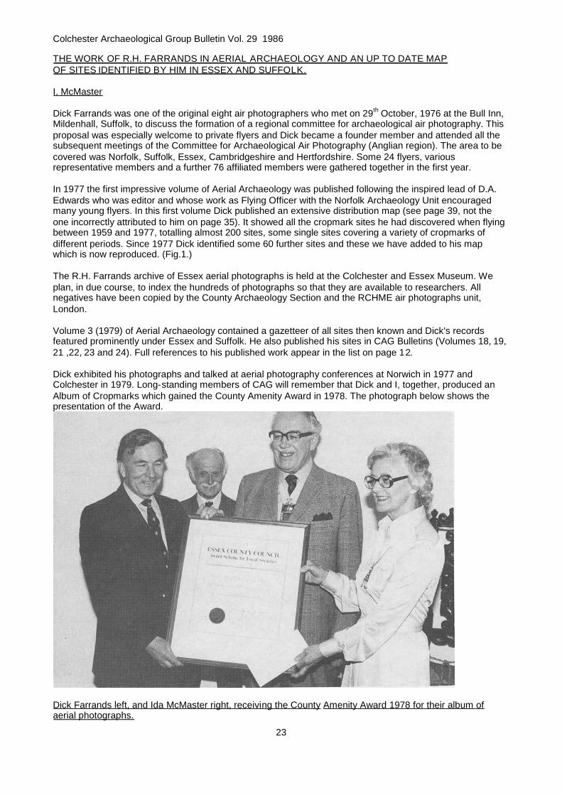
Dick exhibited his photographs and talked at aerial photography conferences at Norwich in 1977 andColchester in 1979. Long-standing members of CAG will remember that Dick and I, together, produced anAlbum of Cropmarks which gained the County Amenity Award in 1978. The photograph below shows thepresentation of the Award.
Dick Farrands left, and Ida McMaster right, receiving the County Amenity Award 1978 for their album ofaerial photographs.

Colchester Archaeological Group Bulletin Vol. 29 1986
24
Figure 1. Cropmark sites identified by R. H. Farrands 1959-1983

Colchester Archaeological Group Bulletin Vol. 29 1986
25
Dick was a most energetic and original worker and he has left for us a mass of valuable material. Those ofus who saw him towards the end of his life remember his determination to complete his unfinishedarchaeological work. I regard myself as most fortunate in having been able to work with him; I greatly valuedhis help and much appreciated his expertise which he so readily shared; I still miss his wise counsel.
THE CONTRIBUTION OF R.H.FARRANDS
No reader needs to be reminded of the immense importance of the County's archaeological heritage. Theformation of an Archaeology Section within the County Council's Planning Department in the early 1970swas an acknowledgement of this and a commitment to make provision for its preservation and recording ona county basis. These policies, and their successful implementation, ultimately result from the dedicated anduntiring fieldwork of archaeologists such as Dick Farrands. Without his keen observation many sites wouldhave been destroyed unrecorded, whilst his fieldwork, particularly his aerial photography, played a major partin re-assessing the County's past in terms of "landscape archaeology". The Archaeology Section will alwaysbe dependent on fieldworkers like Dick, with infectious enthusiasm. We have a great deal to thank him forand to remember him by.
David Buckley, County Archaeologist
Colchester Archaeological Group Bulletin Vol. 29 1986
26
THE TECHNOLOGY OF SALT MAKING AND THE RED HILLS. A SURVEY OF ANANCIENT INDUSTRY.
A.J. Fawn
"The mounds consist of a reddish, porous earth, like disintegrated brick, mixed, in some places freely, withbroken pottery of the rudest type, wood charcoal or cinders, and clinkers." Henry Stopes, the first systematicinvestigator, wrote this description in the second of his two papers on the Red Hills (1879, 1884), curiousmounds distributed along the coastal marshland of Essex.
In this century others have published papers describing excavations and discussing results. The local RedHills are covered by Francis Reader (1908, 1910, 1911), who directed the series of excavations initiated bythe Red Hills Exploration Committee, by our past secretary, the late Kay de Brisay (1972, 1973, 1974, 1976,1978, 1978, 1979, 1979) and by another Group member, Dr. Warwick Rodwell, who excavated Hills in thesouth of the county and published a comprehensive review (1979).
While assisting in the preparation of the forthcoming Kay de Brisay Memorial Booklet on the Red Hills, Irealised that, from published information, a more speculative article could be written. Previous writers havetended to approach the subject by examining the archaeological evidence but I shall start from a scientificand technological basis to discuss the problems of the Hills. My experience of them is restricted to thosenear Colchester, gained during Mrs. de Brisay's excavations.
Twelve years ago all our members must have been aware of Red Hills. Now, there will be many who areentirely ignorant of them and therefore I make no apology in writing for the general reader, making use offamiliar material and endeavouring to render science comprehensible and palatable to the non-scientist. Ishould say that I am a physicist who has spent his working life in the plastics industry, which leaves me withpoor qualifications for expounding, as I do here, on chemistry, geology, ceramics, history and economics, notto mention archaeology.
We must start with the generally accepted origin of the Hills and declare that they are the remains of anancient industry for the extraction of salt from sea-water by evaporation, using artificial heat, i.e. not solar, atsome stage. There is no positive proof of this but there must be few people who favour an alternativenowadays. The industry flourished in the Late Iron Age and Romano-British period and recent evidencesuggests that it may have been in existence as early as the Middle Bronze Age. (Wilkinson and Murphy,1983, 1984, 1986).
Stopes was a good observer and his articles contain much information which is still pertinent today. Hedescribes the Hills as ranging in area from half an acre to thirty acres, and in depth from two to four and ahalf feet. (Thirty acres must be unique or an exaggeration, as discussed later.) He comments that they arenumerous. Archaeologists have been counting them ever since and 298 are listed in the forthcomingMemorial Booklet. He speculates on their age, bearing in mind that their lowest strata rest on London clayone or two metres below the surface of the alluvium. He comments on the coarse pottery fragments nowknown as briquetage and provides a map of local Hills.
He is non-committal about the suggestion of his contemporary, the Rev. J.C. Atkinson (1880), that the Hillsare the relics of salt-works, although he lived until the early 1900s and may have reached that conclusion inhis later years, unrecorded by him as far as I know. However, he does, as an F.G.S., remark on their greatage from his knowledge of the development of marine marshes and we shall start with this aspect.
The Environment of the Red Hills
"They lie, as a rule, just above the average high-water mark, or its level, where the saltings have beeninclosed, as, after conversion into marshes, the saltings always shrink, chiefly from loss of water, to muchbelow their original level." (1884, p.97). Stopes went on to describe how the saltings were formed becausehe realised that it was relevant to the appearance of the Hills and a further explanation will be given here,drawn from more modern sources (1969).
Saltings are areas of land between the range of high water at spring and neap tides respectively. (SeeAppendix 1). Alluvium is solid material which has been conveyed in suspension in currents of water anddeposited in areas where the current flows sufficiently slowly to allow settlement. Thus the saltings of theColne and Blackwater estuaries are largely covered by mud which is alluvium brought by the sea from the

Colchester Archaeological Group Bulletin Vol. 29 1986
27
cliffs of Clacton, Frinton and Walton or even further north, mixed , no doubt, with material from the riversthemselves and deposited to form a layer one or two metres thick in the vicinity of the Hills.
This deposit is a recent one geologically speaking, formed as a result of the sea rising relative to the landsince the last glaciation some twenty thousand years ago. It is estimated that the melting of the ice hasresulted in a rise of 60 metres or more, breaking the land-link between England and the Continent andbeginning the development of the present North Sea in 7500-5500 B.C. At first the rise was rapid, perhapstwo metres per century, but since about 5000 B.C, the average is estimated to have been less than 13-16cms. per century although it will have varied according to locality (1972). In this period there have beenreversals or regressions, i.e. relative sea level falling, as will be discussed later, but the main trend has beenupwards.
The alluvium in the vicinity of the Hills rests on London clay, just as the Hills do. When the tide is out the claymay be seen at the bottom of some of the creeks on Langenhoe Marsh and, unlike the alluvium, it is firmenough to stand on without undue sinking. It was laid down about fifty million years ago and, although it hasbeen redistributed by comparatively recent glacial action, its interface with the alluvium represents a mostuseful difference in time for archaeology.
Mersea Island is an outcrop of the clay, overlaid with gravel. Stopes suggested (1884. p,97) that the Islandwas formerly a peninsula with a land bridge across the present Colne estuary and that the river then flowedround the back of the Island, eroding the channels of the Pyefleet and the Strood in the London clay beforejoining the Blackwater. Eventually, with the rising sea level, the water broke through and the peninsulabecame an island. He does not suggest a date for this - and I cannot find any later information, butpresumably it occurred after 5500 B.C., and was probably considerably later.
Before it was covered by the rising water, the surface of the land which was to become the Langenhoe,Peldon and Tollesbury marshes must have sloped gently down to the sea as did the London clay not farbeneath its surface. It is suggested that the sea then had more power without the presence of the impedingalluvium and was able to disperse the thin layer of surface material above the clay before starting to laydown the deposit of alluvium.
As the sea slowly rose and the water transgressed further inland, the alluvium settled to a level which wasgenerally slightly below the mean spring high water level. Obviously the marsh could not grow higher thanthe water which was creating it. Some of the existing creeks are man-made or stream-created but the patternof the others was formed long ago when the alluvium was first deposited, corresponding to the drainage ofthe tide. The pattern was made stable by the growth of salt-water plants which encouraged further depositsof alluvium by trapping solid particles from the water. Thus the alluvium grew around the creeks rather thanthe creeks being the result of erosion of the alluvium as first consideration might suggest.
As the sea's transgression continued, the alluvium grew in area as well as thickness. The oldest and thickestdeposit would have tended to be to seaward and the youngest would have been to landward as a relativelythin layer. However, the situation would have also depended on the currents at any given locality. Forexample, river flow or flooding might have washed away alluvium again.
Having dealt at sane length with the physiography of the marshes we shall now look at the setting of thelocal Red Hills.
The Development of the Hills
Nobody with any sense would start an operation involving fire on ground covered by a tide every twelvehours. Logically the first fire for evaporation must have been lit on dry land out of reach of at least all but thehighest tides but near enough to the normal high tide level for sea-water to be easily accessible. As Stopessays, "just above the average high-water mark", but whether he meant the modern mark or the ancient markis not clear. We can postulate that the ground surface was then London clay or a superficial layer on Londonclay. There salt was made for a considerable number of years and, as successive pottery boiling vessels,equipment and fired clay hearths disintegrated, the debris was piled up in heaps, on the London claysurface. The debris would give a better purchase for the feet than the clay and would become a convenientlydry island at exceptionally high tides. Therefore, replacement hearths were built on top of the heaps. Thesites would be abandoned in favour of others further inland when the salt-makers became disenchanted withhaving to paddle ashore in water at high tide or in the growing mud at low.

Colchester Archaeological Group Bulletin Vol. 29 1986
28
This imaginative picture suggests that the more accessible Hills, near or on the ancient shore and behind asea-wall, are the later ones and that the earlier examples, perhaps from the Bronze Age even, lie under thealluvium to seaward or have been washed away.
We, therefore, have a picture of a mound building up into a Red Hill and the water rising gradually around it.However, the sea level probably did not rise very far during the active life of a Hill and, indeed, may havefallen on occasion. We have mentioned one estimate of average rise as being less than 16 cms. per century.If the active life of a Hill was a century or even two or three centuries, the salt-makers were unlikely to havebeen unduly concerned by the resultant increase in depth of water and the alluvium brought with it. Theoccasional high spring tide and the less frequent storm surges like the disaster of 1953 would have beenmore troublesome, although the operating units, to use modern jargon, were the sort of industrial plant whichcould be replaced easily and no doubt were, in spring at least.
There is evidence of regressions, i.e. falls in relative sea level, around 1300 B.C. and A.D. 300-500. Thesecond regression is of interest because it occurs in a period when the Red Hills are thought to have goneout of use. Reader reported (1908 p.169) evidence of cultivation in the form of narrow stretches on thesurface of a Langenhoe Hill and these may have resulted from ploughing at this time when the disusedmounds were left high and dry.
The thickness of alluvium at the "wet" sites (i.e. to the seaward of the modern sea-wall) at Peldon (de Brisay1974) and Tollesbury (de Brisay 1979) was found to vary from 1.0 to 1.3 metres. The thickness at the "dry"site (i.e. to the landward of the sea-wall) at Osea Road,(de Brisay 1972) where no further marine accretionhas occurred since the building of the wall but where agriculture may have altered levels, was about 1.0 to1.5 metres. Reader's sites, all dry, showed a variation of 0.8 to 1.8 metres. Assuming a sea-level rise of 9cms. per century and an age for the sea-wall of four centuries, we arrive at a range of 11 to 23 centuries forthe age of the Hills. Now this calculation is a very approximate one, based on not a few assumptions, andthe wide range is an indication of this. Nevertheless, it is not inconsistent with the view that the alluvium hasgrown up since the formation of the Hills and indeed since they went out of use.
Some Scientific Aspects of Salt
Most people will know that sodium chloride is the chemical name for the substance commonly known as salt.However, the chemist uses the term "salt" for a member of a numerous range of substances which arechemical compounds of acids and bases. In this section we must use the chemical terminology to reduceconfusion to a minimum and trust that the reader will be able to follow without too much difficulty.
Sea water contains not only sodium chloride but also a large number of other salts, most of them in verysmall quantities. However, some are present in significant amounts and an analysis of the main constituentsis given in Appendix 2 which has two columns of percentages. The first are the amounts by weight of themain salts in 100 gms. of water and the second are the weights of the individual salts expressed as apercentage of the total weight of salts.
Thus, we can see from the first column that the total amount of salts in sea-water is about 3.5%, and that theamount of sodium chloride is 2.7%. The salts appear in the table in order of increasing solubility. As sea-water is evaporated, the least soluble, calcium carbonate and calcium sulphate, come out of solution first.They are the main components of the hardness of fresh water and form the fur inside a kettle. In a brineevaporating pan they deposit on the sides and bottom and are called pan-scale.
When about 90% of the sea-water has evaporated, sodium chloride starts to crystallise out and, to quote the17th century diarist Celia Fiennes, "it candy's about the edges or bottom". (1984. p. 70).
Finally, when about 97% of the water has evaporated, the remaining salts, magnesium sulphate, potassiumchloride and magnesium chloride crystallise out. Magnesium chloride has a bitter taste and consequently, inthe industry, the solution containing the three salts is known as the bittern.
To summarise, the complete evaporation of sea-water to dryness will produce a residue of pan-scale,sodium chloride and bittern solids.
In addition to the soluble salts sea-water contains insoluble substances in varying quantities, such as animaland vegetable matter, living or dead, and minerals, sand, clay and mud. Evaporation concentrates theinsolubles as well as the solubles (1% in sea-water will become about one third of the weight of salts in the

Colchester Archaeological Group Bulletin Vol. 29 1986
29
finished product) and the salt maker normally has to take steps to remove them by filtration or settling.
Sodium chloride is a deliquescent solid and, in an atmosphere above 75% humidity, will absorb moisture tothe extent that it goes into solution so that the crystals become not merely damp but wet. The bittern salt,magnesium chloride, does the same at the even lower humidity of 35% so that, if present, it adds to thewetness. A humidity of 75% is not uncommon in this country, making artificial drying of the product, removalof as much of the bittern as possible and, nowadays, incorporation of an additive to maintain the dryness,desirable.
Scale of the Industry
Dr. Rodwell (1979) points out that the Essex ancient salt industry must have been of surprising magnitudejudging by the size and number of the Red Hills. We are used to thinking of salt as pinches on our plates orin cooking (or perhaps none at all in our health-conscious age!) and a few remarks about the size of theindustry, going backwards from modern times to Domesday may put matters in perspective.
World production in 1958 was 82 million tons. 28 million tons were produced by solar evaporation and therest by brine extraction, rock salt mining and vacuum pan evaporation (the modern thermally efficientmethod). The bulk was used for production of chemicals and only 3% was used for culinary purposes, about2.5 million tons.
It is manufactured by the open pan process, now obsolete in developed countries, which is of interest to ussince it appears to be the direct descendant of the Red Hill operation. It is still used at Maldon and at theLion Works, Northwich, which is run as a working museum, producing commercially. Prior to the introductionof the vacuum pan it was the principal method of making salt by artificial heat for centuries. In Cheshire andWorcestershire large quantities of refined salt were produced by heating natural strong brines from wells inlarge iron pans, which ultimately reached 200 square metres and more in area.
It is interesting to note the effect of the growth of population and of the chemical industry on salt production.In 1887, output was 1.8 million tons from Cheshire, 250,000 tons from Worcestershire and a modest 5,800tons from Staffordshire. In 1823, Cheshire produced 300,000 tons and in 1798 shipped 200,000 tons throughLiverpool, mainly to the east coast of America for the fisheries there. Cheshire rock salt was also shipped toColchester and other East Coast ports in this period for refining by dissolving in sea-water and re-evaporating in open pans.
Information on mediaeval production is scanty and fragmented. Over-production was often a problem andsome form of control by authority or agreement was exercised to maintain the price for many centuries. Afigure of 1,600 tons a year is mentioned for Droitwich, reducing to about 225 tons a year at the time ofDomesday. No figure for Cheshire is to hand. In the late 14th century it is suggested that 200-500 tons wereannually imported from the Continent, mainly "bay salt" from the solar pans in the Bay of Bourgneuf justsouth of Brittany. These early figures are comparable with the estimated production from Red Hills given inAppendix 3.
The Technology of the Salt Industry
We shall now discuss the open pan method and the solar evaporation method in relation to the scientificinformation on sea-water given earlier.
Basically, the open pan method was simple. A solution of salt was heated to evaporate the water freely in alarge flat pan open to the atmosphere, but often beneath a roof to prevent dilution by rain. The largest 20th
century pans in Cheshire were 25 feet wide, to suit the largest rake a salt-worker could handle, and up to140 feet long with a one foot depth of water. Hot gases from coal fires at the front passed through brickworkflues running under the length of the tanks, then under the floor of an adjacent hot house before venting via achimney.
Unlike sea-water, inland brines are nearly saturated with salt and so there was no large volume of water toevaporate (90% of sea-water as stated previously) before the salts started to crystallise out. First the panscale deposited over the hottest parts of the pan near the fires. Then the sodium chloride crystallised out andwas raked and scooped from the pan into suitable vessels for draining. As the evaporation continued more

Colchester Archaeological Group Bulletin Vol. 29 1986
30
brine was fed in to maintain the level and the operation ran continuously for a working week and sometimeslonger depending on the type of salt being produced.
At weekends the pan was allowed to cool and was drained, thus removing the bittern. The layer of pan scalewas broken up and shovelled out, leaving the pan ready for re-filling, re-heating and another week'soperation.
The following points should be noted from this brief summary as having a possible bearing on operations atRed Hills.
First, the pan was not evaporated to dryness, thus avoiding the danger of "burning" the salt, which spoiledthe flavour, and the difficulty of controlling the fire in the final stages of complete evaporation.
Secondly, the removal of the sodium chloride from the pan before the bittern salts began to crystalliseimproved the flavour and reduced the tendency to absorb moisture. These properties were further enhancedby the subsequent draining which removed more bittern. Up to 1900 the wet salt was often drained in conicalwicker baskets called barrows, a practice used for many centuries.
Thirdly, the grain size of the salt was controlled by the rate of heating. The lower the evaporationtemperature, the larger the crystals of salt, so that certain types such as fishery, requiring large grain salt,were made at about 50° C without boiling. On the other hand, higher temperatures and boiling did not allowlarge crystals to form, producing a fine salt suitable for the table.
Fourthly, the salt was dried in the hot house to make it as free-flowing as possible before packing.Nowadays, table salt usually contains an additive to maintain free-flowing properties and plastic packinghelps to keep it dry.
Information on salt-making in the 17th century is provided by Brownrigg (1748) and in the 16 th century byGeorgius Agricola in De Re Metallica. The latter's drawing of an open pan shows the familiar rectangular irontank; albeit considerably smaller in size than the 20th century version, (perhaps 10 ft, by 5 ft by 1 ft) set on asingle brickwork flue with the fire at the front. The fuel was wood instead of coal. Conical wicker basketswere used for draining, positioned over the pan so that the drainings were recycled immediately. Nearby wasa large wooden tank evidently used for the storage of brine prior to evaporation, a feature which will appearsignificant during the later discussion of the Hills.
It was the introduction of coal for fuel instead of wood, with consequent higher temperatures, thatencouraged the adoption of iron for pans. According to Celia Fiennes (1984, p.70) copper was used in the17th century at Lymington, Hampshire, where sea-water was partially evaporated in ponds by solar heat andthen boiled in pans.
The Romans introduced lead pans which continued until the end of the mediaeval period. Lead wasrelatively easily fashioned and was resistant to corrosion. If the pan boiled dry accidentally and melted, themetal could be salvaged and reused.
Incomplete surviving Roman lead pans at Middlewich and Northwich (Salt Museum) are about 15 cms. deepby 50 cms. width or length which is about the postulated size for briquetage pans from Red Hills. Theintroduction of lead pans, in Cheshire and elsewhere, must have been a considerable advance technicallybecause the thermal conductivity of the metal is about thirty times that of pottery and thus substantialsavings in fuel would have been achieved especially since the vessel walls could have been made thinnerwithout losing strength. In addition lead pans would better withstand the stresses of heating and accidentalknocks.
Sea-water is wholly evaporated by the heat of the sun to produce salt in many hot countries (Kaufmann1960, Bloch 1976). Modern sun-pans are often very large, 250 hectares or more, and shallow, a fewcentimetres, relying on the principle that efficient radiation heat transfer and evaporation demand maximumarea and minimum depth of water. The pans, on prepared flat land bordering the sea, are dividedinto connecting sections, the areas of which decrease in sequence as the concentration of the evaporatingsea-water increases. Thus, the first section may be for settling and concentration, the second for depositionof calcium salts equivalent to pan scale and the third for crystallisation of salt with a well-prepared slopingbottom to facilitate eventual drainage of bittern.

Colchester Archaeological Group Bulletin Vol. 29 1986
31
Successive pans are usually set below the preceding one so that the water flows through the system bygravity subject to control by sluices. When sufficient salt has crystallised, the bittern is drained off and theproduct is raked into heaps before removal for washing and drying.
Solar evaporation was practised in this country as far north as Scotland (Clow and Clow 1952 p.51) in thepost-mediaeval period but it seems to have been used mainly, if not completely, for concentration only in ouruncertain climate and the process was completed with the aid of fire. A broad-sheet published by a Societieof Saltmakers in the reign of Charles I pleaded that its method by "Salt-Water and Fire" was "certain"compared with that making "by the sun" since the latter "depended on hot and dry weather" and this musthave been a well-founded statement. Solar concentration was used at Lymington (Fiennes 1984, p.69; Cross1965). A photograph of sun-works at Sutton-on-Sea appears in "Salt" (Rudkin 1975) and these wereapparently used for concentration. Another site in Kent is reported with a photograph showing similarfeatures (Eddison 1983).
With an inadequate excursion into the general field of salt production we will return to the Red Hills and willproceed to speculate on their nature.
The Red Hills
The first point is their size. Stopes estimated their area rather than surveyed them. He says that the majorityrange from half an acre to five acres or more. This is in reasonable agreement with the ones which havebeen measured in conjunction with excavation to give some idea of their limits. The largest of these isReader's Goldhanger X, approximately four acres. Stopes mentions a thirty-acre giant (1879, p.1; 1884,p.98) which may be the same as Laver's 26 acre specimen (Reader 1908, p.189) but neither gives alocation.
It may be difficult to delimit a Hill because the material has been dispersed by the sea and by agriculturalactivities. An eye-witness of the 1953 storm surge described the normally sheltered tidal area behind MerseaIsland as being like the open sea and such floods, unrestrained by sea-walls and alluvium for centuries,would sweep over the Hills, redistribute their surface material and significantly modify their shape. Whencultivation followed the building of the sea-walls, much red earth, as Stopes reported (1884, p.98), wasremoved for lightening heavy clay soils on local farms. A small quantity of ground briquetage mixed withalluvium gives a good imitation of the red fringes of a Hill and demonstrates that dispersal by sea andagriculture may have made the Hills look bigger in area than they were originally. The Peldon Hill hadoutskirts of red alluvium and not original red earth. The general redistribution will have disturbed the internalstructure of the Hills and it is no wonder that excavators are usually disappointed with their findings.
Using Henry Laver's estimate of the volume of his 26 acre Hill, Dr. Rodwell has calculated that the output ofsalt from it was about 150 cu. m. per year, equivalent to a 5 metre cube and sufficient to supply the needs ofthe Trinovantian area, roughly the size of Essex. Although the size of the Laver Hill is unconfirmed, and onecannot help suspecting that it was over-estimated, owing to the reasons given above, Dr. Rodwell'sconclusion is not invalidated for the assumed output can easily be transferred to other Hills. Appendix 3gives further estimates based on population assumptions showing an even higher demand than Dr.Rodwell's figure which is equivalent to 220 tons per year. In Appendix 4 the estimates of 179 to 718 tons peryear are related to the number of hearths required which is not inconsistent with the number of known Hills.The figures are a further confirmation that the industry was substantial, giving rise to appreciable activity at aminimum of 50 hearths at any time.
When a Hill, Reader's Goldhanger X, was flattened in the 1960s, two sets of three clay-lined pits wereobserved, sunk into the red earth of the Hill. Mrs. de Brisay excavated five more sets at Osea Road(1972,1973) and others at Peldon (1974,1978) which were more or less oval in plan with diameters rangingfrom about one to two metres and depths of down to just over a metre. The lining, about 10-20 cms. thick,was the colour of London clay and cracked readily on drying out after excavation.
The pits obviously functioned as tanks. The Peldon tanks were close to the hearth found there and it islogical that the contents were used to feed the evaporating vessels on the hearth. No definite hearths werefound at Osea Road so that the link between hearths and tanks could not be confirmed there.
We must remember that the high tide approached the Hills once every twelve hours and that in between thesea retreated into the far distance as it does today. We may postulate that the tanks were used for storingsea-water near the hearths between high tides. They had sufficient capacity. Appendix 4 gives the

Colchester Archaeological Group Bulletin Vol. 29 1986
32
evaporation rates of the Peldon hearth at various temperatures and at the maximum, boiling, the calculatedrate is 43.2 litres per hour or just over 1,000 litres per 24 hours. Many of the tanks excavated by Mrs. deBrisay were heavily eroded but the deeper ones were presumably closer to the original size and had acapacity still exceeding 1,000 litres. It appears, therefore, that the capacity was adequate for the postulatedevaporation rate.
The fact that they were found in sets of three or more is reminiscent of practice in a modern industrialprocess wherein, at any given time, one tank is being cleaned and used for collecting a liquid, a second isbeing used for settling it and a third is feeding the settled liquid into the next stage in the process. Each tanktakes its turn in the sequence. Additional tanks may be introduced to cope with any bottleneck in the flow. Atthe Red Hills, one tank would be cleaned and filled quickly at high tide, a second would be settling and athird would be feeding the vessels.
Mrs. de Brisay reported (1973. p.22) that it took about eight weeks to evaporate the bulk of a pint of sea-water on a south-facing window ledge. I repeated the experiment in the poor August and September of 1986,evaporating water from a Strood creek in a shallow dish in the open air on my south-facing garage roof. Theevaporation rate as measured by the fall in level during 24 hours varied from 2.2 mm. on a cold day to 4.4mm. on a hot day, when the water temperature rose to 27°C. The latter fall is on a par with average valuesfor the Mediterranean and California of about 5 mm. per 24 hours and must represent about the maximumwhich can be achieved by natural evaporation in this country. However, it is small compared with the rate ofover 6 cm. per 24 hours in a heated pan at 50-55°C. and negligible compared with the 25 cm. per 24 hours at80-85°C. and 108 cm. per 24 hours at boiling. (The rate at boiling depends on how fast the water is boiled butthe figure given indicates the order of magnitude). Natural loss in the clay tanks might have made acontribution to the evaporation if large crystals were being made at vessel temperatures of about 50°c, butwould have been of little value if higher vessel temperatures were used. One concludes that the functions ofthe tanks were storage and settling.
The tendency of London clay to crack on drying out has been noted and it may be that the salt-makers back-filled the tanks in the winter close season in order to prevent their deterioration. I remember looking carefullyat the sectioned fills of the tanks at Osea Road for evidence of settling deposit and seeing nothing butuniform red earth. The sea may have introduced this, of course, but deliberate filling is a possibility.
We now turn to the problem which has intrigued past investigators, the nature of the hearths, the hearthfurniture and the vessels, all of which, it is generally assumed, contributed to the debris, that is the red earthand the briquetage found in the Hills. The problem arises because it is only the debris that is found andreconstruction of the equipment and methods used in the process is, therefore, a matter of guesswork. In thetradition of previous writings on the subject, what follows is mainly speculation, based to some extent onwhat has been stated in previous sections above.
We have already distinguished three operations involving heat which would have been associated with salt-making. These are the manufacture of the equipment, some of which had to be pre-fired at high temperature,the evaporation of the sea-water, and the drying of the wet salt. All three could have produced material asfound in the Hills; the red earth, the briquetage, the charcoal and the clinkers. However, convincing evidencethat the equipment was made at the Hills is lacking and the possibility that it was made at inland sites andtransported to the salterns should be borne in mind. The drying stage may also have been carried outelsewhere. As the salt, once dried, would have tended to become damp again, it may have been distributedin the moist state after draining and the customer then dried it, according to requirements, in front of thedomestic fire. Again, an open mind is best until more evidence is available. The practice may well havediffered from Hill to Hill.
In an appendix to Reader's first report (1908, p.182) Jenkins gave details of analyses intended to determinethe sources of the materials in Hills and briquetage which would have thrown light on the above problems.Unfortunately, the results did not permit definite conclusions, mainly because the selection and identificationof the samples was unsatisfactory. The questions still to be answered by a modern analysis are; is thebriquetage made from London clay or alluvium on site or from another clay source? Are the various types ofbriquetage all made from the same clay source? Is the red earth burnt London clay or burnt alluvium or burntearth, perhaps turves, from another source? Jenkins' analysis shows one interesting result, the high ironoxide content of the briquetage and some of the clays, which would account for the particular redness of theHills, compared with the colour of salt sites elsewhere, Lincolnshire for example.
The types of briquetage found are vessel fragments, other flat fragments which may or may not be parts of

Colchester Archaeological Group Bulletin Vol. 29 1986
33
vessels, pedestals, firebars, wedges and "pinch-props". They form a group of artefacts which has puzzledinvestigators since Stopes' time and I must say, forthwith, that I am similarly mystified although I shall makea few observations which I have not found elsewhere. In making them I shall assume that the Red Hilloperation was the precursor of the open-pan process; evaporation in open vessels, removal of thecrystallised salt to drain and drying of the product.
Enough fragments of vessels have been found (a good selection is stored in the Colchester and EssexMuseum) to indicate that the size postulated in Appendix 4, 80 x 30 x 15 cu. cm., is reasonable. However,there is no suggestion that they were uniform in size or shape. Several large sherds collected by Mrs. deBrisay appear to be parts of vessels with splayed sides, some circular rather than rectangular, which may begreater in volume than the size postulated. It may be that some evaporating units operated with one largevessel instead of multiple pans. The splayed sides would have made assembly of multiples over a hearth alittle more difficult. Stopes remarked on a sherd belonging to a vessel "at least two feet in diameter" (1884,p.102). Many fragments show off-white coatings on one or both sides. On the inside of a pan one wouldexpect to find pan-scale. On the outside one may find a greyish coating from reaction between clay andwood ash from the fire, a form of over-firing found in flues of kilns. Many sherds may have received theircoatings after breakage since they would have been lying on site exposed to further accidental firing andboth sides may exhibit the ash-clay reaction.
Some sherds are free of coatings, display a good red colour, have a firm fabric and no signs of over-firing.They may be associated with a different part of the process, perhaps the drying stage which would not haverequired high temperatures.
Mrs. de Brisay found a pedestal at Osea Road (1972, p.33) near enough complete to show that the form wasa round pillar, with a height up to 30 cm, a round or square base and a top which she described as boat-shaped, that is, like the T-shaped handle of a spade but with roughly flattened upper surface. She also founda pedestal with its base fixed to a flat surface (ibid) with wet clay which had become fired in use so that thepillar must have stood vertically and could have been one of a number supporting a vessel. A parallel is to befound in pottery kiln furniture and reported early examples are from the Holt Roman tile and pottery kiln site(Grimes 1930) where they were similarly fixed to the floor with clay. They had triple-pronged tops to givethree-point support for pottery vessels being fired. With T-shaped tops three pedestals would have beenrequired to support an evaporating vessel and four would have provided greater stability, provided claypacking ("pinch-props") was placed between pedestal and vessel as required.
Most of the pedestals in the Museum show evidence of over-firing, having an off-white coating and adisintegrating fabric, which suggests that they operated in flue conditions. The bases often have a purplishtinge, also evidence of over-firing.
The remains of the local hearths that have been found, Late Iron Age ones at Peldon (de Brisay 1978) andTollesbury (de Brisay 1978) and a Middle Bronze Age specimen at Fenn Creek on the Crouch (Wilkinson etal 1983, 1984, 1986) are of sufficient size to make feasible the production calculations given in Appendix 4but do not enable a satisfactory reconstruction of the use of hearths and pedestals to be made. The originaldrawing for vessels poised on pedestals was that of Riehm (1961). His reconstruction, based onSwinnerton's excavation at Ingoldmells (1932), shows 48 pedestals supporting four vessels on a moderatesized hearth which could take seven, inferring that the full complement of pedestals may have been as manyas 84, a number which leaves little room for a fire. Thus, the drawing does point to the idea that the hearthswere flues since even a smaller number of pedestals would have made feeding of fuel under the vesseldifficult. Instead, as in the mediaeval system, fires might have been lit in front of the vessels, and the hotgases drawn underneath them past the pedestals and up through a chimney to provide the draught. Fluesmust have walls to direct the draught and evidence of these was found at the three Essex sites and atIngoldmells. At Peldon the hearth/flue floor was below the contemporary ground level as indicated by therims of the clay tanks, suggesting that the common-sense practice of sinking the flue into the ground, herered earth, was used. Dr. Rodwell (1982) has discussed evidence that simple pottery kilns were already inuse at the time of the Roman conquest and, if so, the salt-makers of the period would have been familiar withthe advantages of the flue which would have allowed the fire to be moved from under the vessels to oneside. Control of the firing would have become easier, access to vessels improved and the contamination ofvessel contents by smoke, smuts and ash reduced.
Mrs. de Brisay found but one pedestal at Peldon and suggested that firebars resting on hearth/flue wallswere used to support vessels instead. Excavated fragments of firebars show that they were fired bars ofclay, usually rectangular in cross-section, thicker in the middle than at the ends so that the side view is that

Colchester Archaeological Group Bulletin Vol. 29 1986
34
of a low triangle. It is generally assumed that they acted as beams to support vessels and, if so, the term"firebar" given to them by the Red Hills Committee is a misnomer, for the O.E.D, defines a firebar as one ofthe iron bars of a grate, that is, it supports a fire; perhaps support bar would be a better term.
The lengths of the bars, deduced from the incomplete specimens in the Museum, vary from about 20-40 cm.and are too short to span the Peldon, Tollesbury and Fenn Creek hearth/flues without intermediate supports.
It is possible that a central prop such as a pedestal in the centre of the hearth was used in conjunction withpairs of the longest bars, the ends of which would have had to have rested on the rather weak arms of theTs. A use for the smaller bars then has to be decided, for small hearths perhaps?
Similar bars are found in Romano-British kilns for supporting pottery but not all of them have the distinctivetriangular shape of the Red Hill variety. A modern engineer would approve the shape since it puts thestrength where it is needed, in the middle, but early salt-makers had no knowledge of the theory of beamsand it is strange that they went to the trouble of making such a shape when a parallel-sided beam ofadequate thickness would have done equally well for supporting evaporating vessels which formed anevenly distributed load. One should perhaps look for explanations and here are some suggestions.
It is normally assumed that the bars were used apex downwards so that the flat upper surface provided agood seating for the vessels but if they were set apex upwards the vessels would have rested almost onpoint contact, allowing the flue gases to circulate more freely under the vessel and give better heat transfer.Because the weight of the vessels and sea-water (my estimate is about 60-70 kg.) would have placed greatstress at the point of contact, even though it was the thickest part of the beam, the apex was often trimmedoff to provide some degree of load distribution. This suggestion implies that each vessel rested on anarrangement of four bars. It also implies that the salt-makers were quite good at finding practical solutions tothe problem of breaking firebars. It is interesting to note that, at an inland Roman site, Middlewich, there isdirect evidence that bars were used convex surfaces uppermost (Bestwick 1975).
The ends of bars were usually cut off square and this was probably because thin pointed ends would havebeen the weakest parts of the beam. Although cutting off the weak parts shortened the bar, what was leftwas *a stronger beam. This feature tends to confirm the assumption that bars were used as beamssupported at the ends.
Reader commented on the friable nature of the briquetage from the Hill, Goldhanger X, (1884, p.175)attributing it to the sand in the clay used. Later writers have tended to emphasise this whereas examinationof the material from various sites in the Museum shows that the fabric is sometimes of very respectablehardness, at least equivalent to a decent brick. Mention has been made of some vessel sherds with a goodred colour, firm fabric and no sign of over-firing. The majority of firebars have a similar quality, with theexception of those from Goldhanger 10, which are all friable, and it is tempting to link the two types ofbriquetage to a low temperature part of the process. For example, if the supposed vessel sherds which areflat, fairly thin and sometimes have two made edges at right-angles were tiles, they might have been laid onthe slopes of the triangular bars resting, apex uppermost, over collecting vessels, in sets so that theyresembled a series of pitched roofs. Wet salt scooped from the evaporating vessels could then have beenplaced on the tiles so that the drainings would have trickled down the slopes and fallen through the cracksbetween the tiles into the vessels to be re-used.
Alternatively, the tiles could have been replaced on the bars, apex down, so that they formed a salt-dryingfloor over a low temperature flue. The problem is that no such flue has yet been identified positively althoughsites at Mucking (Jones 1977) and Canvey Point (Johnson 1982) have been suggested.
Compared with other forms of briquetage, wedges are rarely found and, obviously, the salt-making processdid not require many of them. Mrs. de Brisay thought that they might have been inserted in the walls of theflues to act as supports for drying vessels as in Brittany (Wilmer, Appendix to Reader 1908,, p.210) but thealmost complete lack of flues makes this impossible to verify. They are similar to pottery kiln furniture.
The use of "pinch-props" as packing pieces has already been suggested and these indeterminate and oftenbroken items of briquetage were probably also small pieces of clay used as luting to stop up chinks in theevaporation assembly. If the theory that the evaporation vessels formed the top of a flue is correct, certainlythere would have been gaps between them to be closed to conserve heat.
Dr. Rodwell suggested that the superstructure of the hearth/flues incorporated quantities of turf and soil

Colchester Archaeological Group Bulletin Vol. 29 1986
35
which became red earth on being fired. This seems very reasonable and, if the superstructure included achimney, the volume of material would be all the greater.
One of the Hills which Reader excavated, Goldhanger VIII (1910, p.69), was unusual in that it exhibited twolevels of different dates, one on top of the other. The lower, earlier level appeared to be a normal Hill with redearth, briquetage and little pottery, but the upper level contained very little briquetage and a considerablequantity of Romano-British pottery, animal bones and oyster shells, indicating a later occupation during theRoman period. No fewer than seven flues, long and narrow, were found set in pairs cut into the red earth,associated with the upper level. If the flues were used for salt-making (there is no proof that they were,Reader wondered whether they might have been cooking places), some change in technology is indicated.The obvious one is the introduction of lead pans which would account for the lack of briquetage. A singlelarge pan heated by each pair of flues might be beyond the capability of Romano-British technology and aseries of smaller pans, similar in size to the earlier briquetage vessels, resting directly on the fired clay wallsof the flues seems more likely. One flue of each pair may have been used for evaporation and the other fordrying.
At another Hill, Langenhoe III, Reader found a hole in the London clay beneath the red earth of the mound,15 ft. by 10 ft, with a maximum depth of 2 ft. (1908,. p.172). He said that such holes commonly occur in thesaltings, presumably inferring that it was natural. However, one possible use for the hole would be the solarconcentration of the sea-water to produce a strong brine for subsequent artificial evaporation. It is ofreasonable size for a sun-pan and it is in the London clay which is where a pan of that date ought to be.More such pans may lie beneath the alluvium but excavation would be a problem.
In order to control the supply of water to the pan a sea-wall would be necessary. Reader found evidence thatthe sea-wall at Goldhanger VIII was of Roman origin (1910, p.76) so that walls of this date are not unknown.
The above discussion of the Red Hills has centred on local examples because a wider review of salternselsewhere in Essex and further afield would have confused the author - if not the reader. It is evident thatsalt-making methods and equipment varied according to locality even if the principles remained the same. Inaddition to the local differences in briquetage mentioned above, more wide-spread variations are found. Theexample in the recent British Museum exhibition, Archaeology in Britain, was not at all like our coastalmaterial in form or fabric and vessels found at Droitwich (Rees 1986) were tall and circular, shaped like avase. Sane supposed salterns may not be what they seem. For example, Gurney (1982) has indicated thatsome Fenland sites were related to other activities involving hearths. These uncertainties will perhaps beresolved as more sites and artefacts are reported.
Finally, the purpose of this article has been to put forward the idea that the ancient methods of salt-making inEssex resembled more recent techniques in principle. The functioning of the Iron Age equipment and thedetails of the process remain obscure and must await further investigation. I hope this brief review will assistthose who undertake it.
Acknowledgement
I am grateful to the Curator, Mr. D. T-D.Clarke, for the opportunity to examine the Red Hill collection and Mrs.de Brisay's papers in the Colchester and Essex Museum.
References
- Akeroyd A.V. Archaeological and Historical Evidence for Subsidence in Southern Britain. Phil.Trans. R. Soc. London. A 272 (1972) 152-169. 2 Agricola G. De Re Metallica XII 546-55.
- Atkinson J.C. Some Further Notes on the Salting Mounds of Essex. Arch. J. 37 (1880) 196-199.- Bestwick J.D. Romano-British Inland Salting at Middlewich (Salinae) Cheshire. In Salt, p.68 Eds.
de Brisay and Evans, see below.- Bloch M.R. Salt in Human History. Interdisciplinary Science Reviews 1, 4 (1976).- Brownrigg W. The Art of Making Common Salt (1748).- Clow, A. and N.L. The Chemical Revolution. The Batchworth Press, London 1952, p. 51.- Cross D.A.E. The Salt Industry of Lymington. J. Indust. Archaeol. II A (ii) (1965) 86-90.- de Brisay K. Preliminary Report on the Exploration of the Red Hill at Osea Road, Maldon, Essex.
CAG Bulletin 15, (1972) 23-43.

Colchester Archaeological Group Bulletin Vol. 29 1986
36
de Brisay K. A Further Report on the Excavation of the Red Hills at Osea Road, Maldon, Essex.1972. CAG Bulletin 16 (1973) 19-36.de Brisay K. The Excavation of a Red Hill at Peldon, Essex. Report on the First Year. CAGBulletin 17 (1974) 25-42.de Brisay K. and Evans K.A. Salt. The Study of An Ancient Industry. Colchester Archaeol. Group(1975).de Brisay K. Recent Finds from Red Hills. CAG Bulletin 19 (1976) 17-18.de Brisay K. The Excavation of a Red Hill at Peldon, Essex, with notes on some other Sites.Antiq. J. LVIII Pt.1. (1978) 31-60.de Brisay K. A Red Hill at Tollesbury, Essex: Its Background and Excavation. CAG Bulletin 21(1978) 5-10.de Brisay K. The Red Hill at Tollesbury, Final Report. CAG Bulletin 22 (1979) 2-8.de Brisay K. Bonfire Firing. CAG Bulletin 22 (1979) 21-22.
- Eddison J. An Intensive Ditching System in the Wicks, South-East of Lydd. Arch. Cant. XCIX(1983) 273.
- Fiennes, Celia. The Illustrated Journeys of Celia Fiennes. Ed. C. Morris. Macdonald Publishers1984.
- Grimes W.F. Holt, Denbighshire. The Twentieth Legion at Castle Lyons. Y Cymmrodur 41 (1930)182.
- Gurney D. Salt Production in the Roman Fenland. Britannia XIII (1982) 304-305.- Jones M.U. Prehistoric Salt Equipment from a Pit at Mucking, Essex. Ant. J. LVII II (1977) 317-
318.- Johnson P.J. Excavations at Canvey Point. Castle Point Archaeological Group 1982.
Ed. Kaufmann D.W. Sodium Chloride; The Production and Properties of Salt and Brine(American Chem. Soc. Monograph No. 146) 1960 Reinhold N.Y. Chapter
- Reader F.W. Report of the Red Hills Exploration Cttee. Proc. Soc. Ant. Lond. 2s xxii (1908) 164-207. Reader F.W. Report of the Red Hills Exploration Cttee. Proc. Soc. Ant. Lond. 2s xxiii (1910)66-163. Reader F.W. The Red Hills and Salting Mounds of Essex. Proc. Woolwich Ant. Soc. XVI(1911) 28-39.
- Rees H. Ceramic Salt Working Debris from Droitwich. Trans. Worcestershire Archaeol. Soc. 3s10 (1986) 47-54.
- Riehm K. Prehistoric Salt-Boiling. Antiquity XXXV (1961) 181-191.- Rodwell W.J. Iron Age and Roman Salt-Winning on the Essex Coast. Invasion and Response
B.A.R. 73 (1979) 133-175. Rodwell W.J. Production of Pottery and Tiles in the Territory ofTrinovantes. Essex Archaeol. Hist. 3S,14. (1982) 15-76.
- Rudkin E.H. Mediaeval Salt Making in Lincolnshire. In Salt, p.40. Eds. de Brisay K. and EvansK.A, see above.
- Steers J.A. The Coastline of England and Wales, Cambridge University Press, 1969, withAddendum 5, Pethick J. Drainage in Tidal Salt Marshes.
- Stopes H. The Salting Mounds of Essex. Arch J. XXXVI (1879) 369-72.Stopes H. The Salting Mounds of Essex.' Essex Naturalist I. (1884) 96-105.
- Swinnerton H. The Prehistoric Pottery Sites of the Lincolnshire Coast. Antiq. J. XII (1932) 239-53.
- Wilkinson T.J., Murphy P. and Austin T.J.F. The Hullbridge Basin Survey. Interim Report No.4(1983) 1-5 & No.5 (1984) 54.Wilkinson T.J. and Murphy P. Archaeological Survey of an Intertidal Zone: The SubmergedLandscape of the Essex Coast, England. Journal of Field Archaeology (Boston University) 13, 2(1986) 186,187.
Appendix 1
As some land-lubbers are, quite reasonably, unaware of the vagaries of tides, I make no apology for statingthat tides flow in and out approximately twice every 24 hours and that the spring tides are the high oneswhich occur approximately every fortnight, the neaps being the low ones in between. Although high springsoccur in the Spring, they also occur in the Autumn, and the tide's appellation does not derive from that of theequinox.
Appendix 2
Typical Composition of Sea-water in Order of Increasing Solubility.

Colchester Archaeological Group Bulletin Vol. 29 1986
37
Chemical Name Common Name % weiqht in % of totalSea-water Solids
Calcium Carbonate Limestone 0.012 0.34Calcium Sulphate Plaster of Paris 0.126 3.61Sodium Chloride Salt 2.723 77.87Magnesium Sulphate Epsom Salt 0.225 6.43Calcium Chloride 0.077 2.20Magnesium Chloride 0.334 9.55
___________________
Total Salts 3.497 100.00Water and Residuals 96.503
___________________
Grand Total 100,000 100.00
Appendix 3
Estimate of Red Hills Production
Assume that they served an area roughly that of Essex and that the population was 100,000. Recentestimates of Britain's total population in the Roman period vary from 500,000 to 2 million. Salt will have beenconsumed not only at the table and in cooking but also in preserving, tanning and by animals. According toBloch (1976) a reasonable average in antiquity was 20 gms. per day per head, which we will take as amaximum. The body needs about 5 gms. per day which we will take as the minimum.
The estimated requirements for 100,000 people are: Maximum. 100,000 x 20 x 365 gms/year = 718tons/year. Minimum. 100,000 x 5 x 365 gms/year = 179 tons/year.
Appendix 4
Estimate of Total Hearths Required
Assume that a hearth like that at Peldon could take a maximum of four evaporating vessels, interiordimensions 80 cms. x 30 cms. Total evaporation area is 4 x 80 x 30 = 9,600 sq. cms.
The following table gives evaporation rates by experiment and production rates from the above area bycalculation, for 100 day operation, in summer only.
Salt water temperature 50-55C 80-85C BoilingRate of evaporation (level drop, cms/hr.) 0.26 1.05 4.50Rate x 9,600 ( ccs./hr. ) 2496 10080 43200Equivalent salt ( ton/100 days) (3%) 0.18 0.71 3.06
From these tonnages, the numbers of hearths needed to produce the maximum and minimum requirementsgiven in Appendix 3 are:
Salt water temperature 50-55C 80-85C Boiling179 tons/year 994 252 58718 tons/year 3999 1011 234
The number of recorded Hills is just over 280 so that the figures suggest that a fairly high evaporationtemperature was needed to give the output required, on the assumption that the number of hearths inoperation at any given time was unlikely to be more than 100-200.

Colchester Archaeological Group Bulletin Vol. 29 1986
38
WINTER MEETINGS 1985/1986
THE ANGLO-SAXON CEMETERY AT SPONG HILL, NORFOLK 21st October, 1985Catherine Hills, B.A., Ph.D., F.S.A. Department of Archaeology, Downing Street, Cambridge
The multi-period site in the middle of N. Elmham parish, near a Roman Road crossing of the river Wensumwas the first Saxon cemetery to be completely excavated (1972-1981). It was first noted in the early 18 th
century by workmen finding urns. More recently, distinct crop marks were observed. Partly because ofincreasing plough damage, it was decided to excavate.
The cemetery is 5th and 6th century date but finds of all earlier periods occurred. Outside the cemetery werepost holes of huts and larger Saxon buildings. There were probably about 3,000 persons buried. A fewgraves were in discernable round barrows and it is likely many more must have had mounds. Very little bonesurvives. Finds included brooches, amber and glass beads, shield bosses, spear heads and a swordscabbard. Most had pots which may have contained food or drink. Especially interesting was a completebronze bowl and metal fish-shaped mounts from a shield.
Some of the cremations had remains of more than one person in the urn, and there were instances of two ormore urns in one hole.
There was a great variety of pots - decorations included cordons, stamps and linear patterns. A few had linedrawings - one showing dogs or wolves hunting a stag.
Some finds seem to have been burned in the original cremation. Other finds seem to have been buried later.Gaming pieces, miniature shears, etc. were found, but almost no silver. The sites used for the cremationswere not discovered.
Graves with brooches of the early migration period were clustered together. Later pot types were outside thisgroup. Stamps on some were found on more than one pot, showing that some potters had more than onespecimen of their work in the cemetery, and the vessels were similar to those being produced in Germany.
A fine pot lid with a seated man on it was a very unusual find. One stamp impressed a runic inscription.
Inhumations started in the 6 th century and, with the arrival of Christianity in the 7th century, the use of thecemetery was abandoned.
It was observed that the "richest" graves were the mounded ones and the most ambitious ones had satelliteburials.
The most spectacular finds can be seen in Norwich Museum.
AERIAL ARCHAEOLOGY IN THE WELSH MARCHES 28th October, 1985Chris Musson, B.Arch., Clwyd-Powys Archaeological Trust
The impact of aerial archaeology on Great Britain has been much less in Wales than in the rest of theCountry, being chiefly confined to the coast and the midland borders. Great contributions - especially instudying Roman sites - were made by St. Joseph and David Wilson - but Cambridge unfortunately ceasedoperating in Wales about twenty years ago. Regional trusts are now beginning to fill the gap left by thiswithdrawal.
Chris Musson's area extends from Prestatyn in the north to the head of the Swansea valleys in the south.Much of the area consists of deeply eroded pre-Cambrian rocks and, because of geological and climaticfactors, moisture deficiency is not such an important factor as in England. In modern times the Dee, Severnand other valleys have been intensively farmed and much of the archaeology lost.
The Berwyns, however, a divisive range with a harsh landscape, has a vast number of cairns of all types, stillbeing discovered. One pair of cairns revealed not only Bronze Age but Neolithic use, with dwellings. BronzeAge dwellings, outside forts, are almost non-existent so far. In the Clwyd-Powys area 180 pre-historic fortsare now known, ranging from Old Oswestry, which rivals Maiden Castle, to a mass of small ones down to 30metres diameter. Many are multivalate and inturned entrances are typical. Forts are not always on highestsites and may be overlooked from higher ground.

Colchester Archaeological Group Bulletin Vol. 29 1986
39
Among later sites are several Roman marching camps and then Offa's Dyke - here, aerial photography hasrevealed at one part a quarry ditch running by the Dyke.
There are a great many castle sites from the Middle Ages, many now represented only by earth works,though some e.g. Llangollen Castle, constructed in a hill fort, show some stone remaining.
Not much is evident of field boundaries, communications and settlement sites and, what there is, is onlyvisible from the air. One fascinating slide showed early field boundaries, not of ditches, but of a series ofmany pits.
The Iron Age sites produce very little pottery; sometimes fragments of Roman pottery are found on them.Some of the newly discovered sites are being excavated wholly, or in part, to establish their date andpurpose; the Royal Commission in Wales has no way of doing aerial photography to help them produce anadequate catalogue of ancient monuments in the Principality and depends heavily on the Trusts in this task.
THE ROMAN VILLA AT WINTERTON, LINCOLNSHIRE 4th November, 1985Roger Goodburn, B.Sc., F.S.A., Institute of Archaeology, Oxford
The Villa is sited in a fold of the hills not far from the Roman ferry site on the River Humber. The area is inthe midst of a great number of villas and farmsteads.
Over 1,000 villas and Roman farms are known in the United Kingdom but their economic position has beenlittle explored so the excavations at Winterton were dissected to find how their economic position related tothe district they dominated. The 2nd century remains overlie an earlier building with circular features, Iron Agein style, but built in stone by Roman farmstead owners. To the east of this were found 1st century Iron Agepottery and overlapping circular features (timber building).
The main 2nd century villa began as a winged corridor villa with an 'L' shaped bath house in which were lifesize figures painted on plaster. Alterations and additions continued into the 4th century.
The original buildings were added to, to provide a courtyard, roughly rectangular, over 200 feet wide with agatehouse. This yard was metalled and rutted, evidently the villa was a working farm as well as a “countryhouse". (Earlier investigators had found mosaics - not of high quality - showing Ceres and Orpheus).
Two of the added buildings were large aisled halls with stout end walls but long sides of mere infilling. Themassive roofs must have been carried mainly on the posts (in one building resting on stone bases) whichdivided the aisles from the nave. Domestic apartments occupied the corners, farming activities including corndrying kilns in the nave, in one case. The other was for living accommodation and had a bath suite. Thisbuilding had the mosaics referred to previously.
One corn drier had been built on a large scale but evidently was ineffective as it had been repeatedlyreduced in size.
Outside the original "domestic" yard another yard was developed with a 3-post gateway. Here were manycoins and small objects lost in a farmyard mire. A third aisled hall had been used for a cattle byre. Thesehalls resembled the 17th - 19th century farm buildings of northern Europe.
Water supply came from a crude conduit to the house, water holes, and one well set in a 12 foot square, 6foot deep construction. The sides of the well were supported by adze trimmed oak planks, probably from onetree, with a stone lining inside.
A network of ditches and fences occupied one area - timber had been used prodigally. The later days of theVilla showed a turn to animal husbandry. There are hoof marks in alluvial soil. The 20,000 bones recoveredare mainly of deer, sheep and cattle (few pigs).
There were some casual burials and a surprisingly small villa cemetery (5 graves) with no grave goods.Here, burials took place with the head to the east. At some distance was a separate good grave with oolitestone.
Perhaps, because of changing economic conditions, the Villa went into a slow decline, the stone robbed

Colchester Archaeological Group Bulletin Vol. 29 1986
40
away, and other articles carried off so there is a poverty of artifacts left for excavators who have found oxgoads, mattocks, and a 4th century antler hoe.
PHOTOGRAPHY ON THE 1982/1984 EXPEDITION TO QASAR IBRIM 11th November, 1985Tony Bonner, Colchester Archaeological Group
The speaker, over a period of several years, has joined the party excavating the site of the hill town of QasarIbrim, mow on the shore of Lake Nassar. The earliest town was settled in the New Kingdom period andoccupation continued until the early 19th century. Because of the entirely arid climate there, organic mattersurvives of very early date.
Qasar Ibrim is notable as being the most southerly place of Roman building. On the hills "inland" are severaloutposts of a garrison. Finds of the period include many amphora sherds and a pile of stone balista missiles."Tavern Street" has a building decorated with carvings of grapes and of an amphora.
A cathedral existed from the late 8th century together with some tombs of church dignitaries, one of whichhas been opened and contained a body (semi-mummified due to the arid climate). The alignment suggeststhis pre-dated the cathedral.
The site became a place of pilgrimage and the cathedral walls show innumerable scratches where pilgrimsscoured out dust to take away as charms. With the advance of Islam the place became a mosque in 1560.About three miles away are carvings of footprints pointing to the cathedral and considered to be of Meroetictimes.
Betty Crowfoot, the party's fabric expert, had a great range of specimens to consider including some earlysilk, probably from China. So much fabric was found that she could eventually use fabric for dating deposits.Of particular interest was a small container with religious quotations in it. Designed to be used as an amulet,the practice can still be seen in Egypt to this day. The vast number of other organic finds included baskets, acloth hat, mats etc, and, in a pit in a temple, one hundredweight of millet seeds. With Christian burials weretwo bouquets of millet sprays. Our speaker took 3,500 photographs for the expedition and had to resort toingenious methods to produce prints as he had no electricity. He showed slides of prehistoric rock carvingson the opposite side of the Valley of the Nile which proved how - in very early times - the landscape hadbeen much more fertile, for they showed animals which required a much moister climate to allow them toexist.
THE HISTORY OF COLCHESTER ENGINEERING 18th November, 1985Andrew Phillips, B.A., B. Ed., Colchester Institute
In the late 19th century Colchester became celebrated for its engineering. The foundations were laid intrades, such as the millwrights, ancillary to agriculture. 1850 saw the number of windmills at its peak, therewere also housemills and a treadmill at the Hythe used in loading and unloading ships. With the use ofauxiliary steam engines, some mills kept going late, even into the present century. The Clubb family - stillrepresented in the town - built the milling machinery at Middle Mill and the advanced annular windmill atBoxford. Windmills actually in the town were working at Butt Road, Mill Road and Greenstead Road.
Colchester had the first iron foundry in Essex: founded in 1792 it lasted until after World War I and wassituated behind the present Williams and Griffin store. The pillars (1819) in front of the Fire Office wereprobably cast there.
Around 1805 Coleman built a foundry at the Hythe. The railings round the Natural History Museum weremade there. Coleman lived in the house, now the Scheregate Hotel, and built east side of Abbeygate Street.He had the Abbeygate foundry behind his house, where he made a great variety of castings, most notablythe castings for North Station Road bridge over the river Colne. He moved to Chelmsford where he made thefirst steam ploughing tackle. Another iron founder produced the fine iron gates for the Town Hall - now on theeast side of the building.
About this time Catchpool had the High Street foundry and got Army contracts - see the massive railingsaround the barracks.
Paxman - the most notable name in this connection - became foreman and had an important part in

Colchester Archaeological Group Bulletin Vol. 29 1986
41
developing portable steam engines but soon left and set up for himself in front of the present "old library".This was a great success and Paxman "saw off" the other foundries in the town except the High Street one.Eventually he moved to the Standard Works and sold his former one to Arthur Mumford - a "gentlemanengineer"; Paxman had started as a craftsman. A notable product of Mumford's was the ironwork for"Jumbo", the water tower (except the tank which he had from Newcastle). The fine staircase inside the towertestifies to his skill. In the 90s he turned to making water tube boilers. He developed engines for yachts andthen for Royal Navy craft and London County Council fire vessels. About the same time a new man, Bear,made a vast range of products from penny farthing cycles to motor cars. He produced, too, lathes andsewing machines.
MILAN, CAPITAL OF THE ROMAN EMPIRE 25th November, 1985David Andrews, B.A., Ph.D., County Archaeological Section, Chelmsford
Dr. Andrews opened his talk by a brief description of Milan's site - a relentlessly flat one - at the western endof the Po plain. Signs of prehistoric occupation have been found and it must always have been a nodal pointfor routes but little is known of it before it appeared in Roman history as a Celtic "town". When pressurestarted from the north, the Romans occupied it as a defensive measure. They abandoned it during the Punicwars but re-occupied it in 197 B.C. and, in due course, it became a Colonia, it prospered as a supplier ofarms etc. to the Army. With the division into areas of responsibility under Diocletian, it became a centre forthe court in the west, until the 5th century invasions of the Goths, when the court moved to Ravenna andMilan was sacked. Later, the town revived somewhat under the Lombards but did not have great importanceuntil the Middle Ages. Recent excavations have been well funded to cover the areas before the Cathedralwhere an underground railway station was to be built. There had been previous explorations of the City'spast elsewhere and fragments locating the supposed Forum and other public buildings, together with streetplan, had been found. Little upstanding Roman work survives except in four churches and - at theArchaeological Museum - a part of the defences. Of these, the Church of St. Lorenzo, outside the walls andon what had been the portico bordered road to Rome, centrally planned and with two apses, is the mostinteresting.
The great Cathedral is the successor to two churches, one mainly under the present building and one underthe piazza. The excavations were difficult as the site was penetrated by many cellars so the stratigraphy ofseveral little surviving "islands" had to be correlated. The processing of finds has been a very slow job but itseems little was found pre-1st century B.C.
The history of the site seems to have been that first there were buildings represented by stake holes,followed by more substantial ones along a road; these were shown by slots for beams.
Then, in the time of Tiberius appear, especially in the north section, a complex of buildings and a paved road(with public buildings later - reflecting the arrival of the court). Following this, was a period of destruction - a"black earth" phase with only shanty buildings. However, this may be only a part of the scene as theexcavations may cover merely ancillary buildings relating to unknown substantial buildings.
Stone used had been brought from the Alps, so later Roman buildings used much recycled stone from earlierconstructions.
The Renaissance brought a great building programme; at this time most of the many cellars wereconstructed. These buildings were mainly in brick.
A TOUR OF HISTORIC HARWICH 2nd December, 1985Robin Looser, The Harwich Society
Mr. Looser introduced the subject with a brief history of the town. Though Roman remains were found atBeacon Hill, there is no recorded occupation - even in Domesday Book - until the Middle Ages, although theAnglo-Saxon Chronicle records a fierce sea fight against Danes at the time of Alfred. The town's first charteris in the time of Edward II and, in 1340, Edward III sailed thence with a fleet to battle. Queen Elizabeth - aftera visit - said "A pretty town, and once nothing". It came to some importance during the 17th century DutchWars when Pepys was M.P. and naval ship building began, (The "Rupert" 1666). A relic of this is thetreadmill crane capable of raising 25 tons, with two 16 feet wheels, now moved to Beacon Hill.

Colchester Archaeological Group Bulletin Vol. 29 1986
42
The town had a phase of prosperity - described by Defoe (1724) with the packet boat service to theContinent. The stage coach service to London was cut from one and a half days in 1748 to 9 hours in 1800.In the Napoleonic Wars the Redoubt was built and soldiery added to the population, but the town thenentered a period of decline, assisted by the decay of its industries, and accentuated by the disastrous floodof 1953. Since then the numerous period houses have been restored and the town has regained its attractiveappearance.
The biggest historic feature is the Redoubt - the only one north of the Thames. It is in a concealed position atBeacon Hill and accommodated 240 men with living quarters, hospital, three cells, a kitchen etc. - even a"library". Water was supplied from a well. The armament originally consisted of ten guns, later replaced bythree bigger ones which commanded the entry to the Haven ports. On the top were four platforms fromwhich supplies could be raised or lowered; access was by drawbridge. By degrees, the military abandonedthe fort and it became overgrown with trees, shrubs, rubbish, until a Trust was formed to renovate it. In thecourse of this one of the 19 th century three large guns was found buried in the great dry moat; it weighs 10tons and, after great efforts, now is back on the Redoubt. Probably the other two are still buried in the moat.It is a muzzle loader but has a rifled barrel (1865).
Other features of old Harwich are the picturesque early light houses and beacon lights, the former NavyYard, (now a busy commercial undertaking), the quay with interesting Victorian buildings, and the memorialto the Mayflower which began its famous voyage from Harwich under Captain Jones. He was a local manand his house still stands. He was twice married in St. Nicholas Church, where his children were baptised.The Church has several features from an earlier building and is interesting as a 19th century building whichuses cast iron pillars to produce a graceful, light interior.
[There is a good account of the town in Arthur Mee's "Essex"].
SCIENCE IN ARCHAEOLOGY 20th January, 1986Dr. John Evans, Director of Chemistry, North East London Polytechnic
This lecture, a wide ranging survey of modern methods in archaeology, opened with a brief review of aerialphotography, including satellite photographs. The speaker explained how the thermal effects shown in colourfrom one known site can help to identify similar sites in the same area. Passing to magnetometer methods,he emphasised the need to beware of carrying metal on the user's person.
Resistivity methods can be rewarding but have practical difficulties - they are labour intensive, the leads toinstruments easily get entangled and cattle, brambles, etc, are often obstructive. Carbon dating hasimproved in recent years and at Oxford there is a superb, but expensive, instrument which requires only verytiny specimens for study. Dendrochronology has been improved by using X-Ray photographs to show rings.Slides were shown to show pit props (from Roman copper mines in Spain) which contain metallic copperparticles. X-Rays are now used to show what is in clay-ferric oxide nodules, or the voids left when all themetal has been corroded away, leaving their original shape in the nodule.
Such methods have explained why tacks from Punic ships contained 98% copper and 2% antimony andwould have been useless - the tin from the originally bronze tacks had been dissolved away. C.A.T.scanners can be used, similarly, on mummies, avoiding the need to unwrap them. Electron microscopeshave been used to identify organic residue on pots, the origin of hairs, and in pollen analyses, as also inmortar analyses. As very minute specimens are used, it is difficult to assure they are representative. Similardifficulty can arise with analyses by spectroscopic emission.
Next, the speaker referred to the growing interest in slags from mineral extraction. These are dense, and, asthe ratio of slag to metal is about 10%, can occur in vast quantities. But slags formed adventitiously by firesin buildings are light and ashy. The speaker is especially interested in identifying organic residues bychromatographic separation, where the various ingredients are separated by solvents in a glass column oron a plate. Residues in vessels, lamp oils, colouring matter in mummy cases or wallpaintings, material used as adhesives (such as beeswax), have all been identified in this way.

Colchester Archaeological Group Bulletin Vol. 29 1986
43
DOMESDAY BOOK: THE UNWANTED BEQUEST 27th January, 1986 A.C. Wright, A.M.A. Curator,Southend Museum
Mr. Wright began by emphasising the great mass of data in Domesday - (2-3 million facts, all entered brieflyin Latin). Essex, Norfolk and Suffolk (Little Domesday) are dealt with in a more detailed way than the othercounties which were more heavily edited. It is likely that the whole survey was completed in one year, anextraordinary feat. It is not a work of art but one of utility.
Like the Bayeux Tapestry, many myths have grown up about it, and the speaker's special point was the viewwidely expressed that the units of measurement - "hide", "acre", etc. widely varied in size across the countryand referred to a "fiscal hide" of now indefinite size. He points out that a land owner might well have holdingsin widely separate districts and would expect his steward to have them all expressed in a uniform measure.Also, William would not have set his clerics - civil servants - the task of collecting a lot of meaninglessstatistics.
There were, naturally, differences of perception in land use from hundred to hundred; land which might bedescribed in one hundred as rough pasture might be regarded as meadow or even copse in another and thecommissioners wrote down what the "locals" described. In some cases e.g. Eastry Hundred, Kent, held byArchbishop Odo, they were suspicious and checked by recording what the occupiers of his lands told them.
Mr. Wright contends that the Domesday acre was virtually the same as the modern acre and also the sameas the earlier "Tribal Hidage" and "Burghal Hidage" acre. Mr. Wright has produced great statistical supportfor this belief and has confirmed that the Hide was 240 acres, and also that the arable area in each Hundredwas constant for a great length of time, though there was a tendency, after the institution of Danegeld tax, forthe area returned by farmers as arable to be reduced to the actual area of productive ploughland.
Using 240 acres per hide, the area of land in a Hundred regarded as woodland, plough, swinewood, etc. wasvery close to that recorded by Chapman and Andre, as was the number of mills, thus showing the rurallandscape remained little altered over centuries.
It is quite impossible to record here the vast amount of work Mr. Wright has put into this painstaking researchand it is greatly to be hoped it will be published in the near future.
HADDENHAM, CAMBRIDGESHIRE 3rd February, 1986Chris Evans, Department of Archaeology, Downing Street, Cambridge
The site concerned is in the peat fen near the Bedford levels. Owing to drainage schemes and changes insea level, there have been great changes in the landscape - the surface is now .4 metres in some partsbelow the 1867 level. In early times, settlement was on gravel terraces or other gravel areas; these becamepeat covered in time with an increase in wetness but, in the present conditions, the peat is being removed bywind and ploughing, so excavation is desirable before the archaeology is ploughed away.
In the area described by Mr. Evans are numerous Bronze Age burial mounds on old River Ouse terraces andat least two Neolithic ones. Sites on gravel are sometimes revealed by aerial photography, others can benoted in the banks of drainage ditches when they are cleaned out.
The Central Research Area - a gravel one - had Bronze Age and Iron Age burials and the largest singleditched causewayed camp yet found in this country. The ditch had been made in 5 metre lengths separatedby 2 metre causeways. Inside was a palisade ditch with corresponding interruptions. There had been a wideceremonial entrance (with human skulls in the adjacent ditch). Originally a mid-Neolithic monument ofdisplay, later the area was used for mid Bronze Age house sites and a field system.
Being suitable for occupation the Bronze Age house sites were used in the Iron Age for later houses and, asthe site was long undisturbed, the stubs of early Iron Age huts remained for the excavator to find.
The orientation of the Bronze Age houses was followed in Iron Age times. Careful excavations revealed themarks of Iron Age ploughing which had spread the rubbish from Bronze Age pits. Property lines hadpersisted for 300 years.

Colchester Archaeological Group Bulletin Vol. 29 1986
44
One large Iron Age house, destroyed by fire, had been replaced by two smaller ones. The drip ditch of thelarge one had circled the house so there must have been a bridge for access. The later houses had entrancecauseways but the drip ditch, remarkably, did not discharge into the main ditch (in which were found wellpreserved skeletons of large birds - cranes, probably, - and stakes with axed facets). One house had acentral fireplace with a bread oven on flues made of large pots. Vast numbers of Bronze Age and Iron Agesherds were found.
Occupation was at last discontinued as the site became wetter, but a Roman shrine on a Bronze Age barrowwas replaced by a timber shrine whose post holes remain. Here were interments of carefully arranged goatand sheep bones, each with its own pots and, in some cases, with a coin set in the mandible. Eventually theRoman levels were dismantled and peat spread gradually over the site.
RECENT ARCHAEOLOGICAL SURVEY WORK IN SOUTH EAST SUFFOLK 10th February, 1986J. Newman, Suffolk Archaeological Unit
The main object of the Survey in South East Suffolk has been to discover more about Anglo-Saxon Suffolk,especially around the Sutton Hoo site and its relationship to the area of the Saxon Kingdom. It is one of foursuch surveys in East Anglia and has been pursued for four years. It is not practicable to do this work over allEast Anglia but the variety of geology in the surveyed areas are representative. Part of the South EastSuffolk area, away from the coast is heavy clay, the coastal part is sandy, there are also districts of glacialgravels. The clay areas have many small streams and rivers, important in earlier times for barge traffic andsupplying water to habitation sites, many of which are found in their valleys. Here also the clay is ofteneroded to expose more manageable lighter soils.
Work began at Rendlesham, given by Bede as a key site, though the Saxon "Palace" site is now covered bythe present house. Hoo Hill, nearby, has a pagan Saxon cemetery, and there is a wide scatter of early Saxonand Ipswich mid-Saxon sherds. Excavation on a barn site gave a fragment of a Bronze shield confirming theRoyal connection.
Next came an intensive survey of the fields at Sutton Hoo beyond the Birmingham University research area.Here there was a thin Bronze Age and Iron Age scatter but no early Anglo-Saxon finds. The main Saxon sitein the parish is occupied by Sutton Hoo House. Two villages are mentioned in Domesday; one has not beenlocated, the other (at Wilford Bridge) was never more than a hamlet and has a scatter of 7th - 13th centurysherds. Several rather small sites (near Sutton Church, at Thetford Ward, Botley) have the same history;they do not show continuous occupation from Roman times.
Abraded sherds are difficult to date but there have been numerous metal finds by the Metal Detectors' Clubwhich has been of considerable help archaeologically. Concentrations of metal finds are separate from sherdconcentrations - the former being normally from destroyed cemeteries, the latter from habitation sites.
A large area is owned by the Forestry Commission. When land is replanted, field walking discovers not onlysherds and metal remains but also earthworks. Mr. Newman especially mentioned a hitherto unknownbarrow found in Forestry land.
There is a vast number of sites being found on the clay lands west of the River Deben and many of the oldtimber framed farmhouses have spreads of Saxon pottery near them. The distribution of spreads in theRemenham - Sutton Hoo area, however, suggest that this was a royal estate. The dedication of RemenhamChurch to St. Gregory is in accord with an early date in the conversion of the district to Christianity.
CRICKLEY HILL, AN OUTSTANDING PREHISTORIC SITE IN GLOUCESTERSHIRE 17th February, 1986P.W. Dixon, M.A., D.Phil., F.S.A., Department of Classical and Archaeological Studies, The University ofNottingham
Dr. Dixon has been excavating for 17 years on this Cotswold site and has found 20 completely separatedperiods of occupation beginning with a number of bean shaped pits without artefacts or fire, followed by acauseway enclosure of about an acre with a double enclosure of about 3,000 B.C. producing Windmill Hillpottery. Some causeways were strangely narrow; the ditched parts of the enclosures had been refilled atvarious times and, when re-dug, had been progressively shallower. The banks had always been low; so far,three gateways have been located. Settlement was well organised with fences and enclosures. A notable

Colchester Archaeological Group Bulletin Vol. 29 1986
45
find was a Neolithic house site with post holes and hearth. The interior road led to a cobbled platform withtwo "ears" or cairns protruding. At the west end had been a little rectangular building with a burnt areaoutside. The trackway observed a little "spell stone" for many centuries and the only "finds" of pottery andflint were in the adjacent "ear". A shrine in a settlement is most unusual and the closest Neolithic parallel is atTustrup (Denmark).
The Neolithic was not a peaceful period. The causeway ditches at Crickley with the corresponding palisadeinside were defensive. In its final stage the settlement was destroyed by fire and a great number of leafshaped arrowheads were found, chiefly in the occupation area.
In a hollow was a long mound with a circle at the west end which covered a site of a small building. Beyondthis was a post hole (? a totem pole). Just to the east of the mound was a stone slab with burning on it andunderneath, a collection of bones of farm animals. The whole of this area was confined by a groove withsigns of brushwood fire. The date is uncertain - probably about 2,000 B.C. (c.f. Dartmoor sites) but thefeature must be of a religious nature. The causeway camp was re-fortified in the Iron Age with a massivetimber laced wall. There are three Iron Age phases - each ending with destruction by fire. Occupation siteswere confined to the east end of the fort which was near the well engineered eastern gateway. Signs ofnumerous granaries were found. The earlier phase had rectangular houses, the last phase, a large roundhouse.
This was succeeded by a number of Dark Age huts (one 5-sided) with a winding trackway between themand, further to the west, a timber framed building. Roman sherds were found in this phase. The arrangementsuggests a chief and his men.
Later still, a 12th - 13 th century long house has been found at the edge of the common.
The long occupation, with its numerous breaks, suggests that the position of this site must have had a greatprestige value in the surrounding area, otherwise successive chiefs would have settled on other placesinstead of re-occupying this particular spot, as the Cotswold ridge is suitable in many places for such apurpose.
16th and 17th CENTURY DOMESTIC WALL PAINTINGS IN ESSEX 24 th February, 1986Mrs. M. Carrick, Kelvedon
Mrs. Carrick is making a study of these paintings and hopes to identify all known ones in the county. Thepainters of particular works are not known by name but she will endeavour to divide them into groupsattributable to one artist, and hopes light might be thrown on the subject by studying painters' wills.
The paintings mainly date from 1575 to 1620 when many houses had chimneys built and floors inserted. Alarge number depict arcading, often with a pendant in the middle of the arch. One slide showed a pendanttassel very similar to another example three miles away.
Architectural features include painted studwork, panelling, ceiling joists, etc. A now destroyed Colchesterexample had an imitation (painted) staircase.
Mrs. Carrick referred now to lettering - beginning with a well painted example which had a very obscuresignificance. Another house had a text from a psalm over the fireplace and elsewhere a text fromDeuteronomy.
An interesting picture of Jephthah's return showed his daughter's maids, but the daughter's place issuggested to be where the observer is standing. Other Biblical characters found are Elijah, Abraham andIsaac, Judith, Ester, etc. In true mediaeval style, the scene of Christ with the woman of Samaria shows Christmuch larger that the woman, as he is the major figure in importance.
Some scenes have classical motifs and these often derive from Emblem Books - first used in England in1586.
A particularly fine set of paintings in one house showed children carrying Bacchus upstairs, Bacchus with hisleopard, goat, etc. - the whole series seem, to be from a book. The same house has a memento mori and afire scene, said to be the Fire of London, but this is doubtful.

Colchester Archaeological Group Bulletin Vol. 29 1986
46
One house has two arcaded scenes, one of Aeneas carrying his father from burning Troy whence the smokeblows into the next part of the arcade where Geryon is depicted with a rabbit by him.
All these scenes are in private houses, not normally available to the public but Eastbury House, Barking, hasa splendid series of paintings which can be seen - the Miraculous Draught of fishes (?) and a landscape withfishponds and a "Dutch looking" house.
JAYWICK, THE STORY OF AN UNOFFICIAL TOWN 3rd March, 1986Colin Ward, Kersey Uplands
Between the beginning of this century and the second World War there were long times when farmingbecame unprofitable on poorer soils and land could be bought for very low prices. In the coastal areasbetween Hampshire (e.g. Hayling Island) and Walton, the land often finished as "Plotland" where a plot couldbe bought for a few pounds. In Essex these areas lie south of a line through Stock and Walton. Cheaptransport, more people with holidays, the cult of the "great outdoors" and often a wish to be part of a"property owning democracy", encouraged this development.
Though always on marginal land and often liable to flooding, the sub-standard buildings which grew up onplotlands were frequently upgraded in the course of years and, from being holiday homes, changed toretirement homes.
At Jaywick, Frank Steadman (born 1874), a surveyor, in 1928 acquired several hundred acres with the ideaof building a normal housing estate, having been told by the authorities that drainage etc, would be notrouble; but when difficulties became apparent, divided the land up into small plots. He put in a concreteroad, and, with convincing advertising in East London and elsewhere, sold the plots with a beach hut oneach one for £50. The marine lake he promised failed as the water leaked back to the sea but the "summerresidences" were popular and a freeholders' association flourished (in which George Lansbury's nephew wasactive). Steadman met the Association in 1932 and told them his side of the long running dispute withClacton Council. He was strongly backed by Mr. Quick who printed his publicity matter and owned the"Clacton Times".
Steadman maintained his popularity with giving £300 towards the cost of laying on water, then a site for achurch (to which he also gave a donation) and assistance for a club house and aid to other projects.
The question of responsibility for sea defences was always a hotly argued one - especially when the councildefrayed the cost for the Butlin site but wanted the freeholders at Jaywick to contribute heavily for their seadefences. In 1936 there was a complex high court case over this matter. In spite of - or because of - the lackof amenities, there was always a very good community spirit at Jaywick with packed meetings of theFreeholders' Association and Ratepayers' Association. Gradually the plots were occupied more and more byretired folk and less used as holiday homes. In the Great Tide of January 1953, 35 people were drowned.After this sea defences began to be built.
Clacton Council, who wished the settlement to disappear, began to buy plots for £150-200 but only the moretimorous left and a public enquiry resulted in a report supporting the "settlers".
The school population is now rising and the local authority has a more sympathetic attitude. Architects nowquote the wide variety of D.I.Y, improvements to the dwellings as a "good example of structuring the builtenvironment to suit the circumstances" and this – the largest "plot land" development on the Essex coast - islikely to have a settled future.
CENTURIATION FOR COLCHESTER: A HYPOTHESIS 10th March, 1986Tony Symes, Leicestershire
The speaker began by a brief account of Roman methods of settling discharged veterans on areas of landdivided by a rectangular grid of access roads or tracks, the major ones being the Kardo Maximus with ageneral north-south orientation and at right angles to this the Decumanus Maximus. Between and parallel tothese at four times 20 actus (i.e. 4 x 710 metres) were strong roads called Quintarii. The other dividing roadswould be more like farm tracks. This Centuriation is most commonly found near a Colonia and is now more

Colchester Archaeological Group Bulletin Vol. 29 1986
47
easily identified in North Africa and Italy, but, so far, has not been located in Britain near any of the Coloniae.
Mr. Symes has concentrated his work on plotting the place names in "Street" on maps of this area using acomputer and finding many of them falling in a pattern which would fit the quintarius lines of a grid such asthat described above. He thinks he has found three such areas of Centuriation in the Colchester area. One isthe area between the two recognised Roman roads north-northwest of Colchester (MR9042 and 9147) andthe town itself, extending eastwards almost to the River Gipping. The second rectangular area lies betweenthe upper reaches of the Rivers Colne and Stour (Halstead and Sudbury) and comes south almost as far asTiptree. The third is in the Tendring Hundred, based on, and south of, the Roman road between Colchesterand Mistley. The latter two areas have not yet been explored to the same degree as Area 1.
Mr. Symes considers that his theory gains support from stretches of existing roads and parish boundariesetc., which seem to follow the course of his quintarius boundaries. It is also noticeable that the three areas allcover the better land north of the London clay belt.
Following Professor Mann's estimate that just under half a legion's intake would survive to become veterans,and that many of these would then take a money payment in lieu of a land settlement, he cautiously thinksthat about five and a half thousand soldiers taking up plots on retirement is about what one would expectfrom the probable number of legionaries involved and the area of land covered by this suggestedcenturiation. Mr. Symes recommends further reading:
(1) John Bradford - "Ancient Landscapes"(2) Professor Dilke - "Roman Land Surveyors"
GROUP ACTIVITIES 17th March, 1986
As in former years the final meeting of the Winter Programme took the form of talks by Group members.
Mr. Russell reported on his observation of the Fire Office colonnade during recent repairs of damage causedby a traffic accident. The Colonnade consists of six freestanding cast iron pillars and two half pillars (one ateach end) engaged in sandstone work. They were made close by and erected in 1820. Above each pillar is acapital carrying an entablature into which is fitted an almost cylindrical support for the work above it. Thewhole is tied into the main body of the building by timber beams which have rotted away at the outer end andthe repair work has required very expensive scaffolding for a long period and much new timbering (nowsecured with stainless steel bolts). Mr. Russell praised the Guardian Royal Exchange for the great care andexpense they have lavished on this splendid feature of the High Street. The bad state of the colonnaderevealed by the accident might easily have led to its being demolished as a dangerous structure.
James Fawn then gave a pictorial history of C.A.G. since its foundation in 1957, using mainly slides from thelarge collection made by the late Peter Hulbert. Mr. Hull, first chairman of the Group, gave it an impetus bymaking available various small investigations round the town - notably in a drain through the Roman Wallopening into Vineyard Street.
Among the great number of "digs" illustrated, some of the more notable were the Ardleigh Ring Ditches andIron Age house, the Crockleford Roman Road, two Roman Kilns (Lexden and Mount Bures) and two Red Hilldigs (Osea Road and Peldon). These - and many others - can be found in the C.A.G. Bulletin.
_______________
This set of informal notes is produced as an 'aide memoire'. The reports have not been seen by the lecturers.Ed.

Colchester Archaeological Group Bulletin Vol. 29 1986
48
THE TWENTY EIGHTH ANNUAL GENERAL MEETING OF THE COLCHESTERARCHAEOLOGICAL GROUP HELD ON MONDAY 13 th OCTOBER 1986 AT 7.30 pm.
Approximately 30 persons were in attendance.
1. MINUTES OF THE LAST ANNUAL GENERAL MEWING
The Minutes of the meeting held on 14th October, 1985 had been published in The Bulletin andcopies of the Minutes had also been sent to all members. It was agreed that the Minutes should be taken asread and they were accordingly signed by the Chairman. There were no matters arising to be dealt with,other than those included separately on the Agenda.
2. TREASURER'S REPORT
A financial statement had been prepared by the Treasurer and had been circulated before themeeting to all members. It showed that there had been a deficit for the year of £31.18 and that, as at 13th
August, 1986, the accumulated fund had been reduced to £86.44. The accounts and the Treasurer's oralreport were accepted.
The Treasurer reported, with regret, that another deficit was expected in 1986-87 and this would furtherdiminish the accumulated fund to a dangerously low level. He, accordingly, proposed - on behalf of theCommittee - that the annual subscriptions for 1986-87 should be increased as follows:
Existing ProposedIncrease
New
Individual: Full year £3.00 £1.00 £4.00half-year £1.50 £0.50 £2.00
Family: Full year £5.00 £1.00 £6.00half-year £2.50
The proposal was seconded and agreed.
£0.50 £3.00
3. EDITOR'S REPORT
Mr. Dennis Tripp conveyed Mrs. Kath Evans' apologies for her unavoidable absence. Hereported, on her behalf, that the 1985 issue of The Bulletin published in 1986 had been a bumper edition andhad attracted a number of favourable comments. Mr. Mark Davies said that the high quality reflected Mrs.Evans' work as Editor, a remark endorsed by Mr. Dennis Tripp from his own experience as a contributor. Itwas agreed that members' thanks to Mrs. Evans for all her work should be recorded.
The 1986 edition would be dedicated to the memory of Mr. Dick Farrands and would contain, as a principalfeature, a paper on his work. Nevertheless, there would be room for other items and Mrs. Evans asked thatanyone with a suitable contribution should let her have it by 30th November, 1986.
Mr. James Fawn suggested that, in addition to full-length articles, the Bulletin should include shorter items oreven individual paragraphs in the form of 'Notes and Queries'.
4. RED HILLS BOOKLET
Mr. Mark Davies reported on the work that had been carried out by the Sub-committee over thepast year. It was very much regretted that the booklet was not yet out, but the work had proved to be a greatdeal more than had been expected. The first, descriptive, part is now two-thirds complete and the secondpart, a gazetteer and bibliography, is virtually complete. It is hoped to complete Part I in the next few weeksand to publish the booklet in the early part of 1987.

Colchester Archaeological Group Bulletin Vol. 29 1986
49
Mr. Dennis Tripp, as Treasurer of the Kay de Brisay Memorial Fund, reported that the Fund's position at 13th
October, 1986 was as follows:
Donations received 846.50Bank interest 287.03
£1,133.53
Less expenses:Drawings for booklet £158.00Other 24.84
£ 182.84
950.69Represented by:Deposit account 947.03Current account 3.66
£ 950.69
5. GROUP ACTIVITIES
Mr. James Fawn reported on the group outings that had taken place in 1986 and on thearchaeological work carried out by individual members.
He drew attention to the exhibition which had been arranged for display after the meeting in the main hall ofthe Castle, and which had been based on that prepared by the Group for the History Fair in June. Heexpressed the great debt owed to the Curator and staff of the Museum for their assistance and he paidtribute to the hard work of Mrs. Kath Evans and Mrs. Ida McMaster.
The Secretary referred to the notice which had been sent out with the AGM papers about the outing on 1st
November to the British Museum exhibition 'Archaeology in Britain'. Although the closing date had been 6thOctober, he had received only six applications. He was prepared to extend the closing date to 20th Octoberbut he urged that members should consider taking part and should encourage others to do so too.
6. ELECTION OF OFFICERS AND COMMITTEE MEMBERS
The Chairman explained that all the existing officers were prepared to continue. It wasproposed, seconded and agreed that they should be confirmed in their respective offices.
As notified in the agenda, there were two vacancies on the Committee. The Secretary had received nonominations and none were received from the floor. The Chairman accordingly put forward the Committee'snominations, Mrs. Ida McMaster and Mr. Richard Shackle. Their appointment to the Committee wasseconded and agreed.
The Chairman thanked the retiring members, Mrs. Margaret Merry and Mrs. Dinah Beckett, for all their workon the Committee.
7. APPOINTMENT OF REPRESENTATIVES TO OTHER ORGANISATIONS
The Secretary reported that all the existing representatives were prepared to continue. Theirreports had been posted on the notice board. The current representatives are as follows:
Council for British Archaeology: Mr. Mark Davies

Colchester Archaeological Group Bulletin Vol. 29 1986
50
Colchester Archaeological Trust: Mr. Vic. ScottC.A.D.F.A.S: Mr. Harry PalmerRoman River Conservation Zone: Mr. Alf. DoorneEssex Archaeological and Historical Congress: Mr. Tony DoncasterColchester Ranges Conservation Group: Mr. Howard Brooks
8. OUTINGS FOR 1987
The Secretary put forward a suggestion of a weekend outing to York, perhaps in March 1987,to York, principally to see the Jorvic Viking Centre. In order to ensure the success of the outing and tominimise the cost, it would be organised in conjunction with the Friends of the Colchester ArchaeologicalTrust. A show of hands indicated that approximately fourteen of the members present would be interestedin the outing.
9. ANY OTHER BUSINESS
(1) Keep Colchester Castle Fund
Mr. James Fawn drew attention to the plan, mentioned in the letter convening the meeting,to raise the sum of £100 and hoped that members would contribute generously.
(2) Twinning
The Secretary reported that, as a result of a suggestion made by the Twinning Society, theCommittee had recently written to organisations in Wetzlar and Avignon.
(3) Current Archaeology
The Secretary mentioned that copies of the 100th issue had been received for freedistribution and were available at the back of the hall.
(4) Obituaries
The Chairman regretted that he had to report the deaths of Mr. Harold Edwards and Mr. R.Wysock-Crundall.

Colchester Archaeological Group Bulletin Vol. 29 1986
51
HAROLD J. EDWARDS, ESQ.
Further to the brief note in the minutes of the A.G.M. on the death of Harold Edwards, I should like to add thefollowing. Harold Edwards became a member of the Group in its very early days, and was a regular attendeeat all the meetings, as well as doing a considerable amount of work in the field. We used to cycle out, withhis son Ben (now County Archaeologist in Lancashire) to Ardleigh when Felix Erith was excavating at VincesFarm. Later when Kay de Brisay started her research on the Red Hills, Edwards accompanied her on manyof the visits she made to all the sites in the district. He was an all round Antiquarian and had a very goodworking knowledge of the Dyke system in Colchester having walked all the dykes. His other interests wereTrade signs and folklore. Ill health for the past few years made it impossible for him to attend lectures but, inthe earlier days, like our other member, Dick Crundall who died recently, Edwards cycled to meetings inColchester with great regularity in all weather. At one time he was a Vice-President.
A.B.D.
ADDITIONS TO THE LIBRARY SINCE SEPTEMBER, 1986
To encourage members to make good use of the library, we plan to publish annually a list of new booksacquired.
The Roman Army - Webster G.John Corbett, Pillar of Salt, 1817-1901 - Midddlemas B, and Hunt J.Roman Britain - Salway P.Lindow Man - the Body in the Bog - Stead, Bourke and BrothwellThe Sutton Hoo Ship BurialThe Salt Museum, information folderArchaeology in Britain since 1945, eds Longworth I, and Cherry J.
PamphletsLion Salt Works, Marston - Thompson J.B.Nantwich Museum - Salt MakingExamples of English Handwriting, 1150-1750 - Grieve H.Prehistory of the Somerset Levels - Coles J. and Orme V.Goldhanger, an Estuary Village - Benham M.Site Manual, Museum of London

Colchester Archaeological Group Bulletin Vol. 29 1986
52
COLCHESTER ARCHAEOLOGICAL GROUP
Winter Meetings 1986-1987
In the Lecture Room, Colchester Castle, at 7.30 p.m.
198613th October ANNUAL GENERAL MEETING, Exhibition of Group Activities
20th October THE LANDSCAPE OF SUTTON HOO, Dr. P.M. Warner, Homerton College, Cambridge
27th October MAPS FOR NATURE CONSERVANCY, Robin Fenton, Peterborough
3rd November THE PREHISTORIC LOGBOAT FROM HASHOLME, NORTH HUMBERSIDESean McGrail, B.A., Ph.D., F.S.A., M.I.F.A., Master Mariner
10th November AERIAL ARCHAEOLOGY IN THE MIDLANDS, Robert Hartley, B.A. LeicestershireMuseums, Art Galleries & Records Service
17th November PREHISTORY IN NORFOLK, John Wymer, M.A., F.S.A., Field Officer for the NorfolkArchaeological Unit
24th November THE BIRDLIP GRAVE GROUP - A CLOSE LOOK, Malcolm J. Watkins, B.A., A.M.A.,Archaeology Director, Gloucester City Museums and Art Gallery
1st December IRON AGE AND ANGLO-SAXON SETTLEMENT AT BURROW HILL, BUTLEY, EASTSUFFOLK, Valerie Fenwick, M.A., F.S.A.
8th December CHRISTMAS PARTY
198719th January THE HISTORY OF PAXMANS, Andrew Phillips, B.A., B.Ed., Colchester Institute of
Higher Education
26th January BANCROFT- PREHISTORIC FARM TO ROMAN VILLA, R.J. Zeepvat, Senior SiteSupervisor for Milton Keynes Archaeological Unit
2nd February ROMAN POTTERY AT COLCHESTER, Robin Symonds, B.A., Ph.D.
9th February THE MESOLITHIC; HOW IT DOESN'T WORK, Robert M. Jacobi, M.A., Ph.D.,Department of Archaeology, University of Lancaster
16th February AIR PHOTOGRAPHY AND THE ARCHAEOLOGY OF BURIED LANDSCAPES;CURRENT WORK AND NEW DIRECTIONS, Rowan Whimster, B.A., Ph.D., Head of AirPhotographs Unit, Royal Commission on Historical Monuments (England)
23rd February SOME ASPECTS OF TIMBER-FRAMED BUILDINGS, D.F. Stenning, ConservationSpecialist Advisor, County Planning Dept.
2nd March CELTIC RELIGIOUS SURVIVALS UNDER ROME: AND DEITIES AND RITUALSCENES ON THE POTTERY FROM THE COLCHESTER AND OTHER FACTORIES,Graham Webster, O.B.E., M.A., Ph.D., F.S.A., A.M.A.
9th March IRON AGE AND EARLY ROMAN SILCHESTER IN THE LIGHT OF RECENTEXCAVATIONS, Michael Fulford, B.A., Ph.D., Faculty of Letters and Social Sciences,University of Reading.
Members - entrance per meeting 20pNon-Members - entrance per meeting 50p