coffs harbour highway planning – coffs harbour section ... · fragmented and low strength rock...
TRANSCRIPT

Coffs Harbour Highway Planning – Coffs Harbour SectionReview of Coastal Ridge Way Proposal
T:\JO\FINAL REPORTS WORD&EXCEL\CRW\CRW REPORT FINAL 16 FEB.DOC FEB 2004 REVISION 5 PAGE 29
6.1 Topography and Geotechnical6.1.1 Terrain and Land UseThe Coastal Ridgeway Option leaves the existing Pacific Highway alignment just south ofEnglands Road. The alignment heads almost due west between Englands Road and NewportsCreek before turning north at the foot of the Coastal Range scarp face. The road would climbfrom this point as it passes into Boambee State forest. The alignment stays within the steep hillyterrain (slopes 8-35%) passing through Orara East State Forest. At approximately 1km south-west of Old Bucca Road the CRW either starts a descent before connecting with the Sapphireto Woolgoolga Option D (existing highway upgrade) just north of Bucca Road or continues northalong the top of the escarpment before connecting with the Sapphire to Woolgoolga Option A.Due to the steep hilly terrain associated with the Coastal Range, numerous deep cuts ortunnels, high fills and viaduct structures will be required along this alignment.
6.1.2 GeologyThe Department of Mineral Resources 1 : 100,000 Geological Series Sheet SH 56 – 11 of CoffsHarbour (undated), the 1992, 1 : 250,000 Metallogenic Study and the Mineral Deposit DataSheets SH 56/-10 & SH/56 –11 of Dorrigo – Coffs Harbour indicate that the geology along thealignment is subdivided into two main units of Late Carboniferous age. Rocks of the CorambaFormation underlie the northern section down to just south of Korora. South of this, rocks of theBrooklana Formation underlie the area. The regional metamorphic grade increases from northto south. The rock types vary from lower grade feldspathic wackes in the north to higher gradeargillites and black siltstones in the south. The Coramba Beds overly the Brooklana Formationand both are strongly folded and faulted.
The Brooklana Formation comprises thin-bedded siliceous argillite, slate and rare siliceousgreywacke and the Coramba Formation comprises thin-bedded Greywacke, slate and siliceousargillite. The engineering properties of the two formations are expected to be similar and hencecertain general characteristics ascertained from the recent investigations on Option A in thenorthern strategy area (on the Coramba Formation) can be assumed to apply to the section ofthe CRW within the Brooklana Formation.
6.1.3 Major Geotechnical ConsiderationsCuttingsThe steep terrain requires deep cuts in order to obtain satisfactory vertical alignment. Numerousdeep cuts in excess of 30m would be necessary along the Coastal Ridgeway option.
Throughout the steep terrain the rock head is expected to be very shallow with a thin soil cover.The extremely weathered rock in the upper regions of the rock profile is expected to befragmented and low strength rock and will need to be battered back at 1V:2H. At deeper depththe rock may become highly silicified, very high strength rock and require blasting to excavate.The silicified rock, although much harder and less weathered is typically highly fractured, itwould therefore be prudent, for planning purposes, to assume that cuts may have to bebattered back at 1V:1.5H in the harder rock. Terraces would be provided at 7 – 10 metreintervals to provide drainage, allow for maintenance and protect the adjacent carriageway fromrock falls.
Rock excavated from cuttings would most probably be suitable as general rock fill and maybesuitable in road layerworks and concrete.
6. Biophysical Issues
Coffs Harbour Highway Planning – Coffs Harbour SectionReview of Coastal Ridge Way Proposal
T:\JO\FINAL REPORTS WORD&EXCEL\CRW\CRW REPORT FINAL 16 FEB.DOC FEB 2004 REVISION 5 PAGE 30
Fill EmbankmentsDue to the rugged terrain consisting of ridges and steep sided valleys, major fill embankmentswill be required along the CRW. The indicative vertical alignment indicates that many of the fillembankments would need to be between 30 to 40m high. Numerous other areas of fill less than10m high would also be required.
Typically the embankments are expected to be founded on stiff to very stiff subgrades orbenched into rock in the sides of the steep valleys
Fill embankments would have to be constructed no steeper than 1V:2H for stability purposesbut may need to be flattened to 1V:3H or 1V:4H for ease of maintenance. Batter slopes wouldneed to be broken at 7.5m vertical intervals by a 4.0m wide bench/berm. Batter slopes wouldthen be topsoiled and grassed to reduce the possibility of erosion. Significant earthworks areexpected to be required to bench in the very high embankments to ensure stability.
Deeper compressible alluvial soils may be encountered near the tie-in points with the existingPacific Highway at the northern and southern ends of the alignment. At these points some re-working and/or stabilisation of the existing subgrade material may be required using methodssuch as wick drains.
StructuresAs previously noted, significant engineering structures including tunnels and viaducts would berequired as part of the CRW proposal. Founding of bridge and viaduct structures is not likely tobe a major concern due to the expected shallow bedrock. Hard rock tunnelling methods wouldhave to be employed, probably including both tunnel boring machines and drill and blastmethods. The high quartz content and high unconfined compressive strength of the materialwould result in significant wear on machinery.
Slope StabilityClearing of the vegetation on the steep slopes may cause localised slope instability especiallyon steep colluvial slopes associated with the Suicide soil landscape formation which coversmuch of the CRW alignment. Cutting benches for fill construction may cause instability of thecolluvium and excavation of benches would have to be carefully monitored. The stability of cutand fill batters is expected to be satisfactory if constructed to the suggested batters. However,numerous high angled slickensided joints were evident in the rock investigated for the morenorthern Option A. Some inferred faults are shown on the geological map of the area and ifencountered along the CRW, they could be a potential failure plane and may cause largerrockslides where the fault intersects proposed cuttings.
ErosionTypically the soils tested throughout the northern section of the strategy area were of very lowdispersion potential with Emerson Class Numbers of 5 to 6. However, the fine grained nature ofall the soils means they are particularly susceptible to sheet and gully erosion. The Megan soillandscape is indicated to be highly to very highly susceptible to this type of erosion. Adequateprotection of both cut and fill embankments would be required. Measures would includebenching, grassing and the provision of cut-off drains and landscaping to direct water awayfrom the cut and fill batters.
Coffs Harbour Highway Planning – Coffs Harbour SectionReview of Coastal Ridge Way Proposal
T:\JO\FINAL REPORTS WORD&EXCEL\CRW\CRW REPORT FINAL 16 FEB.DOC FEB 2004 REVISION 5 PAGE 31
6.2 BiodiversityA desk study was undertaken to identify the broad impacts of the CRW proposal on ecologicalcommunities, threatened terrestrial species, wildlife linkages, Koala habitat and threatened aquaticspecies. Further details are contained within Appendix I.
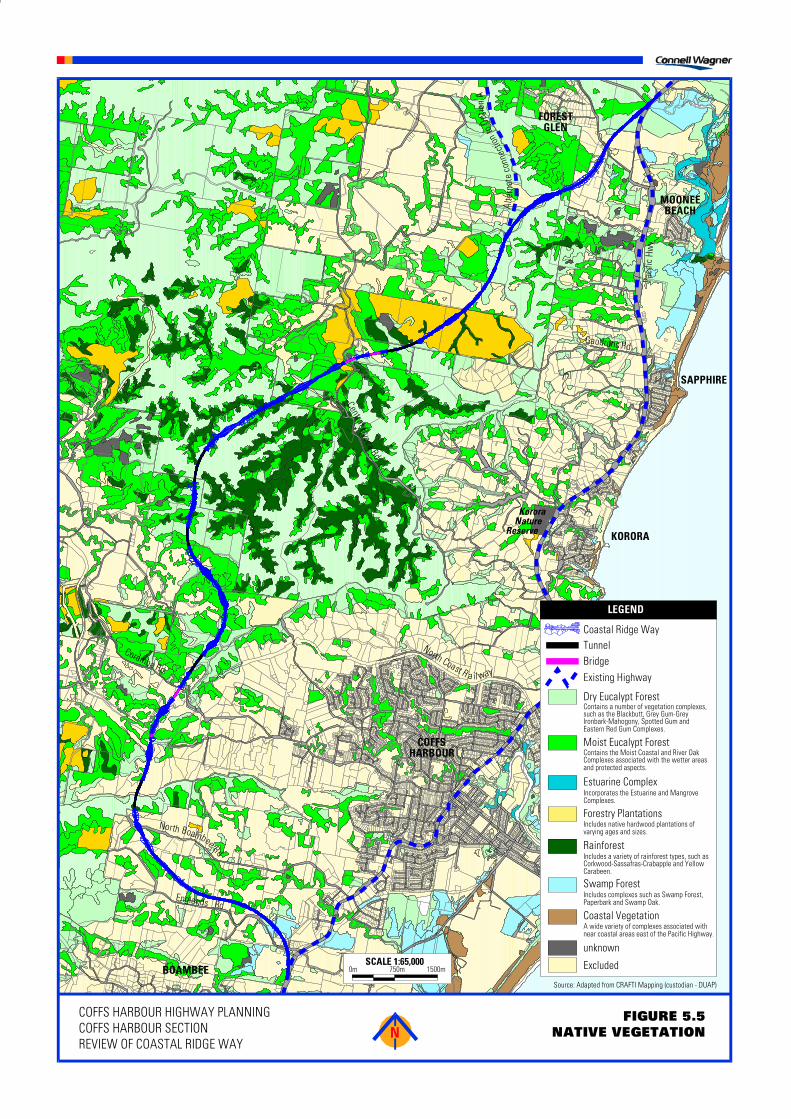
From existing information it was possible to determine that the CRW passes through twelve vegetationtypes, including a number of rainforest, wet and dry sclerophyll eucalypt forests and a swamp forest(refer Figure 5.5). This variety of communities reflects the traverse of the CRW from the environmentsassociated with coastal lowlands at the southern and northern ends, to those of the more elevated andrugged land to the west. The indicated native vegetation removal required as a direct result of CRWwould be as follows:
• 64.4ha of High Conservation Status and 20ha of Low Conservation Status ecological communities• 4.1ha of Forest Management Zones 2 and 3, noted to constitute an informal reserve system within
State Forests.
These Forest Management Zones have recently been declared special management zones under theNational Park Estate (Reservations) Act 2002. Special management zones are recognised in theForestry Act 1916 as areas of State forest that have special conservation value and certain forestryoperations, such as general purpose logging, are prohibited in these zones. With certain exceptions,Section 21A of the Forestry Act prohibits such a declaration to be revoked (either wholly or in part)except by an Act of Parliament or by notice of the Governor of NSW. The exceptions enablingrevocation of special management zones only apply in certain circumstances and in accordance withthe provisions of the Forestry Act. The exceptions are:
• exchange of land• land up to 20ha being made available for a public work or public purpose
The agreement of both Houses is required to effect the revocation by an Act of Parliament.
All vegetation types in the study area have the potential to contain a number of threatened species andthe location of records and the presence of suitable habitats indicate that the CRW could impact on anumber of threatened species. Should a threatened species occur on the CRW, the extent of habitatremoval is of a magnitude that it is likely to put at risk one or a number of local populations.
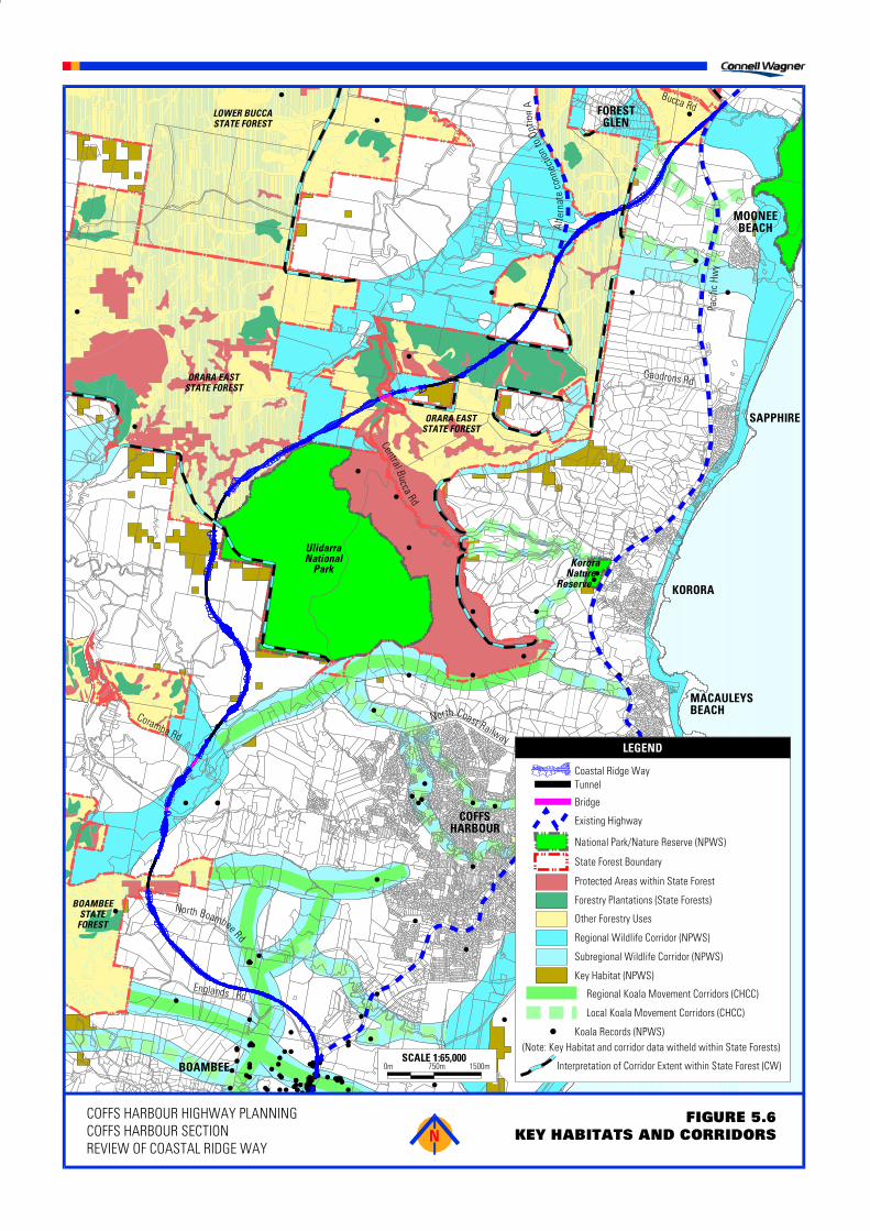
The CRW has the potential to impact on Regional and Sub-regional wildlife linkages and Koalamovement corridors as shown in Figure 5.6. This is likely to have a substantial impact on themovement of fauna from large areas of vegetation in the west to coastal areas.
If adopted, the CRW would require extensive and expensive mitigative measures. Due to the nature ofthe environment traversed, it is considered unlikely that the road design or alignment could be alteredsuch that impacts can be effectively avoided or minimised. As such, approval of the CRW would behighly dependent on mitigative measures to address impacts (e.g. fauna overpasses and underpasses,compensatory habitat etc.). However, it is considered likely that contemporary mitigation measureswould only be partially effective in mitigating the impacts along much of the road.
The CRW is likely to result in a significant impact on one or a number of threatened species listedunder the Threatened Species Conservation Act and the Commonwealth Environment Protection &Biodiversity Conservation Act. On this basis, it would require approvals from both the DEC and theCommonwealth Department of Environment & Heritage (formerly Environment Australia). The proposalwould require very extensive and detailed ecological studies. Mindful of the probable high level of
������������
����������������������
��
�������������� �
��������������� �
������� ����� �
��� �������������
������� �
�������� �
�������� � ����
�������
�������������� ������ � ��������� � ����� ���� �!��������"� ��"��#"� �$�������#�� ��������� %�"�����%��� ���� %�"������� � �&
�������� ���������������%���� ��'������ � ��������� %��� � �� ���� ����%��� � %��� ��&
$������� �� �������� ���%�������� ���� � �&
$����% ������ � ��%���%���������������������� ����%���( �&
$����% �������� ������������ ��� ������ ����������%#���������#������ ���%�) ��������� �&
$����% ������ � ����� ������������ ���� ��������%������'��&
*���% ����� ��������� � ��������� %��� � ������������ ��� ������ ���������+�� ���&
�����% %����� ,�*%� %��������*�-$�������.����%����#��/*�0
��������+�� ���
�'����+*�!'/��+$"+1*)��2*33$3"�'����+*�!'/�����-$'3���$�1�'���'*�-*2��$�"��1*)
-��� �!��%�
���������%� �1��
��������
�������
���������������������������
�����
�������
������
������������
����3�� ������� � �� ���
������������4� 564� 7644�
������%�����%
���������%
3�� �!���� ��%
� �����!�� ����%
����� ��
� +��
"��%������%
������� ���
* � ��
� ���
�� ���
����'
����*
�
�
�
�
�
�
�
�
��
�
�
�
�
�
�
�
�
�
�
�
�
�
�
�
�
�
�
�
�
� �
�
��
����
�
�
��
�
�
�
�
��
�
�
��
� �
������������������������
�
�
� �
�
��
��
�
�
�
����
�
���
��
�
�
��
��
� �
� �
�
�
��
�
���
�
��
�
�
�
���
�
��
�
��
�
�
��
��
�� �
�
� �����
��
�
���
�
����
�
�
������������� ��� ��� ������������
������
��������������
����������������
���������������������
������������������ ��������������
������������������
������������ !������������"��������
���������������#�"�$���� ���������� � �%�&���������#�"�$���� ���������� � �
�����'�����������������&��������������������������������������
��������������������� ��������������
��������&������������
(�����������
)����*������������ ���������������������������������� ��
������������������
������ �������������
����������������������
����������������������
�������������
���$�����
��������$������
���������& &����
��&&����
��&�� �&
� ��
+����������
���������
���� �����
�����������������������������
��������������������
�������
������
������
������� ���
������������,$ -.,$ /.,,$
0�����1��02���)+��13��%1��)�+ 0�����1��02���� ()0���4)���0�� 01�(1%��)5+���13
��� ������
������� ���
1 �����
����&�
���&���
�����0*
�����1
�����&����1����������������������
0�������������2���������������������������������������
��������� �����������

Coffs Harbour Highway Planning – Coffs Harbour SectionReview of Coastal Ridge Way Proposal
T:\JO\FINAL REPORTS WORD&EXCEL\CRW\CRW REPORT FINAL 16 FEB.DOC FEB 2004 REVISION 5 PAGE 32
habitat impact, the limited opportunities to avoid or minimise the impact, the high reliance on mitigationmeasures, the low prospect of achieving effective impact mitigation (even on the assumption that bestpractice measures are implemented) and the presence of viable alternative routes for the Highway, theapproval process would be complicated with no certainty that approval could be achieved.
Option A for the Sapphire to Woolgoolga project forms the northern extension of the CRW proposal.This proposal passes through the recently declared addition to the Sherwood Nature Reserve. On 18September 2003, the Hon Bob Debus MP, Minister for the Environment, wrote to the Hon Carl ScullyMP, Minister for Roads, advising of the potential constraints and processes that may need to beadopted if a route through the Nature Reserve was selected as the preferred option. The letterincluded the advice that, should the preferred option traverse the Nature Reserve, a number ofprocesses to enable the development of a road within a Nature Reserve would need to be followed,including the concurrence of the Minister for the Environment and the passage of an Act of Parliamentto revoke the required section of the Nature Reserve. The letter also advised that, if the RTA makes anapplication to construct the road through the Reserve, the RTA would be required, at that time, toconsider the availability of suitable alternative routes, and proposals to minimise/mitigate and/orcompensate for the environmental impacts of the proposal on the DEC estate.