coal map of south america - usgs - u.s. geological · pdf filecoal map of south america by...
TRANSCRIPT
U.S. DEPARTMENT OF THE INTERIOR U.S. GEOLOGICAL SURVEY
COAL MAP OF SOUTH AMERICA
By
Jean N. Weaver and Gordon H. Wood, Jr.
Pamphlet to accompanyCOAL INVESTIGATIONS
MAP C-145

CONTENTS
Summary 1 Introduction 1
Background 1 Methods 1 Definitions and Criteria Used in this Report 2
Sedimentary Basins 2Coal Basins, Fields, and Occurrences 2Age 2Rank 2Rank classes and rank groups of coal 3Peat 3
Coal and Peat Deposits 3Age of South American Coal Deposits 3Mississippian Coal 4Pennsylvanian, Pennsylvanian and Permian, and Permian CoalTriassic Coal 4Jurassic Coal 4Cretaceous Coal 4Tertiary Coal 4Peat - 4
Explanation of Selected Columns in the Tabular Data for each CountryInternal Administrative Area (Internal Adm. Area) 4Map Number 5Coal Field, Occurrence/Mine Name 5Operator 5Mine Type 5Recovery Activity 5Number of beds 5Coal Quality Parameters 5
Summary 5 Acknowledgments 5 Selected References 6 South American Counterparts 12 TABLES
Coal Mines and Occurrences in Argentina 16Coal Mines and Occurrences in Bolivia 19Coal Mines and Occurrences in Brazil 21Coal Mines and Occurrences in Chile 27Coal Mines and Occurrences in Colombia 29Coal Mines and Occurrences in Ecuador 31Coal Mines and Occurrences in Guyana 32Coal Mines and Occurrences in Paraguay 33Coal Mines and Occurrences in Peru 34Coal Mines and Occurrences in Suriname 39Coal Mines and Occurrences in Uruguay 40Coal Mines and Occurrences in Venezuela 41
Contents III

SUMMARY
All nine countries that were visited in South America contain coal deposits. Some coal deposits are more econom ical to exploit than others, but all have been or could be developed to some extent for local use. Export of Venezue lan and Colombian coal will probably increase in the near future. Deforestation is an environmental concern in many parts of South America. For this reason, coal as an alterna tive energy source could be developed. If and when this hap pens, opportunities could be present for the United States and foreign companies to invest in and (or) cooperatively conduct coal exploration, development, mining, and utiliza tion programs in South America.
result of library research and it did not include updated infor mation from scientists and others in the coal-bearing coun tries of South America. During the Fall of 1991, the senior author (Weaver) visited Uruguay, Argentina, Chile, Peru, Ecuador, Colombia, Venezuela, Brazil, and Bolivia. The purpose of the nine-country visit was twofold: (1) to discuss with geologists and other authorities in each country the quantity, quality, and distribution of known coal resources and the status of coal recovery and utilization and (2) to inform them of the current role of coal research in the U.S. Geological Survey. Paraguay was not visited because of time constraints. Guyana and Suriname were visited in the spring of 1993.
INTRODUCTION
This report was prepared to provide (1) a map of the coal fields and occurrences of coal in South America; (2) written documentation and references of the coal deposits identified on the coal map; and (3) data regarding the quality of the coal in each deposit.
The authors hope this report, which we believe to be the most complete compilation of published data on coal for the continent, will provide coal resource information to help guide exploration, development, mining, industrial and domestic use, export and import of coal, and aid in land-use planning throughout South America. On first examination, our research seems to substantiate a common belief that coal resources of South America are small. However, the data gathered for this report indicate that this belief may be erro neous. Such an error is easily understood because much, if not most, of South America's coal-bearing rocks are con cealed from view by (1) thick jungle and associated soils, (2) younger volcanic rocks, (3) non-coal-bearing Tertiary and Quaternary valley fill adjacent to mountain ranges, and (4) complex structural features within nearly inaccessible high mountain ranges. These factors have made it exceedingly difficult for geologists and explorers, who have mostly worked without the aid of adequate maps, to find and evalu ate the coal potential of South America.
Reports on the geology, mining, and paleobotany-pale- ontology of coal and coal-bearing rocks in South America helped us classify coal fields and coal occurrences as to their age, rank, depth of burial, number of beds, and sulfur and ash content. A list of selected references by nation is included, and a section has been included which lists the most perti nent references used in this study. In addition, data was obtained from written and oral communications with foreign coal authorities during the visits to each country.
BACKGROUND
This study was started by the late Gordon H. Wood, Jr. The original compilation, completed before his death, was a
METHODS
The geologic and mining engineering literature on the coal fields and coal occurrences of South America range from modern formal published reports to letters and other informal documents that date back as far as the late 1700's. Because of the great range in age of reports and in the exper tise of their authors, the quality of the reports ranges from poor to excellent. Some reports state without further infor mation that coal was exposed in a river bed, canyon wall, or on a hillside. Other reports provide much data, which may or may not include precise locations, age designations of coal beds, ranks of coal, chemical analyses, stratigraphy, thick nesses of overburden, thicknesses of coal beds, mine maps and cross sections, petrographic descriptions of coal, and postulated depositional environments of coal. Only a few reports include enough data to be considered as adequately describing an individual mine, group of mines, or a coal field. Consequently, the authors adopted the following meth ods and guidelines for assessing South American coal resources.
1. No attempt was made to estimate the coal resources (recoverable coal) of the individual mines, occurrences, and coal fields of South America.
2. Data presented for individual coal occurrences were derived from the credited coal company or geological sur vey (s) or mining companies of the country.
3. The coal map is comprehensive and shows most of the known coal fields and reported occurrences. This is in con trast to most published maps which show only "major" coal fields and occurrences. The map also shows areas that may be underlain by coal and where the geology suggests that coal could be present.
Information on the size of coal fields and coal occur rences in South America is summarized on the map. The map clearly shows that many occurrences can be grouped into fields because such occurrences have a common geo logic history. Each coal field or coal occurrence shown on the map is identified by a serial number that is unique within

each country. In the tables for each country, each coal deposit is further identified by a name, or where there is no name, that fact is indicated. Each deposit listing also has supporting data gathered from the literature or from cooper ating specialists from the South American countries.
DEFINITIONS AND CRITERIA USED IN THIS REPORT
Identified coal-in-place. Known coal occurrence. Loca tion, rank, quantity, quality, and depth of burial are known or are estimated from specific geologic evidence. Identified coal may be at any depth of burial, but it will not be more than 3 mi (4.8 km) from the point where a coal thickness is measured (Wood and others, 1983). The areas on the map marked by symbols and colors for rank designation and geologic age, respectively, are known coal occurrences.
Hypothetical coal-in-place. Coal which probably exists at depth, is more than 3 mi (4.8 km) from points of thickness measurement, is believed to be similar to known coal occur rences that surround points of measurement, and is a logical extension of known coal (identified coal-in-place). On the map these areas appear as pink areas surrounding areas of known coal occurrence.
Speculative coal-in-place. Undiscovered coal that is postulated to exist in (1) geologic settings suitable for the formation of peat from swamp deposits and the formation of peat to coal, or (2) areas where coal beds are hidden in the subsurface because of burial by younger sedimentary or vol canic rocks or hidden because of overlying structural fea tures such as thrust faults or nappes (Cooper and others, 1979). These speculative areas are included primarily in the sedimentary basins shown on the map.
SEDIMENTARY BASINS
The known large sedimentary basins of South America that are reported to contain coal are shown on the map. Basins are areas of the earth's crust where sediment has accu mulated. Such basins are a common habitat of fossil fuels of all types. Coal is common among the sedimentary rocks of some types of basins but may be a minor constituent of, or entirely lacking in, other types of sedimentary basins. The geologic history of a basin determines (1) whether coal is present or not, and (2) the physical and chemical character istics that control the economic potential of coal deposits.
Five of the eight largest coal areas of the world (esti mated coal resources of more than 500x109 tonnes) are essentially coincident with large sedimentary basins and the other three coal areas each include large basins (E.R. Landis and J.N. Weaver, written commun., 1992). Basins are shown on the map to facilitate inferences of coal deposits from known or reported coal areas or occurrences.
COAL BASINS, FIELDS, AND OCCURRENCES
Coal basins can be coincident with sedimentary basins. In many cases, however, coal basins are part of larger sedi mentary basins. Because of local and regional tectonic dis turbances, some coal basins have been deformed.
Coal fields and coal basins can be areally coincident; however, coal fields are commonly smaller than coal basins and their boundaries are commonly geographically and eco nomically defined.
Coal occurrences usually are reports of coal of undeter mined extent. Occurrences may range from organic material such as coalified wood in otherwise non-coal-bearing rocks, to preliminary indications of economically valuable coal deposits.
AGE
The geologic ages of the coal-bearing rocks of each coal field and occurrence are reported in the tables for each coun try and are shown on the map. Colors represent ages of the coal-bearing rocks. Geologic age assignments follow those accepted by the U.S. Geological Survey. The Periods are abbreviated in the tables as follows: Carboniferous = Carb., Mississippian = Miss., Pennsylvanian = Penn., Permian = Perm., Triassic = Tri., Jurassic = Jur., Cretaceous = Cret., Tertiary = Tert., and Quaternary = Quat. Age assignments straddling period boundaries are shown, for example, as Perm./Carb. Where the coal is mostly of one age, that period is placed first as Perm./Carb. (such as in Brazil and Uruguay).
RANK
The rank of coal is classified from analytical data accord ing to the degree of metamorphism, progressive alteration, or coalification (maturation) in the natural series from lignite to anthracite (Wood and others, 1983). The rank classes and rank groups of coal and their abbreviations, as shown in the tables for each country, are listed in the following table.
The rank of coal can be used to infer the approximate dry, mineral-matter-free heat value, fixed carbon, and volatile matter in coal, because the amounts of the constituents vary little within each rank (Wood and others, 1983). The deter mination of rank is a necessary part of coal classification and description. Geologists throughout the world have found that the rank of coal can vary gradually over many miles and ver tically over hundreds to thousands of feet. In the Andean Region, it has been noted that many of the rank assignments shown in the country tables vary because of adjacent intru sions and (or) structural complexities.
Different ranks of coal are shown by different symbols on the map. Anthracite is represented by a square, bituminous by a circle, subbituminous by an ellipsoid, lignite by a

Coal rank classes and groups and their abbreviations as used in this report (Wood and others, 1983)
Class Group Abbreviation
I. Anthracite
II. Bituminous
III. Subbituminous
IV. Lignite
1. Meta-anthracite2. Anthracite3. Semianthracite
1. Low volatile bituminous coal2. Medium volatile bituminous coal3. High volatile A bituminous coal4. High volatile B bituminous coal5. High volatile C bituminous coal
1. Subbituminous A coal2. Subbituminous B coal3. Subbituminous C coal
1. Lignite A2. Lignite B
an
ma an sa
bit
IvbmvbhvAbhvBbhvCb
sub
subA subB subC
lig
ligA ligB
triangle, and peat by a diamond. Dashed symbols indicate data that were acquired from drill holes.
PEAT
Peat, and organic material which develops from the incomplete breakdown of wetland vegetation, may occur where the natural drainage of rainwater is reduced or impeded (Bord Na Mona, 1984). Utilization of peat deposits depends on their inherent properties. The organic compo nents of peat vary according to the degree of decomposition. One of the primary uses of peat is as a fuel, and for this rea son it has been included on this map.
The mineral and (or) inorganic ash content greatly influ ence peat fuel combustion. In a calorific comparison with other fuels, air-dried peat (35 percent moisture content) has a higher energy content than wood, while processed and ben- eficiated peat products approached the lower end of the coal spectrum.
Peat has been used as a form of energy in numerous coun tries for at least the last 2,000 years, and it has been used on an industrial scale since before World War I. It is often
extremely valuable in remote areas which lack other indige nous energy forms. On a small scale, it may replace scarce firewood as the principle source of household energy. On a larger scale, it may be used for industrial steam and power generation.
COAL AND PEAT DEPOSITS
AGE OF SOUTH AMERICAN COAL DEPOSITS
The map shows the age of the coal occurrences as ascer tained from literature and specialists in the countries of South America. Some of the age determinations were based on investigations of the fossil flora in the coal beds or in immediately adjacent strata and of the fossil fauna in adja cent terrestrial and marine rocks. Most ages were derived from paleobotanical and paleontologic data from older or younger rocks miles away from the coal deposits. The remainder of the age determinations are probably estimates whose correctness mostly depends on the experience of the

researcher. Almost all of the age determinations were done many years ago and, therefore, may be open to revision.
The age of South American coal deposits ranges from Late Mississippian (Lower Carboniferous) to Quaternary, but the deposits are principally of Tertiary and Cretaceous ages.
MISSISSIPPIAN COAL
The oldest known coal beds in South America are Missis sippian (Lower Carboniferous). They are in Brazil and Peru and are reportedly thin; none have been mined. Because there is so little information on Mississippian coal and because the beds are so thin, such coal has been combined with Pennsylvanian coal in this report and referred to as Car boniferous. The age of the coal in the southern Brazil States (Rio Grande do Sul, Santa Catarina, Parana is controversial. The Companhia de Pesquisa de Recursos Minerals (CPRM) reports in a review of Brazil data that coal in those States is Permian in age. The Parana basin contains all of the coun try's commercial coal, which is in the Rio Bonito Formation of the Gondwana sequence (Machado, 1983).
PENNSYLVANIAN, PENNSYLVANIAN AND PERMIAN, AND PERMIAN COAL
Coal beds of Pennsylvanian, Pennsylvanian and Permian, and Permian age are known in Brazil, Argentina, and Peru, and they are of particular economic and resource importance in Brazil. The coal beds of the Parana coal field of southeast ern Brazil are typical of similar beds throughout the South ern hemisphere. They are the principal source of bituminous and subbituminous coal in South America, and, for the last century, they have been the principal source of coal mined on the continent.
TRIASSIC COAL
Coal beds of Triassic age are rare in South America, and they are only in northwestern Argentina and northern Chile.
JURASSIC COAL
Coal deposits of Jurassic age are generally of small lat eral extent and are known only in Argentina and Peru.
CRETACEOUS COAL
Coal beds of Cretaceous age have been identified only in Argentina, Peru, and Colombia. They are concentrated in the intermontane valleys of the Andes Mountains and they are of potential economic and resource value only in Peru and Argentina.
TERTIARY COAL
Tertiary coal fields and occurrences compose approxi mately one-half of all coal deposits of all ages in South America. The areal extent of Tertiary coal deposits is sev eral times greater than the extent of all other deposits of other ages. The tonnage of Tertiary coal is estimated to be much greater than for any other age or combination of ages. More than 55 percent of Tertiary fields and occurrences are in Venezuela. Most of the estimated tonnage of Tertiary coal underlies the Amazon River drainage basin in Brazil, Peru, and Colombia. The remainder of the Tertiary coal appears to be evenly distributed throughout the coal-bearing nations of the continent. Tertiary coal is not recognized in Paraguay and Uruguay.
PEAT
Within South America, peat deposits of various dimen sions have been found primarily in Brazil, Bolivia, Colom bia, Guyana, Venezuela, Paraguay, Suriname, and southern Chile. Brazil contains the most laterally extensive peat deposits. Most deposits are in swamplands in river valleys and on alluvial plains. Some deposits have been developed locally for agriculture but few have been evaluated for eco nomic potential as an energy source. Starting in the early 1980's, technical assessment of the peat deposits in Brazil has been undertaken by the Companhia de Pesquisa de Recursos Minerals (CPRM).
EXPLANATION OF SELECTEDCOLUMNS IN THE TABULAR DATA
FOR EACH COUNTRY
INTERNAL ADMINISTRATIVE AREA (INTERNAL ADM. AREA)
Each country is divided into provinces, states, regions, or departments. These boundaries are geographical or political boundaries within each country and they help to identify coal regions or occurrences. The Internal Administrative Area is included for each listing in the table for each country.
Argentina: provinceBolivia: departmentBrazil: stateChile: regionColombia: departmentEcuador: provinceGuyana: regionParaguay: departmentPeru: departmentSuriname: districtUruguay: departmentVenezuela: state

MAP NUMBER COAL QUALITY PARAMETERS
Each coal deposit or occurrence shown on the map is identified by a serial number that is unique within each country.
COAL FIELD, OCCURRENCE/MINE NAME
Each coal deposit has been assigned a name. The name generally reflects a geographical feature or a town near the deposit. An operating mine can be distinguished from a coal occurrence or coal field because a mining company is usu ally listed in the "Operator" column.
OPERATOR
This column identifies an owner, a company mining coal at a particular location, or a government geological survey doing exploration at a specific site.
MINE TYPE
Mine type indicates if the coal is being mined in a surface open-pit (S) or underground (U) mine.
The ash, sulfur, volatile matter, moisture, and heat values are mostly reported on an as-received basis. There are some discrepancies in the values. For example, some heat values will be too low or high for the reported rank class or group. This is a reflection of the discrepancies in international coal quality standards. Frequently the basis for such heat values is unknown or unreported; these values were included in the tables in lieu of no entry at all.
SUMMARY
The South American continent has abundant energy resource potential. Coal has been found to exist in nine of the South American countries and peat is present in eight countries. Available estimates of the amount of coal and peat present are based on inadequate and, sometimes, unreliable information. The range of physical and chemical character istics of coal and peat is undefined in most reported resource areas. Nevertheless, the resource potential for use of coal and peat as alternative, indigenous energy sources is large. A better understanding of the quality and quantity of coal and peat resources in South America is required for planning and efficient utilization in an environmentally acceptable manner.
RECOVERY ACTIVITY
This column was included in an effort to expand the "mine type" column. Activities listed in this column include drill holes, small mines for local domestic use, and explora tion.
NUMBER OF BEDS
The number of beds listed is the total number of beds reported at an occurrence. This number does not indicate the total number of beds being mined. In most cases, less than half the reported beds are being mined.
ACKNOWLEDGMENTS
Gary D. Stricker and Ronald Affolter (BCG) provided assistance with computer related issues. I (Weaver) visited with numerous geologists, consultants, mining engineers, and economists in each country, and to all of them I owe my sincere thanks and gratitude. I was warmly received and through each person's time and generosity was able to obtain data that contributed towards a product which is truly coop erative in nature. A list of all contacts can be found at the end of this pamphlet. Organizations that provided coal data are also listed at the end of the pamphlet. I (Weaver) extend my thanks to all personnel in the Economic Sections of our U.S. Embassies.

SELECTED REFERENCES
GENERAL REFERENCES
Alvarado, B., 1980, Recursos de Carbon en Suramerica, inColloque Recursos Energetiques: Congres Geologique International, Paris, France, Revue de L'lnstitut Francais du Petrole, v. XXXV, no. 2, p. 387-421.
Archangelsky, S., 1968, Paleobotany and palynology in South America A historical review: Review of Paleobotany and Palynology, v. 7, p. 249-266.
__1970, Fundamentos de Paleobotanica: UniversidadNacional de La Plata, Serie Tecnica y Didactica, La Plata, Argentina, no. 10, 347 p.
Bergmann, F.A.J., 1983, Coal Resources of the Argentine Republic, in Kottlowski, F.E., Cross, A.T., and Meyerhoff, A. A., eds., Coal Resources of the Americas Selected Papers: Boulder, Colorado, Geological Society of America, The Geology of North America Special Paper 179, p. 15.
Bergmann, F.A.J., and Xicoy, A.N., 1990, Coal Resources of Argentina, in Ericksen, G.E., Canas Pinochet, M.T., and Reinemund, J.A., eds., 1989, Geology of the Andes and its relation to hydrocarbon and mineral resources: Houston, Texas, Circum-Pacific Council for Energy and Mineral Resources Earth Science Series, v. 11, p. 131-137.
Berry, E.W., 1945, The Weichselia Stage in the Andean Geosyncline: Baltimore, Md., Johns Hopkins University, Studies in Geology, no. 14, p. 152-169.
Bord na Mona (Irish Peat Development Authority), 1985, Fuel and Peat in Developing Countries, in World Bank, ed., World Bank Technical Paper, v. 41, 146 p.
Burroughs, W.G., 1915a, Coal fields of South America: The Colliery Engineer, v. XXXVI, no. 20, p. 552-553.
__1915b, Coal fields of South America: The Colliery Engineer, v. XXXVI, no. 12, p. 643-644.
__1915c, Coal fields of South America: The Colliery Engineer, v. XXXVI, no. 1, p. 30-31.
__1915d, Coal fields of South America: The Colliery Engineer, v. XXXVI, no. 2, p. 72-73.
__1915e, Coal fields of South America: The Colliery Engineer, v. XXXVI, no. 3, p. 153-155.
Cooper, B., Niering, F., Jr., Symonds, E., 1979, eds., Latin America and Caribbean Oil Report: Published by Petroleum Economist, London, England, 1979, 328 p.
Creer, K.M., 1972, Paleomagnetism of Permocarboniferous rocks with special reference to South American formations: Rio de Janerio, Brazil, Anais da Academia Brasileira de Ciencias, v. 44.
DeLoczy, L., 1970, Role of transcurrent faulting in SouthAmerican tectonic framework: American Association of Petroleum Geologists Bulletin, v. 54, no. 11, p.
2111-2119. Departamento Nacional da Producao Mineral, 1985, Principais
Depositos Minerais: Republica Federativa do Brasil.Companhia Vale do Rio Doce, Brasilia, Brasil, v. I, p.1-37.
Du Toit, A.L., 1927, A geological comparison of SouthAmerica with South Africa: Carnegie Institution ofWashington, Publication 381, 158 p.
__1937, Our wandering continents, an hypothesis ofcontinental drifting: Edinburgh, Scotland, Oliver andBoyd, 366 p.
Ericksen, G.E., Canas Pinochet, M.T., and Reinemund, J.A.,eds., 1989, Geology of the Andes and its relation tohydrocarbon and mineral resources: Houston, Texas,Circum-Pacific Council for Energy and MineralResources Earth Science Series, v. 11, 452 p.
Ethridge, F.G., Flores, R.M., and Harvey, M.D., 1979, eds.,Recent Developments in Fluvial Sedimentology:Society for Economic Paleontologists andMineralogists, Special Publication no. 39, 389 p.
Flores-Williams, H., 1983, Chilean, Argentine, and BolivianCoals, in Kottlowski, F.E., Cross, A.T., and Meyerhoff,A. A., eds., Coal Resources of the Americas SelectedPapers: Boulder, Colorado, Geological Society ofAmerica, The Geology of North America Special Paper179, p. 1.
Gansser, A., 1954, The Guiana shield (South America);Geological Observations: Ecologae GeologicaeHelvetiae, v. 47, no. 1, p. 77-112.
__1973, Facts and theories on the Andes: The GeologicalSociety (London) Journal, v. 129, pt. 2, p. 93-131.
Grossling, B.F., 1981, World Coal Resources (2d ed.):London, England, Financial Times BusinessInformation Ltd., 166 p.
Halpern, M., 1972, Geochronologic evolution of southern SouthAmerica: Anais Da Academia Brasilerra de Ciencias,v. 44, p. 149-160, Rio de Janeiro.
Halpern, M., Umpierre, U.M., and Linares, E., 1972,Radiometric ages of crystalline rocks from SouthAmerica as related to Gondwana and Andean geologicprovinces, in International Upper Mantle project:Buenos Aires, Argentina, Conference solving earthproblems, 26-31, II, p. 345-356.
Helwig, J., 1972, Late Paleozoic stratigraphy and tectonics ofthe central Andes: Anais da Academia Brasileiro deCiencias, v. 44, p. 161-171, Rio de Janeiro.
Laskav, B., 1979, Evolution of Gondwana coal basins:Calcutta, India, Fourth International GondwanaSymposium, 1977, v. 1, p. 223-232.
MacDonald, W.D., 1972, Late Paleozoic tectonics of SouthAmerica: Sao Paulo, Brazil, Academia Brazil, Cienc.,p. 197-208.
Machado, E.R., 1983, Coal in Brazil, in Kottlowski, F.E.,Cross, A.T., and Meyerhoff, A. A., eds., Coal Resources
of the Americas Selected Papers: Boulder, Colorado, Geological Society of America, The Geology of North America Special Paper 179, p. 23.
Martino, O.D., 1988, Mineral Industries of Latin America: U.S. Bureau of Mines, Minerals Perspective Report, 134 p.
Meyen, S.V., 1979, Relation of Angara and Gondwana floras A century of controversies: Calcutta, India, Fourth International Gondwana Symposium, 1977, v. 1, p. 45-50.
Ministerio de Energia y Minas, 1981, Minerales de Venezuela: Direccion de Geologia, Publicacion no. 8, Caracas, Venezuela, p. 60-69.
O'Rourke, I.E., 1983, Coal basins of Ecuador, in Koitlowski, F.E., Cross, A.T., and Meyerhoff, A.A., eds., Coal Resources of the Americas Selected Papers: Boulder, Colorado, Geological Society of America, The Geology of North America Special Paper 179, p. 43.
Ocala, L.C., and Meyer, R.P., 1973, Crustal structure from the Pacific Basin to the Brazilian shield between 12° and 30°S latitude: Geological Society of America Bulletin, v. 84, p. 3387-3404.
Organization Latinoamericana de Energia (OLADE), 1984, Inventario de Recursos de Carbon Mineral en Paises No Productores de America Latina: Documentos D-PLACE no. 15, 689 p.
Petersen, R.C., 1983, Coal resources of Peru, in Kottlowski, F.E., Cross, A.T., and Meyerhoff, A.A., eds., Coal Resources of the Americas Selected Papers: Boulder, Colorado, Geological Society of America, The Geology of North America Special Paper 79, p. 35.
Renz, H.H., 1942, Stratigraphy of northern South America, Trinidad, and Barbados: Proceedings Eighth American Scientific Congress, 1940, Geological Sciences, v. 4, p. 513-571.
Rocha-Campos, A.C., ed., 1972, Simposio International sobre os Sistemas Carbonifero e Permano na America do Sul: Rio de Janeiro, Brazil, Anais da Academia Brasileira de Ciencias, v. 44, 391 p.
Rodriquez, S.E., 1986, Recursos Minerales de Venezuela:Boletin de Geologia, Ministerio de Energia y Minas, v. XV, no. 27, 228 p.
Schlatter, L., 1977, Coal worldwide how much, what kind and where to find it: Dublin, Ireland, Petro Consultants, Ltd., v. 2.
Singewald, J.T., Jr., 1943, Bibliography of economic geology of South America: Geological Society of America Special Paper 50, p. 1-159.
Suescun-Gomez, D., 1983, Coal deposits in Colombia, inKottlowski, F.E., Cross, A.T., and Meyerhoff, A.A., eds., Coal Resources of the Americas Selected Papers: Boulder, Colorado, Geological Society of America, The Geology of North America Special Paper 179, p. 49.
Weeks, L.G., 1947, Paleogeography of South America:
American Association of Petroleum GeologistsBulletin, v. 31, no. 7, p. 1194-1241.
Wegener, A., 1929, Die Enstehung der Kontinente und Ozeans(4th ed.): Braunshweig, Germany, Vieweg und John.
Wood, G.H., Jr., Kehn, T.M., Carter, M.D., and Culbertson,W., 1983, Coal Resource Classification System of theU.S. Geological Survey: U.S. Geological SurveyCircular 891,65 p.
Zeil, W., 1979, The Andes A geological review: Berlin,Stuttgart, Gebruder Borntraeger, 260 p.
ARGENTINA
Beder, R., 1921, Yacimientos de materias explotables de la Republica Argentina: Buenos Aires, Argentina, Direccion General de Minas, Geologia e Hidrologia, 420 p.
Bergmann, F.A.J., and Filippmi, J.R., 1972, Situation del Carbon y del Coque en Argentina: Caracas, Venezuela, ILAFA Carbon 1972, May 22-25, 1972.
Borrello, A.V., 1956, Recursos Minerales de la RepublicaArgentina: Buenos Aires, Argentina, Ministerio de Education de la Nation, Revista de Ciencias Geologicas, p. 9-336.
Harrington, H.J., 1956, Argentina, in Handbook of SouthAmerican Geology: Geological Society of America Memoir 65, p. 129-165.
Heim, A., 1949, Estudio Geologico del Carbon "Retico y del Valle de la Pena," in Argentina: Buenos Aires, Argentina, Direccion General de Industria Minera, Buletin 59.
Herrero-Ducloux, A., 1963, The Andes of Western Argentina, in Backbone of the Americas, tectonic history from pole to pole: American Association of Petroleum Geologists Memoir 2, p. 16-28.
Segerstrom, K., and Turner, J.C.N., 1972, A conspicuousflexure in regional trends in the Puna of Northwestern Argentina: U.S. Geological Survey Professional Paper 800-B, p. B205-B209.
BOLIVIA
Ahlfeld, F., 1954, Los yacimientos minerales de Bolivia: BancoMinero de Bolivia y La Corporation Minera deBolivia, p. 232-253.
__1956, Bolicia, in Jenks, W.F., ed., Handbook of SouthAmerica Geology: Geological Society of AmericaMemoir 65, p. 129-165.
Ahlfeld, F., and Schneider-Scherbina, A., 1964, Losyacimientos minerales y de hidrocarburos de Bolivia:Departamento Nacional de Geologia Boletin, no. 5(especial), p. 339-340.
Berry, E.W., 1933, Carboniferous plants interbedded in themarine sections of Bolivia: American Journal of

Science, v. XXV, p. 49-54. Chamot, G.A., 1965, Permian section at Apillapampa, Bolivia,
and its fossil content: Journal Paleontology, v. 39, no.6, p. 1112-1124.
Cousminer, H.L., 1965, Permian spores from Apillapampa,Bolivia: Journal of Paleontology, v. 39, no. 6, p. 1097-1111.
Newell, N.D., 1949, Geology of the Lake Titicaca region, Peruand Bolivia: Geological Society of America Memoir36, p. 42-43.
Rod, E., 1960, Strike-slip fault of continental importance inBolivia: American Association of PetroleumGeologists Bulletin, v. 44, no. 1, p. 107-108.
Sonnenberg, F.P., 1963, Bolivia and the Andes, in Backbone ofthe Americas, tectonic history from pole to pole:American Association of Petroleum Geologists Memoir2, p. 36-46.
BRAZIL
Abreu, S.F., 1962, Combustiveis fosseis, in Recursos minerais do Brazil: Ministerio da Industria e do Commercio, Institute Nacional de Tecnologia, v. II, p. 42-138.
Andrado, R., J.R., 1955, Reconhecimento geologico do Alto Rio Fresco, Estado do Para: Brazil Divisao Geologia Mineralogia, Rel. Annual, 1954, p. 32-38.
Barbosa, O., and de Almeida, F.F.M., 1949, A serie Tubarao na Bacia do Rio Tiete, Estado de Sao Paulo: Ministerio da Agricultura, Departamento Nacional da Producao Mineral, Divisao de Geologia e Mineralogia, Notas Prelimiares e Estudos, no. 48, 16 p.
__1952, Comparison between the Gondwana of Brazil,Bolivia, and Argentina, in Symposium sur les series do Gondwana: 19th International Geologic Congress, p. 313-324.
Dolianti, E., 1946, Noticia Sobre Novas Formas na "Flora de Glossopteris" do Brasil Meridional: Ministerio da Agricultura, Departamento Nacional da Producao Mineral, Divisao de Geologia e Mineralogia, Notas Preliminares e Estudos, no. 34, p. 1-6.
__1953a, A Flora do Gondwana Inferior em Santa Catarina, pt. I, O Genero Glossopteris: Ministerio da Agricultura, Departamento Nacional da Producao Mineral, Divisao de Geologia e Mineralogia, Notas Preliminares e Estudos, no. 60, 7 p.
__1953b, A Flora do Gondwana Inferior em Santa Catarina, pt. II, O Genero Taeniopterias: Ministerio da Agricultura, Departmento Nacional da Produpao Mineral, Divisao de Geologia e Mineralogia, Notas Preliminares e Estudos, no. 61, 7 p.
__1954a, Gangamopteris Angustifolia E.G. Buriadico naFormacao Marica do Rio Grande do Sul: Ministerio da Agricultura, Departamento Nacional da Produpao Mineral, Divisao de Geologia e Minerologia, Notas
Preliminares e Estudos, no. 87, 6 p.__1954b, A Flora do Gondwana Inferior em Santa Catarina,
pt. V, O Genero Gangamopteris: Ministerio da Agricultura, Departamento Nacional da Producao Mineral, Divisao de Geologia e Mineralogia, Notas Preliminares e Estudos, no. 89, 12 p.
__1954c, A Flora da Carboniferos Inferior de Teresina, Piaui: Ministerio da Agricultura, Departamento Nacional da Producao Mineral, Divisao de Geologia e Mineralogia Boletin, no. 148, p. 1-56.
__1956, A Flora de Gondwana Inferior em Santa Catarina: Ministerio da Agricultura, Departamento Nacional da Producao Mineral, Divisao de Geologia e Mineralogia, Notas Preliminares e Estudos, no. 95, p. 1-8.
Frakes, L.A., and Crowell, J.C., 1972, Late Paleozoicgeography between the Parana Basin and the Andean Geosyncline: Anais da Academia Brasileira de Ciencias, v. 44, p. 139-14.
Good, J.E., Abrea, Alvaro, and Fraser, Thomas, 1949, The coal industry of Brazil, pt. I, General economy, production, and market; pt. II, Technology of mining and preparation: U.S. Bureau of Mines Technical Paper 713, pt. 1-38, pt. II, 110 p.
Gordon, M., 1947, Classification of the Gondwanic rocks of Parana, Santa Catarina and Rio Grande Do Sul: Ministerio da Agricultura, Departamento Nacional da Producao Mineral, Divisao de Geologia e Mineralogia, Notas Preliminare e Estudos, no. 38a, p. 1-19.
Gordon, M., and Brown, R., 1952, Plantas Triassicas do Sul do Brasil: Ministerio da Agricultura, Departamento Nacional da Producao Mineral, Divisao de Geologia e Mineralogia, Notas Preliminares e Estudos, no. 54, 10 p.
Gothan, W., and Jongmans, W.J., 1952, Contribuicao para o Conhecimento de Alethopteris Branneri White: Ministeria da Agricultura, Departamento Nacional da Produpao Mineral, Divisao de Geologia e Mineralogia, Notas Preliminares e Estudos, no. 5, 10 p.
Horowitz, A., 1972, Probable paleogeographic implications of the global distribution of the Late Permian Cathaysian microflora: Anais da Academia Brasileira de Ciencias, v. 44, p. 174-177.
Institute de Geosciencias, 1974, Mapa Geologico do Estado Rio Grande do Sul: Ministerio da Educacao e Cultura, scale 1:2,000,000.
Kegel, W., 1952, Sobre A formacao Piaui (carbonifero superior) no Araguia: Ministerio da Agricultura, Departamento Nacional da Producao Mineral, Divisao de Geologia E Mineralogia, Notas Preliminares e Estudos, no. 56, 7 p.
__1954, Lamelibranquias da Formacao Poti (Carboniferous Inferior) do Piaui: Ministerio da Agricultura, Departamento Nacional da Produpao Mineral, Divisao de Geologia e Mineralogia, Notas Preliminares e Estudos, no. 88, 14 p.

__1955, Carvao No Piaui, Brasil: Ministerio da Agricultura, Departamento Nacional da Producao Mineral, Divisao de Geologia e Mineralogia, Notas Preliminares e Estudos, no. 92, p. 1-10.
Lashar, B., and Raya Rao, C.S., eds., 1979, Fourth Gondwana Symposium Papers: Delhi, India, Hindustan Publishing Corporation, v. 1, 384 p.
Machado, E.R., 1970, Geologia do Carvao no Brasil, in pt. Ill, Simposio do Carvao Nacional, Curiba: Revista Carvao de Pedra, nos. 11-12, ano 2, p. 26-39.
__1972, O Carvao Neopaleozoico de Brasil Meridional: Anais da Acadamia Brasileira de Ciencias, p. 209-236.
Mesner, J.C., and Woolridge, L.C.P., 1964, MaranhaoPaleozoic Basin and Cretaceous Coastal Basins, North Brasil: American Association of Petroleum Geologists Bulletin, v. 48, no. 9, p. 1475-1512.
Ministerio das Minas e Energia, 1971, Mapa Geologico do Brasil: Ministerio das Minas e Energia, scale 1:5,000,000.
__1981, Geologic map of Brasil and adjoining ocean floor including mineral deposits: Ministerio das Minas e Energia, scale 1:2,500,000, 4 sheets.
Manachesi, W., 1982, Coal in Latin America and Brazil, contribution to the energetic crisis challenge, in Simposio International Sobre la Cooperation entre Europa y America Latina para la utilizacion del carbon: Instituto Italo-Latino Americano and Ministerio de Minas y Energia de Colombia, November 23-27, 1981, Cartagena, Colombia, p. 59-153.
Oliveira, A.T. de, 1956, Brazil, in Handbook of SouthAmerican Geology: Geological Society of America Memoir 65, p. 1-62.
Oliveira, P.E. de, 1936, Um brachiopoda Carbonifera de Rio Moa, Territorio de Acre, Brasil: Serie Geology and Minen, Notas 6.
Oliveira, P.E. de, 1953, Sobre un Nova Conchestraceo fossil de Estrado da Bahio: Ministerio da Agricultura, Departamento Nacional da Produc.ao Mineral, Divisao de Geologia e Mineralogia, Notas Preliminares e Estudos, no. 63, p. 11.
Oppenheim, V., 1935, Petroleum geology of Gondwana rocks of southern Brazil: American Association of Petroleum Geologists Bulletin, v. 19, no. 12, p. 1725-1805.
__1936, Gondwana Rocks and Geology of Petroleum ofSouthern Brazil: American Association of Petroleum Geologists Bulletin, v. 20, no. 6, p. 819-820.
Paiva, G. de, and Miranda, J., 1937, Carvao Mineral da Piaui: Ministerio da Agricultura, Departamento Nacional da Produc.ao Mineral, Service de Fomento de Produc.ao Mineral, Boletin, no. 20.
Paiva, G. de, Miranda, J., Reyes, J.M., andMariaca, G., 1939, Geologia da Faixa Subandina da Bolivia: Ministerio da Agricultura, Departmento Nacional da Produc. ao Mineral, Divisao de Geologia e Mineralogia, Boletin,
no. 101. Schuchert, C., 1928, Review of the Late Paleozoic formations
with special reference to the ice-age of Middle Permiantime: Geological Society of America Bulletin, v. 39,no. 3, p. 769-886.
Willig, C., 1974, Trabalhos de pesquisa de carvao realizadospelo convenio DNPM/CPRM em Santa Catarina:Conselho Nacional Petroleo Atual, no. 38, ano 5, p.8-55.
CHILE
Briiggen, J., 1914, Los carbones del Valle longitudinal y la zonacarbonifera al sur de Curanilahue, en la Provincia deArauco: Sociedad Nacional de Mineria, 56 p.
__1950, Fundamentos de la geologia de Chile: InstitutoGeographico Militar, 374 p.
Harrington, H.J., 1961, Geology of part of Antofugasta andAtacama provinces, Northern Chile: AmericanAssociation of Petroleum Geologists Bulletin, v. 45,no. 2, p. 169-197.
Instituto de Investigaciones Geologicas, 1968, Mapa Geologicode Chile: Instituto de Investigaciones Geologicas,scale 1:1,000,000, 7 sheets.
Mufioz, C.J., 1956, Chile, in Jenks, W.F., ed., Handbook ofSouth American Geology: Geological Society ofAmerica Memoir 65, p. 187-214.
Rassmuss, J., 1920, Geologia de los yacimientos de carbon:Direction General de Minas, Geologia e Hidrologia,Bulletin 23, p. 27.
Segerstrom, K., 1967, Geologia de las Hojas Copiapo y Ojos delSalado, Provincia de Atacama: Instituto deInvestigaciones Geologicas, Boletin 24, 58 p.
Toenges, A.L., and Kelly, L.W., 1948, Coals of Chile: U.S.Bureau of Mines Bulletin 474, 106 p.
Wenzel, G.O., 1955, Las Reservas Carboniferas Nacionales:Revista de Minerales, Instituto de Ingenieros de Minasde Chile, ano x, no. 49, p. 49-57.
COLOMBIA
Anderson, P.M., 1927, Nonmarine Tertiary Deposits ofColombia: Geological Society of America, v. 38, no. 4, p. 591-644.
Barry, E.W., 1945, Late Tertiary fossils from eastern Colombia: Johns Hopkins University Studies in Geology, no. 14, p. 172-190.
Cortes, E.B., 1974, Carbones de Colombia: Ministerio de Minas y Petroleos, 253 p.
Duran, R.R., Sanchez, G., Angarita, L.A., Zambrano, P.O., and Uribe, C.A., 1979, Zonas Carboniferas de Colombia, Recursos, Clasificacion y Convenios Bilaterales: Ministerio de Minas y Energia, Instituto Nacional de Investigaciones Geologico-Minera, no. 3, 29 p.

Duran, R.R., Mujica, P.E.G., Nigrinis, R.A., Granados, A.,Mejia, L.J., Gil, Enrique, 1977, Recursos Minerales de Colombia: Ministerio de Minas y Energia, Institute Nacional de Investigaciones Geologico-Mineral, no. 3, anexo 1, p. 95-124.
Elkin, M.E., 1965a, Las cuencas carboniferas de Boyaco y Cundinamarca (Guaduas-Tocaima): Ministerio de Minas y Petroleos, Servicio Geologico Nacional, Informe no. 1453, v. XIII, nos. 1-3.
__1965a, El Cretacico carbonifero al norte de la Sabana de Bogota: Ministerio de Minas y Petroleos, Servicio Geologico Nacional, Informe no. 1453, nos. 1-3, p. 85-99.
Molina, E.E., 1965a, El Cretacico carbonifero al Norte de la Sabana de Bogota: Ministerio de Minas y Petroleos, Servicio Geologico Nacional, Boletin Geologico, v. XII, p. 5-84.
Olsson, A.A., 1956, Colombia, in Jenks, W.E., ed., Handbook of South American Geology: Geological Society of America Memoir 65, p. 293-326.
Reina, A.L., 1981, Potencialidad y caracteristicas de la recursos del carbon, in Simposio Internacional sobre la Cooperacion entre Europa y America Latina para la utilizacion del carbon: Institute Italo-Latino Americano and Ministerio de Minas y Energia de Colombia, p. 155-182.
Singewald, Q.D., 1976, Mineral resources of Colombia (other than petroleum): U.S. Geological Survey Bulletin 964- B, p. 53-204.
ECUADOR
Berry, E.W., 1945, Fossil flora from southern Ecuador: Johns Hopkins University, Studies in Geology, no. 14, p. 93-149.
Bristow, C.R., 1973, Guide to the geology of the Cuenca Basin, southern Ecuador: Ecuadorian Geological and Geophysical Society, p. 28-31.
Liddle, R.A., and Palmer, K.V.W., 1941, The geology andpaleontology of the Cuenca-Azogues-Biblian region, Provinces of Canar and Azuay, Ecuador: Paleontological Research Institution, pt. 1, p. 12.
Lewis, G.E., Tschoop, H. J., and Marks, J.G., 1956, Ecuador, in Handbook of South American Geology: Geological Society of America Memoir 65, p. 251-296.
Sheppard, G., 1937, The geology of southwestern Ecuador: T. Murby and Company, London, England, 275 p.
Wasson, T., and Singewald, J.H., 1927, Geological exploration east of the Andes in Ecuador: American Association of Petroleum Geologists Bulletin, v. 11, no. 12, p. 1253-1282.
Wolf, T., 1892, Geografia y Geologia Del Ecuador: Leipzig, Germany, 671 p.
PARAGUAY
Harrington, H.J, 1956, Paraguay, in Handbook of SouthAmerican Geology: Geological Society of America Memoir 65, p. 99-114.
Putzer, Hannfrit, 1962, Geologic von Paraguay: Berlin, Gebriider Borntraeger, 182 p.
PERU
Anonymous, 1959, Los Recursos de Carbon y Petroleo, in Planregional para el desarrollo del sur del Peru: Informes,Lima, Peru, PS/A6, v. 11, 24 p.
Bambilla, D.E., 1957, Geologia de la zone antracifera deHuayday, Luema, La Libertad: Primer CongresoNacional de Geologia, Sociedad Geologica del Peru,Toma 32, p. 32-50.
Habich, E.A.V., 1904, Yacimientos carboniferos del districto deChecras: Ministerio de Fomento, Cuerpo deIngenieros de Minas del Peru Boletin no. 18, p. 1-32.
Jenks, W.F., 1956, Peru, in Handbook of South AmericanGeology: Geological Society of America Memoir 65,p. 215-248.
Kurnmel, Bernhard, 1948, Geological reconnaissance of theContamana region, Peru: Geological Society ofAmerica Bulletin, v. 59, p. 1217-1266.
Olive, W.W., 1978, Coal deposits of Latin America, in Coalresources of the Americas: Geological Society ofAmerica Special Paper 179, p. 49-56.
Oppenheim, V., 1937, Geological exploration between UpperJurua River, Brogih, and Middle Ucayali River, Peru:American Association of Petroleum GeologistsBulletin, v. 21, no. 1, p. 97-110.
Paredes, R.M., 1981, Recursos Carboniferos del Peru y susperspectivas de uso, in Simposio Internacional sobre lacooperacion entre Europa y America Latina para lautilizacion del Carbon: Instituto Italo-LatinoAmericano, y Ministerio de Minas y Energia deColombia, p. 447-469.
Read, C.B., 1938, The age of the Carboniferous strata of theParacas Peninsula, Peru: Journal of the WashingtonAcademy of Sciences, v. 28, no. 9, p. 396-403.
Santolalla, P.M., 1904, La Provincia de Cajatamboy asientominerales: Ministerio de Fomento, Cuerpo deIngenieros de Minas del Peru, Boletin no. 10, p. 52-58.
__1905, Los yacimientos minerales y carboniferos de laProvincia de Celendin: Ministerio de Fomento,Cuerpo de Ingenieros de Minas del Peru, Boletin no.32, p. 45-50.
Singewald, J.T., 1928, Geology of the Pictis and PachetadaRivers: Geological Society of America Bulletin, v. 39,no. 2, p. 447-464.
Steinmann, G., 1930, Geologia del Peru: Heidelberg, Germany,C. Winters, 448 p.
10

U.S. Department of Energy, 1979, Joint Peru/United States Report on Peru/United States Cooperative Energy Assessment: Department of Energy, v. 2, Annex 1, p. 45-66.
URUGUAY
Falconer, J.D., 1937, The Gondwana system (Permian and Triassic?) of Northeastern Uruguay with a special reference to the Eogondwana beds: Montevideo, Uruguay Institute de Geologia y Perforaciones, Boletin no. 23, 112 p.
__1956, Uruguay, in Handbook of South American Geology: Geological Society of America Memoir 65, p. 115-128.
Oppenheim, Victor, 1935, Petroleum geology of CentralSedimentary basin of Uruguay: American Association of Petroleum Geologists, v. 10, no. 8, p. 1205-1218.
VENEZUELA
Bellizzia, A.G., 1969, Minerals: Congreso Geologico Venezolano, 4th, 1969, Recursos Minerales de Venezuela map, scale about 1:7,500,000.
Brandi, K., 1978, Venezuela looks to the future with coal: World Coal, August, p. 28-30.
Brondijk, J.F., 1967, "Eocene" formations in the southwestern part of the Maracaibo Basin: Asociacion Venezolana de Geologia, Mineria y Petroleo Boletin, v. 10, no. 2, p. 35-50.
Bucher, W.H., 1952, Geologic structure and organic history of Venezuela: Geologic Society of America Memoir 49, 113 p.
Clemente, G. de Juana, 1947, Elements of the diastrophichistory of Northeastern Venezuela: Geological Society of America, v. 58, no. 8, p. 689-702.
Creer, K.M., 1965, Paleomagnetic data from the GondwanaContinents, in Symposium on Continental drift: Royal Society London Philosophical Transactions, v. 258, p. 27-40.
Dengo, Gabriel, 1953, Geology of the Caracas region,Venezuela: Geological Society of America Bulletin, v. 64, no. 1, p. 7-40.
Fary, R.W., 1980, Venezuela: U.S. Geological Survey Professional Paper 1175, p. 347-348.
Ferrer, A., Merino, M., andKapa, G., 1976, Reservas(Carboniferas) de Venezuela, in Congreso Ilafa- Carbon, Usos del Carbon en siderurgia: Abastecimiento y (Tecnologia) Ciudad de Mexico, 25- 30 July, Institute Latino Americano del Fierro y el Acero, Santiago, Chile, p. 97-98.
Halse, G.W., 1947, Oil fields of West Buchivacoa, Venezuela: American Association of Petroleum Geologists Bulletin, v. 31, no. 12, p. 2170-2182.
Hedberg, H.D., 1950, Geology of the Eastern Venezuela Basin
(Anzoategui-Monagas-Sucre-Eastern Guarico portion):Geological Society of America Bulletin, v. 61, no. 11,p. 1173-1216.
__1956, Northeastern Venezuela, in Venezuela, Lopez, V.M.,Hedberg, H.D., and Kehrer, Louis, eds., Handbook ofSouth American Geology: Geological Society ofAmerica Memoir 65, p. 337-340.
Heintz, P., 1976, El (Carbon) del Zulia, en Siderurgia, inCongreso Ilafa-Carbon, Usos del Carbon en Siderurgia:Abastecimiento y (Technologia) Ciudad de Mexico,25-30 July, Institute Latino-Americano del Fierro y elAcero, Santiago, Chile, p. 98-99.
Hess, H.H., and Maxwell, J.C., 1949, Geological reconnaissanceof the island of Margerita, part 1: Geological Society ofAmerica Bulletin, v. 60, p. 1857-1868.
Joves, J.L., and Montes, M.F., 1979, Perspectivas de la CuencaCarbonifera del Guasare, Estado Zulia, Venezuela, inCongreso Ilafa-Carbon, Explotacion yCommercialization, 22-26 April, Bogota, Colombia, p.37-43.
Kahrer, L., 1946, Some observations of Cretaceous andpre-Cretaceous beds in southwestern and northern centralparts of Venezuela: Boletin de Geologia y Mineria, v.1, p. 47-73.
Liccioni, J.L., 1970, Aspectos de la Industria Minera enVenezuela: Ministerio de Minas y Hidrocarburos,Caracas, Venezuela, p. 52-54.
Liddle, R.A., 1946, The geology of Venezuela and Trinidad, 2ded.: Fort Worth, Texas, J.P. MacGowan, 562 p.
Lopes, V.M., Mencher, R., andBrineman, J.H., 1942, Geologyof southeastern Venezuela: Geological Society ofAmerica Bulletin, v. 53, no. 6, p. 849-872.
Lopes, V.M., Hedberg, H.D., and Kehrer, Louis, 1956,Venezuela, in Jenks, W.F., ed., Handbook of SouthAmerican Geology: Geological Society of AmericaMemoir 65, p. 327-349.
Miranda, R.L., and Novillo, V, 1976, Carbon y coque deNaricual, Venezuela, in Congreso Ilafa-Carbon-Usosdel Carbon en Siderurgia: Abastecimiento y(Tecnologia) Ciudad de Mexico, 25-30 Julio, InstituteLatino-Americano del Fierro y el Acero, Santiago,Chile, p. 27-32.
Olive, W.W., 1978, Coal deposits of Latin America, in Coalresources of the Americas: Geological Society ofAmerica Special Paper 179, p. 57-64.
Pfefferkorn, H.W., 1977, Plant megafossils in Venezuela andtheir use in geology: V Congreso GeologicoVenezolano: Memoria, Tomo I, p. 407-414.
Rod, E., 1956, Strike-slip faults of Northern Venezuela:American Association of Petroleum GeologistsBulletin, v. 40, no. 3, p. 457-476.
Resales, H.; 1967, Geologia del Area Barcelona-Rio Quereoual(Estado Anzoategui): Asociacion Venezolana deGeologia, Mineria y Petroleo, p. 7-8.
11

Smith, R.J., 1953, Geology of the Los Tequis-Cua region,Venezuela: Geological Society of America Bulletin, v. 64, no. 1, p. 41-64.
Trump, G.W., 1964, Guidebook, October 24, 25, 26, 1964, to the Geology of Western Tachira: Asociacion Venezolana de Geologia, Mineria y Petroleo, p. 7-10.
World Coal Resources and Reserves Data Bank Service, 1981, World coal resources regional review No. 1, Colombia and Venezuela: London, U.K., International Energy Agency, p. 42-50.
SOUTH AMERICAN COUNTERPARTS
ARGENTINA
Teniente Coronel Alfredo Cordoba Director Nacional de Mineria Av. Santa Pel 548, piso 11 Buenos Aires, Argentina
Dr. Federico A. J. Bergmann (retired)Geologo, Yacimientos Carboniferos Fiscales (YCF)Chacabuco 159-1876, BernalArgentina
Dr. Walter DefortunaInterventorYacimientos Carboniferos Fiscales (YCF)Av. Santa Fe 1548,4th Floor, (1060) CapitalBuenos Aires, Argentina
BOLIVIA
Dr. Eduardo SoriaGeobolLa Paz, Bolivia
Lie, Ana Maria Aranibar Lafuente Directora, Centre Documentacion e Informatica Ministerio De Mineria y Metalurgia Avenida 18 de Julio, 1769 La Paz, Bolivia
BRAZIL
Dr. Antonio Juarez Milman MartinsDirector-Recursos MineraisCompnhia de Pesquisa de Recursos Minerais (CPRM)Avenida Pasteur 404, Urea CEP 22292Rio de Janeiro, Brazil
Dr. Firmino Moraes Sant'Anna Sindicato Nacional da Industria Extra9ao de CarvSo Rua Anfilofio de Carvalho 29, 6° Andar, CEP 20-030 Rio de Janeiro, Brazil
Dr. Cladis Antonio Presotto/Superintende RegionalDr. Thelmo Suffert/Engenheiro Civil de MinasDr. Luis Fernando F. Albuquerque/ Geologo de CarvaoCPRMRua Banco da Provincia, 105, Morro Santa Teresa90650 Porto Alegre RSBrazil
CHILE
Dr. Alfredo Astaburuaga L.Dra. Annemarie Hoffa de AguirreInstitute Latinoamericano del Fierro y el Acero (ILAFA)Dario Urzua 1994, Casilla 16065Santiago 9, Chile
Dr. Rolando Sanz-Guerrero CEPAL-United Nations Casilla 179-D, Santiago, Chile
Dr. Eduardo Zuiiiga Pacheco Gerente General ENACAR Antonio Bellet 281 Santiago, Chile
Dr. Ramiro Bonilla ParraGerente de ProyectosEmpresa Nacional de Carbon S.A. (ENACAR)Casilla 107,Lota Alto, Chile
Dr. Joaquin Acevedo Bravo/Gerente, Division Mina LotaDra. Silvia Gladys D. Contreras/Ingeniero Civil de MinasENACARCarlosCousinol990Lota, Chile
Dr. Tihomir E. Domic M.Gerente de Planificacion y DesarolloCOCAR S.A.Moneda 920, Oficina 404Santiago, Chile
Dr. Hugo ConnServicio Nacional de Geologia y Mineria Jose Miguel De La Barra 536, Piso 7 Santiago, Chile
Dr.Horacio Gonzales Gutierrez Ingeniero Civil de Mineria Servicio Nacional Geologia y Mineria Casilla 10465, Av. Santa Maria 0104 Providencia, Santiago, Chile
12

COLOMBIA
Dr. Enrique Avalos SantosDr. Nelson Rodolfo Amaya C.CarbocolCuadra 7, No. 31-10, Piso 10, Piso 6 (Amaya)Santafe de Bogota, Colombia
Dr. Loy H. HarrisPresidenteEsso Colombiana Ltda.Carrera 7, No. 36-45Bogota, Colombia
Dr. Francisco Jose Garcia T. Intercor/International Colombia Carrera 7, No. 37-69 Oficina 803 Bogota, Colombia
Dr. Arturo Pulecio O. Departamento de Relaciones Publicas Intercor El Cerrejon-Norte, AA 52409 Barranquilla, Colombia
Dr. Orlando Guzman VelezPresidenteProdecoCentre Prodeco, Cuadra 11, No. 84-15Apartado Aereo 089147Bogota, Colombia
Dr. Augusto Jimenez M. Presidente Drummond Ltd. Apartado 250712, Bogota, Colombia
Dra. Maria Cecilia Ruiseco Presidente de Comercio Carbones Del Caribe, S.A. Cuadra 10, No. 27-51, Oficina 206 Bogota, Colombia
Dr. Francisco Zambrano Ortiz/Geologo T.C., Proyectos FosfatosDr. Leonidas Angarita Acevedo/Jefe, Division Recursos MineralesInstitute Nacional de Investigaciones Geologico-Mineras(INGEOMDSfAS)Diagonal 53, No. 34-53, Apartado Aereo 4865Bogota, Colombia
ECUADOR
Dr. Antonio RazoDr. Isaac CastilloDr. A. KormanOrganization Latinoamericana de Energia (OLADE)Avenida Occidental, Edificio OLADE
P.O. Box 6413 CCI, Quito, Ecuador
Ing. Edgar Lopez R.GeologoInstitute Ecuatoriano de MineriaAvenida 10 de Agosto 55-40 y VillalenguaQuito, Ecuador
GUYANA
Dr. William WoolfordCommissionerGuyana Geology and Mines CommissionUpper Brickdam, P.O. Box 1028Georgetown, Guyana
Mr. Kampta Persaud Manager, Geological Services Guyana Geology and Mines Commission Upper Brickdam, P.O. Box 1028 Georgetown, Guyana
PERU
Ing. Oscar Posadas Perales CENTROMDSf Peru S.A. Javier Prado Este 2155, Apartado 2412 San Borja Lima 1, Peru
Ing. Atahualpa Jessen RojasJefe Direction de MineriaMINERO PERUBernardo Monteagudo 222, Magdalena del MarLima, Peru
Ing. Ramiro Moro SommoIng. Guillermo Diaz HuaynaELECTRO PERUAv. Heroes Navales 144, Oficina 903Lima l,Peru
Dr. Carlos SoldiDirector de Promotion y DesarolloPontificia Universidad Catolica del PeruAv. Universitaria, cuadra 18San Miguel, Apartado 1761Lima, Peru
Dr. Alberto Manrique, Private Consultant Tnte. Alberto Chabrier 263 San Isidro, Apartado 18-0892 Lima 27, Peru
Dra. Juana Del CastilloPresidenteInstituto Geologico Minero y Metalurgico (DSTGEMMET)
13

Pablo Bermudez 211, Jesus Maria, Apartado 889 Lima 11, Peru
Ing. Oscar Palacios MoncayoDirector de GeologiaINGEMMETPablo Bermudez 211, Jesus Maria, Apartado 889Lima 11, Peru
SURINAME
Dr. Glenn M. Gernerts, M. Sc.DirectorSuriname Geological and Mining ServiceKlein Watterstraat 26Paramaribo, Suriname
Mr. Richard L. VerweyGeneral ManagerGeology and Mining ConsultingPrins Hendrikstraat 36; P.O. Box 328Paramaribo, Suriname
URUGUAY
Dr. Hugo B. Tosi, Asesor TecnicoJorge S. da Silva, PaleontologistDireccion Nacional de Mineria y Geologia (DINAMtGE)Hervidero2861,Montevideo, Uruguay
VENEZUELA
Dr. Miguel H. Cano de Los RiosDirectorMinisterio de Energia y MinasTorre Oeste-Parque Central, Piso 8Caracas, Venezuela
Dr. Miguel Gimenez/Gerente de PlanificacionDr. William Neumann/Gerente de ProyectosCarbones Del Zulia, S.A.Calle 77 (15 de Julio con Av. 11)Edificio Lagoven, Apartado 1200,Maracaibo, CP4001Venezuela
14

TABLES
15

Coal mines and occurrences in Argentina[Note: Data reflect information acquired during visit to country- LM, local mining-type unknown; an., anthracite; bit., bituminous; sub., subbituminous; lig., lignite;Internal adm. area. Internal administrative area; YCF, Yacimientos Carbonfferos Fiscales; Tert., Tertiary; Jur., Jurassic; Tri., Triassic; Perm., Permian.]
Internal adm. area
Santa Cruz
Santa Cruz
Santa Cruz
Santa Cruz
Santa Cruz
Chubut
Chubut
Chubut
Rib Negro
Rib Negro
Neuquen
Neuquen
Mendoza
Mendoza
Santa Cruz
Map number
1
2
3
4
5
6
7
8
9
10
11
12
13
14
15
Coal Field, occurrence/ mine name
Rib Coyle
Rib Santa Cruz
Rib Turbfo
Logo Viedma
LaCrilla
Indio
Lepa
Rib Corintos
Santa Ana
Pico Quemado
Jorge Newberry
Burgos
Cervantes/ La Manga
Cerro Morado
Cabo Curios
Operator
n.a.
n.a.
YCF
n.a.
n.a.
n.a.
n.a.
n.a.
n.a.
n.a.
n.a.
n.a.
n.a.
n.a.
n.a.
Mine type
none
none
none
none
none
none
none
none
none
none
none
none
none
none
none
Recovery activity
n.a.
n.a.
LM
n.a.
LM
LM
n.a.
n.a.
n.a.
LM
LM
n.a.
n.a.
LM
n.a.
Age
Tert.
Tert.
Tert.
Tert.
Tert.
Tert.
Tert.
Tert.
Tert.
Tert.
Tert.
Jur.
Jur.
Tri.
Tert.
Rank
Ng.
lig.
sub.
bit.
bit.
sub.
bit.
bit.
bit.
bit.
bit.
bit.
an.
bit.
sub.
Number of beds1
3
3
6 +
1
1
1
1
1
1
4
1
1
1
1
1
Ash(%)2
n.a.
n.a.
10-25
n.a.
n.a.
n.a.
n.a.
n.a.
n.a.
10-20
n.a.
n.a.
n.a.
n.a.
n.a.
SuKur{%) 2
n.a.
n.a.
0.6-
0.8
n.a.
n.a.
n.a.
n.a.
n.a.
n.a.
0.2-
0.5
n.a.
n.a.
n.a.
n.a.
n.a.
Vol. matter(%)z
n.a.
n.a.
46-50
n.a.
n.a.
n.a.
n.a.
n.a.
n.a.
41
n.a.
n.a.
n.a.
n.a.
n.a.
Moisture (%)z
n.a.
n.a.
13.5
n.a.
n.a.
n.a.
n.a.
n.a.
n.a.
3-5
n.a.
n.a.
n.a.
n.a.
n.a.
Heat value (kcal/kg)
2.000
2.000
5,800-
7.000
n.a.
n.a.
n.a.
n.a.
n.a.
n.a.
6.106
n.a.
n.a.
n.a.
n.a.
n.a.

Argentina-Continued
Mendoza
Mendoza
Mendoza
San Juan
Mendoza
San Juan
San Juan
LaRioja
LaRioja
Santa Cruz
Santa Cruz
Catamarca
Tucuman 7
Saita
Santa Cruz
Jujuy
Jujuy
Jujuy
Saita
Jujuy
16
17
18
19
20
21
22
23
24
25
26
27
28
29
30
31
32
33
34
35
Santa Maxima/El
Salito
El Quemado
Santa Clara
Rickard
LaAlta
La Delfina
Alto Rib Jachal
La Negro
Tambillas
Arroyo Pescado/Rfb
Deseado
Meseta Deseada
Chaschuil
Bobon
Escoipe
Arroyo del Carbdn
Valle de Lerma
Mina Azules
Tacanalte
Porongal
Santa Barbara
n.a.
n.a.
n.a.
n.a.
n.a.
n.a.
n.a.
n.a.
n.a.
n.a.
n.a.
n.a.
n.a.
n.a.
n.a.
n.a.
n.a.
n.a.
n.a.
n.a.
none
none
none
none
none
none
none
none
none
none
none
none
none
none
none
none
none
none
none
none
n.a.
n.a.
n.a.
LM
n.a.
LM
n.a.
LM
n.a.
n.a.
n.a.
n.a.
n.a.
n.a.
LM
n.a.
LM
n.a.
n.a.
LM
Tri.
Tri.
Tri.
Tri.
Perm.
Tri.
Tri.
Tri.
Tri.
Tert.
Tert.
Tri.
Tert.
Tert.
Tert.
Tert.
Tert.
Tert.
Tert.
Tert.
bit.
bit.
bit.
bit.
bit.
bit.
bit.
bit.
bit.
«g.
Hg.
bit.
Hg.
ng.
bit.
bit.
bit.
rig.
lig.
bit.
1
1
1
1 +
1
1
1
1
1
1
1
1
1
1
13
1
1
1
1
1
n.a.
n.a.
n.a.
n.a.
n.a.
n.a.
n.a.
n.a.
n.a.
n.a.
n.a.
n.a.
n.a.
n.a.
n.a.
n.a.
n.a.
n.a.
n.a.
n.a.
n.a.
n.a.
n.a.
n.a.
n.a.
n.a.
n.a.
n.a.
n.a.
n.a.
n.a.
n.a.
n.a.
n.a.
n.a.
n.a.
n.a.
n.a.
n.a.
n.a.
n.a.
n.a.
n.a.
n.a.
n.a.
n.a.
n.a.
n.a.
n.a.
n.a.
n.a.
n.a.
n.a.
n.a.
n.a.
n.a.
n.a.
n.a.
n.a.
n.a.
n.a.
n.a.
n.a.
n.a.
n.a.
n.a.
n.a.
n.a.
n.a.
n.a.
n.a.
n.a.
n.a.
n.a.
n.a.
n.a.
n.a.
n.a.
n.a.
n.a.
n.a.
n.a.
n.a.
n.a.
n.a.
n.a.
n.a.
n.a.
n.a.
n.a.
n.a.
n.a.
n.a.
n.a.
n.a.
n.a.
n.a.
n.a.
n.a.
n.a.

Argentina Continued
Jujuy
Jujuy
Jujuy
Jujuy
Tierra delFuego
Tierra delFuego
36
37
38
39
40
41
ArroyoTunalfto
Arroyo BarroBlanco
DuranzoHuaico
Arroyo ElZaquan
Rib Lopez
Bahfa Slogget
n.a.
n.a.
n.a.
n.a.
n.a.
n.a.
none
none
none
none
none
none
LM
LM
LM
LM
n.a.
n.a.
Tert.
Tert.
Tert.
Tert.
Tert.
Tert.
Kg.
tig.
Hg.
ng.
fig.
lig./sub.
1
1
1
1
1
1
n.a.
n.a.
n.a.
n.a.
n.a.
n.a.
n.a.
n.a.
n.a.
n.a.
n.a.
n.a.
n.a.
n.a.
n.a.
n.a.
n.a.
n.a.
n.a.
n.a.
n.a.
n.a.
n.a.
n.a.
n.a.
n.a.
n.a.
n.a.
n.a.
n.a.
: Indicates the total number of beds present-does not reflect the number of beds mined. 2 : Ash, sulfur, volatile matter, and moisture values are mostly based on an as-received

Coal mines and occurrences in Bolivia[Note: Data has been reviewed by scientists from GEOBOL and from the Economic Section of the US Embassy in La Paz.Corrections and suggested changes have been incorporated into the table and map.E., exploration phase; n.a., not available; an., anthracite; lig., lignite; Quat., Quaternary; Tert., Tertiary;Perm., Permian.]
Internal adm. area
La Paz/Manco Kapac
Cochabamba/ Capinota
Cochabamba/ Cabinota
Tarija/ Arce
Tarija/ Arce
PotostfR. Bustillo
Chuquteaca/Lub Calvo
Coohabamba/ Punata
Coohabamba/ Chapara
Cochabamba/ Chapare
Cochabamba/ Chapare
Santa Cruz/ A. Sandoval
Map number
1
2
3
4
5
6
7
8
9
10
11
12
Coal Field, occurrence/ mine name
Isla Del Sol
Aplliapampa
Padcaya
Guandacay/ Rib Cambari
Rib Tomolosa
Uncia
FHo Azaro/ Ticucha
Cochabamba wells
Patatl
Sacaba
Villa Tunari
La Gaiba
Operator
n.a.
n.a.
n.a.
n.a.
n.a.
n.a.
n.a.
n.a.
n.a.
n.a.
n.a.
n.a.
Mine type
n.a.
n.a.
n.a.
n.a.
n.a.
n.a.
n.a.
E
n.a.
n.a.
n.a.
n.a.
Recovery activity
n.a.
LM
n.a.
n.a.
n.a.
n.a.
n.a.
drill hole
n.a.
n.a.
n.a.
n.a.
Age
Perm.
Perm.
Quat.
Tart.
Tert.
Quat.
Quat.
Tert.
Tert.
Tert.
Tert.
Tert.
Rank
an.
an.
ng.
ng.
lig.
peat
lig.
lig.
Kg.
ng.
lig.
lig.
Number of beds1
3
1 +
n.a.
n.a.
3
n.a.
n.a.
3 +
2 +
2
n.a.
n.a.
Ash (%)2
42.0
n.a.
n.a.
n.a.
49.0
n.a.
n.a.
n.a.
30.12
66.5
n.a.
n.a.
Sulfur (%)2
0.74
n.a.
n.a.
n.a.
1.24
n.a.
n.a.
n.a.
4.2
0.5
n.a.
n.a.
Vol. matter(%)2
14.0
n.a.
n.a.
n.a.
27.77
n.a.
n.a.
n.a.
43.46
19.30
n.a.
n.a.
Moisture (%)2
n.a.
n.a.
n.a.
n.a.
n.a.
n.a.
n.a.
n.a.
n.a.
n.a.
n.a.
n.a.
Heat value (kcal/kg)
4,630
n.a.
n.a.
n.a.
4,300
n.a.
n.a.
n.a.
4,300
n.a.
n.a.
n.a.

Bolivia Continued
Pando/ Madre de Dibs
Cochabamba/ Chapare
La Paz/lngavi
La Paz/Pacajes
La Paz/Franz Tamayo
La Paz/lturralde
Cochabamba/ Punata
La Paz/Pacajes
La Paz/Murillo
Oruro/Sejama
Oruro/Saucari
La Paz/Murillo
La Paz/Murillo
La Paz/Murillo
La Paz/Loayza
13
14
15
16
17
18
19
20
21
22
23
24
25
26
27
Amazonas
San Antonio/ Rib Chapara
Guaqui
Corocoro/ Cachaca
Ulla Ulla
San Buena- vantura-Beu
Punata/ Cliza
Achiri
Tacagua /El Alto
Totora
Chochoca
Milluni
Chacaltaya
Chugulaguillo
Monte Blanco
n.a.
n.a.
n.a.
n.a.
n.a.
n.a.
n.a.
n.a.
n.a.
n.a,
n.a.
n.a.
n.a.
n.a.
n.a.
E
n.a.
n.a.
n.a.
n.a.
n.a.
n.a.
n.a.
n.a.
n.a.
n.a.
n.a.
none
none
n.a.
drill hole
n.a.
n.a.
n.a.
n.a.
n.a.
n.a.
n.a.
n.a.
n.a.
n.a.
n.a.
outcrop
outcrop
n.a.
Tert.
Tert.
Tert.
Tert.
Tert.
Perm.
Tert.
Tert.
Tert.
Quat.
Quat.
Quat.
Quat.
Quat
Quat.
lig.
lig.
lig.
lig.
lig.
an.
lig.
ng.
ng.
peat
peat
peat
paat
peat
peat
n.a.
n.a.
n.a.
1 +
1
1
1 +
1
4
2
2
n.a.
n.a.
n.a.
n.a.
n.a.
n.a.
n.a.
n.a.
n.a.
n.a.
n.a.
n.a.
n.a.
28.0-
85.0
26.16
n.a.
n.a.
n.a.
n.a.
n.a.
n.a.
n.a.
n.a.
n.a.
n.a.
n.a.
n.a.
n.a.
n.a.
n.a.
n.a.
n.a.
n.a.
n.a.
n.a.
n.a.
n.a.
n.a.
n.a.
n.a.
n.a.
n.a.
n.a.
5.0-37.0
44.26
n.a.
n.a.
n.a.
n.a.
n.a.
n.a.
n.a.
n.a.
n.a.
n.a.
n.a.
n.a.
n.a.
n.a.
n.a.
n.a.
n.a.
n.a.
n.a.
n.a.
n.a.
n.a.
n.a.
n.a.
n.a.
n.a.
n.a.
n.a.
n.a.
n.a.
n.a.
n.a.
n.a.
n.a.
1 : Indicates the total number of.beds present-does not reflect the numbar of beds being mined 2 : Ash, sulfur, volatile matter and moisture values are mostly based on an as-received baste

Coal mines and occurrences in Brazil[Note: Data reflect information acquired during visit to country- Internal adm. area, internal administrative area.Garb., Carboniferous; Perm., Permian; Tert., Tertiary; Quat., Quaternary; S., surface mine; U., underground mine;E., exploration phase; LM., local mining-type unknown; N.A., not available; ?, unknown; an., anthracite;bit., bituminous; sub., subbituminous; lig., lignite.]
Internal adm. area
Rio Grande Do Sul
Rio Grande Do Sul
Rio Granda Do Sul
Rio Grande Do Sul
Rio Grande Do Sul
Rio Grande Do Sul
Rio Grande Do Sul
Rio Grande Do Sul
Rio Granda Do Sul
Rio Granda Do Sul
Rio Grande Do Sul
Map numbar
1
2
3
4
5
6
7
8
9
10
11
Coal Field, occurrence/
mlna name
Mina Selval
Mina Hula Negra
Mina Candkrta
Charqueadae/ Guaiba
Calombo
Faxinal
Mina Racralo
Mina Butla Leste
Mina do Leio 1
Arrolo Dos Ratos
Iruf
Operator
CNMC
n.a.
CRM
COPELMI
MSH
COPELMi
COPELMI
COPELMI
CRM
n.a.
CRM
Mine typa
S
S
S
U
n.a.
S
S
S
S
n.a.
S
Recovery activity
n.a.
n.a.
n.a.
n.a.
n.a.
n.a.
n.a.
n.a.
n.a.
n.a.
n.a.
Aga
Perm.
Perm.
Perm.
Perm.
Perm.
Perm.
Perm.
Perm.
Perm.
Perm.
Perm.
Rank
sub.
sub.
sub.
sub.
sub.
sub.
sub.
sub.
sub.
sub.
sub.
Number of beds1
5
?
10
3
?
4
8 +
2
3
11
2
Ash (%)2
51.0
?
52.20
53.60
?
59.32
57.10
52.00
57.10
?
41.80
Sulfur (%)2
1.14
n.a.
1.7
0.70
n.a.
1.57
1.70
1.80
0.70
n.a.
0.30
Vol. matter (%)2
22.11
nva.
21.00
19.50
n.a.
17.58
20.93
21.72
19.30
n.a.
24.30
Moisture (%)2
n.a.
n.a.
11.30
6.70
n.a.
n.a.
n.a.
5.00
5.00
n.a.
9.60
Heat value (kcal/kg)
3,322
n.a.
3.230
2.737
n.a.
2.646
2,852
3,320
2,860
n.a.
4,158

Brazil-Continued
Rio Grande Do Sul
Rio Grande do Sul
Rio Granda Do Sui
Santa Catarlna
Santa Catarina
Santa Catarina
Santa Catarina
Santa Catarina
Santa Catarina
Santa Catarina
Santa Catarina
Santa Catarina
Santa Catarina
Santa Catarina
Santa Catarina
Santa Catarina
Santa Catarina
Santa Catarina
Santa Catarina
Santa Catarina
Santa Catarina
Santa Catarina
12
12-a
13
14
15
16
17
18
19
20
21
22
23
24
25
26
27
28
29
30
31
32
Gravatai/M orunga va-Chico Loma
Sta. Terezlnha
Capan£
Linha Batteta
Santa Augusta
Mina A
Poco 10 Icara
Mina B
Poco 3
Verdinho UM2
Painel-F
Poco 3-4
Sao Simao
Antonio de Lucca "A"
Antonio de Lucca "B"
Sao Geraldo
Estiva dos Pregos
Voita Redonda
Morozini
Rio Deserto
Itanema II (CA)
Fontanela
n.a.
n.a.
CP
CPSA
ecu
CPSA
CPSA
CPSA
CBCA
CCSA
C.C.C.
C.C.C.
CBCA
CBCA
CBCA
ecu
COCALIT
CCSA
CPSA
ICRDL
CTSA
CMSA
n.a.
n.a.
S
s
u
u
u
u
n.a.
U
n.a.
n.a.
U
U
U
U
n.a.
U
S
U
S
n.a.
n.a.
n.a.
n.a.
none
n.a.
n.a.
n.a.
n.a.
n.a.
n.a.
n.a.
n.a.
n.a.
n.a.
n.a.
n.a.
n.a.
n.a.
n.a.
n.a.
n.a.
n.a.
Perm.
Perm.
Perm.
Perm.
Perm.
Perm.
Perm.
Perm.
Perm.
Perm.
Parm.
Perm.
Parm.
Perm.
Perm.
Perm.
Perm.
Perm.
Perm.
Perm.
Perm.
Perm.
sub.
sub.
sub.
bit.
bit.
bit.
bit.
bit.
bit.
bit.
bit.
bit.
bit.
bit.
bit.
bit.
bit.
bit.
bit.
bit.
bit.
bit.
12
n.a.
1
1
3
3
2
2
?
2
n.a.
n.a.
2
2
2
2
n.a.
2
1
2
1
1
53
?
48.00
?
33.75
31.80
32.60
?
?
32.10
n.a.
n.a.
32.00
33.03
33.03
n.a.
n.a.
32.10
n.a.
34.32
28.80
n.a.
1.6
n.a.
1.50
n.a.
1.00
13.12
1.45
n.a.
n.a.
1.93
n.a.
n.a.
2.60
3.30
3.30
n.a.
n.a.
1.93
n.a.
2.61
2.30
n.a.
n.a.
n.a.
n.a.
n.a.
17.17
25.70
22.00
n.a.
n.a.
27.50
n.a.
n.a.
28.33
23.45
23.45
n.a.
n.a.
27.50
n.a.
12.41
29.90
n.a.
n.a.
n.a.
n.a.
n.a.
n.a.
n.a.
n.a.
n.a.
n.a.
n.a.
n.a.
n.a.
n.a.
n.a.
n.a.
n.a.
n.a.
n.a.
n.a.
n.a.
n.a.
n.a.
n.a.
n.a.
3,300
n.a.
5,450
5,500
5,500
n.a.
n.a.
n.a.
n.a.
n.a.
5,800
5,300
5,300
n.a.
n.a.
n.a.
n.a.
5,322
n.a.
n.a.

Brazil Continued
Santa Catarina
Santa Catarina
Santa Catarina
Santa Catarina
Santa Catarina
Santa Catarina
Santa Catarina
Santa Catarina
Santa Catarina
Santa Catarina
Rio Grande Do Sul
Parana
Parana
Parana
Parana
Parana
Paran6
Parana
Parana
Parent
Sao Paulo
33
34
35
36
37
38
39
40
41
42
43
44
45
46
47
48
49
50
51
52
53
Esperanca
Mlna # E/F/G
Fontanala (SA)
Fonseca (CA)
Goulart
CWade Mlneira (CA)
Forquilhlnha
Santana
Popo 1
Figueira
Sao Sep6
Campina Dos Pupos (Tibagi)
Barbosa
Ribeirao Novo
Amando Simoes (Rio Peixe)
Ibaitf
Tomazina
Rio das Cinzas
Mina Do Cedro
Sao Joao Do Triunfo
Buri
CMSA
MFCNMCBB
n.a.
n.a.
n.a.
CMSA
CTSA
ecu
IBRAMiL
IBRAMiL
n.a.
KPM
n.a.
n.a.
CCC
n.a.
n.a.
n.a.
n.a.
n.a.
n.a.
U
U
n.a.
n.a.
n.a.
S
S
n.a.
n.a.
n.a.
S ?
n.a.
n.a.
n.a.
U
n.a.
n.a.
n.a.
n.a.
n.a.
n.a.
n.a.
n.a.
n.a.
n.a.
n.a.
n.a.
n.a.
n.a.
n.a.
n.a.
n.a.
n.a.
n.a.
n.a.
n.a.
n.a.
n.a.
n.a.
n.a.
n.a.
LM
Perm.
Perm.
Perm.
Perm.
Perm.
Perm.
Perm.
Perm.
Perm.
Perm.
Perm.
Perm.
Perm.
Perm.
Perm.
Perm.
Perm.
Perm.
Perm.
Perm.
Perm.
bit.
bit.
bit.
bit.
bit.
bit.
bit.
bit.
bit.
bit.
sub.
sub./bit.
bit.
bit.
bit.
bit.
bit.
bit.
bit.
bit.
sub.
2
2
n.a.
n.a.
n.a.
2
2
n.a.
n.a.
2
4
2
1
3
2
1
1
2
1
11 ?
1
34.05
31.25
n.a.
n.a.
n.a.
n.a.
30.90
n.a.
n.a.
n.a.
36-38
45.00
45.00-
60.00
50.00
22.00-
23.00
33. DO-
40. 00
26.00
29.00
29.00
n.a.
n.a.
2.10
2.15
n.a.
n.a.
n.a.
n.a.
n.a.
n.a.
n.a.
n.a.
n.a.
10.00-13.00
n.a.
n.a.
6.0-10.0
n.a.
4.08
n.a.
n.a.
n.a.
n.a.
31.30
30.00
n.a.
n.a.
n.a.
n.a.
29.00
n.a.
n.a.
n.a.
n.a.
10.00-
24.00
n.a.
n.a.
22.00-
29.00
n.a.
37.43
n.a.
n.a.
n.a.
n.a.
n.a.
n.a.
n.a.
n.a.
n.a.
n.a.
n.a.
n.a.
n.a.
n.a.
n.a.
2.0-4.0
n.a.
n.a.
2.3-3.0
n.a.
n.a.
n.a.
n.a.
n.a.
n.a.
5.270
5,578
n.a.
n.a.
n.a.
n.a.
n.a.
n.a.
n.a.
n.a.
n.a.
4.200-
4,600
n.a.
n.a.
5,750
n.a.
5,735
n.a.
n.a.
n.a.
n.a.
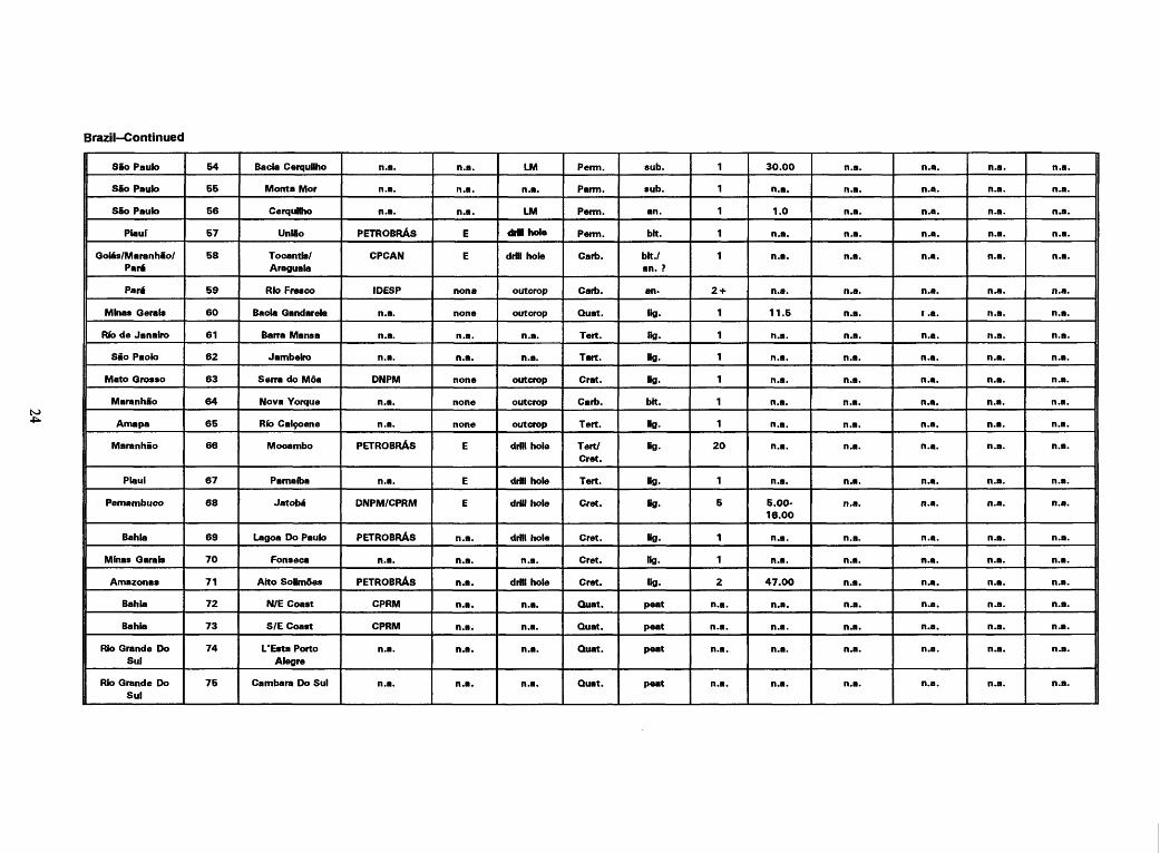
Brazil-Continued
SSo Paulo
SSo Paulo
SSo Paulo
Piauf
Goias/MaranhSo/ Part
Part
Minas Gerals
Rib de Janairo
Sao Paolo
Mato Qrosso
Maranhao
Amapa
Maranhao
Plaui
Pemambuco
Bahla
Minas Garais
Amazonas
Bahia
Bahia
Rio Grande Do Sui
Rio Grande Do Sul
54
55
56
57
58
59
60
61
62
63
64
65
66
67
68
69
70
71
72
73
74
75
Bacia Cerquilho
Monta Mor
Cerquilho
Unlio
Tocantb/ Araguala
Rio Fresco
Bacia Gandarela
Barra Mansa
Jambeiro
Serra do Mda
Nova Yorque
Rib Cal9oene
Mocambo
Parnaiba
Jatoba
Lagoa Do Paulo
Fonseca
Aito SoHmoes
N/E Coast
S/E Coast
L'Esta Porto Alegre
Cambara Do Sul
n.a.
n.a.
n.a.
PETROBRAS
CPCAN
IDESP
n.a.
n.a.
n.a.
DNPM
n.a.
n.a.
PETROBRAS
n.a.
DNPM/CPRM
PETROBRAS
n.a.
PETROBRAS
CPRM
CPRM
n.a.
n.a.
n.a.
n.a.
n.a.
E
E
nona
none
n.a.
n.a.
none
none
none
E
E
E
n.a.
n.a.
n.a.
n.a.
n.a.
n.a.
n.a.
LM
n.a.
LM
driihole
drillhole
outcrop
outcrop
n.a.
n.a.
outcrop
outcrop
outcrop
drill hole
drill hole
drill hole
drill hole
n.a.
drillhole
n.a.
n.a.
n.a.
n.a.
Perm.
Parm.
Perm.
Perm.
Garb.
Garb.
Quat.
Tert.
Tart.
Crat.
Garb.
Tert.
Tert/ Cret.
Tert.
Cret.
Cret.
Cret.
Cret.
Quat.
Quat.
Quat.
Quat.
sub.
sub.
an.
bit.
bit./ an. ?
an.
Kg.
ng.
Kg.
Kg.
bit.
Hg.
Bg.
Kg.
Kg.
Kg.
ng.
Kg.
peat
peat
peat
peat
1
1
1
1
1
2 +
1
1
1
1
1
1
20
1
5
1
1
2
n.a.
n.a.
n.a.
n.a.
30.00
n.a.
1.0
n.a.
n.a.
n.a.
11.5
n.a.
n.a.
n.a.
n.a.
n.a.
n.a.
n.a.
5.00-
16.00
n.a.
n.a.
47.00
n.a.
n.a.
n.a.
n.a.
n.a.
n.a.
n.a.
n.a.
n.a.
n.a.
n.a.
n.a.
n.a.
n.a.
n.a.
n.a.
n.a.
n.a.
n.a.
n.a.
n.a.
n.a.
n.a.
n.a.
n.a.
n.a.
n.a.
n.a.
n.a.
n.a.
n.a.
n.a.
r. a.
n.a.
n.a.
n.a.
n.a.
n.a.
n.a.
n.a.
n.a.
n.a.
n.a.
n.a.
n.a.
n.a.
n.a.
n.a.
n.a.
n.a.
n.a.
n.a.
n.a.
n.a.
n.a.
n.a.
n.a.
n.a.
n.a.
n.a.
n.a.
n.a.
n.a.
n.a.
n.a.
n.a.
n.a.
n.a.
n.a.
n.a.
n.a.
n.a.
n.a.
n.a.
n.a.
n.a.
n.a.
n.a.
n.a.
n.a.
n.a.
n.a.
n.a.
n.a.
n.a.
n.a.
n.a.
n.a.
n.a.
n.a.
n.a.
n.a.

Brazil Continued
Paran6
Parana
Parana
Parana
Sao Paulo
Minas Garete
Minas Cerate
Minas Cerate
Minas Qerate
Goias
Bahia
Maranhao
Maranhao
Maranhao
Parti
Amapa
Amazonas
Amazonas
Amazonas
Amazonas
Amazonas
Mato Grosso
Rondonla
76
77
78
79
80
81
82
83
84
85
86
87
88
89
90
91
92
93
94
95
96
97
98
Curitiba
Ponta Grossa
Afro Rio Ivaf
Afro Rio Iguacu
Valle Paraiba Do Sul
Sul de Minas
Tridngulo Mineiro
Aito Rio Sio Francisco
NE de Minas
Arredores de Brazilla
SWBahla
Barreirinha
Lago A9U
Pinheiro
llha de Marajd
Araguari
Medlo Amazonas
Baixo Rio Madeira
Baixo Rio Purus
Aito Rio Negro
Baixo Rio Branco
Xapuri
Abuna
n.a.
n.a.
n.a.
n.a.
n.a.
n.a.
n.a.
n.a.
n.a.
n.a.
n.a.
n.a.
n.a.
n.a.
n.a.
n.a.
n.a.
n.a.
n.a.
n.a.
n.a.
n.a.
n.a.
n.a.
n.a.
n.a.
n.a.
n.a.
n.a.
n.a.
n.a.
n.a.
n.a.
n.a.
n.a.
n.a.
n.a.
n.a.
n.a.
n.a.
n.a.
n.a.
n.a.
n.a.
n.a.
n.a.
n.a.
n.a.
n.a.
n.a.
n.a.
n.a.
n.a.
n.a.
n.a.
n.a.
n.a.
n.a.
n.a.
n.a.
n.a.
n.a.
n.a.
n.a.
n.a.
n.a.
n.a.
n.a.
n.a.
Quat.
Quat.
Quat.
Quat.
Quat.
Quat.
Quat.
Quat.
Quat.
Quat.
Quat.
Quat.
Quat.
Quat.
Quat.
Quat.
Quat.
Quat.
Quat.
Quat.
Quat.
Quat.
Quat.
peat
peat
peat
peat
peat
peat
peat
peat
peat
peat
peat
peat
peat
peat
peat
peat
peat
peat
peat
peat
peat
peat
peat
n.a.
n.a.
n.a.
n.a.
n.a.
n.a.
n.a.
n.a.
n.a.
n.a.
n.a.
n.a.
n.a.
n.a.
n.a.
n.a.
n.a.
n.a.
n.a.
n.a.
n.a.
n.a.
n.a.
n.a.
n.a.
n.a.
n.a.
n.a.
n.a.
n.a.
n.a.
n.a.
n.a.
n.a.
n.a.
n.a.
n.a.
n.a.
n.a.
n.a.
n.a.
n.a.
n.a.
n.a.
n.a.
n.a.
n.a.
n.a.
n.a.
n.a.
n.a.
n.a.
n.a.
n.a.
n.a.
n.a.
n.a.
n.a.
n.a.
n.a.
n.a.
n.a.
n.a.
n.a.
n.a.
n.a.
n.a.
n.a.
n.a.
n.a.
n.a.
n.a.
n.a.
n.a.
n.a.
n.a.
n.a.
n.a.
n.a.
n.a.
n.a.
n.a.
n.a.
n.a.
n.a.
n.a.
n.a.
n.a.
n.a.
n.a.
n.a.
n.a.
n.a.
n.a.
n.a.
n.a.
n.a.
n.a.
n.a.
n.a.
n.a.
n.a.
n.a.
n.a.
n.a.
n.a.
n.a.
n.a.
n.a.
n.a.
n.a.
n.a.
n.a.
n.a.
n.a.
n.a.
n.a.
n.a.
n.a.
n.a.
n.a.
n.a.
n.a.
n.a.
n.a.
n.a.
n.a.
n.a.
n.a.
n.a.
n.a.
n.a.
n.a.
n.a.
n.a.
n.a.
n.a.
n.a.
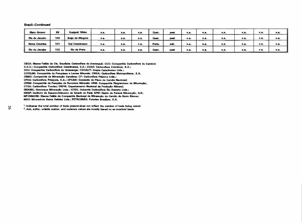
Brazil-Continued
Mato Qrosso
Rio de Janeiro
Santa Catarina
Rio de Janeiro
99
100
101
102
GuajaraY Mbim
Brejo da Mingota
Sul Catarinense
Rio da Prata
n.a.
n.a.
n.a.
n.a.
n.a.
n.a.
n.a.
n.a.
n.a.
n.a.
n.a.
n.a.
Quat.
Quat.
Perm.
Quat.
peat
peat
sub.
peat
n.a.
n.a.
n.a.
n.a.
n.a.
n.a.
n.a.
n.a.
n.a.
n.a.
n.a.
n.a.
n.a.
n.a.
n.a.
n.a.
n.a.
n.a.
n.a.
n.a.
n.a.
n.a.
n.a.
n.a.
ON
CBCA: Massa Falida da Cla. Braslleira Carbonffera de Ararangua; CCC: Companhia Carbonffera do Cambuf;C.C.C.: Companhia Carbonffera Catarinensa. S.A.; CCSA: Carbonffera Cricriuma, S.A.;CCU: Companhia Carbonffera de Urussanga; COCALIT: Coqua Catarinense Ltda.;COPELMI: Companhia de Pesquisas a Lavras Minerals; CMSA: Carbonffera Metropolitana, S.A.CNMC: Companhia de Mineracao Candiota; CP: Carbonffera Palermo Ltda.;CPSA: Carbonffera Prospers, S.A.; CPCAN: Comtesao do Piano de Carvao Naclonal;CPRM: Companhia da Pesquisa de Recursos Minerals; CRM: Companhia Riograndese de MineragSo;CTSA: Carbonffera Trevlso; DNPM: Departamento Nacional da Producao Mineral;IBRAMiL: Ibracoqua MineragSo Ltda.; ICRDL: Industrie Carbonffera Rio Deserto Ltda.;IDESP: Instituto de DesenvoK/imento do Estado do Part; KPM: Klabin do Parana Mineracao, S/A;MFCNMCBB: Massa Falida da Companhia Naclonal da M in are 960 de Carvao do Barro Blanco;MSH: Mineradora Santa Helofea Ltda.; PETROBRAS: Petroleo Brasllero, S.A.
': Indicates tha total number of beds present-does not reflect the number of beds being mined 2: Ash. sulfur, volatile matter, and moisture values are mostly based on as-received basis

Coal mines and occurrences in Chile[Note: Data reflect information acquired from COCAR, ENACAR, and SERNAGEOMIN during visit to country. LM, local mining-type unknown; an., anthracite; bit., bituminous;sub., subbituminous; lig., lignite; Internal adm. area. Internal administrative area; n.a., data not available; S, surface mine; U, underground; ?, uncertain;Quat., Quaternary; Tert., Tertiary; Tri., Triassic.]
Internal adm. area
Atacama
Atacama
Atacama
Concepcion
Concepcion
Concepcion
Concepcion
Concepcion
Concepcion
Concepcttn
Arauco
Arauco
Araucanla
Araucanla
Araucanla
Araucania
Araucania
Map number
1
2
3
4
5
6
7
8
9
10
11
12
13
14
15
16
17
Coal field, occurrence/
mine name
Cerro La Tema
Cerro La Guardia
Alto del Carmen
Guilacoga
Concepcion
Collco Sur
Schwager (Coronet)
Lota
RamadHlas
San Justo
Curanilahue
Trongol
PHpico
Lebu
Plegaria
Lirquen
Temuco
Operator
n.a.
n.a.
n.a.
n.a.
n.a.
ENACAR
Schwager
ENACAR
n.a.
n.a.
n.a.
ENACAR
n.a.
ENACAR (CVL)
n.a.
n.a.
n.a.
Mine type
n.a.
n.a.
n.a.
n.a.
n.a.
U
U
U
U
U
n.a.
n.a.
U
U
n.a.
none
n.a.
Recovery activity
?
?
?
LM
outcrop
7
under sea
under sea
?
?
LM
LM
?
?
LM
?
?
Age
Tri.
Tri.
Tri.
Tri.
Tert.
Tert.
Tert.
Tert.
Tert.
Tert.
Tert.
Tert.
Tert.
Tert.
Tert.
Tart.
Tri.
Rank
an.
an.
an.
an.
bit.
bit.
bit.
bit.
bit.
bit.
bit.
bit.
bit.
bit.
bit.
bit./lig.
an.
Number of beds1
2
n.a.
n.a.
n.a.
3
4
3 +
9
n.a.
n.a.
n.a.
n.a.
n.a.
n.a.
n.a.
1
n.a.
Ash(%)2
n.a.
n.a.
n.a.
n.a.
n.a.
n.a
n.a.
7.7-
12.9
n.a.
n.a.
n.a.
n.a.
n.a.
n.a.
n.a.
n.a.
n.a.
Sulfur (%>2
n.a.
n.a.
n.a.
n.a.
n.a.
n.a
n.a.
0.61-
1.82
n.a.
n.a.
n.a.
n.a.
n.a.
n.a.
n.a.
n.a.
n.a.
Vol. matter(%}2
n.a.
n.a.
n.a.
n.a.
n.a.
n.a
n.a.
37.0-
41.0
n.a.
n.a.
n.a.
n.a.
n.a.
n.a.
n.a.
n.a.
n.a.
Moisture (%)2
n.a.
n.a.
n.a.
n.a.
n.a.
n.a
n.a.
2.8-
3.5
n.a.
n.a.
n.a.
n.a.
n.a.
n.a.
n.a.
n.a.
n.a.
Heat Value (kcal/kg)
n.a.
n.a.
n.a.
n.a.
n.a.
n.a.
3,722-
3,944
7,500
n.a.
n.a.
n.a.
n.a.
n.a.
n.a.
n.a.
n.a.
n.a.
NJ

Chile-Continued
Valdivia
Valdivla
Valdivia
Los Lagos
Los Lagos
Los Lagos
Los Lagos
Magallanes
Magallanes
Magallanes
Magallanes
Magallanes
Magallanes
Magallanes
Magallanes
Magallanes
Magallanes
Magallanes
Magallanes
18
19
20
21
22
23
24
25
26
27
28
29
30
31
32
33
34
35
36
San Jose de Mariquina
Rib San Pedro
Pupunahue
Punta de la Galera
Valdivia Basin
Paraga
Orsona/ La Union
Mina Chllena
Rib Rubens
Mina Dorotea
Mina Magdalena
Mina Elena (Valle)
Mina Josefina (Sara)
Is la Riesco
Peckett
Mina Vuicano
Mina Loreto
Mina Santa Clara
Tierra del Fuego
n.a.
n.a.
n.a.
n.a.
n.a.
n.a.
n.a.
ENACAR
BHP Utah
ENACAR
ENACAR
ENACAR
ENACAR
ENACAR
COCAR
ENACAR ?
ENACAR
ENACAR
n.a.
n.a.
n.a.
U
n.a.
n.a.
n.a.
n.a.
n.a.
none
none
n.a.
n.a.
n.a.
n.a.
S
none
none
none
n.a.
?
LM
7
?
7
7
?
?
?
?
LM
LM
LM
LM
?
?
7
?
?
Tert.
Ten.
Tert.
Tert.
Tert.
Tert.
Tert.
Tert.
Tert.
Tert.
Tert.
Tert.
Tert.
Tert.
Tert.
Tart.
Tert.
Tert.
Quat.
sub.
sub.
sub.
sub.
sub.
sub.
sub.
sub.
sub.
sub.
sub.
sub.
sub.
sub.
sub.
sub.
sub.
sub.
peat
n.a.
1
1
n.a.
n.a.
n.a.
n.a.
n.a.
n.a.
n.a.
n.a.
8
14
24
13
n.a.
n.a.
n.a.
n.a.
n.a.
n.a.
n.a.
n.a.
n.a.
n.a.
n.a.
n.a.
n.a.
n.a.
n.a.
n.a.
9.7
n.a.
17.0
n.a.
n.a.
n.a.
n.a.
n.a.
n.a.
n.a.
n.a.
n.a.
n.a.
n.a.
n.a.
n.a.
n.a.
n.a.
n.a.
0.38
n.a.
0.6-
1.0
n.a.
n.a.
n.a.
n.a.
n.a.
n.a.
n.a.
n.a.
n.a.
n.a.
n.a.
n.a.
n.a.
n.a.
n.a.
n.a.
37.0
n.a.
n.a.
n.a.
n.a.
n.a.
n.a.
n.a.
n.a.
n.a.
n.a.
n.a.
n.a.
n.a.
n.a.
n.a.
n.a.
n.a.
n.a.
19.0
n.a.
1.3
n.a.
n.a.
n.a.
n.a.
n.a.
n.a.
n.a.
n.a.
n.a.
n.a.
n.a.
n.a.
n.a.
n.a.
n.a.
n.a.
12.222?
n.a.
2.270
n.a.
n.a.
n.a.
n.a.
': Indicates total number of beds present; not number of beds mined2 : Ash, sulfur, volatile matter and moisture are mostly based on an as-received baste
ENACAR: Empresa Nacional del Carbon, S.A.; COCAR: Compartia de Carbones Chile, S.A.; CVL: Compafiia Victoria de Lebu; BHP Utah: Broken Hill Properties; SCHWAGER: Schwager, S.A.

Coal mines and occurrences in Colombia[Note: Data reflect information acquired during visit to country- Internal adm. area, internal administrative area; S., surface mine; E., exploration phase; LM, local mining-type unknown; an., anthracite; bit., bituminous; sub., subbituminous; lig., lignite; Tert., Tertiary; Cret., Cretaceous.]
Internal adm. area
Guajira
Guajira
Guajira
Guajira
Cesar
Cesar
Cesar
Cesar
Cesar
Norta de Sentander
Santa nder
Antioquia
Cordoba
Cordoba
Cordoba
Map number
Ka)
Kb)
2
3
4
5
6
7
8
9
10
11
12
13
14
Coal Field, occurrence/
mine name
El Cerrejon/Zona Norte
El Cerrejon/Zona Central
n.a.
Oreganal
La Jagua de Iblrico
El Descanso
La Loma
Calenturitas
La Palma/Perlja
Tasajero
San Vicente
Urabe/ Mutata/Cigoroda
Mina Zimba
Taraza/Rfo Man
Cienaga de Oro
Operator
Carbocol
Intercor
Prodeco
Cb del Car
Cb del Car
Carbocol
Drummond/ Carbocol
Prodeco
Carbo Andes
Carbocol
Carbocol
Carbocol
Cb del Car
n.a.
n.a.
Mine typa
S
S
E/S
E/S
8
E
E
E
S
n.a.
n.a.
n.a.
n.a.
n.a.
n.a.
Recovery activity
n.a.
n.a.
n.a.
n.a.
n.a.
LM
LM
LM
n.a.
n.a.
n.a.
n.a.
LM
LM
LM
Age
Tart.
Tert.
Tert.
Tert.
Tert.
Tert.
Tert.
Tert.
Tert.
Tert.
Tert.
Tert.
Tert.
Tert.
Tert
Rank
bh./sub.
bit./sub.
bit./sub.
bit./sub.
bit./sub.
bit. /sub.
bit./sub.
bit./sub.
bit./sub.
bit.
bit.
sub.
sub./bit.
sub.
fig./sub.
Number of beds 1
40
40
30
30
10?
?
16
?
?
?
?
1
17
1
7
Ash (%)*
8.25
5.94
n.a.
5.0-7.0
n.a.
7.92
4.63
5.0-7.0
low
12.52
29.35
n.a.
17.00
n.a.
n.a.
Sulfur (%)2
0.75
0.81
n.a.
0.6-0.75
n.a.
0.56
0.6
0.4-0.6
low
1.0
1.75
n.a.
1.50
n.a.
n.a.
Vol. Mattar
«%)*
32.80
34.38
n.a.
35.0-37.0
n.a.
n.a.
41.44
34.0-36.0
high
34.07
28.45
n.a.
34.50
n.a.
n.a.
Moisture(%)*
n.a.
n.a.
n.a.
n.a.
n.a.
n.a.
n.a.
n.a.
n.a.
n.a.
n.a.
n.a.
n.a.
n.a.
n.a.
Heat value (kcal/kg)
6.500
6,666
n.a.
n.a.
n.a.
5,993
7,320
6.388-
6,555
6,666
7.260
5,830
4.722
4.722
4.722
4,722

Colombia-Continued
Sucre
Bolivar
Cordoba
Antfoquia
Caldas
Choco
Cauca
Valle del Cauca
VaHe del Cauca
Cundinamarca
Cudinamarca
Boyaca
Boyaca
Boyeca
Cundinamerca/ Boyaca
Cundinamarca/ Boyaca
Cundinamarca/ Boyaca
Cundinamarce/ Boyaca
Cundinamarca
Cundinamarca
Cundinamarca
Amazonas
15
16
17
18
19
20
21
22
23
24
25
26
27
28
29
30
31
32
33
34
35
36
San Jacinto
Puri/Caceri
Alto San Jorga
Amaga/Sopetran
Rio Suclo/Quinchia
Tado
Mercaderes
Suerez/Piayon/ Dtnde
Valle del Cauca
Pubenza/Dindal
Guatiquia
Tunja/Pelpa/ Duttema
Sogamoso/Morca/ Topaga/ Paz del
Rio/Jerico
Vesquez
Lenguazaque
Sueva/Umbita/ Lagttota
Cogua/Samaca
Guecheta
La Pradera
El Saito
Rib Frio
Latecia
n.a.
n.a.
Cerbocol
Carbocol
Carbocol
Carbocol
Carbocol
Carbocol
Carbocol
Carbocol
Carbocol
n.a.
n.a.
Carbocol
Prodeco
Carbocol
Carbocol
Carbocol
Carbocol
Carbocol
Carbocol
n.a.
n.a.
n.a.
S
n.a.
n.a.
none
n.a.
none
S
n.a.
n.a.
none
n.a.
n.a.
S
n.a.
n.a.
n.e.
n.a.
n.a.
n.a.
n.a.
n.a.
n.a.
n.a.
LM
n.a.
n.a.
n.a.
n.a.
n.a.
LM
LM
n.a.
LM
LM
n.a.
LM
LM
n.a.
n.a.
n.a.
n.a.
E
Tert.
Tert.
Tert.
Tert./Cret.
Tert.
Tert.
Tert.
Tert.
Tert.
Tert./Cret.
Tert./Cret.
Tert./Cret.
Tert./Cret.
Tert./Cret.
Tert.
Tert.
Tert.
Tert.
Tert.
Tert./Cret.
Tert./Cret.
Tert.
lig.
sub.
sub.
sub. /an.
bit.
sub./bh.
sub.
sub. /an.
sub. /an.
sub.
bit.
sub.
sub.
an ./sub.
bit.
bit.
bit.
bit.
bit.
bit.
bit.
sub.
2
4
17
9
8 +
?
4
3
12
9
4
8
17
3
10
5
14
?
?
2
17
2
n.e.
n.a.
15.56
12.30
n.a.
n.a.
n.a.
n.a.
30.10
n.a.
n.a.
n.a.
n.a.
21.2
n.a.
n.a.
n.a.
n.a.
n.a.
8.0-15
n.a.
n.a.
n.a.
n.a.
1.32
0.42
n.a.
n.a.
n.a.
n.a.
1.70
n.a.
n.a.
n.a.
n.a.
1.30
n.a.
n.a.
n.a.
n.a.
n.a.
0.90-0.96
n.a.
n.a.
n.a.
n.a.
35.48
36.40
n.a.
n.a.
n.a.
n.a.
25.70
n.a.
n.a.
n.a.
n.a.
29.30
n.e.
n.a.
n.a.
n.a.
n.a.
28.0-34.0
n.a.
n.a.
n.a.
n.a.
n.a.
n.a.
n.a.
n.a.
n.a.
n.a.
n.a.
n.a.
n.a.
n.a.
n.a.
n.a.
n.a.
n.a.
n.a.
n.a.
n.a.
n.a.
n.a.
n.a.
n.a.
n.a.
4.792
5.455
n.a.
n.a.
n.a.
n.a.
5.122
n.a.
n.a.
n.a.
n.a.
5.788
n.a.
n.a.
n.a.
n.a.
n.a.
6,650-
7.333
n.a.
n.a.
Carbocol: Carbones da Colombia, S.A. (INTERCOR and EXXON are affiliated with Carbocol); Cb del Car: Carbones del Caribe. 8.A. Prodeco: Productos de Colombia, S.A.; Drummond: Drummond Lta.; CarboAndes: Carbones de loe Andes, S.A.
': Indicates the total numbar of beds present-does not raflact the number of beds being mined 2: Aeh, eulfur, volatile matter, and moisture are mostly based on an as-received basis

Coal mines and occurrences in Ecuador[Note: Data has been reviewed by scientists from the Institute Ecuatoriano de Mineria in Quito. Data reflects their suggested changes in the table below and on the map.LM, local mining-type unknown; E, exploration phase; 7. unknown; n.a., not available; lig., lignite; sub., subbituminous; Internal adm. area. Internal Administrative Area.]
Internal adm. area
Loja
Loja
Azuay
Pichincha
Azuay
Cafiar/Azuay
Guayas
Guayas
Manabl
Manabl
Morona-
Santiago
Chimborazo
Napo
Map number
1
2
3
4
5
6
7
8
9
10
11
12
13
Coal Field, occurrence/
mine name
Malacatos
Rib Malacatos (Lola)
Nabdn
San Antonio de Pichincha
Cafiar/Azoques- Biblian
BibHan
Punta Santa Elena
Progreso
Pedernales
Cabo San Mateo
Cuenca Amazonas
Cuenca El Derrumbo
Tena
Operator
n.a.
n.a.
n.a.
n.a.
n.a.
n.a.
n.a.
n.a.
n.a.
n.a.
n.a.
n.a.
n.a.
Mina type
?
?
None
Nona
?
?
None
?
None
?
E
None
E
Recovery activity
LM
LM
n.a.
n.a.
LM
LM
drill hole
drill hole
drillhole
drill hole
drill hole
n.a.
drill hole
Age
Tert.
Tert.
Tert.
Quat.
Tert.
Tert.
Tart.
Tert.
Tert.
Tert.
Tert.
Tert.
Tert.
Rank
Hg./sub.
sub.
fig.
Ha.
Hg./sub.
ub.
fig.
Kg.
Kg.
Kg.
«g.
Hg./sub.
Hg.
Number of bede1
8
5
?
1
2
?
?
?
?
?
?
1
4
Ash(%)2
15
8
n.a.
n.a.
6.4-6.0
n.a.
n.a.
n.a.
n.a.
n.a.
n.a.
n.a.
n.a.
Sulfur (%)2
8
8
n.a.
n.a.
1-1.7
n.a.
n.a.
n.a.
n.a.
n.a.
n.a.
n.a.
n.a.
Vol. matter (%)2
n.a.
n.a.
n.a.
n.a.
n.a.
n.a.
n.a.
n.a.
n.a.
n.a.
n.a.
n.a.
n.a.
Moisture (%)2
n.a.
n.a.
n.a.
n.a.
n.a.
n.a.
n.a.
n.a.
n.a.
n.a.
n.a.
n.a.
n.a.
Heat value (kcal/kg)
4.500
2,600-
5.500
n.a.
n.a.
4,000
n.a.
n.a.
n.a.
n.a.
n.a.
n.a.
n.a.
n.a.
': Indicates the total number of beds present-does not reflect the number of beds being mined 2 : Ash, eurfur, volatile matter and moisture values are mostly based on an as-received basis
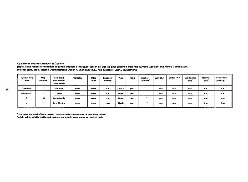
Coal mines and occurrences in Guyana[Note: Data reflect information acquired through a literature search as well as data obtained from the Guyana Geology and Mines Commission.Internal adm. area. Internal Administrative Area; ?, unknown; n.a., not available; Quat., Quaternary]
Internal adm. area
Demerara
Demerara ?
?
?
Map number
1
2
3
4
Coal Field, occurrence/ mine name
En more
Hubu
Springiands
Low Ground
Operator
none
none
none
none
Mine type
none
none
none
none
Recovery activity
n.a.
n.a.
n.a.
n.a.
Age
Quat.?
Quat.
Quat.
Quat. ?
Rank
peat
peat
peat
peat
Number of beds 1
?
?
?
?
Ash (%)2
n.a.
n.a.
n.a.
n.a.
Sulfur (%)2
n.a.
n.a.
n.a.
n.a.
Vol. Matter (%)2
n.a.
n.a.
n.a.
n.a.
Moisture (%)2
n.a.
n.a.
n.a.
n.a.
Heat value (kcal/kg)
n.a.
n.a.
n.a.
n.a.
NJ
1 : Indicates the total of beds present; does not reflect the number of beds being mined 2 : Ash, sulfur, volatile matter and moisture are mostly based on an as-received basis
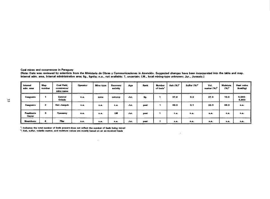
Coal mines and occurrences in Paraguay[Note: Data was reviewed by scientists from the Ministerio de Obras y Communicaciones in Asunci6n. Suggested changes have been incorporated into the table and map.Internal adm. area. Internal administrative area; lig., lignite; n.a., not available; 7. uncertain; LM., local mining-type unknown; Jur., Jurassic.]
Internal adm. area
Caaguazu
Caaguazu
Presldente Hayes
Neembucu
Map number
1
2
3
4
Coal Field, occurrence/ mine name
Coronet Oviedo
San Juaquin
Ypacaray
Pilar
Operator
n.a.
n.a.
n.a.
n.a.
Mine typa
none
n.a.
n.a.
n.a.
Recovery activity
outcrop
n.a.
LM
n.a.
Age
Jur.
Jur.
Jur.
Jur.
Rank
lig.
peat
peat
peat
Number of beds1
1
1
1
?
Ash (%)2
37.6
48.0
n.a.
n.a.
Sulfur (%)2
0.3
0.1
n.a.
n.a.
Vol. matter (%)2
37.3
33.3
n.a.
n.a.
Moisture (%)2
10.0
48.0
n.a.
n.a.
Heat value (kcal/kg)
4.640-
6,800
n.a.
n.a.
n.a.
': Indicates the total number of beds present-does not reflect the number of beds being mined 2 : Ash, sulfur, volatile matter, and moisture values are mostly based on an as-received basis

Coal mines and occurrences in Peru[Note: Data has been reviewed by scientists from Minero Peru and from SENAGE (formerly INGEMMET).Changes and corrections have been made according to their recommendations.E., exploration phase; LM.. local mining-type unknown; n.a., not available, 7. unknown; Kg., lignite;meta., meta-anthracite; an., anthracite; bit., bituminous; sub., subbituminous; Internal adm. area, internaladministrative area;Tert., Tertiary; Cret., Cretaceous; Jur., Jurassic.]
Intemaiadm. area
Tumbes
Tumbes
Tumbes
Piura/Sullana
Piura/Palta
Lambayeque
Cajamarca/ Hualgayoc
Cajamarca
Cajamarca/ Celendin
Cajamarca/ Santa Cruz
Cajamarca/ Santa Cruz
Cajamarca/ La kin Canada
Cajamarca/ Cajabamba
Map number
1
2
3
4
5
6
7
8
9
10
11
12
13
Coal Field, occurrence/ mine name
Zorritos
Caleta Cruz
Casitas
Jahuay Negro
Silla de Paita
Motupe
Pinapata/Tuco
Hualgayoc
Punte
Cuptenique
San Benito
Yanacancha
Huayday
Operator
n.a.
n.a.
n.a.
n.a.
n.a.
n.a.
n.a.
n.a.
n.a.
n.a.
n.a.
n.a.
n.a.
Mine type
n.a.
n.a.
n.a.
n.a.
n.a.
n.a.
n.a.
n.a.
n.a.
n.a.
n.a.
n.a.
n.a.
Recovery activity
LM
LM
LM
LM
LM
LM
LM
LM
n.a.
n.a.
n.a.
LM
LM
Age
Tert.
Tert.
Tert.
Tert.
Tert.
Cret.
Cret.
Cret.
Cret.
Cret.
Cret.
Cret.
Cret.
Rank
Kg.
Kg-
lig.
Kg.
Kg.
an.
an.
an.
an.
an.
an.
an./bh.
an.
Number of beds1
?
7
?
?
?
?
5
4
?
5
?
2 +
8
Ash (%)2
20.-36.
n.a.
n.a.
n.a.
n.a.
n.a.
6.0-35.0
n.a.
n.a.
8.0-12.0
n.a.
n.a.
n.a.
Sulfur (%)2
4-5
n.a.
n.a.
n.a.
n.a.
n.a.
0.6-1.2
n.a.
n.a.
0.6
n.a.
1.5
n.a.
Vol. matter(%)2
27.00-
32.00
n.a.
n.a.
n.a.
n.a.
n.a.
3.0-8.0
n.a.
n.a.
n.a.
n.a.
40.0-50.0
n.a.
Moisture (%)2
n.a.
n.a.
n.a.
n.a.
n.a.
n.a.
n.a.
n.a.
n.a.
n.a.
n.a.
n.a.
n.a.
Heat value (kcal/kg)
2.700-
4,300
n.a.
n.a.
n.a.
n.a.
n.a.
6,400-
7,600
n.a.
n.a.
6,750
n.a.
7.000
n.a.

Peru-Continued
Cajamarca/ Cajabamba
La Libertad/Lotuaco
La Ubertad/Otzuco
La Libertad/Otzuco
La Libertad/Otzuco
La Ubertad/Otzuco
La Libertad/Otzuco
La Libertad/Otzuco
La Libertad/Otzuco
La Libertad/Otzuco
La Libertad/Otzuco
Ancash
Ancash/ Pallasca
Ancash/ Pallasca
Ancash
Ancash/ Pallasca
14
15
16
17
18
19
20
21
22
23
24
25
26
27
28
29
Ambara
C'lchur
Cafia Brava
Colpa/Agua Caliente
Huertas
San Jose ?
Antracita ?
La Libertad ?
Silcahuanga ?
Caliacuyan ?
Juanita/Tres Rfos ?
Conchucos
Qalgada
Ancos
Mayday
San Carios/ Santa
n.a.
n.a.
n.a.
n.a.
n.a.
n.a.
n.a.
n.a.
n.a.
n.a.
n.a.
n.a.
n.a.
n.a.
n.a.
n.a.
n.a.
n.a.
n.a.
n.a.
n.a.
n.a.
n.a.
n.a.
n.a.
n.a.
n.a.
n.a.
n.a.
none
none
n.a.
LM
n.a.
LM
n.a.
n.a.
n.a.
n.a.
LM
n.a.
n.a.
n.a.
n.a.
LM
n.a.
n.a.
LM
Cret.
Cret.
Cret.
Cret.
Cret.
Cret.
Cret.
Cret.
Cret.
Cret.
Cret.
Cret.
Cret.
Cret.
Cret.
Cret.
an.
an.
an.
an.
an.
an.
an.
an.
an.
an.
an.
an.
an.
an.
an.
an./meta.
?
?
10
10
10
10
10
10
10
5
10
2
5
3
5
5 +
n.a.
n.a.
n.a.
n.a.
n.a.
n.a.
n.a.
6.0-10.0
n.a.
n.a.
n.a.
6.0-14.0
10.5-
32.0
0.5-32.0
n.a.
13.0
n.a.
n.a.
n.a.
n.a.
n.a.
n.a.
n.a.
1.0-2.5
n.a.
n.a.
n.a.
n.a.
0.7-0.8
0.7-0.8
n.a.
n.a.
n.a.
n.a.
n.a.
n.a.
n.a.
n.a.
n.a.
2.5-12.0
n.a.
n.a.
n.a.
4.0-6.0
4
4
2.0
6.0-8.0
n.a.
n.a.
n.a.
n.a.
n.a.
n.a.
n.a.
n.a.
n.a.
n.a.
n.a.
n.a.
n.a.
n.a.
n.a.
n.a.
n.a.
n.a.
n.a.
n.a.
n.a.
n.a.
n.a.
7,000-
7,500
n.a.
n.a.
n.a.
6.000-
7.300
4,377-
6.660
n.a.
n.a.
n.a.

Peru Continued
Ancash
Ancash/ Pallasca
Ancash/ Caraz
Ancash/ Pallasca
Ancash/ Pallasca
Anoash/ Pallasco
Ancash
Ancash/ Huari
Ancash/ Huari
Ancash/ Huari
Ancash/ Huari
Huanuco
Ancash/ Huari
Ancash/ Huari
Anoash/ Huari
Pasco/DAC
Pasco/DAC
Pasco/DAC
Pasco/DAC
Huanuco/ Dos de Mayo
Lima/ Chancay
Lima/ Chancay
30
31
32
33
34
35
36
37
38
39
40
41
42
43
44
45
46
47
48
49
50
51
Sihuas/ Tarica
Santa
Buenaventura /Caraz
Pallasquina
Potrcros
La Limena
La Sateada
San Lute
Chacas
Huari
Santa Rosa
Huallanca
San Marcos/ Huari
Tampillas
Juproc
LLacsa
Qoyllarisquiza
Quishuar- cancha/Jara
Vincuscancha
Queropatca
Huancho
Yacu
n.a.
n.a.
n.a.
n.a.
n.a.
n.a.
n.a.
n.a.
n.a.
n.a.
n.a.
n.a.
n.a.
n.a.
n.a.
n.a.
n.a.
n.a.
n.a.
n.a.
n.a.
n.a.
n.a.
none
n.a.
n.a.
n.a.
n.a.
n.a.
n.a.
n.a.
n.a.
n.a.
n.a.
n.a.
n.a.
n.a.
n.a.
n.a.
n.a.
n.a.
n.a.
n.a.
n.a.
n.a.
n.a.
LM
n.a.
LM
LM
n.a.
n.a.
n.a.
n.a.
n.a.
n.a.
n.a.
n.a.
n.a.
n.a.
LM
n.a.
n.a.
LM
n.a.
n.a.
Cret.
Cret.
Cret.
Cret.
Cret.
Cret.
Cret.
Cret.
Cret.
Cret.
Cret.
Cret.
Cret.
Cret.
Cret.
Cret.
Cret.
Cret.
Cret.
Cret.
Cret.
Cret.
an.
bit ./an.
an.
an.
an.
an
bit.
bit.
bit.
bit.
an.
an.
an.
bit.
bit.
sub.
sub./bit.
sub.
sub.
bit.
btt./sub.
bit./sub.
1
6 +
1
5 +
5 +
2
?
?
?
?
?
5
15
?
?
4 +
4
4
4
?
?
?
4.0-6.0
n.a.
8.6
n.a.
n.a.
13.0
n.a.
n.a.
n.a.
n.a.
n.a.
20.0
n.a.
n.a.
n.a.
n.a.
54.0
48.0
n.a.
n.a.
n.a.
n.a.
n.a.
n.a.
0.8
n.a.
n.a.
n.a.
n.a.
n.a.
n.a.
n.a.
n.a.
n.a.
n.a.
n.a.
n.a.
n.a.
12.0
2.8
n.a.
n.a.
n.a.
n.a.
4.0-6.0
n.a.
3.5
n.a.
n.a.
2.0
n.a.
n.a.
n.a.
n.a.
n.a.
6.5
n.a.
n.a.
n.a.
n.a.
23.4
29.0
n.a.
n.a.
n.a.
n.a.
n.a.
n.a.
n.a.
n.a.
n.a.
n.a.
n.a.
n.a.
n.a.
n.a.
n.a.
n.a.
n.a.
n.a.
n.a.
n.a.
n.a.
n.a.
n.a.
n.a.
n.a.
n.a.
n.a.
n.a.
6.750
n.a.
n.a.
n.a.
n.a.
n.a.
n.a.
n.a.
n.a.
6,394
n.a.
n.a.
n.a.
n.a.
n.a.
3,500
n.a.
n.a.
n.a.
n.a.

Peru Continued
Lima/ Cajatambo
Lima/ Cajatambo
Lima/ Chancay
Lima/ Chancay
Junta/ Yauli
Junin/ Yauli
Junln/ ConcepckSn
Junin/ Concepcion
HuancaveHca
Huancavelica
Huancavelica
Huancavelica
Huancavelica
Cusco ?
Arequipa/ Isiay
Puno/Puno
Puno
Moquegua
Moquegua
Moquegua
Arequipa/ Caylloma
52
53
54
55
56
57
58
59
60
61
62
63
64
65
66
67
68
69
70
71
72
Oyon
Saquicocha
Yanquil
Parquin
Marcapomaco -cha
Pomacocha
Jatunhuasi
Nahunpuquio
Vilca
Lircay
Pilpichaca
Santa Ana
Churcampa
Lialiahue ?
Toco Velingo
Viique
Mafiazo
Isquirpo
Tamizgue
Pampilla
Sumbay
n.a.
n.a.
n.a.
n.a.
n.a.
n.a.
n.a.
n.a.
n.a.
n.a.
n.a.
n.a.
n.a.
n.a.
n.a.
n.a.
n.a.
n.a.
n.a.
n.a.
n.a.
n.a.
n.a.
n.a.
n.a.
n.a.
n.a.
n.a.
n.a.
n.a.
n.a.
n.a.
n.a.
n.a.
n.a.
n.a.
n.a.
n.a.
n.a.
n.a.
n.a.
n.a.
LM
n.a.
n.a.
n.a.
n.a.
n.a.
LM
n.a.
n.a.
n.a.
n.a.
n.a.
n.a.
n.a.
n.a.
n.a.
n.a.
n.a.
n.a.
n.a.
n.a.
Cret.
Cret.
Cret.
Cret.
Cret.
Cret.
Cret.
Cret.
Cret.
Cret.
Cret.
Cret.
Cret.
Cret./Jur.
Cret./Jur.
Cret./Jur.
Cret./Jur.
Cret./Jur.
Cret./Jur.
Cret./Jur.
Cret./Jur.
sub.
sub.
sub.
sub.
sub.
sub.
bh./sub.
sub.
sub.
sub.
sub.
sub./bft.
sub./bft.
bit.
bit.
bit.
bit.
bit.
bit.
bit.
bit.
11
11
?
?
?
?
6
?
?
?
?
?
?
?
?
?
?
1
1
1
4
6.0-12.0
n.a.
n.a.
n.a.
n.a.
n.a.
6.0-20.0
n.a.
n.a.
n.a.
n.a.
n.a.
n.a.
n.a.
n.a.
n.a.
n.a.
n.a.
n.a.
n.a.
17.4
0.7
n.a.
n.a.
n.a.
n.a.
n.a.
0.6-2.0
n.a.
n.a.
n.a.
n.a.
n.a.
n.a.
n.a.
n.a.
n.a.
n.a.
n.a.
n.a.
n.a.
1.06
16.0-22.0
n.a.
n.a.
n.a.
n.a.
n.a.
32.0-38.0
n.a.
n.a.
n.a.
n.a.
n.a.
n.a.
n.a.
n.a.
n.a.
n.a.
n.a.
n.a.
n.a.
6.66
n.a.
n.a.
n.a.
n.a.
n.a.
n.a.
n.a.
n.a.
n.a.
n.a.
n.a.
n.a.
n.a.
n.a.
n.a.
n.a.
n.a.
n.a.
n.a.
n.a.
n.a.
7.000-
7,600
n.a.
n.a.
n.a.
n.a.
n.a.
5.000-
7.000
n.a.
n.a.
n.a.
n.a.
n.a.
n.a.
n.a.
n.a.
n.a.
n.a.
n.a.
n.a.
n.a.
6.945

Peru Continued
Arequipa/ CayOoma
Arequipa/ Cast ilia
Moquegua/ Carumas
Moquegua/ Carumas
Moquegua/ Carumas
Tacna/Palca
Cuzco/Paruro
Cuzco/ Chumbivilca
Arequipa/ La Union
Loreto
Loerto
Lorato
Loreto
Lorato
Loreto
Loreto
Loreto
73
74
75
76
77
78
79
80
81
82
83
84
85
86
87
88
89
Murco
Corire
Carumas
Estampar- que ?
Mtequini ?
Palca
Paruro
Livttaca
Cotahuasi
Chambara
Requena
Requena
San Pablo/Rfo Amazonas
Pebas/Rio Amazonas
Iquitos/Rfb Amazonas
Nauta/Rfb Amazonas
San Antonlo/Rfb
Marafion
n.a.
n.a.
n.a.
n.a.
n.a.
n.a.
n.a.
n.a.
n.a.
n.a.
n.a.
n.a.
n.a.
n.a.
n.a.
n.a.
n.a.
n.a.
n.a.
n.a.
n.a.
n.a.
n.a.
n.a.
n.a.
n.a.
n.a.
E
none
E
E
E
E
E
n.a.
n.a.
n.a.
n.a.
n.a.
n.a.
n.a.
n.a.
n.a.
n.a.
drill hole
outcrop
drill hole
drill hole
drill hole
drill hole
drill hole
Cret./Jur.
Cret./Jur.
Cret./Jur.
Cret./Jur.
Cret./Jur.
Cret./Jur.
Tert.
Tert.
Tert.
Tert.
Tert.
Cret.
Tert.
Tert.
Tert.
Tert.
Tert.
bit.
bit.
bh./an.
bit.
bit.
bit.
Hg.
lig.
ug.
lig.
lig.
an.
fig.
lig.
lig.
lig.
lig.
2
1
3
3
1
1
1
2
1
1 +
1
1
1
1
1
1
1
15.0
n.a.
2.0-5.0
n.a.
n.a.
n.a.
n.a.
n.a.
n.a.
n.a.
n.a.
n.a.
n.a.
n.a.
n.a.
n.a.
n.a.
3.5
n.a.
n.a.
n.a.
n.a.
n.a.
n.a.
n.a.
n.a.
n.a.
n.a.
n.a.
n.a.
n.a.
n.a.
n.a.
n.a.
27.0
n.a.
9.0-38.0
n.a.
n.a.
n.a.
n.a.
n.a.
n.a.
n.a.
n.a.
n.a.
n.a.
n.a.
n.a.
n.a.
n.a.
n.a.
n.a.
n.a.
n.a.
n.a.
n.a.
n.a.
n.a.
n.a.
n.a.
n.a.
n.a.
n.a.
n.a.
n.a.
n.a.
n.a.
7.300
n.a.
n.a.
n.a.
n.a.
n.a.
n.a.
n.a.
n.a.
n.a.
n.a.
n.a.
n.a.
n.a.
n.a.
n.a.
n.a.
1 : Indicates tha total numbar of beds present-does not reflect the number of beds being mined 2 : Ash, sulfur, volatile matter and moisture values are mostly based on an as-recalved basis
DAC: Daniel A. Carrion

Coal mines end occurrences in Suriname[Note: Deta reflect compilation of existing literature and data obtained by the Geology and Mines Survey.Internal edm. area. Internal administrative aree; n.a., not available; ?, unknown; Plei., Pleistocene; Quat., Quaternary]
Internal adm. area
Coronla/ Samara oca
Marowijne
Sipaliwini
Map number
1
2
3
Coal Field, occurrence/ mine name
Coronie
Moengo Tapoa
Corantijn
Operator
n.a.
n.a.
n.a.
Mine type
none
nona
none
Recovery activity
n.a.
n.a.
E
Age
Quat. ?
Quat. ?
Plei.
Rank
peat
peat
peat
Number of beds1
?
?
?
Ash (%)2
4.4-12
n.a.
n.a.
Sulfur (%)2
n.a.
n.a.
n.a.
Vol. matter (%)2
n.a.
n.a.
n.a.
Mobtura (%)2
94-95
n.a.
n.a.
Heat value (kcal/kg)
4,500
n.a.
4,200
VO
': Indicate* the total number of beds present-doe* not reflect the number of beds being mined 2: Ash, sulfur, volatile matter and moisture are mostly based on an as-received basis

Coal mines and occurrences in Uruguay[Note: Data reflect information acquired from DINAMIGE during visit to the country. Internal adm. area. Internal administrative area; E., exploration phase;?. unknown; n.e., not available; sub., subbituminous; Tert., Tertiary; Perm., Permian but some Carboniferous; Carb., Carboniferous.]
Internal adm. area
Cerro Largo
Cerro Largo
Cerro Largo
Treinta y Tree
Tacuarembo
Tacuarambo
Cerro Largo
Cerro Largo
Canelone* or San Jose
Maldonado
Map number
1
2
3
4
5
6
7
8
9
10
Coal Field, occurrence/ mine name
Canada de Los Burros
Picada de Qregorio
Cuchilia de Melo
Estancia La Cordillera
Ansina/Paso Borracho
Clara
Cerro Bianco
Rfo Negro/ Pailaros
Bafiado Este de Santa Teresa
Carrasco
Operator
n.a.
n.a.
n.a.
n.a.
n.a.
n.a.
n.a.
n.a.
n.a.
n.a.
Mine type
none
E
none
none
E
E
E
E
?
?
Recovery activity
outcrop
drill hole
outcrop
outcrop
drill hole
drill hole
drill hole
outcrop
drill hole
n.a.
Age
Perm./ Carb.
Perm./ Carb.
Perm./ Carb.
Perm./ Carb.
Perm./ Carb.
Perm./ Carb.
Perm./ Carb.
Perm./ Carb.
Tert.
Quat.
Rank
sub.
sub.
sub.
sub.
sub.
sub.
sub.
sub.
peat
peat
Number of beds1
3
3
3
1
1
1
1
1
3
?
Ash (%)2
36.46
36.0-
46.0
36.0-
46.0
n.a.
n.a.
n.a.
n.a.
n.a.
10.0
n.a.
Sulfur (%)2
1.4-4.1
1.4-4.1
1.4-4.1
n.a.
n.a.
n.a.
n.a.
n.a.
n.a.
n.a.
Vol. matter (%)2
26.0-35.0
n.a.
n.a.
n.a.
n.a.
n.a.
n.a.
n.a.
64.0
n.a.
Mobture (%)2
10.0-14.0
n.a.
n.a.
n.a.
n.a.
n.a.
n.a.
n.a.
15.0
n.a.
Heat value (deal/kg)
n.a.
n.a.
n.a.
n.a.
n.a.
n.a.
n.a.
n.a.
2.577
1,132-2,002
1 : Indicates the total number of beds present-does not reflect the number of beds being mined 2 : Ash, sulfur, volatile matter and moisture values are mostly based on an as-reoeived baste

Coal mines and occurrences in Venezuela[Note: Data has been reviewed by scientists from Carbozulia and from the Ministerio de Energfa y Minas. Amended changes have been incorporated into the table and map. S., surface mine; U., underground mine; E., exploration phase; LM., local mining-type unknown; *, export quality; bit., bituminous; sub., subbituminous; lig., lignite; ?, unknown; n.a., not available; Tert.. Tertiary; Quat., Quaternary!
Interanl adm. area
ZulU.
Zulia
Zulia
Zulia
Zulia
Tachira
Tachira
Tachira
Tachira
Tachira
Tachira
Anzoategui
Anzoategui
Anzoategui
Map number
1
2
3
4
5
6
7
8
9
10
11
12
13
14
Coal Field, occurrence/ mine name
Guasare/Mfna Norte
Quasare/Paso Diablo*
Quasare/ Socuy
Quasare/ Cachlri/lnciarte
Tocuco/Aricuba/ Rfb de Oro
Franja Nooriental La Frfa-EI Vljia
Lobatera
Las Adjuntas
Rublo
Santo Domingo
San Antonio
Naricual
Mlna Aguas Caliente
Las Delicias
operator
CZ-CV-M
CZ/AGC
CZ/SCI/VO
CZ
CZ
CSO
cso
CSO
cso
cso
cso
Ven. 1166 YQPLC
CV
CPO
Mine type
S/U
S
E
E
E
E
S
n.a.
S
E
E
S/U
E
n.a.
Recovery activity
drill hole
drill hole
drill hole
drill hole
n.a.
n.a.
drill hole
n.a.
n.a.
S/U
n.a.
n.a.
n.a.
n.a.
Age
Tert.
Tert.
Tert.
Tert.
Tert.
Tert.
Tert.
Tert.
Tert.
Tert.
Tert.
Tert.
Tert.
Tert.
Rank
sub./bit.
sub./bit.
sub./bit.
sub. /bit.
sub./bit.
sub./bit.
sub./bit.
sub./bit.
sub./bit.
sub./bit.
sub./bit.
bit. /sub.
sub.
sub.
Number of beds1
30
30
30
30
15
1
1 +
7 +
7 +
20
?
27
1
1
Ash (%f
7.5
7.5
3.40
2.86
3.0
18.8
18.8
n.a.
18.8
1.5-19.7
1.5-19.7
2.1
n.a.
n.a.
Sulfur (%)2
0.6
0.6
0.6
0.8
0.5
0.94
0.94
n.a.
0.94
0.19-4.6
0.19-4.6
1.2
n.a.
n.a.
Vol. matter (%)2
34.5
34.5
37.26
38.3
38.0
43.3
43.3
n.a.
43.3
38.5-63.0
38.5-53.0
39.8
n.a.
n.a.
Moisture (%)2
n.a.
n.a.
4.93
4.28
n.a.
n.a.
n.a.
n.a.
n.a.
n.a.
n.a.
n.a.
n.a.
n.a.
Heat value (kcal/kg)
7,027
7.030
7,494
7.438
7.200
7,000
n.a.
n.a.
n.a.
n.a.
n.a.
7,680
n.a.
n.a.

Venezuela-Continued
Anzoategui
Anzoategui
Anzoategui
Anzoategui
Quarico
Aragua
Aragua
Aragua
Falcon
Anzoategui
Anzoategui
Anzoategui
Aragua
15
16
17
18
19
20
21
22
23
24
25
26
27
San Antonio E
Mines De Arriba
Fila Maestra*
Santa Maria de Ipin*
Unare
El Corozo/ Sabana Qrande
Taguay
El Pefidn*
Cerro Peiao
Piacoa
Monagas
Pariaguan
Para para
CPO
CPO
CV
CPO
CPO
CPO
CPO
CPO
CF
CF
CPO
CPO
CPC
n.a.
n.a.
S
E
E
E/S
E
E
S
none
none
none
none
n.a.
n.a.
n.a.
drill hole
n.a.
n.a.
n.a.
n.a.
n.a.
n.a.
drill hole
n.a.
n.a.
Tert.
Tert.
Tert.
Tert.
Tert.
Tert.
Tert.
Tert.
Tert.
Quat.
Tert.
Tert.
Tert.
sub.
sub.
Wt./8Ub.
Kg.
sub.
bit.
sub.
lig./sub.
lig./sub.
peat
Hg./bk.
bit.
sub./bit.
1
1
28
1
1
2 +
2 +
3 +
2
n.a.
1
1
1
n.a.
n.a.
6.0
n.a.
n.a.
6.84
8.8
6.41
5.0
2.7
n.a.
n.a.
n.a.
n.a.
n.a.
0.96
n.a.
n.a.
2.25
2.9
3.28
4.1
2.3
n.a.
n.a.
n.a.
n.a.
n.a.
40
n.a.
n.a.
42.74
38.0
42.77
34.20
n.a.
n.a.
n.a.
n.a.
n.a.
n.a.
n.a.
n.a.
n.a.
n.a.
n.e.
n.a.
8.9
n.a.
n.a.
n.a.
n.a.
n.a.
n.a.
12,000
n.a.
n.a.
7.300
5.700
5.700 ?
6,388
n.a.
n.a.
n.a.
n.a.
cr en
en -o
b
CZ: Carbozulia, S.A.; CV: Cavoven; AGC: Agipcoal; SCI/VO: Shell Coal International/ Veba Oel; YQPLC: Young Group PLC; CF: CorpoFalcon, S.A.; CSO: Corposuoeste; CPO: Corporiente; CPC: Corpocentro; M: Messey.
1 : Indicate:) the total number of beds present-does not reflect the number of beds being mined 2: Ash, sulfur, volatile matter, and mobture values are mostly based on an as-received basis