cnheat™ radio frequency predictions for fixed wireless
TRANSCRIPT

DATA S H E E T
©2021 Cambium Networks, Inc. 1 cambiumnetworks.com
q u i c k l o o k :
cnHeat is built upon Cambium Networks’ expertise in fixed wireless Radio Frequency (RF) planning, propagation and modeling as seen in LINKPlanner and integrated with GIS data down to one-meter precision. cnHeat generates highly accurate RF predictions and derivative services that precisely represent the reality of the RF world. 3, 5, 28, and 60 GHz are supported.
cnHeat features four capabilities: Locate, Identify and Optimize and LiDAR
cnHeat™ Radio Frequency Predictions for Fixed Wireless
Key HighlightsLocate• Best-in-class RF Prediction Software: Provides a 3D view
with resolution down to one meter covering site radius of eight miles.
• 3 GHz nLOS / NLOS propagation model: Accurate predictions of coverage behind trees and buildings for all your 3 GHz access points.
• Ease of Use: Customer service representatives can find the best place to install on any property (latitude, longitude and height) in seconds.
• Operational Savings: Improve successful install times and avoid failed installs.
Identify• Find New Customers: Find the building locations
and addresses that have coverage per desired installation height and RSSI requirements.
Optimize• Find Optimal Greenfield Site Locations: Determine the
optimal locations to cover the most subscribers.
LiDAR• Obtain high resolution DTM (Digital Terrain Model) and
DSM (Digital Surface Model) from high resolution LiDAR.
• This DTM and DSM allows for cnWave planning using the ANP (Advanced Network Planning) tool.
DATA S H E E T
©2021 Cambium Networks, Inc. 2 cambiumnetworks.com
DATA S H E E T
cnHeat™ Radio Frequency Predictions
Locate your subcribers with high-resolution heat mapsUses one-meter or better, resolution GIS data.
One meter prediction display resolution.
Installation height provided to optimize SM placement.
Installation height dynamically configurable.
Coverage RSSI dynamically configurable.
Coverage display shows either RSSI or height.
Trillions of RF prediction calculations at the user's fingertips.
Select location on map with cursor and bubble appears:
• Latitude and Longitude.
• Distance from AP sites.
• Height required for LOS to each AP site.
• Height of clutter (e.g. building height or tree height).
• Coverage heights required for LOS and various RSSIlevels in 3 GHz NLOS.
Travel to location instantly via address, latitude and longitude, or common names.
Dynamically display rain or non-rain propagation for 28 and 60 GHz.
Dynamically display the four 60 GHz channels.
Quickly and accurately plan 60 GHz networks and DN placement.
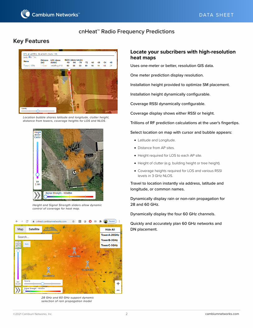
Location bubble shares latitude and longitude, clutter height, distance from towers, coverage heights for LOS and NLOS.
Height and Signal Strength sliders allow dynamiccontrol of coverage for heat map.
Key Features
28 GHz and 60 GHz support dynamic selection of rain propagation model
DATA S H E E T
©2021 Cambium Networks, Inc. 3 cambiumnetworks.com
DATA S H E E T
cnHeat™ Radio Frequency Predictions
Identify your subscribers with locations and addressesUser specifies the height of coverage above the roof or ground, and the minimum RSSI level.
Summary of total buildings covered is provided. Customer has ability to receive:
• Location (Latitude and Longitude) for each building provided (worldwide)
• Address for each building provided (United States)
Target end customers based on these locations and addresses provided to user. Or user can have locations provided at no charge to MarketBroadband.com, which will convert the locations to postal address data for a marketing campaign.
Optimize your Greenfield site placementUp to 32K subscriber locations.
Center point for Greenfield site search and radius of search.
Two desired site heights.
Receive heat map showing subscribers covered at every square meter.
LiDAR for cnWave PlanningSpecify your AOI (area of interest) up to one square mile of coverage.
High resolution LiDAR used to create high resolution DTM (Digital Terrain Model) and DSM (Digital Surface Model) for your AOI.
DTM and DSM used in ANP (Advanced Network Planning) tool to optimize coverage, cost, and throughput of cnWave network.
Cambium Networks ([email protected]) or a Cambium Networks authorized distributor provides ANP planning.
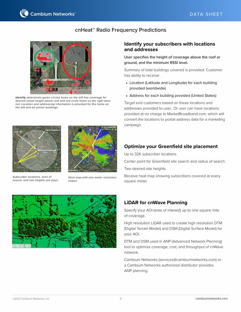
Identify determines green circled home on the left has coverage for desired install height above roof and red circle home on the right does not. Location and addressing information is provided for the home on the left and all similar buildings.
Subscriber locations, area of search, and site heights are input.
Heat map with one meter resolution output.

DATA S H E E T
©2021 Cambium Networks, Inc. 4 cambiumnetworks.com
DATA S H E E T
cnHeat™ Radio Frequency Predictions
ABOUT CAMBIUM NETWORKS
Cambium Networks empowers millions of people with wireless connectivity worldwide. Its wireless portfolio is used by commercial and
government network operators as well as broadband service providers to connect people, places and things. With a single network architecture
spanning fixed wireless and Wi-Fi, Cambium Networks enables operators to achieve maximum performance with minimal spectrum. End-to-end
cloud management transforms networks into dynamic environments that evolve to meet changing needs with minimal physical human
intervention. Cambium Networks empowers a growing ecosystem of partners who design and deliver gigabit wireless solutions that just work.
cambiumnetworks.com10192021
High-Resolution GISDriven by one-meter or better GIS resolution
Up to 32K subscriber locations.
Center point for Greenfield site search and radius of search.
Two desired site heights.
Receive heat map showing subscribers covered at every square meter.
Best-in-Class Propagation ModelsPropagation models reflect reality
Propagation model experience from leading RF equipment provider and cutting-edge RF propagation tools such as LINKPlanner.
3 GHz nLOS / NLOS developed to support the fixed point-to- multipoint experience.
Powered by High-Performance ComputingTrillions of calculations are needed to handle a site's GIS data.
Trillions more calculations needed for 3D one-square-meter predictions covering eight-mile radius.
Calculations facilitating predictions available instantly via cnHeat's user interface.
Try out a demo version of cnHeat cnHeat Demo Website:cnheat.cambiumnetworks.com
ACCOUNT NAME: cnheat
PASSWORD: demo