close enough for government work? - bsee data center · on non-b&b, tims generated sobd's,...
TRANSCRIPT

Close Enough ForClose Enough ForGovernment Work?Government Work?
Prepared byPrepared by Paul RogersPaul Rogers
MMS, Mapping and Boundary BranchMMS, Mapping and Boundary Branch
Minerals Management ServiceMinerals Management Service Gulf of Mexico OCS RegionGulf of Mexico OCS Region
Spatial Data WorkshopSpatial Data Workshop September 14, 2000September 14, 2000
New Orleans, LANew Orleans, LA

Mapping & Boundary BranchMapping & Boundary BranchResponsibilities:Responsibilities:
➣ Baseline Development➣ Boundary Development (Domestic & National)➣ Supplemental Official OCS Block Diagrams (SOBD’s)➣ Official Protraction Diagrams & Leasing Maps (OPD’s & LM’s)➣ Areal Measurements➣ Development and Maintenance of an Official Offshore Cadastral
Database➣ In Cooperation, Develop and Maintain Planning Area Legal
Descriptions and Coverages➣ Preparation and Maintenance of Metadata

To Support:To Support:➣ Ownership Determination➣ Mapping➣ Navigation Requirements➣ Domestic & National Interests➣ Resource Management➣ Law Enforcement
➣ National Environmental Policy Act (NEPA)➣ Oil Pollution Act (OPA)➣ Submerged Lands Act (SLA)➣ Outer Continental Shelf Lands Act (OCSLA)➣ Safe Drinking Water Act (SDWA)➣ Coastal Zone Management Act (CZMA)➣ Endangered Species Act (ESA)➣ Coastal Barrier Resources Act (CBRA)➣ National Wildlife Refuge Administration Act➣ As well as State laws, regulations, and law enforcement actions
➣ Etc.

Under National GuidanceUnder National Guidanceand Authority Of:and Authority Of:
➣ Presidential Proclamation No. 2667, 28-SEP-1945, Policy of the UnitedStates With Respect to the Natural Resources of the Subsoil andSeabed of the Continental Shelf
➣ Submerged Lands Act of 1953, as amended 43 USC 1301➣ Outer Continental Shelf Lands Act of 1953, as amended, 43 USC 1331➣ Presidential Proclamation No. 5030, 10-MAR-1983, Exclusive
Economic Zone of the United States of America➣ Presidential Proclamation No. 5928, 27-DEC-1988, Territorial Sea of
the United States of America➣ Presidential Proclamation No. 7219, 02-AUG-1999, Contiguous Zone of
the United States➣ U.S. Supreme Court Decrees➣ Other

Under International GuidanceUnder International Guidanceand Authority Of:and Authority Of:
➣ Law of the Sea Conventions 1958, 1982➣ International Court of Justice (ICJ)➣ International Agreements➣ Treaties

Milestones in the MMS Adoption/Milestones in the MMS Adoption/Implementation of NAD 83Implementation of NAD 83
March 1989 A second issue paper on implementing NAD 83 in MMS is distributed to allMMS Program Directors and OCS Regions. The MOSG is tasked with drafting animplementation plan and an implementation team is established.
May 1989 At the request of the National Ocean Industries Association, MMS and theNational Geodetic Survey (NGS) meet with industry representatives to discusscoordinate transformations on the OCS. The first NAD 83 Implementation Teammeeting is held to advise regional and OSC representatives of the issues associatedwith the datum change.
August 1989 The MMS publishes a Federal Register Notice 54 FR 31737 stating that (1)the Agency will develop a NAD 83 implementation plan, (2) current offshore cadastrecoordinates are referenced to NAD 27, and (3) future MMS cadastre-related documentswill include a reference datum.

Milestones in the MMS Adoption/Milestones in the MMS Adoption/Implementation of NAD 83 ContinuedImplementation of NAD 83 Continued
November 1989 The NOS indicates that conversion of all nautical charts from NAD 27to NAD 83 is targeted for 1997.
December 1989 Attendees at the 10th Annual Gulf of Mexico Information Transfermeeting are briefed on the MMS plans for implementation of NAD 83. The FGCCapproves the use of an NGS software package named "North American DatumConversion" (NADCON) to transform coordinate values. A second meeting of the MMSNAD 83 Implementation Team is held.
February 1990 The MMS publishes Federal Register Notice 55 FR 3494 stating thatNADCON would be used for OCS coordinate transformations and that lessees' rightsissued under NAD 27 legal descriptions will continue to be protected as warrantedunder that description. Additional NAD 83 tests and implementation alternatives wereprovided to the Implementation Team and the OCS Regions.

Milestones in the MMS Adoption/Milestones in the MMS Adoption/Implementation of NAD 83 ContinuedImplementation of NAD 83 Continued
March 1990 The MMS NAD 83 Implementation Team met to develop a draftimplementation plan. They were unable to reach a consensus in severalareas, necessitating a revised approach to develop the implementation plan.
April 1990 A draft implementation plan was sent to Team members for review.
May 1990 The MMS NAD 83 Implementation Plan issue paper is revised and sent to theOCS Regions and Program staffs for review.
August 1990 Revised draft Implementation Plan distributed by the MMS DeputyAssociate Director for Offshore Leasing for official review and comment.

Milestones in the MMS Adoption/Milestones in the MMS Adoption/Implementation of NAD 83 ContinuedImplementation of NAD 83 Continued
November 1990 Attendees at the 11th Annual Gulf of Mexico Information Transfermeeting are updated on the MMS plans for implementation of NAD 83. The MMSpublishes Federal Register Notice 55 FR 48929 requesting comments on the proposeddraft MMS NAD 83 Implementation Plan.
May 1991 The MMS publishes Federal Register Notice 56 FR 20020 advising that theagency will be initiating a three-phase implementation of NAD 83 on the OCS. TheAlaska OCS Region hosts a MMS NAD 83 Implementation Forum.
October 1991 The Chukchi Sea Planning Area (Alaska) is converted from NAD 27 toNAD 83.
November 1991 “The Minerals Management Service’s Implementation of the NorthAmerican Datum of 1983 in the EEZ” is presented in Portland, OR, at the 1991 EEZSymposium on Mapping and Research.

Milestones in the MMS Adoption/Milestones in the MMS Adoption/Implementation of NAD 83 ContinuedImplementation of NAD 83 Continued
December 1991 At the request of NOIA headquarters, representatives of the MMSMapping & Survey Group met in Houston, TX, with their Navigation and PositioningSubcommittee.
February 1992 The MMS publishes Federal Register Notice 57 FR 5168 statingthat the Agency has adopted NADCON v2.00 as its transformation software.
September 1992 MMS NAD 83 Implementation Team meeting.
May 1993 “Project Plan for Implementing NAD 83 in the Minerals Management Service”approved and adopted by the Agency.

MMS NAD 83 Implementation TeamMMS NAD 83 Implementation TeamAugust 1990August 1990
• Alaska OCS Region --Tom Warren• Atlantic OCS Region -- Fred Grey• Gulf of Mexico OCS Region -- Homer Benton• Pacific OCS Region -- Fred White, Boyd Bosserman• Offshore Systems Center -- Mary Coats, Paul Rasmus• HQ, Br. Of Sales Activities -- Dave Bornholdt, Yvonne Morehouse• HQ, Resource Evaluation -- David Zinzer• HQ, Strategic & International Minerals -- Ed Krause, Barry Drucker• HQ, Rules & Operations -- Mark Fleury• OCS Survey Group -- Leland Thormahlen, Gary Boyack, Richard Naito,
Paul Rogers• Royalty Management -- Boh Walker• Solicitor’s Office -- Susan Hoven Cason• NOS/NGS -- LCDR Warren Dewhurst

MMS/Industry NAD 83 DiscussionsMMS/Industry NAD 83 DiscussionsJanuary 1989 - May 1991January 1989 - May 1991
• BP Exploration, Inc. -- Roger Lott• Chevron Geosciences Company -- James Morgan• CONOCO, Inc. -- Grady Lewis• GPS Technology Corporation -- L. Harold Spradley• Mobil Oil -- John P. Gay• National Ocean Industries Association -- Robert J. Moran• Phillips Petroleum Company -- Susan Robb• Shell Oil Company -- Henk Krynen• Texaco -- David Thomas• Information Transfer Meeting, Gulf of Mexico OCS Region, December
1989• Information Transfer Meeting, Gulf of Mexico OCS Region, November
1990• NAD 83 Implementation Forum, Alaska OCS Region, May 1991

MMS NAD 83 Industry Mailing ListMMS NAD 83 Industry Mailing List
Alaska Map Service, Inc. COMSATAmerada Hess Corp. CONOCO, Inc.AMOCO Production Co. Diamond Chemicals Co.Anadarko Petroleum Corp. Digicon Geophysical Corp.Anadrill Schlumberger Elf Aquitaine, Inc.ARCO Alaska, Inc. Exploration Sciences Corp.Atlantic Richfield Co. EXXON Exploration Co.F.R. Bell & Associates Halliburton Geophysical ServicesBP America Hamilton Brothers Exploration Co.BP Exploration, Inc. IDB-A, Aeronautical CommunicationsChallenger Minerals, Inc. Jackson Oil Corp.Chance, John E. & Assoc. Kerr-McGee Corp.Chevron U.S.A., Inc. LCMF, Ltd.Chevron E&P Services Co. Louisiana Land & Exploration Co.Columbia Gas Development Corp. Louisiana Offshore Oil Port, Inc.

MMS NAD 83 Industry Mailing List Con’t.MMS NAD 83 Industry Mailing List Con’t.
Marathon Oil Co. Pennzoil Exploration & Production Co.Maxus Exploration Co. Petrofina Delaware, Inc.Mesa Petroleum Co. Phillips Petroleum Co.Mobil Oil Exploration & Pogo Producing Co. Producing Southwest, Inc. Santa Fe Minerals, Inc.Mobil Oil Corp. Satellite Positioning Co.Murphy Oil USA, Inc. Shell Oil Co.National Ocean Industries Assn. Shell Development Co.Newfield Exploration Co. Shell Offshore, Inc.Odeco Oil & Gas Co. Shell Western E&P, Inc.Offshore Navigation Sonat Exploration Co.Oryx Energy Co. Sun Operating Limited PartnershipOXY USA, Inc. Texaco U.S.A., IncPanCanadian Petroleum, Inc. Texaco Producing, Inc.

MMS NAD 83 Industry Mailing List Con’t.MMS NAD 83 Industry Mailing List Con’t.
Texas Eastern ExplorationTXP Operating Co.Union Oil Company of CaliforniaUnion Texas Petroleum Corp.United Gas Pipeline Co.Unocal Exploration Corp.Williams Exploration Co.Western GeophysicalWimpol, Inc.

MMS NAD 83 State Mailing ListMMS NAD 83 State Mailing List
Alabama, State of Massachusetts Geological SurveyAlabama Geological Survey Mississippi Geological SurveyAlabama Oil & Gas Board New Hampshire Dept. Envir. ServicesAlaska Dept. Nat. Resources New Jersey Dept. Envir. ProtectionCalifornia St. Lands Commission New York Geological SurveyConnecticut Dept. Env. Protection North Carolina DNRDelaware Geological Survey Oregon Div. State LandsFlorida, State of Pennsylvania Geological SurveyFlorida Geological Survey Rhode Island Geological SurveyGeorgia Geological Survey South Carolina Geological SurveyLouisiana Dept. of Trans. Texas General Land OfficeLouisiana, State of Virginia Div. Mineral ResourcesMaine Geological Survey Washington Div. Aquatic LandsMaryland Geological SurveyMassachusetts CZM

“Datum References for Information Provided to the Public by the MMS. The publicwas notified (54 FR 31737, 8/1/89) that the MMS references its offshore coordinatevalues to NAD 27. Now, since multiple datums are in use, the MMS will cite theappropriate reference datum on pertinent documents.”
MMS NAD 83 Draft Implementation PlanMMS NAD 83 Draft Implementation PlanAugust 10, 1990*August 10, 1990*
*This draft implementation plan contained the final recommendations of the MMS NAD 83Implementation Team prior to the Agency’s adoption “Project Plan For Implementing NAD 83in the Minerals Management Service Part I: Responsibilities and Timeframes” and “Part II:Technical Aspects of Implementation,” May 3, 1993.

MMS NAD 83 Implementation PlanMMS NAD 83 Implementation PlanMay 3, 1993May 3, 1993
1. Executive Summary
“...Second, MMS employees must become datum conscious and verify datum references.Prior to 54 FR 25318 most Agency employees did not have to relate coordinates to aspecific datum. MMS coordinate and associated data referenced NAD 27, and althoughother datums existed, MMS did not develop data tied to them. However, the United Statesadoption of NAD 83 directly or indirectly affects every aspect of the Agency's mission.Since the adoption of NAD 83, every locational coordinate (e.g., shot points) and arealmeasurement (e.g., the number of 8(g) hectares on a Supplemental Official OCS BlockDiagram (SOBD)) must carry a specific datum reference. Do they reference NAD 27? Dothey reference the original NAD 83 adjustment--NAD 83 (1986)? Do they reference aHARN--NAD 83 (199x)? Assumptions are no longer acceptable; the mixing of datum-referenced data can cause major problems and expense for the Agency.”

MMS NAD 83 Implementation PlanMMS NAD 83 Implementation PlanMay 3, 1993May 3, 1993
3. DATUM REFERENCING
In 54 FR 31737, August 1, 1989, the MMS advised the public that:
! The Agency had been referencing NAD 27 for all offshore coordinate and areal measurementcomputations.
! The Agency would cite the appropriate reference datum on pertinent documents.
Some examples of appropriate datum citations are:
! "The coordinate values appearing on/in this document were derived using NAD 27."
! "The coordinate values appearing on/in this document were derived using NAD 83 (1986).” See Part II,section 2.1.5.
! On maps, place NAD 27 or NAD 83 (1986) directly under the bar scale.
! On non-B&B, TIMS generated SOBD's, add "Datum: NAD 27" directly under "State Lease No." in theupper right corner of the block.
Ensuring the integrity of datum-dependent data developed, received, and/or disseminated by theMMS is an Agency-wide responsibility.

“Datum References for Information Provided to the MMS. It is recommended thatindustry supply data to MMS on the NAD 83 datum to eliminate errors caused by theuse of disparate industry or company transformation programs. Further, if the datahas been transformed or converted, copies of the raw data must also be provided to theMMS. (For authority, see 30 CFR 250.17). This policy will allow the MMS to maintainconsistency and compatibility within all national database systems. (See Appendices Eand J.)”
MMS NAD 83 Draft Implementation PlanMMS NAD 83 Draft Implementation PlanAugust 10, 1990August 10, 1990

MMS NAD 83 Implementation PlanMMS NAD 83 Implementation PlanMay 3, 1993May 3, 1993
3.1. OCS Regions
The OCS regions must:
! Ensure that datum citations are an integral part of all pertinent documents, maps/graphics,and digital data provided to the public or other Federal/State government agencies.
! Identify and document the datum of all datum-dependent information held by the OCSregions.
! Incorporate datum identification into non-national computer systems containing datum-dependent data.
! Ensure that newly received data is compatible with existing data.
Current (1992) OCS regional policies for submission of datum-dependent data to theAgency can be found in Figure 3. (The regional policies were identified by regional Teamrepresentatives at the September 15-17, 1992, Team meeting.)

MMS NAD 83 Implementation PlanMMS NAD 83 Implementation PlanMay 3, 1993May 3, 1993
3.1. OCS Regions
The OCS regions must:! Ensure that datum citations are an integral part of all pertinent documents, maps/graphics, and digital data provided to the public or other Federal/State government agencies.! Identify and document the datum of all datum-dependent information held by the OCS regions.! Incorporate datum identification into non-national computer systems containing datum-dependent data.! Ensure that newly received data is compatible with existing data.
Current (1992) OCS regional policies for submission of datum-dependent data to the Agency can befound in Figure 3. (The regional policies were identified by regional Team representatives at theSeptember 15-17, 1992, Team meeting.)
Figure 3. Acceptable survey datums for datum-dependent data received by the MMS.
OCS Region NAD 27 NAD 83 Datum of Survey
Alaska Yes Yes Not Required*Atlantic Yes Yes Not Required*Gulf of Mexico Yes Yes Not Required*Pacific * * Required*
*Only the Pacific OCS Region requires datum-dependent data submissions on the original datum of survey--i.e., whenNAD 27 is the original survey datum, NAD 27 data is acceptable. The other OCS Regions will accept transformeddata when the transformation method has been identified.

“Since the MMS adopted NADCON in 1990 I haveadvised BP to do the same for all of our offshoreactivities, to remain consistent. I have just gonethrough a series of discussions aimed at gettingour contractors similarly aligned … only to be toldthat there is a rumor that MMS is about to issuesome other sort of datum shift for different areasin the Gulf of Mexico. Do you know anythingabout this?”
E-mail message to Paul Rogers, MMS, from Roger Lott, BritishPetroleum, 19 June 1997

“The rumor came from a surveyor working on oneof our offshore projects… Offshore operators likestability in the protraction. We don’t care whatnumbers are assigned to lease block boundariesas long as the lease areas on the surface of theearth are not changed… But because there areso few people in the industry who fully understandcoordinate systems, any change causes greatconfusion and therefore is not welcomed ifunnecessary.”
E-mail message to Paul Rogers, MMS, from Roger Lott, BritishPetroleum, 23 June 1997

Flower Garden Banks National Marine Sanctuary
http://walrus.wr.usgs.gov/pacmaps/wf_index.htmlhttp://walrus.wr.usgs.gov/pacmaps/gm_index.html

Flower Garden Banks National Marine Sanctuary
Oblique view of West Flower Garden looking north. Colors indicate relativedepths. Reds are shallower, while blues are deeper.
http://walrus.wr.usgs.gov/pacmaps/wf_persp.html

Flower Garden Banks National Marine Sanctuary
Shaded Relief of West Flower Gardens
http://walrus.wr.usgs.gov/pacmaps/wf_shd.html
USGS does not statewhat datum thelatitude and longitudecoordinates reference.
Does it make anydifference?

Hibernia Gravity Base Structure PlatformHibernia Gravity Base Structure Platform
http://www.hibernia.ca/html/about_hibernia/pg_13.htmlhttp://www.gov.nf.ca/exec/premier/hibernia.htm
Location: The GrandBanks, 315 km (170nautical miles) eastsoutheast of St. John’s,Newfoundland.
Water Depth: 80 meters/262 feet.
GBS: 106 meters/348 feetin diameter, 85 meters/279 feet high; with topsidesupport shafts (26 meters/85 feet), 111 meters/364feet high.
Total Platform Height:225 meters/738 feet.
Weight: 600,000 tonsduring tow; with ballast 1.2million tons.

Hibernia Gravity Base Structure PlatformHibernia Gravity Base Structure Platform
http://www.phudpucker.com/images/tx%20images/hmdc01.jpghttp://www.gasandoil.com/goc/news/ntn72602.html
Maximum Positioning Tolerance on Sea Floor: 10 meters (33 feet).Actual Platform Positioning: Within 2.5 meters (8 feet) of targettouchdown point.

“June 6, 1997 The Hibernia platform has been successfully positioned atthe Hibernia field, officially bringing the tow-out operation to an end… OnJune 5 the weather forecast was favourable and the nine Maersk tugs slowlymoved the 600,000 tonne platform into position. ‘Our satellite positioningsystem allowed us to install the platform to within 2.5 metres (7.5 feet)of the target touch-down point,’ said Henk van Zante, ConstructionGeneral Manager with Hibernia Management and Development CompanyLtd. (HMDC). ‘We had a maximum tolerance of 10 metres (30 feet) forthe touch-down. This has been a superbly executed marine operation. Thelast 10 kilometres (6.25 miles) of the tow were the most delicate part of theoperation, and we would not move forward from the holding area untilweather conditions were acceptable,’ van Zante said. ‘At times there wasonly 3 metres (9 feet) clearance between the bottom of the platform and theocean floor, so we had to move very slowly and carefully. Our averagespeed during this last leg was 0.5 knots or less.’”
Alexander’s Gas & Oil Connectionshttp://www.gasandoil.com/goc/news/ntn72602.htm
Excerpt from “Hibernia Positioned”Excerpt from “Hibernia Positioned”

!10 meter positional tolerance
target position "
!2.5 meter actual positioning
Comparison of Hibernia Positional ToleranceComparison of Hibernia Positional Toleranceand Its Actual Positioningand Its Actual Positioning

Flower Garden Banks National Marine Sanctuary
Shaded Relief of West Flower Gardens
http://walrus.wr.usgs.gov/pacmaps/wf_shd.html
The approximate center ofthe image (blue lines) is27°52’00”N 93°49’30”W.

West Flower Garden Banks NMSCORPSCON v5.11.08 & NADCON* v2.10 GEOTRANS v2.0** & MADTRAN
NAD 83/WGS 84Latitude/Longitude
NAD 27Latitude/Longitude
Datum Shift(meters/feet)
NAD 83/WGS 84Latitude/Longitude
NAD 27Latitude/Longitude
TransformationError (meters/feet)
27°52’00.00000”N93°49’30.00000”W
27°51’59.02358”N93°49’29.43786”W
Lat.=30.057m/98.612’Long.=15.378m/50.453’
27°52’00.00000”N93°49’30.00000”W
27°51’58.9”N93°49’29.3”W
Lat.= ✂ 3m/9.84’Long.= ✂ 5m/16.40’
NAD 83/WGS 84X/Y, UTM Zone 15(meters)
NAD 27 X/Y, UTMZone 15(meters)
NAD 83/WGS 84X/Y, UTM Zone 15(meters)
NAD 27 X/Y,UTM Zone 15(meters)
X = 418 782.702Y= 3 082 705.812
X = 418 796.329Y = 3 082 504.576
X = 418 783Y = 3 082 706
X = 418 800Y = 3 082 502
*Officially adopted as the transformation software used by the MMS **Uses the Molodensky method for datum transformationNADCON was developed and is maintained by the NGS. CORPSCON, GEOTRANS, and MADTRAN were developed by the U.S. ArmyTopographic Engineering Center. MADTRAN is no longer available, and has been replaced by GEOTRANS.

Flower Garden Banks National Marine Sanctuary
Shaded Relief of West Flower Gardens
http://walrus.wr.usgs.gov/pacmaps/wf_shd.html
The approximate center ofthe image (blue lines) is27°52’00”N 93°49’30”W. Thedifference between thesecoordinates on NAD 83/WGS84 and NAD 27 is 30.057meters (98.612 feet) inlatitude and 15.378 meters(50.453 feet) in longitude.
Approximation of Shift
Blue lines = NAD 83/WGS 84Red lines = NAD 27
1+second north in latitude (99 feet)1/2 second west in longitude (50 feet)Area = 4950 sq ft = .1+ acres

Comparison of the Positioning of Hibernia &Comparison of the Positioning of Hibernia &the NAD 27/83 Shift in the GOMthe NAD 27/83 Shift in the GOM
West Flower Garden Banks NMS AreaWest Flower Garden Banks NMS Area
# Hibernia Platform Positioning
# West Flower Garden Banks NMS Area
N $ $$$
= NAD 27= NAD 83
Datum Shift!10 meter positional tolerance
target position "
!2.5 meter actual positioning

Mars Tension Leg PlatformMars Tension Leg Platform
http://www.offshore-technology.com/projects/mars/mars1.html
Location: Mississippi Canyon Block 807 in 2940 feet of water.

http://www.shellus.com/home_fs.html
Mississippi Canyon
←Y = 10 232 640.000’
←Y = 10 216 800.000’
←X
= 91
8 72
0.00
0’
←X
= 93
4 56
0.00
0’

Mars Tension Leg PlatformCORPSCON v5.11.08 & NADCON* v2.10 GEOTRANS v2.0** & MADTRAN
NAD 83/WGS 84Latitude/Longitude
NAD 27Latitude/Longitude
Datum Shift(meters/feet)
NAD 83/WGS 84Latitude/Longitude
NAD 27Latitude/Longitude
TransformationError (meters/feet)
28°10’11.20842”N89°13’22.45485”W
28°10’10.28640”N89°13’22.35360”W
Lat.=28.383m/93.120’Long.=2.762m/9.062’
28°10’11.50000”N89°13’22.70000”W
28°10’10.3”N89°13’22.4”W
Lat.= ✂ 7m/9.84’Long.= ✂ 5m/16.40’
NAD 83/WGS 84X/Y, UTM Zone 16(feet)
NAD 27 X/Y,UTM Zone 16(feet)***
NAD 83/WGS 84X/Y, UTM Zone 16(feet)
NAD 27 X/Y, UTMZone 16 (feet)
X = 924 379.418Y= 10 229 668.949
X = 924 373.000Y =10 229 010.000
X = 924 358.017Y = 10 229 698.801
X = 924 368.912Y = 10 229 011.566
*Officially adopted as the transformation software used by the MMS***Coordinates from the MMS TIMS database.
**Uses the Molodensky method for datum transformation
NADCON was developed and is maintained by the NGS. CORPSCON, GEOTRANS, and MADTRAN were developed by the U.S. ArmyTopographic Engineering Center. MADTRAN is no longer available, and has been replaced by GEOTRANS.
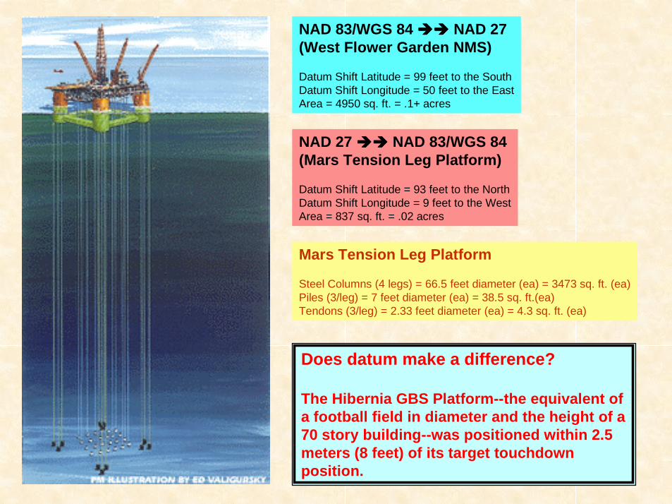
NAD 83/WGS 84 %%%%%%%% NAD 27(West Flower Garden NMS)
Datum Shift Latitude = 99 feet to the SouthDatum Shift Longitude = 50 feet to the EastArea = 4950 sq. ft. = .1+ acres
Mars Tension Leg Platform
Steel Columns (4 legs) = 66.5 feet diameter (ea) = 3473 sq. ft. (ea)Piles (3/leg) = 7 feet diameter (ea) = 38.5 sq. ft.(ea)Tendons (3/leg) = 2.33 feet diameter (ea) = 4.3 sq. ft. (ea)
NAD 27 %%%%%%%% NAD 83/WGS 84(Mars Tension Leg Platform)
Datum Shift Latitude = 93 feet to the NorthDatum Shift Longitude = 9 feet to the WestArea = 837 sq. ft. = .02 acres
Does datum make a difference?
The Hibernia GBS Platform--the equivalent ofa football field in diameter and the height of a70 story building--was positioned within 2.5meters (8 feet) of its target touchdownposition.

!10 meter positional tolerance
target position "
!2.5 meter actual positioning
# West Flower Garden Banks NMS Area
Comparison of the Positioning of Hibernia &Comparison of the Positioning of Hibernia &the NAD 27/83 Shift in the GOMthe NAD 27/83 Shift in the GOM
West Flower Garden Banks NMS Area &West Flower Garden Banks NMS Area &Mars Platform AreaMars Platform Area
# Hibernia Platform Positioning
# Mars Platform Area
N $ $$$
= NAD 27= NAD 83
Datum Shift

Mars Pipelines and CapacitiesMars Pipelines and Capacities
http://www.offshore-technology.com/projects/mars/mars3.html

Oil Tanker Rips Pipeline; Fuel Spilled in Bay
Monday, March 18, 1991
LARRY B. STAMMER and LAURIE BECKLUNDLA TIMES STAFF WRITERS
An oil tanker chartered by Chevron, U.S.A., ripped open anundersea oil pipeline with its anchor a mile off El Segundo onSaturday night, spilling 27,720 gallons of a highly volatileoily fuel mixture into Santa Monica Bay, the U.S. CoastGuard reported Sunday...

!10 meter positional tolerance
target position "
!2.5 meter actual positioning
# West Flower Garden Banks NMS Area
So, back to where we started...So, back to where we started...What What ISIS “Close Enough For “Close Enough For
Government Work?”Government Work?”
# Hibernia Platform Positioning
# Mars Platform Area
N $ $$$
= NAD 27= NAD 83
Datum Shift

Questions and Answers
Thank You For Your Interest!
Minerals Management ServiceMinerals Management ServiceLeasing DivisionLeasing Division
Mapping & Boundary BranchMapping & Boundary Branch