climatology.4.temp dist
DESCRIPTION
www.pmfias.com https://www.youtube.com/c/PoorMansFriendGeography for UPSC IASTRANSCRIPT
www.pmfias.com https://www.youtube.com/c/PoorMansFriend www.pmfias.com
WWW.PMFIAS.COM
Distribution of Temperature
Sun is the ultimate source of heat. And the differential heat received from sun by
different regions on earth is the ultimate reason behind all climatic features. So
understanding the patterns of distribution of temperature in different seasons is
important for understanding various climatic features like wind systems, pressure
systems, precipitation etc..
Insolation
Earth intercepts only one in two billion parts of solar radiation. This intercepted
radiation is called Insolation.
Insolation Proportion of Solar energy received or intercepted by earth.
Some heat within the core and mantle is transfered to the surface and ocean bottoms
through volcanoes, springs and geysers. But this heat received at the surface form
interiors of the earth is negligible.
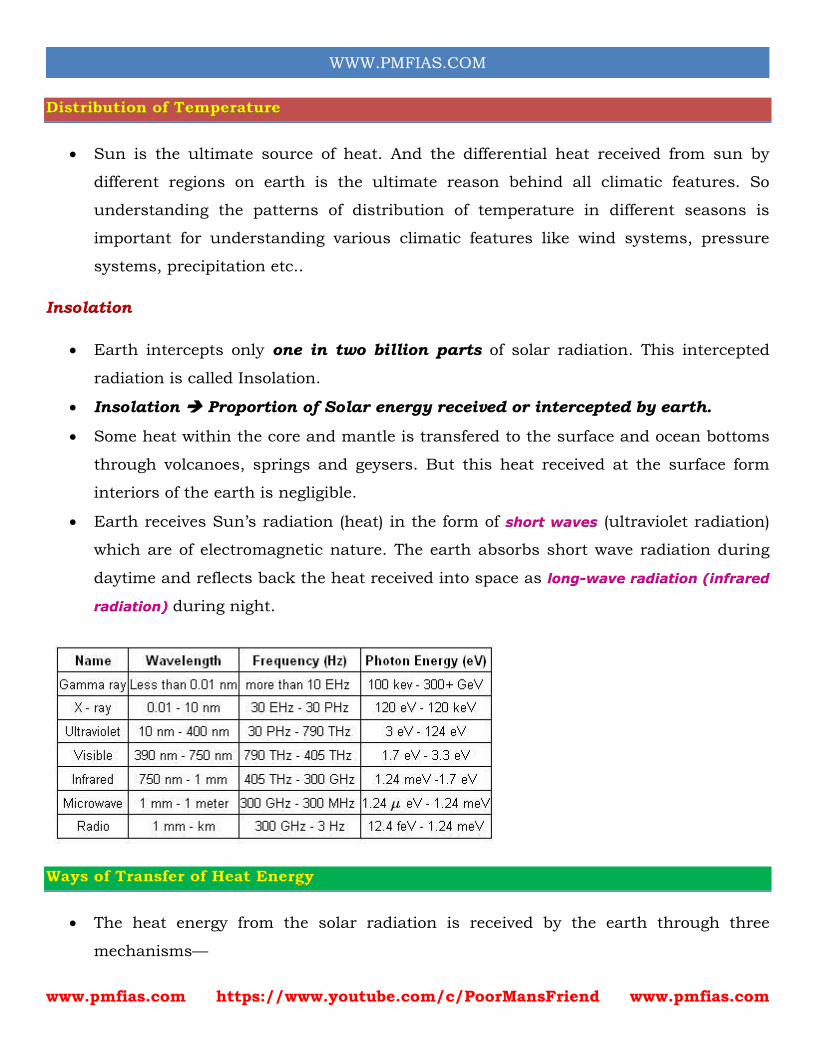
Earth receives Sun’s radiation (heat) in the form of short waves (ultraviolet radiation)
which are of electromagnetic nature. The earth absorbs short wave radiation during
daytime and reflects back the heat received into space as long-wave radiation (infrared
radiation) during night.
Ways of Transfer of Heat Energy
The heat energy from the solar radiation is received by the earth through three
mechanisms—
www.pmfias.com https://www.youtube.com/c/PoorMansFriend www.pmfias.com
WWW.PMFIAS.COM
1. Radiation Heat transfer from one body to another without actual contact or
movement. It is possible in relatively emptier space, for instance, from the sun to the
earth through space.
2. Conduction Heat transfer through matter by molecular activity. Heat transfer in
iron and other metals is by conduction. Generally, denser materials like water are good
conductors and a lighter medium like air is a bad conductor of heat.
3. Convection Transfer of heat energy by actual transfer of matter or substance from
one place to another. (heat transfer by convection cycles in atmosphere as well as
oceans)
Factors Affecting Distribution of Insolation
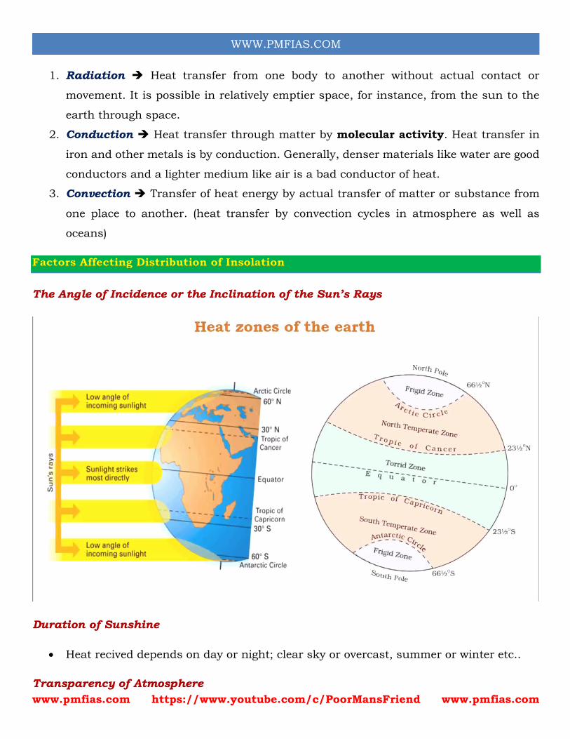
The Angle of Incidence or the Inclination of the Sun’s Rays
Duration of Sunshine
Heat recived depends on day or night; clear sky or overcast, summer or winter etc..
Transparency of Atmosphere
www.pmfias.com https://www.youtube.com/c/PoorMansFriend www.pmfias.com
WWW.PMFIAS.COM
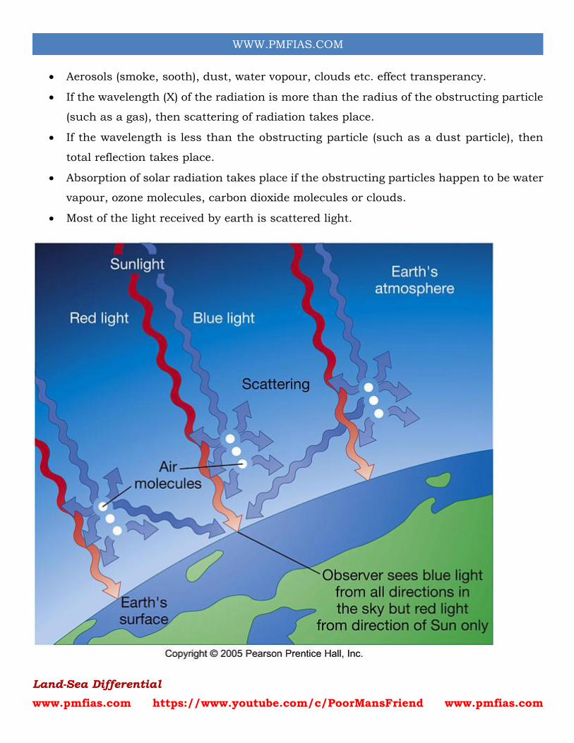
Aerosols (smoke, sooth), dust, water vopour, clouds etc. effect transperancy.
If the wavelength (X) of the radiation is more than the radius of the obstructing particle
(such as a gas), then scattering of radiation takes place.
If the wavelength is less than the obstructing particle (such as a dust particle), then
total reflection takes place.
Absorption of solar radiation takes place if the obstructing particles happen to be water
vapour, ozone molecules, carbon dioxide molecules or clouds.
Most of the light received by earth is scattered light.
Land-Sea Differential
www.pmfias.com https://www.youtube.com/c/PoorMansFriend www.pmfias.com
WWW.PMFIAS.COM
Albedo of land is much grater tha albedo of oceans and water bodies. Especially snow
covered areas reflect upto 70%-90% of insolation.
Average penetration of sunlight is more in water—upto 20 metres, than in land—where
it is upto 1 metre only. Therefore, land cools or becomes hot more rapidly compared to
oceans. In oceans, continuous convection cycle helps in heat exchange between layers
keeping diurnal and annual temperature ranges low. (more while studying salinity and
temperature distribution of oceans)
The specific heat of water is 2.5 times higher than landmass, therefore water takes
longer to get heated up and to cool down.
Prevailing Winds
Winds transfer heat from one latitude to another. They also help in exchange of heat
between land and water bodies.
The oceanic winds have the capacity to take the moderating influence of the sea to
coastal areas—reflected in cool summers and mild winters. This effect is pronounced
only on the windward side (the side facing the ocean).
The leeward side or the interiors do not get the moderating effect of the sea, and
therefore experience extremes of temperature.
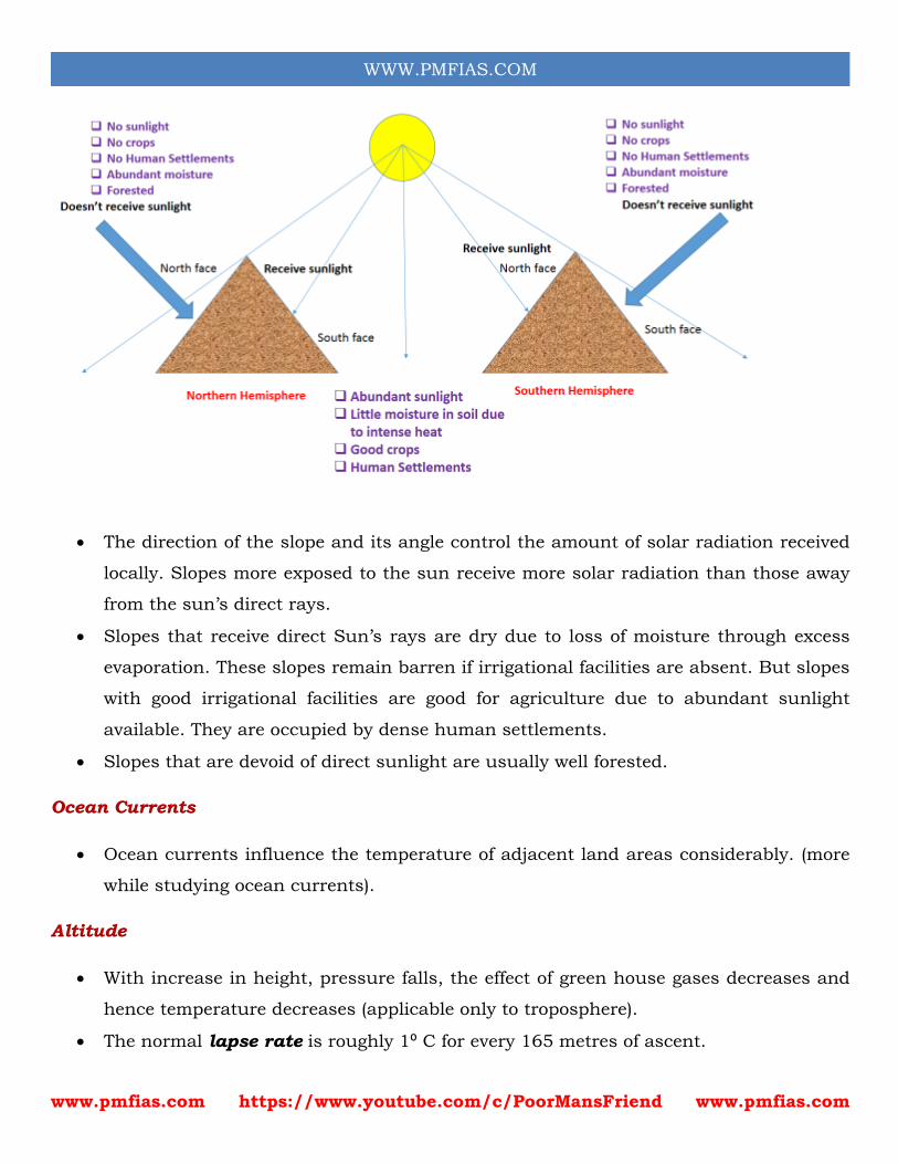
Aspects of Slope
www.pmfias.com https://www.youtube.com/c/PoorMansFriend www.pmfias.com
WWW.PMFIAS.COM
The direction of the slope and its angle control the amount of solar radiation received
locally. Slopes more exposed to the sun receive more solar radiation than those away
from the sun’s direct rays.
Slopes that receive direct Sun’s rays are dry due to loss of moisture through excess
evaporation. These slopes remain barren if irrigational facilities are absent. But slopes
with good irrigational facilities are good for agriculture due to abundant sunlight
available. They are occupied by dense human settlements.
Slopes that are devoid of direct sunlight are usually well forested.
Ocean Currents
Ocean currents influence the temperature of adjacent land areas considerably. (more
while studying ocean currents).
Altitude
With increase in height, pressure falls, the effect of green house gases decreases and
hence temperature decreases (applicable only to troposphere).
The normal lapse rate is roughly 1⁰ C for every 165 metres of ascent.
www.pmfias.com https://www.youtube.com/c/PoorMansFriend www.pmfias.com
WWW.PMFIAS.COM
Earth’s Distance form Sun
During its revolution around the sun, the earth is farthest from the sun (152 million
km on 4th July). This position of the earth is called aphelion.
On 3rd January, the earth is the nearest to the sun (147 million km). This position is
called perihelion.
Therefore, the annual insolation received by the earth on 3rd January is slightly more
than the amount received on 4th July.
However, the effect of this variation in the solar output is masked by other factors like
the distribution of land and sea and the atmospheric circulation.
Hence, this variation in the solar output does not have great effect on daily weather
changes on the surface of the earth.
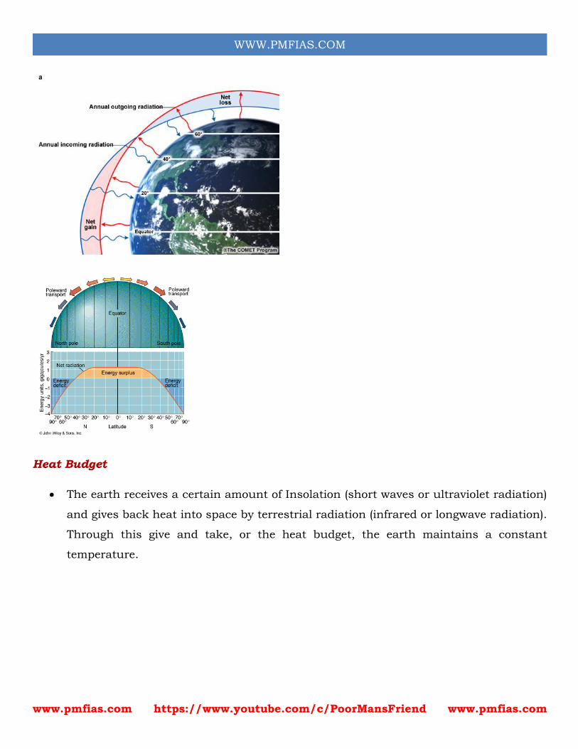
Latitudinal Heat Balance
The amount of insolation received varies from latitude to latitude.
Regions within the equator and 40° N and S latitudes receive abundant sunlight and
hence more heat will be gained than lost. Hence they are energy surplus regions.
Regions beyond 40° N and S latitudes lose more heat than that gained from sunlight.
Hence they are energy deficit regions (This is because of slant sunlight and hight albedo
of polar regions).
Going by this logic, the tropics should have been getting progressively hotter and the
poles getting progressively cooler. And the planet would have been inhospitable except
for few regions near mid latitudes. But, in reality, this does not happen.
The atmosphere (planetary winds) and the oceans (ocean currents) transfer excess heat
from the tropics (energy surplus region) towards the poles (energy deficit regions)
making up for heat loss at higher latitudes.
And most of the heat transfer takes place across the mid-latitudes (30° to 50°)[more
while studing jet streams and cyclones], and hence much of the stormy weather is
associated with this region.
Thus, the transfer of surplus energy from the lower latitudes to the deficit energy zone
of the higher latitudes, maintains an overall balance over the earth’s surface.
www.pmfias.com https://www.youtube.com/c/PoorMansFriend www.pmfias.com
WWW.PMFIAS.COM
Heat Budget
The earth receives a certain amount of Insolation (short waves or ultraviolet radiation)
and gives back heat into space by terrestrial radiation (infrared or longwave radiation).
Through this give and take, or the heat budget, the earth maintains a constant
temperature.
www.pmfias.com https://www.youtube.com/c/PoorMansFriend www.pmfias.com
WWW.PMFIAS.COM
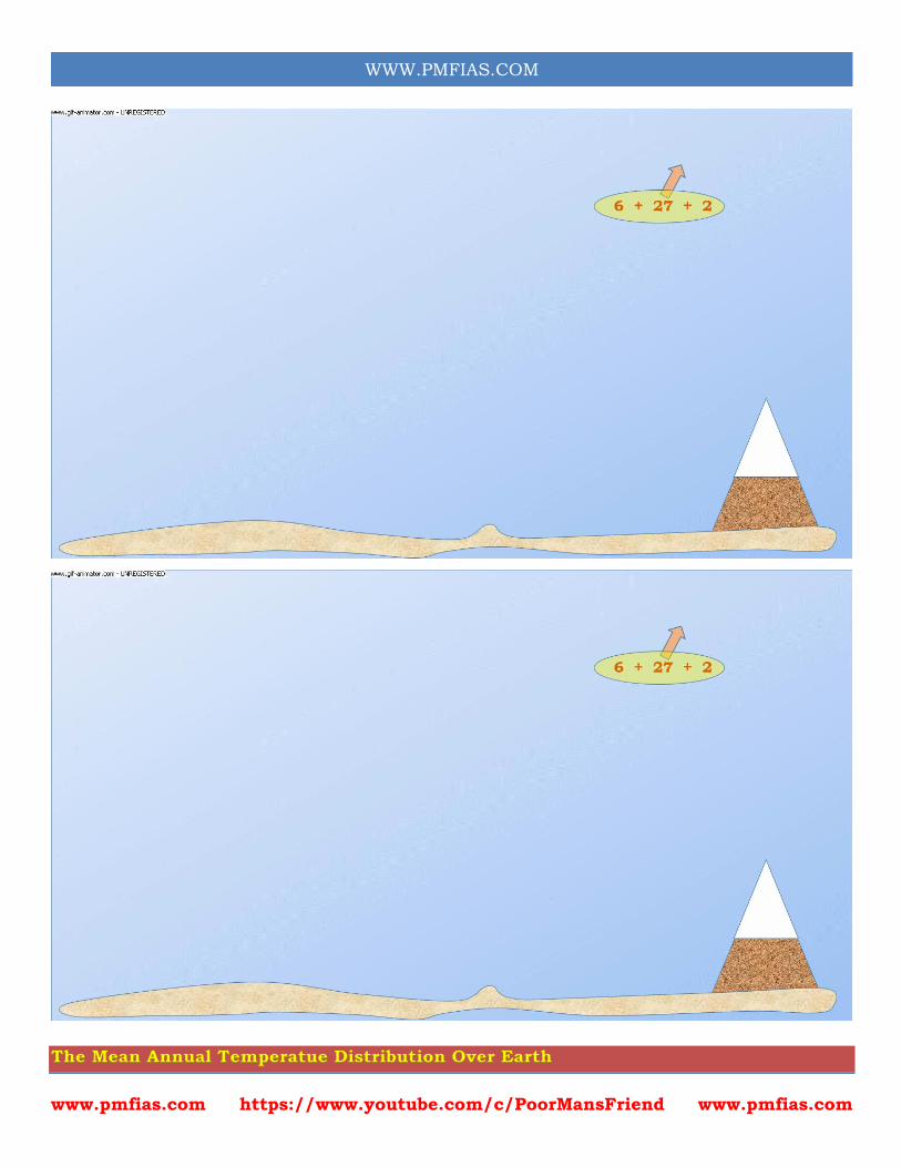
The Mean Annual Temperatue Distribution Over Earth
www.pmfias.com https://www.youtube.com/c/PoorMansFriend www.pmfias.com
WWW.PMFIAS.COM
Isotherm: An imaginary line joining places having equal temperatures.
The horizontal or latitudinal distribution of temperature is shown with the help of a
map with isotherms.
Effects of altitude is not considered while drawing an isotherm. All the temperatures
are reduced to sea levels.
General characteristics of isotherms.
1. Generally follow the parallels. Isotherms have close correspondence with the latitude
parallels mainly because the same amount of insolation is received by all the points
located on the same latitude.
2. Sudden bends at ocean - continent boundaries. (due to differential heating of land
and water, temperatures above the oceans and landmasses vary even on the same
latitude) (we have seen how land sea differential effects temperature distribution)
3. Narrow spacing between isotherms indicate rapid change in temperature (high
thermal gradient).
4. Wide spacing between isotherms indicate small or slow change in temperatures (low
thermal gradient).
General Trend
The highest temperatures occur over tropics and sub-tropics (high insolation). The
lowest temperatures occur in polar and subpolar regions. in continents due to the
effect of continentality.
Diurnal and annual range of temperatures are highest in the interiors of continents due
to the effect of continentiality (in continental interiors these will no moderating
effect of oceans).
Diurnal and annual range of temperatures are least in oceans.
Low temperature gradients are observed over tropics and high temperature gradients
over middle and higher latitudes.
Temperature gradients are usually low over the eastern margins of continents. (This
is because of warm ocean currents)
Temperature gradients are usually high over the western margins of continents.
(This is because of cold ocean currents)
www.pmfias.com https://www.youtube.com/c/PoorMansFriend www.pmfias.com
WWW.PMFIAS.COM
The isotherms are irregular over the northern hemisphere due to an enhanced land-sea
contrast. Because of predominance of land over water in the north, the northern
hemisphere is warmer. The thermal equator lies generally to the north of geographical
equator.
While passing through an area with warm ocean currents, the isotherms show a
poleward shift. (Nort Atlantic Drift and Gulf Stream combined with westerlies in
Northern Atlantic; Kurishino Current and North Pacific current combined with
westerlies in Northern Pacific) (we will see about ocean currents in detail later.)
Mountains also affect the horizontal distribution of temperature. For instance, the
Rockies and the Andes stop the oceanic influence from going inwards into North and
South America.
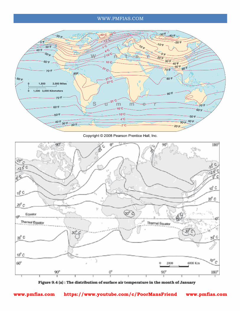
Distribution of Temperature
The global distribution of temperature can well be understood by studying the
temperature distribution in January and July.
The temperature distribution is generally shown on the map with the help of isotherms.
The Isotherms are lines joining places having equal temperature.
In general the effect of the latitude on temperature is well pronounced on the map, as
the isotherms are generally parallel to the latitude. The deviation from this general trend
is more pronounced in January than in July, especially in the northern hemisphere.
In the northern hemisphere the land surface area is much larger than in the southern
hemisphere. Hence, the effects of land mass and the ocean currents are well
pronounced.
Seasonal Distribution of Temperature — January
www.pmfias.com https://www.youtube.com/c/PoorMansFriend www.pmfias.com
WWW.PMFIAS.COM
www.pmfias.com https://www.youtube.com/c/PoorMansFriend www.pmfias.com
WWW.PMFIAS.COM
During January, it is winter in the northern hemisphere and summer in the southern
hemisphere.
The western margins of continents are warmer than their eastern counterparts, since
the Westerlies are able to carry high temperature into the landmasses.
The temperature gradient is close to the eastern margins of continents. For instance,
along the east coast of Asia and North America, the temperature changes at the rate of
1.5°C per degree latitude, while along the western margins it changes at the rate of 0.5
C per degree latitude. The isotherms exhibit a more regular behaviour in the southern
hemisphere.
Northern Hemisphere
The isotherms deviate to the north over the ocean and to the south over the continent.
This can be seen on the North Atlantic Ocean. The presence of warm ocean currents,
Gulf Stream and North Atlantic drift, make the Northern Atlantic Ocean warmer and
the isotherms show a poleward shift indicating that the oceans are warmer and are
able to carry high temperatures polewards.
An equatorward bend of the isotherms over the northern continents shows that the
landmasses are overcooled and that polar cold winds are able to penetrate southwards,
even in the interiors. It is much pronounced in the Siberian plain.
Lowest temperatures are recorded over northern Siberia and Greenland.
Southern Hemisphere
The effect of the ocean is well pronounced in the southern hemisphere. Here the
isotherms are more or less parallel to the latitudes and the variation in temperature is
more gradual than in the northern hemisphere. The isotherm of 20° C, 10° C, and 0° C
runs parallel to 35° S, 45° S and 60° S latitudes respectively.
The high temperature belt runs in the southern hemisphere, somewhere along 30°S
latitude.
The thermal equator lies to the south of geographical equator (because the
Intertropical Convergence Zone or ITCZ has shifted southwards with the apparent
southward movement of the sun).
www.pmfias.com https://www.youtube.com/c/PoorMansFriend www.pmfias.com
WWW.PMFIAS.COM
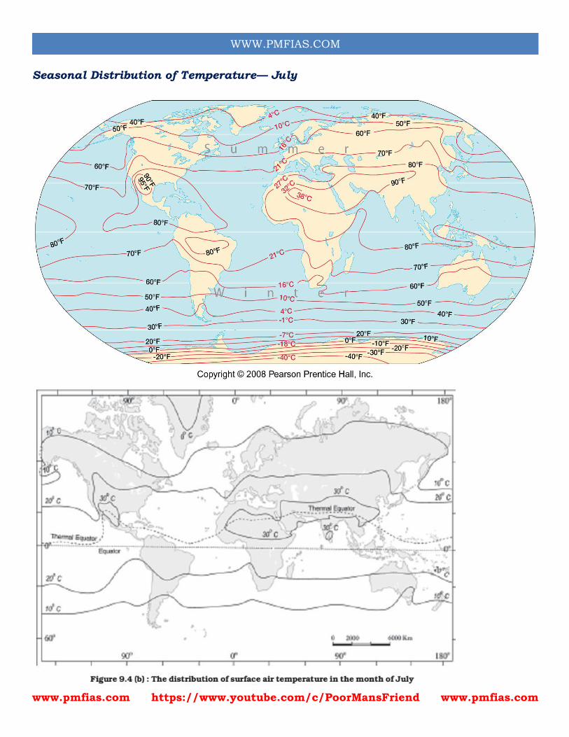
Seasonal Distribution of Temperature— July
www.pmfias.com https://www.youtube.com/c/PoorMansFriend www.pmfias.com
WWW.PMFIAS.COM
During July, it is summer in the northern hemisphere and winter in the southern
hemisphere. The isothermal behaviour is the opposite of what it is in January.
In July the isotherms generally run parallel to the latitudes. The equatorial oceans
record warmer temperature, more than 27°C. Over the land more than 30°C is noticed
in the subtropical continental region of Asia, along the 30° N latitude. Along the 40° N
runs the isotherm of 10° C and along the 40° S the temperature is 10° C.
Northern Hemisphere
The highest range of temperature is more than 60° C over the north-eastern part of
Eurasian continent. This is due to continentality. The least range of temperature, 3°C,
is found between 20° S and 15° N.
Over the northern continents, a poleward bend of the isotherms indicates that the
landmasses are overheated and the hot tropical winds are able to go far into the
northern interiors.
The isotherms over the northern oceans show an equatorward shift indicating that the
oceans are cooler and are able to carry the moderating effect into tropical interiors. The
lowest temperatures are experienced over Greenland.
The highest temperature belt runs through northern Africa, west Asia, north-west India
arid southeastern USA. The temperature gradient is irregular and follows a zig-zag
path over the northern hemisphere.
Southern Hemisphere
The gradient becomes regular over the southern hemisphere but shows a slight bend
towards the equator at the edges of continents. Thermal equator now lies to the north
of the geographical equator.
Questions from NCERT
The atmosphere is mainly heated by the: (a) Short wave solar radiation (c) Long wave
terrestrial radiation (b) Reflected solar radiation (d) Scattered solar radiation
The main reason that the earth experiences highest temperatures in the subtropics in
the northern hemisphere rather than at the equator is : (a) Subtropical areas tend to
www.pmfias.com https://www.youtube.com/c/PoorMansFriend www.pmfias.com
WWW.PMFIAS.COM
have less cloud cover than equatorial areas. (b) Subtropical areas have longer day hours
in the summer than the equatorial. (c) Subtropical areas have an enhanced “green
house effect” compared to equatorial areas. (d) Subtropical areas are nearer to the
oceanic areas than the equatorial locations.
30 words
How does the unequal distribution of heat over the planet earth in space and time cause
variations in weather and climate?
What are the factors that control temperature distribution on the surface of the earth?
In India, why is the day temperature maximum in May and why not after the summer
solstice?
Why is the annual range of temperature high in the Siberian plains
150 words
How do the latitude and the tilt in the axis of rotation of the earth affect the amount of
radiation received at the earth’s surface?
Discuss the processes through which the earth-atmosphere system maintains heat
balance.
Compare the global distribution of temperature in January over the northern and the
southern hemisphere of the earth.